satellite image, source for terrestrial information, threat to national security
TRANSCRIPT

RC C
hakra
borty,
ww
w.m
yrea
ders.
info
Satellite Image,
Source for Terrestrial Information,
Threat to National Security
by
R. C. Chakraborty
Visiting Professor at JIET, Guna.
Former Director of DTRL & ISSA (DRDO),
www.myreaders.wordpress.com
December 11, 2007
MANIT TRAINING PROGRAMME
on
Information Security
December 10 -14, 2007
at
Maulana Azad National Institute of Technology (MANIT),
Bhopal – 462 016
www.myreaders.info

RC C
hakra
borty,
ww
w.m
yrea
ders.
info
The Maulana Azad National Institute of Technology (MANIT), Bhopal,
conducted a short term course on "Information Security", Dec. 10 -14,
2007. The institute invited me to deliver a lecture. I preferred to talk on
"Satellite Image - source for terrestrial information, threat to
national security". I extended my talk around 50 slides, tried to give an
over view of Imaging satellites, Globalization of terrestrial information and
views express about National security. Highlights of my talk were:
► Remote sensing, Communication, and the Global Positioning satellite Systems;
► Concept of Remote Sensing;
► Satellite Images Of Different Resolution;
► Desired Spatial Resolution;
► Covert Military Line up in 1950s;
► Concept Of Freedom Of International Space;
► The Roots Of Remote Sensing Satellites;
► Land Remote Sensing Act of 1992;
► Popular Commercial Earth Surface Imaging satellites - Landsat , SPOT and Pleiades , IRS and Cartosat , IKONOS , OrbView & GeoEye, EarlyBird, QuickBird, WorldView, EROS;
► Orbits and Imaging characteristics of the satellites;
► Other Commercial Earth Surface Imaging satellites – KOMPSAT, Resurs DK, Cosmo/Skymed, DMCii, ALOS, RazakSat, FormoSAT, THEOS;
► Applications of Very High Resolution Imaging Satellites;
► Commercial Satellite Imagery Companies;
► National Security and International Regulations – United Nations , United States , India;
► Concern about National Security - Views expressed;
► Conclusion.
02

RC C
hakra
borty,
ww
w.m
yrea
ders.
info
Satellite Image,
Source for Terrestrial Information,
Threat to National Security
► Remote sensing satellites, Communication satellites, and the Global
Positioning System (GPS) together have immense strategic value. The
capabilities derived from these systems are driving the commercial engine
of the new information-based economy.
► Uses for Remote Sensing Imageries, range from the military
(reconnaissance, mapping, damage assessment), to the commercial
(farming, mining, real estate), the humanitarian (human rights abuses) and
environmental catastrophe.
Similarly, Satellite communications, have connected businesses located on
opposite sides of the globe as well as increased the capacity and speed of
command and control links on the battlefield.
Finally, the Global Positioning Systems have significantly enhanced
precision targeting and troop coordination also improved airline safety, the
tracking of vehicles and many more.
03

RC C
hakra
borty,
ww
w.m
yrea
ders.
info
Commercial satellite market ► Satellite systems have dual use - both civil and military. The governments
and businesses around the world recognize the immense value, the satellite
applications can offer them. The satellite industry traditionally dominated by
programs run with government funding are now controlled by commercial
interests. Even military for their operational necessity have now been
looking for ways to save money by absorbing private sector capabilities
rather than preferring expensive classified systems.
The proliferation of satellite technology is largely because of commercial
interests. The revenue form the commercial satellite market is growing fast
in both the United States and worldwide. In 1996 global satellite industry
revenues were around $37.5 billion (U.S. $19 billion), was estimated to
reach $82.6 billion in 2000. According to satellite industry associations, the
U.S. satellite industry revenues represent nearly half of worldwide
revenues. The figures include commercial communications satellite services,
launch services, manufacturing of satellites and ground equipment, as well
as sale of remote sensing imagery and value-added services. The satellite
services and applications alone represents around two-thirds of space
industry revenues. The industry associations estimated, that the global
commercial satellite service revenues will more than triple by 2009. One
good reason is that satellite images are most preferred source for
terrestrial information. [http://www.fas.org/spp/eprint/article06.html , Commercial
Space and United States National Security]
04

RC C
hakra
borty,
ww
w.m
yrea
ders.
info
Remote Sensing ► Concept of Remote Sensing
Remote Sensing is a technology by which the characteristics of objects of
interest can be identified, measured or analyzed without direct contact.
Remote Sensing systems include :
− Source : Electro-magnetic radiation which is reflected or emitted from an
object is the usual source of remote sensing data.
− Sensor : A device to detect the electro-magnetic radiation reflected or emitted
from an object; e.g. - Cameras or scanners.
− Platform: A vehicle that carries remote sensor; e.g. - aircrafts or satellites.
− Output : Data usually an Image .
The Remote sensing data are processed by computer and interpreted by
humans, and then finally utilized in agriculture, land use, forestry, geology,
hydrology, oceanography, meteorology, environment etc.
05

RC C
hakra
borty,
ww
w.m
yrea
ders.
info
Satellite Images ► Satellite Images Of Different Resolution
Below shown for the purpose of comparison the satellite images of four
different spatial resolutions – 1, 10, 30 and 80 meter. All images are
centered at same target; because the images are of same size, the
decrease in resolutions are seen with increase in area covered.
1 Meter Panchromatic
10 Meter Panchromatic
30 Meter Multispectral 80 Meter Multispectral
06

RC C
hakra
borty,
ww
w.m
yrea
ders.
info
Desired Image Resolution ► Desired Spatial Resolution
The spatial resolutions required for detection, location, identification, and
differentiation of objects on Earth surface are indicated below.
One-Meter Identify and Map : manhole covers, automobiles, bus shelters, highway lanes,
sidewalks, utility equipment, fence lines, and free-standing trees and bushes.
Identify : characteristics features of many of above mentioned objects.
Detect : small areas of stress in farm fields or tree stands.
Locate and Map : houses, roads, buildings, courtyards, and small farm fields.
Differentiate : among types of buildings and houses. 10-Meter
Locate and Map : buildings, yards, roads, property boundaries, athletic fields,
farm fields, and side streets.
Differentiate : farm fields, tree stands and relative vegetative health. Make : small-area land-cover classifications. 20/30-Meter
Locate : airports, city centers, suburbs, shopping malls, sports complexes, large
factories, forest stands, and large farm fields.
Make : generalized land-cover classifications. 80-Meter
Map : regional geological structure. Assess : vegetative health in a large region. 1-Kilometer Assess : vegetative indices for states and entire countries. Track : events like - insect infestation, drought and desertification.
07

RC C
hakra
borty,
ww
w.m
yrea
ders.
info
Over-flight in space - history
► Covert military line up in 1950s
From mid-1940s to early 1990s was the period of tension, competition and
conflict known as cold war between the United States and the Soviet Union.
Let us recall few events occurred between 1950 and 1960.
− In early 1950s, U.S thought of an Spy plane U-2 to photograph a
particular location, knowingly violating a country's airspace. The plane
would fly at 70,000 feet, beyond the reach of Soviet fighters and
missiles, and also outside the range of radar detection, equipped with
imaging sensors, either wet film photo, electro-optic or imaging radar.
− In 1955, U.S. offered to Soviet Union an “Open Skies” policy, allowing
mutual territorial surveillance which was not agreed by the later.
− In 1956, U.S. stated U-2 fly-over program, secretly gathered data on
Soviet missile capabilities, knowingly violating the country's airspace.
For four years, the U-2's cameras took photos of ICBM testing sites and
air bases.
− In October 1957, "Sputnik" the first satellite was successfully launched
by Soviet Union
− On May 1, 1960 the spy plane U-2 came to crisis, shot down over the
Soviet Union. The U.S. denied the true purpose of the plane.
− Thus, U.S. faced two unsuccessful initiatives :
(a) the “Open Skies” policy offered to Soviet Union in 1955, was rejected
(b) the "U-2 fly-over program" , aborted in 1960 because direct aerial
observation means violating that country's airspace.
− In August 1960, U.S. secretly developed "Discoverer XIV", a spy
satellite and recovered its first film capsule.
− Interpretation : In a way "Sputnik orbit" tacitly legitimized pictures
from over-flight in space.
08

RC C
hakra
borty,
ww
w.m
yrea
ders.
info
Freedom Of International Space ► Concept Of Freedom Of International Space
Soon after Sputnik was launched in 1957, the U.S. perceived, that the
Soviet Union unintentionally established the concept of freedom of
international space.
U.S. talked about peaceful uses of space for the benefit of mankind, while
pursuing military applications. In a way, U.S. showed concern for both
power and legitimacy. For example :
− Launch of First satellite as a scientific project : U.S. on March 17,
1958, launched Vanguard-1, the first artificial satellite with a scientific
experiment into orbit around the Earth as part International Geophysical
Year (July 1, 1957 to Dec. 31, 1958). Thus U.S. became the champion of
openness, international cooperation, and the rule of law in space.
− Campaign for Reconnaissance satellites : Necessary for gathering
reliable information about military developments behind the iron curtain,
to negotiate arms control and to retain defense sufficiency in the
absence of agreements. This is likely only if usage of imaging satellites
are legitimatized.
Note :
1. The launching of Sputnik was also planned as part of the IGY, but Soviet Union
launched the satellite using a military intercontinental ballistic missile. The Sputnik
launch went against the plan to use non-military rocket and satellite designs
and deployments to collect data during the IGY.
2. The IGY was over on Dec. 31 1958. The scientific community learned from the
satellite based experiments of the benefits of the international scientific
cooperation. the scientists of different disciplines once worked in isolation found
common ground and new paths to invention. Eventually, the public began to see the
benefits of these scientific endeavors in their daily lives.
09

RC C
hakra
borty,
ww
w.m
yrea
ders.
info
Remote Sensing Satellites ► The Roots Of Remote Sensing Satellites
Remote Sensing refers to viewing Earth from space across the visible
and other spectra. There are three main facets of Remote Sensing :
(1) Image resolution; (2) Satellite's repeat/revisit days; and (3) Sensor's
spectral coverage. The image resolution is a critical component that largely
decides its military utility.
The commercial potential of remote sensing satellites were envisaged much
before the fall of Soviet Union (1991). NASA launched the civilian remote
sensing satellite Landsat in 1972, that provided the satellite images of
resolution 80 meter of Earth to the non-governmental sector. But soon this
new technology became untenable for the private sector to sustain and
derive profit. The effectiveness of Landsat suffered because of low
resolution. Landsat eventually, languished over a decade before a
commercial market sufficient to make it profitable materialized.
But then U.S. space industry faced new challenge in 1986. It lost the
superpower monopoly, because of economic competitiveness. A more
capable French Imaging competitor launched remote sensing satellite
SPOT-1 in February 1986, followed by SPOT-2 in January 1990. The image
resolutions were 10 meter.
The competition became more while India launched IRS-1A in 1988 and
IRS-1B in 1991. The image resolutions were 36 meter. While these two
satellites offered resolution less than SPOT but then IRS-1C and IRS-1D
were slated for launch in 1995 and 1997. These two satellites were
expected to capture images of resolution 5.8 meter.
The result was, in the year 1992, U.S. declared new initiative – known as
Land Remote Sensing Act of 1992.
10

RC C
hakra
borty,
ww
w.m
yrea
ders.
info
Remote Sensing Act 1992 ► Land Remote Sensing Act of 1992
This act enabled U.S. to maintain its leadership in land remote sensing by:
− providing data continuity for the Landsat program,
− establishing a new national Land Remote Sensing Policy,
− implementing a fundamental change, rejecting full commercialization in
favor of a more long-term, and protective development of the remote
sensing industry under the guidance of the DoD and NASA.
The relevant extracts from this act of 1992: Sec.2 Findings, Sec.3
Definitions , and Sec.103 Data Policy are stated below.
◊ Extracts from Sec. 2. Findings : declared
− The continuous collection and utilization of land remote sensing data from
space are of major benefit in studying and understanding human impacts
on the global environment, in managing the Earth's natural resources, in
carrying out national security functions, and in planning and conducting
many other activities of scientific, economic, and social importance.
− Full commercialization of the Landsat program cannot be achieved within
the foreseeable future, . . . . . . commercialization of land remote sensing
should remain a long-term goal of U.S. policy.
− Development of the remote sensing market and the provision of
commercial value-added services based on remote sensing data should
remain exclusively the function of the private sector.
11

RC C
hakra
borty,
ww
w.m
yrea
ders.
info
Remote Sensing Act 1992
◊ Extracts from Sec. 3. Definitions : apply
− The term `Landsat system' means Landsats 1, 2, 3, 4, 5, and 6, and any
follow-on land remote sensing system operated and owned by the United
States Government, along with any related ground equipment, systems,
and facilities owned by the United States Government.
− The term `Landsat 6 contractor' means the private sector entity which was
awarded the contract for spacecraft construction, operations, and data
marketing rights for the Landsat 6 spacecraft.
− The term `Landsat 7' means the follow-on satellite to Landsat 6.
◊ Extracts from Sec. 103 : Data policy for Landsat 4 through 6
Landsat Program Management shall enter into negotiations with the Landsat 6
contractor to formalize pricing, distribution, acquisition, archiving, and
availability of un-enhanced data.
− Un-enhanced data shall be provided, . . . , to the United States
Government and its affiliated users . . . , on the condition that such un-
enhanced data are used solely for noncommercial purposes;
− Landsat data users are able to acquire un-enhanced data contained in the
collective archives of foreign ground stations as easily and affordably as
practicable;
− United States Government and its affiliated users shall not be prohibited
from reproduction or dissemination of un-enhanced data to other agencies
of the United States Government and other affiliated users, on the
condition . . . . . . used solely for noncommercial purposes;
− A viable role for the private sector in the promotion and development of the
commercial market for value added and other services . . . . is preserved;
− Un-enhanced data from the Landsat system are provided to the National
Satellite Land Remote Sensing Data Archive . . . .
12

RC C
hakra
borty,
ww
w.m
yrea
ders.
info
Earth Imaging Satellites ► Popular Commercial Earth Surface Imaging satellites
To acquire images of Earth from space, many satellites were launched
starting from the year 1972. The series of satellites owned by countries –
U.S.A, France, India, and Israel are shown below.
Landsat, SPOT, IRS, IKONOS, OrbView, GeoEye, QuickBird, WorldView, EROS
Year of launch / termination/failure 1970 75 80 85 90 95 2000 05 07 • • • • • • • • •
Landsat1 1972 - 78
Landsat2 1975 - 82
Landsat3 1978 - 82
Landsat4 1982 - 87
Landsat5 1984 - 05
Landsat6 ● 1993 failed
Landsat7 1999 - 03
Landsat Data Continuity Mission is the next satellite , scheduled to be launched in 2011 SPOT 1 1986 - 90
SPOT 2 1990 - 07
SPOT 3 1993 -96
SPOT 4 1998 - 07
SPOT 5 2002 - 07
Pleiades-1,2 To be launched in 2009 09
IRS 1A 1988 - 92
IRS 1B 1991 - 99
IRS P2 1994 - 97
IRS 1C 1995 - 07
IRS 1D 1997 - 07
IRS P6 2003 - 07
Cartosat-1 2005-07
Cartosat-2 07 IKONOS-1 ● 1999 failed
IKONOS-2 1999 - 07
OrbView-3 2003 - 07
OrbView-4 ● 2001 failed
GeoEye-1 To be launched in 2008 08
EarlyBird ● 1997 failed
QuickBird-1 ● 2000 failed
QuickBird-2 2001 - 07
WorldView-1 07
WorldView-2 To be launched in 2008 08
EROS-A 2000 - 07
EROS-B 2006
EROS-C To be launched in 2009 09
• • • • • • • • •
1970 75 80 85 90 95 2000 05 07
13

RC C
hakra
borty,
ww
w.m
yrea
ders.
info
Earth Imaging Satellites ► Orbits and Imaging characteristics of the satellites
Landsat, SPOT, IRS, IKONOS, OrbView, GeoEye, QuickBird, WorldView, and
EROS series of satellites, their launch, status, resolution, swath, repeat
cycle, altitude, inclination and onboard communication are indicated. ◊ Landsat 1 , 2 , 3, 4 , 5 , 6, 7
The satellites Landsat 1 through 7 were launched in last 27 years,
starting from the year 1972. Landsat-7 offers 15 meter resolution.
Satellite Launch Status till date Dec. 2007
Landsat 1 23. 07. 1972 operation ceased on Jan. 1978;
Landsat 2
22. 01. 1975 operation ceased on Feb. 1982;
Landsat 3
05. 03. 1978 operation ceased on Nov. 1982;
Landsat 4
16. 07. 1982 Sensors not operational after July 1987
Landsat 5
01. 03. 1984 went to crisis in Dec. 2005; resumed in Jan. 2006
Landsat 6
05. 10. 1993 failed to reach orbit;
Landsat 7
15. 04. 1999 Faulty scan line on May, 2003;
The orbit and Imaging characteristics : Mostly same for all satellites,
except image resolutions that were constantly improved from 80 to 15 meter .
− Sun-synchronous, near-polar orbit Equatorial crossing time between 9.30 to 10 AM +/- 15 minutes
− Resolution, Swath, Revisit
Resolution Swath Resolution Swath Repeat Altitude IncSatellite Meter Km Meter KM days KM deg
Comm.Equ.
Landsat 1 1972 – 78
80 RBV 185 80 MSS 185 18 917 99.2 DD, VTR
Landsat 2 1975 – 82
80 RBV 185 80 MSS 185 18 917 99.2 DD, VTR
Landsat 3 1978 – 82
80 RBV 185 80 MSS 185 18 915 99.1 DD, VTR
Landsat 4 1982 – 87
30 TM 185 80 MSS 185 16 705 98.2 DD, TDRSS
Landsat 5 1984 – 2005
30 TM 185 80 MSS 185 16 705 98.2 DD, TDRSS
Landsat 6 1993
15 PAN 185 30 ETM 185 Failed to reach orbit DD, TR
Landsat 7 1999 – 2003
15 PAN 185 30 ETM 185 16 705 98.2 DD, TR
− Archived millions of scenes of U.S. and world over.
− A unique resource for global change research.
− Applications in agriculture, cartography, geology, forestry, regional
planning, surveillance, education and national security.
14

RC C
hakra
borty,
ww
w.m
yrea
ders.
info
Earth Imaging Satellites ◊ SPOT 1, 2, 3, 4, 5, Pleiades-1, 2
The satellites SPOT 1 through 5 were launched in last 16 years, starting
from 1986. SPOT-5 offers 2.5 meter resolution. The Pleiades is France's
high-resolution imaging satellite. It would offer images of 0.7 meter
resolution. The program, is supervised by CNES, the France Space
Agency. Pleiades is part of European Earth Remote Sensing program.
Satellite Launch Status till date Dec. 2007
SPOT 1
22. 02. 1986 Operation ceased in 1990; decommissioned in 2003.
SPOT 2
22. 01. 1990 in real-time operation; TRs failed in 1991 & 1993;
SPOT 3
26. 09. 1993 terminated in 1996;
SPOT 4
24. 03. 1998 in operation ;
SPOT 5
03. 05. 2002 in operation;
Pleiades-1
slated for late 2009
Pleiades-2
slated for 2010
The orbit and Imaging characteristics : Mostly same for all satellites,
except image resolutions that were constantly improved from 10 to 2.5 meter.
− Sun-synchronous, near-polar orbit
Equatorial crossing time 10.30 AM +/- 15 minutes
− Resolution, Swath, Revisit Resolution Swath Resolution Swath Repeat Altitud
e Inc Satellite
Meter Km Meter KM days KM deg
Comm.Equ.
SPOT 1 1986 – 90
10 PAN 117 20 MSS 117 26 832 98.7 DD, TR
SPOT 2 1990 –
10 PAN 117 20 MSS 117 26 826 98.7 DD, TR
SPOT 3 1993 – 96
10 PAN 117 20 MSS 117 26 823 98.7 DD, TR
SPOT 4 1998 –
10 PAN 117 20 MSS 117 26 826 98.7 DD, TR
SPOT 5 2002 –
2.5/5 PAN 117 10 MSS 117 26 822 98 DD, Memory
26 695 98.2 Pleiades-1
0.7 PAN 20 2.8 MSS 20 To be launched in 2009
DD, Memory
26 695 98.2 Pleiades-2
0.7 PAN 20 2.8 MSS 20 To be launched in 2010
DD, Memory
− Applications in Land use, agriculture, forestry, geology, cartography,
regional planning, etc. The objective is global coverage and a daily
observation accessibility to any point on Earth;
− Dual use civil and military.
15

RC C
hakra
borty,
ww
w.m
yrea
ders.
info
Earth Imaging Satellites ◊ IRS 1A , 1B, P2, 1C, 1D, P6, P5, Cartosat-2
The IRS satellites 1A through cartosat-2 were launched in last 19 years,
starting from the year 1988. Cartosat-2 offers < 1 meter resolution.
Satellite Launch Status till date Dec. 2007
IRS 1A
17. 03. 1988
mission completed in 1992
IRS 1B
29. 08. 1991
mission completed in 1999
IRS P2
15. 10. 1994
mission completed in 1997
IRS 1C
28. 12. 1995
in operation;
IRS 1D
29. 09. 1997
in operation;
ResSat-1 (P6)
17. 10. 2003
in operation;
Cartosat1 (P5)
05. 05. 2005
in operation;
Cartosat2
10. 01. 2007 in operation;
The orbit and Imaging characteristics : Mostly same for all satellites, except
image resolutions that were constantly improved to from 36 to < 1 meter.
− Sun-synchronous, near-polar orbit
Equatorial crossing time 10.30 AM +/- 15 minutes
− Resolution, Swath, Revisit Resolution Swath Resolution Swath Repeat Altitude IncSatellite
Meter Km Meter KM days KM degComm.
Equ. IRS 1A 1988-92
36 MSS 74x2 72.5 MSS 148 22 904 99 DD, TR
IRS 1B 1991-99
36 MSS 74x2 72.5 MSS 148 22 904 99.4 DD, TR
IRS P2 1994-97
36 MSS 66x2 24 817 98.7 DD, TR
IRS 1C 1995-
5.8 PAN 70 23.5 MSS 142 24 817 98.6 DD, TR
IRS 1D 1997-
5.8 PAN 70 23.5 MSS 142 25 737, 821 98.3 DD, TR
ResSat-1, P6 2003-
5.8 MSS 70 23.5 MSS 140 24 817 98.6 DD, TR
Cartosat1 P5 2005-
2.5 PAN 30 2.5 PAN 30 126 618 97.8 DD, TR
Cartosat-2 2007-
< 1 PAN 9.6 310 630 97.9 DD, Memory
− Applications in crop land and yield estimation, survey of forest resources,
urban mapping, flood mapping, wasteland mapping and drought monitoring
and assessment. 16

RC C
hakra
borty,
ww
w.m
yrea
ders.
info
Earth Imaging Satellites
◊ Ikonos, OrbView , GeoEye Lockheed Martin in 1991 started a Remote Sensing Imaging Satellite
project CRSS. The objective was to offer commercial high-resolution
(1m PAN and 4 m MSS) images with location knowledge in near real-
time and offline. The project went through many changes.
− In 1994, a new company "Space Imaging" was formed with partners,
LMMS, Raytheon/E-Systems, Eastman Kodak Co.
− In 1995, Space Imaging was awarded a license to construct, launch and
operate a two satellites. The company acquired EOSAT (a joint venture of
Lockheed Martin and Hughes Aircraft), later became Space Imaging Inc.
− On April 27, 1999, Ikonos-1 launched by Space Imaging failed.
− On Sept. 24, 1999, Ikonos-2 was successfully launched. The company
began to sell Ikonos-2 imagery.
− On June 26, 2003, OrbView-3 was launched by OrbImage Inc.
− In Sept. 2005, OrbImage acquired Space Imaging; the merged company
was named GeoEye Inc.
− The Ikonos-2 spacecraft is now owned and operated by GeoEye. This
company operates the imaging missions OrbView-2, OrbView-3, and
GeoEye-1 in future.
− In early 2008, GeoEye-1 is scheduled for launch by GeoEye Inc.
17

RC C
hakra
borty,
ww
w.m
yrea
ders.
info
Earth Imaging Satellites Ikonos, OrbView, GeoEye
The satellites Ikonos, OrbView, and GeoEye are commercial remote sensing
systems. Five satellites were launched, two failed, in last 8 years, starting
from the year 1999. GeoEye-1 would offer 0.41 meter resolution.
Satellite Launch Status till date Dec. 2007
Ikonos-1
27. 04. 1999 Failed to reach orbit
Ikonos-2
24. 09. 1999 in operation;
OrbView-2
01. 08. 1997 in operation;
OrbView-3
26. 06. 2003 went on crisis in Mar. 2007;
OrbView-4
21. 09. 2001 Failed to reach orbit
GeoEye-1 (OrbView-5)
slated for second quarter 2008
The orbit and Imaging characteristics : Mostly same for all satellites except
swath; the image resolutions are constantly improved, from 1 to 0.41 meter.
− Sun-synchronous, near-polar orbit
Equatorial crossing time 10.30 AM +/- 15 minutes
− Resolution, Swath, Revisit
Resolution Swath Resolution Swath Repeat Altitude IncSatellite Meter Km Meter KM days KM deg
Comm.Equ.
Ikonos-1 1999
1 PAN 13 4 MSS 13 Failed to reach orbit DD, Memory
Ikonos-2 1999-
1 PAN 13 4 MSS 13 14 681 98.1 DD, Memory
OrbView-2 1997-
Non imaging, for detection of Ocean & Environment conditions
700 98.2 DD, Memory
OrbView-3 2003-2007
1 PAN 8 4 MSS 8 < 3 470 97.2 DD, Memory
OrbView-4 2001
1 PAN 8 4 MSS 8 470 Failed to reach orbit
DD, Memory
GeoEye-1
0.41 PAN 15.2 1.4 MSS 15 660 To be launched in 2008
DD, Memory
− Applications : Used for national security, military mapping, air and marine
transportation.
− As of October 2007, Images of more than 300 million square kilometers of
the Earth’s surface have been archived. To view some images readers may
click at URL http://www.satimagingcorp.com/gallery-ikonos.html, Satellite
Image Corporation.
18

RC C
hakra
borty,
ww
w.m
yrea
ders.
info
Earth Imaging Satellites ◊ EarlyBird, QuickBird, WorldView
In 1992 the WorldView Imaging Corporation was formed as a
commercial business enterprise with the idea of converting space-based
weapons system technology into a viable earth-observation system. It
went through many changes.
− In 1993, WorldView was granted license to build a commercial remote
sensing satellite.
− In 1995, the WorldView and the Commercial Remote Sensing Efforts of Ball
Aerospace merged and formed EarthWatch Inc .
− On Dec. 24, 1997, EarthWatch Inc launched EarlyBird-1 (using Russian
rockets). Four days later, the communication was lost with EarlyBird-1.
− On Nov. 20, 2000, EarthWatch Inc launched QuickBird-1 (using Russian
rockets) which was destroyed in the launch failure.
− In sept. 2001 EarthWatch Inc changed its name to DigitalGlobe.
− On Oct. 18, 2001, DigitalGlobe successful launched QuickBird-2 using
Delta-2 vehicle of Boeing from Vandenberg Air Force Base, USA.
− On Sept. 18, 2007, DigitalGlobe successful launched WorldView-1.
− In early 2008, WorldView-2 is scheduled for launch by DigitalGlobe.
19

RC C
hakra
borty,
ww
w.m
yrea
ders.
info
Earth Imaging Satellites EarlyBird, QuickBird, WorldView
The satellites EarlyBird, QuickBird, WorldView are commercial remote
sensing systems. Four satellites were launched, two failed, in last 10 years,
starting from the year 1997. WorldView-1 offers 0.45 meter resolution.
Satellite Launch Status till date Dec. 2007
EarlyBird-1
24. 12. 1997 Four days later Failed; lost communication;
QuickBird-1
20. 11. 2000 Failed to reach orbit;
QuickBird-2
18. 10. 2001 in operation;
WorldView-1
18. 09. 2007 in operation;
WorldView-2
slated for early 2008
The orbit and Imaging characteristics : Mostly same for all satellites except
swath; the image resolutions are constantly improved, from 3 to 0.46 meter.
− Sun-synchronous, near-polar orbit
Equatorial crossing time 10.30 AM +/- 15 minutes
− Resolution, Swath, Revisit
Resolution Swath Resolution Swath Revisit Altitude Inc Satellite Meter Km Meter KM days KM deg
Comm.Equ.
1.5–2.5 470 97.3 EarlyBird-1 1997
3 PAN 11.1 15 MSS 55.5 Four days later Failed
DD, Memory
QuickBird-1 2000
1 PAN 13 4 MSS 13 600 Failed to reach orbit
DD, Memory
QuickBird-2 2001-
0.61 PAN 16.5 2.5 MSS 16.5 1-3.5 450 98 DD, Memory
WorldView-1 2007-
0.45 PAN 17.6 496 97.2 DD, Memory
WorldView-2
0.46 PAN 16.4 1.8 MSS 16.4 770 To be launched in 2008
DD, Memory
− Applications : Provides highly detailed imagery for precise map creation,
precise change detection and in-depth image analysis; mapping at
unprecedented resolutions in multi-spectral imagery, and opens door to
creation of numerous new products.
− By 2008, DigitalGlob's constellation of satellites will enable commercial and
government customers around the globe to access geospatial information
products from a single source. WorldView-1 alone is capable of collecting up
to 500,000 square kilometers per day of half-meter imagery.
20

RC C
hakra
borty,
ww
w.m
yrea
ders.
info
Earth Imaging Satellites
◊ EROS-A, EROS-B, EROS-C Earth Resources Observation Satellite (EROS) is a series commercial
Earth observation satellites, designed and manufactured by Israel
Aircraft Industries (IAI). The optical payload is supplied by, Elbit
Systems Ltd, one of Israel's largest defense electronics manufacturers
and integrators. The space borne remote sensing technology for the
EROS family was approved by the government of Israel in Oct. 1996.
− The satellites are owned and operated by ImageSat International
(ImageSat), another Israeli company.
− On Dec. 5, 2000, EROS-A was launched on the Russian Start-1 launcher
from the Svobodny Launch Complex in eastern Siberia.
− On April 25, 2006, EROS-B was launched on the Russian Start-1 launcher
from the Svobodny Launch Complex in eastern Siberia.
− In 2009, EROS-C is planned for launch, and its optical resolution has still
not been decided.
− ImageSat has announced plans to launch 3 more satellites in later dates, to
provide full coverage of the entire planet surface with 6 functional
satellites.
21

RC C
hakra
borty,
ww
w.m
yrea
ders.
info
Earth Imaging Satellites EROS-A, EROS-B, EROS-C
The satellites EROS-A, EROS-B, and EROS-C are commercial remote sensing
systems. Two satellites were launched in last 6 years, starting from the year
2000. EROS-2 offers 0.45 meter resolution.
Satellite Launch Status till date Dec. 2007
EROS-A
05. 12. 2000 in operation;
EROS-B
25. 04. 2006 in operation;
EROS-C
slated for early 2009
The orbit and Imaging characteristics : Mostly same for all satellites except
swath; the image resolutions are constantly improved, from 1.8 to 0.7 meter.
− Sun-synchronous, near-polar orbit
Equatorial crossing time 10.30 AM +/- 15 minutes
− Resolution, Swath, Revisit
Resolution Swath Resolution Swath Revisit Altitude Inc Satellite Meter Km Meter KM days KM deg
Comm.Equ.
EROS-A 2000-
1.8 PAN 14 2.5-4.5 500 97.4 DD, Memory
EROS-B 2006-
0.7 PAN 14 500 97.2 DD, Memory
EROS-C
0.7 PAN 11 2.8 MSS 11 500 To be launched in 2009
DD, Memory
− Applications : The objective is to launch and operate a constellation of high-
resolution commercial satellites, primarily for intelligence and national
security applications and to serve a global customer base.
− Among the diverse applications for EROS imagery are: Air Forces, Naval
Forces, Ground Forces, Homeland Security / Border Control, Mapping,
Environment and Disaster Control, and Infrastructure.
− Launch date plans for EROS-B were to use it to monitor Iran's developing
nuclear program for potential threats to Israeli security. An image taken by
the EROS A showed US Air Force B-52 bombers and KC-135 tankers aircraft
at the Indian Ocean island of Diego Garcia. Readers may see some images
at URL : http://www.imagesatintl.com/ .
22

RC C
hakra
borty,
ww
w.m
yrea
ders.
info
Earth Imaging Satellites ► Other Commercial Earth Surface Imaging satellites
Only few countries, USA, France, India, and Israel have highly efficient
commercial Earth remote sensing programs. They offer image resolution 1
meter and less. More importantly, they regularly supplement the space
segment with new satellite and hold the positions as the primary suppliers
of space data.
Many other countries, Korea, Russia, Italy, U.K., JAPAN, Malaysia, Taiwan,
and Thailand also have high resolution satellites. The launch, orbit and
Imaging characteristics of these satellites are indicated below. These
satellites have resolutions 2.5 to 1 meter, considered comparatively less
and thus the applications for which they are used.
Resolution Swath Resolution Swath Repeat Altitude IncSatellite Meter Km Meter KM days KM deg
Country
KOMPSAT 2 28.07.2006
1 PAN 15 4 MSS 15 28 685 98.1 Korea/ Israel
Resurs DK1 15.06.2006
1 PAN 28 2.5 MSS 28 350x610 70 Russia
Cosmo/Skymed-1 08. 06. 2007 Cosmo/Skymed-2 08. 06. 2007 Cosmo/Skymed-3,4 2008 and later
Constellation of four Synthetic Aperture Radar satellites, multi mode - resolution 1, 3-15, 15, 30, 100 meters and swath 1, 40, 30, 40, 100, 200 km., to observe anywhere on the Earth, in all weather and day/nightconditions.
16 619 97.8 Italy
DMC International Imaging (DMCII) [Second generation DMC satellites] 2008, 2009
Disaster Monitoring constellation(DMC)- Five satellites each built in the UK, and operated by the countries that own them: Algeria, China, Nigeria, Turkey and UK. The constellation would image any part of the world on any given day. Daily revisit, wide swath 600 km and resolution MSS 32 meter and later 22 meter, PAN 4 meter.
U.K.
ALOS 24. 01. 2006 –
2.5 PAN 35/70 10 IR 70 46 694 98.2 JAPAN
RazakSat Early 2008
2.5 PAN 20 5 MSS 20 1 to 4 times daily
685 9 Malaysia
FormoSAT-2 (ROCSat-2 renamed) 20. 05. 2004
2 PAN 24 8 MSS 24 daily 891 99.1 Taiwan
THEOS Early 2008
2 PAN 22 15 MSS 90 26 822 98.7 Thailand
23
RC C
hakra
borty,
ww
w.m
yrea
ders.
info
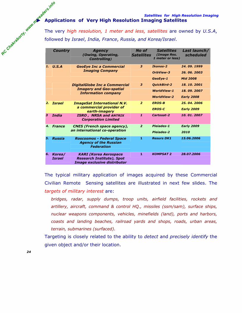
Satellites for High Resolution Imaging ► Applications of Very High Resolution Imaging Satellites
The very high resolution, 1 meter and less, satellites are owned by U.S.A,
followed by Israel, India, France, Russia, and Korea/Israel.
Country Agency (Owing, Operating,
Controlling)
No of Satellites
Satellites (Image Res.
1 meter or less)
Last launch/ scheduled
1. U.S.A 3 Ikonos-2 24. 09. 1999
GeoEye Inc a Commercial Imaging Company OrbView-3 26. 06. 2003
GeoEye-1 Mid 2008
3 QuickBird-2 18. 10. 2001
DigitalGlobe Inc a Commercial Imagery and Geo-spatial
Information company WorldView-1 18. 09. 2007
WorldView-2 Early 2008
2. Israel 2 EROS-B 25. 04. 2006
ImageSat International N.V. a commercial provider of
earth-imagery EROS-C Early 2009
3 India ISRO , NRSA and ANTRIX Corporation Limited
1 Cartosat-2 10. 01. 2007
4. France 2 Pleiades-1 Early 2009
CNES (French space agency),an international co-operation
Pleiades-2 2010
5. Russia Roscosmos - Federal Space Agency of the Russian
Federation
1 Resurs DK1 15.06.2006
6. Korea/ Israel
KARI (Korea Aerospace Research Institute), Spot
Image exclusive distributor
1 KOMPSAT 2
28.07.2006
The typical military application of images acquired by these Commercial
Civilian Remote Sensing satellites are illustrated in next few slides. The
targets of military interest are:
bridges, radar, supply dumps, troop units, airfield facilities, rockets and
artillery, aircraft, command & control HQ., missiles (ssm/sam), surface ships,
nuclear weapons components, vehicles, minefields (land), ports and harbors,
coasts and landing beaches, railroad yards and shops, roads, urban areas,
terrain, submarines (surfaced).
Targeting is closely related to the ability to detect and precisely identify the
given object and/or their location. 24

RC C
hakra
borty,
ww
w.m
yrea
ders.
info
Applications of high resolution images ◊ Image Resolution : 1 meter
Imaging satellites : Ikonos-2 (1999), OrbView-3 (2003) ,
Cartosat-2 (2007) offer 1 meter resolution.
− Resolution 1 meter is considered enough to :
Detect : all most any military utility; means location of a class of
units, objects, or activity of military interest.
Identify : all most any military utility; means determining their general target type. In fact, all military utility can be precisely identified, except few say – radar, supply dumps, rockets and artillery, missiles (SSM/SAM), surface ships, nuclear weapons components, vehicles.
Describe : Few military utility, like bridges, ports and harbors, coasts and landing beaches, railroad yards and shops, roads, urban areas, terrain, submarines (surfaced);
means their size/dimension, configuration/layout, component construction, and equipment count, etc.
− Resolution 1 meter is not enough to:
Analyze : any specific military entity
25

RC C
hakra
borty,
ww
w.m
yrea
ders.
info
Applications of high resolution images ◊ Image Resolution : 0.6 – 0.7 meter
Imaging satellites: QuickBird-2 (2001) offer 0.6 meter resolution; and
Imaging satellites: EROS-B (2006), EROS-C (2009) , Pleiades-1 (2009) ,
Pleiades-2 (2010) , offer 0.7 meter resolution.
− This resolution is considered enough to :
Detect : all most any military utility; means location of a class of units, objects, or activity of military interest.
Identify : all most any military utility; means determining their general target type.
In fact, all military utility can be precisely identified except very few say – radar, supply dumps, rockets and artillery, nuclear weapons components, vehicles.
Describe : few military utility, like - bridges, ports and harbors, coasts and landing beaches, railroad yards and shops, roads, urban areas, terrain, submarines (surfaced).
means their size/dimension, configuration/layout, component construction, and equipment count, etc.
− This resolution is even enough to:
Analyze : few military utility, like – urban areas, terrain,
26

RC C
hakra
borty,
ww
w.m
yrea
ders.
info
Applications of high resolution images ◊ Image Resolution : 0.4 meter
Imaging satellites: WorldView-1 (2007), WorldView-2 (2008) and
GeoEye-1 (2008) offer 0.4 meter resolution.
− This resolution is considered enough to :
Detect : all most any military utility; means location of a class of
units, objects, or activity of military interest.
Identify : all most any military utility; means determining their general target type.
In fact, all military utility can be precisely identified except - Nuclear Weapons Components, Vehicles
− This resolution is enough to :
Describe : few military utility, like - bridges, ports and harbors, coasts and landing beaches, railroad yards and shops,roads, urban areas, terrain, submarines (surfaced). means their size/dimension, configuration/layout, component construction, and equipment count, etc.
− This resolution is even enough to:
Analyze : few military utility, like – bridges, ports and harbors, railroad yards and shops, roads, urban areas, terrain, submarines (surfaced).
27

RC C
hakra
borty,
ww
w.m
yrea
ders.
info
Satellite Imagery Companies ► Commercial Satellite Imagery Companies
Viewing Earth from space have become necessary for every country.
Therefore, the world market of Geo-data and Space Imagery have grown
and would continue to grow towards Globalization of Terrestrial Information.
The United States, Israel, India, and France, hold the world market for
satellite based earth imagery. They run highly efficient operational Earth
Remote Sensing programs. They regularly supplement the space segment
with new satellite and become primary suppliers of earth imagery.
− They follow different models, e.g. United States follow the commercial
model, France and Israel follow public-private partnership, and India
follow state funding.
− They have different perception, interpretation and views about National
Security vis-a-vis Economic, Commercial, Technology and other interest.
Thus, the approaches they follow in their projects/programs (for
developing, funding, owning, controlling and marketing) ultimately decides
the growth of the space imagery market.
These countries and their respective agencies responsible for satellite based
earth imagery are reiterated here.
Country Agency (Owing, Operating, Controlling)
1. USA USGS and NASA
GeoEye Inc
DigitalGlobe Inc
2. Israel ImageSat International N.V.
3. India ISRO , NRSA and ANTRIX Corporation Limited
4. France CNES (French space agency)
Their approaches and commercial tie-up are stated below.
28

RC C
hakra
borty,
ww
w.m
yrea
ders.
info
Satellite Imagery Companies ◊ USGS and NASA : A joint Initiative
− National Aeronautics and Space Administration (NASA) develops and
launch the Landsat spacecrafts ;
− U.S. Geological Survey (USGS) handles the operations, maintenance,
and the management of all ground data reception, processing,
archiving, product generation, and world wide distribution.
◊ GeoEye Inc : Private Remote Sensing System Company
GeoEye Inc, Headquartered in Dulles, Virginia, USA, is a commercial
satellite imagery company, provides high quality, accurate imagery and
products to map, measure, monitor and manage the world. GeoEye
provides Microsoft and Yahoo! search engines 253 million square
kilometers of satellite map images.
− The company provides geospatial data, information and value-added
products for the national security community, strategic partners,
resellers and commercial customers.
− The company own and operates a constellation of three Earth
imaging satellites : IKONOS-2 (1999), OrbView-2 (1997), OrbView-3
(2003), GeoEye-1 (2008) and an International network of a dozen
ground stations, a robust image archive, and advanced geospatial
imagery processing capabilities.
− The company's products are enabling a wide array of applications
including intelligence gathering for national security and defense,
mapping, local government planning, and natural resources and
environmental monitoring.
− GeoEye is a public company listed on the NASDAQ stock exchange
under the symbol GEOY. 29

RC C
hakra
borty,
ww
w.m
yrea
ders.
info
Satellite Imagery Companies ◊ DigitalGlobe Inc : Private Remote Sensing System company
DigitalGlobe, headquartered in Longmont, Colorado with locations in
Washington D.C., is a world wide supplier of high-resolution commercial
satellite imagery. DigitalGlobe is the premier provider of imagery in
Google’s database (Google Maps, Google Earth).
− DigitalGlobe own and operate satellites QuickBird-2 (2001),
WorldView-1 (2007) and WorldView-2 ( 2008).
− DigitalGlobe´s constellation of satellites enables commercial and
government customers around the globe to access a broad selection
of geospatial information products from a single source.
− DigitalGlobe´s system features allow it to efficiently collect over 475
million square kilometers of imagery data annually. Thus,
DigitalGlobe populates and updates its image library with impressive
speed. 30

RC C
hakra
borty,
ww
w.m
yrea
ders.
info
Satellite Imagery Companies ◊ ImageSat International NV : An International Company
ImageSat International N.V. ("ImageSat") is a Netherlands Antilles
company with offices in Limassol, Cyprus and Tel Aviv, Israel. The
Company's offices in Tel Aviv supervise the construction of the EROS
family of satellites and the operations of ImageSat's main Ground
Control Station.
− ImageSat is an international (non U.S.) company.
− ImageSat's principal business is operating high-resolution satellites
and providing exclusive, autonomous high-resolution satellite
imaging services to Governments and their Defense Forces for
National Security and Intelligence applications.
− ImageSat is a commercial provider of high-resolution, satellite earth-
imagery collected by its Earth Remote Observation Satellite (EROS).
− ImageSat own and operate satellites EROS-A (2000), EROS-B (2006),
and EROS-C (2009) .
− ImageSat has partnered with a global network of ground receiving
station operators, value-added information processors to supply
EROS imagery data worldwide. These are :
ImageSat Israel, Ltd. Tel-Aviv , Israel;
Russian Federation, R&D Center ScanEx , Moscow, Russia;
IPT Informatica per il Territorio S.r.l., Rome Italy;
Earth Environment Info. Center - Hiroshima Inst. of Tech., Hiroshima, Japan;
Center for Space & Remote Sensing Research, National Central University
Taiwan;
Comision Nacional de Actividades Espaciales, Paeso Colon , Argentina;
CSIR/Satellite Applications Center SAC-icomtek, Pretoria, South Africa;
MDA Geospatial Services Inc* , Canada;
APOGEE Imaging International* , Lobethal, Australia;
Space Consulting S.A.* Athens, Greece;
[Note : ImageSat Distributors, at Canada, Greece and Australia currently does not serve as a ground receiving station.]
31

RC C
hakra
borty,
ww
w.m
yrea
ders.
info
Satellite Imagery Companies ◊ CNES : Public Estt. of Industrial and Commercial character
The Centre National d'Etudes Spatiales (CNES) is administratively a
public establishment of industrial and commercial character.
− CNES owns and operates the SPOT satellite system.
− SPOT IMAGE Corp. a private company and others of USA hold the
worldwide commercial operations.
− SPOT-5 is publicized as dual purpose serving both military and civil
needs.
Pleiades High Resolution Program : An International Co-Operation
Pleiades High Resolution Program is held under the supervision of CNES
Space Agency of France since 2000 as a part of the European Earth
Remote Sensing program.
− Pleiades is an international co-operation to meet the needs of civilian
and military users. The program is publicized as dual purpose serving
both military and civil needs.
− On January 29, 2001, an agreement was signed between the French
and Italian governments concerning Earth Observation co-operation,
on a dual system serving both military and civil needs.
− The implementation of military space policy in France involves
cooperation between both military and civilian agencies.
− France's military space program focuses primarily on advanced
Remote sensing satellites. 32
RC C
hakra
borty,
ww
w.m
yrea
ders.
info
Satellite Imagery Companies ◊ ISRO /NRSA / ANTRIX Corporation : Government of India
Indian Space Research Organization (ISRO) was established in 1969,
under Department of Space (DOS), Government of India.
− ISRO, Government of India, builds, launch and maintain the Remote
Sensing Earth Observation satellites.
− National Remote Sensing Agency (NRSA), an autonomous
organization under DOS, is responsible for acquisition, processing,
supply of aerial and satellite remote sensing data.
− NRSA also supports, through ANTRIX, establishment of International
Ground Stations and International reseller network to receive,
process and market data products globally.
− ANTRIX Corporation Limited, is the a leading provider of satellite
images worldwide and the marketing arm of ISRO under DOS.
− Antrix Corporation is marketing space products and services in the
global market. Twenty four stations including USA (10) and Russia
(4), across the globe now receive IRS data. In addition to
RESOURCESAT-1 and CARTOSAT-1 and the latest satellite,
CARTOSAT-2, have further enhanced the scope and continuity of
Indian earth observation satellite data services.
− The world archive of satellite data is being created through the
archive station at Svalbard, Norway, which has been used as a
virtual ground station for processing of CARTOSAT-1 data. A number
of resellers have been appointed for data sale to countries including
Canada, Greece and Turkey. 33

RC C
hakra
borty,
ww
w.m
yrea
ders.
info
Security and Regulations ► National Security and International Regulations
Space-based Remote Sensing consists of collecting data regarding the
surface of the earth via satellite. The information gathered from such data
can be used in many applications. The commercial availability of high-
resolution imagery presents both a great benefit to civilian sector and a
deep concern for national security. Such paradox is true every where, it is
true even for military users.
[The military is benefited from access to high-resolution commercial imagery, potentially
saving it the billions of dollars required to produce, field and operate such space-based
remote-sensing systems. There is a dark side, just as the military have access to high-
resolution commercial imagery, so will the general public and foreign entities, allies and
adversaries alike. Without proper protections, military movement and buildup, the lay-out
of military facilities and even the locations of individual pieces of military equipment could
be made available to the public eye within a matter of hours. This could have grave
consequences for military operations and national security.]
A solution if it is - Strike a balance between profitability and protection;
i.e., profitability to industry and protection to national security respectively.
The International Regulations related to National Security are illustrated :
− United Nations Treaties and Principles on Space Law [http://www.unoosa.org/oosa/en/SpaceLaw/treaties.html]
− U.S. National Space Policy [http://www.globalsecurity.org/space/library/policy/national/index.html]
− ISRO:EOS:POLICY-01:2001, Remote Sensing Data Policy (RSDP) , Indian Space Research Organisation
[http://www.isro.org/Announcement-opportunity/rdsp.pdf] [http://www.nrsa.gov.in/policy.html]
34

RC C
hakra
borty,
ww
w.m
yrea
ders.
info
Security and Regulations ◊ United Nations Treaties and Principles on Space Law
[http://www.unoosa.org/oosa/en/SpaceLaw/treaties.html]
The Committee on the Peaceful Uses of Outer Space is the only international
forum for the development of international space law. It has concluded
international legal instruments and legal principles governing space-related
activities. Extracts from the treaties and agreements are reproduced here.
■ Principles Relating to Remote Sensing of the Earth from Outer Space
[http://www.unoosa.org/oosa/en/SpaceLaw/gares/html/gares_41_0065.html] [resolution 3234 (XXIX) of 12 November 1974, the question of the legal implications of remote sensing of the Earth from space, with the aim of formulating draft principles relating to remote sensing. After a lengthy debate over whether remotely sensed data should be internationally available, the UNGA adopted the UN Remote Sensing Principles in the form of a non-binding Resolution on January 22, 1987.] Principle II : . . for the benefit and in the interests of all countries, irrespective
of . . economic, social or scientific technological development . . ;
Principle III : Remote sensing activities shall be conducted in accordance with
international law . . . ;
Principle IV : . . . activities . . on the basis of respect for . . sovereignty of all
States and peoples over their own wealth and natural resources . . . , rights and
interests, in accordance with international law, . . . Such activities shall not be
conducted in a manner detrimental to the legitimate rights and interests of the
sensed State;
Principle V : States carrying . . . activities shall promote international co-
operation . . . . shall make available to other States opportunities for participation
therein. Such participation shall . . . on equitable and mutually acceptable terms;
Principle VI : . . . to maximize the availability of benefits . . . States are
encouraged, through agreements . . . establishment and operation of data
collecting and storage stations and processing and interpretation facilities, . . . .;
Principle VII : States participating . . . activities shall make available technical
assistance to other interested States on mutually agreed terms;
Principle VIII : The United Nations . . . shall promote international co-operation,
including technical assistance and co-ordination in the area of remote sensing;
Principle IX : . . . article IV of the Convention on Registration of Objects
Launched . . . and article XI of the Treaty on Principles Governing the
Activities of States in the Exploration . . . , a State carrying out . . . remote
sensing shall inform the . . . United Nations. . . . make available . . . relevant
information . . . feasible and practicable to any other State, particularly any
developing country that is affected by the programme, at its request.
35
RC C
hakra
borty,
ww
w.m
yrea
ders.
info
Security and Regulations Principle X : Remote Sensing shall promote the protection of the Earth's natural
environment . . . .States . . . having identified information . . . that is . . . harmful
to the Earth's natural environment shall disclose . . . to States concerned.
Principle XI : Remote sensing shall promote the protection of mankind from
natural disasters. . . . States . . . that have identified . . . information . . . useful
to States affected . . . or likely to be affected by impending natural disasters, shall
transmit such data and information to States concerned as promptly as possible.
Principle XII : As soon as . . . data concerning the territory under its jurisdiction
are produced, the sensed State shall have access to them on a non-discriminatory
basis and on reasonable cost terms. The sensed State shall also have access to
the available analysed information concerning the territory under its jurisdiction in
the possession of any State participating in remote sensing activities . . . taking
particularly into account the needs and interests of the developing countries.
Principle XIII : To promote . . . international co-operation, . . . , a State carrying
out remote sensing . . . upon request, enter into consultations with a State whose
territory is sensed . . . make available opportunities for participation and enhance
the mutual benefits to be derived therefrom.
Principle XIV : In compliance with article VI of the Treaty on Principles
Governing the Activities of States in the Exploration . . . , States operating remote
sensing satellites shall bear international responsibility for their activities and
assure that such activities are conducted in accordance with these principles and
the norms of international law, irrespective of whether such activities are carried
out by Governmental or non-governmental entities or through international
organizations to which such States are parties. . . .;
Principle XV : Any dispute resulting from the application of these principles shall
be resolved through the established procedures for the peaceful settlement of
disputes.
36

RC C
hakra
borty,
ww
w.m
yrea
ders.
info
Security and Regulations ◊ U.S. National Space Policy
[http://www.globalsecurity.org/space/library/policy/national/index.html] ■ National Space Study Center – law , doctrine and policy
[http://space.au.af.mil/doctrine.htm]
■ Fact Sheet Foreign Access To Remote Sensing Space Capabilities - March 10, 1994, The White House Office of the Press Secretary [http://www.au.af.mil/au/awc/awcgate/space/pdd-23.htm ]
■ Fact sheet National Space Policy - september 19, 1996, The White House National Science And Technology Council (Obsolete as of 31 Aug 2006) [http://www.au.af.mil/au/awc/awcgate/sep96.htm]
■ A National Security Strategy of Engagement and Enlargement - February 1996, The White House (replaces previous editions of 1994 and 1995) [http://www.globalsecurity.org/space/library/policy/national/1996stra.htm]
■ U.S. national security and government regulation of commercial remote sensing from outer space – 2001, Air Force Law Review, Wntr, 2001 by Michael R. Hoversten. [http://findarticles.com/p/articles/mi_m6007/is_2001_Wntr/ai_75622168]
■ Fact Sheet U.S. Commercial remote sensing policy - April 25, 2003, Office of Science and Technology Policy(OSTP) [http://www.au.af.mil/au/awc/awcgate/space/2003remotesensing-ostp.htm] (This policy supersedes Presidential Decision Directive 23, U.S. Policy on Foreign Access to Remote Sensing Space Capabilities, dated 9 March 1994.)
■ Fact Sheet U.S. Commercial Remote Sensing Space Policy - May 13, 2003, The White House, Office of the Press Secretary [http://www.au.af.mil/au/awc/awcgate/space/2003remotesensing-ostp.htm] [http://www.globalsecurity.org/space/library/policy/national/space-030513-wh-8.htm] (last policy covering this area was issued in 1994)
■ U.S. National Space Policy - Aug 31. 2006, released Oct 06 2006, The White House , Office of Science and Technology Policy http://www.ostp.gov/html/US%20National%20Space%20Policy.pdf http://www.au.af.mil/au/awc/awcgate/whitehouse/ostp_space_policy06.pdf http://www.globalsecurity.org/space/library/policy/national/us-space-policy_060831.htm (This policy supersedes Presidential Decision Directive/NSC-49/NSTC-8, National Space Policy, dated September 14, 1996.) [The "Commercial Space Guidelines" at S.No 7 and "International Space Cooperation" at S.No. 8 are of immediate concern; readers may visit the site and read]
37

RC C
hakra
borty,
ww
w.m
yrea
ders.
info
Security and Regulations ◊ ISRO:EOS:POLICY-01:2001, Remote Sensing Data Policy (RSDP) ,
Indian Space Research Organisation [http://www.isro.org/Announcement-opportunity/rdsp.pdf] [http://www.nrsa.gov.in/policy.html] The Department of Space (DOS) of the Government of India is the nodal
agency for all actions under this policy. For acquisition/distribution of
remote sensing data within India, license/permission from the Government
of India, through the nodal agency, will be necessary.
− National Remote Sensing Agency (NRSA) of the DOS is vested with the authority to acquire and disseminate all satellite remote sensing data in India – both from Indian and foreign satellites.
− Government prescribes the following guidelines to be adopted for dissemination of satellite remote sensing data in India:
(a) All data of resolutions up to 5.8 m shall be distributed on a nondiscriminatory basis and on “as requested basis”; (b) With a view to protect national security interests, all data of 5.8 m and better than 5.8 m resolution images will be screened by the appropriate agency before distribution so that images of sensitive areas are excluded. (i) Data of 5.8m and up to 1m resolution can be distributed to users
after screening and ensuring the sensitive areas are excluded.
(ii) Data of 1m resolution and better will also be screened as above and the following procedure will be followed for its distribution.
1. Government users can obtain the data without any further clearance.
2. Private sector agencies, recommended by at least one Government agency for use of 1m and better resolution data for supporting development activities, can obtain it without any further clearance.
3. Other Private, Foreign and other users can obtain the data after further clearance from an inter-agency High Resolution Image Clearance Committee (HRC).
4. Specific requests for data of sensitive areas, by any user, can be distributed only after obtaining clearance from HRC.
5. Specific sale/non-disclosure agreements to be concluded between NRSA and users for data of 1 m resolution and better.
This policy comes into effect immediately and may be reviewed from time-to time-by Government.
38

RC C
hakra
borty,
ww
w.m
yrea
ders.
info
Security concern-views expressed ► Concern about National Security - Views expressed
[http://www.internationalreporter.com/news/read.php?id=1863]
[http://myreaders.wordpress.com/2007/06/04/17/]
The views reported in the world wide web about security related challenges
and threat because high resolution images are available commercially or
even freely in public domain.
Security concern expressed by Govt. of India
The then President A P J Abdul Kalam, while addressing the National Police
Academy at Hyderabad in mid-October, 2005, expressed concern over the
security threat posed by Google Earth's free mapping program available on
the internet.
The Indian Space Research Organization (ISRO) chief Dr. G Madhavan Nair
hadexpressed concern at high-resolution satellite images offered by Google.
[Ref : “Google Earth worries ISRO chief, wants dialogue”. Press Trust of IndiaNew Delhi, July 8, 2006, HT dated July 9, 2006]
Since then the Chief of Army Staff General J J Singh, Secretary DST Prof V.
S. Ramamurthy, Surveyor General Maj. Gen. M. Gopal Rao, and others
expressed that it could severely compromise a country's security.
39
RC C
hakra
borty,
ww
w.m
yrea
ders.
info
Security concern-views expressed Security concern expressed by experts
Many security experts in and outside the country, even within government
have articulated different view. The IDSA expert C. Uday Bhaskar, Sandia
National Laboratories Security analyst Vipin Gupta, GlobalSecurity.org
Director John Pike, FMNN Privacy Analyst Ravi Visvesvaraya Prasad and
others feel :
◊ “……it is is part of technology enabling characteristics of the present times"
◊ "…… you have multiple eyes in the sky, …… creating a transparent globe
where anyone can get basic information about anyone else, …… accept the
new reality: ……Times are changing, and the best thing to do is adapt to the
advances in technology ……";
◊ “…… June, 2005 launched website http://earth.google.com/, has allowed users
unrestricted access to satellite imagery that otherwise was hardly ever
available to the common man. The sophisticated images capture …… Earth'
geography and allow even street level viewing of cities but at the same time
feature sensitive military and political sites”;
◊ “What can the Indian government do to prevent terrorists or hostile forces
from viewing high resolution photographs of its sensitive installations? The
answer, in practical terms, is Absolutely Nothing At All.”
◊ “…… absolutely no practical, feasible method at present to prevent satellites
from photographing sensitive Indian sites. The only solution is to camouflage
them appropriately, or keep them underground or underwater, as had been
done for the Pokharan II blasts.”
◊ “…… call for limiting access to http://earth.google.com/ is also unfeasible,
since potential terrorists can access this website, or other similar websites
such as MSN TerraServer, from other countries without any restrictions
whatsoever.”
40

RC C
hakra
borty,
ww
w.m
yrea
ders.
info
Security concern-views expressed ◊ “…… several other sources from where images of far higher resolutions can be
obtained. DigitalGlobe's QuickBird satellite images have resolution 2 feet. The
Landsat-7 satellite offers 1.4-metre resolutions of almost any location in the
world for just one dollar per twenty square miles. Google's rival, Microsoft,
offers services such as MSN Virtual Earth, TerraServer, and TerraFly, similar to
Google Earth.”
◊ “…… assertion that "developing countries, which are already in danger of
terrorist attacks, have been singularly chosen for providing high-resolution
images of their sensitive sites, is also not entirely true. Millions of very high-
resolution photographs of US and NATO defence and nuclear installations are
available for free at Google Earth, …… show the White House; the
headquarters of USA's National Security Agency at Fort Meade, US chemical
weapons depots, US nuclear missile sites, and US and NATO defence bases all
over the world in far greater detail.”
◊ “…… India's defence forces state: …. we can also access high-resolution
photographs of terrorist camps in Pakistan-occupied Kashmir, as well as of
Kahuta and Sargodha".
◊ “…… The Indian government should instead focus on utilizing the high-
resolution photographs for positive purposes such as meteorology, hurricane
and cyclone forecasting, emergency and disaster relief, agricultural and
irrigation planning, mineral exploration, oil and gas exploration, monitoring soil
erosion and use of river waters, urban planning, etc.”
◊ “…… Indian civil society is already using data from Google Earth for positive
purposes. Former MP from Mumbai, Kirit Somaiya, said: …… Google Earth
made possible the study of the Mithi river, which was responsible for the
deaths of more than 600 people during the devastating rain and floods in
Mumbai last July …… unplanned development and encroachment along the
river banks were the root cause of the disaster …… no governmental agency
has a map of the Mithi river at all. …… in all official records, this river does not
even exist…"
41

RC C
hakra
borty,
ww
w.m
yrea
ders.
info
Security concern-views expressed ◊ “Reuters reports via CNN International. France Challenges Google Earth With
New Site JUN 23, 2006 - French President Jacques Chirac said it’s important
for his country to have such a site available because he wants France to keep
up with the fast pace of technological innovation today …… "
◊ “ Analysts say the average traffic to the most popular French websites is about
four million a day.”
◊ “ A French remote sensing company that specializes in products for
intelligence, security, and peacekeeping operations — has issued a study of
Google Earth, titled Google Earth Study: Impacts and Uses For Defence and
Security.”
42

RC C
hakra
borty,
ww
w.m
yrea
ders.
info
Conclusion
Should we continue such debate or look for solution ?
► Exploring the views, mentioned above, reported in the world wide web
about security related challenges vis-a-vis the emerging technology of the
present time in creating a transparent globe where anyone can get basic
information about anyone else, the general view is :
Google Earth and their competitors MSN Virtual Earth, TerraServer, and
TerraFly and others are trying to bring a revolution in “Globalization of
Terrestrial Information” about the world we live in.
However, I suggest few measures to safeguard the security aspects.
◊ Google Earth and all their competitors need to adopt a uniform policy to render
terrestrial details.
◊ About resolution of satellite imageries, this may be different but what is
important is that the resolution should be one and same for a particular class
of targets/objects and may have a different resolution for another class of
targets/objects. This means, if resolution say “R1” is set for all cartographic
features, then the resolution could be ‘R2” for all objects of military interest
but certainly not “R1” for some military objects and “R2” for other military
objects of same country or different country.
◊ Thus, the agencies need first to define/categorize targets/objects classes:
having cartographic features, having military interest, industrial units, power
generation units, areas of human settlement, forest region, mountainous
terrain, desert region, coastal region, and ocean etc. They then need to decide
on resolutions one and same or different for the target/object classes.
◊ Having defined and categorized targets/objects classes, then take decision on
resolutions. The decisions must be uniformly applicable to all countries,
irrespective of their geographic location, technology, economy, law and
values. The word resolution must not be generalized but mention clearly,
Resolution - Spatial / Radiometric / Spectral / Temporal / Height.
◊ These suggestions are doable, agreeable and sustainable forever. The
countries having large resources need to serve most and others having limited
resources can do their bit.
43

RC C
hakra
borty,
ww
w.m
yrea
ders.
info
References : Open sources – mainly internet.
Note :
1. This talk has been prepared, using information available from open sources,
mainly internet sources, for bring general awareness about high resolution
satellite images. There is no commercial interest, what so ever, is involved.
2. Readers are invited to place their comments.
44