satellite communication to support eu security policies
TRANSCRIPT

PwC & Ecorys
[January – 2016]
Satellite Communication tosupport EU Security Policies
and Infrastructures
Final report
Ref. Ares(2016)1563278 - 01/04/2016

Satellite Communication to support EU Security Policies and InfrastructuresFinal report
EUROPEAN COMMISSION
Directorate-General for Internal Market, Industry, Entrepreneurship and SMEsDirectorate I — Space Policy, Copernicus and DefenceUnit I.1 — Space policy and research
Contact: Sabine Lecrenier
E-mail: [email protected]
European CommissionB-1049 Brussels

Satellite Communication to support EU Security Policies and InfrastructuresFinal report
Directorate-General for Internal Market, Industry, Entrepreneurship and SMEs
Horizon 2020 - Framework Programme for Research and Innovation (2014-2020)
Work programme 2014-2015 – Activity 3
2016
Satellite Communication tosupport EU Security Policies
and Infrastructures
Final report

Satellite Communication to support EU Security Policies and InfrastructuresFinal report
LEGAL NOTICE
This document has been prepared for the European Commission however it reflects the views only of theauthors, and the Commission cannot be held responsible for any use which may be made of the informationcontained therein.
More information on the European Union is available on the Internet (http://www.europa.eu).
Luxembourg: Publications Office of the European Union, 2014
ISBN 978-92-79-57239-5DOI 10.2873/48575
© European Union, 2014Reproduction is authorised provided the source is acknowledged.
Printed in Belgium
Europe Direct is a service to help you find answersto your questions about the European Union.
Freephone number (*):
00 800 6 7 8 9 10 11
(*) The information given is free, as are most calls (though some operators, phoneboxes or hotels may charge you).

Satellite Communication to support EU Security Policies and InfrastructuresFinal report
5
1. INTRODUCTION .....................................................................................................9
Background ..................................................................................................91.1.
SATCOM services for Security .......................................................................101.2.
Presentation of the study .............................................................................121.3.
2. ANALYSIS OF CIVIL REQUIREMENTS REGARDING SATCOM (PHASE 1)........................14
Methodological approach for phase 1 .............................................................142.1.
Presentation of each user community, their main mission and the related current2.2.
/ future SATCOM usage................................................................................16
2.2.1 Border surveillance......................................................................................16
2.2.2 Maritime community....................................................................................21
2.2.3 Police missions ...........................................................................................29
2.2.4 Civil protection ...........................................................................................35
2.2.5 Humanitarian aid ........................................................................................39
2.2.6 EU external action.......................................................................................42
Presentation of each key infrastructure, their main mission and the related2.3.
current / future SATCOM usage.....................................................................46
2.3.1 Transport infrastructures: air traffic management ...........................................46
2.3.2 Transport infrastructures: rail traffic management ..........................................50
2.3.3 Transport infrastructures: road traffic management.........................................53
2.3.4 Space infrastructures & services: Copernicus..................................................55
2.3.5 Space infrastructures & services: GNSS programmes EGNOS & Galileo ..............59
2.3.6 RPAS communications .................................................................................62
2.3.7 Arctic communications .................................................................................66
2.3.8 EU institutional communications....................................................................70
Main missions - synergies between user communities & key infrastructures........722.4.
Clusters of missions and description of main consolidated requirements.............742.5.
2.5.1 SATCOM for Surveillance..............................................................................74
2.5.2 SATCOM for Crisis Management ....................................................................75
2.5.3 SATCOM for Key Infrastructures....................................................................77
Synthesis of phase 1: high level SATCOM user requirements ............................792.6.
2.6.1 Mission requirements...................................................................................79
2.6.2 Security requirements .................................................................................82
2.6.3 Communication requirements .......................................................................85
2.6.4 Terminal requirements.................................................................................87
2.6.5 Operational background ...............................................................................89
Key findings of phase 1................................................................................912.7.
3. LANDSCAPING EXERCISE (SOLUTIONS – PHASE 2) ..................................................92
Methodological approach for phase 2 .............................................................923.1.
Table of contents

Satellite Communication to support EU Security Policies and InfrastructuresFinal report
6
Systems used/planned to be used by user communities & key infrastructures.....933.2.
3.2.1 Border surveillance......................................................................................93
3.2.2 Maritime community....................................................................................96
3.2.3 Police missions ...........................................................................................97
3.2.4 Civil protection ...........................................................................................98
3.2.5 Humanitarian aid ...................................................................................... 101
3.2.6 EU external action..................................................................................... 102
3.2.7 Transport infrastructures: air, rail and road traffic management ..................... 103
3.2.8 Copernicus ............................................................................................... 107
3.2.9 GNSS programmes: EGNOS & Galileo .......................................................... 109
3.2.10RPAS communications ............................................................................... 113
3.2.11Arctic communications ............................................................................... 116
3.2.12EU institutional communications.................................................................. 117
3.2.13Synthesis ................................................................................................. 119
Risk / threat analysis ................................................................................. 1213.3.
3.3.1. Methodology presentation .......................................................................... 121
3.3.2. Activity 1: identification of risks and threats from a user perspective ............... 123
3.3.3. Activity 2: potential impact, probability of occurrence and mitigation measures
for each risk and threat.............................................................................. 124
3.3.4. Activity 3: severity score of each risk and threat on each main mission............ 126
3.3.5. Activity 4: risk / threat criticality for each main mission & for each user
community / key infrastructure................................................................... 130
3.3.6. A general SATCOM risk: the frequency issue................................................. 133
3.3.7. Third State controlling the system............................................................... 135
Fit / gap analysis....................................................................................... 1363.4.
3.4.1. Methodology............................................................................................. 136
3.4.2. Activity 1: identification and analysis of criteria and critical requirements derived
from phase 1 ............................................................................................ 137
3.4.3. Activity 2: definition of the coverage scale for the estimation of system coverage141
3.4.4. Activity 3: estimation of each system coverage with respect to the different
criteria and critical requirements required by user communities & key
infrastructures .......................................................................................... 141
3.4.5. Conclusions on risk / threat & fit / gap analysis............................................. 148
3.4.6. Conclusions regarding risk/threat analysis in terms of scenarios and technologies149
3.4.7. Conclusions regarding critical requirement analysis in terms of scenarios and
technologies ............................................................................................. 151
Key findings & recommendations regarding phase 2 ...................................... 1533.5.
4. PRESENTATION OF GOVERNANCE SCENARIOS & TECHNOLOGY ROADMAPS (PHASE 3)154
Methodological approach for phase 2 ........................................................... 1544.1.
Potential scenarios .................................................................................... 1554.2.
4.2.1. Preliminary remark.................................................................................... 155
4.2.2. Methodology used to define and analyse scenarios ........................................ 155
4.2.3. Baseline: No EU policy change .................................................................... 157
4.2.3.1 Description.................................................................................... 157
4.2.4. Scenario 1: Market Solution ....................................................................... 158
4.2.4.1 Description.................................................................................... 158
4.2.4.2 Procurement/ purchase options........................................................ 159
4.2.4.3 Budget estimations – Capacity leasing/ purchase ............................... 162

Satellite Communication to support EU Security Policies and InfrastructuresFinal report
7
4.2.4.4 Pros and cons ................................................................................ 162
4.2.4.5 Scenario 1 analysis ........................................................................ 164
4.2.5. Scenario 2: Member States Consortium ....................................................... 171
4.2.5.1. Description.................................................................................. 171
4.2.5.2. Procurement/ purchase options...................................................... 171
4.2.5.3 Budget estimations – Capacity leasing/ purchase ........................................ 172
4.2.5.4 Pros and cons ......................................................................................... 172
4.2.5.5 Scenario 2 analysis ........................................................................ 172
4.2.6. Scenarios 3 & 4: Development of a specific GOVSATCOM, through Public Private
Partnership or EU Space infrastructure......................................................... 175
4.2.6.1. Description.................................................................................. 175
4.2.6.2. Scenario 3: Public Private Partnership............................................. 175
4.2.6.3 Scenario 4: EU Space Infrastructure .......................................................... 181
4.2.6.4 Space segment options for scenarios 3 & 4................................................. 182
4.2.6.5 Scenarios 3 & 4 analysis vs criteria and critical requirements (including security
requirements & EU sovereignty / autonomy) ................................................ 188
4.2.7. Synthesis: potential scenarios..................................................................... 189
Technological developments ....................................................................... 1904.3.
4.3.1. Objectives & methodology.......................................................................... 190
4.3.2. Category 1: technologies/products identified with associated development
proposals & roadmap................................................................................. 191
4.3.3. Category 2: additional technologies/products identified.................................. 202
4.3.4. Category 3: specific needs recommended to support EU GOVSATCOM initiative 204
4.3.5. Synthesis: technological developments ........................................................ 205
5. CONCLUSIONS................................................................................................... 206
LIST OF ACRONYMS AND ABBREVIATIONS.................................................................... 210
ILLUSTRATION INDEX ................................................................................................ 214
ANNEX 1 - SATCOM TECHNOLOGY OVERVIEW............................................................... 215
ANNEX 2 - SATCOM FREQUENCIES .............................................................................. 216
ANNEX 3 - COMMERCIAL SATCOM MARKET................................................................... 217
ANNEX 4 - SATCOM USER REQUIREMENT FOR EACH MAIN MISSION (PHASE 1) ................ 218
ANNEX 5 - TYPE OF SERVICES NEEDED BY MAIN MISSIONS (PHASE 1)............................ 235
ANNEX 6 - QUANTIFICATION OF USERS’ DEMAND ......................................................... 237
1. INTRODUCTION ................................................................................................. 237
Aim ......................................................................................................... 2371.1.
Scope of the quantification: who is concerned? ............................................. 2371.2.
Quantitative elements presented in this analysis ........................................... 2371.3.
Sources of information & main difficulties encountered .................................. 2381.4.
2. GENERAL APPROACH: QUANTIFYING USERS’ DEMAND............................................ 239
Pooling together different satellite systems and services ................................ 2392.1.
2.1.1 Different satellite systems and services........................................................ 239
2.1.2 Different satellite networks......................................................................... 242
2.1.3 Measure parameter: the bandwidth ............................................................. 244
Measuring the bandwidth demand............................................................... 2462.2.
2.2.1 Identification of current, planned and potential GOVSATCOM use ..................... 246

Satellite Communication to support EU Security Policies and InfrastructuresFinal report
8
2.2.2 Number of terminals, connections and liaisons............................................... 250
2.2.3 Bandwidth estimation ................................................................................. 250
2.2.4 General simplifying assumptions .................................................................. 251
Consolidation of users’ demand................................................................... 2542.3.
2.3.1 Aggregated, instantaneous users’ demand and satellite capacity...................... 254
2.3.2 Users’ demand and delivered bandwidth ....................................................... 256
2.3.3 Forecast of the demand .............................................................................. 256
3. CONSOLIDATION OF USERS’ NEEDS..................................................................... 257
Consolidation of users’ needs for each usage (detailled quantitative analysis per3.1.
user community & key infrastructure presented in the next paragraphs) .......... 257
Estimated current usage and estimated 2020, 2025 & 2030 demand - IUD by3.2.
Region (in Mbps)....................................................................................... 260
Estimated current usage and estimated 2020, 2025 & 2030 demand - IUD by3.3.
user community (in Mbps).......................................................................... 261
Estimated current usage and estimated 2020, 2025 & 2030 demand - IUD by3.4.
user community (in Mbps).......................................................................... 262
4. ESTIMATION OF THE BUDGET REQUIRED TO COVER USERS’ DEMAND...................... 263
General simplified assumptions................................................................... 2634.1.
Estimated capacity cost for COMSATCOM, GOVSATCOM and MILSATCOM......... 2634.2.
Estimated budget required per year for COMSATCOM, GOVSATCOM and4.3.
MILSATCOM ............................................................................................. 264
5. DETAILED QUANTITATIVE ANALYSIS PER USER COMMUNITY & KEY INFRASTRUCTURE265
Maritime community.................................................................................. 2655.1.
Border surveillance.................................................................................... 2715.2.
Police missions ......................................................................................... 2765.3.
Civil protection ......................................................................................... 2805.4.
Humanitarian aid ...................................................................................... 2865.5.
EU external action..................................................................................... 2915.6.
Transport infrastructures : air traffic management ........................................ 2975.7.
Transport infrastructures: rail traffic management ........................................ 3035.8.
Transport infrastructures: road traffic management....................................... 3065.9.
Copernicus ............................................................................................... 3115.10.
GNSS programmes.................................................................................... 3135.11.
RPAS communications ............................................................................... 3185.12.
Arctic communications ............................................................................... 3265.13.
EU institutional communications.................................................................. 3295.14.
ANNEX 7 - JUSTIFICATION OF CRITERIA SEVERITY FOR EACH MAIN MISSION (PHASE 2) .. 333
ANNEX 8 - CRITICAL REQUIREMENTS BY MAIN MISSION (PHASE 2) ................................ 347

Satellite Communication to support EU Security Policies and InfrastructuresFinal report
9
1. Introduction
Background1.1.
The European Space Policy1, adopted in February 2007, recognizes “that spacetechnologies are often common between civilian and defence applications and that Europecan, in a user-driven approach, improve coordination between defence and civilian spaceprogrammes, pursuing in particular the synergies in the domain of security, whilstrespecting the specific requirements of both sectors and the independent decisioncompetences and financing schemes”.
The Commission in its 2013 Communication entitled “Towards a more competitive andefficient defence and security sector"2 presents concrete actions to meet the EuropeanCouncil request. In this Communication a chapter is dedicated to Space based upon theidea that “most space technologies, space infrastructures and space services can serveboth civilian and defence objectives. However, contrary to all space-faring nations, in theEU there is no structural link between civil and military space activities. This divide has aneconomic and political cost that Europe can no longer afford. It is further exacerbated byEuropean dependence on third country suppliers of certain critical technologies that areoften subject to export restrictions”.Satellite Communication has been identified as one of the areas for concrete action.“The Commission will act to overcome the fragmentation of demand for security SATCOM.In particular, building on the EDA’s experience, the Commission will encourage the poolingof European military and security commercial SATCOM demand; the Commission willexplore the possibilities to facilitate, through existing programmes and facilities, MemberStates efforts to deploy government owned telecommunications payloads on boardsatellites (including commercial) and develop the next generation of government-ownedMILSATCOM capability at European level”.
In December 2013, the Head of States and Government of the EU met to discuss Defenceand the Common Security and Defence Policy. In the Conclusions3, the European Council“welcomed the Commission communication "Towards a more competitive and efficientdefence and security sector". More specifically, the European Council welcomed plansregarding SATCOM: “preparations for the next generation of Governmental SatelliteCommunication through close cooperation between the Member States, the Commissionand the European Space Agency; a users' group should be set up in 2014; the EuropeanCouncil invites the Council, the Commission, the High Representative, the EuropeanDefence Agency and the Member States, within their respective spheres of competence, totake determined and verifiable steps to implement the orientations set out above”.
1 http://ec.europa.eu/enterprise/policies/space/documents/esp_en.htm2 http://ec.europa.eu/enterprise/sectors/defence/files/communication_defence_en.pdf3 http://www.consilium.europa.eu/uedocs/cms_Data/docs/pressdata/en/ec/140245.pdf

Satellite Communication to support EU Security Policies and InfrastructuresFinal report
10
Finally, the Competitiveness Council in its 5 December 2014 Conclusions4 “recognizes theprogress made with the implementation of the European Space Policy, in particular withthe entry into force of the European Satellite Navigation Systems and Programmes(European GNSS), Copernicus and Horizon 2020 programmes, the Space Surveillance andTracking (SST) Support Framework and UNDERLINES that their successful implementationconstitutes a priority.” On long-term vision and space policy, the Council “stresses that anambitious long-term European space vision among the EU, ESA, their respective MemberStates and other relevant European actors should allow: responding to public policyobjectives and user needs.” As on main emerging priority, the Council furthermore ”notesthe growing demand for GOVSATCOM and therefore underlines the importance ofinvestigating on potential forms of collaboration with Member States, with the foreseeableintent to resort to their GOVSATCOM assets to fulfil EU operational requirements”. Finally,the Council “invites the Commission to inform the Council and the European Parliament, by2016, on the progress made with regard to these conclusions.”
These activities are in line with the specific objectives of the Council Decision establishingthe specific programme implementing Horizon 20205. This programme aims to strengthenindustrial leadership and competitiveness by boosting Europe's lead through research,technological development, demonstration and innovation in the field of i) Enabling andIndustrial Technologies, ii) Information and Communication Technologies (ICT), and iii)Space.
SATCOM services for Security1.2.
SATCOM Services for security can be divided into three distinct capabilities: CommercialSATCOM, Military SATCOM, and Governmental SATCOM capabilities.
Figure 1 - Commercial SATCOM, Military SATCOM and Governmental SATCOM
Commercial SATCOM (COMSATCOM)
Mass market commercial SATCOM (COMSATCOM) is operated by private companies in acompetitive market. Most of the COMSATCOM market is driven by television (broadcast),but there are also much more advanced systems that involve renting or buying dedicatedcommunication stations (hereafter referred to as “terminals”). Government and securityusers are a small, though a high growth market for operators of SATCOM, the bulk of theirturnover being linked to consumer multimedia services (TV and Internet).
4 “Competitiveness Council Conclusions of 5 December 2014”5http://erc.europa.eu/sites/default/files/document/file/Specific%20Programme%20Horizon%202020_council_decision_establishing_the_specific_programme_implementing_Horizon_2020.pdf

Satellite Communication to support EU Security Policies and InfrastructuresFinal report
11
In terms of communication security - in particular security mechanisms to counter threatssuch as anti-jamming, protecting against interception and demodulation, preventingunauthorised access, detection & neutralisation of unauthorised activities – the level ofprotection currently implemented by commercial services is generally insufficient to meetthe information security requirements for Security Missions.
The COMSATCOM market is further described in Annex 3. These commercial services offerlimited security and offer users no control in the space segment. COMSATCOM usuallydoes not have specific protection guarantees in place in terms of access to the resourcenor the system's vulnerability to external attacks.
Military SATCOM (MILSATCOM)
MILSATCOM services are primarily intended for military missions at the national level, or inthe framework of EU CSDP or NATO operations.These services are dedicated to the more critical applications requiring advancedprotection (strong resistance to interference, military cryptography, resistance to nuclearexplosions in orbit and undetectable communications, etc.). Only five European MemberStates have MILSATCOM systems (France, Germany, United-Kingdom, Italy, Spain).
European MILSATCOM systems are technologically very similar to each other and evenlargely interoperable. However all attempts to lead a European project in this area havefailed for reasons of national sovereignty.For the same reason, Member States have clearly indicated that the MILSATCOM shouldnot be considered as a European Initiative as it is specific to military applications notcovered in this Framework.
Governmental SATCOM (GOVSATCOM)
GOVSATCOM services are a new SATCOM service-class that fits between mass marketCOMSATCOM services that do not offer guarantees related to robustness and sufficientavailability, and MILSATCOM services that are both too expensive and too difficult toimplement for conventional use in low or medium intensity crises.
According to the definition approved by the EDA it is "highly available satellitecommunication, providing a level of security with some resilience, obtained usingtechnological solutions available on the market with a minimum of changes."
This, primarily military, need is that the United States through the Wideband GlobalSATCOM Program (WGS) try to convince Allies to join their GOVSATCOM system, andtherefore, for the EU, becomes an issue of European autonomy.It is very likely however that the GOVSATCOM interest is in both security and civilianapplications of the infrastructure for which SATCOM communications is critical.
Some existing systems can though partially match the specifications of the futureGOVSATCOM service, especially in the case of the Franco-Italian satellite system Athena-Fidus, the Spanish XTAR MILSATCOM and the Luxembourg GOVSAT system.
The conclusions of the European Council and the 2014 Space Council recall thatcapabilities are owned and operated by the Member States and welcome the preparationsfor the next generation of Governmental Satellite Communication through closecooperation between the Member States, the Commission and the European SpaceAgency.

Satellite Communication to support EU Security Policies and InfrastructuresFinal report
12
Presentation of the study1.3.
In light of these developments, the Commission has realized a study, named:“Identification of the requirements for Satellite Communication to support EU SecurityPolicies and Infrastructures” to identify options for new activities that could be proposed inthe EU’s Space Program, including co-funding from the Horizon 2020 for activities such asthose related to the development of SATCOM for security space technologies.
This study identifies options to pool and share SATCOM for security within the EU andanalyses the expected gains essential for SATCOM for security users, benefits includingsystem integrity, resilience, security and interoperability.
To meet these objectives this study has covered the following three phases:
Phase 1 has analysed the current as well as future demand side (“user”). The userneeds cover key performance characteristics and cost-efficiencies, as well asevolutions in fixed service or mobile service SATCOM, terminal needs, geographicalarea coverage, local constraints, data link requirements, requirements related tosecurity of communication, etc.
Phase 2 was run parallel to the 1st phase, but was instead focus on identifyingcurrent and planned commercial and governmental SATCOM solutions that thevarious user communities could consider applying to meet the SATCOM requirementsfor the different situations considered under phase 1.
The third and final phase has provided strategic visions to optimize the developmentof SATCOM solutions for security, cost efficiency, interoperability and resilience, bothbefore and after 2020, including assessments for these scenarios. Technologyroadmaps are also proposed, identifying which research elements could besupported by Horizon 2020.
The entire three phases of the project have been implemented over a period of 12 months.
In addition, a quantitative analysis from user’s viewpoint (i.e. system and network solutionfree) was performed. The quantification of users’ demand aims at completing theidentification of users’ requirements with an estimation of the demand in terms ofbandwidth for all users and infrastructures defined in the first phase of the study.
Figure 2 - a three phase-study - (*): presented in annex

Satellite Communication to support EU Security Policies and InfrastructuresFinal report
13
One of the major drivers of the SATCOM study is to create the basis of a user-centricapproach that allow user communities to express their existing and future needs in termsof coverage, quality of service, capacity, cost, inter-operability and security. Futureapplication needs have been also identified so as to match any increases in future demand.As part of the study, two workshops and a final presentation were held:
The first workshop with users. Information and presentations are available on theevent webpage: http://www.pwc.fr/satcom-security-users-workshop.html
The second workshop with Industry and Agencies. Information and presentationsare available on the event webpage: http://www.pwc.fr/satcom-civil-security-industry-agencies-workshop.html
The final presentation with participants from first and second workshops.Information and presentations are available on the event webpage:http://www.pwc.fr/satcom-final-presentation.html

Satellite Communication to support EU Security Policies and InfrastructuresFinal report
14
2. Analysis of civil requirementsregarding SATCOM (phase 1)
Methodological approach for phase 12.1.
Scope of the study: who is concerned?
The following user communities have been identified and serve as references for theassessment of SATCOM needs for EU stakeholders:
Border surveillance Maritime community Police missions Civil protection Humanitarian aid EU external action
In addition, key infrastructures - sometimes transversal to some user communities - havealso been analysed:
Transport infrastructures: air, rail and road traffic management Space infrastructures & services: EGNOS & Galileo, Copernicus Remotely Piloted Aircraft System(RPAS) communications Arctic communications EU institutional communications
The notion of key infrastructure is addressing a transverse SATCOM enabled safety- andsecurity-critical capability or service supporting several or all user communities, such asCopernicus, Arctic-specific services, Galileo etc.Considering the emerging capacity of RPAS, which are currently tested by several usercommunities, it has been decided to consider them as another key infrastructure, beingeasier to assess at this early stage of effective deployment as a whole fleet possiblyallocated to several missions.
These user communities & key infrastructures are presented in the following paragraphs.
Overall methodology for phase 1
The methodology used to collect information has focused on three main activities:
The review of relevant documents (more than 100 documents reviewed) A SATCOM Security Users Workshop, held in Brussels at the beginning of March
2015 (approximately 80 participants from 19 EU Member States). Information andpresentations are available on the event webpage: http://www.pwc.fr/satcom-security-users-workshop.html
Several interviews & workshops with users from the different user communities &key infrastructures (about 40 persons interviewed)
These activities have enabled to define a set of main missions for each user communities &key infrastructures. 31 missions have been identified and are presented in the followingparagraphs.

Satellite Communication to support EU Security Policies and InfrastructuresFinal report
15
Then, for each main mission, short & mid-term (currently – 5 to 10 years) SATCOM needshave been collected from the three sources listed above and a list of consolidatedrequirements has been created. This list of user requirements for each main mission ispresented in annex.
This exercise has allowed us to consolidate critical SATCOM requirements from all the mainmissions of each user communities & key infrastructures: the final synthesis is presentedin the high level SATCOM user requirements (paragraph 2.6).
Figure 3 - overall methodology for phase 1
Satellite Communication to support EU Security Policies and InfrastructuresFinal report
16
Presentation of each user community, their main mission2.2.and the related current / future SATCOM usage
2.2.1 Border surveillance
Presentation
Europe’s border comprises 10,556 km of land borders and 50,641 km of coastline6 ofwhich the Schengen countries account for 9,000 km and 44,000 km respectively7, so a70/30% mix between sea borders (also known as ‘blue’ borders) and land borders (alsoknown as ‘green’ borders).
In any country the border management articulates two main components:
Border Control, which applies for people at the regular Entry Points: airports, seaports, and designated border passages for roads and railways. There are about1,880 designated EU external borders crossing points with controls. Almost half ofthese crossing points are at sea borders and nearly a third is at air borders8.Illustratively, about 700 million people are crossing EU external borders each year.
Border Surveillance, which applies anywhere else to prevent irregular crossings ofborders out of the regular entry points. In 2014, the Member States reported morethan 280 000 detections, which is twice as many as the previous record of 140 000in 2011 (year of the Arab Spring)9 of irregular border crossings attempts detectedat the EU’s external sea and land borders. Furthermore it is estimated that therewere up to 620 000 non-EU country citizens flagged in an illegal situation10. The2015 figures exploded literally, and there are yet no signs of decrease at the end ofthe year.
European border control is governed by the Schengen acquis which comprises a detailedseries of measures designed to compensate for the abolition of internal border controls byreinforcing security at the EU external borders. This means that external borders of the EUare managed differently for Member States part of Schengen Treaty and the others. TheSchengen area includes non EU States such as Switzerland, Lichtenstein, Iceland andNorway (except the Svalbard archipelago). It excludes EU States such as UK, Ireland andDenmark. Romania, Bulgaria, Cyprus and Croatia are due to join pending the finalassessment of their readiness and maturity which remain to be assessed positively.
Consequently, the Schengen area should evolve in a near future and Europe’s bordersshould increase, and the 70/30% mix between sea and land borders should further reducefor land borders when Romania and Bulgaria will be accepted, streamlining the landborders with Russia, Ukraine, Belarus and Moldova, while former Yugoslavia will form anenclave within the Schengen block. Distant islands (Azores, Canary Islands, French WestIndies, La Réunion, etc.) - but also enclaves such as Ceuta or Melilla on the South side ofthe Mediterranean Sea - are stretching far and extend the National Territory of several EUMember States. Such distant territories create furthermore vulnerable external borders tothe EU, requiring governmental communication for which the satellite seems to berelevant.
6 ESA / ESTEC final report : High Speed Bi-way Mobile Satellite Systems - 20117 Frontex website: http://frontex.europa.eu/operations/roles-and-responsibilities/8 List of border crossing points in the EU, annex IV (consolidated) to regulation EC° No 562/20069 Frontex Annual Risk Analysis, 201510 http://appsso.eurostat.ec.europa.eu/nui/show.do?dataset=migr_eipre&lang=fr

Satellite Communication to support EU Security Policies and InfrastructuresFinal report
17
The user community considered in this study is primarily the border surveillanceadministrations of the Schengen Countries. The responsibility for the control of theexternal borders of the Member States lies with the individual Member States. The nationalorganisations within each Member State with responsibility for border control are differentfor every Member State and comprise organisations such as the port-police and federaland local police, the national coast-guard, border guards, Guardia Civil, Guardia diFinanzia, customs and immigration services, drug enforcement agencies, etc. The dutiesand scenarios in which they perform vary, according to geography and circumstances.Responsibility for the financing and co-ordination of joint operations between MemberStates lies with Frontex, the European Agency for the Management of OperationalCooperation at the External Borders. As indicated in its founding regulation11, Frontex hasseveral tasks. First, it is to “assist Member States on training of national border guards,including the establishment of common training standards”. Then, it has to ensure a“follow up on the development of research relevant for the control and surveillance ofexternal borders” and to “assist Member States in circumstances requiring increasedtechnical and operational assistance at external borders”.
An example is the Eurosur system developed by Frontex following the Regulation (EU)1052/2013. This Regulation has formalized the legal framework of the system, “for thepurpose of detecting, preventing and combating illegal immigration and cross-border crimeand contributing to ensuring the protection and saving the lives of migrants”12. It appliesaccordingly to the surveillance of all external land and sea borders as well as to air bordersand to checks at other border crossing points at the discretion of individual participants.Eurosur involves a shared IT platform that enables participating authorities to instantly seeand assess the situation at and beyond the EU external border, with three layers ofinformation — events, operational information, and analysis.
Main missions identified and related current / future SATCOM usage
SATCOM allow connection to homebase and national authorities as well as to Frontex. Theuse of SATCOM is thus primarily related to mobile patrol assets and teams when deployedbeyond the range of terrestrial radio links. SATCOM are needed to transmit not only voicecommunications but also other data e.g. photographs, visa details, biometry, SchengenInformation Systems data, etc.
While the Eurosur infrastructure uses terrestrial governmental communication networks,the Member States often need SATCOM links to exchange information (e.g. videostreaming from a surveillance plane to the coordination centre) and to ensure fast, reliableand secure communication between e.g. patrol vessels.
Sea border surveillance
SATCOM is the more and more preferential way to communicate in high seas for SeaBorder Surveillance stakeholders since the use of HF communication cannot be insuredwith a high level of quality of service. Closer to coast, VHF and increasingly 3G are used,but the very constrained maritime VHF band can hardly support Broadband (VHF DataExchange System - VDES). Consequently, there is a general commercial move towardaffordable maritime broadband SATCOM.
Sea Border Surveillance more and more involves a cross-sectorial and cross-bordercooperation. Illegal immigration routes vary seasonally (sea state and storms) but also asan adaptation of smugglers to the measures taken to restrict departure or patrol at sea.While for the time being most of the current illegal immigration from Turkey to Greeceremains within territorial waters, fully suited for VHF LoS communications, the immigration
11 Regulation (EU) No 2007/2004 of 26 October 2004 establishing a European Agency for the Management ofOperational Cooperation at the External Borders of the Member States of the European Union12 Regulation (EU) N° 1052/ 2013 of 22 October 2013 establishing the European border surveillance system
Satellite Communication to support EU Security Policies and InfrastructuresFinal report
18
routes from Libya include significant areas of High Seas where large Off-Shore PatrolVessels (OPVs) are required and SATCOM appear most appropriate, In High Seas, Militaryassets are often involved alongside Police and/or Coastguard vessels, using eithercommercial or military SATCOM.
Land border surveillance
Up to now, land border surveillance only marginally required using SATCOM. However, theBalkans Crisis is currently requiring a very significant operational capability deployment onSouth-Eastern borders, supported by a capacity increase of FRONTEX under discussion. Inthe frame of such semi-continuous missions, SATCOM can help sharing local operationalpictures between headquarters, aerial surveillance and border patrols to secure effectiveinterception. When a particular event occurs, SATCOM may provide a portable solutionwhere 3G is unavailable. SATCOM usage has been assessed by FRONTEX as an average10% of the global data traffic generated by the additional land border surveillance effort.
This usage is expected to strongly increase with the use of more satellite imagery, pilotedsmall aircrafts with remotely operated surveillance equipment, and use of RPAS. Howeverthis denomination is today associated with costly military solutions, while the BorderSurveillance missions might be executed with much simplified systems such as theTEKEVER prototype currently tested by EMSA for maritime surveillance.
Pre-frontier surveillance
The use of Common Surveillance Tools defined in EUROSUR Regulation includes thesurveillance of the pre-frontier era of the EU. This pre-frontier includes the high-seas andthird world countries coast and land (as for example the West and North African countriesparticipating to the SeaHorse Network). Contrary to land and sea border surveillance, thefocus here is rather centred on early detection, meaning that space imagery (highresolution radar and optic) can potentially be an important source of data.
Observation of the pre-frontier is also conducted with aerial means, including RPAS.
Obviously aerial observation will take advantage from access to satellite communications,but also Earth Observation Satellites may also benefit as relays for their radar or opticsurveillance payload will be faster and hence have much higher added value for BorderSurveillance community.

Satellite Communication to support EU Security Policies and InfrastructuresFinal report
19
Synthesis: main missions related to border surveillance
Sea bordersurveillance
Description Mission location & duration Current / future in Arctic
Monitoring and control of external sea (or 'Blue') borders
Related activities: Detection of small boats from coastal radars, video cameras,
attended semaphores Air patrolling (incl RPAS in the future), maritime patrols Aggregation of ship tracking data (AIS, LRIT, S-AIS, VTS
radar, VDS from satellite etc.) Incidental sightings from fishermen, cargoes, ferries, cruise
ships, etc. Mandate an air or maritime patrol to assess the situation Decide to escalate as a SAR case (cf. Maritime user
community)
Location: Europe Duration: Permanent
No
SATCOM usage (current and potential) Main stakeholders Current / potential RPAS usage
SATCOM has become the preferred way to communicate beyondLine-of-Sight in high seas. HF is also used to communicate inhigh seas beyond LoS but is weather-dependent and very lowdata rate communication.Closer to coast, VHF and increasingly 3G are used. Landing spotscan be very small ports or beaches where terrestrial coms mightbe unavailable
Frontex; EMSA; National Authority operating coastalmaritime surveillance stations; Maritime Authoritiesdeploying airborne and maritime surveillance; BorderPolice and Migration Authorities; EEAS & originating thirdcountries e.g. through Seahorse; Merchant, fishing orpassenger ship Masters as first sighting
Yes: RPAS are already tested by FRONTEX andseveral MS (example Perseus and Closeye), andcould become common by 2020 onward; longendurance is essential; RPAS can be associatedas scouts to complement current maritimesurveillance planes in reconnaissance missions

Satellite Communication to support EU Security Policies and InfrastructuresFinal report
20
Land bordersurveillance
Description Mission location & duration Current / future in Arctic
Monitoring and control of external land (or 'Green') borders
Related activities: Detect and track approaching vehicles and groups of people Deter physical crossing Stop people, check ID and visas, apprehend if needed Record biometric data and other identification clues Provide temporary shelter while proceeding asylum
applications
Location: Europe Duration: Permanent
No
SATCOM usage (current and potential) Main stakeholders Current / potential RPAS usage
Tetra and Tetrapol remain by far the most used solutions;SATCOM needed in areas not covered by terrestrialnetworks (“last mile problem”) as increasingly smugglerstarget remote border sections
Data from EO satellites transmitted through SATCOM Remote sensing likely to develop (cameras, seismometers,
etc.)
Frontex; Europol; Border guards, border police; NationalSecurity agencies, customs; EEAS & originating thirdcountries
Yes: RPAS could be particularly efficient inthese missions to direct patrols more efficientlyand timely, should the operation cost decreaseand the insertion in airspace be solved
Pre-frontiersurveillance
Description Mission location & duration Current / future in Arctic
Ensure early preparation activities related to land and seaborder missions (early detection, surveillance): pre-frontierintelligence exchange for building common intelligence picturefor EU pre-frontier surveillance.
Location: Europe & bordering countries Duration: Permanent
No
SATCOM usage (current and potential) Main stakeholders Current / potential RPAS usage
Data from EO satellites transmitted through SATCOM Secure cross-border data exchange through SATCOM with
third countries (e.g. Seahorse/ MeBoCC) Will strongly increase with the use of more satellite imagery,
piloted small aircraft with remotely operated surveillanceequipment, and use of RPAS
Frontex; EUSC-EMSA; Europol; Border guards, borderpolice; National Security agencies, customs; EEAS andthird countries (to discourage departure and prosecutesmugglers)
Yes: RPAS are already tested by EMSA andseveral Member States, and could becomecommon by 2020 onward; long endurance isessential; long sensor range needed

Satellite Communication to support EU Security Policies and InfrastructuresFinal report
21
2.2.2 Maritime community
Presentation
Today maritime transport is the single most important means for international tradeaccounting for almost 90% of international imports and exports of goods worldwide. Thistrade has increased in volume by 70% between 1970 and 2010 while the tonnage hasmultiplied by 2.5 over the same period13. The interdependence of modern economiesmakes them particularly reliant on the fluidity of maritime supply routes. Therefore, wecan assume that this maritime traffic will continue to increase in the next years inparticular in EU seas and oceans.
For the purpose of this study, the maritime user community has been sub-structured alongthe six following activities:
The maritime safety and search and rescue The maritime security The fishery control The maritime transport The maritime resources exploitation The maritime environment protection
It is unanimously recognized that drawing a clear cut on what relates to “Security” and theother duties of these activities is quite impossible: at sea situations are rapidly evolutiveand change the nature of the mission, trafficking schemes are interlinked (drug or armscan be found when controlling an irregular fishing vessel), human trafficking and seaborder control most often results into SAR operations. And, last but not least, all types ofoperations relate to the same group of users with the same assets (maritime surveillanceaircraft, helicopters, patrol vessels and RPAS which benefit from a less restricted airspaceover the seas).
For each of these activities of the maritime management, the respective attributions of theNational Authorities, Ministries, Agencies, etc. greatly varies from a Member State toanother, resulting in yet unsolved interoperability challenges when interventions requirepooling assets from first responders of so diverse origin, culture and typical equipment.
Still, intervening in high seas requires naval assets generally operated by Naval Forces(heavy lift naval helos, large ocean going vessels with airlift capabilities, airborne maritimesurveillance instruments, etc.) while coastal patrolling requires only small boats availableto many administrations (border police, coast guards, customs, etc.), so the maritimecommunity appears de facto as a “Dual” domain of capabilities; NATO standardizationefforts insure that military assets are largely interoperable across Europe; but converselythis reveals to be a barrier for extending this interoperability (such as for SATCOM) to civilactors jointly involved in dual maritime response operations. VHF voice communications(and GSM where available) often reveal the only fully interoperable mean ofcommunication at sea.
The maritime user community is acknowledged as fragmented and heterogeneous. Inevery maritime European Member State, users are much more diverse (e.g. CISE – cf.also the following paragraph – federates ultimately more than 400 national agencies EU-wide, and could be extended in the long term also to the even broader commercial sector).
13 Source: UNCTADstat

Satellite Communication to support EU Security Policies and InfrastructuresFinal report
22
At a period when government's resources are under pressure, the fragmentation ofmaritime management authorities is recognized as a major area of political effort toimplement significant transformations such as streamlining organizations, implementingcoordination bodies, sharing assets and conducting joint patrolling and interventions - notonly cross-sectorial - but also cross-border.
Users belonging to the previous six activities have already identified the need to workclosely together, seek synergies and in particular share much more data and informationthan they were used to do. It is why they are all active in co-developing the CommonInformation Sharing Environment (CISE) in the framework of the European Maritime Policy(Blue Book, Blue Growth, Integrated Maritime Surveillance, etc.). The objective of thisambitious initiative is to foster cross-sectorial and cross-border information exchangesamong all maritime communities including Defence and Environment. The CISEdevelopment is supported by various projects with the intention of achieving the effectiveoperational value of these extended exchange schemes through large scale internationalstudies and trials. Concrete progress includes common semantics and cross-sectorial datamodels, concept of operations and public demonstrations of shared maritime situationawareness, etc.
Main missions identified and related current / future SATCOM usage
As VHF range barely exceeds 35 miles SATCOM have for many years been a vital link inmaritime activities on the high seas, both for boats and aircraft, in complementing HFcommunications in meeting the demand for data communications. In addition there is astrong trend towards integrating SATCOM devices on all helicopters now entering intoservice.RPAS are already being used by maritime users as, for instance, in the Italian MareNostrum operation.
Maritime safety and surveillance of maritime traffic
Maritime safety and surveillance is a core activity conditioning the rapid response time andaccuracy of information required in a security emergency. Satellite communication istherefore essential for maritime security and the protection of assets, providing a strongand reliable network of communications to analyse, report key issues and supportinterventions. Maritime surveillance cannot be performed solely from coastal stations andsatellite surveillance; maritime nations need to deploy short and long range assets in orderto perform maritime surveillance, proceed to rescue operations, provide medical assistanceand Search and Rescue (SAR) with long range specialized aircraft possibly associated inthe future with RPAS. In the same time, to increase trade efficiency and maritime security,merchant ships are increasingly “connected” to the ship owner centres of operationsthanks to the increased availability of broadband SATCOM in high seas (except HighNorth/Deep South where SATCOM capabilities are deficient).
At the EU level the European Maritime Safety Agency (EMSA) provides operationalmaritime Surveillance services for the benefit of Member States through the EuropeanUnion’s Maritime Information and Exchange System, SafeSeaNet. EMSA provides specificmaritime data services for EU Member States such as LRIT (Long Range Identification andTracking system for EUMS flagged vessels), CleanSeaNet (for EUMS EEZ waters), THERIS,the Integrated Maritime Data Environment (IMDatE) developed as integrated data portalfor EUMS maritime administrations, and the National Single Window (NSW) prototype -developed by EMSA with six Member States (Bulgaria, Greece, Italy, Malta, Romania andNorway) to enable data flows between the shipping industry and authorities in a MemberState, and between Member States, via SafeSeaNet.

Satellite Communication to support EU Security Policies and InfrastructuresFinal report
23
LRIT requires the use of SATCOM to transmit standardized position and identificationmessages at regular intervals from all cargo ships above 300T gross tonnage andpassenger ships. LRIT does not require broadband access, a requirement easily satisfiedby current commercial constellations except for Arctic and Antarctic. Other systems arebased on VHF ship position transmissions (AIS) among nearby ships also collected bycoastal stations further connected by terrestrial internet (SafeSeaNet, Marine Traffic, etc.).An alternative in high seas is to gather AIS emissions from ships through a satellite link,known as Sat-AIS.
IMDatE is a new integrated gateway to the various maritime data repositories managed byEMSA. EMSA also provides specific services to support joint operations such as EUNavFor(which are outside the scope of the present study) but also the maritime missions ofFRONTEX (cf. border surveillance) and European Fishing Control Agency (EFCA). These arelikely drivers of an increased demand of GOVSATCOM capacity.
Regarding the development of the Common Information Sharing Environment, in itselfCISE is “agnostic” regarding the communication channels specific to each user communityand participating state. However, in dealing with the entire maritime domain, SATCOM areimplicitly essential to support the increased data and information flow enabled by CISE.Concrete use cases already investigated in the framework of CISE highlight the need forSATCOM between vessels, aircraft and shore-based centres to transmit dual-waysituational data (radar plots, local/global traffic maps, access to databases, etc.), chat-type interactive messaging, pictures and - when circumstances dictate - video streams.These data are gathered locally by “CISE Nodes” which manage their possible access fromother nodes of CISE.
The Arctic region is becoming an area to consider. Regarding ice and polar technologies inparticular there is ongoing EU cooperation with Canada in the field of surveillance andtraffic monitoring in the North-West Passage, where EU technology is being deployed tomeet the Canadian need for maritime traffic monitoring and surveillance in its High North.
Maritime security, illegal activities at sea considered as security threats
This mission’s related activities includes fighting trafficking (weapons, explosives, etc.),illegal trade, piracy (including retention of hostages, seizure of ships, etc.) and armedrobbery at sea.Most of the time maritime security interventions in high or open seas are executed bynaval forces of major navies, with full MILSATCOM capabilities and additional COMSATCOMlinks. Consequently, fulfilling the identified needs may therefore be an opportunity tomutualise procurement of SATCOM capacity to private operators or to establish synergieswith GOVSATCOM.
Arctic might only become an area to consider in a very long term except if the Russia-EU-North America political stances would dramatically degrade.
Monitoring and control of fishery activities
This mission mainly refers to safeguarding sufficient stocks, fighting and deterring IUU(Illegal, Unreported and Unregulated) fishing (which remains a significant criminalactivity). Some specific features related to this mission may be highlighted. Indeed, fishingvessels have a specific obligation of position and activity reporting through SATCOMthrough the VMS system.

Satellite Communication to support EU Security Policies and InfrastructuresFinal report
24
In addition, fishery control often occurs in high seas, where no alternative communicationto shore are available. At the same time, fishery control is increasingly performed throughjoint operations with a diversity of assets with communication systems not interoperableexcept VHF. Images and videos from surveillance aircraft have to be transmitted promptlyto patrolling vessels, while secure communication are needed due to the sensitivecharacter of the fishery control data. SATCOM may therefore represent a possible solutionto these multiple issues.
Arctic waters are not yet significant fishing grounds. However, it is anticipated thatcommercial species will migrate in the high north as a consequence of sea water warming.
Maritime “Search and Rescue” (SAR)
It encompasses activities such as distress calls, rescue services, safeguard of life at sea,response to maritime accidents but also to plane accidents or crashes above the oceans. Itis worth noting that among the numerous international distress alert systems, several arebased upon SATCOM (e.g. Copsas-Sarsat). In the Arctic, past cases tend to demonstratethat SAR is also an issue in this region (e.g. after a crash of a Canadian military C130Hercules in 1991 on close proximity to radar station on Ellesmere Island, first rescuersarrived only 30 hours after the crash). Similarly, in August 2010, the coastguards took 55hours to arrive on site after the grounding of the Clipper Adventurer.
Arctic is also becoming an area to consider as the frequent presence of cruise ships raisesa very challenging issue in terms of SAR activities.
Response to maritime disasters (pollution response, etc.)
Considering maritime activity to monitor environment, initiatives such as Seas Europeanresearch Area on marine sciences have increased interest in the sea environment. This willrequire more maritime traffic in terms of supply and exchange of data, and deployment of“connected” data collection devices such as buoys and undersea gliders. This is also anissue in the Arctic region, where SATCOM is the only way to communicate in the Arctic Seaand airspace.
Overall these increasing activities finally raise important concerns about security and needfor regulation and general surveillance by governmental means including probably not onlypatrol vessels but more and more RPAS that need high level of communications. Onlymiddle altitude/long endurance MALE RPAS cooperating with / substituting maritimesurveillance aircraft may require broadband SATCOM links with guaranteed QoS. Theincreased use of Maritime RPAS is clearly stressed-out in the EU Maritime SecurityStrategy Action Plan, and EMSA has now engaged a demonstration programme ofmaritime pollution detection using low cost long endurance RPAS (TEKEVER).
Regarding the Arctic area, Arctic sea is acknowledged as an extremely fragile environment.In the same time oil & gas exploration is developing rapidly on the Arctic shores and therisk of major environmental accidents cannot be ignored. However today there are nocontingency plans and pollution response assets ready to address a major accident.Furthermore, there is not even a proper doctrine to manage maritime oil pollution inpresence of the ice shelf.

Satellite Communication to support EU Security Policies and InfrastructuresFinal report
25
Synthesis: main missions related to maritime community
Maritime safetyand surveillance
of maritimetraffic
Description Mission location & duration Current / future in Arctic
Ensure maritime safety and the surveillance of maritime traffic
Related activities: Monitor the actual route of every reporting vessel Detect abnormal kinematics and changes of route Assess if it relates to a possible risk for safety or security Actionate in situ control and intervention if deemed
necessary Monitoring of possible obstacles to navigation (off shore
work, lost cargo, floating debris, etc.)
NB: the monitoring of ice and icebergs is a specific mainmission
Location: World Duration: Permanent
Yes: Artic becoming an area to consider ; theupper north is well covered for S-AIS servicesbut Inmarsat-based LRIT would not work ;currently HF radio is about OK (still subject tometeorological disruptions), VHF only locallyinsured by shore stations, Copsas-sarsat relianton Inmarsat so unavailable as well
SATCOM usage (current and potential) Main stakeholders Current / potential RPAS usage
SATCOM has become the preferred way to communicate beyondLine-of-Sight in high seas. HF is also used to communicate inhigh seas beyond LoS but is weather-dependent and very lowdata rate communication.
Closer to coast, VHF and increasingly 3G are preferred
EMSA (SafeSeaNet services); Local maritime trafficmonitoring authority (usually coastguard); Ship Master;Ship owner; Flag State; Port(s) authority (e.g. for refuge);Coastguard
Yes: RPAS already tested by EMSA and severalMS, and should become common by 2020onward; long endurance essential; RPAS can beassociated as scouts to complement currentmaritime surveillance planes in reconnaissancemissions

Satellite Communication to support EU Security Policies and InfrastructuresFinal report
26
Maritimesecurity, illegalactivities at seaconsidered as
security threats
Description Mission location & duration Current / future in Arctic
Ensure maritime security, fighting against illegal activities at seaconsidered as security threats
Related activities: Fighting trafficking of weapons or chemical precursors of
explosives, chemicals or equipment for undercoverednuclear programmes, possibly nuclear materials or wastesfor dirty WMDs, breaching embargoes or supplying terroristgroups
Fighting illegal trade that contribute to fund terrorist groupsthat can include endangered species, people trafficking, oil,drugs, etc.
Fighting piracy and armed robbery at sea, that can includeretention of hostages, seizure of ships and/or cargo, etc.
Location: World Duration: Permanent
Yes: Arctic might only become an area toconsider in a very long term except if theRussia-EU-North America political stanceswould dramatically degrade
SATCOM usage (current and potential) Main stakeholders Current / potential RPAS usage
SATCOM has become the preferred way to communicate beyondLine-of-Sight in high seas. HF is also used to communicate inhigh seas beyond LoS but is weather-dependent and very lowdata rate communication.
Closer to coast, it remains much more secure than VHF or GSM ifmilitary communications are not available (as most of the timemaritime security interventions at sea are executed by Navalforces of major navies, with full military communicationscapabilities)
Europol; Frontex; EMCDDA; JTIAF-S; MAOC-N, CECLAD-M; National Security agencies / customs / anti-drug, etc.;EMSA (ship tracking services); Ship Master; Major shipowners (Maersk, CMA-CGM etc.); Navy / Coastguard /maritime police / customs
Yes: RPAS less detectable than maritimesurveillance planes and should be particularlyefficient in these missions

Satellite Communication to support EU Security Policies and InfrastructuresFinal report
27
Monitoring andcontrol of fishery
activities
Description Mission location & duration Current / future in Arctic
Monitoring and control of fisheries activities, includingimplementation of fishery regulations and deterrence of IUUfishing
Related activities: Safeguard sufficient stocks, as modern fishing vessels might
deplete in only few years the whole stock of valuablespecies up to the point of extinction if fishing activitieswould be left unregulated and uncontrolled
Fight and deter IUU (Illegal, Unreported and Unregulated)fishing that remains a significant criminal activity, oftenconnected with organized crime
Control fishing gears and catches conformity to regulation
Location: World Duration: Permanent
Yes: Arctic waters are not yet significant fishinggrounds; it is however anticipated thatcommercial species (cod etc.) will migrate inthe high north as a consequence of sea waterwarming
SATCOM usage (current and potential) Main stakeholders Current / potential RPAS usage
Fishing vessels have a specific obligation of position andactivity reporting through SATCOM through the VMSsystem
Fishery control often occurs in high seas, where noalternative coms to shore are available
EFCA; EEZ State fishery control agency; Flag State fisherycontrol agency; Ship master; UN fishery resourcesmanagement agencies; Coastguard, if mandated tocontrol fishing vessel
Yes: RPAS already tested by EMSA and severalMS, and should become common by 2020onward; long endurance is essential; RPAS canbe associated as scouts to complement currentmaritime surveillance planes in reconnaissancemissions
Maritime“Search and
Rescue” (SAR)
Description Mission location & duration Current / future in Arctic
Manage maritime SAR activities
Related activities: Distress calls, rescue services, safeguard of life at sea Response to maritime accidents Response to plane accidents / crashes above the oceans
Location: Europe Duration: When event occurs
Yes: Arctic becoming an area to consider; thefrequent presence of cruise ships raises a verychallenging issue should SAR operations beneeded
SATCOM usage (current and potential) Main stakeholders Current / potential RPAS usage
Today VHF remains the most commonly usedcommunication system in SAR operations. However,SATCOM has become the preferred way to communicatebeyond Line-of-Sight in high seas. HF is also used tocommunicate in high seas beyond LoS but is weather-dependent and very low data rate communication
Among the numerous international distress alert systems,several are based upon SATCOM (e.g. Copsas-Sarsat)
MRCC and associated rescue services providers; ShipMaster; Ship owner; Flag State; Port(s) authority ofrefuge; Insurance broker; Possibly the ship builder;Salvage Master; Nearby ships (reroute for assistance);Navy / Coastguard etc.
No: Manned aircraft (and helicopters inparticular) are needed to rescue people, so thecontribution of RPAS is likely to remainmarginal for these missions

Satellite Communication to support EU Security Policies and InfrastructuresFinal report
28
Response tomaritimedisasters
(pollutionresponse, etc.)
Description Mission location & duration Current / future in Arctic
Early detection and response to maritime disasters
Related activities: Early detection of maritime pollutions (oil spills etc.) either
originating from land, from off shore infrastructures orfrom ships
Pollutions response preparedness Pollution control and de-pollution Impact assessment
Location: World Duration: Permanent
Yes: Arctic sea acknowledged as a fragileenvironment; in the same time, oil & gasexploration is developing rapidly on the Arcticshores and the risk of major environmentalaccidents cannot be ignored. However todaythere are no contingency plans and pollutionresponse assets ready to address a majoraccident. Furthermore, there is not even aproper doctrine to manage maritime oilpollution in presence of the ice shelf.
SATCOM usage (current and potential) Main stakeholders Current / potential RPAS usage
Today VHF remains the most commonly usedcommunication system in maritime disaster responseoperations. However, SATCOM has become the preferredway to communicate beyond Line-of-Sight in high seas. HFis also used to communicate in high seas beyond LoS but isweather-dependent and very low data rate communication
Satellite radar imaging is a primary source of pollutionalerts (e.g. CleanSeaNet)
Use of small planes or RPAS with real-time datalinks tomonitor the situation (utilisation of terrestrial and satellitecommunications)
EMSA (CleanSeaNet service, prepositioned responsevessels ready to be hired by MS authorities); MRCCseconded by environment agencies; Ship Master; Shipowner incl hiring of salvage resources; Flag State;Insurance broker; Ad-hoc governmental response taskforce; Associations, volunteers, etc.; Coastal disasterresponse organisations, when pollution reaches shores
Yes: Airborne surveillance extremely efficientto monitor the sea surface; as most ofpollutions involve carbohydrates with adensity lower than seawater, RPAS , aerostats rtethered balloons with optic and radar sensorswould reveal extremely cost efficient; stilltoday manned planes are the primary assets inuse, but drones should become common from2020 onward, as the airspace above a majordisaster area can be managed specifically

Satellite Communication to support EU Security Policies and InfrastructuresFinal report
29
2.2.3 Police missions
Presentation
The EU Police community gathers all the organisations, services, bodies of personsempowered by Member States and EU institutions to enforce the law and struggle againstorganised crime and terrorism within a defined legal or territorial area of responsibility.Depending Member States, organisations and services relevant to law enforcement may bevarious and quite heterogeneous. In some Member States, military services are alsoresponsible for policing in both the armed forces and in the civilian population (mostgendarmeries, such as the French Gendarmerie, the Italian Carabinieri, the SpanishGuardia Civil and the Portuguese Republican National Guard also known as GNR).Alternative names for police forces include constabulary, gendarmerie, police department,police service, crime prevention, protective services, law enforcement agency or civilguard.
The EU Police community acts through several institutions/bodies, mainly:
Directorate-General for Migration & Home Affairs: the mission of this DG lays ontwo main pillars14:
o “Building a common EU migration and asylum policy”, by “developing abalanced and comprehensive EU migration policy, based on solidarity andresponsibility”, while also setting up a “Common European Asylum System,based on solidarity and respect for fundamental rights, to ensure effectiveprotection for the people who need it”;
o “Ensuring EU security”, in order to fight terrorism and organized crime, “bypromoting police cooperation and by preparing to swiftly respond toemerging crises”
Europol: the mission of this EU agency is “to support its Member States inpreventing and combating all forms of serious international crime and terrorism”15
European Monitoring Centre for Drugs and Drug Addiction (EMCDDA): as specifiedin its recast regulation, it aims at providing the EU and the Member States with“factual, objective, reliable and comparable information at European levelconcerning drugs and drug addiction and their consequences16”
Eurojust: its role is to “stimulate and improve the coordination of investigations andprosecutions between the competent authorities in the Member States andimproves the cooperation between the competent authorities of the Member States,in particular by facilitating the execution of international mutual legal assistanceand the implementation of extradition requests. Eurojust supports in any waypossible the competent authorities of the Member States to render theirinvestigations and prosecutions more effective when dealing with cross-bordercrime”17
In the past fifteen years police cooperation in the EU has been focused on theestablishment of national coordination mechanisms within the states as illustrated by thedeployment of 140 liaison officers at Europol. However, recent developments underline anincreasing need of decentralised processes for cooperation of MS police units. There wouldbe some technological and communications issues for the coordination between all units at
14 DG Migration and Home Affairs’ website, http://ec.europa.eu/dgs/home-affairs/who-we-are/about-us/index_en.htm15 Europol’s website, https://www.europol.europa.eu/content/page/europol%E2%80%99s-priorities-14516 Regulation N° 1920/2006, 12 December 2006, on the European Monitoring Centre for Drugs and DrugAddiction (recast)17 Eurojust website, http://eurojust.europa.eu/about/background/Pages/mission-tasks.aspx"

Satellite Communication to support EU Security Policies and InfrastructuresFinal report
30
a sub-state level. For instance, the emergence of joint commissariats in European borderregions is likely to deal with increasing issues of migration and law enforcement.
At the supra-state level, there will be more and more demand for coordination. It is thecase between Europol and Interpol especially in the matters of communication andinformation systems.
Regarding the fight against terrorism, international terrorism can take advantage of globalarrangements such as air travel and the internet and seems now assuming a new form,motivated by a desire to destroy the world and democratic communities. Weapons of massdestruction (chemist, biologics) may be more and more easily disseminated. Chemicalindustrials sites can be also attacked. These activities are conducted in order to spreadmaximum terror in a population. The police will not only have to develop new strategiesand to deal with populations affected. Again, well-established global and cross borderpolicing arrangements could well be useful in such situations. While globalisation thus hasthe ability to place great pressures on the police of all nations, it would also provide somedemand for a better coordination and thus communications.
Main missions identified and related current / future SATCOM usage
Fight against international drug traffic within EU MS areas of jurisdiction
This mission relates to the fight against international drug smuggling and interception ofdrug traffic from reaching the EU market. As described above, the investigations begin andsometimes interception may intervene in high seas far sometimes from European “bluefrontier”.
Most of the time investigations and interception are executed by dedicated services andforces like customs, coast guards, police or gendarmerie forces and in the case of the highseas by armed forces and need efficient coordination under high constraints ofconfidentiality.
The mission response generally includes many phases: information, response organisation,localisation, interception, seizure and legal pursuits.Communications including data, pictures and videos from surveillance units have to beexchanged promptly and seamlessly between HQ and intervention units while using highlysecure links. Not currently technically mandatory as for maritime domain, SATCOMtherefore represent a probable solution to the multiple issues and to better coordinate theactions of the dedicated services especially in cross border interventions or in remote ormountainous areas.
Fight against international organized crime groups (OCG)
This main mission relates to the fight against the most serious forms of internationalcrime, such as terrorism, drug trafficking and people smuggling, focusing on the targetingof criminal organisations. At the same time, fight against counterfeiting and infringementsof intellectual property rights are becoming increasingly widespread. They now includecommodity goods and pharmaceuticals. Cybercriminality is also a rising challenge the EUintends to tackle, since it affects critical infrastructure and information systems in the E.U.Activities related to illegal immigration are performed in collaboration with the BorderSurveillance user community.
For this mission, both SATCOM and terrestrial communication are used, depending on theavailability of the terrestrial network on the event’s location. Processes and issuesencountered are similar as these presented in the previous mission ‘fight againstinternational drug traffic’.

Satellite Communication to support EU Security Policies and InfrastructuresFinal report
31
Communication for Europol
Secured communications are mandatory to exchange information (e.g. on ongoinginvestigations) and support law enforcement activities of the Member States.Communication links are needed between Europol in La Haye (including the 145 Europolliaison officers) and the MS's National law enforcement organisations. In this perspectiveSATCOM can be considered as a back-up layer, communications being mainly terrestrial.
National police missions within EU territories
Due to national and political histories, police and gendarmerie forces and organisations arequite heterogeneous in the EU states with various models and sub-models:
Centralized, federal, national, regional or decentralised Military or civilian forces Impact of judicial in missions Scope of intervention of other administrations Specialised roles and missions
The three main European policing models are described below and most of EU policeorganisations might be classified according one of these models:
Germany organisation is characterized by a federal police force subordinated tominister of interior and ordinary police under the administration of each Germanstate
The French police is composed of three centralized forces, two of which have thesame mission but different jurisdictions at a national scope (rather urban or rural):National Police and National Gendarmerie and Municipal Police at local level.Portugal, Italy, Spain, Netherlands and Belgium have quite similar organisations
In the United Kingdom, law enforcement is organized at the level of administrativedistricts, in England and Wales defined as Home Office police forces(constabularies)
In a rough order of magnitude, the spectrum of missions is quite the same and globallyincludes the main following missions and tasks:
Maintenance of public order: law and order, enforcement of legislation patrollingthe streets and other public places, investigating criminal offences, protection ofnational buildings, dealing with issues of unlawful trafficking, traffic police
Ensuring public safety: protection of individuals and their properties, informs,warns and rescues, assistance in emergency or natural disaster, conductingsecurity operations (e.g. patrols, traffic control, identity checks), dealing with majordemonstrations, sporting events, transport police - waterways Police control trafficmonitoring in particular the transport of hazardous material and/or dangerousgoods, aerial police units deployed for tasks such as traffic surveillance, security atinternational airports and on railways, etc.
Investigating and prosecuting criminal offences, conducts criminal enquiries, servessearch warrants, etc. as well as maintaining specific “judiciary police” services
Other missions may also be accomplished by police forces but are out-of-scope of thismain mission (already covered within the scope of others main missions presented in thisdocument) such as border surveillance, coast guard services, counter-terrorism forces,supporting international police missions for EU or UN, rescue helicopter service (e.g.‘Peloton de Gendarmerie de Haute Montagne’ - PGHM in France).

Satellite Communication to support EU Security Policies and InfrastructuresFinal report
32
For all these missions, SATCOM is mainly used as a backup for Tetra network, but could beused as a main communication link in some remote areas. Some regional or local policeforces thus need secure data transmission via satellite from remote field-vehicles to theircentralized systems. It gives greater command and control at the scene of a transitoryevent and complements existing technologies such as mobile services via LTE/4G/5G.
Over the last decade, in a few countries, satellite broadband has become an establishedand integral part of command and communications for some emergency services.Throughout a few countries such as UK, Police services have installed Ku-band and –increasingly – Ka-band antenna systems onto both new and existing incident commandvehicles, delivering data and resilience capabilities.
Services used via satellite connectivity are mainly Internet access, email, basic informationsharing, pictures and more and more video. Other services such as Voice over IPtelephony and Virtual Private Networking are also used to provide resilient telephony andto connect into corporate networks.

Satellite Communication to support EU Security Policies and InfrastructuresFinal report
33
Synthesis: main missions related to police missions
Fight againstinternational
drug trafficwithin EU MS
areas ofjurisdiction
Description Mission location & duration Current / future in Arctic
Fight against international drug smuggling, interception of drugtraffic from reaching the EU market
Location: Europe Duration: When event occurs
No
SATCOM usage (current and potential) Main stakeholders Current / potential RPAS usage
Not currently technically mandatory as for maritime domain,but SATCOM therefore represent a probable solution to themultiple issues
Europol; EMCDDA; JTIAF-S; MAOC (EMSA); Coast Guards;Police department; FRONTEX; Customs
Yes
Fight againstinternational
Organised CrimeGroups (OCG)
Description Mission location & duration Current / future in Arctic
Fight against international organised crime groups (OCG) forthe most serious forms of international crime (e.g.: illegalimmigration, trafficking in Human Beings, counterfeit goods,excise and MTIC fraud, illicit firearms trafficking, organisedproperty crime, cybercrime, terrorism, etc.)
Location: Europe Duration: When event occurs
No
SATCOM usage (current and potential) Main stakeholders Current / potential RPAS usage
Both terrestrial and SATCOM communications are usedEuropol; Police or gendarmerie department; FRONTEX;Coast guards and customs; National justice bodies
Yes

Satellite Communication to support EU Security Policies and InfrastructuresFinal report
34
Communicationfor Europol
Description Mission location & duration Current / future in Arctic
Communication between Europol in La Haye and the MS'sNational law enforcement organisations
Location: Europe Duration: Permanent
No
SATCOM usage (current and potential) Main stakeholders Current / potential RPAS usage
Communication are mainly terrestrial, SATCOM as a back-uplink
Europol; Europol liaison officers (145 persons);National law enforcement organisations
No
National policemissions within
EU territories
Description Mission location & duration Current / future in Arctic
Ensure administrative police with current tasks such assafety checks, traffic controls, assistance to people inimminent danger, protection duties, etc.
Ensure judicial police, handling penal law enforcement andinvestigation of crimes
Ensure upholding public orders
Location: Europe Duration: permanent for administrative police & when
event occurs for judicial policeNo
SATCOM usage (current and potential) Main stakeholders Current / potential RPAS usage
Mainly terrestrial communications are used at the exception ofa few countries where SATCOM infrastructures are deployedoften at a local level
National, regional or local law enforcement organisationsdepending on the type of police organisation
Yes: general road traffic surveillance, criticalinfrastructures surveillance

Satellite Communication to support EU Security Policies and InfrastructuresFinal report
35
2.2.4 Civil protection
Presentation
The concept of Civil Protection emerged in Europe in the early 1980s and followed theestablishment of initiatives in France and Italy to assess the level of risk posed by floods,landslides, volcanic activity and earthquakes, but also man-made hazards.
The type of disaster hazards is largely dependent on the geography and climate of the EUindividual nations concerned. Many southern States are especially concerned byearthquakes or forest fires, while in northern Europe disasters tend to be smaller andrelated to technology, such as industrial or transport accidents.
In some cases, countries are able to cope with such catastrophes on their own. Butsometimes emergency assistance is required from other nations and it is within thiscontext that the European concept of Civil Protection has been implemented.
In its simplest form, the aim of Civil Protection is to minimise the impact of catastrophicevents. Civil Protection organisations are those which coordinate the necessary actions tomitigate and, where possible, prevent the risk of disasters. Civil Protection is involved withthe construction of specific knowledge, the ability to issue early warnings, the ability toreach people through different information channels, the capacity to coordinate humanresources and the technology needed to cope with calamities.
For each of these activities, the respective attributions of the National Authorities,Ministries, Agencies, etc. greatly varies from a Member State to another, resulting ininteroperability challenges when interventions require pooling assets from first responders.What significantly also vary within the different MS are the mechanisms of coordinationbetween civil protection and fire and rescue services, ambulance and police. For instance,in France, the State ensures the coherence of civil safety policy, a mission carried out bythe General Directorate of Civil Safety and Crisis Management and implemented at thedecentralised level by zone prefects and department prefects. On the ground, this role isfulfilled by the departmental fire and emergency services, which are public departmentalentities.
At European level, the European Community Humanitarian Office (ECHO) was created in1992 as an expression of the European solidarity with people in need all around the world.In 2004 it became the Directorate-General for humanitarian aid and integrated the civilprotection in 2010 for a better coordination and disaster response inside and outsideEurope.The Treaty on the Functioning of the European Union (TFEU) provides a legal frameworkfor achieving humanitarian aid and civil protection at EU level, since “the Treaty of Lisbonunderpins the commitment of the EU to provide assistance, relief, and protection tovictims of natural or man-made disasters around the world (art. 214), and to support andcoordinate the civil protection systems of its Member States (art. 196). It furthermandates the European institutions to define the necessary measures for such actions tobe carried out”18.
DG ECHO supports and complements the prevention and preparedness efforts ofparticipating States, focusing on areas where a joint European approach is more effectivethan separate national actions. In this context, the EU Civil Protection Mechanism wasestablished in 2001, fostering cooperation among national civil protection authoritiesacross Europe.
18 DG ECHO website, http://ec.europa.eu/echo/who/about-echo/legal-framework_en

Satellite Communication to support EU Security Policies and InfrastructuresFinal report
36
The scope of the mechanisms is composed of 3 main phases: prevention and preparednessactions inside the Union and, to a certain extent, also outside the EU and actions to assistwith the response to immediate adverse consequences of a disaster inside or outside theEU (following a request for activation of the mechanism)19.
Since its launch in 2001, the EU Civil Protection Mechanism has monitored over 300disasters and has received more than 180 requests for assistance. It intervened in some ofthe most devastating disasters the world has faced, like Hurricane Katrina in the USA(2005), the earthquake in Haiti (2010), the triple-disaster in Japan (2011), the typhoonHaiyan in the Philippines (2013) and recently the earthquake that hit the Nepal in thebeginning of 2015.
At first glance, the main perspectives in terms of Civil Protection include first of all theneed to increase collaborations between the different user communities when interveningsimultaneously (civil protection, humanitarian aid, security and defense forces, NGOs,etc.). Finally, in recent years there has been emphasis on preparedness for technologicaldisasters resulting from terrorist attack.
Main mission identified and related current / future SATCOM usage
The civil protection services function is changing, with an increasing need for assured high-speed satellite communications between e.g. firemen, security, police, and also for furtherinteroperability among the first responders. In addition to the need for this communicationto be resilient and reliable the question of anywhere and at any time is also crucial. In thisrespect, some EU countries have already taken initiatives. For example the Athena-Fidus,a French-Italian project, addresses these needs with very high rates of data transmission(around 3 Gbits/s). It will use cutting-edge civilian technologies for broadband internetaccess.
Deployment of civil protection teams/ modules in case of natural or man-madedisasters
In both configurations (man-made or natural disasters), SATCOM is mandatory knowingthat terrestrial networks are often disrupted and even destroyed at the onset of a majordisaster. Civil Protection teams need to use easily transportable SATCOM systems for theirworldwide deployment. As an example, the UK has increased its focus on SATCOM afterfloods in 2007 cost the country about £3 billion and cut off hundreds of thousands ofhouseholds and businesses from terrestrial communication. Search and rescue efforts werealso coordinated using SATCOM capabilities in the aftermath of the earthquakes in Haitiand Fukushima (Japan), as well as in a large number of wildfires in Europe. In addition,easy-to-use systems are also needed for Civil Protection stakeholders who operate duringa crisis: SATCOM terminals must be easy-to-use and quickly connectable in order to focussolely on the operation users are leading, and not on establishing communication.
Civil protection ambulance and fire & rescue response on MS territories in case oflocal or regional incident
The aim of this main mission is to ensure permanently and within all the EU MS rapid andeffective response of ambulance and fire & rescue services in case of local or regionalincident. Related activities could imply a large panel of stakeholders such as civilprotection local and regional centres, fire brigades, medical bodies but also localadministration representatives and authorities.
19 Art 2, Decision N° 1313/2013 on a Union Civil Protection Mechanism

Satellite Communication to support EU Security Policies and InfrastructuresFinal report
37
SATCOM are mainly used as a backup for Tetra network in many MS, but could be used asa main communication link in some remote areas within many EU regions. As an example,in France, there are about 20 (20% of total number of departments) departmentalservices for civil protection equipped with SATCOM. In other countries such as UK, most ofemergency and ambulance services used SATCOM as main connexion when deployed onthe field or for permanent links between the main stations.

Satellite Communication to support EU Security Policies and InfrastructuresFinal report
38
Synthesis: main missions related to civil protection
Deployment ofcivil protection
teams / modulesin case of natural
or man-madedisasters
Description Mission location & duration Current / future in Arctic
Ensure rapid and effective deployment of Civil Protection teams/ modules in case of natural or man-made disasters
Location: World Duration: When event occurs
No
SATCOM usage (current and potential) Main stakeholders Current / potential RPAS usage
SATCOM mandatory as terrestrial networks often disrupted ordestroyed at the onset of a major disaster
DG ECHO; Emergency Response Coordination Centre;Local administrations representatives; Law enforcementAuthorities; Civil protection Agencies; Fire brigades;Defence Special Departments; Ministry of Interior; MedicalBodies and Institutions; National Institute for safety
Yes
Civil protectionambulance and
fire & rescueresponse in EUMS territories
Description Mission location & duration Current / future in Arctic
Ensure permanent surveillance and rapid and effectiveresponse of civil protection ambulance and fire & rescueservices in case of local or regional incident
Location: Europe Duration: When event occurs & permanent
No
SATCOM usage (current and potential) Main stakeholders Current / potential RPAS usage
SATCOM as backup for Tetra network in many MS SATCOM as main communication link in a few MS and
remote areas SATCOM to support permanent monitoring of seismic
activity in southern Eastern EU territories
Local administration representatives; Law enforcementAuthorities; Civil protection local and regional centres;Fire brigades; Medical Bodies and ambulances
Yes, with multiple tasks such as remote sensing,global area surveillance, communication relay,actionable payloads (medical kits, etc.),including nuclear protection plan

Satellite Communication to support EU Security Policies and InfrastructuresFinal report
39
2.2.5 Humanitarian aid
Presentation
The humanitarian aid is usually related to emergency response (also called humanitarianresponse) whether in the case of a natural or a man-made disaster, an epidemic or a waror another armed conflict. Humanitarian principles govern the way humanitarian responseis carried out. The humanitarian community brings together partners that aregovernmental and non-governmental actors.
The humanitarian efforts of the United Nations are overseen and facilitated by the Officefor the Coordination of Humanitarian Affairs (OCHA), led by the United Nations EmergencyRelief Coordinator. The United Nations Inter-Agency Standing Committee (IASC) is the keyplayer for coordination of humanitarian assistance bringing together all majorhumanitarian agencies, both within and outside the United Nations. Activities areorganised through the Cluster approach, which clarifies the division of labour amongorganisations and defining roles and responsibilities better. The IASC has designatedglobal Cluster leads in eleven areas of humanitarian activity including agriculture,emergency shelter, health and water, sanitation and hygiene.
Among all these actors, EU institutions and Member States play a key role. They continueto provide the vast proportion of the total reported international humanitarian assistance:US$7.7 billion in 2013, some 47% of the total amount given by worldwide governmentdonors20.
At EC level, two main entities are dealing with humanitarian aid: the European CommunityHumanitarian Office (DG ECHO - for more details, see paragraph related to Civil Protectionuser community) and the Emergency Response Coordination Centre (ERCC).
The ERCC is the operational heart of the humanitarian and civil protection readinessposture. Its key assets are to21:
Deal with several simultaneous emergencies in different time zones Monitor hazards 24/7 Collect and analyse real-time information on disasters Prepare plans for the deployment of experts, teams and equipment Work with Member States to map available assets and coordinate the EU’s disaster
response efforts by matching offers of assistance to the needs of the disaster-stricken country
The ERCC acts as a “coordination hub” upon requests for assistance from EU MemberStates.22
Concerning permanent representations, ECHO has in 2015 46 field offices in 41countries23. These field offices fund different humanitarian actors like International Non-Governmental Organisations (INGOs), United Nations Agencies and Red Cross Movement.
As underlined by annual DG ECHO reports from 2011 to 2014, the global number ofemergencies is growing in frequency, complexity and severity, and is aggravated bychallenges such as climate change, rapid urbanisation and under-development.
20 Global Humanitarian Assistance report 201421 http://ec.europa.eu/echo/files/aid/countries/factsheets/thematic/ERC_en.pdf22 Decision No 1313/2013/EU of the European Parliament and of the Council of 17 December 2013 on a UnionCivil Protection Mechanism23 http://ec.europa.eu/echo/files/about/jobs/experts/ECHO_Field_Network.pdf

Satellite Communication to support EU Security Policies and InfrastructuresFinal report
40
Armed conflicts and protracted crises also show worrying trends across the globe. Thiscalls for ever more efficient humanitarian action and particularly the reinforcement of thecoordination between EU and Member States and better collaborations between thedifferent user communities when intervening simultaneously (civil protection,humanitarian, security and defense forces, NGOs, etc.).
Main missions identified and related current / future SATCOM usage
SATCOM systems have recently been used in the fight against the Ebola disease in WestAfrica: a SATCOM provider has allowed NGOs and other aid organisations to make use ofits SATCOM links24 to provide satellite broadband internet access in all the remotelocations where Ebola has been detected.At the moment, SATCOM is still not as highly utilised in humanitarian operations as in civilprotection, and there is great interest in adopting a high data rate infrastructure if it canbe achieved within budget. For instance, SATCOM services could provide acommunications life-line for disaster victims. For the time being however NGO's areprocuring SATCOM in such a way as might create both security and cost problems. In thefuture a provision of guaranteed SATCOM coverage for humanitarian aid as part of EUsupport could be considered.
Humanitarian aid assistance in case of natural or man-made disasters
This mission is meant to ensure rapid and effective delivery of relief assistance to peoplefaced with immediate consequences of natural or man-made disasters. In such case,SATCOM uses as a back-up to terrestrial communication, especially when terrestrialnetworks are partially or totally destroyed.
Humanitarian aid assistance in case of non-international armed conflict
Under this mission, the aim is to ensure rapid, durable and effective delivery of reliefassistance to people faced with the immediate/long term consequences of non-international armed conflicts. Similarly as previously, SATCOM is to be used as a backuplink to terrestrial communication.
Humanitarian telemedicine
This mission refers to the provision of telemedicine (primary and/ or secondary) todeveloping countries in times of immediate and/or permanent medical need with the aimof improving personal health. As an example during the Ebola outbreak, satellitecommunications have been used to speed up the diagnoses of pathogens. Thanks toSATCOM, medical teams and doctors running clinical trials of the new antivirals havecollaborated in real time with the specialised department of EU hospitals to modifytreatment plans as patient blood samples were analysed. Satellite navigation was alsoused to track samples that had been collected. Locating members of the field teams wasfinally critical for their safety, regarding unsecured and even dangerous environments inwhich they were operating.In many countries, SATCOM may be also a backup to terrestrial communication, mostspecifically in regions lacking adequate infrastructure.
24 A broadband data service for users who require high monthly volumes of always-on Standard IP data forsustained periods of operation.

Satellite Communication to support EU Security Policies and InfrastructuresFinal report
41
Synthesis: main missions related to humanitarian aid
Humanitarian aidassistance in case
of natural orman-madedisasters
Description Mission location & duration Current / future in Arctic
Ensure rapid and effective delivery of relief assistance to peoplefaced with the immediate consequences of natural disasters(earthquake, tsunami, land slide, flood, hurricane, etc.) or man-made disasters
Location: World Duration: When event occurs
No
SATCOM usage (current and potential) Main stakeholders Current / potential RPAS usage
SATCOM in back-up to terrestrial communication, especiallywhen terrestrial networks are partially or totally destroyed
DG ECHO; Emergency Response Coordination Centre;Local administrations representatives; Law enforcementAuthorities; Civil protection Agencies; Fire brigades;Defence Special Departments; Ministry of Interior; MedicalBodies and Institutions; National Institute for safety
Yes
Humanitarianaid assistance in
case of non-international
armed conflicts
Description Mission location & duration Current / future in Arctic
Ensure rapid, durable and effective delivery of relief assistanceto people faced with the immediate/long term consequences ofnon-international armed conflicts
Location: World Duration: When event occurs
No
SATCOM usage (current and potential) Main stakeholders Current / potential RPAS usage
SATCOM in back-up to terrestrial communication, especiallywhen terrestrial networks are partially or totally destroyed
ECHO field offices; Military forces; Host Government andAdministrations; NGOs : MSF, redcross and redcrescent,etc.
Yes
HumanitarianTeleMedicine
(HTM)
Description Mission location & duration Current / future in Arctic
Telemedicine for countries in case of outbreak or permanentmedical need
Location: World Duration: When event occurs & Permanent
No
SATCOM usage (current and potential) Main stakeholders Current / potential RPAS usage
SATCOM mandatory technically in regions lacking adequateterrestrial infrastructure or as back up for terrestrial network
ECHO field offices; Local AdministrationsRepresentatives; NGOs : MSF, redcross and redcrescent,etc.; Health departments; Medical bodies andorganisations
No

Satellite Communication to support EU Security Policies and InfrastructuresFinal report
42
2.2.6 EU external action
Presentation
Following the entry into force of the Treaty of Lisbon on 1st December 2009, the EuropeanExternal Action Service (EEAS) was officially launched on 1st January 2011. It is theEuropean Union's diplomatic service entitled to support the High Representative (HR) tofulfil his/her mandates, namely to conduct the Common Foreign and Security Policy(CFSP), including the Common Security and Defence Policy (CSDP) of the EU. It is to workin cooperation with the diplomatic services of the Member States, as well as with theGeneral Secretariat of the Council and the services of the Commission, in order to ensureconsistency between the different areas of the Union’s external action and between thoseareas and its other policies25.
The EEAS is responsible for the functioning of about 139 EU Delegations and Officesoperating around the world (June 2015 figures). These representations play a key role inimplementing the EU’s foreign policies. They serve EU interests by presenting, explainingand implementing EU policy; analysing and reporting on the policies and developments ofthe host countries; and conducting negotiations in accordance with a given mandate.
In order to enable the European Union to fully assume its responsibilities in terms of crisismanagement, the European Council (Nice, December 2000) has established permanentpolitical and military structures. Among these structures, the Civilian Planning and ConductCapability (CPCC), which is part of the EEAS, is the permanent structure responsible for anautonomous operational conduct of civilian CSDP operations. Under the political controland strategic direction of the Political and Security Committee and the overall authority ofthe High Representative, the CPCC ensures the effective planning and conduct of civilianCSDP crisis management operations, as well as the proper implementation of all mission-related tasks26.
There are currently eleven civilian CSDP missions supervised and supported by CPCCcovering a large spectrum of tasks including training, advising, mentoring and monitoringin the field of police, rule of Law and Security Sector Reform: EUPOL COPPS and EUBAMRafah in the Palestinian Territories, EUBAM Libya, EUPOL Afghanistan, EULEX Kosovo,EUSEC in RD Congo, EUMM Georgia, EUCAP NESTOR (Horn of Africa and Western IndianOcean), EUCAP SAHEL Niger, EUCAP SAHEL Mali and EUAM Ukraine.
25 Council Decision 2010/427/EU establishing the organisation and functioning of the European External ActionService26 http://eeas.europa.eu/csdp/structures-instruments-agencies/cpcc/index_en.htm

Satellite Communication to support EU Security Policies and InfrastructuresFinal report
43
Figure 4 – Ongoing missions and operations – March 201527
Drawing future trends regarding the EU External Action evolution is not an easy task,considering the weight of Member States when it comes to dealing with foreign policymatters. Notwithstanding, some general perspectives can be synthetically delivered, suchas the multiplication of EU delegations’ missions, which should result in a growing need toexchange diplomatic and foreign affairs information, or the increasing complexity of crisis,which turn more and more multi-actor and multidimensional.
Main missions identified and related current / future SATCOM usage
EU civilian CSDP crisis management or police operations outside the EU
SATCOM play a key role in a large number of EU-led civil CSDP or police missions in high-risk areas. Since the entry into force of the Lisbon Treaty and the establishment of theEuropean External Action Service (EEAS), the Common Security and Defence Policyappears to be moving away from targeted, small-scale missions based on partial sub-strategies, to missions deployed within a more comprehensive and high-risk strategicframework.
In these new frameworks CSDP missions have had to cope with further threats such asviolent radicalisation, criminal activity and terrorism. And in operations such as theongoing missions EUCAP Sahel Mali or EUBAM Ukraine Moldova, it is clear that theenvironment is dangerous and threatening for deployed personnel.This perception has lead EU in the case of EUBAM Libya to reduce in a first step thefootprint in Libya and finally to leave the Libyan territory in August 2014 and to deploy themission in Tunisia due to the risks for staff deployed.
27 http://www.eeas.europa.eu/csdp/missions-and-operations/

Satellite Communication to support EU Security Policies and InfrastructuresFinal report
44
Therefore as addressed in the Common Staff Target of the European Defence Agency,SATCOM is key to support civilian missions related to crisis management or police.
Election observation
In the frame of these missions (e.g. in Mozambique in 2014), both terrestrial and SATCOMlink may be required, depending on the availability of national network and the generalenvironment of security. In addition to the individual security of the staff deployed, thereis a need for reliable and confidential satellite communication for collection of poll data andreports of the team. These reports should be achieved through secured SATCOMtechnologies, in order to minimize the fraud risk, ensure rapid results and a good overviewof all electoral processes.

Satellite Communication to support EU Security Policies and InfrastructuresFinal report
45
Synthesis: main missions related to EU external action
EU civilian CSDPcrisis
management orpolice
operationsoutside the EU
Description Mission location & duration Current / future in Arctic
Ensure the effective planning and conduct of EU civilian CSDPcrisis management or police operations outside the EU
Related activities: training, advising, mentoring and monitoringin the field of police, rule of Law and Security Sector Reform
Location: World Duration: When event occurs
No
SATCOM usage (current and potential) Main stakeholders Current / potential RPAS usage
Both terrestrial and SATCOM, SATCOM to connect EU MissionHQ to Brussels or Delegation and to connect HQ and staff inmission in remote or poor connected areas
EEAS; HR; CPCC; INTCEN; Delegations; Host governmentand administrations (when existing); Military forces
Yes, potentially in the future
Electionobservation
Description Mission location & duration Current / future in Arctic
Ensure planning and conduct of election observation (about 100staff per mission with a core team of 10 persons)
Location: World Duration: When event occurs
No
SATCOM usage (current and potential) Main stakeholders Current / potential RPAS usage
Both terrestrial and SATCOM depending national networks Poll data and report collection using secured SATCOM
technologies to reduce frauds and ensure rapid validation
EEAS; HR; CPCC; INTCEN; Delegations; Host governmentand administrations; UN missions; Military forces
No

Satellite Communication to support EU Security Policies and InfrastructuresFinal report
46
Presentation of each key infrastructure, their main2.3.mission and the related current / future SATCOM usage
In this section, the notion of key infrastructure corresponds to SATCOM-enabled safetyand security-critical utilities and services transverse to the prior notion of usercommunities, i.e. serving several/sometimes all user communities. Key infrastructures aresimilarly analysed in terms of main mission than user communities.
2.3.1 Transport infrastructures: air traffic management
Presentation
Air Traffic Management (ATM) consists in 3 distinct activities: Air Traffic Control (ATC), AirTraffic Flow Management (ATFM) and Air Space Management (ASM).
An international body is editing standards and recommended practices applicable to allinternational flights: the International Civil Aviation Organisation (ICAO). In EuropeEurocontrol is an intergovernmental organisation composed of 41 Member States in chargeof the safety of the air navigation. This organisation operates one air traffic control centre,in Maastricht. It operates also the Central Flow Management Unit, which is responsible ofregulating the air traffic in the airspace of its Member States. It operates also two systemsvery important for the functioning of the European ATM: the European AIS Data Base(EAD), and the Pan-European Network System (PENS).
In 2010, the European ATM system has controlled 9.5 million flights and on busy days,33.000 flights. The 2020 forecast shall increase to 17 million flights yearly and 50,000flights on busy days.
However, mainly due to the fragmentation of the European airspace, there were 19.4million minutes delay for en-route air traffic flow management and on average, each flightis 49 km longer than direct flight. It represents an estimated cost of 4 billion EUR a year28.
The SESAR project aims to ensure the modernisation of the European ATM system toenable this future growth in European flights. Some countries, such as the US, are alsoinvesting in ATM: the next generation program NextGen in the US is in line with the SESARprogram and both are aligned with ICAO Global Air Navigation Plans.
Eurocontrol has been designated in 2011 by the European Commission as the NetworkManager for the European ATM system29. Its overarching mission is to “coordinate thevarious network functions in order to develop consistent short and long term optimisationsolutions at network level, compliant with the performance objectives”. It is thereforeaimed at contributing to the delivery of air traffic management’s (ATM) performance in thepan-European network in the areas of safety, capacity, environment / flight efficiency andcost effectiveness.
The publication of the first SES regulations, in 2004 by the European Union, was followedby the launching of the SES Research Project, named SESAR, and by the creation of theSESAR JU in 2008 to coordinate all the activities listed in the ATM Master Plan (as revisedin 2012).
28 http://ec.europa.eu/transport/modes/air/single_european_sky/29 Commission regulation (EU) N° 677/2011 laying down detailed rules for the implementation of Air TrafficManagement (ATM) network functions and amending Regulation (EU) No 691/2010

Satellite Communication to support EU Security Policies and InfrastructuresFinal report
47
The activity of the SJU is limited to R&D activities, up to verification and validation with fullscale experiments. Eurocontrol is one partner of the European Commission and stronglysupports the activities of the SESAR JU. The SESAR R&D programme is harmonised withthe analogue programme in the Unites States, Nextgen.
The deployment of the future ATM system is coordinated and synchronized by adeployment manager, designated by the EC in 2014 (framework partnership), in order tostart the first phase named Pilot Common Project, in 2015.
Main mission identified and related current / future SATCOM usage
Air traffic management
Today, SATCOM usage is very low inside the EU continental area; some links of theaeronautical fixed telecommunications network use V-SAT, in particular for communicatingwith remote sites ; air-ground communications are based on direct links in the VHF band,for the transmission of voice essentially, and few data.
The principle within SESAR is to move away from the use of voice communications as theprimary means of communication and to rely more on data communications to exchangeinformation and instructions between the controller and the pilot. Furthermore afundamental aspect of the SESAR concept is the greater integration of the aircraft into theAir Traffic Systems and increased use of data sharing between the aircraft and the groundsystems to enable trajectory based operations. Ultimately the goal is to integrate aircraftin the System Wide Information management (SWIM) network so that information can beshared and used by all actors in the ATM system.
To enable this, SESAR is proposing to deploy a Future Communication Infrastructure (FCI)based on the “multilink communications concept” in which SATCOM could play animportant role alongside terrestrial based communications as indicated within the 2015edition of the SESAR Master Plan (paragraph 5.5.1, Communication Roadmap):“depending on studies and cost-benefit analysis, possible introduction of higher capacitydatalink technologies in the context of the FCI initiatives comprising airport, terrestrial andsatellite communications (SATCOM) datalink segments operating in a multilinkenvironment”.
The communications between the aircraft in-flight and the ground control centres is criticalfor the safety of the flights: they should be secured against ill-intentioned acts, inparticular when these communications consist in digital messages. Data communicationsecurity standards applicable to the air-ground data-links are currently being defined bythe ICAO globally and by EASA at the European level. Their need is evaluated in thecontext of the Single European Sky, in particular within the SESAR project.
Furthermore, following recent aviation accidents (Air France AF447 Rio-Paris, MalaysianAirlines MH370), several studies (ICAO, SESAR, etc.) are analysing the possible use ofsatellite capabilities for global surveillance and positioning of airline flights. Severalsolutions exist to-day (such as the ADS/C, automatic dependent surveillance contract,application based on Inmarsat or Iridium) or will exist soon (such as the satellite-basedADS/B, automatic dependent surveillance broadcast concept). The edition 2015 of theSESAR Master Plan 5.5.3, Surveillance Roadmap, indicates: “In addition to ground-basedsurveillance, satellite-based ADS-B will become available as a source for surveillanceespecially in oceanic and remote areas.” Such a permanent flight tracking will becomemandatory soon, following the decision of the High-Level Safety Conference that tookplace in February 2015 in Montreal. States recommend new flight tracking performancestandard at ICAO High Level Safety Conference: “Member States of the International CivilAviation Organization (ICAO) recommended the adoption of a new 15-minute aircrafttracking standard during discussions amongst the over 850 participants to the UN aviationbody’s 2015 High Level Safety Conference” (reference: ICAO web site).

Satellite Communication to support EU Security Policies and InfrastructuresFinal report
48
Finally, there is a specific issue on ATM in the Arctic region as polar flights will increasesteadily because polar routes are very fuel efficient for US-Asia and EU-Asia direct flights.The aeronautical industry defines the North Pole area as areas north of 78° Northernlatitude whereby a Polar route is any flight route that goes through some portion of thisarea. Polar routes have since the 1950s created interest in the aeronautical community asa potential way to connect North America and Asia in a faster and more fuel efficient way.While during the cold war Arctic flights were, due to political reasons, practically stopped,the topic has over the last two decades again gained interest.
Regulators are still cautious in the aeronautical industry with regulatory obligations fordistance to emergency landing points depending on the number of engines and enginesperformance (ETOPS regulation). Such regulations and the limited airport infrastructure inthe region thus greatly limit the addressable aero market in the Arctic region. At least forinternational commercial Arctic flights the number of aircraft is limited to only very large,multiple engine plane types. Therefore, most of the Polar air traffic is estimated to beinternational meaning as a connection of different countries and regions with the aircraftentering and leaving the polar area regularly. Between 2000 and 2010, the number ofpolar flights increased from few hundreds to 9,000/year; this polar traffic is expected tocontinue to grow by about +1,000 flights/year if no geo-political obstacle materializes 30.Should local countries decide to upgrade some of their most northern airports, the growthmight become even stronger. However, past use cases underline that some incidents weredue to an erroneous landing approach of a pilot, resulting into landing far-off track. In thiscase, availability of persistent SATCOM link of large commercial aircraft is an increasingdemand.
30 Concept of Operations for International Space Weather, World Meteorological Organization (WMO)
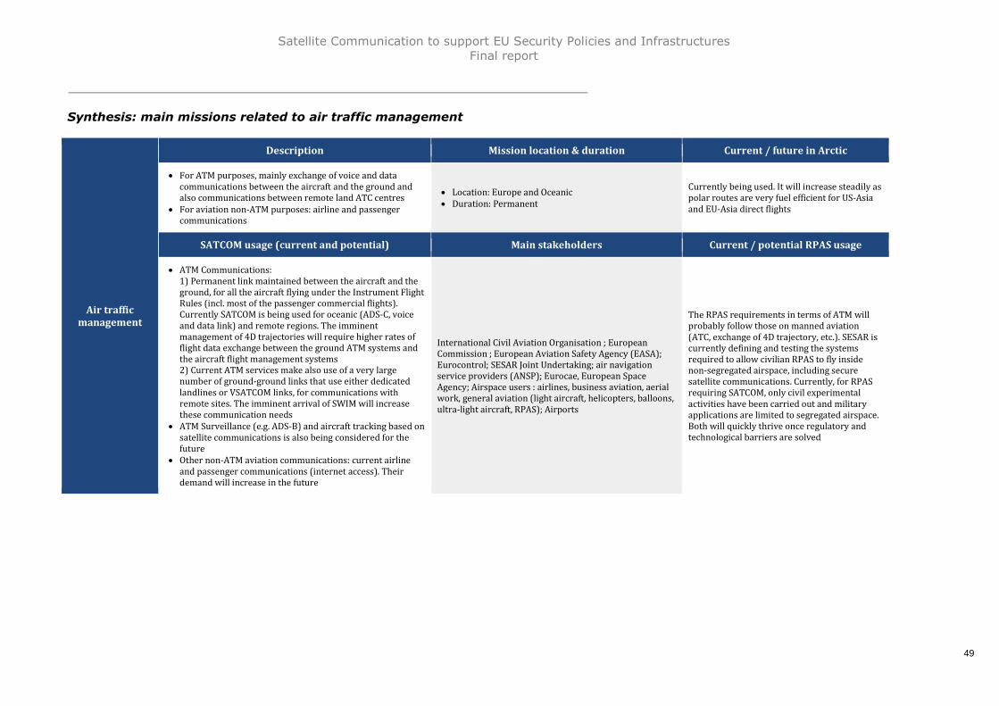
Satellite Communication to support EU Security Policies and InfrastructuresFinal report
49
Synthesis: main missions related to air traffic management
Air trafficmanagement
Description Mission location & duration Current / future in Arctic
For ATM purposes, mainly exchange of voice and datacommunications between the aircraft and the ground andalso communications between remote land ATC centres
For aviation non-ATM purposes: airline and passengercommunications
Location: Europe and Oceanic Duration: Permanent
Currently being used. It will increase steadily aspolar routes are very fuel efficient for US-Asiaand EU-Asia direct flights
SATCOM usage (current and potential) Main stakeholders Current / potential RPAS usage
ATM Communications:1) Permanent link maintained between the aircraft and theground, for all the aircraft flying under the Instrument FlightRules (incl. most of the passenger commercial flights).Currently SATCOM is being used for oceanic (ADS-C, voiceand data link) and remote regions. The imminentmanagement of 4D trajectories will require higher rates offlight data exchange between the ground ATM systems andthe aircraft flight management systems2) Current ATM services make also use of a very largenumber of ground-ground links that use either dedicatedlandlines or VSATCOM links, for communications withremote sites. The imminent arrival of SWIM will increasethese communication needs
ATM Surveillance (e.g. ADS-B) and aircraft tracking based onsatellite communications is also being considered for thefuture
Other non-ATM aviation communications: current airlineand passenger communications (internet access). Theirdemand will increase in the future
International Civil Aviation Organisation ; EuropeanCommission ; European Aviation Safety Agency (EASA);Eurocontrol; SESAR Joint Undertaking; air navigationservice providers (ANSP); Eurocae, European SpaceAgency; Airspace users : airlines, business aviation, aerialwork, general aviation (light aircraft, helicopters, balloons,ultra-light aircraft, RPAS); Airports
The RPAS requirements in terms of ATM willprobably follow those on manned aviation(ATC, exchange of 4D trajectory, etc.). SESAR iscurrently defining and testing the systemsrequired to allow civilian RPAS to fly insidenon-segregated airspace, including securesatellite communications. Currently, for RPASrequiring SATCOM, only civil experimentalactivities have been carried out and militaryapplications are limited to segregated airspace.Both will quickly thrive once regulatory andtechnological barriers are solved

Satellite Communication to support EU Security Policies and InfrastructuresFinal report
50
2.3.2 Transport infrastructures: rail traffic management
Presentation
Rail transport occupies a core position in Europe’s overall transport sector. More than 800operators operate about 60,000 locomotives and rail cars on a relatively dense railwaynetwork covering 200,000 kilometres of tracks in the European Union. On a daily basis, EUrailway transport meets demand for 1.1 billion passenger-kilometres and over 1 billiontonne-kilometres of freight. In 2012, around 9 billion passenger trips were made byrailway31.
Rail transport requires a large infrastructure, deployed and maintained by InfrastructureManagers. The Rail Traffic Management system infrastructure in the EU comprises themain railways, many of them being used by high speed trains, and the regional and localrailways; the separation between trains is essentially based on automatic systemsdeployed along the railways; railways control centres manage the train flow on the mainrailways.
The trains, high-speed or conventional, are operated by Railway companies. In manycountries around the world, the Railway Companies are also the managers of theirinfrastructure: in this case, they are classified as Integrated Railway Companies.
The presence of more than twenty different signalling and speed control systems for railtransport in the EU has been an impediment to the growth of international rail traffic andto the extension of the internal market, by creating barriers to the transport of goods andbringing about extra-costs for the operators32. On the basis of this assessment, ERTMS hasbeen conceived by the EC in 2005 as a common system between the different EU MemberStates. This system is composed of two segments: first, GSM-R, a radio communicationsystem based on standard GSM (used by mobile telephones), but using differentfrequencies specific to rail; then, ETCS (European Train Control System), which not onlyallows permitted speed information to be transmitted to the driver, but also monitors thedriver's compliance with these instructions33.
The European Railway Agency (ERA) was set up to help create an integrated railway areaby reinforcing safety and interoperability. The Agency also acts as the system authority forthe European Rail Traffic Management System (ERTMS) project. DG MOVE of the EC isresponsible of the supervision of the ERA34 and it is assisted by the RailwayInteroperability and Safety Committee.
The Community of European Railway and Infrastructure Companies (CER) is the leadingEuropean railway association. It was founded in 1988 with twelve members and nowbrings together more than 70 members - European railway undertakings, their nationalassociations as well as infrastructure companies35. It aims at representing the interest ofits members to the EU institutions, with the objective to “contribute to a regulatoryenvironment enhancing business opportunities for European railway and railwayinfrastructure companies”36.
In addition, the International railways union (UIC) is an international organisation whichaims at promoting rail transport at world level and at meeting the challenges of mobilityand sustainable development. In particular the UIC promotes interoperability through thecreation of world standards for railways.
31 ECORYS report « the economic footprint of railway transport in Europe »32 http://europa.eu/legislation_summaries/transport/rail_transport/l24458_en.htm33 ibid34 DG MOVE’s mission statement, downloadable on DG MOVE website35 http://www.cer.be/about-us/who-we-are/36 ibid

Satellite Communication to support EU Security Policies and InfrastructuresFinal report
51
The Shift to Rail (S2R) Joint Undertaking aimed at increasing the attractiveness andefficiency of rail transport globally has identified technological enablers for a muchimproved rail traffic management and control, defined in the IP2 work-package. Itproposes the acceleration of ERTMS deployment and the development of a number ofadditional technology demonstrators; most of them relying on increased fail-safeconnectivity between train and infrastructure and between trains.
Main mission identified and related current / future SATCOM usage
Rail traffic management
To-day, SATCOM usage is very low; some high speed trains are equipped with SATCOMterminals for the connection with the Internet network, for the passengers essentially; thecommunications between the train drivers and the ground controllers use cellularnetworks, either analogue or the GSM-R. However, the GSM technology is becoming moreand more obsolete, the so-called 4G mobile networks being deployed within the EU since2010. It will be difficult to maintain the GSM/R hardware if the GSM is completelyabandoned by the mobile network operators. In addition, there are also more and moredifficulties for using the GSM/R in some areas, due to the interferences produced by the3G/4G mobile networks that are deployed in the adjacent bands; these interferences havealready produced many incidents and even one accident hopefully without injured people.
For safety critical communications as well as for non-safety critical communications, thereis also a move towards data oriented communications, based on IP protocol. The GSM-Rhas not been designed to fulfil these requirements and a new system will be necessary.However the transition from the current GSM/R system to the future should be progressiveand allow the old GSM/R-equipped trains to continue to be able to communicate until theirnew on-board system will be installed. There is now a new technology, the so-calledsoftware-defined radios, that allows integrating in the same terminal many standards thatcan be used transparently to the user. The cost of this technology is becoming less andless important and should allow this soft transition. As well as the possibility to add newcommunication channels like the communication satellites, on geostationary or low earthorbits.
The new European train control system is based essentially on ground-based radiocommunications between the trains and the Control Centres; satellites could increasecapacity and make train traveling economically more attractive. Both SATNAV37 andSATCOM will be used to set up future satellite-based platforms and be suitable for TrainControl and Management-Systems. The ESA has funded a number of studies andexperiments to promote the use of satellite navigation and communications for rail trafficmanagement and he European Railway Agency has been appointed by the EC to launch astudy on the evolutions of the railway communication system. Future needs could besignificant, as 30% of current road freight over a 300 km range is forecast to move toother transport modes such as rail or waterborne transport by 2030, and more than 50%by 205038.
37 Navigation satellites, i.e. GPS or Galileo38 http://europa.eu/legislation_summaries/transport/bodies_objectives/tr0054_en.htm

Satellite Communication to support EU Security Policies and InfrastructuresFinal report
52
Synthesis: main missions related to rail traffic management
Rail trafficmanagement
Description Mission location & duration Current / future in Arctic
Communications between trains and ground infrastructures fortrain control and operations management
Location: Europe Duration: Permanent
No
SATCOM usage (current and potential) Main stakeholders Current / potential RPAS usage
Current European train control system is based on cellularcommunications, GSM/R; this system suffers a large number ofinterferences due to the deployment of 3G/4G cellular networksin the adjacent band; the EC has mandated the ERA to define anew standard that could include satellite communications
European Commission; European Railways Agency;Shift2Rail JU; CER community of European Railways andinfrastructure companies; Union International desChemins de fer ; National regulatory authorities; Trainoperating companies; Infrastructure managementcompanies
Yes, e.g. in France, the railways operator, SNCF,make use of RPAS to achieve surveillanceoperations along the railways, for safety andsecurity assurance

Satellite Communication to support EU Security Policies and InfrastructuresFinal report
53
2.3.3 Transport infrastructures: road traffic management
Presentation
Road transport is the principal means of transport in the European Union for bothpassengers and goods. Today, the European Union has almost one vehicle for every tworesidents, and road freight traffic represents more than two thirds of the total tonnage39.
Trucks carrying goods across the EU, including the transport of dangerous goods,and the transport of living animals, submitted to specific regulations;
Coaches and buses carrying paying passengers; coach lines crossing all the EU overlong distance journeys;
Commercial vehicles (vans) used for carrying equipment and employees; Private cars, used for private journeys, on short or long distance.
The Road Transport Systems for road vehicles, trucks, buses, cars, is very developed inthe EU and includes motorways, main roads, regional and local roads, with about 5 millionkilometres of paved roads40. The development of intelligent terrestrial vehicles, cars,trucks, ships, barges, as well as automated road transport and automated ships/barges iscurrently subject to a number of studies and experiments world-wide. The EC has adopteda legal framework41 to accelerate the deployment of Intelligent Transport System (ITS)across Europe. Four priorities areas have been identified:
Optimal use of road, traffic and travel data; Continuity of traffic and freight management ITS services; ITS road safety and security applications; Linking the vehicle with the transport infrastructure.
Main mission identified and related current / future SATCOM usage
Road traffic management
Satellite communications are currently not very developed by this community who ismainly using cellular communications / radiofrequency link. Today, some road vehicles areequipped with satellite terminal, either for the exchange of small messages or for theconnection with the Internet network (passenger buses). The Intelligent TransportSystems are still under deployment; for the e-Call system, and the road charging systems,communications are based on existing cellular networks or short range radiocommunications (DSRC). Automated transport systems and intelligent vehicles will requirevery dependable communication links, either with other vehicles or with the groundinfrastructure. It is possible that they will require satellite communications where ground-based systems are not available. The interoperability of these systems will be based oncommon standards since the communication links are highly critical for safety and must besecured.Finally, RPAS could be useful to supervise road traffic and detect rapidly any issue (e.g.accident, traffic jam, etc.).
39 http://ec.europa.eu/transport/modes/road/doc/broch-road-transport_en.pdf40 ERF 2012 statistics41 Directive 2010/40/EU Of The European Parliament And Of The Council of 7 July 2010 on the framework for thedeployment of Intelligent Transport Systems in the field of road transport and for interfaces with other modes oftransport

Satellite Communication to support EU Security Policies and InfrastructuresFinal report
54
Synthesis: main missions related to road traffic management
Road trafficmanagement
Description Mission location & duration Current / future in Arctic
Communications between cars and ground infrastructures forroad traffic management
Location: Europe Duration: Permanent
No
SATCOM usage (current and potential) Main stakeholders Current / potential RPAS usage
Current communication based only on cellular communications/ radiofrequency link. SATCOM link could potentially be usefulto reduce the roaming cost
European Commission; EU Road Federation; InternationalRoad Federation; ERTICO-ITS Europe; ETSC - Europeantransport safety council
Yes: RPAS as well as aerial means can be usedto supervise the road traffic, detect sources oftraffic jam, and allow quick reactions for re-establish the traffic flow

Satellite Communication to support EU Security Policies and InfrastructuresFinal report
55
2.3.4 Space infrastructures & services: Copernicus
Presentation
SATCOM is at the same time a space infrastructure and an essential element of otherspace infrastructure, such as Copernicus, EGNOS and Galileo.
The Copernicus program - “the Union Earth observation and monitoring programme”42 - iscomposed of three components:
A service component ensuring delivery of information in the following areas:atmosphere monitoring, marine environment monitoring, land monitoring, climatechange, emergency management and security
A space component ensuring sustainable spaceborne observations for the serviceareas listed above
An in-situ component ensuring coordinated access to observations throughairborne, seaborne and ground based installations for the service areas listed above
As described in the regulation, the Copernicus services component is aimed at addressingsix main service areas:
The atmosphere monitoring service provides information on air quality on aEuropean scale, and the chemical composition of the atmosphere on a global scale.It shall in particular provide information for air quality monitoring systems run atthe local to national scales, and contribute to the monitoring of atmosphericcomposition climate variables, including, where feasible, the interaction with forestcanopies. This service is operated under a delegation agreement between the ECand the European Centre for Medium-Range Weather Forecasts (ECMWF)
The marine environment monitoring service provides information on the state anddynamics of physical ocean and marine ecosystems for the global ocean and theEuropean regional marine areas, in support of marine safety, contribution tomonitoring of waste flows, marine environmental, coastal and Polar Regions, and ofmarine resources as well as meteorological forecasting and climate monitoring. Thisservice is operated under a delegation agreement between the EC and MercatorOcean
The land monitoring service provides information on land use and land cover,cryosphere, climate change and biogeophysical variables, including their dynamics,in support of the global-to-local environmental monitoring of biodiversity, soil,inland and coastal waters, forests and vegetation, and natural resources, as well asimplementation in general of environment, agriculture, development, energy, urbanplanning, infrastructure and transport policies. This service is operated under adelegation agreement between the EC and the European Environment Agency(EEA) and with a Cross Sub-delegation agreement with the Joint Research Centre(JRC)
42 Regulation (EU) No 377/2014, 3 April 2014, establishing the Copernicus Programme and repealing Regulation(EU) No 911/2010

Satellite Communication to support EU Security Policies and InfrastructuresFinal report
56
The climate change service provides information to increase the knowledge base tosupport adaptation and mitigation policies. It shall in particular contribute to theprovision of Essential Climate Variables, climate analyses, projections andindicators at temporal and spatial scales relevant to adaptation and mitigationstrategies for the various Union's sectorial and societal benefit areas. This service isoperated under a delegation agreement between the EC and the European Centrefor Medium-Range Weather Forecasts (ECMWF)
The emergency management service provides information for emergency responsein relation to different types of disasters, including meteorological hazards,geophysical hazards, deliberate and accidental man-made disasters and otherhumanitarian disasters, as well as the prevention, preparedness, response andrecovery activities. This service is operated under a Cross Sub-delegationagreement with the Joint Research Centre (JRC)
The security service will provide information in support of the civil securitychallenges of Europe improving crisis prevention, preparedness and responsecapacities, in particular for border and maritime surveillance, but also support forthe Union's external action, without prejudice to cooperation arrangements whichmay be concluded between the Commission and various Common Foreign andSecurity Policy bodies, in particular the European Union Satellite Centre. Thisservice will be operated under delegation agreements between the EC and Frontex,The European Maritime Safety Agency (EMSA) and the European Union SatelliteCentre (EUSC)
The Copernicus space component comprises two types of satellite missions, dedicatedsatellites Sentinel and missions from other space agencies, called contributing missions.Each Sentinel mission is based on a constellation of two satellites to fulfil revisit andcoverage requirements, providing robust datasets for Copernicus services component.These missions carry a range of technologies, such as radar and multi-spectral imaginginstruments for land, ocean and atmospheric monitoring.
ESA is establishing a mechanism to integrate, harmonise and coordinate access to all therelevant data from the multitude of different satellite missions. This is being carried out inclose cooperation with national space agencies, Eumetsat and, where relevant, withowners of non-European missions contributing to the Copernicus objectives.A unified ground segment, through which the data are streamed and made freely availablefor Copernicus services component, completes the space component. Each Copernicussatellite mission, both the dedicated Sentinel missions as well as each contributingmission, has a ground segment, and is operated independently.
Finally, the Copernicus in situ component ensures the collection and usage of in situ datato serve the Copernicus services described above. In situ data includes observation datafrom ground-, sea- or air-borne sensors, and are provisioned mainly by Member Statesand to the extent that it is necessary other third party. A delegation agreement has beensigned between the EC and the European Environment Agency (EEA) for the overallcoordination of the Copernicus in situ component.

Satellite Communication to support EU Security Policies and InfrastructuresFinal report
57
Main missions identified and related current / future SATCOM usage
Copernicus data collection
The first mission related to Copernicus is the reception of raw data from the CopernicusSpace Component through the ground segment and transmission to the Space ComponentData Access System. The Sentinel satellites will be equipped for transmitting the payloaddata to the mission control centre via geostationary communication satellites, operated bycommercial communication satellite providers.
For some usage (e.g. maritime security, emergency), reception of raw data is in real timefrom the Space component through EDRS network. SATCOM will also be used for in-situdata collection from ground station in isolated areas (e.g. Arctic region).
Copernicus data distribution
The distribution of processed data from the ground data centre to the users is thesecond main mission of Copernicus. This distribution is made through a permanentdata network, mainly terrestrial except when they are isolated or in remote areashaving no terrestrial connection (e.g. Arctic zone), or for broadcasting datasimultaneously to a group of users. For example, Eumetsat distributes data andproducts in real-time to users, primarily via EumetCast - a satellite-based broadcastservice for environmental data. It uses commercial communication satellites tomulticast files (data and products) in real-time to users, including security andmilitary, equipped with VSAT terminals.

Satellite Communication to support EU Security Policies and InfrastructuresFinal report
58
Synthesis: main missions related to Copernicus
Copernicus datacollection
Description Mission location & duration Current / future in Arctic
Reception of raw data from the Copernicus SpaceComponent through the ground segment and transmissionto the Space Component Data Access System
For some usage (e.g. maritime security, emergency),reception in real time of raw data from the Spacecomponent through EDRS network
Location: World Duration: Permanent
Yes: data collection from stations located inArctic zones
SATCOM usage (current and potential) Main stakeholders Current / potential RPAS usage
Permanent data network required, mainly terrestrial with someexceptions: For data reception stations located in isolated areas (e.g.
Arctic zone, etc.), connection with the data centre is carriedout by satellite link
Sentinel satellites 1 and 2 are equipped with EDRS payloadwhich allow users to receive raw data in real time
DG GROW; ESA; EUMETSAT; EDRS Operator; EMSA No
Copernicus datadistribution
Description Mission location & duration Current / future in Arctic
Distribution of processed data to users through variousnetworks or systems (terrestrial or satellite)
Location: World Duration: Permanent
Yes: some Users located in Arctic zones. Thenumber of these users will increasesignificantly in the future with the increase ofactivities in this zone
SATCOM usage (current and potential) Main stakeholders Current / potential RPAS usage
Permanent data network required, mainly terrestrial with someexceptions: For data users having no terrestrial connections For real time transmission of the data, EDRS connection will
be used
DG GROW; ESA; EUMETSAT; EDRS Operator; EEAS; JRC;ECMWF; Mercator Ocean; Frontex; EMSA
No

Satellite Communication to support EU Security Policies and InfrastructuresFinal report
59
2.3.5 Space infrastructures & services: GNSS programmes EGNOS& Galileo
Presentation
The European Global Navigation Satellite Systems (GNSS) programmes consist in twoseparate programmes: EGNOS and Galileo. The EGNOS system monitors and improves thequality of signals from existing GNSS. EGNOS is also called the Europe’s satellite-basedaugmentation system – SBAS – and is using SATCOM transponders to make the USA’sGlobal Positioning System (GPS) suitable for safety critical applications such as flyingaircraft or navigating ships through narrow channels. Galileo is the European globalsatellite-based navigation systems and will provide four services: an open service, a publicregulated service (PRS), a commercial service (CS) and a Search and Rescue (SAR)service.
Since 2008, the European Commission is responsible of these two programs, in particularwith respect to the Council and the Parliament. Their regulation43 has defined the tasksthat the EC has to achieve, the budget available and the conditions for its utilisation. AGNSS program Directorate has been set-up within the DG GROW, with around 80 persons.The EC has established a GNSS Program Committee, with representatives of the MemberStates and of the third countries having signed an agreement with the EU (Norway,Switzerland) with regular meetings, where the EC reports on the progress of the programsand consults the participants before taking some important decisions.
The EC has established delegation agreements with the European Space Agency (ESA) andthe European GNSS Agency (GSA):
ESA is acting as the procurement agent, and as the architect of the two programs,EGNOS and Galileo. ESA has established two program management teams: one inToulouse (France) for managing the EGNOS program (evolutions of the currentoperational system, preparation of a new version V3 to be deployed around 2020),one team in ESTEC (Netherlands) for managing the deployment of Galileo
GSA is acting as supervisory authority for the exploitation of EGNOS, which isrealized by the ESSP-SAS Company, based in Toulouse. GSA is also responsible ofthe management of the security accreditation process, and supports the GalileoSecurity Accreditation Board. The GSA is also responsible of the GNSS marketdevelopment within the EU, and publishes an annual market survey. The EC canalso delegate to the GSA any other activities about the two GNSS programs. TheGSA is also preparing to become the supervisory authority for the exploitation ofGalileo that should start progressively when the number of operational satellite willbe sufficient (early operations). The GSA is administered by an AdministrativeBoard with representatives of the EC and the Member States. The staff of the GSAis around 50 people and should become more important when Galileo operationswill start. Many staff members are coming from the EC program directorate
43 Regulation (EU) 1285/2013 on the implementation & exploitation of European Satellite Navigation Systems

Satellite Communication to support EU Security Policies and InfrastructuresFinal report
60
Furthermore, Eurocontrol has been associated to the EGNOS program since its inception,and assures the supervision of its performances with respect with the ICAO SBASrequirements.EGNOS is now operational since 2011 and the next version of the system - the EGNOS-V3– is currently in preparation.
Galileo is still in the deployment phase. During the preceding phase (i.e. before 2013),four satellites were launched successfully and three of them are now in service. In 2014,two satellites were launched on an incorrect orbit. In 2015, two satellites were launched inSeptember and two others in December. The rest of the constellation should be deployedduring the coming years. The system should become fully operational around 2018-2020.
Main missions identified and related current / future SATCOM usage
EGNOS data transmission
EGNOS is based on anchor stations (40 monitoring stations and 2 mission control centres)and three geostationary communication satellites relaying the EGNOS data to the user’sreceiver. Thus, EGNOS data transmission is:
Between EGNOS anchor stations: the 40 EGNOS monitoring stations use eitherterrestrial networks (landlines) or VSAT links to transmit the data to the 2 missioncontrol centres (Roma and Madrid). VSAT are used for remote sites, whereterrestrial link is not feasible or not reliable;
Between EGNOS mission control centres and the three GEO satellites; Between the three GEO satellites and the final users
Galileo data transmission
As for EGNOS, the Galileo system is composed of anchor stations (16 remote stationsdeployed around the world and 2 Mission Control Centres in Oberpfaffen-Hofen and Fucinoused to transmit or receive essential information to/from the satellites, such as telemetryand tele-command information, signals monitoring, services specific data) and aconstellation of 30 MEO satellites. Consequently, satellite communication will be requestedfor:
Data transmission between anchor stations: most of the 16 remote stationsdeployed around the world use VSAT links to exchange data with the 2 Missioncontrol centres. The data exchanged is very sensitive and must absolutely besecured. Today the links between the ground stations and the Control Centres aresubcontracted to a communication service provider and make use of satellite links.The level of availability of these links shall be ensured at an appropriate level bythe communication service provider
Data transmission from users located all around the world (including Arctic area) tothe mission control centres. For example, there is already a Search & Rescue (SAR)payload on 6 satellites of the 1st Galileo constellation, and probably on the nextsatellite generation. It implies that no dedicated SATCOM link is required. However,this functionality might require some technological development to improvesecurity.

Satellite Communication to support EU Security Policies and InfrastructuresFinal report
61
Synthesis: main missions related to GNSS programmes EGNOS & Galileo
EGNOS datatransmission
Description Mission location & duration Current / future in Arctic
Transmission of EGNOS data from monitoring stations to the 3EGNOS GEO satellites and between the anchor stations (40monitoring stations and 2 mission control centres)
Location: Europe Duration: Permanent
No
SATCOM usage (current and potential) Main stakeholders Current / potential RPAS usage
EGNOS uplink: 3 up-links in the fixed satellite servicecommunications band, to transfer the EGNOS signal fromthe ground to the 3 EGNOS geostationary satellites
EGNOS downlink: downlinks use the GPS L1 frequency(1575 MHz)
EGNOS monitoring stations: the 40 EGNOS monitoringstations use either terrestrial networks (landlines) or VSATlinks to transmit the data to the 2 mission control centres(Roma and Madrid); VSAT are used for remote sites, where aterrestrial link is not feasible or not reliable
DG ENTR; European GNSS agency, GSA; ESA; Eurocontrol;Users : civil aviation, other transport modes, agriculture;ESSP, European Satellite Service Provider
Yes: RPAS use GNSS for guidance (en-route andapproach) and possibly for anti-collision(ADS/B).
Galileo datatransmission
Description Mission location & duration Current / future in Arctic
Transmission of data between monitoring stations (16remote stations deployed around the world and 2 MissionControl Centres)
Data transmission from users located all around the world(including Arctic area) to the mission control centres (SAR)
Location: World Duration: Permanent
Yes: some users located in Arctic zones. Thenumber of these users will increasesignificantly in the future with the increase ofactivities in this zone
SATCOM usage (current and potential) Main stakeholders Current / potential RPAS usage
Most of the 16 Galileo remote stations deployed around theworld use VSAT links to exchange data with the 2 Missioncontrol centres (Oberpfaffen-Hofen, Fucino). NB: the levelof availability of these links shall be guaranteed by thecommunication service provider
There is already a Search & Rescue (SAR) payload on 6satellites of the 1st Galileo constellation, and probably onthe next satellite generation. It implies that no dedicatedSATCOM link is required. However, this functionality mightrequire some technological development to improvesecurity
DG ENTR; GSA; ESA; Open Service users: mass market;PRS users: governmental or EU organisations; SAR users:maritime and civil aviation transports
Yes: Galileo open service could be used by alltransport modes, jointly with the other GNSSopen signals (GPS, Glonass, Beidou, EGNOS)

Satellite Communication to support EU Security Policies and InfrastructuresFinal report
62
2.3.6 RPAS communications
Presentation
While limiting its scope to the use of Remotely Piloted Aircraft Systems (RPAS) forsecurity missions, this analysis tries to encompass the communication requirements forthe usage of RPAS by all the user communities to support their particular missionsdiscussed in the Sections 2.2.1 to 2.2.6. This “transverse” approach has been adoptedbecause the global fleets of the various types of RPAS are easier to assess than theirprecise allocation among user Communities for specific missions.
The development of RPAS has opened a promising new chapter in the history of aviation.Being remotely piloted, RPAS can perform tasks that manned systems cannot perform,either for safety or monetary reasons.
Since the publication of national regulations in several EU Member States, thecommercial RPAS activity is growing rapidly. In France the number of registeredoperators has increased rapidly from zero beginning of 2012 to more than 1000beginning of 201544.
The commercial drones market – composed at 90% of video taking for the moment – isevolving towards the supply of sophisticated data and diagnostic means for a variety ofareas such as surveillance of linear infrastructures (railways, oil and gas pipelines, powerlines, etc.), agriculture and environment, mapping and monitoring of construction sites,quarries, mines, etc. and diagnosis of the state of buildings, infrastructures andarchitectural sites. A specialized market is also developing for public services users withina large number of areas such as road traffic surveillance, maritime surveillance, bordersurveillance.
RPAS should not be referred as one single entity, for instance, there are very differenttypes of RPAS: while nano and miniature drones are not considered here, tactical RPAScorrespond to large aircrafts with high performance payloads (observation systems andcommunications; vertical take-off and landing RPAS (VTOL, generally rotary wings) aremandated to operate from ships; Medium Altitude Long Endurance (MALE), High AltitudeLong Endurance (HALE) are providing long range capabilities – flying times generallyexceed those of manned surveillance aircrafts.
The most relevant categorization of RPAS for this study is whether they are deployed inLine of Sight (LoS), hence compatible with direct radio-transmissions and do not requireSATCOM, or over-the-horizon: currently the MALE RPAS has a niche on maritimesurveillance, mainly for its extended endurance, and uses SATCOM.
RPAS are currently subject to national regulations only; the ICAO and the EASA have notpublished any specific requirement document regarding their flights. However the EUMember States are competent for RPAS with a maximum mass below 150 kg and theEASA is competent for the RPAS with a mass above 150 kg: currently, there are 12Member States that have published national regulations, but several are preparing to doit. There is no harmonization between these national regulations. However, most of themhave restricted severely the RPAS commercial flights: maximum height above the groundbelow 500 ft., visual line-of-sight allowing the remote pilot to always see the RPAS, day-time only, no flight at proximity of airports, no flight above populated areas. All otherflights are submitted to the deliverance of a waiver by the national safety authorities, andare generally be limited to segregated airspaces, reserved for their flights.
44 OPECST report – “audition du 24 novembre 2014 sur Les drones et la sécurité des installations nucléaires”

Satellite Communication to support EU Security Policies and InfrastructuresFinal report
63
Given that the full integration of civil RPAS into the European ATM System is vital andthat the mission of SESAR is to create the new generation of ATM systems andoperations, civil RPAS will need to be incorporated into future SESAR solutions. The ECpublished in 2014 a communication45, proposing to give to the EASA the fullresponsibility for all RPAS masses, and to task SESAR 2020 to design and experiment thetechnologies required for authorizing the flight of RPAS inside un-segregated airspace.
There are a number of barriers to the development of the RPAS civilian activity: safety,security, privacy of citizens, responsibilities in case of accident. The development of aserious RPAS activity will certainly require sophisticated new technologies, in order toguarantee a satisfactory level of safety, including sense-and-avoid systems that arecurrently subject to experiments within the SESAR program.
Military RPAS flights are also becoming more and more frequent, but are restricted tosegregated airspaces. However, there is a strong need to authorize these flights tooperate into non segregated airspace and therefore be potentially managed by civilianATM.As these military RPAS are considered as state aircraft, they are not subject to allrequirements applicable to civilian RPAS, and they can do this under the condition thatthey do not risk to produce a collision with a civilian aircraft or with ground populations.
Main mission identified and related current / future SATCOM usage
Surveillance of infrastructures or human activities using RPAS
Over-the Horizon (OTH) RPAS will require satellite communications for the exchange ofdata between the unmanned aircraft in-flight and the ground. The SESAR program willcarry out the required technology research necessary to safely integrate RPAS intoEuropean air traffic management system including SATCOM.
Indeed, to allow the flight of RPAS inside non-segregated airspace, a communication linkwill have to be established permanently between the RPAS and the ground. Three typesof data need to be exchanged: control data from the RPAS (necessary to the remote pilotto supervise the flight), command data from the remote plot to the RPAS (forcommanding manoeuvres or downloading flight plan) and the communication linkbetween the Air Traffic Control unit and the remote pilot, via the RPAS. Satellite links willalso be useful for the real-time transmission of the payload data, in particular forsurveillance applications.
In 2012 a new frequency within the aeronautical C-band was allocated by the ITU.Frequency use is submitted to the publication of an ICAO standard. This band can beused for line-of-sight or satellite communications. At the present time there is nosatellite, in orbit or planned, that is equipped to receive and transmit within this newband. The military RPAS flying into non-segregated airspace currently use COMSATCOMand the frequency bands used not classified as safety-of-life as with the aeronauticalbands. This question will be discussed during the next ITU World Radio communicationsConference in November 2015.A key factor of the future usage of RPAS for safety and security missions is the operationcost. Today military MALE and HALE RPAS are expensive systems designed to spare thelife of pilots more than to reduce the mission cost. They have been used already formissions in the scope of this study (e.g. during the Italian Mare Nostrum sea bordersurveillance operation) but would not rapidly substitute manned surveillance planes.Conversely, civilian “low cost” long range RPAS solutions are developing (e.g. the
45 COM/2014/0207, “A new era for aviation Opening the aviation market to the civil use of remotely pilotedaircraft systems in a safe and sustainable manner”

Satellite Communication to support EU Security Policies and InfrastructuresFinal report
64
TEKEVER maritime surveillance plane tested by EMSA) which have the potential ofoperational cost one order of magnitude lower that would boost the operational usage.

Satellite Communication to support EU Security Policies and InfrastructuresFinal report
65
Synthesis: main mission related to RPAS communications
Surveillance ofinfrastructures
or humanactivities using
RPAS
Description Mission location & duration Current / future in Arctic
Activities related to the surveillance of infrastructures orhuman activities using RPAS
Location: Worldwide Duration: When event occurs
Yes (both current and future)
SATCOM usage (current and potential) Main stakeholders Current / potential RPAS usage
Currently, for RPAS requiring SATCOM, only civil experimentalactivities have been carried out and military applications arelimited to segregated airspace. Both will quickly thrive onceregulatory and technological barriers are solved.
RPAS radio communications can make use of direct links(including cellular networks when very low level flights) whendirect line of sight between the RPA and the ground station. Ifthe RPA is beyond line of sight from the ground station,SATCOMM is required. RPAS require three types of differentSATCOM:1) Command and Control link between the ground control
station and the vehicle.2) Transmission of payload - sensor data (video, radar, etc.)
taken on-board the RPA requiring higher data rates.3) ATM communications (as stated in the ATM section)
potentially including Sense and Avoid datacommunications
The International Civil Aviation Organisation; TheEuropean Commission; The European Aviation SafetyAgency; The SESAR JU; Eurocontrol; The national aviationsafety authorities; The RPAS sector: manufacturers,operators, training centres, remote pilots
Yes (both current and future)

Satellite Communication to support EU Security Policies and InfrastructuresFinal report
66
2.3.7 Arctic communications
Presentation
The Arctic region is a vast territory, and for the purpose of this study is defined as theregion above 65°N latitude more precisely 66°33'46''which is the exact latitude of theArctic Circle46.
Commercial and economic activity and, subsequently, demand for industrial exploitationand communication will not grow equally in all parts of the Arctic region. Hence, the Arcticregion has been further sub-divided into 3 geographic areas:
Europe (Scandinavia): with Norway, Denmark, Sweden, Iceland and Finland, fiveEuropean countries have territories within the Arctic region. Main interests in theregion are concentrated in Scandinavia with in particular Norway that has access tothe Northern Atlantic and an interest in the region through its Arctic IslandSvalbard. Denmark has a strong interest in the region given that Greenland isDanish territory
North America (Canada and Alaska): in North America the interests in the Arctic aresplit between Canada and the US, through Alaska, whereby the geographicallylarger part belongs to Canada. Both countries are increasingly focused on thedevelopment of on the region to exploit its abundant natural resource reserves
Russia: Russia has the largest share of all countries in the Arctic, with its Arcticterritory reaching from the borders with Norway and Finland in the west, overSiberia and the Bering Sea almost towards Alaska. The region is of increasingimportance for the country as of its natural resources including in particular oil &gas, metals and coal. More than a fifth of Russian territory lies north of the polarcircle
The strategic and economic interest for the Arctic area has been rapidly rising, resulting ina reinforced human presence in this region. The melting of the polar ice cap may indeedreduce the distance between ports in the northern Pacific Sea and the northern AtlanticSea, opening new shipping routes someday accessible to most classes of vessels. Inaddition, the end of the cold war has allowed a significant increase of the number ofaeronautical polar flights (e.g. airspace opened over Russia for western airlines). Anotherchanging factor lays in the recent discovery of oil and gas deposits in the Arctic region,with important exploitation forecast, as well as for marine and mineral resources.Consequently, the development of both maritime and air transport in the Arctic requiresadequate Search and Rescue capabilities in case of accident. SAR regions have beenagreed between Russia, Canada, Denmark, USA, Norway and Iceland (and marginallyFinland and Sweden). From an EU perspective, the Norwegian stake to effectively provideSAR services over this huge section of the Arctic Sea is significant.
Finally, the Council of the EU has decided47 that the EU should further increase itscontribution to resolving concerns about a sustainable future for the Arctic region and itspeoples.
46 Latitude considered on 1st January 201547 Council conclusions on developing a European Union Policy towards the Arctic Region, 12 May 2014

Satellite Communication to support EU Security Policies and InfrastructuresFinal report
67
Main missions identified and related current / future SATCOM usage
In the future, as described in the presentation of the user communities andinfrastructures, Arctic communications will be requested for the following missions:
Maritime: mainly for maritime safety and security, response to maritime disasters,search & rescue activities, and probably to monitor fishery activities
Copernicus: for data collection and distribution from / to entities located in Arctic Galileo: for users located in Arctic Transport: for Air traffic Management, as the ECAC area covers high latitudes
regions where services to air traffic are provided by European states, EU MemberStates or non-EU, such as Norway
Data and voice links between surveillance aircraft, regional operational centres andpatrol vessels
Larger RPAS – using SATCOM – are the only unmanned systems able to operateunder strong winds, turbulences, very low temperatures and bad visibility of theArctic region
As activities in the Arctic are expected to increase considerably in the next few years theavailability of means of communications is a necessity. Most of the Arctic is covered by iceand ocean making the use of terrestrial communications difficult and the use of SATCOMsystems essential.
The Arcticom study from the European Space Agency on "Future Arctic CommunicationsNeeds" has concluded, based on consultations with various stakeholders that in theEuropean Arctic the demand for broadband communication is forecasted to grow at 26%CAGR from 110 Mbps in 2010 to 1 Gbps by 2020. Europe should still require less capacitythan North America or Russia. In addition, some prominent features can be emphasized:
Broadband access for local populations is forecasted to remain the largest usersegment likely requiring 750 Mbps in 2020, up from 91 Mbps in 2010
Maritime users are forecasted to be the fastest growing segment with capacitydemand growing at 33% per year over the period, reaching about 145 Mbps by2020 and continuing to grow exponentially till 2030
The energy and government segments have solid growth prospects, fromcumulative 10 Mbps in 2010 to a forecasted 135 Mbps by 2020
Moreover, hybrid SATCOM solutions (geostationary and non-geostationary such as HEO –Highly Elliptical Orbit) must be developed as the area above 75°N is not covered bygeostationary communication satellites (except GEO inclined satellites). The rapid pace oftechnological change and the lack of convergence between the different stakeholdersinvolved in these regions is another issue.
An additional main mission, specific to Maritime safety for Arctic, was also identified and isdescribed below.

Satellite Communication to support EU Security Policies and InfrastructuresFinal report
68
Specific maritime safety for Arctic
The melting of Arctic ice reveals much faster than originally predicted from the climatechange models, every year showing a “record low” in terms of ice coverage. The primarycontribution of earth observation to improve the efficiency of transportation in the Arcticincludes the monitoring and charting of sea ice covers. In particular, areas of open waterwithin ice fields, as well as areas of thin, first-year ice constitute transportation corridors ofchoice in ice-covered waters. In addition to vessel traffic, earth observation is also useful as anavigation aid for individuals travelling on near shore ice, as well as on river and lake icecovers used as ice roads during the winter months.
Ice charting and surveillance is typically provided by national ice services to ensureadequate coverage of high-resolution sea ice information (i.e. derived from wide-swathSAR data) for areas under their jurisdiction. However, much of the Arctic basin is notcovered by operational ice services providing high-resolution products, although coarse-resolution, global-scale products derived from passive microwave sensors are available. Asa result, the full potential for supporting safe shipping and offshore operations is onlyrealized in areas covered by national ice services. For the remainder of the Arctic basin,an appropriate governance of ice services is yet to be established.
Ice detection and monitoring is a mature application of radar earth observation. Whilenational ice services provide reliable data, there remain some deficiencies that need tobe overcome to optimize these services. Repeat coverage of the existing satellites likeRadarsat-2 and COSMO- SkyMed is not frequent enough and the data resolution needs tobe improved, so the launch of additional satellites, such as Sentinel 1 and 3 and RadarsatConstellation, is required to improve ice monitoring to ensure marine transportationsafety as vessel traffic in the Arctic continues to increase.
Ice tracking can be done from radar satellites but SATCOM beacons are also very costeffective, with data almost instantaneous while radar images often require at least half a dayto be collected and processed, increasing collision risks if the drifting rate is high e.g. by badweather. Icebergs (mainly issued from the Greenland ice shelve) are easier to track than seaice; distinguishing multi-year ice (denser, thicker) from single year ice and assessing itsthickness accurately is important as the risk for navigation is much greater for the first one.
In that case, SATCOM are required to collect in-situ sensors (e.g. tracking beacons onicebergs, thickness probes, temperature probes, use of RPAS, sightings from cooperativeships sailing in the region, etc.), to download satellite radar data, to distribute the Data tothe ice monitoring service providers, to distribute ice monitoring services to all ships, toreport sightings from ships, planes etc.

Satellite Communication to support EU Security Policies and InfrastructuresFinal report
69
Synthesis: main mission related to Arctic communications
Specificmaritime safety
for Arctic
Description Mission location & duration Current / future in Arctic
Specific services to ensure maritime safety in the Arctic region,including as immediate priorities: Ice monitoring services for improving the safety of
navigation and off shore activities, Unattended sensor stations for meteo-oceanography and
communication relays, Broadcast of specific data services for mariners and mining
industries
Location: Arctic Duration: Permanent
Yes, with a rapid growth after 2025 when mostof the Arctic sea will become navigable insummer
SATCOM usage (current and potential) Main stakeholders Current / potential RPAS usage
SATCOM is the only way to communicate in the Arctic sea, andare needed for: Process satellite radar (near-real time needed for drifting
ice blocks) Collect in-situ sensors (temperature, beacons, etc.) Collect sightings Oceano-meteorological monitoring, previsional assessment Distribution of the service to all mariners
JRCC/MRCC and associated rescue services providers; ShipMaster; Ship owner; Coastal Authorities (ice roads, etc.);Ports; Coastguard/Navy
Yes: long endurance RPAS with EO and radarwould provide very useful complement tosatellite radar

Satellite Communication to support EU Security Policies and InfrastructuresFinal report
70
2.3.8 EU institutional communications
Presentation
Institutional communications between European Commission bodies within and outsideEurope is essential for the EC. Sensitive political negotiations, crisis management, next VIPvisit information, etc. – all these activities require European and worldwide connectionsbetween various EC bodies. As an example, the EU Delegations around the world (alreadydescribed in the presentation of the User Community EU External Action) play a key role inpresenting, explaining and implementing EU’s foreign policies, and consequently requireconnections with EU headquarters. The increasing involvement of the EU in public safetyand security missions requires the bodies assigned to such activities to be capable ofperforming them as best as possible.
Main missions identified and related current / future SATCOM usage
As terrestrial network infrastructures are subject to physical limitations – or simply cannotmeet the needs of certain activities – SATCOM play a vital role in EU InstitutionalCommunication in addition to terrestrial systems. They allow access to, and the sharing of,trusted information from any location to enable quicker decision making. Three mainmissions – currently using or which could potentially use satellite communication – havebeen identified with users within the scope of EU Institutional Communication. Thesemissions are presented in the following paragraphs.
Communication for the 139 EU delegations (EEAS)
This main mission aims at connecting with the headquarter located in Brussels the 139 EUEEAS delegations disseminated around the globe for any type of communications includingthose of confidential nature and of security. Communications are mainly terrestrial, but atleast one satellite link is required as security back-up for each EU delegation. This SATCOMlink with permanent availability is key as the satellite link is the last link on which thesecurity of those entities lies.Moreover, in some countries, the terrestrial network could not be available. And when theterrestrial network is available, generally the quality and availability are not sufficient: inthat case, staff deployed is using SATCOM permanently.
Communication for the 46 ECHO field offices
This main mission aims at connecting the 46 ECHO worldwide field offices and theirheadquarter in Brussels for any type of communications including those of confidentialnature and of security. SATCOM usage has similarities with the precedent mission(communication for the 139 EU EEAS delegations): one satellite link required as securityback-up for each field offices, and SATCOM link often used in countries where terrestrialnetwork performance is not sufficient.
Communication for EU High Representatives and Special Representatives
EU High Representatives and EU Special Representatives also require communicationduring their mission. These communications are mainly terrestrial, but satellite solutionscould bring significant benefits in terms of confidentiality and security. Today, there areabout ten special representative missions per year (5 to 10 staff with a high level diplomateach). This figure could double in 202048.
48 Source: interview with EU Institutional Communication stakeholders

Satellite Communication to support EU Security Policies and InfrastructuresFinal report
71
Synthesis: main mission related to EU institutional communications
Communicationfor the 139 EU
delegations(EEAS)
Description Mission location & duration Current / future in Arctic
Communications between the EEAS HQ in Brussels and its 139EU delegations disseminated around the globe
Location: World Duration: Permanent
No
SATCOM usage (current and potential) Main stakeholders Current / potential RPAS usage
Communications mainly terrestrial, but at least one satellite linkis required as security back-up for each EU delegation
EEAS; DIGIT; EU Delegations No
Communicationfor the 46 ECHO
field offices
Description Mission location & duration Current / future in Arctic
Communications between the ECHO HQ in Brussels and its 46field offices disseminated around the globe
Location: World Duration: Permanent
No
SATCOM usage (current and potential) Main stakeholders Current / potential RPAS usage
Terrestrial communication mainly, but often not available When available, generally, quality and availability are not
sufficient, so staff deployed is using SATCOM SATCOM link mandatory in back up to terrestrial
communication
DIGIT; ECHO field offices No
Communication forEU High
Representativesand Special
Representatives
Description Mission location & duration Current / future in Arctic
EU High Representative communications during theirmissions outside Brussels and Special Representativescommunications during their missions
Location: World Duration: When event occurs
No
SATCOM usage (current and potential) Main stakeholders Current / potential RPAS usage
Communications mainly terrestrial, but satellite solutionscould bring significant benefits in terms of confidentiality andsecurity
EEAS; DIGIT No

Satellite Communication to support EU Security Policies and InfrastructuresFinal report
72
Main missions - synergies between user communities & key infrastructures
Main missionBorder
surveillanceMaritime
communityPolice missions Civil protection Humanit. aid
EU externalaction
Air trafficmanagement
Rail trafficmanagement
Road trafficmanagement
Copernicus EGNOS Galileo RPAS comms. Arctic comms.EU Institutional
comms.
Sea bordersurveillance
4
IncludingEurosur
449 4 4 4
Land bordersurveillance
4
4
Assistance (e.g.medical
assistance)
4 4 4
Pre-frontiersurveillance
450
4 4 4 4
Maritime safetyand surveillanceof maritimetraffic
4 4 4 4 4 4 4
Maritimesecurity, illegalactivities at seaconsidered assecurity threats
4
IncludingEurosur
4 4 4
Monitoring andcontrol offisheriesactivities
4 4 4
Maritime “Searchand Rescue”(SAR)
4
To manage themedical support
on shore
4 4 4
Response tomaritimedisasters(pollutionresponse, etc.)
4 4 4 4 4 4 4
Fight againstinternationaldrug trafficwithin EU MSareas ofjurisdiction
4 4 4 4 4 4
Fight againstinternationalOrganised CrimeGroups (OCG)
4 4 4 4 4 4 4
Communicationfor Europol
4 4
National Policemissions withinEU territories
4 4 4 4 4 4 4 4 4 4 4
Deployment ofcivil protectionteams / modulesin case of naturalor man-madedisasters
4
Marine pollutionby CPM
4 4 4 4 4 4 4 4
Civil protectionambulance andfire & rescueresponse on MSterritories
4 4 4 4 4 4 4 4 4 4
Humanitarian aidassistance in caseof natural orman-madedisasters
4 4 4 4 4 4
4
If HQ collocatedwith ECHO field
office
49 Including Terrestrial and Satellite AIS (SSN), LRIT, SAR Radar (CleanSeaNet), the National Single Window (NSW), the Union maritime Information and Exchange System, and CISE voluntary collaborative process50 Including Terrestrial and Satellite AIS (SSN), LRIT, SAR Radar (CleanSeaNet), the National Single Window (NSW), the Union maritime Information and Exchange System, and CISE voluntary collaborative process
2.4.

Satellite Communication to support EU Security Policies and InfrastructuresFinal report
73
Main missionBorder
surveillanceMaritime
communityPolice missions Civil protection Humanit. aid
EU externalaction
Air trafficmanagement
Rail trafficmanagement
Road trafficmanagement
Copernicus EGNOS Galileo RPAS comms. Arctic comms.EU Institutional
comms.
Humanitarian aidassistance in caseof non-internationalarmed conflicts
4 4 4 4 4
4
If HQ collocatedwith ECHO field
office
Humanitariantelemedicine
4 4 4
EU civilian CSDPcrisismanagement orpolice operationsoutside the EU
4 4 4 4 4 4 4
Electionobservation
4 4 451
Air trafficmanagement
4 4 4
4
IncludingSESAR
4 4
Rail trafficmanagement 452
4
IncludingERTMS
4
Road trafficmanagement
4 453 4 4
Copernicus datacollection
4 4
Copernicus datadistribution
4 4 4 4 4 4 4 4
EGNOS datatransmission
4
EGNOS integrityservice is used
for some criticalapplications likethe tracking of
dangerous goodstransports by
trucks, trains orbarges
4
EGNOS systemto-day formally
used by civilaviation
4
EGNOS integrity service is used forsome critical applications like the
tracking of dangerous goodstransports by trucks, trains or
barges
4
4
EGNOS V3could transmit
correctiveinformation (inaddition to GPS
correctiveinformation)
4
Galileo datatransmission
4
Highly secured Galileo PRS could be used by mobile users participating to civil protection activities, as well asCSDP, border and maritime surveillance operations
4
Galileo open service could be used by all transportmodes, jointly with the other GNSS open signals (GPS,
Glonass, Beidou, EGNOS)
4 4 4
Surveillance ofinfrastructuresor humanactivities usingRPAS
4
Several user communities can make use of RPAS : civil protection (surveillance),humanitarian aid (search, survey), CSDP or border surveillance or maritime surveillance
operations (military RPAS essentially)
4 4 4 4
4
Potentially inthe future forcivilian CSDP
crisismanagement
operations
Specific maritimesafety for Arctic
4 4 4 4 4
Communicationfor the 139 EUdelegations(EEAS)
4
EEAS & ECHOdelegationssometimes
located in thesame building
4 4
Communicationfor the 46 ECHOfield offices
4 4
Communicationfor EU HighRepresentativesand SpecialRepresentatives
4 4
51 If EU delegation is represented in the country52 A link could be established with Civil Protection, for the response to train accidents which could result in a great number of victims and destructions; it includes the management of risks in case on accident of a train carrying dangerous goods (chemical products)53 - In case of accident involving a truck transporting dangerous goods, civil protection services shall be informed very rapidly, in order to protect the population in the area- In case of accident of vehicles carrying passengers, the civil protection services should be alerted rapidly in order to organize the rescue operations; the eCall system will contribute to improve the response time of the rescue services

Satellite Communication to support EU Security Policies and InfrastructuresFinal report
74
Clusters of missions and description of main2.5.consolidated requirements
In the following section main missions have been grouped in clusters. This choice wasdictated by the findings which showed possible synergies among user's missions.Security missions have been classified into 3 clusters:
Surveillance Crisis management Key infrastructures
Some user communities can belong to different clusters. For instance, maritime userscan participate both in Crisis Management (e.g. Maritime 'Search and Rescue' (SAR)mission) and Surveillance (e.g. Maritime Safety and surveillance of maritime traffic). Itwill also be necessary to have discussion with military user communities to identifyfurther synergies.
Consultations with users have allowed identifying SATCOM user’s requirements for eachmain mission. The following paragraphs present each of these clusters and the mainconsolidated SATCOM requirements requested by related users. It allows to identifypossible synergies in terms of user requirements.
2.5.1 SATCOM for Surveillance
Related main missions
User communities /key infrastructures
Main missions
Border surveillance Sea border surveillance
Land border surveillance
Pre-frontier surveillance
Maritime community Maritime safety and surveillance of maritime traffic
Maritime security, illegal activities at sea considered as securitythreats
Monitoring and control of fisheries activities
Presentation & consolidated SATCOM requirements
The global and non-intrusive coverage of SATCOM systems are very useful in supportinglarge area surveillance systems. They can gather information from a variety of sensors(land, sea, air and even space-based) and provide a global overview to various end-users. SATCOM have been used for border and maritime surveillance for years in thedeployment of border control missions at sea and in remote terrestrial border zones.Today however it is less used in maritime patrolling since most crossings are made byroad, train or air - infrastructures equipped with permanent control facilities connectedthrough landlines (PST and secure national networks).
Consultations with users have allowed identifying SATCOM user’s requirements forsurveillance missions. These missions mainly require a permanent SATCOM link with aregional coverage (i.e. sea basin or continent).Interoperability with other team members has been highlighted as an importantrequirement. However, users have expressed an increasing need for interoperability withstakeholders of the same community but from different countries.

Satellite Communication to support EU Security Policies and InfrastructuresFinal report
75
Integrated terminals available 24/7 are mainly requested for surveillance missions.Trainings to users shall be performed so that that they could deploy and use SATCOMsystems in the most efficient way and in good time. As for crisis management missions,equipment shall be adapted to specific environment and shall be resistant to shocks. Forinstance, SATCOM used by Maritime users shall be adapted for marine environments(humidity, saltwater, etc.). Users required tracking, voice, text, database, real-timeimaging and video services.For surveillance missions such as maritime safety, sea and land border surveillance,SATCOM systems shall allow the exchange of information with a high level ofconfidentiality. Users also require SATCOM system protected against interception,intrusion and interferences.
2.5.2 SATCOM for Crisis Management
Related main missions
User communities /key infrastructures
Main missions
Maritime community Maritime 'Search and Rescue' (SAR)
Response to maritime disasters (pollution response, etc.)
Police missions Fight against international drug traffic within EU MS areas ofjurisdiction
Fight against international Organised Crime Groups (OCG)
National Police missions within EU territories54
Civil protection Deployment of civil protection teams / modules in case ofnatural or man-made disasters
Civil protection ambulance and fire & rescue response on MSterritories55
Humanitarian aid Humanitarian aid assistance in case of natural or man-madedisasters
Humanitarian aid assistance in case of non-international armedconflicts
Humanitarian TeleMedicine (HTM)
EU external action EU civilian CSDP crisis management or police operationsoutside the EU
Election observation
54 Could also be classified in the Surveillance cluster55 Could also be classified in the Surveillance cluster

Satellite Communication to support EU Security Policies and InfrastructuresFinal report
76
Presentation & consolidated SATCOM requirements
SATCOM is a key capability for crisis management, whether inside or outside the EU as,for example, in the case of exceptional natural disasters such as hurricanes, floods,earthquakes, fires; also though when technological man-made accidents (includingbiological, chemical and nuclear threats) or other disasters e.g. terrorist attacks occur.In these cases terrestrial communication networks are often put out-of-service and FirstResponders activities consequently based primarily on satellite communications thatallow actors to manage high peaks of traffic and a huge variety of data in real-time andshare it with various agencies.
In terms of mission requirements, users mainly required local coverage (i.e. missionperformed within a diameter less than 500 km). Some users, such as civil protection andhumanitarian aid, have global missions but operate in a local theatre, and thereforerequire scalable and flexible satellite capacities. Missions often take place after aparticular event has occurred. In this case a SATCOM link can be set up for a limitedtime.In terms of interoperability, users have demonstrated the need to communicate withother user communities due to the multiplicity of the stakeholders on-site. In the case ofa communications breakdown immediate recovery or redundancy of the SATCOM link hasbeen requested by users.
Different equipment depending on the mission phases are requested. Thus, when firstresponder teams reach the operation site, tracking and hand-held equipment arerequired to allow tracking, voice and text services. A few hours later VSAT and plug-and-play SATCOM terminals with laptops using large amounts of bandwidth need to bedeployed to enable both reception and transmission of information (database, real-timeimaging and video, computer services). These equipment shall be adapted to specificenvironment (temperature, humidity, rainfall / snowfall, etc.) and shall be resistant toshocks. A clear need for an easy-to-use SATCOM system has been expressed, one thatenable users to focus on their core mission (e.g. emergency situations as in the case ofproviding humanitarian aid or in civilian CSDP crisis management operations)Finally, as interference is a common issue in SATCOM, having an anti-interferencesystem is also one of the first requirements unanimously requested by all users.

Satellite Communication to support EU Security Policies and InfrastructuresFinal report
77
2.5.3 SATCOM for Key Infrastructures
Related main missions
User communities /key infrastructures
Main missions
Police missions Communication for Europol
Transportinfrastructures
Air traffic management
Rail traffic management
Road traffic management
Copernicus Copernicus data collection
Copernicus data distribution
EGNOS EGNOS data transmission
Galileo Galileo data transmission
RPAS communications Surveillance of infrastructures or human activities using RPAS
Arctic communications Specific maritime safety for Arctic
EU institutionalcommunications
Communication for the 139 EU delegations (EEAS)
Communication for the 46 ECHO field offices
Communication for EU High Representatives and SpecialRepresentatives
Presentation & consolidated SATCOM requirements
SATCOM is the critical backbone of many infrastructures. Some are strictly securityrelated such as the above mentioned EUROSUR and CISE and some related to a securitypolicy. Security requirements are taken into account when providing for SATCOM -particularly in the areas of transport and space where the supported information systemsare vital for the safety of the users.
Main consolidated SATCOM requirements for transport infrastructures (air, railand road traffic management) and space & services infrastructures (Copernicus,EGNOS and Galileo)
Communication for missions related to space (Copernicus, EGNOS, and Galileo) andtransport (ATM, Rail & Road Traffic Management) infrastructures shall be permanent.Transport infrastructures required communication for users based in Europe for low datarate exchanges (tracking, voice, text), whereas space infrastructures are locatedworldwide with two types of communication channels: low data rate for Galileo andEGNOS, and very high data rate for Copernicus. Also, transport infrastructures, Galileoand EGNOS require possible on-the-move capabilities while Copernicus is more a VSATbased service.For every infrastructure, satellite communication availability shall be immediate. Inparticular, EGNOS and Galileo systems availability must be compliant with definedstandards56.Continued availability of the SATCOM link is particularly essential in the case it providesthe sole mean of communication for ATM & Rail Traffic Management. For space
56 EGNOS is compliant with ICAO standards (SBAS systems). Once Galileo will be fully deployed, it will becompliant with ICAO and IMO standards related to GNSS systems (for Air / Maritime usages)

Satellite Communication to support EU Security Policies and InfrastructuresFinal report
78
infrastructures such as EGNOS and Galileo a recovery “within a few hours” is neededsince the operations they run are less critical than the others mentioned earlier.Integrated terminals available 24/7 allowing tracking service are requested by alltransport infrastructures. Equipment shall be adapted to each specific environmentproposed by each infrastructure. Finally, users require SATCOM system protected againstinterferences.
Main SATCOM requirements for RPAS communications
Although the use of RPAS appears irrelevant for some users as of today, othercommunities e.g. Maritime community, Police Missions and Border Surveillance haveexpressed a significant growing interest. For example, EMSA and Frontex are alreadytesting the use of RPAS to complement current maritime aircraft in surveillance andreconnaissance missions. These users required secure communication, with systemresilient to jamming, interception, intrusion and interferences, particularly in highlysensitive security missions. RPAS require highly secured permanent and resilient low datarate communication for command, control and ATM, whereas payload communicationrequires on-demand high data rate return link capabilities.
Main SATCOM requirements for Arctic communications
The availability of means of communications in the Arctic region is a necessity. Most ofthe Arctic is covered by ice and ocean making the use of terrestrial communicationsdifficult and the use of SATCOM systems essential. Consequently, users require SATCOMArctic coverage for their future missions in this area (e.g. response to maritime disasters,ice monitoring, SAR activities, Copernicus data collection and distribution from / toentities located in Arctic, Galileo data transmission for users located in Arctic, ATM andRPAS. User requirements are the same as those requested for these missions locatedoutside Arctic. However, SATCOM systems shall be able to operate under Arctic specificenvironment: strong winds, turbulences, very low temperatures, bad visibility, etc.
Main SATCOM requirements for EU institutional communications
Institutional communications between European Commission bodies / High and specialrepresentatives within and outside Europe require secure and immediate communication.SATCOM play a vital role in EU institutional communication in addition to terrestrialsystems. They allow access to, and the sharing of, trusted information from any locationto enable quicker decision making. Users need both fixed and mobile SATCOM (on land,at sea, or in the air – especially to connect EU high and special representatives with EUheadquarters) providing simultaneous voice and data, enabling email, video conferencingand data transfer.
SATCOM secure communication is also a key requirement in order to prevent a maliciousinterception, manipulation, or blocked communications. The confidentiality of theinformation exchanged is also a key requirement.
An early approach of SATCOM « pooling » capabilities has been observed and could berequested more often in the near future due to pressure on the users’ budget. Forinstance ECHO and EEAS offices are often located in the same premises and use thesame SATCOM capabilities to ease their SATCOM-related investment and operating costs.These SATCOM capabilities are requested to connect ECHO field offices and EEASdelegations with their headquarter located in Europe.Additionally, users expressed a main concern with regard to the origin of the commercialSATCOM systems they are using (space and ground segments, terminals). An EUcertification process was suggested by users, such as the one putted in place forcybersecurity.

Satellite Communication to support EU Security Policies and InfrastructuresFinal report
79
Synthesis of phase 1: high level SATCOM user2.6.requirements
This section identifies and describes the SATCOM civil user requirements necessary tosupport EU security policies and infrastructures. Requirements collected have beenclassified into 5 families:
Figure 5 – Families of key user requirements
2.6.1 Mission requirements
Duration of missions
Two main configurations are defined in terms of duration of communication for securitymissions. First of all, communication can be permanent: two-thirds of the 31 mainmissions are permanent. This is mainly the case for missions related to space andtransport infrastructures (Copernicus, EGNOS, Galileo, air, rail & road trafficmanagement), as well as EU institutional communications (connection of the EEAS &ECHO headquarters in Brussels to their delegations or global field offices). Surveillancemissions (maritime surveillance, border surveillance and police missions) also require apermanent SATCOM link.
Missions can also take place after a particular event has occurred. In this case a SATCOMlink can be set up for a limited time. This may be the case when “Search and Rescue” isactivated, in reaction to a maritime accident (the mission is generally a few hours ormaximum one day long), or in the context of civilian CSDP missions led by EEAS outsideEU Member States.

Satellite Communication to support EU Security Policies and InfrastructuresFinal report
80
Location
SATCOM communication shall be available:
For users’ European missions as requested by the following user communities &key infrastructures which operate most of the time within Europe geographicalfootprint: rail transport, border surveillance (excepted for pre-border surveillance)and police missions.
For users’ worldwide missions: civil protection & humanitarian aid (worldwidemissions in case of natural or man-made disasters, including telemedicine), EUexternal action, maritime surveillance in international waters (primarily for EUMember States flag state vessels), EU institutional communications to connect EUworldwide delegations or offices and EU High and Special Representatives, but alsoCopernicus, Galileo & RPAS.
For Arctic-specific missions related to maritime safety: users require SATCOMproviding services directed to the Arctic region. Today, three services are identifiedas immediate needs:
o Ice monitoring services for improving the safety of navigation and off shoreactivities
o Unattended sensor stations for meteo-oceanography and communicationrelays
o Broadcast of specific data services for mariners and mining industriessafety
In the same time, others missions located worldwide and / or in Europe also requireaccess to SATCOM services in the Arctic area. These missions are mentioned in thefollowing paragraph.
Arctic area
As mentioned previously, Arctic coverage shall be available for future missions. One-thirdof the 31 main missions are concerned: maritime (mainly for maritime safety andsecurity, response to maritime disasters, search & rescue activities, and probably tomonitor fishery activities), humanitarian aid (in case of natural or man-made disasters),Copernicus (for data collection and distribution from / to entities located in Arctic),Galileo (for users located in Arctic), ATM and RPAS (as larger RPAS – using SATCOM –are the only systems able to operate under strong winds, turbulences, very lowtemperatures and bad visibility of the Arctic region), and finally the ice monitoringmission specific to Arctic region.
Distance of operations
Missions can be more or less close to the users’ bases. In general, thanks to itsworldwide delegations, EEAS is often already on site when a specific event occurs andcan communicate as SATCOM capabilities are already available. On the other handSATCOM systems shall be easily transportable for worldwide deployment for users suchas civil protection teams.

Satellite Communication to support EU Security Policies and InfrastructuresFinal report
81
Coverage area & flexibility
SATCOM systems shall be aligned with three scales of coverage defined by users:
Local (mission performed within a diameter less than 500 km): requested mostlyfor crisis management missions, e.g. after typhoon Haiyan hit The Philippines in2013. Some user communities e.g. civil protection, humanitarian aid, have globalmissions but operate in a local theatre, and therefore require scalable and flexiblesatellite capacities
Regional (sea basin or continent): requested mainly for maritime missions (thecoverage should include sea basins), border surveillance (either land or seaborders) and transport infrastructures (coverage should include all of Europe)
Global: requested mostly for space infrastructures such as Galileo and Copernicus,as well as for EU institutional communications (link with EEAS and ECHO worldwidedelegations).
NB: some missions require several type of coverage
Synergies
For some missions, an early approach of SATCOM « pooling » capabilities has beenobserved and could be requested more often in the near future due to pressure on theusers’ budget. For instance ECHO and EEAS offices may be located in the same premisesand could use the same SATCOM capabilities to ease their SATCOM-related investmentand operating costs.

Satellite Communication to support EU Security Policies and InfrastructuresFinal report
82
2.6.2 Security requirements
Several users are using non secured commercial SATCOM and are aware of the risk itmay entail. Nonetheless they cannot work differently since there is sometimes no otherusable systems available.
Confidentiality
SATCOM systems shall allow the exchange of information with a high level ofconfidentiality, in particular for communication between EU headquarters and itsworldwide delegations, also for EU High Representatives and Special Representativescommunications during their missions. About three quarters of the 31 main missionsrequest confidentiality of the communications.The use of commercial SATCOM does not meet this requirement, in particular when non-European commercial SATCOM operators are contracted. As a consequence users havereported that they do not exchange all the information they would like to with theirBrussels’ headquarter since their terminal is not considered fully trustworthy or secure.
Access
SATCOM system shall provide four types of access to the data exchanged:
Access to the recipient only (e.g. EU High and Special Representativecommunications during their missions outside Brussels)
Access to all staff of the same team (e.g. EU worldwide delegation communicationwith EU headquarters)
Access to all teams from the same country (e.g. communication betweencoastguards and maritime police in case of sea border surveillance missions)
Access to everybody (e.g. communication between civil protection & humanitarianteams from different countries in case of natural or man-made disasters)
Some missions require several type of user’s access to the content exchanged: e.g. oneterminal with only an access to a specific recipient, and other terminals with an access toall staff of the same team.Access can also be requested depending on users’ mission phase. For instance when firstresponder teams reach its site of operation, they may only require communication withtheir own team. A few hours later communication access can be opened to other usercommunities. In conclusion, smart and selective architectures are required on the field tocorrectly broadcast information.
In addition the usage of SATCOM terminals for security missions shall only be possibleusing an access code to avoid abusive use. More than two thirds of the main missionsrequired the utilization of access codes, mainly permanent missions related to EUinstitutional communications (e.g. communication for the EU EEAS delegations, ECHOfield offices and EU High Representatives) and transport infrastructures (e.g. air and railtraffic management), but also crisis management missions related to police, maritime,border and civil protection user communities.

Satellite Communication to support EU Security Policies and InfrastructuresFinal report
83
Jamming
SATCOM link shall be resilient to jamming, particularly in highly sensitive securitymissions (e.g. police missions). More than two thirds of the 31 main missions requireanti-jamming capabilities.Commercial SATCOM has started to be provided with anti-jamming capabilities but onlyfor new satellites operating over areas known to be subjected to such threat (Middle-East). China is also a region at risk but local operators are unlikely to invest in suchtechnology.
Interception, intrusion and tampering
Most user communities & key infrastructures require SATCOM system protected againstinterception of communications, intrusion into the communication networks (includingprotection against satellite control intrusion which could have consequences on dataintegrity) and tampering which could make the data harmful for the users57.
Interferences
Having an anti-interference system is one of the first requirements unanimouslyrequested by all users. Interference is a common issue in SATCOM even for commercialsystems. Commercial operators are used to protecting against interference but only to acertain extent. As for jamming, severe interference requires identifying the location andways to interrupt or shield the physical source(s). This is not always possible abroad ormay require significant time to identify in a crisis situation.
Cybersecurity and compliance with EU standards
User communities & key infrastructures currently use commercial SATCOM terminalsoften made outside Europe, which represent for these users an issue in terms ofhardware and software control.Several users suggest that commercial SATCOM systems and associated products (i.e.both terminal and communication link) should be at least compliant with existingcertification standards (e.g. Information Technology Security Evaluation Criteria ITSEC)and rules (e.g. security rules for protecting EU classified information -EUCI 58).
EU autonomy
Users identify an issue when they have to use a non-EU operator capacity in certainareas. For instance if the US DoD requests capacity from a US operator the later mightno longer be able to provide capacity to other users.This constraint might imply to ask for EU satellite operator capacity for the provision ofcritical communication for European user communities’ security missions. Todaycommercial SATCOM operators within Europe can offer secure communication capabilitiesbut there is no guaranteed provisions of SATCOM capacity for user communities.
57 In the specific case of Copernicus, raw data shall be accessible to all, according to the April 2014 relatedregulation. However, the Commission should apply restrictions on the GMES open dissemination in specificcases, e.g. where the free, full and open access to some GMES dedicated data and GMES service informationwould affect the rights and principles enshrined in the Charter of Fundamental Rights of the EU, or where thereis a issue related to the protection of security interests of the Union (cf. Regulation (EU) N°1159/2013). In anycase protecting the integrity Copernicus data against tampering remains a key requirement of the system58 Regulation (EU) N° 2013/488/EU: ‘Security rules for protecting EU classified information (EUCI)’

Satellite Communication to support EU Security Policies and InfrastructuresFinal report
84
This is especially the case when user communities have to face an important spot traffic,for instance in crisis management missions. The commercial operator planning ofSATCOM resources are indeed difficult to change with regards to the bandwidth requiredin such situations. A guaranteed capacity owned or leased on a long term basis bygovernment or institution seems to be the most relevant way to provide usercommunities with the capacity they need when they need it.
Security of supplies
Similar to the link provision, users require that the hardware used is available on time,fully compatible with their needs and provide secure enough communication.As most commercial SATCOM terminals are currently made outside Europe users identifyan issue in terms of SATCOM value chain control. Indeed, they and the EC cannot havean impact on the design and the security clearance of products made by non-EUmanufacturers.This issue concerns also the space segment as satellites must answer a certain type ofrequirements. If EU made satellites are to be used for security concerns, the Europeansatellite supply chain shall be able to integrate the required hardware or technologies tofit with the user communities’ operational constraints.
Technology control
Technologies are not a requirement per se. However, as preliminarily highlighted, veryspecific technologies are requested by several users. Some of these technologies are notyet readily available within the EU supply chain or have to be developed in the comingyears. These technologies can then be identified as critical to fulfil the user communities’mission needs. Today these technologies can be commercially provided by non-EUsuppliers. However the supply of this hardware and the confidentiality clearance cannotbe guaranteed.
Examples of these critical technologies are:
Electronically steerable terminal antenna (for on-the-move, low profile aircraftantenna, maritime, etc.)
Multi-frequency terminal receiver (for adaptability, resilience, ubiquity, etc.) EU-made / certified rugged terminal (for hand-held, VSAT, on-the-move, etc.) Software Define Radio (SDR) (for interoperability, security, etc.) L-band hardware (for omni-directional terminal antenna, mobility, aviation,
transport, etc.) Commercial grade encryption hardware designed, manufactured and certified in
Europe
In several sectors (e.g. ATM) technology development should also ensure consistencyand inclusion into relevant sectorial technology programmes (e.g. SESAR).

Satellite Communication to support EU Security Policies and InfrastructuresFinal report
85
2.6.3 Communication requirements
Communications availability
All missions required at least low data rate immediate communication. This requirementis one of the first to be requested by all users. However, this immediate availability is notprovided today for all the user communities: some still have to ask for the establishmentof a communication link that can take hours or days from the commercial operators theydepend on. This is mainly the case outside Europe where user communities could rely onlocal service providers. In the Arctic59, above 70° North, SATCOM might not be availableat all, while no terrestrial communication alternative exists either.
NB: EGNOS and Galileo systems availability must be compliant with defined standards60
Services61
As a result of the analysis so far user communities & key infrastructures most requestedservices appear to be tracking, text, voice (including voice over IP) and database(including imaging). Some services may not be widely requested yet but represent asignificant development potential in the near future, namely: computer services e.g.software, real-time imaging, videoconferencing or real-time video. Regarding real-timevideo, some users (border surveillance) already transmit video e.g. from their patrolboats to their headquarter.
Database service is mainly required outside Europe, especially for EU external action,humanitarian aid and civil protection missions and for institutional communicationsbetween EU offices located outside Europe (EEAS, ECHO) and European headquarters. InEurope terrestrial networks are available most of the time for data transmission butSATCOM is perceived as a secured back-up.
Some users such as civil protection demonstrate differentiated service requirementsaccording to their mission phases. Thus, when first responder teams reach the operationsite, tracking, voice and text services need to be set up. A few hours later VSAT thenneeds to be deployed to enable image transmission and videoconferencing withheadquarters or other local sites (family calls).
Baseline requirement
Several user communities & key infrastructures operating worldwide require low datarate versatile and ubiquitous (anywhere, anytime) communications at the very least. Thislink would be mainly used for voice and text, possibly with secured tracking.
59 And Antarctic region, beyond 70° South60 EGNOS is compliant with ICAO standards (SBAS systems). Once Galileo will be fully deployed, it will becompliant with ICAO and IMO standards related to GNSS systems (for Air / Maritime usages)61 Cf. Annex ‘type of services requested for each mission’

Satellite Communication to support EU Security Policies and InfrastructuresFinal report
86
Communication paths
Communication links shall allow two paths (NB: some missions require differentcommunication paths at the same time):
Communication in-between users located on the ground Communication between a user located on the field and a headquarter
Communication between users and headquarters are required by most of the usercommunities, whereas SATCOM link between users located on the field are mainlyestablished for crisis management missions such as civil protection missions (e.g. Haiti in2010 or The Philippines in 2013), maritime ‘Search and Rescue’ and CSDP missions.
SATCOM system shall be coupled with either an autonomous terrestrial network (e.g.autonomous network deployed by civil protection teams in case of natural or man-madedisasters) or a local terrestrial network (e.g. EEAS and ECHO EU delegations worldwideusing SATCOM as a back-up link of the terrestrial network).
SATCOM link recovery
In the case of a communications breakdown immediate recovery of the SATCOM link hasbeen requested by several user communities & infrastructures such as European externalaction, humanitarian aid and transport. Continued availability of the SATCOM link isparticularly essential since it provides the sole mean of communication in the case of ATM& rail traffic management.EU institutional communications and space key infrastructures such as EGNOS andGalileo have expressed a request for recovery “within a few hours” since the operationsthey run are less critical than the user communities’ missions mentioned earlier.
Communication cost constraints
With respect to the cost of communication some users have not identified strong limits(e.g. a maximum amount of minutes per day for SATCOM usage). When a “crisis factor”occurs - for instance to save life, the importance of cost tends to decrease, rapidity ofaction and emergency prevailing over the notion of cost. For example EU external actionand police users recognize that communication cost is not a discriminating factor.
Communication cost constraints disappear particularly when addressing low data rateservices such as instantaneous voice and text services. User communities often use highcost systems relying on high cost per Mbps frequency bands (L-band in particular).
Notable exceptions are evident however for EU institutional communications and bordersurveillance users who, because their missions are mostly permanent, incur significantcosts maintaining their SATCOM link.Similarly the cost of communications seems to be an obstacle to the development ofSATCOM for humanitarian aid users due to their budgets constraints.

Satellite Communication to support EU Security Policies and InfrastructuresFinal report
87
2.6.4 Terminal requirements
Equipment type
Some equipment such as tracking, hand-held and integrated terminals (including VSAT)is widely requested by users for immediate connectivity. Others, such as on-the-moveterminals and plug-and-play SATCOM terminals with laptops, represent importantpotential developments.
As described before some users, such as civil protection, request different equipmentdepending on their mission phases. Thus, when first responder teams reach theoperation site, tracking and hand-held equipment are required. In a second phase VSATand plug-and-play SATCOM terminals with laptops using large amounts of bandwidthneed to be deployed to enable both reception and transmission of information.
Specific environments & resilience to shocks
SATCOM terminals shall be adapted to specific environments. For instance, SATCOM usedby maritime users shall be adapted for marine environments (humidity, saltwater,vibration), and on-board SATCOM terminals used for ATM shall be compliant withapplicable certification standards (temperature, altitude, low drag profile, etc.).Crisis management SATCOM’s terminals shall ensure reliable communications all yearround in all climatic conditions.
The overwhelming majority of key infrastructures & user communities also requireterminals resilient to shocks for their missions in harsh environments.
Need of terminal easy-to-use
A clear need for an easy-to-use SATCOM system has been expressed, one that enableusers to focus on their core mission (e.g. emergency situations as in the case ofproviding humanitarian aid or in civilian CSDP crisis management operations).
Depending on the location it may be that only one provider can offer a service, and thatmay not necessarily be matched to terminal characteristics. Consequently, for a uniqueservice, users have to use different terminals depending on the country in which theyoperate. Some users expressed the idea of a “multiple providers” terminals to simplifyboth the equipment requirement and operation.
Availability & autonomy
SATCOM terminals shall be available either 24/7 or on-demand. As users need SATCOMfor security missions, most of them require a 24/7 availability of the terminal in the field.
Terminal specific autonomy is required by several user communities & key infrastructuresof the main mission using a hand-held device: EU external action, humanitarian aid andcivil protection user communities require terminals with several hours of autonomy (highcapacity battery, solar panels, etc.) for their operations - especially when dealing withnatural or man-made disasters in locations without power.
Terminal replacement
In case of a terminal breakdown a replacement is required immediately as continuouscommunication is often crucial for security missions. Also some key transportinfrastructures (air traffic management and rail) require back-up / redundant terminals toavoid any communication loss.

Satellite Communication to support EU Security Policies and InfrastructuresFinal report
88
Terminal cost constraint
A low cost terminal is one of the major requirements expressed by users. This statementhas to be understood in the context of a difficult economic situation, constrains on theusers’ budget. The idea of a multi-system capable single terminal (with potential EUaccreditation / certification) was also raised.

Satellite Communication to support EU Security Policies and InfrastructuresFinal report
89
2.6.5 Operational background
For users, in particular for aviation/ATM, service and costs factors will be decisive in theirchoice of a SATCOM solution (cost is a key driver for most commercial airliners). Thetechnical enabler retained will have to deliver positive cost-benefit analysis.
Interoperability and handover capability
Interoperability with other team members has been highlighted as an importantrequirement. However, users have expressed an increasing need for interoperability withstakeholders of the same user community but from different countries. Due to greatercooperation between European Member States security missions now frequently consistof teams from several countries – including non-European countries when involved civilprotection and humanitarian aid missions.
Due to the multiplicity of the stakeholders on-site some users have demonstrated theneed to communicate with other user communities during the mission so as to share thebenefits of synergies – for instance civil protection with humanitarian aid and EEAS in thecase of natural or man-made disasters. Border control missions sometimes also requirethe ability to communicate with national military navies.
Handover capability – i.e. the capacity for a seamless device to switch from terrestrialcommunication system to a satellite one, when the unit moves out of the coverage areaof the terrestrial system and vice versa - was also suggested by some users.
For aviation and due to its global nature, interoperability and compliance with globalstandards, mainly the ones produced by the International Civil Aviation Organisation(ICAO), are paramount.
Training & ease of use
Some users need to deploy their material on the site of operation, and therefore requestthat they be trained in order to deploy their SATCOM systems in the most efficient wayand in good time (e.g. crisis management missions).
In addition to the need for training, a need for easy-to-use systems has been expressed.Some users who operate during a crisis need a plug-and-play SATCOM with their laptop,i.e. one that is easy-to-use and quickly connectable in order to focus solely on theoperation they are leading, and not on establishing communication.
By way of illustration C-band is currently widely used in humanitarian and civil protectionmissions because of the hardware legacy. C-band requires less accurate pointing and iseasier for a novice SATCOM user to manage. However it offers lower data rates thanother bands and may be threatened by the development of terrestrial networks. Ka-bandis often perceived as a high data rate enabler but is also said to be more complex to usebecause it needs greater pointing accuracy. In that case users will require dedicatedtraining or an adapted terminal - possibly capable of self-pointing.

Satellite Communication to support EU Security Policies and InfrastructuresFinal report
90
Accreditation / certification processes
Accreditation / certification processes are mandatory for some user communities / keyinfrastructures and could impose specific requirements.For example, SATCOM usage for air traffic management and RPAS command and controlneeds to go through a certification process in line with existing Single European Skylegislative framework: one step was the allocation of a frequency for this usage by theITU. A specific part of the L-band was selected and could imply specific requirements interms of services and terminals.
RPAS
Although the use of RPAS appears irrelevant for some user communities & keyinfrastructures, other communities (e.g. maritime, police and border surveillance) haveexpressed significant interest. For example, EMSA is already testing the use of RPAS tocomplement current maritime aircraft in surveillance and reconnaissance missions.
Some user communities e.g. transport, civil protection, maritime security (marinepollution), have identified a clear potential for development but also have significant legalconstraints to overcome (e.g. civilian RPAS are not authorized to fly into non segregatedairspace and must fly at very low level, and at short distance from the remote pilot)before allowing a common and regular use of such systems.

Satellite Communication to support EU Security Policies and InfrastructuresFinal report
91
Key findings of phase 12.7.
Phase 1 – key findings
• Several strong similarities in terms of requirements expressed by usersbelonging to different user communities (e.g. crisis management,surveillance)
• When user requirements are similar, the SATCOM demand could bepooled
• Significant increase of demand as a result of the requirements in newtypes of services
• Strong requirement for secured communication, with different types ofservices requiring different levels of security
• Lack of security of current systems used impacting the missions of mostof the user communities and infrastructures
• Some user communities expressed the idea of having ‘securityaccredited’ services to ensure their mission
• Services should be compliant with existing accreditation / certification(e.g.: ATM)
• Most users envisioned the use of RPAS in the mid-term future
• Potential demand of services over the Arctic region

Satellite Communication to support EU Security Policies and InfrastructuresFinal report
92
3. Landscaping exercise (solutions –phase 2)
Methodological approach for phase 23.1.
Phase 2 was run parallel to the 1st phase, but was instead focused on identifying privatelyand publicly owned SATCOM solutions that the various user communities considerapplying to meet the SATCOM requirements for the different situations considered underphase 1. This review of the system has been proceeded through:
First the identification of SATCOM systems currently used / planned to be used byuser communities & key infrastructures
In parallel, a detailed risk / threat analysis from a user perspective was alsoperformed. Risks and threats were derived from the analysis made during phase 1
Then, a fit / gap analysis between current / future systems and risks / threats wasrealized. The systems were selected in the course of this exercise due to theircharacteristics, presenting a wide panorama of the solutions
A SATCOM civil security workshop with Industry / Agencies was held in Brussels at theend of June 2015. Information and presentations are available on the event webpage:http://www.pwc.fr/satcom-civil-security-industry-agencies-workshop.html
NB: Military SATCOM systems (MILSATCOM) are out of the scope of this studyand are not studied in this document.
Figure 6 - overall methodology for phase 2

Satellite Communication to support EU Security Policies and InfrastructuresFinal report
93
Systems used/planned to be used by user communities3.2.& key infrastructures
This part aims at summarizing, for each user communities & key infrastructures, theSATCOM system currently used or planned to be used. During the first phase of thestudy, a series of 31 main missions performed by several user communities & keyinfrastructures were identified. The analyses of the used/planned systems are based onidentified SATCOM usages as defined in the quantitative analysis of the study(in annex).
3.2.1 Border surveillance
Usercommun. /key infra.
Main mission Identified SATCOM usagesStatus ofSATCOMusages
Comments
Bordersurveillance
Sea bordersurveillance
(1) SATCOM to support JointOperations organized by Frontex
(2) SATCOM to support nationaloperations
Current
Land bordersurveillance
Pre-frontiersurveillance
(3) Pre-frontier intelligenceexchange for building commonintelligence picture for EU pre-frontier surveillance
Current
The border surveillance activity is threefold: the maritime border surveillance, the landborders surveillance and the pre-frontier intelligence. In the frame of border surveillance,the main consumption of SATCOM bandwidth is related to the maritime patrolling effortof the engaged maritime states either through national sea border patrols (e.g. theItalian Mare Nostrum operation) or through joint European patrols organized by Frontex(e.g. the current Triton operation). Pre-frontier intelligence is a growing initiative ofFrontex, but national initiatives also exist (e.g. Spanish initiative of Seahorse networkwith North West African states).
Sea border surveillance-related SATCOM usages: SATCOM to support JointOperations organized by Frontex (usage n°1) and to support nationaloperations (usage n°2)
While involved assets (maritime patrol vessels and aircraft) are taken from the nationalresources globally available for maritime surveillance, Sea border surveillance operationsrepresent an extra demand on national assets identified in the following section(maritime community). The assets are hired specifically for sea border surveillancemission e.g. by Frontex and all the assets deployed in an operation are 100% availablefor this purpose (still, they do not operate 100% of time). The CSDP missions (EUNavForanti-piracy and the ongoing SOPHIA EUNavFor Med anti-human trafficking operations)are executed by military assets not included in this study.
At EU level, Frontex has been organizing for many years Joint Operations in the Westpart of North Atlantic Ocean and Mediterranean Sea (HERA, HERMES, INDALO, AENEAS,POSEIDON, TRITON, etc.).
Most frequently, Italy, Spain and Greece are hosting the Frontex Joint Operations, asbeing the most exposed southern sea borders; France, Spain, Portugal, Malta andRomania are the other largest contributors to these operations.
The same countries are also performing Sea border surveillance patrols, complementingthe geographic coverage.

Satellite Communication to support EU Security Policies and InfrastructuresFinal report
94
For Sea border surveillance patrols, communications equipment used depend on the areaof operations, i.e. coastal or high seas. These equipment can include: Marine Band VHF,HF radio, X, L-band Satellite communications. Clearly only the last three provide a longrange capability. Marine Band VHF is only valuable for coastal communications and intership communications.
All off-shore patrol vessels are fitted with SATCOM; naval vessels are often fitted bothwith MILSATCOM (when engaged in military missions) and commercial SATCOM.
Commercial SATCOM offer a straightforward solution to the lack of interoperability ofsome of the other radio communication systems when assets from diverseadministrations and Member States operate joint sea border surveillance missions andassociated SAR operations (most of the detected boats loaded with migrants are not safeand seaworthy and must be rescued as soon as detected).
Today the most used commercial maritime broadband SATCOM terminal (Inmarsat fleetbroadband) offers a bandwidth of 432 kbps, while smaller vessels are only terminalsaround 10kbps only providing voice and text links. All maritime SATCOM terminalssupport GMDSS emergency messaging, which up to now excludes Iridium as alternativeprimary SATCOM maritime services provider.
There is no bulk contract for the provision of current SATCOM access; Member Stateshave each distinct procurement schemes, equipment policies, etc. even from anadministration to the next.
Land border surveillance-related SATCOM usages: SATCOM to support bordercontrol operations organized by Frontex (included in usage n°1)
The SATCOM traffic generated by land border surveillance is currently significantly lowerthan the one generated by sea and pre-frontier surveillance; however the pressure onSouth-East borders (Syrian migrant’s crisis) is growing the SATCOM capacity requirementassessed by FRONTEX for the European Border Guard under creation.
The resulting SATCOM usage is to substitute terrestrial communications in difficultterrains for systems such as:
Airborne assets Unattended sensor networks (cameras, seismometers) Terrestrial patrols (all terrains vehicles and by foot) Control stations in remote crossing points, incl. video monitoring of control
operations
Pre-frontier intelligence exchange for building common intelligence picture forEU pre-frontier surveillance (usage n°3)
While Frontex has plans to further develop pre-frontier surveillance activities, incooperation with EUSC (satellite imagery and high resolution satellite radar), the onlyreported example to date is the “SeaHorse” network established at the initiative of Spainwith a number of countries of origin of small boats carrying migrants toward mainlandSpain or Spanish Islands (in particular Canary Islands). The deployed SATCOM networkincludes62:
One Central Border Control Coordination Centre, localized in Gran Canaria Eight National Contact Points terminals
62 Source: Spanish Guardia Civil

Satellite Communication to support EU Security Policies and InfrastructuresFinal report
95
In 2008, the project was relying on 2 types of SATCOM liaisons (64 kbps and 320downlink/64 uplink kbps). The bandwidth required for each station, and the number ofstations is likely to experience a quick growth during the next years in order to helpmanaging the EU borders crisis. A situation where most countries of origin of migrantsare equipped with at least 1 Contact Point terminal is very likely by the horizon 2030.
In parallel, FRONTEX identifies the need to allocate some aircraft and vessels to pre-frontier surveillance missions which would require using SATCOM.

Satellite Communication to support EU Security Policies and InfrastructuresFinal report
96
3.2.2 Maritime community
Usercommunities / key
infra.
Main missionsIdentified SATCOM
usages
Statusof
SATCOMusages
Comments
Maritimecommunity
Maritime Safety andSurveillance ofmaritime traffic
(4) SATCOM for shipmonitoring andreporting systems
(5) SATCOM formaritime surveillanceand intervention assets
(6) Communicationsfor remote maritimestations
Current
(4): negligible in terms ofbandwidthfor current systems (LRIT,VMS)European S-AIS to befactored as specific payloadrequirement similar toEDRS
(6): No informationavailable (number ofstations, location,bandwidth not available)
Maritime Security,illegal activities atsea considered assecurity threats
Monitoring andcontrol of fisheryactivities
Maritime “Searchand Rescue” (SAR)
Response tomaritime disasters(pollution response,etc.)
SATCOM for ship monitoring and reporting systems (usage n°4)
LRIT (Long Range Identification and Tracking System) is a mandatory position and routereporting system worldwide established under the auspices of IMO. There are currently8500 merchant vessels that are tracked by the European LRIT Data Centre (sourceEMSA). However, as reports are only sent every 6 hours, this represents only a traffic of34 000 LRIT messages/day through commercial Satcom (mainly Inmarsat) which don'taccount much in the global existing capacity. Flag and Coastal states are entitled toimpose a more frequent reporting if they cover the cost: this could become a driver forGOVSATCOM, however not decisive.
VMS (Vessel Monitoring System) is a similar mandatory position and activity reportingsystem for fishery vessel, imposed by the States either to their own fishermen anywhereor to any fisherman allowed to fish in their EEZ fishing grounds. The reporting is notfrequent and, in 2015, the 7000 fishing vessels that are tracked by EU Member States(source Commission) represent a traffic of only 28 000 VMS messages /day most of itthrough commercial SATCOM.
SATCOM for maritime surveillance and intervention assets (usage n°5)
There is no bulk contract either for the provision of current SATCOM access; MemberStates have each distinct procurement schemes, equipment policies, etc. Today the mostused commercial maritime broadband SATCOM terminal (Inmarsat fleet broadband)offers a bandwidth of 432kbps, while smaller vessels are only terminals around 10 kbpsonly providing voice and text links. All maritime SATCOM terminals support GMDSSemergency messaging, which up to now excludes Iridium as alternative primary SATCOMmaritime services provider. Small crafts used for coastal interventions do not need anySATCOM system, VHF being sufficient, and today the GSM 3G/4G cover provides areasonable broadband access near coasts.

Satellite Communication to support EU Security Policies and InfrastructuresFinal report
97
3.2.3 Police missions
Usercommunities / key
infra.
Main missionsIdentified SATCOM
usages
Statusof
SATCOMusages
Comments
Policemissions
Fight againstinternational drugtraffic within EU MSareas of juridiction
(7) SATCOM to support allPolice missions requiringsatellite communication
(8) SATCOM to supportEuropol communication
Current
No information availableregardingCommunication forEuropol (8) but probablynegligible
Fight againstinternationalOrganised CrimeGroups (OCG)
Communication forEuropol
National Policemissions within EUterritories
SATCOM to support all Police missions requiring satellite communication (usagen°7)
In EU Member States, there is no ‘one size fits all’ approach to Police forces. Thefunctioning of police may be very different as they are rooted in national contexts andhistorical experiences. Thus Police and Gendarmeries structures and framework are verydifferent and often decentralized.Some Police agencies use satellite communication for data and voice. As terrestrialcommunication is cheaper than satellite, satellite communication services are very oftenused only as backup systems in case of emergency or in a poor connected context (rural,mountainous, etc.).Some EU police agencies used both fixed and mobile transportable and portable satellitecommunication terminals via solutions provided by the current fixed satellite services inKu or Ka bandwidth, as Eutelsat and SES systems.There is therefore no generic contract for the provision of these current SATCOM access.Member States have each distinct procurement schemes, equipment policies even froman administration to the next.

Satellite Communication to support EU Security Policies and InfrastructuresFinal report
98
3.2.4 Civil protection
Usercommunities / key
infra.
Main missions Identified SATCOM usagesStatus ofSATCOMusages
Comments
Civilprotection
Deployment of civilprotection teams /modules in case ofnatural or man-madedisasters
(9) SATCOM to supportdeployed EU / MS teams incase of natural or man-madedisasters
Current
Civil protectionambulance and fire &rescue response on MSterritories
(10) Permanent SATCOMcapabilities existing on EUterritories to support CivilProtection teams (e.g. fires,rescue, and ambulance,seismic activity and criticalinfrastructure monitoringmissions)
Current
SATCOM to support deployed EU / MS teams in case of natural or man-madedisasters (usage n°9)
Historically, ICT procurement of DG ECHO was decentralized, which lead to the formationof disharmonized ICT infrastructure and locally managed Internet connection contracts.In an effort to improve the quality of communications in the field office network, improvemanageability and decrease overall cost, DG ECHO decided to consolidate existing VSATInternet connection providers and request additional services for mobile communications.After a call for tender in end 2013, a framework SATCOM contract (“Provision of VSATservice and mobile satellite telephony & data services for DG ECHO”) has been awardedto Astrium Services Enterprises AS Norway 2014 for 4 years and at a cost of 6 M€. DGECHO is currently satisfying its need through this contract which provides the currentsolution for both this mission and the closely related humanitarian aid and EUinstitutional communications missions.
The needs of first response teams are addressed within the contract with followingequipment and services:
Portable satellite communication platform type Inmarsat/ BGAN L-band forworldwide unit missions in remote areas
Satellite phones (head of mission, deputies and staff in mission): Iridium, Thuraya,etc.
Regarding first platform, it is compliant with ruggedness and environmental certificationsnorm IP protection class 54. For standard IP communications, it offers a bandwidth of448/464kbps (Tx/Rx) and a streaming IP communication bandwidth (Tx/Rx) of 32, 64,128 kbps. Services are mainly voice and IDSN 64kbps via USB. The total number ofthese types of platforms seems to be about 10.Satphones are able to be used worldwide. They are GPS-enabled SOS with emergencyservices and necessary software. For ruggedness and environment certification, theyrespond to norms IP65 and MIL-STD-810. The services provide are data, SMS, e-mailsfunctions and GPS positioning. The duration of satphone on stand-by position is minimumup to 30 hours and the minimum duration of talk time is up 3,5 hours.

Satellite Communication to support EU Security Policies and InfrastructuresFinal report
99
In order to provide mobile field officers with internet and telephony services around theglobe and through the contract mentioned above, DG ECHO gets global communicationservices for the two above type of terminals: single subscription for all SIM cards in useby DG ECHO, provision of Standard IP (Internet data) and voice (telephony) services persubscribed SIM card and shared data traffic consumption on the standard IP among allSIM cards in use by DG ECHO.
Permanent SATCOM capabilities existing on EU territories to support civilprotection teams (usage n°10)
In EU Member States, there is no ‘one size fits all’ approach to civil protection. As for theuser community police missions, the functioning of European civil protection countriesmay be very different as they are rooted in national contexts and historical experiences.Thus civil protection structures and framework are very different and often decentralized.The civil protection agencies use satellite communication mainly for voice communicationamong local responders and local sites. As terrestrial communication is cheaper thansatellite, satellite communication services are very often used only as backup systems incase of emergency or in a poor connected context (rural, mountainous, etc.).Many shortcomings analysis have identified the main weakness of current SATCOMservices for that user community. Actually, at the exception of a few MS, needs are notfully satisfied by current systems, especially in particular situations like HazardIdentification, Terrorist Attack Management, Risk Assessment, Coordination, EarlyWarning and Search & Rescue.A critical issue is related to the cost of satellite services. The nature of demand isfragmented due to heterogeneous structure of civil protection in different MS asmentioned above. The nature of supply is also very fragmented (the many satelliteservice providers and systems) and subject to regular constraints of contracts. This twofeatures result in not optimized prices, problems of interoperability due to lack ofstandardization, poor mutual awareness of needs and capabilities, often inadequatesecurity, and often inegal quality of service. Therefore most of agencies have difficultiesto experience full potential use of satellite communications.Concerning types of services, it may highlight that voice transmissions are still muchmore common than data services. This is due to the emergency procedures often basedon vocal information. On the other side, the introduction of new services (images andflows of data, etc.) even if considered with interest is limited once more by the high costof bandwidth or by a global contract that limit a normal global bandwidth.The equipment and infrastructures currently exploited by the civil protection agencies aremainly commercial devices which vary not only at country level but also in some MS at aregional level and even local level (due to contractual obligation for call for tender). Itraises issues related to the interoperability among civil protection forces.The global landscape is therefore marked by the lack of governmental satellite servicethat could satisfy dedicated security, QoS, availability and cost issues. This has leadedsome MS to decide to allocate some MILSATCOM communications capabilities for civilprotection use.Thus in Spain, a satellite communications network (RECOSAT) has been operational since2002 for the needs of Spain civil protection. It consists of a space segment, with abandwidth of 1 MHz leased to the shared military/civilian Hispasat 1D satellite service.The ground segment consists of one central station in the Directorate General of CivilProtection and Emergencies and 52 stations in remote areas in government delegations,5 stations in remote areas in islands (Fuerteventura, Gomera, Hierro, Lanzarote and LasPalmas), and also remote stations mounted in vehicle. Additionally, Spain has set up acommunication network for nuclear emergency plans. This network providescommunication infrastructure required in nuclear emergency planning and is composed ofsub networks. It has been renovated in 2010, changing from earthly technology classicalPMR to the satellite technology, in which is used the same RECOSAT space segment.This is also the scenario for Athena Fidus which bandwidth capacity respond also to civilprotection needs of the two MS involved in the project (France and Italy).

Satellite Communication to support EU Security Policies and InfrastructuresFinal report
100
In others MS, the current fixed satellite services supplied to the civil protection agenciesare commercial capacities in Ku or Ka, such as capacity sold by Eutelsat and SES. Criticalaspect of current systems is their availability as the allocation of the necessarybandwidth could take several days – not acceptable for crisis situation. Another criticalaspect is to connect the local communication network put in place by the deployed unitand the fixed regional or interregional center by setting up a bridge over SATCOMbetween the two networks.Mobile services are mainly used by the local or regional mobile responders for voicecommunication with more and more often tracking information. These services areprovided by Globalstar, Iridium and Thuraya systems. Compatibility with terrestrialnetwork is often implemented. Even if these satellite terminals are very useful, civilprotection operators prefer to switch – when it is available – to terrestrial wirelessnetwork (GSM, GPRS) as terrestrial terminals are smaller and lighter and communicationcosts are lower than satellite communication.Data transmission services - for applications required by civil protection users - areprovided by Inmarsat with transportable SATCOM terminals (BGAN platform, data rate of450 kbps). Nevertheless, as mentioned before, cost of communications is a stronglimitation for users.

Satellite Communication to support EU Security Policies and InfrastructuresFinal report
101
3.2.5 Humanitarian aid
Usercommunitie
s / keyinfra.
Main missionsIdentified SATCOM
usages
Status ofSATCOMusages
Comments
Humanitarianaid
Humanitarian aidassistance in case ofnatural or man-madedisasters
(11) SATCOM to supporthumanitarian aid in acontext of crisismanagement
(12) SATCOM to supporthumanitarian aid in acontext of crisis or war
(13) SATCOM to supporttelemedicine
CurrentHumanitarian aidassistance in case ofnon-internationalarmed conflicts
HumanitarianTeleMedicine (HTM)
SATCOM to support humanitarian aid in a context of crisis management (usagesn°11 & n°12)
As stated in the previous paragraph, the strategy of DG ECHO has consolidated existingSATCOM capabilities by a framework SATCOM contract awarded in 2014. The solutions interms of equipment and services are mainly Inmarsat, Iridium and Thuraya. Thedefinition of these solutions is described in the previous civil protection analysis.
SATCOM to support telemedicine (usage n°13)
For the first response team and to provide communications services to its field officers,DG ECHO is using terminals and services described in the previous missions. Globally, DGECHO has not been able to satisfy the very important needs in VSAT terminals throughthe contract mentioned above. Other systems deployed have been essentially providedby NGOs and operators, such as mobile satellite terminals (Thuraya, Iridium, etc.) andVSAT Ka-band terminals.

Satellite Communication to support EU Security Policies and InfrastructuresFinal report
102
3.2.6 EU external action
Usercommunities / key
infra.
Main missions Identified SATCOM usagesStatus ofSATCOMusages
Comments
EU externalaction
EU civilian CSDPcrisis managementor police operationsoutside the EU
(14) SATCOM to support EUcivilian CSDP crisismanagement or policeoperations outside the EU
Current
Election observation(15) SATCOM to supportElection Observation Mission
Current
SATCOM to support EU civilian CSDP crisis management or police operationsoutside the EU (usage n°14)
Each civilian CSDP mission is satisfying its need of communication and informationsystems through a specific contract awarded in the state/area of deployment. One orseveral operators provide solutions to the CSDP missions in a yearly or multi-yearlycontract basis. SATCOM solutions are mainly used to establish links between:
Deployed HQ, EEAS/Brussels and delegation (if not collocated); Main deployed HQ and regional sub HQ; Staff deployed on mission in remote or poor connected areas and main or
secondary HQ.
Depending on the type of mission and its location, the following SATCOM systems areoften used:
VSAT-Ka band platform for main and secondary HQs; Inmarsat/ BGAN platform L-band for unit missions in remote areas; Satellite phones (head of mission, deputies and staff in mission): Iridium, Thuraya,
etc.
SATCOM to support election observation mission (usage n°15)
Each election observation mission is satisfying its need of communication and informationsystems through a specific contract awarded in the state/area of deployment. SATCOMsolutions are mainly used to establish links between deployed head of mission andEEAS/Brussels and links between staff and head of mission.
Depending on the type of mission and its location, the following SATCOM systems areoften used:
Inmarsat/ BGAN platform L-band for head of mission; Satellite phones: Iridium, Thuraya, etc.

Satellite Communication to support EU Security Policies and InfrastructuresFinal report
103
3.2.7 Transport infrastructures: air, rail and road trafficmanagement
Usercommunities / key
infra.
Main missions Identified SATCOM usagesStatus ofSATCOMusages
Comments
Transportinfrastructures
Air trafficmanagement
(16) Air to groundcommunications
Current
Rail trafficmanagement
(17) SATCOM to supportcommunications betweentrain drivers and trafficcontrol centres, on secondaryrailways with no GSM/Rinfrastructure
Potential
Road trafficmanagement
(18) Tracking of dangerousgoods transport
Potential
(19) Emergency callPlanned (eCallby 2018)
SATCOM to support air traffic management - air to ground communications(usage n°16)
Current SATCOM based air-ground communications are provided by service providerssuch as Inmarsat (98 %) or Iridium (2%). Inmarsat offer their Inmarsat Classic Aero andSwiftBroadband services: the safety-critical communications, ATC (Air-traffic control) andAOC (Airline operational communications)63, can only use to-day the Classic-Aeroservices. These services provide data-rates of up to 10.5 kbps for data and up to 9.6kbps for voice. The SwiftBroadBand service is to-day restricted to the non-safety-criticalcommunications such as APC (passenger communications) and AAC (airlineadministrative communications). Inmarsat has proposed to the ICAO to authorize the useof the SBB for safety-critical communications and the decision is expected for 2016. TheSBB service offers data-rates of up to 432 kbps for aircraft equipped with high-gain L-band antennas. With intermediate-gain the data-rates are lower: up to 160 kbps. A low-gain antenna is also possible offering lower data-rates. SBB is also currently used bymission surveillance aircraft to exchange operational data with control and commandcenter.
End of 2014, the number of aircraft equipped with a Classic Aero terminal was 7130, andthe number of aircraft equipped with a SBB terminal, 5450 (source: Inmarsat 2014Annual report). The equipped aircraft are long haul aircraft: Airbus A310, A330, A340,and A380; Boeing B747, B757, B767, B777, B787 and MD-11.For the non-safety-critical communications, like APC (including the in-flightentertainment), many airlines are equipping their aircraft with Ku-band or even Ka-bandterminals, offering broadband communications with high data rates. Several serviceproviders such as GoGo, Panasonic, Row-44, Viasat, Thales-IFEC, are proposingcommunication services to the airlines. They use existing FSS satellites. Inmarsat iscurrently deploying the Global Xpress satellites offering high-speed broadband in the Ka-band.
Inmarsat is also now participating in the Iris ESA project with the provision of an Irisprecursor with early trials planned for 2016 and funded by the SESAR program. Thesetrials will use an enhanced SwiftBroadband service.
63 Source: the ICAO Doc 9718

Satellite Communication to support EU Security Policies and InfrastructuresFinal report
104
Inmarsat is also developing a new satellite, Europasat, which will use the S-band, overthe continental EU, and is proposing broadband non-safety communications to theairlines via a combination of the satellite and a ground-based network.Global Flight Tracking
There is another SATCOM need that has appeared in 2015, for assuring the permanenttracking of the aircraft in-flight anywhere in the world. In February 2015, the ICAO high-level safety conference decided that all aircraft position should be tracked at least every15 minutes when there is no emergency situation; the position update rate is changed toaround 1 minute when an abnormal event is detected. The European Commissionpublished in December 2015 a regulation (2015/2338) which mandates the global flighttracking: “By 16 December 2018 at the latest, the operator shall establish and maintain,as part of the system for exercising operational control over the flights, an aircrafttracking system”. This regulation applies to heavy aircraft with a maximum take-off massgreater than 27000 kg.
Outside some continental areas where radar coverage is available, there is no ground-based mean to-day to follow the aircraft trajectories. Only satellite links could assure thisfunction. Most of the long-haul aircraft are equipped to communicate by satellite, mainlyvia Inmarsat, and some flying in the Polar Regions, are also equipped with an Iridiumterminal. There exists an ICAO standard for the transmission of the aircraft position atregular intervals, the ADS/C standard. Inmarsat has decided to offer to its customers theflight tracking free of charge.
For the other aircraft not equipped with a SATCOM terminal, it will be possible to assurethe tracking by satellite-based ADS/B systems. To-day 60 % of all aircraft is equippedwith the ADS/B system. The equipage will become mandatory around 2020, to fly withincertain airspaces, like the US or the ECAC airspaces.
SATCOM to support communications between train drivers and traffic controlcentres (usage n°17)
The main function of the railway communication systems is the transmission of voicecalls between the train drivers and the train traffic controllers. The current Europeanstandard is the GSM/R, a cellular network derived from the GSM standard. The GSM/R isalso capable of transmitting data for the ETCS (European train control system)applications, standardized by the ERA agency. ETCS and GSM/R are the two componentsof the European Railway Management System (ERTMS). As the GSM is becomingobsolete, a successor is required and the ability to continue support of the GSM-R beyond2030 is doubtful. A multilink solution is proposed to replace the GSM-R, includingsatellites.
Up to now, only tests have been performed, in particular by the European Space Agency(e.g. SATCOM4Rail project), using Iridium satellites. The deployment should start slowly,and be based on existing SATCOM, Inmarsat, Iridium or Ku-band GEO.
To-day, some high speed trains are equipped with a satellite terminal for passenger’sdata communications, via Internet. The passengers can access to the terminal via a WiFinetwork deployed inside the cars. The terminal is connected to a Ku-band GEO SATCOM.The performances are not very satisfactory due to the blockage of the satellite link by agreat number of obstacles near the tracks. The future should be in a hybrid solution,mixing satellite links with ground based stations covering the holes in the satellitecoverage.

Satellite Communication to support EU Security Policies and InfrastructuresFinal report
105
SATCOM for tracking of dangerous goods transport (usage n°18)
Dangerous are solids, liquids, or gases that can harm people, other living organisms,property, or the environment. Dangerous goods include materials that are radioactive,flammable, explosive, corrosive, oxidizing, asphyxiating, biohazardous, toxic, pathogenic,or allergenic. Also included are physical conditions such as compressed gases and liquidsor hot materials.
Mitigating the risks associated with hazardous materials may require the application ofsafety precautions during their transport, use, storage and disposal. Most countriesregulate hazardous materials by law, and they are subject to several internationaltreaties as well.
The most widely applied regulatory scheme is that for the transportation of dangerousgoods. The United Nations Economic and Social Council issues the UN Recommendationson the Transport of Dangerous Goods, which form the basis for most regional, national,and international regulatory schemes.
The European Union has passed numerous directives and regulations to avoid thedissemination and restrict the usage of hazardous substances, important ones being theRestriction of Hazardous Substances Directive and the REACH regulation. There are alsolong-standing European treaties such as ADR (European Agreement concerning theInternational Carriage of Dangerous Goods by Road (1957)) and RID transport by rail)that regulate the transportation of hazardous materials by road, rail, river and inlandwaterways, following the guide of the UN Model Regulation.
Several projects funded either by the EU, within the FP6 and FP7 programmes (MITRA,SCUTUM), or by ESA (ARTES-DG-TRAC), have investigated the possibility to use thespace technologies, GNSS and SATCOM, to track the dangerous goods transports. Todaythere is no EU regulation making this tracking mandatory, and the use of thesetechnologies is based on a decision taken by the operator. The communications betweenthe vehicles and the operator headquarters is realized either via cellular networks or bySATCOM when the cellular network is not available.
SATCOM to support road traffic management and emergency call (usage n°19)
The regulation (EU) 2015/758 of the European Parliament and of the Council concerningtype-approval requirements for the deployment of the eCall in-vehicle system based onthe 112 service, stipulates that “the public interoperable Union-wide eCall service basedon the single European emergency call number 112 and Third Party Service supportedeCall systems (TPS eCall services) can coexist provided that the measures necessary toensure continuity in the provision of the service to the consumer are adopted. In order toensure continuity of the public 112-based eCall service in all Member States throughoutthe lifetime of the vehicle and to guarantee that the public 112-based eCall service isalways automatically available, all vehicles should be equipped with the public 112-basedeCall service, regardless of whether or not a vehicle owner opts for a TPS eCall service.”
Article 5, Paragraph 3 of the regulation: “Paragraph 2 is without prejudice to the right ofthe vehicle owner to use a TPS eCall in-vehicle system providing a similar service, inaddition to the 112-based eCall in-vehicle system, provided that all the followingconditions are met: (a) the TPS eCall in-vehicle system shall comply with the standardEN 16102:2011 ‘Intelligent transport systems — eCall — Operating requirements forthird party support’; (b) manufacturers shall ensure that there is only one system activeat a time and that the 112-based eCall in-vehicle system is triggered automatically in theevent that the TPS eCall in-vehicle system does not function; (c) the vehicle owner shallhave the right to choose to use the 112-based eCall in-vehicle system rather than a TPSeCall in-vehicle system at all times; (d) manufacturers shall include information on theright referred to in point (c) in the owner's manual.”

Satellite Communication to support EU Security Policies and InfrastructuresFinal report
106
It is up to the car manufacturers to propose to their customer to install a Third PartyService, which can be based on satellite communication, in addition of the Pan-Europeansystem, based on cellular networks. According to Article 7 of the regulation, the eCallsystem will start is operations in April 2018. Up to now, no European car manufacturerhas announced its intention to use satellite links in addition to cellular networks. Onlytests have been performed with the Solaris S- band satellite, to validate the feasibility ofthis system (e.g. FP7 SafeTrip).
ERTICO – ITS Europe was founded in 1991 as a platform for the cooperation of allrelevant stakeholders to develop and deploy ITS in Europe. The ERTICO Partnership is apublic/private Partnership consisting of over a hundred partners across 8 differentsectors, all working towards bringing intelligence into mobility of people and goods inEurope. ERTICO participated to the FP7 SafeTrip project. According to the ERTICOassociation, the use of satellites offers a number of advantages for the IntelligentTransport Systems such as eCall: it guarantees a back-up communication capability,closes the coverage gaps of terrestrial networks, has very efficient broadcast mode,provides a Pan-European solution without roaming, requires less ground infrastructure,etc.

Satellite Communication to support EU Security Policies and InfrastructuresFinal report
107
3.2.8 Copernicus
Usercommunities / key
infra.
Main missionsIdentified SATCOM
usages
Status ofSATCOMusages
Comments
Copernicus
Copernicus datacollection
(20) Data collection ofin-situ componentsthrough satellite
PotentialNo information availablebut probably negligible
Copernicus datadistribution
(21) Distribution ofprocessed data to theusers having noterrestrial connection
CurrentandPotential
Intelsat & Eutelsat usedby Eumetsat for its datadistribution serviceEumetCast
The Copernicus program - “the Union Earth observation and monitoring programme”64 -is composed of three components:
A service component ensuring delivery of information in the following areas:atmosphere monitoring, marine environment monitoring, land monitoring, climatechange, emergency management and security;
A space component ensuring sustainable spaceborne observations for the serviceareas listed above;
An in-situ component ensuring coordinated access to observations throughairborne, seaborne and ground based installations for the service areas listedabove.
A unified ground segment, through which the data are streamed and made freelyavailable for Copernicus services component, completes the space component. EachCopernicus satellite mission, both the dedicated Sentinel missions as well as eachcontributing mission, has a ground segment, and is operated independently.
SATCOM for Copernicus data collection (usage n°20)
The first mission related to Copernicus is the reception of raw data from the CopernicusSpace Component through the ground segment and transmission to the SpaceComponent Data Access System. Some Sentinel satellites will be equipped fortransmitting the payload data to the mission control centre via EDRS payload embarkedon geostationary communication satellites.All reception earth stations (Sentinel or EDRS reception stations) are connected throughterrestrial means, even the most remote one (located in Spitzbergen Island) operated byKSAS for Eumetsat. Therefore, currently there is no use of any satellite connection forthis mission. However, where and when a governmental satellite capacity would beavailable, it could be considered using it for connecting some of the isolated Copernicusreception stations or in-situ collection sites in nominal or as back-up solutions.
64 Regulation (EU) No 377/2014, 3 April 2014, establishing the Copernicus Programme and repealing Regulation(EU) No 911/2010

Satellite Communication to support EU Security Policies and InfrastructuresFinal report
108
SATCOM for Copernicus data distribution (usage n°21)
The distribution of processed data from the ground data center to the users is the secondmain mission of Copernicus. This distribution is made available to the users through theinternet network. Therefore, there is a potential need of SATCOM communications for theusers who have no or a poor internet access.On the other hand, today Eumetsat uses Eutelsat and Intelsat systems for its servicecalled EumetCast. This service multicast files (data and products) in real-time to users(currently > 4000) including security and military, equipped with reception dishes andDVB receivers.Some other delegation entities of the Copernicus programme could consider copyingEumetsat for distributing the standard data which are requested by numerous in real-time through satellite.

Satellite Communication to support EU Security Policies and InfrastructuresFinal report
109
3.2.9 GNSS programmes: EGNOS & Galileo
Usercommunities/ key infra.
Main missions Identified SATCOM usagesStatus ofSATCOMusages
Comments
GNSSprogrammes
EGNOS datatransmission
(22)SATCOM link toretransmit NAV signals overthe area of interest
(23) Provision of securedcommunication to remoteEGNOS integrity monitoringstations
CurrentlythroughCOMSATCOM
Current
Galileo datatransmission
(24) SATCOM links toconnect the more remoteground stations withsensitive links to the Galileosatellites (TT&C andULS)such as those located inFrench Guyana, Tahiti, LaReunion, NouvelleCaledonie,Norway, Sweden
Current
SATCOM link to retransmit NAV signals over the area of interest (usage n°22)
The main mission of EGNOS is the transmission of complementary data to the usersallowing them to correct the main source of position error, due to the ionosphere, and toassess the integrity level of the calculated position. With these information theaeronautical users are able to fly accurately safety critical trajectories such asapproaches with vertical guidance (APV).
EGNOS message is currently broadcast to the users through navigation payloads onboard 2 GEO satellites (for redundancy purpose) covering each an area which compriseslatitudes from 20°N to 70°N and longitudes from 40°W to 40°E. Nominally, a third GEOpayload is used for test purpose (EGNOS-Test partition) and can be used in operation(EGNOS-OP partition) in case one of the two GEO payloads used in EGNOS-OP needs tobe replaced or moved to EGNOS-Test. This third GEO payload is also called “In-orbitspare». One new satellite, SES-5, has been recently integrated in EGNOS operationalsystem (and should be replaced in 2026) and a second one, ASTRA-5B, is currentlyundergoing integration tests and should be integrated in EGNOS operational system bythe end of 2016. The GSA has published in June a RFI for a third satellite which shouldstart its mission in 2020. It is possible that few operators will express their interest. Inthat case it would be useful to have public European geostationary satellites equippedwith EGNOS transmitters. The uplink between the ground station and the satellite canuse a FSS frequency (C-band, Ku-band, Ka-band) or one C-band frequency allocated tothe RNSS.
EGNOS is a Satellite-Based Augmentation System (SBAS) compliant with an ICAOstandard, similar to other SBAS systems already in operation, such as the WAAS systemin North America and the MSAS system in Japan, or which will be put in service soon,such as the Russian SDCM system. The WAAS system uses commercial SATCOM forrelaying the SBAS signal to the users. The MSAS uses a government satellite, MTSAT.The SDCM system uses the Luch-5A, 5B governmental satellites.
In the coming years, the satellite navigation will become more and more used by the civilaviation aircraft, from take-off to landing, and the SBAS systems will play an importantrole in the provision of integrity information to the user ‘receivers. The new Airbus A350is proposed to the airlines with an SBAS receiver. More and more commercial aircraft willbe equipped. With this receiver, the aircraft can perform instrument approaches to therunways with the same performances as the ILS-Cat I.

Satellite Communication to support EU Security Policies and InfrastructuresFinal report
110
Consequently, the airport operators are planning to decommission progressively the ILS-Cat I systems that are installed to-day on many airports. The EU civil aviation transportnetwork will depend strongly on EGNOS and the risk of ill-intentioned acts against it willbecome high. Using a public secured GEO SATCOM could help to mitigate this risk.Another risk also could be mitigated: the risk of relocation of a SATCOM, when theoperator makes a decision of relocation or when the satellite is sold or leased to anotheroperator; this was the case with Inmarsat 4F2 and Artemis satellites.
The preliminary specification of the payload is included into the GSA RFI: “request forinformation in preparation for the procurement of an EGNOS GEO navigation payloadservices GEO-3”. This payload should transmit an SBAS signal at L1 as well as a signalthat can be received directly by the Galileo receivers and is similar to the signalstransmitted by the Galileo satellites:
Frequency bands: L1 (1575 +/- 12 MHz); E5 (1191 +/- 27 MHz) Number of ground stations: 2 PRN code rates: L1: 1.023 Mchips/s; E5 a and b: 10.23 Mchips /s, i.e.: 20.7 Mcps
of PRN code Data rates: L1: 250 bps; E1: 125 bps; E5a: 25 bps; E5b: 125 bps Number of user’s terminals: several thousands (to-day, EGNOS is used essentially
by civil aviation and agriculture, but numerous experiments are going-on todevelop the number of safety critical applications: e.g. train position monitoring,ships navigation near the shore, road transport of dangerous goods)
Service area: ECAC (European Civil Aviation Conference)
Provision of secured communication to remote EGNOS integrity monitoringstations data distribution (usage n°23)
The RIMS (Ranging and Integrity Monitoring Stations) have the important mission tocollect as much high-quality data as possible to elaborate the EGNOS messages for theusers. Three types of RIMS are deployed: RIMS-A, B and C. The role of RIMS A is to feedthe processing system; the role of RIMS-B is to feed the independent check responsibleto verify the message computed by the processing system.
The RIMS-A and B provide at a continuous rate of 1 Hz the ranging measurements andthe navigation message for each GPS, Glonass, and GEO (EGNOS) satellite in view. TheRIMS-C has been developed to monitor the GPS signals and detect specific GPS failuremodes. RIMS A and B are deployed on all the sites, and RIMS-C on a limited number ofsites. Each site sends the data to the processing centers via a telecommunication link(128 kbps), either terrestrial or satellite (VSAT) link.
Today they are 8 RIMS sites (out of 39) connected via VSAT: Abu Simbel, Agadir,Alexandria, Athens, Djerba, Egilsstadir, Golbasi, La Palma, Nouakchott, Sofia. Each ofthese sites is connected to two MCC (Mission Control Centres). There are 2 MCC: Madridand Roma. More RIMS are planned for deployment, in order to extend the servicecoverage: these remote sites should be connected via VSAT. All these links are verycritical for the EGNOS services, in particular for the safety of life service, dedicatedmainly to the navigation of civil aviation aircraft, from take-off to landing.

Satellite Communication to support EU Security Policies and InfrastructuresFinal report
111
After 2020, a new version of EGNOS should be deployed, with several mainimprovements: dual frequency signal, L1+L5; integrity data for GPS and Galileo. Theexisting RIMS will be replaced by new ones, which are not yet under development. It isdifficult to-day to estimate the future number of RIMS, after the deployment of EGNOSv3: the existing RIMS sites should be conserved, and the extension of the service areashould continue but with less RIMS, thanks to the dual-frequency signal which allows theuser’s receivers to correct the ionospheric ranging error, and do not require EGNOS datafor this correction. However the current L1 only receivers will continue to be operatedand will require these data. In Africa, there is a project to deploy an SBAS system whichcould be an extension of EGNOS v3, but no decision has been taken yet. In that case, thenumber or RIMS could be increased significantly.
SATCOM links to connect the more remote ground stations with sensitive linksto the Galileo satellites (usage n°24)
For the control of the Galileo system, the ground segment is organized in Mission controlcentres, located in Europe; and remote stations, located worldwide. The following typesof stations are deployed:
TTC stations consisting of a full-motion parabolic antenna ULS stations composed of several full-motion parabolic antennas GSS stations used to monitor the navigation signals MEOLUT stations used for the Search and Rescue service
In order to optimize the number of stations required in the Galileo system the co-locationof TTC, ULS and GSS stations is implemented. The following types of remote sites willexist in the Galileo system:
TTC/ULS/GSS sites: Kourou, La Réunion, Nouméa, Papeete (new deployment),Redu;
TTC/GSS: Kiruna; ULS/GSS sites: Svalbard GSS sites: Jan Mayen, Saint Pierre et Miquelon, Azores, Fucino, Ascencion, Wallis,
Kerguelen, Falfland, Troll. MEOLUT: Larnaca, Maspalomas, Svalbard (co-located with the ULS/GSS stations).
The TTC station consists of one full-motion antenna (approx. 13-m diameter) working inESA standard PM and spread spectrum modes in S-band (uplink: 2034.747 MHz;downlink: 2209.680 MHz).
The ULS stations are composed of several full-motion antennas (approx. 3-m diameter)for transmitting a spread spectrum signal in C-band (5000-5010 MHz), withoutoperational downlink implementation, for uploading mission related information. Inprinciple, each ULS stations will comprise 4 antenna heads.The GSS stations are receive-only reference stations used to monitor the navigationsignals. Each GSS station consists in 4 omnidirectional antennas and the associatedelectronics.
The MEOLUT stations consist in 4 full-motion antennas operating at 1544 MHz.The ground stations are connected to the Mission Control Centres via telecommunicationlinks, either terrestrial for the sites located inside the continental EU, or via VSAT. Eachlink has a maximum data rate of 30 Mbps.
The most critical VSAT links concern the TTC and the ULS stations deployed over 6 sitesoutside the EU. Today there is no plan to either deploy other ground stations or to usesecure SATCOM for the GSS-only sites. The full operational capability of Galileo isexpected in 2020, and no significant change in the mission should take place before2030. Entire wide area network is contracted by the GSA to British Telecom who has inturn contracted aspects of the SATCOM subsystem to SES.

Satellite Communication to support EU Security Policies and InfrastructuresFinal report
112

Satellite Communication to support EU Security Policies and InfrastructuresFinal report
113
3.2.10 RPAS communications
Usercommunitie
s / keyinfra.
Main missionIdentified SATCOM
usages
Status ofSATCOMusages
Comments
RPAS comms.
Surveillance ofinfrastructures orhuman activitiesusing RPAS
(25) Pilot to RPAScontrol communications
(26) Link pilot-ATCservices (may also bevia SATCOM if pilotcontrol facility remote)
(27) Download ofpayload data
(28) Sense & Avoid(S&A) systemcommunication
Current
(25), (26) & (28):negligible so far interms of bandwidthcompared to (27)during mission(however, will dependon EU reqs for senseand avoid system)
SATCOM for RPAS (usages n°25, n°26 n°27 & n°28)
Regarding the field of security, some governmental missions require either permanent oroccasional (i.e. when event occur) presence of RPAS, as presented in the following table:
Missions requiring permanent RPAS use Missions requiring occasional RPAS use
Maritime surveillance which encompassesgeneral surveillance, pollution monitoring,safety at sea, law enforcement activities(fishery control, customs, anti-drugtrafficking, border control) and anti-piracy
Police mission which encompassessurveillance, traffic safety, anti-crime
Border surveillance which includes landborder
Permanent civil protection criticalinfrastructures surveillance which includethe general surveillance of nuclear plants,chemical industrials centres, hydro powerplants, pipelines
Civilian CSDP operations including crisismanagement and police missions
Arctic specific missions: surveillance,police, maritime safety at sea and icemonitoring
Civil protection on natural and man-made disaster in EU
Civil protection and humanitarian onnatural and man-made disasteroutside EU
Intervention in case of pollution,search and rescue
Police, anti-drugs, illicit traffic
However, integration in non-segregated airspace is a major pre-requisite for extensiveadoption of RPAS-based applications. The current lack of RPAS acquisition roadmap at EUlevel and MS level to equip security users with RPAS is the consequence: most of EUbodies seem to wait for the future regulatory framework to involve themselves in suchacquisition plan.
Considering that a RPAS consists of a vehicle with sensors, equipment, remote pilot (RP)and a Remote Pilot Station (RPS), communication links between the RPA, Air TrafficControl (ATC) and the Remote Pilot Station are important elements of the RPAS systemto ensure safe and efficient operation. If we exclude light unmanned vehicle not able tooperate beyond radio line of sight, SATCOM is a key enabler for RPAS integration.SATCOM links will have 4 relay functions:

Satellite Communication to support EU Security Policies and InfrastructuresFinal report
114
Command and control (C2) of the vehicle: it comprises the two-way exchange ofmessages related to flight progress, status and updates. Data concern a range oftypical functions to control and monitor the flight. It may include for exampleconsolidated flight control input and brakes, propeller pitch, primary instrumentdata, navigation system derived position, altimeter, system health data, FlightManagement System (FMS) data upload, outside air temperature, etc.
Sense and Avoid (S&A) and terrain and weather is a system designed to meet ATCrequirements for separation assurance, collision avoidance, terrain and obstacleavoidance. To allow RPAS operation outside segregated airspace, it is assumed thata RPAS will have an S&A system capable of detecting, monitoring/tracking andalerting the pilot to objects near the RPA that need to be avoided. The types of S&Ainformation and corresponding messages that need to be conveyed to pilot Aircrafttarget track message, resolution advisory message, weather radar message,terrain avoidance, real-time video, etc.
ATM communications: ATC relay (voice and data) enables reports to ATC, receipt offlight information and to react to ATC clearances and requests. It is a critical needto maintain communications both voice and data between ATC and the RemotePilot at all times. The communications path between the RPS and the RPAS has toprovide equivalent (or superior) QoS performance to that of the existing air-groundcommunications system and will depend on the category of airspace where theRPAS currently flies. The RPAS requirements in terms of ATM will probably followthose on manned aviation (ATC, exchange of 4D trajectory, etc.). SESAR iscurrently defining and testing the ATM systems (including Sense and Avoid andsecure satellite communications) required to allow civilian RPAS to fly inside non-segregated airspace
Payload communications (data, payload control and command): payloads related toexploitation and management of flow of information received from surveillancesensors (video, imaging, radar, signal intelligence, AIS,). Part of the data can bepre-processed on board or analysed after the mission. But for real-time operationsa maximum throughput is needed over the satellite channel to enable quick andefficient decision taking
A rough order of magnitude of bandwidth and systems/services for these functions arepresented below:
FunctionRough order of magnitude ofbandwidth
Systems/services
C2 Between 5 kbps and 38,4 kbps Telemetry
S/ABetween low level (200 kbps) andhigh level (HD - between 1,5 Mbpsand 13 Mbps ) models
Model low level : low quality videoModel high level : high quality video
No system S/A currently operationalfor RPAS. Test trials
ATC Maximum 5,15 kbps Relay via RPA assumed
Payload From 1 Mbps to 10 MbpsBGAN and swift broadbandKu and Ka bands
RPAS frequencies allocations regarding safety and security usage will be discussed duringWRC 2015 in Geneva.Finally, an analysis of the system characteristics regarding their availability to provide ornot SATCOM link for RPAS operations was also performed. The table below presents theresults of the analysis.It is worth noting that even if several systems are sized to provide SATCOM link, alimited number of RPAS are equipped with SATCOM antenna.

Satellite Communication to support EU Security Policies and InfrastructuresFinal report
115
NB: Military SATCOM systems (MILSATCOM) are out of the scope of this study. Sicral,Skynet 5 and Syracuse 3 / COMSAT NG are presented only for information at the end ofthe following table.
Systems C2 S/A ATC PayloadUsers / missions (incl.
certification)
Avanti Yes65 Potentially66 Yes Yes
Eutelsat Yes Potentially Yes Yes
Government services andmissionsUS DOD, French Air force,etc.
Eutelsat -Quantum
Yes Potentially Yes Yes
Globalstar Yes TBC Yes No67 Tracking of aircraft in flightGlobalstar non certified ICAO
Hispasat Yes Potentially Yes Yes
InmarsatYes (GlobalXpress)
Yes Yes YesGovernment services andmissions
Inmarsat -Europasat
Yes Potentially Yes Yes
Operational in 2017.Aviation services andpotentially Civil protection(next-generation emergencynetwork services for publicprotection and disaster relief)
Iridium Yes No Yes No Certified ICAO
Iridium Next Yes Potentially Yes YesCertification ICAO to beconfirmed
O3b Yes Potentially Yes YesGovernment services andmissions
SES Yes Potentially Yes Yes
US continental and outsidecontinental ISR and armedoperationsMilitary US RPAS : Predators,Reapers and Gray EaglesR&T/DE: Global Hawk
Thuraya No No No No
Athena Fidus Yes Potentially Yes YesGovernment and militaryservices and missions
EDRS Potentially PotentiallyPotentially
PotentiallySuppose integrated lasercomturret on RPAS
HeinrichHertz
Yes Yes Yes YesMilSATCOM services andmissions
Luxgovsat Yes Yes Yes YesAll governmental and militarymissions
XTar Yes No Yes NoGovernment and militaryservices and missions
Sicral Yes Potentially Yes NoAll governemental andmilitary missions
Skynet 5 Yes Potentially Yes YesGovernment and militaryservices and mission
Syracuse 3/COMSAT NG
No/Potentially
No/Potentially
No/Potentially
No/Potentially
No current integratedterminal with Syracuse 3Potentially with COMSAT NG
65 Yes : the system characteristics allow considered satcom link for RPAS operations66 Potentially : the system characteristics could potentially allow considered satcom link for RPAS operations67 No : the system characteristics do not allow considered satcom link for RPAS operations

Satellite Communication to support EU Security Policies and InfrastructuresFinal report
116
3.2.11 Arctic communications
Usercommunities / key
infra.
Main mission Identified SATCOM usagesStatus ofSATCOMusages
Comments
Arcticcomms.
Specific maritimesafety for Arctic
(29) Ice monitoring services forimproving the safety of navigationand off shore activities
(30) Unattended sensor stations formeteo-oceanography andcommunication relays
(31) Broadcast of specific dataservices for mariners and miningindustries
Potential
Specific maritime safety for Arctic: ice monitoring services for improving thesafety of navigation and off shore activities (usage n°29), unattended sensorstations for meteo-oceanography and communication relays (usage n°30) andbroadcast of specific data services for mariners and mining industries (usagen°31)
The melting of Arctic ice reveals much faster than originally predicted from the climatechange models, every year showing a “record low” in terms of ice coverage. The totalmelting of the ice cap in summer could occur in 2030 or even earlier. The warming of theNorth Atlantic is triggering a migration of plankton and fish schools further north. Thismeans all human activities (shipping, oil extraction, fishing, etc.) will develop thereat avery fast rate, while infrastructures remain quasi inexistent.
In the Arctic (and Antarctic) region, the only current SATCOM supply is Iridium, largelyunder US control and thus unsuitable for GOVSATCOM usages, i.e. there is a considerablecapability gap. Due to the very limited terrestrial infrastructures, SATCOM is often soughtas the primary communication channel, not just as a back-up. The geographic reality,historical approach to new communications network development, and the rapid pace oftechnological change and its corresponding expectations have combined to create anArctic communications infrastructure that is inadequate to meet current and futureneeds. While the overall demand is far too low to justify commercial ventures, thecapability gap is primarily a GOVSATCOM challenge.
This is particularly evident for the conduct of Search and Rescue operations, at a timewhere more and more cruise ships sail the Arctic waters in summer – and about 30planes a day fly over the region all year around. The tragically late response to the 1991C130 crash might be improved nowadays by the better SATCOM availability - still thecrash was known at the time it occurred. Simply, knowing better the condition ofsurvivors and their lack of protective equipment could have enabled an early dropping ofmost needed supplies before paramedics could rally the place. In the Clipper Adventurenavigation accident, the enquiry revealed as a root cause the ignorance by the crew of anearlier navigational risk notice (NOTSHIP) that reveals a lack of persistentcommunications; after the incident, it is worth noticing an incapacity to assess the realcondition of the vessel, again broadband SATCOM could have provided a mean totransfer pictures and reports from the ship to let the owner assess if the ship remained ornot safe enough to postpone evacuation.
The conduct in the Arctic regions of universal governmental duties (maritime safety andsecurity, fisheries control, search and rescue, air traffic management, civil protection,response to disasters, etc.) is assessed as a fraction of the activities analyzed in theprevious sections.

Satellite Communication to support EU Security Policies and InfrastructuresFinal report
117
3.2.12 EU institutional communications
Usercommunities / key
infra.
Main missions Identified SATCOM usagesStatus ofSATCOMusages
Comments
EUinstitutionalcomms
Communication forthe 139 EUdelegations (EEAS)
(32) Permanent link betweeneach of the 139 EEAS offices andEEAS HQ in Brussels
Current
Communication forthe 46 ECHO fieldoffices
(33) Permanent link betweenECHO offices and the ECHO HQlocated in Brussels
Current
Communication forEU HighRepresentativesand SpecialRepresentatives
(34) SATCOM link betweenmission location and EEASheadquarters in Brussels when asecured terrestrial solution is notavailable
Current
Communication for the 139 EU EEAS delegations (usage n°32)
The EU Delegations are 139 spread around the world. For their communications, theyrely on the national network of the country where they are implemented and theinternational network to connect Brussels EEAS Headquarter. However there is anidentified need for security and confidentiality purposes of a communication channelindependent from locally controlled infrastructures for each of these delegations andsatellite connection is a perfect solution for this. The need for this communicationchannel is dependent of the size and importance of each delegation.
This delegation network is contracted by the DG DIGIT to British Telecom under a globalcontract. It includes the satellite connections, mainly the use of Intelsat system.
Communication for the 46 ECHO field offices (usage n°33)
The EU DG ECHO has established regional field offices to manage and coordinate itsaction in the different countries where it operates. These field offices are 46 around theworld concentrated in Africa, Latin America and Asia. They are sometimes collocated withEU EEAS delegations.
In addition with the means of communications that they procure locally, these fieldoffices share a satellite capacity of 9 Mbit/s provided through a centralized contractawarded to Astrium Services Entreprises AS Norway in 2014 for 4 years (cf. civilprotection and humanitarian aid description above for additional details).
This capacity augmented then to 15 Mbits/s is used for communications with Brussels DGECHO headquarters as well as communications with the project teams they supervise andcoordinate on the field. This satellite capacity is mandatory for the security of these fieldoffices as well as the ECHO project teams as it would be the last communication meansat the disposal of these entities in case of emergency. It is subcontracted by Airbus on acommercial system such as Eutelsat, SES or Intelsat.

Satellite Communication to support EU Security Policies and InfrastructuresFinal report
118
Communication for EU High Representatives and Special Representatives (usagen°34)
The EEAS has the mission of providing communications support to EU HighRepresentatives and EU Special Representatives during their missions outside ofBrussels. It is mandatory that the security level of the communications means madeavailable to these users provide the assurance for EU diplomacy to have a levelequivalent to any foreign diplomatic MS network. Recourse to satellite capacity andservices is an efficient means to meet such objective as it could be totally independent ofany local and terrestrial infrastructures. Nevertheless, it was not possible to access anyspecific contract or documentation relevant to this SATCOM usage.

Satellite Communication to support EU Security Policies and InfrastructuresFinal report
119
3.2.13 Synthesis
The following table aims at synthetizing, according to the user communities & keyinfrastructures, the main system(s) currently used or planned. Some examples ofinitiative to poll user’s demand are also presented, as well as some examples ofsynergies of SATCOM capacity between user communities/key infrastructures.
Thus, it leads to notice the wide variety of systems used by user communities & keyinfrastructures, knowing that some may also use several systems. The heterogeneity ofthe systems used by some user communities & key infrastructures (e.g. civil protection)may be explained by the fact that there is generally no “one-size-fit-all” approach withinthe Member States (i.e. no centralization of needs at national level), which makes it evenmore difficult to achieve at EU level.
Although some systems are used by several user communities & key infrastructures, thistable points out that it does not result automatically in a centralized purchase at EU level,which would generate cost-saving by avoiding budgetary duplications.Interoperability is also a key challenge for user communities & key infrastructures.
Usercommunities &
keyinfrastructures
Main system(s)currently used orplanned to use
Examples ofinitiatives to pool
user’s demand
Example of synergiesof SATCOM capacity
with other usercommunities &infrastructures
Bordersurveillance
InmarsatLimited (often not evenat National level)Seahorse (initiative)
Yes with maritime safety& security (samemaritime patrollingassets)
Maritimecommunity
Inmarsat CISE (indirectly)
Northern shift ofnavigation and fishingArctic coverage criticalfor Search and Rescue
Police missions
Fixed andtransportable satelliteservices in Ku or Kabandwidth, as Eutelsatand SES systems
Not identified
Possible with civilprotection regardingcritical infrastructuresprotection and in case ofterrorist event
Civil protection
V-SAT Ka-bandplatformInmarsat(BGAN,platform L-band)Iridium, Thuraya(Satphones)c
DG ECHO share EUcapacity providedthrough a centralizedcontract awarded toAstrium ServicesEntreprise AS Norwayin 2014 for 4 yearsEmergency.lu(commercial)
Might be some synergieswith EU offices
Possible synergies withPolice regarding criticalinfrastructures and incase of terrorist event inEU
Humanitarian aid
Inmarsat(BGAN,platform L-band)Iridium, Thuraya(Satphones)
DG ECHO sharecapacity providedthrough a centralizedcontract awarded toAstrium ServicesEntreprise AS Norwayin 2014 for 4 yearsTélécom SansFrontières & othersNGO
Might be some synergieswith EU external actionwhen equipped withsatellite communicationsystems
EU externalaction
V-SAT Ka-bandplatform for main andsecondary HQsInmarsat(BGAN,platform L-band)Iridium, Thuraya(Satphones)
EEAS SATCOMdeployable packages(pooling at EEAS level)
Might be some synergieswith DG ECHO whenECHO field officesequipped

Satellite Communication to support EU Security Policies and InfrastructuresFinal report
120
Usercommunities &
keyinfrastructures
Main system(s)currently used orplanned to use
Examples ofinitiatives to pool
user’s demand
Example of synergiesof SATCOM capacity
with other usercommunities &infrastructures
Air trafficmanagement
Inmarsat Not identified Maritime
Rail trafficmanagement
Deployment shouldstart slowly, based onexisting SATCOM,Inmarsat, Iridium orKu-band GEO
ERTMS could be anenabler
Not identified
Road trafficmanagement
Tests performed withSolaris S- bandsatellite
Not identified Not identified
Copernicus
Copernicus: use ofEDRS infrastructure byCopernicus Sentinel1A 2A for collectingdataEumetcast: use ofIntelsat and Eutelsattransponders byEumetSat forbroadcasting standarddata to users throughDVB multiplex
Not identified Not identified
GNSSprogrammes
EGNOS: 3 commercialGEO SATCOM(Inmarsat and SES)for navigation signalbroadcast; RFI for anew GEO; need todeploy new GEO’safter 2025
Galileo: commercialVSAT links withremote groundstations; 6 mostvulnerable stations,used for uplinks to thesatellites; need of avery high level ofsecurity
Galileo entire wide areanetwork contracted bythe GSA to BritishTelecom who has inturn contractedSATCOM subsystem toSES
Not identified
RPAS comms.
Cf. specific analysisabove (RPAScommunicationparagraph)
Not identified
ATM, Copernicus, otheruser communitiesinterested (police, civilprotection, CSDPmissions, etc.)
Arctic comms. Iridium Not identified Not identified
EU institutionalcomms.
Eutelsat, SES, Intelsat
EU delegation networkcontracted by the DGDIGIT to BritishTelecom under a globalcontractECHO field offices sharecapacity providedthrough a centralizedcontract awarded toAstrium ServicesEntreprises AS Norwayin 2014 for 4 years
Not identified

Satellite Communication to support EU Security Policies and InfrastructuresFinal report
121
Risk / threat analysis3.3.
3.3.1. Methodology presentation
Methodologies and standards
The ISO/ IEC 27000 series published jointly by the International Organization forStandardisation and the International Electrical Commission present interesting bestpractices recommendations in terms of security management. This family of standards iswidely recognized by prominent institutions such as the Secretariat General of the EUCouncil, the French SGDSN, Ministries, Defense Agencies, Space Agencies (e.g. CNES),Orange, Alcatel CIT, Airbus Defense & Space, Thales Security Systems, etc.
Several methodologies of risk analysis are compliant with these series of standards suchas PILAR, VERENICE or EBIOS. Even if these methodologies can have different nationalinspirations, their approach remains similar and they can be basically described asconsisting of five stages:
Studying the context: this encompasses a global and explicit vision of the systemat stake, of the relevant constraints and referentials. The aim of this reflection is toanswer the question: “what has to be protected?”
Expression of the needs: the approach consists in positioning the elements to beprotected in terms of confidentiality, integrity, availability and highlighting theimpact in case of damage, as well as the sources of threat that could generatethese damages.
Analysing the threats: listing the scenarios potentially impacting the criticalcomponents of the system is here the objective, answering de facto the question:“against what should we protect?”
Identification of the security objectives: emphasizing the real risks and expressingthe objective to tackle them in the particular context preliminarily studied. Itmeans answering to the crucial question “what are the risks?”
Determination of the security requirements (out of scope in the framework of thecurrent study): specifying the concrete measures to be implemented to treat therisk on the basis of an argumented negotiation, in order to assess whether they areacceptable or not. Then, for each risk assessed as being “significant”, technical andnon-technical security measures have to be foreseen and security requirements areidentified.

Satellite Communication to support EU Security Policies and InfrastructuresFinal report
122
Adaptation to the GOVSATCOM study
In the context of the study, a simplified methodology adapted to the needs of this studywas derived in order to provide a high level analysis from a user perspective. Theadapted methodology is composed of 4 main activities:
Activity 1: identification of risks and threats (named ‘criteria’) from a userperspective, derived from the analysis performed during phase 1
Activity 2: first analysis of each risk and threat regarding their potential impact,their probability of occurrence and mitigation measures
Activity 3: second analysis of each risk and threat regarding their severity(computation of the severity score) on each of the 31 main missions conducted byuser communities and key infrastructures identified during phase 1
Activity 4: computation and analysis of the risk / threat criticality for each mainmission & for each user community / key infrastructure, corresponding to theprobability of occurrence (activity 2) times the severity score (activity 3)

Satellite Communication to support EU Security Policies and InfrastructuresFinal report
123
3.3.2. Activity 1: identification of risks and threats froma user perspective
The following list of risks and threats has been identified from activities performed duringphase 1.
#CCriteria
categoryCriteria (risk / threat)
Corresponding high level usersSATCOM requirements identified in
phase 1(cf. synthesis of phase 1: high level usersSATCOM requirements presented above)
C1
Availability
SATCOM capacity notavailable during all missionduration (continuity ofcommunications)
Mission requirements - Duration ofmissions
C2Interdiction to use thesystem in the area ofoperation
Mission requirements - Location
C3 Jamming Security requirements - Jamming
C4 Interference Security requirements - Interferences
C5Third State controlling thesystem68 Security requirements - EU autonomy
C6Commercial entity controllingthe service69 Security requirements - EU autonomy
C7 Frequency band not availableOperational background - Accreditation /certification processes
C8Terminal too complex forcommon civilian usage
Terminal requirements - Need of terminaleasy-to-useOperational background - Training & easeof use
C9 Shortage of terminal powerTerminal requirements - Availability &autonomy
C10Terminal vulnerability tospecific environment / shock
Terminal requirements - Specificenvironments & resilience to shocksTerminal requirements - Terminalreplacement
C11Shortage of componentsupply due to third Statestechnology dependence
Security requirements - Technologycontrol
C12
Confidentiality& Integrity
Interception / protection ofinformation
Security requirements - Interception &Intrusion
C13 CyberattackSecurity requirements - Cybersecurity &compliance with EU standards
C14 Spoofing / intrusionSecurity requirements - Interception &Intrusion
C15Authentication / Nonrepudiation
Security requirements - Access
C16 Security of supplySecurity requirements - Security ofsupplies
68 This criteria can also be classified into the ‘Confidentiality & Integrity’ family69 This criteria can also be classified into the ‘Confidentiality & Integrity’ family

Satellite Communication to support EU Security Policies and InfrastructuresFinal report
124
3.3.3. Activity 2: potential impact, probability ofoccurrence and mitigation measures for each risk andthreat
A first analysis of each risk and threat regarding their potential impact, their probabilityof occurrence and mitigation measures is performed. The occurrence scale is defined inthe table hereunder:
Probability Description
Very low 1 <10% The event should not happen
Low 2 10-30% The event could happen but on specificcases/situations
Moderate 3 30-60% The event could equally happen or not
High 4 60-90% The event could happen on most cases
Very high 5 >90% The event will almost certainly happen
The following table presents the result of the first analysis of each risk and threat:description, potential impact, probability of occurrence and mitigation measures.

Satellite Communication to support EU Security Policies and InfrastructuresFinal report
125
Mitigation
#Criteria
categoryCriteria Additional description Potential impact
Probabilityof
occurrencePreventive Corrective
C1
Availability
SATCOM capacity not availableduring all mission duration(continuity of communications)
No communications available / loss of thecommunication for users and / or for KeyInfrastructures
2 Guaranteed capacity contractPurchase capacity on the spot market (atwhich cost?)
C2Interdiction to use the system inthe area of operation
SATCOM system not licensed in certainregion
Users not able to use their SATCOM system incertain region (e.g. Asia)
3
Have at least one SATCOMsystem licensed for every regionwhere missions could occurAgreement with local regulators
Procure local licensed capacity (issue ofgovernance / confidentiality)
C3 JammingIntentional or unintentional disruption of thecommunications
No communications available / loss of thecommunication for users and / or for KeyInfrastructures
3Anti-jamming / Spread spectrum/ Multi-frequency system
Detection capability
C4 InterferenceUnintentional disruption of thecommunications
Loss of quality datarate untill loss of comms 5Anti interference system (SSTtechnology)
Detection capability
C5Third State controlling thesystem
Foreign governments / EU MS governmentstake over capacity
No communications available / loss of thecommunication for users and / or for keyinfrastructures
2EU governance of GOVSATCOMcapabilities by EU authority
Back-up capacityProcurement of COMSATCOM capacity (issueof security and availability)
C6Commercial entity controlling theservice
Commercial operators take over capacityNo communications available / loss of thecommunication for users and / or for keyinfrastructures
2European shareholding operatorsmight be less constrained by nonEU GOV
Procurement from other operators if possible /otherwise none
C7 Frequency band not available
Misallocation of frequency bands dedicated tosecurity missions (e.g. terrestrial pressure onC-band, all commercial frequency band usedby SAT-TV reporters)
Frequency band not available for security missioncommunication
3EC / MS to protect bandallocation (ITU)
Change terminal type to get anotherfrequency band
C8Terminal too complex forcommon civilian usage
Terminals currently in development forGOVSATCOM system are military basedwhich might be too complex for certain usercommunities (e.g. humanitarian aid, Rail,etc.)
User not able to use the full capability (unability touse service for security such as encryption, etc.)User not able to establish the communication
2TrainingSpecific civilian terminal design
SATCOM / IT officer on the field
C9 Shortage of terminal power Limited autonomy of the terminalNo communications available / loss of thecommunication for users
2Low consumption terminalSpecific terminal design
Autonomous power supply
C10Terminal vulnerability to specificenvironment / shock
Terminal vulnerability to specific environment(shock, water, salt, temperature, transport)
Terminal not available for communication 4Ruggedized / shock resilient /waterproof terminal (terminaladapted to environment)
Terminal replacement / stocks (cost / volumesto be defined)
C11Shortage of component supplydue to third States technologydependence
Lack of technology available in Europe
Higher cost for satellite / terminal manufacturing
Not possible to purchase critical technologies dueto export restrictions (ITAR)
'European dependence on third country suppliersof certain critical technologies that are oftensubject to export restrictions' (CommissionCommunication “Towards a more competitive andefficient defence and security sector", July 2013)
3EC to support critical technologyR&D
Technology agreement with foreign country
C12
Confidentiality &Integrity
Interception / protection ofinformation
- On-purpose diversion of communication byunwanted user- Interception of unintentionalelectromagnetic emanation which couldinvolve the disclosure of classifiedinformation- Lack of information encryption(broadcast to unwanted users, unprotectedHQ communications)
Disclosure of sensitive information without abilityto be aware of
5
- Specific waveform, TRANSEC,encrypted (not present enoughin commercial systems, toomuch in military systems)- Adapted network management/ broadcast- Tempest security measures
Technical and infrastructure measures
C13 CyberattackVirus in the system that destroys/ saturatesthe network/ reroutes the communications
No communications available / loss of thecommunication for users and / or for KeyInfrastructuresDisclosure of sensitive information
5 EU certified hardware / softwareAnti-virus protectionReboot capability
C14 Spoofing / intrusionIntrusion of malicious user in thecommunication networkIntrusion could occurred at gateway level
Reception of misleading information tocompromise the mission (e.g. critical for RPAScommand)
2
Secured / proprietary gatewayTerminal trackingsystemTerminal tracking systemTerminal check-in procedureCryptography of communications
Detection capabilityChange encryption mode
C15 Authentication / Non repudiation
Authentication system being deficientUnwanted user in the communicationnetworkStolen / lost terminals
Share information with unwanted users, reception/ transmission of misleading information tocompromise the users and / or Key InfrastructuresmissionLegal dispute in case of incident
5
Access codeElectronic signing +acknowledgment signalTracability processTerminal tracking systemTerminal check-in procedureCryptography of communications
Change access codeRemote neutralization of lost / stolenterminals
C16 Security of supplyUncontrolled hardware / software designSupply chain not securised
Intentional system disruptionHardware / software backdoor
3EU certified hardware / softwareEU supply chain
Change hardware / software

Satellite Communication to support EU Security Policies and InfrastructuresFinal report
126
3.3.4. Activity 3: severity score of each risk and threat oneach main mission
A second analysis of each risk and threat regarding their severity on each of the 31 mainmissions conducted by user communities and key infrastructures is performed.
Main missions are classified under user communities/key infrastructures as definedduring phase 1 and summarized below:
#Mainmission
User communities/ key
infrastructuresMain missions
M1
Border surveillance
Sea border surveillance
M2 Land border surveillance
M3 Pre-frontier surveillance
M4
Maritime community
Maritime safety and surveillance of maritime traffic
M5Maritime security, illegal activities at sea considered as securitythreats
M6 Monitoring and control of fishery activities
M7 Maritime “Search and Rescue” (SAR)
M8 Response to maritime disasters (pollution response, etc.)
M9
Police missions
Fight against international drug traffic within EU MS areas ofjuridiction
M10 Fight against international Organised Crime Groups (OCG)
M11 Communication for Europol
M12 National Police missions within EU territories
M13Civil protection
Deployment of civil protection teams / modules in case ofnatural or man-made disasters
M14Civil protection ambulance and fire & rescue response on MSterritories
M15
Humanitarian aid
Humanitarian aid assistance in case of natural or man-madedisasters
M16Humanitarian aid assistance in case of non-international armedconflicts
M17 Humanitarian telemedicine (HTM)
M18EU external action
EU civilian CSDP crisis management or police operations outsidethe EU
M19 Election observation
M20Transportinfrastructures
Air traffic management
M21 Rail traffic management
M22 Road traffic management
M23Copernicus
Copernicus data collection
M24 Copernicus data distribution
M25GNSS programmes
EGNOS data transmission
M26 Galileo data transmission
M27RPAScommunications
Surveillance of infrastructures or human activities using RPAS
M28Arcticcommunications
Specific maritime safety for Arctic
M29
EU institutionalcommunications
Communication for the 139 EU delegations (EEAS)
M30 Communication for the 46 ECHO field offices
M31Communication for EU High Representatives and SpecialRepresentatives

Satellite Communication to support EU Security Policies and InfrastructuresFinal report
127
As presented in the last paragraph, the probability of occurrence is dependent on thenature of the criteria. The severity is differentiated for each mission, since they do notencounter the same level of severity. Definition of the severity for each criteria categoryis presented in the following paragraphs.
Definition of severity level for availability category
Availability is treated as criteria category considering this has been one of the toprequirements expressed by the users along phase 1. Under this category, risks andthreats identified are jamming, interference, interdiction to use the system in the area ofoperation, frequency band not available, shortage of terminal power, etc.
The definition of severity level for this category is:
Severity – Availability
N/A 0 Not applicable to the mission considered
Negligible 1 The lack of satellite communication has almost no impact onthe mission
Limited 2 The lack of satellite communication cuts non-critical services.The mission can be done.
Significant 3 The lack of satellite communication cuts services with partialcompletion of the mission
Important 4 The lack of satellite communication cuts core services andimpacts safety and security. The mission can barely beachieved
Critical 5 Unavailability of communications jeopardizing the user’s safety.The mission cannot be achieved

Satellite Communication to support EU Security Policies and InfrastructuresFinal report
128
Definition of severity level for confidentiality & integrity category
Confidentiality & integrity are spotted as criteria category since it was reported duringphase 1 that a high level of confidentiality shall be required for several families of usercommunities & key infrastructures, such as protection of information. Integrity is also anassociated issue knowing that some user communities & key infrastructures haveexpressed concerns if the privacy of their satellite communication were to beundermined. This includes risks and threats such as spoofing/ intrusion, interception,cyber-attacks, authentication/ non-repudiation, security of supply.
The definition of severity level for this category is:
Severity - Confidentiality & integrity
N/A 0 Not applicable to the mission considered
Negligible 1 Unwanted dissemination of information/loss of integrity withoutimpact on the mission
Limited 2 Unwanted dissemination of information impacting punctuallythe mission/loss of integrity impacting minor hardware/systemwithout fallout
Significant 3 Confidentiality issues impacting the mission with minorconsequences (logistics, delays, partial completion, etc.)/ lossof integrity implying a partial achievement of the mission
Important 4 Confidentiality issues impacting the mission with majorconsequences (replanning, rerouting, security, safety, etc.)/loss of integrity impacting safety and security
Critical 5 Confidentiality breach/ loss of integrity jeopardizing the user’ssafety and compromising the mission
The next page presents the severity score of each criteria on each of the 31 mainmissions. The justification of each severity is presented in annex.

Satellite Communication to support EU Security Policies and InfrastructuresFinal report
129
Severity score of each criteria for each main missions
Bordersurveillance
Maritime community Police missionsCivil
protectionHumanitarian
aid
EUexternalaction
Air Rail Road CopernicusGNSS
programmesRPAS
comms.Arctic
comms.EU instit.comms.
#Criteria
categoryCriteria M1 M2 M3 M4 M5 M6 M7 M8 M9 M10 M11 M12 M13 M14 M15 M16 M17 M18 M19 M20 M21 M22 M23 M24 M25 M26 M27 M28 M29 M30 M31
C1
Availability
SATCOM capacity notavailable during allmission duration(continuity ofcommunications)
4 3 5 4 5 4 5 3 3 3 2 4 5 5 5 5 5 5 5 4 5 5 3 4 4 3 5 5 4 5 5
C2Interdiction to usethe system in thearea of operation
0 0 0 0 3 0 0 0 1 1 0 0 5 0 5 4 5 5 5 0 0 3 1 2 0 0 5 1 1 4 3
C3 Jamming 4 3 5 4 5 4 5 3 4 4 2 4 3 5 3 3 5 5 4 4 5 5 3 2 4 3 5 5 4 5 5
C4 Interference 4 3 5 4 5 4 5 3 4 4 2 4 4 5 3 3 4 5 4 4 5 5 2 2 4 3 5 5 4 4 4
C5Third Statecontrolling thesystem
3 3 2 3 3 3 4 4 4 4 5 4 5 5 4 4 5 5 4 3 5 5 1 1 3 3 5 3 4 4 5
C6Commercial entitycontrolling theservice
3 3 2 3 3 3 4 4 4 4 3 4 5 5 4 4 5 5 4 3 5 5 1 1 3 3 5 3 4 4 5
C7Frequency band notavailable
4 2 5 4 5 4 5 3 4 4 2 4 5 2 3 4 5 5 4 3 1 5 1 1 0 0 5 5 2 2 2
C8Terminal too complexfor common civilianusage
1 4 4 1 2 3 3 3 2 2 2 3 2 3 2 2 2 2 2 0 0 0 3 4 0 0 0 1 2 4 4
C9Shortage of terminalpower
0 4 1 0 0 1 0 0 4 4 1 2 3 3 3 3 4 3 2 3 0 0 1 1 0 3 0 4 1 2 4
C10Terminal vulnerabilityto specificenvironment / shock
5 5 3 5 5 5 5 5 4 4 3 2 5 5 3 3 4 4 2 2 0 0 3 3 0 0 0 5 3 4 4
C11
Shortage ofcomponent supplydue to third Statestechnologydependence
3 3 3 3 4 2 2 2 4 4 4 4 3 4 1 3 1 5 2 1 0 0 1 1 0 0 4 4 4 4 4
C12
Confidentiality& Integrity
Interception /protection ofinformation
4 4 5 3 5 4 1 1 5 5 3 5 5 5 3 4 5 5 5 4 4 3 2 5 0 0 5 0 5 5 5
C13 Cyberattack 4 3 5 4 5 4 5 3 5 5 3 5 5 5 3 4 5 5 5 3 4 5 3 4 3 3 3 5 5 5 5
C14 Spoofing / intrusion 4 4 5 4 5 4 2 2 5 5 3 5 5 5 3 5 5 5 5 3 5 3 3 3 3 2 5 0 5 5 5
C15Authentication / Nonrepudiation
5 5 5 5 5 5 5 4 5 5 3 5 5 5 3 5 5 5 5 5 5 3 4 4 3 5 2 4 5 5 5
C16 Security of supply 4 3 5 4 5 4 5 3 5 5 3 5 5 5 4 4 4 5 5 3 1 0 4 5 3 5 0 5 5 5 5

Satellite Communication to support EU Security Policies and InfrastructuresFinal report
130
3.3.5. Activity 4: risk / threat criticality for each mainmission & for each user community / key infrastructure
Risk / threat criticality for each main mission
Then, the risk / threat criticality for each main mission is performed, corresponding tothe probability of occurrence of the risk / threat (activity 2) times the severity score ofthe considered main mission (activity 3).
Severity
1 2 3 4 5
Occu
rren
ce
1 1 2 3 4 5
2 2 4 6 8 10
3 3 6 9 12 15
4 4 8 12 16 20
5 5 10 15 20 25
On this basis, the criticality is classified into seven categories:
Level ofcriticality
Description
Extremely low 0 to 2 The event should not happen, with generally almost no impact on themission
Very low 3 to 5 The event should not happen but with impact on non-critical services ofthe mission
Low 6 to 9 The event could happen on specific cases with impact on non-criticalservices of the mission
Moderate 10 to 12 The event could equally happen or not, with impact on non-criticalservices of the mission
High 13 to 15 The event will almost certainly happen, partial completion of the missionto be expected
The event could equally happen or not, with potential damages of criticalkey infrastructures with potential loss of human lifes
Very high 16 to 20 The event could happen on most cases, high impact on missioncompletion to be expected
The event could happen on most cases with potential impact on keycritical infrastructures;
The event should certainly happen, resulting in cut of core services – themission can barely be achieved
Extremely high > 21 The event should certainly happen and results in damages on key criticalinfrastructures with potential loss of human lifes
Risk / threat criticality for each user community / key infrastructure
The objective is to determine the criticality of each criteria on each user community &key infrastructure.
For a considered user community/key infrastructure, every main missions belonging tothis user community/key infrastructure has a severity rating defined previously. To definethe criticality of the criteria on this user community/key infrastructure, the maximumseverity rating of all the mission(s) is kept and computed in the criticality formula (i.e.probability of occurrence of the risk / threat times maximum severity rating). Thisdetermines the risk / threat criticality per user community and infrastructure presentedin the following page).

Satellite Communication to support EU Security Policies and InfrastructuresFinal report
131
Criticality
# Criteria category CriteriaBorder
surveillanceMaritime
communityPolice
missionsCivil
protectionHuman.
aid
EUexternalaction
ATM Rail Road CopernicusGNSS
programmesRPAS
comms.Arctic
comms.EU instit.comms.
C1 Availability
SATCOM capacity notavailable during all missionduration (continuity ofcommunications)
10 10 8 10 10 10 8 10 10 8 8 10 10 10
C2 AvailabilityInterdiction to use thesystem in the area ofoperation
0 9 3 15 15 15 0 0 9 6 0 15 3 12
C3 Availability Jamming 15 15 12 15 15 15 12 15 15 9 12 15 15 15
C4 Availability Interference 25 25 20 25 20 25 20 25 25 10 20 25 25 20
C5 AvailabilityThird State controlling thesystem
6 8 10 10 10 10 6 10 10 2 6 10 6 10
C6 AvailabilityCommercial entitycontrolling the service
6 8 8 10 10 10 6 10 10 2 6 10 6 10
C7 AvailabilityFrequency band notavailable
15 15 12 15 15 15 9 3 15 3 0 15 15 6
C8 AvailabilityTerminal too complex forcommon civilian usage
8 6 6 6 4 4 0 0 0 8 0 0 2 8
C9 Availability Shortage of terminal power 8 2 8 6 8 6 6 0 0 2 6 0 8 8
C10 AvailabilityTerminal vulnerability tospecific environment / shock
20 20 16 20 16 16 8 0 0 12 0 0 20 16
C11 AvailabilityShortage of componentsupply due to third Statestechnology dependence
9 12 12 12 9 15 3 0 0 3 0 12 12 12
C12Confidentiality &Integrity
Interception / protection ofinformation
25 25 25 25 25 25 20 20 15 25 0 25 0 25
C13Confidentiality &Integrity
Cyberattack 25 25 25 25 25 25 15 20 25 20 15 15 25 25
C14Confidentiality &Integrity
Spoofing / intrusion 10 10 10 10 10 10 6 10 6 6 6 10 0 10
C15Confidentiality &Integrity
Authentication / Nonrepudiation
25 25 25 25 25 25 25 25 15 20 25 10 20 25
C16Confidentiality &Integrity
Security of supply 15 15 15 15 12 15 9 3 0 15 15 0 15 15
The criticality is maximum mainly for criteria related to security, such as interference, interception/protection of information, cyberattack and authentication/non repudiation, in accordance with the needof secure communications expressed by user communities & key infrastructures in the first part of the study.

Satellite Communication to support EU Security Policies and InfrastructuresFinal report
132
Additional information regarding the criteria having extremely high criticality (criticality >21) are given in the following table:
#CCriteria
categoryCriteria User communities & key infrastructures considering the criteria as extremely critical
C4 Availability Interference
Border surveillance/civil protection/EU external action: interference appears to be the main source of major disruption of SATCOM links for these user communities Maritime community: interference appears to be the main source of major disruption of SATCOM links on board maritime surveillance vessels and planes in high seas -
while deliberate jamming is not likely to occur Rail/road: interference appears to be the main source of major disruption of SATCOM links for transport infrastructures RPAS: interferences can result in RPAS control with dramatic consequences (e.g. crash) Arctic: SATCOM being the only global communication channel over the Arctic, any service disruption is critical
C12Confidentiality &Integrity
Interception / protectionof information
Border surveillance: information could not be intercepted by trafficants in order to taking border trafficants by surprise (i.e. key factor of success and terrain superiority Maritime community: it is a common tactic of trafficants to throw overboard the illegal goods (drug, IUU fish catches etc.) if they know they are tracked by maritime
patrols. Information superiority is critical in the balance of forces Police missions: a large fraction of the operational information exchanged by Police forces is extremely sensitive Civil protection : a significant fraction of the operational information exchanged by civil security forces is very sensitive; e.g. media control (including social networks) is
essential in particular to limit risks of panicking; personal data (casualties, etc.) must also remain protected Humanitarian aid: the context of interventions is increasingly putting humanitarian teams at risk if their activity and location can be intercepted EU external action: as for any diplomatic activity, information security is extremely critical Copernicus: while currently the data is public, safety and security applications supporting critical security missions are developing and will require ad-hoc data protection RPAS: both command link and data link must be protected EU institutional communications: as for any high level institutional activity, information security is extremely critical
C13Confidentiality &Integrity
Cyberattack
Border surveillance: the increased connection of border trafficking (goods and people smuggling) with organized crime suggest to consider the risk of cyber-neutralization of SATCOM to protect major smuggling operations as real
Maritime community: as for border control, the increased connection of border trafficking (goods and people smuggling) with organized crime suggest to consider therisk of cyber-neutralization of SATCOM to protect major smuggling operations as real
Police missions: as a most visible element of Governmental credibility, Police SATCOM are at risk of cyberattacks Civil protection: as a most visible element of Governmental credibility, Civil Protection SATCOM are at risk of cyberattacks Humanitarian aid: for the same reason of "ideological conflicts" underpinning humanitarian aid, disruptive cyberattacks could occur and consequences could be critical EU external action: EU external action is a highly attractive target for cyberattacks Road: the multicity of infrastructures and vehicles increases vulnerability against cyberattacks Arctic: Arctic regions and the associated resources are challenged by sovereignty disputes; cyberattacks are part of the "low intensity" conflict components EU institutional communications: EU institutional activity is a highly attractive target for cyberattacks
C15Confidentiality &Integrity
Authentication / Nonrepudiation
Border surveillance: specially in the context of joint multinational operations, SATCOM exchanges must be unambiguously trustworthy to not require additional checksdelaying actions
Maritime community: as for border control, especially in the context of joint cross-sectoral/multinational operations, SATCOM exchanges must be unambiguouslytrustworthy to not require additional checks delaying actions
Police missions: legal consequences at stake if Police operational communications cannot be later authentified or might be ignored/repudiated during criticalinterventions
Civil protection: legal consequences at stake if civil protection operational communications cannot be later authentified or might be ignored/repudiated during criticalinterventions
Humanitarian aid: misleading information is an easy way to ambush deployed humanitarian staff EU external action: as for any diplomatic activity, the unambiguous authentication of sources and recipients of information is critical Air & rail traffic management: major legal stakes in case of problem GNSS programmes: GNSS data integrity is becoming critical as geo-localisation applications are embedded in so many systems EU institutional communications: as for any high level institutional activity, the unambiguous authentication of sources and recipients of information is critical

Satellite Communication to support EU Security Policies and InfrastructuresFinal report
133
3.3.6. A general SATCOM risk: the frequency issue
Frequency availability is a key element of any radio system. There is a number offrequency bands used for SATCOM70. Frequencies are by essence a limited resourceconcurrently managed at ground level (national legislation, terrestrial use), at regionalscale (CEPT71 in Europe, CITEL72 in America) and worldwide (ITU73). Becauseradiofrequency spectrum is still considered as a “National resource” by most States,harmonization and frequency allocations are lengthy processes, and local usages mightbe granted (taxi, firemen, etc.) that result into interferences with global systems.
In addition, there are strong pressures from industry (in particular in the USA) to shiftthe frequency ownership paradigm from a public ownership (“the Commons”, as air orwater) to a possibly privatized “property right” (as land) – a permanent ownership wouldbecome far more constraining than current “licensing” of usage that remains revocable.
From a technology perspective, frequency spectrum allocations are facing current trends:
The shift from mobile phones (voice, short text messages) to smartphones (dataincl. video) requires a massive bandwidth increase in the L and C-bands to beregained over prior frequency allocations
The shift from analog to digital broadcast of TV Channels, which could ultimatelyshift completely from wireless to fibre in the very long term, freeing theradiofrequency spectrum
The general shift from analog to digital for radio-transmissions, allowing to narrowinter-channels guard bands but conversely revealing more sensitive tointerferences
The increased globalization of the telecommunication solutions
The trend to multiply wide-area broadband wireless relays (satellites andstratospheric relays in project e.g. Google LOON HAPS), extending the geographicscale of interference with ground systems.
As these technologies evolve faster than regulatory processes, the spectrum allocationfor some options of the GOVSATCOM system investigated in this study is potentially atstake. The following risk components are identified.
Availability
L and S-bands (hand held terminals and low bandwidth services):
L-band is under pressure from terrestrial mobile communication. Parts of the SATCOMbands have allocations to specific SATCOM services, e.g. AMSS(R)S in L-band.
S-band is used by some communications satellites, especially those of NASA forcommunication with ISS and Space Shuttle. In May 2009, Inmarsat and Solaris mobile (ajoint venture between Eutelsat and Astra) were awarded each a 2×15 MHz portion of theS-band by the European Commission. Hence some S-band satellite services are due tostart in Europe soon.
70 Cf. annex71 European Conference of Postal and Telecommunications Administrations72 Inter-American Telecommunications Commission73 International Telecommunications Union, part of the UN

Satellite Communication to support EU Security Policies and InfrastructuresFinal report
134
While S band is less used than the other ones (mainly for meteorological radartransmission, radio services such as the ones offered by the XM Radio satellite fleet, andInternational Space Station communications), Q/V bands are other frequency bandscurrently not used but with a significant potential (cf. technological developmentsproposed in phase 3).
C, X, Ku and Ka-bands (V-Sat and high bandwidth services):
C-band is under pressure from terrestrial mobile communication; the commercial stake islargely unbalanced in favour of the mass-market of terrestrial communications, and it willbe difficult to safeguard the SATCOM frequency access for part or all of those frequenciesto be either transferred to terrestrial mobile use or shared between terrestrial andsatellite. In some parts of the world the lower parts of C-band used for satellitecommunication have already been re-allocated to terrestrial use and the possibility offurther re-allocations have been discussed at the World Administrative Radio Conferencein November 2015 but the fragmentation of the various decisions (per frequency and percountry) is such that the overall impact remains to be assessed.
X-Band is up to now primarily used for MILSATCOM and current frequency availability isgood.
Ku-band is widely used for satellite TV broadcast and is often saturated in the UnitedKingdom and Germany - and consequently does not fulfill the need of availabilityexpressed by users.
Ka-band is increasingly used for commercial satellite communication. In parts of thisband mobile and fixed services are designated as co-primary which means both servicescan use the band whereas in other bands the allocation is for one type of service to beallocated as primary. However, for several years now, there has been use of fixedsatellite service terminals using C-band and Ku-band fixed satellite services on ships andaircraft and regulations have been amended to permit this. The allocations at Ka-bandrecognize this and it seems likely that in future allocations the differentiation betweenfixed and mobile satellite service may not be used. There is a separate Ka-band formilitary use.
Protection against interferences
The space component of SATCOM is more likely affected by jamming (deliberatesaturation by malevolent radio emissions) than interferences; still terrestrial systemsemitting radiofrequencies with inadvertently pointed arrays, excessive source levelsand/or poorly designed active components may blind inadvertently some spot beams,while terrestrial applications such as GSM also raise the noise floor and reduce the overallSignal to Noise Ratio of the SATCOM transmitter which results into reduced globalbandwidth.
The SATCOM ground stations are similarly exposed more critically to jamming thaninterferences, however poorly designed systems (including any high power electro-mechanical machinery) in the vicinity might create interferences easily to detect andaddress. As for the satellite component, any increased use of the same frequencyspectrum is a source of noise possibly compensated by larger parabolic antenna andincreased pointing accuracy.
The SATCOM terminals are far more sensitive to interference from other terrestrialradiofrequency applications competing in the same bands. While the risk of interferenceremains low in High Seas and humanitarian intervention theatres, as the proximity ofcompetitive radiofrequency users is unlikely, Safety-critical terrestrial SATCOMapplications will require a specific frequency allocation management by the EU and MSgovernments.

Satellite Communication to support EU Security Policies and InfrastructuresFinal report
135
3.3.7. Third State controlling the system
This risk is encountered when civilian security user communities and keyinfrastructures use satellite communication from foreign operators with dominantcustomers (e.g. US DoD) or operators established in unstable regions (e.g. MiddleEast).
The Case of US Accreditation of SATCOM
Most of the COMSATCOM & some GOVSATCOM studied in this analysis are potentiallycompliant with the US National Information Assurance Policy established for SpaceSystems used to Support National Security Missions (CNSSP-12). To be compliant,systems require (1) the use of command encryption and (2) the use of telemetryencryption (i.e. encryption algorithm Caribou).
The compliance of COMSATCOM & GOVSATCOM systems to the US National InformationAssurance Policy poses an issue of sovereignty / autonomy of the operators and theirfinal user (including EU civilian security users) requirements may not be achieved as theydepend on US government encryption technologies and security modules. In particularthe accreditation of the security by the only US authorities is unlikely to be compliantwith the Decision of the Council to protect EUCI and of the general principles regardingState security.
A further analysis of EU and non EU systems would have to be performed in order tomonitor at what extend US government encryption technologies and security modulesare deployed on commercial and governmental fleets and the compatibility withGOVSATCOM security requirements.

Satellite Communication to support EU Security Policies and InfrastructuresFinal report
136
Fit / gap analysis3.4.
3.4.1. Methodology
In the view of depicting the most precise and accurate picture of theexisting/planned systems, be they COM or GOVSATCOM (as defined at the beginningof the study), the following systems (listed in alphabetical order) have been selecteddue to their characteristics. They represent a wide panorama of the existing/plannedsolutions.
SystemCOM / GOV
(cf. definition at the beginning of this study)
Avanti Commercial
Eutelsat Commercial
Eutelsat - Quantum Commercial
Globalstar Commercial
Hispasat Commercial
Inmarsat Commercial
Inmarsat - Europasat Commercial
Iridium Commercial
Iridium Next Commercial
O3b Commercial
SES Commercial
Thuraya Commercial
Athena Fidus Governmental
EDRS Governmental
Heinrich Hertz Governmental
Luxgovsat Governmental
X-Tar Governmental
NB: Military SATCOM systems (MILSATCOM) are out of the scope of this studyand are not studied in this document.
This fit/gap analysis is based on a comparison between:
User communities & key infrastructures main risks / threats (derived fromuser’s requirements as explained in the previous section) and additionalcritical requirements (also derived from user’s requirements – cf. followingparagraphs)
and the main characteristics of these systems
The synthesis of this gap analysis is expressed in a percentage per system of userrequirements coverage.As indicated in the Terms of Reference, this analysis has been led on the basis ofdesk research (public data) and information retrieved during consultations conductedwith Industry and Agencies. The information treated and structured as a resultof this process does not pretend to cover thoroughly every single systemcharacteristic. This synthesis should therefore be considered as a globallyaccurate overview more than a holistic survey.
NB: even if EDRS was analysed, the consolidated results presented in thissection do not take into account the EDRS’s percentage of coverage as EDRS hasnot fully the same characteristics as the other systems presented (EDRS is aData Relay System).

Satellite Communication to support EU Security Policies and InfrastructuresFinal report
137
The fit/gap analysis is composed of 3 main activities:
Activity 1: identification and analysis of criteria and critical requirements derivedfrom phase 1 (user perspective) to be compared with systems’ characteristics
Activity 2: definition of the coverage scale for the estimation of system coverage
Activity 3: estimation of each system coverage with respect to the differentcriteria and critical requirements required by user communities & keyinfrastructures
3.4.2. Activity 1: identification and analysis of criteriaand critical requirements derived from phase 1
Based on public information and consultations with Industry and Agencies, theanalysis of the coverage of current / planned COMSATCOM & GOVSATCOM systems isperformed versus two sets of elements:
The 16 criteria (i.e. risks and threats) defined in the risk / threat analysispresented in this document. These criteria are derived from user requirementsand presented in the previous section
A list of additional critical requirements. Indeed, some high level usersSATCOM requirements identified during phase 1 were not translated intocriteria (risk / threat) as it was not relevant. Designated as criticalrequirement, they were classified into 4 categories: mission requirement,service requirement, equipment requirement, purchasing requirement, andwere also included in this analysis in order to cover the entire user’srequirements. These critical requirements and their correspondence with userrequirements identified during phase 1 are presented in the following table:
#CRCritical
requirementcategory
Criticalrequirement
Corresponding high level users SATCOMrequirements identified in phase 1
(cf. synthesis of phase 1: high level users SATCOMrequirements presented above)
CR1
Missionrequirement
Arctic coverage
Mission requirements - Artic Area
e.g. user communities & key infrastructures requiringnow / in the future Arctic coverage for their civiliansecurity missions
CR2RPAScommunications
Operational background - RPAS
e.g. user communities & key infrastructures requiringRPAS communications
CR3
Distance ofoperations fromEurope (i.e.worldwideoperator, regionaloperator withagreement withother operator)
Mission requirements - Distance of operations
e.g. user communities & key infrastructures havingmissions outside Europe
CR4
Flexibility -geographical (i.e.on-demandreallocation ofcapacity,steerable spotbeam)
Mission requirements - Coverage area & flexibility
e.g. user communities & key infrastructures havingworldwide & 'spot' missions, i.e. mission duration:when event occurs

Satellite Communication to support EU Security Policies and InfrastructuresFinal report
138
#CRCritical
requirementcategory
Criticalrequirement
Corresponding high level users SATCOMrequirements identified in phase 1
(cf. synthesis of phase 1: high level users SATCOMrequirements presented above)
CR5
Flexibility -network (i.e.networkmanagementcapabilities)
Mission requirements - Coverage area & flexibilityCommunication requirements - communication paths
CR6 Interoperability
Operational background - Interoperability and handovercapabilityCommunication requirements - communication paths
e.g. user communities & key infrastructures requiringinteroperability with autonomous / proprietaryterrestrial network and/ or user communities & keyinfrastructures requiring interoperability with other usercommunities& key infrastructures and/or usercommunities & key infrastructures requiring handovercapability
CR7SATCOM linkrecovery
Communication requirements - SATCOM link recovery
e.g. user communities & key infrastructures requiringSATCOM link recovery
CR8
Servicerequirement
High data rateservices
Communication requirements - Services
e.g. user communities & key infrastructures requiringhigh data rate services, e.g. computer services,database, realtime imaging, videoconferencing,realtime video
CR9 Service: tracking
Communication requirements - Services
e.g. user communities & key infrastructures requiringtracking services immediately/within a few hours/withina few days on the field
CR10Service: voice /VoIP (Voice overIP)
Communication requirements - Services
e.g. user communities & key infrastructures requiringvoice / VoIP services immediately/within a fewhours/within a few days on the field
CR11 Service: text
Communication requirements - Services
e.g. user communities & key infrastructures requiringtext services immediately/within a few hours/within afew days on the field
CR12
Service:computerservices (e.g.software)
Communication requirements - Services
e.g. user communities & key infrastructures requiringcomputer services immediately/within a fewhours/within a few days on the field
CR13Service: database(incl. image)
Communication requirements - Services
e.g. user communities & key infrastructures requiringdatabase services immediately/within a fewhours/within a few days on the field
CR14Service: realtimeimaging
Communication requirements - Services
e.g. user communities & key infrastructures requiringrealtime imaging services immediately/within a fewhours/within a few days on the field
CR15Service:videoconferencing
Communication requirements - Services
e.g. user communities & key infrastructures requiringvideoconferencing services immediately/within a fewhours/within a few days on the field

Satellite Communication to support EU Security Policies and InfrastructuresFinal report
139
#CRCritical
requirementcategory
Criticalrequirement
Corresponding high level users SATCOMrequirements identified in phase 1
(cf. synthesis of phase 1: high level users SATCOMrequirements presented above)
CR16Service: realtimevideo (e.g.: forRPAS)
Communication requirements - Services
e.g. user communities & key infrastructures requiringrealtime video services immediately/within a fewhours/within a few days on the field
CR17
Equipmentrequirement
Equipment:tracking
Terminal requirements - Equipment type
e.g. user communities & key infrastructures requiringtracking equipment immediately/within a fewhours/within a few days on the field
CR18Equipment:hand-held
Terminal requirements - Equipment type
e.g. user communities & key infrastructures requiringhand-held equipment immediately/within a fewhours/within a few days on the field
CR19Equipment:laptop
Terminal requirements - Equipment type
e.g. user communities & key infrastructures requiringlaptop equipment immediately/within a fewhours/within a few days on the field
CR20Equipment: on-the-move
Terminal requirements - Equipment type
e.g. user communities & key infrastructures requiringon-the-move equipment immediately/within a fewhours/within a few days on the field
CR21Equipment:integratedterminal
Terminal requirements - Equipment type
e.g. user communities & key infrastructures requiringintegrated terminal immediately/within a fewhours/within a few days on the field
CR22
Purchasingrequirement
Terminal cost
Terminal requirements - 'Terminal cost constraint
e.g. user communities & key infrastructures havingterminal cost constraint
CR23Communicationcost
Communication requirements - Communication costconstraints
e.g. user communities & key infrastructures havingcommunication cost constraint (e.g. maximum amountof minutes allowed for utilization per day)
CR24SATCOMprocurement
Mission requirements - Synergies
e.g. user communities & key infrastructures requiringSATCOM capacity / services provided by an operatorhaving a strong experience in leasing
The criteria analysis (risks / threats) has been already performed in the previoussection.The critical requirement analysis is presented in the following table. It shows thecritical requirement required by each user communities & key infrastructures.

Satellite Communication to support EU Security Policies and InfrastructuresFinal report
140
Family ofcriticalrequirements
Critical requirements
Bo
rder
Mari
tim
e Po
lice
Civ
ilP
rot.
Hu
man
.A
id
EU
Ext.
Act.
ATM
Rail
Ro
ad
Co
pern
.
GN
SS
RP
AS
Arc
tic
EU
In
st.
Co
mm
s
Missionrequirements
Arctic coverage
RPAS communications
Distance of operations fromEurope
Flexibility - geographical
Flexibility - network
Interoperability
SATCOM link recovery
Servicerequirements
High data rate services
Service: tracking
Service: voice / VoIP
Service: text
Service: computer services
Service: database
Service: realtime imaging
Service: videoconferencing
Service: realtime video
Equipmentrequirements
Equipment: tracking
Equipment: hand-held
Equipment: laptop
Equipment: on-the-move
Equipment: integratedterminal
Purchasingrequirements
Terminal cost
Communication cost
SATCOM procurement
Legend:
Required by the user community / key infrastructure
Not required by the user community / keyinfrastructure

Satellite Communication to support EU Security Policies and InfrastructuresFinal report
141
3.4.3. Activity 2: definition of the coverage scale for theestimation of system coverage
The fit/gap analysis is performed on commercial and governmental systemsaccording to the methodology explained above. Eventually, the objective is topresent a percentage of coverage of the different systems with respect to thedifferent criteria and critical requirements identified.
The coverage rating is processed over a scale going from 0 (the system’s coveragevs criteria or critical requirement is <10%) to 5 (coverage >91%):
1 Coverage of systems vs user’s criteria & critical requirements
Nocoverage
0 The system’s characteristics are estimated not to cover theidentified user’s criteria / critical requirement at all(coverage<10%)
Negligiblycovered
1 The system’s characteristics are estimated to cover between‘11%<coverage<30%’ of the identified user’s criteria / criticalrequirement
Limitedlycovered
2 The system’s characteristics are estimated to cover‘31%<coverage<50%’ of the identified user’s criteria / criticalrequirement
Significantlycovered
3 The system’s characteristics are estimated to cover‘51%<coverage<70%’ of the identified user’s criteria / criticalrequirement
Importantlycovered
4 The system’s characteristics are estimated to cover‘71%<coverage<90%’ of the identified user’s criteria / criticalrequirement
Fullycovered
5 The system’s characteristics enable it to cover the identifieduser’s criteria / critical requirement (c>91%)
3.4.4. Activity 3: estimation of each system coverage withrespect to the different criteria and critical requirementsrequired by user communities & key infrastructures
The following tables present the results of the criteria analysis and the criticalrequirements analysis. As the objective is to identify if the current/planned setof systems could fulfil user’s requirements – and not to realize a ranking ofcurrent/planned systems versus these requirements – the systems havebeen anonymized and randomly presented by row.

Satellite Communication to support EU Security Policies and InfrastructuresFinal report
142
Fit / gap analysis synthesis: coverage of each user community / key infrastructure criteria (risks / threats) by COMSATCOM &GOVSATCOM
Bo
rder
su
rveil
lan
ce
Marit
ime
co
mm
un
ity
Po
lice
mis
sio
ns
Civ
il
pro
tecti
on
Hu
man
itari
an
aid
EU
exte
rnal
acti
on
Air
traff
ic
man
ag
em
e
nt
Rail
traff
ic
man
ag
em
e
nt
Ro
ad
traff
ic
man
ag
em
e
nt
Co
pern
icu
s
GN
SS
pro
gra
mm
e
s RP
AS
co
mm
s.
Arc
tic
co
mm
s.
EU
inst.
co
mm
s.
COMSATCOM System 1
System 2
System 3
System 4
System 5
System 6
System 7
System 8
System 9
System 10
System 11
System 12
GOVSATCOM System 13
System 14
System 15
System 16
As presented in this table, none of the current/near-future COMSATCOM systems would provide a solution covering every main criteriaidentified by users communities & key infrastructures.GOVSATCOM systems provide a better coverage than COMSATCOM, but none of them fully covers every criteria.

Satellite Communication to support EU Security Policies and InfrastructuresFinal report
143
Detailed analysis per criteria (risks / threats) is presented in the next table:
#Criteria
categoryCriteria (risks / threats) Analysis
C1
Availability
SATCOM capacity notavailable during all missionduration (continuity ofcommunications)
GOVSATCOM offer guaranteed and un-pre-emptible capacities; only few COMSATCOM operators offer this option,however today the level of availability is generally good thanks to the rapid capacity increase of new launches.
C2Interdiction to use thesystem in the area ofoperation
The mitigation of this criteria relates to issues of sovereign control of SATCOM and de facto excludes foreign operatorswith dominant customers (e.g. US DoD) or established in unstable regions (e.g. Middle East).
C3 JammingInterference of external signals (accidental= interference, deliberate=jamming) represents the principal risk ofSATCOM unavailability. Very few COMSATCOM systems are adequately protected. GEO satellites are vulnerable byessence as located in a fixed well known position, but this remains a "Star War" issue; teleports are vulnerable as wellif they are not located in well guarded places, e.g. as an asymmetric threat scenario; however the accidental terminal'ssaturation by local electromagnetic noise remains the highest threat by far. A specific investment in interferencerejection is required (improved waveforms, frequency agility, etc.) to reduce the risk of loss of communications insafety-critical applications.
C4 Interference
C5Third State controlling thesystem
Cf. paragraph belowC6
Commercial entitycontrolling the service
C7Frequency band notavailable
The risk is very low in the Mil-bands, but real in the civil radiofrequency bands; however it does not appear reallysignificant today - but cannot be ignored as the demand for high data rate and additional constellation is everincreasing, and the cost barrier for public use decreasing.
C8Terminal too complex forcommon civilian usage
Modern terminals benefit of largely automated set-up (auto-acquire, etc.) and anyone can master SATCOM access aftera short web tutorial. Very high data rate SATCOM links and primary hubs still require professional support.
C9 Shortage of terminal powerNot a big risk as there are many options to complement/extend battery life of all "nomad" terminals; SATCOMterminals benefit of the global progress of mobility (laptops, smartphones, etc.) with a variety of powerpacks(batteries, solar cells, mechanical energy converters, etc.)
C10Terminal vulnerability tospecific environment /shock
Even if V-Sat dishes are still more common than flat arrays and intrinsically more fragile, there are rugged solutionssuch as casings, radomes etc. for most of the applications however at increased weight and cost. Extremeenvironments (High seas, deserts, poles, etc.) still require Mil-grade electronical components.
C11Shortage of componentsupply due to third Statestechnology dependence
ITAR controlled electronic components remain a significant driver of this risk. There are parallel initiatives at EU level toimprove independent sourcing of critical electronic components.
C12
Confidentiality &Integrity
Interception / protection ofinformation Today most communication infrastructures remain vulnerable; Mil-Grade encryption cannot be generalized and is
detrimental to effective bandwidth and latency; however the situation is not very different than GSM and internetgateways through PST, and each User Community has its own security policies that can be applied as well on Satcomwith ad hoc user layers, VPNs etc.
C13 Cyberattack
C14 Spoofing / intrusion

Satellite Communication to support EU Security Policies and InfrastructuresFinal report
144
#Criteria
categoryCriteria (risks / threats) Analysis
C15Authentication / Nonrepudiation
Authentication reveals a minor risk, with relatively easy solutions if basic PIN/logon features are insufficient (e.g.tokens/dongles/smartcards to conjugate physical identifiers with passwords and codes); non-repudiation must beimplemented explicitly due to the potential legal consequences for safety-and-security-critical data informationexchanges (e.g. integral logbook, full traceability of handshake, automatic acknowledgment of receipt, etc.)
C16 Security of supplyAs for C11 with the implicit requirement of full control of the design in Europe & specific check of components comingfrom outside EU as possible "back door key" or "Trojan horse".

Satellite Communication to support EU Security Policies and InfrastructuresFinal report
145
Fit / gap analysis synthesis: coverage of each user community / key infrastructure critical requirements by COMSATCOM & GOVSATCOM
Bo
rd
er
su
rv
eil
lan
ce
Ma
rit
ime
co
mm
un
ity
Po
lic
em
iss
ion
s
Civ
ilp
ro
tec
tio
n
Hu
ma
nit
ar
ian
aid
EU
ex
ter
na
la
cti
on
Air
tra
ffic
ma
na
ge
me
nt
Ra
iltr
aff
icm
an
ag
em
en
t
Ro
ad
tra
ffic
ma
na
ge
me
nt
Co
pe
rn
icu
s
GN
SS
pr
og
ra
mm
es
RP
AS
co
mm
s.
Ar
cti
cc
om
ms
.
EU
ins
t.c
om
ms
.
COMSATCOM System 1
System 2
System 3
System 4
System 5
System 6
System 7
System 8
System 9
System 10
System 11
System 12
GOVSATCOM System 13
System 14
System 15
System 16
Even if the systems coverage of critical requirements is better than the systems coverage of criteria, none of the current/near-future COMSATCOM &GOVSATCOM systems would provide a solution covering every main requirements identified by users communities & key infrastructures.

Satellite Communication to support EU Security Policies and InfrastructuresFinal report
146
Detailed analysis per critical requirement is presented in the next table:
#Critical
requirementcategory
Critical requirement Analysis
CR1
Missionrequirements
Arctic coverage
The much needed Arctic coverage can only be solved by LEO or HEO constellations, none of the GEOsolutions can help (except with enclined GEO satellite, but with limited performances). Iridium Next isthe only accessible broadband access solution in the Arctic region, however associated with seriousconcerns on sovereignty.
CR2 RPAS communicationsAs CR21 with the additional requirement of uninterruptible control link (possibly insured throughseparate SATCOM solutions for the aircraft control and for the payload), high throughput (payload),small size, low weight and low power consumption.
CR3
Distance of operationsfrom Europe (i.e.worldwide operator,regional operator withagreement with otheroperator)
100% Earth coverage is the exception (Iridium); defining the "adjacent zones" to be covered beyond EUborders will be essential to refine this critical requirement (a single GEO payload will cover at best about1/3 of Earth surface).
CR4
Flexibility - geographical(i.e. on-demandreallocation of capacity,steerable spot beam)
This requirement is decisive to design the payload in terms of steerable beams.
CR5Flexibility - network (i.e.network managementcapabilities)
Redundancy is not the single factor of network flexibility and resilience; the dynamic control ofbandwidth allocation at the satellite payload level, the organization of the ground segment, etc. are alsoinfluenced by this requirement.
CR6 Interoperability
This CR will develop in later phases in several requirements, as it includes both the terminalinteroperability between several SATCOM systems (the same terminal might access other terminalsthrough several satellite constellations forming a "global network of networks" e.g. in the MILSATCOMdomain), and the terminal interoperability with local terrestrial communications (e.g. 3G/4G GSM,Tetrapol, etc.).
CR7 SATCOM link recovery Related to CR5, with same comment.
CR8
Servicerequirements
High data rate servicesThe repeater throughput is not either the only factor driven by this CR: the dynamic control ofbandwidth allocation at the satellite payload level, the organization of the ground segment, etc. are alsoinfluenced by this requirement.
CR9 Service: trackingThis service is a commercial standard for hand-held terminals ("Satphones") only; it remains quite easye.g. for mobile V-Sat users permanently connected to implement it at user-level.
CR10Service: voice / VoIP(Voice over IP)
As soon as broadband acces is provided, all these services are enabled as they come as basic internet-like browser functionalities.
CR11 Service: text
CR12Service: computerservices (e.g. software)

Satellite Communication to support EU Security Policies and InfrastructuresFinal report
147
#Critical
requirementcategory
Critical requirement Analysis
CR13Service: database (incl.image)
CR14 Service: realtime imagingHigh resolution requires an effective throughput only achievable by few commercial broadband SATCOMpackages and sufficiently capable terminal set-ups (dishes, modems, etc.) meaning as well professionaloperators (conflicting with C8).
CR15 Service: videoconferencingGEO solutions adversely affect videoconferencing due to the significant latency, LEO options are morecomfortable; this comes in addition to CR14.
CR16Service: realtime video(e.g.: for RPAS)
Idem as CR14 with the additional requirement of uninterruptible data link for the control-command (cf.C1 and C2).
CR17
Equipmentrequirements
Equipment: tracking Most SATCOM terminals are geolocalized, at least to enable auto-acquire functionalities.
CR18 Equipment: hand-heldType of terminal not optimum for broadband access (even if most handsets now include a local wifi spot)and excluding any high gain antenna design, so unsuitable for high data rate.
CR19 Equipment: laptop The typical "manpack" lay-out with a small dish (hence not suitable for very high data rate).
CR20 Equipment: on-the-move
A wide range of "plug’n play" solutions for vehicles and small vessels; while dynamic pointingstabilization is a common issue, solutions, sizes and performances are very much related to the specificcontext. Flat arrays are generally easier to implement than dishes, however more complex to design,and often only associated with integrated terminals.
CR21Equipment: integratedterminal
The most frequent approach for high data rate terminals. Terminals for trains, aircraft, shelterizedterminals or primary SATCOM links on Naval 1st rank vessels are de facto integrated terminals, not "on-the-move", and require extended integration studies, EMC and system qualification.
CR22
Purchasingrequirements
Terminal costThis CR will further evolve for each user community as "affordable" has not the same conversion in k€;only fully packaged terminals (handsets, manpacks) can really compare costwise.
CR23 Communication costThis CR is only relevant to leased SATCOM capacities; defining communication costs for proprietaryhosted payload or institutionally-funded constellations (ESA Artes or EDRS, etc.) would require acomplex analysis.
CR24 SATCOM procurement
As CR23, this critical requirement is only relevant to leased SATCOM capacities; proprietary institutionalSATCOM capacities do not require users to negociate usage procurement contracts; alternatively, pooledcapacity contracts defer to a leading institution (e.g. EDA) the procurement burden, rendering thisrequirement un-necessary.

Satellite Communication to support EU Security Policies and InfrastructuresFinal report
148
3.4.5. Conclusions on risk / threat & fit / gap analysis
These detailed analyses performed during phase 2 provide a number of keycharacteristics of the needs and expectations of this extended cluster of usercommunities & key infrastructures:
Surprisingly, the coverage of the criteria and critical user requirements by existingand near-future SATCOM systems reveals globally extremely homogeneous acrossthis wide range of user communities & key infrastructures: the inter-columnsdeviation of tables presenting the fit / gap analysis synthesis is negligible. Thismeans that pooling their SATCOM needs is a realistic objective.
The common trend in terms of perceived risks and threats is to insist on followingcharacteristics:
o The permanent availability of the communication channel that has to bebetter protected against Electromagnetics Interferences and eventuallydeliberate jamming than current COMSATCOM, both at satellite andterminal levels
o The overall cybersecurity of the network covering all together dataprotection, user authentication and resilience in case of cyberattack
Current terminals appear to cover several user requirements in terms ofequipment. This is not where specific investment should be addressed; expect forthe improvement of security (e.g. secured terminals, accredited terminals). Criticalrequirements clearly target the space segment of the SATCOM systems.
None of the current/near-future SATCOM systems would provide a full coverage ofthe requirements expressed by users:
o Security requirements not covered by most of the COMSATCOM systems:jamming, interference, cyberattack, third State technology dependence
o Security requirements not covered by most of the GOVSATCOM systems:jamming, third State technology dependence, availability ofcommunications due to limited geographical coverage
o Other critical requirements not covered by most of the COMSATCOMsystems: no provision of Arctic coverage, RPAS communications notavailable
o Other critical requirements not covered by most of the GOVSATCOMsystems: no provision of Arctic coverage, air traffic management servicesnot available due to geographical coverage limitation
Most of the COMSATCOM & some GOVSATCOM studied in this analysis arecompliant with the US National Information Assurance Policy established for SpaceSystems used to Support National Security Missions (CNSSP-12). The sovereignty /autonomy of the operators including when based in Europe and of theirgovernmental users could be challenged if those requirements do not correspond toEU security standards for Information Assurance.
This shapes a way ahead for a dedicated EU GOVSATCOM services bundle meant forcovering this extended perimeter. The stake is high as many safety and security servicesaddressed in this study are life-critical, and overall the criticality score is preoccupating:41% of the criticality matrix comes as “HIGH” and above.
Technological improvements would help meeting the expressed requirements at lowercost than Mil-grade technologies and Mil-system design constraints; several scenarios,options and technologies have been investigated in the next step of this study. The tablebelow summarises the consequences of this phase 2 analysis in terms ofscenario/governance schemes and technologies. These “consequences” provide thebackbone of the phase 3 of the study.

Satellite Communication to support EU Security Policies and InfrastructuresFinal report
149
3.4.6. Conclusions regarding risk/threat analysis in terms of scenarios and technologies
#CCriteria
categoryCriteria (risks /
threats)Consequences in terms of scenario
Consequences in terms of technologies / products/ services
C1
Availability
SATCOM capacity notavailable during allmission duration(continuity ofcommunications)
To guarantee the availability and continuity of thecommunications:- Leasing of capacity / service with guaranteed capacitycontractand / or- EU owned system
C2Interdiction to use thesystem in the area ofoperation
Set-up agreements with local regulators defined by aspecific EU entity
e.g. new role definition for EU entity (CEPT?) tonegotiate agreements with local regulators
C3 Jamming Anti-jamming system / technology needed
C4 Interference Anti-interference system / technology needed
C5Third State controllingthe system
To guarantee EU autonomy / sovereignty:- In case of leasing of capacity, EU shareholdingoperators might be less constrained by non EU whowould like to take over capacity because of need ofcritical communications- EU governance of GOVSATCOM capabilities by EUauthority- EU should only use systems not compliant with the USNational Information Assurance Policy established forSpace Systems used to Support National SecurityMissions (CNSSP-12) or define a cross certification (EU& US) with the US government to ensure its sovereignty/ autonomy vs third state dependency
C6Commercial entitycontrolling the service
C7Frequency band notavailable
Coordination amongst the EU entity supporting theGOVSATCOM initiative and CEPT to lobby the ITU for theprotection of the SATCOM bands used for EU civilmissions
Coordination amongst the EU entity supporting theGOVSATCOM initiative and EU entity (e.g. Eurocontrol)to facilitate accreditation / certification processes

Satellite Communication to support EU Security Policies and InfrastructuresFinal report
150
#CCriteria
categoryCriteria (risks /
threats)Consequences in terms of scenario
Consequences in terms of technologies / products/ services
C8Terminal too complexfor common civilianusage
Training or specific civilian terminal design (service)
C9Shortage of terminalpower
Specific technologies allowing high level of autonomy forterminals
C10Terminal vulnerability tospecific environment /shock
Centralization at EU level of the procurement ofterminals in a bulk procurement process allowing scaleeconomy.Monitoring and rationalization of a terminal base usedby user communities & key infrastructures (e.g. DISAfor Iridium).Maintenance and terminal stocks centralized at EU level
Specific technologies allowing the protection of terminalsto specific environments and shocks
C11
Shortage of componentsupply due to thirdStates technologydependence
EC to support critical technology R&D
C12
Confidentiality& Integrity
Interception / protectionof information
To guarantee the confidentiality & integrity of thecommunications:- Secured satellite manufacturing / components(technology / supply chain control)- Secured communication (encrypted, specificwaveforms, etc.)- Secured proprietary gateways in EU- Secured terminals (certified terminals)
Anti-interception & anti-intrusion system / technologyneeded
C13 Cyberattack Secured control centre in EU
EU accredited hardware / softwareSecured ground segment:- Secured proprietary gateways in EU- Secured terminals (certified terminals)
C14 Spoofing / intrusion Secured control centre in EUAnti-interception & anti-intrusion system / technologyneeded
C15Authentication / Nonrepudiation
Secured control centre in EUNeed secured ground segment:- Secured proprietary gateways in EU- Secured terminals (certified terminals)
C16 Security of supplyEU accredited hardware / softwareEU supply chain

Satellite Communication to support EU Security Policies and InfrastructuresFinal report
151
3.4.7. Conclusions regarding critical requirement analysis in terms of scenarios and technologies
#CRCritical
requirementcategory
Critical requirement Consequences in terms of scenarioConsequences in terms of technologies / products
/ services
CR1
Missionrequirements
Arctic coverage Need a specific Arctic SATCOM system / coverage
CR2 RPAS communications
Need a system allowing:- highly secured permanent and resilient low data ratecommunication for command, control and ATM- on-demand high data rate return link capabilities forpayload communication
CR3
Distance of operationsfrom Europe (i.e.worldwide operator,regional operator withagreement with otheroperator)
Need worldwide coverage SATCOM capacity (leasingand/or EU-owned system)
CR4
Flexibility - geographical(i.e. on-demandreallocation of capacity,steerable spot beam)
To guarantee flexibility:- Leasing of capacity / service with guaranteed capacitycontract with operator fitting geographical and networkmanagement criteriaand / or- EU owned system fitting geographical and networkmanagement criteria
Need flexible and interoperable system and/ortechnologiesNeed terminals capable to switch from a terrestrialcommunication system to a satellite oneCR5
Flexibility - network (i.e.network managementcapabilities)
CR6 Interoperability
CR7 SATCOM link recovery Capacity / service with guaranteed capacity (leasing)System with link recovery capability (e.g. frequencyswitching)
CR8
Servicerequirements
High data rate services
Need sufficient communication sizing of the system,supporting the different services required by usercommunities & key infrastructures (tracking, text, voice,database, computer services, real-time imaging andvideo, videoconferencing)
CR9 Service: tracking
CR10Service: voice / VoIP(Voice over IP)
CR11 Service: text
CR12Service: computerservices (e.g. software)
CR13Service: database (incl.image)
CR14 Service: realtime imaging
CR15Service:videoconferencing
CR16Service: realtime video(e.g.: for RPAS)

Satellite Communication to support EU Security Policies and InfrastructuresFinal report
152
#CRCritical
requirementcategory
Critical requirement Consequences in terms of scenarioConsequences in terms of technologies / products
/ services
CR17
Equipmentrequirements
Equipment: tracking
Need systems supporting the different equipmentrequired by user communities & key infrastructures(tracking, hand-held, integrated, on-the-move, laptopterminals)
CR18 Equipment: hand-held
CR19 Equipment: laptop
CR20 Equipment: on-the-move
CR21Equipment: integratedterminal
CR22
Purchasingrequirements
Terminal cost
Harmonized / centralized SATCOM rules / procurementfor all user community / key infrastructure at EU level )
CR23 Communication cost
CR24 SATCOM procurement

Satellite Communication to support EU Security Policies and InfrastructuresFinal report
153
Key findings & recommendations regarding phase 23.5.
Phase 2 – key findings
• Most critical risk identified: availability of satellite communication formissions
• Sharing of SATCOM capacities (& terminals) to support civilian securitymissions could be envisaged by user communities. Currently, usercommunities & key infrastructures are not leveraging on synergies for theirSATCOM capacities, in spite of the cost savings such an approach couldgenerate
• Existing systems are covering only part of the needs
• Cause of the availability risk can be multifold:
• Political (sovereignty)
• Commercial (autonomy)
• Governmental (availability of frequencies)
• Technical (interference, jamming)
• Confidentiality issues raised, covering level of encryption and cyberattack
• Level of integrity required by users, potentially not ensured by commercialsystems while not requiring military grade system
Phase 2 – recommendations
• Need to define security criteria for GOVSATCOM for the short and longer term
• Need to set up an accreditation process for GOVSATCOM at EU level (i.e.security accreditation authority) in line with EU Standards for InformationAssurance
• Need to assess the possibility of a mutual recognition of EU and US SATCOMsecurity standards and of respective security accreditation processes
• Need to ensure the availability of frequencies for GOVSATCOM systems

Satellite Communication to support EU Security Policies and InfrastructuresFinal report
154
4. Presentation of governancescenarios & technology roadmaps(phase 3)
Methodological approach for phase 24.1.
The third and final phase presented in the current report aims at providing strategicvisions to optimize the development of SATCOM solutions for security, cost efficiency,interoperability and resilience, both before and after 2020, including preliminaryassessment for these scenarios. Each potential scenario exposed in the present reporthas been derived from the user requirements as identified in phase 1 and from theresults of the different analysis led during phase 2.
The second aspect of phase 3 has consisted in building technology roadmaps identifyingwhich research elements could help meeting the requirements expressed by users and besupported by the EU Framework Programme for Research Horizon 2020 or ESAprogrammes ARTES.
The third activity of this phase is the identification of transversal recommendationsderived from the previous phases of the study.
Figure 7 -overall methodology for phase 3

Satellite Communication to support EU Security Policies and InfrastructuresFinal report
155
Potential scenarios4.2.
4.2.1. Preliminary remark
As a preliminary remark, it is worth stressing that the following potential scenarios havebeen elaborated in accordance with the respect of the proportionality principle, asenshrined in Article 5(3) of the TEU and Protocol (No 2) on the application of theprinciples of subsidiarity and proportionality.
However, in the meantime, related legal and socio-economic parameters may not havebeen analyzed in-depth at this stage; further refinements would therefore be requestedto assess their impact on the scenarios quality and effectiveness. These refinementscould be the subject of additional studies.
Potential scenarios submitted for reflection hereunder are not exclusive: thus, scenario 1could be firstly implemented and then completed by scenario 2 and/or scenario 3.
4.2.2. Methodology used to define and analyse scenarios
Each scenario exposed in the present report has been derived from:
The user requirements as identified in the first phase of the study The results of the different analysis led during phase 2
Conclusion of the previous phases has highlighted that current/plannedsystems cannot cover all the user communities & key infrastructuresrequirements.74
Starting from consequences in terms of scenario/governance schemes and technologiespresented at the end of phase 2 report, several interviews and workshops wereperformed with the Industry (manufacturers, operators), ESA and National SpaceAgencies to elaborate both relevant potential scenarios and list of technologies.
Then, each scenario has been evaluated through a fit/gap analysis similar to that realizedduring phase 2. To ensure the overall study consistence, criteria (risks & threats) andusers’ critical requirements defined in phase 2 have been used in the scenarios analysis.As for phase 2 analysis, the objective is to present a percentage of coverage of thedifferent scenarios with respect to the different criteria and critical requirementsidentified.
74 Cf. conclusions of PwC Phase 2, SATCOM study

Satellite Communication to support EU Security Policies and InfrastructuresFinal report
156
The coverage rating is processed over a scale going from 0 (the scenario coverage vscriteria or critical requirement is <10%) to 5 (coverage >91%):
Coverage of scenario vs user’s criteria & critical requirements
No coverage 0 The scenario’s characteristics are estimated not to cover theidentified user’s criteria / critical requirement at all(coverage<10%)
Negligibly covered 1 The scenario’s characteristics are estimated to cover between‘11%<coverage<30%’ of the identified user’s criteria / criticalrequirement
Limitedly covered 2 The scenario’s characteristics are estimated to cover‘31%<coverage<50%’ of the identified user’s criteria / criticalrequirement
Significantlycovered
3 The scenario’s characteristics are estimated to cover‘51%<coverage<70%’ of the identified user’s criteria / criticalrequirement
Importantlycovered
4 The scenario’s characteristics are estimated to cover‘71%<coverage<90%’ of the identified user’s criteria / criticalrequirement
Fully covered 5 The scenario’s characteristics enable it to cover the identified user’scriteria / critical requirement (c>91%)

Satellite Communication to support EU Security Policies and InfrastructuresFinal report
157
4.2.3. Baseline: No EU policy change
4.2.3.1 Description
In this configuration, the EU would not intervene and would not provide any support(either legislative or financial) to the setting up and provision of SATCOM services forSecurity at European level. Each user would continue the acquisition of SATCOM servicesfor security individually mainly on the commercial SATCOM market, without any EUcentralized approach and without synergies of SATCOM capacity, in spite of the costsavings such an approach could generate.
If this situation would be costless in terms of immediate investment to be achieved bythe EU and its Member States, the issues stressed in July 2013 Communication “Towardsa more competitive and efficient defence and security sector”, namely related to thefragmentation of demand for security SATCOM, would remain the same.
In addition, after having identified the user communities needs and expectations in termsof SATCOM for security, this “do-nothing” situation would mean an absence of responseto the conclusions of the December 2013 Defence Council, which welcomed “preparationsfor the next generation of Governmental Satellite Communication through closecooperation between the Member States, the Commission and the European SpaceAgency”. Therefore, the renewal of current European GOVSATCOM capabilities would notbe addressed.
Under such a “status quo” situation, uncovered user requirements analyzed in phase 1and risks / threats described in phase 2 would not be tackled, in particular security-related risks (such as confidentiality, jamming, interference, etc.) and the issue of EUsovereignty / autonomy against third states / anchor customer dependency.

Satellite Communication to support EU Security Policies and InfrastructuresFinal report
158
4.2.4. Scenario 1: Market Solution
4.2.4.1 Description
Under this scenario, the users’ demand to support EU civilian security missions is pooledat EU level. EU could also supervise the purchase of capacity and potentially purchaseCOMSATCOM and/or GOVSATCOM capacity/services.
As an example, a SATCOM Acquisition Office (SAO), namely a common EU-operatedinterface centralizing the demand and potentially the acquisition of SATCOM capacity/services (involving or not all the Member States) could be set-up, on the basis of a legalframework previously elaborated. This would enable further supervision over thepurchase of security/services than the current situation, avoiding potentially duplicationsamong EU Member States’ actions.
No significant capital expenditure (CAPEX) has to be mobilized at EU level but operationalexpenditure (OPEX) could be anticipated in case of purchasing of capacity at EU level.
There is no ownership perspective in this case: it is worth noting that lessors (i.e. legalowners of the capacity) are commercial operators and/or national governments alreadypossessing GOVSATCOM asset. These governments could be EU or not, with differenttypes of consequences especially in terms of sovereignty.
As presented in the phase 2 analysis, this scenario – based on the leasing of commercial/ governmental capacity – does not fully cover the user requirements related to security(interception / protection of information, jamming, etc.).
Consequently, a security accreditation could be considered in order to align COM /GOVSATCOM characteristics with users’ security requirements. This accreditation couldbe realized by a dedicated EU security accreditation authority.In that case, the EU GOVSATCOM could be defined as a market where only ‘EU accreditedCOM/GOVSATCOM’ systems could access.
Capacities are renewed either at commercial operator level or at national governments(providing capacities) level. Under this scenario, research elements identified with theIndustry (manufacturers, operators), ESA and national space agencies to fulfil users’requirements (e.g. accredited secured terminals) could be potentially supported byHorizon 2020 or ESA programmes ARTES (cf. paragraph 4.3 – Technologicaldevelopments).
With the same purposes in mind, an architecture “a minima” could be envisaged for thepurchase of COMSATCOM capacity, throughout the instauration of an enhancedcooperation mechanism. In this case, the perimeter of the initiative and its legalframework would be limited to the Participating Member States, meaning that theacquisition of SATCOM capacity/ services for security by the SAO would only benefit thestakeholders from these particular MS.

Satellite Communication to support EU Security Policies and InfrastructuresFinal report
159
Enhanced cooperation: what’s in this toolbox?
The Amsterdam Treaty lists general provisions conditioning the launch of an enhancedcooperation initiative. Such initiative shall not question the functioning of the EU internalmarket (absolute necessity). In other terms, the Acquis Communautaire has to bepreserved. Accordingly, in order to be launched an enhanced cooperation:
• Should tend to favor the achievement of the EU objectives and preserve its interests
• Has to be in line with the Treaty principles and the institutional framework of the EU
• Shall not affect either the Acquis Communautaire or the measures adopted under theTreaties provisions
• Shall not affect the competences, the rights, obligations and interests of the non-participating Member-States
• Needs to be open to all EU MS and allow them to join the initiative at any moment,pending they respect the initial decision (and potential following decisions) with respectto the frame of the cooperation
Regarding the implementation process of an enhanced cooperation, the TEU foreseesthat all the MS attend the deliberations but only the representatives of the participatingMS can take part of the adoption of related decisions. Depending on the matters at stake,the decisions are to be taken in compliance with the procedures applying to this domain(unanimity, qualified majority vote, codecision or consultation, etc.).
With respect to the funding mechanisms of enhanced cooperation initiatives, it is to benoted that it is up to the participating Member States to assume the expenses engaged inthe frame of the procedure, at the exception of the administrative cost, unless a contrarydecision be adopted by the Council at unanimity.
This funding should be channeled through a specific mechanism outside the EU budgetand be managed by the Commission or another body.
4.2.4.2 Procurement/ purchase options
Several procurement options can be drawn, based on leasing. Indeed, in general terms, aleasing can be defined as a contractual arrangement, between the lessor and the lessee.The lessor is the legal owner of the asset, while the lessee obtains the right to use theasset in exchange of a rent, defined in a dedicated contract by the parties.
Option: leasing of commercial / governmental capacity75
Description
In this case, commercial and/or governmental capacity is leased by the EU. Twoconfigurations are possible:
Either via a long-term arrangement, that foresees the purchase of a given amountof capacity for a defined duration
And / or via a procurement of capacity on the spot market when needed e.g.when an event occurs. The purchase of SATCOM capacity through spot marketcould be considered as an option since several security missions require aSATCOM link only when a specific event occurs.
75 The options dealing with leasing of capacity presented under this section postulate that users already haveterminals

Satellite Communication to support EU Security Policies and InfrastructuresFinal report
160
In this case a SATCOM link can be set up for a limited time. As an example, thismay be the case when “Search and Rescue” is activated, in reaction to a maritimeaccident (the mission is generally a few hours or maximum few days long), or inthe context of civilian CSDP missions led by EEAS outside EU.
Arctic-specific: leasing of Arctic capacity
Description
Arctic communications are a transversal need expressed throughout various mainmissions: indeed, as exposed in the phase 1 of the study, Arctic coverage shall beavailable in the future for about one third of the users’ main missions. More particularly,the missions concerned are Maritime (mainly for maritime safety and security, responseto maritime disasters, search & rescue activities, and probably to monitor fisheryactivities), Copernicus (for data collection and distribution from / to entities located inArctic), Galileo (for users located in Arctic), ATM, RPAS (as larger RPAS – using SATCOM– are the only systems able to operate under strong winds, turbulences, very lowtemperatures and bad visibility of the Arctic region), and finally the security missionsspecific to Arctic region.
As there is no EU GOVSATCOM currently covering the Arctic Region, one of the solutionsto meet the needs expressed the user communities & key infrastructures could be theleasing of commercial capacity / services proposed by COMSATCOM systems providingArctic coverage, such as Iridium. However, the use of Iridium capacity could beassociated with serious concerns in terms of sovereignty and EU autonomy as the systemhas well-known dependency to US government/DoD.
Some manufacturers and operators also propose to provide Arctic coverage through theleasing of capacity from highly inclined GEO satellites. However, the availability ofcommunications is limited (approx. 4 hours / day / satellite) and the quality of servicesprovided is low, especially due to the impossibility to provide high data rate with highlyinclined GEO.
Example
The European Satellite CommunicationsProcurement Cell (ESCPC), renamed later toEU Satcom Market in 2014, can be reportedas a case study. As described by the EDA,“the role of the ESCPC consists in acting as abooking office to stimulate the commonbusiness with contributing Member States,based on a portfolio of SATCOM services tobe contracted by EDA on a pay-per-use basisover three years”. Therefore, this does notimply any permanent monetary contributionfrom the Member States. Astrium serviceswas awarded in 2012 for the EDA frameworkcontract (as a sole source) and has beenproviding services over capacity purchasedto operators (cf. figure – source: EDA).

Satellite Communication to support EU Security Policies and InfrastructuresFinal report
161
Option: leasing of commercial / governmental capacity with guaranteedbandwidth
Description
This scheme encompasses an additional layer, with the notion of “guaranteed bandwidthcapacity”, meaning that a dedicated bandwidth and power capacity on communicationssatellite(s) should be locked for the customer. It allows to cover the risk ofcommunication availability but turns more expensive than a contract without guaranteedbandwidth.
Example
In the case of the US Future COMSATCOM satellite acquisition programme (FCSA)implemented by the US DoD, the subscription services are as follow:
Shared satellite resources in any commercially available frequency band Guaranteed capacity and quality of service On-demand or occasional use solutions Ancillary terrestrial components such as terrestrial backhaul circuits Vendor-specified equipment as part of the service
Option: leasing of services
Description
This option is actually understood as an “integrated package” where the public entity isprovided with the operation, connectivity and the network management. There is apurchase of services (basically including transponder capacity, subscription services andend-to-end solution), instead of purchasing only satellite capacity.
This option has been put forward along phase 3 of the study and praised for its efficiencyfrom the operators’ point of view.
Examples
As an example, SES government solutions76 offer services for long term, short term andoccasional use, portability and multiple protection levels. These services are based on aworldwide coverage (excepted Arctic Region) and could use secure access.
Similarly, Eutelsat government offers services (potentially interconnected) worldwide(North Africa, Sub-Saharan Africa, Mediterranean Basin, Middle East, Southwest Asia,Russia/CIS and Europe), with a guaranteed, secured and immediate availability.77
ASTEL-L and ASTEL-S conventions are other examples of leasing of services. Thus, underASTEL-S convention, Airbus Defence and Space provided the French MoD with SATCOMservices in Ku, C band and SHF. The applications were mostly focusing on land-based,naval and airborne activities and the coverage of world-wide services (video-conferencing, Internet, data exchange).
76 See SES dedicated website and phase 2 of the SATCOM study77 See also phase 2 of the SATCOM study

Satellite Communication to support EU Security Policies and InfrastructuresFinal report
162
4.2.4.3 Budget estimations – Capacity leasing/ purchase
Current satellite communication systems are mainly C/Ku-band satellite communication.Commercial price for C/Ku-bands is estimated to 12-24 M€ per Gbps/year - depending onRegion and band.
The price of communication through GOVSATCOM systems is not publicly available andneeds to be discussed on a case by case basis with the relevant GOVSATCOM owningNation.
4.2.4.4 Pros and cons
COMSATCOM market
Type of leasing Pros and cons
Leasing ofcommercial capacity
The strength of this model lays upon the cost, comparatively low with respect to theother options of leasing. In the case of the ESCPC (renamed later to EU SatcomMarket in 2014), flexibility is also considered as a benefit, since it is a “pay-per-useonly” system.
The pooling effect this cell enables is also acknowledged. Thus, in the case of IS14,the price for France by pooling the needs with Italy would have been 3.2% lower thanif ordered separately. If pooling the needs with Italy and Romania, the price wasestimated to be 7.5% lower for France than if ordered separately78
On the other side, a drawback is that capacity availability is not guaranteed. Theproblem is to deal with exceptional needs not included in the contract when they mustbe satisfied immediately (e.g. for disasters). The EC will be in weak position vis-à-visthe operator. Communication costs will be necessarily higher, even in a competition. Ifin addition, the seller has to cover potential embargoes coming from third countries,the costs may strongly increase.
In addition, to comply with security and user communities’ mission requirements,commercial operators providing SATCOM capacity shall be EU-owned (i.e. to cover therisk of loss of autonomy) and have a worldwide coverage as security missions happenall around the world: missions such as “Connect ECHO field offices”, “Connect the EUEEAS delegations” are typically requiring a worldwide coverage. As analyzed in theHigh Level SATCOM User Requirements, about 10% of the main missions consideredin this study require a global coverage, mostly for Space Infrastructures such asGalileo and Copernicus, as well as for EU Institutional Communications (link with EEASand ECHO worldwide delegations).
Another peculiarity to be taken into account for this model is that it may not requireimportant mobilization of Capital expenditure (CAPEX) as no EU proprietary payload /SATCOM system has to be purchased. However, significant operational expenditures(OPEX) are to be anticipated.
In the USA, the leaders of the commercial satellite industry have explained for manyyears that “one-year leases are the most expensive and least-strategic method”79 forthe public authority in charge (the DoD in that case), which is worth noting in terms ofmodel planning and architecture. In particular, industrials tend to argue that one-yearleasing contracts do not favour an optimal pricing for the lessee, since they maintainsome long-term uncertainties. In addition and as a confirmation of this trend,operators have expressed their preference for long-term contracts and configurationsincluding leasing of services.
Leasing ofcommercial capacitywith guaranteedbandwidth
In the case of security missions, having a guaranteed capacity (including for spotneeds) can clearly be considered as an advantage since some security users shouldget a communication link available 24/7 when event occurs, which is for instance thecase for DG ECHO field offices or for maritime Search and Rescue. On the other hand,this option is more costly than leasing of commercial capacity without guaranteedbandwidth. Similarly as for the previous option (leasing of commercial capacity),operators shall be EU and have a worldwide coverage.
78 EU SatCom Market, EDA presentation79 http://www.intelsatgeneral.com/newsletter/igc-enews-january-2014/#sthash.hCW0iFAM.dpuf
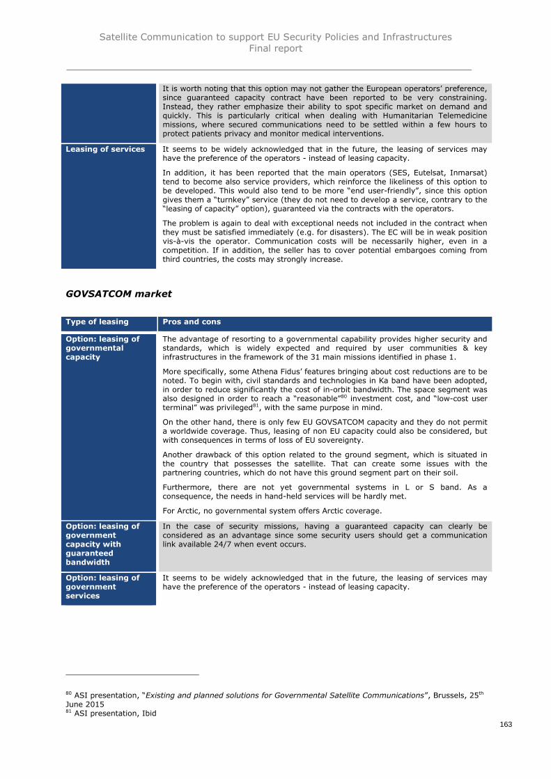
Satellite Communication to support EU Security Policies and InfrastructuresFinal report
163
It is worth noting that this option may not gather the European operators’ preference,since guaranteed capacity contract have been reported to be very constraining.Instead, they rather emphasize their ability to spot specific market on demand andquickly. This is particularly critical when dealing with Humanitarian Telemedicinemissions, where secured communications need to be settled within a few hours toprotect patients privacy and monitor medical interventions.
Leasing of services It seems to be widely acknowledged that in the future, the leasing of services mayhave the preference of the operators - instead of leasing capacity.
In addition, it has been reported that the main operators (SES, Eutelsat, Inmarsat)tend to become also service providers, which reinforce the likeliness of this option tobe developed. This would also tend to be more “end user-friendly”, since this optiongives them a “turnkey” service (they do not need to develop a service, contrary to the“leasing of capacity” option), guaranteed via the contracts with the operators.
The problem is again to deal with exceptional needs not included in the contract whenthey must be satisfied immediately (e.g. for disasters). The EC will be in weak positionvis-à-vis the operator. Communication costs will be necessarily higher, even in acompetition. If in addition, the seller has to cover potential embargoes coming fromthird countries, the costs may strongly increase.
GOVSATCOM market
Type of leasing Pros and cons
Option: leasing ofgovernmentalcapacity
The advantage of resorting to a governmental capability provides higher security andstandards, which is widely expected and required by user communities & keyinfrastructures in the framework of the 31 main missions identified in phase 1.
More specifically, some Athena Fidus’ features bringing about cost reductions are to benoted. To begin with, civil standards and technologies in Ka band have been adopted,in order to reduce significantly the cost of in-orbit bandwidth. The space segment wasalso designed in order to reach a “reasonable”80 investment cost, and “low-cost userterminal” was privileged81, with the same purpose in mind.
On the other hand, there is only few EU GOVSATCOM capacity and they do not permita worldwide coverage. Thus, leasing of non EU capacity could also be considered, butwith consequences in terms of loss of EU sovereignty.
Another drawback of this option related to the ground segment, which is situated inthe country that possesses the satellite. That can create some issues with thepartnering countries, which do not have this ground segment part on their soil.
Furthermore, there are not yet governmental systems in L or S band. As aconsequence, the needs in hand-held services will be hardly met.
For Arctic, no governmental system offers Arctic coverage.
Option: leasing ofgovernmentcapacity withguaranteedbandwidth
In the case of security missions, having a guaranteed capacity can clearly beconsidered as an advantage since some security users should get a communicationlink available 24/7 when event occurs.
Option: leasing ofgovernmentservices
It seems to be widely acknowledged that in the future, the leasing of services mayhave the preference of the operators - instead of leasing capacity.
80 ASI presentation, “Existing and planned solutions for Governmental Satellite Communications”, Brussels, 25th
June 201581 ASI presentation, Ibid

Satellite Communication to support EU Security Policies and InfrastructuresFinal report
164
4.2.4.5 Scenario 1 analysis
COMSATCOM market
As explained previously, each scenario has been evaluated through a fit/gap analysissimilar to that realized during phase 2. To ensure the overall study consistence, criteria(risks & threats) and users’ critical requirements defined in phase 2 have been used inthe scenarios analysis. As for phase 2 analysis, the objective is to present a percentageof coverage of the different scenarios with respect to the different criteria and criticalrequirements identified.
The coverage rating is processed over a scale going from 0 (the scenario coverage vscriteria or critical requirement is <10%) to 5 (coverage >91%). For this scenario with apurchasing of commercial capacity, coverage ratings are based on the coverage of thedifferent COMSATCOM systems analyzed in phase 2 of this study. Percentages ofcoverage correspond to the average of the COMSATCOM systems82 for the consideredcriteria and critical requirements.
Analysis of criteria coverage by scenario 1 / COMSATCOM market
#Criteria
categoryCriteria (risk / threat)
Scenario 1coverage vs
criteriaComments on scenario 1 coverage
C1
Availability
SATCOM capacity notavailable during allmission duration(continuity ofcommunications)
Few COMSATCOM operators offerguaranteed and un-pre-emptible capacitiesHowever today the level of availability isgenerally good thanks to the rapid capacityincrease of new launches
C2Interdiction to use thesystem in the area ofoperation
- In most cases, licensing in all countriesopened for civil SATCOM operation isobtained or obtainable, with the exception ofthe few countries (e.g. Argentina, India)where this use is prohibited- Depends on the negotiation betweenoperator and national authorities ofcountries where are located potentialcustomers
C3 Jamming
- In many cases, commercial systems do nothave any protection against jamming- Very few commercial systems may havesome anti-jamming protection or can bedifficult to jam (e.g. LEO constellation)
C4 Interference
- In some cases, interference monitoringand protection are ensured by monitoringand control centers operated 24h / 375days- Some systems are not protected againstinterference
C5Third State controlling thesystem
If the operator is not EU and / or has strongdependency with non EU government, thisrisk may not be covered at allMoreover, compliance with the US NationalInformation Assurance Policy established forSpace Systems used to Support NationalSecurity Missions (CNSSP-12) (i.e. issue ofthird state / anchor customer dependency)could induce additional risks
C6Commercial entitycontrolling the service
If the operator is not EU and / or has strongdependency with non EU government, thisrisk may not be covered at all.
82 For more details, please refer to the phase 2 of the study

Satellite Communication to support EU Security Policies and InfrastructuresFinal report
165
#Criteria
categoryCriteria (risk / threat)
Scenario 1coverage vs
criteriaComments on scenario 1 coverage
C7Frequency band notavailable
The risk is real in the civil radiofrequencybandsHowever it does not appear really significanttoday - but cannot be ignored as thedemand for high data rate and additionalconstellation is ever increasing, and the costbarrier for public use decreasing
C8Terminal too complex forcommon civilian usage
In most cases, COMSATCOM terminals areuser-friendly and made easy to use
C9Shortage of terminalpower
Most of terminals are for fixed use.Transportable or mobile COMSATCOMterminals offer very limited autonomycompared to GOV/MILSATCOM terminals
C10Terminal vulnerability tospecific environment /shock
Except for some very specialized ones, mostof the terminals requires precautions of usemaking them vulnerable to hostileenvironmentSome external antennas are adapted tospecific environmental conditions
C11Shortage of componentsupply due to third Statestechnology dependence
In most cases, export restrictions or foreigndependence over substantial parts of thesystem
C12
Confidentiality& Integrity
Interception / protectionof information
COMSATCOM capacity and networks havemainly no specific system againstinterception of communications. Protectionof information would require use ofadditional devices (optional)
C13 CyberattackIn most cases, security standards reportedas "perfectible"
C14 Spoofing / intrusionIn several cases, no specific systemimplemented to prevent an intrusion onCOM system
C15Authentication / Nonrepudiation
User's authentication procedures can beimplemented (optional), some vulnerabilitiesidentified
C16 Security of supply
COM satellites are built either inside oroutside EU but may contain equipment’ssubject to ITAR restrictionsTerminals and ground network equipmentare commercial ones and are not subject toany supply chain securisation rules
Analysis of critical requirements coverage by scenario 1 / COMSATCOM market
#Critical
requirementcategory
Critical requirementScenario 1
coverage vsCR
Comments on scenario 2 coverage
CR1
Missionrequirements
Arctic coverage
Except in some cases (Iridium butassociated with serious concerns onsovereignty & enclined GEO satellite, butwith limited performances), Arctic coverageis not enabled by current commercialsystems
CR2 RPAS communicationsRPAS communications allowed in mostcases; but not possible at all for somesystems
CR3Distance of operationsfrom Europe
Some regional operators, others haveworldwide coverage. Few have a veryrestricted coverage area (only EU)

Satellite Communication to support EU Security Policies and InfrastructuresFinal report
166
#Critical
requirementcategory
Critical requirementScenario 1
coverage vsCR
Comments on scenario 2 coverage
CR4 Flexibility - geographical
Generally, the COM systems analyzed areflexible (e.g. steerable spot beam, on-demand reallocation of capacity), but, inmost cases, possible saturations may benoted as limits
CR5 Flexibility - network
Generally, the COM systems analyzed areflexible in terms of network management,but, in most cases, possible saturationsmay be noted as limits
CR6 Interoperability
- Most of the COM systems are notinteroperable with other constellations- Some systems are interoperable withterrestrial network (GSM, Wifi, etc.)
CR7 SATCOM link recovery
In most cases, link recovery is providedthrough another satellite of the operator'sconstellationSome satellites have redundant equipmenton board (e.g. Quantum)
CR8
Servicerequirements
High data rate servicesIn most cases, high data rate services areprovided. In some cases, bandwidth islimited (e.g. Iridium, Thuraya)
CR9 Service: trackingThis service is a commercial standard forhand-held terminals ("Satphones") only
CR10Service: voice / VoIP(Voice over IP)
Voice / VoIP is provided by all thecommercial operators analyzed
CR11 Service: textText service is provided by all thecommercial operators analyzed
CR12Service: computerservices
Provided by most of COM systems but canbe limited by effective bandwidth (e.g.Globalstar, Iridium, Thuraya)
CR13Service: database (incl.image)
Provided by most of COM systems but canbe limited by effective bandwidth (e.g.Globalstar, Iridium, Thuraya)
CR14Service: realtimeimaging
Available in most cases; however, notpossible for some systems having notsufficient bandwidth (e.g. Globalstar)
CR15Service:videoconferencing
Available in most cases; however, notpossible for some systems having notsufficient bandwidth (e.g. Globalstar,Iridium)
CR16 Service: realtime video
Available in some cases and not possiblefor some systems having not sufficientbandwidth (e.g. Globalstar, Iridium,Thuraya)
CR17
Equipmentrequirements
Equipment: trackingMost SATCOM terminals are geolocalized,at least to enable auto-acquirefunctionalities
CR18 Equipment: hand-heldDepends on the system. In some cases,hand-held terminals are not available
CR19 Equipment: laptop Available in most cases
CR20 Equipment: on-the-move Available in most cases
CR21Equipment: integratedterminal
Integrated terminals are provided by all thecommercial operators analyzed
CR22
Purchasingrequirements
Terminal costMost of the time, the cost of COM terminalsis moderate
CR23 Communication cost
The cost of COM communication under thisscenario is generally the most competitive/cheapest (but depend on the frequencyband chosen)

Satellite Communication to support EU Security Policies and InfrastructuresFinal report
167
#Critical
requirementcategory
Critical requirementScenario 1
coverage vsCR
Comments on scenario 2 coverage
CR24 SATCOM procurement
SATCOM capacity easy to purchase asCOMSATCOM operators have a recognizedexperience of leasing contractsHowever, some operators do not have GOVclient

Satellite Communication to support EU Security Policies and InfrastructuresFinal report
168
GOVSATCOM market
For this scenario with a purchasing of governmental capacity, coverage ratings are basedon the coverage of the different GOVSATCOM systems analyzed in phase 2 of this studybalanced by the weight of impacting parameters in case of leasing of non-EU GOVcapacity/ services through non EU GOVSATCOM such as WGS (e.g. distance ofoperations, Third State controlling the system, commercial entity controlling the serviceget a different rating under this configuration).
Analysis of criteria coverage by scenario 1 / GOVSATCOM market
#Criteria
categoryCriteria (risk / threat)
Scenario 1coverage vs
criteriaComments on scenario 1 coverage
C1
Availability
SATCOM capacity notavailable during allmission duration(continuity ofcommunications)
Some limitation observed, e.g. limitation interms of capacity, coverage. Capacitysaturation in some regions or spots at someperiod could happenHowever, GOVSATCOM operators offerguaranteed and un-pre-emptible capacities
C2Interdiction to use thesystem in the area ofoperation
Generally no issue, but some arrangements/negotiations may be required in some areas
C3 Jamming
Depends on the cases: some systems do nothave any jamming protection, while othershave jamming carriers detection andmitigation
C4 InterferenceMost of the system has anti-interferencecapabilities
C5Third State controlling thesystem
EUMS
GOV
Non-EU
GOV
In case of EU MS ownership of theGOVSATCOM system, the risk of preemptionis limited by essenceIn case of non-EU GOVSATCOM system, therisk of preemption is high.Some GOVSATCOM systems (EU and nonEU) are potentially compliant with the USNational Information Assurance Policyestablished for Space Systems used toSupport National Security Missions (CNSSP-12) (i.e. issue of third state / anchor userdependency)
C6Commercial entitycontrolling the service
C7Frequency band notavailable
Not detected as an issue for any of thesystems analyzed
C8Terminal too complex forcommon civilian usage
Depends on the systems; in some cases,terminals are commercial-type (Athena-Fidus) but in others (XTAR, LuxGovSat),they may require some training for an easyuse
C9Shortage of terminalpower
Most of terminals are for fixed use.Transportable or mobile GOVSATCOMterminals offer good autonomy
C10Terminal vulnerability tospecific environment /shock
Mostly designed to operate in hostileenvironment
Extreme environments (High seas, deserts,poles, etc.) still require Mil-grade electroniccomponents
C11Shortage of componentsupply due to third Statestechnology dependence
Depends on the systems: in some cases, noITAR components, while some others(LuxGovSat, XTAR) contain ITAR criticalcomponents
C12Confidentiality& Integrity
Interception / protectionof information
Most of GOV systems have protectionagainst interception and secured TT&CEncryption (sometimes with MIL gradestandards) ensured

Satellite Communication to support EU Security Policies and InfrastructuresFinal report
169
#Criteria
categoryCriteria (risk / threat)
Scenario 1coverage vs
criteriaComments on scenario 1 coverage
C13 Cyberattack
High standards of protection against anycyberattackSome gateways situated on military areas inEUSecured TT&C
C14 Spoofing / intrusionHigh standards of protection observed forGOV systems
C15Authentication / Nonrepudiation
Generally, authentication proceduresprovided
C16 Security of supplySystem design & manufacturing are wellsecured but could be done by non EUmanufacturers
Analysis of critical requirements coverage by scenario 1 / GOVSATCOM market
#Critical
requirementcategory
Critical requirementScenario 1
coverage vsCR
Comments on scenario 2 coverage
CR1
Missionrequirements
Arctic coverageCurrent GOVSATCOM do not offer Arcticcoverage (except with enclined GEOsatellite, but with limited performances)
CR2 RPAS communicationsMost of the GOV systems are compliantwith RPAS communication (N/A for EDRS)
CR3Distance of operationsfrom Europe
EU MS GOV systems do not provideworldwide coverage (e.g. Arctic, some Asiaregions)Consequently, additional capacity has to beleased from non EU GOV system, withconsequences in terms of EU autonomy /sovereignty (cf. risks n°5 & 6)
CR4 Flexibility - geographicalMost of the GOV systems have steerablespot beams and could reallocate capacitywithin a few minutes
CR5 Flexibility - networkMost of the GOV systems have flexible andreconfigurable networks
CR6 InteroperabilityIn general, EU and non EU systemsinteroperable with other systems andterrestrial networks
CR7 SATCOM link recovery Most of the GOV systems are redundant
CR8
Servicerequirements
High data rate servicesHigh data rate services provided by GOVsystems
CR9 Service: trackingGenerally possible to implement it at user-level
CR10Service: voice / VoIP(Voice over IP)
Voice / VoIP is provided under all the GOVsystems
CR11 Service: textText service is provided under all the GOVsystems
CR12Service: computerservices
Computer services are provided under allthe GOV systems
CR13Service: database (incl.image)
Database (incl. Image) is provided under allthe GOV systems
CR14Service: realtimeimaging
Realtime imaging is provided under all theGOV systems
CR15Service:videoconferencing
Videoconferencing is provided under all theGOV systems
CR16 Service: realtime videoRealtime video is provided under all theGOV systems
CR17
Equipmentrequirements
Equipment: trackingMost SATCOM terminals are geolocalized, atleast to enable auto-acquire functionalities
CR18 Equipment: hand-heldDepends on the system. In some cases,hand-held terminals are not available
CR19 Equipment: laptopLaptop (e.g. manpack portable) is providedunder all the GOV systems

Satellite Communication to support EU Security Policies and InfrastructuresFinal report
170
#Critical
requirementcategory
Critical requirementScenario 1
coverage vsCR
Comments on scenario 2 coverage
CR20 Equipment: on-the-move Available in most cases
CR21Equipment: integratedterminal
Available in most cases
CR22
Purchasingrequirements
Terminal cost
X-band terminals are expensive with veryconstraining specificationsFor the Ka-band, variety of terminals couldbe used: from the relatively cheapcommercial terminal up to the most securemilitary one
CR23 Communication cost
X-Band capacity is generally relativelyexpensive due to the cost of X-Band spacecomponent produced in limited quantitiesand the scarcity of available in-orbitcapacityFor Ka Band communication would becheaper but more expensive than purecommercial Ka Band capacity
CR24 SATCOM procurementSome procurement restrictions to beexpected, especially with non EU GOVsystems
Satellite Communication to support EU Security Policies and InfrastructuresFinal report
171
4.2.5. Scenario 2: Member States Consortium
4.2.5.1. Description
In scenario n°2, next generation of GOVSATCOM is developed through pooling & sharingof Member States SATCOM capacities at EU level, with Member States developingGOVSATCOM capacity to cover both their own needs and EU civilian mission needs.
In order to manage the pooling and sharing of EU Member States capacities theEuropean Commission could propose a legal instrument to help structure - under themanagement of the EU - the creation of a Consortium of European GOVSATCOMoperating Member States. A similar instrument has been successfully implemented in theDecision establishing a Space Surveillance and tracking Support Framework. Taking as anexample the Space Surveillance and Tracking (SST) governance model, a “GOVSATCOMsupport framework” could therefore be created by the EC in order to network and usenational GOVSATCOM assets and induced services. This scenario could also envisage theuse of SATCOM systems under the responsibility of the Consortium of EuropeanGOVSATCOM previously defined. In that case, this Consortium should ensure theappropriate level of Information Assurance required for the EU GOVSATCOMcommunications.
As scenario 2 is based on the use of Member States SATCOM capacities (GOVSATCOM),the coverage of security requirements is higher than for scenario 1, but current/plannedGOVSATCOM systems do not fully cover all the security requirements. The securityaccreditation (with a dedicated EU security accreditation authority) presented inthe previous scenario could also be considered in order to align GOVSATCOM systems’characteristics with users’ security requirements.
Similarly as scenario 1, this approach does not address the issue of the renewal ofcurrent European GOVSATCOM systems at EU level as the next generation ofGOVSATCOM development stays at Member States level. Under this scenario, researchelements identified with the Industry (manufacturers, operators), ESA and national spaceagencies to fulfil users’ requirements (e.g. accredited secured terminals) could bepotentially supported by Horizon 2020 or ARTES programmes (cf. paragraph 4.3 –Technological developments).
Example
This configuration has been used by NATO in the case of NSP2K, with a Memorandum ofUnderstanding signed by a consortium of three NATO Member States (France, Great-Britain and Italy). The space segment is to be provided between 2004 and 2019. There,the space segment capability is no longer NATO-owned and controlled but providedthrough national MILSATCOM capabilities.
Most specifically, the space segment is controlled by the Member States, while NATOprovides the guidelines. A Joint Programme Management Office has been set up toenable the overall management of the programme and ensure an open dialogue withNATO, for instance on emerging requirements or changes in constellations.
4.2.5.2. Procurement/ purchase options
The pooling & sharing relies on National capacity, the owner of the capacity being theparticipating Member States. Accordingly, there is no purchase or procurement ofcapacity/ services under this scenario.

Satellite Communication to support EU Security Policies and InfrastructuresFinal report
172
4.2.5.3 Budget estimations – Capacity leasing/purchase
No leasing agreement is passed or capacity/ services purchased. The cost of this scenariois therefore limited. OPEX should however be anticipated to set-up the entity supervisingand managing these pooling and sharing operations, and how they benefit to thedifferent user communities & key infrastructures.
4.2.5.4 Pros and cons
Type of leasing Pros and cons
Member StatesConsortium
This scenario does not imply any transfer of competences in the pooling & sharingpart, which makes it more acceptable for the Member States.
From a Member States perspective as well, this scenario induces an optimization oftheir existing and planned capacities, which should not be underestimated in timesof economic constraint. To finish with, from an EC standpoint, the absence ofpurchase or procurement of capacity/ services in this scenario can be seen as anadvantage (no need to set up projects such as PPP, PFI, etc.).
On the other hand, Member States should continue to give priority to their ownneeds (e.g. Strategic Nuclear Deterrence, Foreign Operations, etc.) over the poolingof their residual capacities.
Moreover, there is actually few GOVSATCOM capacity in the EU, not allowing aworldwide coverage yet necessary for some EU civil security missions.
In addition, potential availability issues may arise. The localisation of the groundsegment could also provoke some sovereignty issues. Intergovernmental schememight cause some governance issues.
4.2.5.5 Scenario 2 analysis
For this scenario, coverage ratings are based on the coverage of the differentGOVSATCOM systems analyzed in phase 2 of this study. Percentages of coveragecorrespond to the average of the GOVSATCOM systems83 for the considered criteria andcritical requirements.
Analysis of criteria coverage by scenario 2
#Criteria
categoryCriteria (risk / threat)
Scenario 2coverage vs
criteriaComments on scenario 2 coverage
C1
Availability
SATCOM capacity notavailable during allmission duration(continuity ofcommunications)
Some limitation observed, e.g. limitation interms of capacity, coverage. Capacitysaturation in some regions or spots at someperiod could happen
C2Interdiction to use thesystem in the area ofoperation
Generally no issue, but some arrangements/negotiations may be required in some areas
C3 Jamming
Depends on the cases: some systems do nothave any jamming protection, while othershave jamming carriers detection andmitigation
C4 InterferenceMost of the system has anti-interferencecapabilities
83 For more details, please refer to the phase 2 of the study

Satellite Communication to support EU Security Policies and InfrastructuresFinal report
173
#Criteria
categoryCriteria (risk / threat)
Scenario 2coverage vs
criteriaComments on scenario 2 coverage
C5Third State controlling thesystem
Pooling and sharing of EU MS GOVSATCOMsystem, the risk of preemption is limited byessence.However, some EU MS GOVSATCOMsystems are potentially compliant with theUS National Information Assurance Policyestablished for Space Systems used toSupport National Security Missions (CNSSP-12) (i.e. issue of third state dependency)
C6Commercial entitycontrolling the service
Pooling and sharing of EU MS GOVSATCOMsystem, the risk of preemption is limited byessence
C7Frequency band notavailable
Not detected as an issue for any of thesystems analyzed
C8Terminal too complex forcommon civilian usage
Depends on the systems; in some cases,terminals are commercial-type (Athena-Fidus) but in others, they may require sometraining for an easy use
C9Shortage of terminalpower
Most of terminals are for fixed use.Transportable or mobile GOVSATCOMterminals offer good autonomy
C10Terminal vulnerability tospecific environment /shock
Mostly designed to operate in hostileenvironment
Extreme environments (High seas, deserts,poles, etc.) still require Mil-grade electroniccomponents
C11Shortage of componentsupply due to third Statestechnology dependence
Depends on the systems: in some cases, noITAR components, while some otherscontain ITAR critical components
C12
Confidentiality& Integrity
Interception / protectionof information
Most of GOV systems have protectionagainst interception and secured TT&CEncryption (sometimes with MIL gradestandards) ensured
C13 Cyberattack
High standards of protection against anycyberattackSome gateways situated on military areas inEUSecured TT&C
C14 Spoofing / intrusionHigh standards of protection observed forGOV systems
C15Authentication / Nonrepudiation
Generally, authentication proceduresprovided
C16 Security of supplySystem design & manufacturing are wellsecured but could be done by non EUmanufacturers
Analysis of critical requirements coverage by scenario 2
#Critical
requirementcategory
Critical requirementScenario 1
coverage vsCR
Comments on scenario 2 coverage
CR1
Missionrequirements
Arctic coverageCurrent EU MS GOVSATCOM do not offerArctic coverage
CR2 RPAS communicationsAll EU GOV systems are compliant withRPAS communication (N/A for EDRS)
CR3Distance of operationsfrom Europe
EU MS GOV systems do not provideworldwide coverage (e.g. Arctic, some Asiaregions)

Satellite Communication to support EU Security Policies and InfrastructuresFinal report
174
#Critical
requirementcategory
Critical requirementScenario 1
coverage vsCR
Comments on scenario 2 coverage
CR4 Flexibility - geographical
Most of the EU GOV systems havesteerable spot beams and could reallocatecapacity within a few minutes, but withinthe coverage of these EU systems - cf. CR3
CR5 Flexibility - networkMost of the EU GOV systems have flexibleand reconfigurable networks
CR6 InteroperabilityIn general, EU systems interoperable withother systems and terrestrial networks
CR7 SATCOM link recovery Most of the GOV systems are redundant
CR8
Servicerequirements
High data rate servicesHigh data rate services provided by GOVsystems
CR9 Service: trackingGenerally possible to implement it at user-level
CR10Service: voice / VoIP(Voice over IP)
Voice / VoIP services are provided by allthe EU MS GOV systems analyzed (N/A forEDRS)
CR11 Service: textText service is provided by all the EU MSGOV systems analyzed
CR12Service: computerservices
Computer services are provided by all theEU MS GOV systems analyzed
CR13Service: database (incl.image)
Database (incl. Image) is provided by allthe EU MS GOV systems analyzed
CR14Service: realtimeimaging
Realtime imaging is provided by all the EUMS GOV systems analyzed
CR15Service:videoconferencing
Videoconferencing is provided by all the EUMS GOV systems analyzed
CR16 Service: realtime videoRealtime video is provided by all the EU MSGOV systems analyzed
CR17
Equipmentrequirements
Equipment: trackingMost SATCOM terminals are geolocalized,at least to enable auto-acquirefunctionalities
CR18 Equipment: hand-heldDepends on the system. In some cases,hand-held terminals are not available
CR19 Equipment: laptopLaptop (e.g. manpack portable) is providedby all the EU MS GOV systems analyzed
CR20 Equipment: on-the-move Available in most cases
CR21Equipment: integratedterminal
Available in most cases
CR22
Purchasingrequirements
Terminal cost
X-band terminals are expensive with veryconstraining specificationsFor the Ka-band, variety of terminals couldbe used: from the relatively cheapcommercial terminal up to the most securemilitary one
CR23 Communication cost N/A N/A: pooling & sharing of capacity
CR24 SATCOM procurementPartly intergovernmental scheme, maycreate some governance issues

Satellite Communication to support EU Security Policies and InfrastructuresFinal report
175
4.2.6. Scenarios 3 & 4: Development of a specific GOVSATCOM,through Public Private Partnership or EU Space infrastructure
4.2.6.1. Description
Under these scenarios, a specific GOVSATCOM system is developed. Two purchasingscheme can be considered:
Scenario 3: a Public Private Partnership (incl. Private Finance Initiative).In that case, EU GOVSATCOM could be defined as ‘combination of public /private initiatives
Scenario 4: an EU Space Infrastructure model (type Galileo &Copernicus). In that case, EU GOVSATCOM could be defined as a SATCOMcapacity owned & operated by the EU, with activities delegated /contracted to Space Agencies / ESA / Industry
In any of those cases, the issue of the renewal of current European GOVSATCOMcapacities would be addressed at EU level. Under both of these scenarios, researchelements identified with the Industry (manufacturers, operators), ESA and national spaceagencies to fulfil users’ requirements (e.g. accredited secured terminals) could bepotentially supported by Horizon 2020 or ARTES programmes (cf. paragraph 4.3 –Technological developments).
4.2.6.2. Scenario 3: Public Private Partnership
At the light of past experiences in the space sector, it appears that PPPs have beenextensively used for the last decades by public authorities worldwide when in position tofund large and expensive infrastructures.
PPP is a valid option but it opens a very wide landscape of possibilities. Some keycharacteristics need to be studied depending on the various phases of a typical spaceprogramme, as presented in the following figure.
Figure 8 - examples of PPP possible configurations

Satellite Communication to support EU Security Policies and InfrastructuresFinal report
176
An analysis of the different procurement schemes allowed under PPP configurations istherefore provided hereunder. Previous space PPPs have been particularly inspiring towithdraw best practices and potential lessons to be taken into account by the EC, alongwith industrials/ operators feedbacks on their PPPs experiences.
Main features
As generally defined by OECD, Public-Private Partnerships (PPP) are “arrangementswhereby the private sector provides infrastructure assets and services that traditionallyhave been provided by government”.
As a matter of fact, it is not easy to categorize PPPs into clear boxes. Knowing the varietyof sectors PPPs are involved in, the diversity of the public and private entities’ statutesthat can engage this kind of process, adopting an exhaustive approach would require toanalyse all the PPPs passed on a case by case basis.
However, in order to draw generic PPP models that have been deployed in the spacesector, it is important to describe first the different steps of PPPs, that can be processed(and at a different degree) either by the public or the private entity:
Design Build Finance Maintain Operate Transfer Concessioning Own
Behind the share of cost, the real interest of PPP lays in the allocation of risks it enablesbetween the public entity and the private partner, more efficient than in case of whollypublic management. They can be:
Political risk (change in policy or regulatory orientations, in tax levels, etc.) Construction risk Operation and maintenance risk Legal and contractual risk Income risk Financial risk Environmental risk Force majeure Project default
According to the respective involvements of the private/ public sector in these differentsteps -corresponding to different levels of risk transfer - several models have beenempirically used in the space sector.
“Design build”
Under this model, the private entity designs and builds the asset upon specificationsprovided by the public sector, usually for a fixed price. The infrastructure’s maintenanceis not aimed at being transferred to the private partner/operator in this case, and thepublic sector keeps the responsibility for the operation.

Satellite Communication to support EU Security Policies and InfrastructuresFinal report
177
“Design-Build-Finance-Operate”
In this system, the private entity designs, builds and operates the new assets. It alsoassumes the risk of financing until the end of the contract period. Contrary to a modelwhere there is an ownership transfer, the public entity remains in this case the owner ofthe infrastructure and assumes in accordance the responsibility for maintenance andoperation.
“Concessioning”
Under a concession agreement, the government gives the right to the private entity tooperate, maintain, and collect user fees for an existing publicly-owned asset. It usuallydoes not imply any transfer of ownership in itself; however, according to the agreementpassed between the parties, certain rights of ownership may be transferred. Thecounterpart of the concession agreement for the private entity is transferring up-frontfees back to the government or a share of revenues.
Examples
During the development phase of Galileo, the industrial organization privileged took theform of a joint venture of leading European space companies, named Galileo Industries(GaIn) and then renamed European Satellite Navigation Industries (ESNI). The selectionwas operated by ESA. The consortium represented the prime contractor for thedevelopment and delivery of the Galileo infrastructure. In retrospect, due to the absenceof real competition, it seems clear that ESA had no other choice but to select suchconsortium as well as the subcontractors selected84.
The selection process and the uncertainties related to the business model were madedifficult, unleashing delays and cost overruns, ESA decided in 2007 to resettle theindustrial organization in charge of the in-orbit validation phase (IOV), and acted itself asthe prime contractor85.
“Joint-Venture Operate”
In the case of a new project, the Joint-Venture is established with a joint ownershipstructure. This configuration does not prevent the government from having a controlinfluence or even a “veto” power. Typically, the operation and maintenance functions aredelegated to the private operator through a management contract, while the rightsattaching to shares and the rights between the shareholders are typically set out in theconstitutional documents of the company and the shareholders' agreement86.
Examples
LuxGovSat is a very recent example of public-private venture between the Luxembourggovernment and SES. Its objective is to provide “a secure, reliable, non-pre-emptible andaffordable governmental SATCOM infrastructure in X-band and military Ka-band toaddress the demand resulting from “governmental and institutional SATCOMrequirements”87. The capital is equally possessed by the Luxembourg State and SES (50M€ each).
84 European Court of Auditors, The management of the Galileo programme’s development and validation phase85 European Parliament, The Galileo Programme : management and financial lessons learned for future spacesystems paid out of the EU budget86 http://ppp.worldbank.org/public-private-partnership/agreements/joint-ventures-empresas-mixtas87 LuxGovSat presentation, example of existing and planned European GOVSATCOM solutions, Brussels, 25th
June 2015

Satellite Communication to support EU Security Policies and InfrastructuresFinal report
178
“Private Finance Initiative with operating entity”
The main characteristic of Private Finance Initiative (PFI) is the use of project finance inorder to deliver a public sector infrastructure or service, on the basis of requirementsestablished by the public entity. In this configuration, private entity is generally alsotasked to operate the infrastructure, for a long-time period (at least 20 years), whichprovides an advantage of stability in terms of project management. It is worth notingthat payment to the private entity is only made if services are delivered according to therequirements of the contractual arrangement (i.e. a concession agreement).
Examples
The implementation of the Skynet 5 system was achieved under a PFI model. It wasdeveloped and operated by Paradigm Secure Communications (private entity), with theaim of providing the UK MoD with secure military communication services, using X band.
Paradigm was selected after demonstrating that it could match the service continuity of astate owned solution and operated at a lower price. The contract included Monthlyavailability fee and usage fees, incentives for both parties, and assurance process to giveMoD guarantees on the service availability. In this configuration, the risks weretransferred to industry at the different stages of the process (Construction, EquipmentPerformance, Network Operations). Nevertheless, the efficiency of such model could bechallenged: based on recent interventions from the UK MoD and Airbus, the PFI modelcould not be selected for the next generation of UK Military satellites.
The publication in June 2015 by the GSA of a request for information for the provision ofa new GEO payload which will relay the EGNOS signal to the user’s receivers providesanother example. As precised by the GSA RFI, the provider shall also assure the launchand the commissioning of the payload, and the uplinks to the payload from two separateearth stations.
The GSA proposes two options for the financing of the procurement:
Option 1: equal yearly leasing fees for the GSA once the payload is accepted in-orbit for the service.
Option 2: complete procurement of the payload by the provider but with fullfinancing of the capital costs by the GSA. The subsequent operations will result inyearly operations fees for the GSA.
“Build-Own-Operate” (BOO)
In this case, the private entity involved builds a new facility, then owns and operates thefacility at its own risk. As a counterpart, the government usually provides revenueguarantees through long-term take-or-pay contracts for bulk supply facilities or minimumtraffic revenue guarantees.
Examples
The Alphasat programme is a BOO: indeed, it was an ESA-originated PPP, between theagency and UK operator Inmarsat, with Astrium as the prime contractor. It consisted in acommercial payload and 4 Technology Demonstration Payloads and was launched in2013. The initiation of this PPP was performed under a two-step approach. Basically, ESAaimed at enabling the in-flight validation of this new product. For this purpose, ESA firstsupported the development of the new product to be commercialized (co-funding withindustry). Then, it was up to Inmarsat to take the risk of flying the new product, andexploit the system over its life time.
Similarly, newly-developed Quantum has been the result of a PPP (established underArtes 33.3) between ESA, Airbus DS and Eutelsat. More precisely, it was an industry-originated PPP, meaning that it was the operators that approached ESA in order to de-risk its business case when introducing its innovative system concept.

Satellite Communication to support EU Security Policies and InfrastructuresFinal report
179
In this framework, ESA funded about 50% of the cost (allocated to innovativedevelopments), the remaining being at the expense of Eutelsat.
According to the operator88, the share of responsibilities between the different entitiesinvolved ESA to bear the technological risk, which would have been too high for acommercial entity. At the same time, it is up to Airbus to develop the payload on theinternational market and to introduce a new platform (SSTL GMP-T).

Satellite Communication to support EU Security Policies and InfrastructuresFinal report
180
EDRS: an example of ESA service driven PPP scheme89
The European Data Relay Satellite System (EDRS) is aimed at improving the service quality andenhancing the reliability and independency of European and Canadian space infrastructures such asCopernicus and also national space assets by providing a space based telecommunication datarelay system. EDRS will foster the development of the satellite data relay services market throughthe exploitation of the infrastructure with commercial/institutional users beyond ESA. It will supportthe standardisation and adoption of Optical and Ka-Band DRS technology by means of theavailability of technological solutions for the EDRS infrastructure as well as for the user community(Earth Observation satellites, UAVs, etc.). Since it has been described as the “most ambitious” PPPpassed by ESA, it is worth a description.
ESA did set-up a ‘Service-driven’ Public Private Partnership scheme for EDRS in order to ensurethat a private partner will commercialize the relay services worldwide. The Private Partnercontributes to the financing of the infrastructure, procures the end-to-end EDRS infrastructure andguarantees the future availability and quality of services. Since the inception of the programme thefirst service contract was expected to be concluded with the anchor users of the Copernicusflagship programme. ESA selected the Private Partner for EDRS through an open competitiveprocess: Airbus Defence and Space (ADS). The PPP is based on the following share ofresponsibilities:
• ESA and ADS co-finance the EDRS-Infrastructure based on a new enabling laser communicationtechnology developed by TESAT (part of ADS) under a German R&D programme.
• ESA bears the risk of providing the anchor service customer Sentinel / Copernicus• ADS owns the infrastructure and finances the operations of the EDRS infrastructure over its life
time.• ADS bears the 3rd party service market risks• ADS bears the end-to-end system and service performance risks• ESA bears the risk of validating the LEO - GEO optical communications in-orbit (Sentinel-1A -
Alphasat/TDP1)
Benefits of the EDRS ‘Service-driven’ PPP scheme
Only a private company has the ability to develop a market of new services. ESA could not do it onits own and the past experience of ARTEMIS as an ESA-only programme showed that nooperational commercial service was ever provided in spite of a very large investment of ESA in thetechnology.
The total cost of the EDRS development is covered by about 60% through the ESA ARTES andother ESA programme; the rest of the funding is provided by the private partners. In addition thereis a complementary public funding for the SLAs service fees.
The PPP allows ESA in its role as R&D and implementation agency to cover the EDRS technicalrisks, which in 2011 still were perceived to be significant. In the meantime, the risks have beenretired, with the LCT being a commercial product and with successful in-orbit deployments andtests, including the 1st GEO-LEO link demonstration of 28.11.2014
The PPP also includes a public undertaking to provide the first anchor customer, which is essentialto allow the development of a market, while the financial scheme is such that ADS in its role ascommercial service provider takes the risk to acquire third party customers and to develop a futureprofitable business.
The private partner has a vested interest in containing the schedule and costs of the programme.With the public partners commitment to the SLAs, ADS carries the full financial responsibility orschedule and cost to completion of the programme.
The private partner in EDRS has a double role as prime contractor of the EDRS implementation andas future EDRS service provider. ADS has been responsible for the EDRS development andimplementation from the start and has been able to optimize the infrastructure and operationsconcept. Consequently, ADS is also responsible for the end to end performance of the system andservices as defined in Service Level Agreements in particular for Copernicus, and there will be nodelay between the acceptance of the EDRS satellites and the start of the provision of operationalservices.
89 ESA contribution

Satellite Communication to support EU Security Policies and InfrastructuresFinal report
181
Pros and cons of the different types of PPP
Type of PPP Pros and cons for the EC
Design-Build The market risk is at the expense of the private partner, since the organizationscheme under this model makes it assume potential cost overruns and delays.
Design-Build-Finance-Operate
Regarding the pros and cons, an assessment needs to be drawn between the gains inthe construction phase and potential offsetting losses in operations phase.
Indeed, potentially, stronger incentive for the private entity, stronger synergiesbetween the different stages of the implementation (design, build, finance, operate)makes it more efficient and more “customer-focused”. On the other hand, empirically,some significant pitfalls have been identified, such as potential conflicts of interestamong the different parties, unexpected problems management and the level of theprivate partner’s revenue risk.
For the public entity, the advantage of this model lays in the fact that it does not“give up” the ownership of the infrastructure.
Concessionning The balance of the European Satellite Navigation Industries (ESNIS) experience hasemphasized some limits to the concessioning model in the space sector. The Galileocase is extremely specific but these identified limits can still be considered as “pitfalls”to be avoided when designing future EU space programmes. For instance:
The Galileo Joint Undertaking (GJU) at the time was newly established, thuslacking experience in managing super large PPP procurements
There were too many unknowns/uncertainties for industry to take over largeown investment share, risk, and responsibility, specially, uncertainty withregard to eventual revenues from Galileo services
The system complexity has been underestimated and the programme riskmanagement has not been developed in accordance
The initial timetable may have been too ambitious and not flexible enough
Joint-VentureOperate
The unequal level and quality of the partners’ contribution can bring aboutimpediments in the expected JV collaboration process. Given that the Joint Venture isdue to aggregate means from two different entities, it is also important to set theobjectives very clear from the beginning, in order to avoid diverging views during theoperational phase. Similarly, the integration of operations is also a key challenge toovercome. On the other hand, such configuration can give access to wideropportunities, new markets and distribution reach for the entities that join together,and it multiplies the potential of skills, technologies available.
PFI with operatingentity
Skynet gathers some characteristics of a “pooling and sharing” system, since it makescapacity available to other EU governments. In addition, it can also use commercialcapacity to meet UK domestic needs. Last but not least, it presents the advantage tobe built, owned and operated on a lease basis which is European. Nevertheless, theefficiency of such model could be challenged: based on recent interventions from theUK MoD and Airbus, the PFI model could not be selected for the next generation of UKMilitary satellites.
Build-Own-Operate
The private entity selected has to perform the tasks contracted (build, ownership andoperation) at its own risk, which is quite significant since it is reported to involve longpayback period.
4.2.6.3 Scenario 4: EU Space Infrastructure
In this scenario, the Space infrastructure is financed by the EU, meaning a mobilizationof a dedicated line in the EU budget. GOVSATCOM is a SATCOM capacity owned &operated by the EU, with activities delegated / contracted to Space Agencies / ESA /Industry, such as for Galileo and Copernicus.
The EU takes the entire risk of the programme in that configuration, and a higher EUbudget amount has to be mobilized.
EU coordinated R&D activities are needed to support future in-orbit EU prototype(s).

Satellite Communication to support EU Security Policies and InfrastructuresFinal report
182
4.2.6.4 Space segment options for scenarios 3 & 4
In both cases, the space segment may take different forms:
Either a hosted payload on a planned satellite (be it commercial, governmental orEU satellite – Copernicus / Galileo)
A hosted payload is basically a module attached to a communication satellite, whichshare the same platform but is generally operated independently. This type of solutionhas been increasingly used by governments/ agencies in their recent space strategy. Themanagement of the payload specifications would be operated by the EU in a centralizedmanner.
Besides, it has been reported that the mission specifications of the payload must beintegrated from the early stage of the hosting satellite design: if the payload mission isdefined afterward, there is a significant risk of ‘mismatch” between the payload and thehosting satellite to be encountered, which is a crucial element to anticipate in terms ofprogramme management.
Or a full satellite communication system
Another option may consist in a full satellite(s) and not only a hosted payload. Thisoption would give the EC room for deploying a “tailored-made” program, adapting thescale, characteristics of the system to be implemented, according to the userrequirements to be filled.
When it comes to know whether to choose a configuration of hosted payload or a fullsystem, this will largely depend on the capacity and the location required for themissions.
As described above, several space segment configurations can be envisaged, a hostedpayload on a planned satellite or of a full satellite communication system, anotherconfiguration as further described below. The Arctic specific space segments are alsotaken into account in this analysis.
Hosted payload on planned satellite
Option 1: hosted payload on EU satellites
Description
The hosted payload architecture described above also applies in this case with thepayload attached to Galileo or Copernicus satellites.
Example
In the frame of the Copernicus programme deployment, next Sentinels’ generations areplanned to be launched on a regular basis. Therefore, a potential scenario would be toattach a payload on next generations of Sentinels, which would provide the securityrequirements necessary when dealing with EU institutional users’ secured satellitecommunications.

Satellite Communication to support EU Security Policies and InfrastructuresFinal report
183
Option 2: hosted payload on civilian/ governmental satellites
Description
The hosted payload scheme remains the same. In this case, the hosted payload would beattached to a civilian or governmental satellite.
Example
As highlighted in phase 2, the XTAR-LANT hosted payload can be taken as an example: itwas placed on the SPAINSAT satellite located at 30 degrees West longitude. It providesover 4 GB of flexible, secure X-band capacity. This system can accommodate massivewideband data requirements90.
Option 3: hosted payload on commercial satellite
Description
In this case, the host satellite is commercially-owned.
Example
Intelsat 22 satellite is in this configuration, since it carries a UHF payload built under a 15year contract to the Australian Defence Force. In particular, the aim was to provideAustralian Defence Force with a rapid launch of tactical communications capability. In thisframework, Intelsat has the responsibility to provide the UHF Payload and Bus Operation,to deliver communications monitoring and In Orbit test services, to provide access totelemetry and annual training.
This has resulted in shared cost of the launch vehicle and spacecraft bus with thecommercial payload, on schedule and, according to the operator, cost-efficiently.
All in all, in this case, using a hosted payload has led to savings of $150 million, rapiddelivery to orbit of significant capabilities (35 months vs. more than 5 years in otherconfigurations). In the meanwhile, the Australian Defence Force has expanded its UHFcapabilities around the globe91.
Option 4: Arctic specific Hosted payload
Description
In this case, the hosted payload would be attached either to commercial, or to an EU orto a governmental satellite allowing an Arctic coverage (LEO or HEO). The main issuehere relates to the business case for commercial operators in Arctic reported as non-viable yet.
Example
One of the possibilities suggested phase 3 consultations to be further assessed couldconsist in attaching a payload on a next generation Sentinel or Galileo satellites.
90 Cf. system presentation – phase 2 of this study91 Intelsat presentation, Example of existing and planned European GOVSATCOM solutions, Brussels, 25th June2015

Satellite Communication to support EU Security Policies and InfrastructuresFinal report
184
Full satellite communication system (COMSAT)
Description
Here, the European Commission would not only become the owner of a hosted payloadbut of the entire satellite(s), with system requirements appropriate to the user needs theEU would intend to match. As for the previous scenario 5.A, this option implies a renewalof GOVSATCOM capacities at EU level.
Example
Already described above, Athena-Fidus is an example of full communication satellitesystem. Heinrich Hertz (H2SAT) is another case study of full satellite communicationsystem, with missions aiming at offering universities, research institutes and industry aplatform for conducting numerous scientific/technical experiments. As system manager,OHB-System performs its work on behalf of the DLR with Astrium GmbH (now AirbusDefence and Space), with funding coming from the German Federal Ministry ofEconomics and Technology (BMWi).
Arctic specific system
The following options were suggested by the Industry during phase 3 interviews:
Arctic systemoptions
Description
GEO inclinedsatellite
Instead of leasing services for the Arctic Region via an inclined GEO satellite (cf.leasing scenarios), an inclined GEO satellite could be purchased and owned by theEC.
Additional satellitesin an existingLEO/MEOconstellation
The European Commission could consider adding an orbital plan to an existingconstellation allowing an Arctic coverage: LEO/MEO constellations are potentialcandidates.
E.g.: the EC action could complement Globalstar or O3b constellations, whichprovide continuous coverage between +/-68°, and coverage 50% of the time at75°N92. However, sovereignty/ autonomy risks should be considered.
Full LEO/MEOconstellation
The European Commission could also consider the development of a LEO/ MEOconstellation allowing an Arctic coverage. 5 to 11 small satellites have beensuggested following industry consultation to allow a permanent Arctic coverage.
Full HEOconstellation
Two configurations are possible:
HEO Tundra: with a 24 hour-periodicity at a 72 000km altitude (twice higherthan GEO, need of more powerful ground antennas), which would require twosatellites in this configuration to ensure continuity of communications overArctic
HEO Molnia: in this case, the periodicity is 12 hours, at a GEO-like altitude(36 000 km). Less power is therefore required for ground antenna incomparison with the HEO Tundra configuration. Three satellites would berequired under a Molnia orbit to ensure continuity of communications overArctic
92 ArctiCOM, final report, 2011
Satellite Communication to support EU Security Policies and InfrastructuresFinal report
185
Orbit options
Considering the existing SATCOM constellations, following orbit options must beconsidered in a global trade-off approach:
Geostationary Earth Orbits (GEO) is the most common solution: it is well knownthat a satellite on an equatorial circular orbit at an altitude of about 35,786 kmwill have a rotation period of approximately 23 hours 56 minutes and 4.9 second,matching exactly Earth’s rotation; as a result, the satellite will remain in aconstant position in reference to earth terrestrial referential, which results inantennas pointing always toward the same direction on either side of the link.As SATCOM operators are often aiming at covering continents in the Northernresp. Southern hemisphere, they prefer to adopt non-equatorial geosynchronousorbits that are elliptical; in such case the satellite will be seen in a sequence ofpositions shaping a 8 and known as an “analemma”, still maintaining a geo-referenced coverage but now requiring tracking antennas. Elliptical GEO orbitsimprove the coverage of high latitudes but still cannot cover Arctic and Antarctic.
As being far from Earth, GEO orbits are “costly” firstly for the launch (morepowerful rockets so the cost per kg on GEO orbit is high) and then during thewhole operational life in terms of energy budget (the power needed for theSATCOM transmitters is higher). GEO SATCOM satellites are generally heavy (>2Tons). However the industry is currently working on the creation of mini-GEOsatellites to reduce the mass of the GEO satellite. Furthermore, the production ofnumerous constellations contributed to the adoption of "serial production"mentality and standardized satellite platforms (e.g. "Spacebus" from Thales AleniaSpace) by the Space industry; the resulting cost-effectiveness enabled thedevelopment of private COMSATCOM constellations.
Low Earth Orbits (LEO) has been adopted by Iridium to insure a 100% cover ofEarth including poles; orbiting time is few hours, depending upon altitude; verylow altitudes were used for “spy satellites” but below 160km residual atmospherefriction reduces the life time to few weeks. The Space Station is at about 400km,but most of Earth Observation (EO) satellites are around 200km which correspondto an orbit of about 90mn.Being at lower altitude reduces the field of view, and a full worldwide cover asIridium requires deploying on complementary orbit planes many tens of satelliteshowever smaller, and the use of EDRS to relay the teleport link from one satelliteto the next.
LEO satellites require less power and are much cheaper in terms of launch cost,which compensate their higher number; their apparent velocity from ground ishigh and the hand-over from one satellite to the next must be carefully managedto insure communications continuity; tracking devices are in perpetual movement.
There are many LEO satellite constellations so numerous opportunities for hostedpayloads, however there are also many debris at these altitudes and the loss ofsatellites due to debris collision is not exceptional.

Satellite Communication to support EU Security Policies and InfrastructuresFinal report
186
Medium Earth Orbit (MEO) designate all orbits between 1,600km and 35,000km,meaning orbits durations between few hours and a day. Compared to LEO, Earthcoverage is greater and a lesser number of satellites is needed.1. It is worth noting that Galileo satellites are on a MEO orbit at 23,222km and 10satellites are needed on each orbit plan (9 operational and one spare), up to atotal of 30 satellites for the redundant coverage of Earth needed for GNSSservices (4 satellites at least visible at any time anywhere on Earth). Galileo andGlonass satellites include a L-band payload and a COPSAS-SARSAT distress calltransponder, which should not be needed on every satellite as not requiring thisquadruple redundancy: this might offer an opportunity to host enough alternativeGOVSATCOM payloads on future Galileo FOC satellites to form a suitable MEOGOVSATCOM constellation, as long as 1 satellite of the 4 visible at any timeanywhere on Earth would operate this GOVSATCOM payload.
Highly Elliptic Orbit (HEO) are extremely dissymmetric; the satellite velocity ismaximum at the low altitude perigee and much slower at the distant apogee,insuring a durable coverage on the region facing this apogee, possibly greaterthan the GEO radius.
The Russian Molniya MILSATCOM constellation was the first to adopt in 1965 anHEO orbit providing a perfect coverage of Arctic; the adoption of an inclination of63.4° insures that the argument of perigee (culminating at about 40,000km) isnot perturbed by the J2 term of the gravitational field of the Earth but stays at−90°: this smart option is known as the “Molniya Orbit”. The complete revolution of this constellation is 12hrs, of which 8 over the targeted regions. As aconsequence, 3 satellites were sufficient to cover the northern half of the Earthhemisphere. The Molniya constellation evolved to include as well TV broadcast.
HEO orbits are also used for intelligence gathering or surveillance of specificgeographic theatres. A narrower Arctic coverage might probably only require 2satellites.

Satellite Communication to support EU Security Policies and InfrastructuresFinal report
187
Pros and cons
Space segmentconfiguration
Pros and cons
Hosted payload oncommercial satellite
As the Intelsat 22 example shows, this architecture enables a public entity to havecommunication capability in orbit in a cost-efficient manner, since building andlaunching cost are non-existing steps. Similarly, risks of delays are mitigated, dueto the absence of these two stages which are generally time consuming andgenerating unexpected delays.
On the other hand, there is no automatic answer to the question of sharing thesavings resulting from the hosted payload arrangement. This is then a case-by-caseissue to be anticipated. In terms of insurance, the presence of a hosted payloadseems to complicate the placement of launch and in-orbit insurance but empirically,these difficulties have tended to be overcome at the benefit of the payload owner.To finish with, there are also legal issues rising from the existence of a hostedpayload on a satellite. In a nutshell, these issues are: frequency coordination, filingsand protections, potential export issues (ITAR-related), government jurisdictionaland control issues etc. In the case of our study, essential concerns are to ensure the“EU-independent” character of the payload with regards to the hosting satellite’sownership, but also the availability of the satellite.
In order to mitigate the risk of “mismatch” emphasized in the description partabove, an option for the EC would be to purchase the hosted payload to amanufacturer and grant the procurement management part to the operator that willdeal with the payload.
Hosted payload onEU satellite
This solution presents a high interest in political terms. Given the currentconstraints on EU Member States’ national budgets (and the EU budget as aconsequence), the fact that a new programme, similar to Galileo or Copernicus doesnot need to be developed, may make it a more acceptable priority among theMember States. Promoting synergies between existing EU space programs (themain missions of GNSS and Copernicus could be entirely covered in this case) andthe hosted payload solution would provide value added. In addition, it is to be notedthat the industry has expressed positive feedbacks on the perspective to have ahosted payload on Copernicus satellites, for example. However, the feasibility of thisoption would have to go through a risk analysis performed at Programme level.
Hosted payload ongovernmentalsatellite
The issue with this model may be the sovereignty dimension, and the dependenceupon one or several Member States capability (i.e. European space-faring nations),which may provoke other Member States’ criticism if they do not benefit from thissolution. That would imply that some user community / key infrastructure missionsthroughout the EU would not be all tackled. Strategically also, depending on a fewMember States capability may make the European Commission relying on nationalpolitical hazards for the smooth implementation of the program. In terms of costand time efficiency, the advantages of the model remain the same as previouslyiterated.
Full COMSAT system The full flexibility given to the European Commission provided by the option ofdeveloping a proprietary space system seems positive, since the EC would be freeto feature its programme, as the owner of the system. In the meantime, potentiallycomplex procurement arrangements (PPP) requiring expertise and preparation onthe EC side have to be anticipated.
However, from a budgetary perspective, this option may turn burdensome andtherefore politically harder to promote before the Member States and the EuropeanParliament later on in the legislative process. Indeed, that would imply to create anew line in the EU budget (likely in the next MFF): referring to the current MFFnegotiations, it may not be an easy task given the economic constraint on the EUand national budgets. It would also require a new regulation to be voted, whichwould be extremely time-eating. Considering the budgetary amount at stake, theefficiency of the investment would have to be carefully assessed
In order to promote synergies with the other dimensions of the EU space policy andflagship programmes, reflections could be usefully led in parallel with respect to theredeployment of existing financial instruments under the EU space policy andflagship programmes to support the GOVSATCOM initiative take-off (H2020 forsupport to SATCOM-related technological developments, Galileo and Copernicusbudgets since this study has emphasized these infrastructures’ users needs insecured SATCOM).

Satellite Communication to support EU Security Policies and InfrastructuresFinal report
188
Space segmentconfiguration
Pros and cons
Arctic specificsystem
This option would enable the EC to propose a “tailor-made” solution in order tomeet the user needs specific to the Arctic Region and presenting developmentpotential at horizon 2030.
The development cost of such option could however be prohibitive with regards tothe identified user needs.
Budget estimations of a hosted payload on planned satellite
The cost of a hosted payload basically depends on the size of the payload. It often standsfor a percentage of the whole programme equal to the mass proportion of the hostedpayload with respect to the total mass of the satellite’s payload.
As an example, on a civil satellite which cost amounts to 250M€, the hosted payload costcan be estimated between 50 and 150M€ (estimation emerged from the industryconsultation along phase 3).
In the context of this study, the cost of the hosted payload will depend on thecharacteristics/ features the EC intends to develop on this payload to meet users’ needs.
Budget estimations of a full satellite communication system (COMSAT)
An illustration of the cost assumption for a full COMSAT over Europe and in the case of aGEO satellite has been estimated between 250 and 400m€ including launch (estimationemerged from the industry consultation along phase 3).
4.2.6.5 Scenarios 3 & 4 analysis vs criteria and criticalrequirements (including security requirements & EUsovereignty / autonomy)
As scenarios 3 & 4 are based on the development of specific infrastructures (through PPPand / or EU infrastructure such as Copernicus and Galileo), coverages of criteria andcritical requirements could be settled at percentage decided by the EC. Thesepercentages mainly depend on the level of investment engaged by the EC and its privatepartners (in case of PPP) to develop its specific infrastructure. For example, the criticalrequirement ‘Arctic coverage’ could be covered by a specific infrastructure if the EUdecides to invest in an Arctic specific infrastructure (cf. paragraph ‘Space segmentoptions for scenarios 3 & 4’). Security requirements could be fully covered by systems’characteristics defined by the EC.
The security accreditation (with a dedicated EU security accreditation authority)presented in the previous scenarios could also be considered to define for exampleaccreditate user terminals.
As scenarios 3 & 4 are based on the development of specific infrastructures, dependenceto third states could be tackled and the EU sovereignty / autonomy could beachieved.
Consequently, the analysis of these scenarios with regard to criteria (risks / threats) andcritical requirements is not relevant as the results of this analysis fully depend on the ECdecisions in terms of systems’ characteristics.

Satellite Communication to support EU Security Policies and InfrastructuresFinal report
189
4.2.7. Synthesis: potential scenarios
The following figure presents the four potential scenarios identified in the third phase ofthe study. A definition of what could be a GOVSATCOM for each scenario is proposed.
Figure 9 - Potential scenarios identified during phase 3

Satellite Communication to support EU Security Policies and InfrastructuresFinal report
190
Technological developments4.3.
4.3.1. Objectives & methodology
The second aspect of phase 3 has consisted in building high level technology roadmapsidentifying which research elements could be potentially supported by Horizon 2020 orARTES programmes. For this purpose, starting from the consequences in terms oftechnologies of phase 1 (user requirements) and phase 2 (landscaping exercise), severalinterviews and workshops were performed with the Industry (manufacturers, operators),ESA and national space agencies to elaborate a list of critical technologies/productsnecessary to support the EU GOVSATCOM initiative. These technologies/ products arerelated to:
Satellite payload / mission technologies & products Network technologies & products Terminal technologies & products Satellite platform technologies & products
These technologies/products have been segmented into 2 classes:
C1: highly critical technologies. To be supported in priority by the EU C2: critical technologies. To be supported in a second phase by the EU (impact on
the GOVSATCOM initiative less critical than C1 technologies)
These technologies/products have been compared with Eurospace 2015 RT priorities93 inorder to identify associated development proposals and suggested roadmaps.
Finally, technologies/products have been classified into 3 categories:
Category 1: a first category of technologies/products that have Eurospace RT’sassociated development proposals and suggested roadmaps
Category 2: a list of technologies/products not linked with Eurospace RT prioritiesbut that have been also recommended by Industry, ESA and national spaceagencies to support the EU GOVSATCOM initiative
Category 3: an additional list of specific needs also recommended during phase 3consultations. These needs are not classified into technologies/products as theyare either well established technology/product (not requiring support throughH2020) or specific process to be developed to support EU civilian security usercommunities & key infrastructures
The following tables present the 3 categories of technologies/products and specific needs.
93 Eurospace is the trade association of the European space manufacturing industry. Eurospace 2015 draft RTpriorities have been kindly provided by the association

Satellite Communication to support EU Security Policies and InfrastructuresFinal report
191
4.3.2. Category 1: technologies/products identified with associated development proposals & roadmap
Satellite payload / Mission, network and terminal technologies & products
FamilyHigh level
critical technology/ product developmentClass of technology/
product
T1 Architecture
Multi-bands architecture:- Different frequency bands (Ka, optical, Q/V) with cross-connected transponders- Multibeam feeds: Ka, Ku, C, L, S- Switch Q/V band
C1
Examples of developmentproposal associated to the
technology T1Development proposal description
Dependencelevel
TRL Start TRL End Duration (year)
Q/V band feeder link payloadTo design and prototype a feeder link payload for high throughputtelecommunication satellites.
To be defined 3 6 4
Next generation receiversKu-MMIC LNAs, mixers and converters featuring better packagingcompatible with multibeam applications
2 4 6 3
Compact RF Feed Chain formulti-spot reflector antennas
New compact RF feed chain that maximized focal area use for multi-spotreflector antenna applications, increasing service coverage and usersdata rate availability
0 4 6 3
T2 OpticMicrowave photonics components for future high capacity microwave photonicreconfigurable payloads (laser, receiver, amplifier, MOEMS matrix, fiber, connectorand passive components, etc.)
C2
Examples of developmentproposal associated to the
technology T2Development proposal description
Dependencelevel
TRL Start TRL End Duration (year)
Optical communication systems
To address the early TRL activities in support of future missionsnecessitating optical communication links. Concrete topics 1) opticalterminals for RPAS (R&D work can support demos managed by FRONTEXand EDA and address external accomodation on RPAS). Thecorresponding Multi-RPAS terminal on GEO satellites should be addressedby ESA through Globnet (decision MC14). 2) Optical constellation systemdesign (Fiber in the Sky). 3) Optical systems for Inter satellite links
0 2 3 4
Optical feeders
Broadband feeders: System design for accommodating High data rateoptical communications GEO to ground to free Ka capacity for users(objective > 100 Gbit/s). Low cost target through terrestrial technologiesspin-in.
1 2 6 5
Optical terminals andarchitectures (very high data
rate)
Low cost lightweight optical communications terminals for ISL & opticaldata-relay for high-speed fully-optical links (e.g. UAV)
0 2 6 5

Satellite Communication to support EU Security Policies and InfrastructuresFinal report
192
FamilyHigh level
critical technology/ product developmentClass of technology/
product
Very High speed rates Opticalsystems for Feeder links
(>1Tbps)Objective > 1 Tbps Gbit/s from GEO to ground and possibly MEO / LEO 1 1 3 8
Photonic componentsdevelopment for future highcapacity microwave photonic
reconfigurable payloads
Photonic technologies: laser, receiver, amplifier, MOEMS matrix, fiber,connector and passive components etc.Development and qualification (potential spin-in) of high data rate, highdensity optical links for future space missions.– 10 Gbps optical emitter/receiver.– SpaceFibre module: Hermetic duplex transceiver– Hermetic multichannel transceivers (4 channel transmit, 4 channelreceive)– Hermetic parallel optics simplex modules, either 12 channel TX or 12channel RX modules.The challenge for developing these components for space remain:– Radiation hard driver electronics– Hermetic fibre (e.g. 1.55 um) feed through technology for parallel opticmodules (12 fibres/module)– Space qualified optical cables and connector assemblies for multifibrecables (12 channels). The cable assemblies include; optical fibre, jacket,connectors and mating adapter assemblies. Different approachesrequired for inside and outside equipment boxes.
3 4 7 4
Optical ground station for datarelay
objective >100Gbps from GEO to ground and in lower frequency fromLEO / MEO to ground and ground to UAV
1 2 6 5
Very High speed rates Opticalground station for feeder links
(>1Tbps)objective > 1 Tbps Gbit/s from GEO to ground 1 1 3 8
Simulation tools, end-to-endresource management and
operation solutions for satellitesystems using optical feeder
links
Within the frame of the new generation of very high throughput satellitesystems using optical feeder links, the objective would be to developtools and expertise for the optimisation of the number of ground stations/ gateways to be installed versus link availability constraints andmanagement of the site diversity to reach these objectives
1 2 6 5
High Speed and general purposeoptocouplers
Bipolar component High Speed and general purpose optocouplers 2 1 6 5
High Speed optical interconnect10 Gbps optical emitter and receiver as Optical interconnect may offerbetter performance than electrical interconnect
2 4 6 3
Integrated optics / processorLong term activities to support European extreme high speed processorwith integrated optical interfaces 22nm processing
3 3 6 8

Satellite Communication to support EU Security Policies and InfrastructuresFinal report
193
FamilyHigh level
critical technology/ product developmentClass of technology/
product
Mixed ASIC technologies (analog,RF & digital) - CMOS
Development and qualification of radiation hard CMOS and/or SiGeEuropean technologies for mixed signal applications. Mixed analog/digitalapplications: CMOS; mixed RF/digital applications: CMOS < 0.35µm orSiGe technologies. Certification of complete supply chain.
2 4 6 4
Optical fibers Optical fibers for advanced spacecraft harness 0 2 4 3
T3 Security Secured TM-TC links (incl. higher data rate): FPGA / DSP TM-TC C1
T4 Security Wide-band TCR C1
T5 Security Software Define Radio (SDR) C1
Examples of developmentproposal associated to thetechnologies T3, T4 & T5
Development proposal descriptionDependence
levelTRL Start TRL End Duration (year)
Security & cryptography, secureand robust TT&C
Assessment, simulation and evaluation of a standardized ground/spacearchitecture (key management, modular security architecture), buildingblocks (encryption algorithms, crypto units) and technologies (publicprivate key generation on satellite, single chip solutions, IP-basedcrypto)
1 4 6 4
Reprogrammable FPGADevelopment of a European large reprogrammable Field ProgrammableGate Array (FPGA) (1-2 Mgates) in 65nm technology
3 2 6 3
Secured network solutions formobility
Define reliable and secured network solutions / infrastructure to supportmobility solutions provided by commercial manufacturers. These mobilitysolutions, if available with a high security level, could allow remotemaintenance, remote operation, and could allow developping newconcepts of operations. Study covers security, reliability and networksolution aspects, possibly prototyping and demonstration.
1 1 5 3
T6 Antenna Flexible antennas C2
T7 Antenna "Froissables" (crumpled) antennas C2
T8 Antenna Inflatable antennas C2
T9 Antenna Mesh antennas C1
T10 Antenna Large reflectors C1

Satellite Communication to support EU Security Policies and InfrastructuresFinal report
194
FamilyHigh level
critical technology/ product developmentClass of technology/
product
T11 Antenna Ka, Ku, Q/V phase array antennas C1
T12 Antenna Q/V bands antennas C1
T13 Antenna Reflect Arrays: C/Ku/Ka multispot large antennas C2
T14 AntennaAnalog & digital beam forming building blocks: high order digital BFN (Beam FormingNetwork) technologies
C2
Examples of developmentproposal associated to the
technologies T6 to T14Development proposal description
Dependencelevel
TRL Start TRL End Duration (year)
Confocal/Imaging antennatechniques
Manufacture an antenna using confocal /imaging technique to improvemulti-spot coverages
To be defined 5 7 3
Lens antenna techniquesTo Design in details an Active discrete lens antenna for Ku or Ka bandmulti-beams applications
To be defined 4 6 3
Next Generation FoldableReflector Dishes
Current foldable antennas are prohibitively expensive and degradepointing accuracy. Cheaper, stable, lighter, and larger folding reflectorswould allow easier accommodation in launcher fairings, reduce requiredtransmit power, reduce mass, and reduce overall cost.
3 4 6 4
Reflect Arrays (C/Ku Band)Development of a C/Ku multispot large antenna as a potentialcompetitive alternate to fully active Tx array
2 4 6 3
Smart antennaHigh order digital BFN technologies - Spin-in/adaptation of terrestrialelementary building blocks and associated equipment for reconfigurableantennas in C/Ku/Ka-band (Transmit section towards users).
0 2 7 6
Tx/Rx active antenna technologybuiding blocks
Active Antennas systems for interfers management (e.g cancelling ofinterferences) and for flexible resources allocation (all frequencies withadvanced capabilities: e.g in-orbit re-configurability). Ku-band adaptationand Ka-band development.
0 2 6 4
T15 Processing Transparent in flight reconfigurable On-Board Processor (OBP) C2
T16 ProcessingInput & output multiplexers (e.g. next generation IMUX and OMUX for C/Ka/Ku/Q/Vbands)
C2
T17 Processing Input & output assemblies (C/Ka/Ku/Q/V bands) C2
Examples of developmentproposal associated to the
technologies T15, T16 & T17Development proposal description
Dependencelevel
TRL Start TRL End Duration (year)
Q/V band feeder link payloadTo design and prototype a feeder link payload for high throughputtelecommunication satellites.
To be defined 3 6 4

Satellite Communication to support EU Security Policies and InfrastructuresFinal report
195
FamilyHigh level
critical technology/ product developmentClass of technology/
product
Next generation agile receivers
Next Generation Input MUltipleXer and Output MUltipleXer(IMUX/OMUX).Frequency and bandwidth agile multiplexers and filters for softwaredefined reconfigurable payload.
0 4 6 2
Next generation receiversKu-MMIC LNAs, mixers and converters featuring better packagingcompatible with multibeam applications
2 4 6 3
Regenerative/Transparent inflight reconfigurable On-Board
Processor (OBP) based onsoftware Radio tecniques
Development of complete high speed OBP system (including high speeddigital components). Long term target performance > 20 Gbit/s. Trend todigital processing (transparent & regenerative) . Require new, advancedcomponents and technologies using successive technology
2 2 5 6
T18 Amplifier SSPA (Solid State Power Amplifier) Ku/Ka bands C2
T19 Amplifier Q/V bands Traveling Wave Tubes (TWT) C1
Examples of developmentproposal associated to the
technologies T18 & T19Development proposal description
Dependencelevel
TRL Start TRL End Duration (year)
Cold CathodesNew Generation of cathodes for Travelling Wave Tube (TWT)performance improvement: Efficiency, Life Time, etc.
0 2 5 4
SSPA (Ka band)Ka-band SSPA CW, GaN based compatible with future flexible payloadsGaN technology moving to higher frequency will enable SSPA up to Ka-band.
2 2 6 5
SSPA (Ku band)Ku-band SSPA 20W CW, GaN based compatible with future flexiblepayloads and active antenna
2 2 6 4
TWT Source materials andcomponents
Qualification of a European source for Travelling Wave Tube (TWT)Materials & Components (critical situation: Single US source)
3 2 6 4
T20Components / sub-
systemsHigh power communication space hardware (high power SSPA, GaN, MOSFETs, ASIC,etc.)
C1
T21Components / sub-
systemsQ/V band packaging technology for LNA, Down Converter and Up Converter C1
Examples of developmentproposal associated to the
technologies T20 & T21Development proposal description
Dependencelevel
TRL Start TRL End Duration (year)
Q/V band feeder link payloadTo design and prototype a feeder link payload for high throughputtelecommunication satellites.
To be defined 3 6 4
Space combiner amplifier basedon GaN technology (X band, etc.)
Space combiner amplifier based on GaN technology (X band, etc. 3 3 6 4

Satellite Communication to support EU Security Policies and InfrastructuresFinal report
196
FamilyHigh level
critical technology/ product developmentClass of technology/
product
Analog components:comparators, amplifiers,
regulators, voltage reference
To develop radiation linear technology for general purpose and precisioncircuits: comparators, amplifiers, regulators, voltage reference, etc. ADC& DACs
3 4 6 5
Graphene based transistors forRF & microwave use
Develop devices operating to 100GHz ; Breakthrough long termtechnology to be investigated for space use
3 3 5 6
RF devices (GaN, SiGe, etc)
Development and qualification of RF transistors (bands: L/C/X…). RFcomponents are critical (for higher power, efficiency, robustness).Derived products (transistors) from technology currently developed inEurope.
3 4 6 3
RF passive isolatorHigh Voltage isolators with high thermal conductivity as Thermal issuesare becoming critical. Improved solutions are needed.
2 3 6 4
RF-MEMS: emphasis onpackaging & reliability
RF MEMS: switches evaluated in 2018; RF MEMS filters: 20GHz TRL 6 in2015; RF MEMS filters: 100GHz TRL 4 in 2015
2 3 6 5
Digital control power componentsDevelopment and qualification of smart microelectronic technologies andcomponents for digital power management.
0 2 6 4
GaN MOS TRANSISTORS forpower conversion
Development and Qualification of GaN MOS transistors, includingpackaging - European source
0 4 6 3
GaN MOSFETs for Spaceapplications including drivers
Establish a supply chain for GaN MOSFETs. Evaluate and space qualifyparts. Support for European supplier
3 3 6 3
High Voltage componentsHigh Voltage relays (> 100V), HV ceramic capacitors (200V-500V),components for HV Electrical Propulsion Control Units 300-1500V
3 3 6 4
High Voltage resistors High Voltage oxide resistors 2 3 6 4
High voltage SiC & GaN diodesDevelop and qualify Silicon Carbide (SiC) and Gallium-Nitride (GaN)diodes for Space usage
3 4 6 3
High voltage SiC Transistor SiC transistors for space usage 2 3 6 3
Power MOSFET transistors -extended voltage range
Extend voltage range of MOSFET family (above 500V and below 60V)Critical component for European non dependence. Existence productrange has to be extended.
3 4 6 3
High temperature passiveelectrical components
Electrical components for high temperature (wires, connectors,packaging...) up to 250°C
0 2 4 3
T22 Terminals Multi-band / multi-frequency terminals C2
T23 TerminalsElectronically steerable terminal antenna, including flat array/low profile antenna foraircraft/ RPAS terminals
C1
Examples of developmentproposal associated to the
technologyDevelopment proposal description
Dependencelevel
TRL Start TRL End Duration (year)
Metamaterial Antennas formobile terminals
Antennas in Ku and Ka band To be defined 2 5 3

Satellite Communication to support EU Security Policies and InfrastructuresFinal report
197
Terminal technologies & products
FamilyHigh level
critical technology/ product development
Class oftechnology/
product
T22 Terminals Multi-band / multi-frequency terminals C2
T23 TerminalsElectronically steerable terminal antenna, including flat array/low profile antenna foraircraft/ RPAS terminals
C1
Examples of developmentproposal associated to the
technologyDevelopment proposal description
Dependencelevel
TRL Start TRL End Duration (year)
Metamaterial Antennas formobile terminals
Antennas in Ku and Ka band To be defined 2 5 3

Satellite Communication to support EU Security Policies and InfrastructuresFinal report
198
Satellite platform technologies & products
FamilyHigh level
critical technology/ product development
Class oftechnology/
product
T24 Thermal Control Deployable radiators C2
T25 Thermal Control Mechanically and capillary biphasic loops C2
T26 Thermal Control High power heat rejection C2
Examples of developmentproposal associated to the
technologyDevelopment proposal description
Dependencelevel
TRL Start TRL End Duration (year)
Development of capillary-pumped biphasic loops
Applicable to very high power telecom platforms.Performance above several hundred watts.
2 5 6 4
Development of mechanically-pumped biphasic loops
Applicable to very high power telecom platforms.Performance above several hundred watts.
3 5 8 5
Materials with variable emissivity/ absorptivity
Technology characterisation of advanced solutions forcontrolled reflectivity/absortivity (e.g. electro-thermochrome, MEMS based devices….) for high performanceand competitive thermal systems. Spin-in opportunities.
2 2 3 3
Clean, lightweight thermal braids
Copper braids used for thermal control feature highmass, and high induced stress on sensitive optronicsequipment. Alternatives, such as carbon fibres, need tobe evaluated with respect to cleanlines, and robustnessto handling and launch environments.
1 5 8 4
Flexible self regulated heaters
Active thermal control improvement: flexible and selfregulated heaters to simplify the regulationmanagement of the heating lines. Also applicable toloop heat pipes.
2 3 6 4
Nanotechnologies for conductivecarbon panels
Introduction of nanotechnologies for conductive carbonpanels, low coefficient of thermal expansion (CTE) heatpipes and equipment and assembly
0 3 6 3
Black insulation material For satellites structures 3 2 3 2
European polyimideAtomic oxygen resistant European polyimide forspacecraft and instruments Multi Layer Insulation (MLI).
3 3 6 3

Satellite Communication to support EU Security Policies and InfrastructuresFinal report
199
FamilyHigh level
critical technology/ product development
Class oftechnology/
product
K-core material
The K-core material has conductivity 4 times that ofalumimum. It enables reduced size and mass ofelectronics packages and/or more capability with higherpower components. Evaluate this material, developproducts (packages, heat spreaders, ..)
3 2 6 4
T27 Power High power satellite platform technologies C2
T28 Power Multi-junction solar cells C2
Examples of developmentproposal associated to the
technologyDevelopment proposal description
Dependencelevel
TRL Start TRL End Duration (year)
High power / high storagebattery cells
Advanced Li-based cells technology - performanceimprovement by at least 30%. Spin-in from terrestrialtechnology.
1 3 5 3
Next generation multiple junctionsolar cells
New quadruple (or more) junction cell concept(efficiency push to 35% BOL and 30% EOL).Technologies to investigate: lattice matched quadruplecells, lattice mismatched quadruple cells, invertedlygrown quadruple solar cells and quadruple solar cellsrealized by semiconductor bonding processes.Cost–effective high quality Ge – substrates are requiredfor present and next generation multi–junction solarcells in space.Need for competitiveness, particularly in
telecommunications, and performance for science andEO missions.
2 2 6 4
Stepper motor gear-box actuatorSADM (Solar Array Drive Mechanism)s and ADTMs(Antenna Deployment and Trimming Mechanism)-develop european source for gearbox
3 3 6 3
T29 Propulsion Electric propulsion C1
Examples of developmentproposal associated to the
technologyDevelopment proposal description
Dependencelevel
TRL Start TRL End Duration (year)
ACS-P feasability sub-system
In order to have breakthrough in mass using smallgyrometer and electrical propulsion, ACS-P isfusion/integration of equipment. Global optimization ison the sub-system ant not only on component.Reduce 4equipment to 1.
0 4 6 3

Satellite Communication to support EU Security Policies and InfrastructuresFinal report
200
FamilyHigh level
critical technology/ product development
Class oftechnology/
product
High Voltage Very low cost DDU(direct drive unit) for electric
propulsion PPUs
The main cost and mass of PPU (Power processing unit)are in the DC/DC converter; DDU (direct drive unit) ableto feed EP thruster directly at 250/350V shalldramatically increase competitivness of EP.
3 2 5 3
Modular low voltage low cost PPU(Power Processing Unit) for
electric propulsion
PPUs for EPs have to be adapted to the technical andcommercial needs wrt the different applications.Compatible with thruster up to 10kW and up to 100V.Focus on PPU efficiency and overall systemcompetitiveness
1 4 8 6
Very high thrust, high powerelectric propulsion system
Investigate and develop very high thrust (1N to 5N)Electric Propulsion thruster with power range 20kW to100kW
2 2 6 6
Advanced Electric propulsionNew concepts of EP including thrust vectoring withimproved performances (Power/thrust ratio) and ISP inpreparation of future platform TC , Science and EO.
1 2 6 6
High Power EP thrusters
Needed for very high specific impulse (>4000 s), powerand thrust density. Improve cathode or developsystems that do not need the additional cathode but willotherwise provide the same high ISP and thrust, andgrid erosion aspects.
1 5 6 3
Highly efficient Multistage Plasma(HEMP)
Use of multistage plasma thrusters for next generationsatellites for large telecom platforms (>250 mN).
2 4 7 4
Multi-purpose, improvedperformance Electric Propulsion
systems (TLC platforms)
Develop EP system with to support multiple functions:NSSK, EWSK roll-contol and orbit transfer maneuver.System with throttable thrust and maneuver optimisedspecific impulse and power to thrust ratio . Improvetotal impulse (> 30%) wrt current state of the art.
Na 3 6 4
High ISP High specific power EPThruster
Plasma thruster with high ISP (>2500S) high specificpower (>30mN/kW) high total impulse (>15MNs) fornext generation large platform for telecom missions
2 3 6 4
High Thrust EP Thruster
Plasma thruster (including new cathode) with highthrust (>300mN) high ISP (>2500S) high specific power(>30-60mN/kW) high total impulse (>15MNs) for fornext generation large platform for telecom missions(and other applications).
2 3 6 3
high current LaB6 cathodes inthe range 10 to 100 Amps
to support the development of very high power electricthrusters there is a need for high current LaB6 hollowcathodes in the range 10 to 100 Amps (for very highthrust >1N)
3 3 6 4
Electric propulsion pointingmechanisms (2 axis)
Validation of generic 2-axis EPPM, deploymentcapabilities, standard building blocks/interfaces, highpayload capability (>16kg), new damping technologies,high pointing range (>15 deg, 3 axis).
0 5 8 4

Satellite Communication to support EU Security Policies and InfrastructuresFinal report
201
FamilyHigh level
critical technology/ product development
Class oftechnology/
product
Electric Propulsion test benchable to test electric thruster in
the range 20 kW to 100kW
to support the development of very high power electricthrusters there is a need for test bench able to test atfull power and equipped with the necessarymeasurement devices.
2 na na 5
Electric Propulsion test benchable to test high power electric
thruster with limited back-sputtering
The back-sputtering is one of the main differencebetween ground test and flight, the development of newchamber shroud or coating with very low backsputteringwill avoid to specifically design thruster /cathode forground test to sustain backsputtering.
3 1 6 6
Electric Propulsion thrustmeasurement device 2axes inthe range 100mN to 300mN
to support the development of high power electricthrusters there is a need for test bench measurementdevice able to continuously measure the whole range ofthrust in two axis with accuracy <1mN.
1 3 7 4
T30Components / sub-
systemsLow cost deployment mechanisms C2
T31Components / sub-
systemsOptimized satellite interface (thermal, mechanical, radiation) to sensitive parts (suchas RF spot beam antenna, laser terminals, processors)
C2
Examples of developmentproposal associated to the
technologyDevelopment proposal description
Dependencelevel
TRL Start TRL End Duration (year)
European TEC (Thermo ElectricCooler)
Thermo Electric Cooler for equipment applications(detection unit, optical bench).
2 3 6 4
Deployable boomsArticulated/telescopic lightweight technology for booms1 to 4 meters, for telecoms and instruments in EO andscience (magnetometers, interferometry)
0 4 6 3

Satellite Communication to support EU Security Policies and InfrastructuresFinal report
202
4.3.3. Category 2: additional technologies/products identified
Satellite payload / Mission and network technologies & products
# FamilyHigh level
critical technology/ product development
Class oftechnology/
product
AT1 Security Centralized Jamming Management (with access to Anti-Jamming capabilities of both Space and Ground segments) C1
AT2 Security Access control & protection incl. metadata related to planning data (MCC level) C2
AT3 Processing High efficiency waveforms C2
AT4 Amplifier Solid State Power Amplifier (SSPA) L/S bands C2
AT5 Amplifier Solid State Power Amplifier (SSPA) Q/V bands C1
AT6Spread SpectrumTechnology (SST)
- Multi-user secured spread spectrum- Gov. protected spread spectrum
C2
AT7Communication SystemMonitoring (CSM)
On-board CSM with remote control from ground C1
AT8Communication SystemMonitoring (CSM)
Terminals equipped with CSM sensors (identification of uplink jammers in spot beam coverage, identification of downlinkjamming attacks on-site)
C1
AT9Components / sub-systems
Power flexibility: flexible MPM (Microwave Power Module)/TWT (adjust power by channel) C2
AT10
Components / sub-systems
MTP (Message Transfer Part) technologies aiming full integrated solutions (embedded heat pipes) C2
AT11
Components / sub-systems
Gateway Q/V C1

Satellite Communication to support EU Security Policies and InfrastructuresFinal report
203
Terminals technologies & products
# FamilyHigh level
critical technology/ product development
Class oftechnology/
product
AT12
Terminals Multi-modem terminal C2
AT13
Terminals Secured terminals C1
AT14
Terminals DVB transec standard in Europe C1

Satellite Communication to support EU Security Policies and InfrastructuresFinal report
204
4.3.4. Category 3: specific needs recommended to support EU GOVSATCOM initiative
# Family Additional needs identified Comments Class of need
AN1 Security Frequency band filling protection
C-band is currently widely used in Humanitarian and CivilProtection missions because of the hardware legacy. C-bandrequires less accurate pointing and is easier for a noviceSATCOM user to manage.However C-band is reported by users to be threatened by thedevelopment of terrestrial networks
C1
AN2 Security Proprietary & secured gateway
EU secured communications should use only secured/proprietary gateways ideally on EU territory allowing toaddress both physical and network key issues of security.Outside Europe and when mandatory, the mitigation ofcybersecurity risks require to maximize synergies with existingother EU infrastructures (e.g. EEAS delegations, DG ECHO fieldoffices, Galileo, EU military bases, etc.)
C1
AN3 Terminals EU certified terminals
User communities & key infrastructures and Industry stronglyrecommend the definition of an EU certification process tocertify user communities & key infrastructures terminals. Theobjective is to guarantee the security of the terminals (e.g. nobackdoor) used for EU civil security missions.
This process could take into account: Security of supply: terminal design in Europe by
certified entities and manufacturing in Europe tosupport EU Industry
Protection of information & interception (e.g.cryptography)
Authentication / Non repudiation (e.g. access codemandatory)
Cybersecurity (e.g. secured hardware / software)
C1

Satellite Communication to support EU Security Policies and InfrastructuresFinal report
205
4.3.5. Synthesis: technological developments
Based on the results of phase 1 (user requirements) and phase 2 (landscaping exercise),and on several interviews and workshops with the Industry (manufacturers, operators),ESA and national space agencies, lists of critical technologies/products have beenelaborated.
As a result from the analysis, the study proposes a list of roadmaps related to 31technologies and taking into accounts developments in terms of architecture, optic,security, antenna, etc.
In addition to those roadmaps, the study identifies a list of 14 additional products (e.g.secured terminals) and 3 specific needs (e.g. EU certified terminals) to support theGOVSATCOM initiative.
Two approaches could be privileged for R&D recommendations related to technologies:“hardening” commercial technologies or “relaxing” existing military technologies.
Those roadmaps and needs would have to be further investigated and analyzed by theCommission, in particular the identification of the required R&D budget and timeframe.
Finally, it is worth stressing that these technologies/products are related both to satellitepayload/mission and satellite platform, and could benefit to all the SATCOM Industry.

Satellite Communication to support EU Security Policies and InfrastructuresFinal report
206
5. Conclusions
A significant increase of the users’ demand not covered by current SATCOMsystems
Detailed analysis of the SATCOM needs of each user communities & key infrastructuresallows defining a set of high level SATCOM user requirements. These requirements areclassified into five families:
Mission requirements e.g. duration of missions, location (including Arcticcoverage), distance of operations, coverage area, flexibility, etc.
Security requirements e.g. confidentiality, access to the data, jamming &interferences, interception, intrusion, cybersecurity, EU autonomy, security ofsupplies, etc.
Communication requirements e.g. availability, services (tracking, text, voice,imaging, video…), link recovery, communication cost, etc.
Terminal requirements e.g. equipment type, environments, easy-to-use,autonomy, replacement, cost, etc.
Operational background e.g. interoperability, handover, training, accreditation &certification, etc.
These results identify the existence of synergies in the requirements expressed by thedifferent user communities (e.g. crisis management missions, surveillance missions)which create an opportunity to pool the SATCOM demand and thus reduce thefragmentation of the SATCOM market to support EU Security Policies and Infrastructures.
The study also highlights a significant increase of the demand of communications bysatellite for current and future civilian missions (such as RPAS communications andcommunications over the Arctic area) and of new services (such as real-time imaging andreal-time video).
The relative limited security of current SATCOM systems is also seen as having an impacton most of the user communities and infrastructures. More secured communication withdifferent types of services/levels of security could significantly support the increase of theuser’s demand.
The quantitative analysis performed confirms these trends: in 2020, the annual user’sdemand94 is estimated to reach 2,3 Gbps (i.e. x8 compared to the estimated currentusage in 2015) and 5,7 Mbps in 2025.
In addition the study has attempted to translate the 2015 & 2020 annual user’s demandin Gbps to an estimated annual budget. This attempt is a very first stage and needs to berefined by a specific financial study:
94 Bandwidth estimation of the peak instantaneous users’ demand (IUD), based on 2 main estimates: evolutionof the user demand & temporal evolution of this demand. Methodology is focused on user’s viewpoint (i.e.system free, network solution free)

Satellite Communication to support EU Security Policies and InfrastructuresFinal report
207
COMSATCOMoption
GOVSATCOMoption
MILSATCOMoption
Estimated cost per Mbps / yearused to estimate the required
budget18 k€ 34 k€ 99 k€
Estimated bandwidth2015 - Usage
305,5 Mbps
Estimated budget 2015 per year 5,5 M€ 10,4 M€ 30,2 M€
Estimated bandwidth (Mbps)2020 - Demand
2 334,2 Mbps
Estimated budget 2020 per year 42 M€ 79,3 M€ 231 M€
In parallel to the collection of users’ requirements and quantitative analysis of user’sdemand, the study has also focused on identifying commercial and governmentalSATCOM solutions currently used by the different user communities and assess howcurrent and planned systems meet the requirements expressed in phase 1. The studyhighlights that there is no systematic centralized purchase at EU level (although somesystems are used by several user communities & key infrastructures) which wouldgenerate cost-saving by avoiding budgetary duplications.
Moreover, results show that current/near-future SATCOM systems95 are covering onlypart of the needs of user communities & key infrastructures. Even if GOVSATCOMsystems provide a better coverage than COMSATCOM systems (75% of coverage vs lessthan 50% of coverage), none of GOVSATCOM systems covers every risks and threatsidentified by users.
Risks related to availability and confidentiality & integrity are the most critical. Thedependence against third states is also a key concern: dependence on US governmentencryption technologies and security modules could challenge European autonomy. Evenif the study identifies that the GOVSATCOM solutions developed recently by the Industryare more appropriate to fulfill the user’s requirements, the existing gap between user’sdemand and solutions provided could justify action by the EU.
Four potential scenarios supported by technology roadmaps and transversalrecommendations
Based on the results of phase 1, phase 2 and quantitative analysis, the third phaseprovides a set of potential scenarios, technology roadmaps and transversalrecommendations, in order to fulfill users’ needs. Four potential scenarios have beenelaborated. These scenarios should be considered as a “toolbox” in order to draw thepolicy options which could be implemented at the horizon of 2025, with intermediaryscenarios potentially implementable on a shorter run. These scenarios are not exclusive.
Scenario n°1: Market Solution
The first scenario defined in the study proposes that the users’ demand to support EUcivilian security missions is pooled at EU level. EU could also supervise the purchase ofcapacity and potentially purchase COMSATCOM and/or GOVSATCOM capacity/services.
95 Systems studied: Athena-Fidus, Avanti, EDRS, Eutelsat (incl. Quantum), Globalstar, Heinrich Hertz, Hispasat,Inmarsat (incl. Europasat), Luxgovsat, Iridium (incl. Iridium Next), O3b, SES, Thuraya, X-Tar

Satellite Communication to support EU Security Policies and InfrastructuresFinal report
208
As an example, a SATCOM Acquisition Office, namely a common EU-operated interfacecentralizing the demand and potentially the acquisition of SATCOM capacity/ services(involving or not all the Member States) could be set-up, on the basis of a legalframework previously elaborated.
However, this scenario – based on the leasing of commercial / governmental capacity –does not fully cover the user requirements related to security. Consequently, a securityaccreditation could be considered in order to align COM / GOVSATCOM characteristicswith users’ security requirements. This accreditation could be realized by a dedicated EUsecurity accreditation authority.
In the case of scenario 1, the EU GOVSATCOM could be defined as a market where only‘EU accredited COM/GOVSATCOM’ systems could access.
Scenario n°2: Member States Consortium
In scenario n°2, the study suggests to develop the next generation of GOVSATCOMthrough pooling & sharing of Member States SATCOM capacities at EU level, with MemberStates developing GOVSATCOM capacity to cover both their own needs and EU civilianmission needs.
The European Commission could propose a legal instrument to help structure - under themanagement of the EU - the creation of a Consortium of European GOVSATCOMoperating Member States.
As scenario 2 is based on the use of Member States GOVSATCOM capacities, thecoverage of security requirements is higher than for scenario 1, but current/plannedGOVSATCOM systems do not fully cover all the security requirements. The securityaccreditation (with a dedicated EU security accreditation authority) presented in theprevious scenario could also be considered to align GOVSATCOM systems’ characteristicswith users’ security requirements.This scenario could also envisage the use of SATCOM systems under the responsibility ofthe Consortium of European GOVSATCOM previously defined. In that case, thisConsortium should ensure the appropriate level of Information Assurance required for theEU GOVSATCOM communications.
In the case of scenario 2, the EU GOVSATCOM could be defined as a ‘sharing of MemberStates SATCOM capacities at EU level’.
Under the next scenarios (n°3 & 4), the study proposes to develop a specificGOVSATCOM system. Two purchasing schemes – i.e. two scenarios – can be considered.In any of those cases, the issue of the renewal of current European GOVSATCOMcapacities would be addressed at EU level.
Scenario n°3: Public Private Partnership
At the light of past experiences in the space sector, it appears that Public PrivatePartnerships (PPPs) have been extensively used for the last decades by public authoritiesworldwide when in position to fund large and expensive infrastructures. In that case,GOVSATCOM could be defined as combination of public / private initiatives.PPP is a valid option but it opens a very wide landscape of possibilities. Keycharacteristics (such as commercial risk, technical risk, ownership, etc.) need to bestudied depending on the various phases of a typical space programme.

Satellite Communication to support EU Security Policies and InfrastructuresFinal report
209
Scenario n°4: EU Space Infrastructure model (type Galileo & Copernicus)
In this scenario, the space infrastructure is financed by the EU, meaning a mobilization ofa dedicated line in the EU budget. GOVSATCOM is a SATCOM capacity owned & operatedby the EU, with activities delegated / contracted to Space Agencies / ESA / Industry,such as for Galileo and Copernicus.
Considering the potential benefits provided from the use of SATCOM by user communitiesand key infrastructures, the study also identified some transversal recommendations:
1) Define a mechanism to pool the satellite communication demand supportingEU civilian security missions
This mechanism could create an EU GOVSATCOM ‘mass market’ and providevisibility/resources planning to service providers and operators.GOVSATCOM is not in competition with the current COMSATCOM "mass market" on thecontrary: it is a different market; with different users’ requirements (e.g. more protectedcommunication) which manufacturers and operators could invest whatever the scenario.It could be supported by a legislative framework ensuring user communities & keyinfrastructures pool their demand, and potentially only use EU systemsaccredited/certified by a dedicated EU security accreditation authority.
2) Define an EU GOVSATCOM security accreditation
This initiative could ensure an adequate level of security of the SATCOM systems used byuser communities & infrastructures and could be supported by a dedicated EU entity. Theissue of EU sovereignty/autonomy against third states dependence could be part of theactivity performed by this entity (especially the definition of a potential cross-certification/accreditation for COMSATCOM and GOVSATCOM systems with third statessuch as the US).
3) Further explore the governance options of scenarios identified
A dedicated study could assess the scenarios quality and effectiveness in terms of thelegal, socio-economic, political, technical & financial feasibility.
4) Further investigate and analyse the high level technological developmentsproposed in the study
Based on the results of phases 1&2 and on Industry (manufacturers, operators), ESA andnational space agencies consultations, the study proposes a list of critical technologies &products. They are related to satellite payload / mission, network, terminal and satelliteplatform.
The technology and security developments needed for GOVSATCOM will benefit to all theSATCOM Industry (whatever the scenario) as most technology developed would alsobenefit the commercial mass market.Two approaches could be privileged for R&D recommendations related to technologies:“hardening” commercial technologies or “relaxing” existing military technologies.
Those technological developments would have to be further investigated and analyzed bythe Commission – in close cooperation with ESA (ARTES programmes) – in particular theidentification of the required R&D budget and timeframe.

Satellite Communication to support EU Security Policies and InfrastructuresFinal report
210
List of Acronyms and Abbreviations
3InSAT Train Integrated Safety Satellite System
ADS Airbus Defence and Space
AIS Automatic Identification System
ARTES Advanced Research in TEle-communicationS Program
ASIC Application-Specific Integrated Circuit
AtalantaOperation Atalanta, also known as European UnionNaval Force
Athena-FidusAccess on theatres for European allied forces nations-French Italian dual
ATM Air Traffic Management
ATS Automated Transport Systems
BFN Beam-Forming Network
BGAN Broadband Global Area Network
BpsBits per second / Kbps: kilo bps / Mbps: mega bps /Gbps: giga bps / Tbps: tera bps
BSS Broadcasting Satellite Service
CIS Community of Independent States
CISE Common Information Sharing Environment
CMOS Complementary Metal Oxide Semiconductor
COMSAT Communication satellite
COMSATCOM Commercial Satellite Communication
CopernicusEuropean Commission's Earth Observation Programme,previously known as GMES
COTS Commercial-off-the-shelf
CP Civil protection
CS Commercial Service
CSDP European Union Common Security and Defence Policy
DDU Direct Drive Unit
DTU Direct to User
EASA European Aviation Safety Agency
EC European Commission
ECAC European Civil Aviation Conference
EDA European Defence Agency
EDRS European Data Relay System
EEAS European External Action Service
EFCA European Fisheries Control Agency
EGNOS European Geostationary Navigation Overlay Service
EHF Extremely High Frequency
EIRP Effective or Equivalent Isotropically Radiated Power
EIT Enabling and Industrial Technologies
EMSA European Maritime Safety Agency
EO Earth Observation
EP Electric Propulsion
ERA European Railway Agency

Satellite Communication to support EU Security Policies and InfrastructuresFinal report
211
ERTMS European Rail Traffic Management System
ESA European Space Agency
ESCPC European Satellite communication procurement cell
ESNI European satellite navigation industries
EU European Union
EUBAM EU Border Assistance Mission
EUCAP European Conference on Antennas and Propagation
EUMETCast EUMETSAT's Multicast Distribution System
EUMETSATEuropean Organisation for the Exploitation ofMeteorological Satellites
EUNavForEuropean Union Naval Force Somalia, also known asOperation
Eurosur European Border Surveillance System
FPGA Field-Programmable Gate Array
Frontex Frontières extérieures
Galileo Global navigation satellite system of Europe
Gbps Gigabit per second
GEO Geostationary or Geosynchronous
GeN Germanium Nitrogen
GJU Galileo Joint-Undertaking
GMES Global Monitoring for Environment and Security
GNSS European Union Satellite Navigation Systems
GOVSATThe Luxembourgian Governmental SatelliteCommunication system
GOVSATCOM Governmental Satellite Communication
GPD Global Positioning System
H2SAT Heinrich Hertz Satellite
HEO Highly Elliptical Orbit
HF High Frequency
HTS High Throughput Satellites
HV High Voltage
IBM Integrated Border Management
ICAO International Civil Aviation Organization
ICT Information and Communication Technologies
IMDatE Integrated Maritime Data Environment
IMO International Maritime Organization
IP Internet Protocol
IP2 Advanced traffic management & control systems
ISL Inter Satellite Link
ITU International Telecommunication Union
IUU fishing Illegal, Unreported and Unregulated fishing
K band Kurz-band (Kurz = short)
Ka bandKurz-above band (Kurz = short, the band directly abovethe K-band)
Ku bandKurz-unter band (Kurz unter = short under, the banddirectly below the K-band)
JV Joint-venture
LEO Low-earth orbit

Satellite Communication to support EU Security Policies and InfrastructuresFinal report
212
LF Low Frequency
LRIT Long Range Identification and Tracking system
MEO Medium Earth Orbit
MFF Multiannual financial framework
MILSATCOM Military Satellite Communication
MoD Ministry of defence
MOEMS Micro-Opto-Electro-Mechanical Systems
MS Member States (of the European Union)
MSS Mobile Satellite Services
Nextgenprogram
Next Generation Air Transportation System
NGO Non-Governmental Organization
NOC Network Operations Center
NSA National Security Agency
OECD Organization for economic cooperation and development
PFI Private Finance Initiative
PPP Public-private partnership
PPU Power Processing Unit
PRS Public Regulated Service
PST Public Switched Telephone network
R&D Research and Development
R&T / RT Research and Technology
RF Radio Frequency
RPAS Remotely Piloted Aircraft System
Rx Receive / receiver / reception
S2R Shift to Rail
SAO SATCOM Acquisition Office
SAR Search and Rescue
SATCOM Satellite Communication
SATNAV Satellite Navigation
SBAS Satellite-Based Augmentation System
SESAR Single European Sky ATM Research
SiC Silicon Carbide
SIGMA the Italian SIGMA Satellite Communication system
SHF Super High Frequency
SSPA Solid State Power Amplifier
SSTSpace Surveillance and Tracking (SST) SupportFramework
SWIM System Wide Information Management
TAS Thales Alenia Space
TEU Treaty of the European Union
TRL Technology Readiness Level
TTC Telemetry, Tracking and Control
TWT Travelling Wave Tube
Tx Transmit / transmitter / transmission
UAV Unmanned Aerial Vehicle
UHF Ultra High Frequency

Satellite Communication to support EU Security Policies and InfrastructuresFinal report
213
VHF Very High Frequency
VIP Very Important Person
VSAT Very Small Aperture Terminal
WGS Wideband Global Satellite Communication Program
WRC World Radio(communication) Conference
XTAR The XTAR Satellite Communication system

Satellite Communication to support EU Security Policies and InfrastructuresFinal report
214
Illustration index
Figure 1 - Commercial SATCOM, Military SATCOM and Governmental SATCOM.............10
Figure 2 - a three phase-study - (*): presented in annex ..........................................12
Figure 3 - overall methodology for phase 1 ..............................................................15
Figure 4 – Ongoing missions and operations – March 2015 ........................................43
Figure 5 – Families of key user requirements ...........................................................79
Figure 6 - overall methodology for phase 2 ..............................................................92
Figure 7 -overall methodology for phase 3 .............................................................154
Figure 8 - examples of PPP possible configurations .................................................175
Figure 9 - Potential scenarios identified during phase 3 ...........................................189
Figure 10 - Satellite communication (SATCOM) injonction point................................215
Figure 11 - Simplified relation between satellite system design and users’ requirements
.................................................................................................................241
Figure 12 - Simplified representation of Simplex (green) and Duplex (blue) liaisons....242
Figure 13 - Representation of a "Star" satellite network...........................................242
Figure 14 - Representation of a "Mesh" satellite network .........................................243
Figure 15 - Simplified representation of the satellite liaison provided to a user terminal
.................................................................................................................244
Figure 16 - Digital communication circuit...............................................................251
Figure 17 - Main points of measure of data traffic...................................................254
Figure 18 - Number of activations of EUCP Mechanism (source: annual DG ECHO reports)
.................................................................................................................280
Figure 19 - SATCOM4Rail project preliminary results (source: ESA) ..........................304
Figure 20 - Galileo ground segment (source: ESA)..................................................316

Satellite Communication to support EU Security Policies and InfrastructuresFinal report
215
Annex 1 - SATCOM TechnologyOverview
SATCOM are artificial satellites launched into space to provide global telecommunications.Operation of SATCOM can be broken down into three segments: the space segment (thesatellites), the control segment (the operators) and the terminal segment (the users).The space segment includes the satellites as well the launch facilities that are needed toplace satellites in orbit or non-orbit the control segment consist of the ground elementsused to monitor, control and track the satellite, the payload it is carrying, and thecommunications network. This segment covers functions such as station keeping,processor management and frequency usage. Commercial SATCOM control is performedby the system owner or operator. The terminal segment covers the equipment on theland, at sea or in the air, used for transmitting and receiving signals between the groundand communication satellites. These terminals access the payload of communicationsatellites, which is then translated, amplified for broadcasting, and then fed to theantenna for transmission.
Within these segments SATCOM services can be further broken down into fixed versusmobile applications (figure 5). “Fixed” SATCOM operate from a terminal on the ground ina fixed location, whereas “mobile” counterparts are transmitted from a terminal that canbe in motion or temporarily stationary at the time of communication – such as a ship,aircraft, vehicle or foot person. Mobile SATCOM have traditionally provided voice and lowrate data services up to about 0.5 Mb/s but recently services derived from fixed satellitesystems have become available offering more than 10 Mb/s (the market where FixedSATCOM mostly operate). Vice versa, fixed SATCOM have started to operate more in thetraditional markets of mobile SATCOM as well. The next section will elaborate further onthese developments.96
Figure 10 - Satellite communication (SATCOM) injonction point97
96 http://www.telesat.com/about-us/why-satellite/fixed-and-mobile-satellite-communications &http://www.satellitetoday.com/telecom/2012/05/01/fss-and-mss-blurring-the-lines/97 Source: Strategy& PwC, 2012. Why satellites matter

Satellite Communication to support EU Security Policies and InfrastructuresFinal report
216
Annex 2 - SATCOM Frequencies
There are five frequency bands which are used for the majority of satellitecommunications. The table below shows the frequencies and allocations.
Frequency Allocation
L-band (1-2 GHz) Mobile Satellite Services
C-band (4-8 GHz) Fixed Satellite Services
X-band (8-12 GHz) Military/Governmental
Ku-band (12-18 GHz) Fixed and Broadcast Satellite Services
Ka-band (26-40 GHz)Fixed and Mobile Satellite Services and
Military/Governmental
Within each of the bands shown in the table there are specific allocations for differentregions of the world and different type of services. The specific allocations in each regionmay use the same or slightly different frequencies in each region.
S band (2-4 Ghz) is less used than the previous ones (mainly for meteorological radartransmission, radio services such as the ones offered by the XM Radio satellite fleet, andInternational Space Station communications).
Q (33-50 Ghz) and V (50-75 Ghz) bands are other frequency bands currently not usedbut with a significant potential (cf. technological developments proposed in phase 3).

Satellite Communication to support EU Security Policies and InfrastructuresFinal report
217
Annex 3 - Commercial SATCOM Market
Civilian uses of SATCOM can be divided into several markets: broadcast, trunking, Directto User (DTU) and mobile satellite services.Satellite broadcasting of radio and television are categorized as “contribution”, wheresignals are transmitted from the satellite to the broadcast station, or “distribution”, inwhich content is transmitted to the final user. For contribution, the market perspective ispositive, since satellite offers it prime characteristic to transmit a signal to a broad groupof international users. For distribution, satellite broadcasting in Europe faces strongcompetition from other terrestrial broadcasting technologies. Most regions in Europe arecovered by terrestrial broadcasting technologies. Therefore market possibilities forsatellite broadcasting are smaller than they are in parts of the world where there mightnot be TV at all. The main advantage of satellite television is thus its coverage. It has thecapacity to distribute its signals all over Europe (and the world for that matter) reachingpeople that have no other access to television broadcasts. In densely build areashowever reception can be problematic (Ecorys, 2005).
The market for trunking services can be divided into two: internet trunking and non-IPvoice and data trunking. In the case of trunking the satellite network is used to extendthe terrestrial network in areas where no terrestrial network is available, or where thetraffic is not sufficient to provide a cost-effective terrestrial solution. Satellite networkscan also be used to provide backup to terrestrial network or when, for example,additional capacity is needed (Ecorys, 2005).
DTU (Direct To User) Services can be split into the following three parts: Broadband,Corporate and government networks and Military SATCOM services, of which onlygovernmental networks are covered in this study. Government networks use satellitecommunication networks since this offers them the possibility to use the sametechnology for their whole network instead of different technologies at different locations.Also, due to the global coverage of the satellite network, connections of remote offices atlocations where no terrestrial solutions are available are made possible.
Finally, mobile satellite services (MSS) are provided by a satellite and communicate withportable terminals in the ground. This allows high speed communication between mobileterminals that is comparable with smart phones.
Applications of SATCOM can be divided in the following categories:
Text, data and internet-based applications: from basic internet usages (e-mail,web browsing, and file transfer) to commercial and governmental applications (e-Commerce, security, and smart metering)
Audio: basic telephone, audio broadcasting, streaming and on-demand servicesetc.
Video: a wide range of TV and video broadcasting applications
Real time interactive multimedia, such gaming and online gambling
Providing back-up systems for infrastructure, as well as managing communicationin emergency situations

Satellite Communication to support EU Security Policies and InfrastructuresFinal report
218
Annex 4 - SATCOM user requirement for each main mission (phase 1)
Legend:
IM: ImmediateWFH: Within a Few HoursWFD: Within a Few Days
Not applicable
‘Crisis management’ cluster of missions
Main missionn°7 - Maritime
'Search andRescue' (SAR)
n°8 - Responseto maritime
disasters(pollution
response, etc.)
n°9 - Fightagainst
internationalmaritime drugtraffic withinwaters under
EU MSjuridiction
n°10 - Fightagainst
internationalOrganised
Crime Groups(OCG)
n°12 - NationalPolice missions
within EUterritories
n°13 -Deployment ofcivil protection
teams /modules in
case of naturalor man-made
disasters
n°14 – Civilprotection
ambulance andfire & rescueresponse on
MS territories
n°15 -Humanitarianaid assistance
in case ofnatural orman-madedisasters
n°16 -Humanitarianaid assistancein case of non-international
armed conflicts
n°17 -Humanitariantelemedicine
(HTM)
n°18 - CivilianCSDP crisis
managementoperations
n°19 - Electionobservation
User community / keyinfrastructure
Maritimecommunity
Maritimecommunity
Police missions Police missions Police missions Civil protection Civil protection Humanitarian aid Humanitarian aid Humanitarian aidEU external
actionEU external
action
# 1 Mission location & duration
Worldwide mission location &permanent duration
4 4 4 4 4 4 4 4 4 4 4 4
Worldwide mission location &spot (i.e mission duration:
when event occurs)
4 4 4 4 4 4 4 4 4 4 4 4
ONLY Europe mission location& Permanent duration or Spot
4 4 498
4 4 4 4 4 4 4 4 4
Current / potential futuremissions in Arctic
4 4 4 4 4 4 4 4 4 4 4 4
# 2Area to consider for themission (type of coveragearea)
Local coverage area (within adiameter of less than
500kms)
4 4 4 4 4 4 4 4 4 4 4 4
Regional coverage area (e.g.sea bassin, Continent)
4 4 4 4 4 4 4 4 4 4 4 4
Global coverage 4 4 4 4 4 4 4 4 4 4 4 4
# 3Need to set up / have anautonomous / proprietaryterrestrial network
4 4 4 4 4 4 4 4 4 4 4 4
# 4Communicationsavailability:
Communications availability:IM
4 4 4 4 4 4 4 4 4 4 4 4
Communications availability:WFH
4 4 4 4 4 4 4 4 4 4 4 4
Communications availability:WFD
4 4 4 4 4 4 4 4 4 4 4 4
# 5
Type of requested servicesfor the communications VSSATCOM deployment timeon the field:
Service needed: Tracking - IMdeployment on the field
4 4 4 4 4 4 4 4 4 4 4 4
Service needed: Tracking -WFH deployment on the field
4 4 4 4 4 4 4 4 4 4 4 4
Service needed: Tracking -WFD deployment on the field
4 4 4 4 4 4 4 4 4 4 4 4
98 Europe + EU territories located in the Atlantic ocean (the Caribbean)

Satellite Communication to support EU Security Policies and InfrastructuresFinal report
219
Main missionn°7 - Maritime
'Search andRescue' (SAR)
n°8 - Responseto maritime
disasters(pollution
response, etc.)
n°9 - Fightagainst
internationalmaritime drugtraffic withinwaters under
EU MSjuridiction
n°10 - Fightagainst
internationalOrganised
Crime Groups(OCG)
n°12 - NationalPolice missions
within EUterritories
n°13 -Deployment ofcivil protection
teams /modules in
case of naturalor man-made
disasters
n°14 – Civilprotection
ambulance andfire & rescueresponse on
MS territories
n°15 -Humanitarianaid assistance
in case ofnatural orman-madedisasters
n°16 -Humanitarianaid assistancein case of non-international
armed conflicts
n°17 -Humanitariantelemedicine
(HTM)
n°18 - CivilianCSDP crisis
managementoperations
n°19 - Electionobservation
Service needed: Voice / VoIP(Voice over IP) - IM
deployment on the field
4 4 4 4 4 4 4 4 4 4 4 4
Service needed: Voice / VoIP(Voice over IP) - WFH
deployment on the field
4 4 4 4 4 4 4 4 4 4 4 4
Service needed: Voice / VoIP(Voice over IP) - WFD
deployment on the field
4 4 4 4 4 4 4 4 4 4 4 4
Service needed: Text - IMdeployment on the field
4 4 4 4 4 4 4 4 4 4 4 4
Service needed: Text - WFHdeployment on the field
4 4 4 4 4 4 4 4 4 4 4 4
Service needed: Text - WFDdeployment on the field
4 4 4 4 4 4 4 4 4 4 4 4
Service needed: Computerservices (e.g. software) - IM
deployment on the field
4 4 4 4 4 4 4 4 4 4 4 4
Service needed: Computerservices (e.g. software) -
WFH deployment on the field
4 4 4 4 4 4 4 4 4 4 4 4
Service needed: Computerservices (e.g. software) -
WFD deployment on the field
4 4 4 4 4 4 4 4 4 4 4 4
Service needed: Database(incl. image) - IM deployment
on the field
4 4 4 4 4 4 4 4 4 4 4 4
Service needed: Database(incl. image) - WFH
deployment on the field
4 4 4 4 4 4 4 4 4 4 4 4
Service needed: Database(incl. image) - WFD
deployment on the field
4 4 4 4 4 4 4 4 4 4 4 4
Service needed: Realtimeimaging - IM deployment on
the field
4 4 4 4 4 4 4 4 4 4 4 4
Service needed: Realtimeimaging - WFH deployment on
the field
4 4 4 4 4 4 4 4 4 4 4 4
Service needed: Realtimeimaging - WFD deployment on
the field
4 4 4 4 4 4 4 4 4 4 4 4
Service needed:Videoconference - IM
deployment on the field
4 4 4 4 4 4 4 4 4 4 4 4
Service needed:Videoconference - WFHdeployment on the field
4 4 4 4 4 4 4 4 4 4 4 4
Service needed:Videoconference - WFDdeployment on the field
4 4 4 4 4 4 4 4 4 4 4 4
Service needed: Realtimevideo (e.g.: for RPAS) - IM
deployment on the field
4 4 4 4 4 4 4 4 4 4 4 4
Service needed: Realtimevideo (e.g.: for RPAS) - WFH
deployment on the field
4 4 4 4 4 4 4 4 4 4 4 4
Service needed: Realtimevideo (e.g.: for RPAS) - WFD
deployment on the field
4 4 4 4 4 4 4 4 4 4 4 4
# 6 Estimated Mbps / terminal Cf. quantitative analysis

Satellite Communication to support EU Security Policies and InfrastructuresFinal report
220
Main missionn°7 - Maritime
'Search andRescue' (SAR)
n°8 - Responseto maritime
disasters(pollution
response, etc.)
n°9 - Fightagainst
internationalmaritime drugtraffic withinwaters under
EU MSjuridiction
n°10 - Fightagainst
internationalOrganised
Crime Groups(OCG)
n°12 - NationalPolice missions
within EUterritories
n°13 -Deployment ofcivil protection
teams /modules in
case of naturalor man-made
disasters
n°14 – Civilprotection
ambulance andfire & rescueresponse on
MS territories
n°15 -Humanitarianaid assistance
in case ofnatural orman-madedisasters
n°16 -Humanitarianaid assistancein case of non-international
armed conflicts
n°17 -Humanitariantelemedicine
(HTM)
n°18 - CivilianCSDP crisis
managementoperations
n°19 - Electionobservation
# 7Exchanges required VSSATCOM deployment timeon the ground:
Exchanges in-between userslocated on the ground - IMdeployment on the ground
4 4 4 4 4 4 4 4 4 4 4 4
Exchanges in-between userslocated on the ground - WFH
deployment on the ground
4 4 4 4 4 4 4 4 4 4 4 4
Exchanges in-between userslocated on the ground - WFD
deployment on the ground
4 4 4 4 4 499
4 4 4 4 4 4
Exchanges between a userlocated on the ground and aHQ - IM deployment on the
ground
4 4 4 4 4 4100
4 4 4 4 4 4
Exchanges between a userlocated on the ground and a
HQ - WFH deployment on theground
4 4 4 4 4 4101
4 4 4 4 4 4
Exchanges between a userlocated on the ground and a
HQ - WFD deployment on theground
4 4 4 4 4 4 4 4 4 4 4 4
# 8Interoperability VSSATCOM deployment timeon the field:
Interoperability with otherteam members - IM
deployment on the field
4 4 4 4 4 4 4 4 4 4 4 4
Interoperability with otherteam members - WFH
deployment on the field
4 4 4 4 4 4 4 4 4 4 4 4
Interoperability with otherteam members - WFD
deployment on the field
4 4 4 4 4 4 4 4 4 4 4 4
Interoperability withstakeholders from other
teams in the same country -IM deployment on the field
4 4 4 4 4 4 4 4 4 4 4 4
Interoperability withstakeholders from other
teams in the same country -WFH deployment on the field
4 4 4 4 4 4 4 4 4 4 4 4
Interoperability withstakeholders from other
teams in the same country -WFD deployment on the field
4 4 4 4 4 4 4 4 4 4 4 4
Interoperability with otherstakeholders from different
countries - IM deployment onthe field
4 4 4 4 4102
4 4 4 4 4 4 4
Interoperability with otherstakeholders from different
countries - WFH deployment
4 4 4 4 4 4 4103
4 4 4 4 4
99 Between first responders team and CP modules and between first responders and ERCC/HQ100 Between first responders team and ERCC/HQ101 Between first responders team and ERCC/HQ102 Standards of CSDP need interoperability before deployment103 In case of transfrontier incident

Satellite Communication to support EU Security Policies and InfrastructuresFinal report
221
Main missionn°7 - Maritime
'Search andRescue' (SAR)
n°8 - Responseto maritime
disasters(pollution
response, etc.)
n°9 - Fightagainst
internationalmaritime drugtraffic withinwaters under
EU MSjuridiction
n°10 - Fightagainst
internationalOrganised
Crime Groups(OCG)
n°12 - NationalPolice missions
within EUterritories
n°13 -Deployment ofcivil protection
teams /modules in
case of naturalor man-made
disasters
n°14 – Civilprotection
ambulance andfire & rescueresponse on
MS territories
n°15 -Humanitarianaid assistance
in case ofnatural orman-madedisasters
n°16 -Humanitarianaid assistancein case of non-international
armed conflicts
n°17 -Humanitariantelemedicine
(HTM)
n°18 - CivilianCSDP crisis
managementoperations
n°19 - Electionobservation
on the field
Interoperability with otherstakeholders from different
countries - WFD deploymenton the field
4 4 4 4 4 4 4 4 4 4 4 4
# 9Recovery - durationrequired for SATCOM linkrecovery:
IM recovery of SATCOM link 4 4 4 4 4 4 4 4 4 4104
4 4
WFH recovery of SATCOM link 4 4 4 4 4 4 4 4 4 4 4 4
WFD recovery of SATCOM link 4 4 4 4 4 4 4 4 4 4 4 4
#10
Type of equipment duringmission VS SATCOMdeployment time on thefield:
Equipment: tracking - IMdeployment on the field
4 4 4 4 4 4105
4 4 4 4 4 4
Equipment: tracking - WFHdeployment on the field
4 4 4 4 4 4106
4 4 4 4 4 4
Equipment: tracking - WFDdeployment on the field
4 4 4 4 4 4107
4 4 4 4 4 4
Equipment: hand-held - IMdeployment on the field
4 4 4 4 4 4 4 4 4 4 4 4
Equipment: hand-held - WFHdeployment on the field
4 4 4 4 4 4 4 4 4 4 4 4
Equipment: hand-held - WFDdeployment on the field
4 4 4 4 4 4 4 4 4 4 4 4
Equipment: laptop - IMdeployment on the field
4 4 4 4 4 4 4 4 4 4 4 4
Equipment: laptop - WFHdeployment on the field
4 4 4 4 4 4 4 4 4 4 4 4
Equipment: laptop - WFDdeployment on the field
4 4 4 4 4 4 4 4 4 4 4 4
Equipment: on-the-move - IMdeployment on the field
4 4 4 4 4 4 4 4 4 4 4 4
Equipment: on-the-move -WFH deployment on the field
4 4 4 4 4 4 4 4 4 4 4 4
Equipment: on-the-move -WFD deployment on the field
4 4 4 4 4 4 4 4 4 4 4 4
Equipment: integratedterminal (incl. fixed VSAT) -IM deployment on the field
4 4 4 4 4 4 4 4 4 4 4 4
Equipment: integratedterminal - WFH deployment
on the field
4 4 4 4 4 4 4 4 4 4 4 4
Equipment: integratedterminal - WFD deployment
on the field
4 4 4 4 4 4 4 4 4 4 4 4
#11
Estimated number ofterminals:
104 Immediate for consultation and epidemiology105 Hand held - tracking - enable SOS with emergency services and necessary software106 Hand held - tracking - enable SOS with emergency services and necessary software107 Hand held - tracking - enable SOS with emergency services and necessary software

Satellite Communication to support EU Security Policies and InfrastructuresFinal report
222
Main missionn°7 - Maritime
'Search andRescue' (SAR)
n°8 - Responseto maritime
disasters(pollution
response, etc.)
n°9 - Fightagainst
internationalmaritime drugtraffic withinwaters under
EU MSjuridiction
n°10 - Fightagainst
internationalOrganised
Crime Groups(OCG)
n°12 - NationalPolice missions
within EUterritories
n°13 -Deployment ofcivil protection
teams /modules in
case of naturalor man-made
disasters
n°14 – Civilprotection
ambulance andfire & rescueresponse on
MS territories
n°15 -Humanitarianaid assistance
in case ofnatural orman-madedisasters
n°16 -Humanitarianaid assistancein case of non-international
armed conflicts
n°17 -Humanitariantelemedicine
(HTM)
n°18 - CivilianCSDP crisis
managementoperations
n°19 - Electionobservation
Tens of terminals needed 4 4 4 4 4 4108
4 4 4 4 4109
4110
Hundreds of terminals needed 4 4 4 4 4111
4 4 4 4 4 4 4
Thousands of terminalsneeded
4 4 4 4 4 4 4 4 4 4 4 4
#12
Terminal adapted tospecific environment(temperature, humidity,rainfall/ snowfall,vibration, marineenvironment/ desert,altitude)
4 4 4 4 4 4 4 4 4 4 4112
4
#13
Specific autonomyrequired
4 4 4 4 4 4 4 4 4 4 4 4
#14
Resilience to shocks 4 4 4 4 4 4 4 4 4 4 4 4
#15
Need of terminal easy touse
4 4 4 4 4 4 4 4 4 4 4 4
#16
User training on theterminal’s functioning
4 4 4 4 4 4 4 4 4 4 4 4
#17
Availability of theterminal:
Availability of the terminal:24/7 with the user on the field
4 4 4 4 4 4 4 4113
4114
4 4 4
Availability of the terminal:On-demand
4 4 4 4 4 4 4 4 4 4 4 4
#18
Time needed for terminalreplacement (if theterminal breaks):
Terminal replacement: IM 4 4 4 4 4 4 4 4 4 4 4 4
Terminal replacement: WFH 4 4 4 4 4 4 4 4 4 4 4 4
Terminal replacement: WFD 4 4 4 4 4 4 4 4 4 4 4 4
#19
Terminal cost constraint 4 4 4 4 4 4 4 4 4 4 4 4
#20
Communication costconstraints in mission (eg:maximum amount ofminutes allowed forutilization per day)
4 4 4 4 4 4 4 4 4 4 4 4
#21
Confidentiality of theinformation exchanged
4 4 4 4 4 4 4 4 4 4115
4116
4117
#22
Who can access thecontent exchanged:
Access to the contentexchanged: the recipient only
4 4 4 4 4 4 4 4 4 4 4 4
Access to the contentexchanged: all staff of the
same team
4 4 4 4 4 4 4 4 4 4 4 4
108 A mix of VSAT (2 to 5), laptop and light terminals109 Between 10 and 100 depending on missions and elongation of staff deployed with a mix of 1 to 10 VSAT and light terminals110 About 10 core team observers111 Between 10 and 200 with a mix of VSAT and light terminals112 E.g. tropical, desert, equatorial environment, etc.113 Mobile : 24/7 with the user on the field, on-demand : permanent if required for safety or security reason114 Mobile : 24/7 with the user on the field, on-demand : permanent if required for safety or security reason115 Secured communications to protect patient data116 From UE restricted to UE secret117 UE restricted

Satellite Communication to support EU Security Policies and InfrastructuresFinal report
223
Main missionn°7 - Maritime
'Search andRescue' (SAR)
n°8 - Responseto maritime
disasters(pollution
response, etc.)
n°9 - Fightagainst
internationalmaritime drugtraffic withinwaters under
EU MSjuridiction
n°10 - Fightagainst
internationalOrganised
Crime Groups(OCG)
n°12 - NationalPolice missions
within EUterritories
n°13 -Deployment ofcivil protection
teams /modules in
case of naturalor man-made
disasters
n°14 – Civilprotection
ambulance andfire & rescueresponse on
MS territories
n°15 -Humanitarianaid assistance
in case ofnatural orman-madedisasters
n°16 -Humanitarianaid assistancein case of non-international
armed conflicts
n°17 -Humanitariantelemedicine
(HTM)
n°18 - CivilianCSDP crisis
managementoperations
n°19 - Electionobservation
Access to the contentexchanged: all teams from
the same country
4 4 4 4 4 4 4 4 4 4 4 4
Access to the contentexchanged: everybody
4 4 4 4 4 4 4 4 4 4 4 4
#23
Utilization of access codesto the terminals
4 4 4 4 4 4 4 4 4 4 4 4
#24
Need of antijamming 4 4 4 4 4 4 4 4 4 4 4 4
#25
Issues with interception /intrusion
4 4 4 4 4 4 4 4 4 4 4 4
#26
Issues with interferences 4 4 4 4 4 4 4 4 4 4118
4 4
118 High level of QoS needed, information could be vitals

Satellite Communication to support EU Security Policies and InfrastructuresFinal report
224
‘Surveillance’ cluster of missions
119 EU and near maritime basins
Main missionsn°1 - Sea border
surveillancen°2 - Land border
surveillancen°3 - Pre-border
surveillance
n°4 - Maritime safetyand surveillance of
maritime traffic
n°5 - Maritimesecurity, illegalactivities at seaconsidered as
security threats
n°6 - Monitoring andcontrol of fisheries
activities
User community / key infrastructure Border surveillance Border surveillance Border surveillance Maritime community Maritime community Maritime community
# 1 Mission location & duration
Worldwide mission location & permanent duration 4 4 4 4 4 4
Worldwide mission location & spot (i.e mission duration: when event occurs) 4 4 4 4 4 4
ONLY Europe mission location & Permanent duration or Spot 4119
4 4 4 4 4
Current / potential future missions in Arctic 4 4 4 4 4 4
# 2 Area to consider for the mission (type of coverage area)
Local coverage area (within a diameter of less than 500kms) 4 4 4 4 4 4
Regional coverage area (e.g. sea bassin, Continent) 4 4 4 4 4 4
Global coverage 4 4 4 4 4 4
# 3 Need to set up / have an autonomous / proprietary terrestrial network 4 4 4 4 4 4
# 4 Communications availability:
Communications availability: IM 4 4 4 4 4 4
Communications availability: WFH 4 4 4 4 4 4
Communications availability: WFD 4 4 4 4 4 4
# 5Type of requested services for the communications VS SATCOM deployment time on thefield:
Service needed: Tracking - IM deployment on the field 4 4 4 4 4 4
Service needed: Tracking - WFH deployment on the field 4 4 4 4 4 4
Service needed: Tracking - WFD deployment on the field 4 4 4 4 4 4
Service needed: Voice / VoIP (Voice over IP) - IM deployment on the field 4 4 4 4 4 4
Service needed: Voice / VoIP (Voice over IP) - WFH deployment on the field 4 4 4 4 4 4
Service needed: Voice / VoIP (Voice over IP) - WFD deployment on the field 4 4 4 4 4 4
Service needed: Text - IM deployment on the field 4 4 4 4 4 4
Service needed: Text - WFH deployment on the field 4 4 4 4 4 4
Service needed: Text - WFD deployment on the field 4 4 4 4 4 4
Service needed: Computer services (e.g. software) - IM deployment on the field 4 4 4 4 4 4
Service needed: Computer services (e.g. software) - WFH deployment on the field 4 4 4 4 4 4
Service needed: Computer services (e.g. software) - WFD deployment on the field 4 4 4 4 4 4
Service needed: Database (incl. image) - IM deployment on the field 4 4 4 4 4 4
Service needed: Database (incl. image) - WFH deployment on the field 4 4 4 4 4 4
Service needed: Database (incl. image) - WFD deployment on the field 4 4 4 4 4 4
Service needed: Realtime imaging - IM deployment on the field 4 4 4 4 4 4
Service needed: Realtime imaging - WFH deployment on the field 4 4 4 4 4 4
Service needed: Realtime imaging - WFD deployment on the field 4 4 4 4 4 4
Service needed: Videoconference - IM deployment on the field 4 4 4 4 4 4
Service needed: Videoconference - WFH deployment on the field 4 4 4 4 4 4
Service needed: Videoconference - WFD deployment on the field 4 4 4 4 4 4

Satellite Communication to support EU Security Policies and InfrastructuresFinal report
225
Service needed: Realtime video (e.g.: for RPAS) - IM deployment on the field 4 4 4 4 4 4
Service needed: Realtime video (e.g.: for RPAS) - WFH deployment on the field 4 4 4 4 4 4
Service needed: Realtime video (e.g.: for RPAS) - WFD deployment on the field 4 4 4 4 4 4
# 6 Estimated Mbps / terminal Cf. quantitative analysis
# 7 Exchanges required VS SATCOM deployment time on the ground:
Exchanges in-between users located on the ground - IM deployment on the ground 4 4 4 4 4 4
Exchanges in-between users located on the ground - WFH deployment on the ground 4 4 4 4 4 4
Exchanges in-between users located on the ground - WFD deployment on the ground 4 4 4 4 4 4
Exchanges between a user located on the ground and a HQ - IM deployment on the ground 4 4 4 4 4 4
Exchanges between a user located on the ground and a HQ - WFH deployment on the ground 4 4 4 4 4 4
Exchanges between a user located on the ground and a HQ - WFD deployment on the ground 4 4 4 4 4 4
# 8 Interoperability VS SATCOM deployment time on the field:
Interoperability with other team members - IM deployment on the field 4 4 4 4 4 4
Interoperability with other team members - WFH deployment on the field 4 4 4 4 4 4
Interoperability with other team members - WFD deployment on the field 4 4 4 4 4 4
Interoperability with stakeholders from other teams in the same country - IM deployment on thefield
4 4 4 4 4 4
Interoperability with stakeholders from other teams in the same country - WFH deployment on thefield
4 4 4 4 4 4
Interoperability with stakeholders from other teams in the same country - WFD deployment on thefield
4 4 4 4 4 4
Interoperability with other stakeholders from different countries - IM deployment on the field 4 4 4 4 4 4
Interoperability with other stakeholders from different countries - WFH deployment on the field 4 4 4 4 4 4
Interoperability with other stakeholders from different countries - WFD deployment on the field 4 4 4 4 4 4
# 9 Recovery - duration required for SATCOM link recovery:
IM recovery of SATCOM link 4 4 4 4 4 4
WFH recovery of SATCOM link 4 4 4 4 4 4
WFD recovery of SATCOM link 4 4 4 4 4 4
# 10 Type of equipment during mission VS SATCOM deployment time on the field:
Equipment: tracking - IM deployment on the field 4 4 4 4 4 4
Equipment: tracking - WFH deployment on the field 4 4 4 4 4 4
Equipment: tracking - WFD deployment on the field 4 4 4 4 4 4
Equipment: hand-held - IM deployment on the field 4 4 4 4 4 4
Equipment: hand-held - WFH deployment on the field 4 4 4 4 4 4
Equipment: hand-held - WFD deployment on the field 4 4 4 4 4 4
Equipment: laptop - IM deployment on the field 4 4 4 4 4 4
Equipment: laptop - WFH deployment on the field 4 4 4 4 4 4
Equipment: laptop - WFD deployment on the field 4 4 4 4 4 4
Equipment: on-the-move - IM deployment on the field 4 4 4 4 4 4
Equipment: on-the-move - WFH deployment on the field 4 4 4 4 4 4
Equipment: on-the-move - WFD deployment on the field 4 4 4 4 4 4
Equipment: integrated terminal (incl. fixed VSAT) - IM deployment on the field 4 4 4 4 4 4
Equipment: integrated terminal - WFH deployment on the field 4 4 4 4 4 4
Equipment: integrated terminal - WFD deployment on the field 4 4 4 4 4 4
# 11 Estimated number of terminals:
Tens of terminals needed 4 4 4 4 4 4
Hundreds of terminals needed 4 4 4 4 4 4

Satellite Communication to support EU Security Policies and InfrastructuresFinal report
226
120 S-AIS121 Maritime and airborne122 Off field and airborne123 Maritime, off field and airborne124 High confidentiality125 Limited
Thousands of terminals needed 4 4 4 4120
4 4
# 12Terminal adapted to specific environment (temperature, humidity, rainfall/ snowfall,vibration, marine environment/ desert, altitude)
4121
4122
4123
4 4 4
# 13 Specific autonomy required 4 4 4 4 4 4
# 14 Resilience to shocks 4 4 4 4 4 4
# 15 Need of terminal easy to use 4 4 4 4 4 4
# 16 User training on the terminal’s functioning 4 4 4 4 4 4
# 17 Availability of the terminal:
Availability of the terminal: 24/7 with the user on the field 4 4 4 4 4 4
Availability of the terminal: On-demand 4 4 4 4 4 4
# 18 Time needed for terminal replacement (if the terminal breaks):
Terminal replacement: IM 4 4 4 4 4 4
Terminal replacement: WFH 4 4 4 4 4 4
Terminal replacement: WFD 4 4 4 4 4 4
# 19 Terminal cost constraint 4 4 4 4 4 4
# 20Communication cost constraints in mission (eg: maximum amount of minutes allowed forutilization per day)
4 4 4 4 4 4
# 21 Confidentiality of the information exchanged 4 4 4124
4 4 4
# 22 Who can access the content exchanged:
Access to the content exchanged: the recipient only 4 4 4 4 4 4
Access to the content exchanged: all staff of the same team 4 4 4 4 4 4
Access to the content exchanged: all teams from the same country 4 4 4 4 4 4
Access to the content exchanged: everybody 4 4 4 4 4 4
# 23 Utilization of access codes to the terminals 4 4 4 4 4 4
# 24 Need of antijamming 4 4 4 4 4 4
# 25 Issues with interception / intrusion 4125
4 4 4 4 4
# 26 Issues with interferences 4 4 4 4 4 4

Satellite Communication to support EU Security Policies and InfrastructuresFinal report
227
‘Key infrastructures’ cluster of missions
Main missionsn°11 –
Communicationfor Europol
n°20 - AirTraffic
Management
n°21 - RailTraffic
Management
n°22 - RoadTraffic
Management
n°23 -Copernicus
data collection
n°24 -Copernicus
datadistribution
n°25 - EGNOSdata
transmission
n°26 - Galileodata
transmission
n°27 -Surveillance ofinfrastructures
or humanactivities using
RPAS
n°28 - SpecificMaritimeSafety for
Arctic
n°29 -Communicationfor the 139 EU
delegations(EEAS)
n°30 -Communication
for the 46ECHO field
offices
n°31 -Communication
for EU HighRepresentatives
and SpecialRepresentatives
User community/ keyinfrastructure
Police missionsTransport - Air
trafficmanagement
Transport– Railtraffic
management
Transport– Roadtraffic
managementCopernicus Copernicus EGNOS Galileo
RPAScommunications
Arcticcommunications
EU institutionalcommunications
EU institutionalcommunications
EU institutionalcommunications
# 1Mission location& duration
Worldwidemission location &
permanentduration
4 4 4 4 4 4 4 4 4 4 4 4 4
Worldwidemission location &
spot (i.e missionduration: when
event occurs)
4 4 4 4 4 4 4 4 4 4 4 4 4
ONLY Europemission location &
Permanentduration or Spot
4 4 4 4 4 4 4 4 4 4 4 4 4
Current /potential future
missions in Arctic
4 4 4 4 4 4 4 4 4 4 4 4 4
# 2
Area to considerfor the mission(type ofcoverage area)
Local coveragearea (within a
diameter of lessthan 500kms)
4 4 4 4 4 4 4 4 4 4 4 4
Regional coveragearea (e.g. sea
bassin, Continent)
4 4 4 4 4 4 4 4126
4 4 4 4
Global coverage 4 4 4 4 4 4 4 4 4 4 4 4
# 3
Need to set up /have anautonomous /proprietaryterrestrialnetwork
4 4 4 4 4 4 4 4 4 4 4 4 4
# 4Communicationsavailability:
Communicationsavailability: IM
4 4 4 4 4 4 4 4 4 4 4 4 4
Communicationsavailability: WFH
4 4 4 4 4 4 4 4 4 4 4 4 4
Communicationsavailability: WFD
4 4 4 4 4 4 4 4 4 4 4 4 4
# 5
Type ofrequestedservices for thecommunicationsVS SATCOMdeploymenttime on thefield:
Service needed:Tracking - IM
deployment on
4 4 4 4 4 4 4 4 4 4 4 4 4
126 Depending on mission location

Satellite Communication to support EU Security Policies and InfrastructuresFinal report
228
Main missionsn°11 –
Communicationfor Europol
n°20 - AirTraffic
Management
n°21 - RailTraffic
Management
n°22 - RoadTraffic
Management
n°23 -Copernicus
data collection
n°24 -Copernicus
datadistribution
n°25 - EGNOSdata
transmission
n°26 - Galileodata
transmission
n°27 -Surveillance ofinfrastructures
or humanactivities using
RPAS
n°28 - SpecificMaritimeSafety for
Arctic
n°29 -Communicationfor the 139 EU
delegations(EEAS)
n°30 -Communication
for the 46ECHO field
offices
n°31 -Communication
for EU HighRepresentatives
and SpecialRepresentatives
the field
Service needed:Tracking - WFHdeployment on
the field
4 4 4 4 4 4 4 4 4 4 4 4 4
Service needed:Tracking - WFDdeployment on
the field
4 4 4 4 4 4 4 4 4 4 4 4 4
Service needed:Voice / VoIP
(Voice over IP) -IM deployment on
the field
4 4 4 4 4 4 4 4 4 4 4 4 4
Service needed:Voice / VoIP
(Voice over IP) -WFH deployment
on the field
4 4 4 4 4 4 4 4 4 4 4 4 4
Service needed:Voice / VoIP
(Voice over IP) -WFD deployment
on the field
4 4 4 4 4 4 4 4 4 4 4 4 4
Service needed:Text - IM
deployment onthe field
4 4 4 4 4 4 4 4 4 4 4 4 4
Service needed:Text - WFH
deployment onthe field
4 4 4 4 4 4 4 4 4 4 4 4 4
Service needed:Text - WFD
deployment onthe field
4 4 4 4 4 4 4 4 4 4 4 4 4
Service needed:Computer
services (e.g.software) - IMdeployment on
the field
4 4127
4 4 4 4 4128
4129
4 4 4 4 4
Service needed:Computer
services (e.g.software) - WFH
deployment onthe field
4 4 4 4 4 4 4 4 4 4 4 4 4
Service needed:Computer
services (e.g.software) - WFD
deployment onthe field
4 4 4 4 4 4 4 4 4 4 4 4 4
Service needed:Database (incl.
image) - IMdeployment on
the field
4 4 4 4 4 4 4 4 4 4 4 4 4
127 Data128 Data129 Data

Satellite Communication to support EU Security Policies and InfrastructuresFinal report
229
Main missionsn°11 –
Communicationfor Europol
n°20 - AirTraffic
Management
n°21 - RailTraffic
Management
n°22 - RoadTraffic
Management
n°23 -Copernicus
data collection
n°24 -Copernicus
datadistribution
n°25 - EGNOSdata
transmission
n°26 - Galileodata
transmission
n°27 -Surveillance ofinfrastructures
or humanactivities using
RPAS
n°28 - SpecificMaritimeSafety for
Arctic
n°29 -Communicationfor the 139 EU
delegations(EEAS)
n°30 -Communication
for the 46ECHO field
offices
n°31 -Communication
for EU HighRepresentatives
and SpecialRepresentatives
Service needed:Database (incl.image) - WFH
deployment onthe field
4 4 4 4 4 4 4 4 4 4 4 4 4
Service needed:Database (incl.image) - WFD
deployment onthe field
4 4 4 4 4 4 4 4 4 4 4 4 4
Service needed:Realtime imaging- IM deployment
on the field
4 4 4 4 4130
4 4 4 4 4 4 4 4
Service needed:Realtime imaging
- WFHdeployment on
the field
4 4 4 4 4 4 4 4 4 4 4 4 4
Service needed:Realtime imaging
- WFDdeployment on
the field
4 4 4 4 4 4 4 4 4 4 4 4 4
Service needed:Videoconference -IM deployment on
the field
4 4 4 4 4 4 4 4 4 4 4 4 4
Service needed:Videoconference -WFH deployment
on the field
4 4 4 4 4 4 4 4 4 4 4 4 4
Service needed:Videoconference -WFD deployment
on the field
4 4 4 4 4 4 4 4 4 4 4 4 4
Service needed:Realtime video
(e.g.: for RPAS) -IM deployment on
the field
4 4 4 4 4 4 4 4 4 4 4 4 4
Service needed:Realtime video
(e.g.: for RPAS) -WFH deployment
on the field
4 4 4 4 4 4 4 4 4 4 4 4 4
Service needed:Realtime video
(e.g.: for RPAS) -WFD deployment
on the field
4 4 4 4 4 4 4 4 4 4 4 4 4
# 6Estimated Mbps/ terminal
Cf. quantitative analysis
# 7
Exchangesrequired VSSATCOMdeploymenttime on theground:
130 For some usage (e.g. maritime security, emergency), reception in real time of raw data from the Space component through EDRS network

Satellite Communication to support EU Security Policies and InfrastructuresFinal report
230
Main missionsn°11 –
Communicationfor Europol
n°20 - AirTraffic
Management
n°21 - RailTraffic
Management
n°22 - RoadTraffic
Management
n°23 -Copernicus
data collection
n°24 -Copernicus
datadistribution
n°25 - EGNOSdata
transmission
n°26 - Galileodata
transmission
n°27 -Surveillance ofinfrastructures
or humanactivities using
RPAS
n°28 - SpecificMaritimeSafety for
Arctic
n°29 -Communicationfor the 139 EU
delegations(EEAS)
n°30 -Communication
for the 46ECHO field
offices
n°31 -Communication
for EU HighRepresentatives
and SpecialRepresentatives
Exchanges in-between userslocated on the
ground - IMdeployment on
the ground
4 4 4 4 4 4 4 4 4 4 4
Exchanges in-between userslocated on theground - WFH
deployment onthe ground
4 4 4 4 4 4 4 4 4 4 4
Exchanges in-between userslocated on theground - WFD
deployment onthe ground
4 4 4 4 4 4 4 4 4 4 4
Exchangesbetween a userlocated on the
ground and a HQ- IM deployment
on the ground
4 4 4 4 4 4 4 4 4 4 4
Exchangesbetween a userlocated on the
ground and a HQ- WFH
deployment onthe ground
4 4 4 4 4 4 4 4 4 4 4
Exchangesbetween a userlocated on the
ground and a HQ- WFD
deployment onthe ground
4 4 4 4 4 4 4 4 4 4 4
# 8
InteroperabilityVS SATCOMdeploymenttime on thefield:
Interoperabilitywith other team
members - IMdeployment on
the field
4 4 4 4 4 4 4 4 4 4 4
Interoperabilitywith other teammembers - WFHdeployment on
the field
4 4 4 4 4 4 4 4 4 4 4
Interoperabilitywith other teammembers - WFDdeployment on
the field
4 4 4 4 4 4 4 4 4 4 4
Interoperabilitywith stakeholdersfrom other teams
in the samecountry - IM
deployment onthe field
4 4 4 4 4 4 4 4 4 4 4

Satellite Communication to support EU Security Policies and InfrastructuresFinal report
231
Main missionsn°11 –
Communicationfor Europol
n°20 - AirTraffic
Management
n°21 - RailTraffic
Management
n°22 - RoadTraffic
Management
n°23 -Copernicus
data collection
n°24 -Copernicus
datadistribution
n°25 - EGNOSdata
transmission
n°26 - Galileodata
transmission
n°27 -Surveillance ofinfrastructures
or humanactivities using
RPAS
n°28 - SpecificMaritimeSafety for
Arctic
n°29 -Communicationfor the 139 EU
delegations(EEAS)
n°30 -Communication
for the 46ECHO field
offices
n°31 -Communication
for EU HighRepresentatives
and SpecialRepresentatives
Interoperabilitywith stakeholdersfrom other teams
in the samecountry - WFHdeployment on
the field
4 4 4 4 4 4 4 4 4 4 4
Interoperabilitywith stakeholdersfrom other teams
in the samecountry - WFDdeployment on
the field
4 4 4 4 4 4 4 4 4 4 4
Interoperabilitywith other
stakeholders fromdifferent countries
- IM deploymenton the field
4 4 4 4 4 4 4 4 4 4 4
Interoperabilitywith other
stakeholders fromdifferent countries
- WFHdeployment on
the field
4 4 4 4 4 4 4 4 4 4 4
Interoperabilitywith other
stakeholders fromdifferent countries
- WFDdeployment on
the field
4 4 4 4 4 4 4 4 4 4 4
# 9
Recovery -durationrequired forSATCOM linkrecovery:
IM recovery ofSATCOM link
4 4 4 4 4 4 4 4 4 4 4 4 4
WFH recovery ofSATCOM link
4 4 4 4 4 4 4 4 4 4 4 4 4
WFD recovery ofSATCOM link
4 4 4 4 4 4 4 4 4 4 4 4 4
#10
Type ofequipmentduring missionVS SATCOMdeploymenttime on thefield:
Equipment:tracking - IM
deployment onthe field
4 4 4 4 4 4 4 4 4 4 4 4 4
Equipment:tracking - WFHdeployment on
the field
4 4 4 4 4 4 4 4 4 4 4 4 4
Equipment:tracking - WFDdeployment on
the field
4 4 4 4 4 4 4 4 4 4 4 4 4

Satellite Communication to support EU Security Policies and InfrastructuresFinal report
232
Main missionsn°11 –
Communicationfor Europol
n°20 - AirTraffic
Management
n°21 - RailTraffic
Management
n°22 - RoadTraffic
Management
n°23 -Copernicus
data collection
n°24 -Copernicus
datadistribution
n°25 - EGNOSdata
transmission
n°26 - Galileodata
transmission
n°27 -Surveillance ofinfrastructures
or humanactivities using
RPAS
n°28 - SpecificMaritimeSafety for
Arctic
n°29 -Communicationfor the 139 EU
delegations(EEAS)
n°30 -Communication
for the 46ECHO field
offices
n°31 -Communication
for EU HighRepresentatives
and SpecialRepresentatives
Equipment: hand-held - IM
deployment onthe field
4 4 4 4 4 4 4 4 4 4 4 4 4
Equipment: hand-held - WFH
deployment onthe field
4 4 4 4 4 4 4 4 4 4 4 4 4
Equipment: hand-held - WFD
deployment onthe field
4 4 4 4 4 4 4 4 4 4 4 4 4
Equipment: laptop- IM deployment
on the field
4 4 4 4 4 4 4 4 4 4 4 4 4
Equipment: laptop- WFH
deployment onthe field
4 4 4 4 4 4 4 4 4 4 4 4 4
Equipment: laptop- WFD
deployment onthe field
4 4 4 4 4 4 4 4 4 4 4 4 4
Equipment: on-the-move - IMdeployment on
the field
4 4 4 4 4 4 4 4 4 4 4 4 4
Equipment: on-the-move - WFH
deployment onthe field
4 4 4 4 4 4 4 4 4 4 4 4 4
Equipment: on-the-move - WFD
deployment onthe field
4 4 4 4 4 4 4 4 4 4 4 4 4
Equipment:integrated
terminal (incl.fixed VSAT) - IM
deployment onthe field
4 4 4 4 4 4 4 4 4 4 4 4 4
Equipment:integrated
terminal - WFHdeployment on
the field
4 4 4 4 4 4 4 4 4 4 4 4 4
Equipment:integrated
terminal - WFDdeployment on
the field
4 4 4 4 4 4 4 4 4 4 4 4 4
#11
Estimatednumber ofterminals:
Tens of terminalsneeded
4 4 4 4 4 4 4 4131
4 4 4 4132
4133
131 16 ground stations maxi132 46 ECHO field offices133 Approx. 10 high representatives

Satellite Communication to support EU Security Policies and InfrastructuresFinal report
233
Main missionsn°11 –
Communicationfor Europol
n°20 - AirTraffic
Management
n°21 - RailTraffic
Management
n°22 - RoadTraffic
Management
n°23 -Copernicus
data collection
n°24 -Copernicus
datadistribution
n°25 - EGNOSdata
transmission
n°26 - Galileodata
transmission
n°27 -Surveillance ofinfrastructures
or humanactivities using
RPAS
n°28 - SpecificMaritimeSafety for
Arctic
n°29 -Communicationfor the 139 EU
delegations(EEAS)
n°30 -Communication
for the 46ECHO field
offices
n°31 -Communication
for EU HighRepresentatives
and SpecialRepresentatives
Hundreds ofterminals needed
4 4 4 4 4 4 4 4 4 4 4134 4 4
Thousands ofterminals needed
4 4 4 4 4 4 4135
4 4 4 4 4 4
#12
Terminaladapted tospecificenvironment(temperature,humidity,rainfall/snowfall,vibration,marineenvironment/desert, altitude)
4 4 4 4 4 4 4 4 4 4 4 4 4
#13
Specificautonomyrequired
4 4136
4137
4138
4 4 4139
4 4140
4141
4 4 4
#14
Resilience toshocks
4 4 4 4 4 4 4 4 4142
4 4 4 4
#15
Need ofterminal easy touse
4 4 4 4 4 4 4 4 4 4 4 4 4
#16
User training onthe terminal’sfunctioning
4 4 4 4 4 4 4 4 4 4 4 4 4
#17
Availability ofthe terminal:
Availability of theterminal: 24/7
with the user onthe field
4 4 4 4 4 4 4 4 4 4 4 4 4
Availability of theterminal: On-
demand
4 4 4 4 4 4 4 4 4 4 4 4 4
#18
Time needed forterminalreplacement (ifthe terminalbreaks):
Terminalreplacement: IM
4 4143
4144
4 4 4 4 4 4 4 4 4 4
Terminalreplacement:
WFH
4 4 4 4 4 4 4 4 4 4 4 4 4
Terminalreplacement:
WFD
4 4 4 4 4 4 4 4 4 4 4 4 4
134 139 EEAS delegations135 Millions of users136 Integrated terminals137 Integrated terminals138 Integrated terminals139 Several hours140 Integrated terminals141 Powered by ships and ice monitoring centres142 Robustness and resilience143 Back-up terminal needed144 Back-up terminal needed

Satellite Communication to support EU Security Policies and InfrastructuresFinal report
234
Main missionsn°11 –
Communicationfor Europol
n°20 - AirTraffic
Management
n°21 - RailTraffic
Management
n°22 - RoadTraffic
Management
n°23 -Copernicus
data collection
n°24 -Copernicus
datadistribution
n°25 - EGNOSdata
transmission
n°26 - Galileodata
transmission
n°27 -Surveillance ofinfrastructures
or humanactivities using
RPAS
n°28 - SpecificMaritimeSafety for
Arctic
n°29 -Communicationfor the 139 EU
delegations(EEAS)
n°30 -Communication
for the 46ECHO field
offices
n°31 -Communication
for EU HighRepresentatives
and SpecialRepresentatives
#19
Terminal costconstraint
4 4 4 4 4 4 4 4 4 4 4 4 4
#20
Communicationcost constraintsin mission (eg:maximumamount ofminutes allowedfor utilizationper day)
4 4 4 4 4 4 4 4 4 4 4 4 4
#21
Confidentialityof theinformationexchanged
4 4 4 4 4145
4 4146
4147
4 4148
4 4 4
#22
Who can accessthe contentexchanged:
Access to thecontent
exchanged: therecipient only
4 4 4 4 4 4 4 4 4 4 4 4 4
Access to thecontent
exchanged: allstaff of the same
team
4 4 4 4 4 4 4 4 4 4 4 4 4
Access to thecontent
exchanged: allteams from the
same country
4 4 4 4 4 4 4 4 4 4 4 4 4
Access to thecontent
exchanged:everybody
4 4 4 4 4149
4 4 4 4 4 4 4 4
#23
Utilization ofaccess codes tothe terminals
4 4 4 4 4 4 4 4 4 4 4 4 4
#24
Need ofantijamming
4 4 4 4 4 4 4 4 4 4 4 4 4
#25
Issues withinterception /intrusion
4 4 4 4 4 4 4 4 4 4 4 4 4
#26
Issues withinterferences
4 4 4 4 4 4 4150
4151
4 4 4 4 4
145 Copernicus row data available to everyone and non confidential146 None : uncrypted signal147 In particular for PRS data148 Public information149 Copernicus row data available to everyone and non confidential150 Receivers installed on certified aircraft are submitted to EMI tests after installation151 Yes but a site survey is performed before installation

Satellite Communication to support EU Security Policies and InfrastructuresFinal report
235
Annex 5 - Type of services needed by main missions (phase 1)
Legend:I: users require the service on the field immediatelyI: (WFH): users require the service on the field within a few hours (i.e. not immediately)I: (WFD): users require the service on the field within a few days (i.e. not immediately and not within a few hours)
TrackingVoice / VoIP
(Voice over IP)Text
Computer services(e.g. software)
Database(incl. image)
Realtime imaging VideoconferenceRealtime video(e.g.: for RPAS)
Sea border surveillance I I I I I I I
Land border surveillance 4 4 4 4 4 4 4
Pre-frontier surveillance4
(WFH)4
(WFH)4
(WFH)4
(WFH)4
(WFH)4
(WFH)4
(WFH)
Maritime safety andsurveillance of maritimetraffic
4 4 4 I I I I
Maritime security, illegalactivities at sea considered assecurity threats
4 4 4 I I I I
Monitoring and control offisheries activities
4 4 4 I I I I
Maritime “Search and Rescue”(SAR)
4 4 4 I I I I
Response to maritimedisasters (pollution response,etc.)
4 4 4 4 I I I I
Fight against internationaldrug traffic within EU MSareas of jurisdiction
4 4 4 I I I
Fight against internationalOrganised Crime Groups(OCG)
4 4 4 I I I
Communication for Europol 4 4 4 I I I I
National Police missionswithin EU territories
4 4 4 I4
(WFH)4
(WFD)
Deployment of civil protectionteams / modules in case ofnatural or man-made disasters
4 4 4 I4
(WFH)4
(WFD)
Civil protection ambulanceand fire & rescue response onMS territories
4 4 4 4 I I 4 4
Humanitarian aid assistancein case of natural or man-made disasters
4 4 44
(WFD)I
4
(WFH)4
(WFD)4
(WFD)

Satellite Communication to support EU Security Policies and InfrastructuresFinal report
236
TrackingVoice / VoIP
(Voice over IP)Text
Computer services(e.g. software)
Database(incl. image)
Realtime imaging VideoconferenceRealtime video(e.g.: for RPAS)
Humanitarian aid assistancein case of non-internationalarmed conflicts
4 4 44
(WFD)I
4
(WFH)4
(WFD)4
(WFD)
Humanitarian TeleMedicine(HTM)
4 4 44
(WFD)I
4
(WFH)4
(WFD)4
(WFD)
EU civilian CSDP crisismanagement or policeoperations outside the EU
4 4 4 I4
(WFH)4
(WFD)
Election observation 4 4 44
(WFH)
Air Traffic Management 4 4 4 4152
Rail Traffic Management 4 4 4
Road Traffic Management 4 4 4
Copernicus data collection I 4153
Copernicus data distribution I
EGNOS data transmission 4154
Galileo data transmission 4155
Surveillance of infrastructuresor human activities usingRPAS
4 I 4
Specific maritime safety forArctic
4 4 I 4
Communication for the 139EU delegations (EEAS)
4 4 4 I 4 4 4
Communication for the 46ECHO field offices
4 4 4 I 4 4 4
Communication for EU HighRepresentatives and SpecialRepresentatives
4 4 4 4 I 4 4 4
152 Data needed153 For some usage (e.g. maritime security, emergency), reception in real time of raw data from the Copernicus Space component through EDRS network154 Data needed155 Data needed

Satellite Communication to support EU Security Policies and InfrastructuresFinal report
237
Annex 6 - Quantification of users’demand
1. Introduction
Aim1.1.
The quantification of users’ demand aims at completing the identification of users’requirements with an estimation of the demand in terms of bandwidth for all usercommunities & key infrastructures and their associated main missions defined in the firstphase of the study (cf. final report).
Scope of the quantification: who is concerned?1.2.
All user communities and key infrastructures defined in the first phase of the study areconcerned.
User communities:
• Border surveillance• Maritime community• Police missions• Civil protection• Humanitarian aid• EU external action
Key infrastructures:
• Transport Infrastructures: air, rail and road traffic management• Space infrastructures & services: EGNOS & Galileo, Copernicus• RPAS communications• Arctic communications• EU institutional communications
The notion of key infrastructure is addressing a transverse SATCOM enabled safety- andsecurity-critical capability or service supporting several or all user communities, such asCopernicus, Arctic-specific services, Galileo etc.
Considering the emerging capacity of RPAS, which are currently tested by several usercommunities, it has been decided to consider them as another key infrastructure, beingeasier to assess at this early stage of effective deployment as a whole fleet possiblyallocated to several missions.
Quantitative elements presented in this analysis1.3.
The quantification exercise includes the estimation, consolidation and comparison of thefollowing values:
• Current available SATCOM bandwidth by user community & key infrastructure• Potential evolution of the SATCOM demand in 2020• Potential evolution of the SATCOM demand in 2025• Potential evolution of the SATCOM demand in 2030• Estimated budget required to cover 2015 usage and 2020 demand

Satellite Communication to support EU Security Policies and InfrastructuresFinal report
238
Sources of information & main difficulties encountered1.4.
These estimations are based on publicly available data, interviews with members of usercommunities and key infrastructures and expert analyses. It is important to note that:
• SATCOM usage and demand data are rarely consolidated within user communities.This is particularly true for humanitarian aid, police missions, maritimecommunity, etc.
• Few reports and SATCOM contracts are publicly accessible• A significant part of GOVSATCOM applications are planned or anticipated but not
yet designed (RPAS, Arctic, road/rail traffic management, etc.)
A large amount of critical technical parameters must be taken into account to convertusers’ demand into satellite capacity: Service Level Agreement, Network management,Satellite system design, etc. This quantification was performed from a userperspective and therefore does not prefigure a GOVSATCOM satellite capacitybut rather provide a sizing of the user demand to fulfil.
The forecast is an estimation of future demand based on current and foreseen trends in1) users demand and 2) telecommunication services. It does not aim at predicting theactual demand but rather at estimating the growth that GOVSATCOM demand couldpotentially face.

Satellite Communication to support EU Security Policies and InfrastructuresFinal report
239
2. General approach: Quantifyingusers’ demand
Pooling together different satellite systems and services2.1.
2.1.1 Different satellite systems and services
Satellite services
Telecommunications by satellite encompass a wide range of services. The following non-comprehensive list provides examples of the most common existing services:
• Satellite Data Relay: transmission of data between satellites and ground stationsthrough another satellite
• Data collection (many-to-one): collection of data (usually very small) from a largeamount of ground terminals and retransmission to ground stations
• Broadcast (one-to-many): broadcast of several channels to a large amount toground terminals (biggest market is TV but this service can also be used tobroadcast information to users of meteo services for example)
• Communication-by-satellite (one-to-one): radio-communication service (one-wayor two-ways, symmetrical or asymmetrical) between ground terminals. This groupof services includes:
o Telephony and VoIPo Network backbone and long-haul transmissiono Broadband & Internet-by-satelliteo VSATo Etc.
From a user perspective, a large variety of parameters, both related to the mission andto the telecommunication service itself, are taken into account (cf. for example theresults of phase 1 of the SATCOM study) to choose the appropriate SATCOM service.
Satellite systems
These services are provided by different satellite system architectures:
• Satellite Data Relay: Satellite Data Relay services can be provided by one orseveral satellites. The European Data Relay System (EDRS) relies, at the moment,on one GEO satellite. EDRS relays data from Sentinel satellites (Copernicusprogram). Sentinel 1 and 2 are equipped with payloads allowing a laser liaisonwith the GEO positioned EDRS satellite. Typically the images from Sentinelsatellites are transmitted to EDRS satellites via an optical link and then relayed toa reception station via radio link.Another solution to provide Satellite Data Relay services is to use bandwidth froma host satellite. This is the case of EGNOS payloads hosted on telecommunicationsatellites (Sirius 5, Astra-5B, Inmarsat 4-F2, etc.).
• Data collection (many-to-one): data collection services can be provided bydedicated nano or micro-satellites (e.g. VesselSat operated by Orbcomm for theAIS tracking system), via hosted payloads (for example on the O3b medium earthorbit), or from geostationary satellites.

Satellite Communication to support EU Security Policies and InfrastructuresFinal report
240
• Broadcast (one-to-many): the principal European multi-cast governmental serviceidentified in this study is the EUMETCast service. EUMETCast is a multi-service,multi-cast system based on standard Digital Video Broadcast (DVB) technology. Ituses commercial telecommunication geostationary satellites to multi-cast files(data and products) to a wide user community. The service is provided on leasedcapacity on commercial telecommunication geostationary satellites. The DVB-S2European service is hosted on Ku-band transponder C4 on EUTELSAT 10A locatedat 10°E. The DVB-S Americas and African service is hosted on leased C-bandtransponders on the SES-6 and Eutelsat 5WA satellites respectively.
• Communication-by-satellite (one-to-one): communication-by-satellite services canbe provided by different system architectures that are usually grouped in twofamilies:
o Fixed Satellite Service (FSS) – mainly C and Ku-bando Mobile Satellite Service (MSS) – mainly L and S-band
Traditionally, the FSS and MSS sectors operated in different markets and providedfundamentally different services to different customers. Today the lines between the twoare blurring as both FSS and MSS actors increasingly address the other’s core markets.
Despite this blurring of the lines, the difference between FSS and MSS is usually made bytaking into account spectrum bands. FSS usually rely on C and Ku bands while MSS relyon L and S bands. Indeed these spectrum bands have certain technical characteristics(resilience to atmospheric attenuation, wide antenna angles) that make them verysuitable and desirable for mobile satellite communications. However, the spectrum isrelatively low frequency which places a significant capacity constraint on networks usingthese bands which, in turn, leads to high prices for customers.
It is interesting to note that even at the beginning MSS services, and in particularInmarsat with its global coverage, were also used in remote locations for fixedcommunication services in the absence of alternative (and more cost-effective)FSS/VSAT services. Today, there is a proliferation of satellites providing FSS/VSATservices across the globe enabling users to choose the satellite service, or build aportfolio of services, best suited to their needs. In 2015 operators still believe that MSSwill remain a premium service offering a global and resilient connectivity based onportable and easily-deployable terminals and will remain a must-have for many users.FSS operators relied on higher frequency C-, Ku-, and more recently, Ka-bandfrequencies. FSS originated as point-to-point service, and evolved into point-to-multipoint broadcasting, especially with the evolution of very small aperture terminals(VSATs) that increasingly facilitate the transmission of FSS uplinks/downlinks to mobileearth stations, induced by the growing demand for broadband connectivity. With theemergence of new actors and technologies, FSS now also increasingly offer services foraeronautical, maritime and other transport communications such as train in particular forinternet access.
The main MSS systems are:
• Constellations – Iridium156 with almost 70 satellites in LEO (approximately 780km) provides voice and data coverage to satellite phones, pagers and integratedtransceivers over Earth's entire surface. Iridium direct competitors are Globalstar(48 LEO communication satellites) and Orbcomm (29 LEO communicationsatellites).
156 Detailed presentation of Iridium system is available in the phase 2 report
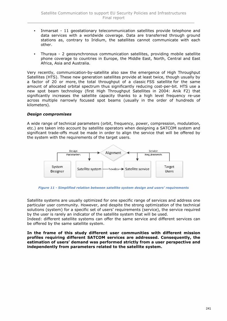
Satellite Communication to support EU Security Policies and InfrastructuresFinal report
241
• Inmarsat - 11 geostationary telecommunication satellites provide telephone anddata services with a worldwide coverage. Data are transferred through groundstations as, contrary to Iridium, the satellites cannot communicate with eachother.
• Thuraya - 2 geosynchronous communication satellites, providing mobile satellitephone coverage to countries in Europe, the Middle East, North, Central and EastAfrica, Asia and Australia.
Very recently, communication-by-satellite also saw the emergence of High ThroughputSatellites (HTS). These new generation satellites provide at least twice, though usually bya factor of 20 or more, the total throughput of a classic FSS satellite for the sameamount of allocated orbital spectrum thus significantly reducing cost-per-bit. HTS use anew spot beam technology (first High Throughput Satellites in 2004: Anik F2) thatsignificantly increases the satellite capacity thanks to a high level frequency re-useacross multiple narrowly focused spot beams (usually in the order of hundreds ofkilometers).
Design compromises
A wide range of technical parameters (orbit, frequency, power, compression, modulation,etc.) are taken into account by satellite operators when designing a SATCOM system andsignificant trade-offs must be made in order to align the service that will be offered bythe system with the requirements of the target users.
Figure 11 - Simplified relation between satellite system design and users’ requirements
Satellite systems are usually optimized for one specific range of services and address oneparticular user community. However, and despite the strong optimization of the technicalsolutions (system) for a specific set of users’ requirements (service), the service requiredby the user is rarely an indicator of the satellite system that will be used.Indeed: different satellite systems can offer the same service and different services canbe offered by the same satellite system.
In the frame of this study different user communities with different missionprofiles requiring different SATCOM services are addressed. Consequently, theestimation of users’ demand was performed strictly from a user perspective andindependently from parameters related to the satellite system.

Satellite Communication to support EU Security Policies and InfrastructuresFinal report
242
2.1.2 Different satellite networks
Satellite telecommunications services are also provided by different network topologies.Among these topologies, the most basic ones are the simplex and duplex ones where asatellite is used to provide a wireless liaison between two remote terminals. The liaisoncan be one-way (simplex, mostly used for broadcast services) or two-ways (duplex,mostly used for long-haul backbone for corporate networks, telephony, etc.).
Note: in the figures below the “satellite” symbol represents the space infrastructure that,within a network, can be comprised of one (in most cases) or several satellites able torelay a signal between each other.
Figure 12 - Simplified representation of Simplex (green) and Duplex (blue) liaisons
More complex networks can link several terminals. These networks are organised in“Star” or “Mesh” topologies (other hybrid topologies exist).
In a “Star” network, each terminal is linked to a Hub station by satellite. An indirectconnection between two terminals using a satellite can be provided: the signal from thefirst terminal must go through the Hub station before being redirected to the secondterminal. In this network topology the Hub manages the network and is also oftenconnected to ground public networks such as the internet or the public phone network orto private/corporate networks, therefore providing ground connection to remote users.The liaisons can be one-way or two-way and symmetric or asymmetric.
Figure 13 - Representation of a "Star" satellite network

Satellite Communication to support EU Security Policies and InfrastructuresFinal report
243
In a “Mesh” network, terminal can be directly connected to each other without the signalgoing through a hub station. It is important to note that “Mesh” networks also includestations to monitor and manage the network and/or to provide connection to groundnetworks. Similarly, the liaisons can be one-way or two-way and symmetric orasymmetric.
Figure 14 - Representation of a "Mesh" satellite network
These figures provide simplified representations of how space infrastructure can beintegrated in telecommunication networks. Actual networks involving space infrastructureare very complex arrangements of terrestrial and space terminals, hubs, control stations,teleports, etc.
The impact of Network Management parameters are addressed later in the document.Independently from the network topology, a satellite provides a liaison between tworemote terminals. The term “terminal” is used here with the sense of extremity of anetwork and it is understood that a satellite can link terminals of different natures suchas other satellites, phones, stations, VSAT, terminals aboard aircraft or ships forexample.

Satellite Communication to support EU Security Policies and InfrastructuresFinal report
244
2.1.3 Measure parameter: the bandwidth
The satellite is an integral part of the communication circuit and provides a connectionbetween two remote terminals. The common point between all SATCOM systems andservices is that a satellite liaison (radio or optical) is used to carry data from an emittingterminal to a receiving one.
One of these terminals can be considered as the “user terminal”. Note that the otherterminal can also be a user terminal, from this user’s perspective his terminal is alsoconnected to other terminals by satellite.
The following figure provides a simplified representation of the satellite liaison providedto a user terminal:
Figure 15 - Simplified representation of the satellite liaison provided to a user terminal
Since all telecommunications services consist in transmitting data from one point toanother, the single parameter allowing a pooling and a quantification of the demand isthe bandwidth.
In networks, the term “bandwidth” is used for different concepts. It can be expressed inbits per second, in Hertz for frequency bandwidth (physical information transportationrequirements) or in baud per seconds (before modulation). In this study bandwidthrefers to the data transfer rate of a communication channel. From a userperspective it corresponds to the available capacity for his connection. Thisvalue can be considered independently from the system architecture.Bandwidth, as defined for this quantitative analysis, is expressed in bits per second(bps); modern networks typically have speeds measured in the millions of bits persecond (megabits per second, or Mbps) or billions of bits per second (gigabits persecond, or Gbps). Different applications require different bandwidths. An instantmessaging conversation might take less than 1,000 bits per second (bps); a voice overIP (VoIP) conversation requires 56 kilobits per second (Kbps) to sound smooth and clear.Standard definition video (480p) works at 1 megabit per second (Mbps), but HD video(720p) wants around 4 Mbps, and HDX (1080p), more than 7 Mbps.A satellite system design limits the maximum bandwidth that can be provided to one userand limits the total bandwidth demand that can be handled simultaneously. This isparticularly true for one-to-one communication but also for satellite relay, one-to-many(satellite broadcast) and many-to-one (data collection) services. For satellite broadcast

Satellite Communication to support EU Security Policies and InfrastructuresFinal report
245
for example the user defining the bandwidth demand is not the user receiving the databut the broadcasting company who requires a given data rate to transfer data (TVchannels, meteorology services, etc.) to its users.

Satellite Communication to support EU Security Policies and InfrastructuresFinal report
246
Measuring the bandwidth demand2.2.
2.2.1 Identification of current, planned and potentialGOVSATCOM use
During the first phase of the study, a series of 31 main missions performed by severaluser communities & key infrastructures were identified.
For this quantitative analysis, SATCOM usages have been derived from these 31main missions. These usages have been selected as they are potentiallyquantified in term of SATCOM demand.
They have been classified using 3 main status:
• SATCOM currently used for this usage• SATCOM planned for this usage extrapolating current mode of operations• SATCOM potentially relevant for this usage assuming a transformation of the
modes of operation thanks for e.g. to an increasingly available/affordable SATCOMconnectivity
It is important to note that, given the different angle adopted; these usages werereorganized to match the bandwidth estimation methodology (i.e. a usage could berelated either to one main mission or to several main missions).
For example, in the case of sea border surveillance, experts estimated the bandwidthrequired by vessels, aircraft and other assets engaged in the sea border surveillance.One SATCOM terminal on-board a vessel for example allows it to be connected toaircraft, to shore stations and to other vessels in high sea. The different types ofconnections were used to size the bandwidth required per vessel.This reorganization avoided to count multiple times the same terminal and the samebandwidth used for different purposes.
The following table provides a synthesis of this analysis.

Satellite Communication to support EU Security Policies and InfrastructuresFinal report
247
# Mainmission
Usercommunities /
keyinfrastructures
Main mission SATCOM usagesStatus of SATCOM
usages
1
Bordersurveillance
Sea border surveillance(1) SATCOM to support Joint Operations organized byFrontex
(2) SATCOM to support national operations
Current2 Land border surveillance
3 Pre-frontier surveillance(3) Pre-frontier intelligence exchange for building commonintelligence picture for EU pre-frontier surveillance
Current
4
Maritimecommunity
Maritime safety and surveillance ofmaritime traffic
(4) SATCOM for ship monitoring and reporting systems
(5) SATCOM for maritime surveillance and interventionassets
(6) Communications for remote maritime stations
Current
5Maritime security, illegal activitiesat sea considered as securitythreats
6Monitoring and control of fisheryactivities
7Maritime “Search and Rescue”(SAR)
8Response to maritime disasters(pollution response, etc.)
9
Police missions
Fight against international drugtraffic within EU MS areas ofjuridiction (7) SATCOM to support all police missions requiring satellite
communication
(8) SATCOM to support Europol communication
Current10Fight against internationalOrganised Crime Groups (OCG)
11 Communication for Europol
12National police missions within EUterritories
13
Civil protection
Deployment of civil protectionteams / modules in case of naturalor man-made disasters
(9) SATCOM to support deployed EU / MS teams in case ofnatural or man-made disasters
Current
14Civil protection ambulance and fire& rescue response on MSterritories
(10) Permanent SATCOM capabilities existing on EUterritories to support Civil Protection teams (e.g. fires,rescue, and ambulance, seismic activity and criticalinfrastructure monitoring missions)
Current
15 Humanitarian aidHumanitarian aid assistance incase of natural or man-madedisasters
(11) SATCOM to support humanitarian aid in a context ofcrisis management Current

Satellite Communication to support EU Security Policies and InfrastructuresFinal report
248
# Mainmission
Usercommunities /
keyinfrastructures
Main mission SATCOM usagesStatus of SATCOM
usages
16Humanitarian aid assistance incase of non-international armedconflicts
(12) SATCOM to support humanitarian aid in a context ofcrisis or war
(13) SATCOM to support telemedicine17 Humanitarian TeleMedicine (HTM)
18
EU external action
EU civilian CSDP crisismanagement or police operationsoutside the EU
(14) SATCOM to support EU civilian CSDP crisismanagement or police operations outside the EU
Current
19 Election observation (15) SATCOM to support Election Observation Mission Current
20
Transportinfrastructures
Air traffic management157 (16) Air to ground communications Current
21 Rail traffic management(17) SATCOM to support communications between traindrivers and traffic control centres, on secondary railwayswith no GSM/R infrastructure
Potential
22 Road traffic management(18) Tracking of dangerous goods transport Potential
(19) Emergency call Planned (eCall by 2018)
23
Copernicus
Copernicus data collection (20) Data collection of in-situ components through satellite Potential
24 Copernicus data distribution(21) Distribution of processed data to the users having noterrestrial connection
Current and potential
25
GNSSprogrammes
EGNOS data transmission
(22)SATCOM link to retransmit NAV signals over the area ofinterest
Currently throughCOMSATCOM
(23) Provision of secured communication to remote EGNOSintegrity monitoring stations
Current
26 Galileo data transmission
(24) SATCOM links to connect the more remote groundstations with sensitive links to the Galileo satellites (TT&Cand ULS) such as those located in French Guyana, Tahiti, LaReunion, New Caledonia, Norway, Sweden
Current
157 Including Global flight tracking

Satellite Communication to support EU Security Policies and InfrastructuresFinal report
249
# Mainmission
Usercommunities /
keyinfrastructures
Main mission SATCOM usagesStatus of SATCOM
usages
27RPAScommunications
Surveillance of infrastructures orhuman activities using RPAS
(25) Pilot to RPAS control communications
(26) Link pilot-ATC services (may also be via SATCOM ifpilot control facility remote)
(27) Download of payload data
(28) Sense & Avoid (S&A) system communication
Current
28Arcticcommunications
Specific maritime safety for Arctic
(29) Ice monitoring services for improving the safety ofnavigation and off shore activities
(30) Unattended sensor stations for meteo-oceanographyand communication relays
(31) Broadcast of specific data services for mariners andmining industries
Potential
29
EU institutionalcommunications
Communication for the 139 EUdelegations (EEAS)
(32) Permanent link between each of the 139 EEAS officesand EEAS HQ in Brussels
Current
30Communication for the 46 ECHOfield offices
(33) Permanent link between ECHO field offices and theECHO HQ located in Brussels
Current
31Communication for EU HighRepresentatives and SpecialRepresentatives
(34) SATCOM link between mission location and EEASheadquarters in Brussels when a secured terrestrial solutionis not available
Current

Satellite Communication to support EU Security Policies and InfrastructuresFinal report
250
2.2.2 Number of terminals, connections and liaisons
For each user community & key infrastructure numbers of terminals were estimated onthe basis of:
• Interviews and public reports data• Exploitation of national data when available to extrapolate at European level
When relevant, user communities & key infrastructures were segmented by types ofusers on the basis of their bandwidth demand and/or type of connections. For example,in the case of RPAS or maritime communications, RPAS and vessels were segmented intoseveral categories (size, range, etc.) in order to get a more accurate estimation of thecorresponding SATCOM demand.
The accuracy of the estimation of the number of users is not always directly accessible.Various extrapolation models have been used depending on the availability of relevantinformation.
2.2.3 Bandwidth estimation
To calculate users’ bandwidth demand, two values were considered:
• Minimum bandwidth need: minimum bandwidth required to perform the mission.When available the Committed Information Rate (CIR) was taken into account
• Maximum bandwidth demand: maximum bandwidth demand often including a“nice-to-have” bandwidth that would allow users to maximize the use of SATCOMfor the mission but that does not take into account budget constraints andexisting solutions
The bandwidth demand estimated in the analysis corresponds to a “best compromise”comprised between the minimum bandwidth need and the maximum bandwidth demand.This “best compromise” took into account the demand but also budget constraints. Theemergence of new SATCOM solutions allowing a significant increase of bandwidth for thesame budgets was also taken into account in the forecast.
Estimations for European user communities & key infrastructures were also compared toexisting available bandwidth values allowed to assess if the level of demand estimatedwas realistic.
The value was estimated for all user communities & key infrastructures and SATCOMservices. The accuracy of the estimation depends on the availability of relevantinformation and on the status of the demand (current / planned / potential use ofSATCOM).

Satellite Communication to support EU Security Policies and InfrastructuresFinal report
251
2.2.4 General simplifying assumptions
The wide variety of telecommunication services and satellite systems required severalsimplifying assumptions. The main ones are described and explained hereafter.
Digital bandwidth
A communication circuit aims at carrying data from one point to another while optimizingpower and frequency resources. Similarly to ground communications, satellitecommunications include various steps for signal coding, correction, multiplexing,modulation and amplification. The following graph presents a simplified view of a digitalcommunication circuit for which the physical layer is provided by a satellite radio liaison:
Figure 16 - Digital communication circuit
In modern networks the signal is almost systematically digitalized. The informationbecomes independent of its nature (sound, image, etc.) and as a consequence all typesof data can be handled by the same system. Digital signals are described as discrete, ordiscontinuous, because they are transmitted in small, separate units called bits.In order to use a common measure unit, the bit per second, this analysisconsidered all users’ bandwidth demand in digital equivalent.
Symmetric liaisons
Given the low level of available information, as a simplifying assumption, allsatellite liaisons are symmetric and therefore did not take into account thedifferences between downlink (or download) and uplink (or upload) demand forasymmetrical liaisons.
This simplification is often used by satellite operators to advertise the capacity of theirsatellites. In this case it is considered that the satellite system delivers a bandwidth tothe terminal equal to the maximum of the two values (download bandwidth or uploadbandwidth).

Satellite Communication to support EU Security Policies and InfrastructuresFinal report
252
Throughput and connection time
A significant part of SATCOM services are based on a total available throughput or on atotal available connection time. For example the bandwidth can be guaranteed up to atotal of 3 Gbits per months or up to 100 hours per months. After this throughput orconnection time is reached the bandwidth drops dramatically.In the case of telephony, a wide range of different offers exist including pay-per-minuteor monthly plans.
In the frame of the quantification analysis the bandwidth was calculatedwithout taking into account such service agreements. The estimation focusesthe calculation of the bandwidth required for a terminal and not on the totalquantity of data that it should handle per month.Still, it considers the effective usage ratio of the assets (e.g. number of days atsea/vessel, number of flying hours/year for aircraft and RPAS, etc.) as SATCOM links areonly activated during effective operations.
Security
Security is a key criterion for EU security missions. SATCOM systems can be threatenedat different levels. More specifically providing a secured SATCOM service means thatsecurity were taken on the service itself (availability, resilience, etc.), on the content(controlled access, encryption, etc.) and on cyber threats.The security of an information system is achieved by the combination of severalmeasures:
• INFOSEC is addressed through the encryption of information meant to protectdata, transform red data into black, before accessing the modem at theapplication level
• COMSEC is achieved by encrypting the communication channel, modem to modemat the IP level
• TRANSEC is achieved by encrypting the transmission layer, from modem tomodem at radio level
With the increasing demand from commercial users for protection from unwantedinterference, denial of service attacks and security of data, many commercial satelliteoperators are in the process of incorporating security features such as:
• The use of the narrow, multiple spot beam architecture (HTS satellites inparticular) to mitigate jamming and interference
• Network operation to the US Government security standards DoD 8500.2 and themore recent NIST 800-53
• Incorporation of anti-interference waveforms, such as the Protected TacticalWaveform, for incorporation into the ground segment. It is anticipated that thesenew waveforms will reduce or eliminate more than 90% of interference – bothintentional and non-intentional
• Satellite commanding encrypted to the same level as a classified network• The design of a new generation of satellite payloads that will incorporate flexible
beam forming. The benefits of this technology are that, in case of attemptedjamming, beams can be re-formed to avoid the jamming signal
• Co-located hub/teleport facilities which address both physical and networksecurity
Users negotiating large capacity contracts (e.g. MoDs, etc.) also have the possibility toimplement their own cryptography solutions, manage on their own Virtual PrivateNetworks (VPNs) and globally implement a customized security layer on the pre-existingSATCOM infrastructure to elevate its security level. They operate with dedicated staff andhave the capacity to conduct some audit security issues.

Satellite Communication to support EU Security Policies and InfrastructuresFinal report
253
In parallel, operators such as Eutelsat in particular has been targeted by Middle East-based denial-of-service attacks and are now introducing anti-jamming technologies, inparticular geo-location, which can be used to locate a jamming source. It is foreseen thatsteerable beams, which can null a jamming signal, will also be introduced using the on-board processing technologies such as those being developed by Thales Alenia Space forthe Hispasat AG1 satellite and Airbus for the Eutelsat Quantum satellite.
Satellite control and feeder link station location is clearly a risk factor and while fleetoperators such as Eutelsat, SES and Intelsat operate a global network of ground stationsother regional satellite operators are tied to regional hub stations with varying degrees ofdesirability for government communications.
It is important to note that most of these technics have an impact on the bandwidth. Thisimpact can be either direct or indirect:
• Direct impact: the security measure reduces the bandwidth available at user level• Indirect impact: the security measure does not reduce the bandwidth available at
user level but increases the size of the data being transmitted, indirectly reducingthe amount of “real” data that can be transferred per second
The level of impact on the bandwidth depends on the security solutionimplemented. For this reason, security standards and their impact on thebandwidth were not taken into account in the quantification activity.

Satellite Communication to support EU Security Policies and InfrastructuresFinal report
254
Consolidation of users’ demand2.3.
2.3.1 Aggregated, instantaneous users’ demand andsatellite capacity
Figure 17 - Main points of measure of data traffic
Aggregated User Demand (AUD)
The simplest way to compile the total users’ bandwidth demand is to calculate the totalAggregated User Demand (AUD). This value is obtained by summing up the bandwidthrequired by all users to perform their missions (e.g. the aggregated users demand of twousers requiring 1 Mbps is 2 Mbps even if both users are not using their capability).
This calculation gives an order of magnitude of the total demand but does not allow asizing of the related data traffic. Indeed, the AUD does not take into account that thedemand of a user is not continuous and that the demand of different users isasynchronous. This is particularly true when addressing a global coverage. For example,in the case of the EU institutional communications missions (SATCOM connections for EUdelegations and ECHO field offices), the offices are spread around the globe andtherefore have very different connection times. Even within a single office, the bandwidthdemand varies during the day. Another example to illustrate differences between AUDand actual traffic is the demand for maritime safety activities. Typically, Europeancountries have a fleet of vessels deployed in the frame of maritime safety missions.According to experts estimation such vessels are deployed around 120 days per year witha rolling out management of available assets according to operations planning. Thereforethe demand for each vessel is effectively used only a third of the year.
To conclude, it is important to note that AUD alone does not allow a good sizingof the satellite capacity that will be required to cover the users’ demand.
Aggregated UserDemand
Instantaneousbandwidth
demand
Satellitecapacity

Satellite Communication to support EU Security Policies and InfrastructuresFinal report
255
Instantaneous User Demand (IUD)
Users demand can be permanent or temporary:
• A permanent demand requires a telecommunication service providing a bandwidthavailable 24/7. In this case the related satellite or network capacity is either usedor reserved. These are very particular and expensive services
• A temporary demand requires a telecommunication service providing a bandwidthon-demand. In this case the related satellite or network capacity is not alwaysused or reserved (this depends on the service level agreement)
Consequently, a more accurate measure of users demand is therefore the InstantaneousUser Demand (IUD). This value takes into account the actual bandwidth required at agiven time. This value is more relevant from a service supplier standpoint and allows abetter understanding of the satellite capacity that will be required to cover the demand.
The IUD is the fraction of the AUD that is actually required at a given moment. The IUDalso varies during the day and along the year between a minimum and a peak demand.In this study it is the peak demand value, corresponding to a maximum demand at agiven moment (peak period), that was estimated.Satellite operators and service providers systematically try to anticipate thisinstantaneous demand to size the satellite capacity that will be required and/or toprepare the network management. Very complex models are applied to estimate the IUD.These models take into account a wide range of parameters such as contracted servicelevel agreement, users’ past traffic, etc.
To complete the AUD calculation and in order to provide a value allowing a moreaccurate estimation of the SATCOM capacity that will be required to cover users’demand, average IUD were estimated (when possible) for each usage.
Without access to actual SATCOM contracts and to users’ bandwidth consumptionprofiles, this calculation was very complex. The estimation was based on extrapolation ofknown IUD values, on estimation provided in public reports and on demand modellingwith various known parameters. The hypothesis and sources used to estimate the IUDvary between user communities, missions and SATCOM uses.
Satellite capacity
A satellite is a dimensioning node within a communication network. The satellite capacityis the total bandwidth that can be handled by one satellite or by a satellite systemsimultaneously. A satellite capacity can be given in frequency bandwidth or bandwidthcapacity. Various parameters related to the satellite system such as spectral efficiency,modulation efficiency, multi-beam technology (High Throughput Satellites) orcompression standards impact the conversion of user’s bandwidth demand in satellitecapacity. Therefore it is important to note that the IUD is only an indicator of thesatellite capacity required to cover the demand.

Satellite Communication to support EU Security Policies and InfrastructuresFinal report
256
2.3.2 Users’ demand and delivered bandwidth
The IUD is not equal to the instantaneous delivered bandwidth. Indeed the actual users’demand is not systematically fully covered by the service providers. The Service LevelAgreement (SLA) between a user and a service provider gives way to a large number ofnetwork management parameters. They are applied by the service provider to distributeits total available bandwidth among the users while ensuring a given Quality of Service(QoS).
Most of FSS SATCOM communication services are handled in Multiple Channels PerCarrier (MCPC) scheme158. In this network scheme several subcarriers are combined ormultiplexed into a single bitstream before being modulated onto a carrier transmittedfrom a single location to one or more remote sites. The distribution of the bandwidth isperformed on the basis of multiple access methods such as Frequency Division MultipleAccess (FDMA) or Time Division Multiple Access (TDMA) that allow several terminalsconnected to the same multi-point transmission medium to transmit over it and to shareits capacity. Conversely, MSS use mostly Single Channel Per Carrier (SCPC) scheme forreturn links and MCPC (generally based on TDMA) for forward links. The channel-accessscheme itself also depends on contractual service parameters. Among these parametersthe maximum bandwidth, the Committed Information Rate (CIR, minimum availablebandwidth) and the Contention Ratio (CR, number of subscribers that can share theconnection) are the most important ones. When the user requires guaranteed andunrestricted bandwidth, service providers may apply a Single Channel Per Carrier (SCPC)scheme where satellite bandwidth is dedicated to a single source. However this networkscheme is particularly inefficient for burst transmission such as internet access.
To conclude it is important to note that the actual bandwidth delivered to a useris limited by a series of service parameters (or network parameters from aservice provider perspective) and does not always meet the actual demand.These complex and highly variable network parameters were not taken intoaccount in the quantification. Other elements of the Quality of Service (QoS) ofthe liaison also determine the satisfaction of the user demand beyond thedelivered bandwidth, but is not considered at this stage.
2.3.3 Forecast of the demand
In addition to 2015 usage values, an estimate of the evolution of the demand accordingto a series of drivers is also provided.
The drivers were either suggested during interviews (e.g. in the case of EU delegationsthe SATCOM demand follows the same evolution as typical business demand), in reports(e.g. Peak Instantaneous Aircraft Counts evolution provided in IRIS report for air trafficmanagement) or by PwC’s experts after research.
158 New satellite could use RNIS instead of MCPC. For MSS, FDMA/SCPC and/or CDMA are used

Satellite Communication to support EU Security Policies and InfrastructuresFinal report
257
3. Consolidation of users’ needs
Consolidation of users’ needs for each usage (detailled quantitative analysis per user community & key infrastructure presented in the nextparagraphs)
Estimated bandwidth (Mbps)2015 - Usage
Estimated bandwidth (Mbps)2020 - Demand
Estimated bandwidth (Mbps)2025 - Demand
Estimated bandwidth (Mbps)2030 - Demand
# Mainmission
User coms /key infras.
Main missions SATCOM usages Comments Eur. ArcticRest of
theWorld
TOT Eur. ArcticRest of
theWorld
TOT Eur. ArcticRest of
theWorld
TOT Eur. ArcticRest
of theWorld
TOT
1
Bordersurveillance
Sea bordersurveillance
(1) SATCOM to support JointOperations organized byFrontex
(2) SATCOM to supportnational operations
-> Estimated bandwidth isfor usages (1) and (2) forboth land and sea bordersurveillance
6,0 0,0 0,0 6,0 131,0 0,0 0,0 131,0 377,0 0,0 0,0 377,0 870,0 3,0 0,0 873,0
2Land bordersurveillance
3Pre-frontiersurveillance
(3) Pre-frontier intelligenceexchange for building commonintelligence picture for EU pre-frontier surveillance
-> Estimated bandwidth isfor usage (3)
0,3 0,0 2,7 3,0 103,0 0,0 27,0 130,0 155,0 0,0 45,0 200,0 208,0 0,0 72,0 280,0
TOTALborder
6,3 0,0 2,7 9,0 234,0 0,0 27,0 261,0 532,0 0,0 45,0 577,0 1078,0 3,0 72,0 1153,0
4
Maritimecommunity
Maritime safetyand surveillanceof maritimetraffic
(4) SATCOM for shipmonitoring and reportingsystems
(5) SATCOM for maritimesurveillance and interventionassets
(6) Communications forremote maritime stations
(4): Negligible in terms ofbandwidthfor current systems (LRIT,VMS)European S-AIS to be factoredas specific payloadrequirement similar to EDRS
(6): No information available(number of stations, location,bandwidth not available)
-> Estimated bandwidth isprimarily for usage (5)
32,0 0,4 3,6 36,0 157,5 3,6 17,9 179,0 502,4 29,6 59,1 591,1 1 320,8 165,1 165,1 1 651,0
5
Maritimesecurity, illegalactivities at seaconsidered assecurity threats
6Monitoring andcontrol of fisheryactivities
7Maritime “Searchand Rescue”(SAR)
8
Response tomaritimedisasters(pollutionresponse, etc.)
TOTALmaritime
32,0 0,4 3,6 36,0 157,5 3,6 17,9 179,0 502,4 29,6 59,1 591,1 1 320,8 165,1 165,1 1 651,0
9
Police missions
Fight againstinternationaldrug trafficwithin EU MSareas ofjuridiction (7) SATCOM to support all
police missions requiringsatellite communication
(8) SATCOM to support Europolcommunication
No information availableregarding Communication forEuropol (8) but probablynegligible
-> Estimated bandwidth isfor usage (7)
20,6 0,0 0,0 20,6 166,3 0,0 0,0 166,3 544,3 0,0 0,0 544,3 1 657,7 0,0 0,0 1 657,710
Fight againstinternationalOrganised CrimeGroups (OCG)
11Communicationfor Europol
12National policemissions withinEU territories
TOTALpolice missions
20,6 0,0 0,0 20,6 166,3 0,0 0,0 166,3 544,3 0,0 0,0 544,3 1 657,7 0,0 0,0 1 657,7
13 Civil protection
Deployment ofcivil protectionteams / modulesin case of naturalor man-madedisasters
(9) SATCOM to supportdeployed EU / MS teams incase of natural or man-madedisasters
-> Estimated bandwidth isfor usage (9)
6,0 0,2 6,0 12,1 14,3 0,5 14,3 29,0 35,2 1,0 35,2 71,3 88,1 1,5 88,1 177,7
3.1.

Satellite Communication to support EU Security Policies and InfrastructuresFinal report
258
Estimated bandwidth (Mbps)2015 - Usage
Estimated bandwidth (Mbps)2020 - Demand
Estimated bandwidth (Mbps)2025 - Demand
Estimated bandwidth (Mbps)2030 - Demand
# Mainmission
User coms /key infras.
Main missions SATCOM usages Comments Eur. ArcticRest of
theWorld
TOT Eur. ArcticRest of
theWorld
TOT Eur. ArcticRest of
theWorld
TOT Eur. ArcticRest
of theWorld
TOT
14
Civil protectionambulance andfire & rescueresponse on MSterritories
(10) Permanent SATCOMcapabilities existing on EUterritories to support civilprotection teams (e.g. fires,rescue, and ambulance,seismic activity and criticalinfrastructure monitoringmissions)
-> Estimated bandwidth isfor usage (10)
154,0 0,0 0,0 154,0 1 124,0 0,0 0,0 1 124,0 2 604,0 0,0 0,0 2 604,0 5 633,0 0,0 0,0 5 633,0
TOTALcivil protection
160,0 0,2 6,0 166,1 1 138,3 0,5 14,3 1 153,0 2 639,2 1,0 35,2 2 675,3 5 721,1 1,5 88,1 5 810,7
15
Humanitarianaid
Humanitarian aidassistance incase of natural orman-madedisasters
(11) SATCOM to supporthumanitarian aid in a contextof crisis management
(12) SATCOM to supporthumanitarian aid in a contextof crisis or war
(13) SATCOM to supporttelemedicine
-> Estimated bandwidth isfor usage (11)
0,0 0,2 3,3 3,5 0,0 0,7 9,2 9,9 0,0 1,4 26,7 28,1 0,0 2,5 78,7 81,2
16
Humanitarian aidassistance incase of non-internationalarmed conflicts
-> Estimated bandwidth isfor usage (12)
0,0 0,0 6,2 6,2 0,0 0,0 18,1 18,1 0,0 0,0 52,9 52,9 0,0 0,0 156,6 156,6
17HumanitarianTeleMedicine(HTM)
-> Estimated bandwidth isfor usage (13)
0,0 0,8 12,4 13,2 0,0 2,3 32,8 35,1 0,0 4,6 87,4 92,0 0,0 7,5 235,4 242,9
TOTALhuman. aid
0,0 1,0 21,9 22,9 0,0 3,0 60,1 63,1 0,0 6,0 167,0 173,0 0,0 10,0 470,7 480,7
18EU externalaction
EU civilian CSDPcrisismanagement orpolice operationsoutside the EU
(14) SATCOM to support EUcivilian CSDP crisismanagement or policeoperations outside the EU
-> Estimated bandwidth isfor usage (14)
0,0 0,0 9,2 9,2 0,0 0,0 20,1 20,1 0,0 0,0 48,1 48,1 0,0 0,0 120,7 120,7
19Electionobservation
(15) SATCOM to supportelection observation mission
-> Estimated bandwidth isfor usage (15)
0,0 0,0 2,5 2,5 0,0 0,0 5,3 5,3 0,0 0,0 11,4 11,4 0,0 0,0 24,6 24,6
TOTALEU ex. action
0,0 0,0 11,7 11,7 0,0 0,0 25,4 25,4 0,0 0,0 59,5 59,5 0,0 0,0 145,3 145,3
20
Transportinfrastructures
Air trafficmanagement
(16) Air to groundcommunications159
-> Estimated bandwidth isfor usage (16)
0,0 0,0 0,0 0,0 3,0 0,1 26,9 30 4,0 0,1 35,9 40,0 5,0 0,2 44,8 50,0
21Rail trafficmanagement
(17) SATCOM to supportcommunications between traindrivers and traffic controlcentres, on secondary railwayswith no GSM/R infrastructure
-> Estimated bandwidth isfor usage (17)
0,0 0,0 0,0 0,0 0,0 0,0 0,0 0,0 8,0 0,0 0,0 8,0 39,0 0,0 0,0 39,0
22Road trafficmanagement
(18) Tracking of dangerousgoods transport
-> Estimated bandwidth isfor usage (18)
0,0 0,0 0,0 0,0 0,4 0,0 0,0 0,4 0,8 0,0 0,0 0,8 1,1 0,0 0,0 1,1
(19) Emergency call-> Estimated bandwidth isfor usage (19)
0,0 0,0 0,0 0,0 0,1 0,0 0,0 0,1 0,2 0,0 0,0 0,2 0,3 0,0 0,0 0,3
TOTALtransport infra.
0,0 0,0 0,0 0,0 3,4 0,1 26,9 30,4 12,9 0,1 35,9 48,9 45,4 0,2 44,8 90,4
23
Copernicus
Copernicus datacollection
(20) Data collection of in-situcomponents through satellite
No information availablebut probably negligible(and back-up connectiononly)
0,0 0,0 0,0 0,0 0,0 0,0 0,0 0,0 0,0 0,0 0,0 0,0 0,0 0,0 0,0 0,0
24Copernicus datadistribution
(21) Distribution of processeddata to the users having noterrestrial connection
Intelsat & Eutelsat used byEumetsat for its datadistribution service EumetCast
-> Estimated bandwidth isfor usage (21)
0,0 0,0 0,0 0,0 16,0 0,0 0,0 16,0 30,0 0,0 0,0 30,0 60,0 0,0 0,0 60,0
TOTALCopernicus
0,0 0,0 0,0 0,0 16,0 0,0 0,0 16,0 30,0 0,0 0,0 30,0 60,0 0,0 0,0 60,0
159 Including Global flight tracking

Satellite Communication to support EU Security Policies and InfrastructuresFinal report
259
Estimated bandwidth (Mbps)2015 - Usage
Estimated bandwidth (Mbps)2020 - Demand
Estimated bandwidth (Mbps)2025 - Demand
Estimated bandwidth (Mbps)2030 - Demand
# Mainmission
User coms /key infras.
Main missions SATCOM usages Comments Eur. ArcticRest of
theWorld
TOT Eur. ArcticRest of
theWorld
TOT Eur. ArcticRest of
theWorld
TOT Eur. ArcticRest
of theWorld
TOT
25
GNSSprogrammes
EGNOS datatransmission
(22)SATCOM link to retransmitNAV signals over the area ofinterest
-> Estimated bandwidth isfor usage (22)
3,1 0,0 0,0 3,1 21,7 0,0 0,0 21,7 41,4 0,0 0,0 41,4 62,0 0,0 0,0 62,0
(23) Provision of securedcommunication to remoteEGNOS integrity monitoringstations
-> Estimated bandwidth isfor usage (23)
0,2 0,0 0,9 1,0 0,3 0,0 1,6 1,9 0,3 0,0 1,6 1,9 0,3 0,0 1,6 1,9
26Galileo datatransmission
(24) SATCOM links to connectthe more remote groundstations with sensitive links tothe Galileo satellites (TT&C andULS) such as those located inFrench Guyana, Tahiti, LaReunion, NouvelleCaledonie,Norway, Sweden
-> Estimated bandwidth isfor usage (24)
0,0 0,0 0,0 0,0 30,0 30,0 120,0 180,0 30,0 30,0 120,0 180,0 30,0 30,0 120,0 180,0
TOTALGNSS
3,3 0,0 0,9 4,1 52,0 30,0 121,6 203,6 71,7 30,0 121,6 223,3 92,3 30,0 121,6 243,9
27RPAScommunications
Surveillance ofinfrastructures orhuman activitiesusing RPAS
(25) Pilot to RPAS controlcommunications
(26) Link pilot-ATC services(may also be via SATCOM ifpilot control facility remote)
(27) Download of payload data
(28) Sense & Avoid (S&A)system communication
(25), (26) & (28): negligibleso far in terms of bandwidthcompared to (27) duringmission (however, will dependon EU requirements for senseand avoid system)-> Estimated bandwidth isfor usage (27) and is anestimation of the 2015demand (and not usage)
3,2 0,0 0,0 3,2 149,5 12,9 8,0 170,4 596,6 61,8 45,0 703,4 1 674,6 203,0 216,3 2 093,9
28Arcticcommunications
Specific maritimesafety for Arctic
(29) Ice monitoring servicesfor improving the safety ofnavigation and off shoreactivities
(30) Unattended sensorstations for meteo-oceanography andcommunication relays
(31) Broadcast of specific dataservices for mariners andmining industries
-> Estimated bandwidth isfor usages (29), (30) and(31)
0,0 2,0 0,0 2,0 0,0 6,0 0,0 6,0 0,0 10,0 0,0 10,0 0,0 15,0 0,0 15,0
29
EU institutionalcommunications
Communicationfor the 139 EUdelegations(EEAS)
(32) Permanent link betweeneach of the 139 EEAS officesand EEAS HQ in Brussels
-> Estimated bandwidth isfor usage (32)
0,0 0,0 5,0 5,0 0,0 0,0 10,0 10,0 0,0 0,0 20,0 20,0 0,0 0,0 32,0 32,0
30Communicationfor the 46 ECHOfield offices
(33) Permanent link betweenECHO field offices and theECHO HQ located in Brussels
-> Estimated bandwidth isfor usage (33)
0,0 0,0 15,0 15,0 0,0 0,0 30,0 30,0 0,0 0,0 61,0 61,0 0,0 0,0 122,0 122,0
31
Communicationfor EU HighRepresentativesand SpecialRepresentatives
(34) SATCOM link betweenmission location and EEASheadquarters in Brussels whena secured terrestrial solution isnot available
-> Estimated bandwidth isfor usage (34)
0,0 0,0 10,0 10,0 0,0 0,0 20,0 20,0 0,0 0,0 30,0 30,0 0,0 0,0 60,0 60,0
TOTALEU instit.comms
0,0 0,0 30,0 30,0 0,0 0,0 60,0 60,0 0,0 0,0 111,0 111,0 0,0 0,0 214,0 214,0
TOTAL 225,3 3,6 76,6 305,5 1 917,0 56,1 361,1 2 334,2 4 929,1 138,5 679,3 5 746,911
649,9427,8 1 537,9
13 615,6

Satellite Communication to support EU Security Policies and InfrastructuresFinal report
260
Estimated current usage and estimated 2020, 2025 & 2030 demand - IUD by Region (in3.2.Mbps)

Satellite Communication to support EU Security Policies and InfrastructuresFinal report
261
Estimated current usage and estimated 2020, 2025 & 2030 demand - IUD by user3.3.community (in Mbps)

Satellite Communication to support EU Security Policies and InfrastructuresFinal report
262
Estimated current usage and estimated 2020, 2025 & 2030 demand - IUD by user3.4.community (in Mbps)

Satellite Communication to support EU Security Policies and InfrastructuresFinal report
263
4. Estimation of the budget required tocover users’ demand
General simplified assumptions4.1.
In addition the study has attempted to translate the 2015 & 2020 annual user’s demandin Gbps to an estimated annual budget. This attempt is a very first stage and needs to berefined by a specific financial study.
To estimate the budget required to cover 2015 usage and 2020 demand presented in thelast paragraphs, public information and consultations with Industry are used. Simplifiedassumptions were adopted and are explained hereafter.
As innovative technologies / satellites will be launched after 2020 such as HighThroughput Satellites (HTS) - that could significantly reducing cost-per-bit - 2025 and2030 estimations are not performed in this document. These estimations could berealized in a specific study.
Estimated capacity cost for COMSATCOM, GOVSATCOM4.2.and MILSATCOM
COMSATCOM option GOVSATCOM option MILSATCOM option
Assumptions
COMSATCOM is mainlyC/Ku-bands satellitecommunication
Commercial price forC/Ku-bands is estimated12-24 M€ per Gbps/yeardepending on Region andband
Average price consideredis 18 M€ per Gbps /year
Assumptions are basedon the Athena-Fidusprogramme (publicinformation):
Estimated cost of thespace segment: 280M€
Estimated cost of theground component:221,4 M€
Actualized cost of theprogramme: 540 M€ in2015
Estimatedmaintenance: 14M€/year
Lifetime of theprogramme: 15 years
Peak data rate: 3 Gbps Estimated average
data rate: 1,5 Gbps Approximate yearly
cost for 1 Gbps = 34M€
Assumptions are basedon Skynet 5 programme(public information):
Estimated cost of theprogramme: £3,6Bn /5,2Bn€ in 2004(satellites: Skynet 5A,B, C and D)
Actualized cost of theprogramme: 6,1Bn€ in2015
Estimated lifetime ofthe programme: 18years
Estimated total datarate:3/4 Gbps
Estimated price 85/113M€ per Gbps /year(incl. services andterminals)
Estimated cost perMbps / year used to
estimate the requiredbudget
18 k€ 34 k€ 99 k€

Satellite Communication to support EU Security Policies and InfrastructuresFinal report
264
Estimated budget required per year for COMSATCOM,4.3.GOVSATCOM and MILSATCOM
COMSATCOM option GOVSATCOM option MILSATCOM option
Estimated bandwidth2015 - Usage
305,5 Mbps
Estimated budget 2015 peryear
5,5 M€ 10,4 M€ 30,2 M€
Estimated bandwidth (Mbps)2020 - Demand
2 334,2 Mbps
Estimated budget 2020 peryear
42 M€ 79,3 M€ 231 M€

Satellite Communication to support EU Security Policies and InfrastructuresFinal report
265
5. Detailed quantitative analysis peruser community & key infrastructure
Detailed quantitative analyses for each user community & key infrastructure areexplained hereafter. As border surveillance quantitative analysis is derived from themaritime community quantitative analysis, the first detailed analysis presented is themaritime one (and not the border one, even if user community & key infrastructurepresentations always start with Border Surveillance user community in the other partof the study).
Maritime community5.1.
Context: main missions (synthesis)
The main missions analyzed under the maritime community have been divided asfollows:
• Maritime safety and surveillance of maritime traffic• Maritime security, illegal activities at sea considered as security threats• Monitoring and control of fishery activities• Maritime “Search and Rescue” (SAR)• Response to maritime disasters (pollution response, etc.)
Estimated current and future use of SATCOM
Derived from these missions, the quantification of current/foreseen use of SATCOM bythis wide user community is threefold:
• SATCOM for ship monitoring and reporting systems (usage 4): as being the onlycommunication channel between high seas and shore, SATCOM are mandated defacto by the various mandatory position reporting systems: primarily the LongRange Identification and Tracking - LRIT for merchant ships, and the VesselMonitoring System - VMS for the fishing vessels, - maritime tracking / reporting
• SATCOM for maritime surveillance and intervention assets (usage 5): as requiringmaritime Member States to deploy vessels and aircraft to enforce laws, deterillegal activities, and provide assistance when required (Search and Rescue - SAR,pollution response) – maritime surveillance and intervention
• Communications for remote maritime stations (usage 6)
Main missions SATCOM usagesStatus of SATCOM
usages
Maritime safety and surveillance of maritimetraffic
Maritime security, illegal activities at seaconsidered as security threats
Monitoring and control of fishery activities
Maritime “Search and Rescue” (SAR)
Response to maritime disasters (pollutionresponse, etc.)
(4) SATCOM for ship monitoring andreporting systems
(5) SATCOM for maritime surveillance andintervention assets
(6) Communications for remote maritimestations
Current

Satellite Communication to support EU Security Policies and InfrastructuresFinal report
266
General methodological approach
For maritime community and border surveillance user communities, the followingcategorizations of vessels and aircraft have been made in order to derive associatedcurrent/predicted SATCOM equipment.
Proposed categorization of vessels:
Category Description Current/predicted SATCOM equipment
CAT 1
First line units >1000T and >60mlength (high seas, frigates + corvettes+ cutters, most of the time fitted withhelideck and hangar)
Fully equipped with broadband SATCOM capabilities
CAT 2300-500T and 50-60m (high seas,possible operation of VTOL RPAS)
Most often equipped with broadband SATCOMcapabilities, however a fraction of this category iscurrently equipped only with SATCOM voice and textmessages. The trend is to gain full broadbandaccess in the coming years.
CAT 3100-300T and 30-50m (off shore patrolboats)
SATCOM available capabilities is similar to CAT 2 butbroadband capabilities are not expected to becomplete before 10 years (today only few countrieshave already invested in this capability)
CAT 440-100T and 18-30m (littoral patrolboats)
SATCOM access is not likely to exceed voice andtext messages (again with some exceptions)
CAT 5 <40T and <18m coastal interventionWill never be equipped with any SATCOM capabilityeven in the long term
Proposed categorization of aircraft:
Category Description Current/predicted SATCOM equipment
CAT AMaritime patrol planes (long range, fullcapability)
Fully equipped with broadband SATCOM capabilities
CAT BSmall surveillance planes (visual +limited systems)
Remains currently often equipped only withSATCOM voice and text messages, but the trend isto gain full broadband access at a 10 years horizon
CAT CHeavy and medium helicopters(operated from land or from large CAT1 vessels)
Remains currently often equipped only withSATCOM voice and text messages, but the trend isto gain full broadband access in the coming years
CAT DSmall helicopters (operated from landor from CAT1 vessels)
Remains currently often equipped only withSATCOM voice and text messages, but the trend isto gain full broadband access at a 10 years horizon
CAT EMALE/HALE RPAS (take-off and landingfrom shore or aircraft carriers)
Fully equipped with broadband SATCOM capabilitiesas deployed beyond visual horizonIs the only asset where the SATCOM datalink isoperated nearly continuously during the RPASmission. The SATCOM usage by RPAS as a whole isevaluated in a dedicated chapter of this report
CAT FVTOL RPAS (generally rotary wings,operated from medium and largevessels)
All the RPAS remaining in the direct Line of Sight(LoS) of the operator will never be equipped withany SATCOM capability even in the long term

Satellite Communication to support EU Security Policies and InfrastructuresFinal report
267
Some precisions have to be made on the general methodology used during thequantification with respect to the maritime community. A number of vesselssimultaneously in operation was estimated according to a number of factors describedbelow:
• Average time spent in operations by each asset:
o For vessels, the fleet availability is a key factor (vessels effectivelyoperational): an average availability of 70% is proposed160. Availablevessels spend a part of their lives in harbours, the time at sea is estimatedaround 120 days per year
o For aircraft, the figure of 10% (800h of flight/year) is typically themaximum availability of the asset
• The percentage of devolution of these assets to maritime safety and securitymissions, which is about 100% for all maritime administrations except for NavalForces for which an average 35% is proposed (however unarmed naval assetstotally devoted to civilian missions are accounted for at 100%).
Considering Italy as an example, maritime safety and security missions are executed bythe Coastguard (Guardia Costiera), the Ecomic crime Police (Guardia di Finanza) and theNavy (Marina Militare), which operate following assets (in this order):
Number of vessels mobilised for maritime safety and security missions:
CategoryCoast Guard
(Guardia Costiera)
Ecomic crimePolice
(Guardia diFinanza)
Navy(Marina Militare)
TOTAL
CAT 1 3 0 223+(22x35%)=11 CAT 1
after weighting Mil assets
CAT 2 4 3 0 7 CAT 2
CAT 3 0 9 2 (ultra-fast) 10 CAT 3
CAT 4 4 54 0 58 CAT 4
CAT 5 Excluded (no SATCOM capabilities)
Number of aircraft mobilised for maritime safety and security missions:
CategoryCoastGuard
(Guardia Costiera)
Ecomic crimePolice (Guardia di
Finanza)
Navy(MarinaMilitare)
TOTAL
CAT A 3 4 59 CAT A after weighting
Mil assets
CAT B 3 10 0 13 CAT B
CAT C 13 5749 (includingAirforce SARhelicopters)
87 CAT C
CAT D 0 28 0 28 CAT D
CAT E 0 0 12 4 CAT E
CAT F Excluded (no SATCOM capabilities)
160 Source: parliamentary reports

Satellite Communication to support EU Security Policies and InfrastructuresFinal report
268
By generalizing this assessment to the various maritime Member States of the EU, itresults into a European “maritime assets inventory” mobilised for various maritime safetyand security missions, including maritime traffic surveillance, Search and Rescue,fisheries control, pollution response and all aspects of law enforcement, but excludingmilitary and anti-piracy operations.
This assets inventory is then used to weigh the relative SATCOM IUD of the maritimeadministrations of the various EU Member States.
For one particular country (France), the exact inventory of SATCOM terminals on boardvessels at sea actively conducting maritime security and safety missions was accessible,with actual data rates (AUD). Applying the same pro-rata between civilian and militarymissions, vessels availability and days at sea, the overall current IUD for FrenchAdministrations has been accurately established at 5.347Mbps for the naval component.An extrapolation for aerial assets (RPAS excluded), less numerous, is adding 0.871 Mbpsfor the aircraft component.
It must be pointed-out that France has already deployed broadband terminals on allCAT2 and many CAT3 vessels, as only few maritime nations in the EU. This has beentaken into account while forecasting values in 2020, 2025 and 2030.
The results for the global SATCOM IUD for the seaborne missions for transport safety,fishery control and security of EU27 come as follows in the table below.
This global demand was distributed between Europe, Arctic and the rest of the Worldaccording to various reports on operations and on estimation of the evolution of activitiesin the Arctic region.
Usage 4: SATCOM for ship monitoring and reporting systems
Several elements need to be taken into account to quantify this usage:
Maritime Transport vessels tracking – LRIT
There are currently 8 500 merchant vessels that are tracked by the European LRIT DataCentre161. This represents a traffic of 34 000 LRIT messages day through commercialSATCOM (mainly Inmarsat). Today EMSA estimates that this traffic will increase by 5 to10% each year. This will represent around 100 000 LRIT messages per day in 2030.There are in total about 20 000 merchant ships at any time sailing in European waters162,but as LRIT is reported through flag states the EU LRIT Data Centre is only managing thedownlink for those under EU MS flag, while the other are transmitted by landline from therespective foreign National LRIT Data Centres.Another way to evaluate the LRIT-related SATCOM traffic is to cross-check with typicalLRIT SATCOM satellite payload data rates. Examples found of LRIT data rates for a singlesatellite payload range between 128 and 300 kbps163.
Fishery vessels tracking – VMS
In 2015, there are 7 000 fishing vessels that are tracked by EU Member States164. Thisrepresents a traffic of 28 000 VMS messages per day most of it through commercialSATCOM. The number of fishing boats is expected to remain quite stable over time with afew bigger fishing vessels operating at greater distances.
161 Source:EMSA162 Source: EMSA, NOAA and Eutelsat163 Source NOAA and EUTELSAT164 Source: European Commission

Satellite Communication to support EU Security Policies and InfrastructuresFinal report
269
Other mandatory reporting systems
Specific reporting schemes exist and might appear in specific maritime areas (e.g. highnavigation risks, fragile environment, and transport of highly dangerous goods) such asthe Baltic Sea, the Arctic maritime routes, etc. Nevertheless these reporting systems areexpected to remain marginal compared to the general LRIT and VMS systems.
It is worth stressing at this stage that SATCOM is mandatory for maritimereporting systems but these services are negligible in terms of bandwidth.Additionally these tracking systems are already well covered by varioussystems. The launch of a European S-AIS secured system could be relevant butis out-of-scope for this study.
Usage 5: SATCOM for maritime surveillance and intervention assets
In a first step, the use of SATCOM services was estimated on the basis of thecurrent/predicted equipment on board of intervention assets (vessels and aircraft).
Estimated bandwidth use and demand for broadband
The current typical broadband SATCOM terminal baseline for intervention assets isInmarsat Fleet Broadband capable of 432 kbps; the broader band MILSATCOM systemsavailable on first rank Naval Vessels (CAT1) are not considered in this quantification, onlythe non-mil SATCOM for civilian missions’ purposes.In the future, the number of vessels equipped with broadband capabilities is expected toincrease significantly. CAT2 vessels should be equipped with broadband by 2020 andCAT3 vessels by 2025. The bandwidth of broadband services is also expected to increasesignificantly. Today the most used commercial maritime broadband SATCOM terminal(Inmarsat fleet broadband) offers a bandwidth of 432 kbps. The emergence of newbroadband solutions and the demand to get access to near real-time Earth-Observationhigh definition satellite images will definitely and substantially increase the demand formore bandwidth on seaborne and airborne border surveillance assets.
Several sources confirmed that maritime assets are already being equipped with moreperformant terminals. The combination of a high demand from users, the emergence ofnew broadband solutions and the confirmation of national institutions willingness to equiptheir vessels and aircraft with increased SATCOM capacity suggested an optimisticscenario for the evolution of GOVSATCOM demand.The following bandwidth values were taken into account for the forecast of CAT1 vessels:
• 3 Mbps per terminal by 2020• 10 Mbps per terminal by 2025• 20 Mbps per terminal by 2030
The increase of bandwidth was estimated differently for each category of vessels andaircraft with the hypothesis that smaller vessels and aircraft were progressively equippedwith the capability of the upper category.
Estimated bandwidth use and demand for voice/text
The bandwidth required to provide voice/text messages capabilities aboard these assetswas estimated to be around 10% of the Inmarsat Fleet Broadband bandwidth. These 43kbps (10%) allow several simultaneous standard voice channels. No demand for asignificant increase of bandwidth for voice/text services was expressed in 2015.Nevertheless, it is important to note that the likely increase of the number of maritimeoperations will impact the demand in the coming years.

Satellite Communication to support EU Security Policies and InfrastructuresFinal report
270
Usage 6: Communications for remote maritime stations
During interviews and researches it appeared that a few stations used for governmentalmaritime activity (transport and fishing activity control, search and rescue, etc.) areremotely located with no access to terrestrial networks. GOVSATCOM capabilities,typically secured VSAT connections, are relevant for these stations.
Despite a significant time of research, no useful and exploitable data could be collected.To estimate the demand for these stations their number, location and bandwidth demandwould be required. It appears that such stations are operated by national institutions andtheir locations are not consolidated in any public European documents. Nevertheless,experts estimate that the number of these stations is very low, in the order of a fewunits, and their demand should remain low, except if networks of unattendedcommunication and meteorological relays would develop in the Polar Regions (cf. Arctic).
Synthesis of estimated current and future bandwidth for maritime community
Main mission SATCOM usages Status Comments
Maritime safety andsurveillance of maritimetraffic
Maritime security, illegalactivities at sea consideredas security threats
Monitoring and control offishery activities
Maritime “Search andRescue” (SAR)
Response to maritimedisasters (pollutionresponse, etc.)
(4) SATCOM for shipmonitoring and reportingsystems
(5) SATCOM for maritimesurveillance andintervention assets
(6) Communications forremote maritime stations
Current
(4): Negligible in terms of bandwidthfor current systems (LRIT, VMS)European S-AIS to be factored asspecific payload requirement similarto EDRS
(6): No information available(number of stations, location,bandwidth not available)
-> Estimated bandwidth isprimarily for usage (5)
Estimated bandwidth(Mbps)
Europe ArcticRest of the
WorldTOTAL
Estimated bandwidth for usage (5) - Total Maritime community
2015 - Usage 32,0 0,4 3,6 36,0
2020 - Demand 157,5 3,6 17,9 179,0
2025 - Demand 502,4 29,6 59,1 591,1
2030 - Demand 1 320,8 165,1 165,1 1 651,0

Satellite Communication to support EU Security Policies and InfrastructuresFinal report
271
Border surveillance5.2.
Context: main missions (synthesis)
SATCOM allow connection to home-based and national authorities as well as to Frontex(the European Agency in charge of developing and implementing the tools of IntegratedBorder Management). The use of SATCOM is thus primarily related to mobile patrolassets and teams when deployed beyond the range of terrestrial radio links. SATCOM areneeded to transmit not only voice communications but also other data e.g. photographs.
While the Eurosur infrastructure uses terrestrial governmental communication networks,the MS often needs SATCOM links to exchange information (e.g. video streaming from asurveillance aircraft to the coordination center) and to ensure fast, reliable and securecommunication between e.g. patrol vessels.
Border surveillance basically encompasses the following main missions:
Sea border surveillance Land border surveillance Pre-frontier surveillance
Estimated current and future use of SATCOM
To support the three main missions identified under this user community, three SATCOMusages have been highlighted, as indicated in the table below:
In the frame of border surveillance, the main consumption of SATCOM bandwidth isrelated to the maritime patrolling effort of the engaged maritime states. A lower butsignificant use of SATCOM also comes from pre-frontier intelligence activities such as theSeahorse program.
SATCOM for land border surveillance assets
Interviews and public reports suggest a demand from land border teams to get SATCOMcapabilities for:
• Telecommunications capabilities (phones, BGAN, VSAT) for remotely deployedteams with no access to terrestrial networks (last-mile problem)
• Telecommunications capabilities (mostly VSAT) for remote land border stations
Additionally, experts believe that automatic land border controls could be operated byinstalling special existing solutions (cameras, detectors, etc.) that could transmit datathrough satellite when ground communications are absent, i.e. estimated at typically10% of the global traffic. This type of equipment is envisaged by FRONTEX whichsuggested the bandpass requirements considered in this study.
Main mission SATCOM usagesStatus ofSATCOMusages
Sea border surveillance (1) SATCOM to support Joint Operationsorganized by Frontex
(2) SATCOM to support national operations
Current
Land border surveillance
Pre-frontier surveillance(3) Pre-frontier intelligence exchange forbuilding common intelligence picture for EUpre-frontier surveillance
Current

Satellite Communication to support EU Security Policies and InfrastructuresFinal report
272
These assumptions anticipate the creation of mobile EU Border Guard patrols likely to beequipped with SATCOM equipment (hand-held terminals, air and maritime patrollingassets, etc.) as a response to the Balkans migration crisis (cf. European Commissionpress release dated 15/12/2015).
Usage 1: SATCOM to support Joint Operations organized by Frontex
FRONTEX has been organizing for many years Joint Operations in Atlantic andMediterranean Sea (HERA, HERMES, INDALO, AENEAS, POSEIDON, TRITON, etc.). Mostfrequently, Italy, Spain and Greece are hosting the Frontex Joint Operations, as being themost exposed southern sea borders; France, Spain, Portugal and Romania are the largestcontributors to these operations.
The current use of SATCOM was estimated on the basis of the equipment currentlyavailable on the deployed assets (vessels and aircraft). The fleet used for the jointoperations has been assessed as follows (current TRITON operation):
• Seaborne component (current 2015) : 3 CAT1 & 2 CAT2 & 2 CAT4• Airborne component (current 2015) : 1 CATA & 1 CATB & 1 CATC
The decision of the Council to reinforce significantly TRITON suggests an increase of thedeployed assets as follows:
• Seaborne component (demand 2015): 6 CAT1 & 6 CAT2 & 6 CAT3• Airborne component (demand 2015): 2 CATA & 1 CATB & 2 CATC
This will represent the largest ever task force mobilized for maritime border surveillance.
Important note: the military CSDP mission EUNavForMed (a.k.a. SOPHIA) is notaddressed using mainly MILSATCOM.
More recently, FRONTEX is also planning the resources needed to support the creation ofthe European Border Guard. Every 40km section of land border under strong migratorypressure might require deploying:
• 1 airborne asset (small plane or RPAS) with surveillance cameras• 5 fixed surveillance systems• 3 mobile surveillance systems• 4 foot patrols• Up to 100 unattended cameras• Up to 300 underground sensors (seismometers or pressure sensors)
The communications requirements for such critical border section would amount to 45Mbps, of which an average 10% only solvable by SATCOM. The number of concurrentlyactivated border sections is also estimated as growing up to 10% of the global externalborders in the horizon of this study.
Usage 2: SATCOM for sea border surveillance assets
The user community associated to the execution of sea border surveillance missions inhigh seas (where SATCOM capabilities are required) includes vessels and aircraft that aregenerally taken from the global inventory already addressed in the previous paragraph(maritime community: transport, fisheries, safety and security at sea).
Consequently, the demand must not be duplicated. The evaluation is the additional usageof SATCOM due to the sea border surveillance missions that exceed in deploymentduration and assets usage the previous baseline.

Satellite Communication to support EU Security Policies and InfrastructuresFinal report
273
In the case of international cooperation, SATCOM usage is also a mean to solve thechallenges of naval communications interoperability between vessels and aircraftprovided by many different national administrations. This might require a temporaryfitting of SATCOM terminals on vessels not actually equipped permanently.
To conclude: the AUD for sea border surveillance is already included in the AUDcalculated for national maritime assets in the previous section. An additional IUD canhowever be estimated since an additional usage of SATCOM can occur in the frame of seaborder surveillance missions.
Among the nations under direct pressure on their maritime borders, Spain and Italy arethe most involved; Malta is limited by its few assets, Greece has limited resources too.
The largest ever national operation relating to blue border surveillance is the Italian MareNostrum, which involved the following assets:
• Seaborne component : 3 CAT1 & 2 CAT2• Airborne component : 1 CATB & 4 CATC & 2 CATE
It is suggested to use it as a maximum envelope of SATCOM usage by National seaborder control operations. No more than 2 operations of such extent can be deployed atthe same time.
Usage 3: pre-frontier intelligence exchange for building common intelligencepicture for EU pre-frontier surveillance
The only reported example to date is the “SeaHorse” network established at the initiativeof Spain with a number of countries of origin of small boats carrying migrants towardmainland Spain or Spanish Islands (in particular Canary Islands). The deployed SATCOMnetwork includes (source: Spanish Guardia Civil):
• 1 Central Border Control Coordination Centre, localized in Gran Canaria,• 8 National Contact Points terminals
In 2008, the project was relying on 2 types of SATCOM liaisons (64kbps and320(DL)/64(UL) kbps). With an upgraded equipment and an increased number ofNational Contact Points terminals, the current SATCOM AUD of the “SeaHorse” projectwould amount to around 3 Mbps in 2015. As the need for such secure exchanges with thecountries of origin of migrants will persist, the modernization of SATCOM terminals willincrease the bandwidth, while more countries will be associated.
The IUD is difficult to estimate without precise contractual or usage data, it has beenestimated that up to 100% of the AUD should be covered during peak hours and crisissituation.
The bandwidth required for each station, and the number of stations is likely toexperience a quick growth during the next years in order to help managing the EUborders crisis. A situation where most countries of origin of migrants are equipped withat least one contact point terminal is very likely by the horizon 2030.
In addition, FRONTEX is anticipating the need to dedicate some aerial and maritimeassets to pre-frontier surveillance of the areas under high migratory pressure. Up to 2airborne assets (planes or RPAS) and 4 seaborne assets could be required for each zone,and up to 5 zones might have to be monitored concurrently if the current migratorypressure persists. The data transmission of such pre-frontier patrols primarily relies onSATCOM and would require 30 Mbps per zone.

Satellite Communication to support EU Security Policies and InfrastructuresFinal report
274
Estimating the current/expected use of SATCOM for sea border surveillance
According to the evolution of broadband services for maritime the realistic broadbanddemand was estimated as follows, similarly as for the maritime community section:
• Average broadband available in 2015: 432 kbps (current standard service)• Average broadband demand in 2020: 3 Mbps (emergence of improved systems
and demand of improved access to big data: Earth observation images)• Average broadband demand in 2025: 10 Mbps• Average broadband demand in 2030: 20 Mbps (emergence of improved systems
and demand of improved access to big data: Earth observation images)
Aggregated user demand
For sea border surveillance operations the AUD is already included in the estimation fornational assets identified in the previous section (maritime community).
Instantaneous user demand
The Instantaneous User Demand (IUD) was calculated taking into account the actualoperational deployment of airborne and seaborne assets.
The IUD for Triton JO was estimated around:
Estimated IUD for Triton JO
2015 (use) 3 Mbps
2020 (demand) 39 Mbps
2025 (demand) 125 Mbps
2030 (demand) 310 Mbps
The IUD for a National Operation (Mare Nostrum case) was estimated around (up to 5national sea border control operations might be active simultaneously in the worst case):
Estimated IUD for National Operation (MareNostrum case)
2015 (use) 3 Mbps
2020 (demand) 32 Mbps
2025 (demand) 102 Mbps
2030 (demand) 260 Mbps
The IUD for land border surveillance, as planned for the future European Border Guardmissions, is estimated around:
Estimated IUD for land border surveillance(from FRONTEX estimates)
2015 (use) 0
2020 (demand) 60 Mbps
2025 (demand) 150 Mbps
2030 (demand) 300 Mbps

Satellite Communication to support EU Security Policies and InfrastructuresFinal report
275
The IUD for pre-frontier intelligence (distributed 10% in Europe and 90% in the rest ofthe World – mostly around the Mediterranean Sea) is estimated around:
Estimated IUD for pre-frontier surveillance
2015 (use) 3 Mbps
2020 (demand) 130 Mbps
2025 (demand) 200 Mbps
2030 (demand) 280 Mbps
Synthesis of estimated current and future bandwidth for border surveillance
Main mission SATCOM usages Status Comments
Sea border surveillance(1) SATCOM to support JointOperations organized byFrontex
(2) SATCOM to support nationaloperations
Current
-> Estimated bandwidth is forusages (1) and (2) for bothland and sea bordersurveillanceLand border surveillance
Pre-frontier surveillance
(3) Pre-frontier intelligenceexchange for building commonintelligence picture for EU pre-frontier surveillance
Current-> Estimated bandwidth is forusage (3)
Estimated bandwidth(Mbps)
Europe ArcticRest of the
WorldTOTAL
Estimated bandwidth for usages (1) and (2)
2015 - Usage 6,0 0,0 0,0 6,0
2020 - Demand 131,0 0,0 0,0 131,0
2025 - Demand 377,0 0,0 0,0 377,0
2030 - Demand 870,0 3,0 0,0 873,0
Estimated bandwidth for usage (3)
2015 - Usage 0,3 0,0 2,7 3,0
2020 - Demand 103,0 0,0 27,0 130,0
2025 - Demand 155,0 0,0 45,0 200,0
2030 - Demand 208,0 0,0 72,0 280,0
Total Border surveillance
2015 - Usage 6,3 0,0 2,7 9,0
2020 - Demand 234,0 0,0 27,0 261,0
2025 - Demand 532,0 0,0 45,0 577,0
2030 - Demand 1078,0 3,0 72,0 1153,0

Satellite Communication to support EU Security Policies and InfrastructuresFinal report
276
Police missions5.3.
Context: main missions (synthesis)
The EU police community gathers all the organisations, services, bodies of personsempowered by member states and EU institutions to enforce the law and struggle againstorganised crime and terrorism within a defined legal or territorial area of responsibility.Depending on the Member States, organisations and services relevant to lawenforcement may be various and quite heterogeneous. In some Member States, militaryservices are also responsible for policing in both the armed forces and in the civilianpopulation (most gendarmeries, such as the French Gendarmerie, the Italian Carabinieri,the Spanish Guardia Civil and the Portuguese Republican National Guard). Alternativenames for police forces include constabulary, gendarmerie, police department, policeservice, crime prevention, protective services, law enforcement agency or civil guard.
The following missions have been studied under this user community:
• Fight against international drug traffic within EU MS areas of jurisdiction• Fight against international Organised Crime Groups (OCG)• Communication for Europol• National Police missions within EU territories
Current use of SATCOM services
For homeland police missions, SATCOM systems are quite not used except in UK. Policeand terrestrial surveillance is mostly conducted with terrestrial network only based on theTETRA network. SATCOM allows to connect to National Authorities, to Frontex and alsopossibly to Law Enforcement Agencies such as Europol and Interpol.Interviews have not enabled experts to determine a homogeneous need of SATCOM bypolice communities for classical law enforcement in MS even if many have expressedsome interest to increase the resilience of governmental communications.
Regarding UK model, the use of SATCOM is thus primarily related to mobile patrollingassets and teams when deployed beyond the range of terrestrial radio links.
Two SATCOM usages have therefore been derived from the four missions mentionedabove:
• SATCOM to support all Police missions requiring satellite communication (usage 7)• SATCOM to support Europol communication (usage 8)
Main mission SATCOM usagesStatus of SATCOMusages
Fight against international drug traffic withinEU MS areas of jurisdiction
(7) SATCOM to support all Police missionsrequiring satellite communication
(8) SATCOM to support Europolcommunication
Current
Fight against international Organised CrimeGroups (OCG)
Communication for Europol
National Police missions within EU territories

Satellite Communication to support EU Security Policies and InfrastructuresFinal report
277
SATCOM to support all Police missions requiring satellite communication (usage7)
Considering the low amount of available data, the analysis has been based on thecontract to be awarded in 2015 for 4 Ka SATCOM aimed at on-the-move commandvehicle for police of Dyfed-Powys165.
An extrapolation has therefore been led for the whole UK and the EU, taking data such asthe EU surface, number of inhabitants, number of police staff (1 704 949 police staff forall EU MS).
A theoretical extrapolation gave 407 terminals in UK and 4 452 terminals in EU.However, most of MS police organisations use mainly terrestrial networks (e.g. France)without or with a very low level of SATCOM infrastructure. On that account and takinginto account a need for communications network resilience, experts have decided toretain a figure corresponding to one tenth of the total extrapolated terminals, i.e. 445terminals.
Several assumptions have then been used:• One terminal for 20 000 staff, meaning a total of 85 terminals• No significant change for police staff at horizon 2030• Decrease of number of aircraft by 10% replaced by RPAS• FSS increase of 5 % per 5 year• Other assumptions:
165 Largest county of UK with 1100 police staff, 500 000 inhabitants on a surface of 5800 km2
2015 2020 2025 2030
Estimated number of satphone
Evolution broadband per X staff 20000 17000 14000 10000
Evolution 1 satphone per X staff 20000 17000 14000 10000
Progressive integration of SATCOM terminals in aircraft with both satphone and broadbandcapacity
Staff police 1 704 949 1 704 949 1 704 949 1 704 949
Evolution of number of aircraft 432 389 350 315
Evolution of number of aircraftequipped satphone
86 156 280 315
Evolution of number of aircraftequipped broadband
22 39 87 157
Evolution of bandwidth (Mbps)
Evolution deployable MSS VSAT 1 6,45 13,868 30,000
Evolution portable MSS BGAN 0,432 1,231 3,509 10,000
Evolution of satphones txt 0,001 0,001 0,001 0,001
Evolution of satphone voice IP 0,05 0,05 0,05 0,05
Evolution of aircraft SATCOM 0,432 3 10 20

Satellite Communication to support EU Security Policies and InfrastructuresFinal report
278
Estimated AUD & IUD
For IUD, ratio of operational employment (assumption): 20%
SATCOM to support Europol communication (usage 8)
No information available regarding Communication for Europol but probablynegligible compared to usage n°7.
2015 2020 2025 2030
Estimated AUD
Number of FSS/deployable MSS 85 100 122 170
Number of satphone 85 100 122 170
Number of aircraft satphone 86 156 280 315
Number of aircraft SBB 22 39 87 157
AUD for FSS/deployable MSS 85,25 702,04 1826,73 5114,85
AUD for satphone 4,26 5,01 6,09 8,52
AUD for aircraft satphone 4,32 7,78 14,00 15,75
AUD for aircraft SBB 9,33 116,64 874,80 3149,28
AUD - total bandwidth needs 103 831 2722 8288
Estimated IUD
IUD for FSS/deployable MSS 85,25 702,04 1826,73 5114,85
IUD for satphone 4,26 5,01 6,09 8,52
IUD for aircraft satphone 4,32 7,78 14,00 15,75
IUD for aircraft SBB 9,33 116,64 874,80 3149,28
IUD - total bandwidth needs 20,6 166,3 544,3 1657,7

Satellite Communication to support EU Security Policies and InfrastructuresFinal report
279
Synthesis of estimated current and future bandwidth for Police missions
Main mission SATCOM usages Status Comments
Fight against internationaldrug traffic within EU MSareas of jurisdiction
(7) SATCOM to support allPolice missions requiringsatellite communication
(8) SATCOM to supportEuropol communication
Current
No information available regardingCommunication for Europol (8) butprobably negligible
-> Estimated bandwidth is for usage(7)
Fight against internationalOrganised Crime Groups(OCG)
Communication for Europol
National Police missionswithin EU territories
Estimated bandwidth(Mbps)
Europe ArcticRest of the
WorldTOTAL
Estimated bandwidth for usage (7) - Total police missions
2015 - Usage 20,6 0,0 0,0 20,6
2020 - Demand 166,3 0,0 0,0 166,3
2025 - Demand 544,3 0,0 0,0 544,3
2030 - Demand 1657,7 0,0 0,0 1657,7
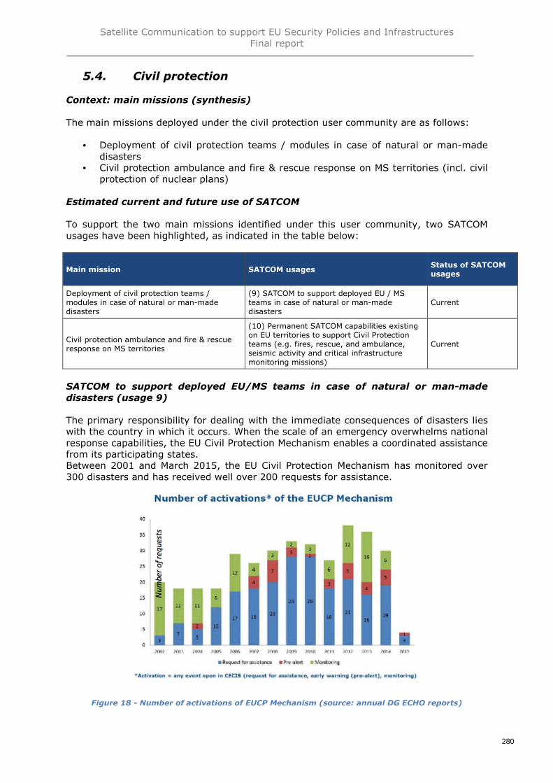
Satellite Communication to support EU Security Policies and InfrastructuresFinal report
280
Civil protection5.4.
Context: main missions (synthesis)
The main missions deployed under the civil protection user community are as follows:
• Deployment of civil protection teams / modules in case of natural or man-madedisasters
• Civil protection ambulance and fire & rescue response on MS territories (incl. civilprotection of nuclear plans)
Estimated current and future use of SATCOM
To support the two main missions identified under this user community, two SATCOMusages have been highlighted, as indicated in the table below:
SATCOM to support deployed EU/MS teams in case of natural or man-madedisasters (usage 9)
The primary responsibility for dealing with the immediate consequences of disasters lieswith the country in which it occurs. When the scale of an emergency overwhelms nationalresponse capabilities, the EU Civil Protection Mechanism enables a coordinated assistancefrom its participating states.Between 2001 and March 2015, the EU Civil Protection Mechanism has monitored over300 disasters and has received well over 200 requests for assistance.
Figure 18 - Number of activations of EUCP Mechanism (source: annual DG ECHO reports)
Main mission SATCOM usagesStatus of SATCOMusages
Deployment of civil protection teams /modules in case of natural or man-madedisasters
(9) SATCOM to support deployed EU / MSteams in case of natural or man-madedisasters
Current
Civil protection ambulance and fire & rescueresponse on MS territories
(10) Permanent SATCOM capabilities existingon EU territories to support Civil Protectionteams (e.g. fires, rescue, and ambulance,seismic activity and critical infrastructuremonitoring missions)
Current
Satellite Communication to support EU Security Policies and InfrastructuresFinal report
281
The following trends are highlighted by users:
• The need to reinforce coordination between EU and Member States• The need to increase collaborations between different user communities when
intervening simultaneously: Civil Protection, Humanitarian Aid, security andmilitary forces, NGO, etc.
• Annual DG ECHO reports from 2011 to 2014 underline the increase ofemergencies and note that “Worldwide, natural disasters are growing infrequency, complexity and severity, and are aggravated by challenges such asclimate change, rapid urbanisation and under-development. Armed conflicts andprotracted crises also show worrying trends across the globe”
Case study: Nepal, April 2015. Key aspects:
• 13 CP participating governmental teams coming from Europe (12 EU MS & 1Norwegian)
• 1 coordination centre and 2 hubs distant each other of about 50 km• Logistics as a major challenge with access remaining a key problem: a significant
proportion of affected villages only accessible by foot or helicopter• SATCOM solutions deployed (non-exhaustive list):
o 2 BGAN and many IsatPhone deployed by TSF (30 Mbps)o 35 satellite mobile phones and 10 satellite BGAN terminals deployed by
International Telecommunications Union (ITU)o Satellite support from SES and Luxembourg-based emergency.lu
Key assumptions for quantification:
• The number of EU interventions which can be identified as globally the number ofrequest for assistance represent an average of 16 interventions per year, asillustrated in the table above
• The number of CP teams simultaneously deployed is assessed to be 5• Duration of missions: between 7 days and more than a year• By mission, one EU core team equipped with BGAN and satphone• From 1 to 15 specialised team equipped with VSAT/BGAN and satphones: average
of 5• Number of simultaneous missions: 2,65• 10% increase per 5 years of number of missions• 50% outside EU territories• 10% increase per 5 years of number of staff deployed• Other assumptions:
2015 2020 2025 2030
Evolution of bandwidth (Mbps)
Evolution deployableMSS VSAT
3 6,45 13,868 30,000
Evolution portableMSS BGAN
0,432 1,231 3,509 10,000
Evolution of satphonestxt
0,001 0,001 0,001 0,001
Evolution of satphonevoice IP
0,05 0,05 0,05 0,05
Evolution of aircraftSATCOM
0,432 3 10 20

Satellite Communication to support EU Security Policies and InfrastructuresFinal report
282
Estimated AUD & IUD
For IUD, ratio of operational employment (assumption): 25%
2015 2020 2025 2030
Estimated AUD
Number of max teams MS + EU 15 15 15 15
Number of missions 2,7 2,9 3,2 3,5
Number of MSS BGAN 40 44 48 53
Number of MSS VSAT 40 44 48 53
Number of satphones per team 5
Number of satphone 75,00 82,50 90,75 99,83
Evolution of mobile SATCOM per unit (Mbps) 0,05 0,05 0,05 0,05
Evolution of deployable SATCOM per unit(Mbps)
3,00 6,45 13,87 29,82
Bandwidth needs for mobile satphone (Mbps) 3,75 4,13 4,54 4,99
Bandwidth needs for deployable SATCOM MSSBGAN (Mbps)
17,17 53,83 168,77 529,09
Bandwidth needs for deployable SATCOM MSSVSAT (Mbps)
119,25 282,03 666,99 1577,44
Total bandwidth needs 140,2 340,0 840,3 2111,5
Estimated IUD (bandwidth simultaneously)
Number of teams MS + EU 5 5 5 5
Number of MSS BGAN 13 15 16 18
Number of MSS VSAT 13 15 16 18
Numbers of satphone 40 44 48,4 53,24
Evolution of mobile SATCOM per unit (Mbps) 0,05 0,05 0,05 0,05
Evolution of deployable SATCOM per unit(Mbps)
3,00 6,45 13,87 29,82
Bandwidth needs for mobile satphone (Mbps) 2,00 2,20 2,42 2,66
Bandwidth needs for deployable SATCOM MSSBGAN (Mbps)
5,72 17,94 56,26 176,36
Bandwidth needs for deployable SATCOM MSSVSAT (Mbps)
39,75 94,01 222,33 525,81
Total bandwidth needs 47,5 114,2 281,0 704,8
Total simultaneously bandwidth needs 11,9 28,5 70,3 176,2
The rapid melting of ice in the Arctic regions and the absence of international agreementsto protect this particularly fragile ecosystem will allow the progressive development ofmining in the region, especially oil fields. Inevitably industrial accidents will occur, e.g.from the destabilization of exploitation infrastructures due to the melting of permafrost.Pipes leakages, oil fires, gas explosions etc. will trigger possibly large and complexdisaster response operations to rescue victims in extremely remote locations and containthe environmental impact. Natural disasters consecutive to extreme weather might occuras well.
In this region, SATCOM will be the main communication backbone of Civil Protectionforces. However this demand will only grow slowly in the next decade (few Mbps) whileremaining a long term prospect.

Satellite Communication to support EU Security Policies and InfrastructuresFinal report
283
Civil protection ambulance and fire & rescue response on MS territories (usage10)
Data concerning CP staff in MS:• CP staff (28 MS) : 2 049 702• CP aircraft (28 MS) : 277
Case study: Spain
A Satellite Communications Network has been operational since 2002 for the needs ofSpain civil protection (RECOSAT). It consists of the following elements:
• “Space segment”, with a bandwidth of 1 MHz, by leasing the Hispasat 1D satelliteservice
• “Ground Segment” consisting of:o 1 central station in the Directorate General of Civil Protection and
Emergencies consisted of an antenna of 4.5 meters in diameter andNetwork Management Centre
o 52 stations in remote areas in Government Delegations and Sub-Delegations consisted of antennas from 1.2 to 1.8 meters in diameter.
o 5 stations in remote areas in Island Directions of Fuerteventura, Gomera,Hierro, Lanzarote and La Palma, formed by antennas from 1.2 to 1.8meters in diameter
o A few remote stations mounted in a vehicleo More than 15 mobile and satphones equipment with Thuraya, Iridium and
Inmarsat service terminals
Additionally, Spain state has set up a communication network for nuclear emergencyplans. This network provides the communications infrastructure required in nuclearemergency planning and it is composed of sub networks. They are the five networks thatprovide communications between Government Delegations and Sub delegations. Thesenetworks infrastructure has been renovated in 2010, changing from earthly technologyclassical PMR to the satellite technology, using the RECOSAT space segment.
For fight against fires, Spain use also a fleet of aircraft composed of 35 fixed-wing andhelicopters.

Satellite Communication to support EU Security Policies and InfrastructuresFinal report
284
Key assumptions for quantification:
• No significant change for CP staff at horizon 2030• Decrease of number of aircraft by 10% replaced by RPAS• FSS number increase by 5 % per 5 year• Number of satphone increasing as indicating below:
2015 2020 2025 2030
Satphones increase- different ratios
Evolution of ratio for broadband 20000 17000 14000 10000
Evolution of ratio of satphone perstaff
20000 17000 14000 10000
Integration of satphone and broadband capacity in aircraft
Staff fire and rescues andambulance
2 049 702 2 049 702 2 049 702 2 049 702
Evolution of number of aircraft 277 249 224 202
Evolution of number of aircraftequipped satphone
55 100 179 202
Evolution of number of aircraftequipped broadband
14 25 56 101
Evolution of bandwidth (Mbps)
Evolution deployable MSS VSAT 1 6,45 13,868 30,000
Evolution portable MSS BGAN 0,432 1,231 3,509 10,000
Evolution of satphone txt 0,001 0,001 0,001 0,001
Evolution of satphone voice IP 0,05 0,05 0,05 0,05
Evolution of aircraft SATCOM 0,432 3 10 20
AUD and IUD estimation
For IUD, estimated ratio of operational employment (assumption): 20%
2015 2020 2025 2030
AUD estimation
Number of FSS/deployable MSS 752 752 752 752
Number of satphone 188 221 268 375
Number of aircraft SBB 14 25 56 101
AUD for satphone 9,39 11,04 13,41 18,77
AUD for FSS/deployable MSS 752 5264 11280 22560
AUD for aircraft SBB 5,98 74,79 560,92 2019,33
AUD for aircraft satphone 2,77 4,99 8,97 10,10
Total bandwidth needs 770 5355 11863 24608
IUD estimation (bandwidth simultaneously)
Number of aircraft equipped satphone 55 100 179 202
IUD for FSS/deployable MSS 752 5527 12436 26116
IUD for aircraft satphone 2,77 4,99 8,97 10,10
Total simultaneously bandwidthneeds
154 1124 2604 5633

Satellite Communication to support EU Security Policies and InfrastructuresFinal report
285
Synthesis of estimated current and future bandwidth for civil protection
Main mission SATCOM usages Status Comments
Deployment of civilprotection teams / modulesin case of natural or man-made disasters
(9) SATCOM to support deployedEU / MS teams in case of naturalor man-made disasters
Current-> Estimated bandwidth is forusage (9)
Civil protection ambulanceand fire & rescue responseon MS territories
(10) Permanent SATCOMcapabilities existing on EUterritories to support CivilProtection teams (e.g. fires,rescue, and ambulance, seismicactivity and critical infrastructuremonitoring missions)
Current-> Estimated bandwidth is forusage (10)
Estimated bandwidth(Mbps)
Europe ArcticRest of the
WorldTOTAL
Estimated bandwidth for usage (9)
2015 - Usage 6 0,2 6 12,1
2020 - Demand 14,3 0,5 14,3 29,0
2025 - Demand 35,2 1,0 35,2 71,3
2030 - Demand 88,1 1,5 88,1 177,7
Estimated bandwidth for usage (10)
2015 - Usage 154,0 0,0 0,0 154,0
2020 - Demand 1 124,0 0,0 0,0 1 124,0
2025 - Demand 2 604,0 0,0 0,0 2 604,0
2030 - Demand 5 633,0 0,0 0,0 5 633,0
Total civil protection
2015 - Usage 160,0 0,2 6,0 166,1
2020 - Demand 1 138,3 0,5 14,3 1 153,0
2025 - Demand 2 639,2 1,0 35,2 2 675,3
2030 - Demand 5 721,1 1,5 88,1 5 810,7

Satellite Communication to support EU Security Policies and InfrastructuresFinal report
286
Humanitarian aid5.5.
Context: main missions (synthesis)
The main missions identified of this user community are to provide emergency responseand aid assistance for population confronted to disasters, and include:
• Epidemic and telemedicine• Natural disaster• Man-made disaster such as war or other armed conflict
In these three scenarios, the humanitarian community brings together partners that aregovernmental or, mainly on the field, non-governmental actors with a generalcoordination of humanitarian effort under UN responsibility.Since 2010 interventions for all major crises zones around the world include Syria, SouthSudan, and the Central African Republic, as well as countries facing post-conflictinstability, such as Côte d’Ivoire and the Central African Republic.In 2013, approximately 124 million people were affected by natural disasters, man-madeor protracted crises were helped. Humanitarian aid was provided in more than 90 non-EUcountries.
The EU together with Member States was at the forefront of all major crises globally,notably in the response to the Syria crisis, and was the largest international aid donor.Unprecedented EU collaboration was mobilised during the mega disaster caused byTyphoon Haiyan in the Philippines; 180 million euros were donated by the EU and itsMember States, in addition to in-kind assistance.
2013 saw the inauguration of the Emergency Response Coordination Centre (ERCC) thatgreatly facilitates the management of operations with a fully-fledged 24/7 duty system.The key mission of the ERCC is to provide operational support, integrated situationalawareness and analysis for the coordination of actions through both humanitarian aid andcivil protection instruments.
Estimated current and future use of SATCOM
To support the main mission identified under this user community, three SATCOM usageshave been highlighted, as indicated in the table below:
Main mission SATCOM usageStatus ofSATCOMusages
Humanitarian aid assistance in case of naturalor man-made disasters
(11) SATCOM to support humanitarian aid in acontext of crisis management
Current
Humanitarian aid assistance in case of non-international armed conflicts
(12) SATCOM to support humanitarian aid in acontext of crisis or war
Current
Humanitarian TeleMedicine (HTM) (13) SATCOM to support telemedicine Current

Satellite Communication to support EU Security Policies and InfrastructuresFinal report
287
SATCOM to support humanitarian aid in a context of crisis management (usage11)
Key assumptions
• Increase by 10% of number of natural disaster missions per period of 5 years• All missions deployed outside Europe• 10% increase of number of staff deployed
2015 2020 2025 2030
Evolution of staff deployed
International staff deployed 200 220 242 266
Increase number of mission natural disaster 1,0 1,1 1,2 1,3
AUD and IUD estimation
For IUD, ratio of operational employment (assumption): 50%
2015 2020 2025 2030
AUD estimation
Numbers of VSAT per mission 2,0 2,5 3,1 3,9
Total of VSAT for all missions 2,0 2,8 3,8 5,2
One satphone for X people 20 17 13 10
Numbers of satphone 10 13 19 27
Evolution of mobile SATCOM per unit (Mbps) 0,05 0,05 0,05 0,05
Evolution of deployable SATCOM per unit (Mbps) 3,0 6,5 13,9 30,0
Bandwidth needs for mobile satphone (Mbps) 0,50 0,65 0,93 1,33
Bandwidth needs for deployable SATCOM (Mbps) 6,0 17,7 52,4 156,0
Total bandwidth needs 6,50 18,38 53,37 157,31
IUD estimation
Number of staff 200 220 242 266
Number of missions 1,0 1,1 1,2 1,3
Total bandwidth needs 3,3 9,2 26,7 78,7
The Arctic “indigenous” populations are scarce and endangered by the rapid change oftheir environment. In addition, a much greater number of “expatriates” will settle at leastfor summer to develop the infrastructures and plants developed to exploit the naturalresources now accessible due to the melting of polar ice. The extreme weather and lackof infrastructures which characterize the region require prompt external assistance tothese populations should a particular man-made or natural disaster occur. This includestelemedicine access as well (usage 13).
In this region, SATCOM will be the main communication backbone of humanitarianassistance staff and the only channel for distant services such as telemedicine. Howeverthis demand will only grow slowly in the next decade (few Mbps) while remaining a longterm prospect until permanent infrastructure (hospitals, etc.) will become a reality.

Satellite Communication to support EU Security Policies and InfrastructuresFinal report
288
SATCOM to support humanitarian aid in a context of crisis or war (usage 12)
Key assumptions
• Increase by 10% of number of crisis and war per period of 5 years• All missions deployed outside Europe• 10% increase of number of staff deployed (see previous usage)• Number of VSAT per mission: see previous usage• Ratio of satphone per staff: one satphone for 20 staff in 2015 with progressive
increase of ratio to one satphone for 10 staff in 2030
AUD and IUD estimation
For IUD, ratio of operational employment (assumption): 50%
2015 2020 2025 2030
AUD estimation
Number of staff 200 220 242 266
Number of missions 2,0 2,2 2,4 2,7
Number of VSAT per mission 2,0 2,5 3,1 3,9
Total of VSAT for all missions 4,0 5,5 7,6 10,4
One satphone for X people, X = 20 17 13 10
Number of satphone 10 13 19 27
Evolution of mobile SATCOM per unit (Mbps) 0,05 0,05 0,05 0,05
Evolution of deployable SATCOM per unit (Mbps) 3,0 6,5 13,9 30,0
Bandwidth needs for mobile satphone (Mbps) 0,50 0,65 0,93 1,33
Bandwidth needs for deployable SATCOM (Mbps) 12,0 35,5 104,9 312,0
Total bandwidth needs 12,50 36,12 105,80 313,28
IUD estimation
Total bandwidth needs 6,2 18,1 52,9 156,6
SATCOM to support telemedicine (usage 13)
This activity can be illustrated with the case study of EBOLA. Here are some key driversconcerning emergency response to the outbreak:
• Telecommunications infrastructure often very basic in rural parts of Africa• Influx of responders into affected rural areas put pressure on already fragile
networks• Outbreak affect entire countries including very remote areas• Three countries concerned : Ghana, Sierra Leone and Liberia• While the disease can resurface 3months after the last survivor is released, the
network deployed is aiding in bringing a halt to the febrile disease’s spread• Need to provide services over a much larger area than for natural or man-made
disaster• A phased approach with 3 phases and a dynamic management of terminals:
o First phase: mobile satellite terminals such as IP+ and BGANs (easy totransport and deploy in remote areas)
o Second phase: terminals VSATs (with boosted bandwidth)o Third phase: extension of connectivity from existing terrestrial or satellite
backhauls to close locations using point to point wireless system

Satellite Communication to support EU Security Policies and InfrastructuresFinal report
289
• Even after the Ebola crisis has been controlled, there are still social consequencesto manage as creation of orphans, food insecurities caused by the inability toplant seeds. It is necessary to stabilize situation with classic humanitarian aspectstaking a more central role (rebuilding the countries, efficient coordination throughconnected offices and facilities). SATCOM therefore continue to have a role in thiscontext
• The need to increase collaborations between the different user communities whenintervening simultaneously (e.g. Humanitarian and NGOs)
• Rationale and type of links :o Communications between mobile lab or medical HQ and ERCC or reference
hospital center in Europe and also medical NGOso Communications between mobile lab or medical HQ and medicals and staff
deployed in remote and infected areas• Quantification of SATCOM terminals for the three countries for the response
community (i.e. NGO and international institutions)166
o 250 mobile satellite terminalso Over 100 VSATs terminal into the three countries.
But, going deeper in the analysis and have an assessment of need of specific eitherinstitutional or NGO relevant to EU effort is impossible so far due to the internationalcharacter of NGO deployed on events.
Key assumptions167
• 10% increase of staff deployed• One mission permanently deployed• Mission deployed outside Europe• One satphone for 20 staff in 2015 with progressive increase of ratio to one
satphone for 10 staff in 2030 (see previous usages)• 5 deployable broadband MSS per mission in 2015 with continuous increase of
25% of number of VSAT per period of 5 years
AUD and IUD estimation for epidemic and telemedicine
For IUD, ratio of operational employment (assumption): 80%
2015 2020 2025 2030
AUD estimation
Numbers of VSAT per mission 5 6 8 10
Total of VSAT for all missions 5 6 8 10
One satphone for X people, X= 20 17 13 10
Numbers of satphone 10 13 19 27
Evolution of satphone bandwidth (Mbps) 0,05 0,05 0,05 0,05
Evolution of deployable SATCOM bandwidth (Mbps) 3,00 6,45 13,87 30,00
Bandwidth needs for mobile satphone (Mbps) 0,50 0,65 0,93 1,33
Bandwidth needs for deployable SATCOM (Mbps) 15,00 40,31 108,34 292,97
Total bandwidth needs 15,50 40,96 109,27 294,30
IUD estimation
Total bandwidth needs 12,4 32,8 87,4 235,4
166 http://www.satellitetoday.com/telecom/2015/04/28/satellite-industry-responds-to-nepalese-earthquake/167 For Arctic telemedicine, cf. usage n°11

Satellite Communication to support EU Security Policies and InfrastructuresFinal report
290
Synthesis of estimated current and future bandwidth for humanitarian aid
Main mission SATCOM usages Status Comments
Humanitarian aidassistance in case ofnatural or man-madedisasters
(11) SATCOM to supporthumanitarian aid in a context ofcrisis management
Current-> Estimated bandwidth is forusage (11)
Humanitarian aidassistance in case of non-international armedconflicts
(12) SATCOM to supporthumanitarian aid in a context ofcrisis or war
Current-> Estimated bandwidth is forusage (12)
Humanitarian TeleMedicine(HTM)
(13) SATCOM to supporttelemedicine
Current-> Estimated bandwidth is forusage (13)
Estimated bandwidth(Mbps)
Europe ArcticRest of the
WorldTOTAL
Estimated bandwidth for usage (11)
2015 - Usage 0,0 0,2 3,3 3,5
2020 - Demand 0,0 0,7 9,2 9,9
2025 - Demand 0,0 1,4 26,7 28,1
2030 - Demand 0,0 2,5 78,7 81,2
Estimated bandwidth for usage (12)
2015 - Usage 0,0 0,0 6,2 6,2
2020 - Demand 0,0 0,0 18,1 18,1
2025 - Demand 0,0 0,0 52,9 52,9
2030 - Demand 0,0 0,0 156,6 156,6
Estimated bandwidth for usage (13)
2015 - Usage 0,0 0,8 12,4 13,2
2020 - Demand 0,0 2,3 32,8 35,1
2025 - Demand 0,0 4,6 87,4 92,0
2030 - Demand 0,0 7,5 235,4 242,9
Total humanitarian aid
2015 - Usage 0,0 1,0 21,9 22,9
2020 - Demand 0,0 3,0 60,1 63,1
2025 - Demand 0,0 6,0 167,0 173,0
2030 - Demand 0,0 10,0 470,7 480,7
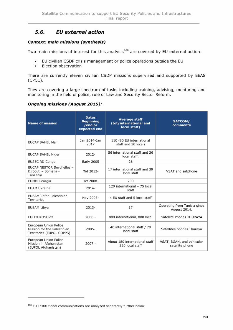
Satellite Communication to support EU Security Policies and InfrastructuresFinal report
291
EU external action5.6.
Context: main missions (synthesis)
Two main missions of interest for this analysis168 are covered by EU external action:
• EU civilian CSDP crisis management or police operations outside the EU• Election observation
There are currently eleven civilian CSDP missions supervised and supported by EEAS(CPCC).
They are covering a large spectrum of tasks including training, advising, mentoring andmonitoring in the field of police, rule of Law and Security Sector Reform.
Ongoing missions (August 2015):
Name of mission
DatesBeginning/end or
expected end
Average staff(tot/international and
local staff)
SATCOM/comments
EUCAP SAHEL MaliJan 2014-Jan
2017110 (80 EU international
staff and 30 local)
EUCAP SAHEL Niger 2012-56 international staff and 36
local staff.
EUSEC RD Congo Early 2005 26
EUCAP NESTOR Seychelles –Djibouti – Somalia -Tanzania
Mid 2012-17 international staff and 39
local staffVSAT and satphone
EUMM Georgia Oct 2008- 200
EUAM Ukraine 2014-120 international – 75 local
staff
EUBAM Rafah PalestinianTerritories
Nov 2005- 4 EU staff and 5 local staff
EUBAM Libya 2013- 17Operating from Tunisia since
August 2014.
EULEX KOSOVO 2008 - 800 international, 800 local Satellite Phones THURAYA
European Union PoliceMission for the PalestinianTerritories (EUPOL COPPS)
2005-40 international staff / 70
local staffSatellites phones Thuraya
European Union PoliceMission in Afghanistan(EUPOL Afghanistan)
2007 -About 180 international staff
320 local staffVSAT, BGAN, and vehicular
satellite phone
168 EU Institutional communications are analyzed separately further below

Satellite Communication to support EU Security Policies and InfrastructuresFinal report
292
Missions completed
Name of mission
DatesBeginning/end or expected
end
Average staff(tot/international and
local staff)
SATCOM/comments
European Union PoliceMission in the formerYugoslav Republic ofMacedonia (EUPOL Proxima)
2003 - 2005 186
European Union PoliceMission in Kinshasa (DRC)(EUPOL Kinshasa)
2005 -2007 About 50/104 Satphone for Head of
mission, deputy, Securityand deputy
EUPOL RD Congo 2007 - 2014 About 304 Satphone for Head of
mission, deputy, Securityand deputy
European Union PoliceMission in Bosnia andHerzegovina (EUPM),
2003-2012 480 (272) Satellite mobiles
EUJUST LEX IrakJuly 2005-Dec
201366 staff (53 internationalexperts and 13 local staff)
EU SSR Guinea BissauJune 2008 -Nov 2009
16 (out of 27) internationalsand 14 (out of 19) locals
EU AVSEC South SudanJune 2012-April 2014
34 international staff and 15local staff.
AMM Monitoring MissionACAH –Indonesia
Sept 2005-Dec 2006
130 international staff &local staff 90
EUJUST THEMIS GeorgiaJuly 2004- July
200530
Estimated current and future use of SATCOM
To support the main missions identified under this user community, two SATCOM usageshave been highlighted, as indicated in the table below:
Main mission SATCOM usageStatus ofSATCOMusages
EU civilian CSDP crisis management or policeoperations outside the EU
(14) SATCOM to support EU civilian CSDPcrisis management and police operationsoutside the EU
Current
Election observation(15) SATCOM to support Election ObservationMission
Current

Satellite Communication to support EU Security Policies and InfrastructuresFinal report
293
SATCOM to support EU civilian CSDP crisis management and police operationsoutside the EU (usage 14)
Key assumptions:
• Average of 10 simultaneous missions• Deployed international staff per mission : between 5 and 1000 – average about
150• Simultaneously deployed staff (august 2015) : about 1500 international staff• 1/3 of missions in poor connected areas• Telecommunications between EU deployed Mission HQ and EEAS/Brussels and
Delegation (if not collocated)• Telecommunications between deployed HQ and staff in mission in remote or poor
connected areas• Mains SATCOM terminals used :
o Satellite phones (head of mission and deputies): Iridium, Thuraya, etc.o VSAT for main and secondary HQs,o BGAN for unit missions in remote areas
Evolution of these missions:
No predictable trend but the following points could be assessed:
• The duration is increasing from an average of 3 years (completed operations)towards 5 years (missions on going)
• The number of simultaneously missions will therefore increase• The volume of staff deployed will increase (x3 between completed missions and
ongoing missions)• It appears main issues regarding the need to connect deployed staff with their
social and familial environment• The use of RPAS for crisis management when staff not deployed in the same HQ
or to cover remote area (e.g. EUPOL Afghanistan, EUCAP Nestor, etc.)• Therefore, as indicated in the table hereunder, the following assumptions were
used:o Increase of 10% per 5 years of people deployedo Increase of 10% per 5 years of mission deployed
The assumption for the number of SATCOM equipment will be based on thefollowing169:
o 2 VSAT per mission (to take account different sites of deployment)o One hand-held SATCOM terminal per 10 staffo Evolution bandwidth of SATCOM terminals:
2015 2020 2025 2030
International staff deployed 1500 1650 1815 1997
Number of missions 10 11 12 13
Evolution of bandwidth of mobileSATCOM (kbps)
50 50 50 50
Evolution of deployable SATCOM(kbps)
3000 6450 13868 29815
169 Source: EEAS consultation

Satellite Communication to support EU Security Policies and InfrastructuresFinal report
294
AUD & IUD estimation
The table below calculates the Aggregated User Demand (AUD) represented by all theneed of communication for all staffs deployed in the different mission. It is obtained bymultiplying the bandpass of each terminal either handheld or deployable while themissions are ongoing and are located in poor connected areas (factor of 1/3).
For IUD, ratio of operational employment (assumption): 30%
2015 2020 2025 2030
AUD estimation
Nb of staff 1500 1650 1815 1997
Nb of missions 10 11 12 13
Ratio of mission in poor connectedareas
33%
Nb of missions in remote areas 3,3 3,7 4,0 4,4
Nb of VSAT per mission 2 2,2 2,4 2,7
Total of VSAT for all missions 6,7 8,0 9,7 11,8
Nb of satphone 150 165 181,5 199,65
Evolution of mobile SATCOM per unit(Mbps)
0,05 0,05 0,05 0,05
Evolution of deployable SATCOM perunit (Mbps)
3 6,45 13,868 29,815
Bandwidth needs for mobile satphone(Mbps)
7,5 8,2 9,1 9,9
Bandwidth needs for deployableSATCOM (Mbps)
20 52 135 352
Total AUD 27,5 60,2 144,5 362,1
IUD estimation
Total IUD 9,2 20,1 48,1 120,7
SATCOM to support Election Observation Mission (usage 15)
Since 2000 the EU has deployed more than 140 missions involving the participation ofover 11 000 observers. Various types of observers participate in the European Union'sElection Observer Missions (EOMs). European Union’s Elections Observer Missions (EUEOMs) are led by a Chief Observer and are made up of a core team (involving a deputyChief Observer and some electoral experts) and some long term and short termobservers.
The following figures and assumptions have been hence made:
• Each Core Team member receives a mobile/satellite phone• Teams deployed in the country, especially in rural areas, are provided with
satellite phone devices guaranteeing communication between the mission and theteams at all times
• 10 core team par mission, about 79 staff on average• 2,5 simultaneous missions• 3 phases:
o The core team is deployed for 6 à 8 weekso Long term observers are deployed for 4 to 6 weekso Short term observers are deployed as a pair for 15 days
• One SATCOM VSAT per core team• One satphone per 10 staff• Same assumptions for evolution of bandwidth for the horizon 2020 – 2025 and
2030

Satellite Communication to support EU Security Policies and InfrastructuresFinal report
295
AUD & IUD estimation
For IUD, ratio of operational employment (assumption): 30%
2015 2020 2025 2030
AUD estimation
Nb of core team 10 10 10 10
Nb of staff except core team 69 69 69 69
Nb of missions 2,5 2,5 2,5 2,5
Nb of VSAT per mission 1,00 1,00 1,00 1,00
Total of VSAT for all missions 2,50 2,50 2,50 2,50
Nb of satphone 16,90 16,90 16,90 16,90
Evolution of mobile SATCOM per unit(kbps)
0,05 0,05 0,05 0,05
Evolution of deployable SATCOM per unit(kbps)
3,00 6,45 13,87 29,82
Bandwidth needs for mobile satphone(kbps)
0,85 0,85 0,85 0,85
Bandwidth needs for deployable SATCOM(kbps)
7,50 16,13 34,67 74,54
Total AUD 8,35 16,97 35,51 75,38
IUD estimation
Total IUD 2,5 5,3 11,4 24,6

Satellite Communication to support EU Security Policies and InfrastructuresFinal report
296
Synthesis of estimated current and future bandwidth for EU external action
Main mission SATCOM usages Status Comments
EU civilian CSDP crisismanagement or policeoperations outside the EU
(14) SATCOM to support EUcivilian CSDP crisismanagement and policeoperations outside the EU
Current-> Estimated bandwidth is forusage (14)
Election observation(15) SATCOM to supportElection Observation Mission
Current-> Estimated bandwidth is forusage (15)
Estimated bandwidth(Mbps)
Europe ArcticRest of the
WorldTOTAL
Estimated bandwidth for usage (14)
2015 - Usage 0,0 0,0 9,2 9,2
2020 - Demand 0,0 0,0 20,1 20,1
2025 - Demand 0,0 0,0 48,1 48,1
2030 - Demand 0,0 0,0 120,7 120,7
Estimated bandwidth for usage (15)
2015 - Usage 0,0 0,0 2,5 2,5
2020 - Demand 0,0 0,0 5,3 5,3
2025 - Demand 0,0 0,0 11,4 11,4
2030 - Demand 0,0 0,0 24,6 24,6
Total EU External Action
2015 - Usage 0,0 0,0 11,7 11,7
2020 - Demand 0,0 0,0 25,4 25,4
2025 - Demand 0,0 0,0 59,5 59,5
2030 - Demand 0,0 0,0 145,3 145,3

Satellite Communication to support EU Security Policies and InfrastructuresFinal report
297
Transport infrastructures : air traffic management5.7.
Context: main missions (synthesis)
At EU level, the SESAR programme aims at ensuring the modernisation of the Europeanair traffic management (ATM) system to enable the future growth in European flights.SESAR is proposing the “multilink communications concept” in which SATCOM could playan important role alongside terrestrial based communications. The communicationsbetween the aircraft in-flight and the ground control centres is critical for the safety ofthe flights: they should be secured against ill-intentioned acts, in particular when thesecommunications comprise of digital messages.
Estimated current and future use of SATCOM
To support the main mission identified under this user community, one SATCOM usagehas been highlighted, as indicated in the table below:
Air to ground communications (usage 16)
A study was jointly carried out by Eurocontrol and the FAA (USA) between 2004 and2007 to define the Future Communication Infrastructure for civil aviation (FCI). A futureair-ground communication infrastructure was proposed, based on a multi-link solution,and a progressive transition from the voice communications to the datalinkcommunications. A satellite component was included.
An assessment of the communication needs was also performed, and published in 2007:the COCR v2 (Communication Operational Concept Requirements). This document givesthe estimated needs for the ATC communications and AOC communications, and includesan evaluation of the Peak Instantaneous Aircraft Count (PIAC), i.e. the maximum numberof aircraft in the same phase of flight. ATC communications are established between theflight crews and the Air Traffic Control units and the AOC communications, between theflight crews and the airline operational centers.
The COCR v2 has been reviewed in 2011 by a group of airspace user representatives thatproduced a report which concludes that:
• AOC applications do not have more stringent requirements than ATS applications• As a consequence, datalink quality of service to support ATS should be able to
support the requirements which are necessary to support AOC services• AOC data-traffic volumes, as determined by this study and compared to COCR V2
assumptions, result in a significant increase of AOC required capacity (demand)• Certain AOC applications should be classified as ATS, with possible impact on ATS
capacity requirement• End goal for the Airspace User is a “connected” aircraft (connected anywhere,
anyplace, anytime, anybody)• Cost price (Operating costs, Communication costs) is the major factor• It is the Airspace User feeling that in general, total bandwidth requirements for a
single aircraft in 2020 will be a significantly higher than today (ATS and AOCcombined)
• Airspace User Group recommends to use the AOC Data Service description andcharacteristics from this Report as a baseline to refine the COCR
Main mission SATCOM usageStatus ofSATCOMusages
Air traffic management (16) Air to ground communications Current

Satellite Communication to support EU Security Policies and InfrastructuresFinal report
298
• A number of AOC Services (e.g. Emergency Services) identified in the AirspaceUsers-Report require large amount of bytes to be transmitted in short period oftime. The design of the Datalinks should be capable to handle this type ofmessages
ESA - in agreement with the SESAR-JU - funded a preliminary definition study (phase B)for a dedicated satellite system, within the ARTES 10-IRIS project. The study was carriedout in parallel with the launch of an experiment with the Inmarsat Swift Broad Band(SBB) system, in L-band, named the IRIS Precursor. To-day, the Phase B is finished andthe IRIS Precursor is on-going. A study has been launched by the SJU to refine thedetailed needs for the future air-ground communication system. This study is not finishedand the results are not yet available. Based on the COCR v2, the IRIS dedicated satellitesystem (2 GEO satellites) should be capable to support the following performances:
• Messages sizes: from 77 bytes to 21000• Peak data rate: 14 kbps by aircraft• Peak instantaneous aircraft count (PIAC) over ECAC: 6000 aircraft
According to an ESA-CNES paper (ACP/WGF 20/WP17- 20/03/09) presented at a meetingof the Aeronautical Communication Panel of ICAO, “the calculation studies that ESAundertook are assuming the following hypothesis:
• COCR V2 satellite services of ATC, AOC and NET (network management) services• For the COCR V2 flight domains applicable to the aviation services through a
satellite infrastructure (i.e. ENR, TMA, ORP)• Busiest day of the year (31 August at 2025)• For the Eurocontrol traffic growth of Scenario B/C (i.e. Medium)• IFR flights between 12:00 and 18:00 UTC
Current results have shown that the information volume under the above assumption isof the order of 4 Mbps in the forward link and about 1.2 Mbps in the return link.What is interesting to note from these simulation results is that the forward linkinformation volume is driven (80% of the total) by AOC services like WXGRAPH(graphical weather information).”
In conclusion:
• In 2025: 4 Mbps (forward link data rate estimated in the ESA/CNES report)• In 2020: 3 Mbps (assuming an increase in the traffic of 4% per year)• In 2030: 5 Mbps (assuming the same rate of 4%)
These figures are based on the COCR V2 communication needs, and should increasesignificantly when the airspace user representatives needs will be taken into account. Asthe work is still in progress within the SESAR programme, it is too early to dispose of theupdated values. If a detailed definition of the GOVSATCOM system with an ATM missionis launched, it will be absolutely necessary to update these values.
Furthermore, if such dedicated system was intended to offer the aeronautical mobilecommunication service over a greater area than the ECAC, including the Oceanic, Remoteand Polar Regions of the world, it is expected that the peak instantaneous aircraft countwould be 10 times more important, i.e. 60 000 in 2025, meaning a communication need10 times more important with respect to the preceding values based on the COCR V2:
• In 2020: 30 Mbps• In 2025: 40 Mbps• In 2030: 50 Mbps

Satellite Communication to support EU Security Policies and InfrastructuresFinal report
299
Note: based on public information, the current usage is considered as low in terms ofbandwidth demand170.
The decision concerning the service coverage should be taken at a later stage and notonly based on technical arguments.
Global Flight Tracking
There is another SATCOM need that has appeared in 2015, for assuring the permanenttracking of the aircraft in-flight anywhere in the world. In February 2015, the ICAO high-level safety conference decided that all aircraft position should be tracked at least every15 minutes when there is no emergency situation; the position update rate is changed toaround 1 minute when an abnormal event is detected. The European Commissionpublished in December 2015 a regulation (2015/2338) which mandates the global flighttracking: “By 16 December 2018 at the latest, the operator shall establish and maintain,as part of the system for exercising operational control over the flights, an aircrafttracking system”. This regulation applies to heavy aircraft with a maximum take-off massgreater than 27000 kg.
Outside some continental areas where radar coverage is available, there is no ground-based mean to-day to follow the aircraft trajectories. Only satellite links could assure thisfunction. Most of the long-haul aircraft are equipped to communicate by satellite, mainlyvia Inmarsat, and some flying in the Polar Regions, are also equipped with an Iridiumterminal. There exists an ICAO standard for the transmission of the aircraft position atregular intervals, the ADS/C standard. Inmarsat has decided to offer to its customers theflight tracking free of charge.
For the other aircraft not equipped with a SATCOM terminal, it will be possible to assurethe tracking by satellite-based ADS/B systems. To-day 60 % of all aircraft is equippedwith the ADS/B system. The equipage will become mandatory around 2020, to fly withincertain airspaces, like the US or the ECAC airspaces. Each equipped aircraft transmitsthrough its radar transponder, at 1090 MHz, every 0.5 second, a 112 bits message withthe aircraft position (the ADS/B standard requires the reception of 2 successive 112 bitsmessages to get the full position). These transmissions can be received by orbitingsatellites and relayed to the ATC control centers or the airline operation centers.
For one position every 15 minutes, the communication need for a PIAC of 60000 aircraft(2025) is: 2*112*60000/15/60=15 kbps; if the interval is reduced to 1 minute, thatfigure would be 225 kbps. This global need is low and negligible compared to theprevious figures (usage n°16) but requires a constellation of LEO or MEO satellites tocover the entire globe.
In Europe, ESA has demonstrated on a test satellite that this function was feasible with asmall satellite, PROBA-V. The project was the joint effort of SES Techcom Services andthe DLR Institute of Space Systems, as well as the DLR institute of Flight Guidance. SESTechcom Services developed the data segment along with the Data Processing andAnalysis Segment (DPAS), while DLR developed the payload. After more than one year inoperation, the demonstrator has captured 165 million ADS/B traffic data and was able todecode 30 million positions between July 2013 and April 2015. No decision has beentaken yet by SES Techcom for the deployment of an operational system.
170 Inmarsat annual report 2014: 7130 aircraft equipped with classic-aero. Considering the forward link datarate estimated in the ESA/CNES report, the estimated users’ demand corresponds to a few tens of kbps

Satellite Communication to support EU Security Policies and InfrastructuresFinal report
300
An operational system is being developed by the Aireon company, and will be carried bythe Iridium Next satellites under development by TAS. Several European air navigationservice providers have invested into the Aireon company: IAA (Ireland), ENAV (Italy),Naviair (Denmark). The system should become operational in 2018.
ATM & Arctic Region
An increased number of flights adopt Arctic routes, however limited by obligations fordistance to emergency landing points depending on the number of engines and enginesperformance (ETOPS regulation). Such regulations and the limited airport infrastructurein the region thus greatly limit the international commercial Arctic flights to multipleengine plane types such as the Boeing 777, 747, etc. today. Between 2000 and 2010,the number of polar flights increased from few hundreds to 9,000/year; this polar trafficis expected to continue to grow by about +1,000 flights/year if no geo-political obstaclematerializes. Should local countries decide to upgrade some of their most northernairports, the growth might become even stronger.
The related SATCOM requirements include:
Extending ADS-B availability to the whole region
In some areas of the Arctic (e.g. northern airspace around Hudson Bay in Canada, beingextended to some oceanic areas off the east coast of Canada and Greenland) radarsurveillance coverage does not exist, so ADS-B is a critical safety system for airtransportation. Pilots benefit from ADS-B by having the ability to see, on their in-cockpitflight display, other traffic operating in the airspace, receiving pertinent updates rangingfrom temporary flight restrictions to runway closings, and by air traffic controllers havingthe ability to more accurately and reliably monitor their positions.
While ADS-B currently covers only a fraction of the Arctic, at least Canada (TransportCanada, 2007) and Iceland (CANSO, 2011) plan is to extend coverage over theremainder of their Arctic regions. It is likely that other Arctic nations will follow and thatthis technology will only increase in relevance for air transportation safety.
Improving SAR capabilities
The development of both maritime and air transport in the Arctic requires adequateSearch and Rescue (SAR) capabilities in case of accident. SAR regions have been agreedbetween Russia, Canada, Denmark, USA, Norway and Iceland (and marginally Finlandand Sweden); from an EU perspective, the Norwegian stake to effectively provide SARservices over this huge section of the Arctic Sea is significant.
SAR operations involve the response to distress signals by air-, water- or land-basedequipment and personnel. There are many ways that distress can be signaled. Amongthese, signals from ELT (Emergency Locator Transmitter), EPIRB (Emergency PositionIndicating Radio Beacon) and PLB (Personal Location Beacon) devices can be relayed toauthorities through the COSPASS-SARSAT system of satellites.As a last option, Iridium SATCOM phones might also be used to alert. So there arealready gaps in communication systems availability to secure the capability to alertinstantaneously.
Earlier aeronautic incidents such as the crash of a Canadian military C130 Hercules onNovember 1991 in close proximity (20km) of the radar station on Ellesmere Island,400nm from the North Pole in the Arctic have shown the importance of responding withupmost urgency as the partially destroyed aircraft hardly provides a shelter for survivors,with very little survival and medical equipment while wounds are generally severe.

Satellite Communication to support EU Security Policies and InfrastructuresFinal report
301
In this case, first rescuers only arrived after 30 hours, the first evacuation airlift onlyexecuted after 40hrs. Several survivors died of cold.171
The tragically late response to the 1991 C130 crash might be improved nowadays by thebetter SATCOM availability - still the crash was known at the time it occurred. Simply,knowing better the condition of survivors and their lack of protective equipment couldhave enabled an early dropping of most needed supplies before paramedics could rallythe place.
More recently, First Air Flight 6560 was a charter flight which crashed near Resolute,Nunavut, Canada, on 20th August 2011. But the crash occurred alongside the runway at atime where the Canadian Forces were conducting Operation Nanook 2011 nearby, whichwas about to simulate an air disaster in the Resolute Bay area! As a result, RoyalCanadian Air Force firefighters were readily available to respond and reach the crash sitein a very short time, so it is an exceptionally favorable context not representative of theArctic challenges - it might have conducted to underestimate the current capability gap.
Improving weather - and “Space weather”- forecast and alert services
Air transport safety is greatly impacted by weather patterns and access to reliable andaccurate weather services is imperative for safe and effective operations. Weatherforecasts can also significantly impact cost effectiveness as route planning and schedulingis dependent on a clear understanding of current and future weather systems.
As with communications satellites, many of the space-based weather observationplatforms are geostationary in near-equatorial orbits and are also unable to provide dataon high-latitude atmospheric conditions. The more northerly remote areas of Europe andCanada are on the periphery of such system’s ‘field of view’. EUMETSAT, ESA, and NOAAhave been working since the late 1990s to jointly develop satellite systems that monitorweather and climate change over the poles. Current weather satellite systems that collectdata over the Polar Regions employ Low-Earth Orbits that provide high-quality spatialresolution information over high latitudes but on a narrow flight path – sometimes taking6 hours before the same area is imaged again (e.g. Metop, NOAA-19).
Several missions are proposed to be implemented over the next 10 years to address thedeficiencies of current systems (e.g. Arktika, CARVE, CASSIOE, Meteosat Third Gen). Inaddition to improved imagery at more frequent repeat cycles, the provision of data fromthe infrared and ultraviolet/visible sounding missions will help derive improved forecasts.
One of the main issues with Cross Polar air traffic is the influence of “space weather”(magnetic storms in particular). Space weather phenomena occur when energeticparticles thrown out from the Sun interact with the earth’s magnetic field producingmagnetic disturbances and increased ionization in the ionosphere, between 100 and1,000 km above the earth. Space weather phenomena has 3 main consequences on polarflights: risk for the passengers’ health due to ionizing radiation, risk of air-ground HFcommunication breakdown due to scintillation (ionospheric propagation) and risk ofsatnav signal losses and / or important measurement error (ionospheric propagation).
While the sun is the main driver of space weather impacts, other factors (e.g. radiationbelt dynamics) also play an important role. Since the earth’s magnetic field isconcentrated at the poles172, high latitudes are particularly impacted by thesedisturbances. Planned satellite missions proposed to monitor the radiation belts includeNGRM (next generation radiation monitor) programme/ESA, ERG/Japan, MMS/USA andRBSP/USA.
171 http://www.nytimes.com/1991/11/05/world/after-a-plane-crash-30-deadly-hours-in-the-arctic.html172 I.e. magnetic pole

Satellite Communication to support EU Security Policies and InfrastructuresFinal report
302
Weather data communication needed could be two-way, on the one hand regularinformation updates to the airplane to avoid solar storms and dangerous weather areasand to better coordinated the flight planning and on the other hand regular data sentfrom the airplane to the centre including external sensor data on environmentalconditions (e.g. temperatures, radiation, etc.).
The figures of the “Arctic” column of the next table on ATM Transport Infrastructure aremeant to alert on these critical capability gaps, while currently published figures largelydiverge depending on the source and would require a more comprehensive surveyexceeding the present study framework.

Satellite Communication to support EU Security Policies and InfrastructuresFinal report
303
Transport infrastructures: rail traffic management5.8.
Context: main missions (synthesis)
The new European train control system is based essentially on ground-based radiocommunications between the trains and the Control Centres; satellites could increasecapacity and make train traveling economically more attractive. Both SATNAV andSATCOM will be used to set up future satellite-based platforms and be suitable for TrainControl and Management-Systems. The ESA has funded a number of studies andexperiments to promote the use of satellite navigation and communications for rail trafficmanagement and he European Railway Agency has been appointed by the EC to launch astudy on the evolutions of the railway communication system.
Estimated current and future use of SATCOM
To support the main mission identified under this user community, one SATCOM usagehas been highlighted, as indicated in the table below:
SATCOM to support communications between train drivers and traffic controlcentres, on secondary railways with no GSM/R infrastructure (usage 17)
The main function of the railway communication systems is the transmission of voicecalls between the train drivers and the train traffic controllers. The current Europeanstandard is the GSM/R, a cellular network derived from the GSM standard. In addition tothe point to point communications, the GSM/R allows advanced speech call items (ASCI)like the voice broadcast service, the voice group call service and the Railways EmergencyCall service. The voice is converted from analog signal to digital data flow compatiblewith the available bandwidth by a voice codec. There are a number of existing GSMcodecs standardized by the ETSI institute, but only two of them are compatible with theASCI features, the so-called full rate codec, with a bit rate of 13 kbps, and the half ratecodes, at 5.6 kbps. One channel is required for each train. The channel spacing is 200kHz.
The GSM/R is also capable of transmitting data for the ETCS (European Train ControlSystem) applications, standardized by the ERA agency. These data include thetransmission of information from the trains such as the train position, as well as thetransmission by the train control center of safety related commands and information tothe train driver.
According to the ERA document “Evolution of GSM/R draft final report”: “The currentsituation with rail communications is that GSM/R is well established, and provides aEuropean-wide interoperable system for voice and data communications. While the voiceaspect is widespread, there is less use of the European Train Control System (ETCS),although this is increasing.
Main mission SATCOM usageStatus ofSATCOMusages
Rail Traffic Management
(17) SATCOM to support communicationsbetween train drivers and traffic controlcentres, on secondary railways with no GSM/Rinfrastructure
Potential

Satellite Communication to support EU Security Policies and InfrastructuresFinal report
304
A successor to GSM/R is required primarily due to the expected obsolescence of GSM/R.The ability of the rail industry to continue to support GSM/R beyond roughly 2030 isdoubtful. Given the long procurement cycles in the rail sector, planning for a successorneeds to begin now.”
The same document proposes a multi-technology solution including satellites:“Satellite communication could be useful to bring connectivity to remote areas whichwould otherwise be expensive or impractical to serve. There are two main opportunities:
• Current and future use of geosynchronous (GEO) satellites, or• Future use of Medium Earth Orbit (MEO) satellites.”
The European Space Agency has undertaken a project named SATCOM4Rail, which is stillon-going, with the following preliminary results:
• The LEO (Iridium) and Inmarsat BGAN systems can be used - as well as Ku-bandGEO SATCOM - for a short-term (2015-2020) SATCOM solution, for safety criticalapplications and eventually liability critical communications.
• For a mid-term (2020-2030) solution, GEO Ka-band or S-band are also possiblefor the safety critical and liability critical communications.
• A long-term solution (2030+) can be based on MEO satellites in the C-band.
Figure 19 - SATCOM4Rail project preliminary results (source: ESA)
The bit rate for safety critical communications should be limited in order to allow voicecommunications similar to the existing GSM/R: 13 kbps with the full rate codec or 5.6kbps for the half rate codec.
The number of terminals will be limited to the trains running on the secondary railwayswhere the GSM/R deployment would be too costly with respect to the low traffic density:the maximum number of terminals is evaluated to 10 % of the stock of locomotives andrailcars (59 269 in the EU-27 in 2011173).
173 According to DG MOVE publication “pocketbook 2013”

Satellite Communication to support EU Security Policies and InfrastructuresFinal report
305
The deployment should start slowly, and be based on existing SATCOM, Inmarsat,Iridium or Ku-band GEO. It will require the publication by ERA of an interoperabilitystandard that should probably not happen before 2020. However, if it is decided todevelop a completely new system in C-band on MEO satellites such as Galileo, it isprobable that the deployment before 2030 will be much reduced and should start onlyonce the new system is declared operational, after 2030.In conclusion, the expected number of terminals assuming no decision taken on thedevelopment of a MEO system is:
• 2015-2020: few experiments• 2025: maximum 1% of 59269, around 600• 2030: maximum 5 %, around 3000
Concerning the satellite bandwidth, it will depend on the technology used: regionalcoverage of EU by a single beam or by multiple beams reusing the same frequencies;multiple access mode to the satellite: either FDMA-SCPC (single channel per carrier) orCDMA (code-division multiple access). The dimensioning case is one single beam andFDMA-SCPC. Assuming 2 Hz of bandwidth for 1 bps, the maximum satellite bandwidthcould be:
• In 2025: 600 x 13k x 2 = 15.6 MHz (7.8 MHz with a HR vocoder)• In 2030: 3000 x 13k x 2 = 78 MHz (39 MHz with a HR vocoder)
Of course, these figures can be significantly reduced by using multiple beams and CDMA.

Satellite Communication to support EU Security Policies and InfrastructuresFinal report
306
Transport infrastructures: road traffic management5.9.
Context: main missions (synthesis)
Intelligent transport systems - extract from the Directive 2010/40/EU:
Intelligent Transport Systems’ or ‘ITS’ means systems in which information andcommunication technologies are applied in the field of road transport, includinginfrastructure, vehicles and users, and in traffic management and mobilitymanagement, as well as for interfaces with other modes of transport
ITS integrate telecommunications, electronics and information technologies withtransport engineering in order to plan, design, operate, maintain and managetransport systems. The application of information and communication technologiesto the road transport sector and its interfaces with other modes of transport willmake a significant contribution to improving environmental performance,efficiency, including energy efficiency, safety and security of road transport,including the transport of dangerous goods, public security and passenger andfreight mobility, whilst at the same time ensuring the functioning of the internalmarket as well as increased levels of competitiveness and employment
Funded by the FP7 program, the SafeTRIP project defined and tested the applications ofsatellite communications for road vehicles, in particular those linked with safety. Thesatellite used for these tests was the Eutelsat 10A satellite, which carried an S-bandpayload for communicating with mobiles. The service named Solaris is operated by theEchoStar Company, which has ordered the construction of a dedicated satellite, whichshould be launched in 2016. Another company, Inmarsat, has also ordered theconstruction of a satellite with an S-band payload, the Europasat satellite, to be launchedend of 2016. These two operators were selected in 2009 after a competitive tender, bythe European Commission to deploy pan-European networks based on S-band satellites.The main mission of these satellites will be the broadcasting of television to mobile users,in airplanes, boats or terrestrial vehicles.
The modulation will comply with the DVB-SH standard of ETSI. This standard allows thetransmission of data. S-band introduces a new suite of pan-EU services promotingdelivery of Public Protection and Disaster Relief services against the EU ‘Solidarity Clause’policy objective. PPDR services are provided by relevant protection and disaster riskagencies, notably police, fire and ambulance services, civil defense, and auxiliary servicessuch as military search and rescue. The S-band system will provide high connectivityspeeds, which will serve PPDR.
Estimated current and future use of SATCOM
To support the main mission identified under this user community, two SATCOM usageshave been highlighted, as indicated in the table below:
Main mission SATCOM usagesStatus ofSATCOM usages
Road traffic management
(18) Tracking of dangerous goods transport Potential
(19) Emergency callPlanned(eCall by 2018)

Satellite Communication to support EU Security Policies and InfrastructuresFinal report
307
Tracking of dangerous good transports (usage 18)
Dangerous are solids, liquids, or gases that can harm people, other living organisms,property, or the environment. Dangerous goods include materials that are radioactive,flammable, explosive, corrosive, oxidizing, asphyxiating, biohazardous, toxic, pathogenic,or allergenic. Also included are physical conditions such as compressed gases and liquidsor hot materials.
Mitigating the risks associated with hazardous materials may require the application ofsafety precautions during their transport, use, storage and disposal. Most countriesregulate hazardous materials by law, and they are subject to several internationaltreaties as well. The most widely applied regulatory scheme is that for the transportationof dangerous goods. The United Nations Economic and Social Council issues the UNRecommendations on the Transport of Dangerous Goods, which form the basis for mostregional, national, and international regulatory schemes.
The European Union has passed numerous directives and regulations to avoid thedissemination and restrict the usage of hazardous substances, important ones being theRestriction of Hazardous Substances Directive and the REACH regulation. There are alsolong-standing European treaties such as ADR (European Agreement concerning theInternational Carriage of Dangerous Goods by Road (1957)) and RID transport by rail)that regulate the transportation of hazardous materials by road, rail, river and inlandwaterways, following the guide of the UN Model Regulation.
Several projects funded either by the EU, within the FP6 and FP7 programmes (MITRA,SCUTUM), or by ESA (ARTES-DG-TRAC), have investigated the possibility to use thespace technologies, GNSS and SATCOM, to track the dangerous goods transports. Todaythere is no EU regulation making this tracking mandatory, and the use of thesetechnologies is based on a decision taken by the operator. The communications betweenthe vehicles and the operator headquarters is realized either via cellular networks or bySATCOM when the cellular network is not available.
The road transport of dangerous goods concerns around 4% of the road transportactivity174. According to the pocketbook 2013175, the total number of goods vehicle in theEU was near 34 million in 2011. The number of dangerous good transport vehicles can beestimated at 4 % x 34 million = 1.4 million.
The SATCOM equipped vehicles should be those that use roads where a continuous GSMcoverage is not available. It is estimated that the maximum percentage of SATCOMequipped vehicles should be 20%, i.e. 0.28 million vehicles.
The document industry security guidelines for the transport of dangerous goods176 states:“Vehicles should be fitted with radios or some other means of two-way communicationsbetween the driver and the base”.
ESA has launched a study named DG-TRAC concerning the tracking and tracing ofdangerous goods in the medical domain: the proposed system comprises a satellite bi-directional communication service. The service will allow suitably equipped emergencyservices to receive information about dangerous goods and any eventual alerts that areraised (in case of an incident) in near real-time”. However this equipage is not yetmandatory and is based only on national regulations or on voluntary equipage by theoperators. In the future, the equipage could become mandatory across the EU, as it isthe case for the eCall for new passenger cars. But for this, a new EU regulation will berequired and this could take several years.
174 Source: Eurostat web site175 DG MOVE publication176 Source DG MOVE web site

Satellite Communication to support EU Security Policies and InfrastructuresFinal report
308
For the eCall, the first proposal by the EC was in 1999, and the application will start in2018, around 20 years later; for the dangerous goods, this means that a new regulationcould be applied after 2030 only.
Between 2015 and 2030, the number of SATCOM equipped vehicles should increase veryslowly. An optimistic estimate is that over 15 years, the number could increase fromalmost zero up to 10 % of the maximum number of SATCOM equipped vehicles, i.e. 10% x 0.28 million = 28 000 vehicles, 9 300 in 2020, 18 700 in 2025 and 28 000 in 2030.
The communication needs are difficult to assess as the vehicles should use in priority theGSM network and eventually the satellite network when the GSM communication is notpossible. Probably only a few percentage of the communications will require the SATCOMlink either for position reporting, for administrative purpose (exchange of messages ordocuments), or for technical purpose (surveillance of the payload, and the tractor), oreven for a voice communication between the operator and the driver. The communicationneeds for one vehicle should be very small: probably less than 30s by hour when thevehicle is moving. With the GPRS system, this 30s of communications represent roughly30 x 9.6 = 288 kb per hour per vehicle.
On one complete day, the vehicle is supposed moving during 50 % of the time. Inaddition, the SATCOM use should be limited to a few percentage of the time (when theGSM network is not available), say 10 %. The average data rate per vehicle could be:(288 kb/3600) x 0.5 x 0.1 = 4 bps per vehicle. The peak rate could be 10 times moreimportant: 40 bps per vehicle. This gives the following estimates:
• In 2020: 9 300 x 40 = 372 kbps• In 2025: 18 700 x 40 = 0.75 Mbps• In 2030: 28 000 x 40 = 1.1 Mbps
Emergency call (usage 19)
The eCall EC initiative approved by the European Parliament aims to deploy a deviceinstalled in all road vehicles that will automatically dial 112 in the event of a serious roadaccident, as well as GNSS coordinates to local emergency agencies. On-board unitprototypes have been successfully tested with GPRS over cellular networks. The project issupported by the European Automobile Manufacturers Association (ACEA), an interestgroup of European car, bus, and truck manufacturers, and ERTICO. On 28 April 2015 theEuropean Parliament voted in favor of eCall regulation which requires all new cars beequipped with eCall technology from April 2018. However the coverage of GSM cellularnetworks is not assured over all the EU Member States, in particular in some remoteareas, mountains, islands. The satellite could be used in these areas.The public EU-wide eCall service based on the single European emergency call number112 and third party service supported eCall systems (TPS eCall services) can coexistprovided that the measures necessary to ensure continuity in the provision of the serviceto the consumer are adopted. Car manufacturers can commercialize cars with two eCallsystems, one using the cellular networks and the other another radio communicationnetwork, including satellite networks.
The number of road vehicles in the EU is very large: near 242 million passenger cars in2011 with a growth rate of 1.3%. According to the pocketbook 2013177, the number ofnew passenger car registration is around 12 million. After 2018 they should be eCallequipped after 2018: it is estimated that 25% could be equipped for satellitecommunications (in complement of GSM communications). So each year the number ofSATCOM equipped cars could reach 3 million cars (12 million x 25%).
177 DG MOVE publication

Satellite Communication to support EU Security Policies and InfrastructuresFinal report
309
Concerning the use of these communications, the pocketbook 2013 of the DG MOVEindicates that in 2011 the number of accidents was near 1.2 million for the EU. For thenew cars, the number of distress calls could reach: (1.2 million / 242 million) x 3 million= 14 900 calls. Plus the false alarms that could increase significantly that figure: forSarsat-Cospas, the false alarm rate if near 95%178. Based on this false-alarm rate, thenumber of calls could reach 0.298 million calls per year for the new cars.The simultaneous number of calls depends on their duration: it is assumed that each callcould last around 30 seconds, including the transmission of the alarm and the voicecommunication between the call center and the passengers. The average number ofsimultaneous distress calls is: 0.298 million x 30/365/24/3600 = 0.283.
The peak number of simultaneous calls is evaluated to be 10 times this average value,i.e. 2.83. The minimum data rate of GPRS is 9.6 kbps (Circuit Switched Data): thecommunications are bi-directional and all the data rates given concern each direction (forall road communications). The peak data rate for all the new vehicles of one year couldreach 2.83 x 9.6 K = 26.9 Kbps. This gives the following values for the years 2020, 2025and 2030:
Synthesis of estimated current and future bandwidth for transportinfrastructures: air, train & road
178 Source : ICAO-APSAR/TF/3−WP03 25 – 29/01/2015
2020 2025 2030
SATCOM equipped vehicles(in million)
6 21 36
Distress calls number(in million)
0.595 2.08 3.57
Peak number of simultaneouscalls
(in million)5.7 19.8 34
Peak data rate 54 Kbps 190 Kbps 326 Kbps
Main mission SATCOM usages Status Comments
Air traffic management(16) Air to groundcommunications
Current-> Estimated bandwidth isfor usage (16)
Rail traffic management
(17) SATCOM to supportcommunications betweentrain drivers and trafficcontrol centres, on secondaryrailways with no GSM/Rinfrastructure
Potential-> Estimated bandwidth isfor usage (17)
Road traffic management
(18) Tracking of dangerousgoods transport
Potential-> Estimated bandwidth isfor usage (18)
(19) Emergency callPlanned (eCallin 2018)
-> Estimated bandwidth isfor usage (19)

Satellite Communication to support EU Security Policies and InfrastructuresFinal report
310
Estimated bandwidth(Mbps)
Europe ArcticRest of the
WorldTOTAL
Estimated bandwidth for usage (16)
2015 - Usage 0,0 0,0 0,0 0,0
2020 - Demand 3,0 0,1 26,9 30
2025 - Demand 4,0 0,1 35,9 40
2030 - Demand 5,0 0,2 44,8 50
Estimated bandwidth for usage (17)
2015 - Usage 0,0 0,0 0,0 0,0
2020 - Demand 0,0 0,0 0,0 0,0
2025 - Demand 8,0 0,0 0,0 8,0
2030 - Demand 39,0 0,0 0,0 39,0
Estimated bandwidth for usage (18)
2015 - Usage 0,0 0,0 0,0 0,0
2020 - Demand 0,4 0,0 0,0 0,4
2025 - Demand 0,8 0,0 0,0 0,8
2030 - Demand 1,1 0,0 0,0 1,1
Estimated bandwidth for usage (19)
2015 - Usage 0,0 0,0 0,0 0,0
2020 - Demand 0,1 0,0 0,0 0,1
2025 - Demand 0,2 0,0 0,0 0,2
2030 - Demand 0,3 0,0 0,0 0,3
Total Transport infrastructures
2015 - Usage 0,0 0,0 0,0 0,0
2020 - Demand 3,4 0,1 26,9 30,4
2025 - Demand 12,9 0,1 35,9 48,9
2030 - Demand 45,4 0,2 44,8 90,4

Satellite Communication to support EU Security Policies and InfrastructuresFinal report
311
Copernicus5.10.
Context: main missions (synthesis)
The Copernicus program - “the Union Earth observation and monitoring programme”- is composed of three components:
• A service component ensuring delivery of information in the following areas:atmosphere monitoring, marine environment monitoring, land monitoring, climatechange, emergency management and security
• A space component ensuring sustainable spaceborne observations for the serviceareas listed above
• An in-situ component ensuring coordinated access to observations throughairborne, seaborne and ground based installations for the service areas listedabove
A unified ground segment, through which the data are streamed and made freelyavailable for Copernicus services component, completes the space component. EachCopernicus satellite mission, both the dedicated Sentinel missions as well as eachcontributing mission, has a ground segment, and is operated independently.
Estimated current and future use of SATCOM
To support the two main missions identified under this user community, two SATCOMusages have been highlighted, as indicated in the table below:
Data collection of in-situ components through satellite (usage 20)
Some Sentinel satellites will be equipped for transmitting the payload data to the missioncontrol centre via EDRS payload embarked on geostationary communication satellites.
All reception earth stations (Sentinel or EDRS reception stations) are connected throughterrestrial means, even the most remote one (located in Spitzbergen Island) operated byKSAS. Therefore, except possible back-up purposes, it appears no need for SATCOMconnections for Copernicus data collection.
Distribution of processed data to the users having no terrestrial connection(usage 21)
The distribution of processed data from the ground data centre to the users is the secondmain mission of Copernicus. This distribution is made available to the users through theinternet network. Therefore, there is a potential need of SATCOM communications for theusers who have no or a poor internet access.
On the other hand, today Eumetsat uses Eutelsat and SES systems for its service calledEumetCast. This service multicast files (data and products) in real-time to users(currently > 4000) including security and military, equipped with reception dishes andDVB receivers.
Main mission SATCOM usagesStatus ofSATCOMusages
Copernicus data collection(20) Data collection of in-situ componentsthrough satellite
Potential
Copernicus data distribution(21) Distribution of processed data to theusers having no terrestrial connection
Current andpotential

Satellite Communication to support EU Security Policies and InfrastructuresFinal report
312
Some other delegation entities of the Copernicus programme could consider copyingEumetsat for distributing the standard data which are requested by numerous in real-time through satellite. The required satellite capacity is of one 33 MHz transponder and itoperates over Europe/Africa, Asia and South America179.
Synthesis of estimated current and future bandwidth for Copernicus
179 Eumetsat website
Main mission SATCOM usages Status Comments
Copernicus data collection(20) Data collection of in-situcomponents through satellite
PotentialNo information available butprobably negligible (and back-upconnection only)
Copernicus datadistribution
(21) Distribution of processeddata to the users having noterrestrial connection
Current andpotential
Intelsat & Eutelsat used by Eumetsatfor its data distribution serviceEumetCast
-> Estimated bandwidth is forusage (21)
Estimated bandwidth(Mbps)
Europe ArcticRest of the
WorldTOTAL
Estimated bandwidth for usage (20)
2015 - Usage 0,0 0,0 0,0 0,0
2020 - Demand 0,0 0,0 0,0 0,0
2025 - Demand 0,0 0,0 0,0 0,0
2030 - Demand 0,0 0,0 0,0 0,0
Estimated bandwidth for usage (21)
2015 - Usage 0,0 0,0 0,0 0,0
2020 - Demand 16,0 0,0 0,0 16,0
2025 - Demand 30,0 0,0 0,0 30,0
2030 - Demand 60,0 0,0 0,0 60,0
Total Copernicus
2015 - Usage 0,0 0,0 0,0 0,0
2020 - Demand 16,0 0,0 0,0 16,0
2025 - Demand 30,0 0,0 0,0 30,0
2030 - Demand 60,0 0,0 0,0 60,0

Satellite Communication to support EU Security Policies and InfrastructuresFinal report
313
GNSS programmes5.11.
Context: main missions (synthesis)
The main missions covered by this key infrastructure are:
• EGNOS data transmission• Galileo data transmission
Estimated current and future use of SATCOM
To support the two main missions identified under this user community, three SATCOM usageshave been highlighted, as indicated in the table below:
SATCOM link to retransmit NAV signals over the area of interest (usage 22)
The main mission of EGNOS is the transmission of complementary data to the users allowingthem to correct the main source of position error, due to the ionosphere, and to assess theintegrity level of the calculated position. With these information the aeronautical users are able tofly accurately safety critical trajectories such as approaches with vertical guidance (APV).
EGNOS message is currently broadcast to the users through navigation payloads on board 2 GEOsatellites (for redundancy purpose) covering each an area which comprises latitudes from 20°N to70°N and longitudes from 40°W to 40°E. Nominally, a third GEO payload is used for test purpose(EGNOS-Test partition) and can be used in operation (EGNOS-OP partition) in case one of the twoGEO payloads used in EGNOS-OP needs to be replaced or moved to EGNOS-Test. This third GEOpayload is also called “In-orbit spare». One new satellite, SES-5, has been recently integrated inEGNOS operational system (and should be replaced in 2026) and a second one, ASTRA-5B, iscurrently undergoing integration tests and should be integrated in EGNOS operational system bythe end of 2016. The GSA has published in June 2015 a RFI for a third satellite which should startits mission in 2020. It is possible that few operators will express their interest. In that case itwould be useful to have public European geostationary satellites equipped with EGNOStransmitters. The uplink between the ground station and the satellite can use a FSS frequency (C-band, Ku-band, Ka-band) or one C-band frequency allocated to the RNSS.
Main mission SATCOM usagesStatus of SATCOMusages
EGNOS data transmission
(22)SATCOM link to retransmit NAV signalsover the area of interest
(23) Provision of secured communication toremote EGNOS integrity monitoring stations
Currently throughCOMSATCOM
Current
Galileo data transmission
(24) SATCOM links to connect the moreremote ground stations with sensitive links tothe Galileo satellites (TT&C and ULS) such asthose located in French Guyana, Tahiti, LaReunion, Nouvelle Caledonie,Norway, Sweden
Current

Satellite Communication to support EU Security Policies and InfrastructuresFinal report
314
EGNOS is a Satellite-Based Augmentation System (SBAS) compliant with an ICAO standard,similar to other SBAS systems already in operation, such as the WAAS system in North Americaand the MSAS system in Japan, or which will be put in service soon, such as the Russian SDCMsystem. The WAAS system uses commercial SATCOM for relaying the SBAS signal to the users.The MSAS uses a government satellite, MTSAT. The SDCM system uses the Luch-5A, 5Bgovernmental satellites.In the coming years, the satellite navigation will become more and more used by the civil aviationaircraft, from take-off to landing, and the SBAS systems will play an important role in theprovision of integrity information to the user ‘receivers. The new Airbus A350 is proposed to theairlines with an SBAS receiver. More and more commercial aircraft will be equipped. With thisreceiver, the aircraft can perform instrument approaches to the runways with the sameperformances as the ILS-Cat I. Consequently, the airport operators are planning to decommissionprogressively the ILS-Cat I systems that are installed to-day on many airports (50 ILS-Cat I willbe decommissioned in France over 100 in service). The EU civil aviation transport network willdepend strongly on EGNOS and the risk of ill-intentioned acts against it will become high. Using apublic secured GEO SATCOM could help to mitigate this risk. Another risk also could be mitigated:the risk of relocation of a SATCOM, when the operator makes a decision of relocation or when thesatellite is sold or leased to another operator; this was the case with Inmarsat 4F2 and Artemissatellites.
The preliminary specification of the payload is included into the GSA RFI: “request for informationin preparation for the procurement of an EGNOS GEO navigation payload services GEO-3”. Thispayload should transmit an SBAS signal at L1 as well as a signal that can be received directly bythe Galileo receivers and is similar to the signals transmitted by the Galileo satellites:
• Frequency bands: L1 (1575 +/- 12 MHz); E5 (1191 +/- 27 MHz)• Number of ground stations: 2• PRN code rates: L1: 1.023 Mchips/s; E5 a and b: 10.23 Mchips /s, i.e.: 20.7 Mcps of PRN
code• Data rates: L1: 250 bps; E1: 125 bps; E5a: 25 bps; E5b: 125 bps• Number of user’s terminals: several thousands (to-day, EGNOS is used essentially by civil
aviation and agriculture, but numerous experiments are going-on to develop the numberof safety critical applications: e.g. train position monitoring, ships navigation near theshore, road transport of dangerous goods)
• Service area: ECAC (European Civil Aviation Conference)
In conclusion for EGNOS SBAS signal transmission (mainly European coverage):
• In 2015: 3 x 1,023 Mbps = 3,1 Mbps• In 2020: 21.7 Mbps, via one GEO satellite• In 2025: 41.4 Mbps via 2 GEO satellites• In 2030: 62 Mbps via 3 GEO satellites
Provision of secured communication to remote EGNOS integrity monitoring stations(usage 23)
The RIMS (Ranging and Integrity Monitoring Stations) have the important mission to collect asmuch high-quality data as possible to elaborate the EGNOS messages for the users. Three typesof RIMS are deployed: RIMS-A, B and C. The role of RIMS A is to feed the processing system; therole of RIMS-B is to feed the independent check responsible to verify the message computed bythe processing system.

Satellite Communication to support EU Security Policies and InfrastructuresFinal report
315
The RIMS-A and B provide at a continuous rate of 1 Hz the ranging measurements and thenavigation message for each GPS, Glonass, and GEO (EGNOS) satellite in view. The RIMS-C hasbeen developed to monitor the GPS signals and detect specific GPS failure modes. RIMS A and Bare deployed on all the sites, and RIMS-C on a limited number of sites. Each site sends the datato the processing centers via a telecommunication link (128 kbps), either terrestrial or satellite(VSAT) link.
Today they are 8 RIMS sites (out of 39) connected via VSAT: Abu Simbel, Agadir, Alexandria,Athens, Djerba, Egilsstadir, Golbasi, La Palma, Nouakchott, Sofia. Each of these sites is connectedto two MCC (Mission Control Centres). There are 2 MCC: Madrid and Roma. More RIMS areplanned for deployment, in order to extend the service coverage: these remote sites should beconnected via VSAT. All these links are very critical for the EGNOS services, in particular for thesafety of life service, dedicated mainly to the navigation of civil aviation aircraft, from take-off tolanding.
After 2020, a new version of EGNOS should be deployed, with several main improvements: dualfrequency signal, L1+L5; integrity data for GPS and Galileo. The existing RIMS will be replaced bynew ones, which are not yet under development. It is difficult to-day to estimate the futurenumber of RIMS, after the deployment of EGNOS v3: the existing RIMS sites should beconserved, and the extension of the service area should continue but with less RIMS, thanks tothe dual-frequency signal which allows the user’s receivers to correct the ionospheric rangingerror, and do not require EGNOS data for this correction. However the current L1 only receiverswill continue to be operated and will require these data. In Africa, there is a project to deploy anSBAS system which could be an extension of EGNOS v3, but no decision has been taken yet. Inthat case, the number or RIMS could be increased significantly.
In conclusion for EGNOS RIMS data transmission mission:
• Data rate: 128 kbps for each RIMS site, permanent• Number of RIMS sites connected via VSAT : 8 in 2015; up to 15 in 2020; no significant
change between 2020 and 2030• Total data rate: 1.024 Mbps in 2015; 1.9 Mbps in 2020; no significant change between
2020 and 2030 (assumption: 15% in Europe, 85% outside Europe)
SATCOM links to connect the more remote ground stations with sensitive links to theGalileo satellites (TT&C and ULS) such as those located in French Guyana, Tahiti, LaReunion, New Caledonia, Norway, Sweden (usage 24)
For the control of the Galileo system, the ground segment is organized in Mission control centres,located in Europe; and remote stations, located worldwide. The following types of stations aredeployed:
• TTC stations consisting of a full-motion parabolic antenna.• ULS stations composed of several full-motion parabolic antennas.• GSS stations used to monitor the navigation signals.• MEOLUT stations used for the Search and Rescue service.
In order to optimize the number of stations required in the Galileo system the co-location of TTC,ULS and GSS stations is implemented. The following types of remote sites will exist in the Galileosystem (see figure):
• TTC/ULS/GSS sites: Kourou, La Réunion, Nouméa, Papeete (new deployment), Redu;• TTC/GSS: Kiruna;• ULS/GSS sites: Svalbard• GSS sites: Jan Mayen, Saint Pierre et Miquelon, Azores, Fucino, Ascencion, Wallis,
Kerguelen, Falfland, Troll.• MEOLUT: Larnaca, Maspalomas, Svalbard (co-located with the ULS/GSS stations).

Satellite Communication to support EU Security Policies and InfrastructuresFinal report
316
The TTC station consists of one full-motion antenna (approx. 13-m diameter) working in ESAstandard PM and spread spectrum modes in S-band (uplink: 2034.747 MHz; downlink: 2209.680MHz).
The ULS stations are composed of several full-motion antennas (approx. 3-m diameter) fortransmitting a spread spectrum signal in C-band (5000-5010 MHz), without operational downlinkimplementation, for uploading mission related information. In principle, each ULS stations willcomprise 4 antenna heads.The GSS stations are receive-only reference stations used to monitor the navigation signals. EachGSS station consists in 4 omnidirectional antennas and the associated electronics.
The MEOLUT stations consist in 4 full-motion antennas operating at 1544 MHz.
Figure 20 - Galileo ground segment (source: ESA)
The ground stations are connected to the Mission Control Centres via telecommunication links,either terrestrial for the sites located inside the continental EU, or via VSAT. Each link has amaximum data rate of 30 Mbps.
The most critical VSAT links concern the TTC and the ULS stations deployed over 6 sites outsidethe EU. Today there is no plan to either deploy other ground stations or to use secure SATCOMfor the GSS-only sites. The full operational capability of Galileo is expected in 2020, and nosignificant change in the mission should take place before 2030.
• Data rate: 30 Mbps for each TTC/ULS site, permanent• Number of critical sites connected via VSAT : 6, with 1 in Europe (Sweden), 1 in Arctic
Region (Norway), and 4 rest of the World (French Guyana, Tahiti, La Reunion, NewCaledonia)
• Total data rate: 180 Mbps

Satellite Communication to support EU Security Policies and InfrastructuresFinal report
317
Synthesis of estimated current and future bandwidth for GNSS programmes
Main mission SATCOM usages Status Comments
EGNOS datatransmission
(22)SATCOM link to retransmitNAV signals over the area ofinterest
(23) Provision of securedcommunication to remote EGNOSintegrity monitoring stations
CurrentlythroughCOMSATCOM
Current
-> Estimated bandwidth isfor usage (22) & usage(23)
Galileo data transmission
(24) SATCOM links to connect themore remote ground stationswith sensitive links to the Galileosatellites (TT&C and ULS) such asthose located in French Guyana,Tahiti, La Reunion, NouvelleCaledonie,Norway, Sweden
Current-> Estimated bandwidth isfor usage (24)
Estimated bandwidth(Mbps)
Europe ArcticRest of the
WorldTOTAL
Estimated bandwidth for usage (22)
2015 - Usage 3,1 0,0 0,0 3,1
2020 - Demand 21,7 0,0 0,0 21,7
2025 - Demand 41,4 0,0 0,0 41,4
2030 - Demand 62,0 0,0 0,0 62,0
Estimated bandwidth for usage (23)
2015 - Usage 0,2 0,0 0,9 1,0
2020 - Demand 0,3 0,0 1,6 1,9
2025 - Demand 0,3 0,0 1,6 1,9
2030 - Demand 0,3 0,0 1,6 1,9
Estimated bandwidth for usage (24)
2015 - Usage 0,0 0,0 0,0 0,0
2020 - Demand 30,0 30,0 120,0 180,0
2025 - Demand 30,0 30,0 120,0 180,0
2030 - Demand 30,0 30,0 120,0 180,0
Total GNSS programmes
2015 - Usage 3,3 0,0 0,9 4,1
2020 - Demand 52,0 30,0 121,6 203,6
2025 - Demand 71,7 30,0 121,6 223,3
2030 - Demand 92,3 30,0 121,6 243,9

Satellite Communication to support EU Security Policies and InfrastructuresFinal report
318
RPAS communications5.12.
Context: main missions (synthesis)
Regarding the field of security, some governmental missions require either permanent oroccasional (i.e. when event occur) presence of RPAS, as presented in the following table:
Missions requiring permanent RPAS use Missions requiring occasional RPAS use
Maritime surveillance which encompasses generalsurveillance, pollution monitoring, safety at sea, lawenforcement activities (fishery control, customs, anti-drug trafficking, border control) and anti-piracy
Police mission which encompasses surveillance, trafficsafety, anti-crime
Border surveillance which includes land border Permanent civil protection critical infrastructures
surveillance180
which include the general surveillance of
nuclear plants, chemical industrials centres, hydropower plants, pipelines
Civilian CSDP operations including crisis management
and police missions181
Arctic specific missions: surveillance, police, maritimesafety at sea and ice monitoring
Civil protection on natural and man-made disaster in EU Civil protection and humanitarian on natural and man-
made disaster outside EU Intervention in case of pollution, search and rescue Police, anti-drugs, illicit traffic
In accordance, all these missions have been centralized in the main mission identified forRPAS: surveillance of infrastructures or human activities using RPAS.However, integration in non-segregated airspace is a major pre-requisite for extensiveadoption of RPAS-based applications. The current lack of RPAS acquisition roadmap at EUlevel and MS level to equip security users with RPAS is the consequence: most of EUbodies seem to wait for the future regulatory framework to involve themselves in suchacquisition plan.
RPAS frequencies allocations regarding safety and security usage will be discussed duringWRC 2015 in Geneva.
After having reviewed current work and activity within the RPAS industry and also themilitary and security user’s communities, it is proposed for the purpose of this study toidentify three categories of RPAS:
• Category 1 (CAT 1 RPAS): unmanned vehicle not able (authorised) to operatebeyond radio line of sight (approximately 150 km). This category include lightvehicle unable to carry SATCOM antenna at the horizon of 2030
• Category 2 (CAT 2 RPAS): unmanned vehicles able to operate beyond radio line ofsight (approx. > 150 km) with low level performance equipment (one sensor or afew sensors but with low performances). This category use SATCOM terminalswith moderate need of bandwidth.
• Category 3 (CAT 3 RPAS): unmanned vehicles able to operate beyond line of sight(approx. > 150 km) with equipment high level performance (two or more sensorswith high performance and fusion system: e.g. Guardian US coast guards). Cat 3will use important and increasing bandwidth in the 15 years to come.
180 This mission may be classified as a police mission if necessary for the purpose of the study181 For the purpose of study, it is recommended to consider only main CSDP mission with staff deployed outsidemain HQ therefore needing a patrol of RPAS or needing a surveillance of some sector

Satellite Communication to support EU Security Policies and InfrastructuresFinal report
319
This categorization is independent of the missions and the performances of the RPAS andit excludes military UAS and drones used by military forces.
A RPAS consists essentially in a Remotely piloted aircraft (RPA) with sensors and flightsupport equipment, a Remote Pilot Station (RPS) with the equipment used by the Remotepilot to control the aircraft, and required communication links to between the RPS andthe RPA.
Estimated current and future use of SATCOM
To support the main mission identified under this user community, four SATCOM usageshave been highlighted, as indicated in the table below:
Communication links between the RPA, Air Traffic Control (ATC) and the Remote Pilot areimportant elements of the RPAS system to ensure safe and efficient operation. If weexclude light unmanned vehicle not able to operate beyond radio line of sight, SATCOM isa key enabler for RPAS integration. SATCOM links will have 4 relay functions:
Command and control (C2) of the vehicle (usage n°25): it comprises the two-wayexchange of messages related to flight progress, status and updates. Dataconcern a range of typical functions to control and monitor the flight. It mayinclude for example consolidated flight control input and brakes, propeller pitch,primary instrument data, navigation system derived position, altimeter, systemhealth data, Flight Management System (FMS) data upload, outside airtemperature, etc.
ATM communications (usage n°26): ATC relay (voice and data) enables reports toATC, receipt of flight information and to react to ATC clearances and requests. Itis a critical need to maintain communications both voice and data between ATCand the Remote Pilot at all times. The communications path between the RPS andthe RPAS has to provide equivalent (or superior) QoS performance to that of theexisting air-ground communications system and will depend on the category ofairspace where the RPAS currently flies. The RPAS requirements in terms of ATMwill probably follow those on manned aviation (ATC, exchange of 4D trajectory,etc.). SESAR is currently defining and testing the ATM systems (including Senseand Avoid and secure satellite communications) required to allow civilian RPAS tofly inside non-segregated airspace
Payload communications (data, payload control and command – usage n°27):payloads related to exploitation and management of flow of information receivedfrom surveillance sensors (video, imaging, radar, signal intelligence, AIS). Part ofthe data can be pre-processed on board or analysed after the mission. But forreal-time operations a maximum throughput is needed over the satellite channelto enable quick and efficient decision taking
Main mission SATCOM usagesStatus of SATCOM
usages
Surveillance ofinfrastructures or humanactivities using RPAS
(25) Pilot to RPAS control communications
(26) Link pilot-ATC services (may also be via SATCOM if pilotcontrol facility remote)
(27) Download of payload data
(28) Sense & Avoid (S&A) system communication
Current

Satellite Communication to support EU Security Policies and InfrastructuresFinal report
320
Sense and Avoid (S&A – usage n°28) and terrain and weather is a systemdesigned to meet ATC requirements for separation assurance, collision avoidance,terrain and obstacle avoidance. To allow RPAS operation outside segregatedairspace, it is assumed that a RPAS will have an S&A system capable of detecting,monitoring/tracking and alerting the pilot to objects near the RPA that need to beavoided. The types of S&A information and corresponding messages that need tobe conveyed to pilot Aircraft target track message, resolution advisory message,weather radar message, terrain avoidance, real-time video, etc.
A rough order of magnitude of bandwidth and systems/services for these functions arepresented below:
FunctionRough order of magnitude of
bandwidthSystems/services
C2 Between 5 kbps and 38,4 kbps182 Telemetry 183
S/ABetween low level (200 kbps184) andhigh level (HD - between 1,5 Mbpsand 13 Mbps 185) models
Model low level : low quality videoModel high level : high quality video
No system S/A currently operationalfor RPAS. Test trials
ATC Maximum 5,15 kbps186 Relay via RPA assumed
PayloadCAT 2 & CAT 3 RPAS
From 1 Mbps187 (CAT 2 RPAS) to 10Mbps (CAT 3 RPAS)
BGAN and swift broadbandKu and Ka bands
For an RPAS operation the payload function will be the more dimensional in terms ofbandwidth connectivity when on route/transit. For taxing, departures, arrivals andapproach, the Sense and Avoid function is also significant to consider, but negligiblecompared to the bandwidth required for payload function.
Regarding payloads, needs in terms of bandwidth and high data rate will certainlycontinue to increase. This is mainly driven by the rapid evolution of sensors andadvanced sensor suite comprising for instance:
• Raw data HD or THD video and sensor technologies such as hyper- andmultispectral imaging, infrared, etc.
• Signal intelligence• Radar (SAR, ISAR, MTI, etc.)• High performance communication systems
To respond to this demand, key issues to be considered are the following:
182 RPAS type MALE use by US Coast guards for maritime surveillance and called « Guardian » - source: CohamSystems paper on Guardian BST (2013) & Study WG-73/ITU WP-5B183 RPAS type MALE use by US Coast guards for maritime surveillance and called « Guardian » - source: CohamSystems paper on Guardian BST (2013) & Study WG-73/ITU WP-5B184 Source: Study WG-73/ITU WP-5B185 High quality video: 13.9 Mbps stream providing resolution equivalent to acuity of human eye with a 25 Hzframe rate (Reduced rate of 1.5 Mbps for cruise phase), source: report Eurocontrol (European air trafficmanagement programme) UAS C3 Channel Saturation Study Final Report - Deliverable 5186 Source: Coham Systems paper on Guardian BST (2013) &http://www.intelsatgeneral.com/solutions/airborne-isr and more particularly white paper issued in 2014 oncomparison of bandwidth offered by last solution of Intelsat « Epic NG »187 Eclipse used its Aero+ Velocity IP aggregation solution to combine four HDR channels to provide averagespeeds of 2.15 Mbps with peak speeds of around 2.75 Mbps, which is approximately two times faster thanexisting SwiftBroadband in-flight connections, source: http://www.intelsatgeneral.com/solutions/airborne-isrand more particularly white paper issued in 2014 on comparison of bandwidth offered by last solution ofIntelsat « Epic NG »

Satellite Communication to support EU Security Policies and InfrastructuresFinal report
321
• Dimension of the antenna able to be integrated on unmanned (or manned)airframe (> 1 m)
• Technology of phased array antenna for terminals will increase throughput uplink
This trend may be illustrated by the increasing requesting of capacity of Ethernetswitches for intra-aerial platform network. Currently designed to perform 1 Gbps, on-going military needs require 10 Gbps188. This bandwidth is still constrained by wirelessradio connection with current constraint of 5-10 Mbps.189
Therefore, the assessment of bandwidth demand is proposed to be:
Function 2020 2025 2030 Key drivers
PayloadCAT 2 RPAS
10 Mbps 20 Mbps 50 MbpsEO/IR multispectral: evolution
THD or radar imagery &complex modes
PayloadCAT 3 RPAS
20 Mbps 50 Mbps 100 MbpsEO/IR multispectral: evolutionTHD or radar imagery & other
sensors
S&ACAT 2 / CAT 3
RPAS
Model high level:between 1,5 Mbpsand 13 Mbps (4)
Model high level:between 1,5 Mbpsand 13 Mbps (4)
Model high level:between 1,5 Mbpsand 13 Mbps (4)
Hypothesis: video MD or HDafter 2025
C2CAT 2 / CAT 3
RPAS
Between 5 and 38.4kbps
38.4 kbps 38.4 kbps No significant evolution
ATCCAT 2 / CAT 3
RPAS5.15 kbps x 2 5.15 kbps x 2 5.15 kbps x 2 No significant evolution
188 White Paper 2015 Curtiss Wright about key networking capabilities available in modern Ethernet switchesand router systems designed to support intra- and inter-vehicle/aircraft network architectures189 White Paper 2015 Curtiss Wright about key networking capabilities available in modern Ethernet switchesand router systems designed to support intra- and inter-vehicle/aircraft network architectures

Satellite Communication to support EU Security Policies and InfrastructuresFinal report
322
RPAS areas of interest - assumptions
RPAS area of interest – permanent missionsRPAS area of interest - occasional RPAS
use
For Maritime community, 7 areas: East, South and WestMediterranean, Golf of Biscay, North Sea, Baltic sea, NorthFeroes
It must be pointed out that the operation of RPAS in high seasis not hampered by heterogeneous and complex nationallegislations and is developing rapidly, as it provides a significant“horizon extension” to patrolling vessels as well as a lowaltitude scouting function to complement and assist mannedhigh altitude maritime surveillance aircraft
For Police missions, 8 areas: North Europe, middle Europe East,middle Europe West, South East Europe, each to be divided in 2sub-areas
For Border surveillance, 6 areas: North East Europe, Middle EastEurope, South East Europe, 3 areas each to be divided in 2 subareas
For permanent Civil Protection and critical infrastructuressurveillance, 8 areas: North East Europe, Middle East Europe,South East Europe, North West Europe, Middle West Europe,South West Europe, Middle center Europe and Middle Southcenter Europe
For civilian CSDP operations including crisis management andpolice missions: 4 simultaneously missions of interest
Arctic specific missions (surveillance, police, maritime safety atsea and ice monitoring: Greenland region and North Scandinaviaregion
Duration from a few hours (e.g. search andrescue, etc.) to a number of weeks (e.g.pollution, fires, etc.): Natural and man-made disaster: one area of
interest in Europe (10 % of time, 2simultaneously)
Natural and man-made disaster: one area ofinterest outside Europe (10 % of time)
Intervention in case of pollution, search andrescue: one area of interest (10 % of time, 2simultaneously)
Police, traffic accident, anti-drugs, illicittraffic: one area of interest (20% of time, 10simultaneously)
Other assumptions:
• Needs for civilian and commercial RPAS (i.e. cargo freight, etc.) not taken intoaccount in this analysis even if general requirement for secure and reliable C2developed in Transport Infrastructure - ATM
• RPAS SATCOM antennas able to be integrated in light/small vehicle at 2025 timeframework
• Industry will be able to deliver the needed technology in time for systemdevelopment
• EU and MS agencies will be able to set some regulatory framework to allow RPASto become fully integrated into the Air traffic Management (ATM)
• EU will get the authorisation to fly RPAS above the territory of third countrieswhen deployed for CDSP or other missions

Satellite Communication to support EU Security Policies and InfrastructuresFinal report
323
RPAS simultaneously in operation
It is necessary to take into account transit from and to airfields for RPAS. In a globalassessment, the following factors were considered:
• A factor of 1,3 for permanent missions190
• A factor of 1,5 for non-permanent missions• A factor of 2 for Arctic missions
Considering all these aspects and within EU area, the number of governmental RPASoperating simultaneously may be evaluated as follows:
190 Since it is possible optimize the permanent deployment of RPAS.
MissionsRPASCAT
20152020w/o
transit
2020with
transit
2025w/o
transit
2025with
transit
2030w/o transit
2030with transit
RPAS - permanent missions
Maritimesurveillance
cat 3 0,1 2 2,6 4 5,2 4 5,2
Police cat 2 0,1 1 1,3 2 2,6 4 5,2
Bordersurveillance
cat 3 0,1 1 1,3 2 2,6 3 3,9
Civil protection cat 2 0,1 1 1,3 2 2,6 4 5,2
Civilian CSDPoperations
cat 2 0 0,5 0,65 1,5 1,95 3 3,9
Artic (x2 fortransit)
cat 3 0,1 2 2,6 4 5,2 4 5,2
RPAS - occasional missions
Natural or man-made disaster
EUcat 3 0,1 0,1 0,15 0,2 0,3 0,2 0,3
Natural or man-made disaster
outside EUcat 2 0 0,1 0,15 0,2 0,3 0,2 0,3
Pollution andSAR
cat 3 0 0,2 0,3 0,2 0,3 0,2 0,3
Police cat 2 0 2 3 2 3 2 3
TOTAL N/A N/A 8 11 15 20 22 29
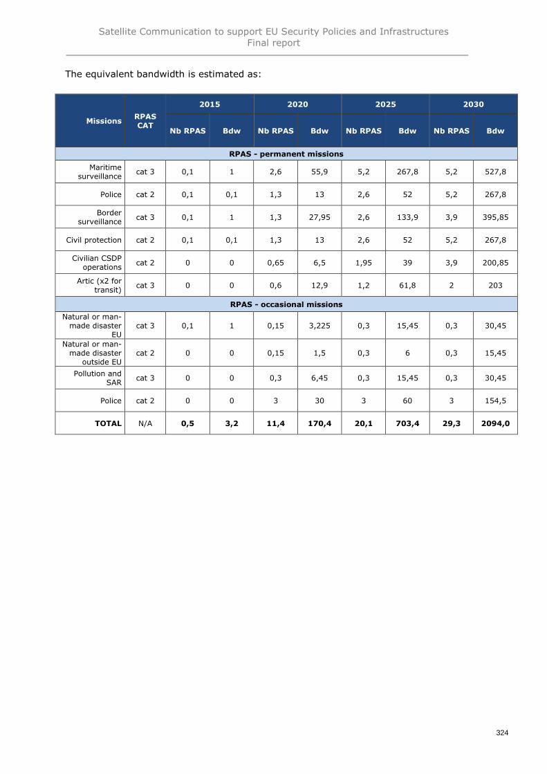
Satellite Communication to support EU Security Policies and InfrastructuresFinal report
324
The equivalent bandwidth is estimated as:
MissionsRPASCAT
2015 2020 2025 2030
Nb RPAS Bdw Nb RPAS Bdw Nb RPAS Bdw Nb RPAS Bdw
RPAS - permanent missions
Maritimesurveillance
cat 3 0,1 1 2,6 55,9 5,2 267,8 5,2 527,8
Police cat 2 0,1 0,1 1,3 13 2,6 52 5,2 267,8
Bordersurveillance
cat 3 0,1 1 1,3 27,95 2,6 133,9 3,9 395,85
Civil protection cat 2 0,1 0,1 1,3 13 2,6 52 5,2 267,8
Civilian CSDPoperations
cat 2 0 0 0,65 6,5 1,95 39 3,9 200,85
Artic (x2 fortransit)
cat 3 0 0 0,6 12,9 1,2 61,8 2 203
RPAS - occasional missions
Natural or man-made disaster
EUcat 3 0,1 1 0,15 3,225 0,3 15,45 0,3 30,45
Natural or man-made disaster
outside EUcat 2 0 0 0,15 1,5 0,3 6 0,3 15,45
Pollution andSAR
cat 3 0 0 0,3 6,45 0,3 15,45 0,3 30,45
Police cat 2 0 0 3 30 3 60 3 154,5
TOTAL N/A 0,5 3,2 11,4 170,4 20,1 703,4 29,3 2094,0

Satellite Communication to support EU Security Policies and InfrastructuresFinal report
325
Synthesis of estimated current and future bandwidth for RPAS
Main mission SATCOM usages Status Comments
Surveillance ofinfrastructures or humanactivities using RPAS
(25) Pilot to RPAS controlcommunications
(26) Link pilot-ATC services(may also be via SATCOM ifpilot control facility remote)
(27) Download of payload data
(28) Sense & Avoid (S&A)system communication
Current
(25), (26) & (28): negligible so far interms of bandwidth compared to (27)during mission (however, will dependon EU requirements for sense andavoid system)
-> Estimated bandwidth is forusage (27) and is an estimation ofthe 2015 demand (and not usage)
Estimated bandwidth(Mbps)
Europe ArcticRest of the
WorldTOTAL
Estimated bandwidth for usage (27) - Total RPAS communications
2015 - Usage 3,2 0,0 0,0 3,2
2020 - Demand 149,5 12,9 8,0 170,4
2025 - Demand 596,6 61,8 45,0 703,4
2030 - Demand 1 674,6 203,0 216,3 2 093,9

Satellite Communication to support EU Security Policies and InfrastructuresFinal report
326
Arctic communications5.13.
Context: main missions (synthesis)
The melting of Arctic ice reveals much faster than originally predicted from the climatechange models, every year showing a “record low” in terms of ice coverage. The totalmelting of the ice cap in summer could occur in 2030 or even earlier. The warming of theNorth Atlantic is triggering a migration of plankton and fish schools further North. Thismeans all human activities (shipping, oil extraction, fishing, etc.) will develop at a veryfast rate, while infrastructures remain quasi inexistent.
In the future, as described in the presentation of the User Communities andInfrastructures (phase 1 of the study), Arctic communications will be requested forseveral user communities: Maritime, Copernicus, Galileo, ATM, etc. However, anadditional main mission, specific to Maritime safety for Arctic, was also identified:“Specific Maritime Safety for Arctic”.
Estimated current and future use of SATCOM
To support the main mission identified under this user community, three SATCOM usageshave been highlighted, as indicated in the table below:
In the Arctic (and Antarctic) region, the current SATCOM supply is virtually non-existent,i.e. there is a considerable capability gap. Due to the very limited terrestrialinfrastructures, SATCOM is often sought as the primary communication channel, not justas a back-up as in most locations. The geographic reality, historical approach to newcommunications network development, and the rapid pace of technological change andits corresponding expectations have combined to create an Arctic communicationsinfrastructure that is inadequate to meet current needs and future needs. While theoverall demand is far too low to justify commercial ventures, the capability gap isprimarily a GOVSATCOM challenge.
This is particularly evident for the conduct of Search and Rescue operations, at a timewhere more and more cruise ships sail the Arctic waters in summer – and about 30planes a day fly over the region all year around. The tragically late response to the 1991C130 crash might be improved nowadays by the better SATCOM availability - still thecrash was known at the time it occurred. Simply, knowing better the condition ofsurvivors and their lack of protective equipment could have enabled an early dropping ofmost needed supplies before paramedics could rally the place. In the Clipper Adventurenavigation accident, the enquiry revealed as a root cause the ignorance by the crew of anearlier navigational risk notice (NOTSHIP) that reveals a lack of persistentcommunications; after the incident, it is worth noticing an incapacity to assess the realcondition of the vessel, again broadband SATCOM could have provided a mean totransfer pictures and reports from the ship to let the owner assess if the ship remained ornot safe enough to postpone evacuation.
Main mission SATCOM usagesStatus ofSATCOMusages
Specific maritime safety forArctic
(29) Ice monitoring services for improving the safety ofnavigation and off shore activities
(30) Unattended sensor stations for meteo-oceanography andcommunication relays
(31) Broadcast of specific data services for mariners and miningindustries
Potential

Satellite Communication to support EU Security Policies and InfrastructuresFinal report
327
For the purpose of the present study, Arctic SATCOM requirements have been structuredas follows:
• The conduct in the Arctic regions of universal governmental duties (maritimesafety and security, fisheries control, search and rescue, air traffic management,environmental protection, civil protection and response to disasters, etc.) isassessed as a fraction of the activities analysed in the previous sections
• The present section is only assessing the few specific “Arctic services” identified atthis stage, namely:
o Ice monitoring services for improving the safety of navigation and off shoreactivities,
o Unattended sensor stations for meteo-oceanography and communicationrelays,
o Broadcast of specific data services for mariners and mining industries
Such services only exist today in few parts of the Arctic, and quantifying the associatedSATCOM demand remains a challenge. The estimates proposed here are only few Mbps,up to few tens Mbps at the 2030 horizon, adding to the fraction of the universal missionsto be conducted in the Arctic as Arctic will remain a hostile region. Missions such asFishery control, border control, drug trafficking are not expected to be required in thehorizon of this study so far from mainland Europe.
As a whole, the Arcticom study suggests a GOVSATCOM demand of about 18 Mbps in2015 and 60 Mbps in 2020 for EU nations and Norway. The present analysis can onlyjustify a fraction of this demand for 2015 but a figure somewhat higher for 2020 (around80 Mbps) – still commensurate. As a need not solvable by current systems, it is achallenge, but it remains far too low to justify an ad-hoc satellite system at EU level. Wayahead identified by previous studies was to negotiate a dedicated SATCOM capacity forEU stakes within one of the ongoing non-European SATCOM programmes, such asCanadian PCW or Russian PolarStar or Arktika – but it has not materialized. At this stage,an EU solution must be found.

Satellite Communication to support EU Security Policies and InfrastructuresFinal report
328
Synthesis of estimated current and future bandwidth for Arcticcommunications
Main mission SATCOM usages Status Comments
Specific Maritime Safetyfor Arctic
(29) Ice monitoring services forimproving the safety ofnavigation and off shoreactivities
(30) Unattended sensor stationsfor meteo-oceanography andcommunication relays
(31) Broadcast of specific dataservices for mariners andmining industries
Potential-> Estimated bandwidth is forusages (29), (30) and (31)
Estimated bandwidth(Mbps)
Europe ArcticRest of the
WorldTOTAL
Estimated bandwidth for usage (29), (30) and (31) – Total Arctic communications
2015 - Usage 0,0 2,0 0,0 2,0
2020 - Demand 0,0 6,0 0,0 6,0
2025 - Demand 0,0 10,0 0,0 10,0
2030 - Demand 0,0 15,0 0,0 15,0

Satellite Communication to support EU Security Policies and InfrastructuresFinal report
329
EU institutional communications5.14.
Context: main missions (synthesis)
EU institutional communications encompass the following main missions:
• Communication for the 139 EU delegations (EEAS)• Communication for the 46 ECHO field offices• Communication for EU High Representatives and Special Representatives
Estimated current and future use of SATCOM
To support the three main missions identified under this user community, three SATCOMusages have been highlighted, as indicated in the table below:
Permanent link between each of the 139 EEAS offices and EEAS HQ in Brussels(usage 32)
There are 139 EU Delegations spread around the world. For their communications, theyrely on ground networks: primarily on the national network of the country where they areimplemented and secondly on the international network to connect them to BrusselsEEAS Headquarter (through a contract managed globally by BT). Today SATCOM servicesare used as a backup of terrestrial lines. Today, it is estimated that about 10 EEAS officesare using SATCOM link. Interviews also clearly identified a strong need for secured andconfidential communication channels independent from locally controlledinfrastructures191.The bandwidth of this communication channel depends on the size and importance of thedelegation. It could be estimated ranging between 2 and 30 Mb for the most importantdelegations. No data were made accessible to estimate the current bandwidth availablefor these EU delegations.At the 2030 horizon, the EU Delegation number and the number of delegations usingSATCOM are foreseen to remain stable192. Nevertheless the demand for communicationscapabilities of these delegations will increase at a rate which could be anticipated to besimilar to the one of any professional entity. The current growth rate of the averageterrestrial bandwidth per household is comprised between 10 and 30% per year inEurope.
191 Interview with EEAS192 Source : EEAS
Main mission SATCOM usagesStatus of
SATCOM usages
Communication for the139 EU delegations(EEAS)
(32) Permanent link between each of the 139 EEAS offices andEEAS HQ in Brussels
Current
Communication for the 46ECHO field offices
(33) Permanent link between ECHO field offices and the ECHOHQ located in Brussels
Current
Communication for EUHigh Representatives andSpecial Representatives
(34) SATCOM link between mission location and EEASheadquarters in Brussels when a secured terrestrial solution isnot available
Current

Satellite Communication to support EU Security Policies and InfrastructuresFinal report
330
Year IUD Assumptions
2015 5 MbpsLink of 5 Mbps per Delegation (10 delegations) and a total capability of
up to 10% of the total requirement
2020 10 Mbps 15% of annual growth rate
2025 20 Mbps 15% of annual growth rate
2030 32 Mbps 10% of annual growth rate
Permanent link between ECHO offices and the ECHO HQ located in Brussels(usage 33)
The EU DG ECHO has established regional field offices to manage and coordinate itsaction in the different countries where it operates. These field offices are 46 around theworld concentrated in Africa, Latin America and Asia. They are sometimes collocated withEU Delegation. In addition with the means of communications that they procure locally,these field offices share a satellite capacity of 9 Mbps provided through a centralizedcontract with Airbus. This capacity is used for communications with Brussels DG ECHOheadquarters as well as communications with the project teams they supervise andcoordinate on the field. This satellite capacity is mandatory for the security of these fieldoffices as well as the ECHO project teams as it is the last communication means at thedisposal of these entities in case of emergency.
The current instantaneous demand is already evaluated to a minimum of 15 Mbps193 withcommunication capabilities of 2/3 Mbps (downlink) per ECHO field office.
At the 2030 horizon, the field offices number would remain stable. Some of them couldmove from one region to another but the total number is expected to remain of the sameorder. The need for communications for these field offices is expected to significantlyincrease, at a rate comparable to the one of EU delegations. Although the satellitecapacity currently used is limited because of costs and budgetary reasons, the satellitebandwidth demand in the future for security and back-up purposes should also increasesignificantly in the same proportion of the global communications needs of the fieldoffices.
Year IUD Assumptions
2015 15 Mbps Current usage of the field offices
2020 30 Mbps 15% of growth rate
2025 61 Mbps 15% of growth rate
2030 122 Mbps 10% of growth rate
193 Source : DG ECHO

Satellite Communication to support EU Security Policies and InfrastructuresFinal report
331
SATCOM link between mission location and EEAS headquarters in Brussels whena secured terrestrial solution is not available (usage 34)
The EEAS has the mission of providing communications support to EU HighRepresentatives and EU Special Representatives during their missions outside ofBrussels.
It is mandatory that the security level of the communications means made available tothe EU High Representatives and EU Special Representatives provide the assurance forEU diplomacy to have a level equivalent to any foreign diplomatic MS network. Recourseto satellite capacity and services is an efficient means to meet such objective as it couldbe totally independent of any local and terrestrial infrastructures.
Each mission (10 to 15 missions per year for each EU High Representatives and EUSpecial Representatives) would last a few days and be constituted of a staff of 5 to 10persons with a high level diplomat194. The communications needs of each mission covervoice and data. It could be estimated to represent an equivalent minimum bandwidth of5 Mbps for each mission. This minimum includes 10 voice channels (500 kbps), two SDvideo channels for teleconferences (2 Mbps) and basic internet access for a fewcomputers (2,5 Mbps).
The special representatives’ number of currently ten could be doubled by 2030195 and therequired bandwidth for each mission could increase significantly and reach in average upto 30 Mbps. Such capability would allow to upgrade teleconferences to HD videoschannels and to improve internet connectivity. Such bandwidth is comparable to an officewith fiber connection.
A maximum of 2 simultaneous missions was taken into account. Given the high criticalityof these communications, it seems adequate to consider that this bandwidth should beavailable permanently.
Year IUD Assumptions
2015 10 MbpsPotential demand with 2 simultaneous missions and a 5 Mbps
requirement per mission
2020 20 Mbps
Progressive increase of demand up to 60 Mbps in 20302025 30 Mbps
2030 60 Mbps
194 Source EEAS195 Source EEAS

Satellite Communication to support EU Security Policies and InfrastructuresFinal report
332
Synthesis of estimated current and future bandwidth for EU institutionalcommunications
Main mission SATCOM usages Status Comments
Communication for the 139EU delegations (EEAS)
(32) Permanent link betweeneach of the 139 EEAS officesand EEAS HQ in Brussels
Current-> Estimated bandwidth is forusage (32)
Communication for the 46ECHO field offices
(33) Permanent link betweenECHO offices and the ECHOHQ located in Brussels
Current-> Estimated bandwidth is forusage (33)
Communication for EU HighRepresentatives and SpecialRepresentatives
(34) SATCOM link betweenmission location and EEASheadquarters in Brusselswhen a secured terrestrialsolution is not available
Current-> Estimated bandwidth is forusage (34)
Estimated bandwidth(Mbps)
Europe ArcticRest of the
WorldTOTAL
Estimated bandwidth for usage (32)
2015 - Usage 0,0 0,0 5,0 5,0
2020 - Demand 0,0 0,0 10,0 10,0
2025 - Demand 0,0 0,0 20,0 20,0
2030 - Demand 0,0 0,0 32,0 32,0
Estimated bandwidth for usage (33)
2015 - Usage 0,0 0,0 15,0 15,0
2020 - Demand 0,0 0,0 30,0 30,0
2025 - Demand 0,0 0,0 61,0 61,0
2030 - Demand 0,0 0,0 122,0 122,0
Estimated bandwidth for usage (34)
2015 - Usage 0,0 0,0 10,0 10,0
2020 - Demand 0,0 0,0 20,0 20,0
2025 - Demand 0,0 0,0 30,0 30,0
2030 - Demand 0,0 0,0 60,0 60,0
Total EU institutional communications
2015 - Usage 0,0 0,0 30,0 30,0
2020 - Demand 0,0 0,0 60,0 60,0
2025 - Demand 0,0 0,0 111,0 111,0
2030 - Demand 0,0 0,0 214,0 214,0

Satellite Communication to support EU Security Policies and InfrastructuresFinal report
333
Annex 7 - Justification of criteria severity for each main mission (phase 2)
# Mainmission
#Criteria Justification of the severity score Severity
M1 Sea Border Surveillance
C1 SATCOM is the only direct link to HQ in high seas; without it, only pre-established routine patrols can be achieved, with a perception of the context limited to the visual and radar horizon 4
C2 N/A - operation in Europe 0
C3 Same severity as C1, as jamming results into communications incapacitation and discontinuity. However risk of occurrence is low (the threat is low-tech) 4
C4 Same severities as C1, as strong interferences result into communications incapacitation and discontinuity. 4
C5 Third State controlling the system results into uncontrolled bandwidth limitations 3
C6 Commercial entity controlling the service results into uncontrolled bandwidth limitations 3
C7 Same severity as C1, as no terminal substitution is possible while at sea, so frequency unavailability means loss of SATCOM link for this mission 4
C8 Naval terminals are operated by expert communication officers 1
C9 Power supply provided by the patrol ships/planes 0
C10 Specifically designed equipment for marine environment needed, otherwise would fail soon (especially external equipment: antennas, cabling, etc.) 5
C11 As governmental procurement, the control of critical technologies is an important factor susceptible to hamper the procurement of the SATCOM systems for missions relating to sovereignty (Border control) 3
C12 If accessed by the people organizing the traffick of migrants, the details of the patrolling plans will allow them to adjust their strategy to get through 4
C13 Same severity as C1, as cyber attacks would result into communications incapacitation and discontinuity 4
C14 Spoofing allows delusing the patrolling teams, e.g. directing them on fictious targets, and the border control mission would be barely achieved. 4
C15 In addition to the previous risk of spoofing, authentication, full traceability and non-repudiation are also critical (e.g. potential legal issues re international legislation and protection of human lives) 5
C16 Same severity as C1, as “trojan horse” and other malware/backdoor access would result into communications incapacitation and discontinuity 4
M2 Land Border Surveillance
C1In hilly regions out of GSM and VHF coverage, SATCOM is the “last mile” communication link with mobile patrols; without it, the patrol will be executed as planned without possible situational update and without real timereporting to HQ
3
C2 N/A - operation in Europe 0
C3 Same severity as C1, as jamming results into communications incapacitation and discontinuity. However risk of occurrence is low (the threat is low-tech) 3
C4 Same severity s as C1, as strong interferences result into communications incapacitation and discontinuity 3
C5 Third State controlling the system results into uncontrolled bandwidth limitations 3
C6 Commercial entity controlling the service results into uncontrolled bandwidth limitations 3
C7 SATCOM terminal exchange can be done easily as ground border patrols are never deployed very far from base 2
C8 Border patrols have only limited training on communication technologies and the SATCOM terminals not dedicated to specific individuals 4
C9 Predominance of portable equipment that cannot be easily recharged during the mission (pedestrian patrols are common). 4
C10 Specifically designed equipment for rugged environment needed, otherwise would fail soon (shocks, moisture, dust…) 5
C11 As governmental procurement, the control of critical technologies is an important factor susceptible to hamper the procurement of the SATCOM systems for missions relating to sovereignty (Border control) 3
C12 If accessed by the people organizing the traffick of migrants, the details of the patrolling plans will allow them to adjust their strategy to get through 4
C13 Same severity as C1, as cyber attacks would result into communications incapacitation and discontinuity 3
C14 Spoofing allows delusing the patrolling teams, e.g. directing them on fictious targets, and the border control mission would be barely achieved. 4
C15 In addition to the previous risk of spoofing, authentication, full traceability and non-repudiation are also critical (e.g. potential legal issues re international legislation and protection of human lives) 5
C16 Same severity as C1, as “trojan horse” and other malware/backdoor access would result into communications incapacitation and discontinuity 3
M3 Pre-frontier surveillance
C1 A typical pre-frontier intelligence network relies at 100% on SATCOM by design (e.g. Seahorse, unattended sensor network, satellite imaging via EDRS, HALE RPAS, etc.). Without it, the system is totally interrupted 5
C2 N/A 0
C3 Same severity as C1, as jamming results into communications incapacitation and discontinuity, interrupting totally the service. 5
C4 Same severity as C1, as strong interferences result into communications incapacitation and discontinuity 5
C5 Third State controlling the system results into uncontrolled bandwidth limitations 2

Satellite Communication to support EU Security Policies and InfrastructuresFinal report
334
# Mainmission
#Criteria Justification of the severity score Severity
C6 Commercial entity controlling the service results into uncontrolled bandwidth limitations 2
C7 Same severity as C1, as no terminal substitution is possible in such system, so frequency unavailability means loss of SATCOM link for this mission 5
C8 Foreign users in the pre-frontier intelligence network cannot be trained easily and can use the excuse of technological complexity to refuse using the system, interrupting the service. 4
C9 Terminals are most of the time in fixed locations where power supply is external. 1
C10 Ruggedized equipment preferable (lack of user precautions, hot /humid countries), however generally indoor so the environmental severity is moderate 3
C11 As governmental procurement, the control of critical technologies is an important factor susceptible to hamper the procurement of the SATCOM systems for missions relating to sovereignty (Border control) 3
C12 Intelligence is worthless if compromized at the time it is gathered 5
C13 Same severity as C1, as cyber attacks would result into communications incapacitation and discontinuity 5
C14 Intelligence is worthless if possibly spoofed at the time it is gathered 5
C15 Same severity as C12 and C14 (similar consequences) 5
C16 Same severity as C1, as “trojan horse” and other malware/backdoor access would result into communications incapacitation and discontinuity 5
M4 Maritime Safety and Surveillance of maritime traffic
C1SATCOM is the only direct communication link of ships in high seas; without it, only local maritime traffic can be monitored, with a perception of the context limited to the visual and radar horizon, the mission is barelyachieved; human lives are at stake (at seas, survivability overboard is hardly few hours, immediate reporting and proper direction of rescue is life-critical)
4
C2EU states are only managing maritime traffic in their own waters of responsibility (incl overseas territories) and adjacent high seas (SAR zones are sometimes extending very far); while critical maritime routes shall also bemonitored in all international waters, interventions are currently made by military forces (out of scope)
0
C3 Same severity as C1, as jamming results into communications incapacitation and discontinuity. 4
C4 Same severity as C1, as strong interferences result into communications incapacitation and discontinuity. 4
C5 Third State controlling the system results into uncontrolled bandwidth limitations 3
C6 Commercial entity controlling the service results into uncontrolled bandwidth limitations 3
C7 Same severity as C1, as no terminal substitution is possible while at sea, so frequency unavailability means loss of SATCOM link for this mission 4
C8 Naval terminals are operated by expert communication officers 1
C9 Power supply provided by the patrol ships/planes 0
C10 Specifically designed equipment for marine environment needed, otherwise would fail soon (especially external equipment: antennas, cabling…) 5
C11 As governmental procurement, the control of critical technologies is a factor susceptible to hamper the procurement of the SATCOM systems, however this mission is not a primary sovereignty issue 3
C12 The interception of sensitive information is significant (security but also trade require data protection) however consequences are not disruptives 3
C13 Same severity as C1, as cyber attacks would result into communications incapacitation and discontinuity 4
C14 Spoofing is a serious issue as it would allow to hide illegal activities or direct attention toward fictious navigation hazards. The impact on the mission effectiveness would be high. 4
C15 Same severity as C12 and C14 (similar consequences) 5
C16 Same severity as C1, as “trojan horse” and other malware/backdoor access would result into communications incapacitation and discontinuity 4
M5 Maritime Security, illegal activities at sea considered as security threats
C1 SATCOM is the only direct link to HQ in high seas; without it, only pre-established routine patrols can be achieved, but no targeted missions such as M5 5
C2EU states are only policing their own waters and adjacent high seas; however international legislation allows interveining againsd drug trafficants or terrorists in high seas, so the occurrence of this risk might jeopardizesome interventions
3
C3 Same severity as C1, as jamming results into communications incapacitation and discontinuity. However risk of occurrence is low (the threat is low-tech) 5
C4 Same severity as C1, as strong interferences result into communications incapacitation and discontinuity. 5
C5 Third State controlling the system results into uncontrolled bandwidth limitations 3
C6 Commercial entity controlling the service results into uncontrolled bandwidth limitations 3
C7 Same severity as C1, as no terminal substitution is possible while at sea, so frequency unavailability means loss of SATCOM link for this mission 5
C8 Naval terminals are operated by expert communication officers 2
C9 Power supply provided by the patrol ships/planes 0
C10 Specifically designed equipment for marine environment needed, otherwise would fail soon (especially external equipment: antennas, cabling…) 5
C11 As governmental procurement, the control of critical technologies is an important factor susceptible to hamper the procurement of the SATCOM systems for missions relating to highly secure SATCOM 4
C12 Any interception of the purpose of the mission is susceptible to jeopardize it; the mission success requires the highest level of information security 5
C13 Same severity as C1, as cyber attacks would result into communications incapacitation and discontinuity 5

Satellite Communication to support EU Security Policies and InfrastructuresFinal report
335
# Mainmission
#Criteria Justification of the severity score Severity
C14 Spoofing allows delusing the patrolling teams, e.g. directing them on fictious targets or usurpating identities etc and the mission would be barely achieved 5
C15 Same severity as C12 and C14 (similar consequences) 5
C16 Same severity as C1, as “trojan horse” and other malware/backdoor access would result into communications incapacitation and discontinuity 5
M6 Monitoring and control of fishery activities
C1SATCOM is the only direct link to HQ in high seas; without it, only pre-established routine patrols can be achieved, with a perception of the context limited to the visual and radar horizon, and no access to the essential VMSdata
4
C2 EU states are only managing fishery controls in their EEZ (up to 200nm off their coastline) 0
C3 Same severity as C1, as jamming results into communications incapacitation and discontinuity 4
C4 Same severity as C1, as strong interferences result into communications incapacitation and discontinuity. 4
C5 Third State controlling the system results into uncontrolled bandwidth limitations 3
C6 Commercial entity controlling the service results into uncontrolled bandwidth limitations 3
C7 Same severity as C1, as no terminal substitution is possible while at sea, so frequency unavailability means loss of SATCOM link for this mission 4
C8 Naval terminals are operated by dedicated communication officers, however less specialized on the smaller fishery control vessels. 3
C9 Power supply provided by the patrol ships/planes 1
C10 Specifically designed equipment for marine environment needed, otherwise would fail soon (especially external equipment: antennas, cabling…) 5
C11 As governmental procurement, the control of critical technologies is an important factor susceptible to hamper the procurement of the SATCOM systems for missions relating to sovereignty (Border control) 2
C12 The IUU fishing is increasingly associated to organized crime; information security is very important, as any pre-advise of control would for example allow throwing overboard most of the IUU catches 4
C13 Same severity as C1, as cyber attacks would result into communications incapacitation and discontinuity 4
C14 Spoofing allows delusing the patrolling teams, e.g. directing them on fictious targets, and fishery control mission would be barely achieved 4
C15 Same severity as C12 and C14 (similar consequences) 5
C16 Same severity as C1, as “trojan horse” and other malware/backdoor access would result into communications incapacitation and discontinuity 4
M7 Maritime “Search and Rescue” (SAR)
C1 SATCOM is the only direct link to HQ in high seas; without it, SAR missions are impossible to trigger and manage 5
C2 EU states are only SAR operations in their own waters and adjacent high seas (internationally agreed SAR zones, still possibly far off the coastline) 0
C3 Same severity as C1, as jamming results into communications incapacitation and discontinuity. However risk of occurrence is low (no threat) 5
C4 Same severity as C1, as strong interferences result into communications incapacitation and discontinuity. 5
C5 Third State controlling the system results into uncontrolled bandwidth limitations 4
C6 Commercial entity controlling the service results into uncontrolled bandwidth limitations 4
C7 Same severity as C1, as no terminal substitution is possible while at sea, so frequency unavailability means loss of SATCOM link for this mission 5
C8 Naval terminals are operated by expert communication officers, however for SAR operations many other ships of opportunity might be involved without such expertise. 3
C9 Power supply provided by the patrol ships/planes 0
C10 Specifically designed equipment for marine environment needed, otherwise would fail soon (especially external equipment: antennas, cabling…) 5
C11 As governmental procurement, the control of critical technologies is an important factor susceptible to hamper the procurement of the SATCOM systems for missions relating to sovereignty (Border control) 2
C12 The SAR activity brings to collect personal data etc that deserve protection; however the primary mission is to save lives and will not be directly impacted by data security issues 1
C13 Same severity as C1, as cyber attacks would result into communications incapacitation and discontinuity 5
C14 Spoofing would allow delusing the intervention teams, e.g. directing them on fictious targets, but there are no reasons to conduct such attack in the context of SAR missions 2
C15 Same severity as C12 and C14 (similar consequences) 5
C16 Same severity as C1, as “trojan horse” and other malware/backdoor access would result into communications incapacitation and discontinuity 5
M8 Response to maritime disasters (pollution response, etc.)
C1 SATCOM is the only direct link to HQ in high seas; but ships already in sight of a pollution can proceed with a perception limited to the visual and radar horizon, still missing the collective coordination. 3
C2 EU states are only managing pollution in their own waters and adjacent high seas, generally covered by the same provider 0
C3 Same severity as C1, as jamming results into communications incapacitation and discontinuity. However risk of occurrence is low (the threat is low-tech) 3
C4 Same severity as C1, as strong interferences result into communications incapacitation and discontinuity 3
C5 Third State controlling the system results into uncontrolled bandwidth limitations 4

Satellite Communication to support EU Security Policies and InfrastructuresFinal report
336
# Mainmission
#Criteria Justification of the severity score Severity
C6 Commercial entity controlling the service results into uncontrolled bandwidth limitations 4
C7 Same severity as C1, as no terminal substitution is possible while at sea, so frequency unavailability means loss of SATCOM link for this mission 3
C8 Naval terminals are operated by expert communication officers, but (as proven by the Deep Water Horizon depollution campaign) many other ships of opportunity might be involved without such expertise. 3
C9 Power supply provided by the intervention ships/planes 0
C10 Specifically designed equipment for marine environment needed, otherwise would fail soon (especially external equipment: antennas, cabling…) 5
C11 As governmental procurement, the control of critical technologies might influence the procurement of the SATCOM systems, however this mission has absolutely no relation to sovereignty 2
C12 The disaster response activity brings to collect personal data etc that deserve protection; however the primary mission is to pprevent or at least contain disasters and will not be directly impacted by data security issues 1
C13 Same severity as C1, as cyber attacks would result into communications incapacitation and discontinuity 3
C14 Oil spills and other maritime disasters are persistent enough for the responders to not be delused long enough by spoofing to endanger the mission, just possibly delaying the response operations by some hours 2
C15 Same severity as C12 and C14 (similar consequences) 4
C16 Same severity as C1, as “trojan horse” and other malware/backdoor access would result into communications incapacitation and discontinuity 3
M9 Fight against international drug traffic within EU MS areas of juridiction
C1 Lack of SATCOM communication link will compromise the effectiveness of course of action of Police forces (coordination and commanding processes during phase of interception) - 3
C2 Negligible – Autonomy of Law enforcement organisations using regional or local communications networks including SATCOM 1
C3 Regarding the needs for coordination, command and control, the loss of communications jeopardize the course of action of police forces and therefore compromise the efficiency of sovereign mission 4
C4 Regarding the needs for coordination, command and control, the loss of communications jeopardize the course of action of police forces and therefore compromise the efficiency of sovereign mission 4
C5 Critical regarding the needs for coordination, command and control, the loss of communications jeopardize the course of action of police forces and therefore compromise the efficiency of sovereign mission 4
C6 Critical regarding the needs for coordination, command and control, the loss of communications jeopardize the course of action of police forces and therefore compromise the efficiency of sovereign mission 4
C7 Critical regarding the needs for coordination, command and control, the loss of communications jeopardize the course of action of police forces and therefore compromise the efficiency of sovereign mission 4
C8 Impact limited due to high standard of qualification and training of polices forces deployed for this type of mission 2
C9 Impact important ; if not, jeopardize the ability to operate in austere location and terrains during long periods and therefore compromise the efficiency of sovereign mission 4
C10 Impact important : if terminal not rugged, jeopardize the ability to operate over vast distance and in austere location and terrains and therefore compromise the efficiency of sovereign mission 4
C11 An issue of great sensitivity for most of national EU MS police forces - loss or restriction of independence of judgment or decision 4
C12 Disruption of critical operations supporting police forces sovereign missions - Undermining of police forces missions that erode the public’s confidence in government 5
C13 Disruption of critical operations supporting police forces sovereign missions - Undermining of police forces missions that erode the public’s confidence in government 5
C14 Disruption of critical operations supporting police forces sovereign missions - Undermining of police forces missions that erode the public’s confidence in government 5
C15Traceability and non repudiation are critical during police forces missions regarding potential national and international legal issues. Disruption of important communication police network - Undermining of police forcessovereign missions that erode the public’s confidence in government.
5
C16 Disruption of critical operations supporting police forces missions - Undermining of police forces sovereign missions that erode the public’s confidence in government 5
M10 Fight against international Organised Crime Groups (OCG)
C1 Lack of SATCOM communication link will compromise the effectiveness of course of action of Police forces (coordination and commanding processes during phase of interception) 3
C2 Negligible – Autonomy of Law enforcement organisations using regional or local communications networks including SATCOM 1
C3 Regarding the needs for coordination, command and control, disruption of critical operations jeopardize the course of action of police forces and therefore compromise the efficiency of sovereign mission 4
C4 Regarding the needs for coordination, command and control, the loss of communications jeopardize the course of action of police forces and therefore compromise the efficiency of sovereign mission 4
C5 Critical regarding the needs for coordination, command and control, the loss of communications jeopardize the course of action of police forces and therefore compromise the efficiency of sovereign mission 4
C6 Critical regarding the needs for coordination, command and control, the loss of communications jeopardize the course of action of police forces and therefore compromise the efficiency of sovereign mission 4
C7 Critical regarding the needs for coordination, command and control, the loss of communications jeopardize the course of action of police forces and therefore compromise the efficiency of sovereign mission 4
C8 Impact limited due to high standard of qualification and training of polices forces deployed for this type of mission 2
C9 Impact important ; if not, jeopardize the ability to operate in austere location and terrains during long periods and therefore compromise the efficiency of sovereign mission 4
C10 Impact important : if terminal not rugged, jeopardize the ability to operate over vast distance and in austere location and terrains and therefore compromise the efficiency of sovereign mission 4
C11 An issue of great sensitivity for most of national EU MS police forces. - loss or restriction of independence of judgment or decision 4
C12 Disruption of critical operations supporting police forces sovereign missions - Undermining of police forces missions that erode the public’s confidence in government 5
C13 Disruption of critical operations supporting police forces sovereign missions - Undermining of police forces missions that erode the public’s confidence in government 5
C14 Disruption of critical operations supporting police forces sovereign missions - Undermining of police forces missions that erode the public’s confidence in government 5

Satellite Communication to support EU Security Policies and InfrastructuresFinal report
337
# Mainmission
#Criteria Justification of the severity score Severity
C15Traceability and non repudiation are critical during police forces sovereign missions regarding potential national and international legal issues. Disruption of important communication police network - Undermining of policeforces missions that erode the public’s confidence in government
5
C16 Disruption of critical operations supporting police forces sovereign missions - Undermining of police forces missions that erode the public’s confidence in government 5
M11 Communication for Europol
C1 Limited 2
C2 N/A 0
C3 Limited impact due to secondary and background role of SATCOM communications 2
C4 Limited impact due to secondary and background role of SATCOM communications 2
C5 Significant regarding the sensitivity of mission and exchange of information - result in a loss or restriction of independence of judgment or decision 5
C6 Important regarding the sensitivity of mission and exchange of information – result in a loss or restriction of independence of judgment or decision 3
C7 Network will be adapted to take into account the frequency bands authorized and their evolution in the different MS 2
C8 Fixed systems are operated and maintained by professionals. 2
C9 Network infrastructures will take into account general environment of Europol sites. 1
C10 N/A 3
C11 An issue of great sensitivity for most of national EU MS police forces - - loss or restriction of independence of judgment or decision 4
C12 Disruption of important communication police network - Undermining EU Agency that erode the EU population in institutions 3
C13 Disruption of important communication police network - Undermining EU Agency that erode the EU population in institutions 3
C14 Disruption of important communication police network - Undermining EU Agency that erode the EU population in institutions 3
C15Full traceability and non repudiation are critical in Europol missions regarding potential national and international legal issues. Disruption of important communication police network - - Undermining EU Agency that erodethe EU population in institutions
3
C16 Disruption of important communication police network - Undermining EU Agency that erode the EU population in institutions 3
M12 National Police missions within EU territories
C1 The lack of SATCOM communication link will compromise the effectiveness and efficiency of courses of action of Police forces and particularly coordination, command and control. 4
C2 N/A 0
C3 Regarding the needs for coordination, command and control, disruption of critical operations jeopardize the course of action of police forces and therefore compromise the efficiency of a sovereign mission 4
C4 Regarding the needs for coordination, command and control, disruption of critical operations jeopardize the course of action of police forces and therefore compromise the efficiency of a sovereign mission 4
C5 Significant regarding the sensitivity of mission and exchange of information – result in a loss or restriction of independence of judgment or decision 4
C6 Significant regarding the sensitivity of mission and exchange of information– result in a loss or restriction of independence of judgment or decision 4
C7 Regarding the needs for coordination, command and control, the loss of communications jeopardize the course of action of police forces 4
C8 May have a limited impact if use of SATCOM is increasing among polices forces as users will be less qualified and complexity of terminal could affect quality of services 3
C9 Limited impact regarding the general environment of polices forces in EU 2
C10 Limited impact due to EU temperate climate 2
C11 An issue of great sensitivity for most of national EU MS police forces 4
C12 Disruption of critical operations supporting police forces sovereign missions - Undermining of police forces missions that erode the EU MS public’s confidence in government 5
C13 Disruption of critical operations supporting police forces sovereign missions - Undermining of police forces missions that erode the EU MS public’s confidence in government 5
C14 Disruption of critical operations supporting police forces sovereign missions - Undermining of police forces missions that erode the EU MS public’s confidence in government 5
C15Full traceability and non repudiation are critical in police forces missions regarding potential legal national and international issues - Undermining of police forces sovereign missions that erode the EU MS public’s confidencein government
5
C16 Disruption of critical operations supporting police forces sovereign missions - Undermining of police forces missions that erode the EU MS public’s confidence in government 5
M13 Deployment of Civil Protection teams / modules in case of natural or man-made disasters
C1 Critical regarding probable failure or collapse of main terrestrial networks – probable impact on staff safety - Human lives at stake 5
C2 Critical regarding probable failure or collapse of main terrestrial networks - probable impact on staff safety 5
C3 Jamming affect the quality of SATCOM link and therefore user’s security 3
C4 Interference will affect the quality of the SATCOM link and affect completion of first response mission – possible impact on staff safety 4
C5 SATCOM link preemption would disrupt critical operation supporting EU emergency first and recovery response. probable impact on staff safety 5

Satellite Communication to support EU Security Policies and InfrastructuresFinal report
338
# Mainmission
#Criteria Justification of the severity score Severity
C6 SATCOM link preemption would disrupt critical operation supporting EU emergency first and recovery response. probable impact on staff safety 5
C7 Misallocation of frequency band or unavaibility of SATCOM terminals adapted to local or regional may disrupt EU operations. probable impact on staff safety 5
C8 Limited. Users deployed in emergency response team or Civil protection teams are well trained and qualified. 2
C9 Impact important ; if not, jeopardize the ability to operate in austere location and terrains during long periods 3
C10 Impact critical ; if not, jeopardize the ability to operate in austere location and terrains (mountain, desert, maritime) with mobile systems - probable impact on staff safety 5
C11 An issue of important to medium sensitivity for most of national EU Ms CP teams except when relevant to military forces (eg French UIISC) 3
C12 Could affect user’s security as these links are dedicated to this mission - Undermining of CP deployment that may erode the wordlwilde EU reputation - probable impact on staff safety 5
C13May cause partial or total disruption of critical operations supporting civilian protection missions in which user security and safety is engaged - Undermining of CP deployment that may erode the wordlwilde EU reputation -probable impact on staff safety
5
C14Could affect performance of communications and partial disruption of critical operations in which user security and safety is engaged - Undermining of CP deployment that may erode the wordlwilde EU reputation - probableimpact on staff safety
5
C15Could affect performance of communications and partial disruption of critical operations in which user security and safety is engaged - Undermining of CP deployment that may erode the wordlwilde EU reputation - probableimpact on staff safety
5
C16 Could cause loss of continuity of critical operations supporting civilian protection missions - Undermining of CP deployment that may erode the wordlwilde EU reputation - probable impact on staff safety 5
M14 Civil protection ambulance and fire & rescue response on MS territories
C1 The lack of SATCOM communication link will compromise the effectiveness and efficiency of surveillance and intervention missions and particularly data collection, coordination, command and control. Human lives at stake 5
C2 N/A 0
C3 Jamming would affect critically security of communications and can cause disruption of critical public safety mission. Undermining of CP forces missions that erode the EU MS public’s confidence in institutions 5
C4 Interference would affect critically security of communications and and can cause disruption of critical public safety mission- Undermining of CP forces missions that erode the EU MS public’s confidence in institutions 5
C5 SATCOM link preemption would disrupt back-up & security coms and cause disruption of critical public safety mission- Undermining of CP forces missions that erode the EU MS public’s confidence in institutions 5
C6 SATCOM link preemption would disrupt back-up & security coms and cause disruption of critical public safety mission- Undermining of CP forces missions that erode the EU MS public’s confidence in institutions 5
C7 Limited. EU MS CP network will adapt to the frequency bands authorized in the different countries 2
C8 Fixed systems are operated and maintained by professionals. Could be an issue for volunteers and non professional CP staff 3
C9 Fixed systems energy has to be securised. More and more autonomy is required for communications on the move regarding increasing need of power to transmit increasing flow of datas 3
C10 FSS vulnerabilities to be studied and taken into account when designed (in theory not critical). High vulnerability of MSS affect the continuity of operation in rough environment. 5
C11An issue of important sensitivity for most of national EU Ms CP teams which increase to sognificant level when relevant to military forces (eg French IIS) or for missions of monitoring critical infrastructures (Nuclear plants,essentials transport nodes, …)
4
C12 Disruption of critical operations supporting civilian protection missions - Undermining of CP forces and organisations missions that erode the public’s confidence in MS government and EU institutions 5
C13 Disruption of critical operations supporting civilian protection missions - Undermining of CP forces and organisations missions that erode the public’s confidence in MS government and EU institutions 5
C14 Disruption of critical operations supporting civilian protection missions - Undermining of CP forces and organisations missions that erode the public’s confidence in MS government and EU institutions 5
C15 Disruption of critical operations supporting civilian protection missions - Undermining of CP forces and organisations missions that erode the public’s confidence in MS government and EU institutions 5
C16 Disruption of critical operations supporting civilian protection missions - Undermining of CP forces and organisations missions that erode the public’s confidence in MS government and EU institutions 5
M15 Humanitarian aid assistance in case of natural or man-made disasters
C1 Critical regarding probable failure or collapse of main terrestrial networks and needs to connect with EU ERCC and to ensure user safety and security - probable impact on staff safety - Human lives at stake 5
C2 Critical regarding increasing number of worldwilde natural disasters and EU commitments - probable impact on staff safety 5
C3 Jamming affect the quality of SATCOM link and therefore effectiveness of the aid 3
C4 Interference affect the quality of SATCOM link and therefore effectiveness of the aid 3
C5 SATCOM link preemption would disrupt critical operation supporting EU emergency first response - probable impact on staff safety 4
C6 SATCOM link preemption would disrupt critical operation supporting EU emergency first response - probable impact on staff safety 4
C7 Misallocation of frequency band or unavaibility of SATCOM terminals adapted to local or regional may affect EU operations. 3
C8 Limited. Users deployed in emergency response team are well trained and qualified. 2
C9 Impact important ; if not, jeopardize the ability to operate in austere location and terrains during long periods 3
C10 Impact critical ; if not, jeopardize the ability to operate in austere location and terrains (mountain, desert, maritime) with mobile systems 3
C11 Not an issue for humanitarian user community 1
C12 Could affect effectiveness of aid - may erode the wordlwilde EU reputation 3
C13 Could affect effectiveness of aid - may erode the wordlwilde EU reputation 3

Satellite Communication to support EU Security Policies and InfrastructuresFinal report
339
# Mainmission
#Criteria Justification of the severity score Severity
C14 Could affect effectiveness of aid - may erode the wordlwilde EU reputation 3
C15 Could affect performance of communications and partial disruption of critical operations - may erode the wordlwilde EU reputation 3
C16 Could cause loss of continuity of critical operations supporting humanitarian aid - may erode the wordlwilde EU reputation 4
M16 Humanitarian aid assistance in case of non-international armed conflicts
C1 Critical regarding probable failure or collapse of main terrestrial networks and needs to connect with EU ERCC and EEAS and to ensure user safety and security of users - Human lives at stake 5
C2 Significant regarding international EU commitments 4
C3 Jamming affect the quality of SATCOM link and therefore effectiveness of the aid 3
C4 Interference affect the quality of SATCOM link and therefore effectiveness of the aid 3
C5 SATCOM link preemption would disrupt critical operation supporting EU aid - probable impact on staff safety 4
C6 SATCOM link preemption would disrupt critical operation supporting EU aid - probable impact on staff safety 4
C7 Misallocation of frequency band or unavaibility of SATCOM terminals adapted to local or regional may deeply affect EU humanitarian aid 4
C8 Limited. Users deployed in humanitarian teams are well trained and qualified. 2
C9 impact important ; if not, jeopardize the ability to operate in austere location and terrains during long periods 3
C10 Impact critical ; if not, jeopardize the ability to operate in austere location and terrains (mountain, desert, maritime) with mobile systems 3
C11 Using non-european technology is not an issue for this mission 3
C12 Could affect effectiveness of aid - may erode the wordlwilde EU reputation - affect security of staff deployed 4
C13 Could affect effectiveness of aid - may erode the wordlwilde EU reputation – affect security of staff deployed 4
C14 Could affect effectiveness of aid - may erode the wordlwilde EU reputation – affect security of staff deployed 5
C15 Could affect performance of communications and partial disruption of critical operations - may erode the wordlwilde EU reputation - affect security of staff deployed 5
C16 Could cause loss of continuity of critical operations supporting humanitarian aid - may erode the wordlwilde EU reputation 4
M17 Humanitarian TeleMedicine (HTM)
C1 Critical regarding lack or poor terrestrial networks. Critical needs to connect with EU ERCC or Field office or medical HQ and to ensure user safety and security. Critical - Human lives at stake 5
C2 Critical regarding lack or poor terrestrial networks. Critical needs to connect with EU ERCC or Field office or medical HQ and to ensure user safety and security 5
C3 Jamming affect the SATCOM link and therfore jeopardize the operations of telemedecine 5
C4 Interference affect the SATCOM link and therfore jeopardize the operations of telemedecine 4
C5 SATCOM link preemption would disrupt telemedecine services 5
C6 SATCOM link preemption would disrupt telemedecine services 5
C7 Misallocation of frequency band or unavaibility of SATCOM terminals adapted to local or regional jeopardize totally telemdecine services 5
C8 Limited. Users deployed in emergency response team are well trained and qualified. IT professional often deployed. 2
C9 Impact important ; if not, jeopardize the ability to operate in austere location and terrains during long periods 4
C10 Impact critical ; if not, jeopardize the ability to operate in austere location and terrains (mountain, desert, jungle) with mobile systems 4
C11 Using non-european technology is not an issue for this mission 1
C12 Disruption of critical operations supporting humanitarian telemedecine missions – may erode refugees /local population confidence in EU capabilities 5
C13 Disruption of critical operations supporting humanitarian missions - may erode refugees /local population confidence in EU capabilities 5
C14 Disruption of critical operations supporting humanitarian missions - may erode refugees /local population confidence in EU capabilities 5
C15 Disruption of critical operations supporting humanitarian missions - may erode refugees /local population confidence in EU capabilities 5
C16 Disruption of critical operations supporting humanitarian missions - may erode refugees /local population confidence in EU capabilities 4
M18 EU civilian CSDP crisis management or police operations outside the EU
C1 Critical regarding lack or poor terrestrial networks. Critical needs to connect with EEAS / Field HQ and staff deployed in remote area. Primordial to ensure user safety and security of deployed staff - Human lives at stake 5
C2 Critical regarding lack or poor terrestrial networks. Critical needs to connect with EEAS / Field HQ and staff deployed in remote area. Primordial to ensure user safety and security of deployed staff 5
C3 Jamming unacceptable – jeopardize staff security and room to manoeuvre for the mission. affect completion of mission – 5
C4 Interference unacceptable – jeopardize staff security and room to manoeuvre for the mission. affect completion of mission – 5
C5 Critical - SATCOM link preemption would disrupt completion of mission. 5
C6 Critical - SATCOM link preemption would disrupt completion of mission. 5

Satellite Communication to support EU Security Policies and InfrastructuresFinal report
340
# Mainmission
#Criteria Justification of the severity score Severity
C7 Misallocation of frequency band or unavaibility of SATCOM terminals adapted to local or regional will disrupt EU operations. 5
C8 Limited. Users deployed in civilian CSDP mission are well trained and qualified. 2
C9 Impact important ; if not, jeopardize the ability to operate in austere location and terrains during long periods 3
C10 Impact critical ; if not, jeopardize the ability to operate in austere location and terrains (mountain, desert, maritime) with mobile systems 4
C11 Recourse to non-european technology raise critical security issues 5
C12 Disruption of critical operations supporting EU civilian CSDP missions – Impact will undermine implementation of European Security Strategy 5
C13 Disruption of critical operations supporting EU civilian CSDP missions - Impact will undermine implementation of European Security Strategy 5
C14 Disruption of critical operations supporting EU civilian CSDP missions - Impact will undermine implementation of European Security Strategy 5
C15 Traceability and non repudiation are critical during civilian CSDPmissions regarding potential national and international legal issues. – Impact will undermine implementation of European Security Strategy 5
C16 Disruption of critical operations supporting Eu civilian CSDP missions - Impact will undermine implementation of European Security Strategy 5
M19 Election observation
C1 Critical regarding lack or poor terrestrial networks. Critical needs to connect with EEAS and staff deployed . Primordial to ensure user safety and security of mission . Important to achieve exchange of poll datas. 5
C2 Critical need to implement SATCOM link. No go? 5
C3 Jamming unacceptable – jeopardize staff security and safety – affect completion of mission 4
C4 Interference unacceptable – jeopardize staff security and safety – affect completion of mission 4
C5 Critical - SATCOM link preemption will disrupt completion of mission. 4
C6 Critical - SATCOM link preemption will disrupt completion of mission. 4
C7 Misallocation of frequency band or unavaibility of SATCOM terminals adapted to local or regional may disrupt EU operations. 4
C8 Limited. A dedicated information technology staff is deployed during EOM mission. 2
C9 Impact limited regarding possibilities to prepare deployment 2
C10 Impact limited regarding possibilities to prepare deployment 2
C11 Recourse to non-european technology raise limited security issues 2
C12 Disruption of critical operations supporting Eu Election Observation missions - Undermining of Europea activity and objectives aiming to promote democracy, human rights and the rule of law worldwide. 5
C13 Disruption of critical operations supporting Eu Election Observation missions - Undermining of Europea activity and objectives aiming to promote democracy, human rights and the rule of law worldwide. 5
C14 Disruption of critical operations supporting Eu Election Observation missions - Undermining of Europea activity and objectives aiming to promote democracy, human rights and the rule of law worldwide. 5
C15Traceability and non repudiation are critical regarding potential local and international political and legal issues - Undermining of Europea activity and objectives aiming to promote democracy, human rights and the rule oflaw worldwide.
5
C16 Disruption of critical operations supporting Eu Election Observation missions - Undermining of Europea activity and objectives aiming to promote democracy, human rights and the rule of law worldwide. 5
M20 Air Traffic Management
C1Satellite communications between aircraft and air traffic control centres are used in parallel with ground systems, like VHF, HF, L-Band ; in case of loss of the satellite link, all the aircraft in the same airspace volume willhave to switch to the ground system ; however the capacity of the airspace will be reduced ; the transition between the satellite-based control system to the ground communications will be critical and will induce a strongworkload increase for the controllers, situation potentially unsafe.
4
C2
The satellite terminal on-board each aircraft must comply with all the applicable aeronautical standards, ICAO, RTCA/Eurocae, and this is verified by the airworthiness authorities like EASA; a licence for the on-boardtransmitters is delivered by the national civil aviation authorities; the transmissions must use the frequency bands allocated to aeronautical services by the ITU Radio Regulation; all international flights occurring in theairspace of an ICAO MS can make use freely of the on-board systems, and do not need to require a licence by the national authorities of the state; this is not true for the communications using non-aeronautical bands, likeFSS (for In-Flight Entertainment of the passengers).
0
C3In case of jamming of the satellite receiver, the situation will be similar to that of R1: the aircraft will have to switch to the ground communication systems, VHF, HF or L-band; the transition between the satellitecommunications and the ground communications will increase the controller’s workload and create a potentially unsafe situation.
4
C4Unintentional interferences will produce on the satellite receiver the same consequences than intentional jamming, discussed in R7. If the interferences concern the receiver of one aircraft alone, its consequence should beminor, the pilots being obliged to switch to ground communications systems to communicate with the ACC or the airline.
4
C5
The aeronautical communication satellite use dedicated frequency bands, allocated by the ITU RR to the link between the aircraft and the satellite; however the frequency band allocated to AMS(R)S is also allocated to MSSand in case of extraordinary event like an earthquake, it is possible that the MSS band is saturated and the operator will be obliged to allocate to MSS users frequencies inside the AMS(R)S band; in addition, the linkbetween the satellite and the gateway use the FSS band, that is shared with other satellite systems and radio links, and can be required by the administration of the country where the gateway is installed for its ownsecurity of state, but such a case should be very rare. Its consequences should be equivalent to the loss of one satellite link. The impact should be negligible if a second satellite is able to carry all the traffic, otherwise, itwill be necessary to switch to ground communication systems.
3
C6
The aeronautical communication satellite use dedicated frequency bands, allocated by the ITU RR to the link between the aircraft and the satellite; however the frequency band allocated to AMS(R)S is also allocated to MSSand in case of extraordinary event like an earthquake, it is possible that the MSS band is saturated and the operator will be obliged to allocate to MSS users frequencies inside the AMS(R)S band; in addition, the linkbetween the satellite and the gateway use the FSS band, that is shared with other satellite systems and radio links, and can be required by the administration of the country where the gateway is installed for its ownsecurity of state, but such a case should be very rare. Its consequences should be equivalent to the loss of one satellite link. The impact should be negligible if a second satellite is able to carry all the traffic, otherwise, itwill be necessary to switch to ground communication systems.
3
C7The communication link between the aircraft and the satellite use band allocated to the aeronautical mobile service; these bands are allocated globally by the ITU RR regulation on a primary basis; however the band is alsoallocated on the same primary basis to the generic MSS, with only a foot note stating that the priority shall be given to safety communications, but no ITU document specifies how the operators shall manage this priority ofaccess right; furthermore the links between the satellites and the gateways are treated as feeder links and use the FSS bands, and can be subject to some restrictions in case of interferences due to other satellites using
3

Satellite Communication to support EU Security Policies and InfrastructuresFinal report
341
# Mainmission
#Criteria Justification of the severity score Severity
the same frequency band (as in R8); the ITU coordination process before the launching of the satellite should include the identification of these risks and identify mitigation measures.
C8The on-board terminal should be operated by the crew through the Flight Management Computer; the pilots are trained to operate all the on-board systems, and their level of competence is verified by the airworthinessauthorities.
0
C9The on-board terminal is powered by the on-board power electrical system, with the electricity generated by the engines; if one engine fails, the power should still be available thanks to the other engine(s); if all theengines fail, the situation will be very critical and the safety of the flight will be threatened; there are also batteries and wind mills that can provide some power in order to allow the crew to start-up the engines when this ispossible, and to reset all the systems when the engines are in service.
3
C10The on-board terminal shall be compliant with the applicable aeronautical standards and in particular to those concerning the environment. However some extreme environmental conditions can have serious consequenceson the satellite terminal and the crew will have to revert to ground communications, VHF, HF or L-band.
2
C11The communications between the aircraft and the satellites make use of existing technologies; the feeder links between the satellites and the earth stations use FSS bands, in particular Ka band, with technologies lessmature than L-band.
1
C12The ATC communications between the aircraft crew and the air traffic controllers are not treated as confidential by the ICAO; the AOC communications between the aircraft and the airline operation centre can be treated asconfidential and submitted to encryption.
4
C13If the satellite link is victim of a cyberattack, in particular the gateway earth station, the link can be unavailable (DOS attack): if only one satellite is concerned, the system should be able to carry the traffic via a secondsatellite; however, if the second satellite is not available, the communications will make use of the ground communication systems, with reduced performances, as in R1.
3
C14
If the aircraft receives false ATC messages from a malicious transmitter, and acknowledge reception of them via the satellite link, the ATC controller will detect them and can react via the ground communication link whichis always switched on and set to the correct frequency; if the controller receives a false message from a malicious transmitter, it will react to the message via the satellite link and the crew should be able to detect that theydid not make any request and inform immediately the controller via the ground communication link, assuming that the ground link is available (HF links are very unreliable); in both cases the impact should be limited underthe condition that the ground link is available; if this not the case, the situation could be very serious. If the acknowledgement is also spoofed, the situation can be very serious for the aircraft, and the safety of flight can bethreatened.
3
C15 The impact is similar to the previous case. 5
C16The on-board terminal is fully certified and can be replaced in a workshop by duly certified maintenance technicians; the main risk is when it is a software upgrade, which could include malicious lines of code. Theseoperations should be secured. When a doubt exists on the software upgrade, the crew should use the ground communications to communicate with the ATC or the airline.
3
M21 Rail Traffic Management
C1If the signalling system is based on satellites (navigation-communication), the loss of the SATCOM link will oblige the driver to stop the train; if there is a possible link via a standby satellite, the communication will be re-established rapidly and the train will be able to resume its trip after a short delay. The loss of communications with one satellite can occur when the satellite is not in view of the train, and this case should be taken intoaccount when the system is deployed.
5
C2The trains which could be equipped with a SATCOM terminal are those running on secondary lines where the cost of the deployment of the ground networks like GSM/R is too high w.r.t. the low density of traffic. On suchlines, the licensing will be limited to the State and should be granted by national telecommunication authorities to the train operator before installing the terminal into the trains.
0
C3 The jamming of the satellite receiver will act as a satellite failure, analysed in R1. 5
C4 Unintentional interferences received by the satellite will act as a jamming (R7). Unintentional interferences received by the train receiver will have a more serious effect and oblige the driver to stop the train. 5
C5If the satellite payload is not dedicated to the train traffic management, in particular for the feeder link, there is a possibility that some State (in particular one where a gateway is installed) requires prioritary access to thesatellite for security of state reasons, and in that case the trains using the link will be obliged to stop, until the link is re-established over a back-up satellite.
5
C6 Same analysis than above if the satellite operator is required to give prioritary access to the satellite feeder link in case of extraordinary event like an earthquake. 5
C7There is no frequency band allocated specifically to train communications at ITU level: there exist some frequency bands allocated to Mobile Satellite Service, which include these communications. At EU level, there aresome allocations existing, as for the GSM/R; a part of the S-band has been allocated by the EU to mobile satellite communications and could be used for the links between the trains and the satellites; if there is no EUdecision to dedicate a frequency band to these communications, the national telecommunication authorities of each State will have to decide which band will be used.
1
C8The terminal should be able to use the existing cellular networks like GSM/R and the satellite links; the GSM/R terminal must be compliant with EU regulations that define in particular the Man-Machine Interfacerequirements; the drivers must be trained for using the GSM/R terminals and should get a complementary training for using the satellite link.
0
C9The terminal should be powered by the on-board electric network of the train, and should have a reasonable autonomy in case of power loss, allowing the driver to inform the traffic control centre, as this is the case for theGSM/R terminals.
0
C10 The terminal environment should be similar to the environment that the GSM/R terminal shall withstand. 0
C11 The technologies required for the satellite communications with the trains are very similar to those developed for the GSM/R and for MSS systems, and are available in Europe. 0
C12The train operator may decide to keep the communications between the train drivers and the traffic control centres confidential, as this is possible with the GSM/R. In that case, the communications will be encrypted. Theloss of confidentiality could be considered as a security threat in particular if the train carries dangerous goods.
4
C13A cyberattack could concern the satellite gateway station, if it has access to public telecommunication networks. All the communications with the trains could be stopped. However, the possibility to communicate viaanother gateway should allow the link to be re-established after a reasonable delay and the train should be able to resume their journey.
4
C14The link between the control centre and the train can be spoofed, and false commands can be transmitted to the trains, like excessive speed of train. The encryption of the communications should reduce significantly thisrisk and should be required by national safety authorities.
5
C15In order to avoid the reception of commands that are aimed at another train, like excessive speeds, the communications links should use the authentication mechanism that is defined into the GSM/R specification, and thisshould be required by the national safety authorities.
5
C16The fabrication of the on-board units should be performed by the same companies that are producing GSM/R terminals; the publication of a common European standard by ERA should be a factor to decide the industrialcompanies to start the production.
1
M22 Road Traffic Management
C1The eCall transmissions are not permanent but only in case of accident; the SATCOM link should be available permanently to assure that the alert message will be transmitted without delay; in case of temporaryunavailability, the message transmission could be delayed seriously, and the rescue could be launched too late or never.
5

Satellite Communication to support EU Security Policies and InfrastructuresFinal report
342
# Mainmission
#Criteria Justification of the severity score Severity
C2The eCall system will be deployed across the EU only and the SATCOM link should be used only where the GSM network is not available; the SATCOM-based eCall on-board unit should be licensed to be operatedeverywhere into the EU, but this is not the case to-day. This lack of EU-wide license will limit severely the deployment of such OBU, and restrict them to the State of registration of the cars. However in the States where thesatellite link is not authorized, the GSM link will be available, everywhere except in the coverage gaps.
3
C3The jamming of the satellite receiver will block the transmission of the eCall messages from the cars; the impact on the accident car driver and passengers could be very serious; the only possible mitigation will be theavailability of another RF link, like the GSM, if the accident occurs where a coverage is available.
5
C4 If interference is received by the satellite receiver, its effect can be as serious as a jamming, and the impact will be identical with the previous case. 5
C5There is a risk that the country where the gateway station is based will require some priority access to the satellites in case of security of state threats; this is the case of the Iridium system which has a single gatewaylocated in the USA; it is not the same case for Inmarsat which is has several gateways, located in different countries.
5
C6If the satellite use frequency bands allocated to Mobile Satellite Service, there is a risk to have to give priority to some communications in particular the distress calls from ships; the eCall alerts are not formally recognizedas distress calls by the ITU regulation and are not considered as prioritary calls. If the ITU regulation is changed and recognizes formally the eCall alerts, the level of priority of the system will be maximum, and the risk tohave to give way to other communications will be reduced.
5
C7The lack of a specific frequency band for the eCall by satellite will oblige to share the MSS band with many mobile users, with the risk of unavailability of the link when the alert is sent; the ITU regulation should be changedin order to take into account this communication service, in a manner similar to the Cospas-sarsat satellite-based SAR system for ships and aircraft.
5
C8 The eCall OBU is an automatic unit and do not implies a complex man-machine interface; it should be fully integrated into the on-board systems. 0
C9 The eCall unit should be powered by the car battery, and be able to repeat the transmission of the alert over a significant time, assuming the battery is in good state and fully charged. 0
C10 The eCall unit should be designed to withstand the environmental conditions of any on-board unit. 0
C11 The technologies included into the satellite-based eCall OBU are available within the EU. 0
C12 The eCall alerts should be kept confidential, because they include the registration ID (protection of privacy) of the car as well as the location of the accident; the communications should be encrypted. 3
C13The satellite-based eCall system can be subject to a cyberattack at the level of the gateway station; if the gateway is blocked, and if there is no back-up gateway available, the consequence can be serious; the availabilityof gateway back up, in a different location, should allow the alert messages transmission even during the cyberattack.
5
C14 The spoofing of the satellite receiver with false alert messages, will increase the workload of the rescue centres that will be obliged to call the cars to verify if the alerts are justified. 3
C15 The authentication of the car sending the alert call should be assured in order to reduce the number of false messages to be processed. 3
C16 The supply of the eCall OBU should be controlled by the car manufacturers, or by specialized shops; an industrial standard should be published in order to allow the standardization of the units and their interoperability. 0
M23 Copernicus data collection
C1 In-situ component data would not be collected and could affect the completion of the mission 3
C2 In-situ component data collection by SATCOM would not be implemented in countries where SATCOM will not be licensed 1
C3 Jamming would have impact on quality of data injected in the system 3
C4 Interference could jeopardize the data collection and prevent the use of these data 2
C5 Data coming from in-situ components located in the countries concerned would be excluded from the system, without significant impact 1
C6 Data coming from in-situ components located in the countries concerned would be excluded from the system, without significant impact 1
C7 Data coming from in-situ components located in the countries concerned would be excluded from the system, without significant impact 1
C8 Users will not be telecom professionals. Terminal complexity could affect continuity of the transmission and therefore refers to C1 3
C9 No impact as terminals are fixed and would be permanently powered 1
C10 Vulnerability to difficult environnement could affect continuity of the transmission and therfore refers to Risk 1 3
C11 Recourse to non-european technology is not an issue for this mission 1
C12 Interception of data transmitted by in-situ omponent is not an issue 2
C13 Cyberattack could affect quality of data colleced and partially affect the mission 3
C14 Intrusion could affect quality of data collected and partially affect the mission 3
C15 Authenfication of data providers to the system is key for ensuring the quality of the mission 4
C16 Guarantee of supply chain is key to ensure the quality and integrity of data transmitted and injected in the system 4
M24 Copernicus data distribution
C1 Data would not be distributed to users and could affect the completion of the mission 4
C2 Data distrbution by SATCOM would not be implemented in countries where SATCOM will not be licensed 2
C3 Jamming could cut services 2
C4 Interference could jeopardize the data distribution and prevent the use of these data 2
C5 Data distribution to the countries concerned would be excluded from the system, without significant impact 1
C6 Data distribution to the countries concerned would be excluded from the system, without significant impact 1

Satellite Communication to support EU Security Policies and InfrastructuresFinal report
343
# Mainmission
#Criteria Justification of the severity score Severity
C7 Data distribution to the countries concerned would be excluded from the system, without significant impact 1
C8 Users will not be telecom professionals. Terminal complexity could affect continuity of the transmission and therefore refers to C 1 4
C9 No impact as terminals are fixed and would be permanently powered 1
C10 Vulnerability to difficult environnement could affect continuity of the transmission and therfore refers to Risk 1 3
C11 Recourse to non-european technology is not an issue for this mission 1
C12 Interception of data transmitted could affect user’s security when these data are of security nature 5
C13 Cyberattack could affect quality of data colleced and partially affect the mission 4
C14 Intrusion could affect quality of data collected and partially affect the mission 3
C15 Authenfication of data users to the system is key for ensuring the quality of the mission 4
C16 Guarantee of supply chain is key to ensure the quality and integrity of data transmitted by the system which could affectuser’s security 5
M25 EGNOS data transmission
C1If one RIMS station (out of 40) cannot access to the satellite, the service area will be reduced but the core area will not be affected; if all the RIMS which use a VSAT link are connected via the same satellite, the 8 RIMS willbecome unusable, reducing severely the service coverage.
4
C2 The RIMS stations are fixed stations installed only when the license is granted 0
C3 If the uplink between one RIMS and the satellite is jammed, the service area will be reduced (as in C1); if all the RIMS use the same satellite, the consequence will be more serious. 4
C4 Same justification as above when an interference blocks the satellite reception 4
C5 The communication between the RIMS and the MCC is permanent and cannot be stopped; in case of interruption of the link, the service area will be reduced 3
C6 As above 3
C7 The frequency used for the communications between the RIMS and the SATCOM are chosen by the SATCOM operator within the bands authorized for this satellite, after ITU coordination. 0
C8 The RIMS stations are automatic and there is no operator required ; the only operators that have access to the station are the maintenance technicians, fully trained to perform the maintenance tasks 0
C9The RIMS is powered by the public electricity network ; in case of failure of the network, an uninterruptible power supply with a battery will supply the required power; when the battery is discharged, the RIMS will stop itsactivity and the service area will be reduced
0
C10The RIMS electronic equipment is installed inside a cabinet designed to withstand the environment at the site; in case of extraordinary event (e.g. tornado) the RIMS will be probably affected and will stop its activity andthe service area will be reduced
0
C11 The technologies used for the VSAT communications are standard 0
C12The data transmitted via the satellite are not encrypted and can be intercepted without risk; all the RIMS data are available freely on a web site operated by the EGNOS service operator, so there is no justification toprevent someone to intercept these data.
0
C13If the RIMS is deactivated by a cyberattack, via the control/command data link, the service area will be reduced; if all the RIMS connected via SATCOM are victims of a cyberattack, the service area will be significantlyreduced, but the service will be provided thank to all the other RIMS connected via landlines.
3
C14If one RIMS is victim of spoofing and transmits false data, the bad correlation between these data with the rest of the RIMS should be detected and the data coming from this RIMS will be ignored by the processing system;the service area will be reduced.
3
C15 Each RIMS has an ID code; if a false transmission uses the same ID code, the result will be equivalent to the previous case, C14. 3
C16All the parts used by maintenance technicians to repair the RIMS systems must be procured via a central procurement unit, located inside the EU; the main threat is the replacement of a legacy part by a malicious partduring the transport of the part, but the consequence should be limited to the concerned RIMS, as in C14 or 15.
3
M26 Galileo data transmission
C1Partial completion of the mission: some services will be affected if the communication link with one remote site with up-link antennas to the Galileo satellites is blocked. Can impact safety or security of users of PRS andSAR services. Can degrade the system performances.
3
C2 The Galileo stations are installed after the licence for the VSAT communications is granted; furthermore, the concerned sites are all located into territories controlled by EU MS. 0
C3 If the SATCOM link between one Galileo remote ground station and the MCC is jammed, the mission will be degraded as in C1. 3
C4Same effects than above if the interference concerns the SATCOM reception; the downlink could be also subject to interferences: to reduce the risk, a complete site survey if achieved before the installation of the groundstation.
3
C5 The communication between the ground stations and the MCC is permanent and shall not be stopped; in case of interruption of the link, the services will be degraded (as in C1). 3
C6 As above 3
C7 The frequency bands used for the communications between the ground stations and the SATCOM are FSS bands authorized after ITU coordination. 0
C8 The ground stations are automatic and there is no operator required; the only operators that have access to the station are the maintenance technicians, fully trained to perform the maintenance tasks. 0
C9The ground stations are powered by the public electricity network; in case of failure of the network, an uninterruptible power supply with a battery will supply the required power; when the battery is discharged, the RIMSwill stop its activity and the service area will be reduced.
3
C10The ground station electronic equipment is installed inside a cabinet designed to withstand the environment at the site; in case of extraordinary event (e.g. tornado) the ground station will be probably affected and will stopits activity and the service will be degraded.
0
C11 The technologies used for the communications are standard. 0

Satellite Communication to support EU Security Policies and InfrastructuresFinal report
344
# Mainmission
#Criteria Justification of the severity score Severity
C12The sensitive data received by the ground station from the MCC’s and relayed to the Galileo satellites are encrypted, and the risk of interception is very low; however the encrypted signals transmitted by the Galileosatellites are decoded by the ground station receivers and there is a risk of interception of these data when they are relayed to the Galileo MCC’s: to avoid this risk, the uplink from the ground station link is also encryptedwith a very secure code.
0
C13 The ground station can be submitted to a cyberattack via the control/command data link with the MCC; if the communications with the MCC are blocked, the Galileo services will be degraded. 3
C14If the ground station is spoofed and receives false telecommands to be relayed to the Galileo satellites, the Galileo satellites which will receive the data can become unusable, and even suffer serious damages in case oftransmission of false commands like thrusters commands. To avoid this risk, the TTC link is encrypted from the MCC to the satellite (end-to-end). Furthermore, if only one Galileo satellite is blocked, thanks to the 30-satellite constellation, the Galileo services should not be degraded significantly.
2
C15If the remote-control link between the MCC and the ground station is spoofed, the station can become out of control of the MCC, and the impact on the Galileo satellites can be very serious, and concern several satellites,before the problem is detected and mitigation measures are taken (e.g. station reset by the maintenance technicians); the loss of several satellites is possible, and the impact on the services can be significant; the safetyand security of the users can be impacted.
5
C16All the parts used by maintenance technicians to repair the station systems must be procured via a central procurement unit, located inside the EU; the main threat is the replacement of a legacy part by a malicious partduring the transport of the part. The consequence could be very serious in particular if the malicious part allows some ill-intentioned persons to take control of the station. The impact could be the same as for the previousrisk.
5
M27 Surveillance of infrastructures or human activities using RPAS
C1Critical. During operations, the satellite link need to be available at all times to assure mission critical communications (eg ATC relay, command and control and sense and avoid). Human life at stake if the RPAS control islost and result in a crash
5
C2 Critical. During operations, the satellite link need to be available at all times to assure mission critical communications. EU has to get autorisation to fly RPAS above the territory of third countries when deployed. 5
C3 Jamming will cause the loss of critical link then probably result in the loss of the unmanned vehicle and possible casualties in civilian population if RPAS crashed 5
C4Inflight RPAS regularly encounter fading conditions which may disturb the transmission of datas. Very high level of interference will cause the loss of critical link then probably result in the loss of the remote piloted vehicleand possible casualties in civilian population if RPAS crashed
5
C5 Critical - SATCOM link preemption will conduct to ground fleet of RPAS 5
C6 Critical - SATCOM link preemption will conduct to ground the fleet of RPAS 5
C7 Critical in case of single band terminal – important to significant if multiband 5
C8 N/A - Issues covered by common airworthiness rules 0
C9 N/A - Issues covered by common airworthiness rules 0
C10 N/A - Issues covered by common airworthiness rules 0
C11 Recourse to non-european technology may raise issue of security 4
C12Interception of communications between RPAS and ATC / ground Control and command segment /Mission center may result in disclosure of classified informations. and possible casualties in civilian population if RPAScrashed ;
5
C13 Cyberattack may cause either the takeover of the remote piloted vehicle or even the destruction of the vehicle by crash and possible casualties in civilian population 3
C14 Intrusion will cause the loss of critical link then probably result in the loss or the takeover of the unmanned vehicle and possible casualties in civilian population if RPAS crashed 5
C15 Normal procedures and architecture of ground control station mitigate currently this risk. 2
C16 Not applicable 0
M28 Specific Maritime Safety for Arctic
C1 There is no alternative to SATCOM for most of the Arctic; unavailability of SATCOM means service interruption 5
C2 It is acceptable that SATCOM access in Arctic would require a specific type of terminal, as globally only specifically designed and equipped vesssels can navigate in the region 1
C3 Same severity as C1, as jamming results into communications incapacitation and discontinuity. However the probability of occurrence is extremely low 5
C4 Same severity as C1, as strong interferences result into communications incapacitation and discontinuity. However the probability of occurrence is extremely low 5
C5 Third State controlling the system results into uncontrolled bandwidth limitations 3
C6 Commercial entity controlling the service results into uncontrolled bandwidth limitations 3
C7 Same severity as C1, as no terminal substitution is possible while at sea, so frequency unavailability means loss of SATCOM link for this mission 5
C8 Naval terminals are operated by expert communication officers 1
C9 Power supply provided by the patrol ships/planes; however in case of incident the equipment shall remain operational autonomously for several days (SAR response is very long) 4
C10 Specifically designed equipment for marine+polar environment needed, otherwise would fail soon (especially external equipment: antennas, cabling…) 5
C11 As governmental procurement, the control of critical technologies is an important factor susceptible to hamper the procurement of the SATCOM systems for Arctic, which has strong sovereignty aspects 4
C12 The services M28 are meant for general public access 0
C13 Same severity as C1, as hacking results into communications incapacitation and discontinuity. However the probability of occurrence is extremely low 5
C14 Severity identical to C12 0
C15 The M28 services are life-critical and must be fully traceable, non-repudiable and fully authenticated 4
C16 Severity identical to C13 as having equivalent consequences – with a very low probability of occurrence again 5

Satellite Communication to support EU Security Policies and InfrastructuresFinal report
345
# Mainmission
#Criteria Justification of the severity score Severity
M29 Communication for the 139 EU delegations (EEAS)
C1 SATCOM link is primarily for back-up and security communications. Not available SATCOM would affect completion of the mission and affect staff security 4
C2 SATCOM link would not be implemented for EU delegation in countries where SATCOM will not be licensed. 1
C3 Jamming could affect security communications and affect staff security 4
C4 Interference could affect the quality of the SATCOM link and affect completion of the mission and staff security 4
C5 SATCOM link preemption would disrupt security coms and mission would fail and may place staff in danger 4
C6 SATCOM link preemption would disrupt security coms and mission would fail and may place staff in danger 4
C7 EU delegation network will adapt to the frequency bands authorized in the differnet countries 2
C8 Terminal are fixed and operated and maintained by professionals 2
C9 No impact as terminals are fixed and would be permanently powered 1
C10 Vulnerability to difficult environnement could affect continuity of the transmission and therfore refers to C1 3
C11 Recourse to non-european technology may raise issue of security 4
C12 Interception of data transmitted could affect user’s security as these links are dedicated to this mission and therefore have an impact on staff security 5
C13 Cyberattack could affect quality of data transmitted and therefore user’s security 5
C14 Intrusion could affect quality of data transmitted and therefore user’s security 5
C15 Authenfication of users of the network is key for ensuring the user’s security 5
C16 Guarantee of supply chain is key to ensure the quality and integrity of data transmitted by the system which could affect user’s security 5
M30 Communication for the 46 ECHO field offices
C1 SATCOM link would be for some ECHO field offices the last means of coms for ensuring user’s security. Unavailability of SATCOM link would therefore affect security of user’s 5
C2 Unability to implement SATCOM link in some countries would affect completion of the misssion 4
C3 Jamming could affect security communications and therefore user’s security 5
C4 Interference could affect the quality of the SATCOM link and affect completion of the mission 4
C5 SATCOM link preemption would disrupt security coms and mission would fail 4
C6 SATCOM link preemption would disrupt security coms and mission would fail 4
C7 Network will adapt to the frequency bands authorized in the differnet countries 2
C8 Complexity of terminal could affect quality and continuity of coms 4
C9 Limited impact as terminals are fixed and should be permanently powered 2
C10 Vulnerability to difficult environnement could affect continuity of the transmission and therfore affect mission completion 4
C11 Recourse to non-european technology may raise issue of security 4
C12 Interception of data transmitted could affect user’s security as these links will be in some cases the sole and/or last coms means 5
C13 Cyberattack could affect quality of data transmitted and therefore user’s security 5
C14 Intrusion could affect quality of data transmitted and therefore user’s security 5
C15 Authenfication of users of the network is key for ensuring the user’s security 5
C16 Guarantee of supply chain is key to ensure the quality and integrity of data transmitted by the system which could affect user’s security 5
M31 Communication for EU High Representatives and Special Representatives
C1 SATCOM link main missions would be to ensure confidentiality and security to HR and Sp. Reps coms. Unavailability of SATCOM link would therefore affect security of user’s 5
C2 Unability to implement SATCOM link in some countries would affect completion of the misssion 3
C3 Jamming could affect security communications and therefore user’s security 5
C4 Interference could affect the quality of the SATCOM link and affect completion of the mission 4
C5 SATCOM link preemption would disrupt security coms and mission would fail 5
C6 SATCOM link preemption would disrupt security coms and mission would fail 5
C7 Network will adapt to the frequency bands authorized in the differnet countries 2
C8 Complexity of terminal could affect quality and continuity of coms 4

Satellite Communication to support EU Security Policies and InfrastructuresFinal report
346
# Mainmission
#Criteria Justification of the severity score Severity
C9 Autonomy is key to ensure competion of the mission, as terminals would mainly be mobile 4
C10 Vulnerability to difficult environnement could affect continuity of the transmission and therfore affect mission completion 4
C11 Recourse to non-european technology may raise issue of security 4
C12 Interception of data transmitted could affect user’s security as confidentiality and security are the main missions 5
C13 Cyberattack could affect quality of data transmitted and therefore user’s security 5
C14 Intrusion could affect quality of data transmitted and therefore user’s security 5
C15 Authenfication of users of the network is key for ensuring the user’s security 5
C16 Guarantee of supply chain is key to ensure the quality and integrity of data transmitted by the system which could affect user’s security 5

Satellite Communication to support EU Security Policies and InfrastructuresFinal report
347
Annex 8 - Critical requirements by main mission (phase 2)
This annex is derived from the phase 1 of the study and presents the critical requirements required for each of the 31 main missions.
Bordersurveillance
Maritime community Police missionsCivil
protectionHumanitarian aid
EU externalaction
AirRai
lRoad
CopernicusGNSS
programmesRPAS
Arctic
EU instit. comms
#Critical
reqcategory
Criticalrequirement
(current/potential - IM,
WFH & WFD)
M1
M2 M3Synth
M4 M5 M6 M7 M8Synth
M9M10
M11
M12
Synth
M13
M14
Synth
M15
M16
M17
Synth
M18
M19
Synth
M20
M21
M22
M23
M24
Synth
M25
M26
Synth
M27
M28
M29
M30
M31
Synth
CR1
Missionreqs
Arctic coverage No No No No Yes Yes Yes Yes Yes Yes No No No No No No No No Yes No Yes Yes No No No Yes No No Yes Yes Yes No Yes Yes Yes Yes No No No No
CR2RPAScommunications
Yes
Yes Yes Yes Yes Yes Yes No Yes Yes Yes Yes No Yes Yes Yes Yes Yes Yes Yes No Yes Yes No Yes Yes Yes Yes No Yes Yes Yes Yes Yes Yes Yes No No No No
CR3Distance ofoperations fromEurope
No No Yes Yes Yes Yes No No No Yes No No No No No Yes No Yes Yes Yes Yes Yes Yes Yes Yes No No No Yes Yes Yes Yes Yes Yes Yes Yes Yes Yes Yes Yes
CR4Flexibility -geographical
No No No No No No No No No No No No No No No Yes No Yes Yes Yes Yes Yes Yes Yes Yes No No No No No No No No No Yes No No No Yes Yes
CR5Flexibility -network
No No No No No No No No No No No No No No No Yes No Yes Yes Yes Yes Yes Yes Yes Yes No No No No No No No No No Yes No No No Yes Yes
CR6 InteroperabilityYes
Yes Yes Yes Yes Yes Yes Yes Yes Yes Yes Yes Yes Yes Yes Yes Yes Yes Yes Yes No Yes Yes Yes Yes Yes Yes Yes No Yes Yes Yes No Yes Yes Yes Yes Yes No Yes
CR7
SATCOM linkrecovery
Yes
Yes Yes Yes Yes Yes Yes Yes Yes Yes Yes Yes Yes Yes Yes Yes Yes Yes Yes Yes Yes Yes Yes Yes Yes Yes Yes Yes Yes Yes Yes Yes Yes Yes Yes Yes Yes Yes Yes Yes
CR8
Servicereqs
High data rateservices
Yes
Yes Yes Yes Yes Yes Yes Yes Yes Yes Yes Yes Yes Yes Yes Yes Yes Yes Yes Yes Yes Yes Yes Yes Yes Yes No No Yes Yes Yes Yes Yes Yes Yes Yes Yes Yes Yes Yes
CR9 TrackingYes
Yes Yes Yes Yes Yes Yes Yes Yes Yes Yes Yes No Yes Yes Yes Yes Yes Yes Yes Yes Yes Yes Yes Yes Yes Yes Yes No No No No No No Yes Yes No No Yes Yes
CR1o
Voice / VoIP(Voice over IP)
Yes
Yes Yes Yes Yes Yes Yes Yes Yes Yes Yes Yes Yes Yes Yes Yes Yes Yes Yes Yes Yes Yes Yes Yes Yes Yes Yes Yes No No No No No No No No Yes Yes Yes Yes
CR11
TextYes
Yes Yes Yes Yes Yes Yes Yes Yes Yes Yes Yes Yes Yes Yes Yes Yes Yes Yes Yes Yes Yes Yes Yes Yes Yes Yes Yes No No No No No No No Yes Yes Yes Yes Yes
CR12
Computerservices
No No No No No No No No Yes Yes No No Yes No Yes No Yes Yes Yes Yes Yes Yes No No No Yes No No No No No Yes Yes Yes No No Yes Yes Yes Yes
CR13
DatabaseYes
Yes Yes Yes Yes Yes Yes Yes Yes Yes Yes Yes Yes Yes Yes Yes Yes Yes Yes Yes Yes Yes Yes No Yes No No No Yes Yes Yes No No No Yes Yes Yes Yes Yes Yes
CR14
Realtimeimaging
Yes
Yes Yes Yes Yes Yes Yes Yes Yes Yes Yes Yes Yes No Yes No Yes Yes Yes Yes Yes Yes No No No No No No Yes No Yes No No No No No Yes Yes Yes Yes
CR15
Videoconferecing
Yes
Yes Yes Yes Yes Yes Yes Yes Yes Yes No No Yes Yes Yes Yes Yes Yes Yes Yes Yes Yes Yes Yes Yes No No No No No No No No No No No Yes Yes Yes Yes
CR16
Realtime videoYes
Yes Yes Yes Yes Yes Yes Yes Yes Yes Yes Yes Yes Yes Yes Yes Yes Yes Yes Yes Yes Yes Yes No Yes No No No No No No No No No Yes Yes Yes Yes Yes Yes
CR17
Equipmentreqs
TrackingYes
Yes Yes Yes Yes Yes Yes Yes Yes Yes Yes Yes No Yes Yes Yes Yes Yes Yes Yes Yes Yes Yes Yes Yes Yes Yes Yes No No No Yes No Yes Yes Yes No No Yes Yes
CR18
Hand-heldYes
Yes Yes Yes Yes Yes Yes Yes Yes Yes Yes Yes No Yes Yes Yes Yes Yes Yes Yes Yes Yes Yes Yes Yes No Yes No No No No Yes No Yes No No No No Yes Yes
CR19
LaptopYes
Yes Yes Yes Yes Yes Yes Yes Yes Yes Yes Yes No Yes Yes Yes Yes Yes Yes Yes Yes Yes Yes Yes Yes No No No No No No Yes No Yes No No No No Yes Yes

Satellite Communication to support EU Security Policies and InfrastructuresFinal report
348
Bordersurveillance
Maritime community Police missionsCivil
protectionHumanitarian aid
EU externalaction
AirRai
lRoad
CopernicusGNSS
programmesRPAS
Arctic
EU instit. comms
#Critical
reqcategory
Criticalrequirement
(current/potential - IM,
WFH & WFD)
M1
M2 M3Synth
M4 M5 M6 M7 M8Synth
M9M10
M11
M12
Synth
M13
M14
Synth
M15
M16
M17
Synth
M18
M19
Synth
M20
M21
M22
M23
M24
Synth
M25
M26
Synth
M27
M28
M29
M30
M31
Synth
CR20
On-the-moveYes
Yes Yes Yes Yes Yes Yes Yes Yes Yes Yes Yes No Yes Yes Yes Yes Yes Yes Yes Yes Yes Yes No Yes No No No No No No Yes No Yes Yes No No No Yes Yes
CR21
Integratedterminal
Yes
Yes Yes Yes Yes Yes Yes Yes Yes Yes Yes Yes Yes Yes Yes Yes Yes Yes Yes Yes Yes Yes Yes Yes Yes Yes Yes Yes Yes Yes Yes Yes Yes Yes Yes Yes Yes Yes No Yes
CR22
Purchasingreqs
Terminal costYes
Yes Yes Yes Yes Yes Yes No No Yes Yes Yes Yes Yes Yes Yes Yes Yes Yes Yes Yes Yes Yes Yes Yes Yes Yes Yes No No No Yes No Yes Yes No Yes Yes No Yes
CR23
Communicationcost
Yes
Yes Yes Yes No No No No No No No No Yes No Yes No No No Yes Yes Yes Yes No No No No No No No No No No No No No No Yes Yes No Yes
CR24
SATCOMprocurement
Yes
Yes Yes Yes Yes Yes Yes Yes Yes Yes Yes Yes Yes Yes Yes Yes Yes Yes Yes Yes Yes Yes Yes Yes Yes Yes Yes Yes Yes Yes Yes Yes Yes Yes Yes Yes Yes Yes Yes Yes
TOTAL Criticalrequirement
per MainMission
19 19 20 20 20 20 19 17 19 21 17 17 14 17 20 20 19 22 24 23 22 24 20 16 20 13 11 10 8 9 10 13 8 14 16 13 15 15 18 22

Satellite Communication to support EU Security Policies and InfrastructuresFinal report
349
HOW TO OBTAIN EU PUBLICATIONS
Free publications:
• one copy:via EU Bookshop (http://bookshop.europa.eu);
• more than one copy or posters/maps:from the European Union’s representations (http://ec.europa.eu/represent_en.htm);from the delegations in non-EU countries(http://eeas.europa.eu/delegations/index_en.htm);by contacting the Europe Direct service (http://europa.eu/europedirect/index_en.htm)or calling 00 800 6 7 8 9 10 11 (freephone number from anywhere in the EU) (*).
(*) The information given is free, as are most calls (though some operators, phone boxes or hotels maycharge you).
Priced publications:
• via EU Bookshop (http://bookshop.europa.eu).
Priced subscriptions:
• via one of the sales agents of the Publications Office of the European Union
(http://publications.europa.eu/others/agents/index_en.htm).

DOI 10.2873/48575
ET-0
1-1
6-2
62-E
N-N