salt water intrusion monitoring in coastal aquifers from ... · frequency downhole hydrogeophysical...
TRANSCRIPT
Salt Water Intrusion Monitoring in Coastal Aquifers from High Frequency Downhole Hydrogeophysical Observatories
P.A. Pezard1,4, P. Gouze1, H. Perroud1,2, J. Lofi1, N. Denchik1, G. Henry1,4, M. Geeraert1, D. Neyens3, J.-P. Bellot3, A. Levannier4
1Géosciences Montpellier, Université de Montpellier, France ([email protected]) 2Université de Pau et des Pays de l'Adour, Pau, France 3imaGeau, Cap Alpha, Clapiers, France 4Schlumberger, Montpellier, France ABSTRACT In a context of rapidly growing demography, increasing industrial and agricultural pressure and global climatic warming, coastal aquifers are increasingly subjected to overexploitation and associated sea water intrusion. This phenomenon is particularly accute in semi-arid region such as mediterranan countries and islands, where most coastal aquifers are exposed, especially in the vicinity of metropolitan areas. In order to protect and preserve the long term heritage constituted by this groundwater ressource, new aquifer monitoring technologies have been designed and tested in France over the past ten years. Initially as part of the EC-funded ALIANCE project (FP5-2002/2005), a new kind of near-field, high frequency downhole hydrogeophysical observatory was designed, constructed and set-up at a series of coastal sites chosen as representative of typical geological contexts, hydrological regimes and human impact. These new downhole methods were conceived for long-term in-situ monitoring and prevention of sea water and brine intrusions in coastal aquifers. The principle of this now called Subsurface Monitoring Device (or else "SMD") observatory designed to last over several years is based on the high-frequency (such as daily) probing of the formation electrical resistivity, temperature, pressure and fluid chemistry around a borehole or nearby boreholes. For so-called “real-time” subsurface management, this device is aimed at producing accurate near-field boundary conditions to reduce uncertainties in models, and thereby contribute to the decision-making process for endangered aquifer management. At present, the system is being applied to groundwater management, risk management in the context of salt water intrusion in coastal aquifers or fresh water storage and recovery in shallow brackish aquifers. Over the past few years, this approach has produced downhole time-depth images extending now over more than two years, revealing details of subsurface dynamics in the context of salt water intrusion in exploited coastal aquifers (Maguelone, Hossegor, Coutières, Barcarès and Marana, France) or the storage of fresh water in shallow saline aquifers (Serooskerke, Holland). These resistivity images, once converted into pore fluid conductivity or salinity not only reveal the details of aquifer quality changes over depth and time, but also provide access to the maximum amount of fresh water that might be extracted over time, yielding a novel way to exploit coastal aquifers and, in the end, reach an increased sustainability of this often essential and sometimes endangered coastal ressource. Keywords: hydrogeophysical observatories, electrical properties, downhole monitoring, coastal aquifer, salt water intrusion.
INTRODUCTION Over 50 % of the accessible water at or near the Earth surface is over-exploited due to human activities. Groundwater is particularly at risk in urban or semi-arid areas, with the maximum danger in coastal zones where more than 60% of the world population is concentrated. As the main source of drinking water, this strategic but vulnerable resource is of utmost importance. While the physical processes associated with salt-water intrusion are still being discussed, more field data are needed to assess the predictive models developed for management and vulnerability assessment of groundwater resources in coastal environments. For this, a set of new hydrogeophysical tools, methods and scientific approaches was developed, and tested as part of the ALIANCE research project to obtain an improved description of aquifer and fluid parameters in the subsurface. In particular, a new permananent downhole method was designed for long-term (over several years) in-situ monitoring and prevention of brine intrusion in coastal aquifers. The principle of the observatory is based on the high-frequency (such as daily and at meter-scale) probing of the aquifer electrical resistivity around a borehole. The objective was to improve groundwater sustainability and quality in coastal and semi-arid environments. In particular, the slow renewal of groundwater enhances the need for long-term management tools. Precise monitoring is thus also needed to develop, test and validate new models needed to assess and plan ahead aquifer vulnerability, thereby linking exploration, monitoring, modelling and management facilities. Finally, the cornerstone of the ALIANCE project was the setting-up of field in-situ facilities for experimentation and long-term monitoring. At Maguelone located 10 km south of Montpellier (France) along the mediterranean shoreline, one of the three new ALIANCE coastal experimental sites was developed for instrumental purposes. Limited to the north by the Prevost coastal lagoon and to the south by the Mediterranean shore, this site offers a natural laboratory to study clastic and clay-rich coastal reservoirs saturated with saline fluids. After the deployment of a first prototype in 2004 as part of ALIANCE, the field experiments at Maguelone expanded to test at shallow depth new electrical instruments designed by IMAGEAU for deeper deployment in the context of CO2 geological storage projects. Among 5 new holes drilled for this at Maguelone, two of them were fully cored for geological and petrophysical studies. Together with downhole geophysical logs, these measurements are the basis of a calibration of resistivity data into pore fluid saliny data. METHODS Inversion of electrical resisitivity in terms of "NaCl equivalent" pore fluid salinity The electrical resisitivity Ro of a porous media can be written as a simple product of the electrical formation factor F by the resistivity Rw of the pore fluid (in Ω.m). After Archie (1942), the electrical formation factor F is related to porosity by :
(1) with Ø for porosity and m as a connectivity term for porosity depending on pore shape, and varying from about 1.3 to 2.5. A mean value of m=2.0 is often used in the absence of sufficient core measurements. In terms of conductivity, we have to the first order :
with Co for porous media conductivity and Cw for pore fluid conductivity (both in mS/m). When surface conduction cannot be neglected with respect that of the electrolytic conduction term (with clays, in particular), a more complete model (Waxman & Smits, 1968) integrating surface conductivity term (Cs) is needed with : Co = Cw / F + Cs (3)
The surface conductivity term (Cs) is related to the circulation of cations within the double or "Gouy" layer in relation the cation exchange capacity (CEC) of the minerals. The CEC equates to the number of mobile cations in the pore space per unit mass, expressed in meq/100 g (or cmole/kg). Per unit volume, the CEC is called Qv (expressed in eq/L = 96 320 C), with:
(4) where Ø is porosity and is grain density (in kg/ ). The surface electrical conductivity becomes then, after Revil et Glover (1998) :
(5) where βs accounts for cations mobility in the external part of the double layer and is equal to 0,51. for a NaCl solution. If the surface conductivity is measured on core and compared to potassium (K) amount used here as an empirical proxy for clay content in the sediment, a regression relating the two can be derived with, for the Maguelone site :
Cs = (0.48) K - (31.7) (6) leading to the possibility to derive a continuous downhole log for the surface conductivity Cs from the potassium profile derived from spectral natural gamma radioactivity. Once F computed on the basis of any porosity log such as that obtained from P-wave velocities (Wyllie et al., 1956), the pore fluid conductivity Cw is obtained from :
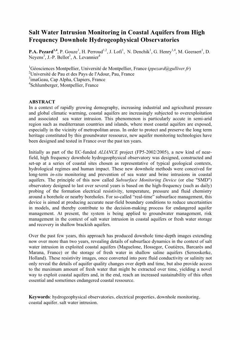
Cw = (Co - Cs) . F (7) and the pore fluid salinity can be derived for a NaCl solution after Guéguen et Palciauska (1992) from : Ln (s) = (0.97) Ln (Cw) - 4.88 (8) RESULTS At Maguelone (France), the resisitivity data inversion in terms of downhole pore fluid salinity reveals the presence of salt water intruding into a 3 m-thick permeable aquifer at about 15 m depth with, below that, a diffusion profile in mostly clay-rich sediments with rare sandy and permeable layers saturated with fresh water. In the absence of m values for pore connectivity, two profiles are presented (m=1.5 and 1.8; Figure 1), almost overlaping which underlines the low impact of m on the inversion, generally is in good agreement with pore fluid samples taken from a multi-packer Westbay completion from Schlumberger (Figure 1).
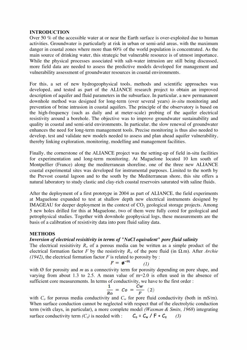
Figure 1. Pore fluid salinity profiles derived from downhole electrical resistivity data inverted after calibration from cores and logs, and compared to salinities measured from downhole fluid samples. DISCUSSION AND CONCLUSIONS In summary, this new hydrogeophysical approach provides a high resolution means to follow at decimeter to meter scale the changes over time in pore fluid composition along a downhole section. This constitutes the basis to set-up a permanent monitoring strategy from in-situ, high frequency, autonomous observatories such as that of imaGeau (Figure 2).
0,1
1
10
100
0 10 20 30 40 50
s (m=1.5)
s (m=1.8)
s_calc (g/l)
Pore
flu
id S
alin
ity
(g/L
)
Depth (m)
Fresh Water Line
Sea Water Line
Figure 2. Salt-water intrusion high-frequency field monitoring set-up and principle from SMD
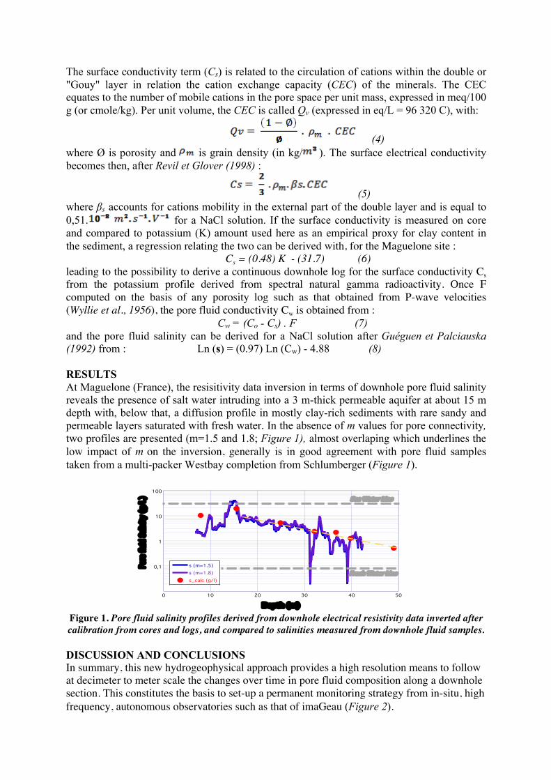
downhole electrical resistivity observatory (sketch provided by imaGeau). Over the past few years, this approach has produced downhole time-depth images extending now over more almost a year (Figure 3), revealing details of subsurface dynamics in the context of salt water intrusion in exploited coastal aquifers (Hossegor, Coutières, Barcarès and Marana; France) or the storage of fresh water in shallow saline aquifers (Serooskerke; Holland). These resistivity images, once converted into pore fluid conductivity or salinity not only reveal the details of aquifer quality changes over depth and time, but also provide access to the maximum amount of fresh water that might be extracted over time, yielding a novel way to manage coastal aquifers and, in the end, reach an increased sustainability of this often essential and sometimes endangered coastal ressource.
Figure 3. Time-depth image of pore water salinity at Hossegor (SW France) for 300 days. Brackish
water is detected above 8 m and isolated from the city aquifer by a clay layer (below). The high-frequency SMD monitoring data reveal not only seasonal changes in water quality but also, with
vertical stripes, the impact of city pumping from a nearby well located 6 m from the SMD. REFERENCES Archie, G.E. (1942). "The electrical resistivity log as an aid in determining some reservoir characteristics".
Petroleum Transactions of AIME 146: 54–62. Guéguen et Palciauska, 1992. Introduction à la physique des roches, pp. 192. Revil et Glover, 1998. Nature of surface electrical conductivity in natural sands, sandstones, and clays,
Geophysical Research Letters, 25, 5, 691-694. Waxman, M.H. and Smits, L.J.M. (1968). "Electrical conductivities in oil-bearing shaly sands". SPE Journal 8
(2): 107–122. Wyllie, M.R.J., Gregory, A. R., and Gardner, L. W., 1956. Elastic wave velocities in heterogeneous and porous
media. Geophysics, 21, 41-70.
Salt water Fresh water
aquifer
Vadose
Pumping
HIGH RESOLUTION ELECTRICAL RESISTIVITY OBSERVATORY
Sea water
Surface data acquisition system
Piezometric