salt marsh vascular plant distribution in relation
TRANSCRIPT

SALT MARSH VASCULAR PLANT DISTRIBUTION
IN RELATION TO TIDAL ELEVATION, HUMBOLDT BAY, CALIFORNIA
by
Anni Lauter Eicher
A Thesis
Presented to
The Faculty of Humboldt State University
In Partial Fulfillment
of the Requirements for the Degree
Master of Arts
May 1987

SALT MARSH VASCULAR PLANT DISTRIBUTION
IN RELATION TO TIDAL ELEVATION, HUMBOLDT BAY, CALIFORNIA
by
Anni Lauter Eicher
We certify that we have read this study and that it conforms to acceptable standards of scholarly presentation and is fully acceptable, in scope and quality, as a thesis for the degree of Master of Arts.
Major Professor
Approved by the Graduate Dean

ABSTRACT
The relationship between tidal elevation and the
distribution of salt marsh vascular plants was
investigated in Humboldt Bay, California. Plant species
composition and cover were assessed and elevation surveyed
in 148 one-square-meter plots in July-August, 1985, within
five salt marsh study sites around northern and central
Humboldt Bay. Elevations were surveyed with reference to
the National Geodetic Vertical Datum (NGVD) and converted
to a mean lower low water (MLLW) scale based on National
Ocean Service (NOS) calculations for the relationship
between NGVD and MLLW.
Twenty-two plant species were encountered in the
sampling, including the three rare plant species:
Orthocarpus castillejoides var. humboldtiensis,
Cordylanthus maritimus ssp. palustris and Grindelia
stricta ssp. blakei. Direct gradient analysis was used to
illustrate the change in species composition with
elevation. Using cluster analysis, the samples were
grouped on the basis of floristic similarity into three
major vegetation types: Salicornia virginica marsh,
Spartina densiflora marsh and mixed marsh, of which the
mixed marsh type was most floristically diverse.
At the four study sites associated with North
Humboldt Bay, salt marsh vegetation ranged from 5.7 to 8.4
iii

ft. MLLW. Tidal characteristics were notably lower at the
fifth study site, Elk River, with salt marsh vegetation
occurring between 3.9 and 6.1 ft. MLLW. Through
discriminant analysis, tidal elevation data for North Bay
were assessed as 60.0 percent effective in predicting the
class memberships identified by cluster analysis. While
there was overlap in their elevation distribution, each of
the salt marsh types was most common within a particular
range of elevation. Salicornia marsh was most prevalent
below 6.9 ft. MLLW, Spartina marsh between 6.9 and 7.3 ft.
MLLW and mixed marsh above 7.3 ft. MLLW.

ACKNOWLEDGEMENTS
I gratefully acknowledge the State Coastal
Conservancy for assistance in funding this study; I am
thankful to Liza Riddle for taking an interest in my work
and helping me obtain these funds. Permission to conduct
field research on the Humboldt Bay National Wildlife
Refuge was granted by the U. S. Fish and Wildlife Service,
through the help of Eric Nelson and Dr. Paul Springer.
I would like to thank the members of my graduate
committee, Drs. Robert Rasmussen, Milton Boyd, Stanley
Harris and Robert Gearheart for reviewing my work. Their
editorial comments were of tremendous help to me in
revising this thesis. I would also like to thank Gary
Stearn for helping me in the field with the surveying,
Bill Lennox for his invaluable guidance in the world of
statistics, and Jim Hopelain for showing me an aerial view
of Humboldt Bay salt marshes.
To my parents, Wolfgang and Josephine, thank you for
your faith in me, your support and encouragement. To my
husband, Robert, thank you for your patience and your
perspective.
v

CONTENTS
ABSTRACT
ACKNOWLEDGEMENTS
LIST OF FIGURES
LIST OF TABLES
INTRODUCTION
LITERATURE REVIEW
Overview
Salt Marsh Zonation
Tide-elevation Complex
Competition
STUDY AREA
Location
Salt Marsh Distribution
Climate
Tidal. Regime
Soils
Study Sites
METHODS
Sampling
Analysis
RESULTS
Direct Gradient Analysis
Cluster Analysis
Discriminant Analysis
vi
Page
iii
v
viii
ix
1
3
5
6
12
15
19
20
20
26
27
29
32
35
46
54

CONTENTS (continued)
DISCUSSION
Zonation
Tidal Elevation
Competition
Future Research
LITERATURE CITED
PERSONAL COMMUNICATIONS
APPENDICES
A. Plant Species List
B. Plant Species Descriptions
vii
Page
61
62
66
67
70
79
80
82

1.
2.
3.
4.
5.
6.
7.
8.
9.
10.
11.
LIST OF FIGURES
Study area map
Typical tidal curve for Humboldt Bay
Location map of salt marsh study sites and National Ocean Service tide gauge stations ...
Elevation ranges of salt marsh plant species ...
Cover and frequency curves of alicornia virginica and Spartina densiflora
Cover and frequency curves of Distichlis spicata and Jaumea carnosa
Cover and frequency curves of Triglochin maritimum and T. concinnum
Frequency curves of Grindelia stricta ssp. blakei, Cordylanthus maritimus ssp. palustris, and Orthocarpus castillejoides
var. humboldtiensis
Classification of samples based on floristic similarity
Cover of dominant plant species in three salt marsh types
Frequency of three salt marsh types within different elevation ranges
viii
Page
16
21
23
39
. 41
42
44
45
47
48
58

LIST OF TABLES
Page 1. Tidal datum terminology 22
2. National Ocean Service tide gauge station locations and dates monitored 24
3. Humboldt Bay tidal datums 25
4. United States Coast and Geodetic Survey benchmarks used in surveying 31
5. Elevation ranges of salt marsh plant species 36
6. Elevation classes used in direct gradient analysis 38
7. Cover of plant species in three salt marsh types 49
8. Frequency of plant species in three salt marsh types 50
9. Tidal elevation as a discriminating variable in the prediction of three salt marsh types
ix
56

INTRODUCTION
Salt marshes are found in the upper intertidal zone
of sheltered, temperate coastlines worldwide. Salt marsh
species occur only within a specific range of tidal
elevation, but the limits for this parameter previously
have not been established for Humboldt Bay, California.
This lack of information has been a hindrance in planning
local salt marsh restoration projects. If an area is too
low, the frequency and duration of tidal inundation may be
too stressful to support vascular plant growth. If too
high, upland plants may outcompete salt marsh species. A
primary goal of this study was to determine the range of
elevations suitable for salt marsh establishment in
Humboldt Bay, based on the distribution of natural
populations.
Zonation patterns of vegetation in salt marshes have
been correlated with tidal elevation (Johnson and York
1915, Chapman 1938, Purer 1942, Hinde 1954, Adams 1963,
Eilers 1975, Claycomb 1983), suggesting another
application for tide level-plant species information in
salt marsh restoration. It may be possible to favor a
certain type of salt marsh community by manipulating
elevation. With this ability, restoration projects could
be designed with specific objectives such as providing
habitat for particular species or mitigating for the loss
1

2
of a certain type of salt marsh. In this study, elevation
ranges are presented for 22 plant species within Humboldt
Bay salt marshes, vegetation types are classified, and the
feasibility of discriminating among these vegetation types
on the basis of tidal elevation is assessed. The
influences of tidal inundation, salinity, soil aeration,
nutrient availability and substrate type on plant
distribution are discussed.

LITERATURE REVIEW
Overview
The classic treatise on the world's salt marshes and
salt deserts was written by Chapman (1960, 1974), who has
since edited another volume on the same subject (1977).
Other major works on the general biology and ecology of
salt marsh communities include Ranwell (1972), Waisel
(1972) , Reimold and Queen (1974) , Pomeroy and Wiegert
(1981) and Long and Mason (1983). Overviews on the
vegetation of North American Pacific coastal marshes have
been provided by Macdonald (1969, 1977a, 1977b) and
Macdonald and Barbour (1974). Community profiles are
available for tidal marshes of the Pacific Northwest
(Seliskar and Gallagher 1983), of San Francisco Bay
(Josselyn 1983) and of southern California (Zedler 1982)
through a series published by the United States Fish and
Wildlife Service.
A central theme in salt marsh field investigations
has been to describe and explain plant distribution
patterns. The vegetation of European salt marshes has
been described by Chapman (1939, 1959), Corre (1985) and
de Jong and de Kogel (1985); Australian salt marshes by
Clarke and Hannon (1967); North American east coast
marshes by Johnson and York (1915), Miller and Egler
(1950), Adams (1963) and Niering and Warren (1980);
3

4
southern California marshes by Purer (1942), Vogl (1966),
Zedler (1977) and Neuenschwander et al. (1979); San
Francisco Bay marshes by Hinde (1954); Oregon marshes by
Jefferson (1974) and Eilers (1975); and Canadian marshes
by Glooschenko (1978).
Humboldt Bay salt marsh vegetation has been described
by Macdonald (1967), Claycomb (1983) and Newton (1985a,
1985b, 1986a). Claycomb documented vegetation changes at
a salt marsh restoration site. Other local studies
containing information on salt marsh vegetation at
restoration sites include Stopher et al. (1981), Miner and
Moore (1982-1986) and Koplin et al. (1984). Newby (1980)
assessed the distribution of cordgrass and pickleweed in
relation to nutrient availability on an island in Humboldt
Bay. Rogers (1981) measured the productivity of selected
salt marsh species in Humboldt Bay.
Josselyn (1982) provided an overview of wetland
restoration in California. Zedler (1984) prepared a
guidebook for salt marsh restoration in southern
California, and Josselyn and Buchholz (1984) a guide for
San Francisco Bay, containing information on
state-of-the-art techniques in marsh restoration,
guidelines for planning and monitoring, revegetation
considerations and recommendations for defining project
goals. Newton (1986b) discussed management considerations
for three rare plant species in Humboldt Bay salt marshes.

5
Race and Christie (1982) discussed the ethics of
mitigation strategies and the role of marsh creation in
coastal management.
Zonation
Zonation is a characteristic feature of salt marsh
communities (Chapman 1960, Macdonald 1977a). The
non-uniformity of the vegetation is obvious upon first
glance, but the delineation, description and explanation
of vegetation units within the salt marsh have been the
subject of much research. Frequently, the vegetation is
envisioned as a series of belts spanning the intertidal
zone, distinguished by reference to tide level with terms
such as low, middle and high or upper marsh (Johnson and
York 1915, Purer 1942, Adams 1963, Neuenscwander et al.
1979, Claycomb 1983). The names of dominant species have
also been used to distinguish vegetation units, generally
with some reference to their position on the shore (Hinde
1954, Clarke and Hannon 1967, Ewing 1983, de Jong and de
Kogel 1985). Others have described the pattern of
vegetation units as a mosaic (Miller and Egler 1950, Burg
et al. 1980, Niering and Warren 1980, Corre 1985).
The delineation of vegetation units within the salt
marsh remains imprecise. Nearly always, some species
transcend the bounds of floristic units, and exceptions
can be found for every environmental delineation of zones.

6
Some investigators have questioned the concept of zonation
in the salt marsh, in turn describing a vegetation
continuum, with species composition and dominance changing
gradually across the environmental gradient (Vogl 1966,
Boorman 1971, Zedler 1977).
Tide-Elevation Complex
Clarke and Hannon (1969) used the term
"tide-elevation complex" to describe a set of interrelated
factors including tidal inundation, soil and water
salinity, soil aeration and nutrient availability. These
factors all exhibit patterns that can be referenced to
tidal elevation, and all are influential in governing
plant distribution. Zedler (1977) demonstrated that
elevation provides a good index of environmental patterns,
with lower elevations having more inundation, higher
salinity and higher soil organic matter.
Within the tide-elevation complex, the impact of any
one factor may vary with species, timing or location. In
general, it appears that tidal inundation is most
influential at low elevations, and that salinity becomes
more important at high elevations (Ranwell 1972, Corre
1985, Niering and Warren 1980).
Tidal inundation affects plant distribution through
wave action, flushing, and the frequency and duration of
submergence periods. At its lower extent, the salt marsh

7
experiences both submergence and emergence daily. The
upper marsh is inundated less frequently, with periods of
emergence sometimes exceeding a month.
Wave action disrupts the substrate, increases
turbidity and uproots seedlings (Macdonald 1977a). Wiehe
(1935) suggested that tidal scour acts as an important
factor limiting the lower distribution of Salicornia
europea by inhibiting seedling establishment.
Tidal flushing can be important in lowering
groundwater salinity, especially at higher elevations,
where evaporation sometimes leads to the development of
hypersaline conditions. In San Francisco marshes, Balling
and Resh (1983) attributed the vigorous plant growth and
high species diversity near mosquito ditches to the
lowering of extreme soil salinities by tidal flushing.
Prolonged submersion in seawater is stressful for
vascular plants in a number of ways. Photosynthesis may
be reduced by a diminished carbon supply and a reduction
in the amount of incident light, or by an alteration in
the light's spectral composition. Transpiration and
respiration may be reduced by stomata closure and a
diminished oxygen supply. Wet soils are prone to
anaerobic conditions because oxygen has a low solubility
in water, and because microbial activity (and hence oxygen
consumption) is higher under moist conditions. Soil
anaerobiosis can induce toxic levels of iron, manganese

8
and sulphide, and interfer with nutrient uptake by plants
(Mahan and Park 1976b, Macdonald 1977a, Zedler 1984,
Groenendijk 1985).
In the Netherlands, Groenendijk (1985) tested plant
tolerances to prolonged seawater immersion. He found
considerable interspecific variation, though he could not
correlate these differences with the positions of species
on the shore. Experiments testing the sensitivity of
generative parts to prolonged tidal immersion did suggest
that reduced reproductive success may be important in the
distribution of some species.
Prolonged emergence can stress plants through soil
dessication and the development of hvpersaline conditions.
Hypersalinity is less common north of Point Conception,
California, than along the southern California coast,
where it is promoted by low rainfall and high evaporation
rates (Macdonald 1969). Nutrient availability can become
limiting during an extended emergence period, as
tidewaters are the major source of nutrients in the salt
marsh (Macdonald 1977a).
Several attempts have been made to correlate patterns
of tidal inundation with patterns of plant distribution.
There is general agreement that inundation patterns
exhibit a discontinuity at the lower limit of salt marsh
establishment. At this level, usually near mean lower
high water (MLHW), the duration of submersion periods

9
decreases markedly. Analyses based on annual hours of
submersion indicate a pattern that declines steadily with
increasing elevation (Hinde 1954, Zedler 1977). Analyses
based on the number and length of continuous submergence
and emergence periods suggest a second major discontinuity
in the inundation pattern (Macdonald 1969, Eilers 1975,
Claycomb 1983). Near the elevation of mean higher high
water (MHHW), there appears to be a marked increase in the
maximum duration of continuous exposure periods.
Macdonald (1969) stated that south of Point Conception,
the MHHW level is easily recognized in the field by the
vertical distribution of floral groups, and that north of
Point Conception, the division is indistinct.
In calculating niche parameters for salt marsh
species, Russel et al. (1985) assessed tidal inundation
using three related measurements: tidal elevation, number
of submergences per year and the longest period of
continuous exposure. While the three measurements did not
exhibit linear relationships to one another, they did
produce similar results in the analysis of niche
parameters.
Recently, salinity has received increased attention
as a major factor in determining salt marsh plant
distribution (Mahall and Park 1976a, Nestler 1977, Ungar
and Riehl 1980, Zedler 1982, Corre 1985, Jaworski and
Tedrow 1985). A basic model of the salinity regime in

10
salt marshes has been described by Mahall and Park (1976a)
and Macdonald (1977a). Salinity gradually increases
landward to a maximum level near mean high water (MHW),
then declines. At low elevations, where oceanic
influences predominate, soil profile salinity is more
stable than at high elevations, where it is affected to a
greater degree by rainfall and evaporation. Salinity
tends to increase with soil profile depth during wet
seasons, but decrease with soil profile depth during dry
seasons, when evaporation produces concentrated soil
salinities near the surface.
Adequate evaluations of salinity are complicated by a
high degree of temporal and spatial variability. Salinity
varies daily with the tide, seasonally with rainfall and
evaporation, and with varying amounts of freshwater
inflow. Zedler (1982) suggested that the year-to-year
variations in salinity make it a good candidate for
explaining yearly changes in salt marsh plant species
composition. It is likely that salinity has its major
impact on plant distribution through extreme conditions
(Corre 1985).
A plant's response to salinity depends on its stage
of development and the degree to which it is already under
stress. Mahall and Park (1976a) suggested that salinity
stress is most critical during late spring and summer,
when plants are actively growing. Ungar and Riehl (1980)

11
concluded that salinity levels at the time of seed
germination are crucial in determining plant distribution.
Zedler (1984) described a "critical period" in the
establishment of the rare annual, Cordylanthus maritimus
ssp. maritimus, in which the seeds are dependent on either
rainfall or flushing by high tides to provide moist,
low-saline conditions for germination. Woodell (1985)
found that while most salt marsh species tested required
brackish or fresh water to germinate, the rate of
germination was greatly enhanced by pre-soaking in
seawater.
The influences of the tide-elevation complex tend to
produce a linear banding of vegetation across the
intertidal zone. This vertical pattern can be obscured
where physical factors other than the tide-elevation
complex exert overriding influences. Differences in soil
texture from one location to another can alter zonation
patterns. Soil moisture and salt retention
characteristics affect salinity gradients. In coarse
soils, percolation is rapid and salt is quickly leached
from the soil surface. In clay soils, salts are retained
better because of slow percolation rates and a higher
cation exchange capacity (Gallagher 1977). Zonation
patterns are also obscured by variations in distance from
water sources (Clarke and Hannon 1967).
Chance also helps determine plant distribution

12
patterns. Storms, flooding, tidal debris buildup,
hypersalinity, herbivory and trampling all cause local
mortality, leading to patches of open space in the marsh.
The chance establishment of one species or another in
these open areas could partly determine later vegetation
patterns (Miller and Egler 1950, Niering and Warren 1980,
Zedler 1982).
Competition
Many salt marsh species appear to have wider ranges
of tolerance to physical stress than they exhibit in the
field (Gray 1985). Using Hutchinson's terminology, the
realized niches of these species are smaller than their
fundamental niches, suggesting that competition occurs
among species for available space and resources. (Odum
1983).
The importance of competition in determining the
distribution of salt marsh plants was suggested by Purer
(1942) and Hinde (1954). Clarke and Hannon (1971) used a
simulated elevation gradient to test the impact of
competition on Australian salt marsh species. They
concluded that four of the six species tested were
influenced by competition at both their lower and upper
limits, and that the other two were affected by
competition at their landward limit.
Zedler (1977) used tests of abundance and association

13
to assess the role of competition among salt marsh species
in the Tijuana Estuary in southern California. She
hypothesized that Salicornia virginica is limited in the
middle of its range by competition with either Batis
maritima or Salicornia bigelovii, or both. Zedler also
suggested that Triglochin maritimum, which blooms earlier
than other salt marsh species, may avoid competition by a
temporal partitioning of resource use.
Russel et al. (1985) measured niche breadths of salt
marsh species in relation to tidal inundation. They found
that mean niche overlaps are significantly smaller in
areas with higher species diversity, presumably resulting
from a greater intensity of competitive interactions in
these areas.
Competition has more impact on species distributions
at high marsh elevations, whereas physical factors tend to
predominate at low elevations. The environmental stresses
associated with tidal inundation appear to have an
overriding influence on determining which species occupy
the lower shore. More species can tolerate the
environmental conditions of the high marsh, setting the
stage for competitive interactions (Chapman 1960, Ranwell
1972, Zedler 1977, Russel et al. 1985).
Competition becomes even more intense landward of the
intertidal zone, where physical conditions are more
favorable for vascular plant growth. Laboratory tests

14
have shown that many salt marsh species grow better in
brackish or fresh conditions than in saline conditions
(Barbour 1970, Barbour and Davis 1970, Phleger 1971).
Quite possibly, these species are restricted from
non-saline habitats by their inability to compete.
Relatively few vascular plants have evolved mechanisms for
tolerating the stresses imposed by periodic tidal
inundation. For those that have, the salt marsh
environment represents an important refuge from
competitors.
STUDY AREA
Location
Humboldt Bay is a large marine embayment occurring in
Humboldt County, northern California. The bay is
comprised of two shallow basins, North Bay (= Arcata Bay)
and South Bay, and a deepwater section around the mouth
called Entrance Bay (Fig. 1). Extensive mudflats are
exposed during low tide in North and South Bays. Two
narrow sand spits shelter the estuary from wave exposure,
allowing the development of salt marsh in the upper
intertidal zone.
According to Cowardin et al. (1979), Humboldt Bay
salt marshes belong to the Columbian Province, estuarine
system, intertidal subsystem, emergent wetland class and
persistent subclass. The tidal regime varies from
regularly to irregularly flooded. Water chemistry is
haline to mixohaline.
Humboldt Bay represents the principal site of salt
marsh between Coos Bay, 156 nautical miles to the north,
and San Francisco Bay, 225 nautical miles to the south.
The salt marsh community in Humboldt Bay is floristically
unique. Spartina densiflora, a Chilean species of
cordgrass presumably introduced during the 1850s, has
risen to a position of dominance here. The species is not
known to occur anywhere else in North America, except for
15

FIGURE 1. Map of study area: Humboldt Bay, California. Shaded areas represent the distribution of salt marsh as mapped by Shapiro and Associates (1980).
16
17
a small patch in San Francisco Bay, where it was
introduced from Humboldt Bay in 1976. Chile imported
lumber from Humboldt Bay during the 1850s while undergoing
a period of rapid development. It is speculated that
seeds of a. densiflora were transported inadvertently
with ballast gathered from Chilean shorelines on lumber
ships returning to Humboldt Bay (Spicher and Josselyn
1985).
Prior to taxonomic investigation by Spicher (1984),
the Humboldt Bay cordgrass was believed to be a northern
ecotype of Spartina foliosa (Pacific cordgrass), a species
characterizing central and southern California coastal
marshes. Aberrations in the habit and distribution of the
cordgrass in Humboldt Bay were noted, but were attributed
to higher rainfall and geographic isolation (Rogers 1981).
Unlike a. foliosa, E. densiflora grows in tussocks, and it
occupies a higher range of elevation in the intertidal
zone than its California relative. a. foliosa reaches its
northern limit just north of San Francisco Bay in Bodega
Bay (Spicher and Josselyn 1985).
North of Humboldt Bay, salt marshes on the Pacific
coast do not have Spartina (Eilers 1975), except for the
introduction of exotic species in spots. S. anglica was
introduced from England to Puget Sound, Washington, in
1961 or 1962 for controlling shore erosion (Spicher and
Josselyn 1985). Kozloff (1983) reported that a.

18
alterniflora, a species native to the North American
Atlantic coast, has firmly established in Willapa Bay,
southern Washington. This same species has been found in
several locations in Humboldt Bay within the past few
years.
Another feature contributing to the floristic
uniqueness of Humboldt Bay salt marshes is the presence of
three rare plant species, two of which are endemic.
Orthocarpus castillejoides var. humboldtiensis (Humboldt
Bay owl's clover), Grindelia stricta ssp. blakei (Humboldt
Bay gumplant) and Cordylanthus maritimus ssp. palustris
(Point Reyes bird's beak) are all on List 1B of the
California Native Plant Society Inventory as rare and
endangered throughout their ranges (California Native
Plant Society 1984). The owl's clover and gumplant are
endemic to the Humboldt Bay area; Point Reyes bird's beak
ranges from Coos Bay, Oregon, to Morro Bay, San Luis
Obispo County, California (Newton 1986b).
Humboldt Bay salt marshes are further distinguished
from northern marshes by the presence of Limonium
californicum (sea lavender) and from southern marshes by
the absence of Frankenia grandifolia and Suaeda
californica (sea blite). Aside from these distinctions,
Humboldt Bay shares a number of floristic components with
other Pacific coast marshes. Species that range from
British Columbia to southern California include Salicornia

19
virginica (pickleweed), Distichlis spicata (saltgrass),
Jaumea carnosa, Triglochin maritimum (arrowgrass) and
Cuscuta salina (marsh dodder) (Macdonald 1977a, 1977b).
Salt Marsh Distribution
Shapiro and Associates (1980) estimated a total of
970 acres of salt marsh remaining in Humboldt Bay (Fig.
1). This acreage represents less than 15 percent of the
estimated 7000 acres present in 1850, when European
settlers initiated the practice of marsh reclamation.
Wet, unstable marshlands were "reclaimed" from the sea for
agricultural use by building dikes that held back
tidewaters. Today much of these former salt marshes are
still pastureland. The salt marshes remaining in Humboldt
Bay are protected by law. Recognition of the ecological
and aesthetic values of coastal wetlands led to the
establishment of the California Coastal Act of 1976, which
deters further destruction of these habitats and requires
mitigation when development is permitted.
Only about 140 acres of salt marsh remain in South
Bay. About 40 acres border the Elk River Estuary. In
North Bay, about 130 acres of salt marsh are associated
with Mad River Slough, 120 acres with Eureka Slough, and
there is a 195-acre parcel of salt marsh on Indian Island.
The remaining salt marsh acreage is scattered around the
periphery of North Bay (Shapiro and Ass. 1980) (Fig. 1)
20
Climate
The Humboldt Bay area has a temperate marine climate,
with mild, wet winters and cool, dry, foggy summers. The
mean annual temperature is 52 degrees Fahrenheit, with
summer months averaging ten degrees warmer than winter
months. The average annual precipitation is 38 inches, 90
percent of which occurs between October and April. Fog is
a dominant feature of the area, especially in summer and
early autumn, with resulting high humidity throughout the
year. Winds prevail from the northwest in spring and
summer and from the south in fall and winter (Elford and
McDonough 1974, U. S. Army Corps 1979).
Tidal Regime
The tidal cycle in Humboldt Bay has a mixed
semidiurnal pattern characterized by two high tides of
unequal magnitude and two low tides of unequal magnitude
each lunar day (Fig. 2, Table 1). The height of the tide
varies from place to place around the bay perimeter in
response to complex current patterns. These variations
were assessed by the National Ocean Service (NOS) at
twelve locations around the bay (Fig. 3, Table 2). Means
were calculated for each stage of the tidal cycle, and
expressed in relation to mean lower low water (MLLW) at
each station (Table 3).

21
FIGURE 2. A typical tidal curve for Humboldt Bay, California. The pattern is mixed-semidiurnal, characterized by two high tides of unequal magnitude and two low tides of unequal magnitude each day. (A tidal day = 24 hours, 50 minutes.) Highs and lows also vary in magnitude from day to day. Tidal heights recorded over extended time periods are used in calculating means. Often such tidal datums are referenced to the height of mean lower low water (MLLW) by setting MLLW = 0 ft.

TABLE 1. Definitions of tidal datum terms (Harris 1981).
HHW = Higher High Water MHHW = Mean Higher High Water
LLW = Lower Low Water MLLW = Mean Lower Low Water
LHW = Lower High Water MLHW = Mean Lower High Water
HLW = Higher Low Water MHLW = Mean Higher Low Water
EHW = Extreme High Water
MHW = Mean High Water, a plane midway between MHHW and MLHW.
MLW = Mean Low Water, a plane midway between MHLW and MLLW.
MTL = Mean Tide Level, a plane midway between MHW and MLW.
MSL = Mean Sea Level, usually within a few 0.01 ft. of MTL. The MSL datum changes over time because the mean elevation of the sea surface is gradually rising relative to land.
NGVD = National Geodetic Vertical Datum, established in 1929 as a reference datum plane for geodetic leveling. It is intended to approximate MSL, however NGVD is a fixed surface that does not change over time.
Diurnal Range = MHHW - MLLW.
Mean Range = MHW - MLW.
22

23
FIGURE 3. Location of five salt marsh study sites and twelve National Ocean Service tide gauge stations in Humboldt Bay, California.

24
TABLE 2. National Ocean Service tide gauge station locations and dates monitored, in Humboldt Bay, California.
TIDE GAUGE STATION ABBREVIATION DATES
941
* 941
* 941
* 941
941
941
941
* 941
941
941
941
941
8983
3365
3817
88Ø2
88Ø1
3799
8778
8757
8767
8739
8723
8686
Upper Mad River Slough
Mad River Slough
Samoa
Eureka Slough
Eureka
Freshwater Slough
Bucksport
Elk River
North Spit
Red Bluff
Fields Landing
Hookton Slough
UMR
MRS
SAM
EUS
EUR
FRS
BS
ER
NS
RB
FL
HS
7/78-1/79
9/77-2/80
4/78-6/79
3/78-6/79
8/77-2/80
3/78-1/79
8/77-2/80
9/77,4/79
8/77- Present
4/73-1/79
4/78-2/30
9/77-6/79
* Tide gauge stations near salt marsh study sites.

TABLE 3. Tidal datums calculated by the National Ocean Service (1981-1985) for twelve locations in Humboldt Bay, California.
HUMBOLDT BAY TIDAL DATUMS (ft. MLLW)
GAUGE STATION MLLW MLW MIILW MTL MLHW MHW MHHW
DIURNAL RANGE
MEAN RANGE NGVD
UMR 0.00MHLW 1.30 2.60 4.26 6.51 7.22 7.93 7.93 5.92 N/A
* MRS 0.00 1.32 2.64 4.18 6.32 7.03 7.74 7.74 5.71 4.28
* SAM 0.00 1.27 2.54 3.95 5.91 6.62 7.33 7.33 5.35 3.99
* EUS 0.00 1.27 2.54 4.01 6.04 6.76 7.48 7.48 5.49 4.04
EUR 0.00 1.28 2.56 3.94 5.90 6.61 7.32 7.32 5.33 4.02
FR 0.00 1.08 2.16 3.78 5.78 6.49 7.20 7.20 5.41 N/A
BS 0.00 1.28 2.56 3.79 5.60 6.30 7.00 7.00 5.02 3.85
* ER 0.00 0.39 0.78 2.40 3.70 4.40 5.10 5.10 4.01 1.96
NS 0.00 1.25 2.50 3.73 5.52 6.22 6.92 6.92 4.97 3.72
RB 0.00 1.21 2.42 3.66 5.43 6.12 6.81 6.81 4.91 3.69
FL 0.00 1.23 2.46 3.69 5.45 6.15 6.85 6.85 4.92 3.70
HS 0.00 1.22 2.44 3.73 5.54 6.24 6.94 6.94 5.02 3.71
* Tide gauge stations near study sites. N/A = Not Available
25

26
Generally, the mean tide level (MTL) and the
amplitude of the tide increase with distance from the
entrance in North Bay, though not in South Bay. At the
North Spit tide gauge station, the MTL is 3.73 feet MLLW,
the diurnal range is 6.92 feet and the mean range is 4.97
feet (National Ocean Service 1981-1985). There is
extensive mixing in the bay as a result of its large tidal
prism, large tidal range and limited freshwater input.
Soils
Salt marsh soils are comprised of the finest
sediments in the bay. The particles are bound tightly
together, forming a peat high in organic matter. Samples
have revealed 63 to 72 percent of the soil content to be
organic matter, mostly roots and dead vegetation (Burton
1972). In most cases, the marsh deposits are three to
four feet thick, grading downward to clayey silts
(Thompson 1971).
Tidal channels penetrate the marshes in dendritic
patterns. Some channels are well-defined, with mud banks
two to three feet high; others are bounded by gradual
slopes covered with vegetation. Like the bay mudflats,
the mud in the tidal channels is soft and black, with an
odor of sulfur. In the vegetated portion of the marsh,
plant roots help stabilize the substrate.
Both erosion and accretion are occurring within

27
Humboldt Bay, as indicated by aerial photographs, sediment
core samples and recorded siltation measurements. Net
erosion is apparent near the mouth of Eureka Slough,
attributable to wave attack and to alterations in the
drainage pattern of Freshwater Creek. Net accretion has
been noted near the mouth of Jacoby Creek, a source of
considerable sediment. At other areas along the bay
shoreline, there appear to be seasonal cycles of erosion
and accretion in response to shifting wind and wave
conditions (Thompson 1971).
Study Sites
Study sites were selected on the basis of the
following criteria: A. Presence of relatively undisturbed
salt marsh. B. Proximity to an established benchmark, for
ease in surveying. C. Proximity to a NOS tide gauge
station, for accuracy in estimating tide levels. Five
areas were selected: Mad River Slough, Jacoby Creek,
Eureka Slough, the Samoa Peninsula, and Elk River (Fig.
3). The first four sites are associated with North Bay,
and the Elk River site with Entrance Bay. The Jacoby
Creek and Eureka Slough sites are part of the Humboldt Bay
National Wildlife Refuge, managed by the United States
Fish and Wildlife Service.
The Mad River Slough site is located on the southwest
side of the mouth of the slough. This marsh was diked in

28
the early 1900s, but the dike was eroded and abandoned by
1927. Reportedly, the area had reverted to salt marsh by
1948 (Shapiro and Ass. 1980). Remnants of the old dikes
are now vegetated primarily with salt marsh species.
The Jacoby Creek site is located on the eastern
shoreline of North Bay, south of the mouth of Jacoby
Creek. Here the marsh gradually slopes westward to the
adjoining mudflats.
The Eureka Slough site is adjacent to the mouth of
the slough, on the east side. Here the bayward margin of
the marsh is a two to three-foot-high bank under active
erosion by wave attack, with clumps of marsh mud and
vegetation slumped onto the mudflat in places.
The Samoa site is located on the western shoreline of
North Bay, near the intersection of the Samoa Bridge and
Samoa Blvd. During the 1930s through the 1950s, log rafts
were stored along this shore. The marsh bank is steep in
most places.
The Elk River site is located on the spit extending
from the river mouth, west of the river channel.
Formation of Elk River Spit first became apparent in the
1930s. The mechanism for sediment deposition in this area
was provided by stabilization of the bay entrance and by
deepening of navigation channels (Costa 1982). Much of
the spit is covered by sand dunes, with pockets of salt
marsh bordering Elk River.

METHODS
Sampling
In July, 1985, 148 sample plots were established.
Transects were run perpendicular to the shoreline, from
randomly-selected points on the edge of the mudflat to the
upper marsh boundary. Sample plots were placed at
twenty-meter intervals along the transects, with
additional plots in segments showing obvious contour
and/or vegetation changes. Thirty-eight plots were
sampled at Samoa, 31 at Eureka Slough, 28 at Mad River
Slough, 28 at Elk River, and 23 at Jacoby Creek.
At each plot, vegetation characteristics were
assessed within a one-square-meter area defined by a
portable quadrat frame. All plant species occurring
inside the frame were recorded and their percent cover
estimated visually. Cover is defined as the vertical
projection of the species crown area to the ground
surface. Cover is considered to have greater ecological
significance as a measure of plant distribution then
density or frequency of individuals (Mueller-Dombois and
Ellenberg 1974). Visual estimates of cover were
facilitated by the placement of central crossbars,
breaking the frame into four 0.25-square-meter
subsections. In addition, the arms of the frame and the
crossbars were marked off in decimeters. Cover was
29

30
estimated to the nearest ten percent, with additional
cover classes for species having one to five percent
cover, and for those with less than one percent cover.
Voucher specimens of all species were collected and filed
at the Humboldt State University Herbarium. Taxonomic
nomenclature used follows Smith and Sawyer (1986).
After vegetation characteristics were recorded, the
center of each sample plot was marked with a wooden stake.
In August, 1985, these points were surveyed with reference
to the National Geodetic Vertical Datum (NGVD), using
U. S. Coast and Geodetic Survey benchmarks as reference
points (Table 4). Elevations were translated to a scale
based on mean lower low water (MLLW), using National Ocean
Service calculations for the relationship between NGVD and
MLLW (Table 3).
No tidal records were available for the Jacoby Creek
area. Based on distance from the bay entrance and
circulation patterns within the Bay (Shapiro and Ass.
1980), records for the Mad River Slough station were
considered the best estimates available of tidal
conditions at the Jacoby Creek salt marsh. On three
occasions in February, 1986 (under calm conditions), the
height of high tide was monitored simultaneously at all
study sites by using plastic tidepoles smeared with a
water-sensitive, color-coded paste ("Kolor Kut"). Heights
at the Mad River Slough and Jacoby Creek sites were within

31
TABLE 4. United States Coast and Geodetic Survey benchmarks used as reference points in surveying elevation at five salt marsh study sites in Humboldt Bay, California.
STUDY SITE BENCHMARK ELEVATION (ft. NGVD)
Samoa # Z 1091 1967 12.35
Mad River Slough # J 735 1970 11.68
Jacoby Creek # G 75 1955 8.91
Eureka Slouch # J 75 1942 22.03
Elk River Slough # S 1087 1967 9.51

32
0.1 foot of each other on all three occasions. Variations
among the other sites were consistent with the figures
established by NOS.
Analysis
Data were interpreted using direct gradient analysis,
cluster analysis and discriminant analysis. Direct
gradient analysis is a form of ordination; cluster and
discriminant analyses are forms of classification.
Ordination and classification techniques are often
combined as complementary tools in the description and
explanation of vegetation patterns (Whittaker 1973, Gauch
1982).
In direct gradient analysis (Whittaker 1967, 1973),
the samples were arranged according to their position on
the tidal elevation gradient. Sample plots were grouped
into 0.25-foot elevation classes. Within each elevation
class, mean percent cover and percent frequency were
calculated for each species.
The samples were grouped on the basis of floristic
similarity in cluster analysis, carried out in the
computer program package CLUSTAN (Wishart 1978). The
plots were clustered by Ward's method of hierarchical
fusion (Ward 1963), using a squared Euclidean distance
matrix as demonstrated by Wishart (1969). This method is
designed to minimize the loss of information in passing

33
from each level of the hierarchy to the next. At each
stage in the fusion process, the objective is to join
whichever two clusters have the least variance between
them, as measured by squared Euclidean distance.
Euclidean distance is called a dissimilarity coefficient
because it measures distances apart, but fundamentally it
fulfills the same function as a similarity coefficient.
The only distinction between dissimilarity and similarity
coefficients is in which direction the scale runs
(Clifford and Stephenson 1975, Romesburg 1984).
Two objectives were achieved by means of discriminant
analysis, using the SPSS computer program, procedure
DISCRIMINANT (Hull and Nie 1981). First, discriminant
analysis was used to measure the validity of the
classification derived by cluster analysis, through a
procedure outlined in Romesburg (1984). A discriminant
function was developed using the floristic attributes of
the plots as independent variables and the class
memberships given by cluster analysis as the dependent
variable. The percentage of plots placed by the
discriminant function into the same classes as by the
cluster analysis is a measure of secondary validity for
the classification.
Second, using the same class memberships as the
dependent variable, tidal elevation data were submitted as
the independent variable. The percentage of class

34
memberships correctly identified indicates how well the
vegetation classes can be delineated on the basis of tidal
elevation.

RESULTS
Direct Gradient Analysis
Elevations sampled at the Elk River study site were
notably lower than at any of the four North Bay sites.
Salt marsh vegetation was found between 3.9 and 6.1 ft.
MLLW at Elk River and between 5.7 and 8.4 ft. MLLW in
North Bay (Table 5). Tidal data collected at Elk River
were excluded from general tide analyses because of the
site's uniqueness.
Twenty-two vascular plant species were encountered in
the study (Appendices A and B). Seventeen species were
recorded at the Jacoby Creek site, 16 species at the Samoa
site, 15 species at the Eureka Slough site, 15 species at
the Elk River site, and 14 species at the Mad River Slough
site. Ten species were common to all five sites, and five
species were recorded at only one of the five sites.
Orthocarpus castillejoides var. humboldtiensis appeared in
samples only at Jacoby Creek, Deschampsia caespitosa only
at Elk River, and the three species Carex lyngbyei,
Scirpus maritimus and Juncus lesueurii only at Samoa
(Table 5).
The North Bay samples were grouped into ten 0.25-ft.
elevation classes (Table 6). Most samples occurred at
intermediate elevations. Species composition and
abundance changed with elevation (Fig. 4). Salicornia
35

TABLE 5. Distribution of salt marsh plants by elevation at Five study sites in Humboldt Bay, California, July-August, 1985. Species ranges at the
four North Bay sites were combined to provide a composite list. Ranges are in ft. MLLW.
NORTH HUMBOLDT BAY STUDY SITES
f NORTH BAY (composite)
ELK RIVER SAMOA
MAD R. SLOUGH
JACOBY CREEK
EUREKA SLOUGH
Salicornia virginica 5.7-7.5 6.4-7.7 5.9-8.4 6.4-7.9 5.7-8.4 3.9-6.1
Spartina densiflora 5.9-7.7 6.1-7.7 5.9-7.6 6.4-7.9 5.9-7.9 3.9-6.1
Jaumea carnosa 6.5-7.4 7.1-7.7 7.1-8.4 7.0-7.9 6.5-8.4 4.7-5.6
Triglochin maritimum 6.5-7.7 7.1-7.4 6.3-8.4 7.4-7.5 6.3-8.4 3.9-4.9
Triglochin concinnum 7.0-7.3 7.1-7.7 7.7-8.4 7.4-7.8 7.0-8.4 ---
Spergularia canadensis 7.2-7.4 7.1 --- 7.5-7.7 7.1-7.7 ---
Cordulanthus maritimus
ssp. palustris 7.0-7.4 7.4 7.7-8.4 7.5-7.8 7.0-8.4 5.4
Atriplex patula ssp. hastata 7.0-7.4 7.4 7.9 7.7-7.8 7.0-7.9 4.9-5.0
Distichlis spicata 7.0-7.4 7.1-7.7 6.6-8.4 7.4-7.8 6.6-8.4 4.3-6.1
Limonium californicum 7.0-7.3 7.1 7.7-8.4 7.4-7.8 7.0-8.4 5.6
P1aPlantagoritima
var. juncoides 7.2-7.3 7.7 7.7-8.2 7.5-7.8 7.2-8.2 5.4
Cuscuta salina 7.2-7.4 7.7 8.4 7.8 7.2-8.4 5.4
36

Table 5. Elevation ranges of salt marsh species, in ft. MLLW (continued).
NORTH HUMBOLDT BAY STUDY SITES
NORTH BAY (composite)
ELK RIVER SAMOA
MAD R. SLOUGH
JACOBY CREEK
EUREKA SLOUGH
Carex lyngbyei 7.4-7.7 --- --- --- 7.4-7.7 ---
Grindelia stricta
ssp. blakei --- --- 7.4-8.4 7,5-7.8 7.4-8.4 4.7-6.0
Scirpus cernuus
ssp. californicus 7.5 --- 7.7-7.9 --- 7.5-7.9 ---
Spergluaria macrotheca --- 7.7 7.6-8.4 --- 7.6-8.4 5.6
Scirpus maritimus 7.7 --- --- --- 7.7 ---
Juncus lesueurii 7.7 --- --- --- 7.7 ---
Parapholis spp. --- --- 7.7-7.9 7.8 7.7-7.9 5.4
Orthocarpus castillejoides var. humboldtiensis --- --- 7.7-8.4 --- 7.7-8.4 ---
Deschampaia caespitosa --- --- --- ___ --- 4.9-5.0
TOTAL RANGE SALT MARSH 5.7-7.7 6.1-7.7 5.9-8.4 6.4-7.9 5.7-8.4 3.9-6.1
NUMBER OF SPECIES 16 14 17 15 22 15
NUMBER OF SAMPLES 38 28 23 31 120 28
37

38
TABLE 6. Elevation classes used in direct gradient analysis of the North Humboldt Bay samples.
ELEVATION (ft. MLLW) NUMBER
OF SAMPLES RANGE MIDPOINT
5.75-6.00 5.88 2
6.01-6.25 6.13 6
6.26-6.50 6.38 7
6.51-6.75 6.63 13
6.76-7.00 6.88 9
7.01-7.25 7.13 31
7.26-7.50 7.38 26
7.51-7.75 7.63 16
7.76-8.00 7.88 8
8.01-8.40 8.20 2
TOTAL: 120

39
TIDAL ELEVATION (ft. MLLW)
6.0 6.5 7.0 7.5 8.0
Salicornia virginica
Spartina densiflora
Jaumea carnosa
Triglochin maritimum
Triglochin concinnum
Spergularia canadensis
Cordylanthus maritimus ssp. palustris
Atriplex patula ssp. hastata
Distichlis spicata
Limonium californicum
Plantago maritima var. juncoides
Cuscuta salina
Grindelia stricta ssp. blakei
Spergularia macrotheca
Parapholis spp.
Orthocarpus castillejoides var. humboldtiensis
6.0 6.5 7.0 7.5 8.0
FIGURE 4. Distribution of major salt marsh plant species across the tidal elevation gradient in North Humboldt Bay, California. Wider bands indicate the range in which each species had its peak cover, as assessed within 0.25-foot elevation classes. Broken bands indicate sporadic occurrence.

40
virginica (pickleweed), a low-growing succulent, extended
to the lowest elevation and had the broadest elevation
range of any species. It was found throughout the entire
range of tidal elevations sampled (Table 5). Salicornia
was more abundant at the low and high ends of its
elevation range then at mid-levels, as indicated by its
bimodal cover and frequency curves (Figs. 4 and 5).
The decline of Salicornia at intermediate elevations
corresponded with a peak in the abundance of Spartina
densiflora (cordgrass). The tall, coarse grass extended
almost as low as Salicornia, but had less cover at low
elevations. At high marsh elevations, the frequency and
cover of Spartina dropped off as those of Salicornia rose
(Table 5, Figs. 4 and 5).
Distichlis spicata (saltgrass) occurred sporadically
at the lower end of its range, and its frequency and cover
increased steadily with elevation. Jaumea carnosa, a
trailing succulent, occupied an elevation range similar to
that of Distichlis, but Jaumea reached its peak cover and
frequency lower, declining slightly at the highest marsh
elevations (Table 5, Figs. 4 and 6).
Two species of arrowgrass, Triglochin maritimum
(common arrowgrass) and T. concinnum (slender arrowgrass)
occur in Humboldt Bay. Triglochin maritimum extended to a
lower tidal elevation, though with sporadic occurrence.
Both species occurred at high marsh elevations, and were

41
FIGURE 5. Cover and frequency of Salicornia virginica and Spartina densiflora over the tidal elevation gradient in North Humboldt Bay, California, based on Ø.25-foot elevation classes. The decline of Salicornia at intermediate elevation corresponded with peaks in the cover and frequency of Spartina. Points based on less than five samples are in parentheses.

42
FIGURE 6. Cover and frequency of Distichlis spicata and Jaumea carnosa over the tidal elevation gradient in North Humboldt Bay, California, based on 0.25-foot elevation classes. The two species had similar ranges, but Jaumea reached its peak cover and frequency lower than Distichlis. Points based on less than five samples are in parentheses.

43
roughly equivalent in terms of frequency and cover (Table
5, Figs. 4 and 7).
The three rare salt marsh plant species in Humboldt
Bay were all associated with high elevation marshes.
Cordylanthus maritimus ssp. palustris (Point Reyes bird's
beak) was found at all of the study sites, occurring at
elevations of 7.0 ft. MLLW or higher in North Bay, and at
5.4 ft. MLLW at Elk River. Orthocarpus castilLejoides
var. humboldtiensis (Humboldt Bay owl's clover) was
encountered only at Jacoby Creek, and only at elevations
of 7.7 ft. MLLW or higher. Grindelia stricta ssp. blakei
(Humboldt Bay gumplant), in samples at three sites,
occurred at elevations over 7.4 ft. MLLW in North Bay, and
over 4.7 ft. MLLW at Elk River (Table 5, Figs. 4 and 8).
None of the three species had more than one percent cover
within any elevation class. Within a single
one-square-meter plot, cover was as high as five percent
for each Cordylanthus and Orthocarpus, both small annuals.
General observations indicated that sampling conducted
earlier in the growing season of Orthocarpus might have
yielded slightly higher cover estimates than those
reported here. Grindelia, a woody perennial, had as high
as twenty percent cover within a single plot.
None of the remaining species had greater than five
percent cover within any elevation class. Generally,
these species were restricted to elevations over 7.0 ft.

44
FIGURE 7. Cover and frequency of Triglochin maritimum and Triglochin concinnum over the tidal elevation
gradient in North Humboldt Bay, California, based on 0.25-foot elevation classes. T. maritimum extended lower than T. concinnum, but with sporadic occurrence. At high elevations, the two species had roughly comparable cover and frequency. Points based on less than five samples are in parentheses.

45
FIGURE 8. Frequency of three rare salt marsh plant species over the tidal elevation gradient in North Humboldt Bay, California, based on 0.25-foot elevation classes. Orthocarpus castillejoides var. humboldtiensis, Cordylanthus maritimus ssp. palustris and Grindelia stricta ssp. blakei all increased in frequency with elevation. Orthocarpus had the lowest frequency, as it was sampled at only one study site. None of the three species had greater than one percent mean cover within any elevation class. Points based on less than five samples are in parentheses.

46
MLLW in North Bay and over 4.7 ft. MLLW at Elk River, and
they all tended to increase in abundance with elevation
(Table 5, Fig. 4).
Cluster Analysis
The samples were grouped on the basis of floristic
similarity, using cluster analysis, into three major
vegetation types (Fig. 9). Salicornia virginica, Spartina
densiflora, Distichlis spicata, Jaumea carnosa and
Triglochin maritimum were present in all three marsh
types, but with markedly different levels of abundance
(Fig. 10, Tables 7 and 8). The Groups can be
characterized as:
A. Salicornia marsh.
B. Spartina marsh.
C. Mixed marsh.
The 36 samples classified as Salicornia marsh and the 53
samples classified as mixed marsh were more alike one
another floristically than either group was to the 59
samples classified as Spartina marsh (Fig. 9). The mixed
marsh type had a higher species diversity than either
Salicornia or Spartina marsh types, both in terms of
species richness and relative cover. Salicornia marsh had
only five species. Two of these, Salicornia and Spartina,
together occupied over 95 percent cover. Spartina marsh
had ten species, but again about 95 percent cover was

FIGURE 9. The samples were grouped on the basis of floristic similarity, through cluster analysis, into three major types: Salicornia marsh, Spartina marsh and mixed marsh. The samples representing the Spartina marsh type were
floristically distinct from all other samples. In relation to this level of
distinction, the Salicornia and mixed marsh types were more alike, and all three marsh types demonstrated high levels of within-group similarity.
47

FIGURE 10. Cover of dominant species within each of three salt marsh types, in Humboldt Bay, California.
48
49
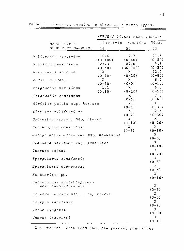
TABLE 7. Cover of species in three salt marsh types.
MARSH TYPE: NUMBER OE SAMPLES:
PERCENT COVER: MEAN (RANGE)
Salicornia
36
Spartina
59
Mixed
53
Salicornia virginica
Spartina densiflora
Distichlis spicata
Jaumea carnosa
Triglochin maritimum
Triglochin concinnum
Atriplexz patula ssp. hastata
Limonium californicum
Grindelia stricta ssp. blakei
Deschampsia caespitosa
Cordylanthus maritimus ssp. palustris
Plantago maritima var. juncoides
Cuscuta salina
Spergularia canadensis
Spergularia macrotheca
Parapholis spp.
Orthocarpus castillejoides var. humboldtiensis
Scirpus cernuus ssp. c alifornicus
Scirpus maritimus
Carex lyngbyei
Juncus lesueurii
70.6 (40-100)
23.3
7.7 (0-40) 87.0
21.5 (0-50)
9.1 (0-50) (30-100) (0-50)
X X 22.0 (0-10) (0-10) (0-80)
X X 8.4 (0-10) (0-5) (0-50)
1.1 X 6.5 (0.10) (0-10) (0-50)
X 7.8 (0-5) (0-60)
X X (0-1) (0-30)
X 2.3 (0-1) (0-30)
X X (0-10) (0-20)
X X (0-5) (0-10)
X (0-5)
X (0-10)
X (0-20)
X (0-5)
X (0-5)
X (0-10)
X (0-5)
X (0-5)
X (0-1)
X (0-50)
X (0-1)
X = Present, with less than one percent mean cover.
50
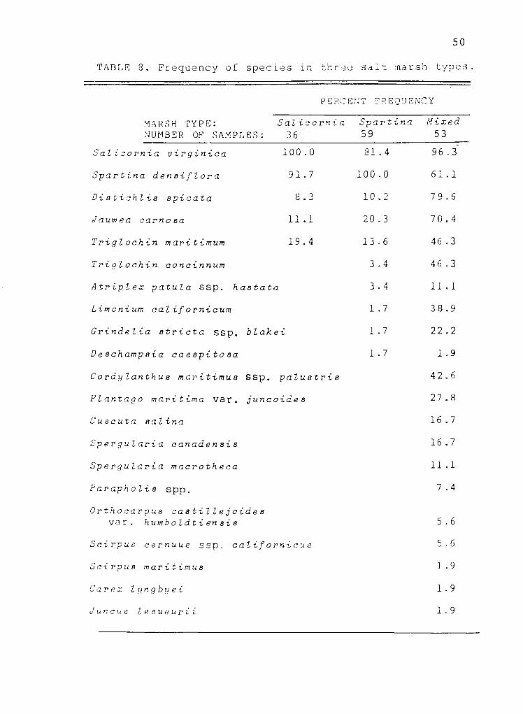
TABLE 3. Frequency of species in three salt marsh types.
MARSH TYPE: NUΜΒΕR OF SAMPLES:
PERCENT FREQUENCY
Salicornia
36 Spartina
59 Mixed
53
Salicornia virginica 100.0
Spartina densiflora 91.7
Distichlis spicata 8.3
Jaumea carnosa 11.1
81.4
100.0
10.2
20.3
96.3
61.1
79.6
70.4
Triglochin maritimum 19.4 13.6 46.3
Triglochin concinnum 3.4 46.3
Atriplex patula ssp. hastata 3.4 11.1
Limonium californicum 1.7 38.9
Grindelia stricta ssp. blakei 1.7 22.2
Deschampsia caespitosa 1.7 1.9
Cordylanthus maritimus ssp. palustris 42.6
Plantago maritima ναr. juncoides 27.8
Cuscuta salina 16.7
Spergularia canadensis 16.7
Spergularia macrotheca 11.1
Parapholis spp. 7.4
Orthocarpus castillejoides να r. humboldtiensis 5.6
Scirpus cernuus ssp. californicus 5.6
Scirpus maritimus 1.9
Carex lyngbyei 1.9
Juncus lesueurii 1.9

51
attributable to the same two species: Spartina and
Salicornia. Twelve species were unique to the mixed marsh
type, with a total of 22 species. Overall no single
species had greater than 25 percent cover, and six species
had between five and 25 percent cover in the mixed marsh
type (Fig. 10, Table 7) .
In the Salicornia marsh type, Salicornia was present
in 100 percent of the samples, with a mean cover of 70.6
percent (Tables 7 and 8). Dense pickleweed mats, two to
three decimeters high, commonly bordered tidal channels
and intertidal flats where the slope was gradual.
Individual tussocks of Spartina were often interspersed
among the pickleweed mats. Occasionally Jaumea,
Distichlis or Triglochin mar ίtimum were found in this
marsh type, but with minimal cover. The number of species
per sample ranged from one to four.
In the Spartina marsh type, Spartina was present in
100 percent of the samples, with a mean cover of 87.0
percent (Tables 7 and 8) . The stiff cordgrass formed
thick, nearly homogenous stands six to ten decimeters
high. Salicornia was scattered sparsely in the
understory, growing in an elongate form. The other eight
species listed as occurring in this marsh type were
generally associated with the occasional openings in
cordgrass stands or along the margins of the stands. The
number of species per sample ranged from one to six.

52
In the mixed marsh type, Distichlis and Salicornia
were co-dominants. Although Salicornia was more widely
dispersed, the two species were approximately equivalent
in terms of cover, with Distichlis tending to form thick
cover in spots. Salicοrnia had a 96.3 percent frequency
with 21.5 percent mean cover, and Distichlis had a 79.6
percent frequency with 22.0 percent mean cover (Tables 7
and 8). Generally the mixed marsh appeared as a
low-growing meadow of grasses, succulents and small herbs,
with occasional taller plants. The number of species per
sample ranged from three to eleven. Jaumea was commonly
interspersed in these meadows, but with less cover than
either of the two dominants. Occasionally Jaumea formed
pure, dense cover in small patches, typically within
slight depressions. £parting occurred in the mixed marsh
type, but with less regularity and less cover than in
either of the other two marsh types. In the mixed marsh,
Spartina individuals tended to be shorter and less
vigorous, appearing stunted in form. Both species of
arrowgrass occurred in the mixed marsh type. Triglochin
maritimum tended to grow in dense tufts up to one meter
tall. The shorter, more delicate T. concinnum was
commonly interspersed with Salicornia and Jaumea.
The three rare plant species Cordylanthus maritimus
ssp. palustris, Orthocarpus castillejoides var.
humboldtiensis and Gτindelia stricta ssp. blakei were all

53
found primarily in the mixed marsh type. Orthocarpus
blooms early in the spring, forming large pink patches in
some areas. I found a white form of Orthocarpus near
Jacoby Creek, also noted by Newton (1986b) as occurring in
Second Slough, Eureka. Orthocarpus was found typically in
open areas where Spartί na was either absent or occurred as
small individuals with low coverage. Orthocarpus was
associated most frequently with Salicornia, Triglochin
concinnum, Jaumea and Distichlis. Cordylanthus occurred
in the same type of association, but it did not form large
patches like Orthocarpus. Cordylanthus blooms in late
spring to early summer. Grindelia was distributed within
a wider range of plant associations. It was found growing
on the edges of Spartina stands and on the sides of dikes
with Deschampsia caespitosa (tufted hairgrass), as well as
within Salicornia - Distichlis - Jaumea meadows.
Scattered throughout these low-growing meadows were
individuals of Limonium californicum (sea lavender) and
Plantago maritima var. juncoides (sea plantain). Two
species of sand spurrey were present. The tiny annual
SperQularia canadensis was typically associated with
Trigl -ochin concinnum, Salicornia and Jaumea. Spergularia
macrotheca, a more stout perennial, tended to occur in
slightly higher, drier sites with Distichlis and
Salicornia. Cuscuta salina (marsh dodder), an orange,
vine-like plant, was found parasitizing Salicornia and

54
occasionally other species in high elevation marshes.
Scirpus cernuus ssp. californicus (slender clubrush)
occurred infrequently and with low cover in the mixed
marsh type. Atriplex patula ssp. hastata, an exotic
annual from Europe, occurred irregularly within the study
marshes, exhibiting more vigorous growth in bordering
disturbed areas.
Two species of sea hard-grass occurred, but they were
not distinguished in the field, and results are here
presented for the two together as Parapholis spp. Until
the recent discovery of P. strigosa in Humboldt Bay by
T.P. Worley (pers. comm. 1986) ρ. incurva was the only
member of the genus reported in North America. Both
species are native to Europe, and they are distinguished
primarily on the basis of anther size.
Scirpus maritimus (saltmarsh bulrush), ,Juncus
lesueurii (salt rush) and Carex lyngbyeί (Lyngby's sedge)
were found growing in patches in the upper margin of salt
marsh at Samoa. Although not sampled elsewhere, these
three species were observed near other study sites, often
in association with one another. All three species are
characteristically associated with brackish conditions.
Discriminant Analysis
Discriminant analysis provided a secondary validation
for the preceding classification. A discriminant function

55
developed on the basis of the floristic attributes of the
samples placed 98.7 percent of the samples into the same
groups as the cluster analysis.
The floristic classification could best be described
by differences in the abundances of Spartina, Salicornia
and Distichlis. On the basis of cover data for these
three species alone, 95.3 percent of the samples were
placed into the same groups as established by cluster
analysis.
A weak correlation between tidal elevation and marsh
type was indicated by discriminant analysis. Using North
Bay data, a discriminant fuction developed solely on the
basis of tidal elevation placed 60.0 percent of the
samples into the same groups as the cluster analysis
(Table 9). Sampling intensity at Elk River was considered
inadequate for accurate evaluation of the relationship
between vegetation patterns and elevation.
Supplied with the elevation data for the North Bay
samples, the DISCRIMINANT program formulated a basic
prediction:
- Below 6.9 ft. MLLW,
the marsh type is Salicornia.
- Between 6.9 and 7.3 ft. MLLW,
the marsh type is Spartina.
- Over 7.3 ft. MLLW,
the marsh type is mixed.

56
TABLE 9. Results of discriminant analysis for North Humboldt Bay, California, showing the number of samples predicted in each salt marsh type on the basis of tidal elevation in relation to the class memberships derived by cluster analysis on the basis of floristic similarity, with correct predictions underlined. The total number of correct predictions was 72/120, or 6Ø.Ø percent.
PREDICTION BASED ON TIDAL ELEVATION
SaLicornia Spartina Mixed marsh marsh marsh
FLORISTIC CLASSIFICATION
Class total
Salicornia marsh 29 19 4 6
Spartina marsh 48 10 23 15
Mixed marsh 43 1 12 30
TOTALS: 120 30 39 51

57
Of the 30 plots with elevations below 6.9 ft. MLLW, 63.3
percent (19/30) were correct predictions, i.e. they
actually were Salicornia marsh. Spartina marsh occurred
in 33.3 percent (10/30) of the low-elevation plots, and
mixed marsh in 3.3 percent (1/30) of the plots. At
intermediate elevations, between 6.9 and 7.3 ft. MLLW,
59.0 percent (23/39) of the plots were correctly predicted
to be Spartina marsh, 10.3 percent (4/39) were actually
Salicοrnia marsh, and 30.7 percent (12/39) actually mixed
marsh. At higher elevations, over 7.3 ft. MLLW, 58.8
percent (30/51) of the plots were correctly predicted as
mixed marsh, 11.8 percent (6/51) were Salicornia marsh and
29.4 percent (15/51) Spartina marsh (Table 9, Fig. 11).
The efficacy of the mean high water (MHW) tidal datum
in predicting marsh type was also assessed. All
elevations were converted to a scale of MHW = 0.
Discriminant analysis revealed a 52.5 percent correct
prediction rate for the MHW elevations, using North Bay
data.
While there was overlap in their elevation ranges,
each marsh type was most prevalent within a different
elevation zone (Fig. 11). Salicornia marsh occurred
primarily at low tidal elevations, Spartina marsh at
intermediate elevations, and mixed marsh at high
elevations. In North Bay, the mean elevation was 6.7 ft.
MLLW (standard deviation: 0.56) for the Salicornia marsh

FIGURE 11. Frequency of three salt marsh types within different ranges of
elevation in North Humboldt Bay, California. While there is overlap in their distribution, each marsh type is most common within a different range of tidal
elevation.
58

59
type samples, 7.0 ft. MLLW (0.37) for the Spartina marsh
type samples, and 7.4 ft. MLLW (0.41) for the mixed marsh
type samples.
At the Samoa study site, the mixed marsh type
occurred in a narrow band along the bayward margin of the
marsh, on a bank 2.5 to 3.5 feet above the adjacent
mudflats. About five meters from the marsh edge, the
vegetation changed from the meadows of Salicornia, Jaumea,
Triglochin concinnum and Distichlis to stands of Spartina.
The transition was fairly abrupt, notable because of the
change in plant height. The Spartina stands extended
landward to the upper margin of the marsh, where the
brackish species Carex lyngbyei, Juncus lesueurii and
Scirpus maritimus occurred in small patches. The southern
section of the study site was dominated by Salicornia mats
which were visibly lower than the Spartina stands and
generally separated from them by tidal channels.
The vegetation pattern was similar at Eureka Slough.
Most of the marsh in this area was covered by thick stands
of Spartina. The mixed marsh type occurred primarily on
high banks bordering the mudflats. Salicornia mats
occurred landward of the railroad tracks, in areas
protected from wave attack and receiving tidal inundation
by way of Eureka Slough.
At the Mad River Slough site, the mixed marsh type
occurred on the dike remnants bordering the bay and along

60
the edge of the slough, bounded on the landward side by
tidal channels. The marsh proper was a mosaic in which
Spartina stands predominated and Salicornia mats occurred
in open areas, typically bordering tidal channels.
At the Jacoby Creek site, the mudflat-marsh interface
was a gradual slope rather than a steep bank. Salicornia
was the primary colonist, occurring in small patches on
the mudflat and gradually progressing to larger mats.
Short individuals of Spartina also occurred along the
mudflat edge. The Spartina marsh type was restricted to a
narrow strip bordering a tidal channel that cut through
the marsh roughly parallel to the shoreline. The
Salicornia - Distichlis - Jaumea meadows representing the
mixed marsh type were more extensive at this site than at
any of the other areas sampled.
At the Elk River site, tall tufts of Triglochin
maritimum occurred locally with Salicornia as colonizers
of the mudflat. Spartina stands bordered the slough, with
Grindelia and Deschampsia appearing in spots along the
edge. The mixed marsh type occurred in small pockets
bordering the adjacent sand dunes.

DISCUSSION
Zonation
Three major floristic types within Humboldt Bay salt
marshes have been described in terms of species
composition and abundance. Each marsh type was associated
primarily with a different range of tidal elevation, but
there were no distinct elevation demarcations between
types. Salicornia virginica marsh was most common at low
elevations, Spartina densiflora marsh at intermediate
elevations and mixed marsh at high elevations. The
Salicornia and Spartina marsh types were each represented
by a single dominant. Both species also occurred in
lesser abundance outside their zones of dominance. In
this sense the vegetation pattern could be interpreted as
a continuum, with individual species ranges overlapping
across the elevation gradient and with the marsh types
representing changes in species dominance.
In contrast to the uniformity of the Salicornia and
Spartina marsh types, the mixed marsh type exhibited
greater heterogeneity, with a number of species
distributed in mosaic patterns. Variations in the
dominance of certain species could be used as a basis for
further subdivisions within this type, though no discrete
associations were revealed by cluster analysis. Most salt
marsh plants are perennials and many reproduce primarily
61

62
by vegetative means. This often results in patchy,
irregular distributions. The uniformity of vegetation at
low elevations with increasing diversity, complexity and
variability at higher elevations is a common
characteristic of salt marsh communities (Vogl 1966,
Macdonald 1977a, Ewing 1983, Russel et al. 1985).
Cluster analysis did not reveal any patterns of
clustering by site, as would be expected if any of the
sites were floristically unique. Major species were
present at all five sites. Each marsh type was
represented at all sites, though with differences in
abundance. The Jacoby Creek marsh was the only study site
with large areas covered by the mixed marsh type and with
minimal coverage by the Spartina marsh type. At the other
four sites Spartina stands were a predominant feature and
the occurrence of the mixed marsh was more restricted.
The Elk River marsh was the only study site where large
patches of Triglochin maritimum colonized the mudflats.
This pattern is characteristic of Oregon coastal marshes,
which tend to be brackish (Macdonald 1977b), and here may
reflect the freshwater influence of Elk River.
Tidal Elevation
The tidal characteristics at Elk River were unique.
The tidal range and mean tidal height here were several
feet lower than in other areas of the bay, attributable to

63
Elk River's history of shoaling, sand bars and other
topographic features (J.R. Hubbard pers. comm. 1986). As a
result, salt marsh vegetation occurred within a lower
elevation range at this site than elsewhere in Humboldt
Bay (Table 5).
Generally, salt marsh vegetation extended slightly
below the level of mean lower high water (MLHW). The
lowest elevation recorded was 0.4 feet below MLHW at
Jacoby Creek and 0.2 feet below MLHW at each Samoa and Mad
River Slough. The lowest elevation recorded at Eureka
Slough was 0.4 feet above MLHW, but I suspect that
increased sampling intensity in this area would reveal
salt marsh occurrence at lower elevations, with a low
extent likely comparable to the other North Bay sites. At
Eureka Slough, vegetation characteristic of low marsh was
restricted to areas sheltered from erosive wave attack,
and no samples were taken in these protected spots. The
erosion occurring in Eureka Slough marshes is apparently
related to alterations in the drainage of the
Freshwater/Eureka Slough system. Diking of tidal channels
and canal-dredging have reduced the load of sediment which
once may have stabilized these marshes (Rogers 1981). At
Elk River, the lowest elevation recorded was 0.2 feet
above MLHW (Tables 3 and 5).
Overall, the lowest extent of salt marsh vegetation
that I recorded was 3.9 ft. MLLW at Elk River and 5.7 ft.

64
MLLW in North Bay, at Samoa. Claycomb (1983) recorded a
low point of 1.5 meters (4.9 feet) MLLW at his Bay Street
(North Bay) salt marsh study site in 1981. In 1980 he
surveyed the same point at 1.7 meters (5.4 feet) MLLW, and
it was his only sample point below 1.8 meters (5.9 feet)
MLLW.
The highest elevations recorded in this study should
not be regarded as the upper limits of these species nor
the potential upper extent of salt marsh vegetation in
Humboldt Bay, since no natural marsh-upland transitions
were available for sampling. At Elk River, there was a
fairly abrupt transition from salt marsh to sand dune
vegetation around 6.1 ft. MLLW. The study sites in North
Bay were all abrubtly terminated at their upper boundaries
by dikes. The highest elevation I sampled in North Bay
was 8.4 ft. MLLW, at the Jacoby Creek marsh. Claycomb
(1983) reported salt marsh extending to 8.8 ft. MLLW, but
his Bay Street study area in North Bay also lacked a
natural marsh-upland transition. Investigators in other
areas have reported salt marsh vegetation extending to the
level of extreme high water (EHW) (Macdonald 1969, 1977a,
Jefferson 1974, Macdonald and Barbour 1974). For most of
North Bay, EHW is estimated at 10.5 ft. MLLW, and for Elk
River at 9.0 ft. MLLW. (National Ocean Service
1981-1985). Harvey et al. (1978) reported that the upper
limit of California salt marshes occurs at about three

65
feet above mean high water (MHW), which would be at about
9.5 to 10.0 ft. MLLW for North Bay, and at about 7.5 ft.
MLLW for Elk River (Table 3).
In addition to elevation range, the related factors
of slope, tidal circulation and drainage are important
considerations in assessing the suitability of an area for
salt marsh establishment. A slope of one to two percent
appears optimal (Zedler 1984). If too flat, drainage may
be inadequate and the impounded tidewaters will inhibit
vascular plant growth, even at seemingly suitable
elevations. Likewise, a high elevation that supports salt
marsh vegetation in an area with adequate tidal
circulation may be unsuitable where tidal flow is
restricted or the slope is too steep. The maximum slope
that can support salt marsh vegetation is unknown.
Within the zone occupied by salt marsh the nature of
the vegetation changed with elevation. Each of the three
vegetation types identified was most common within a
different elevation range, although there was overlap in
their distribution (Fig. 11). Tidal elevation data were
60.0 percent effective in delineating the vegetation types
described (Table 9). Tidal elevation has been discussed
as an index of a complex set of environmental gradients.
While there is a general pattern, these factors do not
always change in a linear fashion. In addition, different
factors may be most critical at different times, at
66
different locations or even on different regions of the
shore. Overlap in the elevation distribution of salt
marsh vegetation types could be attributable to variations
in salinity, substrate type, accretion and erosion,
patterns of vegetation establishment or competitive
interactions.
Competition
The impacts of competition were not tested in this
study, but a few speculations can be made regarding
competitive interactions among salt marsh species in
Humboldt Bay. The lower limits of Salicornia virginica
and Spartina densiflora and the absence of most species
from the lower marsh are probably attributable to
environmental tolerance levels rather than competition.
Few species can tolerate the frequency and duration of
tidal immersion associated with these low elevations.
It is likely that Salicornia is limited in the middle
of its distribution by competition with Spartina, as the
bimodality of Salicornia's abundance curves cannot readily
be explained by environmental limitations. Presumably,
intermediate elevations provide optimal environmental
conditions for Spartina growth, and here the species
out-competes Salicornia. Salicornia appears to have a
wider range of environmental tolerance; it flourishes at
low and high elevations, where not out-competed by

67
Spartina. The growth form of Salicornia is more elongate
and woody where the species occurs with Spartina at
intermediate elevations. Dense Spartina establishment not
only reduces the abundance and vigor of Salicornia, but
apparently precludes the occurrence of most other species,
few of which can compete with the thick growth of the tall
cordgrass.
The growth and flowering of Triglochin spp. early in
the season here may represent an example of competition
avoidance through a temporal partitioning of resources, as
suggested by Zedler (1977) for T. maritimum in the Tijuana
Estuary, southern California.
Competition for space may be important to the
establishment of high marsh annuals. Newton (1986b) noted
that the opening of space associated with slight
disturbance favors the growth of the rare species
Cordylanthus maritimus ssp. palustris in Humboldt Bay.
Numerous other competitive interactions could be occurring
among species in the high salt marsh. This topic warrants
further investigation.
Future Research
With the information presented here, it might be
possible to favor the establishment of a particular
vegetation type in salt marsh restoration by manipulating
elevation, but Further steps are needed to incr ease the
68
reliability of the outcome. A desired vegetation type
could be encouraged by planting selected species. For
example, if a project's objective is to provide habitat
for the three rare salt marsh plant species in Humboldt
Bay, than a Salicornia - Jaumea association would be
desirable. This type of marsh would be favored at
elevations of 7.3 ft. MLLW or higher in North Bay, however
there is still a chance that Spartina stands could
establish at these high elevations (Fig. 11). Planting
Salicornia might be effective in giving this species a
competitive edge over Spartina establishment.
Experimentation along these lines is encouraged.
Reliability of restoration outcomes could also be
enhanced by a clearer understanding of the causes of
overlap in the elevation distribution of these vegetation
types. Future research should focus on determining the
importance of salinity, substrate type, accretion and
erosion, patterns of vegetation establishment, competitive
interactions and vegetation dynamics over time.
An adequate assessment of soil and water salinity
requires frequent, widely-distributed samples. It is
important to know the ranges of salinity in the field and
seasonal distributions as well as averages. Critical
times for sampling the extremes include the end of the dry
season and after heavy rains. Plant phenology should be
considered in assessing the impacts of seasonal variations

69
in salinity.
Specific patterns of accretion or erosion and of
vegetation establishment in an area may be more important
in determining plant distribution than previously
recognized (Macdonald 1977a). A better understanding of
these factors would help in assessing the suitability of
potential restoration sites and in deciding whether or not
to plant.
Whenever feasible, long-term vegetation studies in
natural salt marsh are encouraged. In evaluating the
causes of distribution patterns, it is important to know
how these patterns change temporally as well as spatially.
Controlled experimentation and annual monitoring in
salt marsh restoration projects could help clarify which
factors are most critical in the distribution of salt
marsh species. Furthermore, long-term monitoring is
essential for evaluating the effectiveness of restoration
attempts. The practice of restoration is a relatively new
concept in land management, and it remains to be seen
whether man-made marshes can actually develop to the
functional equivalents of natural wetland ecosystems.

LITERATURE CITED
Adams, D. A. 1963. Factors influencing vascular plant zonation in North Carolina salt marshes. Ecology 44(3):445-456.
Balling, S. S. and V. H. Resh. 1983. The influence of mosquito control recirculation ditches on plant biomass, production and composition in two San Francisco Bay salt marshes. Estuarine Coastal Shelf Sci. 16:151-161.
Barbour, M. G. 1970. Is any angiosperm an obligate halophyte? Am. Midl. Nat. 84(1):105-120.
and C. B. Davis. 1970. Salt tolerance of five California salt marsh plants. Am. Midl. Nat. 84(1):262-265.
Boorman, L. A. 1971. Studies in salt marsh ecology with special reference to the genus Limonium. J. Ecol. 59(1):103-120.
Burg, M. E., D. R. Tripp and E. S. Rosenberg. 1980. Plant associations and primary productivity of the Nisqually salt marsh on southern Puget Sound, Washington. Northwest Sci. 54(3):222-235.
Burton, T. S. 1972. Avian composition and utilization of Gunther Island, California. M. S. thesis, Humboldt State University. Arcata, California, USA. 95 pp.
California Native Plant Society. 1984. Inventory of rare and endangered vascular plants of California. California Native Plant Society Special Publication No. 1 (Third edition). 161 pp.
Chapman, V. J. 1938. Studies in salt-marsh ecology: 1. Physiography and the environmental factors. 2. The tides. 3. The water table, soil aeration and drainage. J. Ecol. 26:144-179.
1939. Studies in salt marsh ecology: 4. Chloride, exchangeable sodium and calcium, and moisture. 5. The vegetation. J. Ecol. 27:160-201.
1959. Studies in salt marsh ecology: 9. Changes in salt marsh vegetation at Scolt Head Island. J. Ecol. 47(3):619-639.
1960. Salt marshes and salt deserts of the world. Interscience Publishers, Inc. New York, New York, USA. 392 pp.
70

71
. 1974. Salt marshes and salt deserts of the world (Second supplemented reprint edition). V. V. J. Cramer. Lehre, Germany. 494 pp.
, editor. 1977. Ecosystems of the world 1: wet coastal ecosystems. Elsevier Scientific Publishing Co. Amsterdam, The Netherlands. 428 pp.
Clarke, L. D. and N. J. Hannon. 1967. The mangrove swamp and salt marsh communities of the Sydney district: 1. Vegetation, soils and climate. J. Ecol. 55(3):753-771.
. 1969. The mangrove swamp and salt marsh communities of the Sydney district: 2. The holocoenotic complex with particular reference to physiography. J. Ecol. 57(1):213-234.
. 1971. The mangrove swamp and salt marsh communities of the Sydney district: 4. The significance of species interaction. J. Ecol. 59(2):535-554.
Claycomb, D. W. 1983. Vegetational changes in a tidal marsh restoration project at Humboldt Bay, California. M. S. thesis, Humboldt State University. Arcata, California, USA. 81 pp.
Clifford, H. T. and W. Stephenson. 1975. An introduction to numerical classification. Academic Press. New York, New York, USA. 229 pp.
Corre, J. J. 1985. Environmental structures and variation in coastal vegetation of the Golfe du Lion (France). Vegetatio 61:15-22.
Costa, S. L. 1982. The physical oceanography of Humboldt Bay. Pages 2-31 in C. Toole and C. Diebel, editors. Proceedings of the Humboldt Bay Symposium. Published by the Humboldt Bay Symposium Committee in cooperation with the Humboldt State University Center for Community Development. Arcata, California, USA.
Cowardin, L. M., V. Carter, F. C. Golet and E. T. LaRoe. 1979. Classification of wetlands and deepwater habitats of the United States. U. S. Fish and Wildlife Service. WS/OBS-79/31. 103 pp.
de Jong, D. J. and T. J. de Kogel. 1985. Salt-marsh research with respect to the civil-engineering project in The Oosterschelde, The Netherlands. Vegetatio 62:425-432.

72
Eilers, H. P. 1975. Plants, plant communities, net production and tide levels: the ecological biogeography of the Nehalem salt marshes, Tillamook County. Ph.D. dissertation, Oregon State University. Corvallis, Oregon, USA. 368 pp.
Elford, C. R. and M. R. McDonough (U. S. Weather Bureau). 1974. The climate of Humboldt and Del Norte Counties. Humboldt and Del Norte Counties Agricultural Extension Service, University of California. Eureka, California, USA. 52 pp.
Ewing, K. 1983. Environmental controls in Pacific Northwest intertidal marsh plant communities. Can. J. Bot. 61:1105-1116.
Gallagher, J. L. 1977. Zonation of wetlands vegetation. Pages 752-758 in J. R. Clark. Coastal ecosystem management: a technical manual for the conservation of coastal resources. John Wiley and Sons. New York, New York, USA. pp.752-758.
Gauch, H. G., Jr. 1982. Multivariate analysis in community ecology. Cambridge University Press. Cambridge, New York, USA. 298 pp.
Glooschenko, W. A. 1978. Above-ground biomass of vascular plants in a subarctic James Bay salt marsh. Can. Field-Nat. 92(1):30-37.
Gray, A. J. 1985. Adaptation in perennial coastal plants with particular reference to heritable variation in Puccinellia maritima and Ammophila arenaria. Vegetatio 61:179-188.
Groenendijk, A. M. 1985. Ecological consequences of tidal management for the salt-marsh vegetation. Vegetatio 62:415-424.
Harris, D. L. 1981. Tides and Tidal Datums in the United States. U. S. Army Corps of Engineers Special Report No. 7. 382 pp.
Harvey, H. T., M. J. Kutilek and K. M. DiVittorio. 1978. Determination of transition zone limits in coastal California wetlands. San Jose State University, San Jose, California, USA. Submitted to the Environmental Protection Agency. 180 pp.
Hinde, H. P. 1954. The vertical distribution of salt marsh phanerogams in relation to tide levels. Ecol. Monogr. 24(2):209-225.

73
Hull, C. H. and N. H. Nie, editors. 1981. SPSS Update 7-9: new procedures and facilities for releases. McGraw-Hill Book Co. New York, New York, USA. 402 pp.
Jaworski, A. Z. and J. C. F. Tedrow. 1985. Pedologic properties of New Jersey tidal marshes. Soil Sci. 139(1):21-29.
Jefferson, C. A. 1974. Plant communities and succession in Oregon coastal marshes. Ph. D. dissertation, Oregon State Univertsity. Corvallis, Oregon, USA. 192 pp.
Johnson, D. S. and H. H. York. 1915. The relation of plants to tide levels. Carnegie Institution Publication No. 206. Washington, D. C., USA. 162 pp.
Josselyn, M. N., editor. 1982. Wetland restoration and enhancement in California. California Sea Grant College Program Publication No. T-CSGCP-007. La Jolla, California, USA. 110 pp.
. 1983. The ecology of the San Francisco Bay tidal marshes: a community profile. U. S. Fish and Wildlife Service, Division of Biological Services. WS/OBS-83/23. 102 pp.
and J. W. Buchholz. 1984. Marsh restoration in San Francisco Bay: a guide to design and planning. Technical report No. 3. Tiburon Center for Environmental Studies, San Francisco State University. San Francisco, California, USA. 104 pp.
Koplin, J. R., A. Franklin and G. A. Newton. 1984. Elk River wildlife monitoring project, final report. Unpublished summary report available from the City Department of Public Works, Eureka, California, USA. 167 PP•
Kozloff, E. N. 1983. Seashore life of the northern Pacific coast. University of Washington Press. Seattle, Washington, USA. 370 pp.
Long, S. P. and C. F. Mason. 1983. Saltmarsh ecology. Blackie. London, England. 160 pp.
Macdonald, K. B. 1967. Quantitative studies of salt marsh mollusc faunas from the North American Pacific Coast. Ph. D. dissertation, University of California, San Diego. University Microfilms. Ann Arbor, Michigan, USA. 316 pp.

74
. 1969. Quantitative studies of salt marsh mollusc faunas from the North American Pacific Coast. Ecol. Monogr. 39(1):33-60.
. 1977a. Coastal salt marsh. Pages 263-294 in M. G. Barbour and J. Major, editors. Terrestrial vegetation of California. John Wiley and Sons. New York, New York, USA.
. 1977b. Plant and animal communities of Pacific North American salt marshes. Pages 167-191 in V. J. Chapman, editor. Ecosystems of the world 1: wet coastal ecosystems. Elsevier Scientific Publishing Co. New York, New York, USA.
and M. G. Barbour. 1974. Beach and salt marsh vegetation of the North American Pacific Coast. Pages 175-234 in R. J. Reimold and W. H. Queen, editors. Ecology of halophytes. Academic Press. New York, New York, USA.
Mahall, B. E. and R. B. Park. 1976a. The ecotone between Spartina foliosa Trin. and Salicornia virginica L. in salt marshes of northern San Francisco Bay: 2. Soil water and salinity. J. Ecol. 64(3):793-809.
. 1976b. The ecotone between Spartina foliosa Trin. and Salicornia virginica L. in salt marshes of northern San Francisco Bay: 3. Soil aeration and tidal immersion. J. Ecol. 64(3):811-819.
Miller, W. R. and F. E. Egler. 1950. Vegetation of the Wequetequock-Pawcatuck tidal marshes, Connecticut. Ecol. Monogr. 20(2):143-172.
Miner, B. and M. Moore. 1982-1986. Environmental study, Elk River mitigation project 01-HUM-101-74.4: annual supplements. Caltrans District 01 environmental planning branch. Eureka, California, USA.
Mueller-Dombois, D. and H. Ellenberg. 1974. Aims and methods of vegetation ecology. John Wiley and Sons. New York, New York, USA. 547 pp.
National Ocean Service (National Oceanic and Atmospheric Administration). 1981-1985. Tidal bench mark sheets for Humboldt Bay: Hookton Slough, Fields Landing, Red Bluff, Elk River, North Spit, Bucksport, Freshwater Slough, Eureka, Eureka Slough, Samoa, Mad River Slough and Upper Mad River Slough.
Nestler, J. 1977. Interstitial salinity as a cause of

75
ecophenic variation in Spartina alterniflora. Estuarine Coastal Mar. Sci. 5:707-714.
Neuenschwander, L. F., T. H. Thorsted, Jr. and R. J. Vogl. 1979. The salt marsh and transitional vegetation of Bahia de San Quintin. Bull. South. Calif. Acad. Sci. 78(3):163-182.
Newby, L. C. 1980. Impact of salt marsh chemistry of Spartina and Salicornia distribution, Indian Island, Humboldt Bay, California. Ph. D. dissertation, University of California at Los Angeles, California, USA. 106 pp.
Newton, G. A. 1985a. Botanical Survey of the proposed wetland mitigation sites: Belcher, Ford and Lambert. Unpublished report available from the Humboldt County Department of Public Works, Eureka, California, USA. 38 pp.
. 1985b. Botanical review and mitigation plan for the Second and Third Slough sewer line project. Unpublished report available from the City of Eureka, California, USA.
. 1986a. Botanical reiew and recommendations for the Palco marsh enhancement program. Unpublished report available from the City of Eureka, California, USA. 25 pp.
. 1986b. The ecology and management of three rare salt marsh species of Humboldt Bay. In California Native Plant Society conference proceedings. Rare and endangered plants: a California conference on their conservation and management, November 5-8, 1986, Sacramento, California, USA.
Niering, W. A. and R. S. Warren. 1980. Vegetation patterns and processes in New England salt marshes. Bioscience 30(5):301-307.
Odum, E. P. 1983. Basic ecology. Saunders College Publishing. San Francisco, California, USA. 613 pp.
Phleger, C. F. 1971. Effect of salinity on growth of a salt marsh grass. Ecology 52(5):908-911.
Pomeroy, L. R. and R. G. Weigert. 1981. The ecology of a salt marsh. Springer-Verlag. New York, New York, USA. 271 pp.
Purer, E. A. 1942. Plant ecology of the coastal salt

76
marshlands of San Diego County, California. Ecol. Monogr. 12:82-111.
Race, M. S. and D. R. Christie. 1982. Coastal zone development: mitigation, marsh creation and decision-making. Environ. Manage. 6:317-328.
Ranwell, D. S. 1972. Ecology of salt marshes and sand dunes. Chapman and Hall. London, England. 258 pp.
Reimold, R. J. and W. H. Queen, editors. 1974. Ecology of halophytes. Academic Press. New York, New York, USA. 605 pp.
Rogers, J. D. 1981. Net primary productivity of Spartina foliosa, Salicornia virginica and Distichlis spicata in salt marshes at Humboldt Bay, California. M. A. thesis, Humboldt State University. Arcata, California, USA. 122 pp.
Romesburg, H. C. 1984. Cluster analysis for researchers. Lifetime Learning Publications. Belmont, California, USA. 334 pp.
Russell, P. J., T. J. Flowers and M. J. Hutchings. 1985. Comparison of niche breadths and overlaps of halophytes on salt marshes of differing diversity. Vegetatio 61:171-178.
Seliskar, D. M. and J. L. Gallagher. 1983. The ecology of tidal marshes of the Pacific Northwest coast: a community profile. U. S. Fish and Wildlife Service, Division of Biological Services. FWS/OBS-82/32. 65 pp.
Shapiro and Associates, Inc. 1980. Humboldt Bay wetlands review and baylands analysis. 3 vol. U. S. Army Corps of Engineers, San Francisco District, Contract No. DACW07-78-C-0082.
Smith, J. P. and J. 0. Sawyer, Jr. 1986. A checklist of vascular plants in northwest California (Eighth edition). Department of Biological Science, Humboldt State University. Arcata, California, USA.
Spicher, D. P. 1984. The ecology of a caespitose cordgrass (Spartina sp.) introduced to San Francisco Bay. M. A. thesis. San Francisco State University. San Francisco, California, USA. 83 pp.
and M. N. Josselyn. 1985. Spartina (Gramineae) in northern California: distribution and taxonomic notes. Madrono 32(3):158-167.

77
Stopher, M., D. Base and C. Martz. 1981. Environmental study, Elk River mitigation project 01-HUM-101-74.4. Caltrans District 01 environmental planning branch. Eureka, California, USA. 16 pp.
Thompson, R. W. 1971. Recent sediments of Humboldt Bay, Eureka, California. Final report to the Petroleum Research Foundation. PRF No. 789-G2. 62 pp.
Ungar, I. A. and T. E. Riehl. 1980. The effect of seed reserves on species composition in zonal halophyte communities. Bot. Gaz. 141(4):447-452.
United States Army Corps of Engineers. 1979. Humboldt Harbor and Bay, California: review of reports. San Francisco District, California, USA. 43 pp.
Vogl, R. J. 1966. Salt marsh vegetation of Upper Newport Bay, California. Ecology 47(1):80-87.
Waisel, Y. 1972. Biology of halophytes. Academic Press. New York, New York, USA. 395 pp.
Ward, J. H. 1963. Hierarchical grouping to optimize an objective function. American Statistician 58:236-244.
Whittaker, R. H. 1967. Gradient analysis of vegetation. Biol. Rev. Camb. Philos. Soc. 42:207-264.
. 1973. Ordination and classification of communities. Dr. W. Junk b. v. Publishers. The Hague. 737 pp.
Wiehe, P. 0. 1935. A quantitative study of the influence of tide upon populations of Salicornia europea. J. Ecol. 23:323-333.
Wishart, D. 1969. An algorithm for hierarchical classifications. Biometrics 25(1): 165-170.
. 1978. CLUSTAN 2 (Third edition). Program Library Unit. Edinburgh University. Edinburgh, Scotland.
Woodell, S. R. J. 1985. Salinity and seed germination patterns in coastal plants. Vegetatio 61:223-229.
Zedler, J. B. 1977. Salt marsh community structure in the Tijuana Estuary, California. Estuarine Coastal Mar. Sci. 5:39-53.
. 1982. The ecology of southern California coastal

78
salt marshes: a community profile (Second printing, with corrections, 1984). U. S. Fish and Wildlife Service, Biological Services Program. FWS/OBS-81/54. 110 pp.
. 1984. Salt marsh restoration: a guidebook for southern California. California Sea Grant Report No. T-CSGCP-009. Institute of Marine Resources, University of California, A-032. La Jolla, California, USA. 46 pp.

PERSONAL COMMUNICATIONS
Hubbard, J. R.: Chief, Tidal Datum Quality Assurance Section, Sea and Lake Levels Branch of the National Ocean Service, National Oceanic and Atmospheric Administration, Rockville, Maryland, USA.
Worley, T. P.: M. A. student at Humboldt State University, Arcata, California, USA.
79

80
APPENDIX A: Plant Species List
SCIENTIFIC NAME FAMILY COMMON NAME
Atriplex patula L. ssp. hastata (L.) Hall & Clem.
CHENOPODIACEAE orache, saltbush
Carex lyngbyei Hornem. CYPERACEAE Lyngby's sedge
Cordylanthus maritimus Nutt. SCROPHULARIACEAE Point Reyes ssp. palustris (Behr) Chuang & Heckard bird's beak
Cuscuta salina Engelm. CUSCUTACEAE marsh dodder
Deschampsia caespitosa (L.) Beauv. ssp. beringensis (Hult.) Lawr.
GRAMINEAE tufted hairgrass
Distichlis spicata (L.) Greene GRAMINEAE saltgrass
Grindelia stricta DC. COMPOSITAE Humboldt Bay ssp. blakei (Steyerm.) Keck gumplant
Jaumea carnosa (Less.) Gray COMPOSITAE jaumea
Juncus lesueurii Bol. JUNCACEAE salt rush
Limonium californicum (Boise.) Heller
PLUMBAGINACEAE sea lavender, marsh rosemary
Orthocarpus castillejoides Benth. SCROPHULARIACEAE Humboldt Bay var. humboldtiensis Keck owl's clover

APPENDIX A: Plant Species list (continued).
SCIENTIFIC NAME
Parapholis incurva (L.) Hubb.
FAMILY COMMON NAME
curved sea hard-grass, sicklegrass
GRAMINEAE
Parapholis strigosa (Dum.) Hubb. GRAMINEAE sea hard-grass
Plantago maritima L. var. juncoides
(Lam.) Gray PLANTAGINACEAE sea plantain
Salicornia virginica L. CHENOPODIACEAE pickleweed
Scirpus cernuus Vahl ssp. californiucus (Torr.) Thorne CYPERACEAE slender club rush
Scirpus maritumus L. CYPERACEAE saltmarsh bulrush
Spartina densiflora Brong. GRAMINEAE cordgrass
Spergularia canadensis (Pers.) Don var. occidentalis Rossb.
CARYOPHYLLACEAE sand-spurrey
Spergularia macrotheca (Hornem.) Heyn. CARYOPHYLLACEAE sand-spurrey
Triglochin concinnum Davy JUNCAGINACEAE slender arrowgrass
Triglochin maritumim L. JUNCAGINACEAE common arrowgrass
Nomenclature is consistent with Smith and Sawyer (1986).
81

APPENDIX B: Plant Species Descriptions
CARYOPHYLLACEAE
Spergularia canadensis (sand spurrey): a tiny, inconspicuous annual, 0.5-2 dm., blooming in mid-spring with pale pink, 5-merous flowers 5-7 mm. across. The opposite leaves are light green and slightly fleshy.
Spergularia macrotheca (sand spurrey): a larger, sprawling perennial, 1-4 dm., with succulent light-green stems and whorled leaves tinged with red. The rose-pink flowers are up to one cm. across.
CHENOPODIACEAE
Atriplex patula ssp. hastata (orache): an exotic annual from Europe, 3-10 dm., characterized by the arrowhead shape of its soft-green, opposite leaves. Young foilage has a scurfy coating. Leaf-like bracts enclose the small, inconspicuous flowers. Pistillate flowers occur below staminate flowers in the same spike.
Salicornia virginica (pickleweed): a perennial, 2-3(6) dm., with decumbent, somewhat woody lower stems and erect, succulent branches. The leaves are reduced to small scales, and the minute flowers are sunken in cavities of the internodes. The pale-green plant grows vegetatively in spring, flowers in early to mid-summer, and takes on a red, senescent form in autumn.
PLANTAGINACEAE
Plantago maritima var. juncoides (seaside plantain): an evergreen perennial, 1-3 dm., with narrow, basal leaves that are fleshy and curved. The small, greenish, 4-petaled flowers are concentrated in spikes raised up on scapes.
PLUMBAGINACEAE
Limonium californicum (sea lavender): a rather showy perennial, 2-5 dm., closely related to the horticultural statice. Blooming from mid-summer into the fall, the tiny lavender flowers are clustered at the ends of a much-branched scape, with leathery, spatulate leaves growing in a basal rosette. Limonium is a salt-excreter, and salt crystals are often evident on
82
83
the undersides of the leaves. The species occurs along much of the California coast, reaching its northern limit in Humboldt Bay.
CUSCUTACEAE
Cuscuta salina (marsh dodder): an obligate parasite commonly associated with Salicornia; other hosts observed include Jaumea and Triglochin. Cuscuta is believed to be related to morning-glories. The plant is bright orange, and it is virtually all tendril, having no chlorophyll, no roots and drastically reduced leaves. An annual, its life as an individual plant consists of a short period after germination, before attaching to a host. In June, tiny yellow buds open to white, shallow-campanulate flowers, 2-3 mm. in size.
SCROPHULARIACEAE
Cordylanthus maritimus ssp. palustris (Point Reyes bird's beak): a delicate branched or unbranched annual, 1-4 dm., listed by the California Native Plant Society as rare and endangered. The common name "bird's beak" refers to the shape of the flower, and so does the generic name (Cordylanthus = "club-flower"). The flower has a tubular corolla 1.5-2 cm. long, with two lips approximately equal in length. The lower lip is shallowly three-lobed, and the upper one curved at the apex. The flower is white, with a yellowish base and a deep purple margin. The flower is surrounded by glaucous green bracts. The bird's beak is a facultative parasite. It forms haustoria, which penetrate the roots of other species. The haustoria could provide an alternate source of water during periods of long emergence. C. maritimus ssp. maritimus is a southern California species of bird's beak, also listed as rare and endangered. There is some question as to whether these two species are truly distinct taxonomically (Dunn in Zedler 1984).
Orthocarpus castillejoides var. humboldtiensis (Humboldt Bay owl's clover): a small annual, 1-3 dm., listed by the California Native Plant Society as rare and endangered. Bright purple bracts distinguish the variety, which is endemic to Humboldt Bay salt marshes. In early to middle spring, patches of Orthocarpus appear in brilliant bursts of color. The flowers, about 2 cm. long, are typically pink, with yellow on the tip of the lower lip. A white form is reported in this study occurring in the Jacoby Creek salt marsh, and by Newton

84
(1986b) occurring in Second Slough, Eureka.
COMPOSITAE
GrindeLia stricta ssp. blakei (Humboldt Bay gumplant): a woody perennial, 3-5 dm., with reddish-brown stems and alternate, clasping leaves. The subspecies is endemic to Humboldt Bay and is listed by the California Native Plant Society as rare and endangered. The profuse yellow flowers, to 5 cm. across, bloom in late summer and are surrounded by green, recurved bracts. Leaves and bracts are resinous, hence the name "gumplant."
Jaumea carnosa (jaumea): a succulent perennial, 1-3 dm., decumbent or ascending, with linear, opposite leaves. The terminal, solitary flowers are yellow and about one cm. across.
JUNCAGINACEAE
Triclochin: the genus is characterized by a distinctive inflorescence: a spikelike raceme of minute, greenish flowers at the top of a naked scape, blooming in early spring. The basal leaves are narrow and somewhat fleshy.
T. concinnum (slender arrowgrass): a delicate plant, 0.5-3 dm., with deep-green leaves that are well-spaced. Ligules are two-lobed. Scapes are often slightly shorter than the leaves.
T. maritimum (common arrowgrass): a taller, more robust plant, 1-10 dm., with lime-green leaves tending to grow in dense tufts. The species can further be distinguished from T. concinnum by having entire ligules and scapes always taller than the leaf blades.
JUNCACEAE
Juncus lesueurii (salt rush): a rush, 3-9 dm., found in sand dune habitats as well as tidal marshes. In dunes, salt rush has arching stems and a compact inflorescence, but where it grows bordering salt marsh, stems are erect and the inflorescence an open panicle. These two growth forms may represent two subspecies (Shapiro and Ass. 1980).

85
CYPERACEAE
Carex lyngbyei (Lyngby's sedge): a monoecious sedge, 2-9 dm., with erect staminate spikes located above the drooping, purplish pistillate spikes.
Scirpus cernuus ssp. californicus (slender club-rush): a small annual, 0.5-2 dm., with green, filiform culms, generally growing in tufts. The solitary brown spikelets are each subtended by a single involucral leaf appearing as a continuation of the culm.
Scirpus maritimus (saltmarsh bulrush): a 5-10 dm. bulrush with sharply triangular stems and a capitate infloresence subtended by several elongated bracts.
GRAMINEAE
Deschampsia caespitosa (tufted hairgrass): densley tufted perennial grass, 6-12 dm., with leaves mostly basal and with an open panicle.
Distichlis spicata (saltgrass): a bluish-green perennial grass, 2-3 dm., with wiry stems arising from horizontal, creeping rootstocks. The stiff, two-ranked leaf blades characteristically ascend from the stem at 45-degree angles. Green spikes appear in early summer, soon drying to straw-brown. Saltgrass is dioecious, with the male spike taller than the blades and the thicker female spike shorter than or equal to the height of the blades. Saltgrass is dormant through the winter.
Parapholis incurva (curved sea hard-grass): a yellowish-green annual grass native to Europe, with culms mostly decumbent, but with erect, slender spikes that resemble culms. Spikelets are embedded in cavities of the cylindric, articulate rachis, falling attached to the rachis joints. Anthers are 0.5-1 mm. long.
Parapholis strigosa (sea hard-grass): similar to P. incurva, also native to Europe, and only recently discovered in Humboldt Bay as the first record of the species in North America (T.P. Worley pers. comm. 1986). P. strigosa is distinguished from P. incurva primarily by having larger anthers, 1.5-4 mm. long.
Spartina densiflora (cordgrass): a coarse grass, 3-10 dm., native to Chile, introduced to Humboldt Bay in the mid-1800s. In Humboldt Bay this species was once considered a northern ecotype of Spartina foliosa

86
(Pacific cordgrass). The tussocky habit of Spartina densiflora is the most striking feature distinguishing the species from S. foliosa, which grows in evenly-spaced culms. In addition, S. densiflora has narrower leaves, narrower indurate culms, smaller spikelets and often some purplish coloration in its stems and spikelets. In Humboldt Bay the cordgrass blooms around June and continues some degree of vegetative growth year-round. S. foliosa flowers later and is dormant over winter (Spicher and Josselyn 1985).