safe streets, healthy neighborhoods south philadelphia project
DESCRIPTION
The Bicycle Coalition of Greater Philadelphia (BCGP) launched a new initiative called “Safe Streets, Healthy Neighborhoods”in order to advance Philadelphia’s biking and walking facilities and increase safety. BCGP sought professionalassistance for creating designs and garnering community support for corridors that will safely connect neighborhoodswith the existing bike lane and regional trail network. They prioritized specific neighborhood corridors for design treatmentto make them better places for walking, biking, and transit. Due to a high level of bicycling, South Philadelphia isBCGP’s first undertaking as part of this new initiative.TRANSCRIPT
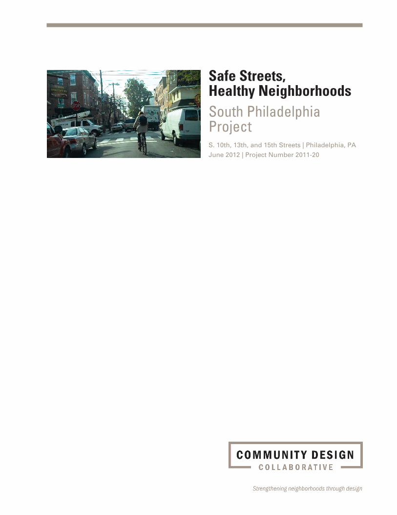
Safe Streets,Healthy NeighborhoodsSouth Philadelphia ProjectS. 10th, 13th, and 15th Streets | Philadelphia, PA June 2012 | Project Number 2011-20

© Community Design Collaborative, 2012
Safe Streets, Healthy NeighborhoodsSouth Philadelphia ProjectS. 10th, 13th, and 15th Streets | Philadelphia, PA June 2012 | Project Number 2011-20
Prepared for
Bicycle Coalition of Greater Philadelphia1500 Walnut Street, Suite 1107
Philadelphia, Pennsylvania 19102
Alex Doty, Executive Director
Susan Dannenberg, MCP,
Safe Streets, Healthy Neighborhoods Planner
Sarah Clark Stuart, Policy Director
Prepared by
Volunteers of the Community Design CollaborativeBrown & Keener, a division of RBA, Firm Volunteer
Mark Keener, AIA, AICP, Urban Designer
Neil Desai, AICP, Planner
LRSLA studio, Firm Volunteer
Julie Bush, ASLA, Reg. Landscape Architect
Frank Garnier, Renderer
Anita Toby Lager, ASLA, Reg. Landscape Architect
The RBA Group, Firm Volunteer
Linda Reardon, P.E., Civil Engineer
Jackson Wandres, Reg. Landscape Architect
About Us
The Community Design Collaborative is a community design
center that provides pro bono preliminary design services to
nonprofit organizations, offers unique volunteer opportuni-
ties for design professionals, and raises awareness about the
importance of design in community revitalization. Founded in
1991 as a program of AIA Philadelphia, the Collaborative is an
independent 501(c)(3) nonprofit organization with a network of
more than 1,000 volunteers.
The Collaborative awards grants of preliminary design ser-
vices to over 30 nonprofit organizations each year. Its service
grants are tailored to meet the specific facility and community
development needs of each nonprofit recipient. Through these
service grants, design professionals—volunteering their ser-
vices pro bono—help nonprofits communicate their goals for
rebuilding their neighborhoods through smart, innovative de-
sign. The Collaborative also brings together diverse partners,
stakeholders, and design disciplines to investigate important
themes in the revitalization of communities through its Infill
Philadelphia initiative.
The Collaborative relies on a variety of resources to achieve
its goal of assisting nonprofits in need of preliminary design
services. Our programs are supported through grants from
the William Penn Foundation, City of Philadelphia’s Office of
Housing and Community Development, City of Philadelphia’s
Department of Commerce, PNC Bank Foundation, Wells Fargo
Foundation, Connelly Foundation, and AIA Philadelphia.
The Collaborative also relies on the generous support of indi-
vidual and corporate donors for operational support. The Col-
laborative’s signature annual event is the Bowling Ball, which
raises funds through a night of bowling fun for firms, friends,
and fans. In addition, the Collaborative’s volunteers donate
hundreds of hours of in-kind services each year. To learn more
about the Collaborative, visit our website at www.cdesignc.
org or contact us at [email protected].
The Community Design Collaborative’s products are intended to provide visu-alconcepts and to assist in the preliminary phase of project design and planning. All drawings and construction budgeting figures are limited to conceptual de-sign and are neither intended nor may be used for construction. The Community Design Collaborative and our project volunteers assume no responsibility or li-ability for our services including the recommendations of our volunteers, the technical accuracy of our work product or for any unauthorized use.
Board of Directors
Mami Hara, ASLA, AICP, Co-Chair
Paul Sehnert, Co-Chair
Alice Berman, AIA
Brian Cohen
S. Michael Cohen
Cheryl Conley
Tavis Dockwiller, ASLA
Patrycja Doniewski, AIA
Daryn Edwards, AIA
Eva Gladstein
Jeff Goldstein, AIA
Eric Larsen, PE
Paul Marcus
Joe Matje, PE
Darrick M. Mix, Esq.
Michael J. Paul, PE
Kira Strong
Paul A. Vernon
Richard W. Winston, AIA
Pam Zimmerman, AIA
John Claypool, AIA, AICP Ex-officio
Staff
Elizabeth K. Miller
Linda Dottor, AICP
Robin Kohles, AIA
Heidi Segall Levy, AIA
Christopher Mohr
Table of Contents Safe Streets, Healthy NeighborhoodsSouth Philadelphia Project2011-20
IntroductionOverview
Project Location
Context
Existing ConditionsPhotos
Conceptual DesignDesign Discussion
Proposed Drawings
Description of ServicesValue of Services Donated
Letter of Agreement
Client Application

IntroductionOverview
Safe Streets, Healthy NeighborhoodsSouth Philadelphia Project2011-20
The Bicycle Coalition of Greater Philadelphia (BCGP) launched a new initiative called “Safe Streets, Healthy Neighbor-
hoods” in order to advance Philadelphia’s biking and walking facilities and increase safety. BCGP sought professional
assistance for creating designs and garnering community support for corridors that will safely connect neighborhoods
with the existing bike lane and regional trail network. They prioritized specific neighborhood corridors for design treat-
ment to make them better places for walking, biking, and transit. Due to a high level of bicycling, South Philadelphia is
BCGP’s first undertaking as part of this new initiative.
The Safe Streets, Healthy Neighborhoods: South Philadelphia Project was initiated through a service grant provided to
BCGP by the Community Design Collaborative (Collaborative). The goal for the volunteer Collaborative Design Team was
to prioritize specific neighborhood corridors in South Philadelphia and offer design solutions to make them better places
for walking, biking, and transit – expanding the potential of walking and cycling as a preferred travel mode for recreation,
commuting and for household errands, while increasing safety and quality of life for all users.
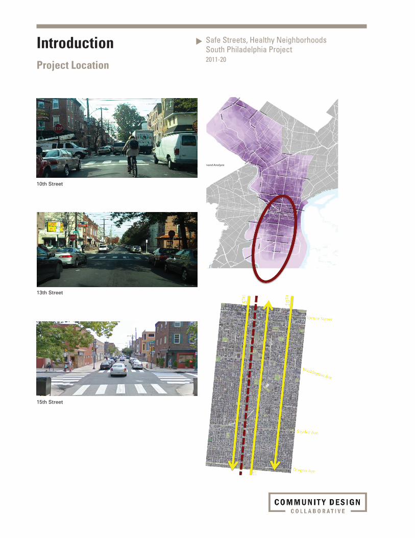
The Safe Streets, Healthy Neighborhoods: South Philadelphia Project AreaA “missing link” in the emerging city-wide network is the South Broad corridor – connecting the vital, complex South
Philadelphia neighborhoods with Center City commerce and new-economy Navy Yard jobs. This study is focused on the
Broad Street Corridor between City Hall and the Navy Yard. The task assigned to the Collaborative Design Team was to
design a way to accommodate bicycle travel along the South Broad Street Corridor between South Street and Oregon
Avenue. The assignment assumed that bikeway connections below Oregon are being mapped out and designed as part
of an ongoing Delaware Valley Regional Planning Commission project.
Project DefinitionPhiladelphia’s South Broad Street is an important gateway into the city for visitors, workers, shoppers, and residents, in-
cluding those arriving and departing from Philadelphia International Airport. It serves as a ceremonial place for parades
and celebrations. The street is active at all hours, heavily traveled by car, bus, pedestrians and subway. South Broad is
the de facto “main street” for numerous surrounding neighborhoods; and would be the logical, preferred north-south
route for cyclists except for:
• inflexibledimensionallimitationsthateliminatethepotentialfordedicatedbicyclelanes
• “fatalflaw”operationalconflictsintheblocksaboveSouthStreetespeciallyatbusstops.
As a result, the City and BCGP recommended that bike travel shift to the 13th/15th Street one-way pair. South bound
10th Street is also designated as a Bicycle-Friendly Street in the City’s plan. The elements of the bikeway facility shown
for 13th and 15th are recommended for 10th street as well.
The City of Philadelphia has been successful in implementing bicycling infrastructure improvements in Center City and
other neighborhoods by utilizing excess capacity. Where geometry allowed, the Philadelphia Streets Department has in-
corporated bike lanes into their repaving plans since the 1990s. In recent years, the Mayor’s Office of Transportation and
Utilities has extended the grid of bicycle infrastructure into Center City with the implementation of buffered bike lanes on
Spruce, Pine and 13th Streets. The bold move of removing automobile travel lanes to accomplish this showed vision and
provided much needed infrastructure for the burgeoning Philadelphia cycling population.
IntroductionOverview
Safe Streets, Healthy NeighborhoodsSouth Philadelphia Project2011-20
The challenge in South Philadelphia is that there is neither excess capacity, nor are there excess travel lanes. The tight
geometry of the predominantly residential streets offers a challenge for designing bicycle- and pedestrian-friendly infra-
structure to improve safety in this neighborhood with cycling rates over 5.5% overall and as high as 18% in some census
tracts. These high levels of cycling implore Philadelphia to find solutions to this difficult design problem. The ultimate
goal of the Safe Streets, Healthy Neighborhoods: South Philadelphia Project is to provide safe infrastructure that im-
proves the quality of life for all users of the street.
Process BCGP and the Collaborative formed a Task Force that included area neighborhood groups, and representatives of the
Philadelphia City Planning Commission, Philadelphia Streets Department, Philadelphia Water Department, Philadelphia
Parks & Recreation, Philadelphia City Council, state and local politicians, and the Mayor’s Office of Transportation and
Utilities.
The design services and recommendations offered by the Collaborative Design Team emerged from two public work-
shops and two technical working meetings (one with Philadelphia City Planning Commission, one with Philadelphia
Water Department) and two sessions with a Collaborative peer review group.
Work ProductsThe team created a number of products documenting the corridor and illustrating recommendations:
• MapoftheBroadStreet/13thStreet/15thStreetCorridor
• PowerPointpresentationforthepublicworkshopsshowingrelevantdesignstrategiesillustratedwith
examples from the U.S. and Europe
• Videoofwindshieldtourofthe13thStreetand15thStreetcorridors
• Planviewdrawingsshowing“Quick-start”recommendeddesignata“Typical”Block
• Planviewdrawingsshowingalongerterm“CompleteStreet”recommendeddesignata“Typical”
Block and a “Typical” intersection (2 options)
• Photosimulation-Mid-blockview:illustratingwhattherecommendeddesignelementsmightlooklike
• Photosimulation-Intersectionview:illustratingwhattherecommendeddesignelementsmightlook
like
• Narrativerecorddescribingprojectprocessandrecommendations
What’s Next?Based on the work of the Collaborative Design Team and the input of workshop participants and City staff, BCGP will
pursue funding and implementation of the Safe Streets, Healthy Neighborhoods: South Philadelphia Project in partner-
ship with the City of Philadelphia. Over the last decade, significant numbers of Philadelphians have shifted to bicycle
commuting and positioned Philadelphia as an excellent big city for biking. By building on these trends, Philadelphia has
the opportunity to transform itself into a world-class bicycling city.
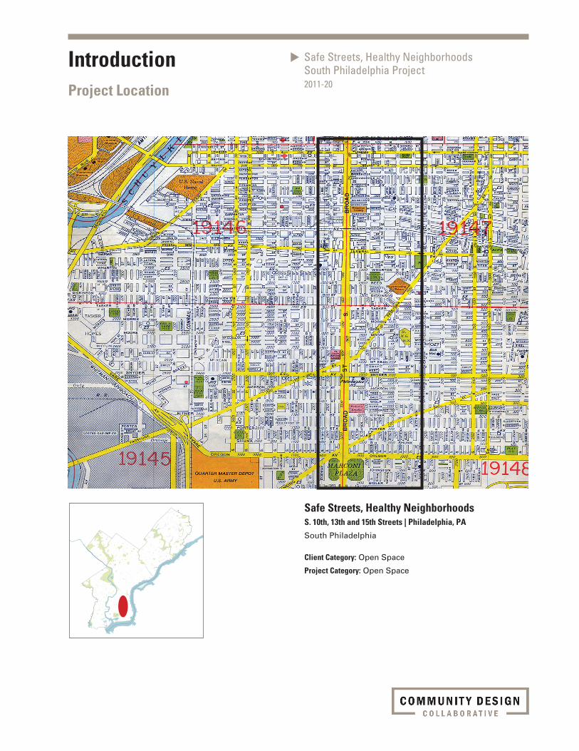
IntroductionProject Location
Safe Streets, Healthy NeighborhoodsSouth Philadelphia Project2011-20
Safe Streets, Healthy NeighborhoodsS. 10th, 13th and 15th Streets | Philadelphia, PA
South Philadelphia
Client Category: Open Space
Project Category: Open Space
Safe Streets, Healthy NeighborhoodsSouth Philadelphia Project2011-20
IntroductionProject Location
10th Street
13th Street
15th Street
IntroductionContext
Safe Streets, Healthy NeighborhoodsSouth Philadelphia Project2011-20
View looking northeast on Paschall Avenue
View looking northeast on Paschall Avenue
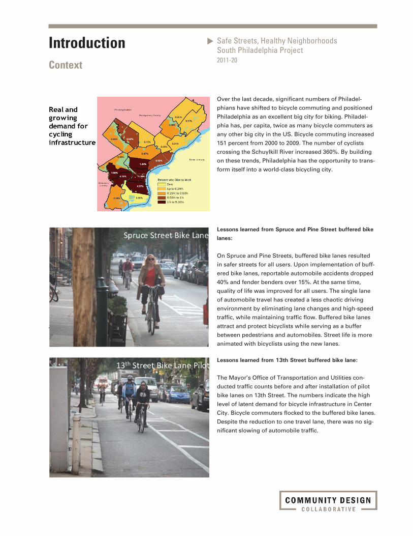
Over the last decade, significant numbers of Philadel-
phians have shifted to bicycle commuting and positioned
Philadelphia as an excellent big city for biking. Philadel-
phia has, per capita, twice as many bicycle commuters as
any other big city in the US. Bicycle commuting increased
151 percent from 2000 to 2009. The number of cyclists
crossing the Schuylkill River increased 360%. By building
on these trends, Philadelphia has the opportunity to trans-
form itself into a world-class bicycling city.
Lessons learned from Spruce and Pine Street buffered bike lanes:
On Spruce and Pine Streets, buffered bike lanes resulted
in safer streets for all users. Upon implementation of buff-
ered bike lanes, reportable automobile accidents dropped
40% and fender benders over 15%. At the same time,
quality of life was improved for all users. The single lane
of automobile travel has created a less chaotic driving
environment by eliminating lane changes and high-speed
traffic, while maintaining traffic flow. Buffered bike lanes
attract and protect bicyclists while serving as a buffer
between pedestrians and automobiles. Street life is more
animated with bicyclists using the new lanes.
Lessons learned from 13th Street buffered bike lane:
The Mayor’s Office of Transportation and Utilities con-
ducted traffic counts before and after installation of pilot
bike lanes on 13th Street. The numbers indicate the high
level of latent demand for bicycle infrastructure in Center
City. Bicycle commuters flocked to the buffered bike lanes.
Despite the reduction to one travel lane, there was no sig-
nificant slowing of automobile traffic.
IntroductionContext
Safe Streets, Healthy NeighborhoodsSouth Philadelphia Project2011-20
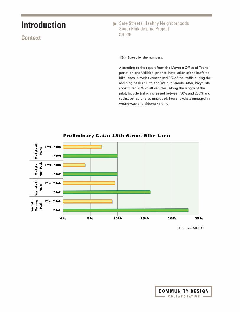
Source: MOTU
13th Street by the numbers:
According to the report from the Mayor’s Office of Trans-
portation and Utilities, prior to installation of the buffered
bike lanes, bicycles constituted 9% of the traffic during the
morning peak at 13th and Walnut Streets. After, bicyclists
constituted 23% of all vehicles. Along the length of the
pilot, bicycle traffic increased between 30% and 250% and
cyclist behavior also improved. Fewer cyclists engaged in
wrong-way and sidewalk riding.
Safe Streets, Healthy NeighborhoodsSouth Philadelphia Project2011-20
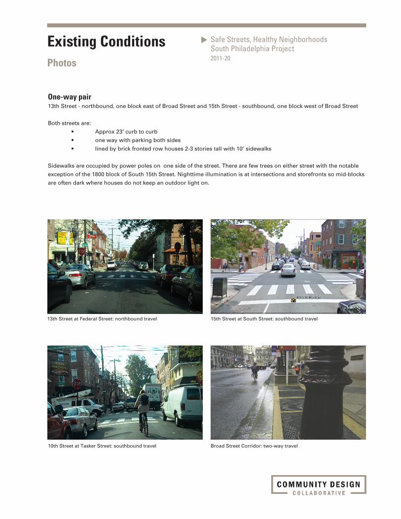
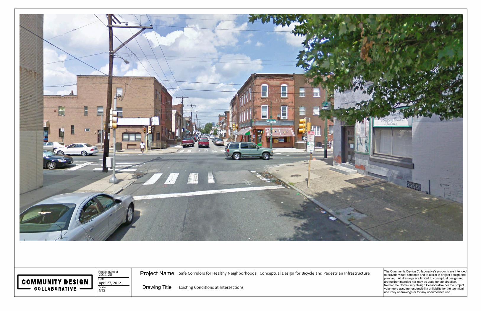
Existing ConditionsPhotos
13th Street at Federal Street: northbound travel
10th Street at Tasker Street: southbound travel
15th Street at South Street: southbound travel
Broad Street Corridor: two-way travel
One-way pair13th Street - northbound, one block east of Broad Street and 15th Street - southbound, one block west of Broad Street
Both streets are:
• Approx23’curbtocurb
• onewaywithparkingbothsides
• linedbybrickfrontedrowhouses2-3storiestallwith10’sidewalks
Sidewalks are occupied by power poles on one side of the street. There are few trees on either street with the notable
exception of the 1800 block of South 15th Street. Nighttime illumination is at intersections and storefronts so mid-blocks
are often dark where houses do not keep an outdoor light on.

Safe Streets, Healthy NeighborhoodsSouth Philadelphia Project2011-20
Design Discussion
Proposed Drawings
Conceptual Design

Safe Streets, Healthy NeighborhoodsSouth Philadelphia Project2011-20
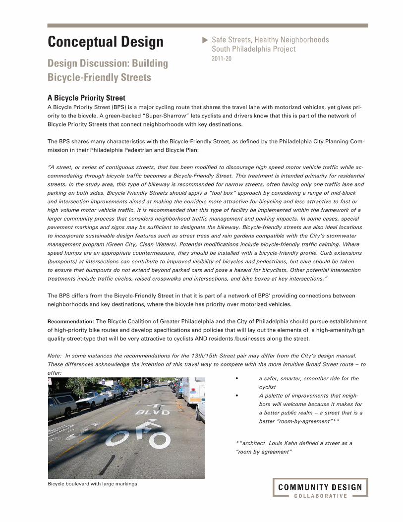
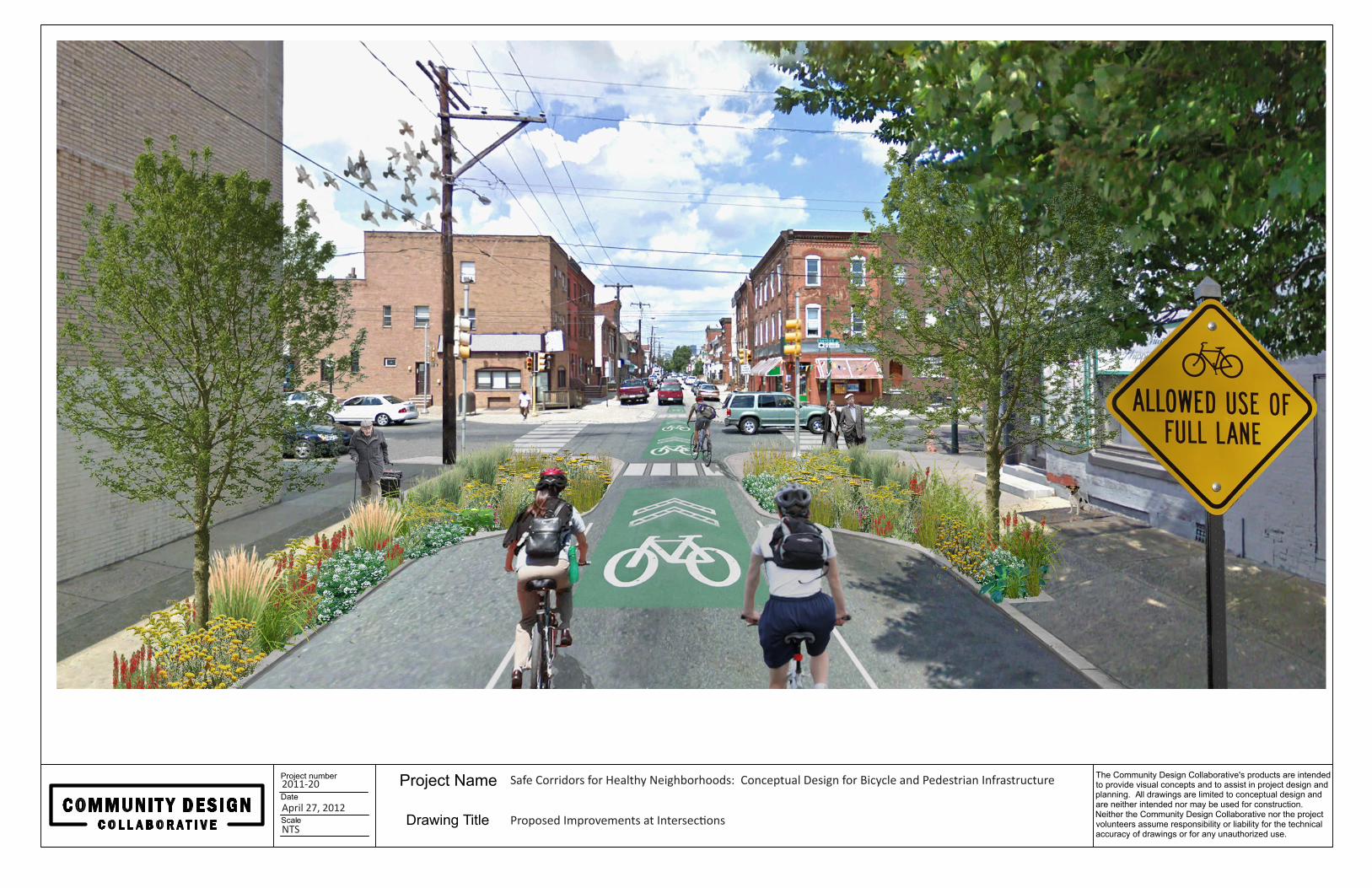
Bicycle boulevard with large markings
A Bicycle Priority Street A Bicycle Priority Street (BPS) is a major cycling route that shares the travel lane with motorized vehicles, yet gives pri-
ority to the bicycle. A green-backed “Super-Sharrow” lets cyclists and drivers know that this is part of the network of
Bicycle Priority Streets that connect neighborhoods with key destinations.
The BPS shares many characteristics with the Bicycle-Friendly Street, as defined by the Philadelphia City Planning Com-
mission in their Philadelphia Pedestrian and Bicycle Plan:
“A street, or series of contiguous streets, that has been modified to discourage high speed motor vehicle traffic while ac-commodating through bicycle traffic becomes a Bicycle-Friendly Street. This treatment is intended primarily for residential streets. In the study area, this type of bikeway is recommended for narrow streets, often having only one traffic lane and parking on both sides. Bicycle Friendly Streets should apply a “tool box” approach by considering a range of mid-block and intersection improvements aimed at making the corridors more attractive for bicycling and less attractive to fast or high volume motor vehicle traffic. It is recommended that this type of facility be implemented within the framework of a larger community process that considers neighborhood traffic management and parking impacts. In some cases, special pavement markings and signs may be sufficient to designate the bikeway. Bicycle-friendly streets are also ideal locations to incorporate sustainable design features such as street trees and rain gardens compatible with the City’s stormwater management program (Green City, Clean Waters). Potential modifications include bicycle-friendly traffic calming. Where speed humps are an appropriate countermeasure, they should be installed with a bicycle-friendly profile. Curb extensions (bumpouts) at intersections can contribute to improved visibility of bicycles and pedestrians, but care should be taken to ensure that bumpouts do not extend beyond parked cars and pose a hazard for bicyclists. Other potential intersection treatments include traffic circles, raised crosswalks and intersections, and bike boxes at key intersections.“
The BPS differs from the Bicycle-Friendly Street in that it is part of a network of BPS’ providing connections between
neighborhoods and key destinations, where the bicycle has priority over motorized vehicles.
Recommendation: The Bicycle Coalition of Greater Philadelphia and the City of Philadelphia should pursue establishment
of high-priority bike routes and develop specifications and policies that will lay out the elements of a high-amenity/high
quality street-type that will be very attractive to cyclists AND residents /businesses along the street.
Note: In some instances the recommendations for the 13th/15th Street pair may differ from the City’s design manual. These differences acknowledge the intention of this travel way to compete with the more intuitive Broad Street route – to offer:
Conceptual DesignDesign Discussion: Building Bicycle-Friendly Streets
• asafer,smarter,smootherrideforthe cyclist • Apaletteofimprovementsthatneigh- bors will welcome because it makes for a better public realm – a street that is a better “room-by-agreement”**
**architect Louis Kahn defined a street as a “room by agreement”
Safe Streets, Healthy NeighborhoodsSouth Philadelphia Project2011-20
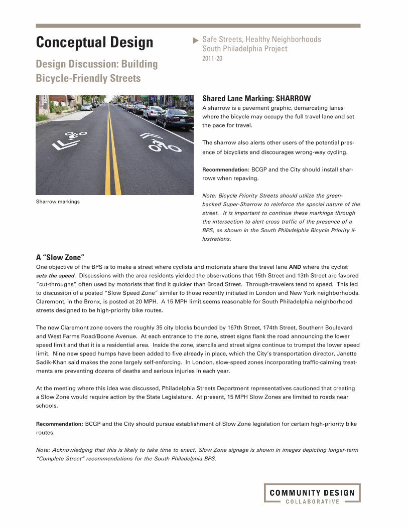
Sharrow markings
Shared Lane Marking: SHARROWA sharrow is a pavement graphic, demarcating lanes
where the bicycle may occupy the full travel lane and set
the pace for travel.
The sharrow also alerts other users of the potential pres-
ence of bicyclists and discourages wrong-way cycling.
Recommendation: BCGP and the City should install shar-
rows when repaving.
Note: Bicycle Priority Streets should utilize the green-backed Super-Sharrow to reinforce the special nature of the street. It is important to continue these markings through the intersection to alert cross traffic of the presence of a BPS, as shown in the South Philadelphia Bicycle Priority il-lustrations.
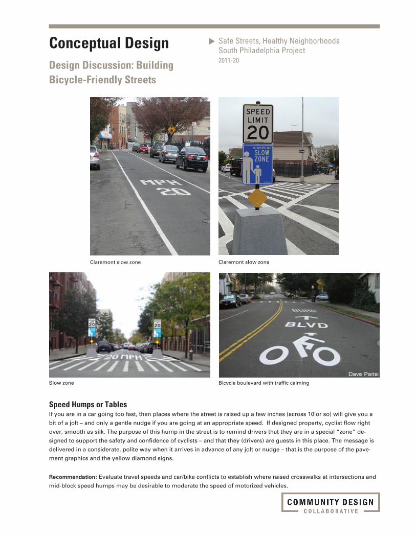
A “Slow Zone”One objective of the BPS is to make a street where cyclists and motorists share the travel lane AND where the cyclist
sets the speed. Discussions with the area residents yielded the observations that 15th Street and 13th Street are favored
“cut-throughs” often used by motorists that find it quicker than Broad Street. Through-travelers tend to speed. This led
to discussion of a posted “Slow Speed Zone” similar to those recently initiated in London and New York neighborhoods.
Claremont, in the Bronx, is posted at 20 MPH. A 15 MPH limit seems reasonable for South Philadelphia neighborhood
streets designed to be high-priority bike routes.
The new Claremont zone covers the roughly 35 city blocks bounded by 167th Street, 174th Street, Southern Boulevard
and West Farms Road/Boone Avenue. At each entrance to the zone, street signs flank the road announcing the lower
speed limit and that it is a residential area. Inside the zone, stencils and street signs continue to trumpet the lower speed
limit. Nine new speed humps have been added to five already in place, which the City’s transportation director, Janette
Sadik-Khan said makes the zone largely self-enforcing. In London, slow-speed zones incorporating traffic-calming treat-
ments are preventing dozens of deaths and serious injuries in each year.
At the meeting where this idea was discussed, Philadelphia Streets Department representatives cautioned that creating
a Slow Zone would require action by the State Legislature. At present, 15 MPH Slow Zones are limited to roads near
schools.
Recommendation: BCGP and the City should pursue establishment of Slow Zone legislation for certain high-priority bike
routes.
Note: Acknowledging that this is likely to take time to enact, Slow Zone signage is shown in images depicting longer-term “Complete Street” recommendations for the South Philadelphia BPS.
Conceptual DesignDesign Discussion: Building Bicycle-Friendly Streets
Safe Streets, Healthy NeighborhoodsSouth Philadelphia Project2011-20
Claremont slow zone Claremont slow zone
Slow zone Bicycle boulevard with traffic calming
Speed Humps or TablesIf you are in a car going too fast, then places where the street is raised up a few inches (across 10’or so) will give you a
bit of a jolt – and only a gentle nudge if you are going at an appropriate speed. If designed property, cyclist flow right
over, smooth as silk. The purpose of this hump in the street is to remind drivers that they are in a special “zone” de-
signed to support the safety and confidence of cyclists – and that they (drivers) are guests in this place. The message is
delivered in a considerate, polite way when it arrives in advance of any jolt or nudge – that is the purpose of the pave-
ment graphics and the yellow diamond signs.
Recommendation: Evaluate travel speeds and car/bike conflicts to establish where raised crosswalks at intersections and
mid-block speed humps may be desirable to moderate the speed of motorized vehicles.
Conceptual DesignDesign Discussion: Building Bicycle-Friendly Streets
Safe Streets, Healthy NeighborhoodsSouth Philadelphia Project2011-20
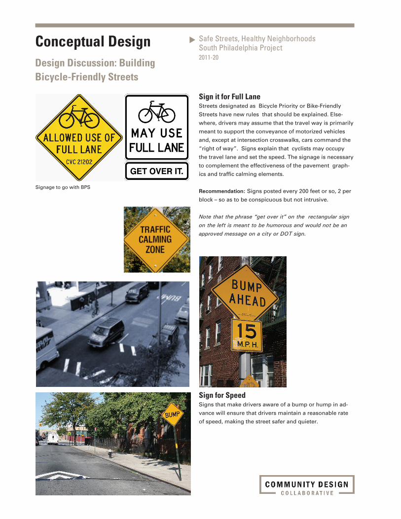
Sign it for Full LaneStreets designated as Bicycle Priority or Bike-Friendly
Streets have new rules that should be explained. Else-
where, drivers may assume that the travel way is primarily
meant to support the conveyance of motorized vehicles
and, except at intersection crosswalks, cars command the
“right of way”. Signs explain that cyclists may occupy
the travel lane and set the speed. The signage is necessary
to complement the effectiveness of the pavement graph-
ics and traffic calming elements.
Recommendation: Signs posted every 200 feet or so, 2 per
block – so as to be conspicuous but not intrusive.
Note that the phrase “get over it” on the rectangular sign on the left is meant to be humorous and would not be an approved message on a city or DOT sign.
Signage to go with BPS
Sign for SpeedSigns that make drivers aware of a bump or hump in ad-
vance will ensure that drivers maintain a reasonable rate
of speed, making the street safer and quieter.
Conceptual DesignDesign Discussion: Building Bicycle-Friendly Streets
Safe Streets, Healthy NeighborhoodsSouth Philadelphia Project2011-20
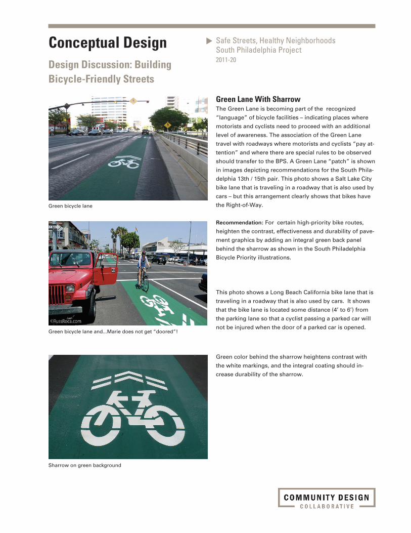
Green Lane With SharrowThe Green Lane is becoming part of the recognized
“language” of bicycle facilities – indicating places where
motorists and cyclists need to proceed with an additional
level of awareness. The association of the Green Lane
travel with roadways where motorists and cyclists “pay at-
tention” and where there are special rules to be observed
should transfer to the BPS. A Green Lane “patch” is shown
in images depicting recommendations for the South Phila-
delphia 13th / 15th pair. This photo shows a Salt Lake City
bike lane that is traveling in a roadway that is also used by
cars – but this arrangement clearly shows that bikes have
the Right-of-Way.
Recommendation: For certain high-priority bike routes,
heighten the contrast, effectiveness and durability of pave-
ment graphics by adding an integral green back panel
behind the sharrow as shown in the South Philadelphia
Bicycle Priority illustrations.
This photo shows a Long Beach California bike lane that is
traveling in a roadway that is also used by cars. It shows
that the bike lane is located some distance (4’ to 6’) from
the parking lane so that a cyclist passing a parked car will
not be injured when the door of a parked car is opened.
Green bicycle lane
Green bicycle lane and...Marie does not get “doored”!
Sharrow on green background
Green color behind the sharrow heightens contrast with
the white markings, and the integral coating should in-
crease durability of the sharrow.
Conceptual DesignDesign Discussion: Building Bicycle-Friendly Streets
Safe Streets, Healthy NeighborhoodsSouth Philadelphia Project2011-20
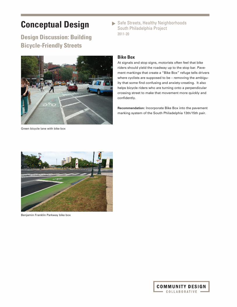
Green bicycle lane with bike box
Benjamin Franklin Parkway bike box
Bike BoxAt signals and stop signs, motorists often feel that bike
riders should yield the roadway up to the stop bar. Pave-
ment markings that create a “Bike Box” refuge tells drivers
where cyclists are supposed to be – removing the ambigu-
ity that some find confusing and anxiety-creating. It also
helps bicycle riders who are turning onto a perpendicular
crossing street to make that movement more quickly and
confidently.
Recommendation: Incorporate Bike Box into the pavement
marking system of the South Philadelphia 13th/15th pair.
Conceptual DesignDesign Discussion: Building Bicycle-Friendly Streets
Safe Streets, Healthy NeighborhoodsSouth Philadelphia Project2011-20
Bump with on-street parking
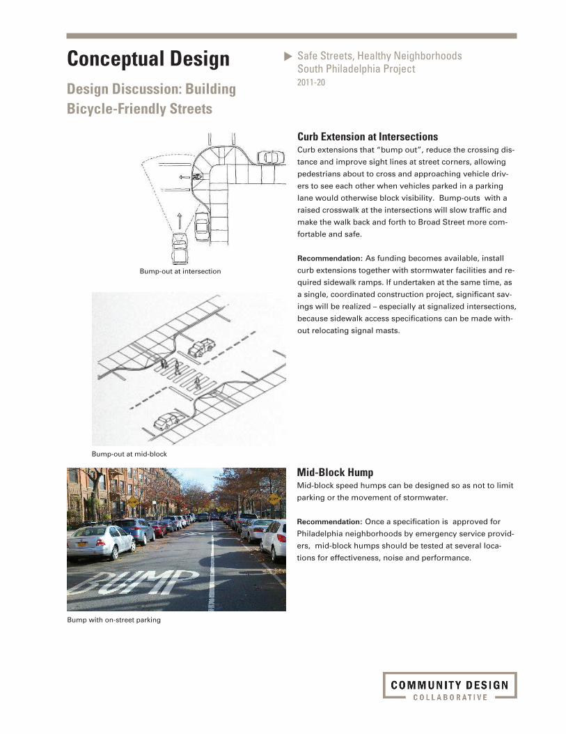
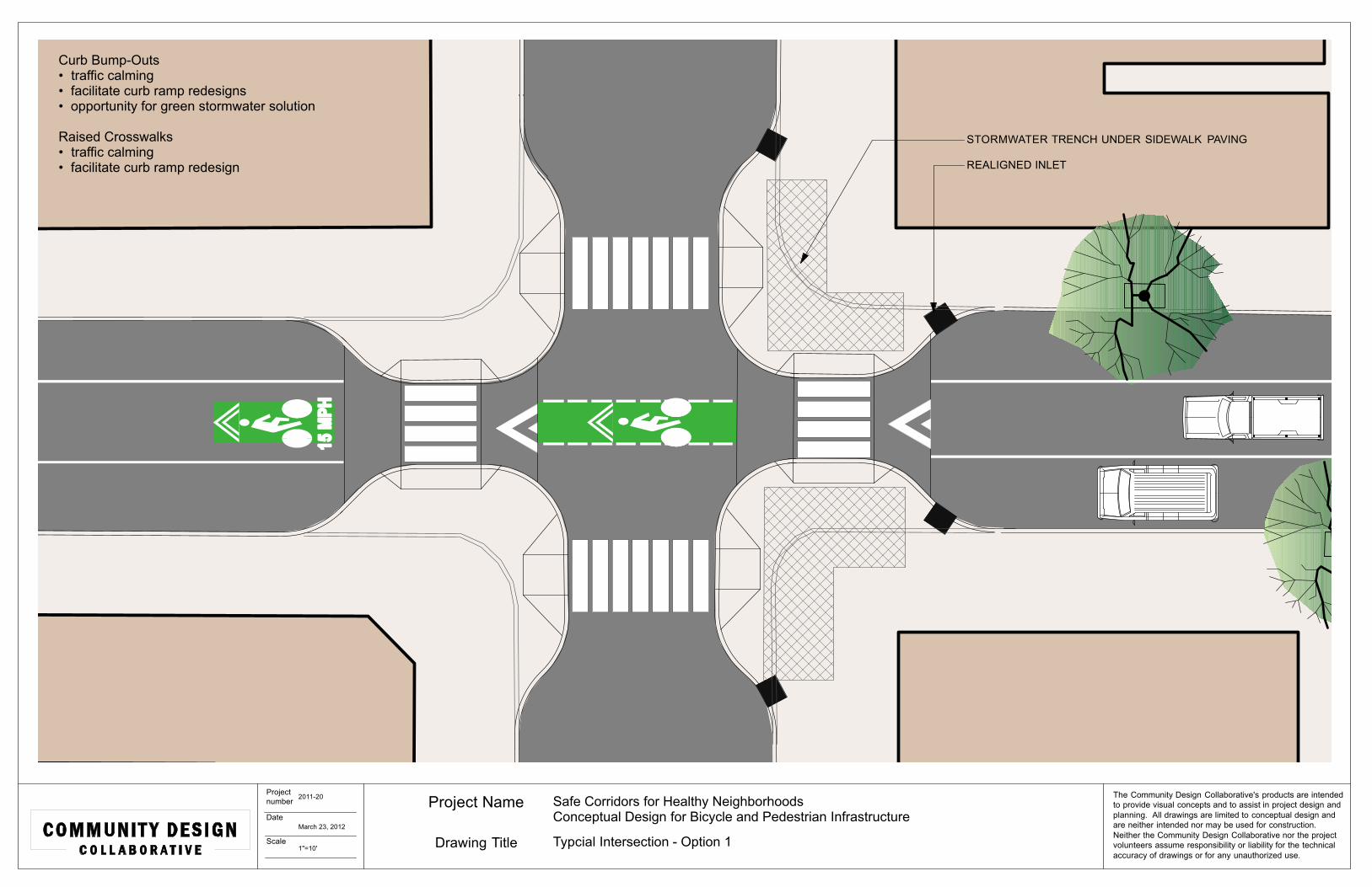
Curb Extension at IntersectionsCurb extensions that “bump out”, reduce the crossing dis-
tance and improve sight lines at street corners, allowing
pedestrians about to cross and approaching vehicle driv-
ers to see each other when vehicles parked in a parking
lane would otherwise block visibility. Bump-outs with a
raised crosswalk at the intersections will slow traffic and
make the walk back and forth to Broad Street more com-
fortable and safe.
Recommendation: As funding becomes available, install
curb extensions together with stormwater facilities and re-
quired sidewalk ramps. If undertaken at the same time, as
a single, coordinated construction project, significant sav-
ings will be realized – especially at signalized intersections,
because sidewalk access specifications can be made with-
out relocating signal masts.
Mid-Block HumpMid-block speed humps can be designed so as not to limit
parking or the movement of stormwater.
Recommendation: Once a specification is approved for
Philadelphia neighborhoods by emergency service provid-
ers, mid-block humps should be tested at several loca-
tions for effectiveness, noise and performance.
Bump-out at intersection
Bump-out at mid-block
Conceptual DesignDesign Discussion: Building Bicycle-Friendly Streets
Safe Streets, Healthy NeighborhoodsSouth Philadelphia Project2011-20
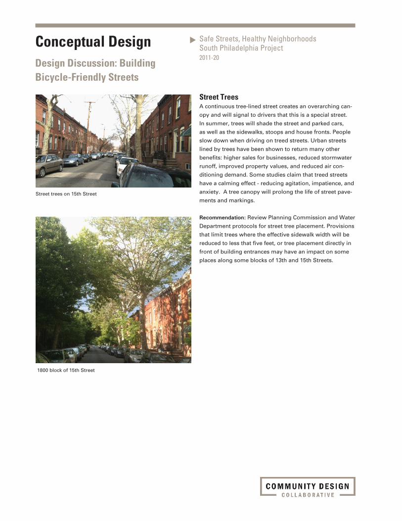
Street TreesA continuous tree-lined street creates an overarching can-
opy and will signal to drivers that this is a special street.
In summer, trees will shade the street and parked cars,
as well as the sidewalks, stoops and house fronts. People
slow down when driving on treed streets. Urban streets
lined by trees have been shown to return many other
benefits: higher sales for businesses, reduced stormwater
runoff, improved property values, and reduced air con-
ditioning demand. Some studies claim that treed streets
have a calming effect - reducing agitation, impatience, and
anxiety. A tree canopy will prolong the life of street pave-
ments and markings.
Recommendation: Review Planning Commission and Water
Department protocols for street tree placement. Provisions
that limit trees where the effective sidewalk width will be
reduced to less that five feet, or tree placement directly in
front of building entrances may have an impact on some
places along some blocks of 13th and 15th Streets.
Street trees on 15th Street
1800 block of 15th Street
Conceptual DesignDesign Discussion: Building Bicycle-Friendly Streets
Southwest Community Development CorporationConceptual Design for Facility Improvements2009-06
Conceptual DesignDesign Discussion: Building Bicycle-Friendly Streets
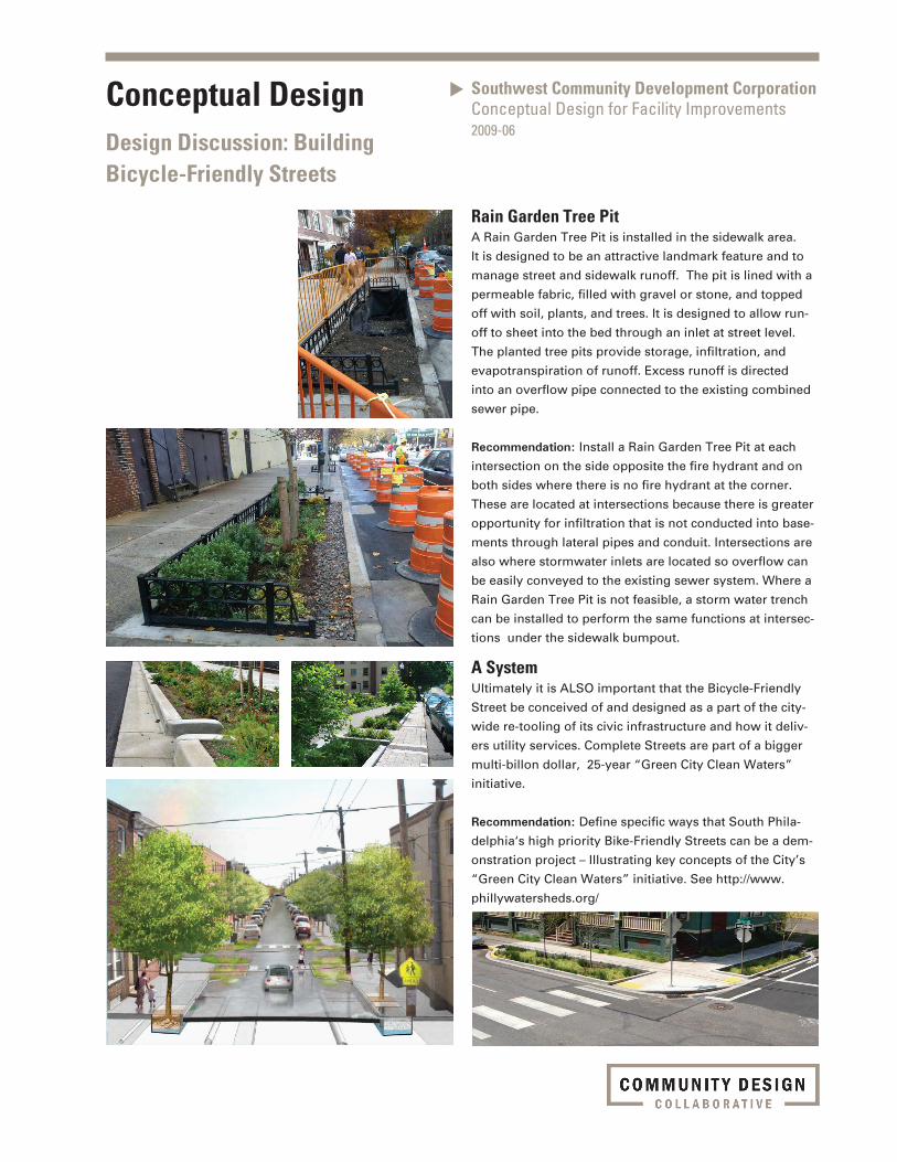
Rain Garden Tree Pit A Rain Garden Tree Pit is installed in the sidewalk area.
It is designed to be an attractive landmark feature and to
manage street and sidewalk runoff. The pit is lined with a
permeable fabric, filled with gravel or stone, and topped
off with soil, plants, and trees. It is designed to allow run-
off to sheet into the bed through an inlet at street level.
The planted tree pits provide storage, infiltration, and
evapotranspiration of runoff. Excess runoff is directed
into an overflow pipe connected to the existing combined
sewer pipe.
Recommendation: Install a Rain Garden Tree Pit at each
intersection on the side opposite the fire hydrant and on
both sides where there is no fire hydrant at the corner.
These are located at intersections because there is greater
opportunity for infiltration that is not conducted into base-
ments through lateral pipes and conduit. Intersections are
also where stormwater inlets are located so overflow can
be easily conveyed to the existing sewer system. Where a
Rain Garden Tree Pit is not feasible, a storm water trench
can be installed to perform the same functions at intersec-
tions under the sidewalk bumpout.
A System Ultimately it is ALSO important that the Bicycle-Friendly
Street be conceived of and designed as a part of the city-
wide re-tooling of its civic infrastructure and how it deliv-
ers utility services. Complete Streets are part of a bigger
multi-billon dollar, 25-year “Green City Clean Waters”
initiative.
Recommendation: Define specific ways that South Phila-
delphia‘s high priority Bike-Friendly Streets can be a dem-
onstration project – Illustrating key concepts of the City’s
“Green City Clean Waters” initiative. See http://www.
phillywatersheds.org/
Safe Streets, Healthy NeighborhoodsSouth Philadelphia Project2011-20
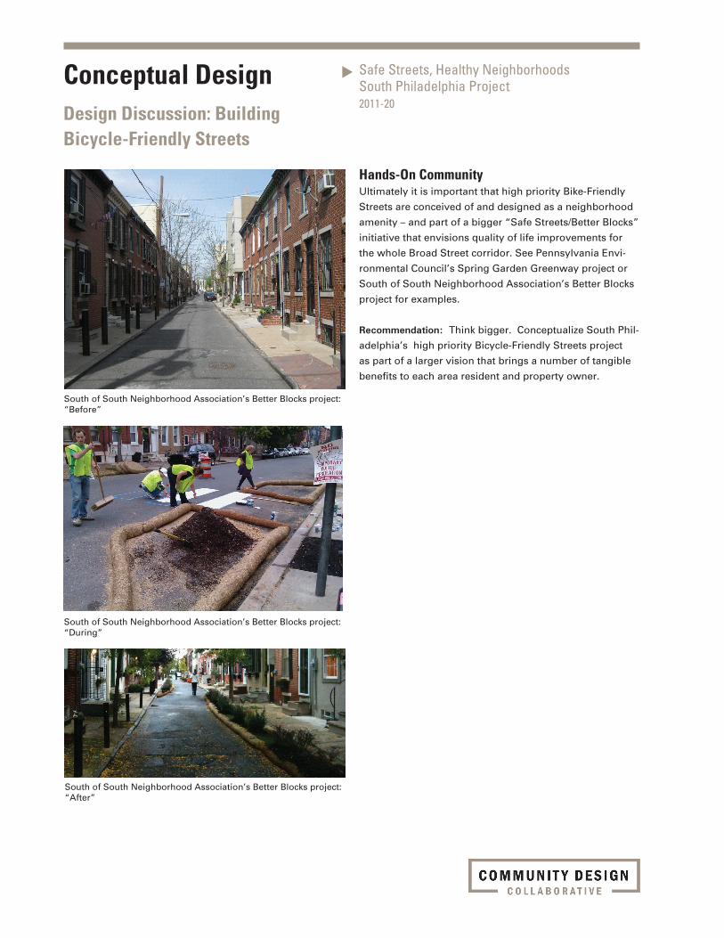
Hands-On CommunityUltimately it is important that high priority Bike-Friendly
Streets are conceived of and designed as a neighborhood
amenity – and part of a bigger “Safe Streets/Better Blocks”
initiative that envisions quality of life improvements for
the whole Broad Street corridor. See Pennsylvania Envi-
ronmental Council’s Spring Garden Greenway project or
South of South Neighborhood Association’s Better Blocks
project for examples.
Recommendation: Think bigger. Conceptualize South Phil-
adelphia’s high priority Bicycle-Friendly Streets project
as part of a larger vision that brings a number of tangible
benefits to each area resident and property owner.
South of South Neighborhood Association’s Better Blocks project: “Before”
South of South Neighborhood Association’s Better Blocks project: “During”
South of South Neighborhood Association’s Better Blocks project: “After”
Conceptual DesignDesign Discussion: Building Bicycle-Friendly Streets
Safe Streets, Healthy NeighborhoodsSouth Philadelphia Project2011-20
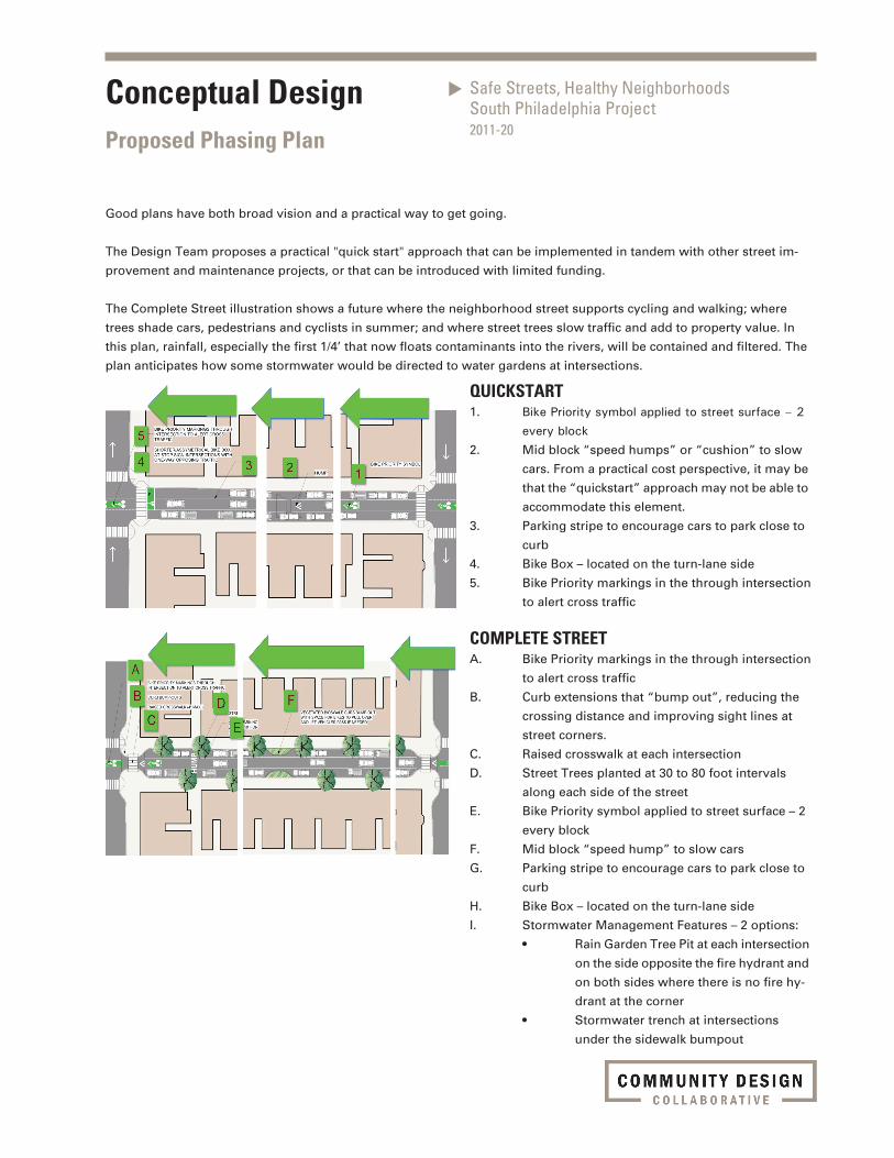
Conceptual DesignProposed Phasing Plan
QUICKSTART1. Bike Priority symbol applied to street surface – 2 every block2. Mid block “speed humps” or “cushion” to slow
cars. From a practical cost perspective, it may be
that the “quickstart” approach may not be able to
accommodate this element.
3. Parking stripe to encourage cars to park close to
curb
4. Bike Box – located on the turn-lane side
5. Bike Priority markings in the through intersection
to alert cross traffic
COMPLETE STREETA. Bike Priority markings in the through intersection
to alert cross traffic
B. Curb extensions that “bump out”, reducing the
crossing distance and improving sight lines at
street corners.
C. Raised crosswalk at each intersection
D. Street Trees planted at 30 to 80 foot intervals
along each side of the street
E. Bike Priority symbol applied to street surface – 2
every block
F. Mid block “speed hump” to slow cars
G. Parking stripe to encourage cars to park close to
curb
H. Bike Box – located on the turn-lane side
I. Stormwater Management Features – 2 options:
• RainGardenTreePitateachintersection
on the side opposite the fire hydrant and
on both sides where there is no fire hy-
drant at the corner
• Stormwatertrenchatintersections
under the sidewalk bumpout
Good plans have both broad vision and a practical way to get going.
The Design Team proposes a practical "quick start" approach that can be implemented in tandem with other street im-
provement and maintenance projects, or that can be introduced with limited funding.
The Complete Street illustration shows a future where the neighborhood street supports cycling and walking; where
trees shade cars, pedestrians and cyclists in summer; and where street trees slow traffic and add to property value. In
this plan, rainfall, especially the first 1/4’ that now floats contaminants into the rivers, will be contained and filtered. The
plan anticipates how some stormwater would be directed to water gardens at intersections.

Safe Streets, Healthy NeighborhoodsSouth Philadelphia Project2011-20
Conceptual DesignProposed Drawings

15 M
PH
15 M
PH
15 M
PH
15 M
PH
The Community Design Collaborative's products are intended to provide visual concepts and to assist in project design and planning. All drawings are limited to conceptual design and are neither intended nor may be used for construction. Neither the Community Design Collaborative nor the project volunteers assume responsibility or liability for the technical accuracy of drawings or for any unauthorized use.
Project number
Date
Scale
Project Name Safe Corridors for Healthy Neighborhoods Conceptual Design for Bicycle and Pedestrian Infrastructure
Drawing Title Typicial Block Recommendations - Quick Start
2011-20
1"=40'
4. BIKE PRIORITY MARKINGS THROUGH INTERSECTION TO ALERT CROSS TRAFFIC
3. SHORTER/ASSYMETRICAL BIKE BOX AT STOP SIGN INTERSECTIONS WITH ONE-WAY OPPOSING TRAFFIC
1. BIKE PRIORITY SYMBOL
2. SOLID WHITE LINES DELINEATING PARKING AND NARROWING TRAVEL LANE TO 10' FOR TRAFFIC CALMING PURPOSES
March 23, 2012
3. CURB TO CURB BIKE BOX AT NTERSECTIONS WITH TWO-WAY OPPOSING TRAFFIC

15 M
PH
HUMP
15 M
PH
15 M
PH
15 M
PH
Project number
Date
Scale
Project Name Safe Corridors for Healthy Neighborhoods Conceptual Design for Bicycle and Pedestrian Infrastructure
Drawing Title Typicial Block Recommendations - Complete Street
2011-20
March 23, 2012
1"=40'
A. BIKE PRIORITY MARKINGS THROUGH INTERSECTION TO ALERT CROSS TRAFFIC
B. CURB BUMP-OUTS
C. RAISED CROSSWALK (4" MAX.)
D. STREET TREES
F. VEGETATED BIOSWALE CURB BUMP-OUT WITH SPACE FOR BIKES TO PULL OVER AND LET VEHICLES PASS IF NEEDED
G. SOLID WHITE LINES DELINEATING PARKING AND NARROWING TRAVEL LANE TO 10' FOR TRAFFIC CALMING PURPOSES
H. MID-BLOCK SPEED CUSHION IN 600' LONG BLOCKS
The Community Design Collaborative's products are intended to provide visual concepts and to assist in project design and planning. All drawings are limited to conceptual design and are neither intended nor may be used for construction. Neither the Community Design Collaborative nor the project volunteers assume responsibility or liability for the technical accuracy of drawings or for any unauthorized use.

HUMP
15 M
PH
The Community Design Collaborative's products are intended to provide visual concepts and to assist in project design and planning. All drawings are limited to conceptual design and are neither intended nor may be used for construction. Neither the Community Design Collaborative nor the project volunteers assume responsibility or liability for the technical accuracy of drawings or for any unauthorized use.
Project number
Date
Scale
Project Name
Drawing Title
Safe Corridors for Healthy Neighborhoods Conceptual Design for Bicycle and Pedestrian Infrastructure
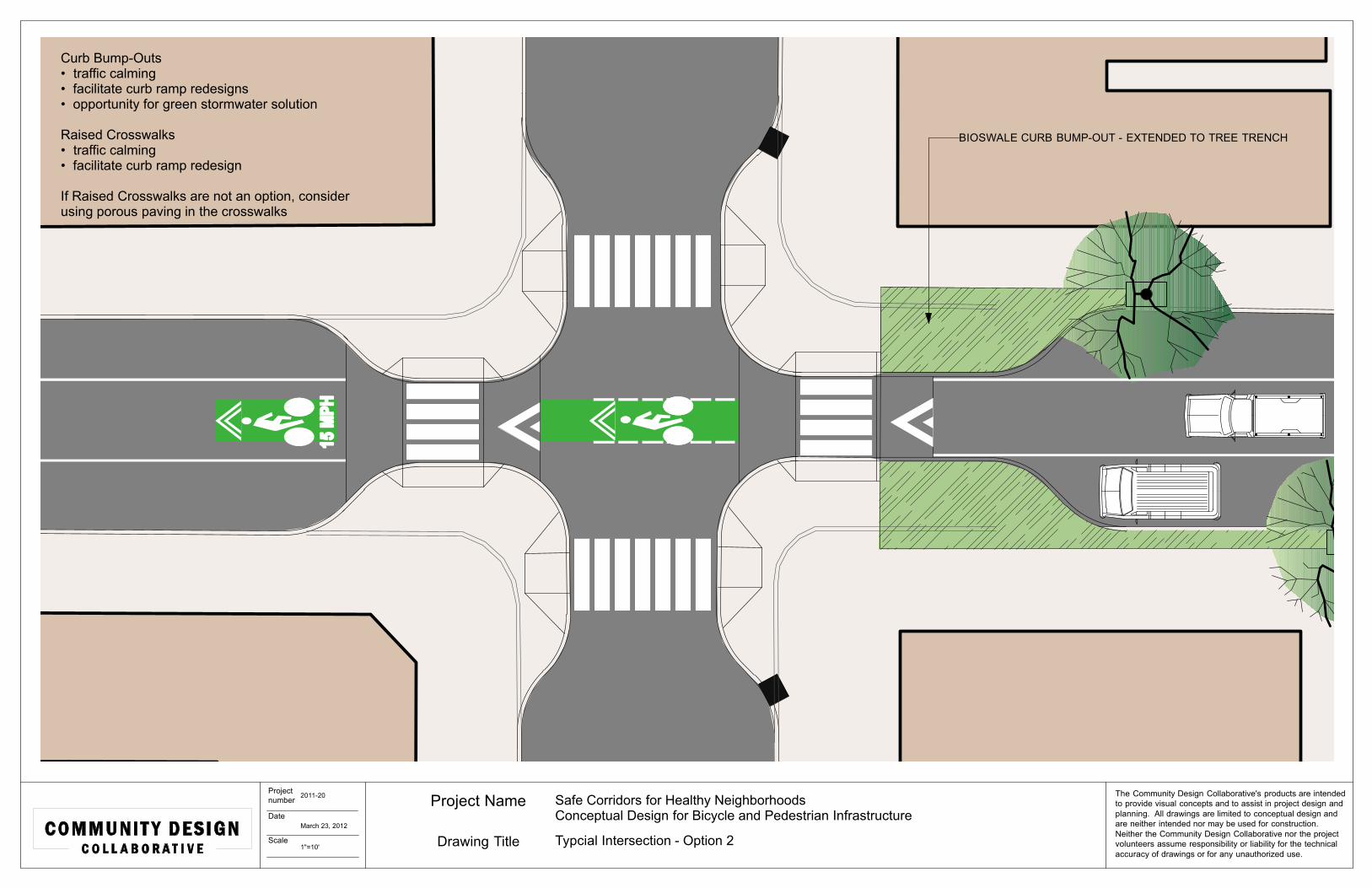
Typcial Intersection - Option 1
Curb Bump-Outs• traffic calming• facilitate curb ramp redesigns• opportunity for green stormwater solution
Raised Crosswalks• traffic calming• facilitate curb ramp redesign
STORMWATER TRENCH UNDER SIDEWALK PAVING
REALIGNED INLET
2011-20
March 23, 2012
1"=10'

HUMP
15 M
PH
The Community Design Collaborative's products are intended to provide visual concepts and to assist in project design and planning. All drawings are limited to conceptual design and are neither intended nor may be used for construction. Neither the Community Design Collaborative nor the project volunteers assume responsibility or liability for the technical accuracy of drawings or for any unauthorized use.
Project number
Date
Scale
Project Name
Drawing Title
Safe Corridors for Healthy Neighborhoods Conceptual Design for Bicycle and Pedestrian Infrastructure
Typcial Intersection - Option 2
Curb Bump-Outs• traffic calming• facilitate curb ramp redesigns• opportunity for green stormwater solution
Raised Crosswalks• traffic calming• facilitate curb ramp redesign
If Raised Crosswalks are not an option, consider using porous paving in the crosswalks
BIOSWALE CURB BUMP-OUT - EXTENDED TO TREE TRENCH
2011-20
March 23, 2012
1"=10'

The Community Design Collaborative's products are intended to provide visual concepts and to assist in project design and planning. All drawings are limited to conceptual design and are neither intended nor may be used for construction. Neither the Community Design Collaborative nor the project volunteers assume responsibility or liability for the technical accuracy of drawings or for any unauthorized use.
Project number
Date
Scale
Project Name
Drawing Title
Safe Corridors for Healthy Neighborhoods: Conceptual Design for Bicycle and Pedestrian Infrastructure
Existing Conditions at Intersections
2011-20
April 27, 2012
NTS

The Community Design Collaborative's products are intended to provide visual concepts and to assist in project design and planning. All drawings are limited to conceptual design and are neither intended nor may be used for construction. Neither the Community Design Collaborative nor the project volunteers assume responsibility or liability for the technical accuracy of drawings or for any unauthorized use.
Project number
Date
Scale
Project Name
Drawing Title
Safe Corridors for Healthy Neighborhoods: Conceptual Design for Bicycle and Pedestrian Infrastructure
Proposed Improvements at Intersections
2011-20
April 27, 2012
NTS

The Community Design Collaborative's products are intended to provide visual concepts and to assist in project design and planning. All drawings are limited to conceptual design and are neither intended nor may be used for construction. Neither the Community Design Collaborative nor the project volunteers assume responsibility or liability for the technical accuracy of drawings or for any unauthorized use.
Project number
Date
Scale
Project Name
Drawing Title
Safe Corridors for Healthy Neighborhoods: Conceptual Design for Bicycle and Pedestrian Infrastructure2011-20
April 27, 2012
NTSProposed Improvements at mid-block