safe locations for vehicles (primarily commercial motor
TRANSCRIPT


This project is intended to design 3 chain-up stations
along the US 285 and CO 9 corridors that will provide
safe locations for vehicles (primarily Commercial Motor
Vehicles) to mount tire chains prior to both Kenosha Pass
and Hoosier Pass. These locations improve driver
compliance with the chain law, allow CSP to enforce the
chain law when active and result improved traffic
operations of these highways (Fewer back ups and
closures).

The design and construction of these three locations is
paid for using Federal Freight Funding. So, while there is
some flexibility in the design of these stations, Federal
Freight funding does have specific limits what types of
improvement can built using them
1) Hoosier Pass/CO 9 – design of two chain-up
stations on each direction of CO 9, one on
southbound direction CO 9 in the Town of Blue
River in Summit County (CDOT Region 3) and one
on northbound direction of CO 9 in the Town of
Alma in Park County (CDOT Region 2)
2) Kenosha Pass/US 285 – design of one chain-up
station on southbound US 285 (CDOT Region 2)
near the unincorporated community of Grant.

The overarching purpose of this project is to improve both safety and traffic operations on
both CO 9 and US 285 when:
Winter Traveling conditions warrant the use of vehicle traction devices on the steep grades
of Hoosier Pass and Kenosha Pass.
On several occasions when I-70 is dealing with traffic incidents, inclement weather or
closures, Drivers use the combination of CO 9 and US 285 as an alternate route into and
out of the Mountains.
By improving compliance of commercial motor vehicles with the chain law helps to reduce
major backups and closures along these corridors.

Responding to stranded trucks requires CDOT maintenance forces to focus their efforts
to get the truck moving or into a save location out of traffic which pulls their
attention away from snow removal operations.
In extreme situations, Truck Heavy Tow vehicles need to be dispatched which can
result in closures until the truck can be moved.
A designated, safe pull-off encourages voluntary compliance from CMV drivers to
mount tire chains during the chain law.
without safe pull outs law enforcement is not willing to enforce the to issue citations
that result in fines
Corridors that do not provide safe locations for CMV driver to chain-up, CSP is not
willing, nor do they have the ability to safely enforce the chain law.

Looking at if from a corridor safety perspective, well designed chain-up stations will.
Minimize occurrences of trucks chaining up in unsafe locations (partially blocking travel
lanes, driveways or side streets)
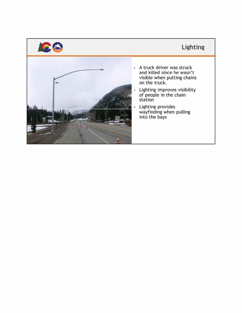
Reduces the personal exposure of truck drivers to safety concerns while they are focused
on installing tire chains
Minimizes the time it takes for maintenance to implement the chain law, and reduces their
exposure to safety issues through the use of ITS signs that can be turned on automatically.
Provides safe egress from the adjacent highway and safe ingress back into traffic when
they have finished installing their tire chains
Reduced the posted speed limit by 10 MPH every time the chain law is implemented. This
is done using variable speed limit sighs. This speed limit reduction is absolutely
enforceable because the time and dates are tracked along with the chain law.
From an environmental point of view, Chain stations have been shown to have positive

impacts to
noise
air quality
Water quality
A designated chain station encourages drivers to chain up and ultimately avoid crashes and
potential HAZMAT situations.
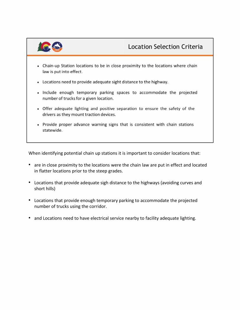
When identifying potential chain up stations it is important to consider locations that:
• are in close proximity to the locations were the chain law are put in effect and located
in flatter locations prior to the steep grades.
• Locations that provide adequate sigh distance to the highways (avoiding curves and
short hills)
• Locations that provide enough temporary parking to accommodate the projected
number of trucks using the corridor.
• and Locations need to have electrical service nearby to facility adequate lighting.

The things that need to be avoided when selecting chain-up station locations are:
• multiple small chain station locations
• Locations that may allow CMVs stopping on the road
• Locations that would create larger impact to the environmental (tree
removal, large cuts into the slope and potentially creating physical barriers
for wildlife.
• Locations that adversely impact access points for residential driveways and
side streets.

This Slide provides a quick overview of how chain-up stations work:
• Only used when chain law is in effect.
• Trucks have up to 30 minutes to chain up.
• Long term parking is not allowed
• Chain law enforcement typically by CSP, but have also utilized local law
enforcement through IGAs
• Trucks without traction devices can be turned around.
• Trash and snow removal by CDOT.
• Lighting to be in use only when needed (nighttime and during low visibility)


This Slide provides an overview of traffic conditions on CO 9
The Bar chart on the left side of the slide shows the Annual Average Daily Traffic for
Southbound CO 9 during the winter months
The number in the blue portions is the number of passenger vehicles
The number in grey is the number of trucks.
As you can see the average daily traffic grows steadily between between 2016 and
2018 (approximately 600 vehicles each year) and seems to level off a bit between
2018 and 2019.
On the Right side of the slide, we can see the Annual Average Daily Traffic for both
directions of CO 9 during the winter months.
Again, the blue is passenger vehicles, and the grey is the number of trucks.
Looking total traffic on CO 9 we see a steady increase each year between 2016 and
2019.
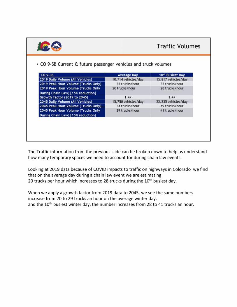
The Traffic information from the previous slide can be broken down to help us understand
how many temporary spaces we need to account for during chain law events.
Looking at 2019 data because of COVID impacts to traffic on highways in Colorado we find
that on the average day during a chain law event we are estimating
20 trucks per hour which increases to 28 trucks during the 10th busiest day.
When we apply a growth factor from 2019 data to 2045, we see the same numbers
increase from 20 to 29 trucks an hour on the average winter day,
and the 10th busiest winter day, the number increases from 28 to 41 trucks an hour.


This slide shows the number of times the chain law was implemented each year.
This information shown is in both directions of the highway
Please keep in mind that some days implement the chain law multiple times)
So that means in 2019, the chain law was implemented 166 times on CO 9.

The upper portion of this slide breaks down the number of days the chain law was active
on CO 9.
So, we can see in 2019 the chain law was in effect 79 different days on CO 9
The Lower portion of this slide breaks out the percentage of day that the chain law was in
active during nighttime hours.
That means that on CO 9 the Chain Law was active during approximately 30 nights.
Keep in mind that this data is shown for both the northbound and Southbound directions
of CO 9.

Now applying typical chain station standards used in
Region 2, and considering location criteria and truck
traffic volumes, CDOT and our team have
selected this location for the SB CO 9 Chain-up Station.
This slide shows the approximate footprint that a
standard chain-up station would take to create
13 truck parking spaces that would accommodate up to
26 trucks each hour.

So the layout from the previous slide is based on this standard typical section for Chain-
up stations currently being applied in Region 2. This has been our starting point for
design, but I would like to reemphasize that today’s meeting is to get your
comments and concerns to find a solution that work for all the stakeholders in this
project.
From the existing edge of pavement (on the west side) the additional widening would
be approximately 50’ which would require about 35 feet of additional ROW on the
West Side.


Last year as this project was in the information gathering phase, I spoke to Mr. Stein over
the phone, and
Our design team had a virtual meeting with Michelle Eddy (on 11/24/2020) to discuss
some of the local issues and concerns.
This slide provide a summary of the issues that were raised.
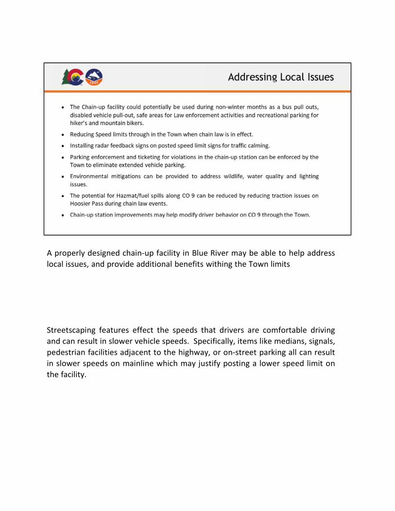
A properly designed chain-up facility in Blue River may be able to help address
local issues, and provide additional benefits withing the Town limits
Streetscaping features effect the speeds that drivers are comfortable driving
and can result in slower vehicle speeds. Specifically, items like medians, signals,
pedestrian facilities adjacent to the highway, or on-street parking all can result
in slower speeds on mainline which may justify posting a lower speed limit on
the facility.


