rsvqa meets bigearthnet: a new, large-scale, visual
TRANSCRIPT

RSVQA MEETS BIGEARTHNET: A NEW, LARGE-SCALE, VISUAL QUESTIONANSWERING DATASET FOR REMOTE SENSING
Sylvain Lobry1, Begum Demir2, Devis Tuia3
1 LIPADE, Universite de Paris, Paris, France2 Technische Universitat Berlin, Berlin, Germany
3 Ecole Polytechnique Federale de Lausanne, Sion, Switzerland
ABSTRACT
Visual Question Answering is a new task that can facilitatethe extraction of information from images through textualqueries: it aims at answering an open-ended question for-mulated in natural language about a given image. In thiswork, we introduce a new dataset to tackle the task of visualquestion answering on remote sensing images: this large-scale, open access dataset extracts image/question/answertriplets from the BigEarthNet dataset. This new datasetcontains close to 15 millions samples and is openly avail-able. We present the dataset construction procedure, itscharacteristics and first results using a deep-learning basedmethodology. These first results show that the task of vi-sual question answering is challenging and opens new in-teresting research avenues at the interface of remote sensingand natural language processing. The dataset and the codeto create and process it are open and freely available onhttps://rsvqa.sylvainlobry.com/
Index Terms— Visual Question Answering, Dataset,Deep learning, Natural Language, Computer Vision
1. INTRODUCTION
Visual Question Answering (VQA) is a task introduced inthe computer vision community [1] that aims at answeringan open-ended question relative to an image, formulated innatural language. In a remote sensing context, this task canbe used as a framework to extract generic information fromremote sensing images, as proposed by [2]. By using naturallanguage as an interface, technical skills in computer visionwould no longer be necessary to extract specific informationfrom remote sensing images.
Natural language can be used in conjunction with remotesensing images for instance to generate captions (or descrip-tions). To this effect [3] encodes the image to a latent spaceand decodes it to generate a caption. [4] aims at solving theproblem of redundant information in ground truth caption bysummarizing them. In addition to VQA, natural language canalso be used to interact with remote sensing images throughimage querying: this has been approached through fixed rules
by [5] allowing to query images based on their meta-data orby generating a description of an image which is compared tothe query in a latent space in [6].
VQA, on the other hand, allows to extract high-level in-formation from the image content. VQA models are gener-ally based on deep learning [7] and therefore call for largedatasets. Two datasets have been proposed for VQA for re-mote sensing (RSVQA), in [2]. The first one is based onnine Sentinel-2 tiles covering the Netherlands, and the sec-ond on 10′659 high-resolution (15cm) patches covering partsof the USA. Using information from OpenStreetMap, 77′232and 1′066′316 image/question/answer triplets have been con-structed, respectively. These two RSVQA datasets show twomain limitations: the number of possible answers is limited(9 and 98, respectively) and the number of samples is not suf-ficient to train large deep learning architectures.
As deep learning models are being increasingly used toextract information from remote sensing data, there is a needfor large-scale datasets. To this effect, [8] introduced theBigEarthNet dataset: it contains 590′326 Sentinel-2 patcheswith labels extracted from the 2018 CORINE Land Cover(CLC) database. Each image from this dataset is annotatedwith the land cover classes from the 3rd level (L3, out of L1,L2 and L3) of the CLC hierarchy.
In this work, we create a new, large-scale, RSVQAdataset from the Sentinel-2 images and land cover classesof the BigEarthNet data named RSVQAxBEN. We describethe construction procedure and analyze the characteristicsof this new dataset in section 2. Finally, we propose abaseline to tackle the VQA task and analyze the resultsobtained on our dataset in section 3. In support of repro-ducible research and future developments, the dataset andthe code to create and process it are freely available onhttps://rsvqa.sylvainlobry.com/.
2. DATASET CREATION
The new dataset is composed of a series of image / question /answer triplets extracted from the Sentinel-2 images and landcover classes from BigEarthNet. In this section, we describethe construction of this dataset.

2.1. Question construction procedure
The procedure to construct a single question/answer pair for agiven Sentinel-2 image and based on the CLC L3 labels pro-vided by BigEarthNet is stochastic. Note that the only inputto this procedure is the list of labels: the image is not usedexplicitly to construct the question/answer pairs.
We first create a list of present/absent labels at the threeCLC levels and randomly choose a type of question to ask: itcan either be a yes/no question about the presence of a landcover (e.g. ”Is there a water body in the image?”) or a ques-tion to which the answer is one or several land cover (LC)classes names (Land cover questions):
• Yes/no questions: first, the CLC level to which thequestion will apply is selected, followed by the answer(yes or no), directly retrieved by comparing the selectedclass with those present in the footprint of the imageconsidered by a geographical query. Note that we se-lect the number of land cover classes to be contained inthe question (from one to three). When more than oneelement is selected, logical connectors (and and or) areused to build the question.
• Land cover questions: similarly to yes/no questions, theCLC level of the question is selected first. However, inthis case, a question can also be defined on all threeCLC levels. A question is then randomly chosen be-tween:
– a question asking which land cover classes arepresent;
– a question, for which one or two land coverclasses present in the image are given, and askingwhich other classes are present. In this case, theland cover classes provided in the question arechosen randomly from the list of classes presentin the image.
To prevent the construction of ill-posed questions formula-tions, land cover classes containing the words ”and” or ”or”(e.g. ”scrub and/or herbaceous vegetation associations”) cannot appear in the questions (as these words can be used aslogical connectors between different classes). Using this pro-cedure, we can define a large variety of questions, the answerof which can be automatically retrieved from the list of CLClabels associated to the image. Samples obtained with thisprocedure are shown in Table 1.
2.2. Dataset construction
Based on the question construction procedure, we generatea database for the 590′326 patches of the BigEarthNet S2dataset. We first select the RGB bands of each patch andrescale them to 8 bits (from 12). Then, we create 25 differ-ent questions for each patch, for a total of 14′758′150 im-age/question/answer triplets.
Type # classes Questionyes/no 1 Are some rice fields present?yes/no 2 Are there inland wetlands
and maritime wetlands?yes/no 3 Are there water bodies and
agricultural areas or wetlands in the image?LC 0 Which L1 classes are in the image?LC 1 In addition to water bodies,
which classes are in the image?LC 2 Besides transitional woodland/shrub
and mixed forest, what land coverclasses are in the scene?
Table 1. Samples of questions from our dataset. Land coverclasses in the question are in bold.
Fig. 1. Dataset splits relatively to the latitude of the images:the training set is indicated in red, the validation set in yellowand the test set in green.
2.3. Dataset splitting
When using supervised machine learning procedures, it is im-portant to split the dataset in training, validation and test sets.We propose to split the dataset based on the spatial locationof the image, to avoid positive biases due to geographicalproximity of train and test samples. Specifically, we split thedataset according to their latitude, as shown in Figure 1. Wealso exclude from these splits the 70′987 patches fully cov-ered by seasonal snow, cloud or shadow following the recom-mendation of [8]. Using this methodology, we select 66% ofthe valid (i.e. not fully covered by snow, cloud or shadow)samples for training, 11% for validation and 23% for test.
2.4. Dataset analysis
Our dataset contains two types of questions: those for whichthe answer is ”yes” or ”no” (queries about the presence of oneor several land covers) and those for which the answer is a (list

of) land cover type(s). Yes/No questions are the most frequent,with a frequency of 80.7%. This is because many of the landcover questions generated are ill-posed (see Section 2.1) andtherefore discarded. Moreover, we observed 28′049 possibleanswers among the 2′846′757 land cover questions and thisled to a a strong imbalance in the frequency of the single pos-sible answers: the most frequent answer is ”None”, covering14.7% of the cases and the second one, ”Water bodies”, is theanswer to 3.6% of land cover questions. At the other end ofthe distribution, there are 12′218 answers appearing only oncein the dataset (an example of such an answer is ”Broad-leavedforest, complex cultivation patterns, coniferous forest, discon-tinuous urban fabric, land principally occupied by agricul-ture, with significant areas of natural vegetation, mixed forest,non-irrigated arable land and water courses”).
Regarding the complexity of the questions, 72.3% con-tains at least one logical connector (”and” or ”or”), with27.1% of the questions containing two logical connectors.
3. BASELINE
3.1. Proposed model
To create a baseline for our dataset, we used the VQA modelproposed in [2]. This model contains a feature extractor forthe image (ResNet-152 [9] pre-trained on ImageNet [10])and one for the question (skip-thoughts architecture [11],pre-trained on the BookCorpus dataset [12]). Each featureextractor produces a 1′200 dimensional feature vector, andthe two vectors are then merged with a point-wise multiplica-tion and passed to a multi-layer perceptron for the predictionof the most probable answer (among a set of pre-definedones). For a detailed description of our baseline, we refer thereader to [2].
3.2. Training settings
Output’s dimension: Since the number of possible answersin our training set is large (26′875 unique answers), we re-strict the set of possible answers to the 1′000 most frequentones. These answers cover 98.1% of the answer space in thetraining set. Therefore, the output size of the multi-layer per-ceptron is 1′000. In other words, the maximum accuracy thatour model can reach on the training set is 98.1%.Training: We use the optimizer proposed by [13] with alearning rate of 10−6 and a batch size of 1′024 for 10 epochs.These hyper-parameters have been set experimentally.
3.3. Results
We present the results obtained with our baseline in Table 2.The accuracy is defined as the ratio between the number ofcorrect answers and the number of questions. It can be seenthat, while the performance on yes/no questions is on-par withperformances reported in [2], land cover questions show a
Fig. 2. Confusion matrix obtained with our proposed modelin logarithm scale with a zoom (indicated in red) on the partcovering the 8 most frequent answers.
poor performance. This can easily be explained by looking atthe confusion matrix in Figure 2. It can be seen that the modelactually restrict its answer space to 17 answers, including themost frequent ones. This partially comes from the strong im-balance of the answer frequency: these 17 most frequent an-swers cover 87% of the answer space.
Type of answer AccuracyYes/No 79.92%
Land cover 20.57%Global 69.83%
Table 2. Accuracy obtained with our proposed model.
Visually, we show in Figure 3 some predictions madeby the baseline on the test set. In Figures 3(a, b), we seeexamples of good predictions over simple yes/no questions.Queries combining several land cover classes through logicconnectors are also often answered correctly, as shown inFigure 3(c), where a water body is indeed present. However,we show in Figure 3(d) a question where our model does notanswer correctly. This could be explained by the fact thatlogical formulas are not handled explicitly and the modelonly answers ”yes” because mixed forests are present in theimage. Finally, we show results on Land cover questions inFigures 3(e, f). In Figure 3(e), the model answer correctlyto the question, where the answer is simple. However, Fig-ure 3(f) shows that the model, despite being explicitly askedfor L2 classes, only provides L1 classes. This can be ex-plained when looking at the confusion matrix: the model can
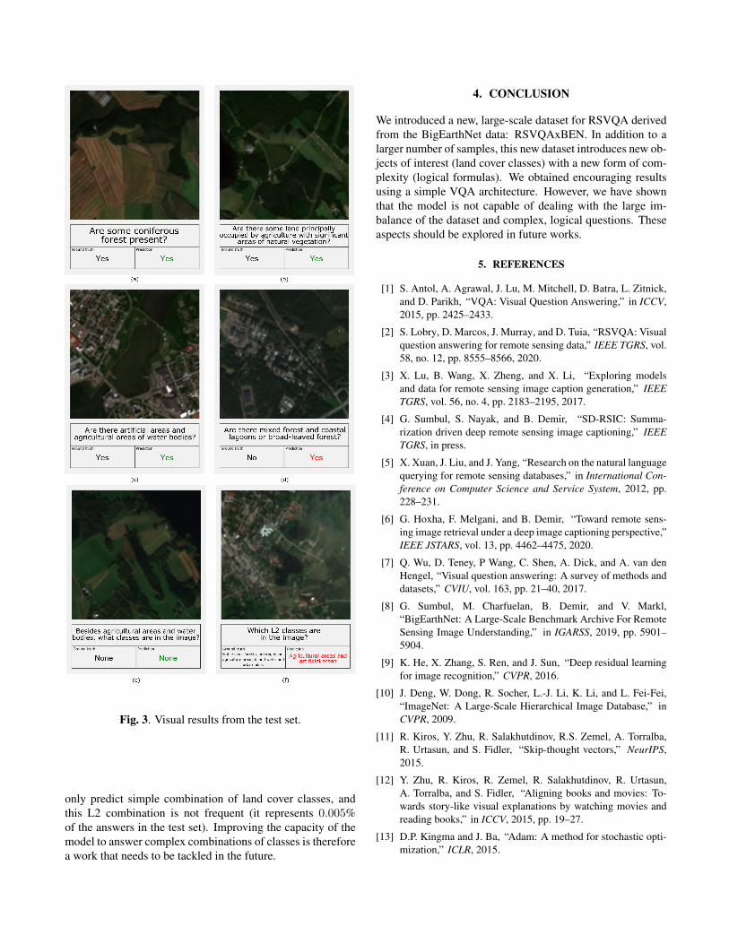
Fig. 3. Visual results from the test set.
only predict simple combination of land cover classes, andthis L2 combination is not frequent (it represents 0.005%of the answers in the test set). Improving the capacity of themodel to answer complex combinations of classes is thereforea work that needs to be tackled in the future.
4. CONCLUSION
We introduced a new, large-scale dataset for RSVQA derivedfrom the BigEarthNet data: RSVQAxBEN. In addition to alarger number of samples, this new dataset introduces new ob-jects of interest (land cover classes) with a new form of com-plexity (logical formulas). We obtained encouraging resultsusing a simple VQA architecture. However, we have shownthat the model is not capable of dealing with the large im-balance of the dataset and complex, logical questions. Theseaspects should be explored in future works.
5. REFERENCES
[1] S. Antol, A. Agrawal, J. Lu, M. Mitchell, D. Batra, L. Zitnick,and D. Parikh, “VQA: Visual Question Answering,” in ICCV,2015, pp. 2425–2433.
[2] S. Lobry, D. Marcos, J. Murray, and D. Tuia, “RSVQA: Visualquestion answering for remote sensing data,” IEEE TGRS, vol.58, no. 12, pp. 8555–8566, 2020.
[3] X. Lu, B. Wang, X. Zheng, and X. Li, “Exploring modelsand data for remote sensing image caption generation,” IEEETGRS, vol. 56, no. 4, pp. 2183–2195, 2017.
[4] G. Sumbul, S. Nayak, and B. Demir, “SD-RSIC: Summa-rization driven deep remote sensing image captioning,” IEEETGRS, in press.
[5] X. Xuan, J. Liu, and J. Yang, “Research on the natural languagequerying for remote sensing databases,” in International Con-ference on Computer Science and Service System, 2012, pp.228–231.
[6] G. Hoxha, F. Melgani, and B. Demir, “Toward remote sens-ing image retrieval under a deep image captioning perspective,”IEEE JSTARS, vol. 13, pp. 4462–4475, 2020.
[7] Q. Wu, D. Teney, P Wang, C. Shen, A. Dick, and A. van denHengel, “Visual question answering: A survey of methods anddatasets,” CVIU, vol. 163, pp. 21–40, 2017.
[8] G. Sumbul, M. Charfuelan, B. Demir, and V. Markl,“BigEarthNet: A Large-Scale Benchmark Archive For RemoteSensing Image Understanding,” in IGARSS, 2019, pp. 5901–5904.
[9] K. He, X. Zhang, S. Ren, and J. Sun, “Deep residual learningfor image recognition,” CVPR, 2016.
[10] J. Deng, W. Dong, R. Socher, L.-J. Li, K. Li, and L. Fei-Fei,“ImageNet: A Large-Scale Hierarchical Image Database,” inCVPR, 2009.
[11] R. Kiros, Y. Zhu, R. Salakhutdinov, R.S. Zemel, A. Torralba,R. Urtasun, and S. Fidler, “Skip-thought vectors,” NeurIPS,2015.
[12] Y. Zhu, R. Kiros, R. Zemel, R. Salakhutdinov, R. Urtasun,A. Torralba, and S. Fidler, “Aligning books and movies: To-wards story-like visual explanations by watching movies andreading books,” in ICCV, 2015, pp. 19–27.
[13] D.P. Kingma and J. Ba, “Adam: A method for stochastic opti-mization,” ICLR, 2015.