route 630 & interstate 95 interchange reconstruction los comparison ... the route 630 &...
TRANSCRIPT
U.S. DEPARTMENT OF TRANSPORTATION FEDERAL HIGHWAY ADMINISTRATION
and VIRGINIA DEPARTMENT OF TRANSPORTATION
ENVIRONMENTAL ASSESSMENT RE-EVALUATION
Route 630 & Interstate 95 Interchange Reconstruction
Stafford County
State Project: 0095-089-F09, C501, P101, R201UPC 13558
Federal Project: NH-095-2(393)
From: 0.5 miles west of Austin Ridge Drive
To: Jefferson Davis Highway (Route 1) for a distance of 1.52 miles
Submitted Pursuant to 42 U.S.C. 4332(2)(C)
Approved for Public Availability: Date For Division Administrator
Draft Environmental Assessment
1
CONTENTS Section 1 – PURPOSE AND NEED Page 1.1 Study Area ........................................................................................................................................................................ 3 1.2 History .............................................................................................................................................................................. 4 1.3 Needs ................................................................................................................................................................................ 5 1.3.1 Existing Conditions .............................................................................................................................................. 5 1.3.1.A Safety ................................................................................................................................................................... 6 1.3.1.B Capacity ................................................................................................................................................................ 7 1.3.1.C Geometry .............................................................................................................................................................. 8 1.3.2 Future Conditions .................................................................................................................................................... 8 1.3.2.A. Safety .................................................................................................................................................................. 9 1.3.2.B Capacity ................................................................................................................................................................ 9 1.3.2.C Geometry ............................................................................................................................................................ 10 1.4 Summary ......................................................................................................................................................................... 10 Section 2 - ALTERNATIVES 2.1 Introduction .................................................................................................................................................................... 11 2.2 Alternatives Development and Screening ....................................................................................................................... 11 2.3 Alternatives Eliminated from Detailed Study ................................................................................................................. 12 2.4 Alternatives Carried Forward .......................................................................................................................................... 14 2.4.1 No-build Alternative ............................................................................................................................................. 14 2.4.2 Build Alternative ................................................................................................................................................... 14 Section 3 - ENVIRONMENTAL CONSEQUENCES 3.1 Overview of Environmental Issues ................................................................................................................................ 19 3.2 Historic Properties .......................................................................................................................................................... 24 3.2.1 Historic Property Identification ............................................................................................................................ 24 3.2.2 Effects on Historic Property .................................................................................................................................. 25 3.3 Water Resources ............................................................................................................................................................. 25 3.3.1 Surface Waters ...................................................................................................................................................... 25 3.3.2 Wetlands ............................................................................................................................................................... 25 3.3.3 Floodplains ........................................................................................................................................................... 26 3.3.4 Permits and Mitigation…………………………………………………………… ............................................... 26 3.4 Construction .................................................................................................................................................................... 26 3.4.1 Late Discoveries .................................................................................................................................................... 26 3.4.2 Water Quality ........................................................................................................................................................ 27 3.4.3 Air ......................................................................................................................................................................... 27 3.4.4 Noise ..................................................................................................................................................................... 27 3.4.5 Solid Waste and Hazardous Materials .................................................................................................................. 27 3.5 Indirect Effects ................................................................................................................................................................ 27 3.6 Cumulative Effects .......................................................................................................................................................... 28 Section 4 - COORDINATION AND COMMENTS 4.1 Agency Coordination ...................................................................................................................................................... 32 4.2 Public Involvement ......................................................................................................................................................... 32 Appendix A - MOBILE SOURCE AIR TOXICS
FIGURES 1 Project Location and Study Area ...................................................................................................................................... 3 2 Environmental Study Area ............................................................................................................................................... 4 3 Candidate Build Alternative…………..…………………………………………………………………...……..……16 4 Typical Sections…………………………………………………………………………………………………...…...17
TABLES 1 HTRIS Crash Data ........................................................................................................................................................... 6 2 Crash Rate Comparison .................................................................................................................................................... 7 3 LOS Comparison .............................................................................................................................................................. 8 4 Alternatives Eliminated From Detailed Study................................................................................................................ 11 5 Comparison of Alternatives LOS .................................................................................................................................... 15 6 Estimated Cost ................................................................................................................................................................ 16 7 Summary of Environmental Issues .................................................................................................................................. 19
Draft Environmental Assessment
2
8 Summary of Impacts ....................................................................................................................................................... 23 9 Cumulative Effects Matrix……………………………………………………………………………………………….29 Appendix A - Interchange Modification Report Appendix B – Final Small Whorled Pogonia Survey Appendix C - Preliminary Hazardous Materials Site Assessment Appendix D- Final Noise Report Appendix E – Draft Northern Long-Eared Bat Survey
Draft Environmental Assessment
3
Section 1 PURPOSE AND NEED
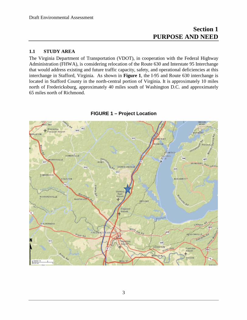
1.1 STUDY AREA The Virginia Department of Transportation (VDOT), in cooperation with the Federal Highway Administration (FHWA), is considering relocation of the Route 630 and Interstate 95 Interchange that would address existing and future traffic capacity, safety, and operational deficiencies at this interchange in Stafford, Virginia. As shown in Figure 1, the I-95 and Route 630 interchange is located in Stafford County in the north-central portion of Virginia. It is approximately 10 miles north of Fredericksburg, approximately 40 miles south of Washington D.C. and approximately 65 miles north of Richmond.
FIGURE 1 – Project Location

Draft Environmental Assessment
4
FIGURE 2 – Environmental Study Area
1.2 HISTORY The Route 630 & Interstate 95 Interchange Reconstruction project in Stafford County has been proposed since the early 1990s. In early 1995, a Major Investment Study (MIS) was begun to define the purpose and need, develop alternatives, consider costs and environmental impacts. Between May 1995 and June 1996 multiple meetings were held with state and federal environmental agencies in which the public participated. The conclusion of the MIS was that an improved interchange is needed at Route 630. On August 21, 1997 the Commonwealth Transportation Board (CTB) approved the project which involved upgrading and expanding the interchange modifying Route 630 with I-95 from the current simple diamond configuration to a spilt-diamond configuration. In addition, it included a relocation of Route 630 between Austin
Draft Environmental Assessment
5
Ridge Drive and U.S. Route 1 opposite Hospital Center Drive. The project was evaluated previously in the Final Environmental Assessment for I-95 Improvement Study in association with the Route 627 and I-95 Interchange Project. On July 14, 1999 the Federal Highway Administration issued its determination that this project would not have any significant impacts to the environment in the Final Environmental Assessment. In late 2009 the VDOT began preparing an Interchange Modification Report (IMR) for the FHWA which evaluated nine initial alternatives. During the initial review, five of these alternatives were carried forward for geometric refinement and detailed study. The remaining four alternatives were eliminated for various considerations which are described further in detail in Section 2 of this Environmental Assessment. The FHWA approved the IMR on June 10, 2011. A Citizen Information Meeting was held on June 14, 2012 and presented the previous Alternative A2 design showing the location provided in the IMR which was approved by the CTB. Due to the escalation of construction costs, VDOT decided to develop a more cost-effective alternative. The Stafford County Comprehensive Plan identifies the Route 630 & I-95 Interchange Reconstruction as a County priority, and identifies the future expansion and improvement of existing roadway facilities supplemented by the strategic construction of new roadways, the expansion of existing transit and commuter parking facilities, and the construction of new facilities to support increased options for transportation. The proposed improvements are consistent with the 2035 Constrained Long-range Plan (CLRP) developed by the Fredericksburg Area Metropolitan Planning Organization (FAMPO).
1.3 NEEDS 1.3.1 Existing Conditions The following narrative outlines current traffic patterns and demonstrates the need for improvements that reduce existing safety concerns, enhance operational deficiencies, and improve capacity for future roadway demand. Route 630 is an urban collector road and serves local commuter traffic to and from points east and west of Stafford County. Route 630 is mainly a two lane roadway and runs in an east-west direction serving the Stafford County Courthouse and local government buildings. The Courthouse Area is located in the northwest quadrant of the existing intersection of Route 630/ US Route 1 approximately .75 miles to the east of Interstate 95 interchange. The Stafford Hospital Center is located to the south of US Route 1/ Route 630 intersection.
The need for the project is based on capacity deficiencies, as well as existing safety and operational deficiencies. Interstate 95 is a six lane divided facility and is the primary roadway through Stafford County. Interstate 95 provides an integral part in connecting Washington D.C. and Richmond along with most the east coast. The existing interchange at Interstate 95 and Route 630 is a conventional rural diamond interchange. All four ramps are similar in geometrics and length. On Route 630 the northbound and southbound ramp intersections are signalized and are spaced approximately 800 feet apart. The nearest signalized intersection to the west of the study interchange is located at Route 630 and Austin Ridge Drive located approximately 1,500 feet from the Interstate 95 southbound ramp
Draft Environmental Assessment
6
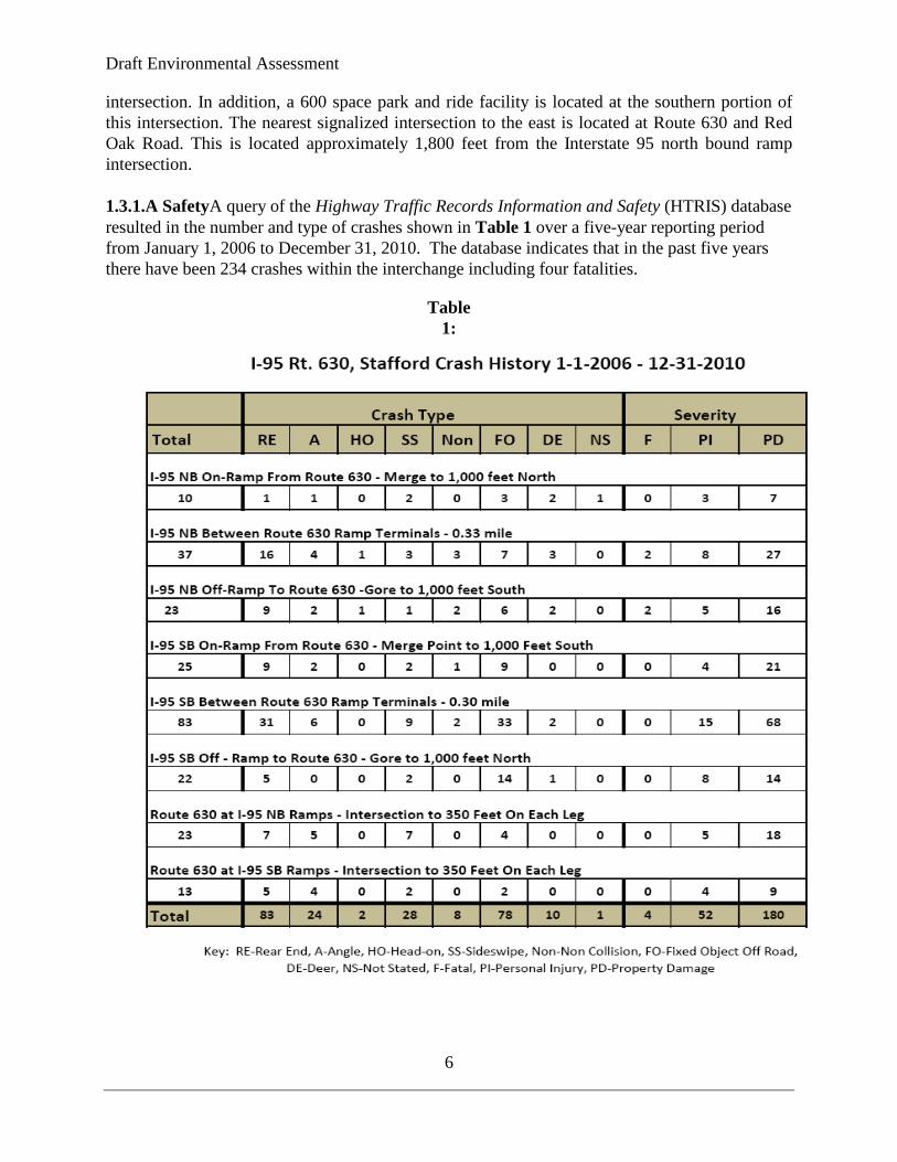
intersection. In addition, a 600 space park and ride facility is located at the southern portion of this intersection. The nearest signalized intersection to the east is located at Route 630 and Red Oak Road. This is located approximately 1,800 feet from the Interstate 95 north bound ramp intersection. 1.3.1.A SafetyA query of the Highway Traffic Records Information and Safety (HTRIS) database resulted in the number and type of crashes shown in Table 1 over a five-year reporting period from January 1, 2006 to December 31, 2010. The database indicates that in the past five years there have been 234 crashes within the interchange including four fatalities.
Table 1:
Draft Environmental Assessment
7
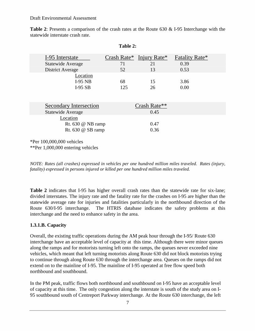
Table 2: Presents a comparison of the crash rates at the Route 630 & I-95 Interchange with the statewide interstate crash rate.
Table 2:
I-95 Interstate Crash Rate* Injury Rate* Fatality Rate* Statewide Average 71 21 0.39 District Average 52 13 0.53
Location I-95 NB 68 15 3.86 I-95 SB 125 26 0.00
Secondary Intersection Crash Rate** Statewide Average 0.45
Location Rt. 630 @ NB ramp 0.47
Rt. 630 @ SB ramp 0.36 *Per 100,000,000 vehicles **Per 1,000,000 entering vehicles
NOTE: Rates (all crashes) expressed in vehicles per one hundred million miles traveled. Rates (injury, fatality) expressed in persons injured or killed per one hundred million miles traveled.
Table 2 indicates that I-95 has higher overall crash rates than the statewide rate for six-lane; divided interstates. The injury rate and the fatality rate for the crashes on I-95 are higher than the statewide average rate for injuries and fatalities particularly in the northbound direction of the Route 630/I-95 interchange. The HTRIS database indicates the safety problems at this interchange and the need to enhance safety in the area.
1.3.1.B. Capacity
Overall, the existing traffic operations during the AM peak hour through the I-95/ Route 630 interchange have an acceptable level of capacity at this time. Although there were minor queues along the ramps and for motorists turning left onto the ramps, the queues never exceeded nine vehicles, which meant that left turning motorists along Route 630 did not block motorists trying to continue through along Route 630 through the interchange area. Queues on the ramps did not extend on to the mainline of I-95. The mainline of I-95 operated at free flow speed both northbound and southbound. In the PM peak, traffic flows both northbound and southbound on I-95 have an acceptable level of capacity at this time. The only congestion along the interstate is south of the study area on I-95 southbound south of Centreport Parkway interchange. At the Route 630 interchange, the left

Draft Environmental Assessment
8
turn lanes onto the I-95 on- ramps occasionally queued into the through lanes of Route 630 when tractor trailers were involved in the vehicle mix. In addition at times motorists making left turns into the gas stations would affect operations through the interchange area since there are no turn lanes. The existing operations are anticipated to deteriorate as shown by the year 2037 operational aspects; therefore there is a need for improving capacity along the corridor. The Route 630 interchange merges and diverges were operating at a LOS D or better during the AM and PM peak hours. The intersection at Route 630 and I-95 northbound on/off ramp is currently operating at a LOS C during both the AM and PM peak hours. The I-95 southbound on/off ramp intersection with Route 630 operates today at a LOS B during the AM peak hour and LOS B during the PM peak hour. The intersection at Route 630 and Red Oak Drive is currently operating at a LOS C during the AM peak hour and LOS B in the PM peak hour. Today the intersection at Route 630 and Austin Ridge Drive/Park and Ride Lot is operating at a LOS C in both the AM and PM peak hours.
Table 3:
LOS AM (PM) Comparison
AM (PM) LEVEL OF SERVICE COMPARISON Intersection 2009 2037 No Build Route 630 @ Austin Ridge Road C (C) F>150 (F>150) Route 630 @ I-95 Southbound Ramps B (B) F>150 (F>150) Route 630 @ I-95 Northbound Ramps C (C) F>150 (F>150) Route 630 @ Red Oak Drive C (B) F>150 (F>150) Source: I-95/ Route 630 Interchange Modification Report, November 2010
The level of service (LOS) operation in the project area is determined by the capacity and indicates how efficiently traffic is handled through the corridor. The level of service is a direct reflection of the average delay experienced by drivers. LOS is characterized by the operating conditions of a facility in terms of traffic performance measures related to speed and travel time, freedom to maneuver, traffic interruptions, comfort, and convenience. The following numeric values are expressed in average per vehicle delay in seconds. The threshold for LOS “F” is 80.0 seconds per vehicle. A less than 10.0, B 10.01-20.0, C 20.01-35.0, D 35.01-55.0, E 55.01-80.0.
1.3.1.C. Geometry
The interchange has several geometric deficiencies associated with its current configuration. The existing diamond interchange ramps and auxiliary lanes do not meet current design criteria for length. The existing bridges carrying I-95 across Route 630 provide only 14’ – 0” of vertical clearance instead of the minimum of 16’-6”. There are also four existing commercial entrances on Route 630 in close proximity to the ramp terminals which do not currently meet VDOT access management criteria.
1.3.2 Future Conditions- 2037 No Build Growth rates for traffic volumes are based on the 2035 FAMPO model which includes socioeconomic data. This model uses roadway network improvements such as the I-95 HOT lanes and project growth to produce the 2037 project average daily traffic and peak hour volumes. These volumes were refined to match forecasted volumes on the I-95 south of

Draft Environmental Assessment
9
Centerport Parkway that were developed for the I-95/Rest Area project. 1.3.2. A. Safety
The increased traffic volumes will likely exacerbate the safety and capacity problems and future levels of service will degrade along the corridor.
1.3.2.B Capacity
Under future no build traffic conditions, the signalized intersections along Route 630 at the I-95 northbound on/off ramp, I-95 southbound on/off ramp, Red Oak Drive and Austin Ridge Drive are all expected to operate at a LOS F during both the AM and PM peak hours. This will cause queues to extend on to the mainline of I-95 and cause serious operational problems with stopped traffic occurring in the through lanes.
The 2009 average daily traffic was 136,000 vehicles per day while the 2037 no build forecasts showed traffic volumes are anticipated to increase on I-95 to approximately 239,000 vehicles per day north of Route 610 which will be the highest volume in the study area. From that point south, volumes are expected to decrease to approximately 212,000 to 227,000 vehicles per day along I-95. The 2009 average daily traffic utilizing east bound Route 630 is 17,000 vehicles per day and 15,600 vehicles per day west bound along Route 630. Route 630 both east and west of I-95 will increase to over 40,000 vehicles per day. All ramps are anticipated to grow to between 16,000 and 20,000 vehicles per day. Peak hour volumes along I-95 are anticipated to increase to approximately 9,000 vehicles per hour in the peak direction (NB AM; SB PM) north of Route 630. The volumes decrease further to the south and peak hour volumes south of Route 630 are projected to be between 7,800 and 9,000 vehicles per hour with approximately 2,500 to 3,000 of these motorists utilizing the HOT lanes. All ramps at Route 630 are anticipated to exceed 1,000 vehicles per hour in the peak hour except for the I-95 southbound off ramp to Route 630 in the AM peak hour with the movements combined (eg. SB to EB and SB to WB). The highest volume movement is from Route 630 to I-95 northbound in the AM peak. Traffic volumes along Route 630 are anticipated to grow over 2,000 vehicles per hour in the peak direction. Typically, most design and planning efforts try to achieve LOS C in rural areas and LOS D in urban areas to ensure acceptable operating levels of service for motorists. Traffic forecast for future conditions indicates that most of the intersections and mainline along this segment of Route 630 will be operating under LOS D, E and F. Under LOS E all speeds are reduced to a low, but relatively uniform value. Freedom to maneuver within the traffic stream is extremely difficult. Comfort and convenience levels are extremely poor, and driver frustration is generally high. Operations at this level of service are usually unstable, because small increases in traffic flow or minor disruptions within the traffic stream will cause traffic flow breakdowns. LOS F is used to define forced or complete breakdown in traffic flow in which traffic flows are unstable and the vehicle delay is high. Traffic operations with queues under failing levels of service are characterized by stop-and-go conditions, and are extremely unstable. Under LOS F arrival flow exceeds discharge flow and queues form, resulting in slow speeds and stop-and-go traffic flow
Draft Environmental Assessment
10
occurring in a cyclic fashion. Highway facilities operating under LOS E or F conditions are considered unacceptable. As shown in Table 3, future traffic operations would degrade and under the No-build scenario several intersections would not provide acceptable levels of service for motorists.
1.3.2.C Geometry
Under the No-Build Alternative, the existing interchange at Interstate 95 and Route 630 would remain conventional diamond interchange with short term minor restoration type activities. The existing diamond interchange ramps and auxiliary lanes would remain inadequate in length. The existing bridges carrying I-95 across Route 630 would provide only 14’ – 0” of vertical clearance instead of the minimum of 16’-6”. The four existing commercial entrances on Route 630 would remain in close proximity to the ramp terminals. This alternative would not displace any families, businesses, farms, or nonprofit organizations, and would not affect any natural, ecological, cultural, or scenic resources. However, this alternative would not satisfy the identified transportation needs because it would not address the safety, capacity or improve operational deficiencies.
1.4 Summary
In conclusion, the purpose of this project is to increase transportation capacity, improve safety, and enhance operational deficiencies at this interchange in Stafford County. In addition, this project would support local, regional, and state planning efforts as well as accommodate future projected changes in land use and development growth along the corridor as identified by the 2015 Stafford County Economic Development Strategic Plan. The Stafford County Board of Supervisors, Stafford County Comprehensive Plan, VDOT and the Fredericksburg Area Metropolitan Planning Organization recognize this project as a priority for the region.
Draft Environmental Assessment
11
Section 2 ALTERNATIVES
2.1 INTRODUCTION
This section discusses the range of alternatives considered, the process used to identify and screen the alternatives, alternatives considered and eliminated from further consideration, and alternatives carried forward for detailed study. The No-Build Alternative was retained for detailed study to serve as a baseline for alternatives comparison. A Candidate Build Alternative (A-2) has been identified and is described in detail.
In addition to the No-Build Alternative, nine improvement alternatives were evaluated. During the initial review, five of these alternatives were carried forward for geometric refinement and detailed study. The remaining four alternatives were eliminated for various considerations which are described and their reasoning elimination.
Substantial public and interagency involvement and coordination have occurred since the project inception which shaped the alternative process.
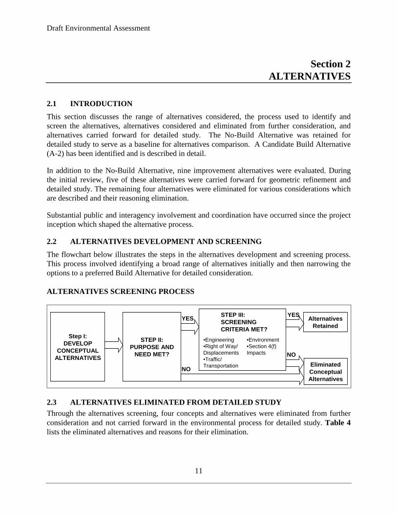
2.2 ALTERNATIVES DEVELOPMENT AND SCREENING
The flowchart below illustrates the steps in the alternatives development and screening process. This process involved identifying a broad range of alternatives initially and then narrowing the options to a preferred Build Alternative for detailed consideration. ALTERNATIVES SCREENING PROCESS
Step I:DEVELOP
CONCEPTUALALTERNATIVES
YES
STEP II:PURPOSE AND
NEED MET?
AlternativesRetained
EliminatedConceptualAlternatives
STEP III:SCREENINGCRITERIA MET?
•Engineering•Right of Way/ Displacements•Traffic/Transportation
•Environment•Section 4(f) Impacts
YES
NO
NO
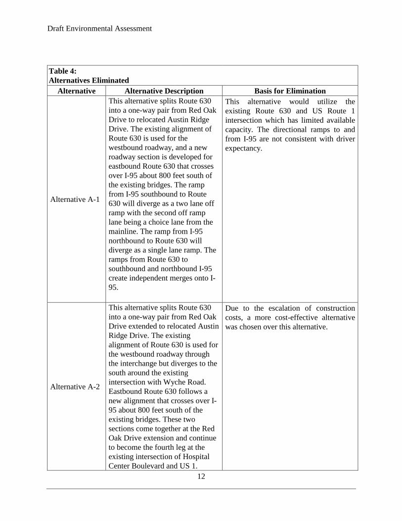
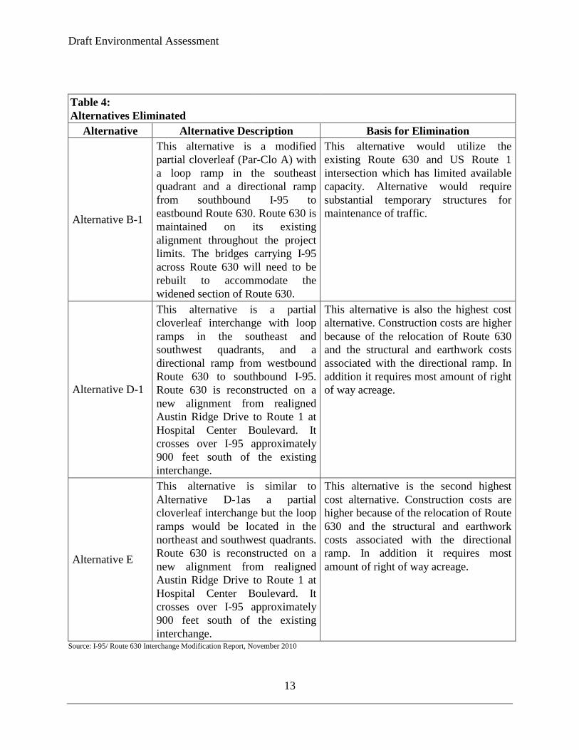
2.3 ALTERNATIVES ELIMINATED FROM DETAILED STUDY Through the alternatives screening, four concepts and alternatives were eliminated from further consideration and not carried forward in the environmental process for detailed study. Table 4 lists the eliminated alternatives and reasons for their elimination.
Draft Environmental Assessment
12
Table 4: Alternatives Eliminated
Alternative Alternative Description Basis for Elimination
Alternative A-1
This alternative splits Route 630 into a one-way pair from Red Oak Drive to relocated Austin Ridge Drive. The existing alignment of Route 630 is used for the westbound roadway, and a new roadway section is developed for eastbound Route 630 that crosses over I-95 about 800 feet south of the existing bridges. The ramp from I-95 southbound to Route 630 will diverge as a two lane off ramp with the second off ramp lane being a choice lane from the mainline. The ramp from I-95 northbound to Route 630 will diverge as a single lane ramp. The ramps from Route 630 to southbound and northbound I-95 create independent merges onto I-95.
This alternative would utilize the existing Route 630 and US Route 1 intersection which has limited available capacity. The directional ramps to and from I-95 are not consistent with driver expectancy.
Alternative A-2
This alternative splits Route 630 into a one-way pair from Red Oak Drive extended to relocated Austin Ridge Drive. The existing alignment of Route 630 is used for the westbound roadway through the interchange but diverges to the south around the existing intersection with Wyche Road. Eastbound Route 630 follows a new alignment that crosses over I-95 about 800 feet south of the existing bridges. These two sections come together at the Red Oak Drive extension and continue to become the fourth leg at the existing intersection of Hospital Center Boulevard and US 1.
Due to the escalation of construction costs, a more cost-effective alternative was chosen over this alternative.
Draft Environmental Assessment
13
Table 4: Alternatives Eliminated
Alternative Alternative Description Basis for Elimination
Alternative B-1
This alternative is a modified partial cloverleaf (Par-Clo A) with a loop ramp in the southeast quadrant and a directional ramp from southbound I-95 to eastbound Route 630. Route 630 is maintained on its existing alignment throughout the project limits. The bridges carrying I-95 across Route 630 will need to be rebuilt to accommodate the widened section of Route 630.
This alternative would utilize the existing Route 630 and US Route 1 intersection which has limited available capacity. Alternative would require substantial temporary structures for maintenance of traffic.
Alternative D-1
This alternative is a partial cloverleaf interchange with loop ramps in the southeast and southwest quadrants, and a directional ramp from westbound Route 630 to southbound I-95. Route 630 is reconstructed on a new alignment from realigned Austin Ridge Drive to Route 1 at Hospital Center Boulevard. It crosses over I-95 approximately 900 feet south of the existing interchange.
This alternative is also the highest cost alternative. Construction costs are higher because of the relocation of Route 630 and the structural and earthwork costs associated with the directional ramp. In addition it requires most amount of right of way acreage.
Alternative E
This alternative is similar to Alternative D-1as a partial cloverleaf interchange but the loop ramps would be located in the northeast and southwest quadrants. Route 630 is reconstructed on a new alignment from realigned Austin Ridge Drive to Route 1 at Hospital Center Boulevard. It crosses over I-95 approximately 900 feet south of the existing interchange.
This alternative is the second highest cost alternative. Construction costs are higher because of the relocation of Route 630 and the structural and earthwork costs associated with the directional ramp. In addition it requires most amount of right of way acreage.
Source: I-95/ Route 630 Interchange Modification Report, November 2010
Draft Environmental Assessment
14
2.4 ALTERNATIVES CARRIED FORWARD 2.4.1 No-build Alternative Under the No-Build Alternative, Route 630 would remain a two-lane facility and the interchange would remain in its current configuration. This alternative would not displace any families, businesses, farms, or nonprofit organizations, and would not affect any natural, ecological, cultural, or scenic resources. However, this alternative would not satisfy the identified transportation needs because it would not address the safety, capacity or improve operational deficiencies at this interchange.
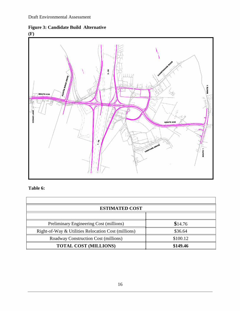
2.4.2 Alternative F (Candidate Build Alternative) Diverging-Diamond Interchange on New Route 630 Alignment Description:
This alternative requires the construction of Route 630 on new alignment from Austin Ridge Drive to the intersection of Route 1 and Hospital Center Drive. Route 630 follows a new alignment that crosses over Interstate 95 approximately 800 feet south of the existing bridges. Under this alternative, new bridges would be constructed parallel to and south of the existing bridges carrying I-95 over Route 630. This configuration would allow the existing bridges to remain in service during construction and would allow the overall construction project to be phased. Route 630 will continue east to become the fourth leg at the existing intersection of Hospital Center Boulevard and US 1.
The Diverging-Diamond Interchange (DDI) configuration involves elongated, skewed crossover intersections along the minor roadway (in this case, Route 630) and generally requires that access points be located further from the ramp termini than existing conditions allow.
Pedestrians and bicyclist would be accommodated via a 10 foot shared used path along the westbound alignment of Route 630. The existing Route 630 under I-95 will be retained for use by pedestrian and bicyclist, which would also include the installation of two - 10’ x 10’ box culverts under the existing north bound on and southbound off ramps. This provides the safest route that has the least interference from free-flow interchange movements. The shared use path would tie in to UPC 4632, Route 630 widening project to the west and UPC 91238 , Stafford Streetscape project to the east.
The existing park and ride lot would be relocated as part of the project across Interstate 95 to the just to the west of relocated Wyche Road, the park-and-ride lot would be relocated to the northeast quadrant of the interchange. Access will be provided via relocated Wyche Road and existing Route 630, located approximately 900 feet east of the of the interchange ramp. The park-and-ride location does not preclude the addition of spaces in the future; however, the park-and-ride will be provided with the same number of spaces as are provided by Alternative A2.
Wyche Road is proposed to be shifted for the new alignment of Route 630. A cul-de-sac is planned at the north end of the existing Wyche Road. However, Wyche Road is proposed to be

Draft Environmental Assessment
15
relocated and intersect with the new Route 630 alignment approximately 600 feet to the east at the intersection of Red Oak Drive and newly aligned Route 630.
Approximately 1000 feet west of the interchange, Austin Ridge Drive is relocated to a new intersection about 500 feet west of the existing intersection where the eastbound and westbound sections of Route 630 come together.
Ability to meet needs: The Candidate Build Alternative would address future traffic demands in this area of Stafford County. The improvements to this interchange would enhance safety conditions along the corridor and correct operational deficiencies.
TABLE 5: COMPARISON OF ALTERNATES 2037 AM (PM) LEVELS OF SERVICE AND OPERATIONAL ASPECTS
Source: I-95/ Route 630 Interchange Modification Report, November 2010
Draft Environmental Assessment
16
Figure 3: Candidate Build Alternative (F)
Table 6:
ESTIMATED COST
Preliminary Engineering Cost (millions) $14.76
Right-of-Way & Utilities Relocation Cost (millions) $36.64 Roadway Construction Cost (millions) $100.12
TOTAL COST (MILLIONS) $149.46
Draft Environmental Assessment
17
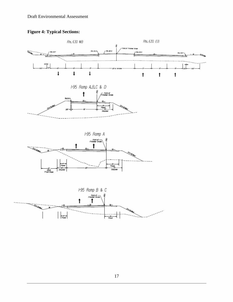
Figure 4: Typical Sections:

Draft Environmental Assessment
18
Figure 4: Typical Sections Continued:
Austin Ridge Drive
Wyche Road
Draft Environmental Assessment
19
Section 3
ENVIRONMENTAL CONSEQUENCES
3.1 OVERVIEW OF ENVIRONMENTAL ISSUES Table 7 summarizes environmental issues associated with the Build Alternative and their relevance to the project. Table 8 quantifies impacts of the proposed project. Key issues requiring further discussion are addressed following the tables.
Table 7: Environmental Issues
Resource/Issue Remarks
Land Use, Socioeconomics, and Right of Way/Relocations
The project is consistent with current and planned local land use. The project is identified by the Fredericksburg Area Metropolitan Planning Organization as a regional priority in the draft 2035 Constrained Long Range Transportation Plan. The land use along this interchange is a mixture of Urban Commercial, Office, Suburban Residential, Manufactured Home, Planned Development 2, and Agricultural with several undeveloped tracts of land mostly in industrial use. Based on preliminary design the Stage 1 Relocation Assistance Report the proposed project would displace five businesses, one non-profit organization, and one single family home. There are four gas station/repair/ convenience businesses, a McDonald’s and a Fraternal Order of Eagles. The yearly income for the one displaced/household is estimated to be below the median household income for Stafford County . The median household income for Stafford County was $93,065 according to the 2010 census information. There is no scarcity of similar housing nearby and no community facilities or services will be affected; the impact on the neighborhood and local housing market will be minimal. The area housing market appears to be adequate to provide replacement housing. Single family dwellings are available for purchase in the surrounding area. The project will also require total acquisition of 7 vacant parcels. Minor impacts to water and sewer master planning would be affected by the project, resulting from removing land area from proposed development.
Environmental Justice Populations
There are low-income, elderly, disabled, and minority populations within the study corridor however these populations would not suffer disproportionately high or adverse effects from the project as indicated in the VDOT Stage I Relocation Report. Therefore, in accordance with
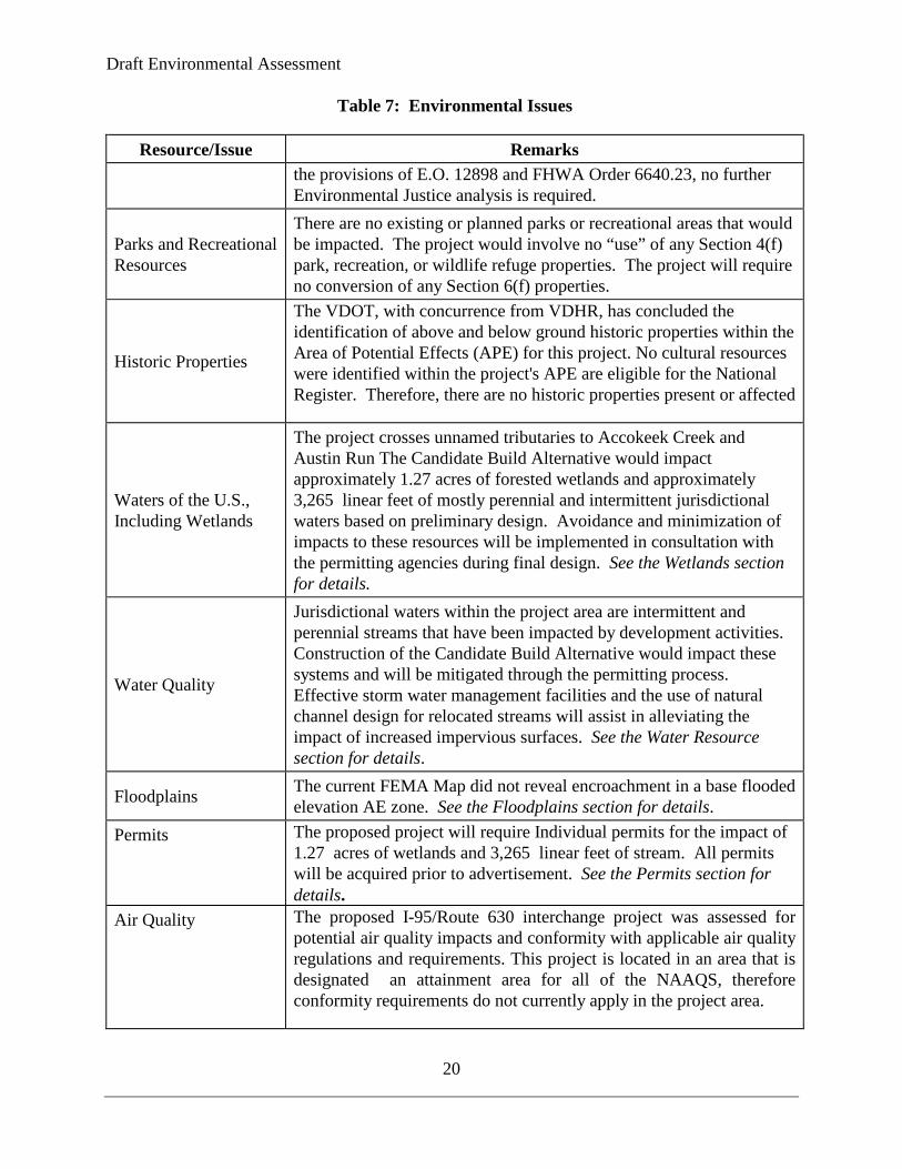
Draft Environmental Assessment
20
Table 7: Environmental Issues
Resource/Issue Remarks the provisions of E.O. 12898 and FHWA Order 6640.23, no further Environmental Justice analysis is required.
Parks and Recreational Resources
There are no existing or planned parks or recreational areas that would be impacted. The project would involve no “use” of any Section 4(f) park, recreation, or wildlife refuge properties. The project will require no conversion of any Section 6(f) properties.
Historic Properties
The VDOT, with concurrence from VDHR, has concluded the identification of above and below ground historic properties within the Area of Potential Effects (APE) for this project. No cultural resources were identified within the project's APE are eligible for the National Register. Therefore, there are no historic properties present or affected
Waters of the U.S., Including Wetlands
The project crosses unnamed tributaries to Accokeek Creek and Austin Run The Candidate Build Alternative would impact approximately 1.27 acres of forested wetlands and approximately 3,265 linear feet of mostly perennial and intermittent jurisdictional waters based on preliminary design. Avoidance and minimization of impacts to these resources will be implemented in consultation with the permitting agencies during final design. See the Wetlands section for details.
Water Quality
Jurisdictional waters within the project area are intermittent and perennial streams that have been impacted by development activities. Construction of the Candidate Build Alternative would impact these systems and will be mitigated through the permitting process. Effective storm water management facilities and the use of natural channel design for relocated streams will assist in alleviating the impact of increased impervious surfaces. See the Water Resource section for details.
Floodplains The current FEMA Map did not reveal encroachment in a base flooded elevation AE zone. See the Floodplains section for details.
Permits The proposed project will require Individual permits for the impact of 1.27 acres of wetlands and 3,265 linear feet of stream. All permits will be acquired prior to advertisement. See the Permits section for details.
Air Quality The proposed I-95/Route 630 interchange project was assessed for potential air quality impacts and conformity with applicable air quality regulations and requirements. This project is located in an area that is designated an attainment area for all of the NAAQS, therefore conformity requirements do not currently apply in the project area.
Draft Environmental Assessment
21
Table 7: Environmental Issues
Resource/Issue Remarks
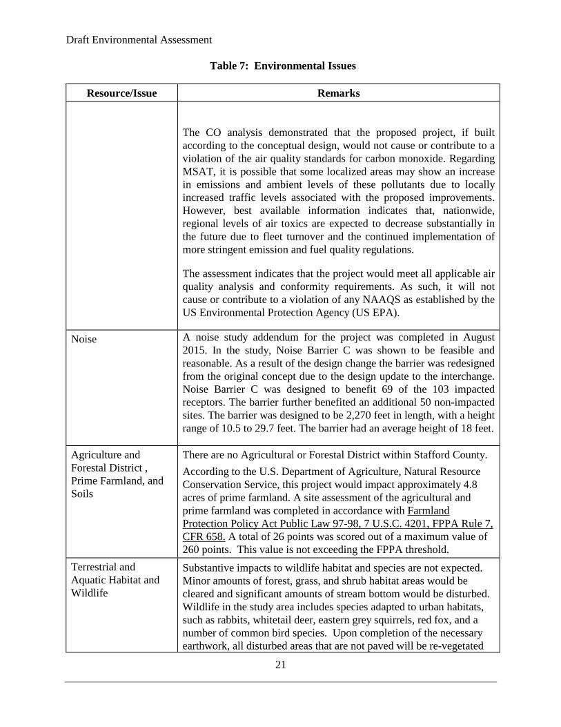
The CO analysis demonstrated that the proposed project, if built according to the conceptual design, would not cause or contribute to a violation of the air quality standards for carbon monoxide. Regarding MSAT, it is possible that some localized areas may show an increase in emissions and ambient levels of these pollutants due to locally increased traffic levels associated with the proposed improvements. However, best available information indicates that, nationwide, regional levels of air toxics are expected to decrease substantially in the future due to fleet turnover and the continued implementation of more stringent emission and fuel quality regulations.
The assessment indicates that the project would meet all applicable air quality analysis and conformity requirements. As such, it will not cause or contribute to a violation of any NAAQS as established by the US Environmental Protection Agency (US EPA).
Noise A noise study addendum for the project was completed in August 2015. In the study, Noise Barrier C was shown to be feasible and reasonable. As a result of the design change the barrier was redesigned from the original concept due to the design update to the interchange. Noise Barrier C was designed to benefit 69 of the 103 impacted receptors. The barrier further benefited an additional 50 non-impacted sites. The barrier was designed to be 2,270 feet in length, with a height range of 10.5 to 29.7 feet. The barrier had an average height of 18 feet.
Agriculture and Forestal District , Prime Farmland, and Soils
There are no Agricultural or Forestal District within Stafford County. According to the U.S. Department of Agriculture, Natural Resource Conservation Service, this project would impact approximately 4.8 acres of prime farmland. A site assessment of the agricultural and prime farmland was completed in accordance with Farmland Protection Policy Act Public Law 97-98, 7 U.S.C. 4201, FPPA Rule 7, CFR 658. A total of 26 points was scored out of a maximum value of 260 points. This value is not exceeding the FPPA threshold.
Terrestrial and Aquatic Habitat and Wildlife
Substantive impacts to wildlife habitat and species are not expected. Minor amounts of forest, grass, and shrub habitat areas would be cleared and significant amounts of stream bottom would be disturbed. Wildlife in the study area includes species adapted to urban habitats, such as rabbits, whitetail deer, eastern grey squirrels, red fox, and a number of common bird species. Upon completion of the necessary earthwork, all disturbed areas that are not paved will be re-vegetated

Draft Environmental Assessment
22
Table 7: Environmental Issues
Resource/Issue Remarks using appropriate grass seed mixes in accordance with VDOT’s plans and specifications.
Threatened and Endangered Species
The U.S. Fish and Wildlife Service (USFWS), Information, Planning, and Conservation System (IPAC) identified Federally Endangered species harperella (ptilimnium nodosum),Federally & State Threatened Dwarf wedge mussel (Alasmidonta heterdon), Federally Threatened Northern long-eared Bat (Myotis septentrionalis) and Federally Threatened & State Endangered Small Whorled Pogonia (Isotria medeoloides), that could be impacted by this project. Suitable habitat for harperella and Dwarf wedge mussel not present within the study area. Between June 24, 2010 and July 16, 2010 VDOT conducted a detailed survey for Small Whorled Pogonia (SWP) within the 525 acre study area. The survey yielded no findings of individual SWP; however, potential habitat did exist mainly on the western side of Interstate 95. The Virginia Department of Game and Inland Fisheries reported in the VDOT GIS that no listed wildlife resources under their jurisdiction have been documented within two miles of the project area. Therefore, impacts upon such resources are not anticipated to result from the proposed work. As the project progresses towards construction additional field survey will be required to confirm SWP are not present within the project limits. Between July 27, 2015 and August 8, 2015, VDOT conducted an acoustic bat survey to determine if the Northern long-eared bat (NLEB) was present within the study area. The result of the acoustic survey, is the probable absence of NLEB has been confirmed within the I-95/Route 630 Interchange project pending USFWS approval. VDOT is currently coordinating with USFWS, the VDOT has recommended that the proposed project will not likely adversely affect the NLEB.
Invasive Species In accordance with Executive Order 13112, Invasive Species, the potential for the establishment of invasive terrestrial or aquatic animal or plant species during construction of the proposed project will be minimized by following provisions in the current VDOT Road and Bridge Specifications. These provisions require prompt seeding of disturbed areas with mixes that are tested in accordance with the Virginia Seed Law and VDOT’s standards and specifications to ensure that seed mixes are free of noxious species. While the proposed right of way is vulnerable to the colonization of invasive plant species from other portions of the site and from adjacent properties, implementation of the stated provisions would reduce the potential for the establishment and proliferation of invasive species.
Draft Environmental Assessment
23
Table 7: Environmental Issues
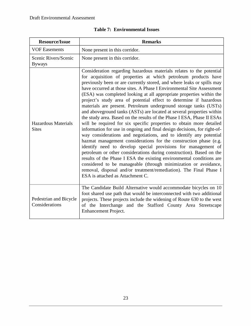
Resource/Issue Remarks VOF Easements None present in this corridor.
Scenic Rivers/Scenic Byways
None present in this corridor.
Hazardous Materials Sites
Consideration regarding hazardous materials relates to the potential for acquisition of properties at which petroleum products have previously been or are currently stored, and where leaks or spills may have occurred at those sites. A Phase I Environmental Site Assessment (ESA) was completed looking at all appropriate properties within the project’s study area of potential effect to determine if hazardous materials are present. Petroleum underground storage tanks (USTs) and aboveground tanks (ASTs) are located at several properties within the study area. Based on the results of the Phase I ESA, Phase II ESAs will be required for six specific properties to obtain more detailed information for use in ongoing and final design decisions, for right-of-way considerations and negotiations, and to identify any potential hazmat management considerations for the construction phase (e.g. identify need to develop special provisions for management of petroleum or other considerations during construction). Based on the results of the Phase I ESA the existing environmental conditions are considered to be manageable (through minimization or avoidance, removal, disposal and/or treatment/remediation). The Final Phase I ESA is attached as Attachment C.
Pedestrian and Bicycle Considerations
The Candidate Build Alternative would accommodate bicycles on 10 foot shared use path that would be interconnected with two additional projects. These projects include the widening of Route 630 to the west of the Interchange and the Stafford County Area Streetscape Enhancement Project.
Draft Environmental Assessment
24
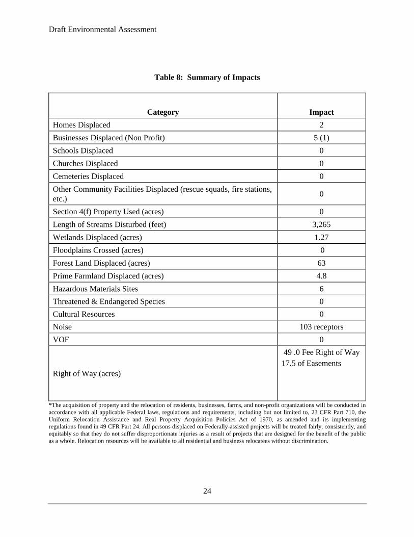
Table 8: Summary of Impacts
Category Impact Homes Displaced 2 Businesses Displaced (Non Profit) 5 (1) Schools Displaced 0 Churches Displaced 0 Cemeteries Displaced 0 Other Community Facilities Displaced (rescue squads, fire stations, etc.) 0
Section 4(f) Property Used (acres) 0 Length of Streams Disturbed (feet) 3,265 Wetlands Displaced (acres) 1.27 Floodplains Crossed (acres) 0 Forest Land Displaced (acres) 63 Prime Farmland Displaced (acres) 4.8 Hazardous Materials Sites 6 Threatened & Endangered Species 0 Cultural Resources 0 Noise 103 receptors VOF 0
Right of Way (acres)
49 .0 Fee Right of Way 17.5 of Easements
*The acquisition of property and the relocation of residents, businesses, farms, and non-profit organizations will be conducted in accordance with all applicable Federal laws, regulations and requirements, including but not limited to, 23 CFR Part 710, the Uniform Relocation Assistance and Real Property Acquisition Policies Act of 1970, as amended and its implementing regulations found in 49 CFR Part 24. All persons displaced on Federally-assisted projects will be treated fairly, consistently, and equitably so that they do not suffer disproportionate injuries as a result of projects that are designed for the benefit of the public as a whole. Relocation resources will be available to all residential and business relocatees without discrimination.
Draft Environmental Assessment
25
3.2 HISTORIC PROPERTIES
3.2.1 Historic Property Identification In accordance with Section 106 of the National Historic Preservation Act of 1966, as amended and its implementing regulations at 36 CFR 800, the VDOT has completed efforts to identify above-ground and below-ground historic properties within the Area of Potential Effects (APE) for the Candidate Build Alternative in consultation with the Virginia Department of Historic Resources (VDHR) and other consulting parties. To summarize, the project’s APE contains no eligible historic properties
3.2.2 Effects on Historic Property In accordance with Section 106, the VDOT has applied the criteria of no effect to the undertaking and has determined that the Candidate Build Alternative for the proposed improvements to the Route 630 & Interstate 95 Interchange Reconstruction as a whole will have no effect on historic properties. VDOT has coordinated with the Virginia Department of Historic Resources (VDHR), and has received concurrence from VDHR that the project will have no effect on historic properties. Several unmarked graves have been located 1200’ west of the proposed intersection of Relocated Route 630 and Route 1. The proposed improvements do not appear to impact the site.
3.3 WATER RESOURCES Water resources are defined as groundwater and surface water, such as aquifers, wetlands, streams, rivers, and ponds. All surface waters identified in the study area are primary, secondary, or tertiary tributaries to the Potomac River. The Virginia Water Quality Standards 9 VAC 25-260 designate this section of the Potomac River and its tributaries as Class III waterways (Nontidal Waters, Coastal and Piedmont Zones), with designated uses including recreation, maintenance of aquatic life (including game fish and wildlife), and production of edible and marketable natural resources (e.g., fish and shellfish).
3.3.1 Surface Waters The project would cross unnamed tributaries of Accokeek Creek and Austin Run. These streams are mostly perennial and intermittent headwater streams draining to the Potomac River Basin.
Direct effects on streams are expected to be extensive, amounting to approximately 3,265 linear feet. The largest of these impacts would occur in perennial stream draining most of the eastern portion of the project to Accokeek Creek. The project has been designed to avoid lateral encroachment into this tributary and intersect and crossing perpendicular. Temporary siltation may occur during construction, due to the nature of the streams being impacted and the topography of the area, it is unlikely that this siltation would be anything more than episodic in nature. The presence of acid sulfate soil exists within the project area, these areas will be identified during design process and remediation will be required if encountered. Minor long-term effects on water quality could occur as a result of an increase in pollutant loads in runoff from impervious surfaces. Such pollutants would include particulates, metals, oil and grease,
Draft Environmental Assessment
26
organics, nutrients, and other harmful substances. Temporary and permanent stormwater management measures, including low impact development systems, vegetative controls and detention basins, will be implemented on this project to minimize potential effects. The project design will incorporate erosion and sediment control measures as specified in the VDOT Road Design Manual and the VDOT Road and Bridge Specifications. The requirements and special conditions of any required permits for work in and around surface waters will be incorporated into construction contract documents.
3.3.2 Wetlands Wetlands in the study area include mostly palustrine forested with some emergent types. These wetland areas provide flood flow attenuation functions and nutrient reduction. Forested wetlands in the study area contribute to the diversity of wildlife habitats, stabilize or trap sediments along stream corridors, and reduce nutrients in runoff. The emergent wetlands in the study area receive overland flow and in some locations, groundwater discharge. Functions of these wetlands include sediment trapping, nutrient reduction, habitat for wildlife, groundwater discharge, and seasonal flood attenuation. In accordance with Executive Order 11990, Protection of Wetlands, all practical measures to minimize harm to wetlands will be implemented as part of the project. Approximately 1.27 acres of palustrine forested and emergent wetlands are expected to be impacted.
3.3.3 Floodplains The Federal Emergency Management Agency (FEMA) mapping of floodplains indicates the absence of any designated 100-year floodplain within the project area. In accordance with Executive Order 11988, Floodplain Management, floodplain encroachments are avoided or minimized to the maximum extent practicable. This project will not encroach on any FEMA designated floodplain areas. No substantial effects on natural or beneficial floodplain values are expected to result from the proposed project.
3.3.4 Permits and Mitigation The Build Alternative would impact wetlands and streams, and therefore would require a Section 404 permit from the U.S. Army Corps of Engineers (USACE) and a Virginia Water Protection Permit from the Virginia Department of Environmental Quality (VDEQ). The USACE & VDEQ was included in the early coordination for this project and will be involved in the permitting phase. Because more than one acre of land would be disturbed, a stormwater permit from the Virginia Department of Environmental Quality(VDEQ) also would be required.
The USACE and VDEQ approve appropriate compensation for wetland and stream impacts on a case-by-case basis during permit development and after final design plans have been developed. Types of wetland compensation are purchasing credits at a wetland bank (either publicly or privately owned), compensation through the Virginia Aquatic Resources Restoration Trust Fund, or on-site mitigation may be a viable option for this project. Wetland compensation options will be coordinated with the USACE and VDEQ during the permitting process.
The project scope has been submitted to the respective agencies through Inter Agency Coordination Meeting (IACM) with the understanding that these impacts will be quantified with the development of final plans, and permit applications for the impacts will be submitted to the
Draft Environmental Assessment
27
Corps of Engineers and the Department of Environmental Quality (DEQ). At that time the Corp and VDOT will negotiate minimization and mitigation methods as part of the permitting process and in accordance with 23 CFR 777.9
3.4 CONSTRUCTION During construction, temporary environmental impacts usually can be controlled, minimized, or mitigated through adequate and prudent construction practices and methods. Potential temporary construction impacts and preventive practices are summarized below.
3.4.1 Late Discoveries During construction, should the discovery of archaeological, paleontological, or rare mineralogical articles occur, work would be suspended immediately. VDOT’s 2007 Road and Bridge Specifications establish the protocol that would be followed should a ―”late discovery” occur. 3.4.2 Water Quality During construction, non-point source pollutants could possibly enter groundwater or surface water from stormwater runoff. To minimize these impacts, appropriate erosion and sediment control practices will be implemented in accordance with VDOT’s Road and Bridge Specifications. These specifications also prohibit contractors from discharging any contaminant that may affect water quality. In the event of accidental spills, the contractor is required to immediately notify all appropriate local, state, and federal agencies and to take immediate action to contain and remove the contaminant.
3.4.3 Air Air quality impacts from construction, consisting of emissions from diesel-powered construction equipment, burning of debris, and fugitive dust, would be temporary. This project will comply with all applicable local, state, and federal regulations, including the Virginia Environmental Regulations 9 VAC 5-40-5600 et seq. regarding open burning and 9 VAC 5-50-60 et seq. regarding fugitive dust emissions. To control dust, measures will be taken to minimize exposed earth by stabilizing with grass, mulch, pavement, or other cover as appropriated.
3.4.4 Noise Construction activity may cause intermittent fluctuations in noise levels. During the construction phase of the project, all reasonable measures will be taken to minimize noise impacts from these activities. VDOT’s Road and Bridge Specifications establish construction noise limits and the contractor will be required to conform to this specification to reduce any impacts of construction noise.
3.4.5 Solid Waste and Hazardous Materials All solid waste materials resulting from clearing and grubbing, demolition, or other construction operations will be removed from the project and disposed of in a legal manner. If contaminated soils are encountered during construction, VDOT will develop and implement appropriate procedures for their proper management and coordinate the removal, disposal, and/or treatment
Draft Environmental Assessment
28
of the soil, as necessary. If contaminated groundwater is encountered during construction, VDOT will implement appropriate specifications for proper management and treatment of the water, as necessary.
3.5 INDIRECT EFFECTS Indirect effects are those that are caused by the proposed action but occur later in time or farther in distance than the direct impacts discussed elsewhere in this document. The most common indirect effects associated with highway projects have to do with induced development, that is, development and the impacts of such development that would not otherwise occur if the project were not constructed. Lands surrounding the proposed project corridor currently can be accessed by the existing road network. As such, they are subject to development even in the absence of implementation of this project. On the other hand, construction of this project would enhance access into these currently undeveloped lands. However, it cannot be said that the project by itself would be the direct cause of the development of the surrounding lands because other factors, such as economic conditions, play a larger role in development decisions. The area is zoned for rural, agricultural, residential, and commercial development. In summary, the proposed project could serve, but would not directly cause, development on adjoining lands. Moreover, the project is consistent with local comprehensive planning regarding land use goals in the surrounding area and the project would be expected to improve overall mobility and connectivity among surrounding land uses and transportation facilities. Fire, police, and rescue emergency services are all expected to benefit from the improved transportation facilities.
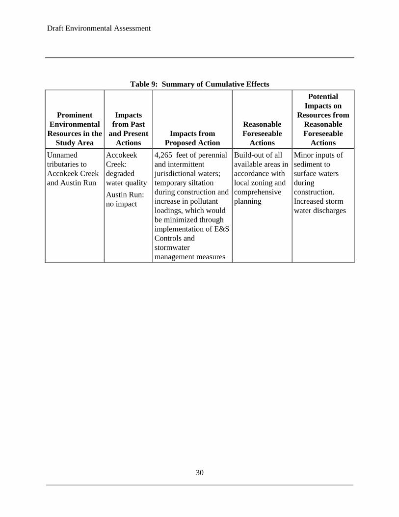
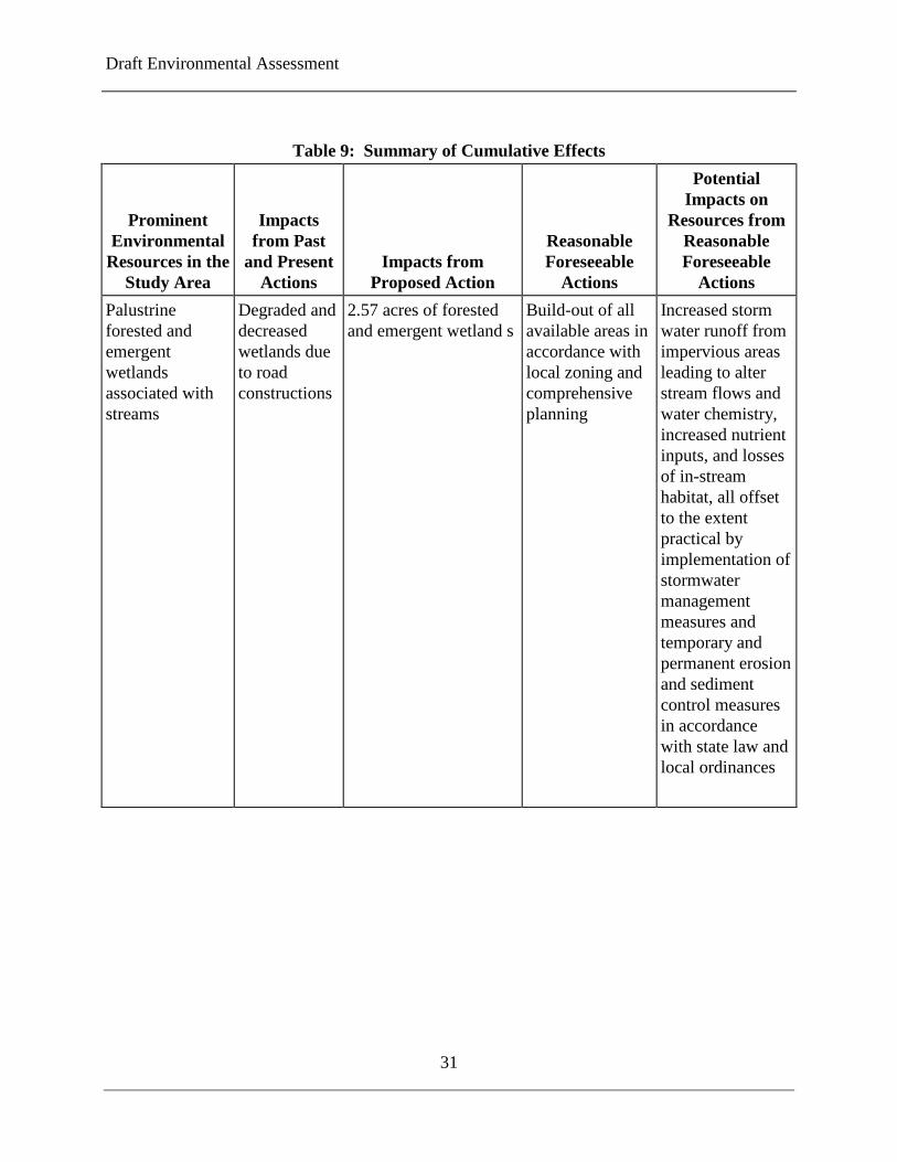
3.6 CUMULATIVE EFFECTS Cumulative effects are the incremental effects of the action when added to other past, present, and reasonably foreseeable future actions, regardless of the sponsor of those actions. The assessment of cumulative effects requires an assessment of the impact of past and present actions have had on the environmental resources in the project study area that will also be impacted by the proposed project; the current affected environment is a reflection of the impacts of those past and present actions over time. Additionally, a review of cumulative effects requires an assessment of how reasonably foreseeable future actions may affect the same environmental resources that would be directly affected by the project. Table 9 summarizes the more prominent environmental resources in the project study area that would be impacted by the proposed project, the impacts that these resources have experienced from past and present actions, the incremental impact expected from the proposed project, identification of potential reasonably foreseeable future actions, and the potential impacts that may occur from other reasonably foreseeable future actions in or near the study area.
Despite the dramatic changes in the landscape that have occurred over time due to human settlement in the surrounding area, the intensity of the incremental impacts of the project is considered small when viewed in the context of impacts from other past, present, and reasonably foreseeable future actions and would not rise to a level that would cause significant cumulative impacts. However, at the western terminus of this project an additional roadway reconstruction project is proposed UPC 4632, that will improve approximately 2 miles of Route 630 from newly constructed Mine Rd to 0.2 miles west of Route 628 (Ramoth Church Road). The typical section would consist of four 12' lanes, 16’ median with a 10’ shared use path on the north side of Route
Draft Environmental Assessment
29
630 with curb and gutter. This project (UPC 4632, VDOT Project# 0630-089-202, C501, P101, R201) was evaluated under a Categorical Exclusion. The effects of this project are included in the summary table below.
Draft Environmental Assessment
30
Table 9: Summary of Cumulative Effects
Prominent Environmental
Resources in the Study Area
Impacts from Past
and Present Actions
Impacts from Proposed Action
Reasonable Foreseeable
Actions
Potential Impacts on
Resources from Reasonable Foreseeable
Actions Unnamed tributaries to Accokeek Creek and Austin Run
Accokeek Creek: degraded water quality Austin Run: no impact
4,265 feet of perennial and intermittent jurisdictional waters; temporary siltation during construction and increase in pollutant loadings, which would be minimized through implementation of E&S Controls and stormwater management measures
Build-out of all available areas in accordance with local zoning and comprehensive planning
Minor inputs of sediment to surface waters during construction. Increased storm water discharges
Draft Environmental Assessment
31
Table 9: Summary of Cumulative Effects
Prominent Environmental
Resources in the Study Area
Impacts from Past
and Present Actions
Impacts from Proposed Action
Reasonable Foreseeable
Actions
Potential Impacts on
Resources from Reasonable Foreseeable
Actions Palustrine forested and emergent wetlands associated with streams
Degraded and decreased wetlands due to road constructions
2.57 acres of forested and emergent wetland s
Build-out of all available areas in accordance with local zoning and comprehensive planning
Increased storm water runoff from impervious areas leading to alter stream flows and water chemistry, increased nutrient inputs, and losses of in-stream habitat, all offset to the extent practical by implementation of stormwater management measures and temporary and permanent erosion and sediment control measures in accordance with state law and local ordinances

Draft Environmental Assessment
32
Table 9: Summary of Cumulative Effects
Prominent Environmental
Resources in the Study Area
Impacts from Past
and Present Actions
Impacts from Proposed Action
Reasonable Foreseeable
Actions
Potential Impacts on
Resources from Reasonable Foreseeable
Actions Residential & Commercial Properties
Long term increases in development both by the locality constructing community service facilities and private developers may have cumulatively increase noise levels
Increase in existing noise levels with project vicinity which range from 57 to 75 dBA currently
Interstate 95 HOT Lanes
A noise barrier named “CNE RR Barrier” was designed to provide mitigation to the properties in the north east quadrant of the I-95/Courthouse Road interchange per the I-95 HOT Lanes Study
Draft Environmental Assessment
33
Section 4
COORDINATION AND COMMENTS
4.1 AGENCY COORDINATION In the process of preparing this document, the federal, state, and local agencies listed below were consulted to obtain pertinent information and to identify key issues regarding potential environmental impacts.
U.S. Army Corps of Engineers • U.S. Fish and Wildlife Service • U.S. Environmental Protection Agency • Virginia Department of Historic Resources • Virginia Department of Environmental Quality - Air, Water and Waste Divisions • Virginia Department of Game and Inland Fisheries • Virginia Department of Forestry • Virginia Outdoors Foundation • Virginia Department of Mines, Minerals, and Energy • Virginia Department of Health, Office of Drinking Water • Virginia Department of Conservation and Recreation • Virginia Department of Agriculture and Consumer Services • Stafford County Administrator • Stafford County Department of Parks, Recreation, and Community Services • Stafford County Health Department • Stafford County Department of Planning • Stafford County Superintendent of Schools • Stafford County Emergency Services • Tri-County Soil and Water Conservation District • Natural Resource Conservation Service • Fredericksburg Area Metropolitan Planning Organization (FAMPO)
4.2 PUBLIC INVOLVEMENT
A Citizen Information Meeting was held on June 14, 2012. Comments received were reviewed by the Design Team, VDOT and FHWA and these comments were incorporated into the decision making matrix for developing the previous Candidate Build Alternative for this project. VDOT held a public hearing for Alternative A2 on November 29, 2012. VDOT will hold a public hearing for this Candidate Build Alternative F on September 29, 2015. The purpose of this hearing is to present the preliminary project design and findings of the Environmental Assessment (EA) Re-Evaluation, provide a discussion forum between the public and the project team, and obtain input and comments from the community. There will be 30-day public comment period following the notice of availability of the EA.