vermont interstate interchange · vermont’s landscape? this guidebook is intended to facili-tate...
TRANSCRIPT

VERMONT INTERSTATE INTERCHANGE
Planning and Development
DESIGN GUIDELINES
Vermont Department of Housing and Community Affairs
2
Acknowledgements
Tara Bamford
Don Bourdon
Jane Brown
Tim Fluck
Nancy Hoggson
Julie Iffland
Sandy Levine
Jeff Nick
John Perkins
Stephen Sease
Tim Smith
Stephanie Smith
Chris Walsh
Upper Valley Lake Sunapee Regional Planning
Commission
Two Rivers Ottauquechee Regional Commission
Vermont Agency of Transportation
Chittenden County Regional Planning Commission
Eastern Vermont Gateway Regional Marketing
Organization
Randoph Planning Commission
Middlesex Planning Commission
JL Davis Realty
Vermont Agency of Transportation
Vermont Agency of Natural Resources
Franklin County Industrial Corporation
Vt. Chapter of the American Society of Landscape
Architects
Central Vermont Regional Planning Commission
This Guidebook was produced by the Vermont Department of Housing and
Community Affairs, with support from a Sustainable Development Challenge
Grant from the U.S. Environmental Protection Agency. Sue Minter, Faith
Ingulsrud and Peg Elmer provided staff support. The consultant team included
Terra Firma Urban Design, Burnt Rock, Inc., Associates in Community Planning,
Kathleen Ryan, ASLA, Alex MacLean, Landslides, and Sandra Vitzthum, AIA.
June 30, 2004
This project was guided by a project Advisory Committee. Thanks and apprecia-
tion are extended to the members of the committee, including:
This document portrays conceptual scenarios of planning options for use by the communities
of Vermont. It does not represent state regulatory policy and is not intended for use in regula-
tory proceedings of the State.
Printed on 50% recycled paper (Mohawk 50/10 plus: 50% recycled paper with 15% post con-
sumer waste and processed chlorine free). For more information, contact Mohawk Paper Mills
(800) 843-6455, www.mohawkpaper.com.
Aerial photographs were taken by Alex MacLean (copyright, 2002). All other photographs and
graphic materials, except where noted, were produced by, Julie Campoli, copyright, 2004.
3
Table of Contents
INTRODUCTION
Background 4
Public Policy 4
Purpose of the Guidebook 5
Creating This Guidebook 5
How To Use This Guidebook 6
PLANNING GUIDELINES
Existing Conditions 7
Planning Considerations 8
Local & Regional Context 8
Land Uses 9
Existing & Planned Infrastructure 10
Planning Strategies 11
Public Outreach 11
Municipal Planning 11
Regional Planning 18
State Resources & Programs 19
DESIGN GUIDELINES
The Vermont Context 20
Access Management 27
Site Development 29
Site Layout 30
Building Design 32
Lighting 34
Signs 35
Landscaping 36
APPENDIX 40
RESOURCES 41

4
BBaacckkggrroouunndd
Vermont s interstate system has been a valuable public asset
since work began on it in 1957. Constructed as part of the
nation s post-war infrastructure investment program, the
project took 25 years to complete at a total cost of $670 mil-
lion. The state s 320 miles of interstate highways are now
the backbone of Vermont s transportation network. They
offer world-class views to visitors and tourists, and provide
an engine for economic development through the efficient
delivery of travelers, goods, and services around the state.
They serve as gateways to the state from Massachusetts (via I-
91), New Hampshire (via I-89 and I-93) and Quebec (via I-91
and I-89). With nearly 60% of Vermont s land area lying
within 20 miles of one of 52 highway interchanges, the
interstate system also functions as the front door to many
cities and villages, and much of the state s rural
countryside.1
Many communities along Vermont s interstate system have
benefited from the opportunities for improved transporta-
tion and tourism provided by the highways. But while prox-
imity to the interstate offers development opportunities,
those opportunities can lead to unanticipated community
challenges. In some locations, large-scale commercial devel-
opment close to interchanges has led to increased congestion
and accidents, reduced levels of service along roads and at
nearby intersections, and increasing public costs of mitigat-
ing these impacts. There is also growing concern that some
types of interchange development undermine the economic
vitality of nearby downtowns. And the dispersed, auto-
dependent growth patterns emerging at many interchanges
can have detrimental impacts on Vermont s scenery, envi-
ronment, and traditional downtowns, endangering the quali-
ty of life that defines Vermont.
PPuubblliicc PPoolliiccyy
Throughout the history of development along the interstate,
Vermonters have supported the preservation of the scenic
qualities of the corridor. This support resulted in the land-
mark 1967 law prohibiting billboards, in addition to several
state initiatives and regulatory decisions that highlighted the
importance of protecting scenic highway corridors, includ-
ing the interstate system.2
Planning for development along the interstate system also
takes place within a larger policy context. Vermont s plan-
ning and development law establishes statewide goals for
land use (24 VSA ⁄4302). An overarching goal within the
law is to maintain the historic settlement pattern of compact
villages and urban centers surrounded by rural countryside.
We re on the verge of the greatest development
Vermont has ever seen.
George D. Aiken, 1961.Comments commorating the completion of the first seg-
ment of Vermont s interstate highway system.
These highways are not only freeing motor vehicles to serve their full
economic and social potential, but are also, in inevitable consequence,
expected to influence the development of the state no less significantly
than the coming of the railroad.Vermont Life, 1966
Although they mar the beauty of many other interstate cor ridors,not one of the 500,000 billboar ds l i ning America’ s major high -ways can be found in V ermont. When the state banned billboar dsit r emoved a major contributor of visual clutter fr om the land -scape. W ith outdoor adver tising so long gone fr om our r oadways,it’ s easy to for get the negative impact billboar ds can have onscener y. As other states and communities acr oss the countr ystr uggle to limit the placement and size of billboar ds, V ermont isl i teral l y s i tting pr etty.
Introduction

5
ful planning, and by
illustrating more com-
pact and land-efficient
design and develop-
ment. It explains the
consequences of incre-
mental, uncoordinated
decision making, and
offers strategies for
implementing a compact
growth pattern, while
addressing the land uses
that are generally recog-
nized to be necessary or
desirable at inter-
changes.
The guidebook was devel-
oped and distributed for
use as an educational and planning tool for those seeking to
manage land use and growth pressures in their communi-
ties. The contents of the Guidebook are intended to illus-
trate how the application of various planning principles
might affect a site s development and the resulting impacts
on the community. The scenarios depicted in the
Guidebook are conceptual and demonstrate the possible use
of alternative development approaches. TThhee ccoonntteennttss ooff tthhee
GGuuiiddeebbooookk aarree nnoott iinntteennddeedd aass aanndd sshhoouulldd nnoott bbee ccoonn--
ssttrruueedd oorr aapppplliieedd aass aa ssttaatteemmeenntt ooff tthhee rreegguullaattoorryy ppoolliiccyy ooff
tthhee SSttaattee ooff VVeerrmmoonntt,, aanndd ddoo nnoott ssuuppeerrsseeddee tthhee ppoolliicciieess aanndd
rreeqquuiirreemmeennttss ooff aaddoopptteedd mmuunniicciippaall aanndd rreeggiioonnaall ppllaannss aanndd
bbyyllaawwss..
CCrreeaattiinngg TThhiiss GGuuiiddeebbooookk
This Guidebook is the culmination of a multi-phased study
of Vermont s interchanges. Early in the process of preparing
the guidebook, each interchange was photographed, both
from the ground and the air, to establish an inventory of
land use patterns and views. The photographs were evaluat-
ed, with each view given a scenic quality rating, to determine
where the most vulnerable areas may be. A land use analysis
provided a picture of how interchanges are currently used, as
well as an idea of existing development conditions.
This analysis led to the creation of six interchange types rep-
resenting different growth contexts. Several focus groups
were conducted to solicit the advice of state officials and pol-
icy-makers, local and regional planners, landowners and
developers, and conservation organizations (46 participants).
Advice, oversight and document review was also provided by
the project Advisory Committee, which included representa-
tion from regional planning, economic development and
marketing organizations, local and state officials, and inter-
change developers.
Strip development
along highways is dis-
couraged and important
historic, natural and
scenic features of the
Vermont landscape are
to be identified, protect-
ed and preserved. In
addition, the statute
seeks to foster a strong
economy that provides
rewarding job opportu-
nities and maintains
high environmental
standards.
Executive Order 07-01
was signed in 2001 to
encourage development
and/or conservation of land at the interchanges that will be
consistent with state land use goals. Intended to guide state
agency decisions on planning for and responding to develop-
ment proposed at Vermont s interchanges, the Executive
Order refocused attention on development issues specific to
interchange areas.
Stimulated by state policy, several Vermont municipalities
have worked to plan for growth around local interchanges.
Between 1998 and 2003 eleven municipalities developed
plans to help guide anticipated growth around
interchanges.3 Moreover, several municipalities and the
State initiated land conservation of key scenic parcels near
interchanges.4 In 2000, the Vermont Department of
Housing and Community Affairs (DHCA) received a three-
year grant from the US Environmental Protection Agency to
further interchange area planning along the interstate. The
grant includes: planning projects in four municipalities, nat-
ural resource inventories in those communities, and the
development of this design guidebook.
PPuurrppoossee ooff tthhee GGuuiiddeebbooookk
Interchanges will continue to attract development, just as
the junction of rivers did in earlier times. Given that fact,
what will the development at interchanges consist of? How
will it affect existing infrastructure? How will it fit into
Vermont’s landscape? This guidebook is intended to facili-
tate the type of development at interstate interchanges that
will maintain and even enhance the economic and environ-
mental character of Vermont’s communities.
Intended for use by municipalities, land developers and pub-
lic officials, this guidebook promotes ways to support growth
at interchanges that is consistent with state land use goals
and other state policy initiatives. It was created as a resource
for understanding growth patterns by visualizing the pattern
of land use that will likely result in the absence of meaning-
The landscape at I-93 Exit 1 in W aterfor d embodies the pattern thatVermont’ s land use law r efers to--compact settlement sur rounded by r uralcountr yside.

6
HHooww TToo UUssee TThhiiss GGuuiiddeebbooookk
The guidebook is organized into two sections. The first —
PPllaannnniinngg GGuuiiddeelliinneess—examines existing conditions at inter-
change areas and addresses the special planning issues to be
considered to fully address growth there. This section also
describes strategies for planning at the municipal and
regional levels and some of the state resources that are avail-
able. The second half of the guidebook presents DDeessiiggnn
GGuuiiddeelliinneess for development at interstate interchange areas.
These include design concepts to help new development fit
into the various Vermont contexts found at interstate inter-
changes. Included are recommendations on siting, building,
and landscaping development at interchange locations.
The Planning section is intended primarily for use by local
and regional planners in preparing and adopting plans and
regulations for land around interchanges. The Design
Guidelines are directed to a broader audience. They may be
used by developers and landowners beginning work on
designing development projects, local planning commissions
crafting standards for the review of projects, and citizens
interested in learning about desirable development patterns
at the state s interchanges. Rather than using the guidelines
to evaluate specific projects, the guidelines are designed to
help communities and regions prepare policies that are spe-
cific to the unique setting and context of each of the state s
52 interchanges.
Development at Interstate Interchanges:Why the Special Attention?
Developable land around Vermont’s 52 interstate inter-changes is a finite resource that provides a unique set ofopportunities and challenges for development, especiallywhen viewed from a statewide perspective.Development patterns at interstate interchanges areimportant to all citizens of Vermont for the following rea-sons.
• We expect to have a safe and efficient road system, andpay taxes to support the state transportation systemincluding the interstates and interconnecting highways.Uncoordinated development that generates high levels ofcongestion at interchange areas can hamper our ability totravel safely and efficiently around the state.
• Vermont’s planning and development statute encour-ages all municipal and regional plans to further the state’sprimary land use goal: To plan development so as tomaintain the historic settlement pattern of compact vil-lage and urban centers separated by rural countryside.[24VSA§ 4302(c)(1)]
• Public funds support a wide range of economic devel-opment programs directed towards our historic down-towns and villages. Public investments in these historiccenters (public buildings, sewer/water facilities, sidewalksand parks) seek to maintain their vitality. Development atinterchanges that competes with villages and downtowns,can undermine Vermont’s efforts to maintain and improvethese historic centers of social and economic activity.
• Vermont’s interstate highways provide travelers a win-dow onto the state’s natural and cultural treasures as theytraverse scenic farmland, rolling wooded hillsides, moun-tains, and valleys flanked by villages and small cities.These scenic landscapes help to reinforce the uniqueVermont “brand,”: a high-quality environment combinedwith a rich community life. This kind of positive, recog-nizable image is important to the economic success of asmall, remote state like Vermont. By protecting ourwaterways, valued farmland, and other significant naturaland cultural resources at interstate interchanges throughconservation and careful development, we can providegateways to our communities that successfully convey theunique qualities that define Vermont.
• Services for travelers and facilities requiring trucking arenecessary to a healthy economy in Vermont. These oftenneed to be located at interstate interchanges. Optimallocations for interchange-related facilities need to beidentified and efforts made to ensure that necessary andviable interchange uses are given priority over uses thatcould be located elsewhere.
This guidebook suggests ways that planning for develop-ment at interstate interchanges can address thesestatewide concerns. Owners and developers of land atinterstate interchanges, and the municipalities that con-tain those lands, make decisions about how the inter-state interchange areas will be developed. The planningand design guidelines that follow are intended to helpthose decision-makers meet not only their individual,business or municipal goals but to do so in a way thatwill address the overall interests of the people of
7
Who decides what the pattern of growth will be? Individual landowners decisions are guided by site constraints, market
demand, municipal and regional planning, and local and state regulations. This Guidebook emphasizes the benefits of
proactive planning for interchange area development. A productive and inclusive planning process can bring together the
interests of landowners with the goals and concerns of municipal officials and citizens as well as regional and state entities.
An effective planning process can ultimately lead to a more efficient and predictable regulatory process for interchange devel-
opment.
This section outlines a community planning approach that addresses the
needs of landowners, anticipates the trends of the market, and meets local
and regional goals. As municipalities contemplate options for their inter-
change, they should take a close look at the eexxiissttiinngg ccoonnddiittiioonnss and forces
affecting the physical form of growth. They should also consider several
issues associated with interchange development. PPllaannnniinngg
CCoonnssiiddeerraattiioonnss reviews topics such as local and regional contexts, land
use, and infrastructure. PPllaannnniinngg SSttrraatteeggiieess offers recommendations for
reaching out to the public, developing plans, delineating zoning districts,
and protecting natural resources, as well as outlining regional and state
planning resources.
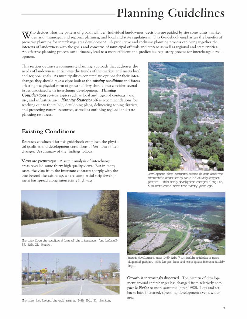
GGrroowwtthh iiss iinnccrreeaassiinnggllyy ddiissppeerrsseedd. The pattern of develop-
ment around interchanges has changed from relatively com-
pact (c.1960s) to more scattered (after 1980). Lots and set-
backs have increased, spreading development over a wider
area.
EExxiissttiinngg CCoonnddiittiioonnss
Research conducted for this guidebook examined the physi-
cal qualities and development conditions of Vermont s inter-
changes. A summary of the findings follows:
VViieewwss aarree ppiiccttuurreessqquuee.. A scenic analysis of interchange
areas revealed some thirty high-quality views. But in many
cases, the vista from the interstate contrasts sharply with the
one beyond the exit ramp, where commercial strip develop-
ment has spread along intersecting highways.
Planning Guidelines
The view fr om the southbound lane of the interstate, just befor e I-89, Exit 21, Swanton.
The view just beyond the exit ramp at I-89, Exit 21, Swanton.
Development that occur red befor e or soon after theinterstate’ s constr uction had a r elatively compactpattern. This strip development emer ged along Rte.5 in Brattlebor o mor e than twenty years ago.
Recent development near I-89 Exit 7 in Berlin exhibits a mor edispersed pattern, with lar ger lots and mor e space between build -ings .

8
CCoommmmeerrcciiaall uusseess ddoommiinnaattee.. Growth at most (91%) of
Vermont s interchanges is governed by land use regulations
that allow a wide array of uses. Nearly all interstate munici-
palities have targeted areas surrounding their interchanges as
appropriate locations for commercial and industrial develop-
ment. Gas stations, industrial parks, or warehousing are
found at 60% of interchanges.
TTrraaffffiicc iiss iinnccrreeaassiinngg rraappiiddllyy. Average annual traffic has
jumped by 10% in the last 5 years and is expected to grow
by 44% in the next 20 years. Interchanges have attracted
retail uses, which, in turn, have generated more traffic and
considerable congestion in some locations.
SSeewweerr aanndd wwaatteerr aarree oofftteenn aavvaaiillaabbllee. A majority of inter-
changes are located within a half mile of municipal water
and wastewater collection systems.
Interchange municipalities should examine similar topics at
a site-specific level. Take a close look at the physical qualities
of the interchange, how it grew in the past, and the condi-
tions that may shape its future growth. In this early phase
of planning, ask some questions, such as:
¥ What is the scenic quality of the interchange?
¥ Are there areas that are visually sensitive and need spe-
cial consideration?
¥ What land use and development patterns have evolved
over time?
¥ How has this affected traffic?
¥ How will current regulations affect the look and feel of
future development?
¥ What are the local and regional market trends for this
interchange?
¥ What are the community goals and vision for the inter-
change area?
PPllaannnniinngg CCoonnssiiddeerraattiioonnss
In addition to a physical analysis, municipalities should con-
sider several issues associated with interchange development.
The following section briefly describes some of the chal-
lenges and choices communities face to achieve local plan-
ning goals in concert with regional and state goals.
LLOOCCAALL && RREEGGIIOONNAALL CCOONNTTEEXXTTConsider how new development will affect the community
overall, as well as a particular interchange area.
RReeggiioonnaall CCoonntteexxtt.. Interchange area planning should take
into consideration regional market demands for goods and
services. Neighboring municipalities should coordinate
responses to interstate-related needs such as rest areas and
traveler services.
RReellaattiioonnsshhiipp ttoo CCoommmmuunniittyy CCeenntteerrss.. An important issue
facing interchange communities, and the state in general, is
the relationship between interchange development and
development within existing downtown and village centers.
A municipality should consider which types of development
would be beneficial, and whether certain types of inter-
change area growth will draw public investment and eco-
nomic vitality away from its traditional center. Competition
Status of commer cial zoning at interstate inter changes. Mostcommunities have designated at least par t of the land ar oundthei r i nter change as a commer cial d i stri ct. S our ce: VTDepar tment of Housing and Community Affairs
Rte. 100 in W aterbur y intersecting I-89 Exit 10 is an ar terial r oad that is sometimes over whelmed by incr eased traffic. In a shor t exitramp, without additional capacity to accommodate waiting vehicles, cars can back up to the travel lane of the interstate, posin g a safetyhazar d.
9
ity of the interchange area that will serve area commuters.
The state transportation agency (VTrans) has sited a number
of facilities at interchanges to promote regional ridesharing,
and to ensure adequate highway maintenance. According to
VTrans officials, additional maintenance facilities will not be
needed in the foreseeable future. VTrans is, however, plan-
ning for the establishment, upgrade and expansion of park-
and-ride facilities at most interchanges. These facilities can
generate significant amounts of traffic at peak hours; but
these also can be designed to incorporate transit facilities
such as bus stops and bicycle storage units to promote alter-
native travel modes.
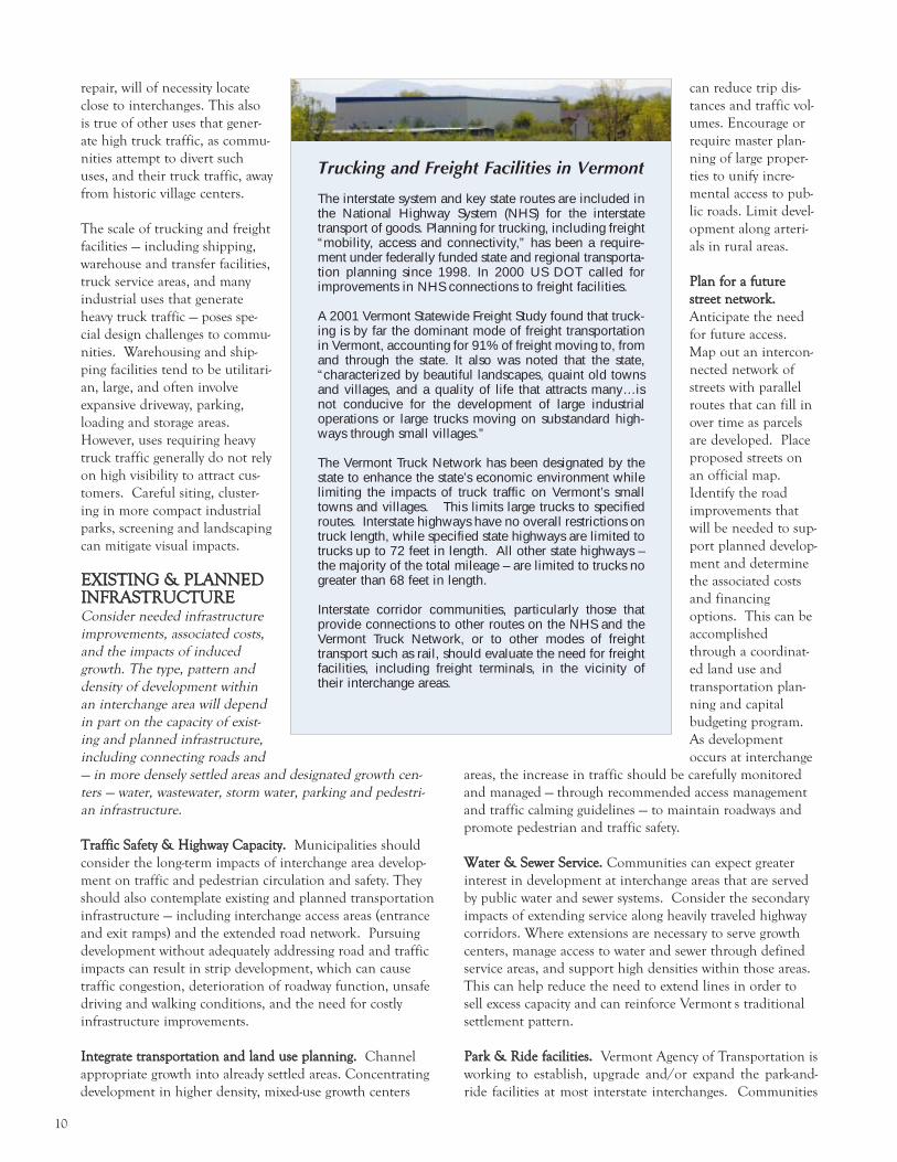
TTrruucckkiinngg && FFrreeiigghhtt FFaacciilliittiieess.. The primary purpose of the
interstate highway system is to provide an efficient trans-
portation network. As Vermont s population and economy
grow, truck traffic is expected to increase. Facilities that rely
on access to large trucks or large numbers of trucks for sup-
plies and distribution, or provide services such as fuel and
between interchange locations and traditional centers takes
place at both the local and regional level.
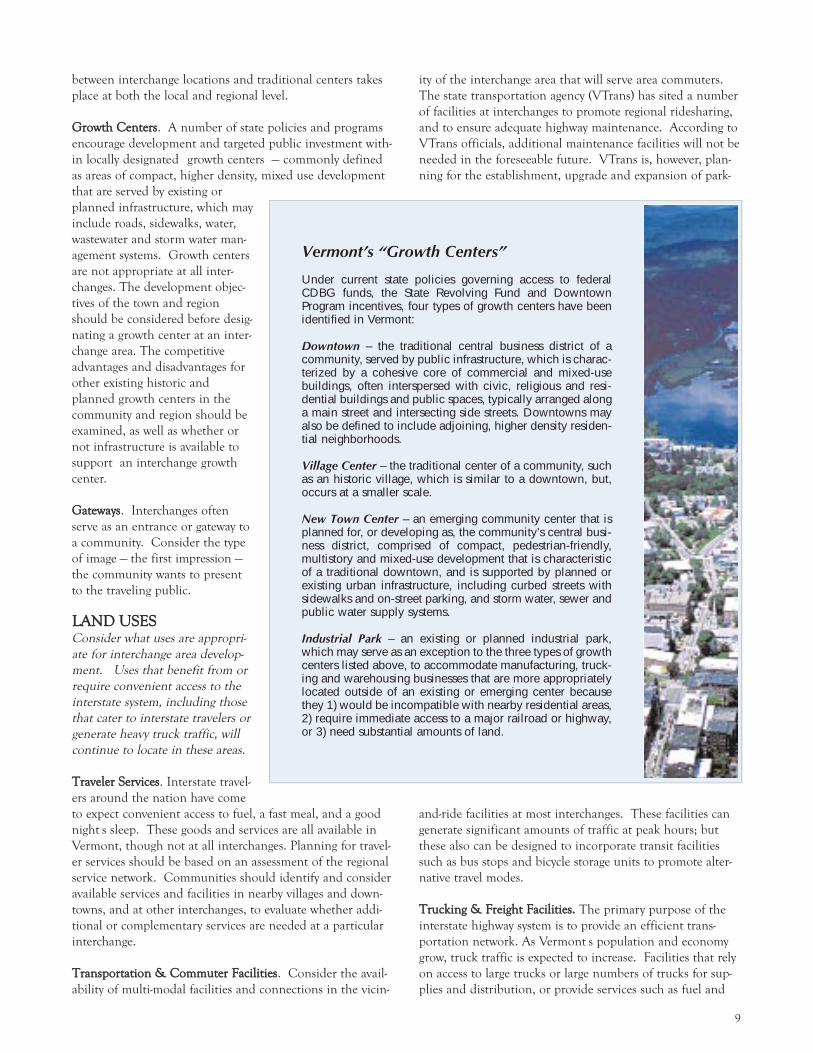
GGrroowwtthh CCeenntteerrss. A number of state policies and programs
encourage development and targeted public investment with-
in locally designated growth centers — commonly defined
as areas of compact, higher density, mixed use development
that are served by existing or
planned infrastructure, which may
include roads, sidewalks, water,
wastewater and storm water man-
agement systems. Growth centers
are not appropriate at all inter-
changes. The development objec-
tives of the town and region
should be considered before desig-
nating a growth center at an inter-
change area. The competitive
advantages and disadvantages for
other existing historic and
planned growth centers in the
community and region should be
examined, as well as whether or
not infrastructure is available to
support an interchange growth
center.
GGaatteewwaayyss. Interchanges often
serve as an entrance or gateway to
a community. Consider the type
of image — the first impression —
the community wants to present
to the traveling public.
LLAANNDD UUSSEESSConsider what uses are appropri-
ate for interchange area develop-
ment. Uses that benefit from or
require convenient access to the
interstate system, including those
that cater to interstate travelers or
generate heavy truck traffic, will
continue to locate in these areas.
TTrraavveelleerr SSeerrvviicceess. Interstate travel-
ers around the nation have come
to expect convenient access to fuel, a fast meal, and a good
night s sleep. These goods and services are all available in
Vermont, though not at all interchanges. Planning for travel-
er services should be based on an assessment of the regional
service network. Communities should identify and consider
available services and facilities in nearby villages and down-
towns, and at other interchanges, to evaluate whether addi-
tional or complementary services are needed at a particular
interchange.
TTrraannssppoorrttaattiioonn && CCoommmmuutteerr FFaacciilliittiieess. Consider the avail-
ability of multi-modal facilities and connections in the vicin-
Vermont’s “Growth Centers”
Under current state policies governing access to federalCDBG funds, the State Revolving Fund and DowntownProgram incentives, four types of growth centers have beenidentified in Vermont:
Downtown – the traditional central business district of acommunity, served by public infrastructure, which is charac-terized by a cohesive core of commercial and mixed-usebuildings, often interspersed with civic, religious and resi-dential buildings and public spaces, typically arranged alonga main street and intersecting side streets. Downtowns mayalso be defined to include adjoining, higher density residen-tial neighborhoods.
Village Center – the traditional center of a community, suchas an historic village, which is similar to a downtown, but,occurs at a smaller scale.
New Town Center – an emerging community center that isplanned for, or developing as, the community’s central busi-ness district, comprised of compact, pedestrian-friendly,multistory and mixed-use development that is characteristicof a traditional downtown, and is supported by planned orexisting urban infrastructure, including curbed streets withsidewalks and on-street parking, and storm water, sewer andpublic water supply systems.
Industrial Park – an existing or planned industrial park,which may serve as an exception to the three types of growthcenters listed above, to accommodate manufacturing, truck-ing and warehousing businesses that are more appropriatelylocated outside of an existing or emerging center becausethey 1) would be incompatible with nearby residential areas,2) require immediate access to a major railroad or highway,or 3) need substantial amounts of land.
10
repair, will of necessity locate
close to interchanges. This also
is true of other uses that gener-
ate high truck traffic, as commu-
nities attempt to divert such
uses, and their truck traffic, away
from historic village centers.
The scale of trucking and freight
facilities — including shipping,
warehouse and transfer facilities,
truck service areas, and many
industrial uses that generate
heavy truck traffic — poses spe-
cial design challenges to commu-
nities. Warehousing and ship-
ping facilities tend to be utilitari-
an, large, and often involve
expansive driveway, parking,
loading and storage areas.
However, uses requiring heavy
truck traffic generally do not rely
on high visibility to attract cus-
tomers. Careful siting, cluster-
ing in more compact industrial
parks, screening and landscaping
can mitigate visual impacts.
EEXXIISSTTIINNGG && PPLLAANNNNEEDDIINNFFRRAASSTTRRUUCCTTUURREEConsider needed infrastructure
improvements, associated costs,
and the impacts of induced
growth. The type, pattern and
density of development within
an interchange area will depend
in part on the capacity of exist-
ing and planned infrastructure,
including connecting roads and
— in more densely settled areas and designated growth cen-
ters — water, wastewater, storm water, parking and pedestri-
an infrastructure.
TTrraaffffiicc SSaaffeettyy && HHiigghhwwaayy CCaappaacciittyy.. Municipalities should
consider the long-term impacts of interchange area develop-
ment on traffic and pedestrian circulation and safety. They
should also contemplate existing and planned transportation
infrastructure — including interchange access areas (entrance
and exit ramps) and the extended road network. Pursuing
development without adequately addressing road and traffic
impacts can result in strip development, which can cause
traffic congestion, deterioration of roadway function, unsafe
driving and walking conditions, and the need for costly
infrastructure improvements.
IInntteeggrraattee ttrraannssppoorrttaattiioonn aanndd llaanndd uussee ppllaannnniinngg.. Channel
appropriate growth into already settled areas. Concentrating
development in higher density, mixed-use growth centers
can reduce trip dis-
tances and traffic vol-
umes. Encourage or
require master plan-
ning of large proper-
ties to unify incre-
mental access to pub-
lic roads. Limit devel-
opment along arteri-
als in rural areas.
PPllaann ffoorr aa ffuuttuurree
ssttrreeeett nneettwwoorrkk..
Anticipate the need
for future access.
Map out an intercon-
nected network of
streets with parallel
routes that can fill in
over time as parcels
are developed. Place
proposed streets on
an official map.
Identify the road
improvements that
will be needed to sup-
port planned develop-
ment and determine
the associated costs
and financing
options. This can be
accomplished
through a coordinat-
ed land use and
transportation plan-
ning and capital
budgeting program.
As development
occurs at interchange
areas, the increase in traffic should be carefully monitored
and managed — through recommended access management
and traffic calming guidelines — to maintain roadways and
promote pedestrian and traffic safety.
WWaatteerr && SSeewweerr SSeerrvviiccee.. Communities can expect greater
interest in development at interchange areas that are served
by public water and sewer systems. Consider the secondary
impacts of extending service along heavily traveled highway
corridors. Where extensions are necessary to serve growth
centers, manage access to water and sewer through defined
service areas, and support high densities within those areas.
This can help reduce the need to extend lines in order to
sell excess capacity and can reinforce Vermont s traditional
settlement pattern.
PPaarrkk && RRiiddee ffaacciilliittiieess.. Vermont Agency of Transportation is
working to establish, upgrade and/or expand the park-and-
ride facilities at most interstate interchanges. Communities
Trucking and Freight Facilities in Vermont
The interstate system and key state routes are included inthe National Highway System (NHS) for the interstatetransport of goods. Planning for trucking, including freight“mobility, access and connectivity,” has been a require-ment under federally funded state and regional transporta-tion planning since 1998. In 2000 US DOT called forimprovements in NHS connections to freight facilities.
A 2001 Vermont Statewide Freight Study found that truck-ing is by far the dominant mode of freight transportationin Vermont, accounting for 91% of freight moving to, fromand through the state. It also was noted that the state,“characterized by beautiful landscapes, quaint old townsand villages, and a quality of life that attracts many…isnot conducive for the development of large industrialoperations or large trucks moving on substandard high-ways through small villages.”
The Vermont Truck Network has been designated by thestate to enhance the state’s economic environment whilelimiting the impacts of truck traffic on Vermont’s smalltowns and villages. This limits large trucks to specifiedroutes. Interstate highways have no overall restrictions ontruck length, while specified state highways are limited totrucks up to 72 feet in length. All other state highways –the majority of the total mileage – are limited to trucks nogreater than 68 feet in length.
Interstate corridor communities, particularly those thatprovide connections to other routes on the NHS and theVermont Truck Network, or to other modes of freighttransport such as rail, should evaluate the need for freightfacilities, including freight terminals, in the vicinity oftheir interchange areas.

11
nesses, and interest groups, as well as indi-
vidual property owners.
CCoooorrddiinnaattiioonn wwiitthh tthhee SSttaattee. The Vermont
Agency of Transportation (VTrans) owns
property bordering every interchange and is
also the state permitting entity for access
rights (curb cuts) along state corridors.
Therefore, VTrans and municipalities
should work together in a community plan-
ning process. Consultation and coordina-
tion with VTrans is important in order to
ensure that state and local decisions are
made in concert with one another. VTrans
also encourages interchange area planning
and town and regional coordination
through access management and corridor
planning efforts.
CCoommmmoonn TThheemmeess.. It s important to identi-
fy common issues and themes to be
addressed in interchange planning, and to
articulate goals and objectives as well as to
reconcile major differences (particularly
before a regulatory process begins).
VViissuuaalliizziinngg OOppttiioonnss. There are a variety of ways to involve
the community — through local surveys, informational meet-
ings and materials, and public forums. One of the hardest,
but most important tasks is helping people visualize future
development options. This can be accomplished through
graphic representations, computer modeling, visual prefer-
ence surveys, and more interactive design workshops
(charettes).
MMUUNNIICCIIPPAALL PPLLAANNNNIINNGGDevelop a municipal plan that guides anticipated growth at
the interchange and spells out policies and recommenda-
tions for the area. Define appropriate districts to accommo-
date interstate-related uses within the municipality s plan-
ning goals. Consider natural, cultural and scenic features,
including critical open space areas and view sheds.
MMuunniicciippaall PPllaann. Municipalities (including towns, cities and
incorporated villages) are granted broad authority under
Vermont s Planning and Development Act (24 VSA Chapter
117) to plan for and regulate development within their bor-
ders. An adopted municipal plan provides the basis for both
regulatory and non-regulatory means to achieve desired pat-
terns of development. The municipal plan should include
specific recommendations to guide the growth and to miti-
gate any negative impacts of interstate-related development
on road capacity, natural, cultural and scenic resources, open
space, and existing villages and downtowns. For a more
detailed list of municipal plan options see Appendix. The
Vermont Department of Housing and Community Affairs
Planning Manual for Vermont Municipalities provides help-
ful information and guidance for preparing municipal plans.
should work with VTrans to help plan for and site these
important commuter facilities.
PPllaannnniinngg SSttrraatteeggiieess
Communities have several tools available to steer growth
toward a desirable pattern. A comprehensive planning
process involves several components. Below is a list of strate-
gies for planning at the municipal and regional levels as well
as some of the state resources that are available.
PPUUBBLLIICC OOUUTTRREEAACCHHDefine desirable growth patterns and ways to achieve them
through a public process.
LLaannddoowwnneerrss. Landowners generally make the development
decisions for particular parcels. Their interests and plans
should be considered in the context of larger community
goals and objectives. Planners should work with landowners
and developers to integrate their projects into the municipal-
ity s interchange planning process. Landowners should work
to coordinate project development with that of neighboring
properties and the surrounding area, and with infrastructure
and road improvements.
PPuubblliicc IInnvvoollvveemmeenntt.. It may seem easier to develop a plan or
proposal with minimal public scrutiny, but it s then general-
ly harder to win public support. To be most effective a com-
prehensive planning process should identify and encourage
participation by anyone who might be affected by inter-
change area development — including local residents, busi-
Infrastructure Costs as Part of the Equation
A 2001 corridor study of US Route 7 from Winooski to Georgia doc-umented existing and proposed land use and development patternswithin the vicinity of I-89 interchange areas (Exits 15-18). Based on abuild-out analysis of local plans and zoning – and proposed growthcenter development in corridor towns– it was determined that, inaddition to other roadway improvements:
• Interchange improvements will be needed at Exits 16, 17and 18,
• Exit 15 will need to be expanded to a full (4-way) inter-change, and
• A new “Exit 17” will be needed.
Preliminary estimated cost: $11.2 to $20.4 million (not includingright-of-way acquisition) Source: Route 7 Winooski to Georgia CorridorStudy, 2001. Prepared for the Chittenden County MPO by Oman Analytics,Peter Hart, Community Planning & Design, and Kathleen Ryan, LandscapeArchitect.
IInntteerrcchhaannggee AArreeaa PPllaann.. Since interchange areas are the
focus of more intense growth pressure, it makes sense to
develop a more detailed plan for each of these areas.
Inventory and mapping information should be detailed
enough to deal with the complexities of ownership, resource
protection and development. Interchange area planning can
involve the following steps:
1. Delineate the interchange plan area in relation to existing
and planned interchange functions, transportation net-
works, land uses, and settlement patterns.
2. Inventory and map natural, cultural and scenic resources,
including view sheds and critical open space areas.
3. Determine which areas are suitable for development by
identifying those that are not (e.g., surface waters, flood-
plains, wetlands, steep slopes).
4. Evaluate the functional capacity of the transportation net-
work within and around the interchange.
5. Determine the capacity of existing water and sewer infra-
structure to support development.
6. Identify ownership patterns (e.g., parcel maps) and engage
landowner(s) in the planning process.
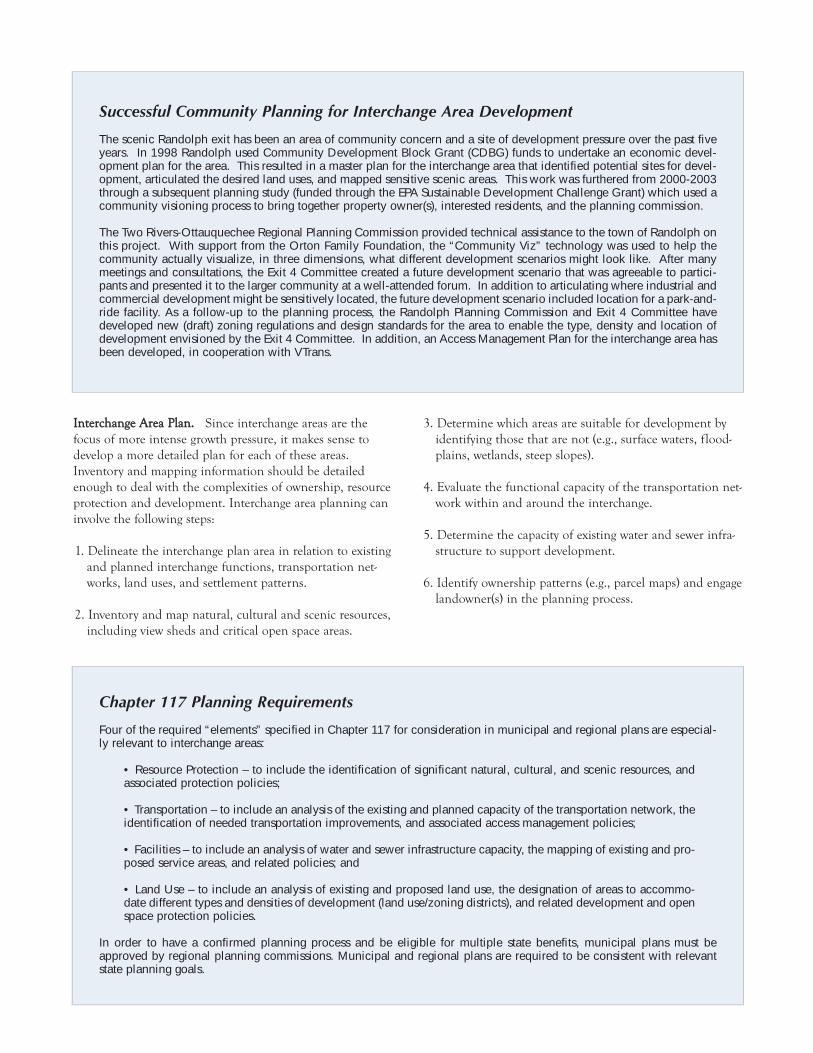
Successful Community Planning for Interchange Area Development
The scenic Randolph exit has been an area of community concern and a site of development pressure over the past fiveyears. In 1998 Randolph used Community Development Block Grant (CDBG) funds to undertake an economic devel-opment plan for the area. This resulted in a master plan for the interchange area that identified potential sites for devel-opment, articulated the desired land uses, and mapped sensitive scenic areas. This work was furthered from 2000-2003through a subsequent planning study (funded through the EPA Sustainable Development Challenge Grant) which used acommunity visioning process to bring together property owner(s), interested residents, and the planning commission.
The Two Rivers-Ottauquechee Regional Planning Commission provided technical assistance to the town of Randolph onthis project. With support from the Orton Family Foundation, the “Community Viz” technology was used to help thecommunity actually visualize, in three dimensions, what different development scenarios might look like. After manymeetings and consultations, the Exit 4 Committee created a future development scenario that was agreeable to partici-pants and presented it to the larger community at a well-attended forum. In addition to articulating where industrial andcommercial development might be sensitively located, the future development scenario included location for a park-and-ride facility. As a follow-up to the planning process, the Randolph Planning Commission and Exit 4 Committee havedeveloped new (draft) zoning regulations and design standards for the area to enable the type, density and location ofdevelopment envisioned by the Exit 4 Committee. In addition, an Access Management Plan for the interchange area hasbeen developed, in cooperation with VTrans.
Chapter 117 Planning Requirements
Four of the required “elements” specified in Chapter 117 for consideration in municipal and regional plans are especial-ly relevant to interchange areas:
• Resource Protection – to include the identification of significant natural, cultural, and scenic resources, andassociated protection policies;
• Transportation – to include an analysis of the existing and planned capacity of the transportation network, theidentification of needed transportation improvements, and associated access management policies;
• Facilities – to include an analysis of water and sewer infrastructure capacity, the mapping of existing and pro-posed service areas, and related policies; and
• Land Use – to include an analysis of existing and proposed land use, the designation of areas to accommo-date different types and densities of development (land use/zoning districts), and related development and openspace protection policies.
In order to have a confirmed planning process and be eligible for multiple state benefits, municipal plans must beapproved by regional planning commissions. Municipal and regional plans are required to be consistent with relevantstate planning goals.

7. Define alternative interchange
development scenarios through
public involvement using graphic
visualization techniques such as
build-out analyses, design charettes,
visual preference surveys, graphic
renderings and computer modeling.
8. Establish a preferred type and pat-
tern of development, to include:
¥ The type, location and density of
development (designated land use
districts, growth centers),
¥ A proposed road network,
¥ Associated infrastructure service
areas (if any), and
¥ Open space or scenic view sheds
designated for conservation.
9. Establish policies and guidelines for
land subdivision and site develop-
ment within the interchange area.
10. Identify needed road and infra-
structure improvements to support
proposed types and densities of
development, as well as associated
costs and methods of financing.
11. Schedule and assign specific
implementation measures or tasks.
To have the full legal effect of a
plan for implementation purposes,
an interchange area plan should
be incorporated in, or adopted as
an amendment to, the municipal
plan.
This level of planning often requires
some outside expertise to conduct
inventories and analyses, offer devel-
opment strategies, and identify infra-
structure needs and associated costs.5
Planning grants are currently avail-
able to qualified communities
through the state s Municipal
Planning Grant and Community
Development Planning Grant pro-
grams administered through the
Department of Housing and
Community Affairs.
IInntteerrcchhaannggee DDiissttrriiccttss.. The type and
density of development at an inter-
change area may be managed locally
through the delineation of zoning
districts. Carefully consider both the
type, and the size, of designated dis-
tricts to ensure that they are con-
sistent with local planning and
development objectives.
DDiissttrriicctt DDeelliinneeaattiioonn. Since most
interchange areas include three
or more sectors, defined by the
interstate and the local road net-
work, it is generally not appropri-
ate to include an entire inter-
change area within one zoning
district. Most interchange dis-
tricts are too large for develop-
ment and over zoning can
result in scattered, lower density
development, strip development
along intersecting roads, and the
loss of critical open space. The
size of a proposed district will
vary based on proposed uses,
development constraints, the
availability of infrastructure, and
open space protection. In delin-
Municipal Plan Example: 2002 Colchester Master Plan
Colchester has actively planned for and is encouraging development in threelocal growth centers, which are Exit 16, 17 and Severance Corners. …
Exit 16 is a densely developed commercial and industrial area. … Thisgrowth center geographically includes all four sides of the interchange exit,extends north to Sunny Hollow, and extends south to the Winooski River. …The entire area is served by municipal water and sewer…The area is largelybuilt out although future development is anticipated at Water Tower Hill, inthe area surrounding the former Rathe Landfill, as well as infill developmentthroughout the growth center. Currently this area includes very limitedmixed-use and few pedestrian amenities. Encouraging mixed-use develop-ment and pedestrian facilities is important for this area.
The Exit 17 growth center is largely undeveloped with some storage ware-house uses, other light industrial uses, and limited residential development.The Planning Commission and Select Board adopted a Growth Center Planfor the Exit 17 area in 2000 which calls for mixed use development that willallow for industrial, commercial and residential development with limitedretail opportunities. The area is characterized by poor soils unsuitable forconventional wastewater disposal. The Town has actively been pursuingsewer capacity and decentralized wastewater systems for this area and theExit 17 Growth Center Plan encourages the Town and property owners topursue wastewater options to allow this area to develop.
-2002 Colchester Master Plan, Local Growth Centers, pp.37-38.
Establish gr owth zones ar ound r oad intersections,not along highway cor ridors.

14
Zoning Bylaws
Zoning Districts
Overlay Districts
Site Plan Review
Conditional Use Review
Design Review
Parking Standards
Access ManagementStandards
Sign Standards
Use Standards
Subdivision Bylaws
Resource Protection Standards
Settlement Pattern Standards
Infrastructure Standards
Master Planning
PlannedDevelopment[PUDs, PRDs]
Regulate the type and density of development. Administered by the ZA, PC and ZBA, or DRB.
Standards defining allowed uses and densities of development (lot, setback, frontage, coveragerequirements). Examples: Interchange, Mixed Use, Industrial/Office, Traveler Service,Conservation districts
Designated areas in which additional standards (e.g., design standards) will be applied to sup-plement or substitute for the standards of the underlying zoning district. May overlay one ormore underlying zoning districts. Examples: Design Review, Scenic, Gateway, Corridor dis-tricts.
Standards that may apply to all allowed uses except for single and two-family dwellings, includ-ing site layout and design, access, traffic and pedestrian circulation, landscaping and screen-ing, and other standards as specified in the bylaws (e.g., building orientation, parking areas,lighting). Administered by the PC or DRB; no warned public hearing is required.
Standards applying to listed “conditional uses,” to evaluate and avoid or mitigate projectimpacts on the capacity of existing or planned community facilities, the character of the area,traffic on roads and highways in the vicinity, other municipal regulations, the use of renew-able energy resources, and other resources or facilities as specified in the bylaws (e.g., thedesign and location of structures and service areas, signs, landscaping). Administered by theZBA or DRB; a warned public hearing is required.
Standards applying to site layout and building design (typically within a design review district);planning study required to identify design issues and criteria. Administered by the PC or DRB;a design review board may serve in an advisory capacity to the PC, DRB and applicants.
Standards for the number of required parking spaces by district and/or use type; may alsoinclude standards for parking area design, layout and screening, loading and service areas.May be administered by the ZA, and/or in association with site plan or conditional use review.
Standards for limiting the number of access points per lot, frontage distance or use by district orroad type; may also include access location and design standards, and reference other stateand town access permits.
Standards for the location, height, sign area, design and illumination of on-premise signs. Mayalso be adopted as a separate ordinance.
Standards that apply to specific types of use, to more specifically regulate their siting, layout anddesign (e.g., gas stations, industrial/office parks).
Regulate the pattern of development and supporting infrastructure. Administered by the PC orDRB; hearing required for final plat approval.
Standards that limit the subdivision of, or otherwise protect, significant natural, cultural and/orscenic features (e.g., through the designation and siting of building envelopes on lots).
Standards that encourage or require compatible lot and road layouts. Examples: traditionalneighborhood, transit oriented, or conservation/open space subdivision designs.
Standards for the provision and design of supporting infrastructure and utilities (e.g., context sen-sitive road and pedestrian design, water/sewer line extensions). Should be consistent withother municipal infrastructure standards, official map.
May include master plan, phasing requirements for larger projects, especially in relation to anadopted municipal capital budget and improvement program.
Standards for planned unit development (PUD) or planned residential development (PRD),adopted under zoning and administered in association with subdivision review, which allowdensity modifications to promote clustered development and protect open space.Administered by the PC or DRB.
KEY: ZA- Zoning Admistrator PC- Planning Commission ZBA- Zoning Board of Adjustment DRB- Development Review Board
Municipal Interchange Development Tools (Regulatory)

15
Capital Budgetand Program
Tax IncrementFinancing
DevelopmentAgreements
Transfer,Purchase orAcceptance ofDevelopmentRights
SupplementalPlans to thetown plan,which mayultimatelybecome incor-porated intothe town planmay include:
ConservationCommission
A municipality may adopt a five-year capital program, updated annually and divided into annualcapital budgets, to provide for maintaining current and acquiring future capital improvements.
Pursuant to 24 VSA 53, subchapter 5 (§1891 - 1900), a municipality may issue bonds to pay fornew infrastructure, such as roads, water and sewer lines, in a defined growth center, and applythe incremental tax revenues to pay off those bonds for up to 10 years.
When it furthers the objectives of the municipal plan and is not possible under current regula-tions, a municipality may adopt a process, with standards and criteria for its application, tonegotiate an agreement for review of a particular parcel that establishes the rights and obliga-tions of all parties.
A municipality may specify sending and receiving areas in order to transfer, purchase or acceptthe donation of development rights, to further the conservation or development objectives of aplan.
Official Map. A municipality may adopt an official map which identifies future municipal utilityand facility improvements, such as road or path rights-of-ways, parkland, utility rights-of-wayand other public improvements to provide the opportunity for the community to purchase landidentified for public improvements prior to development for other use.
Access Management Plan. A municipality may adopt an access management plan to manage traf-fic and access onto public roads from adjacent property.
Downtown, Village Center or New Town Center Plan. A municipality may adopt a plan for thedevelopment and revitalization of downtown and village centers, or to plan for a new towncenter.
Open Space Plan. A municipality may adopt a plan to assess critical natural resources and toguide public and private conservation strategies.
A municipality may form a conservation commission to work on conservation and naturalresource planning issues.
Municipal Interchange Development Tools (Non-regulatory)A municipality may use the following non-regulatory tools, alone or in conjunction with local bylaws, with the pur-
pose of implementing a municipal plan and the state land use goals.
16
eating district boundaries, consider where the development
pattern should be dense and where it should remain sparse.
Districts can be delineated to concentrate development in
nodes around key road intersections or in other suitable
locations, and restricted elsewhere along road corridors and
in open space areas.
CCoommmmeerrcciiaall aanndd IInndduussttrriiaall DDiissttrriiccttss.. Some uses-- particularly
those needing to accommodate significant trucking activity
are not compatible with downtowns and villages and may be
more appropriately located near the interchange. However,
communities should carefully assess the development capaci-
ty of their downtowns and existing industrial parks to deter-
mine whether new commercial and industrial areas are actu-
ally needed for economic development. If there are existing
vacancies and adequate space for growth in already settled
areas, commercial and industrial districts at the interchange
could be limited or downsized. However, some uses-- partic-
ularly those needing to accommodate significant trucking
activity are not compatible with downtowns and villages
and may be more appropriately located near the interchange.
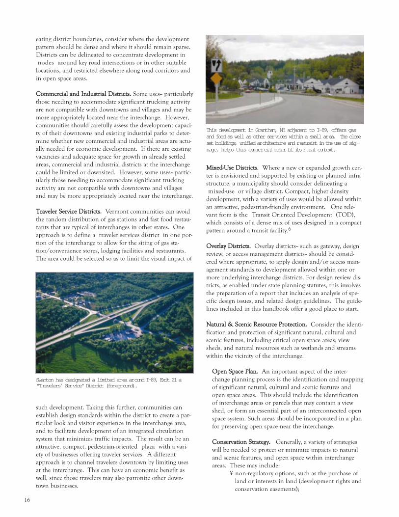
TTrraavveelleerr SSeerrvviiccee DDiissttrriiccttss.. Vermont communities can avoid
the random distribution of gas stations and fast food restau-
rants that are typical of interchanges in other states. One
approach is to define a traveler services district in one por-
tion of the interchange to allow for the siting of gas sta-
tion/convenience stores, lodging facilities and restaurants.
The area could be selected so as to limit the visual impact of
such development. Taking this further, communities can
establish design standards within the district to create a par-
ticular look and visitor experience in the interchange area,
and to facilitate development of an integrated circulation
system that minimizes traffic impacts. The result can be an
attractive, compact, pedestrian-oriented plaza with a vari-
ety of businesses offering traveler services. A different
approach is to channel travelers downtown by limiting uses
at the interchange. This can have an economic benefit as
well, since those travelers may also patronize other down-
town businesses.
MMiixxeedd--UUssee DDiissttrriiccttss.. Where a new or expanded growth cen-
ter is envisioned and supported by existing or planned infra-
structure, a municipality should consider delineating a
mixed-use or village district. Compact, higher density
development, with a variety of uses would be allowed within
an attractive, pedestrian-friendly environment. One rele-
vant form is the Transit Oriented Development (TOD),
which consists of a dense mix of uses designed in a compact
pattern around a transit facility.6
OOvveerrllaayy DDiissttrriiccttss.. Overlay districts-- such as gateway, design
review, or access management districts-- should be consid-
ered where appropriate, to apply design and/or access man-
agement standards to development allowed within one or
more underlying interchange districts. For design review dis-
tricts, as enabled under state planning statutes, this involves
the preparation of a report that includes an analysis of spe-
cific design issues, and related design guidelines. The guide-
lines included in this handbook offer a good place to start.
NNaattuurraall && SScceenniicc RReessoouurrccee PPrrootteeccttiioonn.. Consider the identi-
fication and protection of significant natural, cultural and
scenic features, including critical open space areas, view
sheds, and natural resources such as wetlands and streams
within the vicinity of the interchange.
OOppeenn SSppaaccee PPllaann.. An important aspect of the inter-
change planning process is the identification and mapping
of significant natural, cultural and scenic features and
open space areas. This should include the identification
of interchange areas or parcels that may contain a view
shed, or form an essential part of an interconnected open
space system. Such areas should be incorporated in a plan
for preserving open space near the interchange.
CCoonnsseerrvvaattiioonn SSttrraatteeggyy.. Generally, a variety of strategies
will be needed to protect or minimize impacts to natural
and scenic features, and open space within interchange
areas. These may include:
¥ non-regulatory options, such as the purchase of
land or interests in land (development rights and
conservation easements);
Swanton has designated a limited ar ea ar ound I-89, Exit 21 a“T ravelers’ Ser vice” District (for egr ound).
This development in Grantham, NH adjacent to I-89, offers gasand food as well as other ser vices within a small ar ea. The closeset buildings, unified ar chitectur e and r estraint in the use of sig -nage, helps this commer cial c enter f i t i ts r ural context.

17
Regional Interchange Area PoliciesExample: Two Rivers Ottauqueechee Regional Plan
The 2003 Two Rivers-Ottauquechee Regional Plan identifies interchange areas as one of six types of land use settlementpatterns in the region. The plan highlights related issues and opportunities, noting that “the lack of planning for develop-ment at interchange areas has prompted various forms and types of undesirable development along roads immediate tothe interchange.” The plan goes on to define the following general interchange policies, as well as specific polices foreach of the region’s seven interchange areas. These incorporate many of the best development practices proposed for usein interchange areas.
General Interchange Planning Policies
1. It is the policy of the Region that any area planned for interchange development be constructed to:a. complement the design principles and standards reflected in this Plan;b. promote the most appropriate land uses as determined through a locally sponsored planning process involving affect-
ed landowners, municipalities and the Regional Commission;c. maintain a high standard of scenic amenities for visually sensitive areas with due regard to impacts on neighboring
properties and highway uses;d. discourage creation or establishment of uses deemed more appropriate to town centers and village settlements; ande. encourage planned unit developments (such as trucking terminals, industrial and office parks, service centers, profes-
sional offices, and public buildings).
2. It is the policy of the Region to support the development of Area Plans for each of the interchange areas. Such plansshould be conducted locally as part of each local Planning Commission’s ongoing planning program in cooperation withlandowners, the Regional Commission, and other affected parties. Work should focus on creating an integrated site anddesign plan that serves as a means of addressing potential conflicts or problems noted above. Elements that the planshould include are:
a. access management controls; f. outdoor lighting;b. pedestrian amenitieS; g. landscaping and screening;c. parking; h. signage; andd. energy efficiency; i. open space conservatione. utilities/public services;
3. The Area Plan could serve as the foundation for the identification of the highest and best use of these areas and couldprovide a framework for future development to follow. Incremental and uncoordinated development inconsistent withArea Plans for each of the interchange areas should be discouraged.
4. Development concepts that should be used for interchange areas include:a. a circulation system that is conducive to pedestrian, bicycle and other non-vehicular traffic;b. a density or lot coverage area that is higher than surrounding rural settlement areas;c. use of planned unit development concepts such as high density areas offset by open space;d. a design that incorporates public spaces and promotes social interactions;e. a mixture of uses including non-residential and community facilities, and possibly residential;f. central focal points or public spaces serving the entire area;g. a pattern and scale of development that complements traditional patterns and uses in existing town centers and vil-
lage settlements; andh. provision for ride share parking and travel information services.
5. Any new development at or near interchange areas should promote a nodal development pattern where buildings areclustered, off-street parking is screened in the rear of the parcel and, where practical, inter-connected to adjoining parcels.
6. Municipalities with interchange areas are encouraged to promote creation and adoption of an official map per 24 VSA§4422 to provide a legal means of creating an interconnected network of streets, walkways, and other public facilities oramenities on land designated as interchange development areas.
7. Land use plans for interchange areas should be of a type, scale and design that complement s uses within existing towncenters or village settlement, or areas proximate to them. Appropriate uses may include highway oriented lodging andservice facilities, trucking terminals, research establishments, office and business parks, and light manufacturing facilities orsimilar type uses.
8. Town centers and village settlements are the preferred locations for small businesses, civic and governmental usescatering to the general public, and other uses that together constitute the diverse fabric of downtowns. It is in theRegion’s interest to encourage and enable land uses that have been traditionally developed or planned for downtownareas to remain economically viable. High priority should be given to public investments benefiting infrastructure, hous-ing and transportation facilities within town centers and village settlements. Accordingly, land use activities that havethe effect of eroding the socio-economic vitality of downtowns should be discouraged.

18
¥ regulatory incentives such as density bonuses to
concentrate development in portions of the inter-
change;
¥ the use of designated building envelopes for each
property to localize development on a portion of
the site;
¥ recommended design standards to minimize the
visual impacts of development; and/or strict pro-
hibitions to protect specific resources, such as
wetlands, stream and wildlife corridors.
A municipality should consider those strategies that
will be most effective, and most accepted, locally.7
RREEGGIIOONNAALL PPLLAANNNNIINNGG Coordinate with the Regional Planning Commissions to
frame planning goals within a broader context and to access
information and expertise.
Interchange planning and development takes place within a
regional context. Development patterns at one interchange
may affect the market for development at another inter-
change, and may affect the transportation function of con-
necting arterials between towns. Regional planning for inter-
change areas allows for a more comprehensive consideration
of an area/region s economic development and land use
needs, rather than a sole focus on the site-specific issues.
Vermont s twelve regional planning commissions (RPCs) can
help towns work together and can provide valuable resources
for local and regional interchange planning efforts. RPCs
help coordinate land use and transportation planning func-
tions, and provide a regional perspective for planning.
RPC staff can offer technical assistance to towns by conduct-
ing transportation corridor and interchange area studies,
and assisting with community involvement and visioning
efforts. In addition, regional plans can be especially useful
for identifying and addressing interchange area issues within
their broader regional context. As a part of the state s
Transportation Planning Initiative, (in effect since 1992),
RPCs and Chittenden County s Metropolitan Planning
Organization (MPO) have been given important roles in
determining regional and state transportation funding prior-
ities. RPCs and the MPO are charged with preparing
regional transportation plans and related studies, which
form the basis for determining regional transportation
improvement priorities. Interchange areas — including asso-
ciated land use and development patterns, and potential
impacts to the state road network — are now being given
much more consideration in transportation studies funded
by VTrans under regional work programs.
Local communities can and should continue to participate
in regional planning efforts through their representation on
regional boards and transportation advisory committees.
Some commissions also provide for appointed representa-
tion from other interested parties on regional boards, or
through citizen advisory committees. All regional planning
initiatives must include some form of public outreach,
including opportunities for public participation and com-
ment.
RPCs are also the primary source of technical planning and
GIS mapping assistance for many of Vermont s interstate
corridor communities. RPC staff collect data, provide infor-
mation and guidance, assist in local planning and public
outreach efforts, and help draft local land use regulations.
For communities without municipal planning staff, RPCs
are the best source of needed planning and development
review assistance. Local technical assistance initiatives are
included in annual commission work programs, funded
Concentratedevelopment inar eas of theinter changewher e it wil lhave the leastimpact on natu -ral r esour cesand views.

19
through the Vermont Municipal and Regional Planning
Fund and the Agency of Transportation s Transportation
Planning Initiative.
SSTTAATTEE RREESSOOUURRCCEESS && PPRROOGGRRAAMMSS
State agencies administer several technical and financial
assistance programs that could be augmented to include a
focus on the State s interchange areas. Technical, planning,
financing and program assistance is available through the
planning divisions of the Department of Housing and
Community Affairs (DHCA), the Agency of Natural
Resources (ANR), and the Agency of Transportation
(VTrans).
DHCA has highlighted interchange areas for potential fund-
ing under the state s Municipal Planning Grant Program.
Interchange area planning is also eligible for funding under
the state s Community Development Block Grant Program
and through the Agency of Transportation s Enhancement
Grant and Scenic Byways Programs.
Funding for the acquisition of land, or interests in land —
including the purchase of development and conservation
easements — is available on a competitive basis through the
Vermont Housing & Conservation Trust Fund, adminis-
tered by the Vermont Housing & Conservation Board; and
to a more limited extent through VTrans Transportation
Enhancements Grant Program. Often these funds must be
leveraged with municipal and private sources, accessed
through organizations such as the Vermont Land Trust, the
Trust for Public Land, and other community land trusts.
Local and regional plans, policies, and regulations for inter-
change area development may also be considered and may
play an important role under several other state regulatory
and financing programs including, but not limited to:
¥ Act 250 (District Commission, Environmental Board)
¥ state highway access permits (VTrans)
¥ the State Transportation Improvement Program (STIP),
for funding transportation projects (VTrans)
¥ transportation project development (VTrans)
¥ transportation facility siting (VTrans)
¥ park and rides (VTrans)
¥ state Revolving Loan Fund (RLF) for funding water and
sewer infrastructure (ANR)
¥ air quality permits (ANR)
¥ wetlands permits (ANR)
¥ storm water permits (ANR)
¥ Vermont Downtown Program, for development incen-
tives and infrastructure financing in designated down-
towns, villages and emerging town centers (DHCA)
Such programs benefit from the guidance provided by clearly
stated plan policies and regulations at the local level, and
from ongoing communication and cooperation to ensure
that public policies, regulations and financing programs are
coordinated and consistently applied at all levels of govern-
ment.8 Addressing interchange development issues in a
coordinated, public manner — before an individual project is
proposed that requires state and local permits, or public
financing— can help prevent conflicts later in the process,
and further local and state goals and objectives.

20
Design Guidelines
AANNEEAARRBBYY VVIILLLLAAGGEE OORR
DDOOWWNNTTOOWWNN
A village or downtown is located with-
in 1.5 miles of the interchange.
There is undeveloped land between
the Type A interchange and the vil-
lage/downtown. Development in this
context presents the opportunity to
expand the village fabric in an inter-
connected, compact pattern at an
urban or village density. Some exam-
ples of this type are St. Albans (I-89,
Exit 19), Montpelier, Sharon, Putney,
Weathersfield, Norwich, Fairlee,
Barton, Orleans, St. Johnsbury (I-91,
Exit 20), Derby Line, and Barnet.
See page 22.
TTaaiilloorriinngg GGuuiiddeelliinneess
ttoo tthhee VVeerrmmoonntt CCoonntteexxtt
Vermont s interchanges (or areas within them) can be grouped into the fol-
lowing six categories that represent different growth contexts and develop-
ment conditions. They are described below. Types A, B, and C are found in
areas near existing settlement, where a higher level of growth is appropriate.
Types D and E are in outlying areas where growth should be more limited in
scope. Type F is a special category interchanges with little or no access to the
surrounding land.
This section describes each type and provides corresponding examples of
Vermont interchanges. It offers a glimpse of how new growth might look if it
adhered to current trends, and how it would appear if it followed an alternative
approach. Each type is illustrated with simulated images, except for Type F,
which has no real development capability. These sets of images illustrate various
design approaches to interchange development. A more detailed description of
specific techniques and strategies follows.
The development scenarios presented are based on generalized Geographic
Information Systems (GIS) data that describe natural resource constraints to
development including: parcel lines, soils, slope, floodplain, wetland and habi-
tat. The build-out scenarios are based on an analysis of the general pattern and
trends in land use currently emerging around Vermont s interstate interchanges
as well as actual zoning regulations and property boundaries present in the par-
ticular locations. The build-out scenarios indicate long-term rather than imme-
diate development possible under current zoning. The alternative development
scenarios offer a conceptual view of a more compact and land efficient pattern.
These are not based on detailed land surveys, engineering studies, or analyses of
the market conditions for development. They are intended to illustrate a design
approach rather than provide a detailed site plan. Municipalities wishing to
replicate these concepts in an interchange master plan should obtain more accu-
rate data and conduct a thorough design process.
BB NNEEWW OORR EEMMEERRGGIINNGG
GGRROOWWTTHH CCEENNTTEERR
A village or downtown is located near
the Type B interchange but cannot be
expanded in a contiguous pattern
because of development constraints.
A satellite growth center, with a mix
of uses that complement rather than
compete with the traditional center
can be developed on land near the
interstate. This category is a subset of
the village/downtown type. It is diffi-
cult to identify which interchanges fit
this type without a more detailed
analysis of building constraints and
opportunities at each site. Middlesex,
however, is one example. Some inter-
changes that appear to fit the type A
profile might actually fall into this cat-
egory after closer review at the local
level. See page 23..

21
CC RREEGGIIOONNAALL AARRTTEERRIIAALL
HHIIGGHHWWAAYY// PPOOTTEENNTTIIAALL
SSTTRRIIPP DDEEVVEELLOOPPMMEENNTT
The intersecting highway functions
both as a regional corridor and
connector to a town center in the
Type C interchange. There is a sig-
nificant volume of traffic and
increasing amount of commercial
strip development along the high-
way. This category includes the
more highly developed inter-
changes such as Williston, South
Burlington, Colchester (I-89, Exit
16), Berlin (I-89, Exit 7), White
River Junction, and Brattleboro (I-
91, Exits 1 and 3), where new infill
development can inject a wider
variety of uses and more a walkable
pattern. Also included in this type
are less developed interchanges
that are now emerging as strip
highways: St. Albans (I-89, Exits 19
and 20), Royalton, Bradford, Derby
(I-91, Exit 28), and Waterbury. In
these cases new development could
be designed to modify the linear
pattern, by being limited to specific
areas or nodes and surrounded by
open land. In both cases access to
the highway needs to be carefully
managed in order to protect the
transportation function. See page
25.
DD CCOONNNNEECCTTOORR RROOAADD
For the Type D interchange, the inter-
secting highway or access road carries
primarily local traffic or traffic headed
to a downtown more than 1.5 miles
away. Growth pressure is less intense
and the existing settlement, which takes
a linear form, is sparse. To encourage
the historic settlement pattern and
channel most new commercial uses to
the town center, limits would be needed
on new commercial uses at the inter-
change. Uses demanding proximity to
the interchange can be sited to protect
visual and natural resources. Hartford,
Randolph, Rockingham, Weathersfield,
and Richmond are some other examples
of Type D interchanges. See page 26.
EE RRUURRAALL,, IINNTTEERRSSTTAATTEE--RREELLAATTEEDD
Existing development in the rural
Type E locations is primarily limited
to interstate-related uses such as travel-
er services, and transportation and
trucking facilities. Since they do not
need to be visible from the road,
buildings are distributed in a dis-
persed rather than a linear pattern.
In order to continue this pattern of
use, new growth would need to be
limited in scope and carefully sited.
Examples of Type E interchanges
include Williamstown, Springfield,
Berlin (I-89, Exit 6), Westminster,
Hartland, Lyndon (I-91, Exit 24), and
Newbury. See page 27.
FF LLIIMMIITTEEDD AACCCCEESSSS
HHIIGGHHWWAAYYSS
Lack of access to land on intersecting
highways prevents development at
these interchanges, which are most
often located at the intersection of
two controlled access roads.
Examples include Hartford (I-91, Exit
10), Derby (I-91, Exit 27), and St.
Johnsbury (I-91, Exits 19 and 21).
A Note about Parking: Given the conceptual nature of the scenarios that follow, uses were not assigned to depicted build-ings and, as a result, paved areas shown do not reflect specific parking standards. In the alternative examples, however, thescenarios do represent a planning and design approach that provides adequate parking with minimum use of paving. Thisis achieved through careful siting, shared facilities, and complementary uses. Design techniques are illustrated in furtherdetail in the Site Layout section of the Guidelines.

22
Like many interchanges in this category, I-91, Exit 18 in
Barnet sits close to the historic village center. The
existing built pattern is compact. Development is con-
fined to a small area around the center. Open fields
provide a sharp contrast between built and unbuilt
areas. Views from the interstate of village buildings
across an open meadow are striking.
Under current
zoning regulations,
large-lot subdivi-
sion of the mead-
ow as well as the
land along the
state highway
could easily be
expected. The resulting pattern would be dispersed.
Single use, single story buildings, each with a dedicated
parking lot, would create an inefficient layout and
redundant paving. Multiple curb cuts would increase
vehicular turning movements, affecting the flow of traf-
fic along the state road.
An alternative
approach could
provide new busi-
ness opportunities
AND protect the
scenic qualities of
the interchange.
By clustering new buildings at the edge of the meadow
and sharing parking and circulation space, views of the
village would be preserved. Using the same land-effi-
cient approach in other areas of the site would create a
pattern that resembled the historic compact land use
pattern. If just one quarter of the new buildings were
two story, as shown, this alternative could provide some 4,000 more square feet of commercial/industrial space than the cur-
rent trend scenario. An important feature of this approach is to extend the village street network to accommodate new devel-
opment. A range of building types serves a diversity of uses, including residential.
New space: 57,000 sq. ft.Indus./Comm.
New space: 61,000 sq. ft.Indus./Comm.13-17 units r esiden -tial
AANNEEAARRBBYY VVIILLLLAAGGEE OORR
DDOOWWNNTTOOWWNN

23
Nearby Middlesex Village has very little space to grow,
but the area northwest of I-89, Exit 9 (shown in the
upper left) offers gently sloping terrain, an ample sup-
ply of groundwater and good soils for on-site septic dis-
posal. Travelers on I-89 catch glimpses of the open
fields to the left as they approach the interchange from
the north.
Until recently
Middlesex s land use
regulations defined
this entire area as a
600 acre industrial
zone. The large size
of the district would
provide no incentive
to site buildings and driveways efficiently.
Development could extend across the site, leaving no
open fields. The large, one-story, single-use buildings
(warehouses and truck facilities) shown here are typical
of structures built recently at interchanges around the
state. The pattern is auto-dependent with a road layout
that is costly to build and maintain.
Middlesex is consid-
ering revisions to the
town s zoning to
establish a smaller
commercial district
and a wider mix of
uses. Although less
land is developed,
the more compact pattern provides a substantial
amount of space for a combination of light industrial,
office and residential uses. While large industrial build-
ings are appropriate in some new growth center set-
tings, this particular community is considering limits to
the size of new structures. The image reflects Middlesex s interim rules limiting building size to 15,000 sq.ft. The smaller
building size, tighter layout, and interconnected street network create a more village scale development.
New space: 390,000 sq.ft.Indus.
New space: 122,500 sq..ft.Indus./Comm.50 units r esidential
BB NNEEWW OORR EEMMEERRGGIINNGG
GGRROOWWTTHH CCEENNTTEERR

24
Like other Type C interchanges, Exit 10 in Waterbury
is intersected by a regional transportation corridor.
Rte. 100 is the only thoroughfare between the inter-
state and the fast-growing Stowe/Morrisville area.
Traffic volumes along Rte. 100 are highand growing
steadily. The segment of Rte. 100 just north of the
interchange (shown here) lies within two commercial
zoning districts, one of which extends north to the
Stowe town line. Despite the physical constraints presented by a sloping site, incremental strip development has occurred here
in past years, altering the traditional pattern of open land punctuated by dense development at the crossroads.
Under a current
trend scenario, retail
development contin-
ues to appear along
the highway, hug-
ging the road for
direct access and vis-
ibility. Several curb
cuts are added, slow-
ing traffic with additional turning movements. The
high traffic numbers, and potential customers, justify
the higher costs associated with building on these difficult sites. Extensive cutting is necessary to carve space out of the wood-
ed hillside on the western side of the road and filling is required to create level space close to the road on the east side. A traf-
fic-generating large-scale market increases the congestion. The auto-oriented pattern prevents pedestrian trips between busi-
nesses.
In an alternative sce-
nario, development is
located in fewer areas
of the site but at a
higher density. A
broader range of uses
and an interconnect-
ed street network
could mitigate some
of the traffic problems associated with development.
With the construction of a slower parallel road busi-
ness traffic could be separated from through traffic. Curb cuts would be consolidated into two locations on Rte. 100.
Industrial and/or office buildings could sit comfortably in this setting. Aligned in a tighter pattern along the new street, they
would be able to share circulation and loading space. The large parking lot could accommodate the turning requirements of
trucks. Given the short distances and traditional street profile, pedestrians would be able to walk comfortably from building to
building. Moving development away from the highway would also relocate it to a more level spot, suitable for building.
New space: 64,870 sq.ft.Comm./Indust.
New space: 89,200 sq.ft.Comm./Indust.
CC RREEGGIIOONNAALL AARRTTEERRIIAALL HHIIGGHHWWAAYY//
PPOOTTEENNTTIIAALL SSTTRRIIPP
DDEEVVEELLOOPPMMEENNTT

25
Rte. 2 in Richmond connects I-89, Exit 11 (not shown)
with Richmond Village and a few other small commu-
nities. This segment of highway carries a considerably
lighter load of traffic than I-89, which it parallels. Like
other Type D interchanges, this area sits well outside
the boundaries of the village but is experiencing some
incremental commercial growth. At this small scale,
the mix of residential and low-key commercial uses
blends into the landscape.
If the incremental devel-
opment continued in
the same form, this is
how it might appear.
Richmond s zoning regu-
lations prevent building
in a floodplain, which
makes up the entire field
in the left of this image.
As a result, development
is confined to one side of the road, protecting distant
views of Camel s Hump from the Exit 11 off-ramp and
Rte. 2. The regulations do not, however, significantly
restrict curb cuts or define areas within a site that are suitable for development. Filling in the open field at right with regularly
spaced buildings, each with a separate drive, would change the character of this section of road.
Under an alternative
scenario, this area
could develop as an
integrated residential
and office district rather than a string of unrelated busi-
nesses. Key to this approach is keeping the scale small
and the uses limited. Retail, with its higher traffic
impact, need for visibility and potential to detract from
the historic village, would not be allowed. Smaller lots, smaller structures, shared parking and drives, and the clustering of
development into a portion of the site helps the development fit without having much of a presence on the road. A small,
interconnected street network provides a walkable framework and limits turning movements onto Rte. 2.
New space: 48,000 sq. ft.Comm.16 units r esidential
New space: 40,000 sq. ft.Comm.16 units r esidential
DD CCOONNNNEECCTTOORR RROOAADD
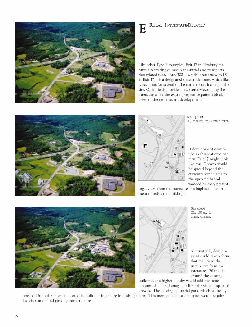
26
If development contin-
ued in this scattered pat-
tern, Exit 17 might look
like this. Growth would
be spread beyond the
currently settled area to
the open fields and
wooded hillside, present-
ing a view from the interstate as a haphazard assort-
ment of industrial buildings.
Like other Type E examples, Exit 17 in Newbury fea-
tures a scattering of mostly industrial and transporta-
tion-related uses. Rte. 302 — which intersects with I-91
at Exit 17 — is a designated state truck route, which like-
ly accounts for several of the current uses located at the
site. Open fields provide a few scenic views along the
interstate while the existing vegetative pattern blocks
views of the more recent development.
Alternatively, develop-
ment could take a form
that maintains the
rural views from the
interstate. Filling in
around the existing
buildings at a higher density would add the same
amount of square footage but limit the visual impact of
growth. The existing industrial park, which is already
screened from the interstate, could be built out in a more intensive pattern. This more efficient use of space would require
less circulation and parking infrastructure.
New space: 88, 500 sq. ft. Comm./Indus.
New space: 123, 000 sq. ft.Comm./Indus.
EE RRUURRAALL,, IINNTTEERRSSTTAATTEE--RREELLAATTEEDD
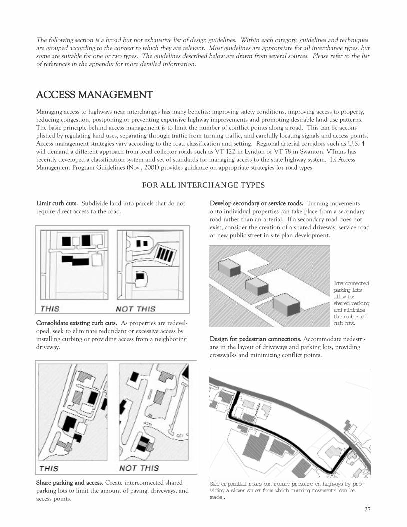
27
The following section is a broad but not exhaustive list of design guidelines. Within each category, guidelines and techniques
are grouped according to the context to which they are relevant. Most guidelines are appropriate for all interchange types, but
some are suitable for one or two types. The guidelines described below are drawn from several sources. Please refer to the list
of references in the appendix for more detailed information.
AACCCCEESSSS MMAANNAAGGEEMMEENNTT
Managing access to highways near interchanges has many benefits: improving safety conditions, improving access to property,
reducing congestion, postponing or preventing expensive highway improvements and promoting desirable land use patterns.
The basic principle behind access management is to limit the number of conflict points along a road. This can be accom-
plished by regulating land uses, separating through traffic from turning traffic, and carefully locating signals and access points.
Access management strategies vary according to the road classification and setting. Regional arterial corridors such as U.S. 4
will demand a different approach from local collector roads such as VT 122 in Lyndon or VT 78 in Swanton. VTrans has
recently developed a classification system and set of standards for managing access to the state highway system. Its Access
Management Program Guidelines (Nov., 2001) provides guidance on appropriate strategies for road types.
LLiimmiitt ccuurrbb ccuuttss.. Subdivide land into parcels that do not
require direct access to the road.
CCoonnssoolliiddaattee eexxiissttiinngg ccuurrbb ccuuttss.. As properties are redevel-
oped, seek to eliminate redundant or excessive access by
installing curbing or providing access from a neighboring
driveway.
SShhaarree ppaarrkkiinngg aanndd aacccceessss.. Create interconnected shared
parking lots to limit the amount of paving, driveways, and
access points.
DDeevveelloopp sseeccoonnddaarryy oorr sseerrvviiccee rrooaaddss.. Turning movements
onto individual properties can take place from a secondary
road rather than an arterial. If a secondary road does not
exist, consider the creation of a shared driveway, service road
or new public street in site plan development.
DDeessiiggnn ffoorr ppeeddeessttrriiaann ccoonnnneeccttiioonnss.. Accommodate pedestri-
ans in the layout of driveways and parking lots, providing
crosswalks and minimizing conflict points.
Inter connectedparking lotsallow forshar ed parkingand minimizethe number ofcurb cuts.
FOR ALL INTERCHANGE TYPES
Side or parallel r oads can r educe pr essur e on highways by pr o-viding a slower str eet fr om which turning movements can bemade.

28
Category 2 - Controlled access, high speed,high volume roads where access to abuttingland is subordinate to through traffic move-ments (e.g. VT 62, Berlin, VT 63, Rte 191,Newport)
Category 3 - Med. to high speed over med. tolong distances. (Regional corridors such asUS 4 Hartford, VT and 103 Rockingham)
Category 4 – Moderate speeds over med. dis-tance routes (e.g. Class 1 town highways andminor collectors on state highways)
Category 5 – Frontage or service roads
Category 6 – Urban roads
DDeessiiggnn ffoorr ppeeddeessttrriiaann ccoonnnneeccttiioonnss.. Accommodate pedestri-
ans in the layout of driveways and parking lots, providing
crosswalks and minimizing conflict points.
IInnssttaallll mmeeddiiaannss wwhheerree aapppprroopprriiaattee.. On busy roads, medians
can keep traffic flowing by limiting left turns to a few loca-
tions. They also ease pedestrian crossing by providing a mid-
point refuge, and can improve the appearance of the road.9
A median pr ovides gr eater contr ol over left turn movements,channeling them to intersections. This technique keeps trafficflowing and pr ovides an aesthetic benefit.
PPrroovviiddee aaddeeqquuaattee ddiissttaannccee bbeettwweeeenn ssiiggnnaalliizzeedd iinntteerrsseeccttiioonnss..
Space intersecting public streets at the following distances to
protect the capacity of intersecting arterials:
FOR VILLAGE/DOWNTOWNS, NEW GROWTH CENTERS, AND REGIONAL STRIPS(INTERCHANGE TYPES A, B, AND C)
PPrroovviiddee aaddeeqquuaattee ddiissttaannccee bbeettwweeeenn tthhee iinntteerrssttaattee aanndd nneeaarrbbyy
ccuurrbb ccuuttss.. Allow at least 250 feet between interstate
exit/entrance ramps and adjacent curb cuts.
AAccccoommmmooddaattee bbiiccyycclleess.. Where uses are concentrated and
residential areas are nearby, accommodate bicycles by provid-
ing bicycle parking and links to any nearby bike paths.
PPrroovviiddee ffoorr ppuubblliicc ttrraannssiitt, including adequate stops and shel-
ters..
PPllaann ffoorr ppuubblliicc ppaarrkkiinngg.. A successful public parking pro-
gram with shared lots and on-street parking, reduces the
need for on-site parking. Minimum parking standards
should be reduced, if possible, with these interchange types,
to allow businesses to minimize paving.
FOR CONNECTOR ROADS AND RURAL SETTINGS(INTERCHANGE TYPES D AND E)
PPrroovviiddee aaddeeqquuaattee ddiissttaannccee bbeettwweeeenn tthhee iinntteerrssttaattee aanndd nneeaarrbbyy
ccuurrbb ccuuttss.. Allow at least 500 feet between interstate
exit/entrance ramps and adjacent curb cuts.
DDiissccoouurraaggee ddiirreecctt ppaarrkkiinngg aacccceessss.. Do not allow cars to back
directly out onto the highway.
PPrroovviiddee aaddeeqquuaattee ddiissttaannccee bbeettwweeeenn ccuurrbb ccuuttss.. Although
there are no clear standards for the spacing of unsignalized
intersections and driveways, one method to calculate dis-
tances is based on the design speed of the road in ques-
tion.10
1 mile
1/2 mile
1/4 - 1/2mile
500 ft.
500 ft.
Highway Type
Source: Vermont Agency of Transportation Access ManagementProgram Guidelines
20
25
30
35
40
45
50
55
125
150
200
225
275
325
400
450
Design Speed (mph) Curb Cut Spacing
Source: Vermont Agency of Transportation AccessManagement Program Guidelines

29
SSIITTEE DDEEVVEELLOOPPMMEENNTT
Minimal disturbance of the natural landform of a site can provide significant environmental and aesthetic benefits. Through
careful site design, the negative effects of grading and removal of vegetation can be reduced.
PPrreesseerrvvee tthhee nnaattuurraall ttooppooggrraapphhyy ooff tthhee llaannddssccaappee bbyy lliimmiittiinngg
cclleeaarriinngg aanndd ggrraaddee ddiissttuurrbbaannccee. Vermont s rolling terrain is
an important part of its unique character. Development
that flattens or creates artificial plateaus degrades that char-
acter. Design and grade the site to minimize cut and fill.
Terrace parking and buildings to hug the existing topogra-
phy. Design grading to avoid steep embankments and sharp
grade changes that are incompatible with surrounding
topography.
Use site and building design to follow the natural contours of thesite. On sloping ter rain a stepped building (above) can eliminatethe need for an ar tificial plateau (below).
THIS
NOT THIS
PPrreesseerrvvee eexxiissttiinngg vveeggeettaattiioonn wwhheerreevveerr ppoossssiibbllee.. Incorporate
and reinforce the existing pattern of woods and fields. New
structures will more likely fit into the landscape if the exist-
ing trees and natural vegetation that surrounds them are pre-
served.
PPrroovviiddee ffoorr wwiillddlliiffee ccrroossssiinngg ppooiinnttss..
BBuuffffeerr ddeevveellooppmmeenntt ffrroomm wwaatteerr rreessoouurrcceess.. Allow for ade-
quate buffers between development construction and
streams and wetlands. Setbacks should be in accordance
with TheVermont Wetland Rules and the Agency of Natural
Resources procedures for stream bank buffers.11
MMaakkee ssttoorrmm wwaatteerr mmaannaaggeemmeenntt aann aattttrraaccttiivvee ffeeaattuurree ooff tthhee
ssiittee.. Design storm water management and erosion control
to adhere to natural drainage patterns using open channel
systems and retention ponds with natural aquatic vegetation
where possible. Best storm water management practices are
reflected in ANR s Vermont Storm Water Manual —
Volume II — Technical Guidance, which requires that run-
off be retained and treated on-site to avoid down-stream ero-
sion and to filter out impurities.12 Vermont regulations gen-
erally allow creativity in the design of retention and treat-
ment facilities. Storm water facilities can be a way to create
inviting outdoor spaces. Careful consideration given to their
placement and detailing will improve the value of the overall
site.
FOR VILLAGE/DOWNTOWNS, NEW GROWTH CENTERS, AND REGIONAL STRIPS
CCoommbbiinnee ssttoorrmm wwaatteerr ffaacciilliittiieess ttoo sseerrvvee sseevveerraall pprrooppeerrttiieess.
Retention ponds and drainage channels take up space and
are difficult to fit on the small lots of a compact village set-
tlement. However, like parking, streets, and sewage treat-
ment, storm water systems are infrastructure investments
that can be shared. Master planned developments can
include a system designed to anticipate and accommodate
future uses.
Stormwater facilities ar e a critical piece of infrastr uc-tur e but they can also be an attractive public amenity .Sour ce: Kathleen R yan.
FOR ALL INTERCHANGE TYPES

30
MMiinniimmiizzee ppaavveedd ssuurrffaacceess.. Provide adequate but not exces-
sive parking. Locate driveways and lots between buildings to
create shared parking facilities. Where adjoining parcels are
not held in single ownership and development is incremen-
tal, rights-of-way and/or reciprocal easements can be
required and reserved through local site plan or conditional
use review in zoning regulations.
PPrreesseerrvvee sscceenniicc vviieewwss,, especially views seen from the inter-
state by placing buildings away from sight lines.
UUssee ssppaaccee eeffffiicciieennttllyy. Maximize available land and open
space by siting buildings close together. Set buildings close
to the street. Use multi-story buildings wherever use and
function permit. Although warehouse and other industrial
uses may not lend themselves to multi-story structures, in
some cases, the office functions of these uses can be located
in a second story portion of the building.
LLooccaattee ppaarrkkiinngg lloottss ttoo tthhee ssiiddee oorr rreeaarr ooff bbuuiillddiinnggss. Except
in cases where full vehicular access is demanded (e.g.-public
safety, highway maintenance and other vehicular facilities)
parking and service areas should not be located in front of
buildings. Front yard park-
ing creates a barrier
between buildings and the
street and allows the view of
cars to dominate. Rear park-
ing lots can provide loading
and circulation space. Side
parking lots are visible from
the street but do not visual-
ly take over the streetscape
if they don t extend beyond
the front line of the build-
ing
PPrreesseerrvvee eexxiissttiinngg vveeggeettaattiioonn wwhheerreevveerr ppoossssiibbllee. Large trees
and tree groupings with the best screening value should be
saved. An early assessment by a trained professional, as well
FOR RURAL SETTINGS
SSIITTEE LLAAYYOOUUTT
Buildings, parking areas, drives, walkways, and sometimes, lots and streets, are the parts that make up a site. The difference
between a poor site plan and an exceptional one is the extent to which these components work together efficiently and in
keeping with Vermont s compact settlement patterns. Buildings will enhance community character if they relate to each other
and have a direct relationship with the street and the people who use it.
Industrial land uses present special challenges to compact and land efficient development. Market forces and potential future
expansion needs may constrain opportunities. Compact industrial development may not be possible in every case. Yet, cer-
tain types of industrial uses, and a mix of uses within an industrial zone may offer opportunities for compact and multi-story
development. Moreover, tools for improving site plan and design (such as reducing set backs and increasing lot coverage
requirements) can improve opportunities for compact development within industrial areas. In addition, allowances for expan-
sions within a zone, rather than for each particular lot may help to address concerns about future expansion needs. Zoning
and use requirements in industrial zones should be reviewed to evaluate potential existing regulatory constraints to compact
industrial development.
FOR ALL INTERCHANGE TYPES
as a Tree Preservation Plan, can help identify the most valu-
able vegetation and determine the measures needed to pre-
serve it.
In village settings, make lots nar row with parking in the r ear . Inless dense locations, parking can be to the side. Do not allowparking lots to extend beyond the fr ont wall of the building.
To make mor e out of less paving, buildings can be gr oupedar ound a shar ed parking and loading ar ea as in this examplewher e one lot ser ves 4 or 5 businesses (above, left).

31
FOR VILLAGE/DOWNTOWNS, NEW GROWTH CENTERS, AND REGIONAL STRIPS
RReepplliiccaattee tthhee ttrraaddiittiioonnaall ppaatttteerrnnss ooff tthhee ssuurrrroouunnddiinngg sseettttllee--
mmeennttss.. Make development fit the existing fabric, especially
in places where new structures will be seen from the inter-
state.
RReellaattee bbuuiillddiinnggss ttoo tthhee ssttrreeeett.. Place buildings close together
along a street, preferably with the narrow end facing the
street. This may be possible for large industrial buildings as
well as smaller multi-story retail and office uses. This layout
will make it possible to share parking and driveways. It will
also create an environment that is the appropriate scale for
pedestrian circulation
LLiinnee ssttrreeeettss wwiitthh ssiiddeewwaallkkss.. Build safe, comfortable connec-
tions between buildings and between parking lots and build-
ing entrances.
AAnnttiicciippaattee ffuuttuurree ggrroowwtthh nneeeeddss.. Plan the site in a way that
enables future expansion without the acquisition of addi-
tional land. Consider how to make the most of parcels and
growth areas, not just today but in the future. Build in a
way that allows for density and for the continuation of a
compact pattern. Some communities may choose to build-
out a growth center to its fullest potential. Consideration
should be given to the future growth needs of the entire
area, rather than for each individual parcel, in order to
accommodate future growth or expansion while maintaining
a compact pattern.
A traditionalpattern con -sists of t ightgr oupings ofbuildings setclose to exist -ing s tr uctur es(left). Thisar rangementfi ts t he c ontextof the existingvillage as wellas pr otectsviews fr om theinterstate.
THIS
NOT THIS
Build to the str eet, close together , so that walk -ing is possible.
THIS
NOT THIS
THIS NOT THIS
If a building is sited on the edge of the lot (left, 1) it leaves r oomfor a futur e addition (2) as well as an expanded parking ar ea.Buildings placed in the middle of a par cel (right) leave feweroptions for futur e expansion.
FOR CONNECTOR ROADS AND RURAL SETTINGS
RReepplliiccaattee aaggrriiccuullttuurraall ppaatttteerrnnss.. As with tradi-
tional farm buildings, arrange structures in for-
mal groupings, close together and at right
angles
These maintenance sheds, seen fr om I-91, ar e close together and aligned at rightangles. They fit the context of their sur roundings by r eplicating the pattern of agri -cultural out buildings.

32
“AAddddrreessss” tthhee ssttrreeeett. Sometimes the front of the building
faces the street, but quite often the front faces parking on
the side facade. In either case, the street facade is a formal
GGrroouupp ttrraavveelleerr sseerrvviicceess ttooggeetthheerr.. Share parking facilities
and connect buildings with sidewalks. Place drive-through
facilities at the rear of the property to minimize pedestrian
conflicts and visual impact
PPrrootteecctt tthhee wwoorrkkiinngg llaannddssccaappee. Develop strategies to facili-
tate/ensure maintenance of the working landscape, agricul-
tural lands, community gardens, farming, etc.
BBUUIILLDDIINNGG DDEESSIIGGNN
The exterior appearance of buildings is important because intentionally or not, buildings communicate a community s values
and help define its uniqueness. Well-designed building exteriors also help orient people, providing focal points and visual
cues about the location of public and private spaces. Well-articulated public entrances are one such example. The way each
building relates to other buildings is also important because the groupings of buildings, such as those around a green, define
the outdoor spaces we inhabit.
FOR ALL INTERCHANGE TYPES
DDeessiiggnn uunniiqquuee bbuuiillddiinnggss tthhaatt ffiitt tthhee ccoonntteexxtt.. With the
exception of the most utilitarian functions that are well
screened from view, buildings should be designed to fit the
character of the site. Avoid generic and franchise prototype
designs, particularly designs that do not fit the local context.
In general, a new building should be remarkable more for its
quality of design than for its commercial associations.
UUssee llooccaall mmaatteerriiaallss wwhheenneevveerr ppoossssiibbllee tthhaatt aarree ooff hhiigghh qquuaallii--
ttyy,, dduurraabbllee,, aanndd pprroovviiddee vviissuuaall iinntteerreesstt..
WWoooodd is the most predominant material for both struc-
ture and finishes in Vermont. An economical alterna-
tive with a similar appearance is cement fiberboard.
Corners, window casings, and other edges should be
carefully constructed. Consider using wood trim in
combination with fiberboard siding.
BBrriicckk vveenneeeerr is a worthwhile investment both for low
maintenance and for resale value. Cornices are perhaps
the most important detail for visual impact, although
the connection between the foundation and first floor
is also critical.
MMeettaallss such as corrugated sheet metal, standing seam
metal roofs, and even flat sheets, are well established in
Vermont. Many buildings, whether residential, indus-
trial, or even civic, have metal roofs. The initial invest-
ment of metal roofs pays off in low maintenance, low
snow loads, and even discounts in fire/hazard insur-
ance.
MMaakkee bbuuiillddiinnggss eenneerrggyy eeffffiicciieenntt.. All structures are subject to
Vermont’s energy codes and must meet certain standards for
windows, insulation, and ventilation.13
FOR VILLAGE/DOWNTOWNS, NEW GROWTH CENTERS, AND REGIONAL STRIPS
Look to Vermont s downtowns and villages as models for architectural design. At the heart of this form is the capacity to
increase density over time. Forms that allow future infill development will not only fit the Vermont context but will provide
future options for economic development.
BBuuiillddiinngg OOrriieennttaattiioonn.. A traditional village building pattern
is to orient buildings gable-end to street, making a somewhat
narrow building that runs deep into the lot.
Building facades that face the str eet should be mor e formal, or highly ar ticulated. than side and r ear facades. Formality can be achievedthr ough ar chitectural details such as exterior ornament that casts shadows (left), gener ous and sometimes symmetrical windows (middle),and pr otected entranceways (left, right).

33
gesture. Formality is implied through details such as:
¥ a higher level of exterior ornament;
¥ more shadows created by this ornament;
¥ generous windows; and
¥ covered entrances.
MMaassssiinngg.. Large buildings ought to be designed to reduce
their bulky appearance. Add box-like volumes on to the rear
of village scale buildings.
UUssee ttrraaddiittiioonnaall pprrooppoorrttiioonnss ttoo ccrreeaattee bbuuiillddiinnggss tthhaatt hhaavvee aa
vviillllaaggee ssccaallee.. In a compact growth setting where a village or
downtown is the model, houses, inns, churches, town halls,
and other such models should be examined. Modern build-
ings can be built to this model, by breaking them down into
smaller-sized elements and linking them together.
Lar ge buildings can fit a compact setting by extending the lar gevolume to the r ear of a smaller scale str uctur e. Truck access andloading can occur in a lar ge r ear ser vice lot.Sour ce: S. V itzthum.
Many old buildings have a height equal to their width (pr opor tionof 1:1) with r oof pitches anywher e fr om 9:12 to 12:12. W indowshave a pr opor tion of 1:2. Sour ce: S. V itzthum
Modern buildings can be lar ge but maintain a human scale bybr eaking their mass into smaller components designed to tradi -tional pr opor tions (gables, windows and doors).
FOR CONNECTOR ROADS AND RURAL SETTINGS
Agricultural or transportation-related buildings can provide a model for new buildings in a rural setting.
Massing. In a farm/rural setting, the barn or mill is a possi-
ble model. Modern equivalents might be warehouses or
transfer stations, rural rest stops/filling stations, or sheds.
When building to this model, the many barns, sheds, mills
and other industrial structures of Vermont should be stud-
ied. Modern development requires spans wider than those
of traditional models, but large footprints can be achieved
by attaching sheds. This technique also gives the building
an organic quality. Use gabled roofs where possible. If one
is building a modern structure, consider breaking down a
large, square plan to a main portion under a gabled roof
with attached sheds.
Rural industrial buildings can better their setting by adjusting theroof pitches to r eplicate the massing of V ermont barns . Sour ce: S.Vitzthum.
traditional barn typical industrial building
vernacular industrial

34
MMiinniimmiizzee ggllaarree tthhrroouugghh tthhee uussee ooff pprrooppeerrllyy iinnssttaalllleedd aanndd
aapppprroopprriiaattee lliigghhttiinngg ffiixxttuurreess.. Fixtures using high wattage
lamps (over 70 wt Metal Halide or the equivalent) have the
greatest potential to produce glare. These fixtures will
enclose or shield the lamp from being directly visible by
passersby if they meet the specifications for Full Cut-Off or
Cut-Off fixtures as defined by the Illumination Engineering
Society of North America (IESNA). Decorative fixtures
using low wattage lamps that are not cut-off types could be
considered for use if
total site illumination
remains low.
Disability glare can
impair visibility and
cause accidents.
Discomfort glare is
an annoyance that
detracts from the night
landscape.
CCoolloorr. In rural settings, dark and
muted colors can help large buildings
blend into their surroundings. Avoid
white and light colors on structures
that have not been designed to a high
standard, especially when trees or
topography cannot provide adequate
screening.
White and other light colors make masses appear lar ger . The white siding on these storagelockers makes them visually jump for war d, while the dark building behind them appearsless dominant despite its lar ger s ize.
LLIIGGHHTTIINNGG
Well-designed exterior lighting provides necessary illumination at night while reducing light pollution. Light pollution
involves both glare and sky glow. Glare is caused when a light source is unshielded or when a bright light is introduced into
an otherwise dark setting. Glare can temporarily impair vision — a safety hazard at worst and a nuisance at best. Sky glow, the
reflection of light in the night sky, reduces the ability to see stars and other features of the night sky. This is of concern not
only for astronomers but also for those seeking to protect the rural qualities of their community. Many Vermont interchanges
are located in rural settings where the surrounding countryside is dark at night. In this environment, even low-level lighting
will be a conspicuous addition to the night landscape. In urban areas, light pollution is a common problem that can be mini-
mized with careful design of new development. Limit illumination to the lowest level needed to create an inviting nighttime
environment. The nighttime visibility of a given site from the interstate will depend on its light levels, the size of the area illu-
minated, and the total amount of light power used. Screening and orientation on the landscape may mitigate the direct visi-
bility of light fixtures but will not reduce the glow from the developed area. Sky glow can be reduced somewhat by the use of
cut-off fixtures and by using minimum light levels.
FOR ALL INTERCHANGE TYPES
AAvvooiidd oovveerr lliigghhttiinngg. Site lighting levels should not exceed
the minimums for each use recommended by the
Illumination Engineering Society of North America
(IESNA) in their current guidelines OR as recommended by
the Outdoor Lighting Manual for Vermont Municipalities,
whichever is lower. The IES document, RP 33-99 is avail-
able as a guide for convenience store and gas station canopy
lighting.14 These references are often used in state regulatory
review (Act 250).
Gas stations should be visible but not overlit. Appr opriate lighting such as this, focuses light in the pumpingar ea and door ways wher e it is needed. Sour ce:Outdoor Lighting Manual for V ermont Municipalities.

35
Diissccoouurraaggee iilllluummiinnaattiioonn ooff bbuuiillddiinngg ffaaccaaddeess, especially if the
building is a light color. The reflectance of the walls may
make the building more prominent and visible from the
interstate. Illuminated awnings lit from beneath or above
should be used sparingly. Illuminate signs, site and building
entries as necessary for safety, rather than as advertising.
Consider turning lights out after business hours.
Discourage competitive lighting between businesses. Set a
common standard through local regulations to prevent busi-
ness from using lighting to compete for attention.
AAddddrreessss sseeccuurriittyy ccoonncceerrnnss..
Illumination used for surveil-
lance should comply with all the
recommendations for normal
site lighting such as light level,
glare and color rendering. If
after hours security is an issue,
property owners should consider
alarms, motion sensor lights, or
both. Lights by themselves do
not prevent break-ins but do
provide visibility for surveillance
by patrols.
UUssee aapppprroopprriiaattee llaammpp ttyyppeess..
Use lamp (bulb) types that illu-
minate the color of surrounding objects correctly. Metal
halide or compact fluorescents are appropriate.
Incandescent lamps can be considered if low wattages are
used (50-70wts). High or low-pressure sodium lamps that
cast an orange glow should be discouraged. These lamps
render green vegetation with a brown/olive cast and connote
a harsh setting.
Cut-off lamps such as these will eliminate glar e in parking ar eas. Sour ce:Outdoor LightingManual for V ermont Municipalities.
SSIIGGNNSS
Though signs are meant to convey information, too many signs competing for attention create visual clutter that overwhelms
the viewer, defeating the purpose of the signs. On a road, visual clutter can become dangerous, as motorists concentrate on
deciphering information from the signs instead of on traffic. Signs need not be large or high to convey information. To avoid
visual clutter carefully consider the number, placement, height and size of business signs. They should be smaller in villages
and growth centers, and scaled to the speed of the road in rural areas.
FOR ALL INTERCHANGE TYPES
PPllaaccee ssiiggnnss iinn aa llooccaattiioonn tthhaatt iiss nnoott vviissiibbllee ffrroomm iinntteerrssttaattee
ttrraavveell llaanneess. In Vermont, the lack of billboards and the
resulting lack of visual clutter from signs along the interstate
is a unique feature that both residents and visitors appreci-
ate. On-premises signs that are oriented to travelers on the
interstate can also lead to visual clutter, since they need to
be large, like billboards, in order to communicate with peo-
ple at high speeds. For this reason, on-premises signs orient-
ed to the interstate are discouraged in favor of smaller signs
oriented to local roads. Information about traveler services
needs to be addressed in a variety of other ways.
AAvvooiidd ssiiggnn cclluutttteerr by limiting freestanding signs to one per
lot. Exceptions should be made for businesses sharing prop-
erties.
AAvvooiidd ssiiggnnss tthhaatt oovveerrwwhheellmm tthhee sseettttiinngg.. Limit the height to
12 feet in villages and growth centers and 16 feet in rural
areas where travel speeds are higher. Signs rarely need to be
more than 20 square feet in size to be effective.
Over -sized signs dwarf the buildings and landscape that sur roundthem.

36
AAvvooiidd uussiinngg ggaass ssttaattiioonn ccaannooppiieess aass ssiiggnnaaggee. Canopies that
span pump islands are large, a minimum of 13.5 feet high
and as long as 100 feet in some cases, and often dwarf near-
by structures. Adding colorful corporate logos makes them
even more dominant. Where canopies are appropriate limit
the face to solid neutral colors to prevent the structure from
visually overwhelming the site.
LLiigghhtt ssiiggnnss ffrroomm aabboovvee. Shield and direct light downward to
prevent it from spilling beyond sign area. Use minimum
amount of light to make the sign visible. To reduce glare,
avoid internally lit signs, especially those with light-colored
backgrounds.
The sign marking this gas station is lar ge enough to see fr om theexit ramp yet doesn’ t over whelm its immediate setting.
This gas station canopy ser ves its purpose, shielding patr ons,without dominating the scene. The plain surface of the canopydoesn’ t hold the eye but allows it to travel down to the door wayof the building.
LLAANNDDSSCCAAPPIINNGG
Landscaping can perform two different design functions defining space and screening. It also provides environmental bene-
fits such as shade and filtering of runoff. Trees, walls, fences, and earth forms can be used to shape outdoor space by provid-
ing edges and canopies as well as emphasizing entrances and other important areas. Large trees provide structure to a land-
scape. Shrubs and smaller plants furnish it with texture. In
addition to blocking undesirable views, trees can be used to
filter storm water runoff and create shade.
Landscaping and Screening
There are many commercial and industrial build-ings around Vermont’s interchanges that travelersnever see. This is because state and local land useregulations often require developers to “screen” orplant trees between their buildings and the high-way. In locations with existing vegetation this tech-nique works quite well in maintaining a greenedge along the road, sustaining the illusion of anintact traditional landscape. Landscaping can playa role in helping a development fit in, softening itsvisual impact, or even making it disappear. But ithas its limitations. When the essence of a scenicview is its very openness no amount of landscap-ing can mitigate the effects of a building thatintrudes on the void. Using landscaping andscreening to hide poorly designed and locatedbuildings is generally an unsatisfactory approach.The best practice is to site and design buildingsthat fit the character of their surroundings, and,more specifically, not site them in visually sensitivelocations.
FOR ALL INTERCHANGE TYPES
EExxcceepptt iinn uurrbbaann oorr vviillllaaggee sseettttiinnggss,, ssccrreeeenn ddeevveellooppmmeenntt ffrroomm
vviieeww ooff tthhee IInntteerrssttaattee. Install planting along the line of sight
to block or filter views. Screening Techniques:
DDeecciidduuoouuss vveeggeettaattiioonn located in the line of sight does
not completely block, but filters views, reducing the
impact of an incompatible element. Even in winter lay-
ers of branches and twigs create a veil across the back-
ground element reducing its visual impact. Deciduous
trees can be used as focal points, providing visual inter-
est through seasonal variations.
DDeennssee eevveerrggrreeeenn ppllaannttiinnggss can block the line of site
completely, year-round. Evergreens do not always thrive
along highways, however. They are generally more vul-
nerable to road salt (in the form of storm water run-off
and salt spray) and highway air pollution. Species near
the highway (50 yards for spray) should be selected with
this in mind.

37
BBeerrmmss. Although they achieve an immediate screen
effect and can buffer noise, if they are not designed
well, berms can be an intrusive element. Design the
slope and contour of a berm to echo those of the sur-
rounding landscape. The exceptions are earthworks
type installations that are intended to be unique forms
or berms that are formed against a wall, enclosing a
space. If a berm s shape is incompatible with surround-
ing landform, planting will exaggerate the effect. The
sloping sides of berms shed water quickly leaving less
for root systems and limit the spread of roots, jeopardiz-
ing the long-term viability of large trees and shrubs
planted there.
WWaallllss aanndd ffeenncceess can be effective and immediate
screens and useful for shaping defining and enclosing a
site. Inexpensive, functional fences can be planted with
fast growing vines to quickly create a green wall.
SSeelleecctt ppllaanntt mmaatteerriiaallss tthhaatt ffiitt tthhee ccoonntteexxtt ooff tthhee ssiittee. Unify
new and existing landscapes by using species native to the
area or similar to neighboring sites, especially in rural set-
tings.
AAvvooiidd iinnvvaassiivvee eexxoottiicc ppllaanntt ssppeecciieess. A growing concern over
invasive plants crowding out native species has resulted in an
effort by state regulators to develop an advisory list of plant
species that should be avoided, especially in rural areas. It is
important to note, however, that not all non-native plants
are invasive.15
LLaannddssccaappee ppaarrkkiinngg lloottss. In large parking lots, transform a
sea of asphalt into a sea of foliage by planting trees on
landscaped islands. This will create a cooler, more humane
space for users of the lot as well as improve the appearance
of parking lots from the interstate. Plant large-species shade
trees 30-50 feet on center. Design islands to be a minimum
of 10 feet wide to provide adequate space for root growth.
In settings wher e ever gr een species do not fit the natural or aes -thetic context, deciduous tr ees can pr ovide an adequate scr een.Rather than block a view , deciduous tr ees filter it enough to veilthe effects of i ntr usive forms.
Landscaped islands br eak up the massiveness of lar ge parkinglots, pr ovide a permeable surface that absorbs r un-off, and offersspace for the lar ge tr ees to thrive and form a shady canopy .
Drivers pr efer shaded parking spaces even if they ar e far ther fr omthe building entrance.
A lar ge parking lot can blend unobtr usively into its sur roundingswhen planted with closely-spaced shade tr ees.
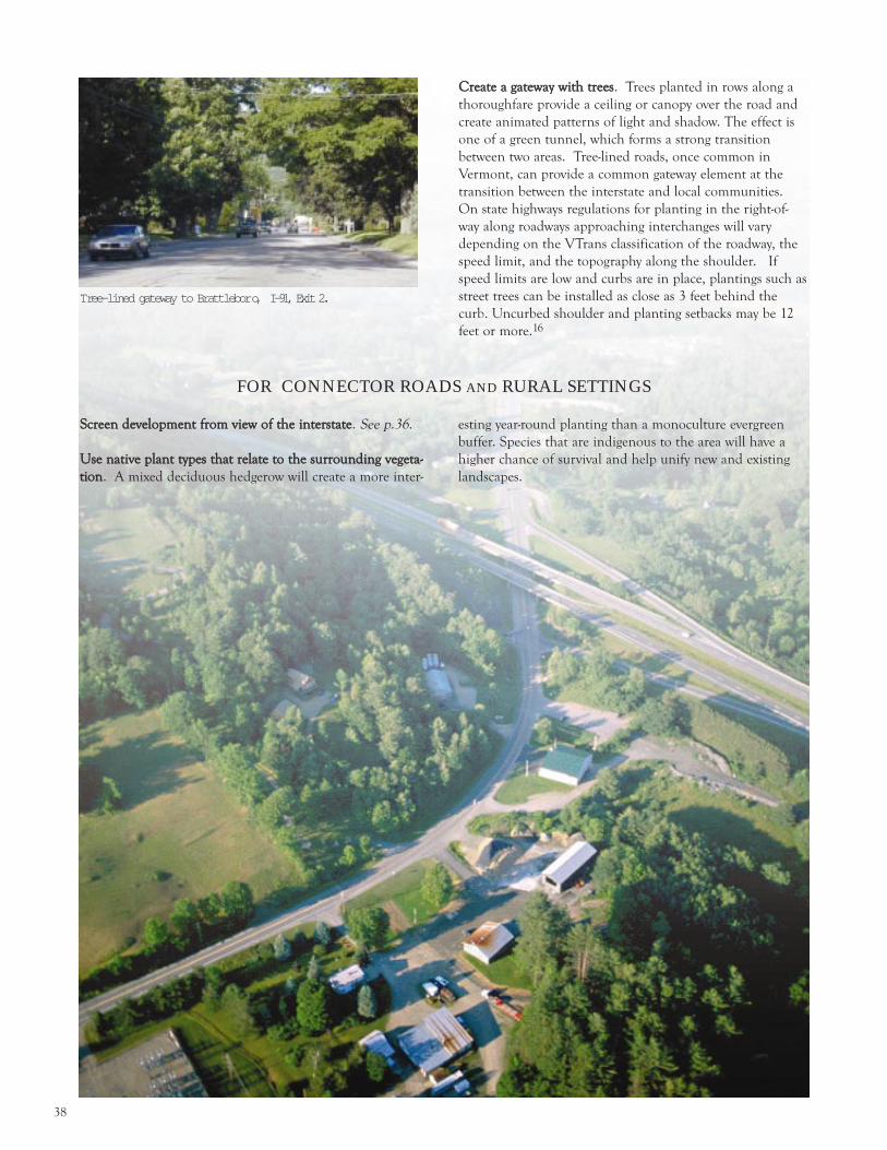
38
Tree-lined gateway to Brattlebor o, I -91, Exi t 2.
CCrreeaattee aa ggaatteewwaayy wwiitthh ttrreeeess. Trees planted in rows along a
thoroughfare provide a ceiling or canopy over the road and
create animated patterns of light and shadow. The effect is
one of a green tunnel, which forms a strong transition
between two areas. Tree-lined roads, once common in
Vermont, can provide a common gateway element at the
transition between the interstate and local communities.
On state highways regulations for planting in the right-of-
way along roadways approaching interchanges will vary
depending on the VTrans classification of the roadway, the
speed limit, and the topography along the shoulder. If
speed limits are low and curbs are in place, plantings such as
street trees can be installed as close as 3 feet behind the
curb. Uncurbed shoulder and planting setbacks may be 12
feet or more.16
FOR CONNECTOR ROADS AND RURAL SETTINGS
SSccrreeeenn ddeevveellooppmmeenntt ffrroomm vviieeww ooff tthhee iinntteerrssttaattee. See p.36.
UUssee nnaattiivvee ppllaanntt ttyyppeess tthhaatt rreellaattee ttoo tthhee ssuurrrroouunnddiinngg vveeggeettaa--
ttiioonn. A mixed deciduous hedgerow will create a more inter-
esting year-round planting than a monoculture evergreen
buffer. Species that are indigenous to the area will have a
higher chance of survival and help unify new and existing
landscapes.

39
1. Kevin O Conner, A Vermont Century: Photographs and Essaysfrom the Green Mountain State, Dick Van Susteren, ed.,Rutland Herald, Barre-Montpelier Times Argus, 1999, p.135.
2. For example, the Vermont State Comprehensive OutdoorRecreation Plan (SCORP) identifies scenic highways as a valu-able public resource. And, in Edwin and Avis Smith #6F0391-EB, the Vermont Environmental Board considered the visualimpact of a subdivision along I-89 in Franklin County and con-cluded that, The Board has consistently emphasized the impor-tance of protecting the scenic views along the Interstate corridor.See, e.g., Re: Heritage Group Inc., Findings of Fact andConclusions of law #4C0730-EB (March 27, 1989; AmmexWarehouse Company, Inc. and Use Permit #6F0248-EB (August3, 1981). P. 6.
3. These plans have chiefly been funded through the VermontCommunity Development Program and the Municipal PlanningGrant program.
4. Conservation of land near interchanges has occurred inColchester, Hartland and Springfield. Richmond is also pursu-ing a scenic conservation easement near the interchange.
5. Regional planning commissions and private consultants maywork with municipalities to development interchange area plans.For example, in 2000 the Upper Valley Lake Sunapee RegionalPlanning Commission conducted an initial analysis of land useissues within each of the region s interstate exits. The intent ofthis study was to assist communities to assess and documentissues associated with interchange development (constraints,plans, regulations) and to establish a regional database of devel-opment trends at interchange sites as a resource for local plan-ning. Regional Planning Commissions and private planningconsultants may work with municipalities to develop interchangearea plans.
6. More information about transit-oriented design is included inthe Chittenden County Regional Planning Commission sTransit-Oriented Design (TOD) for Chittenden County, FirstEdition , March 2002, available on-line at www.ccrpcvt.org.
7. State funding sources for the purchase of land or conservationeasements include Enhancement and Scenic Byways ProgramFunds, administered through the Agency of Transportation, andthe Vermont Housing & Conservation Trust Fund, adminis-tered by the Vermont Housing & Conservation Board (VHCB).Many conservation projects in interchange areas, however, donot rank highly under existing VHCB program and funding cri-teria. It is recommended that a separate funding category andallocation specific to conservation projects within interchangeareas be established.
8. A state agency referral provision under Chapter 117[ ⁄ 4409(c)(6)] requires that, for any proposed development within500 feet of an entrance or exit ramp to a limited access highway,a municipality must submit a copy of the application to theVermont Agency of Transportation for review and commentprior to the issuance of a zoning permit.
9. Access management recommendations were taken from theNorthwest Regional Planning Commission Access ManagementGuidebook by Elizabeth Humstone and Julie Campoli, 1997.
10. Vermont Agency of Transportation, Access ManagementProgram Guidelines (Nov., 2001), p.29. These are distances thatwould allow a driver traveling at the design or posted speed tosee traffic emerging from intersecting driveways and stop if nec-essary.
11. Streambank and Lakeshore Vegetation ManagementProcedure, Agency of Natural Resources (6/96); VermontWetland Rules, Water Resources Board, (1/02).
12. Volume I specifies the technical standards and Volume II pres-ents the supporting information. Contact the Agency ofNatural Resources Water Quality Division for the status of thecurrent law on which development must receive a permit and/orother current best practices manuals or regulations that prevailin your watershed area.
13. Efficiency Vermont can provide additional information onenergy efficient measures, (800)860-4095.
14. This document, titled Lighting for Exterior Environments, isperiodically updated, the current available is Number RP-33-99.Available at http://www.techstreet.com/cgi-bin/detail?product_id=224967.
15. A list of invasive plants and weeds can be obtained from theVermont Department of Environmental Conservation, (802)241-3770. Also available from the same office is Planting SustainableLandscapes — A Guide for Plan Reviewers available from theVermont Urban& Community Forestry Program (802)241-3678.This publication includes a brief list of potentially invasivespecies of street trees.
16. Further detail is available in Landscape Guide for VermontRoadways and Transportation Facilities available from theVermont Urban& Community Forestry Program, (802)241-3678.
EENNDDNNOOTTEESS
40
Babize, Mollie and Cudnohufsky. Designing Your Corner
of Vermont: Protecting Your Property Investment
Through Good Site Design, Vermont Council on the
Arts, 1991.
Community Rules: A New England Guide to Smart Growth
Strategies. Conservation Law Foundation and Vermont
Forum on Sprawl, 2002.
Context Sensitive Design: Thinking Beyond the
Pavement. Federal Highway Administration, 2002.
www.fhwa.dot.gov/csd/.
Creighton, James. Involving Citizens in Community
Decision Making: A Guidebook. Program for Community
Problem Solving, Washington DC. (202)783-2961.
Dealing with Change in the Connecticut River Valley: A
Design Manual for Conservation and Development.
Lincoln Institute of Land Policy, 1988.
Fleming, Ronald Lee. Saving Face: How Corporate
Franchise Design Can Respect Community Identity,
Planning Advisory Service Report Number 452,
American Planning Association, 1994.
Fort Collins Design Manual: Examples and Explanations of
Fort Collins Land Use Code Standards, May 2000.
www.ci.fortcollins.co.us/advanceplanning/documents.php
.
Growing Smarter: Best Site Planning for Residential,
Commercial & Industrial Development, Vermont Forum
on Sprawl, March, 2001.
Growth Centers In Vermont. A Report by the Vermont
Planners Association, 1999.
Humstone, Elizabeth, and Campoli, Julie. Northwest
Regional Planning Commission Access Management
Guidebook, 1997.
The Interchange Planning and Management Handbook.
Interstate 81 Corridor Council. 1991. Published by the
Interstate-81 Corridor Council, in cooperation with the
Virginia Polytechnic Institute. Roanoke, Virginia, July,
1991.
Kindsehi, Thomas K., ASLA and Charles W. Causier, AICP.
Preserving Endangered Rural Character, 1999 American
Planning Association Conference Proceedings, 1999.
www. asu.edu/caed/proceedings99/.
Landscape Guide for Vermont Roadways and
Transportation Facilities, Vermont Urban & Community
Forestry Program. (802)241-3678.
Lighting for Exterior Environments, Illuminating
Engineering Society of North America. This document is
periodically updated, the current edition available is
Number RP 33-99. http://www.techstreet.com/cgi-bin/detail?product_id=224967.
Matheny, Nelda and Clark, James. Trees and Development:
A Technical Guide to Preservation of Trees During Land
Development, 1998. Available from the International
Society of Arboriculture.
Planning Manual for Vermont Municipalities. Vermont
Department of Housing and Community Affairs, 2000.
Planting Sustainable Landscapes — A Guide for Plan
Reviewers, Vermont Urban& Community Forestry
Program. (802)241-3678.
Rhees, Suzanne Sutro, AICP. 1993. Zoning the
Interchange. Zoning News, American Planning
Association, December, 1993.
Ryan, Kathleen and Munson, Michael. Outdoor Lighting
Manual for Vermont Municipalities, Chittenden County
Regional Planning Commission, 1996.
Vermont Agency of Transportation Access Management
Program Guidelines, Nov., 2001.
Vermont s Scenic Landscapes: A Guide for Growth and
Protection. Vermont Agency of Natural Resources, 1991.
Vision 2020—Living with I-99: Final Land Use &
Sustainability Plan and Strategies Handbook. ClearWater
Conservancy. 2001.
www.clearwaterconservancy.org.
Although not all sources listed below are specific to highway interchange areas, several contain detailed information on how to
achieve good planning and design.
Appendix

41
Resources
State-wide Organizations
Preservation Trust of Vermont
104 Church St.
Burlington, VT 05401
(802)658-6647
Vermont Department of Housing and Community Affairs
National Life Building
Montpelier, Vermont 05620
(802)828-3211
http://www.dhca.state.vt.us/
Vermont Forum on Sprawl
110 Main St.
Burlington, VT 056401
(802)864-6310
www.vtsprawl.org
Vermont Housing and Conservation Board
136 Main St.
Montpelier, VT 05602
(802)828-3250
Vermont Land Trust
8 Bailey Ave.
Montpelier, VT 05602
(802)223-5234
www.vlt.org
Vermont Planners Association
Growth Center Committee
c/o VT League of Cities and Towns
89 Main St., Suite 4
Montpelier, VT 05602-2948
(802)229-9111 or (800)649-7915
www.vermontplanners.org
Vermont Planning Information Center
www.vpic.info
National Organizations
Planning Commissioners Joumal
PO Box 4295
Burlington, VT 05406
(802)864-9083
American Plannning Association
1776 Massachusetts Ave., NW
Washington, DC 20036
(202)872-0611
www.planning.org
National Trust for Historic Preservation
1785 Massuchusetts Ave., NW
Washington, DC 20036
(202)673-4000

VermontDepartment ofHousing andComunity Affairs
National LifeBuilding 6th FloorDrawer 20
Montpelier, VT05620
(802) 828-3211(800) 622-4553
http://www.dhca.state.vt.us/