rose and louis de freycinet in the uranie€¦ · on the life of rose de freycinet being produced...
TRANSCRIPT

1
Rose and Louis de Freycinet in the Uranie an illustrated research essay
for the WA Museum’s Journeys of Enlightenment exhibition 2008
Dr M.McCarthy Curator
Department of Maritime Archaeology WA Museum
Report-Department of Maritime Archaeology No 236

2
Vision for the deFreycinet section within Journeys of Enlightenment
This section would concentrate on the work of Louis de Freycinet and his expedition in 1817–1820. It would focus on the many discoveries made and the work of Jacques Arago in recording what they found. It will feature the story of Rose de Freycinet and her daring plan to travel with her husband. This love story and the details in her diary will be a major section of this theme. This area would also feature material from the Kerry Stokes collection, State Library of WA and other private collections that showcases the material that came from this expedition. The Museum’s maritime archaeological work on the wreck of the Uranie [in the Falklands] will appear in this section also. It will include the story of Rose and Louis de Freycinet – their romance and adventure as Rose disguised herself as a man to join her husband on his journey. It will also feature a multimedia with a programme on the life of Rose de Freycinet being produced by the Museum with other production partners (V. Northey, 2008)
The Falklands in context Rose and Louis de Saulces de Freycinet’s voyage in exploration corvette L’Uranie between 1817-1820 links back to earlier French acquisitions in the Falkland Islands where the ship and its complement subsequently came to grief on their voyage home to France. These islands then became the scene of the 2001 ‘Island Castaways’ expedition conducted under the theme of ‘Australian maritime heritage abroad’ in search of Uranie and the de Freycinet camp. It was one of the Western Australian Museum’s most distant field projects (McCarthy, 2002). The loss of territory on the north American continent to the British in the late 1750s, caused the French actively to look elsewhere for potential colonies. Apparently in ignorance of a prior Spanish claim, in 1763 Louis de Bougainville established a small settlement at Port Louis on what the French called the Iles Malouines in honour of the predominantly St Malo element amongst the colonists. The British countered this and established a settlement on what they called the West Falkland Islands. Continuing what in effect was a ‘superpower’ race for territory in 1766 the French again dispatched Bougainville on a voyage around the world that served to increase French interest in the Pacific. Again this was countered by the British and James Cook RN entered the western Pacific and in 1770 encountered a vast land mass he claimed for the Crown and named New South Wales. In this same period part of New Holland in the region of Shark Bay was annexed for France by François-Alesno de St Alloüarn. By 1767 France had realized the mistake and ceded its rights to Port Louis and its surrounds back to Spain and the place was soon abandoned. It remained well known as a sheltered port nonetheless and its nearby waters were frequented by visiting vessels, including whalers and sealers seeking profit and shelter. For its part Uranie was lost while headed there for repairs after suffering damage before rounding Cape Horn on the voyage home. Soon after being abandoned by de Freycinet, the Antarctic explorer James Weddell, who befriended the castaways, marked the wreck on his map and recorded that it was claimed by Spanish interests soon after they left. This casts interesting light on the chain of events that eventually led Argentina to pursue its claim the islands as Las Islas Malvinas in the early 1980s
3
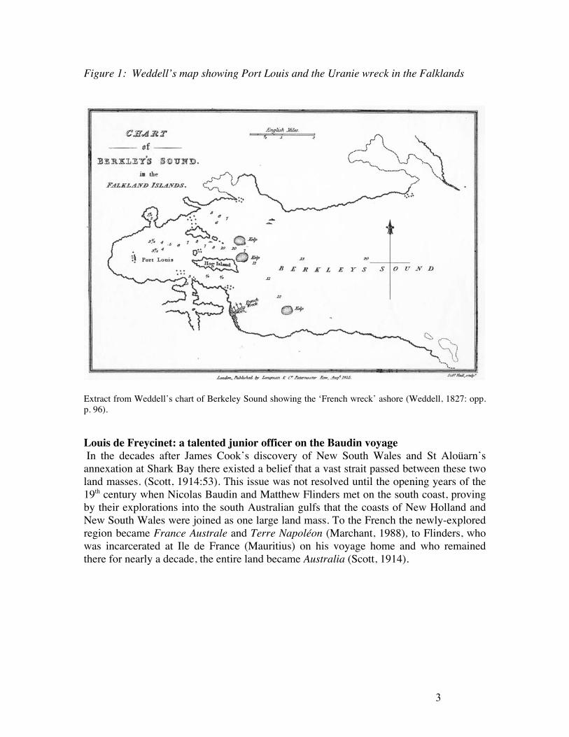
Figure 1: Weddell’s map showing Port Louis and the Uranie wreck in the Falklands
Extract from Weddell’s chart of Berkeley Sound showing the ‘French wreck’ ashore (Weddell, 1827: opp. p. 96). Louis de Freycinet: a talented junior officer on the Baudin voyage In the decades after James Cook’s discovery of New South Wales and St Aloüarn’s annexation at Shark Bay there existed a belief that a vast strait passed between these two land masses. (Scott, 1914:53). This issue was not resolved until the opening years of the 19th century when Nicolas Baudin and Matthew Flinders met on the south coast, proving by their explorations into the south Australian gulfs that the coasts of New Holland and New South Wales were joined as one large land mass. To the French the newly-explored region became France Australe and Terre Napoléon (Marchant, 1988), to Flinders, who was incarcerated at Ile de France (Mauritius) on his voyage home and who remained there for nearly a decade, the entire land became Australia (Scott, 1914).

4
On board one of Baudin’s two exploration ships Naturaliste, commanded by Baron J.F.E. Hamelin was Sub-Lt Louis-Claude de Saulces de Freycinet. Figure 2 Louis-Claude de Saulces de Freycinet. From Bassett, 1962.
Later, while at Shark Bay he was sent by boat to conduct surveys of the area. He also appears to have been on board when the ship’s chief helmsman returned with an inscribed pewter plate commemorating the landing of the Dutch explorer Willem de Vlamingh in 1697. Having long-since fallen from its post, it had been found lying half-buried in the sand at the top of a prominent point overlooking the entrance to the bay. The sailors recognised its importance as the successor to another plate left in the same location by Dirck Hartog in 1616
and immediately brought it back for Hamelin to examine. In objecting to the notion that the plate be removed to France, and in considering that to remove it would have been historical ‘vandalism’, Hamelin had Vlamingh’s plate and a plate of his own re-erected on new posts, the first at the Dutch explorer’s site and the second, if not there, at an as yet undetermined location. As unequivocal evidence of the prior landing of Europeans on their shores, the Hartog, Vlamingh and the Hamelin plates are archaeological relics of great import, and it has been said by one historian that: ‘The title deeds, so to speak, attesting European discovery of Western Australia are three pewter plates left at Cape Inscription, Shark Bay, on three separate occasion’ (Halls, 1974). Figure 3: Hartog, deVlamingh and Hamelin plates (From Halls, 1974).
While at Port Jackson on the east coast, Freycinet was taken from Hamelin’s ship and elevated above others more senior to command a small newly-purchased and locally-built schooner Casuarina with a brief to undertake surveys in shallow waters in concert with

5
Baudin in Géographe. Hamelin for his part was sent home with his ship loaded with artwork, charts, records and with unique flora and fauna specimens, much of which found their way to the Empress Josephine’s much-celebrated garden at Malmaison on the Seine. In the interim, in continuing along the south coast via Tasmania and then back up the west coast in concert with Baudin, Freycinet was to complete the surveys for many fine charts. Figure 4: Casuarina and one of the Corvettes. Appearing on de Freycinet’s Carte Générale de la Nouvelle-Hollande and Carte Général de la Terre Napoléon à la Nouvelle-Hollande.
Thus in the wake of the Dutch and William Dampier, the west, south, and south-west coasts of New Holland were expertly mapped by the French explorers notably D’Entrecasteaux and Baudin who followed them to the island continent. Many places on these coasts now bear French names. Of the charts produced, Beautemps-Beaupré’s work on D’Entrecasteaux’s voyage and de Freycinet’s Carte Générale de la Nouvelle-Hollande and Carte Général de la Terre Napoléon à la Nouvelle-Hollande, and Carte de la Baie des Chiens-Marins, (Shark Bay) while voyaging with Hamelin and Baudin are considered especially notable.

6
Figure 5: de Freycinet’s Carte de la Baie des Chiens-Marins, After the death of Baudin at Mauritius and the return of his expedition to France, responsibility for the production of an official account entitled Voyage de découvertes aux terres australes first fell to the anthropologist Péron, and on his death in 1810 eventually on Louis de Freycinet. When the report was completed in 1816 he proposed another voyage and was successful in obtaining the support of the Institute of France, the Naval and Colonial Ministries and King Louis XVIII.
The aims of the Uranie voyage Freycinet then took command of the 350-ton, 112 French feet (36m) long corvette L’Uranie, formerly La Ciotat, with a complement of 120 men, and 23 officers, including a priest and an artist, Jacques Arago, who also kept an account of the voyage. Of importance, and in contrast to the preceding D’Entrecasteaux and Baudin voyages, where dissension and conflict between the scientists and naval staff was evident, there was to be only one ship and the vast majority of its complement were to be naval personnel. The mission nonetheless grew into a full scientific enterprise part-charged with the investigation of the shape of the earth, terrestrial magnetism, meteorology, and natural science. Further adding to the comprehensive nature of the venture, the expedition report was to be presented under many varied headings, viz. geography, history, observations of the people, government, commerce, primary produce, industries and art. With 596 sub-classes listed under these headings according to Leslie Marchant in his seminal work, France Australe, it made the Uranie voyage ‘one of the most significant anthropological expeditions conducted by the French’ (1988:213). In order to determine the shape of the earth ‘which was then still a mystery’, Marchant also notes that Uranie was to travel as far as possible along the ‘general route of the Tropic of Capricorn’ with the intention of establishing observatories on a parallel as close to that of Rio de Janiero as possible. It was this directive, Marchant observed ‘which is primarily what led Freycinet to Shark Bay’ (1998: 213).

7
Figure 6: Plans of Uranie obtained by P. Godard from French Admiralty Archives H. 5013-22; 176013-17; AN BB4 999.
Stowaway! Rose de Freycinet By June 1814, the 35-year-old Louis de Freycinet and 19-year-old Rose Marie Pinon had married. Though not of their aristocratic ilk, she was very well liked by all in her new family and was described by her future mother-in-law as having had ‘the best possible education’ ‘likeable and admirable’ and having a ‘charming face’ (Reproduced in Rivière, 1996, xiii). Faced with the prospect of a prolonged separation while he conducted the Uranie voyage, apparently neither Louis nor Rose were willing to suffer the same separations that haunted Matthew and Ann Flinders a decade or so earlier. As a result he illicitly prepared (at some cost to the nation) a ‘dunette’ (cabin) as an addition to the existing accommodation on the stern of Uranie. Ostensibly it was for fellow officers and a storehouse for plant and other specimens, but in reality an accommodation for Rose. After these preparations and an elaborate subterfuge, Rose de Freycinet joined the ship disguised as a man and soon after their departure from Toulon in September 1817, her actions roused official indignation and became front page news in papers like the Moniteur Officiel, whose 4 October edition read

8
A few days after this departure, news broke out in Toulon that Madame de Freycinet who had accompanied her husband to the port of embarkation had disappeared thereafter and, dressed as a man had gone on board the ship that same night, despite the ordinances that prohibit the presence of women in state vessels, without official authorisation. This example of conjugal devotion deserves to be made public. (Reproduced in Rivière, 1996, xix)
After leaving Gibraltar, where she joined the crew in meeting the governor dressed ‘as a man in a blue frock-coat with trousers to match’ Rose de Freycinet dressed thereafter as a woman safe in the knowledge she would not be forced off the ship until it called into a French port. Throughout the voyage she kept what was in effect a diary (in the form of letters home to her friend Caroline de Nanteuil). In it she has provided the first educated, literate and socially-aware female’s account of a scientific voyage entailing a circumnavigation of the world, contact with many disparate peoples (including those at Shark Bay in Western Australia) and a shipwreck.
Figure 7: Rose de Freycinet. From Bassett, 1962 Rose de Freycinet’s peers: the first female circumnavigators de Freycinet was preceded by the 26-year-old Jeanne Baré, who though she was assistant to Philibert Commerson, botanist and naturalist on Bougainville’s round the world expedition of 1766-69, kept no records of her voyage and left no personal accounts of her life. Thus Rose de Freycinet became the first European woman to provide an account of her circumnavigation of the globe (1817-1820). In 1768, two years into her voyage,

9
Baré was recognised as a woman by Tahitians soon after the French landed there and she continued on board her presence thereafter acknowledged and accepted by Bougainville. As a result she appears mentioned in his and other officer’s journals and accounts and was described by him as ‘neither plain nor pretty’ and an ‘indefatigable an adept and courageous botaniser’ (Reproduced in Forster, 2000). Commerson dedicated the plant genus Baretia to her and later she was granted a government pension in recognition of her work as his assistant botanist. She later married and by 1785 was living quietly in the French countryside as Madame Dubernat. Following Rose deFreycinet was Gabrielle-Anne Cisterne de Courtiras (The Countess de Saint-Mars) a woman described by Honore Foster in her study of the first of the globe’s female circumnavigators as being ‘of keen intellect, socially aware with an elegant writing style’. She was apparently a member of Alexandre Dumas’ literary circle, and writing under the pseudonym Countess Dash, produced for Paris magazines an account of her voyage between 1843-1851. In 1855 Dumas produced a book, the Journal d’une Parisienne, based on her voyage and later reproduced in French, German and Belgian editions. She also produced what Foster describes as a ‘witty and insightful guide to marriage’ Le Livre des Femmes in 1864. The next circumnavigatrix after Rose de Freycinet was a Viennese, Ida Pfeifer who according to Forster was one of ‘the most popular and admired writers of her day’. She wrote five books of her travels which commenced in 1844, one entitled a ‘A Woman’s Journey Round the World’. Her work received great acclaim and it attracted the attention of scientist and geographers. She was also described as ‘a small energetic and down-to-earth woman who un-hesitantly faced danger and disease on her travels, claimed that she wanted above all things to add to the stock of human knowledge.’ (Reproduced in Forster, 2000). Another important voyager, though not a circumnavigatrix due to her untimely death part-way through the voyage was Marie-Louise Victoire Giradin. Following the death of her young son and then her husband, she joined D’Entrecasteaux’s ship Recherche disguised as a male steward. In search of La Perouse, she traveled across the Indian ocean, along southern Australia and out into the Pacific before the expedition collapsed at Batavia soon after the outbreak of the French Revolution. Embarked on a ship to take her home, in December 1874 she died of dysentery aged 40 years (Duyker, 2005: 144-5). Unlike the famous women who followed, her predecessor Jeanne Baré, and Marie-Louise Giradin, whose presence was posthumously noted, Rose de Freycinet was never officially on board ship, though she had perhaps the best accommodation. Of her there is no official account however. There were, however some contemporary references to her presence, one a small islet (Rose Island) in the Pacific, Cape Rose in Shark Bay and in respect to her maiden name Pinon, a dove (Colomba Pinon) and two plants (Hibiscus pinoéanus; Fougère pinonia). In de Freycinet’s official account of the voyage he makes reference to the discovery of the island ‘which I named Rose Island, from the name of someone who is extremely dear to me’. (Rivière, 2003 xxi).

10
Figure 8: Uranie off New Guinea during the voyage. This image best shows the enhanced accommodation for Rose de Freycinet aft. The object hanging off the mizzen boom is a life preserver. J Arago.
Though Louis was arraigned at a court martial and subsequently exonerated for the loss of his ship, no mention was made of Rose presence on board there. Partly as a result, her story lay largely-forgotten after her death of cholera in 1832, contracted while she was nursing her husband who survived the disease. When she died Rose de Freycinet was 36 years-old, and her husband died still distraught at her loss a decade later. Rose deFreycinet’s remarkable story was not resurrected until 1927 with the publication of her letters in French by Charles Duplomb. Nonetheless, because she had provided a new perspective on official exploration voyages, including, apart from detailed comment on clothing and other personal matters, ‘a keen observing eye for customs’ (Dunmore, 1969:70), interest in her slowly, but steadily grew. The first English-language edition, Marnie Bassett’s Realms and Islands; The world voyage of Rose de Freycinet 1817-1820 was published in 1962, and it was joined in 1996 by Marc Serge Rivière’s A Woman of Courage: The journal of Rose de Freycinet on her voyage around the world 1817-1820.

11
The WA Museum conducted its de Freycinet expedition in 2001 adding further via its websites and reports to the knowledge of the deFreycinet’s and Uranie, firmly cementing the wreck, the survivors camp and the story as part of the ‘shared maritime heritage’ of France, the Falkland Islands and Australia. Further in September 2002 Christies of London auctioned 375 works comprising what they called The Freycinet Collection, including charts, books and the artwork of the voyage (Christies, 2002). Some of that material will appear in this exhibit. Subsequent demand for Rivière’s work, which was carried in many maritime bookshops was such that it went into a second edition in 2003. Figure 9: Title page of the Uranie voyage: featuring a memorial to La Perouse, showing a wreck in the distance and a grieving woman.
Louis deFreycinet’s choice of this image for the cover is interesting, being remarkably like the images of Uranie ashore in the Falklands and also possibly reflecting Rose presence there. The Uranie in Australia After rounding Cape of Good Hope de Freycinet proceeded to Shark Bay and in September 1818 brought L’Uranie to anchor with Dirk Hartog Island in sight. The next day a boat was despatched to the island to recover the Vlamingh plate. In recovering the relic, contrary to his former Captain Hamelin’s sentiments, de Freycinet utilised a time-honoured logic, referring to its exposed location, the possibility of damage or its recovery by less well intentioned others. Rose de Freycinet recorded the event.
On 13 September, Louis sent a boat to Dirck Hatich’s to take away an inscription left behind by the Dutch who landed there about 1600. It is a precious object which we plan to take back to Paris. (Reproduced in Bassett, 1962 :85)
Some on board, notably the artist Jacques Arago, did not approve of his actions and there is at least one journal entry from him disapproving of the removal of the plate. There are also number of depictions of a camp de Freycinet also established in Shark Bay for scientific purposes, including Alphonse Pellion’s Baie des Chiens-Marins: Observatoire de l’Uranie, version which was subsequently published in the official report. It shows Louis de Freycinet alone at work on his calculations at a table outside a

12
very distinctive and quite incongruous circular tent where as Rose appears seated nearby in the original and unofficial version. Figure 10: The official view of the Uranie camp in Shark Bay, Western Australia. Carrying the explanation ‘Desiné par Marchais d’après A. Pellion, Gravè par Forget’ above the title, it is based on Alphonse Pellion’s original. (Note the stack of muskets outside a rudimentary tent)

13
Figure 11: Alphonse Pellion’s unofficial depiction of the Uranie camp in Shark Bay,
Western Australia. (NLA) Later Rose de Freycinet and Jacques Arago describe the land and record a meeting with Aboriginal people in a manner that was to reflect the negative opinions of Dampier and the Dutch before them. Their first encounter was also marred ‘with a certain mistrust’, but when concerned at a developing impasse, Arago relieved the tension when produced a pair of castanets and played a ‘sort of tune’ which resulted in astonishment and then a dance in response from some of the Aborigines. Of equal importance, this image shows the same soldier’s tent and nest of muskets in the two shown above, but without Rose de Freycinet’s tent which would have been behind. Again this is indicative of the selective nature of the official record.

14
Figure 12. Jacques Arago’s sketch of the meeting with Aborigines at Cape Peron. State Library, WA.
The diaries covering these events are quite extensive and there is also great body of artwork extant. The exuberant, almost uninhibited nature of Jacques Arago’s art and writings, and Rose de Freycinet’s frank musings on people, places, events and her reflections on her own reactions, and on occasion, even the appropriateness of her own attire in respect to local custom, allows us to view both her and Arago’s accounts as important social commentary. In that respect they represent far more of an anthropological resource than the more formal accounts of the officers and officials on board L’Uranie and on most other exploration ships that preceded it. After leaving Shark Bay for Timor, where the official artwork again ignores the presence of Rose, while the unofficial works celebrate her landing in style interestingly in two different outfits, one with blue trimmings and the other red. The contrast between these two images and that finally produced as the ‘official’ account are very revealing, as are what appear to be Louis de Freycinet’s crosses on the unofficial renderings, showing

15
what was and what was not to appear in the final version. A close inspection of the boat in the image with Rose dressed in white and blue also captures the reality of such events and a sense of humour. There in the bows is an officer upended, his boots all that are visible of him. The contrast with the pomp and order shown in the official rendition is a delight. Figure 13: J Arago Timor 1818. Reception a Diely. From the Christies Catalogue

16
Figure 14 : Pellion. Premiere scene de la fete donee par le Gouverneur der Diely A Madame de F. Note the crosses and compare with the official version.
Figure 15. Marchais. The official version of the landing. Atlas Historique. Pl 30

17
From Timor Uranie and its complement travelled to Tahiti and there she produced a remarkable series of observations, including a baptism and a wedding on board ship before arriving back in Australia at Sydney. Sydney: ‘roguery’s classic shore’. On the first night in town they were burgled! As an example of her style, and how contemporary Australian society was viewed elsewhere at the time, Rose de Freycinet’s account of this event is well worth reproducing for it reflects views held of the people and place for generations since.
We learnt that during the night our silver, table linen, our servants’ clothing and other effects had been stolen from the ground floor of the house we occupy. You know the purpose of this colony and what sort of people are to be found here in plenty; you will therefore not be astonished at this misdeed: might one not say it is roguery’s classic shore. It would be astonishing not to find thieves here as it would not to meet Parisians in Paris and Englishmen in London (Reproduced in Bassett, 1962:179).
On the eve of their departure, a large quantity of supplies and livestock was loaded. Included were two merino rams, with a view to introducing them to the flocks in France, joining, as curiosities and valuable specimens, eight black swans and a number of emus. Unbeknownst to the voyagers a number of convict stowaways, including a Frenchman, were also on board. This was somewhat ironic for there was more to this voyage than the scientific and social. There was a developing French interest in establishing a south-west Australian penal colony to rival the British institutions on the east coast and in his detailed analysis of the social, political and strategic context of the French interests in the Southland, Leslie Marchant (1998: 209). states that: ‘In the period after Freycinet’s mission, the French government for the first time made specific plans to colonize western Australia, in order to realise the long held Bourbon dream of having a temperate base in the Indian Ocean to match British controlled south Africa’. In apparently following on from the 1772 French annexation of the land further north at Shark Bay, the expeditions that were sent out to achieve this aim all failed to arrive at their destination, however and French interest in a proposed Australian penal colony was completely extinguished by the British establishing themselves at King George Sound (Albany) in 1826 and at the Swan River (Fremantle) in 1829. The loss of L’Uranie The ship left New South Wales in December 1819 for Tierra-del-Fuego, where after suffering damage in a severe storm it was decided to head for the calm waters of Port Louis in the Falkland Islands. Entering what is now Berkeley Sound in February 1820 Uranie struck the rock that now bears its name and the stricken ship was run ashore in a sheltered bay which also now also bears the ship’s name. Unable to refloat the ship, the French remained ashore for about eight weeks where they were occupied in removing as much as possible—including the de Vlamingh Plate and most of the artwork and

18
specimens—from the wreck, in attending to their own survival on a desolate shore, continuing their scientific tasks and in recording the events that had beset them. Eventually the castaways purchased an American vessel, the Mercury, which had called in to Port Louis to effect repairs after a difficult passage around Cape Horn. It was carrying cannon and munitions despatched from the rebels at Buenos Aires to those at Valparaiso and as a result it sailed under their flag (Bassett, 1962:218). Offered a great sum for his ship, the American captain eventually heaved the guns overboard and sold it to the French, who promptly renamed it renamed Le Physicienne and set about preparing it for the voyage home. Physicienne was quite cramped and though Louis de Freycinet continually fretted about the inevitable salvage of his ship by the whalers and sealers who frequented the islands, they sailed off with the most important materials, but with much left behind. The Antarctic explorer James Weddell who was in the Falkland Islands in the brig Jane at the time and who had befriended the recorded that he received a letter from the commander of what he called a ‘patriot national frigate’ which was then at anchor at Port Louis, not far from the Uranie wreck. In that letter Weddell records that he was informed that the Captain was ‘commissioned by the supreme government of the United Provinces of South America’ at Buenos Aires to take possession of the islands and that he also intended to take possession of the wreck (Weddell, 1827). Thus began a chain of events with modern repercussions for the Falklands, for Britain and for Argentina. Appearing in the French Naval Archives under the heading Naufrage de l’Uranie en 1820 is an illustration which, given the title Reliquias d-la corveta Francesca la Urania, and the appearance of the wreck itself has emanated from this time. (French Naval archives, PH 71906). Figure 16 Naufrage de l’Uranie en 1820 is an illustration which, given the title Reliquias d-la corveta Francesca la Urania appears to be a Spanish rendition.
Visible in the background are what are described in the castaway’s journals as ‘Spanish horses’ and it is evident that many were used as food for the starving crew after being prepared in ‘stone
roasting-ovens’ fired with brush, there being no natural timber

19
available for the fires (Bassett, 1962-209). Meanwhile the castaways themselves arrived at Le Havre in November 1820 after a voyage of three years and two months. In their journals, letters and later in the official accounts Louis de Freycinet wrote of all these events as did numerous others, including the artist Jacques Arago and Rose de Freycinet.
Louis de Freycinet’s account: Excerpts from a translation by Mr R. Sexton, member of the Museum’s team).
At 4 p.m. on 14 February we discerned the entrance of French Bay [Berkeley Sound]….[a] reduction in depth made me give the order to fall way two points to larboard to deviate away from the coast; but this excessive care became disastrous for us, and shortly the corvette was brought up with a pretty strong shock on an underwater rock…We hastened… to try to at least fother the leak; but after much work this measure was found inadequate … fear of seeing the corvette sink persuaded me to slip the cable [i.e. to abandon the anchor and]…to stand in for the sandy cove . . . It is therefore at 3 a.m. that the Uranie reached the inevitable termination of her voyage, at the place we have so properly named the Anse de la Providence!
… As soon as the ship was beached we carried some kedge anchors abreast her for fear that the surf should shift her away from shore…she heeled little by little to starboard to the point where the masts made an angle of twenty degrees with the vertical. . . . . . the hull suffered on the ground as a result of the ocean swell… we expected to see the corvette smashed to pieces…soon indeed we came to the sad conclusion that complete planks had been detached from the ship’s bottom through these repeated jolts… As soon as the impossibility of repairing the Uranie had been proven, I set to work decking the longboat with the intention of sending it to Montevideo…to fetch the help we needed…(Freycinet, 1826, Book One, Itinerary: 37-43).
He also states that the ‘valuable merino sheep from New Holland’ and other stock that had survived the voyage were landed though they lost ‘several cases of specimens that were in the hold’.
…it was essential to place in safety immediately the journals and other expedition papers… we generally saved all our work in physical science, astronomy, hydrography, anthropology, and linguistics as well as all our journals and notes on natural history.

20
Freycinet also records that:
…special tents were pitched for our small number of sick, then for the crew, the petty officers, the midshipmen, and the officers; a particular one was also reserved for me, and it was there that all our papers were brought together as well as the astronomical and physical science instruments etc. The one destined to contain our gunpowder was placed in a separate quarter; two likewise were raised to receive the spirits and sea provisions that we had saved from the wreck.
Jacques Arago also commented on these events
Jacques Arago …Letter CLIV: At first the ship was lying on the sand; by degrees she was forced upon the rocks, and, notwithstanding the assurances which had been given to me to the contrary, she fell over on the starboard side, and my cabin was immersed in water…. . . . The collection of shells which I had gathered at every place where we stopped; the different arms of almost every nation on earth; rare birds and curious reptiles; my linen; my books; ten portfolios of sketches and finished drawings; all—all were engulphed… Arago..Letter CLVIII Three horses have been killed to-day, at a short distance from the camp, and the pieces are already placed in store; and as no one can go on board the corvette, which is gradually filling with sand, rolled in with great violence by the high seas…
As did Rose de Freycinet.
Rose de Freycinet 18 February 1820…we are still on board, as Louis does not wish to abandon the ship before the most essential items have been removed from it. We see enormous waves lifting the ship and dropping it with great force. Each time this happens, we feel that the Uranie is going to spilt into two. 29 February…. the longboat has been taken ashore; a tent has been pitched for the carpenters and another for the blacksmiths.

21
Our camp looks like a small village; there is a tent for Louis, one for the equipment and the records where we will also take our meals, one for the staff, one for the midshipmen and one for the volunteers. Three other tents have been pitched, for the hospital, the sailors’ barracks and the masters respectively. There are also small tents for the cooks and the supplies. At some distance from the camp is the powder magazine where arms and ammunition are kept under lock and key. The crew are still busy salvaging anything they can from the ship.
Figure 17: Alphonse Pellion’s view of the Uranie camp showing the wreck offshore
14 March…..sack [of flour] was salvaged and… fell into the hands of the cook during the construction of his oven.. …The only sound that disturbs me, and will torment me for a long time to come, is the noise of the waves crashing against the rocks on the shore, close to our tent. 18 March…my husband decided to take a walk to the ship-yard; we found the chaloupe very advanced [it was being decked] and ready to be launched in two or three days… the crew salvaged…
22
a barrel of pitch. They also removed a box containing 66 cheeses in good condition.. 22 March… The crew are busy tidying up the rigging and various items salvaged from the Uranie. Louis….presses on with the building of his observatory and intends to set up the equipment tomorrow… 30 March…The limited shelter which our tents provide in such a cold and wet climate is very trying.. 4 April… The Sloop [a schooner belonging to the whaler [General Knox] showed M. Dubaut six spots where ships had been wrecked recently… and the captain told Louis that there were perhaps 50 wrecks in this area. Tonight the Scottish captain [Weddell] came to visit Louis who offered him his rigged rowboat; as we cannot take it with us…He appeared to be very grateful and told us that, out of greed, Captain Orne had concealed the tragedy which had befallen the Uranie…I have heard that he asked what my name was and has called this small sloop The Rose.
The Australian desire to locate Uranie Given the impact the de Freycinets had on Australia and on Shark Bay, not the least by the removal of the de Vlamingh plate and their interaction with the Aboriginal people, during the 1999 Tricentennial William Dampier’s visit to Shark Bay, it was decided to go the Atlantic and search for both Uranie in the Falkland Islands and enroute to try and locate William Dampier’s command TM ship Roebuck at Ascension Island (McCarthy, 2004). Like Roebuck it was also accepted from the outset that l’Uranie was a ‘Ship of State’ as defined in the international conventions and that the hull and its contents belonged to each country (Roach, 1996). It was also accepted from the outset that the respective Island communities and their parent governments were the resident community managing the wreck, the camp and the shores on which each ship was lost. Thus with Australia having no legal standing in the matter, a strictly non-disturbance search and survey regime was proposed, with full scrutiny and participation by Falkland Island interests and Government instrumentalities factored in. The expedition was led by Dr M. McCarthy, its chief diver Geoff Kimpton both of the WA Museum’s Department of Maritime Archaeology. Also on the team was chief fundraiser and expedition doctor John Williams, abalone diver John Lashmar of Augusta, Carmelo Amalfi, of the WA Newspapers, award-winning maritime author, Hugh Edwards and Cr Les Moss President of the Shire of Shark Bay. Also on the team but not present in the islands were Australian/French maritime researcher and author M. Philippe Godard (leader of the expedition that found the St Alloüarn annexation site in Shark

23
Bay), philanthropist Dr John Hanrahan, maritime historian Bob Sexton and webmaster Jon Davison. The land camps and beachside wreckage In March 2001 timbers from L’Uranie were clearly visible on the shores of Uranie Bay opposite Long Island Farm on Berkeley Sound. On the beach to the south of Neil and Glenda Watson’s Long Island farmhouse lay knees, fragments of frame, planking, deadwood, iron and copper fastenings, copper sheathing, the odd pulley sheave and other wreckage. Part of a whale skeleton lay near a large knee which being substantial became a focus as a representative of the ship.
Figure 18: Shire of Shark Bay president, Les Moss with a knee from Uranie and replica of the de Vlamingh plate he presented to the Falkland Islands community. H. Edwards Further down the beach was a particularly interesting timber that appeared from the combination of heavy and light fastenings, to be part of a light deck structure, possibly the dunette that Louis de Freycinet had surreptitously constructed as accommodation for his wife.

24
Figure 19: A strangely configured ship’s timber, possibly from the dunette. M. McCarthy The spread of ship’s timbers centres in the region between a distinctive ‘double reef’ structure to the north and a large flowing stream labelled Aiguade de l’Uranie (watering place of the Uranie). Apart from the beachfront wreckage, two occupation sites appeared, one tentatively identified as a ‘civilian camp’ just to the south of the main concentration of timbers and the other a ‘military camp’ immediately inshore of the remains. The ‘civilian camp’: The tentative identification of an area on a remarkably flat plateau interspersed with conglomerations of water-worn rocks that had been carried from the sea for use in a camp or similar is based on the fine discovery of fine blue and white sherds and bottle fragments, on the surface of a small rise at the southern extremity of that same plateau not far from the rock structures. Consistent with the 1820s, these remains appear to have been exposed by wind activity. The elevated nature of the plateau, the number of collapsed rock structures, its sheltered position away from the sea, with another ridge of vegetation behind acting as a windbreak for the westerly winds, makes it a logical place to house
the upper echelon of shipboard society, though this theory was not tested, given the non-disturbance nature of the search and survey undertaken. It needs be accepted that there may be a number of other possibilities for example, the elevated and clear position, the collapsed stone structures and the fine ceramics could be an indication of officer’s quarters or respite adjacent an observatory of the sort Freycinet would have needed to set up to continue his scientific work determining terrestrial magnetism and the shape of the earth. The ‘military camp’ The northern element of the Uranie camp appears as a number of lines of water-worn rock lying on an expanse of grass, some interspersed with ship’s timbers that could not have reached their present position even in the greatest storm and are believed to have been utilised within rock shelters and as supports for tents made from sails. Rocks are also commonly used as anchors for tents and as dividing walls. Between these makeshift structures and the beach, and lying along the grass/sand interface, was evidence of a long

25
since collapsed linear structure facing the sea with regularly spaced concentrations of rock that resembled defensible military ‘bastions’, hence the term ‘military camp’ that was tentatively assigned to it. Nearby on the grass, at its meeting with the beach sands was a deposit consisting of rivetted iron straps and iron spaull that was apparently the remains of an iron tank, possibly the one appearing in the Pellion view above to the side of the small boat Freycinet had his men altering and decking over to provide a means of escape or obtaining assistance. Very close to the shore opposite the Long Island Farm homestead and quite some distance to the north of the features recorded above, lies a large mound comprising a collapsed stone structure, full of sand and vegetation which from the form and style of the bottles lying on the surface at the southern end dates to around 1870/80. Bones, some believe to be those of horses, and fire bricks similar to those found amongst the Uranie timbers ashore were also noted amidst the rocks, however. Being very large, it is possible it was produced by the crew of the Uranie, who, in being over one hundred strong, would have taken little time to build this and the other structures noted above. Theories range from a holding facility for the Port Jackson convicts, a large beacon to alert rescuers or to mark the way into Port Louis, an armoury to house powder and guns from Uranie, to an oven-cookhouse where animals were butchered and the meat and or bones stored for future consumption. The Uranie wreck Though the museum team had secured the assistance of service personnel from the Falkland Island Sub Aqua Club and even though the team were taken to where one of the local divers had found what he described as ‘keel’ timbers 30 years earlier (Eynon, 1972), locating the wreck itself proved surprisingly quite difficult. It was also extremely cold and divers John Lashmar and Geoff Kimpton showed enormous grit and determination as they covered large amounts of seabed in search of Uranie in freezing conditions, both above and below water.
Figure 20: John Lashmar and Geoff Kimpton resting after an arduous underwater search. M. McCarthy Initially the only evidence found consisted of isolated timbers on the seabed and a pulley sheave with an inner coak (from Uranie’s rigging) lodged amongst a rocks forming a

26
distinctive line of two parallel reefs projecting from shore. This has since been dubbed the ‘Dog Reef’ due to the presence of a prominent rock appearing much like the head of a Labrador dog on the northern line of rocks. It is clearly the formation shown in an illustration by the contemporary artist Nicolas Maurin. The ‘dog’s head’ appears as a white rock to the right. Here some of the spars and rigging from Uranie appears and Rose deFreycinet’s tent is also visible.
Figure 21: Nicolas Maurin’s view entitled Naufrage de L’Uranie, looking across ‘Dog Rock’ towards the Camp. Rose de Freycinet’s distinctive tent in the background. (NLA) Squally conditions, with wind gusting sometimes in excess of 40 knots, cut diving time to a bare minimum and with just a few days remaining before the scheduled departure and with the wreck still unfound, the team re-examined the contemporary artwork and an analysis of the extensive survivor’s camp to locate it. The first vantage point fixed was that which artist Alphonse Pellion had occupied while drawing the scene from the hillocks behind the camp. In his view Uranie was just visible on its port side some distance offshore. A boat is being built on the foreshore and the tip of Rose’ tent is just visible to the right of the image.

27
Figure 22: Atlas Historique. Uranie is visible on its side some distance offshore Locating the wreck using contemporary art. The three views used to try and locater the wreck are produced below. The first view is from the high ground behind the camp, the second is that produced by Nicolas Maurin from a vantage point at sea showing spars and rigging amongst the ‘dog’s head reef’ shown above and the third was produced by the unknown Spanish artist, and is from across the bay.

28
Figure 23 . The three views used to try and locate the wreck From a comparison of these views with the topography it became evident that the hillocks shown by the artists near the camp didn’t exist as depicted, or have since eroded, possibly as a result of sand movement after the French occupation. In addition, Pellion’s depiction of the range of hills behind the site to the south-east was not accurate and while the Spanish view showed the ship on the beach behind a line of rocks projecting into the sea
29
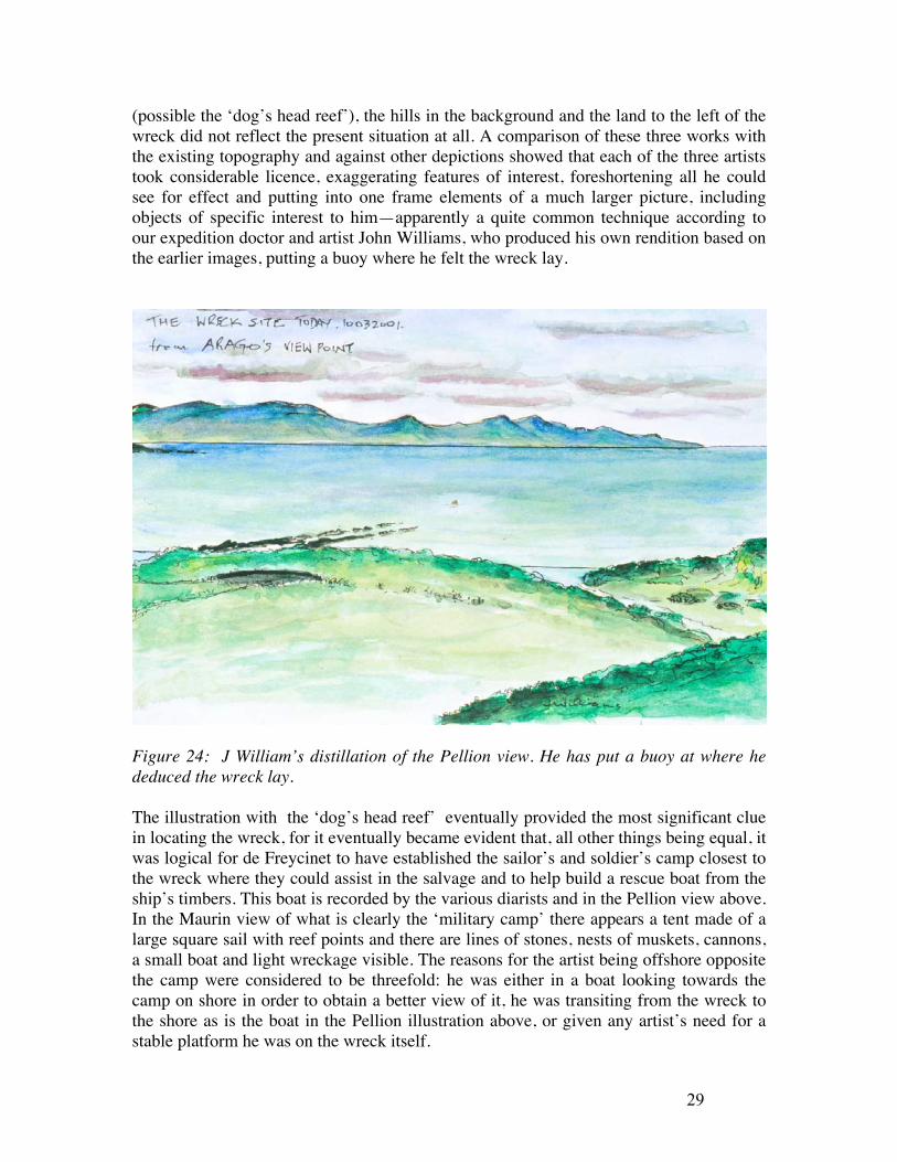
(possible the ‘dog’s head reef’), the hills in the background and the land to the left of the wreck did not reflect the present situation at all. A comparison of these three works with the existing topography and against other depictions showed that each of the three artists took considerable licence, exaggerating features of interest, foreshortening all he could see for effect and putting into one frame elements of a much larger picture, including objects of specific interest to him—apparently a quite common technique according to our expedition doctor and artist John Williams, who produced his own rendition based on the earlier images, putting a buoy where he felt the wreck lay.
Figure 24: J William’s distillation of the Pellion view. He has put a buoy at where he deduced the wreck lay. The illustration with the ‘dog’s head reef’ eventually provided the most significant clue in locating the wreck, for it eventually became evident that, all other things being equal, it was logical for de Freycinet to have established the sailor’s and soldier’s camp closest to the wreck where they could assist in the salvage and to help build a rescue boat from the ship’s timbers. This boat is recorded by the various diarists and in the Pellion view above. In the Maurin view of what is clearly the ‘military camp’ there appears a tent made of a large square sail with reef points and there are lines of stones, nests of muskets, cannons, a small boat and light wreckage visible. The reasons for the artist being offshore opposite the camp were considered to be threefold: he was either in a boat looking towards the camp on shore in order to obtain a better view of it, he was transiting from the wreck to the shore as is the boat in the Pellion illustration above, or given any artist’s need for a stable platform he was on the wreck itself.

30
Using the distinctive dog’s head-shaped rock in the foreground Geoff Kimpton and John Lashmar were then able to ‘fix’ Maurin’s position and were led directly to the wreck under a thick bed of kelp. John Williams record of this appears thus:
It occurred to me that the siting of the wreck in his painting would also be accurate, so I suggested to Mac that, using two hand-held radios, I could stand at 'Pellion's point' and direct the dive-boat to that point where, in his painting, he depicted the wreck. ....we acted out this little charade, and ...Bingo, there it was, shrouded in kelp, but parts of the keel and ribs clearly visible ! Previous parties searching for the wreck had failed to appreciate the detail and accuracy displayed by expedition artists.
An inspection was then conducted and it was found that the Uranie wreck lies on a seabed of sand on an axis from shore of c.100° magnetic, in c.4 m of water, shallowing slightly towards the shoreward end. The visible wreckage, all heavily colonised by kelp, measured c. 24 m long with a keel/frame/keelson assemblage along part of its southern side between the 3-17 m marks. What appeared to be iron ballast ‘pigs’ were visible alongside the keelson on the inner side of the wreck, as were copper bolts, one of which projected laterally from the side of one timber under the ballast. The stubs of a series of double frames project at right angles from the keel/keelson structure, and at the 15 m mark, timbers of a corresponding double frame are visible 7.5 m across the sand from the line of the keel/keelson, with others barely visible at lesser distances from the centreline, one being c.4 m away. Hand-fanning to reveal their form and alignment indicates that they are connected under the sand to the keel, providing evidence that a large section of the wreck lies below the sand at this point. An agglomeration of what appear to be firebricks similar to one seen onshore was seen adjacent one double frame crossing the keel at the 15 metre mark. (McCarthy, et al., 2002b). The position of the wreck and a all the finds on land were then plotted by John Williams to produce the expedition site plan in Figure 25 following. A military and civilian camp are shown together with each of the three artist’s viewpoints.

31

32
Figure 26: Underwater at the Uranie Wreck. M. McCarthy

33
The Shark Bay Camp
In September 2002 Uranie team members, author Hugh Edwards, and Les Moss used charts analysed by another team member South Australian maritime researcher Bob Sexton to fix the area of the camp from the contemporary accounts. Crucial to this exercise was his correcting of the latitude and longitudes given by the French explorers against known landmarks for which a modern ‘fix’ was obtained (e.g. Cape Inscription). Armed with his calculations and then again using the contemporary artworks, they were successful in relocating the Uranie camp at Shark Bay from the sea. An archaeological assessment was later conducted by the Museum and though little remained the area was declared a protected zone ( Gainsford and Prall, 2005).
Figure 27: The de Freycinet campsite in 2002. H.Edwards
References Arago, J., 1823, Narrative of a Voyage Round the World, in the Uranie and Physicienne

34
corvettes &c. London, Treuttel and Wurtz. Printed in facsimile in 1971, Amsterdam.
Bassett, M., 1962, Realms and Islands: The world voyage of Rose de Freycinet (1817-1820). London.
Bonnemains, J., Forsyth, E., & Smith, B., (eds.,) 1988, Baudin in Australian Waters: The artwork of the French voyage of discovery to the southern lands 1800-1804. Melbourne.
Brown, A.J., 2000. Ill-starred Captains: Flinders and Baudin. Crawford House, Adelaide.
de Freycinet, L, 1827, Voyage Autour du Monde, entrepris par ordre du Roi… : Historique, Volume 1. Paris
de Freycinet, L, 1829, Voyage Autour du Monde, entrepris par ordre du Roi… Historique, Volume 2. Paris
Dunmore, J., 1969, French Explorers in the Pacific. Oxford. Duperrey, I., 1825, Plan de la Baie Francaise (à la partie Orientale des Iles Malouines.)
Levé et dressé par M. L.I. Duperrey Officier de marine, Embarqué, sur la Corvette du Roi L’Uranie, 1820. From Voyage Autour du Monde: Atlas Historique (1825), plate 108.
Duplomb, c., 1927. Campagne de l’Uranie: Journal du Voyage autour du monde a bord de l’Uranie, 1817-20. Paris.
Duyker, E., 2005 Girardin, Marie-Louise Victoire (1754 - 1794), Australian Dictionary of Biography, Supplementary Volume, Melbourne University Press, 2005, pp 144-145.
Forster, Honore, 2000. National Library of Australia News January 2000. Gainsford, G., and Prall, R., 2005 Report on the Inspection of the de Freycinet Land
Camp, Shark Bay, 2005. Maritime Heritage Site Inspection Report Department of Maritime Archaeology, Western Australian Maritime Museum Report—Department of Maritime Archaeology, Western Australian Maritime Museum, No. 196.
Godard, P., and de Kerros, T., 2002. Louis de Saint Aloüarn. Lieutenant de vaisseaux du Roy. Un marin breton à la conquête des terres Australes. Perth.
Halls, C.,1974, a Story of Three Plates, Port of Fremantle Quarterly. Winter, 1974. Fremantle.
Hunt., S. and Carter P., 1999, Terre Napoléon: Australia through French Eyes. 1800-1804. Sydney.
McCarthy, M., & Garratt, D. (1998) The Western Australian Maritime Museum Wreck Access and Outreach Program. Bulletin of the Australian Institute for Maritime Archaeology, 22: 127-132.
McCarthy, M., (1982) A wreck inspection programme as an aid to the coordinated management of a large number of wrecksites.
International Journal of Nautical Archaeology, 11(1):47-52. McCarthy, M., 1998. The Turtle Bay Coin: Maritime Heritage Site Inspection Report.
Report-Department of Maritime Archaeology. WA Maritime Museum, No.138a. McCarthy, M., (2002) The Uranie Site(s). Report of an inspection and the context of the
survivor’s camp, wreck and wreckage emanating from the loss of La Corvette du Roi L’Uranie at the Falkland Islands in 1820. (With contributions from D. Eynon,

35
P. Godard, R. Sexton & J. Williams). Report – Department of Maritime Archaeology, Western Australian Maritime Museum, No. 160.
McCarthy, M., 2004, HM Ship Roebuck (1690-1701): Global Maritime Heritage? The International Journal of Nautical Archaeology, 33. (1): 54-66.
Marchant, L., 1998, France Australe: The French search for the Southland and subsequent explorations and plans to found a penal colony and strategic base in south western Australia. 1503-1826. Perth
Rivière, M.S., 1996, A Woman of Courage: The journal of Rose de Freycinet on her voyage around the world 1817-1820. National Library of Australia. Canberra.
Roach, J.A., 1996. Appendix: sunken warships and military aircraft, Underwater archaeology and the Titanic: The legal considerations, in Jarvis, A., et al., 1996. Proceedings, IXth International Congress of Maritime Museums. National Maritime Museum, UK.
Weddell, J., 1827, A Voyage towards the South Pole, performed in the years 1822-24, containing an examination of the Antarctic Sea, &c Second Edition. London.
Wood, G.A., 1922: The Discovery of Australia. London.
WEBSITE: http://www.museum.wa.gov.au/collections/maritime/march/treasures/uranie/defreycinet.html