river halda awakening: a research training and …
TRANSCRIPT

RIVER HALDA AWAKENING: A RESEARCH TRAINING AND AWARENESSCENTRE
At Burischar, Chittagong
ByFarasha Zaman
Seminar II
Submitted in partial fulfillment of the requirementsfor the degree of Bachelor in Architecture
Department of ArchitectureBRAC University
August 2014

2 | RIVER HALDA AWAKENING
ABSTRACT:
The Halda River, originating from a hill creek at Ramgarh Upazilla in the hill-tract district of Khagrachhari isfamous as the fish-mine of Bangladesh. This River and its waters have some unique physical chemical andbiological features which generate a favorable atmosphere for four types of carp fishes, rohu, catla catla, mrigaland kalibaush to lay their eggs in the depths of the river bends, where generated whirlpools help in the processof the lifecycle. The focal physical feature, the ox bow bends of this river, combined with various other chemicaland biological features such as the marshlands alongside the river edge, give this river its character and lifeallowing it to be the richest natural spawning ground of these four species of major carps from the time of itsformation.In the 1960s, this river had more life than it has now, producing 3 times the volume of fishes and so generatingthree times the amount of activity along this river. All this has experienced a major phase of diminishment,generating a situation of large scale depression for the fishermen. The River life degradation is mainly for thestraightening of the river ox bow bends along the river edge, which is the source point of fish life generation.The community takes up this methodology in order to protect their homesteads and properties from thedisasters of river edge erosion. This approach to the river that the people have adapted to is a cause for thelack of awareness and negligence by the existing government projects and also because the locals lackknowledge about the scientific issues related to this river. Such disregard to a natural source is leading to illegal fishing of mother fish, improper river edge protectionmethod development and so on. This, in turn leads to the decrease of fish egg generation, which furtherrelates to less economic generation and creates a break in the natural cycle. Due to decreasing opportunity infisheries sector of this river, most farmers are shifting from that of being a fisherman to agricultural farmers.The idea behind this project generated from this original of providing a platform for the fishermen, which willhelp reach out and allow development and interaction of this community at a local scale. It will further achieveawareness at a wider scale, reaching out to other cities and countries in the process of research, conservationand archiving. Functionally developing the project into providing training spaces, research facilities, andexhibition spaces and various awareness programs and processes was based on this hypothesis, so as tosupport a community and generate a program that has evolved from the site within. The focus of this project was to generate an architecture that celebrates itself within nature giving the river andits surrounding a more valuable meaning, not taking up the space that it will occupy but instead giving back tonature in multiples of what it is taking.
3 | RIVER HALDA AWAKENING
CONTENTS
Chapter 01: Introduction1.1 Project Introduction1.2 History1.3 Description
1.3.1 Location1.3.2 Site Area 1.3.3 Client
1.4 Project Rationale1.5 Key aspect and Objectives1.6 Reason Behind the Choice of Site Location1.7 Basis of the Program Formulation
1.7.1 Basic program
Chapter 02: Site Appraisal2.1 Location of the Site2.2 Surrounding Area Study: Relation at a broader scale2.3 Chosen Area study: Relation to its direct surroundings
2.3.1 Water bodies2.3.2 Vegetation2.3.3 Urban Potentials_ tourist areas and routes2.3.4 Built forms2.3.5 Land use pattern2.3.6 Transport Network
2.4 SWOT analysis2.5 Climate
Chapter 03: Literature Review3.1 Learning3.2 The Learning Center3.3 Recreation as a revenue generator3.4 Threats to Recreational Waters3.5 Heritage_ culture_ tradition3.6 Exhibition spaces3.7 Material3.8 Architectural consideration of lab design
3.8.1 Lab Planning Module3.8.2 Two-Directional Lab Module3.8.3 Three-Dimensional Lab Module3.8.4 Open labs vs. closed labs3.8.5 Flexibility
3.9 Deduction
Chapter 04: Contextual Analysis 4.1 Formulation of the Project4.2 Why the Halda is called a heritage of natural fish breeding in Bangladesh4.3 Announcing the Halda as the national river of Bangladesh

4 | RIVER HALDA AWAKENING
4.4 Experience within the site
Chapter 05: Case Studies 5.1 Case 1: RENZO PIANO. Jean-Marie Tjibaou Cultural Centre5.2 Case2: Center for Ecological Living and Learning (CELL) 5.3 Case3: River Bend Environmental Education Centre5.4 Case 4: Floating gardens can feed Bangladesh
Chapter 06: Program Formulation
Chapter 07: Design Development 7.1 Idea Generation7.2 Volume and Space Generation7.3 Activity and relation to nature7.4 Façade Derivation and Developmental7.5 Architectural Drawings7.6 Renders
Chapter 08: Conclusion
5 | RIVER HALDA AWAKENING
LIST OF FIGURES
Chapter 01: Introduction Image 01: Site rationale near to the River Karnuphuli, surrounded by an ecological zone,
hatcheries, fishermen habitats, a road proposal from the commercial hub, and brick fields tothe opposite.
Image 02: Project rationale and program development
Chapter 02: Site Appraisal Image 03: Site location. 1: In reference to the country, 2: In reference to the Chittagong city. 3:
In reference to the DPZ location Image 04: DPZ location. Image 05: Route map from Dhaka to site and surroundings Image 06: Site location at river edge Image 07: site location is near to the river edge to achieve monitoring, accessibility and
celebrate the river Image 08: Site surrounding features Image 09: River view of the site Image 10: View from site Image 11: water bodies in and around site Image 12: brick fields at the edge of the river Image 13: The unacceptable condition of the river edge Image 14: vegetation in and out of site Image 15: The edge area of the site Image 16: Many species of the birds seen here Image 17: Site is surrounded by beautiful aquatic life Image 18: herons are a common bird here Image 19: tourist places near to site Image 20: built forms related to site Image 21: fisherman’s habitats at the edge of the river Image 22: the fishermen’s and farmer’s habitats are a beautiful experience altogether Image 23: Land use pattern Image 24: agricultural and hatcheries Image 25: Road networks Image 26: Local shops selling all kinds of goods have developed in layers along the edge of
the bridges Image 27: Site Layers Image 28: slope study and potential threat zone analysis Image 29: Climatic graphs and data
Chapter 03: Literature review Image 30: water pollutants and its effects
Chapter 04: Contextual Analysis Image 31: Population decrease of fishermen
Chapter 05: Case Studies

6 | RIVER HALDA AWAKENING
Image 32: Eco friendly material incorporation with modern techniques Image 33: study of wind flow Image 34: River bend Image 35: An Integrated Floating Cage-Aquaponics System (IFCAS) in Barisal, Bangladesh. Image 36: Research labs and corridors of aquatic life research unit, Canada.
Chapter 06: Program Formulation Image 37: bubble diagram and basis of program formulation Image 38: Organgram
Chapter 07: Design Development Image 39: Voronoi Development Image 40: Orientation of polygons Image 41: zoning of functions and their relation Image 42: Central courtyards like space allowing gatherings and interactions Image 43: ecological sampling zone outside library Image 44: community participation area and deck Image 45: agricultural sampling zone Image 46: elevation derivation and façade treatment Image 47: Site Plan Image 48: Ground floor plan Image 49: First Floor plan Image 50: Roof plan Image 51: river view (east elevation) Image 52: section AA ( longitudinal section) Image 53: section BB (through gallery spaces) Image 54: gallery space Image 55: Training space Image 56: outdoor exhibits
7 | RIVER HALDA AWAKENING
AcknowledgementFirst I did like to start in the name of almighty Allah, who gave me the strength and made me capableto complete my thesis. I did like to thank my Parents and family for supporting me through these fiveyears.
I would like to thank my Studio critics, Professor Rubaiya Sultana, Professor Naim Ahmed Kibria,Professor Mohammed Faruq, and Professor Ehsan Khan.
I am ever grateful to my supporting team, Kazi arefin, Tahmidur Rahman, Bidoura Mosharraf, InjamulHaque, Bronte Zaman, Shatil, Kader, Rayed, Fahad Shamshudhdhoha, Zaqaria Prince, Adnan.
Special thanks to Professor Fuad H. Mallick, for supporting me throughout the five yearscourse and for having me in BRAC.

8 | RIVER HALDA AWAKENING
CHAPTER ONE: Introduction
9 | RIVER HALDA AWAKENING
1.1 Project Introduction
River Halda awakening is a project of the Bangladesh Ministry of Fisheries and Livestock. This projectwill further involve the Bangladesh Environmental Lawyers Association and Bangladesh WaterDevelopment board for technical decisions involved. The selected site of around 8 acres = 13284sft,for the chosen project was taken at a river bend near the confluence with River Karnuphuli.The idea of the project is to develop a community based project on the edge of River Halda that willpromote the surrounding nature that it is in.
1.2 History
The River Halda (22° 54´ North and 91° 48´ East to 22° 24´ North and 91° 53´ East) originates in thehilly streams from Halda chora of Khagrachari district and flows a length of 88 kilometers, throughFatickchari, Hathazari and Rouzan districts and then confluences with the river Karnaphuli. “The riveris navigable by big boats 29 km into it (up to Nazirhat) and by small boats 16-24 km further (up toNarayanhat).” (Wikipedia, 2014)
“The River Halda has been the richest natural spawning ground of four species of major Indian carps(Catla catla, Labeo rohita, Cirrhinus mrigala and Labeo calbasu), from the time of its formation. Theriver is fed by several hilly streams starting from its origin, and has 12 important tributaries located inthe lower region (downstream), where four spawning grounds of major carps are situated.” (Kibria,2011)
This is the only tidal river of Bangladesh from where naturally produced fertilized eggs of major carpsare collected and hatched in the mud made scoop on the river bank, during the summer season ofJune to August. It is also the biggest source of naturally produced carp fry for country’s pond culture.Along with being one of the major sources of brood and larvae of giant freshwater shrimp, a richassemblage of shell fish and fresh water dolphins (shushuk) are seen in this river. Besides fishingpurposes the river serves for irrigation, navigation, sand collection and as a supply of water to the citydwellers of Chittagong. Information and status of Biodiversity of any aquatic or terrestrial bodies areessential for formulating proper management policy, but no detailed works were found on thebiodiversity of Halda River.
As per news reports during 1975-76 and 1982-1983, 12 major tributaries of the River Halda(downstream) were blocked by sluice gates and 47 km embankment was made by the BangladeshWater Development Board for irrigation and flood control purposes. “Since 1948 five major oxbowbends (spawning ground of major carps) of the river were lost due to straightening of these bends bythe local people reforming the loops of the river to protect their homestead from destruction by severeerosion of the river edge. The impact of this habitat alteration was observed in the severe declining ofmajor carp fry production from 2470 kg in 1945 to 20 kg in 2004.”(Kibria, 2011)
Emphasis has been given only on the spawning sector of the river, but no measures were undertakento know the diversity and abundance of the other finfish and shell fish, of the river Halda and toprovide suggestions for their conservation or to the conservation of the river as a whole. Recentstudies have also shown the shift of occupation amongst the locals from fishermen to agriculturalfarmers as the other sector is more promising. Documentaries reveal that a huge amount of moneywas wasted while implementing a taka 140 million project that could hardly develop the fish spawningcentre, which was unsuccessful due to lack of monitoring and ill minded officials.
10 | RIVER HALDA AWAKENING
The river is facing high level of degradation due to lack of knowledge and carelessness of the localgovernors. It needs immediate attention as the conditions are already falling out of control.
1.3 Description
The spaces of the project will be designed keeping in focus the locals of this region and community ofthe country, but will also be able to serve the foreign delegates or researchers visiting or working forthe center. The center will be molded to enlighten all ages of the generation.
1.3.1 Location: Burischar, Mohora bill, Chittagong, Bangladesh. (Downstream from the Moduna Ghat bridge)
1.3.2 Site Area: 8acres and 13284sft(DPZ 4, according to Chittagong development authority)
1.3.3 Client: Bangladesh Ministry of Fisheries and Livestock-to preserve fisheries resources-proper management and planned development-increase socio-economic conditions of fishermen-create employment opportunities for the rural unemployed-expand foreign exchange earnings by exporting fish and fishery products-to invent new technologies through research for hatcheries
Bangladesh Water Development Board (BWDB)- To give irrigational solution for the existing processes that hamper the ecological
state of the riverBangladesh Environmental Lawyers Association (BELA)
- To assist efforts to protect the environmentBangladesh Tourism Board
- To promote responsible tourism that will result in the economic development
1.4 Project Rationale
Statement of the river Halda, as a national river is much required. The deteriorating condition of theriver has raised the demands of conserving the heritage and environment of this water body. Beingthe lone natural spawning center of major carp fishes in this region and a major source of revenue formany fishermen, be it at a small scale or large, the area demands proper management, treatment anddesign of the river perimeter.
The project was chosen to attend to the physical implementation of a built mass, and also thinkbeyond and address the more critical factors of the conservation of the natural heritage, generateknowledge on an asset of this country, mold out a new economic advantage with tourist activity and adevelopment which will help in setting a vision to the along the whole of the river edge. The project willenhance and introduce a new way of learning, allowing people to learn through more interactivemethods of observation and bringing back the method of learning through apprentice ship. The projectwill promote a self-sustained community of the fishermen, possibly through employment of the localsin that region and also give regards to not harming the natural settings of the river.
1.5 Key Aspect And Objectives
To give a further focused interpretation about the project, the successive objectives will be fulfilled:

11 | RIVER HALDA AWAKENING
a. Recognize a heritage and natural resource of this country and conserve and prevent thequantity of fish in our country from continuously decreasing facing the possibility of near futureextinction.
b. Facilitate cultural activities (boat racing, fishing etc.) during the seasonal peaks, to present ourculture worldwide and encourage the young generation to participate in traditional activitiesand understand their roots through creating a public realm.
c. Enhance and introduce a new way of learning, allowing people to learn through moreinteractive methods of “firsthand experience” and observation and enlighten populace on aqualife of this tropical region through innovative methods of observation.
d. Enhance the idea of a self-sustained community and utilize the potentials of the locals inbehaviors benefiting them and the project.
1.6 Site Rationale
This specific point of the river, near the confluence was chosen highlighting a few factors. It isbelieved, after much research, that in the ecological being of the upstream regions, where the bendsof the river generate and end, it is best for the spawning of the carp eggs. “This makes approximately20 kilometers length of the river, from Moduna Ghat to Sattar Ghat, feasible for the natural process offish spawning to come about.”(Kibria, 2011) Any intervention with the existing atmosphere and beingof this river may impede with the natural process of the river. “This has once been proven in 1948, bythe major impact on egg spawning due to straightening of ox bow bends.”(Kibria, 2011)
But to run a center successfully, at any cost, revenue generation is a necessity. To serve this demandsome basic recreational behaviors must be facilitated; such as boating, fishing, aqua-agriculture(floating agriculture). And if a research facility is to be offered then it has to have a minimum longevity,thus bringing up a question of permanence and use of materials that may not always support thechemical status of the river during the construction. As a place for reflection or an awareness center,the physical has to be able to facilitate a certain crowd at times, adding to the noise pollution of theenvironment.
Thus the site for the given program has been proposed slightly away from the main biological activityzone, and more near to the Karnuphuli River, where the scale of public activity is already high. Thisalso adds to the allowance of exploring materials in terms of construction and the chosen area beingclose to the existing hatcheries, fishermen’s village and age old Borua Para will be an additionaladvantage of the tourist routes.
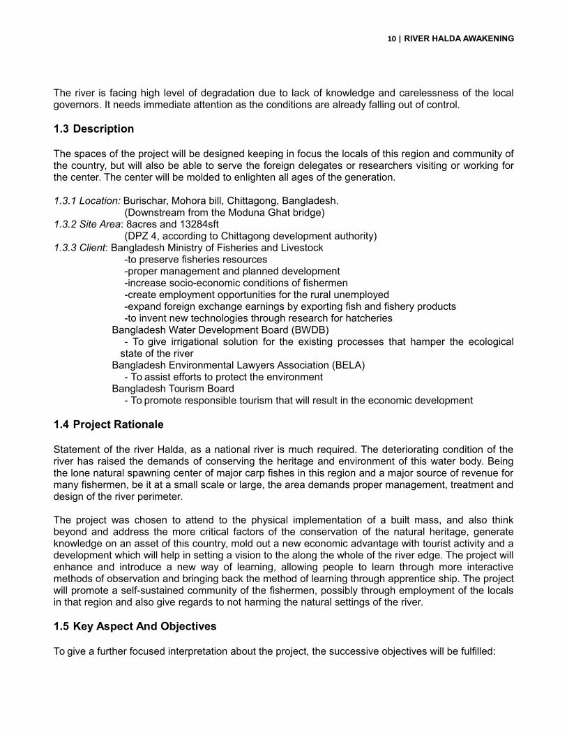
12 | RIVER HALDA AWAKENING
Image 01: Site rationale near to the River Karnuphuli, surrounded by an ecological zone, hatcheries, fishermen habitats, aroad proposal from the commercial hub, and brick fields to the opposite.
Source: Farasha Zaman
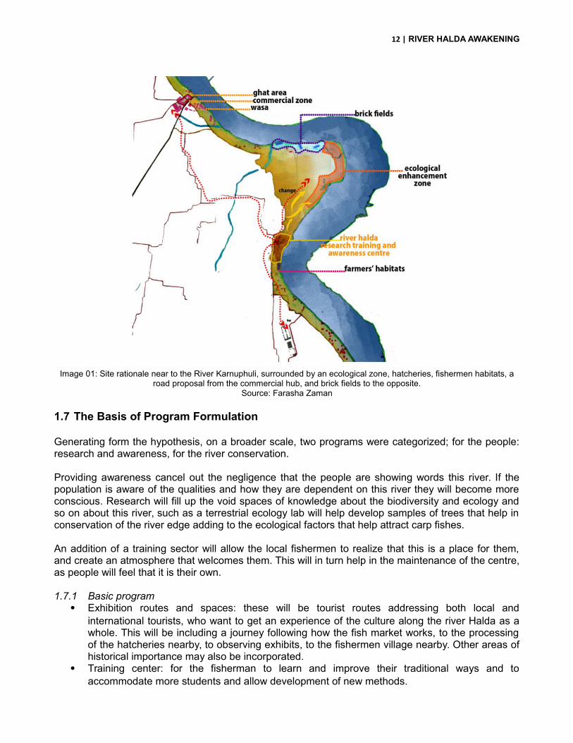
1.7 The Basis of Program Formulation
Generating form the hypothesis, on a broader scale, two programs were categorized; for the people:research and awareness, for the river conservation.
Providing awareness cancel out the negligence that the people are showing words this river. If thepopulation is aware of the qualities and how they are dependent on this river they will become moreconscious. Research will fill up the void spaces of knowledge about the biodiversity and ecology andso on about this river, such as a terrestrial ecology lab will help develop samples of trees that help inconservation of the river edge adding to the ecological factors that help attract carp fishes.
An addition of a training sector will allow the local fishermen to realize that this is a place for them,and create an atmosphere that welcomes them. This will in turn help in the maintenance of the centre,as people will feel that it is their own.
1.7.1 Basic program Exhibition routes and spaces: these will be tourist routes addressing both local and
international tourists, who want to get an experience of the culture along the river Halda as awhole. This will be including a journey following how the fish market works, to the processingof the hatcheries nearby, to observing exhibits, to the fishermen village nearby. Other areas ofhistorical importance may also be incorporated.
Training center: for the fisherman to learn and improve their traditional ways and toaccommodate more students and allow development of new methods.

13 | RIVER HALDA AWAKENING
Water vessel dock and other docks for recreational purpose or purely for observationallearning.
Recreational facilities: boating with Shampan, swimming and diving facilities. Civic ground or a space for recognition realization and reflection: a ground or space to
accommodate activities of festivity or of publicity events. Retail ground: development of a bazaar area or business zone, souvenir shops. Archive and library: for the documentation of the researches in a proper manner and also for
the documentation of the species of fishes, other than carps, found nearby. Research labs: mainly research on maintaining the ecological environment will be done. Hatcheries and observatories and Bird sanctuaries, incorporating the project with the eco park
nearby. Interim accommodation for researchers. Solid waste management plant.
Image 02: Project rationale and program developmentSource: Farasha Zaman

14 | RIVER HALDA AWAKENING
CHAPTER TWO: Site Appraisal
15 | RIVER HALDA AWAKENING
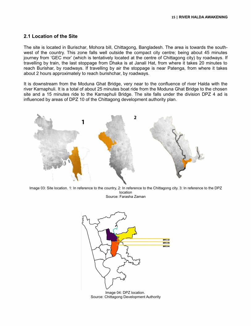
2.1 Location of the Site
The site is located in Burischar, Mohora bill, Chittagong, Bangladesh. The area is towards the south-west of the country. This zone falls well outside the compact city centre; being about 45 minutesjourney from ‘GEC mor’ (which is tentatively located at the centre of Chittagong city) by roadways. Iftravelling by train, the last stoppage from Dhaka is at Janali Hat, from where it takes 20 minutes toreach Burishar, by roadways. If travelling by air the stoppage is near Patenga, from where it takesabout 2 hours approximately to reach burishchar, by roadways.
It is downstream from the Moduna Ghat Bridge, very near to the confluence of river Halda with theriver Karnaphuli. It is a total of about 25 minutes boat ride from the Moduna Ghat Bridge to the chosensite and a 15 minutes ride to the Karnaphuli Bridge. The site falls under the division DPZ 4 ad isinfluenced by areas of DPZ 10 of the Chittagong development authority plan.
Image 03: Site location. 1: In reference to the country, 2: In reference to the Chittagong city. 3: In reference to the DPZlocation
Source: Farasha Zaman
Image 04: DPZ location. Source: Chittagong Development Authority

16 | RIVER HALDA AWAKENING
The site falls near to the Chittagong - Kaptai road, which crosses over the Moduna Ghat Bridge and isfew kilometers of diversion from the Chittagong – Rangamati road, which crosses over the SattarGhat Bridge. This factor could be used in case of the evolution of a new tourism spot, acting as aplace of rest for the day or two for visitors to Rangamati and Kaptai, popular tourist spots of thesouthern belt of Bangladesh.
Image 05: Route map from Dhaka to site and surroundingsSource: Farasha Zaman
2.2 Surrounding Area Study: Relation at a broader scale
Out of the potential spots, this was chosen as it is very near to the confluence of the river Karnuphuliand river Halda, so least amount of damage will be done to the main biological activity zone. Beingnear to the river Karnuphuli also helps, as visitors coming to this area get to experience both the riverslikewise. The settlement characteristics allow further tourist activities and residential zones help inpromoting learning. This part of the river, though being near to the end retains the calmness of theriver Halda, becoming a potential zone to propose leisure and recreational facilities. The variednatural magnificence of a river life can be experienced most from this point acting as a pull factor topeople to visit the project, which will help in accomplishing the target of attaining awareness.

17 | RIVER HALDA AWAKENING
Image 06: Site location at river edgeSource: Farasha Zaman
Image 07: site location is near to the river edge to achieve monitoring, accessibility and celebrate the riverSource: Farasha Zaman
The site is 8acres and 13284sft. (DPZ 4, according to Chittagong development authority) located in asecluded bend of the river Halda. It has the river running along its south western side and hasvegetation towards its eastern side. The main idea behind choosing this location is that the placementof the centre here allows spectacular experience of the aquatic wildlife. Being near to the confluencethis part of the river is visited by the dolphins of the Indian Ocean, Shushuk, and also lobster are seenhere in shoals. Migratory birds visit the char area near to the site. Being away from the main hub ofthe urbanization, this place will add to supporting the tranquility of a research centre, and being rightbeside the river will help collecting fresh samples.
ACCESIBILITY MONITORING CELEBRATION

18 | RIVER HALDA AWAKENING
Image 08: Site surrounding features
Source: Farasha Zaman
The area having agricultural fields nearby will allow in seasonal cultivation of the spawns when mudhouses are needed. Having the training block near to the river will help in maintaining observation ofthe fisherman and illegal methods. The place being near to the confluence is well outside the “off-limit”zone of the river Halda, so accommodating recreational facilities such as swimming boating will nothamper the ecosystem, and if hand- driven boats are introduced and maintained from this pointonwards it will reduce the damage done to the spawning environment by motor boats. The project willact as a civic ground or a space for recognition realization and reflection: a ground or space toaccommodate activities of festivity or of publicity events. The placement of a Solid waste managementplant here will help filter the mixing of the toxic water into the breeding grounds, which will influenceother more majorly effected zones of the river to be addressed.

19 | RIVER HALDA AWAKENING
Image 09: River view of the siteSource: Farasha Zaman
Image 10: View from siteSource: Farasha Zaman
2.3 Site Potentials and Threats
Our country is called the ‘daughter of the rivers’. Our economy has flourished and our civilization hasdeveloped centered around the rivers. The driving force of our economy is the rivers. But lack ofknowledge and eagerness of people has led to the development of major threats to the waters ofmany rivers along with that of River Halda.
Notable threats to this region are caused mainly by the spontaneous growth of brick fields and thepartakers of the agricultural practice. Their lack of knowledge has allowed concrete slopes to bedeveloped as river edge treatment preventing biodiversity, the straightening of the bends (breedinggrounds) and dredging in artificial tributaries, “khals” which hamper the river flow. The river waterchemical level is changed not only for climatic reasons but also the drainage of untreated waterdirectly into the rivers.
2.3.1 Water bodies
Image 11: water bodies in and around siteSource: Farasha Zaman
The main reason of water pollution in this area is thebrick fields. The private owned lands are using thesezones for revenue generation by building brick fields.These should be stopped immediately if we want tosave the river. There land should not however be takenforcefully but relocation can be a good option taken upby the government
20 | RIVER HALDA AWAKENING
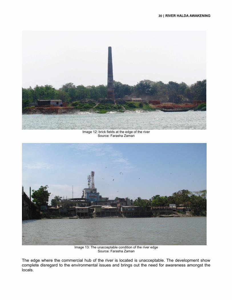
Image 12: brick fields at the edge of the riverSource: Farasha Zaman
Image 13: The unacceptable condition of the river edge
Source: Farasha Zaman
The edge where the commercial hub of the river is located is unacceptable. The development showcomplete disregard to the environmental issues and brings out the need for awareness amongst thelocals.

21 | RIVER HALDA AWAKENING
2.3.2 Vegetation
Image 14: vegetation in and out of siteSource: Farasha Zaman
Image 15: The edge area of the site Image 16: Many species of the birds seen hereSource: Farasha Zaman Source: Farasha Zaman
Image 17: Site is surrounded by beautiful aquatic life Image 18: herons are a common bird hereSource: Farasha Zaman Source: Farasha Zaman
The whole length of the river continues to surprise thetraveler with beautiful wildlife. Starting the journeyupstream will allow experience of seeing shoals ofjumping lobsters and other fishes in the clear water andmany birds on land. Downstream towards the Karnuphuliwill allow the sight of the shushuk.
Other interesting features are hidden amongst the lushgreen lining the river at point where it has not beendamaged by human encroachment to build brick fields orany other unacceptable purpose.
22 | RIVER HALDA AWAKENING
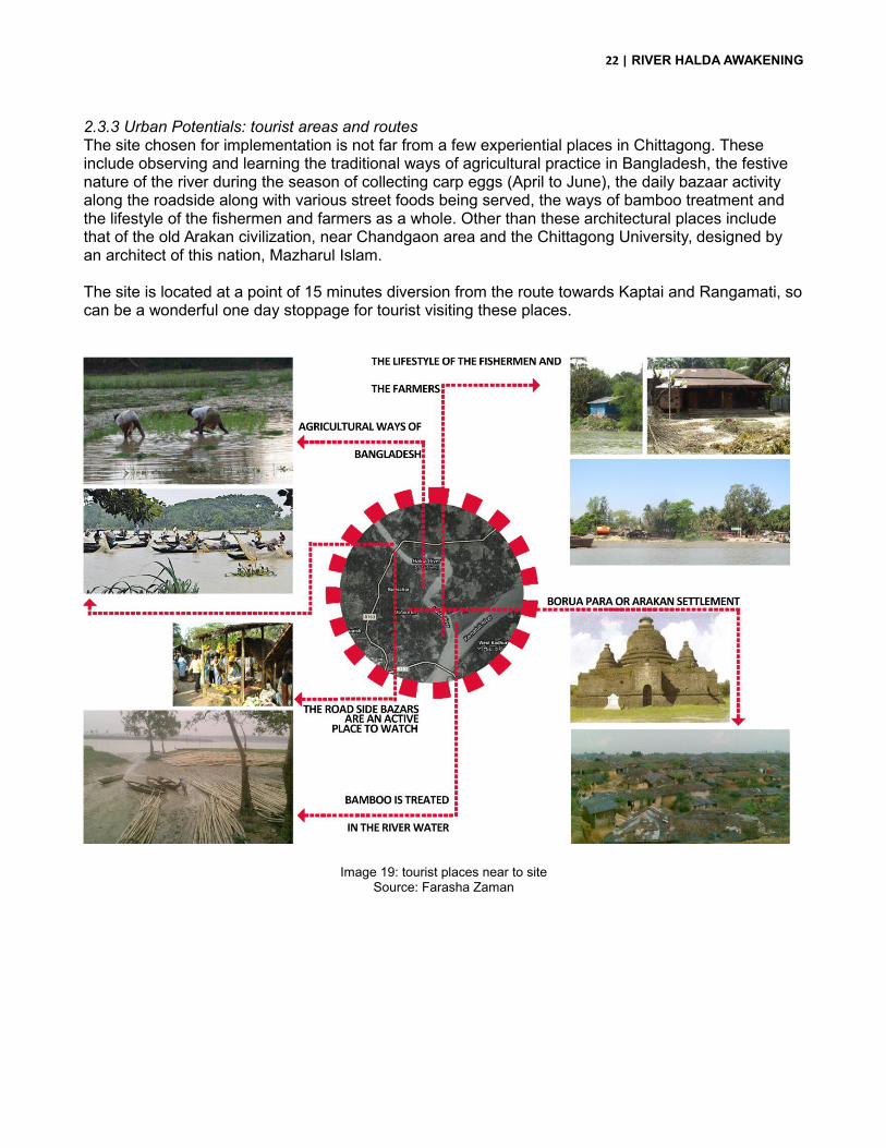
2.3.3 Urban Potentials: tourist areas and routesThe site chosen for implementation is not far from a few experiential places in Chittagong. These include observing and learning the traditional ways of agricultural practice in Bangladesh, the festive nature of the river during the season of collecting carp eggs (April to June), the daily bazaar activity along the roadside along with various street foods being served, the ways of bamboo treatment and the lifestyle of the fishermen and farmers as a whole. Other than these architectural places include that of the old Arakan civilization, near Chandgaon area and the Chittagong University, designed by an architect of this nation, Mazharul Islam.
The site is located at a point of 15 minutes diversion from the route towards Kaptai and Rangamati, socan be a wonderful one day stoppage for tourist visiting these places.
Image 19: tourist places near to siteSource: Farasha Zaman

23 | RIVER HALDA AWAKENING
2.3.4 Built forms
Image 20: built forms related to siteSource: Farasha Zaman
The local houses of this place are mainly of fishermen or farmers, some having the rural characterwhich is observed to be lost in other places of Bangladesh. This is notable factor that could beincorporated in the tourism to be proposed in the later phase.
Image 21: fisherman’s habitats at the edge of the riverSource: Farasha Zaman
The character of the land studied shows that thesettlements are mainly more towards the southern endof the site, which is near to the confluence with the riverKarnuphuli. This pattern has evolved due to the reasonof employment being available in this area. The rest ofthe land is left vacant for paddy fields and otheragricultural purposes.
The western side of the river is seen to have morealarming situation in case of urbanization lined withbrickfields and spontaneous growth of habitats to housetheir workers. The brick fields are exactly at the edge ofthe river, which means dumping of their waste anddebris into the river by default during the hide tide, whichdo not dissolve in the water and cause severesedimentation, along with changing the chemicalbalance of the river water.

24 | RIVER HALDA AWAKENING
Image 22: the fishermen’s and farmer’s habitats are a beautiful experience altogetherSource: Farasha Zaman
2.3.5 Landuse Pattern
Image 23: Land use patternSource: Farasha Zaman
Image 24: agricultural and hatcheries Source: Farasha Zaman
The area is widely cultivated in rice. Some smallareas are cultivated in other crops such as bamboo.The main source of income here is seasonal though,depending largely on fish cultivation. The cultivationnot only involves that of carp fishes but also lobstersand other variety of fishes.
The recent development of the land use includesbrick field, with sand dredged from Karnuphuli riverand water being readily available from the river Hladaitself. This is an alarming scenario harming the riverwater faster than any other cause.
25 | RIVER HALDA AWAKENING
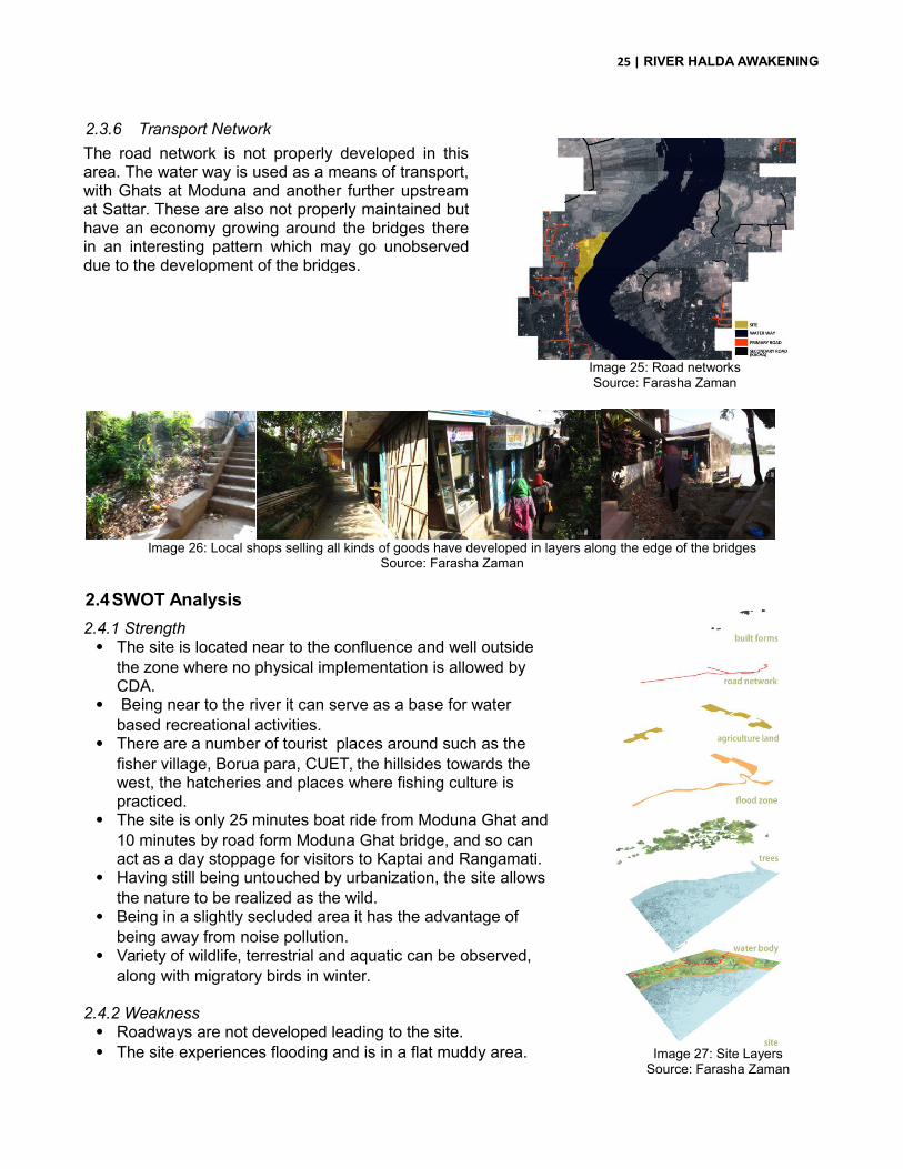
2.3.6 Transport Network
Image 25: Road networksSource: Farasha Zaman
Image 26: Local shops selling all kinds of goods have developed in layers along the edge of the bridgesSource: Farasha Zaman
2.4SWOT Analysis
Image 27: Site LayersSource: Farasha Zaman
The road network is not properly developed in thisarea. The water way is used as a means of transport,with Ghats at Moduna and another further upstreamat Sattar. These are also not properly maintained buthave an economy growing around the bridges therein an interesting pattern which may go unobserveddue to the development of the bridges.
2.4.1 Strength The site is located near to the confluence and well outside
the zone where no physical implementation is allowed by CDA.
Being near to the river it can serve as a base for water based recreational activities.
There are a number of tourist places around such as the fisher village, Borua para, CUET, the hillsides towards the west, the hatcheries and places where fishing culture is practiced.
The site is only 25 minutes boat ride from Moduna Ghat and 10 minutes by road form Moduna Ghat bridge, and so can act as a day stoppage for visitors to Kaptai and Rangamati.
Having still being untouched by urbanization, the site allows the nature to be realized as the wild.
Being in a slightly secluded area it has the advantage of being away from noise pollution.
Variety of wildlife, terrestrial and aquatic can be observed, along with migratory birds in winter.
2.4.2 Weakness Roadways are not developed leading to the site. The site experiences flooding and is in a flat muddy area.

26 | RIVER HALDA AWAKENING
2.4.3 Opportunity
The site experiences flooding and is in a flat muddy area so architecture can be explored. The project may help preserve the untouched experience of nature that is present in the site. Increase the economic growth in the sense of providing more employment. Traditions can be preserved and enhanced.
2.4.4 Threats Being very near to the river may experience landslide. The river is in danger of losing its ecological balance due to spontaneous unplanned growth,
brick fields, and improper drainage. Proper awareness must be provided to a natural heritage of our country which will otherwise
be lost. Serves the economy of the country which will be affected.
Image 28: slope study and potential threat zone analysisSource: Farasha Zaman

27 | RIVER HALDA AWAKENING
2.5 Climate
Chittagong has a tropical monsoon climate and is generally a cyclone prone zone.The temperature in Chittagong ranges from 13.8 to 32.05. (Celsius) and average rainfall varies from 18.0 to 2688.0 (mm/month). The prevailing wind directions are from South to South East during the months of April through September. After taking easterly direction for a while the wind turns to the northerly and north easterly directions, the later prevails from November to January. During the months of February and March winds turn via westerly direction back to the Southerly to south Easterly. 20 Knots/ Beaufort wind scale 5 prevails for 6 percent of the time while those in access of 30Knots/Beaufort wind scale 7 persists for about 0.1 percent of time during cyclones.
Image 29: Climatic graphs and dataSource: Wikipedia

28 | RIVER HALDA AWAKENING
CHAPTER THREE: Literature Review
29 | RIVER HALDA AWAKENING
3.1Learning
"Learning is the act of acquiring new, or modifying and reinforcing, existing knowledge, behaviors,skills, values, or preferences and may involve synthesizing different types of information. The ability tolearn is possessed by humans, animals and some machines. Learning is not compulsory; it iscontextual. It does not happen all at once, but builds upon and is shaped by what we already know. Tothat end, learning may be viewed as a process, rather than a collection of factual and proceduralknowledge. Learning produces changes in the organism and the changes produced are relativelypermanent." (Wikipedia, 2014)
The main idea of learning is to develop and experience, not just gain knowledge. The traditionalmeans of learning were that in which a guru was involved and learning was obtained in the naturefrom the nature. People were taught first to respect the nature and then experiment with it. The newcity ways however have become more advanced, with children having to learn everything that hasalready been researched on so that they can dig deeper into the knowledge. This is not a negativeway, but while doing this the basic knowledge of the small things are being lost. A child growing up inthe city knows how to catch a fish with the fishing rod only in the “fishing game”, not in an actual riveror pond. He is aware of the nature facing extinction but never has seen it die in reality.
Today the ways of learning are mostly based on books and written textual formats rather thanobservation or experience. The basic learning is limited to schools or formalized to examinations.Children only learn what is needed for them to become graduates or obtain higher education degrees.Very few know the roots, heritage and base of their country and their source. One reason behind this is the lacking in the ways knowledge is placed to the children. The childrenget easily attracted to easily accessible knowledge through the internet and rarely visit libraries, orwork beyond what is need for them to graduate in school, thus remaining unaware of many issues,and consequently being unable to serve the needs of a country for young spirits in creatingawareness or taking socially helpful steps.The more people learn about some issue, the more aware people will be. Targeting children is thebest approach as these spontaneous youth spread anything that they learn faster than the aged,mainly as their level of interaction is more varied and larger in number.Innovative methods such as workshops, school study trips, and exhibitions may enlarge theawareness level locally.
Studies show that people learn more through interactions and observations than through attendinglectures. It is also observed that visual means of gaining knowledge is retained more than thatknowledge that is taught.
3.2The Learning Center
A learning Centre is a facility where students engage in independent and self-directed learningactivities. A learning Centre may be one which offers a pupil the chance to focus on specific areas ofstudy or it may be one in which a pupil can explore options. The Learning Centre proposed shouldfocus on delivering or exposing an aspect of study. There is a fine difference between a learningcenter and a school. This is in the variety of options that are provided for study, which is that theLearning Centre focuses on various topics of a sector of study while a school provides more option incase of sectors of study and targets a larger group of the population. The proposal of this LearningCentre is to create awareness and give recognition to the river Halda, which is at the verge of losingits character of being a natural spawning zone for carp fishes.
30 | RIVER HALDA AWAKENING
“Awareness is the silent and choice less observation of what is; in this awareness the problem unrollsitself, and thus it is fully and completely understood. A problem is never solved on its own level; beingcomplex, it must be understood in its total process.” (J.krishnamurti, 1960) Awareness is not self-induced, nor is it the outcome of practice; it understands the whole content of the problem, the hiddenas well as the superficial. The surface of the matter must be understood for the hidden meaning toshow itself. This whole process is not verbal, nor is it a matter of mere experience. Verbalizationindicates dullness of mind; and experience, being cumulative, makes for repetitiousness. Awarenessis passive alertness which reveals its total process. Thus just to perceive or to be conscious of eventsobjects or experiences is not awareness. The whole of an idea must be known and understood. Tounderstand a problem, one has to be able to experience the beauty of what is, and then only will heknow what its absence may be.
If a space can create an experience or memory that one would cherish or want to relive, then only canhe know what its absence will be like to endure. Only knowing about something vaguely or througharticles may not be an effective method to approach everyone.
There are many ways of providing awareness such as Campaigns for publicity Targeted efforts _ targeting certain groups of people to be addressed such as economy class
people to sell hybrid cars which are energy efficient thus maintenance cost is less. Using the media _ Television, radio, talk shows, etc Reach out to NGOs _ for educating people if the person directing is comfortable with foreign
language to that of the locals Classroom educations _ arrange workshops with children as they are potentially more creative
and spontaneous in nature. Arrange seminar/presentations Create well used spaces that the community can learn from automatically Create spaces of experience or a place that initiates a memory.
Out of these, a Learning Center was chosen to reach out to the young generation of Bangladesh.Some steps of campaign and publicity through media has already been taken and failed, so a furtherstrong step, of giving a space to the people who want to work further on the conservation of this riverwas thought necessary. The basis of generating awareness here is that otherwise the place will belost. The river is a site of pride for Bangladesh, and has been declared as a natural heritage of thecountry. Proper awareness of this place and the ecological issues related to it will bring aboutchanges and required development that is much needed for the river. Due to lack of appropriateknowledge and awareness the development along this river is going as a waste as the propertreatment is not being provided, so the area needs to be addressed immediately before furtherdeterioration can take place.
The basic concept of research is to gather knowledge in order to understand an issue, a concept, or atopic to the highest depth possible and then to determine or judge how valid the knowledge gained is.It is required to understand and analyze the solution of a situation and assess what the impact of thesolution will be. "In the broadest sense of the word, the definition of research includes any gathering ofdata, information and facts for the advancement of knowledge." (Shuttleworth, n.d.) The limitations ofa research center, not always having institutional facilities, will be overcome since the site demandstraining facilities provided to the local people to improve their traditional methods of capturing andcultivating fish. However in this case the methodology will first be learnt from the people and then theimproved version will be taught to them. The whole process will not be changed. Thus there will be

31 | RIVER HALDA AWAKENING
additional functions to that of a conventional research center. People who are already learned on thissector will have a space to practice further, but also have an opportunity of training the locals.
Research of this area is needed to support the development proposal of this place, to support andimprove methods of implementations that can happen alongside rivers. The research may not belimited to that of River Halda only, but spread widely for all rivers of this country and maybe continent.The project would be most feasible here since the river already has an ecologically rich environmentto be studied which will vary from other river but could be similar as well. The proposed site also hasscope of tourism which will act a pull factor for people and also as a generous revenue generator.
3.3Recreation as a revenue generator
These are basically factors which enhance the economy of a country in feasible methods. Theprocess of marketing and selling products or services to produce income. There are many ways ofrevenue generation some elevating urbanization of a country others enhancing the heritage sites,such as conservation, tourism and so on.
“Tourism is travel for recreational, leisure, or business purposes, usually of a limited duration. Tourismis commonly associated with trans-national travel, but may also refer to travel to another locationwithin the same country.” (World tourist organization, 2014.) Tourism has become a popular globalleisure activity. Tourism can be domestic or international, and international tourism has both incomingand outgoing implications on a country's balance of payments. Today, tourism is major source ofincome for many countries, and affects the economy of both the source and host countries, in somecases it is of vital importance.
Tourists are people "traveling to and staying in places outside their usual environment for not morethan one consecutive year for leisure, business and other purposes" (World tourist organization,2014.) Recreation can be a part of tourism or it can just serve the locals of a country or even just thecity or part of the city. Recreation is anything that freshen the mind, allows relaxation and helps buildhealthy environment and people. Recreation is an essential and growing activity in the world. It is anactivity that a person does for enjoyment, usually to refresh the body and mind. Recreation ofteninvolves some degree of exercise as well as visiting areas that contain bodies of water such as parks,wildlife refuges, wilderness areas, public fishing areas, and water parks. Recreation is popular forvarious reasons. Besides being a way to enjoy free time, many people use recreation as a way tosocialize. Recreation can be categorized into two general types: active and passive. Active recreation,entailing direct participation, involves activities such as jet skiing in bays and kayaking down rivers.Passive recreation, involving observation, includes such activities as walking along rivers, sunning atbeaches, and watching swim competitions.
Numerous surveys show that water-based activities are among the most popular recreation activities.Certain lands around public reservoirs are open for recreational uses such as hiking, hunting,snowmobiling, and snow skiing. In addition, their waters are available for activities such as boating,water skiing, swimming, fishing, and canoeing. Sometimes restricted zones are set up so that certainactivities, such as fishing, do not interfere with other activities, such as swimming. Even a medium-sized hydropower project can have recreational and tourism value to residents and visitors, providejobs for thousands, and have a monetary benefit in the millions of dollars. “Activities that areexpanding in popularity are cross-country skiing, downhill skiing, backpacking, day-hiking, runningand jogging, pool swimming, and visiting prehistoric sites. By 2040 the most popular recreationalactivities are anticipated to be bicycle riding, swimming, pleasure driving, walking, day hiking,sightseeing, wildlife observation, picnicking, family gatherings, photography, visiting historic sites, anddeveloped camping. With increased interest in the environment and nature, it is important to create

32 | RIVER HALDA AWAKENING
effective strategies for developing recreation to meet growing demand, particularly in areas close towater. Recent surveys have shown that extended long-distance vacations are being replaced by morefrequent, close to-home recreation trips. As a result, the importance of recreation opportunities closeto urban areas is being acknowledged.” (Atkins,n.d.)
Recreational areas near urban areas represent one of the most important opportunities to meet theincreasing demand for recreation. One major role for the government and other federal, state, andlocal agencies is to manage recreational areas. Increasing public access to both public and privateproperties will be necessary in the future as more people spend more time in recreational pursuits.Moreover, achieving sustainable recreation in coastal areas will require examination of issues such ascontinued sprawl development, growing constraints upon public access, nonpoint pollution generatedby recreational activities, and other forms of environmental degradation caused by intensifyingdevelopment and multiplying recreational activities.
Tourism has been known to uplift the economy of countries where it is practiced, if the resource is notexploited. Introducing tourism creates new job opportunities such as for maintenance, staff support forrunning the rest houses, tourist guides and so on. Other than this, tourism to a certain extent ensuresawareness and publicity of a place by default.Tourism brings along people which sometimes is a negative issues, as not all tourists keep theenvironment to be visited clean, but this is a small issues which can be controlled with governmentsupport.
3.4Threats to Recreational Waters
The sheer volume of boats, jet-skis, and swimmers increases the potential for pollution. Increasedactivity of any kind can affect sensitive ecological areas including habitat that wildlife relies on fornesting or spawning. The type of recreation can also threaten water quality. While swimming andfishing can be relatively safe and harmless, boats and jet-skis are powered by gas and oil that canleak into the water. They also kick up waves, which speed up the natural erosion of banks,contributing sediment to the waterway. Although ATVs (all-terrain vehicles) are used on land, they also present a threat to water quality. Thepowerful vehicles tear up the land, exposing dirt to erosive forces like wind and water. The erosion notonly hurts the landscape, but the dirt and sediment can move into waterways, impairing water quality.This section explores the types of pollutants found in water. Almost anything can be considered apollutant if it’s in water and it’s unwanted. Here’s a list of some of the most common water pollutantsand where they can come from.

33 | RIVER HALDA AWAKENING
Pollutant Where it can come from Why it’s a problem
sediment:
Tiny soil and rock particles. Chemicals can attach themselves to these particles as well.
wind and water erosion on ag land, storm water runoff, erosion from construction sites, erosion inurban areas
Changes water habitat which affects whatcan live there. E.g. prevents sunlight frominfiltrating water and reaching plants and animals. domino effect on food chain
Nutrients:
nitrogen and phosphorous
runoff from farm field fertilizers
runoff from residential lawns
runoff from recreational areas (golf courses)
runoff from septic systems
runoff from manure
Causes explosive plant growth which uses up available oxygen in water (hypoxia) leaving areas unable to supportaquatic life.
When consumed in high levels by babies,nitrates reduce the blood’s ability to carry oxygen.
Toxic chemicals:
organic or inorganic chemicalsused in industry, agriculture and in the home e.g. oil, cadmium, lead, mercury, copper, zinc
Chemicals can be spilled, dumped or leaked directly into waterways.
Chemicals that get spilled, dumped, leaked, or are improperly stored can be moved into waterways by runoff.
If ingested, these chemicals can build up and cause serious health problems.
chemicals can negatively affect a water habitat and the wildlife living there
Pathogens:
disease-causing agents, like fecal coliform bacteria, found in animal or human waste
improperly managed sewage, improperly managed livestock, pets
can cause serious diseases like dysentery, hepatitis, food poisoning, parasitic infections

34 | RIVER HALDA AWAKENING
Image 30: water pollutants and its effectsSource: Iowa Public Television, 2004
Tourism is advantageous in the creation of jobs, growth of the economy and improvement of the livingstandards of the locals. The tourism industry also leads to the development of the local crafts industryas well as exploitation of various resources. Tourism also generates different types of income for acommunity: business income, wage earnings and so on. There are many opportunities foremployment for young people and for people interested in part time or casual work. While some of theemployment is skilled, there are also opportunities for people less skilled and who lack formalqualifications. A thriving tourism industry supports growth in other sectors, such as transport,construction, agriculture and retailing. In this case the basic activity of the fisher men may becomerevenue generators, more boatmen will be employed thus ensuring illegal means of harvesting thefish eggs or fish fry be avoided. The souvenir shops can employ more craftsmen.
“Tourism can act as a shop window for the lifestyle of the area. It is increasingly common for peoplewho visit and are impressed with the area to return as residents, thereby increasing demand forhousing and other services.” (Holderfield, 1999) The social benefits of tourism are that it can stimulatenew and expanded community facilities and infrastructure initiatives, such as the improvement ofretail, restaurant and entertainment options, transport services, education and sporting facilities.These increase the quality of life for the community, which may not otherwise not be provided, basedon the residential population alone. Tourism activity often prompts the conservation of culturalheritage, either as a result of increased awareness and pride, or because it can be justified oneconomic grounds as a tourist attraction. Tourism can encourage communities to widen their outlookand to embrace new ideas. It provides opportunities for residents to interact with other people,lifestyles and cultures. Attracting visitors to an area can heighten local awareness and interest,resulting in a greater sense of pride and ownership. The community takes stock of its assets anddistinctive characteristics. This increase in pride can lead to community celebration or the revival ofcultural activities. Knowing that others have travelled across the state, country or world to visit canconsiderably boost a community’s collective ego. “On the credit side, tourism has been partlyresponsible for increased interest in, and concern for, the natural and built environment and itscondition.”(Holderfield, 1999) Effective visitor information services, interpretative signing, guided toursetc. can raise the profile of natural assets and issues surrounding them. In many cases tourism hasprovided an economic argument for conservation, preservation and restoration of natural and builtresources.
3.5Heritage_ culture_ tradition
Heritage is not always the monuments, but any resource of the country. Heritage may be a mountainor an old chapel. Tangible heritage includes buildings and historic places, monuments, artifacts,etc., which are considered worthy of preservation for the future. Objects significant to thearchaeology, architecture, science or technology of a specific culture can be heritage. Objects areimportant to the study of human history because they provide a concrete basis for ideas, and canvalidate them. In case of intangible heritage the values are the same but only the fact remains that theresources are not built, but they can be felt and realized.
Culture refers to the cumulative deposit of knowledge, experience, beliefs, values, attitudes,meanings, hierarchies, religion, notions of time, roles, spatial relations, concepts of the universe, andmaterial objects and possessions acquired by a group of people in the course of generations throughindividual and group striving.
35 | RIVER HALDA AWAKENING
"Cultural heritage is the legacy of physical artifacts and intangible attributes of a group or society thatare inherited from past generations, maintained in the present and bestowed for the benefit of futuregenerations. Cultural heritage includes tangible culture (such as buildings, monuments, landscapes,books, works of art, and artifacts), intangible culture (such as folklore, traditions, language, andknowledge), and natural heritage (including culturally significant landscapes, and biodiversity)."(Wikipedia, 2014)
Traditions relate to people largely. It is practiced by the people and bought into course by the peoplethemselves. It is not just the architecture and the objects from the past that define who we are. It is thegreat variety of folksy customs that are just as alive today, that form a shape a country and itscustoms. Modern day traditions and culture of the Bengal does not relate to the actual values always.There is very little of the population that takes into accord these issues and values and tries tomodernize them. Modernization does not mean that the basis or source of a culture be forgotten.
The generation today has knowledge on computers, gadgets and many more things that are worthappreciating. But in the process of understanding the future, people are forgetting their origin.Bangladesh being a river based country has a wonderful exposure to a variety of fishes beingavailable. But hardly any Bengali child knows the name of these fishes, while knowing much aboutsalmons and tunas. Knowing is not a negative, but not knowing oneself first and knowing about othersis.
In the recent times the traditions and culture are given value to and observed. Many countries havegone through a process of using these resources to develop their economy while conserving it. It is anobserved practice being positive or negative but in the process the resource is preserved.
Our country being as resourceful as the neighbors, India and Myanmar and Sri Lanka can easilyconserve its resources. Influences of the west have become to dominating over a non-colonizednation, where people widely adapt the practices of the west forgetting the identity unconsciously.Presenting the values of this nation has become essential in order to retain the distinctiveness of thiscountry as an individual. Values can be presented in many ways such as conferences, throughbroadcasting and also through practicing the traditions so as they are presented by default.Presenting traditions only during times of festivity is encouraged, but conventional. Following itthrough the year, making it a part of the daily routine is more appreciated.
3.6Exhibition Spaces
The spaces of awareness should more likely be one of an abstract space rather than one that isdefined and guided. The main objective of these exhibition spaces is to achieve awareness, relating topeople in the easiest of manner rather than be museums where people can only observe. The majordifference between a museum and this centre would be that the displays here need to be interactiveand welcoming, allowing touching and holding and experiencing, rather than just observing as such ina full scale museum.
These spaces may be temporary, open to air, open to sky or enclosed as per the demand of thespace rather than the exhibit. Being a river oriented exhibit space set in nature, the properinterpretation would be to welcome and integrate nature as much as possible into these spaces wherethe observer or visitor will not only enjoy the exhibit but also the setting in which it is placed.
3.7Materials

36 | RIVER HALDA AWAKENING
The architecture, being set in a place where the question of conservation is very strong, should alsohave an influence of the surroundings.
Bamboo is a natural surface covering material that has many of the properties of hardwood flooring,even though it is actually produced from a type of grass. It shares many of the positive benefits of ahardwood floor, as well as the drawbacks and vulnerabilities. Bamboo is made from naturalvegetation. The bamboo plant is a highly renewable resource that is able to grow to maturity in as littleas three to five years. “This is much faster than hardwood trees which can take upwards of twentyyears or more to reach maturity.” (Joseph Lewitin, 2011) Bamboo is relatively easy to maintain. Youjust have to sweep or vacuum it regularly to remove small particle debris. You can also occasionaldamp mop it, or clean it with a non wax, non-alkaline, hardwood or bamboo floor cleanser. The use ofnatural materials is an important trend in the construction industry right now. As people are becomingmore ecologically conscious they are demanding products that reflect these values. There are certaintypes of bamboo that can be extremely strong, hard, and durable. Natural, un-carbonized bamboothat was properly harvested and manufactured can be as durable as red oak. Strand woven bamboocan be manufactured even harder than that.Bamboo is a natural material that is made from a highly renewable resource. However there are anumber of environmental concerns regarding bamboo. The adhesive used in its construction cancontribute to the toxicity of an interior space. There are also some concerns that forests are being cutdown and replaced with bamboo fields for commercial purposes. While bamboo definitely has somegreen qualities it is still environmentally ambiguous in a lot of ways. However, unlike most timber,bamboo is a self-regenerating natural resource; new shoots that appear annually ensure productionafter individual culms are harvested.
3.8 Architectural Considerations of lab designOver the past 30 years, architects, engineers, facility managers, and researchers have refined the design of typical wet and dry labs to a very high level.
3.8.1 Lab Planning ModuleThe laboratory module is the key unit in any lab facility. When designed correctly, a lab module will fully coordinate all the architectural and engineering systems. A well-designed modular plan will provide the following benefits:
Flexibility—the lab module, as Jonas Salk explained, should "encourage change" within the building. Research is changing all the time and buildings must allow for reasonable change.
Expansion—the use of lab planning modules allows the building to adapt easily to needed expansions or contractions without sacrificing facility functionality. The depth is based on the size necessary for the lab and the cost-effectiveness of the structural system.
3.8.2 Two-Directional Lab ModuleAnother level of flexibility can be achieved by designing a lab module that works in both directions. This allows the casework to be organized in either direction. This concept is more flexible than the basic lab module concept but may require more space. The use of a two-directional grid is beneficial to accommodate different lengths of run for casework. The casework may have to be moved to create a different type or size of workstation.
3.8.3 Three-Dimensional Lab ModuleThe three-dimensional lab module planning concept combines the basic lab module or a two-directional lab module with any lab corridor arrangement for each floor of a building. This means that a three-dimensional lab module can have a single-corridor arrangement on one floor, a two-corridor layout on another, and so on. To create a three-dimensional lab module:

37 | RIVER HALDA AWAKENING
Single corridor lab design with labs and office adjacent to each other
Single corridor lab design with offices clustered together at the end and in the middle
Single corridor lab design with office clusters accessing main labs directly
3.8.4 Open labs vs. closed labsAn increasing number of research institutions are creating "open" labs to support team-based work. The open lab concept is significantly different from that of the "closed" lab of the past, which was based on accommodating the individual principle investigator. In open labs, researchers share not only the space itself but also equipment, bench space, and support staff. The open lab format facilitates communication between scientists and makes the lab more easily adaptable for future needs. A wide variety of labs—from wet biology and chemistry labs, to engineering labs, to dry computer science facilities—are now being designed as open labs.
3.8.5 FlexibilityIn today's lab, the ability to expand, reconfigure, and permit multiple uses has become a key concern. “The following should be considered to achieve this:
Flexible Lab Interiors Equipment zones—these should be created in the initial design to accommodate equipment,
fixed, or movable casework at a later date. Mobile casework—this can be comprised of mobile tables and mobile base cabinets. It allows
researchers to configure and fit out the lab based on their needs as opposed to adjusting to pre-determined fixed casework.
Flexible partitions—these can be taken down and put back up in another location, allowing lab spaces to be configured in a variety of sizes.
38 | RIVER HALDA AWAKENING
Overhead service carriers—these are hung from the ceiling. They can have utilities like piping, electric, data, light fixtures, and snorkel exhausts. They afford maximum flexibility as services are lifted off the floor, allowing free floor space to be configured as needed.”
(Daniel Watch and Deepa Tolat, 2010)
3.9 Deduction
The learning center will incorporate the features of a research centre, a training center for peopleinterested in ecology, fishing methods, local crafts, study and archiving on aquatic life and someawareness programs such as galleries and interactive zones. The center will have a tourism sectorand some recreational activities acting as revenue generators. Incorporation of exhibition routes andspaces will help support awareness. The project demands community spaces and dealing with the locals as this will ensure that the centrebe self sustained and be for the people and the river itself.

39 | RIVER HALDA AWAKENING
CHAPTER FOUR: Contextual Analysis
4.1 Formulation of the Project
The pride of Bangladesh is its rivers. The main rivers namely the Padma, the Jamuna, the Teesta, theMeghna, the Brahmaputra, and the Surma run through a large area of Bangladesh along with theirthousands of tributaries.“With one of the largest network of rivers, the total number of rivers includingtributaries was 700, until when it has dried up to only 350 in the recent times.” (Wikipedia,2014)“About 12% of Bangladeshi people are directly or indirectly engaged in a lifestyle dependent onfishes. The fisheries sector accounts 4% of GDP and more than 11 percent of annual export earnings.Estimates of livelihood dependence are scattered: 1.4 million full time fishermen and 11 million parttime fishermen. However, case studies and surveys in different regions indicate that some 70 % of allhouseholds in the flood plains catch fish either for income of for food.”(FAO fisheries countryprofile,)There are 260species of fish and 24 species of prawns in Bangladesh, but many fish types arenot known to people of this country.Bengali cuisine is rich and varied with the use of many specializedspices and flavors. Shuţki (dried sea fish) is a popular cuisine in this region. Available sunlight andtemperature throughout the year is an added advantage for fish production. Water fertility is conduciveto fish growth, which is a massively growing sector, in terms of economy. Being a port city from earlytimes, Chittagong attracted people from various regions of the world. These international contacts lefta lasting impact on the language, religion and culture of the city. Rice and fish is the staple food of thepeople. Because of close affinity to the sea, seafood is quite popular. People are highly dependent onthe rivers and have an affinity towards the ports and the river cultures.
But today not only is the culture of this fish based region becoming absent in many places, the sourceitself is also receiving less attention and nearing extinction.

40 | RIVER HALDA AWAKENING
Image 31: Population decrease of fishermenSource: Bangladesh ministry of fisheries and livestock, edited: Farasha Zaman
Just like many other river Halda river is also facing deterioration in terms of environmental issues. This river is a natural spawning zone of Bangladesh, supporting the economy of the country largely. The Halda and its waters have some unique features which cause fishes to come to lay eggs. “These features are of three kinds: physical, chemical and biological. The physical include the ox-bow curves of the river, a good number of hill-streamlets, and the existence of one or more marshes up from every streamlet, the depth of the river, low temperature, and strong current and excessively muddy water. Low conductivity, tolerable levels of water-soluble oxygen, favorable Ph, less hardness, low level of alkalinity etc are among the chemical reasons. The biological reasons are regarding the availability of nutrition: with the first shower of monsoon, the marshes overflow both of their banks andinundate a wide stretch of land, so that a huge variety of organic compounds mix with the water and leave it enriched with more-than-sufficient food for the maturation of the pre-breeding gonads of fishes.”(Kibria, 2012)It is also believed that the water pouring down from a good number of hill-streamlets is rich with many kinds of macro and micro nutrients which help create sufficient food-molecules in the river. The combined effects of these features create a favorable environment in the Halda, which is completely different from other rivers of Bangladesh that stimulates carp fishes to lay eggs during the monsoon.
Carp fishes choose certain places to lay eggs, at special kinds of Bãks (bends) of the river. They are called ox-bow bends. These bends generate favorable motion and currents of the water, and other bio-chemical factors, to create an advantageous environment for fishes to breed and help them fertilize their eggs.(Kibria, 2012)
4.2 Why the Halda is called a heritage of natural fish breeding in Bangladesh
The River Halda deserves recognition as our Natural Vintage of Fish Breeding for its resources, contribution to our economy and other unique features. It is still waiting it’s recognition as one of our national heritages due to the lack of sufficient information and publicity.
The methods of collecting eggs from the Halda, of hatching broods from the eggs and taking care of the broods, are completely indigenous. The local people are using these methods that combine religious faiths and technological knowledge, since ages immemorial. The local egg-collectors are traditionally using this technology for generations.
The Halda is continually contributing to our national economy and playing a very crucial role in it. A strong chain of economic activities revolves around this river round the year. “Taken together, the
Lack of fish in our rivers.
Lack of promotional activities.
Lack of proper training.
Lack of government support.

41 | RIVER HALDA AWAKENING
eggs collected from the Halda, the broods produced from these eggs, and the fish grown from these broods contribute to our national economy about Tk 800 crore.”(Kibria, 2012)Agricultural production, communication and other activities are also a significant contribution of the Halda to our national economy. This contribution can easily be multiplied many times by preserving this river in an eco-friendly manner and managing it in a planned way. It is also believed that the growth-rate of the carp fishes of this river is much higher compared any other sources in our country. This advantage can be exploited properly in cultivating and hatching carp fishes allowing fish cultivators and hatchery owners to make a profit at a much higher rate. The River Halda is the main source of drinking water in Chittagong, the commercial capital and the port city of Bangladesh. “Considering the special quality and availability of the water of this river, the Chittagong WASA has been producing and supplying nearly 20 million gallons of drinking water every day through the Mohra Water Treatment Plant, since 1987.”(Kibria, 2012) The water of this river contains much less heavy metals that are below the standards set by WHO, making Halda an important river as a source of pure drinking water in Chittagong. The Chittagong WASA has started constructing its second project, with the same capacityof the previous one, in 2007 in the Maduna Ghat area of the Halda.
During the season of egg-collection, a festive atmosphere is created on two sides of the river. The local fishermen and egg-collectors wait impatiently throughout the year for the time of year to come. The preparations for catching eggs start from January and February, which include digging ponds andKuas, repairing boats and collecting partners. After having collected the eggs in May, June and July, the hatching, the raising of the broods and selling these young fishes continue up to September and October. The local egg-catchers traditionally live busy days in these seven or eight months. This makes the Halda our natural heritage for fish breeding. The Halda, like Cox's Bazar and the Sundarbans, is another of the natural heritages of our country. But for the lack of information provided and lack of publicity, people have been in the dark concerning this natural resource of our country. The people of Chittagong have been demanding announcement of the Halda as the national heritage of natural fish breeding for long. The icon of the heritage of Chittagong is the Shāmpān – a special kind of boat which reigns the waters of the rivers Halda, Karnaphuli and Sangu. “Numerous songs, Pālās (ballads), dramas and films have been made on the lives and struggles of the boatmen of the Shāmpān (Shāmpānwala).” (Kibria, 2012)The three rivers are the bearer of the folk culture of Chittagong. To the Bengali-speakingpeople around the world, the folk songs of Chittagong are dearly beloved. This is not only a heritage of Chittagong, but also an important part of the ancient culture of Bangladesh. Even the logo of Chittagong University has been designed upon the shape of a Shāmpān. A special genre of songs sung by the Shāmpānwalas of the Halda is called Haldapada songs. Today these traditional songs areabout to be extinct in the face of the aggression of western and Indian culture. The Halda of Chittagong is a great birthplace of our old cultural heritage.
4.3 Announcing the Halda as the national river of Bangladesh
Every sovereign country has some national icons such as national flower, national tree, national fish, national animal etc. that are a symbol of the country's heritage. The river based countries of the world have their own national rivers. For example, our neighboring country India's national river is the Ganges, Pakistan's national river is the Sindhu, and the national river of Egypt is the Nile. In these countries, several factors have been emphasized on for acknowledgement of the national rivers. Theyare: source of the river concerned, its contribution to national economy, communication, water supply, fishery and agricultural production and its role in the field of tourism and heritage. Our country is called the ‘daughter of the rivers’. Our economy has flourished and our civilization has developed centered around the rivers. The driving force of our economy is the rivers. But the fact is, 40 years have gone by after our liberation, but unfortunately, none of our rivers has been announced as the national river of Bangladesh. Taking the contribution and importance of the Halda into account and in

42 | RIVER HALDA AWAKENING
light of the features discussed above, announcement of this river as the National Heritage of natural fish breeding of Bangladesh would assure the maintenance and the security of the brood fishes that come to this river to lay eggs, and at the same time would help it take a further step to be recognized as one of the world's natural heritages.
It is possible to vitalize the national economy by restoring the natural fish breeding areas of the Halda through proper preservation and management in a planned way. “With this thought, in 2007 the Directorate of Fishery of the government of Bangladesh started the activities of a project to preserve and recover the natural fish breeding areas of the Halda. That five year project (2007-12) was targeted mainly to play a role in increasing the natural production of broods of carp fishes in the Haldaand developing the socio-economic conditions of the local people concerned, by helping them to increase their incomes and employment.”(Kibria, 2012)But the do-as-you-wish tendency and shady deals of the people concerned with the design and materialization of the project, the detachment of people who are closely related to the river and the intense personal greed turned that dream into a nightmare. “Four years after the project started it has almost failed to reach its primary target due to faulty design based on unplanned, false and imaginary facts and information.”(Kibria, 2012)
The local people have already started to figure this out. What is needed to restore the natural fish breeding areas of the Halda is the planned, scientific and social management of this river. From the very beginning, the researchers, the conscious civil society of Chittagong, the journalists of the electronic and print media and the local people have been strongly demanding a review of the project.This must be done immediately, otherwise, it will remain impossible to preserve and develop the natural fish breeding areas of this river. The site chosen for implementation is not far from a few experiential places in Chittagong. These include observing and learning the traditional ways of agricultural practice in Bangladesh, the festive nature of the river during the season of collecting carp eggs (April to June), the daily bazaar activity along the roadside along with various street foods being served, the ways of bamboo treatment and the lifestyle of the fishermen and farmers as a whole. Other than these architectural places include that of the old Arakan civilization, near Chandgaon area and the Chittagong University, designed by an architect of this nation, Mazharul Islam.
4.4 Experience within the site
People experience nature as it is. When experiencing nature they are notguided by lines or any physical boundary. Rather they are manipulated bynature itself, and they travel or experience nature by moving through it.
The movement pattern is of a person who is experiencing, observing andis in nature is also random and flowing. It is not one that follows any lineardirection. The contemporary exhibition spaces today are also not limited,restricted and regularly guided, but rather spontaneous, developing fromthe need of the spaces and the experience to be provided. The museumsor exhibition spaces today have become more flexible.
Contextualizing the program of an exhibition space in the site, it is highlydemanded that the spaces flow through nature and celebrate it rather thandefine a new boundary itself. The spaces should be such that it celebratesthe nature, welcoming it as much as possible, rather than control it.

43 | RIVER HALDA AWAKENING
The site is such that it is dotted in trees. It is high in biodiversity.Since the project is one that concerns conservation and alsootherwise the approach towards the architecture must be guided bythe trees.Another major issue behind choosing to keep the trees would bethat the site is vulnerable in places during flash flood, andexperience erosion all year round. Tree roots have been known tobe a major source of support against eroding soil. Thus theconclusion of keeping the trees as much as possible as their rootsholds the soil together.
The site being located in Chittagong allows local material souring.Steel and glass are produced within Chittagong city, while wood andbamboo can be harvested from within the site. Earth is alsoavailable adding to the cultural face of the architecture.
Using these materials, help ensure that the architecture will be oneof a low carbon footprint in ways possible.

44 | RIVER HALDA AWAKENING
CHAPTER FIVE: Case Studies
5.1 Case 1: RENZO PIANO. Jean-Marie Tjibaou Cultural Centre
Materials: The materials used in the building of the conical domes consisted of laminated wood andnatural wood, concrete, coral, aluminum castings, glass panels, tree bark and stainless steel.The iroko (Clorophora excelsa) timber used extensively was imported from Africa (native to tropicalAfrica, from Sierra Leone to Tanzania); it was decided to use iroko because it was durable, and mostlyresistant to attack by insects, fungi and mould. The frames of all cases were pre-fabricatedin France and assembled on-site.Design of the cases: The exterior part of the huts is given an ancient appearance whereas the interiorof each hut has rectangular space (for housing permanent and temporary exhibitions, administrationoffices and studio spaces), where all amenities feature modern technology. The space within each hutwas achieved by discarding the central pillar, a deviation from the traditional Kanak hut design. In thecircular design of the hut’s shells, the height to diameter ratio was reduced giving more space, whichalso resulted in greater dynamic ventilation, as was corroborated by wind tunnel tests. [2] The caseshave giant curved ribs or staves, which are made of iroko slats and steel connections and which also,act as climate control devices. The outer ribs are a curved assembly of slats, which are joined to astraight vertical rib that together form part of the case structure. The staves are designed in such away that the individual pieces appear as if they are woven together. The roof is made of corrugatedaluminum sheets. It has a double roof system, which contributes to the play of shadows. The bottomof the wall, formed by the arc of the staves, has special louvers, called “nacos”. The “nacos” open andclose in tandem automatically by computer control calibrated to the speed of the wind. The doubleroof system also allows air to pass through the roof unchecked. During the monsoon season, the

45 | RIVER HALDA AWAKENING
winds that blow over the cases are very strong; the compound curve of the cases resists the wind,with the “nacos” facilitating this action further by allowing air to pass directly through the cases.
Image 32: Eco friendly material incorporation with modern techniques
Source: Google

46 | RIVER HALDA AWAKENING
Image 33: study of wind flowSource: Google
5.2 Case2: Center for Ecological Living and Learning (CELL) The Center for Ecological Living and Learning (CELL) offers life-changing sustainability educationprograms for students who believe that they can make a difference in the world: students who wouldlike to play an active role in creating long-term solutions to problems facing our local and globalcommunities and environment. CELL offers college semester (and short course) programs focusingon a theme of sustainability through community. Our Middle East Program has a more specific themeof sustainability and peace through community. The purpose of any CELL experience is to ignite a life-long commitment to living sustainably and to giving and receiving support for thiscommitment through community. During the course of a semester program, students learn about theconcepts of sustainability while living in eco-villages and learning from internationally recognizedpartners who are modeling how a “small group of committed people” can make a big difference inachieving local and global sustainability. At the end of a CELL program, students develop action plansthat empower them to return home and employ what they have learned in their own lives and throughimplementing sustainability initiatives in their own communities. This individual and collective action isat the heart of what CELL is all about!
Although our programs have a sustainability theme, they are interdisciplinary by design andemphasize:
Transforming how students view themselves, their relationship to community, and their role aschange agents.
Teaching college students (our future leaders) how problems can be solved through theapplication of critical inquiry, imagination, ingenuity, and individual and communitycommitment.
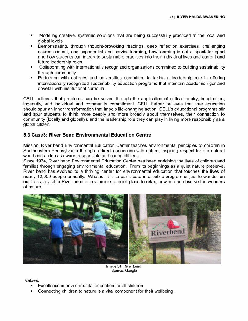
47 | RIVER HALDA AWAKENING
Modeling creative, systemic solutions that are being successfully practiced at the local andglobal levels.
Demonstrating, through thought-provoking readings, deep reflection exercises, challengingcourse content, and experiential and service-learning, how learning is not a spectator sportand how students can integrate sustainable practices into their individual lives and current andfuture leadership roles.
Collaborating with internationally recognized organizations committed to building sustainabilitythrough community.
Partnering with colleges and universities committed to taking a leadership role in offeringinternationally recognized sustainability education programs that maintain academic rigor anddovetail with institutional curricula.
CELL believes that problems can be solved through the application of critical inquiry, imagination,ingenuity, and individual and community commitment. CELL further believes that true educationshould spur an inner transformation that impels life-changing action. CELL’s educational programs stirand spur students to think more deeply and more broadly about themselves, their connection tocommunity (locally and globally), and the leadership role they can play in living more responsibly as aglobal citizen.
5.3 Case3: River Bend Environmental Education Centre
Mission: River bend Environmental Education Center teaches environmental principles to children inSoutheastern Pennsylvania through a direct connection with nature, inspiring respect for our naturalworld and action as aware, responsible and caring citizens.Since 1974, River bend Environmental Education Center has been enriching the lives of children andfamilies through engaging environmental education. From its beginnings as a quiet nature preserve,River bend has evolved to a thriving center for environmental education that touches the lives ofnearly 12,000 people annually. Whether it is to participate in a public program or just to wander onour trails, a visit to River bend offers families a quiet place to relax, unwind and observe the wondersof nature.
Image 34: River bend
Source: Google
Values: Excellence in environmental education for all children. Connecting children to nature is a vital component for their wellbeing.

48 | RIVER HALDA AWAKENING
Being good stewards of the environment and the land we own. Collaboration and partnerships with other organizations to fulfill our purpose. Responsible governance and management to ensure a stable financial foundation. Fun – our work is recreational, creative and educational.
5.4 Case 4: Floating gardens can feed Bangladesh
Image 35: floating gardens of barisalSource: Google
Bangladesh is a crowded nation where more than 150 million people live in an area smaller than theU.S. state of Washington. Poverty, malnutrition, and rural unemployment are daily challenges to foodsecurity. Declining access to fresh water, increasing salinity, and the impacts of climate change furthermagnify the need for sustainable food production. By 2050, it is predicted that there will be 100 millionmore people in Bangladesh. More than three quarters of the Bangladeshi population live in rural areaswhere livelihoods often depend on small-scale fishing and farming. For the people of Barisal in thesouth of the country, it is homestead aquaculture and agriculture in particular that provide essentialfood and income. Typically, household ponds in this region are used to culture fishes like carps andtilapia, and cultivate crops of vegetables along the banks. The banks of the ponds are also plantedwith tall trees that provide firewood for cooking meals. However, these trees often cast large shadowsthat reduce the productivity of both the pond and the vegetable garden. Recognizing the food andincome benefits that maximizing the productivity of these household spaces could bring Bangladeshifamilies, the Agriculture Nutrition Extension Project began working with communities to design andtest a new approach to combining small-scale fish and vegetable farming. Together with the projectstaff, the women and men of nine Barisal households constructed floating gardens that allowvegetables to be grown on the sunny areas of the pond’s surface. Connected to the bottom of theframe is a submerged cage that provides a protected space for fish fry to grow.As the fish are bred incages that can be pulled over the edge of the pond, women find them easier to harvest than pondfish, as they don’t have to enter the water.

49 | RIVER HALDA AWAKENING
Image 35: An Integrated Floating Cage-Aquaponics System (IFCAS) in Barisal, Bangladesh.Source: Google
A form of aquaponics, this method allows the vegetables on the surface to absorb the nutrients fromthe pond water below, and increase the yield of fish and vegetables from one homestead plot. Thisprovides families with food to eat at home and a source of income through selling excess produce atthe market. This is particularly important for the rural poor, as fish are a key source of animal proteinand micronutrients that contribute to a balanced diet. In the first 2 months after the floating gardenswere installed, the Barisal families ate between 4 to 12kg of vegetables, and were able to beginharvesting fish from the cage. This innovative solution can also be installed in naturally occurringbodies of water throughout Bangladesh, as well as canals and rivers. By maximizing the productivityof these natural and household spaces, Bangladesh’s rural poor can secure food, nutrition, andincomes for their families.
The Agriculture and Nutrition Extension Project (ANEP), is a partnership between International DevelopmentEnterprises (iDE), the World Fish, CIMMYT, IRRI, Save the Children International, CODEC, and CEAPRED andis funded by the European Union (EU). The project seeks to sustainably raise agricultural productivity andpromote effective market linkages to improve the nutrition of poor rural and urban households in the south ofBangladesh and the Nepal plains. This action research is jointly conducted by World Fish and BangladeshAgricultural University (BAU).
5.5 Case 5: Aquatic Life Research Facility, Canada

50 | RIVER HALDA AWAKENING
Image 36: Research labs and corridors of aquatic life research unit, Canada.
Source: Google
Located at the Canada Centre for Inland Waters (CCIW) in Burlington, Ontario, the Aquatic LifeResearch Facility is a $4.6M state-of-the-art laboratory designed for studying fish and aquatic lifehealth in the contexts of toxicant and stressor exposure. Built as a joint project between EnvironmentCanada and Fisheries and Oceans Canada, it provides space for scientists, graduate students, anduniversity partners. Completed in summer 2009, the new facility replaces one originally built in the1970s.
Features of the Laboratory The self-contained facility consists of a series of rooms for conducting studies of aquatic life,
including: A fish holding room for hatchery- and laboratory-raised fish with four banks of three holding
tanks on water recirculation systems An experiment room capable of supporting 260 50-L aquaria where large numbers of fish can
be exposed to toxicants and stressors at several levels, and can be tested in replicate A separate wild-fish room where fish caught in the wild can be tested for food chain and
stressor experiments while preventing pathogens from spreading to laboratory-raisedexperimental fish
A room of environmental chambers for testing stressor effects on turtles, amphibians,invertebrates and other forms of aquatic life
A dissection room and a chemistry room where tissue samples can be harvested and preparedfor testing post exposure, but separated from the live fish rooms to prevent pathogens fromcontaminating running experiments
Improved research security: The laboratory was designed with great attention given to propercare of animals. It has several features intended to ensure that safety of research animals ismaintained, including security controlled entrances and exits. It has a main corridor with largebay windows where tours can be conducted without interfering with experiments orresearchers.
Reduced waste and energy consumption: The new facility features water recirculationsystems that conserve 80% of the water, filtering out harmful waste compounds beforepassing it back into the tank, and allowing for a reduction in the energy needed to maintain aconstant temperature. These cost savings will result in the new facility paying for itself in lessthan 10 years.

51 | RIVER HALDA AWAKENING

52 | RIVER HALDA AWAKENING
CHAPTER SIX: Program Development
Awareness

53 | RIVER HALDA AWAKENING
FUNCTION REQUIREMENTS ELEMENTS NUMBER OFELEMENTS
SQUARE FEET
OUTREACHAND NATURE
SECTION
OFFICE ANDADMINISTRATION
1.office rooms2. Main lobby
3. repair area and storagearea
1 Curator room 121
1Collection room 4002 monitoring
personal200
GALLERIES GALLERY FOR RIVERLIFE_HALDA
1.River map2. photo exhibition galleries
11 types
1 1535
AQUA GALLERY FORHALDA SPECIES OF FISH
AND THEIR HABITATS_ENDANGERED AND
EXTINCT
1. 71 species available2. 15 extinct
1 5346
VIRTUAL VISUALIZATIONGALLERY FOR LIFE CYCLE
OF A CARP FISH (3D)
Holographic projections 1 1764
GALLERY FOR ARTIFICIALBREEDING SYSTEMS
Open for observationhatcheries
4
GALLERY FOR FISHINGEQUIPMENT_SUPPORTIVE
AND PROHIBITED
Models and visuals(8 nets, 4 boats, 2 hand
lines )
1 1080 and outside
SPECIAL EXHIBIT SPACE(FOR RELATED SCIENCETOPICS/ OTHER RIVERS
OF THE WORLD)
Any new innovativeachievement or
advancement : examplefishing gear
1 1764
ResearchFUNCTION
REQUIREMENTSELEMENTS
NUMBER OF USERS/ELEMENTSSQUARE FEET
RESEARCH SECTIONOFFICE AND ADMINISTRATION
1.office rooms2. Main lobby
1 documentation100
9 monitoring personal (security)Waiting room 10 = 260
1 monitoring head100
1 lab technician100
1director121

54 | RIVER HALDA AWAKENING
1 advisor121
1 research examiner or head per lab 100x6=
600
1 field supervisor +assistant152
TOILET (50 people)Male toilet
3
Female toilet3
SEMINAR ROOM
2001873
DISCOURSE AREAInformal discussion area
6 heads + advisor + director + field supervisor +4 outsiders575
ACCOMODATION Chittagong university 25 people per batch
ROOMLETS10 people
162 PER ROOMX 10 =1620
TOILETS5 people _3 male/2 female
LIMNOLOGY AND OTHER RESEARCH LABSAQUACULTURE LAB-NATURAL SPAWNING HABITATS OF MAJOR
CARPS CONSERVATION LAB
Controlled pond in which tests are done and monitored1. sample archive area2. locker room3.equipment storage area
1+2 ( HEAD AND RESEARCHER)621
MICROBIOLOGY LAB (FOR INVASIVE SPECIES AND OTHERS)

55 | RIVER HALDA AWAKENING
Basic Biology lab- 1. sampling area2. equipment (machine) desk3. locker room4. equipment storage area5. sampling archive (aquariums)
1+6( HEAD AND RESEARCHER)-existing in chandpur
Existing 5 researchers610
HYDROLOGY AND WATER POLLUTION LABBasic Chemistry lab1. sampling area2. equipment (machine) desk3. locker room4. equipment storage area5. sampling archive (racks)
1+6( HEAD AND RESEARCHER)-existing in chandpur
Existing 5 researchers610
TERRESTRIAL ECOLOGY LABBasic Biology lab – to study agro farming products and conservation trees for this zone1. sampling area2. machine desk3. locker room4.equipment storage area5. sampling archive
1+4( HEAD AND RESEARCHER) –existing argo researchers in chandpur
Existing 5 researchers621
METEOROLOGICAL LAB (air temperature,wind speed, and solar radiation)
for conservation
1+4 (HEAD+ RESEARCHER) 280
STRESSOR CHAMBER AND LAB (LAB FISH AQUARIUM)1(WILD FISH AQUARIUM)
Studying of fish life in stress - chemistry lab 1. Sampling area (aquariums)-ph and salinity, manmade pollution, food diversity, breeding systems.3. locker room4.equipment storage area5. sampling archive
1+4( HEAD AND RESEARCHER PER NUMBER OF SECTIONS)482
WASTE RECYCLING CHAMBERInput areaRecycling areaOutput area
1 OPERATOR + 1 ASSISTANT

56 | RIVER HALDA AWAKENING
Training
FUNCTION REQUIREMENTS ELEMENTS NUMBER OFUSERS/ELEMENT
S
SQUARE FEET
TRAININGSECTION
ADMINISTRATION Office roomsLobby space
1 documentation 100
1 examining head 1001 hatcherytechnician
100
1director 1211 field supervisor
+assistant152
TRAINING INHATCHERIES
_1100PEOPLE
INVOLVED
EX_80 peoplePR_100people
EGG COLLECTIONCHAMBER (HATCHING
PROCESS)
1.egg collection cell 1’ RADIUS CELLSX 50 CELLS
1481
OFFICE 1 field supervisor+assistant
152
MULTIPURPOSE SPACE:
1.TRAININGFOR AGRO
BASEDCULTURE +RESEARCH
(1600PEOPLE
INVOLVED)
2.TRAININGFOR
EQUIPMENTUSAGE
3.WORKSHOP FOR FISHFOOD ANDORGANIC
PROCESSING
WORKSHOP AREA
100 5025
STORAGE ROOM 1 FOREQUIPMENT PURPOSE
200
PRACTISE POND 4000
STORAGE ROOM 2 FORAGRO PURPOSE
200
COLD STORAGE FORFOOD PRESREVATION
150
Common facilities
FUNCTION REQUIREMENTS ELEMENTS NUMBER OFUSERS/ELEMENT
S
SQUARE FEET
RESTAURANT 1.KITCHEN2.RECEPTION/RETAIL
ZONE3.VISTORS AREA
Seating area 60 5515Retail zone 1143
Kitchen 2760Office/ service Manager room 100
MEDICALFACILITY
RECEPTION AREA ANDFIRST AID STATION
1 172
TREATMENT/ NURSINGAREA_BED
2 16X20 = 320
LOCAL SHOPCOMMUNITY
SPACE
STALLS FOR LOCALCRAFTS,FISH
PRODUCTS, ORGANIC
1.Retail area2. storage area
1+1 5000

57 | RIVER HALDA AWAKENING
PRODUCTSBOATING
DOCK(MAX. 200SCHOOL
STUDENTS_50 AT A TIME)
PASSENGER BOAT 10/8
RESEARCH BOAT 2FISHING BOAT 20
SPECIAL SHAMPAN 2LONG TOUR 25/3
SWIMMINGFACILITY AND
FISHINGFACILITY(MAX. 200SCHOOL
STUDENTS_50 AT A TIME)
SWIMMING GEARSTORAGE
60 gear
WASH AREA 15 PERSONFISHING GEAR STORAGE 30 gear
LIVE FEED STORAGEPARKING BICYCLE 20
SELF DRIVEN CARS 8LOCKERROOM
FACILTY FOREXPLORERS
1.Counter2.Store area
LIBRARYRESEARCH
BATCH_25 TO30
STUDENTS
VISITORS AREA Reading area EX_25,PR_30
Stack area 2000 books (BFRIHEAD QUARTERS)
Retail area 1 person
ARCHIVE ANDDOCUMENTATION AREA
Sorting room 1 personDocumentation room 3 students (EX in ctg
uni)Videography and photo
processing area1 shot director1 shot assistant
1 photographydirector

58 | RIVER HALDA AWAKENING
Image 37: bubble diagram and basis of program formulationSource: Farasha Zaman
Image 38: OrgangramSource: Farasha Zaman

59 | RIVER HALDA AWAKENING
CHAPTER SEVEN: Design Development

60 | RIVER HALDA AWAKENING
7.1 Idea GenerationThe idea of the project was developed from the fact that the site is located at the edge of a river that isconstantly eroding, but cannot be noticed. It is a known fact that soil erosion can be naturally prevented by planting trees, as the tree roots help in holding the soil tight preventing erosion.
“In mathematics, a Voronoi diagram is a way of dividing space into a number of regions. A set of points (called seeds, sites, or generators) is specified beforehand and for each seed there will be a corresponding region consisting of all points closer to that seed than to any other. The regions are called Voronoi cells” (Wikipedia, 2010)

61 | RIVER HALDA AWAKENING
Image 39: Voronoi DevelopmentSource: Farasha Zaman
7.2 Volume and Space GenerationIn this case each tree trunk was chosen to be a seed point, connecting them in triangulation first and then through the voronoi to create optimum spaces for one tree.

62 | RIVER HALDA AWAKENING
Image 39: Space Development Inspired from Voronoi
Source: Farasha Zaman
Further development was done so as to not cut down a single tree on site. Spaces in between thetrees were found out being inspired from the system. Then each of these spaces were manipulatedand structured according to the voronoi.
Image 39: choosing polygonsSource: Farasha Zaman
The volumes developed within the spaces in between the trees could be a pure geometry or havegained any formal expressions. The reason for choosing polygons was based on the observation thateach polygonal volume provides more interactive surfaces than that of a pure volume. Each polygonalso allows the relation with the voronoi to be maintained alongside serving the functional zones. Eachcell of the architecture was placed according to the need of the function based on it orientation and inorder to achieve maximum view from within the functional zones.

63 | RIVER HALDA AWAKENING
Image 40: orientation of polygons Source: Farasha Zaman
Image 41: zoning of functions and their relationSource: Farasha Zaman
The voronoi cells can be observed to manipulate themselves according to theneeds to give an optimum space. They are seen to be unequal at sides,elongating and shortening, or taking the direction most feasible to form thespace in harmony with in harmony with its adjacent cell.
Likewise, this interpretation was used to generate the architectural spaces ofthe centre. The facades of each functional cell, has been elongated whereneeded, to achieve a wider view, and in places the facades have been tilted toavoid exposure directly to the western sun.
Each of the cells has their own shape and volumetric difference, as they havebeen developed from the need of the function itself. For instance the galleryspaces have a height of 12’ at their lowest point, in order to achieve loftinessand grandness of space.
The master plan of the project has been achieved throughdesigning each void space in between the trees into avoronoi character of that particular space. No single spacecan be seen to be repeated or can be used for a functionthat has not been assigned to it.
The architectural arrangement of the functional zones andthe circulation is such that it follows the random yetguided pathway through nature. The whole volume hasbeen elevated to a height of 3’ allowing the biodiversity ofthe place to be retained.
The centre is divided into a public zone consisting of thegalleries, a central open space for discussions, exhibitionsand interactions and a community deck. The private zoneconsists of the library, the research labs, the seminarspace and accommodation for the researchers. These twozones have been connected by the training zone and therestaurant area, in order to hold the two functions. Theresearch spaces are placed towards north, near to theecological zone, which can be used as a sampling groundfor the labs. The training zone and the kitchen aredeigned to function in a way so that the food processingsystems can be observed. It is kept at a bending edge ofthe river allowing this zone to become the firstagricultural sampling zone from where the food for therestaurant will be served. The placement allows visitors toknow how and where the food is generating from, addingto the learning experience.

64 | RIVER HALDA AWAKENING
7.3 Activity and relation to nature
Image 42: Central courtyards like space allowing gatherings and Image 43: ecological sampling zone outside library
Interaction
Image 44: community participation area and deck Image 45 agricultural sampling zone
7.4 Façade Derivation and Development
Image 46: elevation derivation and façade treatment
Source: Farasha Zaman
Taking up a space in nature dotted in trees, four elements can be made out, the ground, the treetrunks, the tree canopy and the grass or smaller trees. Interpreting them into architecture, the treetrunks are abstracted into structural columns, the canopy to the roof, the ground to an elevatedplatform and the grass to screens. The roof structure has been further manipulated according to theneed of achieving views and light entry to the functional spaces.

65 | RIVER HALDA AWAKENING
7.5 Architectural Drawings
Image 47: Site PlanSource: Farasha Zaman
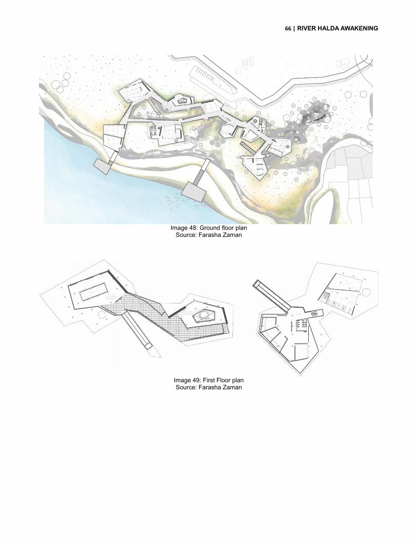
66 | RIVER HALDA AWAKENING
Image 48: Ground floor planSource: Farasha Zaman
Image 49: First Floor planSource: Farasha Zaman

67 | RIVER HALDA AWAKENING
Image 50: Roof planSource: Farasha Zaman
Image 51: river view (east elevation)Source: Farasha Zaman

68 | RIVER HALDA AWAKENING
Image 52: section AA (longitudinal section)Source: Farasha Zaman
Image 53: section BB (through gallery spaces)Source: Farasha Zaman
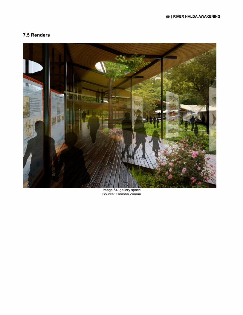
69 | RIVER HALDA AWAKENING
7.5 Renders
Image 54: gallery spaceSource: Farasha Zaman
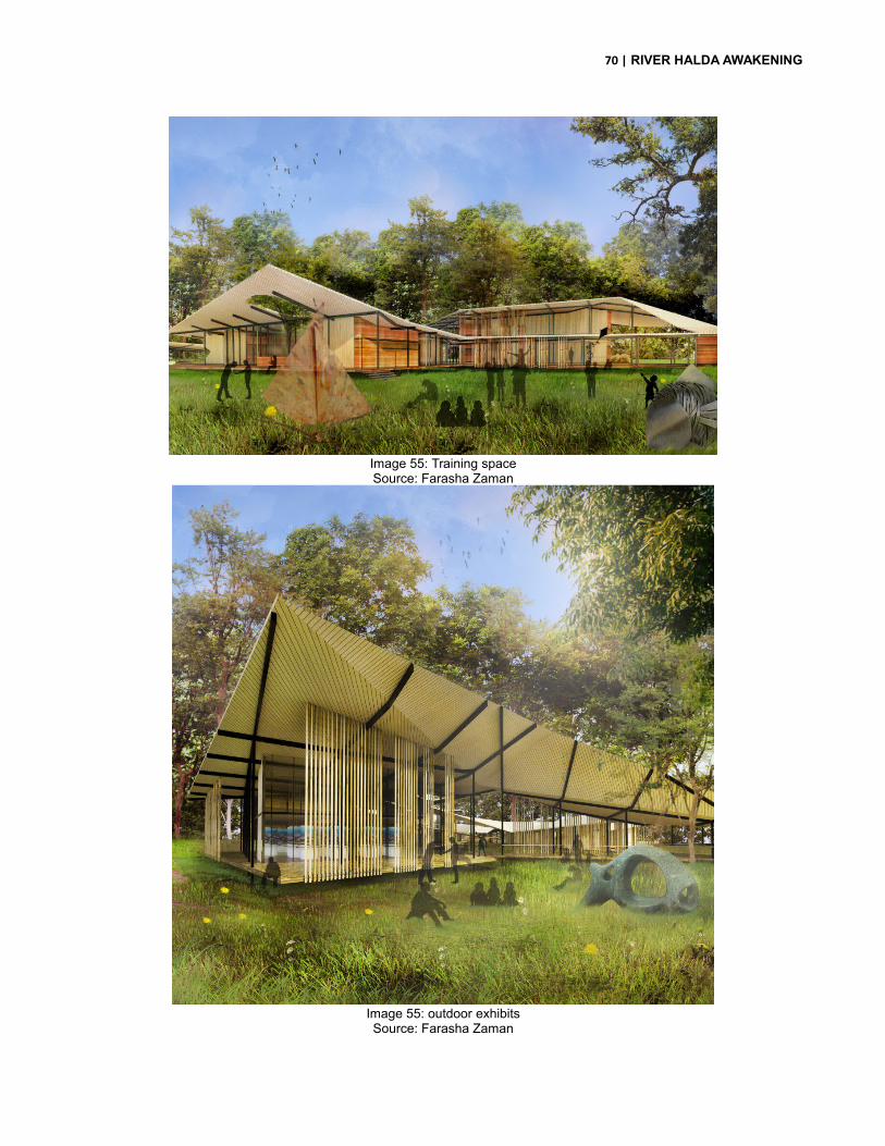
70 | RIVER HALDA AWAKENING
Image 55: Training spaceSource: Farasha Zaman
Image 55: outdoor exhibitsSource: Farasha Zaman

71 | RIVER HALDA AWAKENING
CHAPTER EIGHT: Conclusion

72 | RIVER HALDA AWAKENING
ConclusionRiver Halda awakening is a project for the people of Chittagong whose lives are dependent on thisriver. The project was taken up to help generate awareness, starting from the studio itself, and thenfurther.
People today know very less about the rivers, their ecology, and little do they realize how dependentour daily lives are on rivers. This project has helped achieve this goal, of making people aware of thenature and how we are dependent on each other. The aim was not to generate architecture only but tohelp people relate to bigger issues which we neglect.
The architecture will create a dialogue in nature, welcoming it and yet restricting it but celebrating it,while attending to the functional requirements of a training research and awareness centre. Throughthis project not only will the locals be addressed but also the children and the aged will be able toenjoy the river side.

73 | RIVER HALDA AWAKENING
CITATION
Wikipedia, (2014). Halda River, from Wikipedia, The free Encyclopedia [WWW page] Retrieved data on10th April 2014. URL: http://en.wikepedia.org/wiki/halda_river
Kibria, M.M. (2012) River halda [WWW page]. Retrieved February 22nd, 2014. URLhttp://en.wikepedia.org/about%20halda.html
Shuttle worth, M.S. (n.d) Definition of research [WWW page] Retrieved February 22 nd, 2014. URLhttps://explorable.com/definitionof research
Wikipedia, (2014). World tourist organization, form Wikipedia, the free encyclopedia. [WWW page]Retrieved April 10th, 2014. URL: http:// en,Wikipedia.org/wiki/tourism
Atkins, W.A. (n.d) Water encyclopedia: science and issues. [WWW page] Retrieved March 8th, 2014.URL:http://www.waterencyclopedia.com/po-re/recreation.html
Encyclopedia (2004). Iowa public television: explore more. [WWW page] Retrieved February 20th,2014.URL: http://www.iptv.org/exploremore/water/pollutants/pollutants.cfm
Holderfield,L. (1999). Geography and Environment Management. [WWW page] Retrieved March 29th,2014.URL:http://www.auburn.edu/academic/classes/geog/chanepl/4500/1999_fall/holderfield/tourism_impats.html
FAO fisheries country profile
Professor A.k. Azadi, Chittagong University. Interviewed on January 29th, 2014.
Wikipedia, (2014). Cultural heritage. Retrieved on February 20th, 2014. URL: http:// enWikipedia.org/wiki/cultural_heritage.