ritt kellogg memorial fund registration - colorado college · ritt kellogg memorial fund ... before...
TRANSCRIPT

1/12/17, 9:01 AMIdeal-Logic
Page 1 of 11https://apps.ideal-logic.com/worker/report/28CD7-DX6C/H9P3-DFPWP_5e13991e755dba65/pe239c68c/a1555e53600ee/registration.html
Ritt Kellogg Memorial FundRegistrationRegistration No. SP1Z-52LVCSubmitted Jan 10, 2017 9:48pm by Sophia Redpath
Registration
Aug 29, 2016-Aug 27, 2017
Ritt Kellogg Memorial FundRKMF Expedition Grant RKMF Expedition Grant (2016-1017//INDIVIDUAL)This is the individual application for a RKMF Expedition Grant. Each participant must fill this application outon their own. In this application you will be asked to provide important details concerning your experienceand eligibility for your proposed expedition.
Waitingfor
Approval
Aug 29, 2016-Aug 27, 2017
Ritt Kellogg Memorial FundRKMF Expedition Grant 2016-2017// Group ApplicationThis is the group application for a RKMF Expedition Grant. In this application you will be asked toprovide important details concerning your expedition.
Waiting forApproval
Participant

1/12/17, 9:01 AMIdeal-Logic
Page 4 of 11https://apps.ideal-logic.com/worker/report/28CD7-DX6C/H9P3-DFPWP_5e13991e755dba65/pe239c68c/a1555e53600ee/registration.html
I. Grant Summary
a. Expedition name:Looping the Revillagigedo Island by Sea Kayak
b. What is the primary activity (or activities) of your expedition (i.e. rock climbing, packrafting and hiking, etc.)?Sea kayaking
c. Briefly describe the objective(s) of your expedition:Through the help of this grant we hope to complete a sixteen day sea kayaking trip in which we will circumnavigateRevillagigedo Island in southeastern Alaska. On this trip we hope to hone and develop our kayaking, camping, andwilderness skills (and maybe catch a fish!). Our route takes us through the beautiful and remote Misty Fjords NationalMonument in the Tongass National Forest, allowing us to explore a location that few get to experience first hand.Travelling via sea kayak lends the unique perspective of both spectator to an environment as well as active participantin it. Connecting and interacting with nature is a meaningful part of each of our lives; it is something that connects usto the world we live in, to ourselves and to each other. We hope to use this time in the backcountry to become closerfriends and as an opportunity for self-reflection as we head into our final years at Colorado College, and the rest of ourlives.
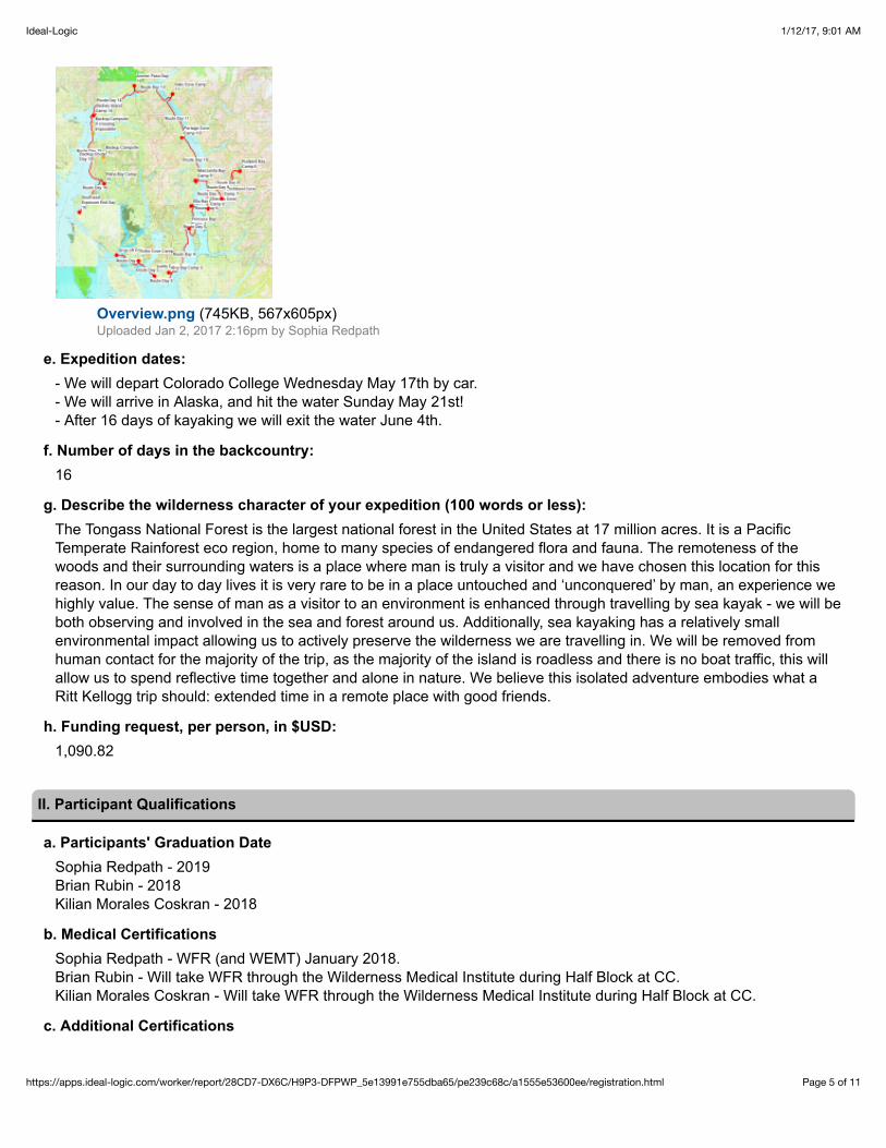
d. Describe the location of the expedition:We will begin our journey in the small coastal town of Ketchikan Alaska, and paddle north, growing more and moreremote as we continue our trip. Our trip will focus on circumnavigating Revillagigedo Island in southeastern Alaska,with a touch of exploring in the local fjords. This route was recommended to us by an outfitting company on the islandwith many years of experience. We will be camping in Tongass National Park and paddling the fjords and straitssurrounding it.
If you would like to view our interactive route map, copy and paste this link into your browser:http://caltopo.com/m/TB9G
Attach an area overview map.
1/12/17, 9:01 AMIdeal-Logic
Page 5 of 11https://apps.ideal-logic.com/worker/report/28CD7-DX6C/H9P3-DFPWP_5e13991e755dba65/pe239c68c/a1555e53600ee/registration.html
Overview.png (745KB, 567x605px)Uploaded Jan 2, 2017 2:16pm by Sophia Redpath
e. Expedition dates:- We will depart Colorado College Wednesday May 17th by car. - We will arrive in Alaska, and hit the water Sunday May 21st!- After 16 days of kayaking we will exit the water June 4th.
f. Number of days in the backcountry:16
g. Describe the wilderness character of your expedition (100 words or less):The Tongass National Forest is the largest national forest in the United States at 17 million acres. It is a PacificTemperate Rainforest eco region, home to many species of endangered flora and fauna. The remoteness of thewoods and their surrounding waters is a place where man is truly a visitor and we have chosen this location for thisreason. In our day to day lives it is very rare to be in a place untouched and ‘unconquered’ by man, an experience wehighly value. The sense of man as a visitor to an environment is enhanced through travelling by sea kayak - we will beboth observing and involved in the sea and forest around us. Additionally, sea kayaking has a relatively smallenvironmental impact allowing us to actively preserve the wilderness we are travelling in. We will be removed fromhuman contact for the majority of the trip, as the majority of the island is roadless and there is no boat traffic, this willallow us to spend reflective time together and alone in nature. We believe this isolated adventure embodies what aRitt Kellogg trip should: extended time in a remote place with good friends.
h. Funding request, per person, in $USD:1,090.82
II. Participant Qualifications
a. Participants' Graduation DateSophia Redpath - 2019Brian Rubin - 2018Kilian Morales Coskran - 2018
b. Medical CertificationsSophia Redpath - WFR (and WEMT) January 2018. Brian Rubin - Will take WFR through the Wilderness Medical Institute during Half Block at CC. Kilian Morales Coskran - Will take WFR through the Wilderness Medical Institute during Half Block at CC.
c. Additional Certifications

1/12/17, 9:01 AMIdeal-Logic
Page 6 of 11https://apps.ideal-logic.com/worker/report/28CD7-DX6C/H9P3-DFPWP_5e13991e755dba65/pe239c68c/a1555e53600ee/registration.html
Sophia Redpath - WEMT and NREMT expire 2018. CPR and CPR for Healthcare Providers expires 2018.
d. Training PlanThough all expedition members have experience with kayaking (though it varies from person to person), we will bepreparing together for this trip in an effort to level the field and brush up on old skills. We will be doing as much as wecan while at school to train for this trip, as well as some on-site preparations. We will attend kayak pool sessions topractice and become comfortable with wet exits and our paddle stroke. We will practice the steps of rescues as bestwe can, considering that the river kayaks available at pool sessions will be very different from sea kayaks. We willtrain our core and upper body with a regular workout regime, and upon arrival in Ketchikan we will go over sea kayakmaintenance, rescue, radio operation and codes with the local outfitter Southeast Exposure.
III. Expedition Plan
a. Land ManagementThe land we will be camping on and the waters we will be traveling in are a part of the Tongass National Forest, thelargest National Forest in the United States! Within this national forest we will be traveling in the Misty Fjords NationalMonument Wilderness, the largest wilderness area on the Tongass National Forest land area. We will not need apermit to use this land.
b. LNT PrinciplesYes
EmptyIn addition to utilizing the seven LNT principles we will be adapting to the nature of our kayaking trip. We will bepacking out all of our trash and food waste, though we can use the tidal zone for rinsing dishes, toothpaste andwastewater. We will be peeing in the tidal zone wherever possible, though for 'number two' we will be going at least100 yards inland and following standard LNT procedures. When making fires we will use driftwood only.
Principles and adaptations from lnt.org
c. Cultural ConsiderationsNo
d. Re-Ration PlansNo
e. Expedition ItineraryRITT ROUTE.pdf (6.6MB)Uploaded Jan 1, 2017 10:13pm by Sophia Redpath
f. Equipment ListEquipment List.pdf (55KB)Uploaded Jan 10, 2017 9:35pm by Sophia Redpath
g. Food ListFood List.pdf (53KB)Uploaded Jan 10, 2017 9:05pm by Sophia Redpath
Food StorageWe will be hanging bear bags each night with all food items and other scented items (such as toothpaste or personaltoiletries). We will be following standard bear-hang protocol as taken from LNT.org - at least 12 feet up and 6 feet outfrom the trunk.

1/12/17, 9:01 AMIdeal-Logic
Page 7 of 11https://apps.ideal-logic.com/worker/report/28CD7-DX6C/H9P3-DFPWP_5e13991e755dba65/pe239c68c/a1555e53600ee/registration.html
IV. Risk Management
a. TravelTravel Plan and Risk Mitigation:
We will depart CC on Wednesday May 16th, driving in Sophie’s 2016 Chevrolet Colorado. The car will have beenserviced and inspected before departure. Ferries from Prince Rupert to Ketchikan run only on Fridays and Tuesdaysso we will be looking to get on the 6:15pm ferry on Friday the 19th. The total driving distance is 32 hours and we havea total of 55 hours and 15 minutes to make it to the ferry if we leave after class at 12pm on Wednesday the 16th.While this is a bit of time crunch we are confident with smart planning and three experienced drivers we will haveplenty of time to make it to Prince Rupert.
Because of our time crunch our first day of driving will take us from Colorado College to Sophie’s family friends housein Billings Montana. According to google maps this will take us 7 hours and 58 minutes of driving so we will arrive justin time for a late dinner. After getting more than 8 hours of sleep, we will leave Sophie’s family friends around 6:00.
On our second day of driving we will cross into Canada and drive to our next destination Mount Robson BC, on theedge of Jasper national park, where we will camp for the night. Google maps estimates that this drive will take us 14hours and 3 minutes, putting our arrival time around 8:00pm. This will give us enough time to set up camp and get tobed early so that we can wake up early for our third day of driving.
Our third day of driving will take us from Mount Robson BC, to Prince Rupert ferry terminal. Google maps estimatesthis drive to take 10 hours and 44 minutes. To make sure that we have extra time to spare for any delays we mightencounter, we will plan on a 5:30am departure, giving us an extra hour and 45 minutes in Prince Rupert before ourferry departs.
Before planning our route we spoke extensively with a local sea kayak tour guide, our outfitter from SoutheastExposure, Jared, about the local area, risks and our experience levels in order to jointly create a route that is safe andfits what we hope to accomplish. He has given us specific camping locations for each night that he knows from hismultiple experiences kayaking around Revillagigedo Island. Before sending our application in we sent our grantproposal to Jared to get one final review and get any last local tips he had to offer. He has given us his seal ofapproval as well as some recommendations for specific camp sites!
Due to the unpredictable weather and in anticipation that we will be delayed, we have planned shorter days into ourtrip that can be combined into one. In the event of multiple days delay we can skip days 5 through 8, going straightfrom Ella camp to Mananita Bay in either one day or multiple. We can also cancel the Walker Cove days (9 and 10)should we have to. This also holds true should any of the crossings be impossible. We will not paddle in the event ofextreme fog, thunderstorms, strong wind or large waves, during daily travel should any of these hazards appear wewill pull over and wait for the situation to subside, or find a suitable campsite to spend the night. While paddling duringthe day we will hold each other and ourselves accountable to stay warm, dry, fed, hydrated and shielded from the sunin order to minimize fatigue and subjective risks.
b. Objective HazardsBears: Although Black bears are the only type of bear found on Revillagigedo Island, there have been unconfirmed grizzlybear sightings on the eastern side of the island. Because of this we will be focusing on familiarizing ourselves with thebehavior and safety protocol surrounding black bears but as an added safety precaution we will also familiarizeourselves with the safety protocol for grizzly bears. While observing a bear in its natural habitat is a goal of ours weare very much hoping to do this from a safe distance. Therefore it is our goal to avoid any close and dangerous bearencounters. In order to do this we have steps we will take daily to reduce risk. When finding an area to camp or restwe will survey the area for any signs of bear such as tracks and trails, scat, or fish carcasses. Should there be signsof bears we will continue paddling along the shore until we find a suitable campsite. When on land we will travel onlyin groups and we will attempt to seem larger and more intimidating. We will cook our meals at least one hundred yards

1/12/17, 9:01 AMIdeal-Logic
Page 8 of 11https://apps.ideal-logic.com/worker/report/28CD7-DX6C/H9P3-DFPWP_5e13991e755dba65/pe239c68c/a1555e53600ee/registration.html
from our camp site and make sure to hang our food in bear hangs at night. When we stop for lunch we will be sure tomake noise and try to keep to more open beaches where possible so as not to surprise bears.
If we do encounter a bear we will first identify what state the bear is in, as well as what type of bear it is, noting thatmother bears with cubs (or unattended cubs) pose a greater risk to us. If it is far away and doesn’t seem to notice us,we will slowly and quietly move away from the area. If the bear does notice us, we will slowly back away while talkingto it in a calming voice to show we are not a threat.
If a bear approaches us then we will first we will attempt to back away while taking out our bear spray. If the bearcontinues towards us we will use the bear spray which each of us will be equipped with at all times to deter an attack.If the bear is not deterred by this and it is a black bear we will fight back with anything possible, as they tend to bemore timid than a grizzly. If it is a grizzly we will lay flat on our stomachs with our hands behind our backs and will playdead.
Water friends! The waters around the Revillagigedo Island are the seasonal home to Humpback Whales, several types of seals,and sea lions. While we hope to see all of these creatures, we will do so from a safe distance. Whales pose thebiggest threat to us in kayaks, though an inquisitive seal or sea lion could potentially capsize us as well. In order tomitigate this risk we will kayak close to the coast as much as possible. During channel crossings we will stay close toeach other, and in the event of a whale spotting we will brace our kayaks against each other to minimize the risk ofcapsize. Should we capsize, we are familiar with several types of in-water rescue, and will perform the mostapplicable rescue and land as soon after as possible.
Weather: Temperatures lie between 40 and 60 degrees in May and June. Because Ketchikan is in the heart of the TongassNational Forest, the largest rainforest in North America, it rains on average 160 inches per year. While May and Juneare both not part of the rainy season we should still expect and prepare to deal with this weather. To minimize risksassociated with rain and wetness (trenchfoot, hypothermia) we will dress appropriately with synthetic warm layers andhard shell rain gear. This combined with waterproof tents, tarps, drybags and experience dealing with weather in thebackcountry will keep us warm and dry!
In the event of a storm or picking up weather while we’re paddling, we will seek the first landing, preferably asheltered cove out of the wind. We will be paddling close to the shoreline most of the time, so landing promptly shouldnot be an issue. We will be monitoring the weather (inclement storms, fog and rain) and will make judgement calls onwhen to seek land or shelter. We will carefully re-evaluate the weather before every channel crossing, and will not goif there is inclement weather.
Sun: We will also be exposed to morning and afternoon sun. Direct sunlight as well as the reflection off the water puts usat risk for sunburn. In order to avoid this as well as the side effects of severe sunburn (chills, fatigue, fever in extremecases) we will wear protective hats, sunglasses and sunscreen on sunny days.
Wind: Wind can be a hazard for kayaks so we will take measures to minimize risk. Our route takes us mainly throughfjords and hugs the shoreline which minimizes wind buildup from large open spaces (fetch), however high winds andchannel crossings can still be a significant risk. We will carry a radio that we can check weather and wind reports onand we will assess the wind at the beginning of each day, and we will not paddle if it is too high or causes waves withwhitecaps. Of course, before every channel crossing we will assess the wind as a part of the weather. If we can seethe trees on the other side of the channel moving that is a good indication of high winds and we will not cross. Duringchannel crossings, before we reach the halfway point we retain the option of turning around. Past the halfway we willcontinue to the other side. Should wind pick up during the day, we will land and wait it out. To minimize wind andweather exposure for our campsites we try and camp in protected coves and inlets.
1/12/17, 9:01 AMIdeal-Logic
Page 9 of 11https://apps.ideal-logic.com/worker/report/28CD7-DX6C/H9P3-DFPWP_5e13991e755dba65/pe239c68c/a1555e53600ee/registration.html
Waves: Waves can be another hazard to kayaks. Whenever possible we will stay perpendicular to the wave direction(either paddling into it or with it) o avoid being broadsided which increases the likelihood of capsizing or getting wet. We will not paddle in waves greater than 3 feet, and will land if the waves become too high. Surf landings will beavoided at all costs, but if there is no other option we will stay perpendicular to the surf, and Sophie (who hasexperience in surf landings) will go first and instruct.
Tides: Tides, while not a direct risk, will be a factor we will need to be aware of during the course of our trip. We will carrytidal charts and are familiar with reading them. We will not camp or leave equipment in tidal zones, and there are notide races (rapids caused by fast moving tidal water) in our route, and nowhere where the tide would significantlyaffect our daily route plan. The tide chart for Ketchikan Alaska during the May-June period is attached at the end ofour route plan.
Fog: Fog is our final concern when paddling. Though our route will have no large boat traffic, thick fog can still posethreats to navigation and hazard recognition. On day 14 we will be passing near a sea plane base, so in the event offog on that day we will stop before the base and wait the fog out. We will also attempt to radio the base and get a ‘goahead’ from the operators. In the event of thick fog on other days we will not paddle, in thinner fog we will paddleclose to the coastline, but would not attempt a crossing.
c. Subjective HazardsDehydration: We will be travelling in saltwater areas makes us prone to dehydration. However, there are plenty of freshwaterdrainages and streams in the area, so we do not anticipate finding water to be a challenge. We have planned to campnear water each night, and fill all our water vessels before leaving during the day, carrying at a minimum 2 liters perperson during travel. We will treat our water with aquamira or iodine or by boiling it. There is one day where we havechosen a campsite with no marked water source, however built into our travel plans for the day is filling up ourdromedary and all our water bottles at a drainage before we arrive at camp, and again the next morning. Should wedecide we would rather camp closer to the source of water it would be very feasible.
Hypothermia & Cold:Our main concern regarding hypothermia or cold related injury and illness is being wet, thus capsizing is the biggestrisk. In the event of a capsize or an unintentional submerging we will efficiently carry out a rescue and treatmentprocedure. Should they be severely cold we would treat them as a hypothermia patient: changing into warm dryclothes, wrapped in a sleeping bag with an external heat source (hot water bottle). Besides capsizing we will be sureto wear the proper layers during paddling days, as well as spray skirts and paddling jackets to minimize wetness.
Trenchfoot:Trenchfoot is a condition caused by consistent exposure to a cold and wet environment. In order to minimize this riskwe will make sure that our socks are dry every day, we will check ourselves for symptoms and make sure our feet getproper ventilation at camp. Should trenchfoot progress we will treat it aggressively by drying and cleaning the foot asmuch as possible. In an extreme case we would evacuate.
Exertion/Exhaustion: Sea kayaking is a strenuous physical activity, and as such overexertion and exhaustion can be risks. It is unsafe topaddle if overly tired as smaller hazards can be exaggerated, and one’s ability to recognize and mitigate risk isdiminished. We will familiarize ourselves with symptoms of overexertion and tiredness (irritability, unusual silence,impaired judgement…) and be sure to react accordingly. We will take planned breaks during travel for food and water,and can take more as need arises. We will be honest with each other and be attentive to all group members needs.We have strategically scheduled shorter days at the beginning of our route when we have full boats and lessexperience, with days growing longer as we become accustomed to the sea kayaks, the environment and the boats
1/12/17, 9:01 AMIdeal-Logic
Page 10 of 11https://apps.ideal-logic.com/worker/report/28CD7-DX6C/H9P3-DFPWP_5e13991e755dba65/pe239c68c/a1555e53600ee/registration.html
get lighter. Staying hydrated and well fed (breakfast, snacks, lunch, and dinner) will help us to fend off feelings ofexhaustion, and stretching before and after long days will help our muscles become accustomed to the physical stressof paddling. You will notice in our route that we included shorter days in the beginning of our trip and the longer onesat the end which will give us a chance to get used to the exertion that comes with kayaking and gain more fitness asthe trip progresses. We also have a rest day built in to give us time give us time to rest and re-energize.
Group Dynamics:While our group has never completed a backcountry trip together, as close friends we have had experiences in closequarters with each other. Last year we did a ten day car camping road trip which will be to our advantage as we sawhow each of us works in sometimes stressful environments. We will work to foster an open dialogue between the threeof us that allows any of us speak up if any of us have a problem or feel unsafe. We will create a set of values touphold on our trip to further ensure that interpersonal issues are reduced.
Experience Levels:This group has varied experience in camping and sea kayaking, but we all have at the minimum functional campingexperience (tent set-up, stove use, bear hangs etc.). We will be training and practicing skills before this expeditionwhich will begin to level the playing field of technical skills. We are confident that with teamwork, enthusiasm andpatience we can all perform at a high level and strengthen our outdoor skills over the course of this trip.
d. Emergency PreparednessEvac Plan: Our evacuation plan will remain the same for our entire trip. In the event of a serious injury or eventrequiring immediate evacuation we will call the Ketchikan Coast Guard (907-228-0340) on the sat phone. The nearesthospital is the PeaceHealth Medical Center in Ketchikan (reachable at 907-225-5171) in case further medical attentionis necessary. In the event of a less serious event requiring evacuation we will call Southeast Exposure who areequipped with boats and resources to rescue us. We will also carry a VHF Radio which we can use to send out adistress (or, “MAYDAY”) signal to any and all nearby vessels (including the coast guard) in the event of sat phonefailure.
e. Emergency ResourcesKetchikan Coast Guard:PeaceHealth Hospital (Ketchikan AK):Southeast Exposure:
V. Budget
BudgetBudget Overview.pdf (28KB)Uploaded Jan 10, 2017 9:18pm by Sophia Redpath
Transportation1669.32
Food and Fuel597.16
Maps and Books0
Communication Device Rental0
Permits/Fees

1/12/17, 9:01 AMIdeal-Logic
Page 11 of 11https://apps.ideal-logic.com/worker/report/28CD7-DX6C/H9P3-DFPWP_5e13991e755dba65/pe239c68c/a1555e53600ee/registration.html
0
Gear Rentals1006.0
Total Funding Request3,272.48
Cost Minimization Measures
Renting from the gear house
Wherever possible we will rent equipment from the Ahlberg gear house. The excellent prices for CCstudents at the gear house would save us significant rental costs when compared to other outfitters.
Using personal gear wherever possible
We will be using our own personal equipment wherever possible. Two of us have personal sleepingbags, and we all have warm layers and kitchen sets. This combined with several other ‘odds andends’ of personal gear saves us a notable amount of money that would be spent in equipment rentals.
Driving to and from instead of flying
Total cost of travel for the trip: $1669.32 (this is a conservative estimate, it could be more)
Although the ferry adds a large cost to our trip, driving by car is still cheaper than flying by planebecause the cheapest round trip on google flights was $607. This would result in a total travel cost of$1821 including the added baggage costs we would surely encounter, as well as making it harder forus to try and save money by purchasing groceries in Colorado where they are cheaper thanKetchikan.
No permit fees
By choosing a Kayaking route around Revillagigedo island which is located in a national forest, weavoid any of the backcountry permits and fees that would have come with Kayaking in a national park.
VI. Expedition Agreement
Expedition Agreement[Untitled]-3.pdf (271KB)Uploaded Jan 10, 2017 8:44pm by Sophia Redpath

Our$route$circumnavigates$the$Revillagigedo$Island,$remaining$close$to$the$coast$with$the$exception$of$twelve$crossings,$most$of$them$minor.$$This$route$was$recommended$to$us$by$a$local$outfitter,$and$we$have$been$in$close$contact$with$them$throughout$the$route>planning$process.$The$total$mileage$of$our$route$is$331.8$miles$long,$with$a$total$of$16$days$in$the$wilderness.$$$$$$DAY$1$(May$21):$$
$$We$will$be$dropped$off$at$Mountain$Point$on$the$morning$of$May$21st.$$We$will$pack$our$kayaks$and$get$to$paddling!$$We$will$leave$Mountain$Point$no$later$than$10am$with$full$water$vessels,$assuming$good$weather$for$our$primary$crossing.$$Our$first$day$on$the$water$with$loaded$boats$is$a$shorter$day,$8.3$miles$in$order$for$us$to$get$the$hang$of$everything.$$We$will$arrive$at$Coho$Cove$and$set$up$camp.$$We$do$not$expect$to$have$to$paddle$at$night$as$the$sun$does$not$set$until$9:00pm.$$Day’s$Mileage:$8.3$Total$Mileage:$8.3$

DAY$2$(May$22):
$$We$will$wake$up,$make$breakfast,$camp$sweep$and$pack$kayaks,$fill$water$and$review$the$day’s$itinerary,$leaving$camp$no$later$than$9:00am.$$We$will$reassess$weather$before$making$the$1$mile$crossing,$and$will$stop$for$lunch$afterwards,$near$Cone$Point.$We$will$paddle$the$4$miles$to$Lucky$Cove$where$we$will$camp$for$the$night.$$Day’s$Mileage:$6.8$Total$Mileage:$15.1$$$

DAY$3$(May$23)$
$$We$will$follow$the$coast$line$for$the$entirety$of$this$day,$stopping$for$lunch$at$the$approximate$halfway$point$near$Pt.$Alava.$$We$will$then$continue$to$our$camp$at$Alava$Bay.$$$$Day’s$Mileage:$8.2$Total$Mileage:$23.3$$ $

DAY$4$(May$24):$
$ $$Again$we$will$be$following$the$coast$for$this$whole$day.$$We$will$paddle$out$of$Alava$Bay,$stopping$for$lunch$at$Rudyard$Island$after$8.3$miles.$Should$we$need$a$break$before$then$there$are$plenty$of$inlets$that$would$work$well$as$a$pull$off$spot.$$After$lunch$we$will$continue$the$8.3$miles$to$Princess$Bay$where$we$will$camp$for$the$night.$$$Day’s$Mileage:$17.4$Total$Mileage:$40.7$$$

DAY$5$(May$25):$
$We$will$begin$the$day$paddling$around$Wasp$Point$and$following$the$coastline$up$to$our$lunch$spot$after$6.5$miles$at$Wasp$Cove.$$We$will$then$paddle$the$remaining$6$miles$up$to$our$camp$at$Ella$Bay.$$$Day’s$Mileage:$12.5$Total$Mileage:$53.2$$
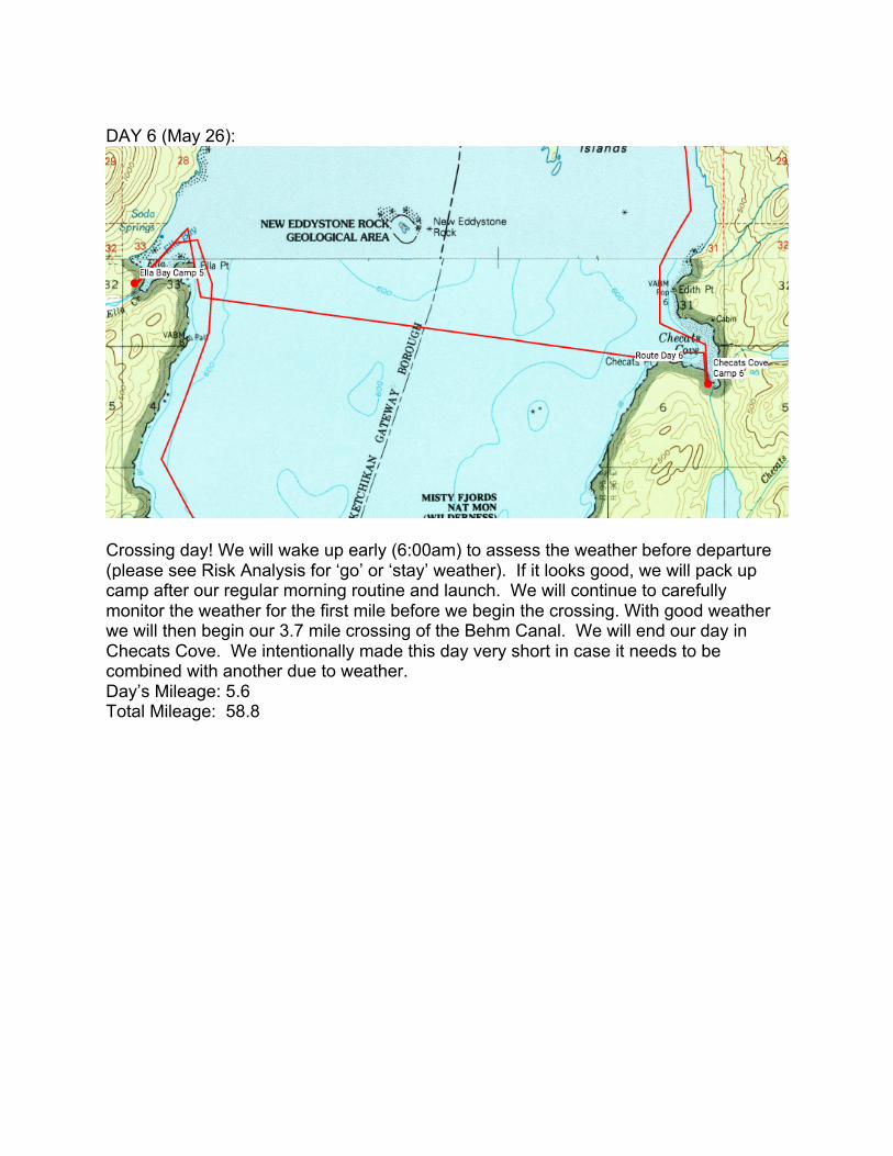
$DAY$6$(May$26):$
$$Crossing$day!$We$will$wake$up$early$(6:00am)$to$assess$the$weather$before$departure$(please$see$Risk$Analysis$for$‘go’$or$‘stay’$weather).$$If$it$looks$good,$we$will$pack$up$camp$after$our$regular$morning$routine$and$launch.$$We$will$continue$to$carefully$monitor$the$weather$for$the$first$mile$before$we$begin$the$crossing.$With$good$weather$we$will$then$begin$our$3.7$mile$crossing$of$the$Behm$Canal.$$We$will$end$our$day$in$Checats$Cove.$$We$intentionally$made$this$day$very$short$in$case$it$needs$to$be$combined$with$another$due$to$weather.$$$Day’s$Mileage:$5.6$Total$Mileage:$$58.8$$ $

DAY$7$(May$27):$
$$We$will$hug$the$coast,$paddling$4.8$miles$up$to$Point$Louise$where$we$will$stop$for$lunch.$$We$will$then$paddle$the$remaining$4.8$miles$to$our$camp$in$Punchbowl$Cove.$$This$day$is$also$a$bit$shorter$in$the$even$that$it$would$need$to$be$combined$with$our$crossing$of$Behm$Canal.$$Day’s$Mileage:$9.8$$Total$Mileage:$68.6$$$ $

DAY$8$(May$28):$
$$
We$will$paddle$up$the$inlet$of$Rudyerd$Bay,$keeping$the$shore$to$our$right$all$day.$$We$
will$stop$for$lunch$after$7.6$miles$before$a$small$crossing$of$another$inlet.$$We$will$then$
continue$to$paddle$the$remaining$5.2$miles$to$camp$at$the$top$of$Rudyerd$Bay.$$$
$
Day’s$Mileage:$12.8$
Total$Mileage:$81.4$
$
$ $

DAY$9$(May$29):$
$$This$is$one$of$our$longest$days,$and$our$longest$of$the$trip$so$far.$$We$will$get$an$early$start,$hugging$the$coast$of$Rudyerd$Bay$inlet$for$13.4$miles,$before$paddling$up$the$coast$of$the$Behm$Canal$for$3$miles.$$We$will$take$a$snack$break$at$an$unnamed$point$7.5$miles$from$camp,$and$stop$for$lunch$at$Point$Eva$on$the$coast$of$the$Canal$13.4$miles$from$camp.$$We$will$reassess$weather$before$making$the$2.7$mile$crossing$of$the$Behm$Canal,$finishing$our$day$up$one$short$mile$after$the$crossing$in$Manzanita$Bay.$$Day’s$Mileage:$21.1$Total$Mileage:$102.5$$ $

DAY$10$(May$30):$
$$We$will$hug$the$coast,$and$paddle$8.6$miles$up$to$stop$for$lunch$at$the$Snip$Islands.$$From$there$we$will$continue$the$remaining$4.9$miles$to$camp$at$Portage$Cove.$$$$Day’s$Mileage:$16$Total$Mileage:$118.5$$ $

$DAY$11$(May$31):$
$$We$will$be$kayaking$up$the$coast,$stopping$for$lunch$6.3$miles$from$camp$at$an$unnamed$outlet.$$From$there$we$will$continue$5.7$miles$up,$and$assess$for$a$crossing.$$If$

everything$looks$good$we$will$proceed$with$our$1.5$mile$crossing,$and$paddle$the$remaining$1$mile$to$camp$at$Saks$Cove.$$$$Day’s$Mileage:$15.3$Total$Mileage:$133.8$$DAY$12$(June$1):$layover$day!$$After$a$few$days$of$heavy$paddling$we$will$give$our$upper$limbs$a$break,$and$take$a$well$deserved$layover$day.$$Activities$will$include$hammock$time,$reading,$campfire$hangouts$and$maybe$some$fishing!$$Day’s$Mileage:$0$Total$Mileage:$133.8$$DAY$13$(June$2):$
$$We$will$paddle$1.5$miles$out$of$Saks$cove$before$making$our$pre>crossing$assessment.$$After$this$1.3$mile$crossing$we$will$continue$up$the$coastline$for$9.8$miles,$and$make$a$short$half>mile$crossing$from$Claude$Point$to$Pt$Lees.$$From$there$we$will$paddle$the$remaining$1.8$miles$to$our$camp$at$Anchor$Pass.$$$Day’s$Mileage:$15.9$Total$Mileage:$149.7$$ $

$DAY$14$(June$3):$
$$We$will$begin$from$Anchor$Pass,$paddle$7.8$miles$to$an$unnamed$outlet$where$we$will$stop$for$lunch.$$From$there$we$will$continue$4.6$miles$to$Snipe$Point$where$we$will$assess$for$a$1.3$mile$crossing.$$$After$the$crossing$we$will$paddle$5.3$miles$to$a$drainage$where$we$will$fill$up$our$water$and$decide$to$either$camp$there$or$continue$1$mile$to$camp$on$Gedney$Island.$$$$Day’s$Mileage:$19.6$Total$Mileage:$169.3$$ $
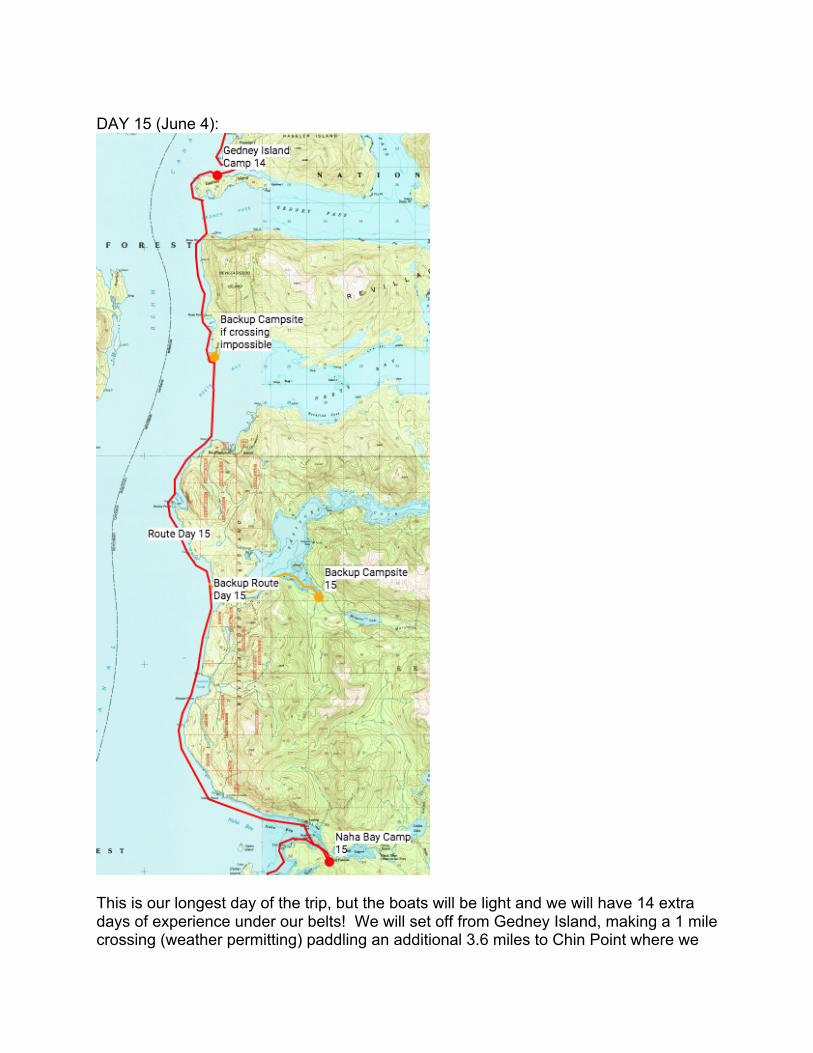
$DAY$15$(June$4):$
$$This$is$our$longest$day$of$the$trip,$but$the$boats$will$be$light$and$we$will$have$14$extra$days$of$experience$under$our$belts!$$We$will$set$off$from$Gedney$Island,$making$a$1$mile$crossing$(weather$permitting)$paddling$an$additional$3.6$miles$to$Chin$Point$where$we$
will$stop$for$lunch.$$If$the$weather$is$bad$enough$that$we$cannot$make$the$second$crossing$we$will$stay$at$Chin$Point.$$Otherwise$we$will$make$the$2$mile$crossing,$and$continue$5.4$miles$before$taking$another$snack$break.$$From$there$we$will$continue$10.6$miles$to$Naha$Bay$to$camp.$$This$is$the$day$that$we$will$be$passing$by$the$sea$plan$base,$so$we$will$utilize$extra$risk$management$protocols$(see$risk$management).$$$$$Day’s$Mileage:$23.7$Total$Mileage:$193$$DAY$16$(June$5):$$$
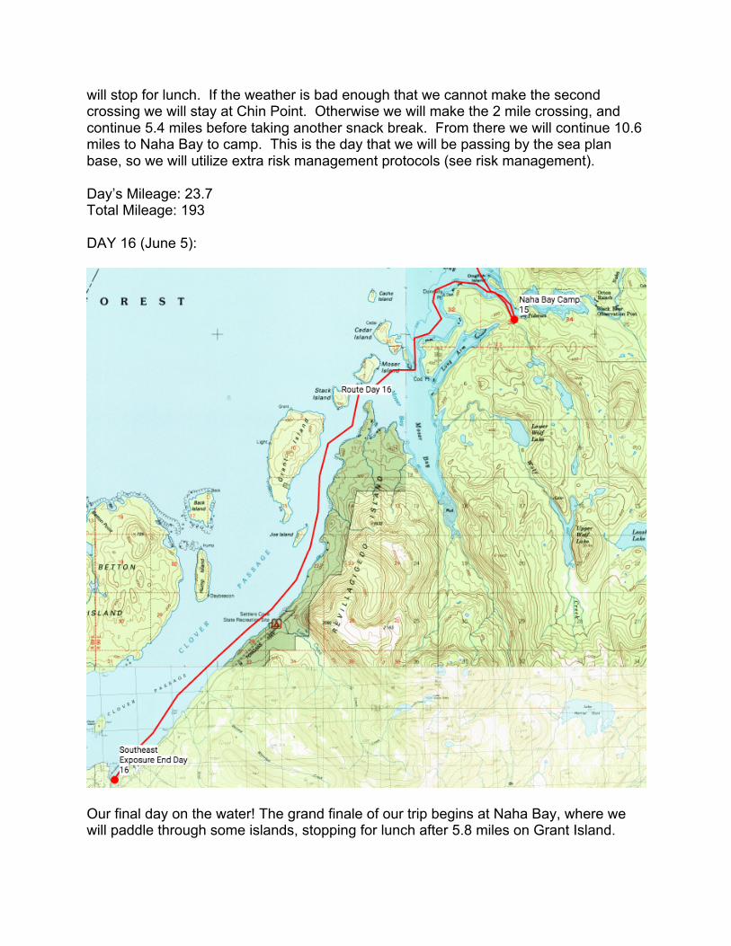
$$Our$final$day$on$the$water!$The$grand$finale$of$our$trip$begins$at$Naha$Bay,$where$we$will$paddle$through$some$islands,$stopping$for$lunch$after$5.8$miles$on$Grant$Island.$$
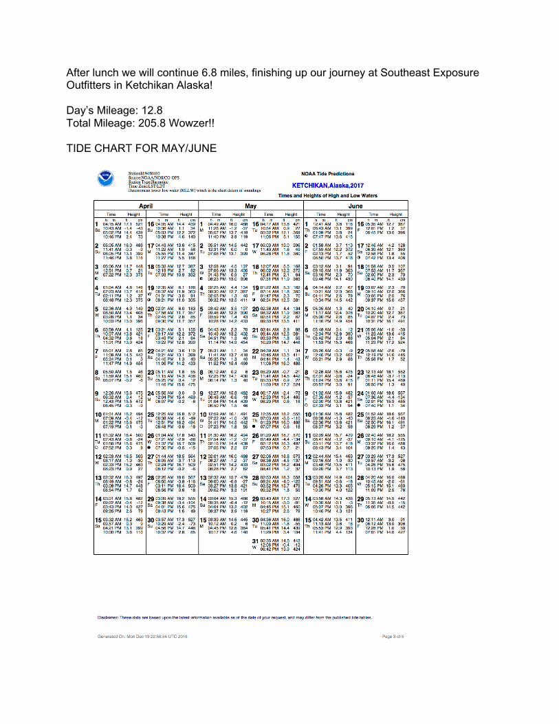
After$lunch$we$will$continue$6.8$miles,$finishing$up$our$journey$at$Southeast$Exposure$Outfitters$in$Ketchikan$Alaska!$$$Day’s$Mileage:$12.8$Total$Mileage:$205.8$Wowzer!!$$TIDE$CHART$FOR$MAY/JUNE$$
$

Equipment*List**
o* Kayak*Gear*Cost:&$900&($300&for&two&weeks&x&3&kayaks)*!* Three*single*kayaks*!* Three*paddles*!* 3*PFD’s*!* Large*dry*bag**!* Small*dry*bag*!* 3*Spray*Tops*
*o* Group*Gear*
!* Three*Person*Tent*!* Paracord*and*light*climbing*rope*for*towing*a*kayak*if*we*need*it*!* 2*Stoves*!* 7*Bottles*of*fuel*for*stove*!* 3*Tarps*!* 1*First*Aid*Kit*(full*First*Aid*list*at*the*bottom)*!* 1*Iodine*!* 1*Trowel*!* 4*Bear*Cans/Bags*!* Bear*Spray**!* Sun*block*!* Zip*lock*bags*!* Hand*sanitizer*!* Spatula/Wooden*spoon*!* Cutting*board*!* Unscented*food*!* 10*Liter*Dromedary*Bag*!* VHF*Radio*!* Satellite*phone*!* Solar*Charger*!* Line*for*bear*hang*!* Compass**
o* Personal*Gear*(1*for*each)*!* Synthetic*sleeping*bag*!* Sleeping*pad*!* Sandals*!* Wool*socks*!* Puffy*jacket*!* Fleece*jacket*!* Rain*jacket/Pants*!* Long*underwear*(synthetic*or*wool*tops*and*bottoms)*!* Fleece*pants*!* Hammock**!* Warm*hat*
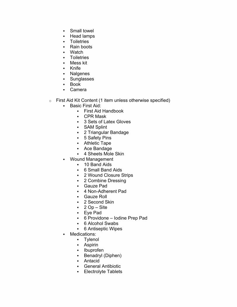
!* Small*towel*!* Head*lamps*!* Toiletries**!* Rain*boots*!* Watch**!* Toiletries*!* Mess*kit*!* Knife*!* Nalgenes**!* Sunglasses*!* Book*!* Camera*
*o* First*Aid*Kit*Content*(1*item*unless*otherwise*specified)*
!* Basic*First*Aid:**!* First*Aid*Handbook*!* CPR*Mask*!* 3*Sets*of*Latex*Gloves**!* SAM*Splint*!* 2*Triangular*Bandage**!* 5*Safety*Pins*!* Athletic*Tape*!* Ace*Bandage*!* 4*Sheets*Mole*Skin***
!* Wound*Management*!* 10*Band*Aids*!* 6*Small*Band*Aids*!* 2*Wound*Closure*Strips*!* 2*Combine*Dressing**!* Gauze*Pad*!* 4*Non^Adherent*Pad**!* Gauze*Roll*!* 2*Second*Skin**!* 2*Op*–*Site**!* Eye*Pad*!* 6*Providone*–*Iodine*Prep*Pad**!* 6*Alcohol*Swabs**!* 6*Antiseptic*Wipes**
!* Medications:***!* Tylenol**!* Aspirin**!* Ibuprofen**!* Benadryl*(Diphen)**!* Antacid**!* General*Antibiotic**!* Electrolyte*Tablets**

!* Sugar*Packets**!* Anti^Itch*Relief*Cream*!* Hydracortizone*Cream**!* Tincture*of*Benzoin**!* Triple*Antibiotic*Ointment**!* Burn*Cream**!* Aloe*Vera*Gel*
!* Tools*!* Tweezers**!* Oral*Thermometer**!* EMT*Shears**!* Irrigation*Syringe**!* Space*Blanket**!* Resealable*Plastic*Bag*
•* Gear*Rentals*
o* Gear*house*rentals*!* 1*Three*Person*Tent**!* 1*Whisper*Light*!* 7*bottles*of*Fuel*for*the*stove*!* 3*Tarps*!* Paracord*and*light*climbing*rope*for*towing*a*kayak*if*we*need*it*(if*free*at*the*gear*house*if*not*don’t*include*here)*
!* 1*First*Aid*Kit*!* 1*Iodine*!* 1*Trowel*!* 4*Bear*Cans/Bags*!* 1*Solar*Charger**
Gear*Rental^*$1,047&(counting&the&25%&discount&renting&from&the&CC&gearhouse&because&Sophie&is&an&ALI&level&2&leader)
Item Quantity Price/Per Total&Cost
Tent 1 $20*Per*week $40
Whisper*Light 1 $8*Per*week $16
Fuel 6 $8*Per*week $96
Kayaks 3 $300 $900
PFD’s 3 Included*in*Kayak*Price $0
Rope 3 $3*Per*week $18
Tarps 3 Included*in*Kayak*Price $0

Large*dry*bags 3 Included*in*Kayak*Price $0
Small*dry*bags 3 Included*in*Kayak*Price $0
Spray*skirt 3 Included*in*Kayak*Price $0
Sleeping*bag 1 $10*Per*week $20
Sleeping*pad 1 $3*Per*week $6
Bear*Spray 3 Included*in*Kayak*Price $0
Bear*Bags 3 Free*from*gear*house $0
Total $1,042
With&Gear&House&Discount&(25%) $1,047
!
Food USD'
Price/LB' Quantity(LB) Total'
Cost Days'Eating
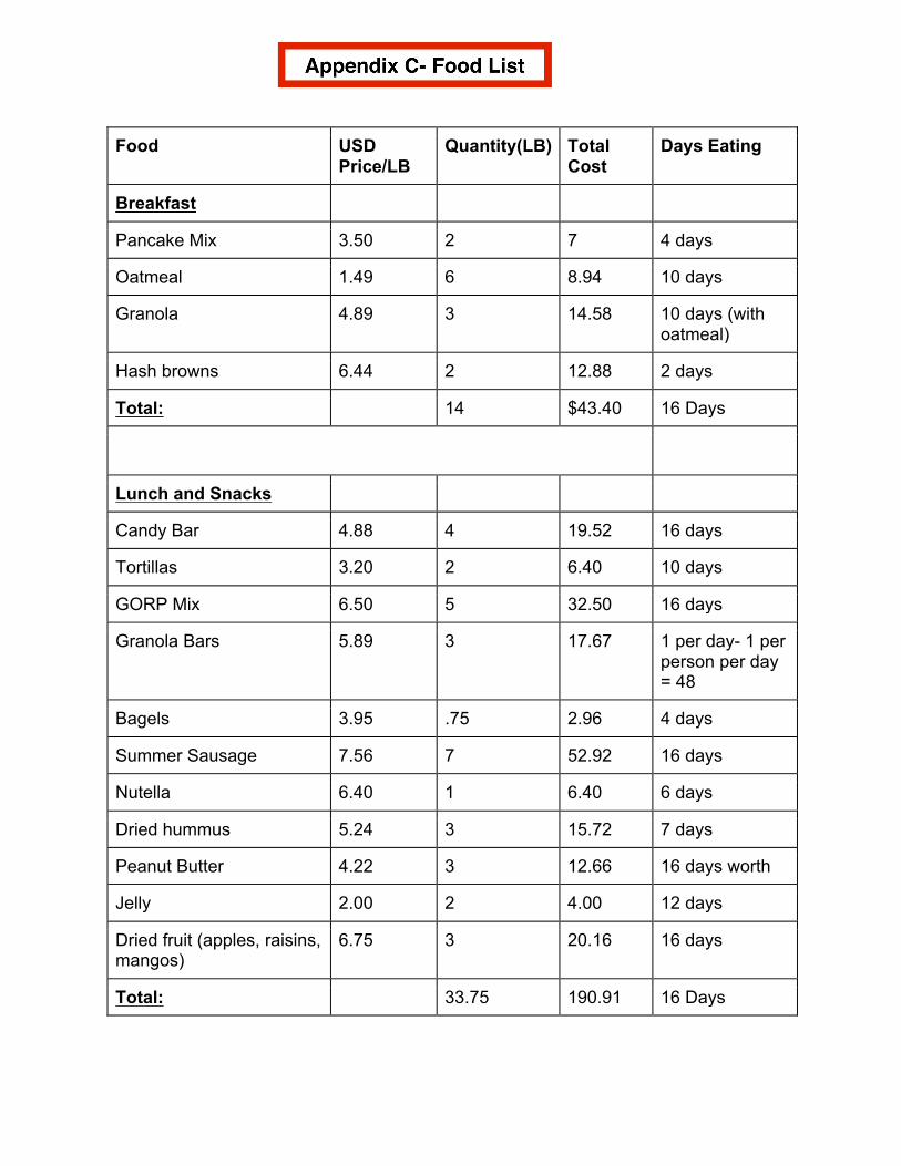
Breakfast
Pancake'Mix 3.50 2 7 4'days
Oatmeal 1.49 6 8.94 10'days
Granola 4.89 3 14.58 10'days'(with'oatmeal)
Hash'browns 6.44 2 12.88 2'days
Total: 14 $43.40 16'Days
Lunch'and'Snacks
Candy'Bar 4.88 4 19.52 16'days
Tortillas' 3.20 2 6.40 10'days
GORP'Mix 6.50 5 32.50 16'days
Granola'Bars 5.89 3 17.67 1'per'dayM'1'per'person'per'day'='48
Bagels' 3.95 .75 2.96 4'days
Summer'Sausage 7.56 7 52.92 16'days
Nutella 6.40 1 6.40 6'days'
Dried'hummus 5.24 3 15.72 7'days
Peanut'Butter 4.22 3 12.66 16'days'worth
Jelly 2.00 2 4.00 12'days'
Dried'fruit'(apples,'raisins,'mangos)
6.75 3 20.16 16'days
Total: 33.75 190.91 16'Days
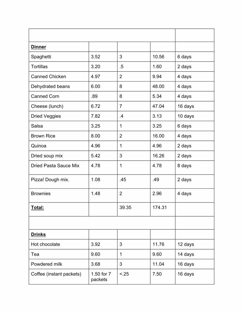
Dinner
Spaghetti' 3.52 3 10.56 6'days
Tortillas 3.20 .5 1.60 2'days
Canned'Chicken 4.97 2 9.94 4'days
Dehydrated'beans 6.00 8 48.00 4'days
Canned'Corn .89 8 5.34 4'days
Cheese'(lunch) 6.72 7 47.04 16'days
Dried'Veggies 7.82 .4 3.13 10'days
Salsa' 3.25 1 3.25 6'days
Brown'Rice' 8.00 2 16.00 4'days
Quinoa 4.96 1 4.96 2'days
Dried'soup'mix 5.42 3 16.26 2'days
Dried'Pasta'Sauce'Mix 4.78 1 4.78 8'days'
Pizza!'Dough'mix.' 1.08 .45 .49 2'days
Brownies 1.48 2 2.96 4'days
Total: 39.35 174.31
Drinks
Hot'chocolate 3.92 3 11.76 12'days'
Tea 9.60 1 9.60 14'days
Powdered'milk' 3.68 3 11.04 16'days
Coffee'(instant'packets) 1.50'for'7'packets
<.25 7.50 16'days

Total: 7.25 39.90
Fresh'Foods
Carrots 2.39 4 9.56 6'days
Broccoli 2.67 4 10.68 6'days
Onions' 1.29 4 5.04 8'days
Peppers 2.99 4 11.96 8'days
Apples 1.59 5 7.95 10'days
Oranges' 1.49 5 7.45 6'days
Total: 26 52.64
Cooking'Add'Ons
Spice'kit'(italian'spice,'cinnamon,'vanilla,'chili,'curry,'salt,'pepper)
Bring'From'Home
16'days
Vegetable'oil Bring'From'Home
16'days
Total: $0.00
Total: 120.35'lbs $501.16'aka.'$10.44'per'person'per'day
!
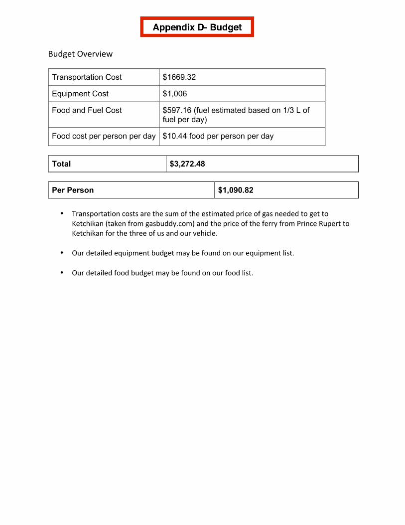
Budget'Overview''
Transportation*Cost $1669.32
Equipment*Cost $1,006
Food*and*Fuel*Cost* $597.16*(fuel*estimated*based*on*1/3*L*of*fuel*per*day)*
Food*cost*per*person*per*day* $10.44*food*per*person*per*day*
Total $3,272.48
Per1Person $1,090.82
'•* Transportation'costs'are'the'sum'of'the'estimated'price'of'gas'needed'to'get'to'
Ketchikan'(taken'from'gasbuddy.com)'and'the'price'of'the'ferry'from'Prince'Rupert'to'Ketchikan'for'the'three'of'us'and'our'vehicle.'''
'•* Our'detailed'equipment'budget'may'be'found'on'our'equipment'list.''
'•* Our'detailed'food'budget'may'be'found'on'our'food'list.''''
'