right-of-way - new · pdf filefunction the process of ... the land titles section of the...
TRANSCRIPT

Highway Design Manual
December 2014
10-1
Chapter 10
RIGHT-OF-WAY
Introduction
The Bureau of Right-Of-Way is responsible for the acquisition, management, and disposal of
all real property under the jurisdiction of the Department. The principle function is the
acquisition of rights-of-way for the construction and improvement of the State’s public
transportation infrastructure. Chapters 228 through 239 of the New Hampshire Revised
Statutes Annotated (RSA) provide authority to layout highways to meet traffic needs and to
outline the steps for acquiring land for highway purposes. The right-of-way process involves
a number of separate functions and continuous coordination with the Bureau of Highway
Design during project development. Chapter 2, Project Development, describes the
interaction between the Bureau of Highway Design, the Bureau of Right-of-Way and others.
This chapter explains Right-Of-Way operations and its relevance to the highway project.
Right-of-Way Operation
The acquisition of right-of-way requires a number of separate functions performed by
cooperating sections within the Bureau of Right-of-Way as described below.
General Organization
Table 10-1 shows the Bureau of Right-of-Way organization chart and depicts the functional
sections of the Bureau. There is a liaison connection to the State’s Attorney General for any
and all legal issues. All formal submissions to the Bureau of Right-of-Way are through the
Section Chiefs or Bureau Administrators (See Appendix 10-1 for Sample ROW Plans
Submittal Memo).
The specific laws governing the right-of-way operation, as that bureau interacts with the
Bureau of Highway Design, are Revised Statutes Annotated (RSA) Chapter 230, State
Highways and RSA Chapter 498-A, Eminent Domain Procedure Act. (1)
Function
The process of obtaining clear right-of-way, both legally and physically, is performed in the
following manner:
The Bureau of Highway Design identifies the project limits based on the project
scope, anticipated construction impacts, associated drainage work, and any other work
that may cause impacts beyond the right-of-way;
The Bureau of Highway Design furnishes an electronic CAD/D plan (pdf) of the
existing detail (including specifically; iron pins, bounds, fences, stone walls and any
evidence of easements, as well as the existing centerline or legacy alignment, if

Highway Design Manual
December 2014
10-2
possible) to the Bureau of Right-of-Way for their use in title research and abstracting.
In turn,
The Land Titles Section of the Bureau of Right-of-Way creates the Existing Right-of-
Way line drawing (ERL) in CAD/D using this existing detail and legacy alignments
which depict rights-of-way, existing easements, and property line locations based on
title research.
The Existing Right-of-Way text drawing (ERT) is also created at this time and
contains text associated with the ERL lines.
This is the process of locating the existing rights-of-way, existing property lines,
verifying property ownership, parcel areas, leases, licenses, easements, other rights
within the property or buildings, and assigning parcel numbers to each property. (See
Appendix 10-2 for the ROW Plan Request Form available in electronic format in the
Highway Design Manual on the Department’s internet);
The Bureau of Highway Design proceeds with development of the proposed highway
improvements to determine right-of-way impacts;
TABLE 10-1
The Bureau of Highway Design initiates public informational and public officials
meetings, in compliance with the Public Involvement Procedures for New Hampshire
Transportation Improvement Projects (2) and the NHDOT Citizen’s Guide to
Transportation Series (8). (The Bureau of Right-of-Way is responsible for setting up

Highway Design Manual
December 2014
10-3
any Public Hearing that may be required – see Appendix 10-16 Request for
Notification for Public Officials/Public Informational Meeting);
The Bureau of Highway Design prepares the Right-of-Way Plans showing the
property to be acquired, required easements, buildings to be removed, and the
relationship of the needed area to the area remaining in the original parcel of land.
(See Appendix 10-8 - Right-of-Way Purchase Plan Checklist);
The Bureau of Highway Design notifies the Bureau of Right-of-Way when property
involving a Federal Energy Regulatory Commission (FERC) Permit is impacted (i.e.
power generating dam). The Bureau of Right-of-Way may not be able to finalize
negotiations with the facility owners until FERC Permit issues have been resolved.
(See Appendix 10-3 for additional FERC information.);
The Acquisition/Relocation Section of the Bureau of Right-Of-Way conducts an
inventory of all features that are within the right-of-way or impacted by the proposed
project;
The Appraisal Section of the Bureau of Right-Of-Way appraises the “damages”
caused by the project and determines a value for those impacts;
The Acquisition/Relocation Section of the Bureau of Right-Of-Way acquires the
right-of-way and easements through negotiation or eminent domain action (which
requires the services of the Attorney General);
The Acquisition/Relocation Section of the Bureau of Right-Of-Way provides
relocation assistance to individuals or businesses displaced by the project. Features
within the Right-of-Way or that are impacted by the project are arranged to be
relocated or removed ;
The Property Manager of the Bureau of Right-Of-Way makes arrangements for
building removal. (Highway Design normally prepares the building demolition
contracts when requested by the Bureau of Right-of-Way); and,
For Federal Aid Projects, the Bureau of Right-of-Way certifies that rights-of-way are
clear (negotiations and settlements finalized) by issuing a Right-Of-Way Certificate at
the PS&E Stage (See Appendix 10-4). More information can be found on ROW and
Real Estate as they pertain to the Federal-Aid Programs under 23 CFR 710.
Project Development Procedure
During project development, the Bureau of Right-of-Way will provide assistance to the
Bureau of Environment as necessary, to address potential social and economic effects that
may result from the proposed improvements. A conceptual stage Relocation Study is
prepared by the Bureau of Right-of-Way for the use of the Bureau of Environment, which
includes information regarding land use, tax base and access impacts. In addition, property
owner and property boundary information may be required for the development of conceptual
mitigation measures.

Highway Design Manual
December 2014
10-4
In preparation for the public involvement process, Right-of-Way may be asked to assist in
securing right-of-entry onto private properties for the purpose of field surveys and
environmental assessment. The Bureau of Right-of-Way may also participate in public
meetings to explain right-of-way acquisition and relocation procedures (See the Public
Involvement Procedures for New Hampshire Transportation Improvement Projects (2) for a
more detailed discussion of public participation opportunities).
The Public Hearing process cannot proceed until all environmental documents have been
processed and approved. Design Approval following the Public Hearing is the culmination
of this process and signifies the point at which right-of-way acquisition can begin.
The following activities are necessary to coordinate the acquisition effort. The Bureau of
Right-of-Way and the Bureau of Highway Design will perform the following:
1. Once preliminary impacts to properties are determined (typically prior to the Public
Officials Meeting), the Bureau of Right-of-Way and the Bureau of Highway Design
should meet to determine if a Public Hearing is necessary. (Generally, if project
construction requires the purchase of additional right-of-way, a Public Hearing is
held; NOTE: Preliminary Design will often request that Final Design complete a pre-
hearing review of the plans to verify location and sizing of proposed easements and
ROW takings. Final Design/Consultant Design will review drainage, drive, slope
matches, etc... for conformance with standard design practices, constructability, and
sizing of proposed easements.
2. Prior to any Public Hearing or the development of Right-of-Way Plans, the Bureau of
Right-of-Way and the Bureau of Highway Design shall meet to finalize the location
and type of proposed right-of-way and easements to present at the Public Hearing;
3. A formal pre-hearing rehearsal, or “dry run”, of the Public Hearing is held to review
minor changes and to familiarize the Commission or the Special Committee with the
project;
4. Following the Public Hearing, the Bureau of Highway Design should request the
Bureau of Right-of-Way review project plans with right-of-way lines and easements,
as depicted at the Slope and Drain Phase, to verify the type and location of proposed
right-of-way and easements before any takes or easement areas are calculated;
5. The Project Manager assigned to the project will formally address all comments
raised at the Hearing (and during the comment period) with the development of the
Report of the Commissioner;
6. Once the Report of the Commissioner has been finalized, the Finding of Necessity
meeting is held to allow the Hearing Commission or appointed Hearing Special
Committee to formally find for or against the necessity of the project;
7. Preliminary Right-of-Way Purchase Plans shall be reviewed with the Right-of-Way
Engineer prior to the formal Right-of-Way Purchase Plans submission; and
8. Shortly after the formal Right-of-Way Purchase Plans submission, the Bureau of
Right-of-Way will request that the Bureau of Highway Design conduct a meeting to

Highway Design Manual
December 2014
10-5
brief the Appraisers and Agents regarding construction details to be considered in
determining right-of-way costs and damages.
9. Agents from the Bureau of Right-Of-Way will negotiate settlements for property
rights either monetarily or by requesting slight modifications to the design. The
Bureau of Highway Design is consulted when changes to the proposed impacts are
requested.
10. After all necessary property rights have been acquired, the Bureau of ROW will issue
a Right-of-Way Certificate for the project.
11. Following receipt of the ROW Certificate, Final Design/Consultant Design will
prepare and submit a signed copy of the final purchase plans to the Bureau of ROW.
Note: Field staking the final right-of-way lines or easements is sometimes requested of the
Survey Section of the Bureau of Highway Design during the Right-of-Way process to allow
property owners to see the location of the proposed right-of-way and easements “on the
ground”.
Right-of-Way Plans
Right-of-Way plans are not included with the construction plans. They are used only to
appraise, acquire, and record the right-of-way necessary for the construction of the project.
Right-of-Way plan sets vary in the number of required sheets and details depending on the
extent of proposed right-of-way impacts on a project.
“Abbreviated” Right-of-Way plans may be appropriate for projects with minor impacts.
Once right-of-way impacts have been identified, the Bureau of Highway Design should
consult with the Bureau of Right-of-Way to determine whether a full or abbreviated set of
plans will be required.
Right-of-Way plans should consist of the items listed in the Right-of-Way Purchase Plan
Checklist (See Appendix 10-8). Rights-of-Way will be flagged on the ROW plans in
accordance with current guidelines (See Appendix 10-14 and 10-15).
Right-of-Way Conveyances
Legal documents are prepared by the Bureau of Right-of-Way to transfer real estate
ownership or other rights from the property owner to the State. The rights are acquired to
accommodate highway/bridge construction, to allow access for maintenance forces, and to
ensure clear sight distance.
Eminent Domain actions are used to acquire property rights (i.e. acquisition, permanent
easements, or temporary easements) when the property owner and the State cannot reach an
equitable agreement. It is important to point out that condemnation cannot occur

Highway Design Manual
December 2014
10-6
without a “successful” Public Hearing, i.e. one on which the Public Hearing
Commission or Special Committee rules in favor of the project. Therefore, any project,
which proceeds without the benefit of a Public Hearing, should be limited to minor
property impacts, which, if necessary, could be eliminated if negotiations with the
property owners are unsuccessful.
Eminent Domain actions (or condemnation proceedings) are a series of legal steps performed
by the State’s Attorney General to obtain private land for public purposes. All condemnation
proceedings are costly, time consuming, and should be avoided whenever possible. At times,
a slight change in design during negotiations or before condemnation proceedings progress
too far can prevent lengthy litigation. It must be realized, however, that the design cannot be
completely controlled by right-of-way considerations and that the Project Manager
responsible for the overall design shall approve any such changes.
The Bureau of Right-of-Way prescribes the type of conveyance to be used and prepares the
documents for acquisition. There is no fixed rule for setting right-of-way widths other than
general guidelines found in the “AASHTO Green Book” (3). Each situation must be
evaluated individually based on the width requirements for the proposed roadway
improvements, the likely cost to acquire the right-of-way, and consideration of the existing
right-of-way layout. Right-of-way widths are determined and laid out by both the
Preliminary Design Section of the Bureau of Highway Design and the Bureau of Right-of-
Way prior to the Public Hearing. The proposed right-of-way shown at the Public Hearing
shall not be altered during the design process without first reviewing the change with the
Front Office. This also applies to significant changes in easements. The Department has
made a commitment to the Executive Council that all changes to Right-of-Way impacts will
be reviewed with the Layout Special Committee/Commission.
Below is a listing and description of the various types of Right-of-Way conveyances.
Whenever possible, acquisitions and easements should conform to these categories.
Acquisitions
Acquisition is the process used by the State to obtain legal possession or control of real
property, or interests therein, required for some aspect of construction or improvement of the
State’s public transportation infrastructure. Chapters 228 through 239 of the New Hampshire
RSA provide authority to layout highways to meet traffic needs.
Easements
This section describes the typical easements encountered on a highway project. Easements
essentially acquire certain defined rights of usage without outright purchase of the property
that the easement is on, and may be temporary or permanent depending on long term
maintenance needs. Permanent easement limits are flagged on the ROW plans, while
temporary easements are not.
Highway Design Manual
December 2014
10-7
Easements (as opposed to acquisitions) often have advantages for the property owner in
relation to zoning. They also may be viewed more favorably for certain environmental
considerations. A figure is included with each following easement description for guidance
in determining its limits. There are other easements encountered on a project such as
guardrail, utility, etc. and for atypical easements such as these, discuss the required limits
with your supervisor.
I. SLOPE EASEMENT
Slope easements can be secured as permanent or temporary easements. The designer should
use judgment in sizing the easements and coordinate with the appropriate District, Turnpikes,
or other maintainer to provide adequate space for the Contractor to accomplish the required
work and to provide an area large enough for maintenance forces to access and maintain the
easement area in the future, as necessary. Roadway fill or cut areas that create steep and/or
long side slopes, and may be subject to erosion, should be purchased as permanent slope
easements due to the likelihood of required maintenance.
Minor grading work with relatively flat, short, side slopes should be purchased as temporary
construction easements. Side slopes of 4:1 or flatter would generally be considered as
temporary construction easements if the flattening of the slope, or otherwise grading to
benefit the property (such as to avoid ponding or improving the property frontage), does not
compromise the integrity of the roadway. However, the designer’s judgment relative to
future maintenance issues should govern this decision. Whether an easement is permanent or
temporary should reflect whether the integrity of the design would be maintained without the
easement being permanent. The Department should not be put in a position that would
require the need for guardrail or other permanent remedial measures should the area be
altered by the property owner after the easement expires.
Figure 10-1 represents an example of a slope easement with slope lines located outside of the
right-of-way. When the slope line enters an existing woods line, a clearing area is required.
This clearing area must be included as part of the easement.
Figure 10-2 illustrates a narrow right-of-way with the proposed roadway ditch constructed
outside of the right-of-way. In this situation, the ditch is part of the roadway typical (cut
section) and will be considered as part of the slope easement. If, however, a closed drainage
system is constructed in the ditch as part of the roadway typical or an active watercourse is
constructed in the ditch, a drainage easement should be obtained rather than a slope
easement.

Highway Design Manual
December 2014
10-8
FIGURE 10-1
FIGURE 10-2

Highway Design Manual
December 2014
10-9
II. DRAINAGE/CHANNEL EASEMENT
There are several different situations that may require drainage easements, such as culvert
inlets and outlets (Figure 10-3), closed system drainage along ditch lines (Figure 10-4), and a
permanent erosion control area (treatment swales, retention basins, etc.) (Figure 10-5). See
Appendix 10-14 and 10-15 for guidance on flagging of easements.
FIGURE 10-3
Figure 10-3 shows a drainage easement at the inlet and outlet of a culvert. Review the
headwater and tailwater to determine if there is a potential for ponding that may affect the
property beyond the intended easement limits. If the hydraulic analysis reflects ponding
occurs beyond these limits, include this area in the easement.
The easement is sized to allow for maintenance of the culvert, its inlet and outlet ditches, and
provides access for the Bureau of Maintenance equipment. Typically, a 20-foot offset from
the center of the pipe, left and right, is sufficient and a minimum of 10-feet beyond the limit
of work. The extent should reflect treatment and erosion control requirements and not an
arbitrary number.

Highway Design Manual
December 2014
10-10
Existing Drainage/Channel Easements should be re-evaluated and new easement(s) may be
required when the replacement pipe is larger than that which exists, the anticipated flow will
be greater, or if the grading in the area substantially changes the old ground.
Figure 10-4 illustrates a drainage easement for a closed drainage system. This easement is
purchased to allow enough area to construct and maintain the system. This easement is
evaluated by the trench excavation slope requirements provided by the Occupational Safety
and Health Administration (OSHA). These guidelines are outlined in “29 CFR Part 1926
OSHA Sub-Part P Excavations and Trenches” (7) and are based on assumed soil types.
When sizing drainage easements, a 1:1 slope excavation is typically used, starting from the
bottom of the trench up to the ground surface. Additional information and guidance provided
in the Geotechnical Report should be considered, if available. Normally, drainage easements
are secured when other methods that could be used for excavation to limit impacts are
deemed impractical, i.e. trench boxes or other shoring methods.
FIGURE 10-4

Highway Design Manual
December 2014
10-11
Figure 10-5 illustrates a drainage easement that includes a drainage pipe, stone protection,
and treatment swale. Size the easement to include adequate access for the Bureau of
Maintenance equipment to maintain the permanent erosion control treatment areas. The
easement is typically set 10 feet beyond the slope line.
FIGURE 10-5
The Bureau of Bridge Design typically determines channel easements, unless the project is a
slope stabilization project along a riverbank. The outside limit of this type of easement is
also typically 10 feet from the limit of the stone.
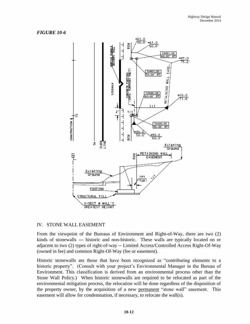
III. RETAINING WALL EASEMENT
This type of easement is becoming more and more common, especially in urban areas where
the NHDOT is trying to limit property impacts. Figure 10-6 depicts the standard practice in
determining the new right-of-way line and limit of the easement. The new right-of-way is
typically 1 foot behind the back of the footing at the point of the wall’s greatest height. This
will keep the entire retaining wall within the right-of-way. The limit of the (permanent)
easement is determined by the OSHA trench excavation requirements, typically a 1:1 back
slope. (See the drainage easement section for additional information regarding limitations of
open excavation vs. shoring options.). Since the height of the retaining wall has a direct
relationship to the new right-of-way and easement, use discretion in the layout and don’t
“zigzag” the right-of-way or easement lines. Design the right-of-way to be a constant offset
from the face of the retaining wall, tapering the easement as required. In some cases, a
temporary easement may be necessary for the construction of the wall (i.e. for sheet piling or
room required to access the top portion of the wall).
Highway Design Manual
December 2014
10-12
FIGURE 10-6
IV. STONE WALL EASEMENT
From the viewpoint of the Bureaus of Environment and Right-of-Way, there are two (2)
kinds of stonewalls --- historic and non-historic. These walls are typically located on or
adjacent to two (2) types of right-of-way -- Limited Access/Controlled Access Right-Of-Way
(owned in fee) and common Right-Of-Way (fee or easement).
Historic stonewalls are those that have been recognized as “contributing elements to a
historic property”. (Consult with your project’s Environmental Manager in the Bureau of
Environment. This classification is derived from an environmental process other than the
Stone Wall Policy.) When historic stonewalls are required to be relocated as part of the
environmental mitigation process, the relocation will be done regardless of the disposition of
the property owner, by the acquisition of a new permanent “stone wall” easement. This
easement will allow for condemnation, if necessary, to relocate the wall(s).

Highway Design Manual
December 2014
10-13
All other stonewalls: are considered non-historic and those found eligible for
reconstruction/relocation by the Stone Wall Policy Committee do not require easements to
relocate since any relocation is considered voluntary. The property owner grants a right-of-
entry for the reconstruction/relocation and enters into a covenant with the State for
preservation/maintenance of the stonewall(s). These non-historic stonewalls will be shown in
their proposed locations on both the Right-of-Way and Construction plans. An entry
representing the total linear length of non-historic stonewalls to be relocated will be shown in
the remarks column on the Right-of-Way Summary Sheet for each parcel involved. The
relocations are tentative, pending the results of negotiations with the property owner(s).
Historic and non-historic stonewalls are relocated identically with respect to the different
types of right-of-way. The following guidelines may be used in placing these walls, subject
to constructability, clear zone requirements, etc.:
1) Figure 10-7 Stonewalls with LAROW/CAROW
FIGURE 10-7
The roadway faces of these walls are typically set behind the right-of-way line sufficiently
(typically 3 feet) to allow maintenance of the wall by the property owner without encroaching
onto the Right-of-Way. A detail shall be included in the Construction plans to clearly
indicate the wall offset from the Right-of-Way line. At least one (1) right-of-way bound will

Highway Design Manual
December 2014
10-14
be placed within the longitudinal limits of each wall to indicate that the face of the stonewall
does not represent the right-of-way line.
2) Stonewalls with common Right-Of-Way
The roadway faces of these walls will be set at the Right-of-Way line when possible, or
beyond the Right-of-Way line when physical conditions dictate.
V. SIGHT LINE EASEMENT
Figure 10-8 depicts the Sight Line Easement required at intersections to provide a clear area
for a vehicle driver’s line of sight. (Refer to Chapter 4 for sight distance calculations.)
This easement is typically set 10 feet off the sight line and legally prohibits the property
owner from placing any physical objects (signs, bushes, trees, etc.) within the easement that
may hinder sight distance. This easement is typically secured at intersections where
acquisition of right-of-way is not feasible or deemed unnecessary.
FIGURE 10-8

Highway Design Manual
December 2014
10-15
VI. TEMPORARY EASEMENTS
These easements are broken down by description and purpose, e.g. traffic control during
construction, driveways (including walkways), drainage, and construction. They allow the
Contractor to temporarily access the property to construct the work required on the plans. In
most cases, except for a driveway or walkway, the Contractor will reestablish the disturbed
area as near as possible to its original state. All temporary easements will have a duration
and an expiration date. The duration is typically the construction time frame for the entire
project. The expiration date should be coordinated with the Bureau of Right-of-Way. This
date may be an expiration date, commonly one year after the project’s completion date, or
established as distant as 10 years beyond the project completion date to allow for construction
delays that may occur, and to avoid the need for re-acquisitions. Exceptions may apply for
landscaping considerations, functional replacements, environmental considerations, etc. This
additional time allows for any necessary remedial work. (Temporary easements do not
require flagging on the Right-Of-Way plans.)
Figure 10-9 illustrates a Temporary Drive Easement. The temporary drive easement is the
limit of work to construct the portion of the drive match that is outside the roadway slope
limit and outside the right-of-way. The area should include any walkways on the parcel. A
dashed line is shown on the Right-Of-Way plans to differentiate between the slope and drive
easement.
FIGURE 10-9

Highway Design Manual
December 2014
10-16
Figure 10-10 shows a Temporary Traffic Control Easement that encompasses the limits of a
detour roadway, or temporary widening, required to maintain traffic during construction.
Generally, the easement line is set 10 feet beyond the proposed slope line. This allows the
Contractor room to construct temporary erosion control measures, as needed. Where slope
lines vary, the designer should set a logical offset rather than “zigzag” the easement along the
slope line.
FIGURE 10-10
VII. COMBINATION EASEMENTS
Figure 10-11 illustrates several overlapping easements (drainage, channel, slope, and
temporary traffic control). Each easement is calculated separately to the right-of-way line.
The easements are calculated separately because each represents a different purpose for
which the same area of land can be used. These areas assist the Appraiser in determining

Highway Design Manual
December 2014
10-17
compensation for the affected property owner. However, the total value of the combined
easements shall not exceed the value of the property itself.
FIGURE 10-11
VIII. UTILITY EASEMENT
This type of easement should be limited to instances where it is necessary to accommodate
relocation of existing utilities because of limited right-of-way and in conjunction with other
permanent easements. The limit of the easement for aerial utilities must account for the cross
arms supporting the electric conductors and the conductors and cables between utility poles.
The limit of the easement for underground utilities is determined by the OSHA trench
excavation requirements, typically a 1:1 back slope. (See the drainage easement section for
additional information regarding limitations of open excavation vs. shoring options.). There
is limited necessity for an easement to accommodate an underground utility as the clearance
from the edge of pavement is not required. Design the easement to be a constant offset from
the utility poles or underground structures without “zigzagging” the easement lines.
Access Control
Right-of-Way lines may be established as common Right-of-Way, Limited-Access Right-of-
Way, or Controlled-Access Right-of-Way. The laws regulating the power of establishment
are found in RSA, Chapter 230.
(Common) Right-of-Way purchase (without access control), allows the abutting property
owner reasonable access to the road and is the least restrictive type of right-of-way. New
driveway access points or changes to existing drives due to property development are subject

Highway Design Manual
December 2014
10-18
to review and permitting by the District Maintenance Engineer and in some instances, by the
Highway Design Administrator. Under normal circumstances, the “reasonable” access to the
road is controlled by the Administrative Rules for the Permitting of Driveways and Other
Accesses to the State Highway System (4).
Limited Access Right-of-Way (LAROW) prohibits any access to the highway except at road
intersections or interchanges. (Limitation of access is a significant design consideration and
greatly improves the safety and operational characteristics of the highway.)
Controlled Access Right-of-Way (CAROW) is less restrictive than Limited Access Right-of-
Way. Private access at grade is permitted along the highway at access points determined
through the Public Hearing process. The “Report of the Commissioner,” prepared after the
Public Hearing, will show all previous access points and those granted as a result of the
Hearing. Each of the points is clearly shown on the Right-of-Way Purchase Plans. If no
points of access are granted, then that statement should be clearly stated on the Right-of-Way
Plans as “zero points of access”. Control or limitation of access can have significant impacts
to property value.
Fencing Right-of-Way
Right-of-Way is sometimes fenced for safety and to prevent trespass and/or encroachment.
The decision to fence right-of-way is based upon the type of right-of-way, the practicality of
installing (and maintaining) the fencing, and the relative benefits to it being fenced.
Normally, common Right-of-Way is not fenced, however, there may be safety concerns,
requests from the abutting property owner, or where an existing privately owned fence is
removed from within the existing Right-of-Way and set back onto the property along the
Right-of-Way line. Controlled Access Right-of-Way (CAROW) is more often fenced as part
of a Right-of-Way Agreement, to enhance safety, to discourage encroachment, or where
unauthorized access issues have been a problem in the past. In virtually all cases, Limited
Access Right-of-Way (LAROW) is fenced. There may be a rare exception.
Preliminary Design will sometimes provide a “Fencing Review” paragraph in the
Engineering Report for those Interstate 4R projects describing, in general, the status of the
existing fencing and the extent of anticipated involvement, especially regarding chain link
fence recommendations.
Existing Fencing
The condition of existing Right-of-Way fence along CAROW or LAROW should be
carefully evaluated when considering repair or replacement. If portions are missing or appear
to be approaching the end of their useful service life, they should be replaced. Within
interchanges or where the facility crosses another roadway, ensure that the proper type of
fence is used for the situation. For example, if it is a residential area or an area susceptible to
encroachment and these encroachments would present a safety problem, use chain link fence
5 or 6 feet high. Most of the time, woven wire fence is used along LAROW.

Highway Design Manual
December 2014
10-19
On Interstate Maintenance (4R) projects, it may not be reasonable to walk the full length of
the mainline LAROW along both barrels to evaluate fence condition. Conduct the field
review by whatever method that results in complete and intact fencing.
Proposed Fencing
When fencing CAROW, be aware of the physical limitations of the area. Certain portions of
the State have terrain that, when combined with the Right-of-Way width, do not permit the
new fencing to be placed on undisturbed ground. Instead, it would need to be placed on a 2:1
or 4:1 slope if the Right-of-Way were to be fenced. This would create a construction
problem and be aesthetically unacceptable. In this case, the CAROW would not be fenced
unless the safety implications outweigh the complications of installation, as may be the case
where chain link fence is warranted.
Public Meetings
Public Hearings are nearly always necessary before right-of-way, including easements, can be
acquired. Hearings, and some Public Informational Meetings, are attended by Bureau of
Right-Of-Way representatives, and the logistics of Public Hearing arrangements are
performed by Bureau of Right-Of-Way personnel. The Presentation at Public Hearing
section of the Public Involvement Procedures for New Hampshire Transportation
Improvement Projects (2) explains the procedure and conduct of the design Public Hearing
where the public is made aware of the proposed Right-Of-Way requirements.
Public Hearings afford the opportunity for property owners to comment on features of the
project which may affect their property. They also learn about their rights and public
assistance available to them.
When the preferred alternative is determined to require takings and/or relocation of either
residences or businesses and thus a Public Hearing is anticipated, the Bureau of Right-Of-
Way shall be notified to perform a relocation study. This information is needed for the
Environmental Document as well as the Public Hearing.
The following outlines the process and time frames required to schedule a Public Hearing:
1. For projects on State Highways, a Commission or Special Committee must be
appointed by the Governor and Council to conduct the Hearing.
2. Generally, a Special Committee conducts Public Hearings that involve
purchasing new LAROW or CAROW. A Commission conducts Public
Hearings involving purchase of (common) ROW. Special Committees are
typically made up of three members of the Executive Council and chaired by
the Councilor within whose district the project resides. Commissions are
made up of three members of the public nominated by the Councilor within
whose district the project resides and appointed by the Executive Council.
3. At the 29% design stage and three to four months prior to the earliest desired
Hearing date; the lead person will submit a “project description” to the Bureau

Highway Design Manual
December 2014
10-20
of Right-of-Way requesting the formation of a Public hearing Commission or
Special Committee. The description will note if there is access control,
municipally owned parks, conservation land, or condominiums and will be
accompanied by a memo stating the anticipated time frame for the Hearing.
The lead person is typically the Chief of Preliminary Design, however, some
projects are “led” by Bridge Design, the Municipal Highways Engineer, or a
Project Manager.
4. At the 29% design stage and concurrent with the request to set up the public
Hearing Commission or Special Committee, the lead person will circulate a
“Request for Public Hearing Checklist” (see Appendix 10-5) within the
Bureau of Highway Design (including the Survey and Utility sections), the
Bureau of Environment, and the Bureau of Right-Of-Way. The form requires
target dates for various tasks to be completed prior to holding the Hearing.
The form also suggests time frames for completing the final design and the
right-of-way process in an effort to set the advertising date.
5. Once the form has circulated, the lead person forwards a Request for Public
Hearing memo (See Appendix 10-12) to the Bureau of Right-of-Way
requesting a Public Hearing. The request includes the following:
A suggested Hearing date, length of presentation boards required, and
anticipated attendance;
Basic purpose and need for the project, background information
concerning how the project was initiated, and the funding involved;
Utility companies to be notified;
Local, State, and Federal agencies and public interest groups (e.g. citizen
committees, natural resource/environmental, etc.) to be notified;
Identification of residences and businesses to be acquired;
Type of environmental documentation and whether wetlands or flood
plains are impacted;
A copy of the completed “Request for Public Hearing Check List”.
Impacts to Municipal land used for conservation or recreation (if
applicable).
6. The Bureau of Right-of-Way will then schedule a Public Hearing date and
location, and prepare notification to officials, agencies, and affected property
owners.
7. The Bureau of Right-of-Way will publish the Hearing notice twice. First, 6
weeks (5 weeks minimum) in advance of the Hearing date and second, 10-15
days in advance of the Hearing. Just prior to sending notices to the
newspapers, the Bureau of Right-of-Way will contact the lead person to

Highway Design Manual
December 2014
10-21
confirm that the Hearing date is acceptable and that all tasks will be completed
as required. In particular, the lead person needs to confirm that the
environmental document will be completed and available for public review 30
days prior to Public Hearing. (Notices indicate that the environmental
documents are available.)
8. The Bureau of Right-of-Way will send notices to officials, agencies, and
affected property owners typically 30 days (15 days minimum per RSA) in
advance of the Hearing.
9. In the event that tasks will not be completed as expected, the Bureau of Right-
of-Way will schedule a new date and notices will be amended. Again, just
prior to publication, the Bureau will confirm the date with the lead person.
10. If a Hearing date must be moved, the lead person will send a memo to the
Director of Project Development detailing why the date is being moved and
identifying a new date.
11. Special consideration, in terms of lead-time, must be given in the case of
Hearings to be held as joint Hearings with the Army Corps of Engineers and
for projects with a large number of affected property owners.
12. Projects impacting municipal land used for conservation or recreational
purposes must be posted at least 90 days in advance of the Hearing per State
law. The lead person will provide a description, the area of land impacted
(dual dimensioned), and mitigation required as part of the Hearing request
memo. The Land and Community Heritage Investment Program (LCHIP) is
an independent state authority that makes matching grants to NH communities
and non-profits to conserve and preserve New Hampshire’s natural, cultural,
and historic resources. If LCHIP land is impacted on a project, an
independent Hearing is required and coordination is completed through the
Bureau of Environment.
13. The process and time frames are similar for Public Hearings held for projects
involving Class IV and V Highways, with the exception that Governor and
Council participation is not required and all owners must be notified 30 days
in advance.
14. If a condominium is involved in the project, notification to owners must be
made 30 days in advance.
Relocation Assistance
Public Highways and Your Property (5) is a publication by the NHDOT that explains the
Relocation Advisory Assistance Program and the Relocation Payment Program. If it is
necessary to relocate a home or business, the assigned Agent administers the programs and
works with the property owner(s) to minimize their inconvenience.

Highway Design Manual
December 2014
10-22
The designer should be aware of such services, however, other than providing information to
the Agent, the designer has no involvement in this process.
Utilities
The cost to relocate public and private utilities that exist on private property and that are
impacted by transportation projects is reimbursed by the Bureau of Right-of-Way as a project
cost. The Acquisition/Negotiation Section of the Bureau of Right-Of-Way coordinates with
the Utilities/Design Services (Utilities) Section of the Highway Design Bureau to accomplish
the required work and to provide associated payments for reimbursement for the required
utility relocations.
Typically, the Utilities Section will assist in the coordination and review of utility relocation
plans, cost estimates, and agreements as needed, and the Bureau of Right-Of-Way will
process payments for reimbursable charges for the relocation work. Utility relocation plans
and cost estimates are generally prepared by the utility or their consultant. If the utility is not
responsible to prepare such plan and cost estimate technical assistance from outside the
Bureau will be required to prepare a relocation plan, specifications and quantity and cost
estimate to be incorporated into the project construction documents.
Building Removal
The Property Management Section of the Bureau of Right-Of-Way administers buildings
purchased by the NHDOT as part of a project, until they can be sold, moved or demolished as
part of a project. If a building is to be demolished, the designer will typically advertise a
separate demolition contract or include the demolition as an item in the project contract. The
Right-of-Way Engineer will coordinate with the Bureau of Highway Design if buildings are
to be demolished. Prior to demolition, the Bureau of Right-Of-Way will arrange to have the
asbestos and hazardous materials that exist within the structure surveyed, so quantities and
locations can be estimated. A report detailing these materials will be developed and provided
to the Bureau of Highway Design for inclusion in the construction contract. (Building
Demolition includes decommissioning septic systems, removal of miscellaneous debris, and
sealing wells.) A Building Demolition Checklist (See Appendix 10-10) has been developed
to assist the project designer in documenting demolition requirements.
Reclassification
When highways are reclassified and returned to towns, the NHDOT may, at its discretion,
rehabilitate the pavement and/or provide other improvements such as cleaning and reshaping
ditch lines. If federal funds were used to obtain the original right-of-way,
reclassification/disposal is subject to 23 CFR620.201, .202, .203. Improvements made on a
roadway on behalf of a Town taking back a former federal-aid state road are not eligible for
federal participation.

Highway Design Manual
December 2014
10-23
The Bureau of Highway Maintenance handles the reclassification of Class I, II and III
highways removed from the State system as a result of relocation.
The classification of service or frontage roads, and reconstructed or relocated Class IV and V
roads, are handled in the following manner:
1) At the Pre-hearing meeting with town or city officials, the NHDOT
representative will call their attention to any proposed service or frontage
roads and any proposed relocations or reconstruction of existing Class IV or
V roads. The representative will also advise that such sections be classified
as Class IV or V, as the case may be, with the NHDOT assuming no
responsibility for continued maintenance.
2) At the completion of the project plans, the Bureau of Highway Design will
notify the Right-of-Way Engineer, in writing, of such roads, furnishing two
copies of plans clearly noting such roads (See Appendix 10-7 Roadway
Reclassification Memo). To avoid failure of notification, the Bureau of
Highway Design includes this in their Right-Of-Way Plans Checklist and
Distribution of Plans list sheet for the project.
3) Near the completion of the construction, the Right-of-Way Engineer will
prepare, for the Commissioner’s signature, a letter of formal notice to the
town or city officials, enclosing a plan, and noting the classification and
mileage of the road(s) involved.
Urban Compact relocation is a function of the Bureau of Highway Maintenance and the
Bureau of Planning and Community Assistance.
Disposal of State Owned Land
When rights-of-way are no longer needed due to road relocation or re-alignment, the land is
sometimes returned to the town, or made available to abutting land owners. The disposal of
unnecessary land or roads relieves the Bureau of Maintenance of physical and financial
responsibility which is an advantage that should be considered. Any existing easements
which are on the property, and need to be perpetuated, should be retained.
The Bureau of Highway Design becomes involved to verify that the land is no longer needed
for future NHDOT projects; while the Bureau of Right-of Way is responsible for related
hearings, advertising, and other legal arrangements. (See Appendix 10-13 Request for
Disposal of State Owned Land)
Final ROW Plans
Issuance of the Right-of-Way Certificate signifies that all property rights have been acquired
for a project. At this point, Final Record Plans and Documents are prepared for filing with

Highway Design Manual
December 2014
10-24
the Bureau of Right-Of-Way. There are two types of final right-of-way plans; Purchase
(Appraisal) ROW Plans and Registry ROW Plans.
Right-Of-Way Purchase Plans (A.K.A. Appraisal Plans)
The Bureau of Highway Design prepares ROW Purchase (Appraisal) Plans specifically for
use by the Department’s Right-Of-Way Agents and Appraisers. These plans are used in-
house for negotiation and purchasing purposes, and are not forwarded to the County
Registries.
Hatching and shading previously used in the development of formal right-of-way plans, and
no longer accepted by the County Registries, is allowed and preferred. Abstracting notes
(such as tax map info) are also included on the plans. Plan production is an iterative process
therefore it is good practice for the highway designer to meet with the Bureau of ROW, to
provide an overview of impacts and receive feedback on preliminary plans, prior to a formal
plan submission. (Refer to Appendix 10-8 for the ROW Purchase Plan Checklist and
Appendix 10-1 for ROW Plan Submittal Memo)
Final record plan set: After the ROW Certificate is issued, half scale (11 x 17) copies of the
Right-of-Way Purchase Plans including a signed front sheet are submitted to the Bureau of
Right-of-Way. These become the “Record Plans” and are filed in the Records Section of the
Bureau of Highway Design.
Right-Of-Way Registry Plans
Registry ROW Plans are filed in the County Registry of Deeds for the county in which the
project is located. Different registries may have specific border and varying plan filing
requirements (see Appendix 10-11 Plat Law), however, most New Hampshire County
Registrars have agreed to accept NHDOT right-of-way plans in a single format. Typically,
the recorded registry plans consist of the Front Sheet, Property Layout and Right-of-Way plan
sheets for the project. All sheets must be 22” x 34” (559 x 864 mm). These plans are printed
on mylar using an inkjet plotter and must not have any shading, hatching, or obscured text.
(See Appendix 10-9 for the Registry Plan Checklist).
When right-of-way acquisitions have been secured (ROW Certificate Issued), Final Right-of-
Way mylars from the Bureau of Highway Design will be submitted. The Front Sheet of these
plans are stamped and signed by the responsible Professional Engineer in the Bureau of
Highway Design (normally the Administrator) or the Consultant responsible for the design.
The following personnel also sign the front sheet:
1) “Approved by” the Bureau of Right-of-Way Administrator.
2) “Recommended for Approval by” Director of Project Development and Municipal
Highways Engineer, if Town or City monies/funds are involved in the contract.
3) “Approved by” the Assistant Commissioner.
Note: ROW plans sent to the print shop normally will not be signed.

Highway Design Manual
December 2014
10-25
References:
1. New Hampshire Revised Statutes Annotated, 1993
2. New Hampshire Department of Transportation (NHDOT), Public Involvement
Procedures for New Hampshire Transportation Improvement Projects, NHDOT,
7 Hazen Drive, Concord, N.H., January 1995
3. American Association of State Highway and Transportation Officials (AASHTO),
A Policy on Geometric Design of Highways and Streets (Green Book), AASHTO,
444 North Capitol Street, N.W., Suite 249, Washington, D.C., 2004
4. New Hampshire Department of Transportation (NHDOT), Administrative Rules
for the Permitting of Driveways and Other Accesses to the State Highway System,
NHDOT, 7 Hazen Drive, Concord, N.H., 2000
5. New Hampshire Department of Transportation (NHDOT), Public Highways and
Your Property, NHDOT, 7 Hazen Drive, Concord, N.H., April 1991
6. New Hampshire Department of Transportation (NHDOT), Right-Of-Way Manual,
NHDOT, 7 Hazen Drive, Concord, N.H., June 20, 2011
7. Occupational Safety & Health Administration (OSHA), 29CFR Part 1926 OSHA
Subpart P Excavations and Trenches, Federal Register: Rules and Regulations,
October 1989
8. New Hampshire Department of Transportation (NHDOT), NHDOT Citizen’s
Guide to Transportation Series, NHDOT, 7 Hazen Drive, Concord, N.H., August
2001

APPENDICES
10-1 Sample Right-Of-Way Plan Submittal Memo
10-2 ROW Plan (aka abstracting) Request Form
10-3 Federal Energy Regulatory Commission
10-4 Right-Of-Way Certificate
10-5 Request for Public Hearing Checklist
10-6 Request for Public Officials/Public Informational Meeting
10-7 Roadway Reclassification Memo
10-8 ROW Purchase Plans Checklist
10-9 Registry ROW Plan Checklist
10-10 Building Demolition Checklist
10-11 Plat Law, RSA 478; 1-a
10-12 Request for Combined Corridor Design Public Hearing
10-13 Request for Disposal of State Owned Land Memo
10-14 Guide for Use of +/- for Flagging of Approximate Rights-of-Way
10-15 Guide for Use of +/- for Flagging of Rights-of-Way