revised september 2014 - eirgrid
TRANSCRIPT

Revised September 2014

REPORT
PROJECT: Grid West Project
CLIENT: EirGrid Plc The Oval 160 Shelbourne Road Ballsbridge Dublin 4
COMPANY: TOBIN Consulting Engineers Block 10-4 Blanchardstown Corporate Park Dublin 15
www.tobin.ie

AMENDMENT RECORD
Client: EirGrid Plc Project: Grid West Project Title: Appendix 6.2 of Lead Consultants Stage 1 Report - Route Corridor Options
Evaluation Report
PROJECT NUMBER: 6424 DOCUMENT REF: 6424-B 6424 Appendix 6.2 Route Corridors Options Evaluation Report doc
B Amendments from Feedback GC/BJD 19/09/14 BJD 19/09/14 BJD 19/09/14A Final Issue MH 21/02/13 DG 21/02/13 MG 21/02/13
Revision Description & Rationale Originated Date Checked Date Authorised Date TOBIN Consulting Engineers

Errata and Amendments
Page Section Amendment 22, 23, 24, 25 and 26
2.3.1 References to N69 corrected to read N59
89 2.7.1 Table 2-8 corrected wrt crossings of existing 38kV lines in corridor B1 / B5 / B6 / B9
91 2.7.1 Text of “Existing Utilities & Infrastructure” revised to reflect correction in Table 2-8.
104 3.1.1 Headings and colours in Table 3-1 corrected to reflect text in Section 3.1.1
110 3.3.1 Table 3-7 corrected to reflect text in Section 3.3.1 119 3.6.1 Table 3-17 corrected to reflect text in Section 3.3.2 129 4.1.1 Table 4-1 corrected to reflect text in Section 4.1.1

Page (i)
TABLE OF CONTENTS
1 INTRODUCTION ........................................................................................................................................................ 1
1.1 ROUTE CORRIDOR EVALUATION CRITERIA ................................................................................................. 2
2 ENVIRONMENTAL OVERVIEW OF ROUTE CORRIDOR OPTIONS ....................................................................... 6
2.1 SETTLEMENTS ................................................................................................................................................. 6 2.2 ECOLOGY .......................................................................................................................................................... 8 2.3 LANDSCAPE .................................................................................................................................................... 21 2.4 GEOLOGY ....................................................................................................................................................... 39 2.5 WATER ............................................................................................................................................................ 43 2.6 CULTURAL HERITAGE ................................................................................................................................... 47 2.7 TECHNICAL ..................................................................................................................................................... 87 2.8 LENGTH OF ROUTE CORRIDOR ................................................................................................................. 101
3 COMPARATIVE EVALUATION OF ROUTE CORRIDOR OPTIONS .................................................................... 103
3.1 SETTLEMENTS ............................................................................................................................................. 104 3.2 ECOLOGY ...................................................................................................................................................... 106 3.3 LANDSCAPE .................................................................................................................................................. 109 3.4 GEOLOGY ..................................................................................................................................................... 113 3.5 WATER .......................................................................................................................................................... 115 3.6 CULTURAL HERITAGE ................................................................................................................................. 117 3.7 TECHNICAL ................................................................................................................................................... 122 3.8 LENGTH OF ROUTE CORRIDOR ................................................................................................................. 126
4 LEAST CONSTRAINED ROUTE CORRIDOR OPTIONS ...................................................................................... 128
5 CONCLUSIONS ..................................................................................................................................................... 138

Page (ii)
TABLES & APPENDICES
LIST OF TABLES Table 1-1 Criteria for Route Corridor Option Evaluation .......................................................................................... 3
Table 2-1 Number of Settlements within the Bellacorick Route Corridor Options ................................................... 7
Table 2-2 Number of Settlements within the Cashla Route Corridor Options ......................................................... 7
Table 2-3 Number of Settlements within the Flagford Route Corridor Options ....................................................... 8
Table 2-4 Significance of Bird Sites/ Flight Lines .................................................................................................. 10
Table 2-5 Summary of type and quantity of cultural heritage sites associated with the Bellacorick study area .... 49
Table 2-6 Summary of type and quantity of cultural heritage sites associated with the Cashla study area ........... 55
Table 2-7 Summary of type and quantity of cultural heritage sites associated with the Flagford study area ......... 76
Table 2-8 Technical Evaluation of Bellacorick Route Corridors ............................................................................ 89
Table 2-9 Technical Evaluation of Cashla Route Corridors ................................................................................... 94
Table 2-10 Technical Evaluation of Flagford Route Corridors ................................................................................. 98
Table 2-11 Length of the Bellacorick Route Corridor Options ............................................................................... 101
Table 2-12 Length of the Cashla Route Corridor Options ..................................................................................... 102
Table 2-13 Length of the Flagford Route Corridor Options ................................................................................... 102
Table 3-1 Bellacorick Route Corridor Options Evaluation ................................................................................... 104
Table 3-2 Cashla Route Corridor Options Evaluation ......................................................................................... 105
Table 3-3 Flagford Route Corridor Options Evaluation ....................................................................................... 105
Table 3-4 Bellacorick Route Corridor Options Ecology Evaluation ...................................................................... 107
Table 3-5 Cashla Route Corridor Options Ecology Evaluation ............................................................................ 108
Table 3-6 Flagford Route Corridor Options Ecology Evaluation .......................................................................... 108
Table 3-7 Bellacorick Route Corridor Options Landscape Evaluation ................................................................. 110
Table 3-8 Cashla Route Corridor Options Evaluation ......................................................................................... 111
Table 3-9 Flagford Route Corridor Options Evaluation ....................................................................................... 112
Table 3-10 Bellacorick Route Corridor Options Evaluation ................................................................................... 113
Table 3-11 Cashla Route Corridor Options Evaluation ......................................................................................... 114
Table 3-12 Flagford Route Corridor Options Evaluation ....................................................................................... 114
Table 3-13 Bellacorick Route Corridor Options Evaluation ................................................................................... 115
Table 3-14 Cashla Route Corridor Options Evaluation ......................................................................................... 116
Table 3-15 Flagford Route Corridor Options Evaluation ....................................................................................... 116
Table 3-16 Bellacorick Route Corridor Options sites rated ................................................................................... 118
Table 3-17 Bellacorick Route Corridor Options Evaluation ................................................................................... 119
Table 3-18 Cashla Route Corridor Options sites rated .......................................................................................... 119
Table 3-19 Cashla Route Corridor Options Evaluation ......................................................................................... 120
Table 3-20 Flagford Route Corridor Options sites rated ........................................................................................ 120
Table 3-21 Flagford Route Corridor Options Evaluation ....................................................................................... 121
Table 3-22 Bellacorick Route Corridor Options Evaluation ................................................................................... 123
Table 3-23 Cashla Route Corridor Options Evaluation ......................................................................................... 124
Table 3-24 Flagford Route Corridor Options Evaluation ....................................................................................... 125

Page (iii)
Table 3-25 Bellacorick Route Corridor Options Evaluation ................................................................................... 126
Table 3-26 Cashla Route Corridor Options Evaluation ......................................................................................... 127
Table 3-27 Flagford Route Corridor Options Evaluation ....................................................................................... 127
Table 4-1 Bellacorick Route Corridor Options Evaluation ................................................................................... 129
Table 4-2 Cashla Route Corridor Options Evaluation ......................................................................................... 131
Table 4-3 Flagford Route Corridor Options Evaluation ....................................................................................... 133
Table 4-4 Least Constrained Corridors; Cashla / Flagford .................................................................................. 134
Table 4-5 Length of Least Constrained Route Corridors to Bellacorick, Cashla & Flagford ................................ 135
LIST OF FIGURES
Figure 1-1 Route Corridor Options ........................................................................................................................... 5
Figure 4-1 Least Constrained Route Corridor Option B1/B2/B3/B9 F1/F3/F6/F7 ................................................. 138
ANNEX ANNEX 2.1 Stage 1 Report - Appropriate Assessment Screening Report

Page 1
1 INTRODUCTION This report sets out how the route corridor options to each of the representational groups were evaluated and compared in order to identify the least constrained Bellacorick route corridor option, the least constrained Cashla route corridor option and the least constrained Flagford route corridor option. Chapter 1 sets out the evaluation method applied in order to appraise route corridor options. Chapter 2 provides a description of the route corridor options taking into account the relevant constraints and within these the identified evaluation criteria which influence the evaluation of route corridor options. This evaluation is divided into the three sectoral groups; Bellacorick, Cashla and Flagford route corridor options. Chapter 3 essentially comprises a comparative multi criteria evaluation of the route corridor options, in order to identify a least constrained route corridor option to Bellacorick, Cashla and Flagford. This was developed by identifying key criteria and evaluating those criteria which would differentiate between route corridor options; that is whether a particular route corridor option is ‘less constrained’ or ‘more constrained’ in respect of a particular criterion in comparison with another route corridor option of the same group e.g. the Bellacorick route corridor options are evaluated against each other. Chapter 4 identifies the least constrained route corridor option to Bellacorick, Cashla and Flagford and combines these to develop an overall least constrained route corridor which compares the least constrained Bellacorick route corridor option with the least constrained Flagford and the least constrained Cashla route corridor option, taking into account the comparative evaluation criteria as set out in Chapter 3. It provides matrices which captures the preference for one route corridor option over another route corridor option taking into account the balance of all criteria in accordance with the ‘less constrained’ or ‘more constrained’ evaluation method. Chapter 5 provides a summary of what the least constrained route corridor option is following a comparison of the least constrained Bellacorick to Cashla route corridor option with the Bellacorick to Flagford route corridor option.

Page 2
1.1 ROUTE CORRIDOR EVALUATION CRITERIA
The project team identified a diverse range of criteria which could potentially comprise evaluation criteria for route corridor appraisal. These criteria derived from the professional expertise of the project team, from the technical and environmental constraint assessments carried out in respect of the route corridors and from information elicited from informal and formal stakeholder and public consultation. Always having regard to best practice, the project team has also had regard to the approach to constraints analysis adopted by the National Roads Authority (NRA) in its 2010 Project Management Guidelines, publically available at www.nra.ie.
From this diverse range of criteria, each specialist identified the key criteria which they considered would influence the evaluation of route corridors from that particular specialist perspective. Table 1-1 herein outlines the criteria which were agreed by the specialists to constitute the ones which should be used to evaluate route corridor options. For clarity in evaluation, the route corridor options have been divided by means of representative locational ‘groups’ into the Bellacorick route corridors, the Cashla route corridors and the Flagford route corridors. A least constrained route corridor associated with each of these groups will be identified taking into account the comparative evaluation criteria. Refer to Table 1-1 for a list of these constraints and the evaluation criteria.

Page 3
Table 1-1 Criteria for Route Corridor Option Evaluation
Evaluation Criteria
Ecology • Potential Impact on Designated Sites for
Nature Conservation • Potential Impact on Wetlands • Potential Impact on Significant Bird
Sites/Flightlines • Potential Impact on Fresh Water Pearl
Mussel Waters • Potential Impact on Annex 1
Habitats/Annex 2 Species
Settlements • Number of dwellings within the
1km route corridor • Indicative population density
within the 1km route corridor
Technical • Geotechnical (length over peat
and karstified rock) • Implementation (e.g. the inherent
difficulties associated with the route corridor and the relative ease of developing a 400kV line solutions in the route corridor)
• Access for Construction and Maintenance.
• Impact of utilities & infrastructure crossings.
Landscape • Potential Impact on International and
National Landscape Designations • Potential Impact on County Landscape
Designations • Potential Impact on Significant
Recreational Areas • Potential Impact on Significant Designed
Landscape Features • Length of Corridor on Elevated Land in
Relation to Key Receptors • Potential Impact on Landscape
Character
Cultural Heritage • Potential Impact on
Archaeological Sites • Potential Impact on
Architectural Sites
Length of Route Corridor • The approximate length of an
indicative line route within the corridor
Geology
• Potential Impact on Proposed
Geological National Heritage Areas
(NHA’s)
• Potential Impact on County Geological
Sites (CGS)
Water
• Potential Impact on River
Crossings
• Potential Impact on Lakes
As mentioned previously, from the diverse range of criteria which were originally identified, a number of criteria were considered generally ‘Neutral’ for the purpose of the comparative evaluation of route corridor options, in that the results are broadly the same for every route corridor option in the overall study area. These criteria include those for which it is reasonably assumed that mitigation measures can and will be implemented and which will therefore be the same or similar for each route corridor option and those issues more appropriately addressed during subsequent detailed route design, preparation of EIS and planning stages. These relate to the following criteria:

Page 4
• Safety and Construction; • Other Technical Considerations; • Air Quality; • Electrical and Magnetic Fields; and • Other Criteria.
Therefore, for the purpose of the comparative route corridor evaluation process, the ‘Neutral’ criteria have been omitted, in order to focus on those other criteria which may differentiate the route corridor options, and specifically on whether a particular route corridor option is ‘less constrained’ or ‘more constrained’ in respect of that particular criterion.

")
!.
!.
!.
!( !(
!(!(
!(
!(
!(
!(
!(
!(
!(
!(
!(
!(!(
!(!(
!(!(
!(
!(
!(
!(
!(
!(
!(
!(
!(
!( !(
!(
")
!(
!(
!(!(
!(
!(
!(
Carrick-on-Shannon
Galway
Tuam
Knock
Boyle
Sligo
RooskyElphin
Athenry
Foxford
Killala
Athlone
Ballina
Collooney
Loughrea
Headford
Cortober
Swinford
Westport
Moycullen
Castlerea
Ballymote
Kiltimagh
Roscommon
Castlebar
Craughwell
Oughterard
Ballinrobe
Tubbercurry
Enniscrone Ballysadare
Ballinasloe
Claregalway
BallyhaunisStrokestown
Charlestown
Crossmolina
Claremorris
Ballaghaderreen
M a y oM a y o
G a l w a yG a l w a y
S l i g oS l i g o
R o s c o m m o nR o s c o m m o n
L e i t r i mL e i t r i m
O f f a l yO f f a l y
L o n g f o r dL o n g f o r d
U l s t e rU l s t e r
C a v a nC a v a n
W e s t m e a t hW e s t m e a t h
T i p p e r a r yT i p p e r a r y
¬«F2
¬«C1
¬«C4
¬«C3
¬«F8
¬«B11
¬«F7
¬«C2
¬«F6
¬«B9
¬«C8
¬«C5
¬«F3
¬«B2
¬«C6
¬«B7
¬«C7
¬«B3
¬«B5
¬«B10
¬«B6
¬«B4
¬«F5
¬«B8
¬«F4
¬«B1
¬«F1
60000.000000
60000.000000
70000.000000
70000.000000
80000.000000
80000.000000
90000.000000
90000.000000
100000.000000
100000.000000
110000.000000
110000.000000
120000.000000
120000.000000
130000.000000
130000.000000
140000.000000
140000.000000
150000.000000
150000.000000
160000.000000
160000.000000
170000.000000
170000.000000
180000.000000
180000.000000
190000.000000
190000.000000
200000.000000
200000.000000
210000.000000
210000.000000
220000.000000
220000.000000
21
00
00
.00
00
00
21
00
00
.00
00
00
22
00
00
.00
00
00
22
00
00
.00
00
00
23
00
00
.00
00
00
23
00
00
.00
00
00
24
00
00
.00
00
00
24
00
00
.00
00
00
25
00
00
.00
00
00
25
00
00
.00
00
00
26
00
00
.00
00
00
26
00
00
.00
00
00
27
00
00
.00
00
00
27
00
00
.00
00
00
28
00
00
.00
00
00
28
00
00
.00
00
00
29
00
00
.00
00
00
29
00
00
.00
00
00
30
00
00
.00
00
00
30
00
00
.00
00
00
31
00
00
.00
00
00
31
00
00
.00
00
00
32
00
00
.00
00
00
32
00
00
.00
00
00
33
00
00
.00
00
00
33
00
00
.00
00
00
34
00
00
.00
00
00
34
00
00
.00
00
00
0 5 10 15 202.5
Kilometres
THE GRID WEST PROJECT
ROUTE CORRIDORS OPTIONS
G.Fil M.Hogan February 2013
M.Garrick
A
1. FIGURED DIMENSIONS ONLY TO BE TAKEN FROM THIS DRAWING
2. ALL DRAWINGS TO BE CHECKED BY THE CONTRACTOR ON SITE
3. ENGINEER TO BE INFORMED OF ANY DISCREPANCIES BEFORE ANY
WORK COMMENCES
4. ALL LEVELS RELATE TO ORDNANCE SURVEY DATUM AT MALIN HEAD
NOTES
A 22-02-13 ISSUED G.F M.H.
Ordnance Survey Ireland Licence No EN 0016013 ©Ordnance Survey Ireland and Government of Ireland
Scale @ A3:
Issue Date Description By Chkd.
Client:
Project:
Title:
Prepared by: Checked: Date:
Project Director:
Consulting, Civil and Structural Engineers,Market Square, Castlebar,Co. Mayo, Ireland.tel: +353-(0)1-8030406fax:+353-(0)1-8030409e-mail: [email protected]
No part of this document may be reproduced or transmitted in any form or stored in any retrieval system of any nature without the written permission of Patrick J. Tobin & Co. Ltd. as copyright holder except as agreed for use on the project for which the document was originally issued.
1:500,000
EXISTING BELLACORICK SUBSTATION
EXISTING FLAGFORD SUBSTATION
EXISTING CASHLA SUBSTATION
Figure 1.1
Lough Carrowmore
Lough Arrow
Lough Key
Lough Gara
Lough Conn
Lough Beltra
Lough Feeagh
Lough Carra
Lough Mask
Lough Corrib Upper
N4
N5
N17
N84
N59
N59
Proposed Study Area
") City
!( Town
County Boundary
National Roads
Regional Road
River
Lakes
!. Substation Site Locations
N60
M6
Motorway
Lough Cullin
Lough Corrib Lower
Identified Corridors
Bellacorick Route Corridor Options i.e.B1
Cashla Route Corridor Options i.e. C1
Flagford Route Corridor Options i.e. F1
¬«B1
¬«C1
¬«F1


Page 6
2 ENVIRONMENTAL OVERVIEW OF ROUTE CORRIDOR OPTIONS This chapter provides an overview of the constraints associated with the route corridor options, having regard to the information gathered to date from desk based studies, field studies and public consultation. Refer to Figure 1-1 for Route Corridor Options.
2.1 SETTLEMENTS
The purpose of the information in this section is to provide a comparative estimated indication of the number of dwellings and estimated indicative population densities within the route corridors. This information is based on the geodirectory1 information; it provides an approximation of the number of buildings within the vicinity of the route corridor options. Published information has been supplemented with additional information sourced from site surveys and aerial photography where possible. All route corridor options avoid the main identified settlements, as identified in the Constraints Report, August 2012. However the predominance of dispersed rural settlement within the overall study area will affect the specific routing and positioning of the overhead line within any route corridor option. It is important to note that the length of the route corridors varies, which will have an effect on the number of dwellings within a particular route corridor option. An estimate of the number of dwellings generally within the 1km of the route corridor options is considered. In order to provide some indication of the population within 1km route corridor, the average household size based on the CSO statistics is used. The most recent CSO statistics are for 2011, which state that average size for private households is 2.73.2 2.1.1 Bellacorick Route Corridor Options Table 2-1 below identifies the number of dwellings within the Bellacorick route corridor options and the length of these route corridors which then allows both the average number of dwellings per km to be estimated and the estimated indicative population within the 1km route corridor. This table indicates that route corridor options B1/B2/B4/B8/B11, B7/B11 and B1/B5/B8/B11 are less populated than route corridor options B1/B2/B3/B9 and B1/B5/B6/B9. The route corridor options that are less populated are located west of Lough Conn, while the more populated route corridors are located east of Lough Conn.
1 This information is based on GeoDirectory data, which is a database of buildings in the Republic of Ireland. It identifies the address and location of every residential and commercial property. 2 This information is based on the CSO statistics; http://www.cso.ie/

Page 7
Table 2-1 Number of Settlements within the Bellacorick Route Corridor Options
Route Corridor Options Number of Dwellings
Length of Route Corridor (km)
Average Dwellings per
Km
Estimated Indicative
Population within the
1km corridor B1/B2/B3/B9 434 51.2 8.5 1,185 B1/B2/B4/B8/B11 299 61.0 4.9 816 B1/B5/B6/B9 450 44.3 10.2 1,229 B7/B11 272 43.0 6.3 743 B1/B5/B8/B11 265 49.8 5.3 723 2.1.2 Cashla Route Corridor Options Table 2-2 below identifies the number of dwellings within the Cashla route corridor options and the length of these route corridors which then allows both the average number of dwellings per km to be estimated and the estimated indicative population within the 1km route corridor. It is apparent from Table 2-2 that the eastern Cashla route corridor options are more populated; this includes B10/C6/C1/C7, B10/C6/C1/C8, C5/C1/C8 and C5/C1/C7. All of these route corridors include section C1, which is a densely populated section of route corridor. A less populated route corridor is the western route corridor C4/C3. Table 2-2 Number of Settlements within the Cashla Route Corridor Options
Route Corridor Options Number of Dwellings
Length of Route Corridor (km)
Average Dwellings per
Km
Estimated Indicative
Population within the
1km corridor B10/ C6/C1/C7 995 88.6 11.2 2,716 B10/ C6/C1/C8 1014 93.0 10.9 2,768 C5/C1/C8 888 84.1 10.6 2,424 C5/C2/C3 669 73.4 9.1 1,826 C5/C1/C7 869 79.8 10.9 2,372 B10/ C6/C2/C3 795 82.3 9.7 2,170 C4/C3 677 76.2 8.9 1,848 2.1.3 Flagford Route Corridor Options Table 2-3 below identifies the number of dwellings within the Flagford route corridor options and the length of these route corridors which then both the average number of dwellings per km to be estimated and the estimated indicative population within the 1km route corridor. Its is apparent from Table 2-3

Page 8
that on average for the Flagford route corridors there are a fewer number of dwellings per km compared to the Cashla route corridor options. Route corridor F1/F2 is less populated than the other route corridor options. Table 2-3 Number of Settlements within the Flagford Route Corridor Options
Route Corridor Options Number of Dwellings
Length of Route Corridor (km)
Average Dwellings per
Km
Estimated Indicative
Population within the
1km corridor F1/F2 500 69.2 7.2 1,365 F1/F3/F6/F7 637 68.8 9.3 1,739 B10/ F4/F5/F6/F7 742 73.6 10.1 2,026 B10/ F4/F8/F7 672 74.0 9.1 1,835
2.2 ECOLOGY
A key consideration in selecting route corridor options was to avoid as far as possible designated sites, and other significant ecological receptors defined in the Constraints Report. The following guidance and information informed this section of the report:
• EirGrid 2012, Ecology Guidelines for Electricity Transmission Projects. A Standard Approach to Ecological Impact Assessment of High Voltage Transmission Projects;
• National Roads Authority (2009). Guidelines for Assessment of Ecological Impacts of National Road Schemes;
• Environmental Protection Agency Ireland (2011). Integrated Biodiversity Impact Assessment Streamlining AA, SEA and EIA Processes Best Practice Guidance;
• The NPWS database (www.npws.ie); • The EPA database (www.epa.ie); • The National Biodiversity Data Centre database (www.biodiversityireland.ie); • Aerial photography and local maps; and • Wind screen survey.
Each route corridor is reviewed against five key ecological receptor criteria identified as relevant to the overall study area. These criteria and a summary of key receptors are summarised as follows: 1. Designated Sites These include:
• Natura 2000 sites protected under the EU Habitats Directive including Special Areas for Conservation (SAC) and Special Areas for Protection of Birds (SPA);
• National Heritage Areas (NHA) are sites designated for conservation and protected under National Legislation; and

Page 9
• Proposed National Heritage Areas (pNHA) are sites which were published on a non-statutory basis in 1995, but have not since been statutorily proposed or designated. These sites are of significance for wildlife and habitats.
At this stage in the planning process each route corridor is screened for potential impacts on Natura 2000 sites as required under Article 6(3) of the European Union Habitats Directive. This initial screening statement is detailed in Annex 2.1. ‘Approprpiate Assessment Screening Report’. Further screening for Appropriate Assessment will be implemented at future stages of the project. The outcomes of this screening exercise informed the evaluation of each route corridor option described in Chapter 3 below. In this case risks to Natura 2000 sites and in particular there qualifying interests were treated as the most significant ecology constraint, and avoidance was a primary consideration. 2. Wetlands Wetland habitats in the study area include raised and blanket bog, wet heath, fens (mire, rich and poor fen), turloughs (identified and not identified), marsh, lakes, rivers (riparian areas) and semi natural wet grasslands. Many of these sites are included in designated sites though many are also currently not designated. 3. Significant Bird Sites/ Flightlines The study area supports significant concentrations of wintering birds outside sites designated specifically for birds (SPA). A large number of sites have been identified and evaluated based on International, National, Regional and Local Importance from Crowe (2005)3 and on going field studies (October 2011 – January 2013). Sites at the lower end of the evaluation spectrum (Regional and Local) are provisional evaluations and a higher / lower evaluation value may arise based on on-going baseline field studies. Potential significant bird flightlines require consideration as wintering birds will move between sites identified, which will present a potential collision risk. In addition core areas where birds are distributed should be avoided by a final line so as to minimise risks of displacement. Field studies have commenced this winter (2012/2013) by TOBIN Ornithologists with October to January (4 months of surveys) surveys completed to date. In addition to sites identified by Bird Watch Ireland I-Webs database; the following guidelines (Table 2-4) was used to inform which areas are likely to be significant for wintering birds and hence require survey.
3 Crowe, O. 2005. Ireland’s Wetlands and their Waterbirds: Status and Distribution. BirdWatch Ireland, Newcastle, Co. Wicklow.

Page 10
Table 2-4 Significance of Bird Sites/ Flight Lines
Significance of Bird Site/ Flight
Lines
Details
Higher potential for significant
flight lines and displacement risk
• Clusters of small wetland sites with identified winter bird
concentrations (IWebs and field survey observations)
• SPA sites within 5km including Lough Corrib and Lough Carra
• Concentrations of recognised more mobile wintering bird species e.g.
Whooper Swans and Greenland White Fronted Geese.
• Concentrations of wintering bird species likely to be of high collisions
risk (e.g. White Fronted Geese and Swan species)
• Turloughs and clusters of turlough sites (favourable for wintering birds)
• Mesotrophic lakes
Lower potential for significant flight
lines and displacement risk
• Extensive areas of bog (degraded and less degraded)
• Extensive forestry areas
• Extensive upland areas
• Oligotrophic Lakes
• Extensive areas urban fabric
• Extensive agricultural land (with no turloughs)
At this stage in the survey work it has been determined that many wintering bird sites exist outside the I-Webs database, however key sites have likely been identified and this informed this analysis. Where information is available, significant areas for breeding birds are also considered for particularly sensitive species such as wildfowl and breeding wader species. Given breeding birds tend to be more widely distributed at lower densities, these will become more relevant at later stages of the projects. 4. Fresh Water Pearl Mussel Waters All Freshwater Pearl Mussel catchments where the river systems are protected as SAC including the non designated overall river catchment are avoided by the route corridors. Several other non designated Freshwater Pearl Mussel river catchments with extant populations occur in the north west of the study area which will require consideration at the line design stage if traversed. 5. Other Annex 1 Habitats/Annex 2 Species These are not likely to be significant at this stage as they occur at a very localised scale more suitable for assessment at line design stage. However a number of sensitive flora and fauna species are intimately associated with specific designated / non designated areas and habitats e.g. wetlands and rivers. The areas which are likely to have concentrations of these species, informed the evaluation process.

Page 11
2.2.1 Bellacorick Route Corridor Options The Bellacorick route corridor options are B1/B2/B3/B9; B1/B2/B4/B8/B11; B1/B5/B6/B9, B7/B11 and B1/B5/B8/B11. They are located between Bellacorick substation and an area east of Castlebar. In the northern area (between Bellacorick and approximately 5km west of Crossmolina) the landscape is dominated by lowland and upland blanket bog. Much of this bog landscape is now degraded or land use has changed in recent years to extensive coniferous forests, wind farms and cutaway bog. East and south of Crossmolina the landscape changes predominantly to agricultural farmland before reaching Lough Conn. West of Lough Conn the landscape changes to upland with marginal farmland, heath, blanket bog and forestry. East of Lough Conn is dominated by agricultural farmland. A distinct area of upland bog and forestry occurs immediately south east of Lough Conn (near Foxford) with the remaining land within the study area south of this location being predominantly farmland. Route Corridor Option B1/B2/B3/B9
This route corridor runs from the existing Bellacorick substation site and north east across degraded bog before entering coniferous forestry and remnant blanket bog. It then runs east before entering an agricultural landscape. It passes between Lough Conn and the River Moy before crossing the River Moy approximately 6km north of Foxford.
• Designated Sites: This route partially crosses Bellacorick Bog SAC (maximum is < 20% of corridor width) and Bellacorick Iron Flush (<20% of the corridor width). It also crosses relatively narrow river sections of the River Moy SAC twice and numerous (unspecified) non designated streams connected to the River Moy.
• Wetlands: This route corridor, largely avoids significant wetlands outside the SAC described above. The route corridor crosses wet heath/ blanket bog in the townland of Drumscoba (south of Carrowkeribly Lake).
• Significant Bird Sites/Flightlines; Along this route corridor there is a potential flightline for Whooper Swans at the River Moy crossing.
• Fresh Water Pearl Mussel: Significant River Catchments are largely avoided by this corridor. • Other Annex 1 Habitats/Annex 2 Species: Discrete areas outside of designated sites which
may hold protected habitats or species are not included in the evaluation of this corridor as they occur at a scale more suitable for assessment at route alignment. Further local based studies will be required at route design/ EIS stage which will inform relevant site specific avoidance and or mitigation measures.
Route Corridor Option B1/B2/B4/B8/B11 This route corridor passes north west from Bellacorick before passing south. It then passes to the west of Lough Conn. Habitats in this area consist of degraded bog, forestry, lowland farmland, marginal upland farmland and boglands.
• Designated Sites: This route partially crosses bog habitat at Bellacorick Bog SAC (maximum is < 40% of corridor width) and Bellacorick Iron Flush (<20% of the corridor width). This route corridor will require 4 crossings of the River Moy SAC river sections and numerous (unspecified) non designated streams connected to the River Moy.

Page 12
• Wetlands: This route corridor option traverses non designated sloping blanket bog/ wet heath south of Levally Lough and south west of Lough Fadda on the Western side of Lough Conn.
• Significant Bird Sites/Flightlines; No significant bird sites have been identified to date though surveys are ongoing to confirm this.
• Fresh Water Pearl Mussel Waters: This route corridor traverses the Moy-Tobergal and Moy-Deel Freshwater Pearl Mussel river catchments.
• Other Annex 1 Habitats/Annex 2 Species: Discrete areas outside of designated sites which may hold protected habitats or species are not included in the evaluation of this corridor as they occur at a scale more suitable for assessment at route alignment. Further local based studies will be required at route design/ EIS stage which will inform relevant site specific avoidance and or mitigation measures.
Route Corridor Option B1/B5/B6/B9
This route corridor traverses degraded and designated bogland habitats, before passing through an agricultural landscape. It passes between Lough Conn and the River Moy before crossing the River Moy approximately 6km north of the town of Foxford.
• Designated Sites: This route corridor would directly impact priority habitat (Lowland Blanket Bog) in Bellacorick Bog SAC, as it crosses approximately 1.5km of this habitat with no existing access roads present. It would cross two narrow sections of the River Moy SAC and numerous (unspecified) non designated streams connected to the River Moy.
• Wetlands: This route corridor would have direct impacts to blanket bog in Bellacorick Bog SAC. Partial wet heath/ blanket bog coverage in the townland of Drumscoba (south of Carrowkeribly Lake) will also be impacted.
• Significant Bird Sites/Flightlines: In this route corridor there is a potential Whooper Swan flightline at the River Moy crossing. Golden Plover and Red Grouse may potentially breed on Bellacorick Bog SAC. Wintering Greenland White Fronted Geese have been recorded in the past feeding on Owenboy Bog located south east of Bellacorick.
• Fresh Water Pearl Mussel Waters: This route corridor largely avoids identified Freshwater Pearl Mussel river catchments.
• Other Annex 1 Habitats/Annex 2 Species: This route corridor could potentially impact Vertigo geyeri and Saxifraga hirculus which are protected Annex 2 listed species in Bellacorick Bog SAC.
Route Corridor Option B7/B11
This route passes west of Lough Conn through marginal upland farmlands and boglands. • Designated Sites: This route corridor crosses sections of Bellacorick Bog SAC along the
existing N59 road which bisects the SAC. The route corridor traverses approximately 900m of land entirely within the SAC, 750m where >70% is in the SAC and 1100m with approximately 50% is in the SAC. Habitats within the SAC in the vicinity of this corridor are relatively degraded and consist of road and verge, farmland, forestry, degraded bog and qualifying bog habitat. It crosses 3 sections of the River Moy SAC and numerous (unspecified) non designated streams connected to the River Moy.

Page 13
• Wetlands: This route corridor crosses blanket bog habitat at Bellacorick Bog SAC. The corridor also crosses upland blanket bog/ wet heath south of Levally Lough and south west of Lough Fadda on the western side of Lough Conn where an impact will likely arise.
• Significant Bird Sites/Flightlines: In this route corridor there is a potential Whooper Swan flightline at the River Moy crossing. Golden Plover and Red Grouse may potentially breed on Bellacorick Bog SAC. Wintering Greenland White Fronted Geese have been recorded in the past feeding on Owenboy Bog located south east of Bellacorick.
• Fresh Water Pearl Mussel Waters: This route corridor traverses the Moy-Tobergal and Moy-Deel Freshwater Pearl Mussel river catchments.
• Other Annex 1 Habitats/Annex 2 Species: This route corridor could potentially impact Vertigo geyeri and Saxifraga hirculus (Bellacorick Bog) protected species occurring in the Bellacorick Bog SAC. It is likely that an indicative line route within a 1km wide corridor can avoid these species.
Route Corridor Option B1/B5/B8/B11
This route traverses degraded and designated bogland habitats, before passing west of Lough Conn through marginal upland farmland and boglands.
• Designated Sites: This route corridor will directly impact priority habitat (Lowland Blanket Bog) in Bellacorick Bog SAC as it crosses approximately 1.5km of this habitat with no existing access roads. It will cross two narrow sections of the River Moy SAC and numerous (unspecified) non designated streams connected to the River Moy.
• Wetlands: This route corridor will have direct impacts to blanket bog in Bellacorick Bog SAC. The corridor also crosses upland blanket bog/ wet heath south of Levally Lough and south west Lough Fadda on the western side of Lough Conn where an impact will likely arise.
• Significant Bird Sites/Flightlines: along this route corridor there is a potential Whooper Swan flightline at the River Moy crossing. Golden Plover and Red Grouse may potentially breed on Bellacorick Bog SAC. Wintering Greenland White Fronted Geese have been recorded in the past feeding on Owenboy Bog located south east of Bellacorick.
• Fresh Water Pearl Mussel: This corridor option traverses the Moy-Tobergal and Moy-Deel Freshwater Pearl Mussel river catchments.
• Other Annex 1 Habitats/Annex 2 Species: This route corridor could potentially impact Vertigo geyeri and Saxifraga hirculus which are protected species in the Bellacorick Bog SAC
2.2.2 Cashla Route Corridor Options The Cashla route corridor options are B10/C6/C1/C7; B10/C6/C1/C8; C5/C1/C8; C5/C2/C3; C5/C1/C7; B10/C6/C2/C3 and C4/C3. The Cashla route corridors are located in a predominantly agricultural landscape. Also of note are scattered turloughs and limestone pavement. The easternmost and central corridors also have extensive areas of degraded raised bog. The Clare River SAC is a significant feature of the landscape which requires crossing by all route corridor options. Route B10 forms a separate section on three of the Cashla route corridor options. This link is located in marginal farmland predominantly, with forestry and areas of degraded bog, The River Moy is a

Page 14
significant ecological feature which will require careful consideration at line design stage on route corridor section B10. Route Corridor Option B10/C6/C1/C7 This easternmost route traverses extensive marginal and better drained farmland with localised areas of upland bog and forestry. An extensive area of degraded bog occurs along this route corridor.
• Designated Sites: This route corridor includes two crossings of the River Moy and numerous (unspecified) non designated streams connected to the River Moy. It requires three crossings of the River Clare which is part of the Lough Corrib SAC.
• Wetlands: An area of sloping upland blanket bog/ wet heath is partially traversed west of Lough Muck . A number of (potential) turloughs occur within this route corridor, which have not been identified in published mapping though were confirmed during field surveys. These occur east/ south east of Balla turlough for up to 6km scattered in agricultural lands. Of particular note is Gortnaraha turlough (Grid Reference - M32288 81794) which occurs within the route corridor. This route corridor also includes numerous fragments of bog type habitats including at a degraded bog site traversed to the north west of Abbey village.
• Significant Bird Sites/Flightlines: A number of potential flightlines are identified as follows, some of which require confirmation from ongoing Wintering Bird Studies.
• Identified flight lines occur between Tawny Lough and Balla turlough which are bisected by this route corridor;
• Gortnaraha Turlough traversed by this route corridor is a wintering bird site which includes a small flock of Whooper Swans;
• Potential flightline west of Levally Lough; and • Potential flightlines in the vicinity of Claremorris.
• Fresh Water Pearl Mussel: this route corridor avoids all identified Fresh Water Pearl Mussel river catchments.
• Other Annex 1 Habitats/Annex 2 Species: Within this route corridor there are areas of limestone pavement in the townland of Caherateemore North (near Cashla substation), which can be avoided.
Route Corridor Option B10/C6/C1/C8 This eastern route corridor traverses extensive marginal and better drained farmland with localised areas of upland marginal farmland with areas of bog and forestry. Extensive areas of degraded bog occur along this route corridor.
• Designated Sites: This route corridor includes two crossings of the River Moy and numerous (unspecified) non designated streams connected to the River Moy. It requires three crossings of the River Clare which is part of the Lough Corrib SAC.
• Wetlands: An area of sloping upland blanket bog/ wet heath is partially traversed west of Lough Muck. A number of (potential) turloughs occur within this route corridor, which have not been identified in published mapping though were confirmed during field surveys. These occur east/ south east of Balla turlough for up to 6km scattered in agricultural lands. Of particular note is

Page 15
Gortnaraha turlough (Grid Reference - M32288 81794) which occurs within the route corridor. This route corridor also includes numerous fragments of bog type habitats including an area of degraded bog to the north west of Abbey village.
• Significant Bird Sites/Flightlines: A number of potential flightlines are identified as follows some of which require confirmation from the ongoing Wintering Bird Studies.
• Identified flight lines occur between Tawny Lough and Balla turlough area which are bisected by this route corridor;
• Gortnaraha Turlough traversed by route corridor is a wintering bird site which includes a small flock of Whooper Swans;
• Potential flightline west of Levally Lough; and • Potential flightlines in the vicinity of Claremorris.
• Fresh Water Pearl Mussel: this route corridor avoids all identified Fresh Water Pearl Mussel river catchments.
• Other Annex 1 Habitats/Annex 2 Species: No significant other habitat species have been noted for consideration at route corridor stage.
Route Corridor Option C5/C1/C8 This eastern route corridor traverses extensive marginal and better drained farmland. Extensive areas of degraded bog occur along this corridor.
• Designated Sites: This route corridor includes one crossing of the River Moy and (unspecified) non designated streams connected to the River Moy. This route corridor requires three crossings of the River Clare which is part of the Lough Corrib SAC.
• Wetlands: A number of (potential) turloughs occur within this route corridor, which have not been identified in published mapping though were confirmed during field surveys. These occur east/ south east of Balla turlough for up to 6km scattered in agricultural lands. Of particular note is Gortnaraha turlough (Grid Reference - M32288 81794) which occurs within the route corridor. Direct impacts to turlough habitat can be avoided at indicatory line design stage. This route corridor also includes numerous fragments of bog type habitats including at an area of degraded bog to the north west of Abbey village.
• Significant Bird Sites/Flightlines: A number of potential flightlines are identified as follows some of which require confirmation from ongoing Wintering Bird Studies.
• Identified flight lines occur between Tawny Lough and Balla turlough which are bisected by this route corridor;
• Identified Whooper Swan roost site and associated flightline at Lough Aveely within the corridor;
• Gortnaraha Turlough traversed by route corridor is a wintering bird site which includes a small flock of Whooper swans;
• Potential flightline west Levally Lough; and • Potential flightlines in the vicinity of Claremorris.

Page 16
• Fresh Water Pearl Mussel: this route corridor avoids all identified Fresh Water Pearl Mussel river catchments.
• Other Annex 1 Habitats/Annex 2 Species: this route corridor has no significant other habitat/ species requiring consideration at route corridor stage.
Route Corridor Option C5/C2/C3 This central route traverses extensive better drained farmland. Localised areas of degraded bog and more marginal farmland and forestry occur along this route corridor. Scattered turloughs become a feature of the wider landscape on the C3 (southernmost) section.
• Designated Sites: This route corridor includes one crossing of the River Moy and (unspecified) non designated streams connected to the River Moy. This route corridor requires one crossing of the River Clare which is part of the Lough Corrib SAC.
• Wetlands: This route corridor includes numerous fragments of bog type habitats. A number of small lakes (e.g. Drumady and Aveely) and associated fringe wetland habitats are included within this route corridor. Identified turloughs are avoided by this route corridor.
• Significant Bird Sites/Flightlines: A number of potential flightlines are identified some of which will require confirmation from ongoing Wintering Bird Studies.
• Identified flight lines between Tawny Lough and Balla turlough area bisected by the route corridor;
• Identified Whooper Swan roost site and associated flightline at Lough Aveely which is within the route corridor;
• Potential flightline at Rathbaun (Blindwell) turlough (2km north Kilconly) which is a potentially nationally important site adjacent to the route corridor;
• Potential flightline associated with Drumady Lake which is located within the route corridor;
• Potential flightline at Turloughs west of Ballindine village (Scardaun West and Pollelamagur Lake) may cross the route corridor; and
• Potential flightline west of Belclare (turlough) may cross the route corridor. • Fresh Water Pearl Mussel: this route corridor avoids all identified Fresh Water Pearl Mussel
river catchments. • Other Annex 1 Habitats/Annex 2 Species: this route corridor has concentrations of limestone
pavement, which it traverses in the townland of Biggera More (9km south west of Tuam) and Tomnahulla townland - 2km north west of Corrandulla village.
Route Corridor Option C5/C1/C7 This eastern route corridor traverses extensive marginal and better drained farmland. Extensive areas of degraded bog occur along this corridor.
• Designated Sites: This route corridor includes one crossing of the River Moy and (unspecified) non designated streams connected to the River Moy. This route corridor requires three crossings of the River Clare which is included in the Lough Corrib SAC.
• Wetlands: A number of (potential) turloughs occur within this route corridor, which have not been identified in published mapping though were confirmed during field surveys. These occur
Page 17
east/ south east of Balla turlough for up to 6km scattered in agricultural lands. Of particular note is Gortnaraha turlough (Grid Reference - M32288 81794) which occurs within the route corridor. This route corridor also includes numerous fragments of bog type habitats including at an area of degraded bog to the north west of Abbey village.
• Significant Bird Sites/Flightlines; A number of potential flightlines are identified as follows some of which require confirmation from ongoing Wintering Bird Studies.
• Identified flight lines occur between Tawny Lough and Balla turlough which are bisected by this route corridor;
• Identified Whooper Swan roost site and associated flightline at Lough Aveely within the corridor;
• Gortnaraha Turlough traversed by route corridor is a wintering bird site which includes a small flock of Whooper swans;
• Potential flightline west Levally Lough; and • Potential flightlines in the vicinity of Claremorris
• Fresh Water Pearl Mussel; this route corridor option avoids all identified Fresh Water Pearl Mussel river catchments.
• Other Annex 1 Habitats/Annex 2 Species; Scattered patches of limestone pavement crossed in the townland of Caherateemore North (near Cashla substation), can be avoided. An area of semi natural woodland south of Turlough village can be avoided at line design stage
Route Corridor Option B10/C6/C2/C3 This central route traverses extensive better drained farmland. Localised areas of degraded bog and more marginal farmland upland bog and forestry occur along this corridor.
• Designated Sites: This route corridor includes two crossings of the River Moy. In addition numerous streams draining into the River Moy SAC are crossed. This corridor option requires one crossing of the River Clare which is part of the Lough Corrib SAC.
• Wetlands: An area of sloping upland blanket bog/ wet heath is partially traversed west of Lough Muck. This corridor includes numerous fragments of bog type habitats. A number of small lakes (e.g. Drumady and Aveely) and associated fringe wetland habitats are included within the route corridor.
• Significant Bird Sites/Flightlines: A number of potential flightlines are identified some of which require confirmation from ongoing Wintering Bird Studies.
• Identified flight lines occur between Tawny Lough and Balla turlough which are bisected by this route corridor;
• Potential flightline at Rathbaun (Blindwell) turlough (2km north Kilconly) which is a potentially nationally important site adjacent to the route corridor;
• Potential flightline associated with Drumady Lake which is located within the route corridor;
• Potential flightline at Turloughs west of Ballindine village (Scardaun West and Pollelamagur Lake) may cross the route corridor; and

Page 18
• Potential flightline west of Belclare (turlough) may cross the route corridor. • Fresh Water Pearl Mussel: this route corridor option avoids identified Fresh Water Pearl
Mussel river catchments. • Other Annex 1 Habitats/Annex 2 Species: this route corridor has concentrations of limestone
pavement, which it traverses in the townland of Biggera More (9km south west of Tuam) and Tomnahulla townland - 2km north west of Corrandulla) village.
Route Corridor Option C4/C3 This corridor traverses a predominantly agricultural landscape with limestone grasslands and associated turloughs of particular note. It is the closest option to Lough Carra and Lough Corrib SAC/SPA.
• Designated Sites: This route corridor requires one crossing of the River Clare which is part of the Lough Corrib SAC.
• Wetlands: This route corridor traverses an area near Ballinrobe with a significant concentration of turloughs. It is highly probable that unidentified smaller turloughs also exist in this area. This route also traverses various fragments of degraded bog.
• Significant Bird Sites/Flightlines; A number of potential flightlines are identified some of which require confirmation from ongoing Wintering Bird Studies.
• Potential Flightline associated with Moy River south of Lough Cullin near Turlough; • Potential flightline near Loughs Carrownacon - near Lough Carra SPA; • Potential Flightline between turloughs in Ballyglass area - near Lough Carra SPA); • Potential nationally significant flightline by Wildfowl at Skealoghan turlough and
turloughs to the east. • Potential nationally significant flightline by Whooper Swans near Kilmaine village ;
and • Potential flightline west Belclare turlough may cross the route corridor.
• Fresh Water Pearl Mussel; this route corridor option avoids all identified Fresh Water Pearl Mussel river catchments.
• Other Annex 1 Habitats/Annex 2 Species; this route corridor option traverses concentrations of limestone pavement in the townland of Biggera More - 9km south west of Tuam and Tomnahulla - 2km North west of Corrandulla village. The region around Lough Carra has internationally significant concentrations of Lesser Horseshoe Bat roosts and associated forage areas.
2.2.3 Flagford Route Corridor Options The Flagford route corridor options are F1/F2, F1/F3/F6/F7, B10/F4/F5/F6/F7, and B10/F4/F8/F7. These route corridors are located in a predominantly marginal agricultural landscape with extensive areas of degraded bog and forestry. The River Moy and associated feeder streams is a significant ecological feature on the western side of all route corridors.

Page 19
Route Corridor Option F1/F2 This route traverses a relatively upland route through marginal farmland, bog and forestry.
• Designated Sites: This route corridor predominantly avoids designated sites though the edge of SAC sites including Doocastle Turlough and Flughany Bog are included within this route corridor. The River Moy SAC is crossed twice by this route corridor and numerous (unspecified) non designated streams draining into the River Moy will require crossing.
• Wetlands: This route corridor has a significant number of larger non designated raised bogs some of which encompass most of the route corridor.
• Significant Bird Sites/Flightlines: within this route corridor a potential flightline exists in the Cloonakillina Lough area.
• Fresh Water Pearl Mussel: this route corridor includes a small section of the River Moy catchment where populations of Freshwater Pearl Mussel occur. The upland area east of Aclare village will be particularly sensitive to water quality impacts..
• Other Annex 1 Habitats/Annex 2 Species: No significant other habitat/ species were noted which require consideration at route corridor stage.
Route Corridor Option F1/F3/F6/F7 This route traverses marginal farmland, bog and forestry.
• Designated Sites: The River Moy SAC is crossed once and numerous (unspecified) non designated streams draining into the River Moy will require crossing.
• Wetlands: This route corridor has a significant number of larger non designated raised bogs some of which encompass most of the corridor. In particular the raised bog in the vicinity of Frenchpark is of high quality (potential national importance).
• Significant Bird Sites/Flightlines: A number of potential flightlines are identified some of which require confirmation from ongoing Wintering Bird Studies.
• Potential flightline in the vicinity of Kilturley Lough • Potential flightline in the vicinity of Kilturley Lough; along the Robe River draining
Lough Gara; and • Potential flightline in the vicinity of Corbally lough area (near Flagford substation).
• Fresh Water Pearl Mussel: This route corridor avoids identified Freshwater Pearl Mussel river catchments.
• Other Annex 1 Habitats/Annex 2 Species: No significant other habitat/ species were noted which require consideration at route corridor stage.
Route Corridor Option B10/F4/F5/F6/F7 This route corridor crosses marginal farmland, bog and forestry.
• Designated Sites: The River Moy SAC is crossed five times by this route corridor and numerous (unspecified) non designated streams draining into the River Moy will require crossing.
• Wetlands: An area of sloping upland blanket bog/ wet heath is partially traversed west of Lough Muck. This route corridor has a significant number of larger non designated raised bogs, some

Page 20
of which encompass most of the corridor. In particular the raised bog in the vicinity of Frenchpark is of high quality (potential national importance).
• Significant Bird Sites/Flightlines: A number of potential flightlines are identified some of which require confirmation from ongoing Wintering Bird Studies
• Potential flightline in the vicinity of Kilturley Lough • Potential flightlines in the vicinity of Kilturley Lough along the Robe River draining
Lough Gara; and • Potential flightlines in the vicinity of Corbally lough area (near Flagford substation).
• Fresh Water Pearl Mussel: This route corridor avoids identified Freshwater Pearl Mussel river catchments.
• Other Annex 1 Habitats/Annex 2 Species: No significant other habitat/ species were noted which require consideration at route corridor stage.
Route Corridor Option B10/F4/F8/F7
This route corridor crosses marginal farmland, bog and forestry. • Designated Sites: The River Moy SAC is crossed twice and numerous (unspecified) non
designated streams draining into the River Moy will require crossing. . • Wetlands: An area of sloping upland blanket bog/ wet heath is partially traversed west of Lough
Muck. This route corridor has a significant number of larger non designated raised bogs, some of which encompass most of the corridor. In particular the raised bog in the vicinity of Frenchpark is of high quality (potential national importance).
• Significant Bird Sites/Flightlines: A number of potential flightlines are identified some of which require confirmation from ongoing Wintering Bird Studies
• Potential Flightlines in the vicinity of Kilturley Lough along the Robe River draining Lough Gara; and
• Potential Flightlines in the vicinity of Corbally lough area (near Flagford substation). • Fresh Water Pearl Mussel: This route corridor avoids identified Freshwater Pearl Mussel river
catchments. • Other Annex 1 Habitats/Annex 2 Species: No significant other habitat/ species were noted
which require consideration at route corridor stage.

Page 21
2.3 LANDSCAPE
This section provides an overview of the landscape constraints associated with the identified route corridor options, having regard to the information gathered to date from desk based studies, field studies and public consultation. The following criteria are used to assess the landscape constraints associated with each route corridor:
• Potential Impact on International and National Landscape Designations; certain parts of the landscape are recognised on a National or International level. Within the study area, this includes Ballycroy National Park and two sites on the Tentative List (2010) for World Heritage Site Status; “Céide Fields and North West Mayo Boglands” and “The Royal Sites of Ireland – Rathcroghan Complex”.
• Potential Impact on County Landscape Designations; each county has recognised the important landscapes and landscape features within its boundary. These are described and mapped in the County Development Plans and County Landscape Character Assessments and range from individual sites to large areas of the landscape.
• Potential Impact on Significant Recreational Areas; these are the main signed/mapped walks or cycleways in the study area.
• Potential Impact on Significant Designed Landscape Features; these are historic gardens and designed landscapes that are rated substantially intact in the National Inventory of Architectural Heritage (Historic Gardens and Designed Landscapes), a desktop based survey. The methodology for this inventory states that a field survey would be required to evaluate heritage significance.
• Length of Corridor on Elevated Land in Relation to Key Receptors; this is a qualitative assessment of the potential effects of the route corridor crossing relatively higher ground.
• Potential Impact on Landscape Character; this is a qualitative assessment of potential for impact on landscape character based on desktop study, fieldwork completed to date and information contained in the County Landscape Character Assessments, which are referred to in the County Development Plans.
2.3.1 Bellacorick Route Corridor Options All Bellacorick route corridor options are located in County Mayo and cross several types of landscape; the flat boglands west and north of Bellacorick, the mountains and valleys west of Lough Conn, the higher ground near Foxford, the undulating landscapes around Ballina and the lakeland landscape of Lough Conn. While there are a number of detailed route corridor options identified in the Bellacorick area, a key issue in the evaluation of the route corridor options in this part of the study area is whether the route corridor should pass east or west of Lough Conn. The options pass through the following Landscape Character Units as described in the Landscape Appraisal for County Mayo:
• North Mayo Inland Bog Basin; • North Mayo Mountain Moorland; • North Mayo Drumlins;

Page 22
• East Mayo Uplands; • Central Mayo Mountain Moorland; and • East Central Drumlin Spine.
They cross the following Mayo Landscape Protection Policy Areas; Policy Area 3 – Uplands, moors heath or bogs, Policy Area 3a – Lakeland sub-area, Policy Area 4 – Drumlins and inland lowland, and Policy Area 4a – Lakeland sub-area. A Development Impact-Landscape Sensitivity Matrix is set out in the Landscape Appraisal for County Mayo and this is used to support decision making about potential development in the landscape. The Matrix states that power lines have potential for high impact in Policy Area 3, and medium-high impact in Policy Area 4.4 Route Corridor Option B1/B2/B3/B9
• Potential Impact on International and National Landscape Designations; the closest section of this route corridor is approximately 4km from the boundary of Ballycroy National Park. It is one of the closest route corridors to the Céide Fields and North West Mayo Boglands Tentative List World Heritage Site (at a distance of approximately 10km and separated by an upland area). It crosses the R315 between Crossmolina and Ballycastle, one of the main approach routes to the Céide Fields site.
• Potential Impact on County Landscape Designations; this route corridor is located within 1km of the northern extent of a Mayo scenic route which runs from Bellacorick bridge to Newport. The route corridor is also within 1km of a Mayo scenic route and scenic views east of Lough Conn. It passes within 2km of a Mayo scenic viewing point north west of the village of Atymass and within 1km of Mayo scenic views at Callow Loughs.
• Potential Impact on Significant Recreational Areas; this route corridor runs within 1 - 5km of the Western Way for approximately 15km and over walking routes north and east of Foxford.
• Potential Impact on Significant Designed Landscape Features; there are no known impacts on significant designed landscapes as listed in the Department of Arts, Heritage and the Gaeltacht, National Inventory.
• Length of Corridor on Elevated Land in Relation to Key Receptors; this route corridor crosses a flat open bogland landscape north of Bellacorick. It runs almost perpendicular to (and up to 8km distance from) the key accessible views of this open landscape from the N59 and R315. The route corridor crosses a small amount of relatively higher ground approximately 5km west the R315. East of Lough Conn, the route corridor crosses some undulating landscape, visible from the N26 between Foxford and Ballina, against a backdrop of the most southern spur of the Ox Mountains.
• Potential Impact on Landscape Character; this route corridor crosses flat open bogland in a landscape with characteristics of wilderness, but with existing electricity infrastructure. It crosses
4 The Development Impact-Landscape Sensitivity Matrix is contained in Part 3, Figure 3 of the Mayo County Development Plan 2008-2014 (pg. 84)

Page 23
areas of landscape complexity with lakeland, woodland and drumlin features along with agricultural patterns, built up areas and transport infrastructure between Lough Conn and the southern spur of the Ox Mountains. It passes through the following Landscape Units as described in the Landscape Appraisal for County Mayo: North Mayo Inland Bog Basin, North Mayo Mountain Moorland (briefly), North Mayo Drumlins, and East Mayo Uplands. Of these, the North Mayo Drumlin landscape unit is described in the Landscape Appraisal for County Mayo as more able to absorb the visual impact of development. The combination of low vegetation and ridgelines of the other units would result in development being more visible over a wider area. It crosses Landscape Policy Areas 3, 4, and 4a. The Development Impact-Landscape Sensitivity Matrix set out in the Landscape Appraisal states that power lines have potential for high impact in Policy Area 3, and medium-high impact in Policy Area 4/4a.
Route Corridor Option B1/B2/B4/B8/B11
• Potential Impact on International and National Landscape Designations; the closest section of this route corridor is approximately 4km from the boundary of Ballycroy National Park. It is one of the closest route corridors to the Céide Fields and North West Mayo Boglands Tentative List World Heritage Site (at a distance of approximately 10km and separated by an upland area). Approximately 8km of the route corridor parallels (at a distance of approximately 2km) the R315 between Crossmolina and Ballycastle, one of the main approach routes to the Céide Fields site.
• Potential Impact on County Landscape Designations; this route corridor is within 1km of the northern extent of a Mayo scenic route which runs from Bellacorick bridge to Newport. It runs within 1 - 5km of a number of Mayo scenic routes and Mayo scenic views on the western side of Lough Conn, northeast of Castlebar and on the eastern side of Beltra Lough.
• Potential Impact on Significant Recreational Areas; this route corridor runs within 1 - 5km of the Western Way for approximately 9km and crosses a number of Castlebar looped walks.
• Potential Impact on Significant Designed Landscape Features; there are no known impacts on significant designed landscapes as listed in the Department of Arts, Heritage and the Gaeltacht, National Inventory.
• Length of Corridor on Elevated Land in Relation to Key Receptors; this route corridor crosses a flat open bogland landscape north of Bellacorick substation. It runs almost perpendicular to (and up to 8km distance from) the key accessible views of this open landscape from the N59. The route corridor crosses a small amount of relatively higher ground approximately 5km west of the R315. The route corridor parallels the R315 at a distance of approximately 2km over slightly undulating but open landscape. South of the N59, the route corridor crosses through undulating landscape between Nephin Beg and Lough Conn. It then passes through Glen Nephin and through an upland valley parallel to a local road. It crosses the southern slopes of the upland areas north of Castlebar.
• Potential Impact on Landscape Character; this route corridor crosses flat open bogland and upland moorland areas with characteristics of wilderness, but with existing electricity infrastructure. It passes through remote upland valleys to the west of Lough Conn which are

Page 24
crossed by local roads. This route corridor passes through the following Landscape Units as described in the Landscape Appraisal for County Mayo: North Mayo Inland Bog Basin, North Mayo Mountain Moorland, Central Mayo Mountain Moorland, North Mayo Drumlins and East Central Drumlin Spine. Of these, the North Mayo Drumlin and East Central Drumlin Spine landscape units are described in the Landscape Appraisal as more able to absorb the visual impact of development. The combination of low vegetation and ridgelines of the other units would result in development being more visible over a wider area. It crosses Landscape Policy Areas 3, 3a and 4. The Development Impact-Landscape Sensitivity Matrix set out in the Landscape Appraisal states that power lines have potential for high impact in Policy Area 3/3a, and medium-high impact in Policy Area 4.
Route Corridor Option B1/B5/B6/B9 • Potential Impact on International and National Landscape Designations; the closest section of
this route corridor is approximately 4km from the boundary of Ballycroy National Park. It crosses the R315 and the N59 between Ballina and Ballycastle, which are the main access routes to the Céide Fields and North West Mayo Boglands candidate World Heritage site. The Céide Fields are located over 15km from this route corridor.
• Potential Impact on County Landscape Designations; this route corridor is within 1km of the northern extent of a Mayo scenic route which runs from Bellacorick bridge to Newport. It is also within 2km of a number of Mayo Scenic Views and a scenic route east of Lough Conn and at Callow Loughs.
• Potential Impact on Significant Recreational Areas; this route corridor runs within 1- 5km of the Western Way for approximately 12km and crosses a number of walks north and east of Foxford.
• Potential Impact on Significant Designed Landscape Features; there are no known impacts on significant designed landscapes as listed in Department of Arts, Heritage and the Gaeltacht, National Inventory.
• Length of Corridor on Elevated Land in Relation to Key Receptors; this route corridor crosses a flat open bogland landscape north of Bellacorick. The route corridor generally parallels (at up to 4km) the key accessible views of this open landscape from the N59. East of Lough Conn, the route corridor crosses some undulating landscape, visible from the N26 between Foxford and Ballina, against a backdrop of the most southern spur of the Ox Mountains.
• Potential Impact on Landscape Character; this route corridor crosses a flat open area in a landscape with characteristics of wilderness, but with existing electricity infrastructure. It crosses areas of landscape complexity with lakeland, woodland and drumlin features along with agricultural patterns, built up areas and infrastructure between Lough Conn and the southern spur of the Ox Mountains. This corridor passes through the following Landscape Units as described in the Landscape Appraisal for County Mayo: North Mayo Inland Bog Basin, North Mayo Drumlins and East Mayo Uplands. Of these, the North Mayo Drumlins landscape unit is described in the Landscape Appraisal as more able to absorb the visual impact of development. The combination of low vegetation and ridgelines of the other units would result in development being more visible over a wider area. This corridor crosses Landscape Policy Areas 3, 4 and 4a. The Development Impact-

Page 25
Landscape Sensitivity Matrix set out in the Landscape Appraisal states that power lines have potential for high impact in Policy Area 3, and medium-high impact in Policy Area 4/4a.
Route Corridor Option B7/B11 • Potential Impact on International and National Landscape Designations; the closest section of
this route corridor is approximately 4km from the boundary of Ballycroy National Park. • Potential Impact on County Landscape Designations; this route corridor generally parallels a
Mayo scenic route at a distance of 0-2km for approximately 4km south of Bellacorick bridge, and passes within 0.5-5km of a number of Mayo scenic routes and Mayo scenic views on the western side of Lough Conn, north of Castlebar and on the eastern side of Beltra Lough.
• Potential Impact on Significant Recreational Areas; this route corridor runs within 1- 5km of the Western Way for approximately 8km and crosses a number of Castlebar looped walks.
• Potential Impact on Significant Designed Landscape Features; there are no known impacts on significant designed landscapes as listed in the Department of Arts, Heritage and the Gaeltacht, National Inventory.
• Length of Corridor on Elevated Land in Relation to Key Receptors; this route corridor parallels the N59 as it crosses a flat open bogland. South of the N59, the route corridor crosses through undulating landscape between Nephin Beg and Lough Conn. It then passes through Glen Nephin and though an upland valley parallel to a local road. It crosses the southern slopes of the upland areas north of Castlebar.
• Potential Impact on Landscape Character; this route corridor crosses flat open bogland and upland moorland in a landscape with characteristics of wilderness, but with existing electricity infrastructure. It passes through remote upland valleys to the west of Lough Conn which are crossed by local roads. This route corridor passes through the following Landscape Units as described in the Landscape Appraisal for County Mayo: North Mayo Inland Bog Basin, North Mayo Mountain Moorland, Central Mayo Mountain Moorland, North Mayo Drumlins and East Central Drumlin Spine. Of these, the East Central Drumlin Spine and North Mayo Drumlins landscape units are described in the Landscape Appraisal as more able to absorb the visual impact of development. The combination of low vegetation and ridgelines of the other units would result in development being more visible over a wider area. This route corridor crosses Landscape Policy Areas 3, 3a and 4. The Development Impact-Landscape Sensitivity Matrix set out in the Landscape Appraisal states that power lines have potential for high impact in Policy Area 3/3A, and medium-high impact in Policy Area 4.
Route Corridor Option B1/B5/B8/B11 • Potential Impact on International and National Landscape Designations; the closest section of
this route corridor is approximately 4km from the boundary of Ballycroy National Park. • Potential Impact on County Landscape Designations; this route corridor is within 1km of the
northern extent of a Mayo scenic route which runs from Bellacorick bridge to Newport. It passes within 1 - 5km of a number of Mayo scenic routes and mayo scenic views on the western side of Lough Conn, north of Castlebar and on the eastern side of Beltra Lough.

Page 26
• Potential Impact on Significant Recreational Areas; this route corridor runs within 1 - 5km of the Western Way for approximately 5km and crosses a number of Castlebar looped walks.
• Potential Impact on Significant Designed Landscape Features; there are no known impacts on significant designed landscapes as listed in the Department of Arts, Heritage and the Gaeltacht, National Inventory.
• Length of Corridor on Elevated Land in Relation to Key Receptors; the route corridor crosses a flat open bogland landscape north of Bellacorick substation. The route corridor generally parallels (at up to 4km) the key accessible views of this open landscape from the N59. South of the N59, the route corridor crosses through undulating landscape and between Nephin Beg and Lough Conn. It then passes through Glen Nephin and through an upland valley parallel to a local road. It crosses the southern slopes of the upland areas north of Castlebar.
• Potential Impact on Landscape Character; the route corridor crosses flat open bogland and upland moorland in a landscape with characteristics of wilderness, but with existing electricity infrastructure. It passes through remote upland valleys to the west of Lough Conn which are crossed by local roads. This route corridor passes through the following Landscape Units as described in the Landscape Appraisal for County Mayo: North Mayo Inland Bog Basin, North Mayo Drumlins, North Mayo Mountain Moorland, Central Mayo Mountain Moorland and East Central Drumlin Spine. Of these, the North Mayo Drumlins and East Central Drumlin Spine landscape units are described in the Landscape Appraisal as more able to absorb the visual impact of development. The combination of low vegetation and ridgelines of the other units would result in development being more visible over a wider area. This corridor crosses Landscape Policy Areas 3, 3a and 4. The Development Impact-Landscape Sensitivity Matrix set out in the Landscape Appraisal states that power lines have potential for high impact in Policy Area 3/3a, and medium-high impact in Policy Area 4.
2.3.2 Cashla Route Corridor Options The Cashla route corridor options are located within County Mayo, County Galway with a small part of one corridor located in County Roscommon. The route corridors cross several types of landscape; the flat open landscapes of the plains of Mayo and mid-Galway, the more undulating lands east of Claremorris and Tuam and the higher ground near Foxford and west of Kiltimagh. The route corridors pass through the following Landscape Character Areas as described in the Landscape Appraisal for County Mayo, the Galway Landscape Character Assessment and the Roscommon Landscape Character Assessment:
• Lakeland Drumlins (Mayo); • East Mayo Uplands • East Central Drumlin Spine (Mayo); • South East Mayo Plains; • Northeast Galway (Tuam Environs); • East Central Galway (Athenry, Ballinasloe to Portumna); and • Cloonfad Bog and Upland (Roscommon).

Page 27
The route corridors cross the following Landscape Protection Policy Areas in County Mayo, Policy Area 3 – Uplands, moors, heaths or bogs, Policy Area 4 – Drumlins and inland lowland, Policy Area 4a – Lakeland Sub-area. A Development Impact-Landscape Sensitivity Matrix is set out in the County Mayo Landscape Appraisal and this is used to support decision making. The Matrix states that power lines have potential for high impact in Policy Area 3, and medium-high impact in Policy Area 4. In County Galway, the Northeast Galway and East Central Galway Landscape Character Areas are described in the County Landscape Character Assessment as of Low Value and Low Sensitivity (with pockets of Moderate Sensitivity). In County Roscommon, the Cloonfad Bog and Upland is considered in the Landscape Character Assessment to be of Moderate Value. Route Corridor Option B10/C6/C1/C7 • Potential Impact on International and National Landscape Designations; there are no
International or National Landscape Designations in the proximity to this route corridor. • Potential Impact on County Landscape Designations; the route corridor passes through a
number of Galway scenic views south of Abbey village, and within 2km of a Mayo scenic route and views at Callow Loughs. It crosses a Mayo scenic route south of the village of Bohola. It crosses a vulnerable ridgeline as designated in the County Mayo Landscape Appraisal west of Lough Muck and a ridgeline west of Lough Roosky.
• Potential Impact on Significant Recreational Areas; it crosses some walking routes east and south of Foxford.
• Potential Impact on Significant Designed Landscape Features; it partly crosses Ballinamore House Demesne, which is described in the National Inventory of Architectural Heritage (NIAH) as having main features substantially present – some loss of integrity. It is possible to avoid the demesne within the route corridor.
• Length of Corridor on Elevated Land in Relation to Key Receptors; the route corridor crosses the eastern slopes of a large hill south of the village of Bohola. It crosses relatively raised lands west of Dunmore village and crosses a ridgeline south of Foxford, west of Lough Muck, and a ridgeline north of Foxford, west of Lough Roosky.
• Potential Impact on Landscape Character; this route corridor crosses some very flat agricultural landscape with low walls and vegetation where structures are potentially visible over wide areas. It also passes through slightly undulating agricultural landscape from east of Claremorris to east of Tuam. It crosses a ridgeline adjacent to Lough Muck just south of Foxford. There is a higher potential for impact where the route corridor crosses higher ground south of Foxford and south of the village of Bohola and in areas of very flat topography west of Dunmore village and south of Tuam.
Page 28
This route corridor passes through the following Landscape Units as described in the Landscape Appraisal for County Mayo: East Mayo Uplands, East Central Drumlin Spine, and South East Mayo Plains. Of these, the East Central Drumlin Spine and South East Mayo Plains landscape units are described in the Landscape Appraisal as the most able to absorb the visual impact of development. This corridor crosses Landscape Policy Areas 3 and 4. The Development Impact-Landscape Sensitivity Matrix set out in the Landscape Appraisal states that power lines have potential for high impact in Policy Area 3, and medium-high impact in Policy Area 4. The route corridor crosses the Northeast Galway (Tuam Environs) and East Central Galway Landscape Character Areas which are described in the County Landscape Character Assessment as of Low Value and Low Sensitivity (with pockets of Moderate Sensitivity). The route corridor crosses briefly the Cloonfad Bog and Upland Landscape Character Area in Roscommon. This area is considered in the Landscape Character Assessment to be of Moderate Value. Route Corridor Option B10/C6/C1/C8 • Potential Impact on International and National Landscape Designations; there are no
International or National Landscape Designations in the proximity of this route corridor. • Potential Impact on County Landscape Designations; this route corridor passes through a
number of Galway scenic views south of Abbey village, and within 2km of Mayo scenic views at Callow Loughs. It crosses a Mayo scenic route south of the village of Bohola. It crosses a vulnerable ridgeline as designated in the County Mayo Landscape Appraisal west of Lough Muck and a ridgeline west of Lough Roosky
• Potential Impact on Significant Recreational Areas; it crosses some walking routes east and south of Foxford.
• Potential Impact on Significant Designed Landscape Features; it partly crosses Ballinamore House Demesne, which is described in the National Inventory of Architectural Heritage as having main features substantially present – some loss of integrity. It is possible to avoid the demesne within the route corridor.
• Length of Corridor on Elevated Land in Relation to Key Receptors; the route corridor crosses the eastern slopes of a large hill south of the village of Bohola. It crosses relatively raised lands west of Dunmore village. It crosses a ridgeline south of Foxford just west of Lough Muck and a ridgeline north of Foxford, west of Lough Roosky.
• Potential Impact on Landscape Character; this route corridor crosses some very flat agricultural landscape with low walls and vegetation where structures are potentially visible over wide areas. It also passes through slightly undulating agricultural landscape from east of Claremorris to east of Tuam. It crosses a ridgeline adjacent to Lough Muck just south of Foxford. There is a higher potential for impact where the route corridor crosses higher ground south of Foxford and south of the village of Bohola and in areas of very flat topography west of Dunmore village and south of Tuam.

Page 29
This route corridor passes through the following Landscape Units as described in the Landscape Appraisal for County Mayo: East Mayo Uplands, East Central Drumlin Spine, and South East Mayo Plains. Of these, the East Central Drumlin Spine and South East Mayo Plains landscape units are described in the Landscape Appraisal as the most able to absorb the visual impact of development. This route corridor crosses Landscape Policy Areas 3 and 4. The Development Impact-Landscape Sensitivity Matrix set out in the Landscape Appraisal states that power lines have potential for high impact in Policy Area 3, and medium-high impact in Policy Area 4. The route corridor crosses the Northeast Galway and East Central Galway Landscape Character Areas which are described in the County Landscape Character Assessment as of Low Value and Low Sensitivity (with pockets of Moderate Sensitivity). The route corridor crosses briefly the Cloonfad Bog and Upland Landscape Character Area in Roscommon. This area is considered in the Landscape Character Assessment to be of Moderate Value. Route Corridor Option C5/C1/C8 • Potential Impact on International and National Landscape Designations; there are no
International or National Landscape Designations in the proximity of this route corridor. • Potential Impact on County Landscape Designations; this route corridor passes through a
number of Galway scenic views south of Abbey village. It crosses a ridgeline designated as vulnerable north of Carrowmore Lough in County Mayo.
• Potential Impact on Significant Recreational Areas; this route corridor passes over some walking routes east of Castlebar.
• Potential Impact on Significant Designed Landscape Features; there are no known impacts on significant designed landscapes as listed in the Department of Arts, Heritage and the Gaeltacht National Inventory.
• Length of Corridor on Elevated Land in Relation to Key Receptors; the route corridor crosses a ridgeline north of Carrowmore Lough and some relatively raised lands west of Dunmore.
• Potential Impact on Landscape Character; this route corridor crosses some very flat agricultural landscape with low walls and vegetation where any structures are potentially visible over wide areas. It also passes through slightly undulating agricultural landscape from east of Claremorris to east of Tuam. It crosses a ridgeline north of Carrowmore Lough and diagonally through a valley running between Atavalley and Ballavery villages. There is a higher potential for impact where the route corridor crosses high ground as well as in areas of very flat topography such as west of Dunmore village and south of Tuam.
This route corridor passes through the following Landscape Units as described in the Landscape Appraisal for County Mayo; East Central Drumlin Spine, and South East Mayo Plains. These landscape units are described in the Landscape Appraisal as more able to absorb the visual impact of development than other more sensitive landscape units. This corridor crosses Landscape Policy Area

Page 30
4. The Development Impact-Landscape Sensitivity Matrix set out in the Landscape Appraisal states that power lines have potential for medium-high impact in Policy Area 4. The route corridor crosses the Northeast Galway and East Central Galway Landscape Character Areas which are described in the County Landscape Character Assessment as of Low Value and Low Sensitivity (with pockets of Moderate Sensitivity). The route corridor crosses briefly the Cloonfad Bog and Upland Landscape Character Area in Roscommon. This area is considered in the Landscape Character Assessment to be of Moderate Value. Route Corridor Option C5/C2/C3 • Potential Impact on International and National Landscape Designations; there are no
International or National Landscape Designations in the proximity of this route corridor. • Potential Impact on County Landscape Designations; this route corridor passes through a
Galway scenic view between Claregalway and Turloughmore. It crosses a ridgeline designated as vulnerable north of Carrowmore Lough in County Mayo and a ridgeline east of Lough Naminnoo in County Mayo.
• Potential Impact on Significant Recreational Areas; it passes over some walking routes east of Castlebar.
• Potential Impact on Significant Designed Landscape Features; it crosses Rockwell Demesne, which is described in the National Inventory of Architectural Heritage (NIAH) as having main features substantially present – peripheral features unrecognisable. It is possible to avoid the demesne by line routing within the route corridor.
• Length of Corridor on Elevated Land in Relation to Key Receptors; it crosses a ridgeline north of Carrowmore Lough, a ridgeline east of Lough Naminnoo in County Mayo and some relatively higher ground at Knockmaa hill, County Galway.
• Potential Impact on Landscape Character; it crosses some very flat landscape with low walls and vegetation in mid-Galway but the landscape becomes slightly undulating as ones moves north. These flat or undulating agricultural landscapes contain a stone wall or hedgerow network, infrastructure, housing and roads. The route corridor crosses some areas of relatively higher ground at Knockmaa hill in County Galway. It crosses a ridgeline north of Carrowmore Lough in County Mayo and diagonally through a valley running between Atavalley and Ballavery villages.
This route corridor passes through the following Landscape Units as described in the Landscape Appraisal for County Mayo; East Central Drumlin Spine and South East Mayo Plains. These landscape units are described in the Landscape Appraisal as more able to absorb the visual impact of development than other landscape units in County Mayo. This corridor crosses Landscape Policy Area 4. The Development Impact-Landscape Sensitivity Matrix set out in the Landscape Appraisal states that power lines have potential for medium-high impact in this Policy Area.

Page 31
The route corridor crosses the Northeast Galway and East Central Galway Landscape Character Areas which are described in the County Landscape Character Assessment as of Low Value and Low Sensitivity (with pockets of Moderate Sensitivity). Route Corridor Option C5/C1/C7 • Potential Impact on International and National Landscape Designations; there are no
International or National Landscape Designations in the proximity of this route corridor • Potential Impact on County Landscape Designations; this route corridor passes through a
number of Galway scenic views south of the village of Abbey. It crosses a ridgeline designated as vulnerable north of Carrowmore Lough in County Mayo and a ridgeline east of Lough Naminnoo.
• Potential Impact on Significant Recreational Areas; this route corridor passes over a number of walking routes east of Castlebar.
• Potential Impact on Significant Designed Landscape Features; there are no known impacts on significant designed landscapes as listed in the Department of Arts, Heritage and the Gaeltacht National Inventory.
• Length of Corridor on Elevated Land in Relation to Key Receptors; it crosses some higher ground north of Carrowmore Lough and some relatively raised lands west of Dunmore and a ridgeline east of Lough Naminnoo.
• Potential Impact on Landscape Character; this route corridor crosses some very flat agricultural landscape with low walls and vegetation where any structures are potentially visible over wide areas. It also passes through slightly undulating agricultural landscape from east of Claremorris to east of Tuam. It crosses a ridgeline north of Carrowmore Lough in County Mayo and diagonally through a valley running between Atavalley and Ballavery villages. There is a higher potential for impact where the route corridor crosses higher ground and in areas of very flat topography such as west of Dunmore village and south of Tuam.
This route corridor passes through the following Landscape Units as described in the Landscape Appraisal for County Mayo; East Central Drumlin Spine, South East Mayo Plains. These landscape units are described in the Landscape Appraisal as more able to absorb the visual impact of development than other landscape units in County Mayo. This route corridor crosses Landscape Policy Area 4. The Development Impact-Landscape Sensitivity Matrix set out in the Landscape Appraisal states that power lines have potential for medium-high impact in this Policy Area. The route corridor crosses the Northeast Galway and East Central Galway Landscape Character Areas which are described in the County Landscape Character Assessment as of Low Value and Low Sensitivity (with pockets of Moderate Sensitivity). The route corridor crosses briefly the Cloonfad Bog and Upland Landscape Character Area in Roscommon. This area is considered in the Landscape Character Assessment to be of Moderate Value.

Page 32
Route Corridor Option B10/C6/C2/C3 • Potential Impact on International and National Landscape Designations; there are no
International or National Landscape Designations in the proximity of this route corridor • Potential Impact on County Landscape Designations; this route corridor passes through a
Galway scenic view between Claregalway and Turloughmore and within 1km of Mayo scenic views at Callow Loughs. It crosses a Mayo scenic route south of the village of Bohola. It crosses a vulnerable ridgeline as designated in the County Mayo Landscape Appraisal just west of Lough Muck.
• Potential Impact on Significant Recreational Areas; it crosses some walking routes east and south of Foxford.
• Potential Impact on Significant Designed Landscape Features; it partly crosses Ballinamore House Demesne, which is described in the National Inventory of Architectural Heritage as having main features substantially present – some loss of integrity and it crosses Rockwell Demesne, which is described as having main features substantially present – peripheral features unrecognisable. It is possible to avoid the demesne within the route corridor.
• Length of Corridor on Elevated Land in Relation to Key Receptors; it crosses along the eastern slopes of higher ground south of the village of Bohola, and some relatively higher ground at Knockmaa in County Galway. It crosses a ridgeline south of Foxford just west of Lough Muck.
• Potential Impact on Landscape Character; it crosses some very flat landscape with low walls and vegetation in mid-Galway but the landscape becomes slightly undulating as ones moves north. This flat or undulating agricultural landscape contains a network of stone walls and hedgerows as well as infrastructure, housing and roads. The route corridor crosses some areas of relatively higher ground at Knockmaa hill in County Galway and south of the village of Bohola. It crosses a ridgeline adjacent to Lough Muck just south of Foxford. There is a higher potential for impact where the route corridor crosses higher and in the very flat landscapes of mid-Galway.
This route corridor passes through the following Landscape Units as described in the Landscape Appraisal for County Mayo; East Mayo Uplands, East Central Drumlin Spine, South East Mayo Plains. Of these, the East Central Drumlin Spine and South East Mayo Plains landscape units are described in the Landscape Appraisal as more able to absorb the visual impact of development. This route corridor crosses Landscape Policy Areas 3 and 4. The Development Impact-Landscape Sensitivity Matrix set out in the Landscape Appraisal states that power lines have potential for high impact in Policy Area 3, and medium-high impact in Policy Area 4. The route corridor crosses the Northeast Galway and East Central Galway Landscape Character Areas which are described in the County Landscape Character Assessment as of Low Value and Low Sensitivity (with pockets of Moderate Sensitivity).

Page 33
Route Corridor Option C4/C3 • Potential Impact on International and National Landscape Designations; there are no
International or National Landscape Designations in the proximity of this route corridor. • Potential Impact on County Landscape Designations; this route corridor passes through a
Galway scenic view between Claregalway and Turloughmore and within 2km of a Mayo scenic route and scenic views on the north eastern end of Lough Carra.
• Potential Impact on Significant Recreational Areas; it passes over walking routes south of Castlebar.
• Potential Impact on Significant Designed Landscape Features; there are no known impacts on significant designed landscapes as listed in the Department of Arts, Heritage and the Gaeltacht National Inventory.
• Length of Corridor on Elevated Land in Relation to Key Receptors; it crosses some relatively higher ground at Knockmaa hill in County Galway, but generally passes through flat or undulating land for the remainder of the route corridor.
• Potential Impact on Landscape Character; it crosses some very flat landscape with low walls and vegetation in mid-Galway. These flat landscapes contain a stone wall or hedgerow network, infrastructure, housing and roads. The route corridor crosses some areas of relatively higher ground at Knockmaa hill in County Galway. There is a higher potential for impact where the route corridor crosses higher ground and in the very flat landscapes of mid-Galway. The route corridor also crosses some open landscapes north of Lough Carra and is the closest route to the main lakes of Galway.
This route corridor passes through the following Landscape Units as described in the Landscape Appraisal for County Mayo; East Central Drumlin Spine, Lakeland Drumlins, and South East Mayo Plains. These landscape units are described in the Landscape Appraisal as the most able to absorb the visual impact of development, although there are sensitivities associated with lakeshores. This route corridor crosses Landscape Policy Area 4 and 4a. The Development Impact-Landscape Sensitivity Matrix set out in the Landscape Appraisal states that power lines have potential for medium-high impact in these Policy Areas. The route corridor crosses the Northeast Galway and East Central Galway Landscape Character Areas which are described in the County Landscape Character Assessment as of Low Value and Low Sensitivity (with pockets of Moderate Sensitivity). 2.3.3 Flagford Route Corridor Options The Flagford route corridor options are located in County Mayo, County Sligo and County Roscommon. The route corridors cross several types of landscape; the upland landscapes of south Sligo and parts of Roscommon, the Curlew Mountains, the higher ground near Foxford and west of Kiltimagh, the uplands, plains and undulating landscapes of Roscommon.

Page 34
The route corridors pass through the following Landscape Character Areas as described in the Landscape Appraisal for County Mayo and Roscommon Landscape Character Assessment (values as assigned in the Landscape Character Assessment are listed):
• East Mayo Uplands; • East Central Drumlin Spine (Mayo). • Ballaghaderreen and Bockagh Hill Uplands (moderate value); • Cloona Lough and Lung River Bogland basin (moderate value); • Mullaghnashee Wet Farmland Plateau (moderate value); • Breedoge Bogland Basin (moderate value); • Elphin Drumlins (moderate value); • Boyle and Curlew Mountains (very high value); • Plains of Boyle (moderate value); • Lough Corry Drumlin Basin (very high value); and • Castlerea Raised Bogland (high value).
They cross the following Mayo Landscape Protection Policy Areas; Policy Area 3 – Uplands, moors, heath or bogs, and Policy Area 4 – Drumlins and inland lowland. A Development Impact-Landscape Sensitivity Matrix is set out in the County Mayo Landscape Appraisal and this is used to support decision making. The Matrix states that power lines have potential for high impact in Policy Area 3, and medium-high impact in Policy Area 4. The County Sligo Landscape Characterisation Map identifies areas of “Sensitive Rural Landscape”. Sensitive Rural Landscapes are described as having “a low capacity to absorb new development e.g. uplands, headlands. They generally support insufficient vegetative cover to screening purposes and most sites are seen against sky or water.” Route Corridor Option F1/F2 • Potential Impact on International and National Landscape Designations; there are no
International or National Landscape Designations in the proximity of this route corridor. • Potential Impact on County Landscape Designations; this route corridor passes within 2km of
Mayo scenic views at Callow Loughs and through approximately 12km of the Sligo sensitive rural landscape. It passes within 1km of a Sligo scenic route at Lough Gara and within 5km of a Sligo scenic route at the Bricklieve Mountains It passes within 1km of the following Roscommon places of interest; Curlew Mountains, Drumanone Portal Tomb, Boyle Golf Course, Tullyboy Animal Farm and Mocmoyne Amenity Area. It passes within 1km of scenic routes north of Lough Gara and within 1km of Roscommon scenic viewpoint V7, within 3km of Roscommon scenic view V26 and within 4km of Roscommon scenic view V9.
• Potential Impact on Significant Recreational Areas; the route corridor passes the Foxford Way walking route northeast of Foxford.

Page 35
• Potential Impact on Significant Designed Landscape Features; there are no known impacts on significant designed landscapes as listed in the Department of Arts, Heritage and the Gaeltacht National Inventory.
• Length of Corridor on Elevated Land in Relation to Key Receptors; the route corridor generally passes through gently undulating or flat land, but crosses some relatively higher ground on the foothills of the Ox Mountains between the villages of Aclare and Corlee in County Sligo. It also crosses the Curlew Mountains.
• Potential Impact on Landscape Character; This route corridor passes through a combination of working agricultural undulating landscapes with houses, infrastructure and roads, and some more remote and upland areas of bog and forestry. It crosses through the Boyle and Curlew Mountains Landscape Character Area as described in the Roscommon Landscape Character Assessment which is given a Very High Value in the county Landscape Character Assessment. It also passes through the Plains of Boyle (Moderate Value) and Lough Corry Drumlin Basin (Very High Value) landscape character areas.
This route corridor passes through the following Landscape Units as described in the Landscape Appraisal for County Mayo; East Mayo Uplands and East Central Drumlin Spine. Of these, the East Central Drumlin Spine is described in the Landscape Appraisal as more able to absorb the visual impact of development. This route corridor crosses Landscape Policy Areas 3 and 4. The Development Impact-Landscape Sensitivity Matrix set out in the Landscape Appraisal states that powerlines have potential for high impact in Policy Area 3, and medium-high impact in Policy Area 4. This route corridor crosses approximately 12km of what the Sligo Development Plan designates sensitive rural landscape. Route Corridor Option F1/F3/F6/F7 • Potential Impact on International and National Landscape Designations; this route corridor
runs approximately 2km to the north of the Tulsk and Raghcroghan Plateau (as delineated in the Roscommon Landscape Character Assessment) which contains the Raghcroghan candidate World Heritage Site.
• Potential Impact on County Landscape Designations; it crosses within 1km of Mayo scenic views at Callow Loughs, and within 4km of Mayo scenic views and a scenic route south east of Swinford. It crosses within 1km of the following Roscommon places of interest; The Old Courthouse Art Gallery and Ballaghaderreen Golf Course. It crosses over Roscommon scenic view V9, within 2km of V10 and V11 and within 4km of V26. It crosses Roscommon driving routes three times and a ridgeline described as vulnerable in the Landscape Appraisal of County Mayo located south of Charlestown.
• Potential Impact on Significant Recreational Areas; it crosses the Foxford Way east of Foxford. • Potential Impact on Significant Designed Landscape Features; there are no known impacts on
significant designed landscapes as listed in the Department of Arts, Heritage and the Gaeltacht National Inventory.

Page 36
• Length of Corridor on Elevated Land in Relation to Key Receptors; this route corridor passes through an area of relatively elevated bogland and forestry between Knock Airport and Ballaghaderreen. It passes through a slightly elevated area south of Frenchpark but generally passes through gently undulating or flat topography and crosses a ridgeline south of Charlestown.
• Potential Impact on Landscape Character; this route corridor passes through a combination of working agricultural, undulating landscapes with houses, infrastructure and roads. It also crosses some relatively upland areas of bog and forestry. It crosses through some open flat areas in Roscommon with potential for wide views as recognised in the County Development Plan scenic views.
It crosses through the following Roscommon Landscape Character Areas; Ballaghaderreen and Bockagh Hill Uplands (moderate value), Cloona Lough and Lung River Bogland basin (moderate value), Mullaghnashee Wet Farmland Plateau (moderate value), Breedoge Bogland Basin (moderate value), Elphin Drumlins (moderate value), Lough Corry Drumlin Basin (very high value) and Castlerea Raised Bogland (high value). Of these areas, the Lough Corry Drumlin Basin and Castlerea Raised Bogland are considered the most sensitive in the County Landscape Character Assessment. This route corridor passes through the following Landscape Units as described in the Landscape Appraisal for County Mayo; East Mayo Uplands and East Central Drumlin Spine. Of these, the East Central Drumlin Spine is described in the Landscape Appraisal as the most able to absorb the visual impact of development. This route corridor crosses Landscape Policy Areas 3 and 4. The Development Impact-Landscape Sensitivity Matrix set out in the Landscape Appraisal states that powerlines have potential for high impact in Policy Area 3, and medium-high impact in Policy Area 4. Route Corridor Option B10/F4/F5/F6/F7 • Potential Impact on International and National Landscape Designations; this route corridor
runs approximately 2km to the north of the Tulsk and Raghcroghan Plateau (as delineated in the Roscommon Landscape Character Assessment) which contains the Rathcroghan Candidate World Heritage Site.
• Potential Impact on County Landscape Designations: it runs over two vulnerable ridgelines as designated in the County Mayo Landscape Appraisal; just west of Lough Muck and south of Charlestown. The route corridor also runs within 1km of a Mayo scenic route and scenic views at Callow Loughs and within 3km of Mayo scenic route and scenic views south east of Swinford. The route corridor runs over Ballaghaderreen Golf Course and passes within 1km of The Old Courthouse Art Gallery, which are Roscommon places of interest. The route corridor runs over Roscommon scenic point V9 and passes within 2km of Roscommon scenic points V10 and V11 and within 4km of V26. The route corridor crosses Roscommon driving routes three times.
• Potential Impact on Significant Recreational Areas; it crosses the Foxford Way and Foxford Loop Walks east and south of Foxford.

Page 37
• Potential Impact on Significant Designed Landscape Features; there are no known impacts on significant designed landscapes as listed in the Department of Arts, Heritage and the Gaeltacht, National Inventory.
• Length of Corridor on Elevated Land in Relation to Key Receptors; it crosses a ridgeline south of Foxford just west of Lough Muck and a ridgeline south of Charlestown. It also passes over some relatively elevated bogland and forestry between Knock Airport and Ballaghaderreen, but generally passes through gently undulating topography.
• Potential Impact on Landscape Character; this route corridor passes through a combination of working agricultural, undulating landscapes with houses, infrastructure and roads, and relatively upland areas of bog and forestry. It crosses a ridgeline adjacent to Lough Muck just south of Foxford. It crosses through some open flat areas in Roscommon with potential for wide views as recognised in the County Development Plan scenic views.
It crosses through Roscommon Landscape Character Areas; Ballaghaderreen and Bockagh Hill Uplands (moderate value), Cloona Lough and Lung River Bogland basin (moderate value), Mullaghnashee Wet Farmland Plateau (moderate value), Breedoge Bogland Basin (moderate value), Elphin Drumlins (moderate value), Lough Corry Drumlin Basin (very high value) and Castlerea Raised Bogland (high value). Of these areas, the Lough Corry Drumlin Basin and Castlerea Raised Bogland are considered the most sensitive in the County Landscape Character Assessment. The route corridor passes through the following Landscape Units as described in the Landscape Appraisal for County Mayo; East Mayo Uplands and East Central Drumlin Spine. Of these, the East Central Drumlin Spine is described in the Landscape Appraisal as more able to absorb the visual impact of development. This corridor crosses Landscape Policy Areas 3 and 4. The Development Impact-Landscape Sensitivity Matrix is set out in the Landscape Appraisal states that powerlines have potential for high impact in Policy Area 3, and medium-high impact in Policy Area 4. Route Corridor Option B10/F4/F8/F7 • Potential Impact on International and National Landscape Designations; this route corridor
runs approximately 2km to the north of the Tulsk and Raghcroghan Plateau (as delineated in the Roscommon Landscape Character Assessment) which contains the Rathcroghan Candidate World Heritage Site.
• Potential Impact on County Landscape Designations; this route corridor runs over a ridgeline as designated as vulnerable in the County Mayo Landscape Appraisal just west of Lough Muck. It runs within 1km of a Mayo scenic route and scenic views south east of Swinford, within 3km of a Mayo scenic route and views at Callow Loughs and within 3km of Mayo scenic route and views south of Bohola. It passes within 1km of The Old Courthouse Art Gallery, a Roscommon places of interest. It runs over Roscommon scenic point V9, within 2km of Roscommon scenic points V10, V11, within 4km of Roscommon scenic point V26 and crosses Roscommon driving routes three times.
• Potential Impact on Significant Recreational Areas; it crosses walking routes east and south of Foxford.

Page 38
• Potential Impact on Significant Designed Landscape Features; there are no known impacts on significant designed landscapes as listed in the Department of Arts, Heritage and the Gaeltacht, National Inventory.
• Length of Corridor on Elevated Land in Relation to Key Receptors; it crosses a ridgeline south of Foxford just west of Lough Muck. The route corridor passes over some unusually elevated bogland paralleling the R375 between Kilbride and Kilkelly but generally passes through gently undulating topography.
• Potential Impact on Landscape Character; this route corridor passes through a combination of working agricultural undulating landscapes with houses, infrastructure and roads, an elevated bog with lakes between Kilbride and Kilkelly, and a relatively elevated area of bogland and forestry between Knock Airport and Ballaghaderreen. It crosses a ridgeline adjacent to Lough Muck just south of Foxford. It crosses through some open flat areas in Roscommon with potential for wide views as recognised in the County Development Plan scenic views.
It crosses through Roscommon Landscape Character Areas; Ballaghaderreen and Bockagh Hill Uplands (moderate value), Cloona Lough and Lung River Bogland basin (moderate value), Mullaghnashee Wet Farmland Plateau (moderate value), Breedoge Bogland Basin (moderate value), Elphin Drumlins (moderate value), Lough Corry Drumlin Basin (very high value) and Castlerea Raised Bogland (high value). Of these areas, the Lough Corry Drumlin Basin and Castlerea Raised Bogland are considered the most sensitive in the County Landscape Character Assessment. This route corridor passes through the following Landscape Units as described in the Landscape Appraisal for County Mayo; East Mayo Uplands and East Central Drumlin Spine. These are described in the Landscape Appraisal as the most able to absorb the visual impact of development. This route corridor crosses Landscape Policy Areas 3 and 4. The Development Impact-Landscape Sensitivity Matrix set out in the County Mayo Landscape Appraisal states that powerlines have potential for high impact in Policy Area 3, and medium-high impact in Policy Area 4.

Page 39
2.4 GEOLOGY
Each route corridor option is evaluated under two geological criteria identified as relevant to the study area (a third geological criteria classified by the GSI as “unidentified” has also been included in the assessment for completeness. These criteria are summarised as follows:
• Potential Impact on Proposed Geological Natural Heritage Site (NHA’s)- the Geological Survey of Ireland (GSI) has compiled a list of sites proposed for designation as Natural Heritage Areas (pNHAs).
• County Geological Site (CGS)- the GSI has also determined a secondary list of County Geological Sites (CGS) which may be considered for protection at local authority level (possibly within future County Development Plans).
• Unidentified Geological (U) sites are also included in the GSI database. Where relevant, these sites will be assessed in more detail at the line design stage.
There are a number of pNHAs and CGSs located within the overall study area, therefore, for the purposes of the evaluation process, these are considered. These geological heritage areas are generally designated as a result of a specific geological interest (e.g. rare fossils or bedrock exposures within active quarries). 2.4.1 Bellacorick Route Corridor Options The Bellacorick route corridors options are B1/B2/B3/B9, B1/B2/B4/B8/B11, B1/B5/B6/B9, B7/B11, B1/B5/B8/B11.They are located between the existing Bellacorick substation and an area east of Castlebar. The geological environment is dominated by blanket bog (blanket peat) in the west (B1, B2, B5, B7, B4 and B8), cutover peat in the northern area near the settlements of Killala, Ballina and Crossmolina (B3, B6, B9) and bedrock (outcrop) recorded at the surface to the south west and west of Lough Conn (B11). Overall, as detailed in the Technical section, there is a range of between 13 and 21kms of blanket peat along the Bellacorick route corridors. Route Corridor Option B1/B2/B3/B9
• Potential Impact on Proposed Geological Natural Heritage Site (NHAs)- there are no NHA sites identified by the Irish Geological Heritage (IGH) programme within this route corridor.
• Potential Impact on County Geological Sites (CGSs) - there are no CGS sites identified by the Irish Geological Heritage (IGH) programme within this route corridor.
Route Corridor Option B1/B2/B4/B8/B11
• Potential Impact on Proposed Geological Natural Heritage Site (NHAs)- there are no NHA sites identified by the Irish Geological Heritage (IGH) programme within this route corridor.
• Potential Impact on County Geological Sites (CGSs) - there are no CGS sites identified by the Irish Geological Heritage (IGH) programme within this route corridor.
Route Corridor Option B1/B5/B6/B9
• Potential Impact on Proposed Geological Natural Heritage Site (NHAs)- there are no NHA sites identified by the Irish Geological Heritage (IGH) programme within this route corridor.

Page 40
• Potential Impact on County Geological Sites (CGSs) - there are no CGS sites identified by the Irish Geological Heritage (IGH) programme within this route corridor.
Route Corridor Option B7/B11
• Potential Impact on Proposed Geological Natural Heritage Site (NHAs)- there are no NHA sites identified by the Irish Geological Heritage (IGH) programme within this route corridor.
• Potential Impact on County Geological Sites (CGSs) - there are no CGS sites identified by the Irish Geological Heritage (IGH) programme within this route corridor.
Route Corridor Option B1/B5/B8/B11
• Potential Impact on Proposed Geological Natural Heritage Site (NHAs)- there are no NHA sites identified by the Irish Geological Heritage (IGH) programme within this route corridor.
• Potential Impact on County Geological Sites (CGSs) - there are no CGS sites identified by the Irish Geological Heritage (IGH) programme within this route corridor.
2.4.2 Cashla Route Corridor Options The Cashla route corridor options are B10/C6/C1/C7, B10/C6/C1/C8, C5/C1/C8, C5/C2/C3, C5/C1/C7, B10/C6/C2/C3 and C4/C3. The geological environment in this area is comprised primarily of agricultural land and cutover peat. Overall, as detailed in the Technical section of this report, there is a range of between 5 and 12kms of cutover peat along the Cashla route corridors. There are localised areas of blanket peat to the east of Castlebar (C5) and at Ballinrobe (C4). Also of note are areas of karstified rock which are dealt with in the Technical section of this report and clusters of turloughs and limestone pavement which are dealt with in the Ecology section of this report. Route Corridor Option B10/C6/C1/C7
• Potential Impact on Proposed Geological Natural Heritage Site (NHAs)- there is one NHA site identified by the Irish Geological Heritage (IGH) programme located within this route corridor (B10). This site is identified by the GSI as FID 165, Site IGH7, Toomore and the principal characteristics are described as “whalebacks and rock drumlins”, this will be further reviewed and avoided where possible at the line design stage.
• Potential Impact on County Geological Sites (CGSs) - there are no CGS sites identified by the Irish Geological Heritage (IGH) programme within this route corridor.
Route Corridor Option B10/C6/C1/C8
• Potential Impact on Proposed Geological Natural Heritage Site (NHAs)- there is one NHA site identified by the Irish Geological Heritage (IGH) programme located within this route corridor (B10). This site is identified by the GSI as FID 165, Site IGH7, Toomore and the principal characteristics are described as “whalebacks and rock drumlins”.
• Potential Impact on County Geological Sites (CGSs) - there are no CGS sites identified by the Irish Geological Heritage (IGH) programme within this route corridor.

Page 41
Route Corridor Option C5/C1/C8 • Potential Impact on Proposed Geological Natural Heritage Site (NHAs)- there are no NHA
sites identified by the Irish Geological Heritage (IGH) programme within this route corridor. • Potential Impact on County Geological Sites (CGSs) - there are no CGS sites identified by
the Irish Geological Heritage (IGH) programme within this route corridor. Route Corridor Option C5/C2/C3
• Potential Impact on Proposed Geological Natural Heritage Site (NHAs)- there are no NHA sites identified by the Irish Geological Heritage (IGH) programme within this route corridor.
• Potential Impact on County Geological Sites (CGSs) - there are no CGS sites identified by the Irish Geological Heritage (IGH) programme within this route corridor.
Route Corridor Option C5/C1/C7
• Potential Impact on Proposed Geological Natural Heritage Site (NHAs)- there are no NHA sites identified by the Irish Geological Heritage (IGH) programme within this route corridor.
• Potential Impact on County Geological Sites (CGSs) - there are no CGS sites identified by the Irish Geological Heritage (IGH) programme within this route corridor.
Route Corridor Option B10/C6/C2/C3
• Potential Impact on Proposed Geological Natural Heritage Site (NHAs)- there is one NHA site identified by the Irish Geological Heritage (IGH) programme located within this route corridor (B10). This site is identified by the GSI as FID 165, Site IGH7, Toomore and the principal characteristics are described as “whalebacks and rock drumlins”.
• Potential Impact on County Geological Sites (CGSs) - there are no CGS sites identified by the Irish Geological Heritage (IGH) programme within this route corridor.
Route Corridor Option C4/C3
• Potential Impact on Proposed Geological Natural Heritage Site (NHAs)- there are no NHA sites identified by the Irish Geological Heritage (IGH) programme within this route corridor.
• Potential Impact on County Geological Sites (CGSs) - there are no CGS sites identified by the Irish Geological Heritage (IGH) programme within this route corridor.
2.4.3 Flagford Route Corridor Options The Flagford route corridors are F1/F2, F1/F3/F6/F7, B10/F4/F5/F6/F7 and B10/F4/F8/F7. They are located in a predominantly poorly drained agricultural landscape with extensive patches of wet grassland, cutover bog and forestry. Overall, as detailed in the Technical section, there is a range of between 15 and 33kms of cutover peat along the Flagford route corridors. There are minor areas of blanket bog to the east of Foxford (F2), south of Charlestown (F6) and west of Boyle (F2). Route Corridor Option F1/F2
• Potential Impact on Proposed Geological Natural Heritage Site (NHAs)- there are no NHA sites identified by the Irish Geological Heritage (IGH) programme within this route corridor.

Page 42
• Potential Impact on County Geological Sites (CGSs) - there are no CGS sites identified by the Irish Geological Heritage (IGH) programme within this route corridor.
Route Corridor Option F1/F3/F6/F7
• Potential Impact on Proposed Geological Natural Heritage Site (NHAs) - there are no NHA sites identified by the Irish Geological Heritage (IGH) programme within this route corridor.
• Potential Impact on County Geological Sites (CGSs) - there are no CGS sites identified by the Irish Geological Heritage (IGH) programme within this route corridor.
• Unidentified Geological Site (U) – there is one unidentified geological site within this route corridor. This site is identified by the GSI as FID 168, Site IGH2-35, Uggool (Charlestown) and the principal characteristics are described as “Silurian fossils”, and this will be further reviewed and avoided where possible at the line design stage.
Route Corridor Option B10/F4/F5/F6/F7
• Potential Impact on Proposed Geological Natural Heritage Site (NHA’s) - there is one NHA site identified by the Irish Geological Heritage (IGH) programme located within this route corridor. This site is identified by the GSI as FID 165, Site IGH7, Toomore and the principal characteristics are described as “whalebacks and rock drumlins”.
• Potential Impact on County Geological Sites (CGS’s) - there are no CGS sites identified by the Irish Geological Heritage (IGH) programme within this route corridor.
• Unidentified Geological Site (U) – there is one unidentified geological site within this route corridor. This site is identified by the GSI as FID 168, Site IGH2-35, Uggool (Charlestown) and the principal characteristics are described as “Silurian fossils”.
Route Corridor Option B10/F4/F8/F7
• Potential Impact on Proposed Geological Natural Heritage Site (NHA’s)- there is one NHA site identified by the Irish Geological Heritage (IGH) programme located within this route corridor. This site is identified by the GSI as FID 165, Site IGH7, Toomore and the principal characteristics are described as “whalebacks and rock drumlins”.
• Potential Impact on County Geological Sites (CGS’s) - there are no CGS sites identified by the Irish Geological Heritage (IGH) programme within this route corridor.

Page 43
2.5 WATER
Each route corridor option is evaluated under two water criteria identified as relevant to the study area. These criteria are summarised as follows:
• Potential Impact on River Crossings – an assessment of the number of river crossings that may be potentially impacted by the proposed development.
• Potential Impact on Lakes – an assessment of the number of lakes that may be potentially impacted by the proposed development.
Numerous water bodies such as rivers and lakes are located within each catchment. 2.5.1 Bellacorick Route Corridor Options The Bellacorick route corridor options are B1/B2/B3/B9, B1/B2/B4/B8/B11, B1/B5/B6/B9, B7/B11, B1/B5/B8/B11. They are located between the existing Bellacorick substation and an area east of Castlebar. The water environment is dominated by Lough Conn, Lough Cullin and a number of smaller lakes with a number of rivers located in the area within and surrounding the route corridors. Route Corridor Option B1/B2/B3/B9
• Potential Impact on River Crossings – there are ten potential river crossings within this route corridor.
• Potential Impact on Lakes – There is one lake recorded in the Water Framework Directive database that is located within this route corridor and that has the potential to be impacted by the proposed development. This lake is identified as Carrowkeribly Lough (IE_WE_34_809) and is located near the River Moy (B9). Construction methodologies carried out according to best practice will minimise any potential adverse impact.
Route Corridor Option B1/B2/B4/B8/B11
• Potential Impact on River Crossings – there are eleven potential river crossings within this route corridor.
• Potential Impact on Lakes – there are no lakes located within this route corridor that have the potential to be impacted by the proposed development.
Route Corridor Option B1/B5/B6/B9
• Potential Impact on River Crossings – there are six potential river crossings within this route corridor.
• Potential Impact on Lakes – there is one lake recorded in the Water Framework Directive database that is located within this route corridor and that has the potential to be impacted by the proposed development. This lake is identified as Carrowkeribly Lough (IE_WE_34_809) and is located near the River Moy (B9). Construction methodologies carried out according to best practice will minimise any potential adverse impact.

Page 44
Route Corridor Option B7/B11
• Potential Impact on River Crossings – there are eight potential river crossings within this route corridor.
• Potential Impact on Lakes – there is one lake recorded in the Water Framework Directive database that is located within this route corridor and that has the potential to be impacted by the proposed development. This lake is identified as Dahybaun Lough (IE_WE_33_1912) and is located near the existing Bellacorick substation (B7). Construction methodologies carried out according to best practice will minimise any potential adverse impact.
Route Corridor Option B1/B5/B8/B11
• Potential Impact on River Crossings – there are seven potential river crossings within this route corridor.
• Potential Impact on Lakes – there are no lakes located within this route corridor that have the potential to be impacted by the proposed development.
2.5.2 Cashla Route Corridor Options The Cashla route corridor options are B10/C6/C1/C7, B10/C6/C1/C8, C5/C1/C8, C5/C2/C3, C5/C1/C7, B10/C6/C2/C3 and C4/C3. The water environment is dominated by a number of small lakes and rivers located in the area within and surrounding the route corridor options. Major lakes including Lough Mask, Lough Corrib Upper and Lough Corrib Lower are located to the west of these route corridors. Route Corridor Option B10/C6/C1/C7
• Potential Impact on River Crossings – there are seventeen potential river crossings within this route corridor.
• Potential Impact on Lakes – there are no lakes located within this route corridor that have the potential to be impacted by the proposed development.
Route Corridor Option B10/C6/C1/C8
• Potential Impact on River Crossings – there are seventeen potential river crossings within this route corridor.
• Potential Impact on Lakes – there are no lakes located within this route corridor that have the potential to be impacted by the proposed development.
Route Corridor Option C5/C1/C8
• Potential Impact on River Crossings – there are thirteen potential river crossings within this corridor.
• Potential Impact on Lakes – there are no lakes located within this route corridor that have the potential to be impacted by the proposed development.

Page 45
Route Corridor Option C5/C2/C3 • Potential Impact on River Crossings – there are six potential river crossings within this route
corridor. • Potential Impact on Lakes – there are no lakes located within this corridor that have the
potential to be impacted by the proposed development. Route Corridor Option C5/C1/C7
• Potential Impact on River Crossings – there are eleven potential river crossings within this route corridor.
• Potential Impact on Lakes – there are no lakes located within this route corridor that have the potential to be impacted by the proposed development.
Route Corridor Option B10/C6/C2/C3
• Potential Impact on River Crossings – there are eight potential river crossings within this route corridor.
• Potential Impact on Lakes – there are no lakes located within this route corridor that have the potential to be impacted by the proposed development.
Route Corridor Option C4/C3 • Potential Impact on River Crossings – there are seven potential river crossings within this
route corridor. • Potential Impact on Lakes – there are no lakes located within this route corridor that have the
potential to be impacted by the development. 2.5.3 Flagford Route Corridor Options The Flagford route corridor options are F1/F2, F1/F3/F6/F7, B10/F4/F5/F6/F7 and B10/F4/F8/F7. The water environment is dominated by Lough Gara and a number of smaller lakes and rivers located in the area within and surrounding the route corridor options. Lough Gara is located to the south of route corridor option F1/F2 and to the north and east of route corridor options F1/F3/F6/F7, B10/F4/F5/F6/F7 and B10/F4/F8/F7. Lough Arrow and Lough Key are located to the north east of the route corridors. Route Corridor Option F1/F2
• Potential Impact on River Crossings – there are eight potential river crossings within this corridor.
• Potential Impact on Lakes – there are no lakes located within this route corridor that have the potential to be impacted by the proposed development.
Route Corridor Option F1/F3/F6/F7
• Potential Impact on River Crossings – there are ten potential river crossings within this route corridor.
• Potential Impact on Lakes – there is one lake recorded in the Water Framework Directive database that is located within this route corridor and that has the potential to be impacted by

Page 46
the proposed development. This lake is identified as Corbally Lough (IE_SH_26_582) and is located near the existing Flagford Substation (F7). Construction methodologies carried out according to best practice will minimise any potential adverse impact.
Route Corridor Option B10/F4/F5/F6/F7
• Potential Impact on River Crossings – there are eighteen potential river crossings within this route corridor.
• Potential Impact on Lakes – there is one lake recorded in the Water Framework Directive database that is located within this route corridor and that has the potential to be impacted by the proposed development. This lake is identified as Corbally Lough (IE_SH_26_582) and is located near the existing Flagford substation (F7). Construction methodologies carried out according to best practice will minimise any potential adverse impact.
Route Corridor Option B10/F4/F8/F7
• Potential Impact on River Crossings – there are eighteen potential river crossings within this route corridor.
• Potential Impact on Lakes – there is one lake recorded in the Water Framework Directive database that is located within this route corridor and that has the potential to be impacted by the proposed development. This lake is identified as Corbally Lough (IE_SH_26_582) and is located near the existing Flagford substation (F7). Construction methodologies carried out according to best practice will minimise any potential adverse impact.
Page 47
2.6 CULTURAL HERITAGE
This section reviews the cultural heritage resource within the identified route corridor options as part of the route corridor evaluation process. Each route corridor was reviewed against eleven cultural heritage site types identified as relevant to the overall study area. These criteria were then summarised into two main criteria – archaeological sites and architectural sites. These criteria and a summary of key site types considered under each criterion are summarised below. Archaeological Sites:
• World Heritage Sites; • Candidate World Heritage Sites that appear on the tentative list for nomination; • National Monuments - In State Ownership or Guardianship within each corridor; • Potential National Monuments - In Local Authority Ownership (Religious Sites) within each
corridor; • National Monuments - Archaeological Monuments Subject to Preservation Orders within each
corridor; and • Sites & Monuments Record Sites within each corridor.
Architectural Sites:
• Architectural Conservation Areas within each corridor; • Record of Protected Structures within each corridor; • National Inventory of Architectural Heritage Rated within each corridor; • Designed Landscapes & Historic Gardens--Demesne Extents within each corridor; and • Designed Landscapes & Historic Gardens--Demesne Points within each corridor.
It should be noted that known cultural heritage features will be avoidable at detailed line design stage. The main potential impact on the cultural heritage will be impact on setting. In route corridor selection the approach is to avoid densities of known cultural heritage sites, with due regard to their legislative status, context and setting. The potential for an impact on these sites was judged in terms of their distance from the route corridor taking into consideration the landscape setting and context including condition, visibility, elevation, scale, screening and association with proximate cultural heritage sites, verified as far as practicably possible through site visits, Also considered were the cultural heritage value including each sites legislative protection and rarity, the site’s amenity value and estimated viewer incidence as well as public accessibility; and the archaeologist’s professional judgement. Although a number of these sites are located outside the route corridor options, there is a potential for impact given either their prominence in the landscape or their relative legislative protection or rarity. Cultural heritage sites within a distance of 1000m from each route corridor option were considered and assessed for potential impact on their settings. Additional sites outside this 1000 buffer were noted during field inspection and in the course of desktop research and incorporated into the analysis of the route corridor options. These sites were added to the quantitative and qualitative analysis of the potential impacts on the cultural heritage resource depicted in Tables 2-2, 2-3 and 2-4.

Page 48
Within and in the vicinity of the route corridors there is a wealth of prehistoric cultural heritage sites ranging from megalithic cemeteries in south County Sligo, stone circles, isolated megaliths and, most notably, the Celtic Royal assembly complex at Rathcroghan in County Roscommon approximately 5km south of route corridor option F7. In the historic period there are scattered ruins of early Christian churches followed by the later ecclesiastical buildings of new monastic orders including the Cistercians at Boyle, the Dominicans at Frenchpark and the Franciscans at Nephin. The Norman Conquest has left a rich legacy of medieval earthworks, castles and walled settlements including the medieval walled town of Athenry, many of which laid the foundation for our present towns and cities. From the Post Cromwellian Period through to the Protestant Ascendancy (17th -19th Century) the loss and acquisition of property have resulted in the field patterns that are familiar to us today and the development of many big houses with their associated gardens and demesne’s. Overall the study area has a rich and varied archaeological and cultural heritage resource with multi period monuments ranging from humble sites of local interest to large complexes of international significance. Within Counties Galway, Leitrim, Mayo, Roscommon and Sligo there are approximately 39,400 archaeological monuments listed in the Site and Monuments Database, 20,056 of which lie within the overall study area and over 6,500 of which lie within 1km of the route corridor options. Given the different environmental constraints within the study area, the complete avoidance of impacts on the settings of archaeological monuments is unlikely. A more detailed historical background to the study area can be found in the Constraints Report5. The following section summarises the cultural heritage resource within a distance of 1000m from each route corridor option including all the archaeological and architectural sites listed in the various inventories. For ease of reference the routes and relevant cultural heritage sites are described from south to north in the cases of the Bellacorick study area and the Cashla study area, and from east to west for the Flagford study area. 2.6.1 Bellacorick Route Corridor Options The Bellacorick route corridor options are shown in Table 2-5 below. These route corridors are located between the existing Bellacorick substation and to the east of Castlebar. The area around Bellacorick is mainly covered by peat bog. However, agricultural lands with significant areas of natural vegetation, conifer forests and pasturelands are also evident particularly to the south and east of Lough Cullin. From a cultural heritage viewpoint the notable monuments in the wider study area include the church and round tower in Turlough (Nat Mon. 100) located north of the Museum of Country Life, the portal tomb at Ballina (Nat Mon. 145) and Ballylahan castle (Nat Mon. 325) on the banks of the River Moy. Generally there are also significant clusters of monuments north of Turlough, in the vicinity of both Derryhick Lough and Levallinree Lough. Other concentrations are found at the junction of the Gweetion and Moy River west of Ballylahan and North of Nephin between Lahardaun and the N59. In the vicinity of Eskeragh Bridge along this roadway there is a number of standing stones, many of which are visible from the road. Architectural sites of importance are for the most part concentrated in the towns. These include the Church and demesne house at Bohola, and the churches and bridge in Foxford. In rural
5 http://www.eirgridprojects.com/projects/gridwest/constraintsreport/#d.en.10716

Page 49
areas the big houses are represented by Turlough House, Rappacastle, Deelcastle, and to the north the Houses at Glenmore and Owenmore. Bridges are also well represented with two listed examples at Turlough and Moyhenna bridge. Table 2-5 Summary of type and quantity of cultural heritage sites associated with the Bellacorick study
area
Bellacorick Route Corridor Options
Legal Status B1/B2/B3/B9 B1/B2/B4/B8/B11 B1/B5/B6/B9 B7/B11 B1/B5/B8/B11
ARCHAEOLOGICAL
NM Preservation Orders
NM Religious Sites 4 4 2 2 2
NM State
SMR Sites 201 223 174 198 199
ARCHITECTURAL
ACA's Demesne Extent 10 4 7 3 3 Demesne Points 10 4 9 2 3 NIAH
RPS 5 5 7 3 4
Route Corridor Option B1/B2/B3/B9 Route corridor section B1 is a relatively short section starting in bogland in Croghaun West townland and terminating in Bellacorick substation near the N59. There are no recorded cultural heritage sites within route corridor section B1. Route corridor section B2 starts at Breaghwyanteen townland near the Breaghwy river and continues westward through forestry plantation south of a hill in Shanettra townland. West of the Coolin River it turns south west through more forestry and boggy land where it connects with route corridor B1. There are no recorded cultural heritage sites within route corridor section B2. The only relevant site is a court tomb (MA028-001) in Shanvodinnaun townland located approximately 1.3km east of the corridors southern extent. Route corridor section B3 starts to the north of the N59 passing through the demesne of Rappacastle (described in the NIAH as having its main features unrecognisable). It continues northwest through both Nettlepark House and Greenwood demesnes - both of whose main features have disappeared. Within the townland of Greenwood and Lauvlyer there are a number of designed landscape features. Where the route corridor passes the Owenmore River there is a church site just outside the 1km wide route corridor in the townland of Killeennashask (MA21-067). The route corridor section then continues towards the R315 at Garranard. There are two megaliths located just outside the route corridor in the townland of Doonanaroo Upper (MA21-027 and -029). Route corridor section B3 connects with B2 in Breaghwyanteen townland near the Breaghwy River.

Page 50
Route corridor section B9 begins south of the N26 in the townland of Shanwar approximately 1.6km east of Foxford village. The route corridor passes a church site in Creggagh (MA49-076) which is completely overgrown and unused. However a Holy well and graveyard further east (MA49-078) are well tended and visited. There is a holy well and graveyard site at Coollagagh townland to the west, which is outside the route corridor. Near the point where the route corridor crosses the Yellow river, and located within the route corridor there are a number of monuments in the townlands of Moorbrook, Rinnananny and Creggagh. This grouping of monuments includes cairns, a standing stone and ringforts. Further north at Coolcrunaun townland the route corridor crosses the River Moy. At Bunnafinglas on the west bank of the Moy there is a megalith (MA48-067) as well as a burial ground (MA48-030) within the route corridor. On the western bank there is a standing stone (MA48-084). The route corridor then crosses the N26 road and passes through the southern portion of Mountfalcon demesne whose main features are unrecognisable. Within the route corridor is a castle in Shanclough townland (MA39-100) located to the rear of an existing dwelling house. This site does not appear to be upstanding. In Ballymacredmond there is a megalithic tomb within the route corridor located along a local access road (MA39-098). Notable also is a protected structure (RPS 148), named Barnfield House in Gortaskibbole which is located within the route corridor. There are a number of cairns generally west of the R310 in the townlands of Gortaskibbole and Corroy as well as scattered enclosures and earthworks, all within the route corridor. At Gortatogher there is a church (MA30-068) located approximately 130m west of the edge of the route corridor. This site is visible on aerial photographs as a grassed over mound. Further north the route corridor continues through Carrowmore House demesne, of which little remains. To the east, located in excess of 800m from the edge of the route corridor, is Deel Castle demesne (MA030-064/RPS 14), a fortified house (MA30-063) and Castlegore bridge (RPS 21). Route corridor section B9 terminates to the south of Rappacastle demense (described in the NIAH as having its main features unrecognisable). Route Corridor Option B1/B2/B4/B8/B11 Route corridor section B1 is a relatively short section starting in bogland in Croghaun West townland and terminating in Bellacorick substation near the N59. There are no recorded cultural heritage sites within the B1 section of the route corridor. Route corridor section B2 starts at Breaghwyanteen townland near the Breaghwy river and continues westward through forestry plantation south of a hill in Shanettra townland. West of the Coolin river it turns south west through more forestry and boggy land where it connects with section B1. There are no recorded cultural heritage sites within this section of the corridor. The only relevant site is a court tomb (MA028-001) in Shanvodinnaun townland located approximately 1.3 km east of the corridors southern extent. Route corridor section B4 starts in Gortnahurra townland where it passes a megalithic tomb and a standing stone (MA039-055 & 056). In Attishane townland it passes through Glenmore demesne which is described as being substantially present. Also of note is the well preserved Millbrook demesne which lies just east of the corridor. North of the Owenmore River and within the route corridor are a number of

Page 51
monuments in Lessnanny and Knockananny townlands. These sites include a megalithic tomb, two ringforts and an enclosure. The route continues north through Carnclogh townland crossing the Dunoven River where it connects with route corridor section B2. Route corridor section B8 starts in Carrowgarve South where it passes over a cluster of fulachta fiadh and burnt mounds. South of the N59 roadway in Carrowkilleen it passes a number of sites featured on the discovery series maps including two megalithic tombs and a standing stone. North of the roadway the route traverses bogland towards Gortahurra. Along this section there are no recorded sites. Route corridor section B11 starts south of Turlough townland and proceeds north across the N5 and Castlebar River in the direction of the R310. Throughout this southern section the corridor passes over a number of ringforts and enclosures in Clogher, Ballyneggin and Rockfield. It also passes through a small area associated with Windsor House demesne described in the NIAH as having virtually no recognisable features. North of this the corridor traverses marginal land with a number of forestry plantations between Cloonkesh and Crucknaree. There is a mound recorded in Ballyknock townland. In Bofeenaun, in the shadow of Nephin, there is a Franciscan friary, ritual site, building and graveyard (MA47-042) which is overgrown and derelict with a dwelling house located immediately beside it. This site is located in excess of 400m to the east of the edge of the route corridor. On the summit of Nephin there are two cairns (MA047-031). The name of the mountain derives from Nemed, mythological ancestor to the Fir Bolg and Tuatha de Danann. North west of Laherdaun the route corridor passes through an area with a high frequency of monuments a number of which appear on the Discovery series maps. Sites within the route corridor include a cluster of fulachta fiadh and burnt mounds in Ballinloughaun, a megalith in Creevy townland (MA038-212) and a number of ringforts and enclosures. The route corridor runs west of a local access road between Laherdaun and Bofeenaun. West of the road there are a series of ringforts and enclosures. Northwest of Laherdaun there are a number of sites, including a megalith (MA047-008) located approximately 380m outside the 1km route corridor in Ballyduff and a castle site (MA47-009) located to the rear of a line of dwelling houses along a road. This site is located in excess of 800m from the edge of the 1km route corridor. Crossing the River Deel there is a notable concentration of fulachta fiadh in Carrowgarve South. Route Corridor Option B1/B5/B6/B9 Route corridor section B1 is a relatively short section starting in bogland in Croghaun West townland and terminating in Bellacorick substation near the N59. There are no recorded cultural heritage sites within the B1 section of the route corridor. Route corridor section B5 continues westward from Gortnahurra townland passing through bog land and forestry plantations terminating in Creaghaun West where it connects with section B1. There is a court tomb located approximately 260m north of the 1km route corridor in Shanvodinnaun townland (MA028-001). Route corridor section B6 starts in the townland of Cloonapisha passing through the southern extent of Rappacastle demesne. Westward it passes an enclosure at Cloonkee and a ringfort at Rathmoyle near

Page 52
the Deel River. East of the R315 it passes through the northern half of Fortland House demesne, of which no significant features are visible, although peripheral features remain. Further west the route corridor passes through the southern portion of Glenmore demesne - this demesne has its main features substantially present. Section B6 connects with section B5 in Gortnahurra townland in the vicinity of a ringfort (MA029-016) which is within both route corridors. Route corridor section B9 begins south of the N26 in the townland of Shanwar approximately 1.6km east of Foxford village. The route corridor passes a church site in Creggagh (MA49-076) which is completely overgrown and unused. However a Holy well and graveyard further east (MA49-078) are well tended and visited. There is a holy well and graveyard site at Coollagagh townland to the west, which is outside the route corridor. Near the point where the route corridor crosses the Yellow river, and located within the route corridor there are a number of monuments in the townlands of Moorbrook, Rinnananny and Creggagh. This grouping of monuments includes cairns, a standing stone and ringforts. Further north at Coolcrunaun townland the route corridor crosses the River Moy. At Bunnafinglas on the west bank of the Moy there is a megalith (MA48-067) as well as a burial ground (MA48-030) within the route corridor. On the western bank there is a standing stone (MA48-084). The route corridor then crosses the N26 road and passes through the southern portion of Mountfalcon demesne whose main features are unrecognisable. Within the route corridor is a castle in Shanclough townland (MA39-100) located to the rear of an existing dwelling house. This site does not appear to be upstanding. In Ballymacredmond there is a megalithic tomb within the route corridor located along a local access road (MA39-098). Notable also is a protected structure (RPS 148), named Barnfield House in Gortaskibbole which is located within the route corridor. There are a number of cairns generally west of the R310 in the townlands of Gortaskibbole and Corroy as well as scattered enclosures and earthworks, all within the route corridor. At Gortatogher there is a church (MA30-068) located approximately 130m west of the edge of the route corridor. This site is visible on aerial photographs as a grassed over mound. Further north the route corridor continues through Carrowmore House demesne, of which little remains. To the east, located in excess of 800m from the edge of the route corridor, is Deel Castle demesne (MA030-064/RPS 14), a fortified house (MA30-063) and Castlegore bridge (RPS 21). Route corridor section B9 terminates to the south of Rappacastle demense (described in the NIAH as having its main features unrecognisable) where it connects into both B6 and B3. Route Corridor Option B7/B11 Route corridor option section B7 starts in Carrowgarve South where it passes over a number of fulachta fiadh and burnt Mounds. Also notable are a number of monuments to the east of the corridor featured on the discovery series maps including two megalithic tombs and a standing stone. The route corridor connects with the N59 at Carrowkilleen townland and from this point follows the road westwards to Bellacorick. Within the corridor, there are standing stones, a stone row, a court tomb and a fulacht fiadh at Eskragh townland. Beside the school at Eskragh there is a stone row visible from the road, as well as a low but upstanding stone row on small hill. Also within the corridor at Dooleeg townland there are a

Page 53
number of standing stones and a stone row (MA28-002, 4 & 6) which are obscured by scrub and trees. From this point the corridor passes through bogland to Bellacorick with no additional monuments noted. Route corridor section B11 starts south of Turlough townland and proceeds north across the N5 and Castlebar River in the direction of the R310. Throughout this southern section the corridor passes over a number of ringforts and enclosures in Clogher, Ballyneggin and Rockfield. It also passes through a small area associated with Windsor House demesne described in the NIAH as having virtually no recognisable features. North of this the corridor traverses marginal land with a number of forestry plantations between Cloonkesh and Crucknaree. There is a mound recorded in Ballyknock townland. In Bofeenaun, in the shadow of Nephin, there is a Franciscan friary, ritual site, building and graveyard (MA47-042) which is overgrown and derelict with a dwelling house located immediately beside it. This site is located in excess of 400m to the east of the edge of the route corridor. On the summit of Nephin there are two cairns (MA047-031). The name of the mountain derives from Nemed, mythological ancestor to the Fir Bolg and Tuatha de Danann. North west of Laherdaun the route corridor passes through an area with a high frequency of monuments a number of which appear on the Discovery series maps. Sites within the route corridor include a cluster of fulachta fiadh and burnt mounds in Ballinloughaun, a megalith in Creevy townland (MA038-212) and a number of ringforts and enclosures. The route corridor runs west of a local access road between Laherdaun and Bofeenaun. West of the road there are a series of ringforts and enclosures. Northwest of Laherdaun there are a number of sites, including a megalith (MA047-008) located approximately 380m outside the 1km route corridor in Ballyduff and a castle site (MA47-009) located to the rear of a line of dwelling houses along a road. This site is located in excess of 800m from the edge of the 1km route corridor. Crossing the River Deel there is a notable concentration of fulachta fiadh in Carrowgarve South. At this juncture section B11 connects with both sections B7 and B8. Route Corridor Option B1/B5/B8/B11 Route corridor section B1 is a relatively short section starting in bogland in Croghaun West townland and terminating in Bellacorick substation near the N59. There are no recorded cultural heritage sites within the B1 section of the route corridor. Route corridor section B5 continues westward from Gortnahurra townland passing through bog land and forestry plantations terminating in Creaghaun West where it connects with section B1. There is a court tomb located approximately 260m north of the 1km route corridor in Shanvodinnaun townland (MA028-001). Route corridor option B8 starts in Carrowgarve South where it passes over a cluster of fulachta fiadh and burnt mounds. South of the roadway N59 in Carrowkilleen it passes a number of sites featured on the discovery series maps including two megalithic tombs and a standing stone. North of the roadway the route traverses bogland towards Gortahurra. Along this section there are no recorded sites.

Page 54
Route corridor section B11 starts south of Turlough townland and proceeds north across the N5 and Castlebar River in the direction of the R310. Throughout this southern section the corridor passes over a number of ringforts and enclosures in Clogher, Ballyneggin and Rockfield. It also passes through a small area associated with Windsor House demesne described in the NIAH as having virtually no recognisable features. North of this the corridor traverses marginal land with a number of forestry plantations between Cloonkesh and Crucknaree. There is a mound recorded in Ballyknock townland. In Bofeenaun, in the shadow of Nephin, there is a Franciscan friary, ritual site, building and graveyard (MA47-042) which is overgrown and derelict with a dwelling house located immediately beside it. This site is located in excess of 400m to the east of the edge of the route corridor. On the summit of Nephin there are two cairns (MA047-031). The name of the mountain derives from Nemed, mythological ancestor to the Fir Bolg and Tuatha de Danann. North west of Laherdaun the route corridor passes through an area with a high frequency of monuments a number of which appear on the Discovery series maps. Sites within the route corridor include a cluster of fulachta fiadh and burnt mounds in Ballinloughaun, a megalith in Creevy townland (MA038-212) and a number of ringforts and enclosures. The route corridor runs west of a local access road between Laherdaun and Bofeenaun. West of the road there are a series of ringforts and enclosures. Northwest of Laherdaun there are a number of sites, including a megalith (MA047-008) located approximately 380m outside the 1km route corridor in Ballyduff and a castle site (MA47-009) located to the rear of a line of dwelling houses along a road. This site is located in excess of 800m from the edge of the 1km route corridor. Crossing the River Deel there is a notable concentration of fulachta fiadh in Carrowgarve South. 2.6.2 Cashla Route Corridor Options The Cashla route corridor options are shown in Table 2-6 below. They are located in a predominantly agricultural landscape with occasional drumlins and small hills. There are small sections of bogland and to a lesser extent forestry clusters. The national monuments in the wider study area include the Cistercian Abbey at Abbeyknockmoy (Nat. Mon. 166), the house and barn site at Cahervoly (Nat. Mon. 369), Ballintober Abbey (Nat. Mon. 521) and the round tower at Balla (Nat. Mon. 403). In contrast to the clusters of sites found elsewhere in the study area the monuments along this section are more dispersed with a relatively moderate frequency. Notable areas where there are concentrations of monuments include the area between Tuam and Dunmore and in the vicinity of Knockma Hill. There are also a number of significant demesne landscapes with their attended structures. Many of these have been broken up into smaller properties and their main features are no longer recognisable. Those that survive in reasonable condition are Castle Ellen, Cregg Castle (located outside the route corridor), Turin Castle, Ellistronbeg, and Ballinamore House (partially within the route corridor). Other structures of note are Cappagh House and Moyherna Bridge. Two sites that also have particular value are the historical Battle site of Knockdoe (1504) and Knockma Hill with its folkloric associations (both are located outside the relevant route corridors).

Page 55
Table 2-6 Summary of type and quantity of cultural heritage sites associated with the Cashla study area
Cashla Route Corridor Options
Legal Status B10/C6/C1/C7 B10/C6/C1/C8 C5/C1/C8 C5/C2/C3 C5/C1/C7 B10/C6/C2/C3 C4/C3
ARCHAEOLOGICAL NM Preservation Orders
2 2 2 6 2 6 6
NM Religious Sites 12 11 15 15 16 10 27
NM State 1 1 1 1
SMR Sites 433 468 476 441 438 397 598
ARCHITECTURAL
ACA's 1 Demesne Extent 9 12 14 14 10 13 27 Demesne Points 8 10 8 6 7 7 19 NIAH 27 48 48 26 27 26 26
RPS 4 6 5 6 3 7 15
Route Corridor Option B10/C6/C1/C7 Route corridor section B10 starts to the east of Bohola and passes a motte (MA071-076) located outside the route corridor beside a protected church and graveyard. Within the route corridor there is a demesne, Barley hill house – (RPS132). Although this site is indicated as having few remaining elements in the NIAH, aerial photographs show a well maintained, tree lined boundary of high stone walls, open parkland and mature trees surrounding the main house. There is also a ringfort within the demesne lands. The route corridor diverts north at Barleyhill House. A church at Carrowcastle (MA71-070) does not survive to any great extent. It is located beside a significant rath which commands good views east to the route corridor. North of this the route corridor passes over both the Gweestion and Moy Rivers where within the corridor; there is a frequency of monuments, the majority of which are raths and enclosures. Also notable in this vicinity, either side of the edge of the route corridor are the church site at Carrowgallda (MA061-152) and the megalithic tomb at Pollnagawna (MA061-160). Also notable is the church site on a bend in the river in Lisduff townland (MA61-152) and a megalithic tomb (MA61-160) at Pollnagowna. Both of these sites are outside the route corridor. To the north where the corridor passes a local access road there are two monuments located to the immediate east and west of the corridors limits. Crossing a local access road just outside the route corridor there is an Early Christian church and graveyard at Toomore (MA61-117) surrounded by a stone wall. The graveyard is still in use and well-tended and occupies a small hill with good views. Further north at Ballinaillaun townland there is court tomb (MA61-116) in excess of 400m outside the 1km route corridor. In Toomore the corridor passes over a castle (MA61-205) – this castle is not featured on the 1st edition map and from an inspection of aerial photographs does not appear to survive above ground. North of Toomore townland the route corridor passes through an area of forestry. Within the corridor near Lough Muc there is a church and graveyard (MA61-077), a ringfort, souterrain and cashel. Nothing appears to remain of these sites but rubble to the rear of two dwelling houses. Continuing north the route corridor

Page 56
passes over a cashel that gives its name to the townland (MA061-077). This section of the corridor terminates to the south of the N26 just west of Foxford. The C6 section comprises a relatively short section and runs to the west of Kiltimagh terminating at a point west of Bohola where it connects with the Flagford route options. From Heathlawn townland, section C6 turns to the north east towards Tawneylough heading to the east of Carrowdangan. Further north in Derryvohy townland there is a cluster of monuments including a holy well, bullaun stone, enclosure and Fulachta fiadh. North west towards elevated ground at Knocknaskeagh townland the route corridor passes to the east of a holy well (MA080-046) and demesne at Ballinamore. The demesne’s main features are described as substantially present however the western extent of the demesne is not very conspicuous with few notable features. The route corridor then passes over a long elevated ridge west of Kiltimagh towards the village of Bohola. C6 terminates near the western portion of Barleyhill House (RPS no. 132) and demesne, this estate is surrounded by high stone walls, open parkland and mature trees, it appears to be in good order and is well preserved. The C1 route corridor section passes a poorly preserved circular cashel (GA058-029) in Ballynamona townland. Between Ballybaun and Ballynakilla townland west of Knockroe the route corridor passes a cluster of ringforts much denuded by agricultural activity. They are all described as poorly preserved but are visible on aerial photos. This area is dominated by Knockroe Hill, elevation 168m, located approximately 1km from the edge of the route corridor. The summit contains three small cairns (GA058-61) along with two holy wells on its southern slope. The holy wells are associated with St. Bernard and there continues to be an annual pattern mass on his feast day August 20th. The route corridor crosses the N63 west of Abbey south of Abbert River. This location is approximately 1km west of National Monument No.160, Abbeyknockmoy Cistercian Abbey. The Abbey dates to the 12th century and was established by Cathal Crobhdearg Ua Conchobair King of Connacht as its benefactor. The Abbey contains fine examples of medieval wall paintings and sculpture. The site is easily accessible, well maintained and a prominent local amenity. North of this in Ballina townland there are two sites (GA58-009) and (GA58-010) classified as a castle and house within the route corridor, neither of which were visible from the road – the archaeological inventory of Galway describes them as having no visible trace as the castle was blown up to furnish stones for another site. There is also an associated field system. West of Barnaderg townland in Garraun there is a concentration of field monuments including various house ruins and ringforts. From an inspection of aerial imagery many of these are obscured by deciduous trees and are set back from local access roads. The dominant site in the area is the tower house at Barnaderg located approximately 750m east, outside of the 1km wide route corridor (GA44-018) most of which survives to its original height (in ruins). Proceeding north through bogland, and drained pasture the route corridor passes over the Grange River and a castle site (no visible remains) in Castlemoyle (GA044-004) near a bend in the river. Approaching Knockaloura West there is a cluster of sites both within and outside the route corridor mostly classified as ringforts and enclosures etc. The majority of these sites are well screened by hedgerows and are inaccessible. The ringforts are reasonably well preserved. A notable example is (GA30-028) known locally as the Black Fort in Carrowroe West, this well-preserved sub circular ringfort is defined by two stone-faced banks and an

Page 57
intervening fosse. A silage pit has been dug into north east section of the monument. Within the interior is a probable souterrain. This fort is located within the route corridor and will be an impact on the setting of this site. Further north is a cairn located just off the road in Carrowroe West (GA30-24). The cairn is defined by a cluster of trees on a small mound and is reasonably inconspicuous from the road. In Carrowmunniagh/Carrowculleen townlands near the N83 there is another cluster of earthworks, ringforts and a mound. Many of these appear to be in poor condition. Also in Carrowmunniagh are the remains of two adjacent moated sites (GA017-42 & 042001) located on the eastern edge of the 1km route corridor. South west of Dunmore town within the route corridor there is a children’s burial ground set within a ringfort at Knockaunnauagat (GA17-13). There are no views from Dunmore town towards the route corridor. In Shanballymore within the route corridor there are two recorded sweathouses and further west outside the route corridor is a children’s burial ground incorporated into a sub-circular well preserved ringfort known locally as Hernon’s rath (GA05- 099). The site is quite inaccessible. Crossing the county boundary into Mayo there is a wedge tomb within the route corridor in Feamore (MA112-32) recorded in the ‘Megalithic Tombs of Ireland’ by DeValera and O’Nualláin. The site is no longer extant and appears to be located down a farm lane to the rear of a house. In Carrowneden townland the route corridor passes over a grassed over cairn (MA102-038) visible on aerial images. Approaching Brickeens townland on the N60 the route corridor passes through the western half of Ballinville demesne of which no features remain other than mature tree-lined boundaries. Proceeding to the North east of Claremorris there is a Carmelite Friary outside the route corridor (MA101-028). Saint Marys Abbey was founded in 1288 for the "Brothers of Our Lady of Mount Carmel" by the Prendergast family of Claremorris. This Carmelite Friary consisted of a church, cloister, domestic quarters and a Lady Chapel. Although suppressed by Elizabeth 1 and partially destroyed by Parliamentarian Forces in 1649 the Carmelites remained almost continuously in Saint Mary for 600 years until c.1870. The site is located just off the main road and has an extensive graveyard. On the eastern slope on an elevated platform in Ballybrehon townland there is a concentration of monuments that for the most part will be shielded from view. Continuing north west the route corridor passes between two sites situated at the edge of the corridor. To the east, down a trackway, there is a church and graveyard in ruins at Kilcolman. The graveyard is in good order but doesn’t appear to be in use. West of the 1km corridor is a castle in Murneen South townland (SMR MA91-017). The castle survives as one gable standing in a low lying field – visible from the road on a small rise. In Murneen North there is a megalith (MA91-016) located in an open field on top of a rise with reasonable views, this site lies 370m north of the 1km wide route corridor. Further west in Gortnaraha townland, a mill (MA091-032) is recorded along a local access road within the route corridor. This mill no longer appears to be extant. The C1 section of the route corridor connects to C6 at Heathlawn townland. The southernmost section of the C7 section of the route corridor starts at Cashla substation and heads north east passing Moor townland the site of a church and graveyard (GA83:060001) situated approximately 200m to the east of the edge of the route corridor. It passes through the western side of Moor Park demesne which is described as having its main features unrecognisable - however an inspection of aerial imagery reveals a well-defined boundary with a tree lined avenue leading to the main house. The route passes the R339 at Newtown townland and proceeds towards Caherateemore

Page 58
North townland where it bypasses a well-defined enclosure (GA070-026) located just outside the route corridor. The route passes between two ringforts near Rathlee townland continuing past a church site at Kilskeagh (GA071-076). This site is in woodland and inaccessible. Also nearby is a rectangular burial ground in Laragh More (GA071-057). Kilskeagh Hillfort is located approximately a kilometre to the south east of the 1km route corridor at this juncture. The hillfort occupies an elevated site to the west of the R347, but is overgrown with hazel scrub and obscured from view. Beyond the western rail corridor the route corridor passes through Castle Ffrench Demesne whose main features are unrecognisable. Route corridor section C7 terminates at Shantallow townland connecting with C1. The C1 section of the route corridor continues north from this juncture through County Galway before connecting with C6 at a point east south east of Balla village, County Mayo. Route Corridor Option B10/C6/C1/C8 Route corridor section B10 starts to the east of Bohola and passes a motte (MA071-076) located outside the route corridor beside a protected church and graveyard. Within the route corridor there is a demesne, Barley hill house – (RPS132). Although this site is indicated as having few remaining elements in the NIAH, aerial photographs show a well maintained, tree lined boundary of high stone walls, open parkland and mature trees surrounding the main house. There is also a ringfort within the demesne lands. The route corridor diverts north at Barleyhill House. A church at Carrowcastle (MA71-070) does not survive to any great extent. It is located beside a significant rath which commands good views east to the route corridor. North of this the route corridor passes over both the Gweestion and Moy Rivers where within the corridor; there is a frequency of monuments, the majority of which are raths and enclosures. Also notable in this vicinity, either side of the edge of the route corridor are the church site at Carrowgallda (MA061-152) and the megalithic tomb at Pollnagawna (MA061-160). Also notable is the church site on a bend in the river in Lisduff townland (MA61-152) and a megalithic tomb (MA61-160) at Pollnagowna. Both of these sites are outside the route corridor. To the north where the corridor passes a local access road there are two monuments located to the immediate east and west of the corridors limits. Crossing a local access road just outside the route corridor there is an Early Christian church and graveyard at Toomore (MA61-117) surrounded by a stone wall. The graveyard is still in use and well-tended and occupies a small hill with good views. Further north at Ballinaillaun townland there is court tomb (MA61-116) in excess of 400m outside the 1km route corridor. In Toomore the corridor passes over a castle (MA61-205) – this castle is not featured on the 1st edition map and from an inspection of aerial photographs does not appear to survive above ground. North of Toomore townland the route corridor passes through an area of forestry. Within the corridor near Lough Muc there is a church and graveyard (MA61-077), a ringfort, souterrain and cashel. Nothing appears to remain of these sites but rubble to the rear of two dwelling houses. Continuing north the route corridor passes over a cashel that gives its name to the townland (MA061-077). This section of the corridor terminates to the south of the N26 just west of Foxford. The C6 section comprises a relatively short section and runs to the west of Kiltimagh terminating at a point west of Bohola where it connects with the Flagford route options. From Heathlawn townland, section C6 turns to the north east towards Tawneylough heading to the east of Carrowdangan. Further north in Derryvohy townland there is a cluster of monuments including a holy well, bullaun stone,

Page 59
enclosure and Fulachta fiadh. North west towards elevated ground at Knocknaskeagh townland the route corridor passes to the east of a holy well (MA080-046) and demesne at Ballinamore. The demesne’s main features are described as substantially present however the western extent of the demesne is not very conspicuous with few notable features. The route corridor then passes over a long elevated ridge west of Kiltimagh towards the village of Bohola. C6 terminates near the western portion of Barleyhill House (RPS no. 132) and demesne, this estate is surrounded by high stone walls, open parkland and mature trees, it appears to be in good order and is well preserved. The C1 route corridor section passes a poorly preserved circular cashel (GA058-029) in Ballynamona townland. Between Ballybaun and Ballynakilla townland west of Knockroe the route corridor passes a cluster of ringforts much denuded by agricultural activity. They are all described as poorly preserved but are visible on aerial photos. This area is dominated by Knockroe Hill, elevation 168m, located approximately 1km from the edge of the route corridor. The summit contains three small cairns (GA058-61) along with two holy wells on its southern slope. The holy wells are associated with St. Bernard and there continues to be an annual pattern mass on his feast day August 20th. The route corridor crosses the N63 west of Abbey south of Abbert River. This location is approximately 1km west of National Monument No.160, Abbeyknockmoy Cistercian Abbey. The Abbey dates to the 12th century and was established by Cathal Crobhdearg Ua Conchobair King of Connacht as its benefactor. The Abbey contains fine examples of medieval wall paintings and sculpture. The site is easily accessible, well maintained and a prominent local amenity. North of this in Ballina townland there are two sites (GA58-009) and (GA58-010) classified as a castle and house within the route corridor, neither of which were visible from the road – the archaeological inventory of Galway describes them as having no visible trace as the castle was blown up to furnish stones for another site. There is also an associated field system. West of Barnaderg townland in Garraun there is a concentration of field monuments including various house ruins and ringforts. From an inspection of aerial imagery many of these are obscured by deciduous trees and are set back from local access roads. The dominant site in the area is the tower house at Barnaderg located approximately 750m east, outside of the 1km wide route corridor (GA44-018) most of which survives to its original height (in ruins). Proceeding north through bogland, and drained pasture the route corridor passes over the Grange River and a castle site (no visible remains) in Castlemoyle (GA044-004) near a bend in the river. Approaching Knockaloura West there is a cluster of sites both within and outside the route corridor mostly classified as ringforts and enclosures etc. The majority of these sites are well screened by hedgerows and are inaccessible. The ringforts are reasonably well preserved. A notable example is (GA30-028) known locally as the Black Fort in Carrowroe West, this well-preserved sub circular ringfort is defined by two stone-faced banks and an intervening fosse. A silage pit has been dug into north east section of the monument. Within the interior is a probable souterrain. This fort is located within the route corridor and will be an impact on the setting of this site. Further north is a cairn located just off the road in Carrowroe West (GA30-24). The cairn is defined by a cluster of trees on a small mound and is reasonably inconspicuous from the road. In Carrowmunniagh/Carrowculleen townlands near the N83 there is another cluster of earthworks, ringforts and a mound. Many of these appear to be in poor condition. Also in Carrowmunniagh are the remains of two adjacent moated sites (GA017-42 & 042001) located on the eastern edge of the 1km

Page 60
route corridor. South west of Dunmore town within the route corridor there is a children’s burial ground set within a ringfort at Knockaunnauagat (GA17-13). There are no views from Dunmore town towards the route corridor. In Shanballymore within the route corridor there are two recorded sweathouses and further west outside the route corridor is a children’s burial ground incorporated into a sub-circular well preserved ringfort known locally as Hernon’s rath (GA05- 099). The site is quite inaccessible. Crossing the county boundary into Mayo there is a wedge tomb within the route corridor in Feamore (MA112-32) recorded in the ‘Megalithic Tombs of Ireland’ by DeValera and O’Nualláin. The site is no longer extant and appears to be located down a farm lane to the rear of a house. In Carrowneden townland the route corridor passes over a grassed over cairn (MA102-038) visible on aerial images. Approaching Brickeens townland on the N60 the route corridor passes through the western half of Ballinville demesne of which no features remain other than mature tree-lined boundaries. Proceeding to the North east of Claremorris there is a Carmelite Friary outside the route corridor (MA101-028). Saint Marys Abbey was founded in 1288 for the "Brothers of Our Lady of Mount Carmel" by the Prendergast family of Claremorris. This Carmelite Friary consisted of a church, cloister, domestic quarters and a Lady Chapel. Although suppressed by Elizabeth 1 and partially destroyed by Parliamentarian Forces in 1649 the Carmelites remained almost continuously in Saint Mary for 600 years until c.1870. The site is located just off the main road and has an extensive graveyard. On the eastern slope on an elevated platform in Ballybrehon townland there is a concentration of monuments that for the most part will be shielded from view. Continuing north west the route corridor passes between two sites situated at the edge of the corridor. To the east, down a trackway, there is a church and graveyard in ruins at Kilcolman. The graveyard is in good order but doesn’t appear to be in use. West of the 1km corridor is a castle in Murneen South townland (SMR MA91-017). The castle survives as one gable standing in a low lying field – visible from the road on a small rise. In Murneen North there is a megalith (MA91-016) located in an open field on top of a rise with reasonable views, this site lies 370m north of the 1km wide route corridor. Further west in Gortnaraha townland, a mill (MA091-032) is recorded along a local access road within the route corridor. This mill no longer appears to be extant. The C1 section of the route corridor connects to C6 at Heathlawn townland. Route corridor section C8 comprises a section to the south of the Cashla options that runs north of Athenry town continuing east of Castle Ellen Demesne before connecting with section C1 at Shantallow townland. East of Cashla substation the route corridor passes over the religious house at Moor (GA083-06). Other sites in this vicinity include a designed landscape feature, a cashel site of which no visible trace remains and an enclosure at Knocknacreeva. Further eastwards the route corridor passes through Castlelambert demesne of which the NIAH notes there are no recognisable features. Beyond this C8 bypasses Moanbaun towerhouse (GA084-096) to the north. The castle survives to four stories but is surrounded by mature woodland. At Ballydavid south the route corridor turns to the north approximately 1.2km away from the historic walled town of Athenry (GA084- 001). In Ballydavid Middle the route corridor passes over a railway bridge noted on the NIAH inventory. In this area on either side of the R339 the route corridor passes two demense’s - Castle Ellen and Belleville. Castle Ellen is described in the garden inventory as largely intact and contains a number of NIAH listed structures including a country house, gate lodge and gates/railings/walls. Other associated recorded monuments
Page 61
include a tower house, and enclosure, designed landscape features and a tunnel. Belleville demesne in contrast has virtually no recognisable features. East of Belleville the route corridor passes over a roadside memorial (GA071-040). This site is indicated on the Discovery series map but is described in the Galway inventory as a poorly preserved drystone circular structure consisting of a pile of collapsed limestone blocks with a rubble core. In Roundfield townland the edge of the route corridor passes approximately 1.6km east of the hillfort at Kilskeagh townland (National Monument by preservation order, GA71-046). At this juncture in Shantallow townland the corridor connects with the southern extent of C1. Route Corridor Option C5/C1/C8 Route corridor section C5 commences in the townland of Heathlawn and proceeds north west to Keelogues townland north of Lough Naminoo terminating in Erriff townland south of N5 roadway. Along this route there is a relatively low incidence of cultural heritage sites. There is a ringfort noted in Carrowgarve north of the N60, beyond this there is a souterrain and earthwork at Carrownahaun townland. Northwards of the R324 there is little of note until the townland of Keelogues where there are two enclosures and a souterrain. In Keelogues Old townland there is also two enclosures and a holy well site (MA079-17). East of the Manulla River in Moyhenna townland, there is a Church & graveyard (MA79-015), 200m to the south of the 1km wide corridor. Just one partially upstanding gable of the church survives. The route corridor passes over Moyhenna Bridge (RPS 128) and a castle site (MA079-14) in Lecarrow townland. The site is not visible on the aerial photographs. C5 passes over an enclosure at Lugganashlere and terminates near a ringfort and souterrain in Erriff townland. The C1 route corridor section passes a poorly preserved circular cashel (GA058-029) in Ballynamona townland. Between Ballybaun and Ballynakilla townland west of Knockroe the route corridor passes a cluster of ringforts much denuded by agricultural activity. They are all described as poorly preserved but are visible on aerial photos. This area is dominated by Knockroe Hill, elevation 168m, located approximately 1km from the edge of the route corridor. The summit contains three small cairns (GA058-61) along with two holy wells on its southern slope. The holy wells are associated with St. Bernard and there continues to be an annual pattern mass on his feast day August 20th. The route corridor crosses the N63 west of Abbey south of Abbert River. This location is approximately 1km west of National Monument No.160, Abbeyknockmoy Cistercian Abbey. The Abbey dates to the 12th century and was established by Cathal Crobhdearg Ua Conchobair King of Connacht as its benefactor. The Abbey contains fine examples of medieval wall paintings and sculpture. The site is easily accessible, well maintained and a prominent local amenity. North of this in Ballina townland there are two sites (GA58-009) and (GA58-010) classified as a castle and house within the route corridor, neither of which were visible from the road – the archaeological inventory of Galway describes them as having no visible trace as the castle was blown up to furnish stones for another site. There is also an associated field system. West of Barnaderg townland in Garraun there is a concentration of field monuments including various house ruins and ringforts. From an inspection of aerial imagery many of these are obscured by deciduous trees and are set back from local access roads. The dominant site in the area is the tower house at Barnaderg located approximately 750m east, outside of the 1km wide route corridor (GA44-

Page 62
018) most of which survives to its original height (in ruins). Proceeding north through bogland, and drained pasture the route corridor passes over the Grange River and a castle site (no visible remains) in Castlemoyle (GA044-004) near a bend in the river. Approaching Knockaloura West there is a cluster of sites both within and outside the route corridor mostly classified as ringforts and enclosures etc. The majority of these sites are well screened by hedgerows and are inaccessible. The ringforts are reasonably well preserved. A notable example is (GA30-028) known locally as the Black Fort in Carrowroe West, this well-preserved sub circular ringfort is defined by two stone-faced banks and an intervening fosse. A silage pit has been dug into north east section of the monument. Within the interior is a probable souterrain. This fort is located within the route corridor and will be an impact on the setting of this site. Further north is a cairn located just off the road in Carrowroe West (GA30-24). The cairn is defined by a cluster of trees on a small mound and is reasonably inconspicuous from the road. In Carrowmunniagh/Carrowculleen townlands near the N83 there is another cluster of earthworks, ringforts and a mound. Many of these appear to be in poor condition. Also in Carrowmunniagh are the remains of two adjacent moated sites (GA017-42 & 042001) located on the eastern edge of the 1km route corridor. South west of Dunmore town within the route corridor there is a children’s burial ground set within a ringfort at Knockaunnauagat (GA17-13). There are no views from Dunmore town towards the route corridor. In Shanballymore within the route corridor there are two recorded sweathouses and further west outside the route corridor is a children’s burial ground incorporated into a sub-circular well preserved ringfort known locally as Hernon’s rath (GA05- 099). The site is quite inaccessible. Crossing the county boundary into Mayo there is a wedge tomb within the route corridor in Feamore (MA112-32) recorded in the ‘Megalithic Tombs of Ireland’ by DeValera and O’Nualláin. The site is no longer extant and appears to be located down a farm lane to the rear of a house. In Carrowneden townland the route corridor passes over a grassed over cairn (MA102-038) visible on aerial images. Approaching Brickeens townland on the N60 the route corridor passes through the western half of Ballinville demesne of which no features remain other than mature tree-lined boundaries. Proceeding to the North east of Claremorris there is a Carmelite Friary outside the route corridor (MA101-028). Saint Marys Abbey was founded in 1288 for the "Brothers of Our Lady of Mount Carmel" by the Prendergast family of Claremorris. This Carmelite Friary consisted of a church, cloister, domestic quarters and a Lady Chapel. Although suppressed by Elizabeth 1 and partially destroyed by Parliamentarian Forces in 1649 the Carmelites remained almost continuously in Saint Mary for 600 years until c.1870. The site is located just off the main road and has an extensive graveyard. On the eastern slope on an elevated platform in Ballybrehon townland there is a concentration of monuments that for the most part will be shielded from view. Continuing north west the route corridor passes between two sites situated at the edge of the corridor. To the east, down a trackway, there is a church and graveyard in ruins at Kilcolman. The graveyard is in good order but doesn’t appear to be in use. West of the 1km corridor is a castle in Murneen South townland (SMR MA91-017). The castle survives as one gable standing in a low lying field – visible from the road on a small rise. In Murneen North there is a megalith (MA91-016) located in an open field on top of a rise with reasonable views, this site lies 370m north of the 1km wide route corridor. Further west in Gortnaraha townland, a mill (MA091-032) is recorded along a local access road within the route corridor. This mill no longer appears to be extant. The C1 section of the route corridor connects to C6 at Heathlawn townland.

Page 63
Route corridor section C8 comprises a section to the south of the Cashla options that runs north of Athenry town continuing east of Castle Ellen Demesne before connecting with section C1 at Shantallow townland. East of Cashla substation the route corridor passes over the religious house at Moor (GA083-06). Other sites in this vicinity include a designed landscape feature, a cashel site of which no visible trace remains and an enclosure at Knocknacreeva. Further eastwards the route corridor passes through Castlelambert demesne of which the NIAH notes there are no recognisable features. Beyond this C8 bypasses Moanbaun towerhouse (GA084-096) to the north. The castle survives to four stories but is surrounded by mature woodland. At Ballydavid south the route corridor turns to the north approximately 1.2km away from the historic walled town of Athenry (GA084- 001). In Ballydavid Middle the route corridor passes over a railway bridge noted on the NIAH inventory. In this area on either side of the R339 the route corridor passes two demense’s - Castle Ellen and Belleville. Castle Ellen is described in the garden inventory as largely intact and contains a number of NIAH listed structures including a country house, gate lodge and gates/railings/walls. Other associated recorded monuments include a tower house, and enclosure, designed landscape features and a tunnel. Belleville demesne in contrast has virtually no recognisable features. East of Belleville the route corridor passes over a roadside memorial (GA071-040). This site is indicated on the Discovery series map but is described in the Galway inventory as a poorly preserved drystone circular structure consisting of a pile of collapsed limestone blocks with a rubble core. In Roundfield townland the edge of the route corridor passes approximately 1.6km east of the hillfort at Kilskeagh townland (National Monument by preservation order, GA71-046). At this juncture in Shantallow townland the corridor connects with the southern extent of C1. Route Corridor Option C5/C2/C3 Route corridor section C5 commences in the townland of Heathlawn and proceeds north north west to Keelogues townland north of Lough Naminoo terminating in Erriff townland south of N5 roadway. Along this route there is a relatively low incidence of cultural heritage sites. There is a ringfort noted in Carrowgarve north of the N60, beyond this there is a souterrain and earthwork at Carrownahaun townland. Northwards of the R324 there is little of note until the townland of Keelogues where there are two enclosures and a souterrain. In Keelogues Old townland there is also two enclosures and a holy well site (MA079-17). East of the Manulla River in Moyhenna townland there is a Church & graveyard (MA79-015), 200m to the south of the 1km wide corridor. Just one partially upstanding gable of the church survives. The route corridor passes over Moyhenna Bridge (RPS 128) and a castle site (MA079-14) in Lecarrow townland. The site is not visible on the aerial photographs. C5 passes over an enclosure at Lugganashlere and terminates near a ringfort and souterrain in Erriff townland. Route corridor section C2 proceeds northwards from Tobberoe townland in County Galway bypassing Claremorris to the east and terminating in Heathlawn. From Toberroe the route corridor passes over a cluster of monuments including a number of ringforts and enclosures, a house site, a holy well and a lime kiln. Approximately 660m west of the edge of the route corridor in the townland of Kilshavney is a church and childrens burial ground (GA028-032). This site is currently undergoing conservation work, ivy has been cut down and the doorway has been rebuilt and repointed. Given its situation on low lying

Page 64
land and the tree cover towards the south along the road, there will be no views towards the route corridor. Kilconly village is located approximately 1.6km to the east of the route corridor near Ratest townland. The village contains two Protected Structures. Near Cloghans Hill the route corridor passes through the north west corner of Blindwell House demesne, the main features of which are intact. A modern bungalow is located beside the old house –which has an associated courtyard surrounded by stone built stables and bell tower. There is also a gatehouse and bawn wall (GA15-029) noted at this location just outside the route corridor. Continuing across the Mayo border through Ballyheeragh and Garrymore the route corridor passes over a number of ringforts and a children’s burial ground. There is a castle in Coolcon townland (MA119-012) located west of the route corridor which is now in ruins. Examination of aerial photos show nothing visible on ground, however in a field further west there is a very noticeable circular cropmark visible. A protected structure (RPS 59) is located to the immediate west of the route corridor at Ballyglass. Proceeding northwest via Killeenrevagh townland the route corridor passes over a number of enclosures before bypassing Scardaun to the west. From here the route corridor passes the Robe river and the R331 between the Hollybrook House and Farmhill Demesne. Both these demenses are described as having only peripheral features visible. Further east of the edge of the route corridor, and now the site of Claremorris Golf Club, is the demesne of Castlemagarret. Little remains of the outer elements of the demesne. North of a local access road to the west of Claremorris in the townland of Clogher More there is a building (MA101:34) Cloghar Macadam located within the route corridor. This site was not visible from adjacent roads however, examination of aerial photographs indicate the survival of elements of the walls. Further north in the townland of Cappagh there is a protected structure (RPS 92) – Cappagh House - located within the route corridor. At Harefield there is a Wedge tomb (MA101-075) located approximately 100m east of the route corridor; it is just visible to the rear of a field as a cairn of stones. There is also a mound with some rubble marking the site of castle nearby at Knackaunakill (MA091-019) outside the route corridor. To the west at this point is Mayo Abbey (MA090-100) a sizeable RMP and a significant site. It is located over 1.5km from the edge of the route corridor. Further north the route corridor passes through Brees Demesne of which little remains. The nearby castle at Brees (MA091-010) located north of the N60 overlooking the road commands good views in all directions. This Anglo-Norman masonry castle has significant vistas in all directions and is located just over 300m to the east of the edge of the route corridor. There is also a children burial ground within an enclosure here. Route corridor C2 terminates in Heathlawn near a crossroads on the N60, where it connects with both C5 and C1. Starting at Cashla substation, the edge of route corridor C3 passes approximately 300m to the west of the fragmentary remains of a religious house and graveyard at Moor townland. It continues north where it crosses the R339 and diverts to the north west at Grange East passing to the south east of (GA70-067), a castle, a church and graveyard and an enclosure. These sites are located just outside the corridor and are accessed via a local access road. The castle survives as an upstanding feature comprising four levels; however it is completely obscured from view by mature woodland. Given the

Page 65
existing cover and restricted views there will be no impact on the setting of this site and the adjacent monuments. To the immediate west of the castle, within the route corridor there is also a holy well site in Coolaran townland (GA77-043). To the south of the N63 in Cahernashilleeny and Caheraunkeelwy townlands there are a number of monuments within the route corridor. These sites comprise two ringforts and an enclosure. In a field to the north of the N63, located within the route corridor there is an impressive enclosure located in low lying ground and defined by a bank and external fosse (GA70-085). At this point the 1km wide route corridor passes to the west of the site of the Battle of Knockdoe in the townland of Knockdoemore (G70-080). According to tradition the battle was fought between this hill and Turloughmore located approximately 1.5km further east north east. The zone of protection for the site is roughly 200m from the route corridor. From the N63 the views towards the north are open in places and it is possible to see the hilltop in the distance, however it is very overgrown with scrub and hazel. From the east the views from the road are marginal due to ribbon development. The route corridor will pass in close proximity to the area of the battlefield. Other sites in the vicinity include ringforts, a field system, a children’s burial ground and historic houses. At Lackagh Bridge there is a well preserved and maintained church and graveyard and a castle, GA70-089 and GA 70-091 respectively. These sites are located approximately 1.5km from the outer edge of the 1km route corridor and appear to be sufficiently screened. Heading north east towards the N17 in Carraun and Carraghy townlands there are a number of monuments within the route corridor including an overgrown but well-preserved cashel (GA70-019) and two enclosures. There is also a cashel and a ringfort at Carraghy townland. Just outside and to the west the route corridor in Carheeny townland there is a moated site (GA70-030) which is in fair condition but is inaccessible and located off the road in undulating farmland. Within the corridor, on the western edge near the townland of Slievefin, there is a barrow and a childrens burial ground noted on the Discovery series Map. The barrow site is classified as a mound in the inventory (GA70-098) and is located just off a local access road. The childrens burial ground is located within the route corridor and comprises an unenclosed rectangular raised area, within a ringfort in agricultural land. At this point the route corridor passes to the west of Cregg Castle demesne, described as having its main features substantially present in the NIAH. The castle itself (GA69-020) is located approximately 1.7km from the edge of the route corridor. At Locaucloggeen and Tomnahulla townlands there is a concentration of monuments within the route corridor, including cashels, enclosures, ringforts and unclassified houses. All these sites are accessed by a small private road terminating at a farmhouse. Continuing north west there is another complex of monuments in the townland of Bolisheen including an impressive cashel which is well preserved but densely overgrown (GA056-024). It is notable at this point that the route corridor passes approximately 2.4km to the west of a National Monument at Cahervoley classified as a house and bawn. The monument comprises a well preserved bawn with extant turrets (NM 369) surrounded by an extensive field system. In Cahermorris the route corridor passes east of Cahermorris house and demesne whose main features are substantially present. East of the house there are three recorded monuments just east of the 1km wide route corridor, consisting of an enclosure and two ringforts. Further north west and located east of
Page 66
the route corridor is Knockma Hill, it is said in legend to be the residence of Finnbheara, the king of the Connaught fairies. Of two large cairns on the hill, one was thought to be the burial-place of Finnbheara and the other of Queen Medb, whose name may be transformed in the name Cnoc Meadha. Knockma Hill is topped with prehistoric cairns. The site is also a well-used amenity for walkers – and the climb to the summit is a way marked Golden Mile. The hill itself is tree covered but there are a number of viewing points particularly towards the west and south. From the cairn at the hilltop (GA42-064) the route corridor will be visible. To the west of Knockma within the route corridor there are a number of monuments. Two cairn sites are noted on the Discovery series maps which occupy elevated positions. There is also a ringfort and souterrain (GA042-061) which is a National Monument by preservation order. Further north of Knockma and east of the route corridor is Castlehackett demesne which has its main features substantially present. The main house is located approximately 2km from the edge of the route corridor. In the vicinity of Lough Hacket to the west of the edge of route corridor there are a number of cairns as well as the demesne and house of Lisdonagh. These sites are well screened. To the north of the R333 there is a childrens burial ground within the route corridor. It is a roughly rectangular unenclosed area. Near Caherlistrane townland, within the route corridor in the townlands of Caheernard and Caherakeeny there are a number of ringforts, enclosures and field systems none of which are conspicuous or of great visibility. Outside the route corridor at this location is the Church at Beagh Beg (GA42-025), a potential National Monument located over 250m west of the route corridor. Examination of aerial photographs indicates that little survives upstanding. North of the Togher River the route corridor passes agricultural land with few recorded monuments until Cloonsheen Abbey (GA28-012) which is located approximately 900m west of the route corridor. This site is located just on the Mayo Border and is not visible from the road, the Galway inventory states that there are no architectural features visible, all that survives is a faint rectangular platform in a small copse of trees. The nearby holy wells are equally ill defined. Route corridor C3 terminates in the townland of Toberroe near the Mayo border where it connects with route corridor C2. Within Toberro townland there is a cluster of monuments comprising ringforts, enclosures and houses. Route Corridor Option C5/C1/C7 Route corridor section C5 commences in the townland of Heathlawn and proceeds north west to Keelogues townland north of Lough Naminoo terminating in Erriff townland south of N5 roadway. Along this route there is a relatively low incidence of cultural heritage sites. There is a ringfort noted in Carrowgarve north of the N60, beyond this there is a souterrain and earthwork at Carrownahaun townland. Northwards of the R324 there is little of note until the townland of Keelogues where there are two enclosures and a souterrain. In Keelogues Old townland there is also two enclosures and a holy well site (MA079-17). East of the Manulla River in Moyhenna townland there is a Church & graveyard (MA79-015), 200m to the south of the 1km wide corridor. Just one partially upstanding gable of the church survives. The route corridor passes over Moyhenna Bridge (RPS 128) and a castle site (MA079-14) in Lecarrow townland. The site is not visible on the aerial photographs. C5 passes over an enclosure at Lugganashlere and terminates near a ringfort and souterrain in Erriff townland. The C1 route corridor section passes a poorly preserved circular cashel (GA058-029) in Ballynamona townland. Between Ballybaun and Ballynakilla townland west of Knockroe the route corridor passes a

Page 67
cluster of ringforts much denuded by agricultural activity. They are all described as poorly preserved but are visible on aerial photos. This area is dominated by Knockroe Hill, elevation 168m, located approximately 1km from the edge of the route corridor. The summit contains three small cairns (GA058-61) along with two holy wells on its southern slope. The holy wells are associated with St. Bernard and there continues to be an annual pattern mass on his feast day August 20th. The route corridor crosses the N63 west of Abbey south of Abbert River. This location is approximately 1km west of National Monument No.160, Abbeyknockmoy Cistercian Abbey. The Abbey dates to the 12th century and was established by Cathal Crobhdearg Ua Conchobair King of Connacht as its benefactor. The Abbey contains fine examples of medieval wall paintings and sculpture. The site is easily accessible, well maintained and a prominent local amenity. North of this in Ballina townland there are two sites (GA58-009) and (GA58-010) classified as a castle and house within the route corridor, neither of which were visible from the road – the archaeological inventory of Galway describes them as having no visible trace as the castle was blown up to furnish stones for another site. There is also an associated field system. West of Barnaderg townland in Garraun there is a concentration of field monuments including various house ruins and ringforts. From an inspection of aerial imagery many of these are obscured by deciduous trees and are set back from local access roads. The dominant site in the area is the tower house at Barnaderg located approximately 750m east, outside of the 1km wide route corridor (GA44-018) most of which survives to its original height (in ruins). Proceeding north through bogland, and drained pasture the route corridor passes over the Grange River and a castle site (no visible remains) in Castlemoyle (GA044-004) near a bend in the river. Approaching Knockaloura West there is a cluster of sites both within and outside the route corridor mostly classified as ringforts and enclosures etc. The majority of these sites are well screened by hedgerows and are inaccessible. The ringforts are reasonably well preserved. A notable example is (GA30-028) known locally as the Black Fort in Carrowroe West, this well-preserved sub circular ringfort is defined by two stone-faced banks and an intervening fosse. A silage pit has been dug into north east section of the monument. Within the interior is a probable souterrain. This fort is located within the route corridor and will be an impact on the setting of this site. Further north is a cairn located just off the road in Carrowroe West (GA30-24). The cairn is defined by a cluster of trees on a small mound and is reasonably inconspicuous from the road. In Carrowmunniagh/Carrowculleen townlands near the N83 there is another cluster of earthworks, ringforts and a mound. Many of these appear to be in poor condition. Also in Carrowmunniagh are the remains of two adjacent moated sites (GA017-42 & 042001) located on the eastern edge of the 1km route corridor. South west of Dunmore town within the route corridor there is a children’s burial ground set within a ringfort at Knockaunnauagat (GA17-13). There are no views from Dunmore town towards the route corridor. In Shanballymore within the route corridor there are two recorded sweathouses and further west outside the route corridor is a children’s burial ground incorporated into a sub-circular well preserved ringfort known locally as Hernon’s rath (GA05- 099). The site is quite inaccessible. Crossing the county boundary into Mayo there is a wedge tomb within the route corridor in Feamore (MA112-32) recorded in the ‘Megalithic Tombs of Ireland’ by DeValera and O’Nualláin. The site is no longer extant and appears to be located down a farm lane to the rear of a house. In Carrowneden townland the route corridor passes over a grassed over cairn (MA102-038) visible on aerial images.

Page 68
Approaching Brickeens townland on the N60 the route corridor passes through the western half of Ballinville demesne of which no features remain other than mature tree-lined boundaries. Proceeding to the North east of Claremorris there is a Carmelite Friary outside the route corridor (MA101-028). Saint Marys Abbey was founded in 1288 for the "Brothers of Our Lady of Mount Carmel" by the Prendergast family of Claremorris. This Carmelite Friary consisted of a church, cloister, domestic quarters and a Lady Chapel. Although suppressed by Elizabeth 1 and partially destroyed by Parliamentarian Forces in 1649 the Carmelites remained almost continuously in Saint Mary for 600 years until c.1870. The site is located just off the main road and has an extensive graveyard. On the eastern slope on an elevated platform in Ballybrehon townland there is a concentration of monuments that for the most part will be shielded from view. Continuing north west the route corridor passes between two sites situated at the edge of the corridor. To the east, down a trackway, there is a church and graveyard in ruins at Kilcolman. The graveyard is in good order but doesn’t appear to be in use. West of the 1km corridor is a castle in Murneen South townland (SMR MA91-017). The castle survives as one gable standing in a low lying field – visible from the road on a small rise. In Murneen North there is a megalith (MA91-016) located in an open field on top of a rise with reasonable views, this site lies 370m north of the 1km wide route corridor. Further west in Gortnaraha townland, a mill (MA091-032) is recorded along a local access road within the route corridor. This mill no longer appears to be extant. The C1 section of the route corridor connects to C6 at Heathlawn townland. The southernmost section of the C7 section of the route corridor starts at Cashla substation and heads north east passing Moor townland the site of a church and graveyard (GA83:060001) situated approximately 200m to the east of the edge of the route corridor. It passes through the western side of Moor Park demesne which is described as having its main features unrecognisable - however an inspection of aerial imagery reveals a well-defined boundary with a tree lined avenue leading to the main house. The route passes the R339 at Newtown townland and proceeds towards Caherateemore North townland where it bypasses a well-defined enclosure (GA070-026) located just outside the route corridor. The route passes between two ringforts near Rathlee townland continuing past a church site at Kilskeagh (GA071-076). This site is in woodland and inaccessible. Also nearby is a rectangular burial ground in Laragh More (GA071-057). Kilskeagh Hillfort is located approximately a kilometre to the south east of the 1km route corridor at this juncture. The hillfort occupies an elevated site to the west of the R347, but is overgrown with hazel scrub and obscured from view. Beyond the western rail corridor the route corridor passes through Castle Ffrench Demesne whose main features are unrecognisable. Route corridor section C7 terminates at Shantallow townland connecting with C1. The C1 section of the route corridor continues north from this juncture through County Galway before connecting with C6 at a point east south east of Balla village, County Mayo. Route Corridor Option B10/C6/C2/C3 Route corridor section B10 starts to the east of Bohola and passes a motte (MA071-076) located outside the route corridor beside a protected church and graveyard. Within the route corridor there is a demesne, Barley hill house – (RPS132). Although this site is indicated as having few remaining elements in the NIAH, aerial photographs show a well maintained, tree lined boundary of high stone walls, open parkland and mature trees surrounding the main house. There is also a ringfort within the

Page 69
demesne lands. The route corridor diverts north at Barleyhill House. A church at Carrowcastle (MA71-070) does not survive to any great extent. It is located beside a significant rath which commands good views east to the route corridor. North of this the route corridor passes over both the Gweestion and Moy Rivers where within the corridor; there is a frequency of monuments, the majority of which are raths and enclosures. Also notable in this vicinity, either side of the edge of the route corridor are the church site at Carrowgallda (MA061-152) and the megalithic tomb at Pollnagawna (MA061-160). Also notable is the church site on a bend in the river in Lisduff townland (MA61-152) and a megalithic tomb (MA61-160) at Pollnagowna. Both of these sites are outside the route corridor. To the north where the corridor passes a local access road there are two monuments located to the immediate east and west of the corridors limits. Crossing a local access road just outside the route corridor there is an Early Christian church and graveyard at Toomore (MA61-117) surrounded by a stone wall. The graveyard is still in use and well-tended and occupies a small hill with good views. Further north at Ballinaillaun townland there is court tomb (MA61-116) in excess of 400m outside the 1km route corridor. In Toomore the corridor passes over a castle (MA61-205) – this castle is not featured on the 1st edition map and from an inspection of aerial photographs does not appear to survive above ground. North of Toomore townland the route corridor passes through an area of forestry. Within the corridor near Lough Muc there is a church and graveyard (MA61-077), a ringfort, souterrain and cashel. Nothing appears to remain of these sites but rubble to the rear of two dwelling houses. Continuing north the route corridor passes over a cashel that gives its name to the townland (MA061-077). This section of the corridor terminates to the south of the N26 just west of Foxford. From Heathlawn route corridor section C6 turns to the north east towards Tawneylough heading to the east of Carrowdangan. Further north in Derryvohy townland there is a cluster of monuments including a holy well, bullaun stone, enclosure and fulacht fiadh. North west towards elevated ground at Knocknaskeagh townland the route corridor passes to the east of a holy well (MA080-046) and demesne at Ballinamore. The demesne’s main features are described as substantially present however the western extent of the demesne is not very conspicuous with few notable features. The route corridor then passes over a long elevated ridge west of Kiltimagh towards the village of Bohola. C6 connects with route corridor option F4 within the western portion of Barleyhill House (RPS no. 132) and demesne, this estate is surrounded by high stone walls, open parkland and mature trees, it appears to be in good order and is well preserved. Route corridor section C2 proceeds northwards from Tobberoe townland in County Galway bypassing Claremorris to the east and terminating in Heathlawn. From Toberroe the route corridor passes over a cluster of monuments including a number of ringforts and enclosures, a house site, a holy well and a lime kiln. Approximately 660m west of the edge of the route corridor in the townland of Kilshavney is a church and childrens burial ground (GA028-032). This site is currently undergoing conservation work, ivy has been cut down and the doorway has been rebuilt and repointed. Given its situation on low lying land and the tree cover towards the south along the road, there will be no views towards the route corridor. Kilconly village is located approximately 1.6km to the east of the route corridor near Ratest townland. The village contains two Protected Structures.

Page 70
Near Cloghans Hill the route corridor passes through the north west corner of Blindwell House demesne, the main features of which are intact. A modern bungalow is located beside the old house –which has an associated courtyard surrounded by stone built stables and bell tower. There is also a gatehouse and bawn wall (GA15-029) noted at this location just outside the route corridor. Continuing across the Mayo border through Ballyheeragh and Garrymore the route corridor passes over a number of ringforts and a children’s burial ground. There is a castle in Coolcon townland (MA119-012) located west of the route corridor which is now in ruins. Examination of aerial photos show nothing visible on ground, however in a field further west there is a very noticeable circular cropmark visible. A protected structure (RPS 59) is located to the immediate west of the route corridor at Ballyglass. Proceeding northwest via Killeenrevagh townland the route corridor passes over a number of enclosures before bypassing Scardaun to the west. From here the route corridor passes the Robe river and the R331 between the Hollybrook House and Farmhill Demesne. Both these demenses are described as having only peripheral features visible. Further east of the edge of the route corridor, and now the site of Claremorris Golf Club, is the demesne of Castlemagarret. Little remains of the outer elements of the demesne. North of a local access road to the west of Claremorris in the townland of Clogher More there is a building (MA101:34) Cloghar Macadam located within the route corridor. This site was not visible from adjacent roads however, examination of aerial photographs indicate the survival of elements of the walls. Further north in the townland of Cappagh there is a protected structure (RPS 92) – Cappagh House - located within the route corridor. At Harefield there is a Wedge tomb (MA101-075) located approximately 100m east of the route corridor; it is just visible to the rear of a field as a cairn of stones. There is also a mound with some rubble marking the site of castle nearby at Knackaunakill (MA091-019) outside the route corridor. To the west at this point is Mayo Abbey (MA090-100) a sizeable RMP and a significant site. It is located over 1.5km from the edge of the route corridor. Further north the route corridor passes through Brees Demesne of which little remains. The nearby castle at Brees (MA091-010) located north of the N60 overlooking the road commands good views in all directions. This Anglo-Norman masonry castle has significant vistas in all directions and is located just over 300m to the east of the edge of the route corridor. There is also a children burial ground within an enclosure here. Route corridor C2 terminates in Heathlawn near a crossroads on the N60, where it connects with both C5 and C1. Starting at Cashla substation, the edge of route corridor C3 passes approximately 300m to the west of the fragmentary remains of a religious house and graveyard at Moor townland. It continues north where it crosses the R339 and diverts to the north west at Grange East passing to the south east of (GA70-067), a castle, a church and graveyard and an enclosure. These sites are located just outside the corridor and are accessed via a local access road. The castle survives as an upstanding feature comprising four levels; however it is completely obscured from view by mature woodland. Given the existing cover and restricted views there will be no impact on the setting of this site and the adjacent monuments. To the immediate west of the castle, within the route corridor there is also a holy well site in Coolaran townland (GA77-043). To the south of the N63 in Cahernashilleeny and Caheraunkeelwy townlands there are a number of monuments within the route corridor. These sites comprise two

Page 71
ringforts and an enclosure. In a field to the north of the N63, located within the route corridor there is an impressive enclosure located in low lying ground and defined by a bank and external fosse (GA70-085). At this point the 1km wide route corridor passes to the west of the site of the Battle of Knockdoe in the townland of Knockdoemore (G70-080). According to tradition the battle was fought between this hill and Turloughmore located approximately 1.5km further east north east. The zone of protection for the site is roughly 200m from the route corridor. From the N63 the views towards the north are open in places and it is possible to see the hilltop in the distance, however it is very overgrown with scrub and hazel. From the east the views from the road are marginal due to ribbon development. The route corridor will pass in close proximity to the area of the battlefield. Other sites in the vicinity include ringforts, a field system, a children’s burial ground and historic houses. At Lackagh Bridge there is a well preserved and maintained Church and graveyard and a Castle, GA70-089 and GA 70-091 respectively. These sites are located approximately 1.5km from the outer edge of the 1km route corridor and appear to be sufficiently screened. Heading north north east towards the N17 in Carraun and Carraghy townlands there are a number of monuments within the route corridor including an overgrown but well-preserved cashel (GA70-019) and two enclosures. There is also a cashel and a ringfort at Carraghy townland. Just outside and to the west the route corridor in Carheeny townland to the west of the route corridor there is a moated site (GA70-030) which is in fair condition but is inaccessible and located off the road in undulating farmland. Within the corridor, on the western edge of the route corridor near the townland of Slievefin, there is a barrow and a cillín childrens burial ground noted on the Discovery series Map. The barrow site is classified as a mound in the inventory (GA70-098) and is located just off a local access road. The cillín childrens burial ground is located within the route corridor and comprises an unenclosed rectangular raised area, within a ringfort in agricultural land. At this point the route corridor passes to the west of Cregg Castle demesne, described as having its main features substantially present in the NIAH. The castle itself (GA69-020) is located approximately 1.7km from the edge of the route corridor. At Locaucloggeen and Tomnahulla townlands there is a concentration of monuments within the route corridor, including cashels, enclosures, ringforts and unclassified houses. All these sites are accessed by a small private road terminating at a farmhouse. Continuing north west there is another complex of monuments in the townland of Bolisheen including an impressive cashel which is well preserved but densely overgrown (GA056-024). It is notable at this point that the route corridor passes approximately 2.4km to the west of a National Monument at Cahervoley classified as a house and bawn. The monument comprises a well preserved bawn with extant turrets (NM 369) surrounded by an extensive field system. In Cahermorris the route corridor passes east of Cahermorris house and demesne whose main features are substantially present. East of the house there are three recorded monuments just east of the 1km wide route corridor, consisting of an enclosure and two ringforts. Further north west and located east of the route corridor is Knockmaa Hill, it is said in legend to be the residence of Finnbheara, the king of the Connaught fairies. Of two large cairns on the hill, one was thought to be the burial-place of Finnbheara and the other of Queen Medb, whose name may be transformed in the name Cnoc Meadha. Knockma Hill is topped with prehistoric cairns. The site is also a well-used amenity for walkers – and the climb to

Page 72
the summit is a way marked Golden Mile. The hill itself is tree covered but there are a number of viewing points particularly towards the west and south. From the cairn at the hilltop (GA42-064) the route corridor will be visible. To the west of Knockmaa within the route corridor there is are a number of monuments. Two cairn sites are noted on the Discovery series maps which occupy elevated positions. There is also a ringfort and souterrain (GA042-061) which is a National Monument by preservation order. Further north of Knockmaa and east of the route corridor is Castlehackett demesne which has its main features substantially present. The main house is located approximately 2km from the edge of the route corridor. In the vicinity of Lough Hacket to the west of the edge of route corridor there are a number of cairns as well as the demesne and house of Lisdonagh. These sites are well screened. To the north of the R333 there is a childrens burial ground within the route corridor. It is a roughly rectangular unenclosed area. Near Caherlistrane townland, within the route corridor in the townlands of Caheernard and Caherakeeny there are a number of ringforts, enclosures and field systems none of which are conspicuous or of great visibility. Outside the route corridor at this location is the Church at Beagh Beg (GA42-025), a potential National Monument located over 250m west of the route corridor. Examination of aerial photographs indicates that little survives upstanding. North of the Togher River the route corridor passes agricultural land with few recorded monuments until Cloonsheen Abbey (GA28-012) which is located approximately 900m west of the route corridor. This site is located just on the Mayo Border and is not visible from the road, the Galway inventory states that there are no architectural features visible, all that survives is a faint rectangular platform in a small copse of trees. The nearby holy wells are equally ill defined. Route corridor C3 terminates in the townland of Toberroe near the Mayo border where it connects with route corridor C2. Within Toberroe townland there is a cluster of monuments comprising ringforts, enclosures and houses. Route Corridor Option C4/C3 Route corridor option section C4 diverts from section C3 near the Mayo-Galway border at Toberroe townland where it heads north west. At this location it passes south of the Church site at Kilshanvy. Part of Turin House demesne is located within this route corridor – according to NIAH Garden survey the demesne’s main features are unrecognisable but peripheral features are present. The gate lodge is a protected structure (RPS No. 227). The main house has undergone some recent restoration work. Further east is a Megalith at Ballinulty (MA122-007) which is located within the route corridor but is well set back in fields and not visible from any public roads. Kilmaine village and the nearby Church & Graveyard (MA121:03) are located over 500m to the west of the edge of the route corridor. There are six RPS’s within Kilmaine town. The edge of the corridor runs 500m to the east of the village however there are no significant views from the centre of the town in this direction. East of Kilmaine there is castle site (MA119:06001), Killernan Castle. This site is upstanding in open ground with good views in all directions. The site has a large exclusion zone and there are lots of earthworks around it. This setting of this castle and its associated features will be significantly impacted by this section of route corridor. West of the castle within the same townland there is also a holy well within the route corridor. Further north in Ellistronbeg townland there is an intact demesne and big House, Fort Ville (RPS no. 44) within the route corridor. The house is set back from the road on a small avenue in parkland. Elsewhere within the route corridor in the same vicinity is a church site (MA118-083) and castle and bawn site (MA118-082) neither of which appear to be upstanding but are visible as grassed over

Page 73
earthworks. To the immediate north of the demesne there is a large RMP zone classified as an indeterminate house (MA 118-078) within the route corridor. There are also numerous enclosures in this general area, as well as a field system and a hut site. An unrecorded mill building was noted at Ardkill townland north of Kilmaine approximately 500m east of the outer edge of the route corridor. This site is a quite impressive upstanding building with good vistas in all directions located in a field to north of a local minor roadway. In the townland of Bunacrower and Carrowmore townlands there are a number of features within the route corridor, all upstanding and visible from nearby roadways. These include at Lecarrow (MA118-039), a castle, (MA118-040 and MA118-041), standing stones. The castle is in a state of dereliction, visible as a mound with a single standing gable. There are also a number of enclosures and other low-lying monuments in this general area within the route corridor. Within Ballinrobe Golf Course further north there is a burial site (MA110-057) and a castle (MA110-056) which are located within the route corridor. There is also a large ringfort (MA110-058) as well as a number of other monuments located just outside the edge of the route corridor. At Robeen there is a fine cut stone, four arch bridge (not listed or protected) crossing the Robeen River to the east of the edge of the route corridor. Also within this townland is a castle (MA110:47) located over 400m east of the edge of the route corridor, with an earthwork located beside it, just off the road. There’s also a church and graveyard nearby – both within the corridor. A standing stone at Rahard (MA110:31) located approximately 350m east of the route corridor is inaccessible. Further north in the townland of Creggarve there is a castle and bawn site (MA100-129) which is located within the route corridor and is partially upstanding; this site is located adjacent to a significant modern quarry site. There are also a number of low-lying enclosures with no visible remains. Route corridor section C4 then passes through the western half of Newbrook demesne, which has little remains or visible features. Further west at this location is the demesne of Moore Hall which is located approximately 2.7km away from the edge of the route corridor. The lake and surrounding forestry are used by walkers and it is a well visited amenity of regional importance. Further north the route corridor passes through elements (peripheral features) of three further demesnes (Mountpleasant demesne and Thomastown demesne, and the northern section of Clogher house demesne). As the route corridor turns north it passes to the immediate east of the ruined church at Cogaula townland (MA89-043) which is located to the rear of two dwelling houses and with a north-south running ridge directly between it and the route corridor. All around the townland of Carrowjames and Ballycarra there is a high concentration of monuments ranging from prehistoric to Early Christian in date some of which are located within the route corridor. These sites lie in low lying, flood prone land and are not visible from the roadway. The sites comprise barrows, standing stones, a church, a ringfort and other monuments. There is a tourist facility – an Eviction cottage and riverside walk, near Elmhall. There is another concentration of sites at Lissaniska townland within the route corridor – these sites comprise an enclosure, two ringforts and a souterrain which are clearly visible on aerial photographs. There are also a number of scattered enclosures to the north. The route corridor continues between Breaffy demesne to the west and Lakeland demesne to the east. South of the N60 there are a number of monuments within the route corridor in Corratanvally

Page 74
townland including a crannog, a mound and a barrow. There are also some ringforts located on elevated ground in Drumdoogh townland and Cappavicar North. Starting at Cashla substation, the edge of route corridor C3 passes approximately 300m to the west of the fragmentary remains of a religious house and graveyard at Moor townland. It continues north where it crosses the R339 and diverts to the north west at Grange East passing to the south east of (GA70-067), a castle, a church and graveyard and an enclosure. These sites are located just outside the corridor and are accessed via a local access road. The castle survives as an upstanding feature comprising four levels; however it is completely obscured from view by mature woodland. Given the existing cover and restricted views there will be no impact on the setting of this site and the adjacent monuments. To the immediate west of the castle, within the route corridor there is also a holy well site in Coolaran townland (GA77-043). To the south of the N63 in Cahernashilleeny and Caheraunkeelwy townlands there are a number of monuments within the route corridor. These sites comprise two ringforts and an enclosure. In a field to the north of the N63, located within the route corridor there is an impressive enclosure located in low lying ground and defined by a bank and external fosse (GA70-085). At this point the 1km wide route corridor passes to the west of the site of the Battle of Knockdoe in the townland of Knockdoemore (G70-080). According to tradition the battle was fought between this hill and Turloughmore located approximately 1.5km further east north east. The zone of protection for the site is roughly 200m from the route corridor. From the N63 the views towards the north are open in places and it is possible to see the hilltop in the distance, however it is very overgrown with scrub and hazel. From the east the views from the road are marginal due to ribbon development. The route corridor will pass in close proximity to the area of the battlefield. Other sites in the vicinity include ringforts, a field system, a children’s burial ground and historic houses. At Lackagh Bridge there is a well preserved and maintained church and graveyard and a castle, GA70-089 and GA 70-091 respectively. These sites are located approximately 1.5km from the outer edge of the 1km route corridor and appear to be sufficiently screened. Heading north east towards the N17 in Carraun and Carraghy townlands there are a number of monuments within the route corridor including an overgrown but well-preserved cashel (GA70-019) and two enclosures. There is also a cashel and a ringfort at Carraghy townland. Just outside and to the west the route corridor in Carheeny townland there is a moated site (GA70-030) which is in fair condition but is inaccessible and located off the road in undulating farmland. Within the corridor, on the western edge near the townland of Slievefin, there is a barrow and a childrens burial ground noted on the Discovery series Map. The barrow site is classified as a mound in the inventory (GA70-098) and is located just off a local access road. The childrens burial ground is located within the route corridor and comprises an unenclosed rectangular raised area, within a ringfort in agricultural land. At this point the route corridor passes to the west of Cregg Castle demesne, described as having its main features substantially present in the NIAH. The castle itself (GA69-020) is located approximately 1.7km from the edge of the route corridor. At Locaucloggeen and Tomnahulla townlands there is a concentration of monuments within the route corridor, including cashels, enclosures, ringforts and unclassified houses. All these sites are accessed by a small private road terminating at a farmhouse. Continuing north west there is

Page 75
another complex of monuments in the townland of Bolisheen including an impressive cashel which is well preserved but densely overgrown (GA056-024). It is notable at this point that the route corridor passes approximately 2.4km to the west of a National Monument at Cahervoley classified as a house and bawn. The monument comprises a well preserved bawn with extant turrets (NM 369) surrounded by an extensive field system. In Cahermorris the route corridor passes east of Cahermorris house and demesne whose main features are substantially present. East of the house there are three recorded monuments just east of the 1km wide route corridor, consisting of an enclosure and two ringforts. Further north west and located east of the route corridor is Knockma Hill, it is said in legend to be the residence of Finnbheara, the king of the Connaught fairies. Of two large cairns on the hill, one was thought to be the burial-place of Finnbheara and the other of Queen Medb, whose name may be transformed in the name Cnoc Meadha. Knockma Hill is topped with prehistoric cairns. The site is also a well-used amenity for walkers – and the climb to the summit is a way marked Golden Mile. The hill itself is tree covered but there are a number of viewing points particularly towards the west and south. From the cairn at the hilltop (GA42-064) the route corridor will be visible. To the west of Knockma within the route corridor there are a number of monuments. Two cairn sites are noted on the Discovery series maps which occupy elevated positions. There is also a ringfort and souterrain (GA042-061) which is a National Monument by preservation order. Further north of Knockma and east of the route corridor is Castlehackett demesne which has its main features substantially present. The main house is located approximately 2km from the edge of the route corridor. In the vicinity of Lough Hacket to the west of the edge of route corridor there are a number of cairns as well as the demesne and house of Lisdonagh. These sites are well screened. To the north of the R333 there is a childrens burial ground within the route corridor. It is a roughly rectangular unenclosed area. Near Caherlistrane townland, within the route corridor in the townlands of Caheernard and Caherakeeny there are a number of ringforts, enclosures and field systems none of which are conspicuous or of great visibility. Outside the route corridor at this location is the Church at Beagh Beg (GA42-025), a potential National Monument located over 250m west of the route corridor. Examination of aerial photographs indicates that little survives upstanding. North of the Togher River the route corridor passes agricultural land with few recorded monuments until Cloonsheen Abbey (GA28-012) which is located approximately 900m west of the route corridor. This site is located just on the Mayo Border and is not visible from the road, the Galway inventory states that there are no architectural features visible, all that survives is a faint rectangular platform in a small copse of trees. The nearby holy wells are equally ill defined. Route corridor C3 terminates in the townland of Toberroe near the Mayo border where it connects with route corridor C2. Within Toberroe townland there is a cluster of monuments comprising ringforts, enclosures and houses. 2.6.3 Flagford Route Corridor Options The Flagford route corridor options are shown in Table 2-7 below. They are located in a predominantly poorly drained agricultural landscape with extensive patches of wet grassland, degraded bog and forestry. The most significant cultural heritage site in the wider area is the Iron Age Rathcrogan complex, near the village of Tulsk. This Royal site is on the tentative list for World Heritage Nominations. Other notable National Monuments include the Cistercian Abbey at Boyle (Nat. Mon. 167)

Page 76
the Cloonshanville High cross (Nat. Mon. 608) near Frenchpark, the ringfort and Ogham stones at Drummin (Nat. Mon. 650), the cashel at Kilcashel (Nat. Mon. 619) and Meelick Round tower (Nat. Mon. 554), As dwelling patterns tend to remain uniform the highest frequency of monuments is on the more fertile land and along river banks. This is the case to the east of the various Flagford route corridors particularly south of Boyle and North of Elphin. Towards the west there is also an increased frequency of monuments around Swinford. Other notable concentrations are around the shores of Lough Gara and west of Foxford in the foothills of the Ox Mountains. Typically architectural sites are concentrated in the urban areas with clusters of protected structures in Boyle, Ballaghaderreen, Frenchpark, Bellangare and Swinford. In a rural context there are significant demesnes at Rockingham south of Lough Key, Clogher and Barley Hill in Bohola. Table 2-7 Summary of type and quantity of cultural heritage sites associated with the Flagford study area
Flagford Route Corridor Options
Legal Status F1/F2 F1/F3/F6/F7 B10/F4/F5/F6/F7 B10/F4/F8/F7
ARCHAEOLOGICAL
NM Preservation Orders 5 5
NM Religious Sites 22 19 24 19
NM State 1 2 3
SMR Sites 608 609 631 550
ARCHITECTURAL
ACA's Demesne Extent 10 5 12 5 Demesne Points 4 3 6 5 NIAH 6 11 11 8
RPS 5 6 7 7
Route Corridor Option F1/F2 The F1 section of the corridor is the shortest of all the sections and starts in the townland of Callow where it passes over a cluster of monuments including a boulder burial, standing stone, stone circle and field boundary (MA049-092001-092005). Also located within this section of corridor further to the west is a ringfort (MA049-088). This section of route corridor terminates to the north of the N26 near Belgarrow. Route corridor section F2 is the most northerly of the Flagford options. From Flagford the route corridor heads north west of the R368. In the vicinity of Flagford there is a church, graveyard and enclosure (RO11-116) located south of the edge of the route corridor in the townland of Killummod. Also notable in this area is Andersons Cottage, a protected structure (RPS No. 1100184) which is located within the route corridor. Proceeding north west the route corridor passes over drumlin country where there are a number of enclosures in the townlands of Drumercool and Drumer within the route corridor. Approaching the R370 road to Boyle the edge of the route corridor passes approximately 130m to the south of a standing stone at Knockacorha (RO10-049). An enclosure in the townland of Rinn (RO10-
Page 77
021) is not accessible and not visible from the roadway but is located within the route corridor. In the townland of Knocknabeast the route corridor turns to the west, north of Cavetown where there is a barrow site within the route corridor at Ardeesh townland (RO10-014). Lying approximately 345m to the south of the edge of the route corridor is the demesne of Clogher house whose main features are substantially present. Within the demesne there are a number of recorded monuments including a church, castle and bawn (RO10-100), the castle does not appear to be upstanding. The route corridor continues south of an area depicted on the Discovery series Map as ‘the plains of Boyle’, an elevated area with a number of recorded monuments including a complex of barrows some of which are within the route corridor. At Knockarush, just east of the N61 there is an enclosure which is visible from the road (RO10-005). Crossing the N61 the route corridor continues south of Boyle Golf Course in the townland of Knockadoobrusna which is a significant Bronze Age landscape, consisting of a complex of sites including earthen embanked enclosures, mounds and barrows. This landscape is concentrated to the north of the route corridor and survives intact within the local Golf Course. The area is noted in the Roscommon County Development Plan as an example of ‘Bronze Age sites, dating from 2000BC – 500BC including burial mounds called Barrows’. Associated with this complex is a hill to the south through which the route corridor passes. This hill contains six recorded monuments including ringforts and a barrow as well as a number of anomalous features visible on aerial photographs. The route corridor also passes through the very north east corner of Ballymore East demesne (main features unrecognisable). At this point the route corridor deviates northwest crossing the R361 to a point west of Boyle town. The route corridor passes to the west of a concentration of sites on the banks of the Boyle River including a church (RO05-020), graveyard, road and souterrain in the townland of Mocmoyne. The church site is located 400m east of the edge of the route corridor. It is notable that along the banks of the River Boyle towards Lough Gara, to the west of the route corridor there is a high frequency of monuments, the majority of which are classified as crannogs, but also including some megaliths, including a portal tomb in Drumanone (RO005-015) and a standing stone (RO005-016). The route corridor passes between this concentration of sites at Lough Gara and the important town of Boyle at this location. Proceeding northwest to the west of the R295, the route corridor passes between two prominent hilltops within the Curlew Mountain Complex as it enters County Sligo. At this point the route corridor passes through a waymarked trackway in the townland of Brisleagh. This is a recorded monument (RO05-001) and is described as a medieval road and noted on the Discovery series map as ‘Bothar an Chorainn’. On the western slopes of the Curlews the route corridor continues north of the Owenmore River through an area of low lying drumlins. There are few cultural heritage sites in this area. There is one ringfort/cashel within the route corridor in the townland of Cloonaeagh. West of the R293 in Kilshalvy there is a graveyard and church in ruins (SO039-116) located approximately 320m north of the edge of the 1km route corridor. Between Cloonanure and Knocknaskeagh townland there are a number of isolated enclosures and ringfort sites. At Mountirvine, there is a Carmelite Friary (Knockmore Abbey - SO044-001-4) with associated cross slab, graveyard and ritual site located approximately 300m south of the edge of the route corridor. Further west there is a barrow site, two ringforts and an enclosure

Page 78
within the route corridor in the townland of Ogham. There is also a ruined church site and graveyard just north of the edge of the route corridor in Kilturra townland. Further west in Flughany townland there are two enclosures within the route corridor. There is little in the way of cultural heritage until Ballincurry townland to the west of the N17. At this location there is a concentration of fulachta fiadh and burnt mounds within the route corridor. West of the N17 the route corridor passes to the south of Banada Friary where there is a concentration of protected structures 1.3km north of the edge of the route corridor. South of the River Moy the route corridor passes approximately 250m south of a graveyard at Coolrecuill. There are also a number of sites along the banks of the Moy at this location, including a barrow and enclosures. Further west at Claddagh and Knockbrack there are a number of roadside ringforts and enclosures within the route corridor. In the vicinity of Croghan Lough, there are two significant elevated points in the townlands of Doonty and Carrownedia, The route corridor passes between these hills where there is a very high concentration of prehistoric monuments (in excess of 20 RMP’s within the route corridor at this point). These monuments are concentrated in the townlands of Toorard, Doonty and Treanneavagh. One of the megalith’s (MA49-101) has an associated field system. This is also the location of the waymarked trail ‘the Foxford Way’. There is a church and graveyard at Knockmullin townland on lower ground and a stone circle, standing stones, a boulder burial and field boundary in Callow townland. Generally this area is notable for small hills, lakes and valleys all of which are dotted with frequent monuments. East of the high ground and to the south of Larganmore in the Yellow River valley there is also a notable megalithic tomb, holy well and graveyard. The route corridor terminates to the north of Lough Callow in the townland of the same name where it passes over a cluster of monuments including a boulder burial, standing stone, stone circle and field boundary (MA049-092001-092005). Route Corridor Option F1/F3/F6/F7 The F1 section of the corridor is the shortest of all the sections and starts in the townland of Callow where it passes over a cluster of monuments including a boulder burial, standing stone, stone circle and field boundary (MA049-092001-092005). Also located within this section of corridor further to the west is a ringfort (MA049-088). This section of route corridor terminates to the north of the N26 near Belgarrow. Route corridor section F3 deviates northwest from the junction of route corridors F6 in the townland of Stripe, heading in the direction of the N5 at Cloonlara. Along the route corridor in the townlands of Cuilmore and Cloonaghboy there is a scatter of ringforts and enclosures. Further north the route corridor passes over the River Moy between the townlands of Ballydrum and Darhanagh. On both side of the river there are a number of ringforts and enclosures within the route corridor. The corridor then deviates to the west in the townland of Ballyboy. South of the route corridor in Cloonlumney there is a footbridge over the river Moy which is a protected structure located approximately 650m south of the edge of the 1km corridor. The route corridor crosses the River Moy at Carrowmoremoy townland in the direction of Blackpatch where there are a number of ringforts and associated souterrains. These sites are located within the route corridor. Westwards towards the townland of Rubble there is a concentration of sites in the area of Lough Rubble within the route corridor. These monuments include

Page 79
a castle and crannog (RMPs MA61-067 castle, 074 a Mill, 065 crannog and -066 bullaun stone) as well as several fulachta fiadh. Further west, near Graffy Townland the Foxford way intersects with the route corridor. There is a concentration of ringforts and enclosures in Quildoo townland. The route corridor then doglegs in Callow townland where, within the corridor, there are standing stones. At this point the corridor connects with route corridor F1. Route corridor section F6 starts in Agalustia townland south of Ballyhaderreen where it passes over a Golf Course. West of the R293 the route corridor passes over a number of ringforts in Drumlassan. Also notable are a series of four ringforts that occupy a ridge to the north of Crunaun bridge outside the route corridor. To the south west of Ballaghaderreen, where there is a concentration of protected structures in an area to the north of the edge of the corridor is a Castlemore Castle in Glebe townland. This site is a National Monument by Preservation Order. To the immediate east of this, also outside the corridor is Glebe church and graveyard (RO008-033). In Ishlaun townland there are two ringforts and a soutterain, also in this area outside and on either side of the corridor are Brooklawn and Castlemore demenses. Castlemore is described as having its main features unrecognisable but peripheral features present. There is no data available on Brooklawn. From here the corridor continues into County Mayo and turns west north west avoiding a complex of prehistoric monuments in the townlands of Rusheens east and west, many of which are featured on the Discovery series Maps. There are also bullaun stones, a holy well and a church site south of the edge of the corridor in Rusheens West. This church and graveyard (MA73-011) is defined by a sub circular enclosure however based on aerial imagery the church does not appear to be upstanding. In Bellaungare there are two ogham stones (NM 659, RO15:51) which are beside (east of) a well-defined ringfort beside a dwelling house. South of Ballaghaderreen in Drumnalassan townland there are a number of ringforts within the route corridor – these sites occupy a ridge and are well set back from local access roads. The ringforts for the most part are obscured from view by overgrowth. There is an impressive cashel (MA073-030) in Kilcashel townland located on a ridge overlooking the route corridor and located to the south of Kilmovee. This site is situated on a long ridge with good views north towards a local road and the route corridor. Westwards between Carrownlacka and Lurga crossroads there are few recorded monuments. North of Lurga crossroads on the N17, outside the route corridor there are a number of sites including a church (MA063-005) and nearby standing stone and holy well in Howe townland. The church is in excess of 550m north of the edge of the corridor. Route corridor F6 connects with corridors F3 in Stripe townland. In Stripe and in the adjacent townlands of Killeen and Barnalyra there is a concentration of sites comprising megaliths, enclosures, ringforts, fulachta fiadh and a wedge tomb (in excess of twenty sites are located within the route corridor here). These sites for the most part are inaccessible from the existing roadways and the majority are located within woodland beside a large operational quarry site. Route corridor section F7 proceeds from the existing Flagford station south east through the townlands of Carrowreagh and Finnor where there are four enclosures within the corridor. South of the existing Flagford substation ‘Andersons Cottage’ is located within the route corridor (RPS 1100184). Further west there is a Fortified House no longer extant at Canbo (RO10-084) just to the north of the edge of

Page 80
the route corridor. There is a notable concentration of monuments in Knockroe townland, including ringforts and hut sites as well as a moated site at Lecarrow townland (R010-093). Croghan Village is located approximately 1.6km north of the route corridor where there are number of demesne features including a high wall, sheds and a church which are all protected structures. To the north of the route in Killpadoge there is a graveyard (RO10-062) which is not visible from the roadway and is located over 1km from the edge of the route corridor. Further west, outside the route corridor in Castletown there are a number of sites including a cashel, a castle a house and two enclosures, none of which are visible from the roadway. Within the route corridor there is a barrow and a number of ringforts in the townland of Portobello. Approaching the N61 the route corridor passes to the north of a Friary at Caldragh crossroads (RO16-015). Very little remains upstanding of this site but there is a well-defined graveyard. West of the N61 there is a moated site in the townland of Carrowmoneen within the route corridor. South of Caldragh crossroads the N61 leads towards Tulsk, northwest of which is the Rathcroghan plateau and archaeological complex. At its nearest the complex is approximately 5km south of the route corridors. The Rathcroghan Conservation Study Area comprises an area of just over seven square kilometres (716 hectares) occupying a plateau between the 120m and 130m contours as detailed on the Discovery series map. This complex of archaeological monuments is of major international significance and is a Candidate World Heritage Site. Rathcroghan is the traditional site of the seat of Connaught’s Iron Age elite and the burial place of the pagan kings of Ireland. It is famous in myth, legend and folklore as the location from which Queen Maeve of Connaught set out on her raid to claim the Brown Bull of Cooley, in the epic tale the ‘Táin’. In the area around the townland of Gortnagoyne at the northern edge of the Rathcroghan plateau there are a number of sites which are located approximately 3.5km from the route corridor. The main concentrations of national monuments related to the Rathcroghan complex are in excess of 5km from the route corridor. The Roscommon County Development Plan (2008-2014) has an objective related to Rathcroghan to ‘protect and conserve the vulnerable archaeological and cultural landscape and to conserve and enhance views from and between the 12 key archaeological monuments and four key view points as identified in the Rathcroghan Archaeological Complex Conservation Study’. West of the N61 there are a number of ringforts and a moated site in Sheerrevagh within the route corridor. From this point there is a decrease in the number of recorded monuments within the corridor as the route passes through marginal land of poor agricultural value. There is a fulacht fiadh in Tartan townland within the route corridor but heading west through forestry and over the Manulla River there is little of note. To the south east of Frenchpark the corridor passes Hermitage house demesne in Ballaghacuilla townland. The house is described as having its main features unrecognisable. South east of Frenchpark, there is the Cloonshanville High Cross (Nat. Mon 658, RO 15:29) and adjacent Dominican Friary (RO15-030).The Friary is upstanding and has an overgrown bell tower but is prominent in the landscape. The high cross stands in isolation in a field further to the south. These sites are located over 400m north of the edge of the route corridor. South of Frenchpark the route corridor passes over the R361 - between the townlands of Keanespark and to a point south of Ballaghaderreen on the R293 there are very few cultural heritage sites within the route corridor other than a ringfort at Lissduff and Cloonfad. South of Cloonfad crossroads, almost 1km south of the route corridor there is an

Page 81
elevated hilltop enclosure and cairn at Mullach na Sí/Fairymount hill (RO014-078 and cairn RO014-066) which affords good views north to the route corridor. Southwest of Ballaghaderreen in the townland of Glebe there are a number of national monuments by preservation order just north of the edge of the route corridor. These include a church and graveyard and a castle site. To the west the route corridor passes through the very southern portion of Castlemore demesne, main features unrecognisable. Route Corridor Option B10/F4/F5/F6/F7 Route corridor section B10 starts to the east of Bohola and passes a motte (MA071-076) located outside the route corridor beside a protected church and graveyard. Within the route corridor there is a demesne, Barley hill house – (RPS132). Although this site is indicated as having few remaining elements in the NIAH, aerial photographs show a well maintained, tree lined boundary of high stone walls, open parkland and mature trees surrounding the main house. There is also a ringfort within the demesne lands. The route corridor diverts north at Barleyhill House. A church at Carrowcastle (MA71-070) does not survive to any great extent. It is located beside a significant rath which commands good views east to the route corridor. North of this the route corridor passes over both the Gweestion and Moy Rivers where within the corridor; there is a frequency of monuments, the majority of which are raths and enclosures. Also notable in this vicinity, either side of the edge of the route corridor are the church site at Carrowgallda (MA061-152) and the megalithic tomb at Pollnagawna (MA061-160). Also notable is the church site on a bend in the river in Lisduff townland (MA61-152) and a megalithic tomb (MA61-160) at Pollnagowna. Both of these sites are outside the route corridor. To the north where the corridor passes a local access road there are two monuments located to the immediate east and west of the corridors limits. Crossing a local access road just outside the route corridor there is an Early Christian church and graveyard at Toomore (MA61-117) surrounded by a stone wall. The graveyard is still in use and well-tended and occupies a small hill with good views. Further north at Ballinaillaun townland there is court tomb (MA61-116) in excess of 400m outside the 1km route corridor. In Toomore the corridor passes over a castle (MA61-205) – this castle is not featured on the 1st edition map and from an inspection of aerial photographs does not appear to survive above ground. North of Toomore townland the route corridor passes through an area of forestry. Within the corridor near Lough Muc there is a church and graveyard (MA61-077), a ringfort, souterrain and cashel. Nothing appears to remain of these sites but rubble to the rear of two dwelling houses. Continuing north the route corridor passes over a cashel that gives its name to the townland (MA061-077). This section of the corridor terminates to the south of the N26 just west of Foxford. Route corridor section F4 starts in Tullnacorra townland where there is a notable concentration of ringforts just west of the R320 where there are seven ringforts all occupying a single plateau within the corridor. Either site of the Gweestion river near Tullyroe Bridge there is a frequency of monuments. North of the corridor in Meelick is a Round Tower (NM 554, MA0 71-028) located approximately 850m from the outside edge the route corridor. This site is prominent landmark. Route corridor F4 connects into B10 to the west of Bohola near Barlyhill House and demesne (Barleyhill house – RPS132). Although Barleyhill is indicated as having few remaining elements in the NIAH, there is a well maintained boundary wall enclosing open parkland and main house. There is also a ringfort within the demesne lands.

Page 82
Route corridor section F5 commences near Stripe townland where there is a concentration of sites comprising megaliths, enclosures, ringforts, fulachta fiadh and a wedge tomb within the route corridor. Three of these sites are featured on the Discovery series map. Further west the corridor passes north of Barnacahogue to the east of Knock Airport. Within this townland also along the river bank are a series of fulachth fiadh and a ringfort classified as National Monument (Nat. Mon. 524) within the corridor. In Kilturly, within the corridor there is a cairn, a fulacht fiadh, a mill and a barrow site. East of the R375 In the townland of Derryronan there is a frequency of monuments including a long linear feature aligned north to south (MA72-099) – leading to a penitential station, there is also cross inscribed stone. This possible pilgrim route and stone are located within the route corridor. There is also a prominent cashel within the corridor which is located on an elevation and has an associated souterrain (MA072-022). West of the R375, through the townlands of Rabaun, Ballyglass, and Carrownaculla there is a high frequency of monuments within the route corridor, the majority of which comprise ringforts, souterrains and enclosures. Route corridor section F5 connects with section F4 in Tullnacorra just west of the R320 where there are seven ringforts all within the corridor occupying a single plateau. Note Swinford town lies to the north of section F5, within the town there is a concentration of protected structures and Brabazon Park demesne of which there are virtually no recognisable features. Route corridor section F6 starts in Agalustia townland south of Ballyhaderreen where it passes over a Golf Course. West of the R293 the route corridor passes over a number of ringforts in Drumlassan. Also notable are a series of four ringforts that occupy a ridge to the north of Crunaun bridge outside the route corridor. To the south west of Ballaghaderreen, where there is a concentration of protected structures in an area to the north of the edge of the corridor is a Castlemore Castle in Glebe townland. This site is a National Monument by Preservation Order. To the immediate east of this, also outside the corridor is Glebe church and graveyard (RO008-033). In Ishlaun townland there are two ringforts and a soutterain, also in this area outside and on either side of the corridor are Brooklawn and Castlemore demenses. Castlemore is described as having its main features unrecognisable but peripheral features present. There is no data available on Brooklawn. From here the corridor continues into County Mayo and turns west north west avoiding a complex of prehistoric monuments in the townlands of Rusheens east and west, many of which are featured on the Discovery series Maps. There are also bullaun stones, a holy well and a church site south of the edge of the corridor in Rusheens West. This church and graveyard (MA73-011) is defined by a sub circular enclosure however based on aerial imagery the church does not appear to be upstanding. In Bellaungare there are two ogham stones (NM 659, RO15:51) which are beside (east of) a well-defined ringfort beside a dwelling house. South of Ballaghaderreen in Drumnalassan townland there are a number of ringforts within the route corridor – these sites occupy a ridge and are well set back from local access roads. The ringforts for the most part are obscured from view by overgrowth. There is an impressive cashel (MA073-030) in Kilcashel townland located on a ridge overlooking the route corridor and located to the south of Kilmovee. This site is situated on a long ridge with good views north towards a local road and the route corridor. Westwards between Carrownlacka and Lurga crossroads there are few recorded monuments. North of Lurga crossroads on the N17, outside the

Page 83
route corridor there are a number of sites including a church (MA063-005) and nearby standing stone and holy well in Howe townland. The church is in excess of 550m north of the edge of the corridor. Route corridor F6 connects with corridors F3 in Stripe townland. In Stripe and in the adjacent townlands of Killeen and Barnalyra there is a concentration of sites comprising megaliths, enclosures, ringforts, fulachta fiadh and a wedge tomb (in excess of twenty sites are located within the route corridor here). These sites for the most part are inaccessible from the existing roadways and the majority are located within woodland beside a large operational quarry site. Route corridor section F7 proceeds from the existing Flagford station south east through the townlands of Carrowreagh and Finnor where there are four enclosures within the corridor. South of the existing Flagford substation ‘Andersons Cottage’ is located within the route corridor (RPS 1100184). Further west there is a Fortified House no longer extant at Canbo (RO10-084) just to the north of the edge of the route corridor. There is a notable concentration of monuments in Knockroe townland, including ringforts and hut sites as well as a moated site at Lecarrow townland (R010-093). Croghan Village is located approximately 1.6km north of the route corridor where there are number of demesne features including a high wall, sheds and a church which are all protected structures. To the north of the route in Killpadoge there is a graveyard (RO10-062) which is not visible from the roadway and is located over 1km from the edge of the route corridor. Further west, outside the route corridor in Castletown there are a number of sites including a cashel, a castle a house and two enclosures, none of which are visible from the roadway. Within the route corridor there is a barrow and a number of ringforts in the townland of Portobello. Approaching the N61 the route corridor passes to the north of a Friary at Caldragh crossroads (RO16-015). Very little remains upstanding of this site but there is a well-defined graveyard. West of the N61 there is a moated site in the townland of Carrowmoneen within the route corridor. South of Caldragh crossroads the N61 leads towards Tulsk, northwest of which is the Rathcroghan plateau and archaeological complex. At its nearest the complex is approximately 5km south of the route corridors. The Rathcroghan Conservation Study Area comprises an area of just over seven square kilometres (716 hectares) occupying a plateau between the 120m and 130m contours as detailed on the Discovery series map. This complex of archaeological monuments is of major international significance and is a Candidate World Heritage Site. Rathcroghan is the traditional site of the seat of Connaught’s Iron Age elite and the burial place of the pagan kings of Ireland. It is famous in myth, legend and folklore as the location from which Queen Maeve of Connaught set out on her raid to claim the Brown Bull of Cooley, in the epic tale the ‘Táin’. In the area around the townland of Gortnagoyne at the northern edge of the Rathcroghan plateau there are a number of sites which are located approximately 3.5km from the route corridor. The main concentrations of national monuments related to the Rathcroghan complex are in excess of 5km from the route corridor. The Roscommon County Development Plan (2008-2014) has an objective related to Rathcroghan to ‘protect and conserve the vulnerable archaeological and cultural landscape and to conserve and enhance views from and between the 12 key archaeological monuments and four key view points as identified in the Rathcroghan Archaeological Complex Conservation Study’.

Page 84
West of the N61 there are a number of ringforts and a moated site in Sheerrevagh within the route corridor. From this point there is a decrease in the number of recorded monuments within the corridor as the route passes through marginal land of poor agricultural value. There is a fulacht fiadh in Tartan townland within the route corridor but heading west through forestry and over the Manulla River there is little of note. To the south east of Frenchpark the corridor passes Hermitage house demesne in Ballaghacuilla townland. The house is described as having its main features unrecognisable. South east of Frenchpark, there is the Cloonshanville High Cross (Nat. Mon 658, RO 15:29) and adjacent Dominican Friary (RO15-030).The Friary is upstanding and has an overgrown bell tower but is prominent in the landscape. The high cross stands in isolation in a field further to the south. These sites are located over 400m north of the edge of the route corridor. South of Frenchpark the route corridor passes over the R361 - between the townlands of Keanespark and to a point south of Ballaghaderreen on the R293 there are very few cultural heritage sites within the route corridor other than a ringfort at Lissduff and Cloonfad. South of Cloonfad crossroads, almost 1km south of the route corridor there is an elevated hilltop enclosure and cairn at Mullach na Sí/Fairymount hill (RO014-078 and cairn RO014-066) which affords good views north to the route corridor. Southwest of Ballaghaderreen in the townland of Glebe there are a number of national monuments by preservation order just north of the edge of the route corridor. These include a church and graveyard and a castle site. To the west the route corridor passes through the very southern portion of Castlemore demesne, main features unrecognisable. Route Corridor Option B10/F4/F8/F7 Route corridor section B10 starts to the east of Bohola and passes a motte (MA071-076) located outside the route corridor beside a protected church and graveyard. Within the route corridor there is a demesne, Barley hill house – (RPS132). Although this site is indicated as having few remaining elements in the NIAH, aerial photographs show a well maintained, tree lined boundary surrounded by high stone walls, open parkland and mature trees surrounding the main house. There is also a ringfort within the demesne lands. The route corridor diverts north at Barleyhill House. A church at Carrowcastle (MA71-070) does not survive to any great extent. It is located beside a significant rath which commands good views east to the route corridor. North of this the route corridor passes over both the Gweestion and Moy Rivers where located within the corridor, there is a frequency of monuments the majority of which are raths and enclosures. Notable here on either side of the corridor are the Church site at Carrowgallda (MA061-152) and the megalithic tomb at Pollnagawna (MA061-160). Also notable is the church site on a bend in the river in Lisduff townland (MA61-152) and a megalithic tomb (MA61-160) at Pollnagowna. Both of these sites are outside the route corridor. To the north where the corridor passes a local access road there are two monuments located to the immediate east and west of the corridors limits. Crossing a local access road just outside the route corridor there is an Early Christian church and graveyard at Toomore (MA61-117) surrounded by a stone wall. The graveyard is still in use and well-tended and occupies a small hill with good views. Further north at Ballinaillaun townland there is court tomb (MA61-116) and a castle (MA61-205) – this castle is not featured on the 1st edition map and from an inspection of aerial photographs does not appear to survive above ground. North of Toomore townland the route corridor passes through an area of forestry. Within the corridor near Lough Muc there is a church and graveyard (MA61-077), a ringfort, souterrain and cashel. Nothing appears to remain of these sites but rubble to the rear of two dwelling houses.

Page 85
Continuing north the route corridor passes over a cashel that gives its name to the townland (MA061-077). This section of the corridor terminates to the south of the N26 just west of Foxford. Route corridor section F4 starts in Tullnacorra townland where there is a notable concentration of ringforts just west of the R320 where there are seven ringforts all occupying a single plateau within the corridor. Either site of the Gweestion river near Tullyroe Bridge there is a frequency of monuments. North of the corridor in Meelick is a Round Tower (NM 554, MA0 71-028) located approximately 850m from the outside edge the route corridor. This site is prominent landmark. Route corridor F4 connects into B10 to the west of Bohola near Barlyhill House and demesne (Barleyhill house – RPS132). Although Barleyhill is indicated as having few remaining elements in the NIAH, there is a well maintained boundary wall enclosing open parkland and main house. There is also a ringfort within the demesne lands. Route corridor F8 diverges from route corridor F7 at the townland of Aghalustia where it crosses the Roosky River and the R239. At Kittymaine the route corridor crosses a demesne of which no features remain. Further west in the townland of Magheraboy there is a ringfort and cillín within the route corridor. There is a cashel (MA073-030) in Kilcashel townland located on a ridge overlooking the route corridor to the south of Kilmovee just outside the route corridor. This site is particularly impressive and is situated on a long ridge with good views. There is also a bullaun stone within the route corridor at this location. In Culliagh to the south of Kilmovee there are three ringforts and from this point west past the R325 and N17 there is little of cultural heritage significance along the route corridor. From Kilkelly towards the north west there are no monuments until the townland of Treanlaur where there are two ringforts, a fulacht fiadh and two enclosures within the route corridor. West of this there is a scattering of ringforts in Castlebarnagh and Carrownacuillea where the route corridor joins F3. Route corridor section F7 proceeds from the existing Flagford station south east through the townlands of Carrowreagh and Finnor where there are four enclosures within the corridor. South of the existing Flagford substation ‘Andersons Cottage’ is located within the route corridor (RPS 1100184). Further west there is a Fortified House no longer extant at Canbo (RO10-084) just to the north of the edge of the route corridor. There is a notable concentration of monuments in Knockroe townland, including ringforts and hut sites as well as a moated site at Lecarrow townland (R010-093). Croghan Village is located approximately 1.6km north of the route corridor where there are number of demesne features including a high wall, sheds and a church which are all protected structures. To the north of the route in Killpadoge there is a graveyard (RO10-062) which is not visible from the roadway and is located over 1km from the edge of the route corridor. Further west, outside the route corridor in Castletown there are a number of sites including a cashel, a castle a house and two enclosures, none of which are visible from the roadway. Within the route corridor there is a barrow and a number of ringforts in the townland of Portobello. Approaching the N61 the route corridor passes to the north of a Friary at Caldragh crossroads (RO16-015). Very little remains upstanding of this site but there is a well-defined graveyard. West of the N61 there is a moated site in the townland of Carrowmoneen within the route corridor.

Page 86
South of Caldragh crossroads the N61 leads towards Tulsk, northwest of which is the Rathcroghan plateau and archaeological complex. At its nearest the complex is approximately 5km south of the route corridors. The Rathcroghan Conservation Study Area comprises an area of just over seven square kilometres (716 hectares) occupying a plateau between the 120m and 130m contours as detailed on the Discovery series map. This complex of archaeological monuments is of major international significance and is a Candidate World Heritage Site. Rathcroghan is the traditional site of the seat of Connaught’s Iron Age elite and the burial place of the pagan kings of Ireland. It is famous in myth, legend and folklore as the location from which Queen Maeve of Connaught set out on her raid to claim the Brown Bull of Cooley, in the epic tale the ‘Táin’. In the area around the townland of Gortnagoyne at the northern edge of the Rathcroghan plateau there are a number of sites which are located approximately 3.5km from the route corridor. The main concentrations of national monuments related to the Rathcroghan complex are in excess of 5km from the route corridor. The Roscommon County Development Plan (2008-2014) has an objective related to Rathcroghan to ‘protect and conserve the vulnerable archaeological and cultural landscape and to conserve and enhance views from and between the 12 key archaeological monuments and four key view points as identified in the Rathcroghan Archaeological Complex Conservation Study’. West of the N61 there are a number of ringforts and a moated site in Sheerrevagh within the route corridor. From this point there is a decrease in the number of recorded monuments within the corridor as the route passes through marginal land of poor agricultural value. There is a fulacht fiadh in Tartan townland within the route corridor but heading west through forestry and over the Manulla River there is little of note. To the south east of Frenchpark the corridor passes Hermitage house demesne in Ballaghacuilla townland. The house is described as having its main features unrecognisable. South east of Frenchpark, there is the Cloonshanville High Cross (Nat. Mon 658, RO 15:29) and adjacent Dominican Friary (RO15-030).The Friary is upstanding and has an overgrown bell tower but is prominent in the landscape. The high cross stands in isolation in a field further to the south. These sites are located over 400m north of the edge of the route corridor. South of Frenchpark the route corridor passes over the R361 - between the townlands of Keanespark and to a point south of Ballaghaderreen on the R293 there are very few cultural heritage sites within the route corridor other than a ringfort at Lissduff and Cloonfad. South of Cloonfad crossroads, almost 1km south of the route corridor there is an elevated hilltop enclosure and cairn at Mullach na Sí/Fairymount hill (RO014-078 and cairn RO014-066) which affords good views north to the route corridor. Southwest of Ballaghaderreen in the townland of Glebe there are a number of national monuments by preservation order just north of the edge of the route corridor. These include a church and graveyard and a castle site. To the west the route corridor passes through the very southern portion of Castlemore demesne, main features unrecognisable.

Page 87
2.7 TECHNICAL
The route corridors have been identified as a result of a detailed corridor identification process and all are considered to be technically feasible based on the level of data used for the selection process. However to determine the least constrained of these route corridor options, they have been appraised against four key criteria which are recognised as being technical challenges. These criteria are summarised as follows:
• Geotechnical: Geological conditions impacts on the level of civil engineering required to support the transmission line towers. In particular the construction of a transmission line across the peat and kartisfied rock prevalent within the study area has significant environmental and cost implications. For the purpose of corridor identification and evaluation, mapping which differentiates between blanket peat, fenn peat and cutover peat has been used. This mapping did not provide information on the depth of the peat and this will have to be investigated further together with other geotechnical investigations, during the line route selection process. The corridor appraisal has considered the length over the different classifications of peat and over karstified rock which the route corridor passes through, reflecting the associated technical challenges to construction, implementation and access.
• Design and Implementation: This included an assessment of how functional/practical the corridor will be to implement (construct). The assessment takes into account the terrain, such as hills, steep slopes, river crossings and geographic features. It also considered the number of changes of direction (line deviations) which will require angle towers, difficulties in construction, any requirement for special towers, such as extended towers or reinforced towers for long spans. These factors all add to the cost of the construction of the line.
• Access for Construction and Maintenance: This will be an assessment of the difficulty of gaining access for construction and maintenance. This will include a review of the distances from suitable access roads, the relative length of new access tracks over difficult terrain such as peat, the possibility of establishing access tracks (temporary roads of sufficient bearing strength to allow access by cranes, trucks and conductor stringing equipment during construction) along the route. The construction of access tracks will cause an increase in cost, particularly where these tracks become sufficiently long to require detailed design and planning permission. It is expected that where there is good access local access to public roads then if ground conditions are suitable, there will be no need to construct dedicated access tracks.
• Utilities and Infrastructure: Irish regulations require transmission lines crossing infrastructure to meet specified vertical clearance distances that are greater than those over normal ground. To achieve this increase in height, sections of lines where crossings occur generally require stronger and/or taller towers and special routing configurations. Therefore the number of crossings is to be minimised, especially with regard to major infrastructure such as 220 kV transmission lines and motorway crossings. Hence the numbers of national roads, significant power lines with voltages 38kV and above, gas transmission and railway lines, crossed on each route corridors have been quantified.

Page 88
While engineering solutions can normally be found to overcome the technical constraints, the cost of construction increases as the level of technical difficulty increases. It is therefore important that the level of technical difficulty or degree of technical constraint be minimised in order to optimise the cost of the project. It should also be noted that many of the technical solutions will have direct environmental consequences. For example the greater the length of access road, the greater is the potential environmental impact. Similarly angle towers need to be stronger and therefore include more steel, making them heavier and increasing their visual impact. The following points should be noted with respect to the evaluation against the technical criteria.
• As the construction of a transmission line over peat both implicit environmental and cost implications which are typically greater where the peat is both more extensive and deeper. As indicated above no ground investigations have been carried out during the corridor route selection. The evaluation is based on the total length over each of the three general classifications of the peat and over areas shown by geological mapping to be karstified rock.
• The estimated number of angle towers is based on the route corridor. It is likely that additional angle towers will be required for the final line to allow deviation around local constraints.
• It has been assumed that new access tracks will be required where ever the distance to the centre of route corridor exceeds 2.5km from an existing road. Given that the route corridors are 1km wide and the route of the line through this corridor has not yet been determined, it is not possible at this stage to identify the actual length of access track required; further design development is necessary before a realistic estimate of this can be made. For the purpose of this evaluation the length of the route corridor that is not within 2.5km of an existing road has been measured and is used as a measure of the length of access track that would be required. No account has been taken of access tracks that may be available in the wind farm developments.
2.7.1 Bellacorick Route Corridor Options The connection to the existing Bellacorick substation is a key requirement to the implementation of the Grid West project and the connection of the Gate 3 wind farms. The proposed Bellacorick route corridors provide technically feasible solutions in an area with a considerable concentration of constraints. The Bellacorick route corridors are best described technically as the eastern set B1/B2/B3/B9 and B1/B5/B6/B9 which travel to the east of Lough Conn and the western set B1/B2/B4/B8/B11, B7/B11 and B1/B5/B8/B11 which travel to the west of Lough Conn. All of the corridors are impacted by the Bellacorick area’s geotechnical conditions, specifically the blanket peat on the approach to the existing Bellacorick substation. Blanket peat makes construction, access and implementation more difficult due to its poor stability and low bearing strength. The west side of Lough Conn is dominated by mountainous terrain which reduces routing options. The last section of B11 on approach to the town of Castlebar of the western corridors travels through rugged terrain where access will be more difficult. The east side of Lough Conn offers less constrained corridor options however these route corridors are impacted by higher population density which reduces routing options.

Page 89
The technical evaluation of each of Bellacorick corridor options is summarised in Table 2-8. The technical constraints are then described in more detail in the following sections. It is important to note that the evaluation of the data presented in Table 2-8 is subject to the assessment of this data by the technical specialist and is used as a guide in the technical evaluation of each route corridor option. Table 2-8 Technical Evaluation of Bellacorick Route Corridors
Criteria B1/B2/B3/B9 B1/B2/B4/B8/B11 B1/B5/B6/B9 B7/B11 B1/B5/B8/B11
Geotechnical
Blanket Peat 19km 20km 13km 17km 21km
Cutover Peat 11km 10km 11km 4km 4km
Karstified Rock 2km 5km 2km 5km 5km
Implementation Minimum no of
angle towers 11 17 9 19 17
Access for Construction and Maintenance
Length of route
corridor requiring
new access
tracks
16km 16km 4km 7km 6km
Impact of
utilities &
infrastructure
crossings
(Crossings)
National Roads 3 2 3 In section B7
the route
corridor runs
parallel to the
N59, the gas
main and
existing 110kV
and 38kV
lines, multiple
crossings may
be necessary
2
Gas Main 4 4
Railways Lines 1 1
220kV
Transmission
Line
110kV
Transmission
Line
1 1 3 1
38kV
Transmission
Line
3 1 2 1
Route Corridor Option B1/B2/B3/B9
• Geotechnical (length over peat & karstified rock) – the corridor traverses approximately 19km of blanket peat (sections B1 and B2) , approximately 11 km of cutover peat (sections B3 and B9) and approximately 2km of karstified rock (section B9). The dominant technical constraint is the Bellacorick peat complex where specialised civil engineering will need to be applied.
• Implementation - An area of the route corridor to the north east of B2 and near the southern tip of B9 runs in close proximity to areas of varied, steep topography. The northern section of the route corridor crosses 19km of blanket peat on approach to the existing 110/33kV Bellacorick substation. It is expected that a minimum of 11 angle towers will be required due to route

Page 90
corridor deviations. Sections B1 and B2 cross areas of land designated for the development of the Oweninny and Cluddaun windfarms, which will make routing of the line more difficult and may require consideration of alternative technical solutions. This requires further consultation, research, and development at the next stage.
• Access for Construction – Sections B1 and B2 traverse the Bellacorick peat complex which makes access more difficult. It is estimated that approximately 16km of route corridor will require new access tracks. Proposed developments by wind farms are expected to provide an increased level of access however the timing of this in relation to the construction of the Grid West transmission line is unknown at this time.
• Existing Utilities & Infrastructure – The initial review of this route corridor indicates a requirement to cross three national roads, four significant power lines including one 110 kV transmission and three 38 kV distribution lines and a rail crossing.
Route Corridor Option B1/B2/B4/B8/B11
• Geotechnical (length over peat & karstified rock) This route corridor crosses approximately 20km of blanket peat (sections B1, B2 and B4, B11), approximately 10km of cutover and blanket peat which occurs sporadic throughout sections B4, B8 and B11. In addition this route corridor crosses approximately 5km of karstified rock including a 3km continuous section within B11 to the south of the village of Bofeenaun. The dominant technical constraint is the Bellacorick peat complex where specialised civil engineering solutions will be required.
• Implementation - The route corridor passes a section of steep topography along the northern section (B2). The southern section (B11) of the route corridor travels through an area of varied/rough terrain north of Castlebar which is predominantly exposed rock and includes topography with areas of significant slope greater than 15º. From site visits it has been ascertained that construction of overhead line and access for construction in these areas may prove more difficult. The central section (B11) of the corridor passes beneath the Nephin Mountain reducing route corridor options, due to constraints associated with potential visual impact. An estimated 17 angle towers will be required due to route corridor deviations.
• Access for Construction - This route corridor passes through 16km of peat where there is little or no access tracks, therefore new access tracks may need to be provided. To the south of the section (B11), the route corridor passes through difficult terrain with little or no access and geotechnical mapping indicates predominantly karstified, rocky outcrops making road construction more difficult.
• Existing Utilities & Infrastructure - The initial review of this route corridor indicates a requirement to cross two national roads, two significant power lines including one 110 kV transmission line and one 38 kV distribution line and the gas transmission pipeline, four times. In addition the route corridor will run in parallel with the gas transmission line for approximately 3-5 km to the north of the town of Castlebar (B11).

Page 91
Route Corridor Option B1/B5/B6/B9 • Geotechnical (length over peat & karstified rock) - The route corridor traverses
approximately 13km of blanket peat (sections B1 and B5), approximately 11km of sporadic cutover peat (sections B6, and B9) and approximately 2km of karstified rock (section B9). The dominant technical constraint is the Bellacorick peat complex where specialised civil engineering solutions will need to be applied.
• Implementation- The route corridor traverses 13km of blanket peat of varying depths which may require special foundations. The route corridor (section B5) provides the most direct connection to the existing Bellacorick substation across the Bellacorick peat complex. From the eastern edge (section B6) of the Bellacorick peat complex, the corridor travel over relatively good ground, suitable for overhead line construction. The route corridor includes a short section of karstified rock to the south of Bunnafinglas River (section B9) with some steep section which may make construction more difficult. It is estimated that approximately nine angle towers will be required due to line deviations.
• Access for Construction - The route corridor (section B5) includes a distance of 4km over blanket peat within designated area which will require access tracks to be constructed. It is envisioned that these tracks will require specialised construction and design methods due to the locations designation hence their construction is considered more difficult. .
• Existing Utilities & Infrastructure – The initial review of the route corridor indicates a requirement to cross three national roads, eight significant power lines including three 110 kV transmission, two 38 kV distribution lines and one railway line.
Route Corridor Option B7/B11
• Geotechnical (length over peat & karstified rock) - The route corridor traverses approximately 17km of blanket peat (sections B7 and B11), 4km of sporadic cutover peat (section B11) and approximately 5km of karstified rock including a 3km continuous section to the south of Bofeenaun (section B11) The Bellacorick peat complex is the dominant technical constraint, where specialised civil engineering solutions will need to be applied.
• Implementation- The first 12km of section B7 of the route corridor travels through blanket peat in close proximity to the existing 110kV transmission lines, gas transmission pipeline and the N59 national road, which all reduce routing options. The route corridor continues to the east via section B11, between the Nephin Mountain and Lough Conn where visual impact will need consideration. A continuous section of exposed karstified rock approximately 2km in length falls within the corridor at the southern end of section B11, north of the town of Castlebar making construction and access more difficult. This section of the route corridor contains varied terrain including some area with slopes greater than 15º. The route corridor will require approximately 19 angle towers due to line deviations plus additional angle towers to traverse steep and varied terrain.
• Access for Construction - Section B7 of the route corridor follows the N59 hence access along this section is expected to be available with the addition of local tracks to the tower locations. Within section B11 approximately 7km of route corridor would require additional

Page 92
access track to be constructed, including at the southern end of the corridor where the terrain is rough and varied and track construction may be more difficult.
• Existing Utilities & Infrastructure - Section B7 of route corridor follows the existing 110kV lines, the N59 and the gas transmission line from the existing Bellacorick substation. This reduces the routing options for the proposed 400kV electricity line and may require multiple crossings of the existing infrastructure. In addition to the crossings along section B7 the corridor will cross one national road and one existing transmission line (one x 110 kV). This route corridor runs parallel to the gas transmission pipeline for approximately 10km on approach to the existing Bellacorick substation (section B7) and for a section approximately 3.5 km to north of the town of Castlebar (section B11).
Route Corridor Option B1/B5/B8/B11
• Geotechnical (length over peat & karstified rock) – The route corridor traverses approximately 21km of blanket peat (sections B1, B5 and B8), 4 km of sporadic cutover peat (section B8 and B11) and approximately 5km of karstified rock including a 3km continuous section to the south of Bofeenaun (section B11). The Bellacorick peat complex is the dominant technical constraint, where specialised civil engineering solutions may need to be applied.
• Implementation- The route corridor will require crossing 21km of blanket peat including 14km of continuous blanket peat through the Bellacorick peat complex, with the construction of associated new access tracks. To the south of section 11, the route corridor crosses an area of karstified rock through steep terrain limiting construction options. Section 11 continues to the east, between the Nephin Mountain and Lough Conn where visual impact will need consideration. Changes in direction will require an estimated 17 angle towers plus additional towers to cater for the varied and steep terrain in the section B11 of corridor to the south of Bofeenaun.
• Access for Construction – Section B5 crosses approximately 4 km of peat within designated areas here access tracks will need to be constructed. It is envisioned that these tracks will require specialised construction and design methods due to the locations designation hence their construction is considered more difficult. Section B11 passes through a 2km section of exposed karstified rock in difficult terrain to the north of Castlebar. This section has limited existing access tracks and construction in this area maybe more difficult.
• Existing Utilities & Infrastructure – The initial review of the route corridor indicates a requirement to cross two national roads, two significant power lines including one 110kV transmission and one 38kV distributions line. The route corridor will also cross the gas transmission line four times. Section B11 of the route corridor runs parallel to the gas transmission line for approximately 3.5 km north of the town of Castlebar.
2.7.2 Cashla Route Corridor Options The route corridors to Cashla substation are generally less technically challenging than the alternative route corridors to Flagford substation. However due to the additional distances required to connect to a less constrained Bellacorick corridors, the overall associated impact of the Cashla options is comparable. The technical challenges posed by the Cashla route corridors are predominantly related to

Page 93
infrastructure crossings, sporadic peat and the number of angle towers required to avoid non-technical constraints. The technical evaluation of each of Cashla corridor options is summarised in Table 2-9 on the following page. The technical constraints are then described in more detail in the following sections. It is important to note that the evaluation of the data presented in Table 2-9 is subject to the assessment of this data by the technical specialist and is used as a guide in the technical evaluation of each route corridor option.

Page 94
Table 2-9 Technical Evaluation of Cashla Route Corridors
Criteria B10/C6/C1/C7 B10/ C6/C1/C8 C5/C1/C8 C5/C2/C3 C5/C1/C7 B10/C6/C2/C3 C4/C3
Geotechnical
Blanket Peat 1km 1km 1km 3km
Cutover Peat 12km 12km 6.5km 10km 12km 9km 5km
Karstified Rock Limited Limited 2km 1km 2km 2km
Implementation Minimum no of angle
towers 17 16 15 19 16 15 19
Access for
Construction and
Maintenance
Length of route
corridor requiring
new access tracks
Limited Limited Limited Limited Limited Limited Limited
Impact of utilities &
infrastructure
crossings (Crossings)
National Roads 6 5 5 13 6 4 3
Gas Main 5 5 5
Railways Lines 2 2 2 1 3 1 2
220kV Transmission
Line 1 2 2 1 1 1 3
110kV Transmission
Line 3 1 2 6 2 5 5
38kV Transmission
Line 6 7 7 5 7 7 9

Page 95
Route Corridor Option B10/C6/C1/C7
• Geotechnical (length over peat & karstified rock) – The geotechnical conditions along this route corridor are generally good with the exception that there is approximately 12km of sporadic cutover peat including continuous sections of up to 2.5km in length near Abbert River (section C1). The corridor also crosses a small area of karstified rock near Cashla substation (section C7).
• Implementation-The terrain is generally good with short sections of cutover peat and an estimated 17 angle towers will be required to cater for line deviations. The easterly positioning of the route corridor adds to its length increasing engineering and construction requirements proportionally. Section C6 of the route corridor crosses some steep terrain with slopes greater than 15º to the west of Kiltimagh which may make implementation more difficult.
• Access for Construction - Existing access roads appear available along the extent of this route corridor, thus requiring only limited additional local tracks to access tower locations.
• Existing Utilities & Infrastructure - The initial review of the route corridor indicates a requirement to cross ten significant power lines including one 220kV, three 110kV transmission lines and six 38kV distribution lines. It will also cross six national roads and two railway lines. The approach to Casha substation (section C8) will be in close proximity to the existing 220kV line and maintaining a crossing angle of greater than 45º will reduce routing options and increase the number of heavier angle towers.
Route Corridor Option B10/ C6/C1/C8
• Geotechnical (length over peat & karstified rock) – The geotechnical conditions along the route corridor are generally good with approximately 12km of sporadic cutover peat including continuous sections of up to 2.5km in length near the Abbert River (section C1). The corridor also crosses small areas of karstified rock near Cashla substation (section C8).
• Implementation- Section C6 of the route corridor crosses some steep terrain with slopes greater than 15º to the west of Kiltimagh which may make implementation more difficult. It is expected that approximately 16 angle towers will be required due to line deviations. The easterly positioning of the route corridor adds to its length increasing engineering and construction requirements proportionally.
• Access for Construction – There is generally good access to this route corridor along the full length of the route. There is a short section of C1 to the west of the town of Athenry which may require the construction of additional access tracks.
• Existing Utilities & Infrastructure - The initial review of the route corridor indicates a requirement to cross ten significant power lines including two 220kV, one 110kV transmission lines and seven 38kV distribution lines. This route corridor will also cross five national roads and two railway lines.
Route Corridor Option C5/C1/C8
• Geotechnical (length over peat & karstified rock) – This route corridor transverses approximately 1km of blanket peat (section C5), approximately 6.5km of sporadic cutover peat

Page 96
(section C5 and C1) and small areas of karstified rock near Cashla substation (section C8). The remainder of the route is over ground that is suitable for the construction of an overhead power line.
• Implementation- The route corridor generally provides reasonable conditions for the implementation of a new transmission line, apart from the northern section of corridor which includes varied, steep terrain to the west of Kiltimagh (section C5). It is expected that approximately 15 angle towers will be required due to line deviations.
• Access for Construction – Access to the route corridor is generally acceptable; however there is a short section of corridor (section C1) to the west of the town Athenry which may require the construction of additional access tracks.
• Existing Utilities & Infrastructure - The initial review of this route corridor indicates a requirement to cross eleven significant power lines including two 220kV, two 110kV transmission lines and seven 38kV distribution lines, five national roads, two railway lines and the gas transmission pipeline, once.
Route Corridor Option C5/C2/C3
• Geotechnical (length over peat & karstified rock) – This route corridor traverse approximately 1km of blanket peat (section C5), approximately 10km of sporadic cutover peat (section C5, C2 and C3) and approximately 2km of karstified rock (sections C2 and C5). The remainder of the route is over ground that is suitable for the construction of an overhead power line.
• Implementation- The northern section of the route corridor passes through an area of steep terrain (section C5) and a number of sections of cutover peat and karstified rock, which will make implementation more difficult than on the remainder of the route. It is expected that an estimated 19 angle towers will be required due to line deviations.
• Access for Construction - There is generally good access for construction along this route corridor.
• Existing Utilities & Infrastructure – The initial review of the route corridor indicates a requirement to cross twelve significant power lines including one 220kV, six 110kV transmission lines and five 38kV distribution lines, thirteen national roads, one railway line and the gas transmission line, five times. Section C3 includes 7km where the gas transmission line runs semi parallel, which may reduce routing options.
Route Corridor Option C5/C1/C7
• Geotechnical (length over peat & karstified rock) – The route corridor traverses approximately 1km of blanket peat (section C5) and approximately 12km of sporadic cutover peat (sections C5, C1 and C7) including continuous sections of up to 2.5km near Abbert River (section C1). It also crosses small areas of karstified rock (section C5), over a distance of about 1km. The remainder of the route is suitable for the construction of an overhead power line.
• Implementation- The route corridor travels through an area of varied terrain to the north (section C5) and includes expanses of cutover peat near Abbert River (section C1), which will

Page 97
make implementation more difficult than on the remainder of the route. The route corridor is expected to require 16 angle towers due to line deviations.
• Access for Construction - There is generally good access for construction along this route corridor.
• Existing Utilities & Infrastructure - The initial review of the route corridor indicates a requirement to cross ten significant power lines including one 220kV, two 110kV transmission lines and seven 38kV distribution lines, six national roads and three railway lines.
Route Corridor Option B10/C6/C2/C3
• Geotechnical (length over peat & karstified rock) – The route corridor traverses approximately 9km of sporadic cutover peat (sections B10, C6, C2 and C3) including continuous lengths near the Togher River of up to 3km (section C3). The corridor also crosses approximately 2km of karstified rock (sections C2 and C3).
• Implementation- The route corridor runs along the base of a valley to the north (sections C2 and C6) and includes a number of areas of steep terrain and difficult geotechnical conditions (sections C2, C3 and C6), which may make implementation of these short sections more difficult than the remainder of the route corridor. An estimated 15 angle towers will be required due to line deviations.
• Access for Construction - There is generally good access for construction along this route corridor.
• Existing Utilities & Infrastructure –The initial review of the route corridor indicates a requirement to cross eleven significant power lines including one 220kV, five 110kV transmission lines and seven 38kV distribution lines, four national road, one railway line and the gas transmission pipeline, five times.
Route Corridor Option C4/C3
• Geotechnical (length over peat & karstified rock) – The route corridor crosses 3km of blanket peat (section C4), 5km of sporadic cutover peat (sections C3 and C4) including continuous lengths near the Togher River (sections C3 and C4) and Black River of up to 3 km and 2 km of karstified rock (section C3 and C4).
• Implementation- The route corridor traverses generally flat topography with a limited amount of cutover and blanket peat. The route corridor is expected to require 19 angle towers due to line deviations.
• Access for Construction – There is generally good access for construction along this route corridor, however short lengths of access tracks may need to be provided near Carheens.
• Existing Utilities & Infrastructure - The initial review of the route corridor indicates a requirement to cross seventeen significant power lines including three 220kV, five 110kV transmission lines and nine 38kV distribution lines, three national roads, two railway lines and the gas transmission pipeline line, five times.

Page 98
2.7.3 Flagford Route Corridor Options The Flagford route corridors are shorter in length than the Cashla route corridor options, with the Flagford route corridor options crossing flat or undulating topography which is generally suitable for the construction of an overhead line. A number of the Flagford route corridors options traverse expanses of cutover peat where the construction of overhead lines and the establishment of access tracks may prove more difficult. Consideration also had to be given to the non-technical constraints particularly cultural heritage and visual impact which occur frequently in the area as discussed in other sections of this report. In refining the route corridors to minimise the impact of these constraints, a number of additional deviations to the route had to be added, which may increase the required number of angle towers. The technical evaluation of each of the Flagford corridor options is summarised in Table 2-10. The technical constraints are then described in more detail in the following sections. It is important to note that the evaluation of the data presented in Table 2-10 is subject to the assessment of this data by the technical specialist and is used as a guide in the technical evaluation of each route corridor option. Table 2-10 Technical Evaluation of Flagford Route Corridors
Criteria F1/F2 F1/F3/F6/F7 B10/F4/F5/F6/F7 B10/F4/F8/F7
Geotechnical
Blanket Peat 4km 2km 2km 1km
Cutover Peat 33km 16km 15km 28km
Karstified Rock
Implementation Minimum no of
angle towers 17 15 13 12
Access for Construction and Maintenance
Length of route
corridor requiring
new access tracks
2.5km
Local only
Local only Local only
Impact of utilities
& infrastructure
crossings
(Crossings)
National Roads 3 5 4 3
Gas Main
Railways Lines 3 1 1 1
220kV Transmission
Line 3 1 1 1
110kV Transmission
Line 2
38kV Transmission
Line 5 4 5 3

Page 99
Route Corridor Option F1/F2
• Geotechnical (length over peat & karstified rock)- The route corridor transverses approximately 4km of blanket peat (section F1) and approximately 33km of cutover peat (sections F1 and F2).
• Implementation- The route corridor traverses rolling terrain suitable for overhead line construction. However the route corridor will cross approximately 37km of peat which may/will add to the construction difficulties. Approximately 17 angle towers will be required due to corridor deviations.
• Access for Construction - Existing road access exists along the length of the corridor; however localised access tracks will be required to be constructed to tower locations off these roads including some in areas of peat. Section F2 includes a 2.5km section to the northwest of Roscommon where existing access is limited and additional access tracks may be required.
• Existing Utilities & Infrastructure - The initial review of this route corridor indicates a requirement to cross 10 significant power lines including three 220kV lines, two 110kV transmission line and five 38kV distribution lines, three national roads crossing and three rail lines.
Route Corridor Option F1/F3/F6/F7
• Geotechnical (length over peat & karstified rock)- The route corridor transverses approximately 2km of blanket peat (section F8) and approximately 16km of cutover peat (sections F1, F3, F6 and F7). The remainder of the route corridor is over ground conditions which are generally considered to be suitable for the construction of overhead lines.
• Implementation- The route corridor is generally flat; however it crosses approximately 20km of peat making construction more difficult. The route corridor is expected to require 15 angle towers due to line deviations.
• Access for Construction - Existing road access exists along the length of the corridor; however localised access tracks will be required to be constructed to tower locations off these roads, including some in areas of peat.
• Existing Utilities & Infrastructure - The initial review of the route corridor indicates a requirement to cross five significant power lines including one 220 kV transmission line and four 38kV distribution lines, a national road (five times) and one railway line.
Route Corridor Option B10/F4/F5/F6/F7
• Geotechnical (length over peat & karstified rock)- The route corridor transverse approximately 2km of blanket peat (section F7) and approximately 15km of cutover peat (sections B10, F4, F5, F6 and F7).
• Implementation- The route corridor transverses general flat topography including approximately 17km of peat adding to the difficultly of construction. The corridor is expected to require 13 angle towers due to line deviations.

Page 100
• Access for Construction - Existing road access exists along the length of the corridor; however localised access tracks will be required to be constructed to tower locations off these roads including some in areas of peat.
• Existing Utilities & Infrastructure - The initial review of the route corridor indicates a requirement to cross six significant power lines including one 220kV transmission lines and five 38 kV distribution lines, a national road, four times and a railway line .
Route Corridor Option B10/F4/F8/F7 • Geotechnical (length over peat & karstified rock)- The route corridor transverse
approximately 1km of blanket peat (section F7) and 28km of cutover peat (sections B10, F4, F7 and F8)
• Implementation- The route corridor traverses approximately 29km of peat making construction more difficult. The corridor is expected to require 12 angle towers due to line deviations.
• Access for Construction - Existing road access exists along the length of the corridor; however localised access tracks will be required to be constructed to tower locations off these roads including some in areas of peat.
• Existing Utilities & Infrastructure - The initial review of this route corridor indicates a requirement to cross four significant power lines including one 220kV transmission line and three 38kV distribution lines, one railway line and three national roads.

Page 101
2.8 LENGTH OF ROUTE CORRIDOR
The approximate length of route corridors has implications in terms of the overall environmental impact. As a baseline, it is generally considered that the shortest route corridor will have a less environmental impacts; however this is not necessarily always the case, and as such, the criterion needs also to be considered when comparing route corridor options relative to environmental and other issues. In addition to the environmental impact the length of the route corridors also has direct implications for the cost of the Grid West project. Generally the cost of the line will be proportional to its length, although the conditions on the route can have a major impact on the cost. For example it may be more cost effective to route a line a long distance over good ground than to route it over a shorter distance with very poor ground conditions. 2.8.1 Bellacorick Route Corridor Options The overall length of the Bellacorick route corridors is subject to change, as it is dependent on a less constrained substation site location. The lengths provided in Table 2-11 are to the existing Bellacorick substation site, which reflects the maximum length of this route corridor. A number of the proposed substation site options are located further east, which would reduce the length of these route corridors. Table 2-11 Length of the Bellacorick Route Corridor Options
Bellacorick Route Corridor Options
Route Corridor Length (km)
B1/B2/B3/B9 51.2
B1/B2/B4/B8/B11 61.0
B1/B5/B6/B9 44.3
B7/B11 43.0
B1/B5/B8/B11 49.8
2.8.2 Cashla Route Corridor Options Table 2-12 illustrates that the Cashla eastern route corridor options are longer than the other Cashla route corridor options; these include B10/ C6/C1/C7, B10/ C6/C1/C8 and C5/C1/C8. The central and western route corridor options are the shortest routes; these include C5/C2/C3, C5/C1/C7 and C4/C3.

Page 102
Table 2-12 Length of the Cashla Route Corridor Options
Cashla Route Corridor Options Route Corridor Length (km)
B10/ C6/C1/C7 88.6
B10/ C6/C1/C8 93.0
C5/C1/C8 84.1
C5/C2/C3 73.4
C5/C1/C7 79.8
B10/ C6/C2/C3 82.3
C4/C3 76.2
2.8.3 Flagford Route Corridor Options The Flagford route corridors are generally shorter than the Cashla route corridors by an average of over 10km in length. Table 2-13 illustrates that the more southern Flagford route corridor options are longer than the more northerly route corridor options. Table 2-13 Length of the Flagford Route Corridor Options
Flagford Route Corridor Options
Route Corridor Length (km)
F1/F2 69.2
F1/F3/F6/F7 68.8
B10/ F4/F5/F6/F7 73.6
B10/ F4/F8/F7 74.0


Page 103
3 COMPARATIVE EVALUATION OF ROUTE CORRIDOR OPTIONS This chapter appraises the route corridor options against the evaluation criteria identified in Table 1-1. No quantitative or weighting system has been applied to the criteria in order to evaluate the route corridor options. It is a qualitative evaluation based on professional expertise and experience which is applied to each route corridor against the identified criteria, as set out in Table 1-1. This qualitative approach thus records whether in respect of a certain criterion, a corridor is ‘more constrained’ or ‘less constrained, based on information and knowledge obtained to date. This evaluation will allow a clear, logical and transparent rationale for the conclusions reached. When comparing one criterion against another, emphasis is also placed on the significance of the likely impact, and whether or not, in general, potential impact can be mitigated. It is reasonable to consider that if there are likely to be long term adverse significant residual impacts which cannot be mitigated, with a particular criterion, these are deemed to be more sensitive than a potential impact which can be mitigated, when comparing route corridor options. Consideration is also given as to whether the indicative line route within the 1km wide corridor can avoid a constraint at the line design stage e.g. for known cultural heritage sites and geological features. Finally, the length of route corridor (line route) has implications in terms of overall environmental impact and the costs associated with the Grid West project. As a broad baseline position, it is generally considered that the shortest line route will have a less / shortest environmental footprint, however this is not necessarily always the case. In addition, generally the cost of the line will be proportional to its length, although the conditions on the route can have a major impact on the cost. For example it may be more cost effective to route a line a long distance over good ground than to over a shorter distance with very poor ground conditions. This criteria needs therefore to be considered with due regard to the foregoing observations when comparing route corridor options relative to environmental and cost impact. In this section, each specialist will review the route corridor options against taken into account the criteria detailed in Chapter 2. Each specialist records whether in respect of their particular criterion, a corridor is ‘more constrained’ or ‘less constrained’, based on information and knowledge obtained to date. As stated herein, the route corridor options have been divided by means of representative locational ‘groups’ into the Bellacorick route corridors, the Cashla route corridors and the Flagford route corridors. Therefore the specialist will record for each of these groups whether a corridor is ‘more’ or ‘less’ constrained from their perspective.

Page 104
3.1 SETTLEMENTS
The key settlement considerations for the evaluation of route corridors includes a comparative estimated indication of the number of dwellings and estimated indicative population densities within each of the 1km wide route corridor options. As all of the route corridor options avoid the main identified settlements, this information considers the one off dwellings and ribbon development within each of the route corridor options. 3.1.1 Bellacorick Route Corridor Options In relation to the Bellacorick group of route corridor options, route corridors B1/B2/B4/B8/B11, B7/B11 and B1/B5/B8/B11 are less populated and therefore are considered less constrained than route corridor options B1/B2/B3/B9 and B1/B5/B6/B9. For the Bellacorick route corridor options, in terms of settlements, Table 3-1 presents the outcomes of the evaluation process for each of the route corridor options.
Table 3-1 Bellacorick Route Corridor Options Evaluation
B1/B2/B3/B9 B1/B2/B4/B8/B11 B7/B11 B1/B5/B6/B9 B1/B5/B8/B11
3.1.2 Cashla Route Corridor Options The eastern Cashla route corridor options are more populated; this includes B10/C6/C1/C7, B10/C6/C1/C8, C5/C1/C8 and C5/C1/C7, these are therefore considered more constrained. A less populated route corridor is the western route corridor C4/C3, which is considered less constrained in terms of settlements. For the Cashla route corridor options, in terms of settlements, Table 3-2 presents the outcomes of the evaluation process for each of the route corridors.

Page 105
Table 3-2 Cashla Route Corridor Options Evaluation
B10/C6/C1/C7 B10/C6/C1/C8 C5/C1/C8 C5/C2/C3 C5/C1/C7 B10/C6/C2/C3 C4/C3
3.1.3 Flagford Route Corridor Options On average there are less numbers of dwellings per km in the Flagford route corridor options, compared to the Cashla route corridor options. Route corridor F1/F2 is less populated than the other Flagford route corridor options; and is therefore considered less constrained in terms of settlements. For the Flagford group of route corridor options, in terms of settlements, Table 3-3 presents the outcomes of the evaluation process for each of the route corridors. Table 3-3 Flagford Route Corridor Options Evaluation
F1/F2 F1/F3/F6/F7 B10/F4/F5/F6/F7 B10/F4/F8/F7

Page 106
3.2 ECOLOGY
The key ecological considerations for the evaluation of route corridors include Designated Sites, Wetlands, Significant Bird Sites/Flightlines, Fresh Water Pearl Mussel Waters and Other Annex 1 Habitats/Annex 2 Species. It is important to highlight that the process for identifying suitable route corridors included full consideration of an extensive database of available information, detailed in the Constraints Report on ecological sites, including their location and extent. The process for identifying suitable route corridor alternatives, avoided as far as possible these identified ecological constraints, with avoidance of Natura 2000 sites and NHA’s of highest priority. The resulting assessment detailed herein is of route corridors where a high degree of impact avoidance has already been implemented. All route corridors nevertheless still include localised ecological constraints, since it is not possible to avoid all of these, given the highly complex study area which has numerous and extensive ecological receptors scattered in broad swathes across the landscape. The sensitivity of many of these receptors, such as designated sites and wetlands in particular is high. The evaluation of ‘less’ and ‘more’ constrained route corridors from an ecological perspective is outlined herein. 3.2.1 Bellacorick Route Corridor Options All of the Bellacorick route corridor options have extensive ecological constraints. Based on a consideration of the key constraints detailed in Chapter 2 it is considered that route corridor B1/B2/B3/B9 is a less constrained route corridor and provides the option with least potential issues regarding ecology. B1/B2/B4/B8/B11 is the next less constrained corridor and slightly more constrained than B1/B2/B3/B9, as more of Bellacorick Bog SAC is included in the corridor. B7/B11 is the next less constrained route corridor after B1/B2/B3/B9 and B1/B2/B4/B8/B11. This is principally because the corridor must pass through Bellacorick Bog SAC, albeit it does so at relatively less sensitive section of the SAC compared to B1/B5/B6/B9 and B1/B5/B8/B11 with much less qualifying bog habitat and more non qualifying habitats i.e. forestry, existing access roads and cutover bog. B1/B5/B6/B9 and B1/B5/B8/B11 are considered more constrained corridors, as they pass through a more sensitive section of the Bellacorick Bog SAC compared to the section of SAC crossed by B7/B11. This section is more sensitive because it includes approximately 1.5km of the SAC with no existing road access which consists entirely of relatively unmodified qualifying blanket bog habitat. These are more constrained corridors principally because a direct impact is likely to be unavoidable to Bellacorick Bog SAC, specifically to lowland Blanket Bog qualifying habitat here.

Page 107
For the Bellacorick route corridor options, in terms of ecology, Table 3-4 presents the outcomes of the evaluation process for each of the route corridors. Table 3-4 Bellacorick Route Corridor Options Ecology Evaluation
B1/B2/B3/B9 B1/B2/B4/B8/B11 B7/B11 B1/B5/B6/B9 B1/B5/B8/B11
3.2.2 Cashla Route Corridor Options All of the Cashla route corridors have localised ecological constraints. Based on a consideration of the key constraints detailed in Chapter 2, it is considered that route corridors B10/C6/C1/C7, B10/C6/C1/C8, C5/C1/C8 and C5/C1/C7 are equally constrained route corridors and can all be considered, as less constrained (relative to other Cashla corridor options). This assessment is based on them having relatively less potential issues regarding ecology compared to other options. Localised risks will still arise to wintering birds at specific locations described herein, and degraded raised bog habitat will also require consideration. Route corridors C5/C2/C3 and B10/C6/C2/C3 are considered more constrained than B10/C6/C1/C7, B10/C6/C1/C8, C5/C1/C8 and C5/C1/C7. This is principally because of additional wintering bird sites (and in particular the proximity to Rathbawn Turlough potentially a nationally important site). Route corridor C4/C3 is considered a more constrained route corridor. It has a high number of dispersed wintering bird sites, where Whooper Swans will potentially make regular flights in the vicinity of this route corridor. This route corridor is also the closest to wintering bird sites potentially linked to Lough Carra SPA. It also traverses an area near the town of Ballinrobe with more turloughs (and potentially unidentified turloughs) within this route corridor compared to other route corridors. For the Cashla route corridor options, in terms of ecology, Table 3-5 presents the outcomes of the evaluation process for each of the route corridors.

Page 108
Table 3-5 Cashla Route Corridor Options Ecology Evaluation
B10/C6/C1/C7 B10/C6/C1/C8 C5/C1/C8 C5/C2/C3 C5/C1/C7 B10/C6/C2/C3 C4/C3
3.2.3 Flagford Route Corridor Options All of the Flagford route corridors have localised ecological constraints, in particular regarding the relatively sensitive upland nature of the River Moy SAC catchment crossed and extensive raised bog habitat crossed which include relatively non degraded (high conservation value) examples. Based on a consideration of the key constraints detailed in Chapter 2 it is considered that while all route corridors include localised risks to ecology, no significant difference can be determined between route corridors from an ecological perspective. It is considered that all route corridor options can be considered as ‘equally constrained’. In this case, the line design stage will be the most important stage for minimising potential ecological impacts. For the Flagford route corridor options, in terms of ecology, Table 3-6 presents the outcomes of the evaluation process for each of the route corridors. Table 3-6 Flagford Route Corridor Options Ecology Evaluation
F1/F2 F1/F3/F6/F7 B10/F4/F5/F6/F7 B10/F4/F8/F7

Page 109
3.3 LANDSCAPE
Overhead electricity transmission lines are large linear elements in the landscape. They are highly visible at close distances and have the potential to affect landscape character. The identification of landscape constraints in advance of the development of route corridor options has resulted in the most sensitive parts of the study area being avoided. These avoided areas include Joyce Country and the Partry Mountains, Clew Bay, the Nephin Beg Mountain range, Ballycroy National Park, the Ox Mountains, Connemara, Lough Key, Lough Garra, Lough Mask, Lough Arrow, Lough Corrib and the coastlines of Mayo, Sligo and Galway. Certain types of landscape are more capable than others of absorbing the visual and landscape effects of an overhead transmission line. This capability is generally associated with the elevation of land in relation to key viewpoints, the potential for screening provided by existing vegetation or topography and the general character of the landscape. Route corridors which avoid upland areas and which pass through gently undulating landscape with a network of hedgerows will be considered more constrained. Areas with existing infrastructure are more capable of absorbing the landscape effects of a new transmission line, than areas with little or no visible infrastructure. The potential for cumulative effects arising from a new transmission line is also acknowledged. Areas with characteristics of wilderness are considered more constrained in terms of potential landscape character impact and have been avoided, where possible, at corridor identification stage. Each county within the study area has identified (in their County Development Plans and Landscape Character Assessments) landscapes or landscape features that are considered special, rare or distinctive and it is preferable to avoid such designated landscapes. The study area also contains some national and potentially international landscape designations. While the use of constraints mapping ensured that these sites were avoided completely, it is preferable to maintain a maximum distance to avoid indirect impacts. Recreation areas and walking/cycling routes generally represent opportunities for people to enjoy the landscape and therefore it is preferable that these are avoided. Historic designed landscapes that are substantially intact have also been considered as a constraint and avoided at the corridor stage. In summary therefore, the landscape criteria which have influenced the recommendations in this section include:
• Potential Impact on International and National Landscape Designations; • Potential Impact on County Landscape Designations; • Potential Impact on Significant Recreational Areas; • Potential Impact on Significant Designed Landscape Features; • Amount of Corridor on Elevated Land in Relation to Key Receptors; and • Potential Impact on Landscape Character.

Page 110
3.3.1 Bellacorick Route Corridor Options Route corridor B1/B5/B6/B9 is considered a less constrained route corridor, from a landscape viewpoint, in the Bellacorick group of route corridors. This is principally due to the avoidance of the upland areas to the west of Lough Conn. The B1/B5 section is less constrained to the B7 section of the alternative route corridor which directly parallels the N59, (providing the main viewing opportunities in this open landscape) and is slightly less constrained to B1/B2 section of route corridor which crosses over a larger area of currently open bog landscape to reach the existing Bellacorick substation. The next less constrained route, from a landscape viewpoint, is B1/B2/B3/B9. This travels over a longer distance of open bog landscape to reach the existing Bellacorick substation than B1/B5/B6/B9, but B1/B2/B3/B9 would become a less constrained route corridor, if a new terminal substation was located in the north of the study area. B1/B2/B4/B8/B11, B7/B11 and B1/B5/B8/B11 are all considered more constrained, in landscape terms, as the B11 section of route corridor passes over mountainous areas, close to scenic viewpoints and scenic routes and over walking routes. There is a significantly higher potential for landscape and visual effects arising from these route corridor options than with route corridor options B1/B5/B6/B9 and B1/B2/B3/B9. For the Bellacorick route corridor options, in terms of landscape, Table 3-7 presents the outcomes of the evaluation process for each of the route corridors. Table 3-7 Bellacorick Route Corridor Options Landscape Evaluation
B1/B2/B3/B9 B1/B2/B4/B8/B11 B7/B11 B1/B5/B6/B9 B1/B5/B8/B11
3.3.2 Cashla Route Corridor Options Route corridors C5/C1/C7 and C5/C1/C8, are considered less constrained route corridors, from a landscape perspective, in the mid Mayo to Cashla section of the study area. This is principally due to the fact that the landscape becomes more undulating as one moves eastwards in this part of the study area, with resulting potential for screening of the proposed transmission line. These route corridor options avoid higher ground south of Foxford, some higher ground at Knockmaa hill and sensitive landscapes north of Lough Carra. Of all the Cashla route corridor options, these two most avoid the very flat and open landscapes of south Mayo and mid-Galway. However, both route corridors pass through very open landscapes for part of the route, particularly at areas west of Dunmore and west/north of the existing Cashla substation. Both route corridors also cross a ridgeline and a valley between Attavally and Bellavary.

Page 111
Route corridors B10/C6/C1/C7 and B10/C6/C1/C8, are similar to those described above but include sections B10 and C6 which link into the Bellacorick route options coming east of Lough Conn. The Bellacorick route corridor options to the east of Lough Conn are less constrained than those to the west of Lough Conn. The B10 and C6 sections cross over a constrained area south of Foxford and over a scenic route and some higher ground south of Bohola. Apart from these localised constraints, the C1/C8 section remains preferable in terms of potential impact on landscape character over the entire route. Route option C5/C2/C3 travels over a longer distance of open flat landscape in south Mayo and mid-Galway than the four route corridor options described above. It therefore would be more visible over a wider area. It also crosses higher ground at Knockmaa hill. It does, however, avoid the sensitive areas south of Foxford and between Lough Carra and Castlebar. B10/C6/C2/C3 is similar to route option C5/C2/C3 but includes the B10 and C6 sections which, as described above, cross over a constrained area south of Foxford and over a scenic route and some higher ground south of Bohola. This route corridor also travels over a longer distance of open flat landscape in south Mayo and mid-Galway and crosses higher ground at Knockmaa hill. C4/C3 is considered a more constrained route in terms of potential impact on landscape character as it is the closest to the main Galway lakes and passes through open flat landscape in mid-Galway. It also crosses sensitive landscapes and a number of walking routes between Lough Carra and Castlebar. For the Cashla route corridor options, in terms of landscape, Table 3-8 presents the outcomes of the evaluation process for each of the route corridors. Table 3-8 Cashla Route Corridor Options Evaluation
B10/C6/C1/C7 B10/C6/C1/C8 C5/C1/C8 C5/C2/C3 C5/C1/C7 B10/C6/C2/C3 C4/C3
3.3.3 Flagford Route Corridor Options Route corridor F1/F3/F6/F7 is considered a less constrained route corridor in the Flagford group of route corridors, although there is less of a difference between the Flagford group of route corridor options than in the other groups. Route corridor F1/F3/F6/F7 is considered a less constrained route corridor principally due to the avoidance of; upland areas between Lough Key and Lough Garra, higher ground south of Foxford, areas designated as sensitive in County Sligo and the foothills of the Ox Mountains. This route corridor does however pass over some relatively upland areas between Knock

Page 112
Airport and Ballaghaderreen, and through open landscape including protected viewpoints in County Roscommon. The next less constrained route corridors are B10/F4/F5/F6/F7 and F1/F2. Route corridor B10/F4/F5/F6/F7 is constrained in the same manner as that described above, apart from it crossing an area of higher ground south of Foxford. Route corridor F1/F2 crosses the foothills of the Ox Mountains and areas designated as sensitive in County Sligo. It also crosses the Curlew Mountains between Lough Key and Lough Garra, which is an area considered of Very High Value in the County Roscommon Landscape Character Assessment. This particular area is a significant constraint for route corridor F1/F2. B10/F4/F8/F7 is slightly more constrained than the three route corridors described above as it crosses an area of higher ground with scenic views between Kilkelly and Kilbride as well as higher ground south of Foxford. It also passes through open landscape including protected viewpoints in County Roscommon. For the Flagford route corridor options, in terms of landscape, Table 3-9 presents the outcomes of the evaluation process for each of the route corridors. Table 3-9 Flagford Route Corridor Options Evaluation
F1/F2 F1/F3/F6/F7 B10/F4/F5/F6/F7 B10/F4/F8/F7

Page 113
3.4 GEOLOGY
The key geological considerations for the evaluation of route corridors include potential impact on Irish Geological Heritage Sites including proposed Natural Heritage Areas (pNHA), County Geological Sites (CGS) and Unidentified Geological Sites (U). The characteristics of the route corridor options are broadly similar in terms of geology and are therefore considered non differentiating constraints in terms of evaluation. The Geological Survey of Ireland (GSI) has not surveyed the extent of each geological heritage feature to date and the potential impact cannot therefore be determined until a preferred corridor is proposed and detailed assessments of any geological heritage sites along that route corridor are undertaken by the GSI. Currently, only two geological heritage sites have been recorded within the route corridor options – a pNHA (characterised as whaleback and rock drumlins) and an unidentified site (characterised as silurian fossils). In summary, in terms of geological constraints, based on the information gathered to date, all route corridor options are considered non differentiating constraints in terms of evaluation, as the potential impact on the geological environment within the route corridor options can be avoided or mitigated against with appropriate mitigation measures. 3.4.1 Bellacorick Route Corridor Options In relation to the Bellacorick route corridor options, there are no geological heritage sites within the route corridor options and therefore the geological characteristics of all the Bellacorick route corridor options are considered as non differentiating constraints. For the Bellacorick route corridor options, in terms of geology, Table 3-10 presents the outcomes of the evaluation process for each of the route corridors. Table 3-10 Bellacorick Route Corridor Options Evaluation
B1/B2/B3/B9 B1/B2/B4/B8/B11 B7/B11 B1/B5/B6/B9 B1/B5/B8/B11
3.4.2 Cashla Route Corridor Options In relation to the Cashla route corridor options, a proposed Natural Heritage Area (pNHA) has been identified within route corridor options B10/C6/C1/C7, B10/C6/C1/C8 and B10/C6/C2/C3. However, as the potential impact of the proposed development on the geological environment within the route corridor options can be avoided or mitigated against with appropriate mitigation measures, the

Page 114
geological characteristics of all Cashla route corridor options are considered as non differentiating constraints. For the Cashla route corridor options, in terms of geology, Table 3-11 presents the outcomes of the evaluation process for each of the route corridors.
Table 3-11 Cashla Route Corridor Options Evaluation
B10/C6/C1/C7 B10/C6/C1/C8 C5/C1/C8 C5/C2/C3 C5/C1/C7 B10/C6/C2/C3 C4/C3
3.4.3 Flagford Route Corridor Options In relation to the Flagford route corridor options, a proposed Natural Heritage Area (pNHA) has been identified within route corridor option B10/F4/F8/F7, an Unidentified Geological Site (U) has been identified within route corridor option F1/F3/F6/F7 and both an NHA and a U site have been identified within B10/F4/F5/F6/F7. However, as the potential impact of the proposed development on the geological environment within the route corridor options can be avoided or mitigated against with appropriate mitigation measures, all the geological characteristics of Flagford route corridor options are considered as non differentiating constraints. For the Flagford route corridor options, in terms of geology, Table 3-12 presents the outcomes of the evaluation process for each of the route corridors. Table 3-12 Flagford Route Corridor Options Evaluation
F1/F2 F1/F3/F6/F7 B10/F4/F5/F6/F7 B10/F4/F8/F7

Page 115
3.5 WATER
The key water consideration for the evaluation of route corridors include the potential impact on water features such as rivers and lakes. This evaluation finds that all route corridor options have a number of river crossings and there are a total of three lakes located within the route corridor options as identified in the Water Framework Directive database. There are many smaller lakes identified within the route corridor options and these will be assessed further, in the line design stage. In summary, in terms of water constraints, based on the information gathered to date, the water features within all route corridor options are considered as non differentiating constraints in terms of evaluation, as the potential impact on the rivers and lakes within the route corridor options can be avoided or mitigated against with appropriate mitigation measures at the line design stage. 3.5.1 Bellacorick Route Corridor Options The Bellacorick route corridor options include a number of potential river crossings and there are also a number of lakes identified within the corridors. The water features within all Bellacorick route corridor options are described as non differentiating constraints as the potential impact on the rivers and lakes within the route corridor options can be avoided or mitigated against with appropriate mitigation measures. For the Bellacorick route corridor options, in terms of water, Table 3-13 presents the outcomes of the evaluation process for each of the route corridors. Table 3-13 Bellacorick Route Corridor Options Evaluation
B1/B2/B3/B9 B1/B2/B4/B8/B11 B7/B11 B1/B5/B6/B9 B1/B5/B8/B11
3.5.2 Cashla Route Corridor Options The Cashla route corridor options include a number of potential river crossings. The water features within all Cashla route corridor options are described as non differentiating constraints as the potential impact on the rivers within the route corridor options can be avoided or mitigated against with appropriate mitigation measures.

Page 116
For the Cashla route corridor options, in terms of water, Table 3-14 presents the outcomes of the evaluation process for each of the route corridors. Table 3-14 Cashla Route Corridor Options Evaluation
B10/C6/C1/C7 B10/C6/C1/C8 C5/C1/C8 C5/C2/C3 C5/C1/C7 B10/C6/C2/C3 C4/C3
3.5.3 Flagford Route Corridor Options The Flagford route corridor options include a number of potential river crossings and there are also a number of lakes identified within the corridors. The water features within all Flagford route corridor options are described as non differentiating constraints as the potential impact on the rivers and lakes within the route corridor options can be avoided or mitigated against with appropriate mitigation measures. For the Flagford route corridor options, in terms of water, Table 3-15 presents the outcomes of the evaluation process for each of the route corridors.
Table 3-15 Flagford Route Corridor Options Evaluation
F1/F2 F1/F3/F6/F7 B10/F4/F5/F6/F7 B10/F4/F8/F7

Page 117
3.6 CULTURAL HERITAGE
The key cultural heritage considerations for the evaluation of route corridors options are divided into two main criteria – archaeological sites and architectural sites. Tables 3-13 – 3-15 summarise the findings of the desk based assessment and site visits for each route corridor option. The scores indicate the rating of route corridor options based on the methodology as described in preceding chapters and summarises the cultural heritage sites intersected by each route corridor, additional sites within 1000m of the edge of the corridor as well as notable sites outside the 1000m buffer. As noted in Chapter 2 the potential for an impact on these sites was judged in terms of their distance from the route corridor taking into consideration the landscape setting and context including condition, visibility, elevation, scale, screening and association with proximate cultural heritage sites. Also considered were the cultural heritage value including each sites legislative protection and rarity, the site’s amenity value and estimated viewer incidence as well as public accessibility; and the archaeologist’s professional judgement. This analysis resulted in an indexing of cultural heritage sites to assist in comparing route corridor options. This process is a useful working measure to assist in a comparative evaluation of these route corridors. Further detailed cultural heritage studies will be required to fully inform predicted impacts and appropriate mitigation measures. Based on full implementation of mitigation measures and successful avoidance of direct impacts to designated sites and as far as possible avoidance of undesignated cultural heritage sites there will be no direct impact on the cultural heritage resource. It is also assumed that the final route will be designed to take advantage of natural screening or topography in the vicinity of cultural heritage sites where there is the potential to impact upon a sites setting or character Remaining potential impacts will relate only to impacts upon previously unrecorded archaeological sites. Given that these are unrecorded it is not possible to accurately predict what the potential level of impact will be in relation to each of the route corridors. Based on the information presented in chapter two comparative evaluation of each route corridor option is detailed below. A summary table presents the number and type of each cultural heritage site within the buffers as described in Chapter 2 as well as the score allocated to each route. The process for identifying corridors has fully considered all available information on cultural heritage sites including their location and extent. During both the constraints study and the route corridor evaluation process cultural heritage constraints identified were considered and, as far as practicably possible avoided. It should be stressed that avoidance of direct impact will be possible and the main potential impacts will be on the setting of cultural heritage sites. Detailed comparative scores are presented below. It should be noted that in the final matrix route corridor options with similar scores were adjudged to have a similar level of potential impacts. For the most part these impacts are likely to be minor to moderate. The final score matrix presented in Chapter 2 reflects the overall adjudged impacts on the cultural heritage resource for each route corridor option.

Page 118
The detailed evaluation and comparative scores of less and more constrained corridors is detailed herein. 3.6.1 Bellacorick Route Corridor Options Table 3-16 Bellacorick Route Corridor Options sites rated
Bellacorick Route Corridor Options
Type B1/B2/B3/B9 B1/B2/B4/B8/B11 B1/B5/B6/B9 B7/B11 B1/B5/B8/B11
ARCHAEOLOGICAL 328 317 273 281 274 ARCHITECTURAL 37 20 37 10 13 SCORE 365 337 310 291 287
As detailed above, there will be no direct impact on the cultural heritage resource as avoidance of known cultural heritage will be possible at the line design stage. Route corridor B1/B2/B3/B9 was deemed to represent the most significant potential impact of all the routes in the Bellacorick group of route corridors. This is principally due to the concentrations of ringforts, enclosures and prehistoric sites within and in the vicinity of this route corridor with several clusters of cultural heritage sites noted. Route corridors B1/B2/B4/B8/B11 and B1/B5/B6/B9 were deemed to be less constrained than B1/B2/B3/B9 in terms of their potential impact on cultural heritage resource. There is however a high number of cultural heritage sites within these route corridors as well as a number of demesnes and demesne landscapes, some of which are difficult to avoid impacting upon. Route corridors B7/B11 and B1/B5/B8/B11 are considered less constrained options from a cultural heritage perspective. These route corridors pass to the west of Lough Conn where there are significantly less cultural heritage sites. There are some notable sites including megaliths, standing stones and several demesnes at the southern of these route corridor options. Overall, route corridors B7/B11 and B1/B5/B8/B11 would have a less potential impact on the cultural heritage resource and were deemed to be the less constrained route corridor options in the Bellacorick sector of the study area. Therefore in terms of cultural heritage preference, B7/B11 and B1/B5/B8/B11 are the less constrained route corridor options with B1/B2/B4/B8/B11 and B1/B5/B6/B9 being more constrained and B1/B2/B3/B9 the most constrained. For the Bellacorick group of route corridor options, in terms of cultural heritage, Table 3-17 presents the outcomes of the evaluation process for each of the route corridors.

Page 119
Table 3-17 Bellacorick Route Corridor Options Evaluation
B1/B2/B3/B9 B1/B2/B4/B8/B11 B7/B11 B1/B5/B6/B9 B1/B5/B8/B11
3.6.2 Cashla Route Corridor Options Table 3-18 Cashla Route Corridor Options sites rated
Cashla Route Corridor Options
Type B10/C6/C1/C7 B10/C6/C1/C8 C5/C1/C8 C5/C2/C3 C5/C1/C7 B10/C6/C2/C3 C4/C3
ARCHAEOLOGICAL 837 858 692 664 670 828 899 ARCHITECTURAL 98 151 139 95 83 110 134 SCORE 935 1009 831 759 753 938 1033
Route corridors C4/C3 and B10/C6/C1/C8 were deemed to represent the more constrained of all the route corridors in the Mid-Mayo to Cashla sector of the study area. With regards to C4/C3 this is principally due to the concentrations of ringforts, enclosures, barrows etc. within this route corridor, with several clusters of cultural heritage sites noted. Route corridor C4/C3 also passes to the west of the site of the battle of Knockdoe, and Knockmaa Hill, and a number of demesnes and related landscapes. With regards to B10/C6/C1/C8, there is a high number of cultural heritage sites within this route corridor as well as a number of demesnes and demesne landscapes, some of which are difficult to avoid impacting upon. Route corridor’s B10/C6/C1/C7 and B10/C6/C2/C3, although less constrained than C4/C3 and B10/C6/C1/C8 were also deemed to be less constrained route corridors. There are a high number of cultural heritage sites within these route corridors as well as a number of demesnes and demesne landscapes, some of which are difficult to avoid impacting upon. Route corridor B10/C6/C1/C7 passes within 2km of the Cistercian abbey at Abbeyknockmoy as well as several clusters of ringforts in the central section. Route corridor B10/C6/C2/C3 also passes to the west of the site of the battle of Knockdoe and Knockmaa Hill and a number of demesnes and related landscapes. It should be noted, however, that these route corridors are longer than the other corridors and therefore have the potential to impact on more cultural heritage sites. C5/C1/C8 and C5/C2/C3 were deemed to be less constrained in terms of their potential impact on the cultural heritage resource. There are however a high number of cultural heritage sites within these route corridor options as well as a number of demesnes and demesne landscapes, some of which are difficult to avoid impacting upon. There are, however less sites which may be impacted upon than route

Page 120
corridors B10/C6/C1/C8, B10/C6/C1/C7, B10/C6/C2/C3 and C4/C3. Route corridor C5/C2/C3 also passes to the west of the site of the battle of Knockdoe and Knockmaa. C5/C1/C7 was considered a less constrained option. There are less cultural heritage sites overall along this route corridor. In terms of preference from the cultural heritage viewpoint, C5/C1/C7 is the less constrained route corridor of the Cashla group of route corridors, followed by route corridors C5/C1/C8, and C5/C2/C3. Route corridor’s B10/C6/C1/C8, B10/C6/C1/C7 and B10/C6/C2/C3 have a similar number of cultural heritage sites within or in the vicinity of the corridors. Route corridor C4/C3 was deemed to be the more constrained route corridor option for the Cashla group of route corridors. For the Cashla route corridor options, in terms of cultural heritage, Table 3-19 presents the outcomes of the evaluation process for each of the route corridors. Table 3-19 Cashla Route Corridor Options Evaluation
B10/C6/C1/C7 B10/C6/C1/C8 C5/C1/C8 C5/C2/C3 C5/C1/C7 B10/C6/C2/C3 C4/C3
3.6.3 Flagford Route Corridor Options Table 3-20 Flagford Route Corridor Options sites rated
Flagford Route Corridor Options
Type F1/F2 F1/F3/F6/F7 B10/F4/F5/F6/F7 B10/F4/F8/F7
ARCHAEOLOGICAL 955 898 938 814 ARCHITECTURAL 34 44 59 43 SCORE 989 942 997 857
Route corridor B10/F4/F5/F6/F7 was deemed to represent the most significant potential impact, from a cultural heritage viewpoint, of all the route corridors in the Flagford group of route corridors. This is principally due to the concentrations of prehistoric sites including cairns, megaliths and standing stones within and in the vicinity of the route corridor, with several clusters of cultural heritage sites noted, particularly at the western end to the east and north of Foxford. Route corridor F1/F2, although less constrained than route corridor B10/F4/F5/F6/F7, was also classified as more constrained. This route corridor passes close to a notable cluster of significant sites in the
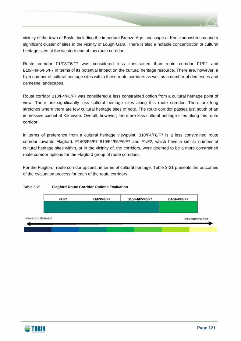
Page 121
vicinity of the town of Boyle, including the important Bronze Age landscape at Knockadoosbrusna and a significant cluster of sites in the vicinity of Lough Gara. There is also a notable concentration of cultural heritage sites at the western end of this route corridor. Route corridor F1/F3/F6/F7 was considered less constrained than route corridor F1/F2 and B10/F4/F5/F6/F7 in terms of its potential impact on the cultural heritage resource. There are, however, a high number of cultural heritage sites within these route corridors as well as a number of demesnes and demesne landscapes. Route corridor B10/F4/F8/F7 was considered a less constrained option from a cultural heritage point of view. There are significantly less cultural heritage sites along this route corridor. There are long stretches where there are few cultural heritage sites of note. The route corridor passes just south of an impressive cashel at Kilmovee. Overall, however, there are less cultural heritage sites along this route corridor. In terms of preference from a cultural heritage viewpoint, B10/F4/F8/F7 is a less constrained route corridor towards Flagford. F1/F3/F6/F7 B10/F4/F5/F6/F7 and F1/F2, which have a similar number of cultural heritage sites within, or in the vicinity of, the corridors, were deemed to be a more constrained route corridor options for the Flagford group of route corridors. For the Flagford route corridor options, in terms of cultural heritage, Table 3-21 presents the outcomes of the evaluation process for each of the route corridors. Table 3-21 Flagford Route Corridor Options Evaluation
F1/F2 F1/F3/F6/F7 B10/F4/F5/F6/F7 B10/F4/F8/F7

Page 122
3.7 TECHNICAL
The key technical considerations for the evaluation of route corridor options includes geotechnical, design and implementation, access for construction and maintenance, and utilities and infrastructure. The diverse nature of the study area presents a variety of constraints which reflect the area’s unique characteristic. The study area is highly constrained, both technically and environmentally. It was not possible to find route corridors that avoided all constraints. The project team initially sought to identify route corridors that avoided major constraints and, where possible, these were routed through areas with fewer constraints. Having identified these corridors, the technical evaluation makes a subjective comparison of the different route corridors, using the agreed technical criteria, so that a technically least constrained corridor could be determined. Each corridor had already been developed by a rigorous selection process such that each corridor was considered a technically feasible route corridor, although it was recognised that varying levels of engineering solution may be necessary in each. The identification of a less constrained corridor provides a better understanding of the relative engineering solutions which may be required to overcome any constraints. 3.7.1 Bellacorick Route Corridor Options The Bellacorick group of route corridors present a diverse range of significant technical constraints. These can be broadly grouped into the constraints associated with the Bellacorick peat complex, constraints associated with the steep and varied terrain to the north of the town of Castlebar and other more general constraints associated with overhead line construction. To allow connection to the existing Bellacorick substation, all route corridors will be required to cross the Bellacorick peat complex. Thus the evaluation seeks to identify the route corridors which allow connection of the existing Bellacorick substation to either the existing Flagford substation or the existing Cashla substation and which offers a less technical and environmental impact, in a highly constrained area. If further studies determine that the optimum substation site is to the east of the Bellacorick peat complex, then a review of route corridors will be undertaken to reflect the new connection point, but route corridors extending to the existing Bellacorick substation represent the most conservative requirement at present. Based on the assessment of each route corridor against the technical criteria, as set out in Chapter 2, a less constrained Bellacorick route corridor is B1/B2/B3/B9. This is because routing to the east side of Lough Conn is technically less constrained than the route corridors to the western side of Lough Conn, where difficult terrain, and extended lengths of karstified rock make implementation and access more difficult. In addition, the approach to the existing Bellacorick substation from the north avoids the major environmentally designated areas where the construction of overhead lines and access tracks is expected to require specialised engineering solutions to minimise or mitigate their impact. The route corridors will need to be co-ordinated with the wind farm developments in the Bellacorick area; however the positioning of the wind farms is considered to be a lesser constraint than construction in an environmentally designated area. These wind farm developments will include the creation of access
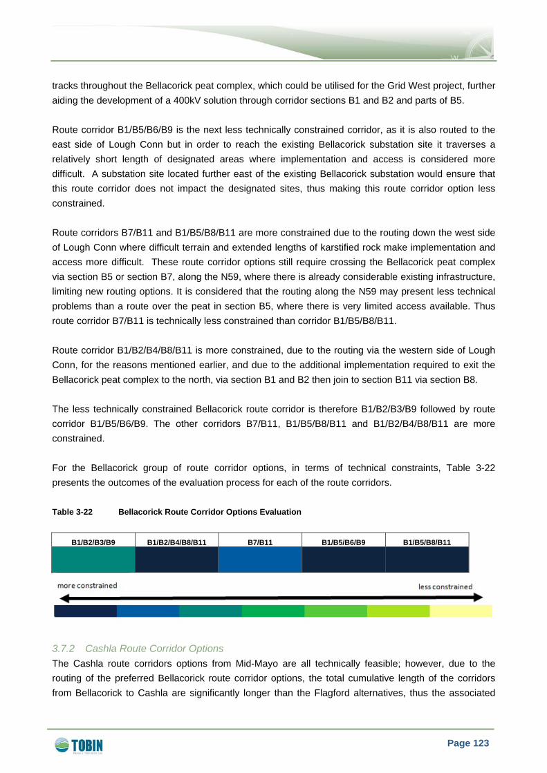
Page 123
tracks throughout the Bellacorick peat complex, which could be utilised for the Grid West project, further aiding the development of a 400kV solution through corridor sections B1 and B2 and parts of B5. Route corridor B1/B5/B6/B9 is the next less technically constrained corridor, as it is also routed to the east side of Lough Conn but in order to reach the existing Bellacorick substation site it traverses a relatively short length of designated areas where implementation and access is considered more difficult. A substation site located further east of the existing Bellacorick substation would ensure that this route corridor does not impact the designated sites, thus making this route corridor option less constrained. Route corridors B7/B11 and B1/B5/B8/B11 are more constrained due to the routing down the west side of Lough Conn where difficult terrain and extended lengths of karstified rock make implementation and access more difficult. These route corridor options still require crossing the Bellacorick peat complex via section B5 or section B7, along the N59, where there is already considerable existing infrastructure, limiting new routing options. It is considered that the routing along the N59 may present less technical problems than a route over the peat in section B5, where there is very limited access available. Thus route corridor B7/B11 is technically less constrained than corridor B1/B5/B8/B11. Route corridor B1/B2/B4/B8/B11 is more constrained, due to the routing via the western side of Lough Conn, for the reasons mentioned earlier, and due to the additional implementation required to exit the Bellacorick peat complex to the north, via section B1 and B2 then join to section B11 via section B8. The less technically constrained Bellacorick route corridor is therefore B1/B2/B3/B9 followed by route corridor B1/B5/B6/B9. The other corridors B7/B11, B1/B5/B8/B11 and B1/B2/B4/B8/B11 are more constrained. For the Bellacorick group of route corridor options, in terms of technical constraints, Table 3-22 presents the outcomes of the evaluation process for each of the route corridors. Table 3-22 Bellacorick Route Corridor Options Evaluation
B1/B2/B3/B9 B1/B2/B4/B8/B11 B7/B11 B1/B5/B6/B9 B1/B5/B8/B11
3.7.2 Cashla Route Corridor Options The Cashla route corridors options from Mid-Mayo are all technically feasible; however, due to the routing of the preferred Bellacorick route corridor options, the total cumulative length of the corridors from Bellacorick to Cashla are significantly longer than the Flagford alternatives, thus the associated

Page 124
engineering required for their implementation, and for construction and maintenance access increases proportionally. Based on the key criteria detailed in Chapter 2 it is considered that five of the route corridors to the existing Cashla substation have a very similar level of overall technical constraint. These route corridors are B10/C6/C2/C3, B10/C6/C1/C7, C5/C1/C8, C5/C2/C3 and C5/C1/C7. Given this similar overall level of constraint within these five route corridors, it is considered that a less constrained Cashla route corridor option is B10/C6/C2/C3 because it is the most direct, has good access and has a less number of implementation constraints. The next less constrained route corridor of the five similar route corridor options is B10/C6/C1/C7 as it has acceptable access for construction and a limited number of implementation constraints but due to the longer route length of B10/C6/C2/C3, the number of line deviations and access requirements is increased. The next less constrained route corridors are C5/C1/C8, C5/C2/C3 and C5/C1/C7 as they have acceptable access but require additional line deviations and existing infrastructure crossings to connect with a less constrained Bellacorick route corridor options. Route corridor B10/C6/C1/C8 is considered to be the next less constrained route corridor option. It is very similar to corridor B10/C6/C1/C7 but the long length introduced by section C8 introduces more line deviations, with associated requirement for angle towers and a section over karstified rock. Although the route corridor C4/C3 has a less geotechnical constraints with less cutover peat compared to the other Cashla route corridors options, the corridor is required to cross three, 220kV transmission lines and will require the most tension towers, making implementation and construction more difficult. It is therefore considered to be the most technically constrained of the Cashla route corridor options. For the Cashla group of route corridor options, in terms of technical constraints, Table 3-23 presents the outcomes of the evaluation process for each of the route corridors. Table 3-23 Cashla Route Corridor Options Evaluation
B10/C6/C1/C7 B10/C6/C1/C8 C5/C1/C8 C5/C2/C3 C5/C1/C7 B10/C6/C2/C3 C4/C3

Page 125
3.7.3 Flagford Route Corridor Options The Flagford route corridor options are generally shorter than the alternative Cashla route corridor options; however geotechnical conditions along the Flagford route corridors require crossing more cutover and blanket peat, which increases the difficulty of implementation and access for construction. Based on the key criteria detailed in Chapter 2 the less constrained Flagford route corridor options are F1/F3/F6/F7 and B10/F4/F5/F6/F7. This is due to their much shorter lengths over blanket and cutover peat allowing easier implementation, with an acceptable number of existing infrastructure crossings and access. The Flagford route corridors F1/F2 and B10/F4/F8/F7 are more constrained because they both cross significant lengths of peat, with F1/F2 crossing 37km of blanket and cut over peat, which results in it being a more constrained Mid-Mayo to Flagford route corridor. For the Flagford group of route corridor options, in terms of technical constraints, Table 3-24 presents the outcomes of the evaluation process for each of the route corridors. Table 3-24 Flagford Route Corridor Options Evaluation
F1/F2 F1/F3/F6/F7 B10/F4/F5/F6/F7 B10/F4/F8/F7

Page 126
3.8 LENGTH OF ROUTE CORRIDOR
In general the Flagford route corridor options are shorter route corridors by an average of 10km in length compared to the Cashla route corridors, therefore the Flagford route corridors are considered generally less constrained in terms of length of route corridor than the Cashla route corridor options. The Bellacorick route corridor options are shorter in length (average length of 50km) than the Cashla and Flagford route corridor options. Of the Cashla route corridors, the shortest route corridors are the central (C5/C2/C3) and western (C4/C3) route corridor options. The longest route corridors are B10/C6/C1/C8, B10/C6/C1/C7 and C5/C1/C8. Of the Flagford route corridors, the more southern Flagford route corridor options which include B10/F4/F5/F6/F7 and B10/ F4/F8/F7 are longer. As a broad baseline position, it is generally considered that the shortest line route will have a less / shortest environmental footprint; however this is not necessarily always the case. This criterion needs therefore to be considered with due regard to the foregoing observations when comparing route corridor options relative to environmental and impact. 3.8.1 Bellacorick Route Corridor Options For the Bellacorick route corridor options, in terms of length of route corridor, Table 3-25 presents the outcomes of the evaluation process for each of the route corridors. Table 3-25 Bellacorick Route Corridor Options Evaluation
B1/B2/B3/B9 B1/B2/B4/B8/B11 B7/B11 B1/B5/B6/B9 B1/B5/B8/B11
3.8.2 Cashla Route Corridor Options For the Cashla route corridor options, in terms of length of route corridor, Table 3-26 presents the outcomes of the evaluation process for each of the route corridors.

Page 127
Table 3-26 Cashla Route Corridor Options Evaluation
B10/C6/C1/C7 B10/C6/C1/C8 C5/C1/C8 C5/C2/C3 C5/C1/C7 B10/C6/C2/C3 C4/C3
3.8.3 Flagford Route Corridor Options For the Flagford route corridor options, in terms of length of route corridor, Table 3-27 presents the outcomes of the evaluation process for each of the route corridors. Table 3-27 Flagford Route Corridor Options Evaluation
F1/F2 F1/F3/F6/F7 B10/F4/F5/F6/F7 B10/F4/F8/F7


Page 128
4 LEAST CONSTRAINED ROUTE CORRIDOR OPTIONS Chapter 3 of this report sets out the evaluation of the Bellacorick, Cashla and Flagford route corridor options, by sectoral area within the larger study area, based on the agreed criterion set out in Chapter 1 of this report. This chapter identifies the least constrained corridor from each of the Bellacorick, Cashla and Flagford route corridor options and combines these to develop an overall least constrained corridor which compares the least constrained Bellacorick route corridor option with the least constrained Flagford and the least constrained Cashla route corridor option. 4.1.1 Bellacorick Route Corridors Taking all constraints into account for the Bellacorick route corridor options, the least constrained route corridor option, is B1/B2/B3/B9.
• In terms of potential impact on settlements i.e. the number of dwellings within route corridor, B1/B2/B3/B9 is considered more constrained than any of the other route corridors to the west side of Lough Conn.
• Specifically, in terms of ecology, route corridors B1/B2/B3/B9, followed by B1/B2/B4/B8/B11, are considered less constrained route corridor options as they avoid the Bellacorick Bog SAC complex. All other route corridors pass through the Bellacorick Bog SAC complex, and so these other route corridors carry significant impediment under ecology, in that they would likely cause a direct impact to Bellacorick Bog, specifically to the lowland blanket bog habitat, a qualifying feature of the site. Combinations of route corridors which include B1/B2/B3/B9 and B1/B2/B4/B8/B11 therefore avoid impacts on the Bellacorick Bog SAC, whereas other route corridor options have the potential to impact on this designated SAC site.
• In terms of landscape constraints, B1/B2/B3/B9 is considered less constrained than B1/B2/B4/B8/B11, B7/B11 and B1/B5/B8/B11. B1/B2/B3/B9 is slightly more constrained than route corridor B1/B5/B6/B9, as route corridor B1/B5/B6/B9 travels over a shorter distance of open bog landscape.
• In relation to cultural heritage, route corridor option B1/B2/B3/B9 is considered a more constrained route corridor compared to the other route corridor options. However as noted previously there will be no direct impact on the cultural heritage resource as it will be possible to avoid all known cultural heritage sites during the line design stage.
• In terms of technical constraints, B1/B2/B3/B9 is considered less constrained than B1/B2/B4/B8/B11, B7/B11 and B1/B5/B8/B11, because these route corridors are routed down the west side of Lough Conn where difficult terrain, and extended lengths of karstified rock, make implementation and access more difficult compared to options on the east side of Lough Conn. B1/B2/B3/B9 is also technically less constrained than route corridor B1/B5/B6/B9 as this corridor traverses a very short length of designated area where implementation and access is considered more difficult.
• The characteristics of route corridor options in the Bellacorick study area are broadly similar in terms of geology and water, and are therefore considered non differentiating constraints in terms of evaluation.

Page 129
• In terms of length of corridor B1/B2/B3/B9 is longer than B1/B5/B6/B9 and B7/B11, as it follows a north easterly direction from the existing Bellacorick substation in order to avoid impact on the Bellacorick Bog SAC complex. B1/B2/B3/B9 is similar in length to B1/B5/B8/B11, it is shorter than B1/B2/B4/B8/B11 by approximately 10km.
The Bellacorick route corridor options evaluation is presented schematically in a matrix format in Table 4-1 for each of the criteria detailed in Chapter 3. As shown in the legend below in this matrix, the more constrained route corridors for each criterion are highlighted in dark blue whilst the less constrained routes are highlighted in lighter colours toward yellow. Table 4-1 Bellacorick Route Corridor Options Evaluation
Constraints B1/B2/B3/B9 B1/B2/B4/B8/B11 B1/B5/B6/B9 B7/B11 B1/B5/B8/B11
Settlements Ecology
Landscape
Cultural Heritage Technical
Geology
Water Length of Line

Page 130
4.1.2 Cashla Route Corridors Having considered all constraints, the least constrained route corridor options to Cashla, are C5/C1/C7, followed by C5/C2/C3, and C5/C1/C8. However, it must be recognised that these particular combinations link to the Bellacorick route corridor options to the west side of Lough Conn, which are more constrained in the context of the Bellacorick group of corridor options. Route corridor B10/C6/C2/C3, which links to the Bellacorick route corridor options to the east side of Lough Conn, is the next least constrained among the Cashla group of corridor options. B10/C6/C2/C3 is less constrained than the other three Cashla route corridor options (namely C4/C3, B10/C6/C1/C7 and B10/C6/C1/C8 for the following reasons:
• In terms of potential impact on settlements, B10/C6/C2/C3 has fewer dwellings per kilometre compared to route corridor B10/C6/C1/C7 and B10/C6/C1/C8. Route corridor C4/C3 has fewer numbers of dwellings that the three route corridor options.
• In terms of ecology, B10/C6/C2/C3 is considered less constrained than C4/C3 but slightly more constrained than B10/C6/C1/C7 and B10/C6/C1/C8.
• In terms of landscape constraints, B10/C6/C2/C3 is considered similar in terms of constraints to route corridors B10/C6/C1/C7 and B10/C6/C1/C8, this is because the B10 and C6 sections cross over a constrained area south of Foxford and higher ground south of Bohola. Route corridor C4/C3 is considered a more constrained route corridor option than all three other route corridor options.
• In terms of cultural heritage constraints, all four eastern Cashla route corridor options are considered more constrained, with C4/C3 being considered the most constrained Cashla route corridor option. However as noted previously there will be no direct impact on the cultural heritage resource as it will be possible to avoid all known cultural heritage sites during the line design stage.
• In terms of technical constraints B10/C6/C2/C3 is considered a less constrained route corridor option compared to all others, as it is the most direct route corridor, has good access and has a less number of implementation constraints.
• The characteristics of route corridor options in the Cashla study area are again broadly similar in terms of geology and water and are therefore considered non differentiating constraints in terms of evaluation.
• In terms of length of corridor, B10/C6/C2/C3 (82.3km) is shorter compared to B10/C6/C1/C7 (88.6km) and B10/C6/C1/C8 (93km). Route corridor C4/C3 is the shortest of the three route corridors at 76.2km.
The Cashla route corridor options evaluation is presented schematically in a matrix format, in Table 4-2 for each of the criteria detailed in Chapter 3.

Page 131
Table 4-2 Cashla Route Corridor Options Evaluation
Constraints B10/C6/C1/C7 B10/C6/C1/C8 C5/C1/C8 C5/C2/C3 C5/C1/C7 B10/C6/C2/C3 C4/C3
Settlements Ecology Landscape Cultural Heritage Technical Geology Water Length of Line

Page 132
4.1.3 Flagford Route Corridors Having considered all the constraints, the least constrained route corridor option to Flagford is F1/F3/F6/F7 for the following reasons:
• In terms of settlement, route corridor F1/F3/F6/F7 has fewer number of dwellings than route corridor B10/F4/F5/F6/F7 and B10/F4/F8/F7. Route corridor F1/F2 has fewer numbers of dwellings that the other three Flagford route corridor options.
• The characteristics of route corridor options in the Flagford study area are broadly similar in terms of ecology and are therefore considered non differentiating constraints in terms of evaluation.
• In terms of landscape constraints F1/F3/F6/F7 is considered a less constrained route corridor compared to the other Flagford route corridors. This is principally due to the avoidance of upland areas between Lough Key and Lough Garra, higher ground south of Foxford, areas designated as sensitive in County Sligo and the foothills of the Ox Mountains.
• In terms of cultural heritage, F1/F3/F6/F7, F1/F2 and B10/F4/F5/F6/F7, are considered more constrained route corridor options than B10/F4/F8/F7. However as noted previously there will be no direct impact on the cultural heritage resource as it will be possible to avoid all known cultural heritage sites during the line design stage.
• In terms of technical constraints F1/F3/F6/F7 is considered a less constrained route corridor compared to the other Flagford route corridors, as it is crosses over shorter lengths of blanket and cutover peat allowing easier implementation.
• The characteristics of route corridor options in the Flagford study area are broadly similar in terms of geology and water and are therefore considered non differentiating constraints in terms of evaluation.
• In terms of length of corridor F1/F3/F6/F7 is the shortest route corridor option. Note however that route corridor option F1/F2 is only 400m longer.
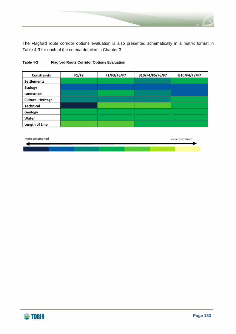
Page 133
The Flagford route corridor options evaluation is also presented schematically in a matrix format in Table 4-3 for each of the criteria detailed in Chapter 3. Table 4-3 Flagford Route Corridor Options Evaluation
Constraints F1/F2 F1/F3/F6/F7 B10/F4/F5/F6/F7 B10/F4/F8/F7
Settlements
Ecology
Landscape Cultural Heritage
Technical
Geology Water
Length of Line

Page 134
4.1.4 Comparative Analysis of Identified Least Constrained Route Corridor Options – Bellacorick
to Flagford and Bellacorick to Cashla This section considers the least constrained route corridor options for both Bellacorick to Flagford and Bellacorick to Cashla. The section should be read in conjunction with Table 4-4 which presents a schematic in a matrix format for the least constrained route corridor options for both Cashla and Flagford. When evaluating the Bellacorick to Flagford and the Bellacorick to Cashla route corridors, the project team are concerned more with differences between the Flagford and Cashla sections of route corridor, as the Bellacorick section is common to both. Therefore in Table 4-4 presented herein, the Bellacorick sections of the route corridors are not shown and the comparative analysis presented is between the least constrained Flagford and Cashla route corridor sections. Table 4-4 Least Constrained Corridors; Cashla / Flagford
Constraints Flagford / Cashla Route Corridor
Combinations
F1/F3/F6/F7 B10/C6/C2/C3
Settlements
Ecology
Landscape
Cultural Heritage
Technical
Geology
Water
Length of Line

Page 135
In relation to each of the constraints, the following main points should be considered:
• Settlements; i.e. the number of dwellings, Bellacorick to Flagford is considered less Bellacorick to Cashla, as it has 0.3 dwellings per km less. The relevant details are also presented in Table 4-5 below.
Table 4-5 Length of Least Constrained Route Corridors to Bellacorick, Cashla & Flagford
Bellacorick to Flagford Route Corridor
Combinations (B-F) Bellacorick to Cashla Route Corridor
Combinations (B-F)
B1/B2/B3/B9 km
F1/F3/F6/F7km
Total km
B1/B2/B3/B9 km
B10/C6/C2/C3 km
Total km
Length (km) 51.2 68.8 120.0 51.2 82.3 133.5
No. of
Dwellings
within each
Corridor
434
(8.5 per
square km)
637
(9.3 per
square km)
1,071
(8.9 per
square km)
434
(8.5 per
square km)
795
(9.7 per
square km)
1,229
(9.2 per
square km)
Difference 13.5km difference in B-C compared to B-F 0.33 dwellings/km difference in B-C compared to B-F
• Ecology; the route corridor option from Bellacorick to Flagford, is considered less constrained
than the route corridor option from Bellacorick to Cashla as all ecological impacts along this route corridor can be minimised or avoided at line design stage.
• Landscape; the Flagford section is considered less constrained than the Cashla section as it avoids the key landscape sensitive areas, including the upland area between Lough Key and Lough Gara, the higher ground south of Foxford, areas designated as sensitive in County Sligo and the foothills of the Ox Mountains. The B10 section of the Cashla route corridor crosses over a constrained area from a landscape perspective south of Foxford.
• Cultural Heritage; the Flagford section is considered similarly constrained to the Cashla section.
• Technical; the Flagford section, is considered more constrained than the Cashla section, as it is required to cross more cutover and blanket peat which increases the difficulty of implementation and access for construction.
• Geology and Water; these constraints are not considered differentiating constraints in terms of evaluation.
• Length of Route Corridor; the Bellacorick to Flagford section is considered less constrained than the Bellacorick to Cashla section as it is 13.5km shorter in length, which has implications for the extent of the environmental footprint potentially impacted and also to the costs associated with the Grid West project.

Page 136
From the above analysis, the least constrained route corridor option is from Bellacorick to Flagford, which is a combination of route corridor option B1/B2/B3/B9 from the Bellacorick group of corridor options, together with F1/F3/F6/F7 from the Flagford group of corridor options. Refer to Figure 4-1 which shows this least constrained route corridor option. The next least constrained corridor route combination from Bellacorick to Cashla, represented by a combination of route corridor option B1/B2/B3/B9 from the Bellacorick group of corridor options, together with B10/C6/C2/C3 from the Cashla group of corridor options.


")
!.
!.
!.
!( !(
!(!(
!(
!(
!(
!(
!(
!(
!(
!(
!(
!(!(
!(!(
!(!(
!(
!(
!(
!(
!(
!(
!(
!(
!(
!( !(
!(
")
!(
!(
!(!(
!(
!(
!(
Carrick-on-Shannon
Galway
Tuam
Knock
Boyle
Sligo
RooskyElphin
Athenry
Foxford
Killala
Athlone
Ballina
Collooney
Loughrea
Headford
Cortober
Swinford
Westport
Moycullen
Castlerea
Ballymote
Kiltimagh
Roscommon
Castlebar
Craughwell
Oughterard
Ballinrobe
Tubbercurry
Enniscrone Ballysadare
Ballinasloe
Claregalway
BallyhaunisStrokestown
Charlestown
Crossmolina
Claremorris
Ballaghaderreen
M a y oM a y o
G a l w a yG a l w a y
S l i g oS l i g o
R o s c o m m o nR o s c o m m o n
L e i t r i mL e i t r i m
O f f a l yO f f a l y
L o n g f o r dL o n g f o r d
U l s t e rU l s t e r
C a v a nC a v a n
W e s t m e a t hW e s t m e a t h
T i p p e r a r yT i p p e r a r y
¬«F2
¬«C1
¬«C4
¬«C3
¬«F8
¬«B11
¬«F7
¬«C2
¬«F6
¬«B9
¬«C8
¬«C5
¬«F3
¬«B2
¬«C6
¬«B7
¬«C7
¬«B3
¬«B5
¬«B10
¬«B6
¬«B4
¬«F5
¬«B8
¬«F4
¬«B1
¬«F1
60000.000000
60000.000000
70000.000000
70000.000000
80000.000000
80000.000000
90000.000000
90000.000000
100000.000000
100000.000000
110000.000000
110000.000000
120000.000000
120000.000000
130000.000000
130000.000000
140000.000000
140000.000000
150000.000000
150000.000000
160000.000000
160000.000000
170000.000000
170000.000000
180000.000000
180000.000000
190000.000000
190000.000000
200000.000000
200000.000000
210000.000000
210000.000000
220000.000000
220000.000000
21
00
00
.00
00
00
21
00
00
.00
00
00
22
00
00
.00
00
00
22
00
00
.00
00
00
23
00
00
.00
00
00
23
00
00
.00
00
00
24
00
00
.00
00
00
24
00
00
.00
00
00
25
00
00
.00
00
00
25
00
00
.00
00
00
26
00
00
.00
00
00
26
00
00
.00
00
00
27
00
00
.00
00
00
27
00
00
.00
00
00
28
00
00
.00
00
00
28
00
00
.00
00
00
29
00
00
.00
00
00
29
00
00
.00
00
00
30
00
00
.00
00
00
30
00
00
.00
00
00
31
00
00
.00
00
00
31
00
00
.00
00
00
32
00
00
.00
00
00
32
00
00
.00
00
00
33
00
00
.00
00
00
33
00
00
.00
00
00
34
00
00
.00
00
00
34
00
00
.00
00
00
0 5 10 15 202.5
Kilometres
THE GRID WEST PROJECT
LEAST CONSTRAINED ROUTE CORRIDOR OPTION -
BELLACORICK TO FLAGFORD
G.Fil M.Hogan February 2013
M.Garrick
A
1. FIGURED DIMENSIONS ONLY TO BE TAKEN FROM THIS DRAWING
2. ALL DRAWINGS TO BE CHECKED BY THE CONTRACTOR ON SITE
3. ENGINEER TO BE INFORMED OF ANY DISCREPANCIES BEFORE ANY
WORK COMMENCES
4. ALL LEVELS RELATE TO ORDNANCE SURVEY DATUM AT MALIN HEAD
NOTES
A 22-02-13 ISSUED G.F M.H.
Scale @ A3:
Issue Date Description By Chkd.
Client:
Project:
Title:
Prepared by: Checked: Date:
Project Director:
Consulting, Civil and Structural Engineers,Market Square, Castlebar,Co. Mayo, Ireland.tel: +353-(0)1-8030406fax:+353-(0)1-8030409e-mail: [email protected]
No part of this document may be reproduced or transmitted in any form or stored in any retrieval system of any nature without the written permission of Patrick J. Tobin & Co. Ltd. as copyright holder except as agreed for use on the project for which the document was originally issued.
1:500,000
EXISTING BELLACORICK SUBSTATION
EXISTING FLAGFORD SUBSTATION
EXISTING CASHLA SUBSTATION
Figure 4.1
Lough Carrowmore
Lough Arrow
Lough Key
Lough Gara
Lough Conn
Lough Beltra
Lough Feeagh
Lough Carra
Lough Mask
Lough Corrib Upper
N4
N5
N17
N84
N59
N59
Proposed Study Area
") City
!( Town
County Boundary
National Roads
Regional Road
River
Lakes
!. Substation Site Locations
N60
M6
Motorway
Lough Cullin
Lough Corrib Lower
Identified Corridors
Bellacorick Route Corridor Options i.e.B1
Cashla Route Corridor Options i.e. C1
Flagford Route Corridor Options i.e. F1
¬«B1
¬«C1
¬«F1
Least Constrained Corridor


Page 138
5 CONCLUSIONS The least constrained route corridor option for the Grid West project as evaluated in this report, presents what is considered the most appropriate balance between the various technical and environmental evaluation criteria. The evaluation process shows the least constrained route corridor option is from Bellacorick to Flagford, which is a combination of route corridor option B1/B2/B3/B9 from the Bellacorick group of corridor options, together with F1/F3/F6/F7 from the Flagford group of route corridor options. The next least constrained corridor route combination is from Bellacorick to Cashla, represented by a combination of route corridor option B1/B2/B3/B9 from the Bellacorick group of corridor options, together with B10/C6/C2/C3 from the Cashla group of corridor options. It is considered that the majority of potential impacts can be mitigated as part of the detailed design of a specific line route within the identified route corridor. However having regard to the nature of a 400kV overhead line project, there will be some potentially significant impacts which cannot be mitigated these primarily relate to visual impacts. The route corridor options, and the least constrained route corridor option in the view of the advisory specialist team, will be subject to consultation at the forthcoming round of Public Consultation, including discussions with statutory consultees, and public Open Days. All feedback in relation to the ‘least constrained route corridor’ will be taken into consideration, in progressing Stage 2 of EirGrid’s Project Development and Consultation Roadmap, which will also include ongoing technical and environmental studies, as the project moves towards the confirmation of an ‘emerging preferred option’ for the Grid West project.


Page 139
ACRONYM AA Appropriate Assessment ACA Architectural Conservation Areas CGS County Geological Sites CSO Central Statistics Office EIA Environmental Impact Assessment EIS Environmental Impact Statement EPA Environmental Protection Agency EU European Union GSI Geological Survey of Ireland IGH Irish Geological Heritage IGHP Irish Geological Heritage Programme NHA Natural Heritage Area NIAH National Inventory of Architectural Heritage NM National Monument NPWS National Parks and Wildlife Service pNHA proposed Natural Heritage Areas RMP Records of Monuments and Places RPS Record of Protected Structures SAC Special Area of Conservation SEA Strategic Environmental Assessment SMR Site and Monuments Record SPA Special Protection Area U Unidentified Geological Sites


ANNEX 2.1
Stage 1 Report - Appropriate Assessment Screening Report


STAGE 1 REPORT APPROPRIATE ASSESSMENT SCREENING REPORT
TOBIN CONSULTING ENGINEERS

STAGE 1 REPORT - APPROPRIATE ASSESSMENT- SCREENING REPORT
PROJECT: Grid West Project
CLIENT: EirGrid The Oval 160 Shelbourne Road Ballsbridge Dublin 4
COMPANY: TOBIN Consulting Engineers Block 10-4 Blanchardstown Corporate Park Dublin 15
www.tobin.ie

DOCUMENT AMENDMENT RECORD
Client: EirGrid Project: Grid West Project Title: Annex 2.1 Stage 1 Report - Appropriate Assessment Screening Report
PROJECT NUMBER: 6424 DOCUMENT REF: 6424-A 6424 Report .doc
A Final Issue RM 22/02/13 DG 22/02/13 MG 22/02/13 Revision Description & Rationale Originated Date Checked Date Authorised Date
TOBIN Consulting Engineers

Page (i)
TABLE OF CONTENTS
1 INTRODUCTION ......................................................................................................................................................... 1
2 STATUTORY CONTEXT ............................................................................................................................................ 5
3 GUIDANCE ................................................................................................................................................................. 6
4 ASSESSMENT METHODOLOGY .............................................................................................................................. 8
5 SCREENING ............................................................................................................................................................. 10
5.1 BRIEF DESCRIPTION OF PROJECT .............................................................................................................. 10
5.2 IDENTIFICATION OF RELEVENT NATURA 2000 SITES ............................................................................... 11
5.3 ASSESSMENT OF LIKELY EFFECTS ............................................................................................................. 11
6 APPROPRIATE ASSESSMENT SCREENING FOR STAGE 1 - CONCLUSION ..................................................... 22
6.1 ROUTE CORRIDOR OPTIONS ....................................................................................................................... 22
6.2 EMERGING LEAST CONSTRAINED CORRIDOR ......................................................................................... 25
6.3 SUBSTATION OPTIONS ................................................................................................................................. 26

Page (ii)
LIST OF FIGURES Figure 1-1 Natura 2000 Sites - Bellacorick Route Corridor and Substation Options ........................................................ 2
Figure 1-2 Natura 2000 Sites - Cashla Route Corridor and Substation Options .............................................................. 3
Figure 1-3 Natura 2000 Sites – Flagford Route Corridor and Substation Options ............................................................ 4
LIST OF TABLES Table 4-1 Description of Score and AA requirements ..................................................................................................... 9
Table 5-1 Route Corridor Options ................................................................................................................................. 10
Table 5-2 High Level Appropriate Assessment Screening and likely Appropriate Assessment requirements for Route Corridor Options: Bellacorick ........................................................................................................................ 13
Table 5-3 High Level Appropriate Assessment Screening and likely Appropriate Assessment requirements for Route Corridor Options: Cashla............................................................................................................................... 15
Table 5-4 High Level Appropriate Assessment Screening and likely Appropriate Assessment requirements for Route Corridor Options: Flagford............................................................................................................................. 18
Table 5-5 High Level Appropriate Assessment Screening and likely Appropriate Assessment requirements for Least Constrained Corridor Option ......................................................................................................................... 20


Page 1
1 INTRODUCTION This Appropriate Assessment (AA) Screening Report is an Annex Report to Appendix 6.2 of the Lead Consultants’ Stage 1 Report – ‘Route Corridor Evaluation Report’. The findings of this AA Screening Report have been a primary consideration in informing that Route Corridor Evaluation Report. This report details an initial Screening Stage to determine the requirement for further AA on all route corridors taken forward as part of the Grid West project. An emerging Least Constrained Corridor, based on all constraints, is the outcome of the Route Corridor Evaluation Report and is also screened for AA herein. The key considerations regarding AA and selection of the Least Constrained Corridor are minimizing risk of potential impacts on Natura 2000 sites from the development. Route Corridor Options in the three sub sections of the overall study area; Bellacorick, Flagford and Cashla are considered. It should be noted that a complete corridor between Bellacorick and either Cashla or Flagford, will contain a Bellacorick corridor element, linking with a Cashla or Flagford corridor element, as the case may be. Potential impacts generated by substation location options are also considered in this report. The overall study area including Natura 2000 designated sites and proposed route corridors (comprised of individual sections) and substation study areas are illustrated in accompanying Figures 1-1, 1-2 and 1-3. The study area is constrained regarding Natura 2000 sites and in particular around Bellacorick. Therefore it is important to highlight that a primary consideration in defining potential corridors for the Grid West project was to position them from the outset to avoid, as much as possible, direct crossing of Natura 2000 sites by corridors. In addition all potential substation sites have been selected outside Natura 2000 site boundaries. Therefore, it is important to appreciate that this initial screening for AA is based on corridors where a high degree of impact avoidance has already been implemented, through careful positioning.This is an initial high level AA screening report for the Grid West project. As the Appropriate Assessment process is iterative in nature, further AA screening will follow at all future stages of the project, for example once a viable overhead line route is selected from the various corridor options. This report and other ongoing studies / further AA reports will inform, in an iterative manner, an approach for the project which seeks to minimise risks to Natura 2000 sites. The key aim of this report is to consider the potential impacts associated with the routing of a 400kV overhead line within each route corridor option on Natura 2000 sites in view of their conservation objectives. This initial assessment of likely effects informs where further AA consideration will be required as the project plan develops and more information becomes available.


!.
!( !(
!(!(
!(
!(
!(
!(
!(
!(
!(
!(
!(
!(
!(
!(
!(
!(
!(!(
!(
Owenduff/Nephin Complex SPA
Lough Mask SPA
Lough Conn and Lough Cullin SPA
Lough Carra SPA
Ballysadare Bay SPA
Drumcliff Bay SPA
Cummeen Strand SPA
Killala Bay/Moy Estuary SPA
Blacksod Bay/Broadhaven SPA
Blacksod Bay/Broadhaven SPA
Carrowmore Lake SPA
Clare Island SPA
Bellanagare Bog SPA
Lough Gara SPA
Sligo/Leitrim Uplands SPA
Illanmaster SPABallintemple and Ballygilgan SPA
Ardboline Island and Horse Island SPA
Aughris Head SPA
Cross Lough (Killadoon) SPA
Owenduff/Nephin Complex
Mweelrea/Sheeffry/Erriff Complex
Clew Bay Complex
Broadhaven Bay
Ox Mountains Bogs
Corraun Plateau
Glenamoy Bog Complex
Mullet/Blacksod Bay Complex
Lough Carra/Mask Complex
Slieve Fyagh Bog
Ballysadare Bay
River Moy
Cummeen Strand/Drumcliff Bay (Sligo Bay)
Lough Hoe Bog
Bellacorick Bog Complex
Newport River
Killala Bay/Moy Estuary
Callow Bog
Unshin River
Keel Machair/Menaun Cliffs
Erris Head
Lough Gall Bog
Kilsallagh Bog
Cloonchambers Bog
Carrowbehy/Caher Bog
Lackan Saltmarsh and Kilcummin Head
Corliskea/Trien/Cloonfelliv Bog
Clare Island Cliffs
Templehouse and Cloonacleigha Loughs
Urlaur Lakes
Owenduff/Nephin Complex
Flughany Bog
River Moy
The Twelve Bens/Garraun Complex
Williamstown Turloughs
Errit Lough
Lough Gill
Doogort Machair/Lough Doo
Lough Cahasy, Lough Baun and Roonah Lough
Derrinea Bog
Drumalough Bog
Oldhead Wood
Tullaghanrock Bog
Union Wood
Brackloon Woods
Lough Dahybaun
Ox Mountains Bogs
Lisnageeragh Bog and Ballinastack Turlough
Doocastle Turlough
Towerhill House
Balla Turlough
Lough Nabrickkeagh Bog
Turloughmore (Sligo)
Cloonakillina Lough
Coolcam Turlough
Kilglassan/Caheravoostia Turlough Complex
Carrowkeel Turlough
Cross Lough (Killadoon)
Bricklieve Mountains & Keishcorran
River Moy
Bellacorick Iron Flush
Bellacragher Saltmarsh
Knockalongy and Knockachree Cliffs
Carrowmore Lake Complex
Ballinafad
Moore Hall (Lough Carra)
¬«F2
¬«C4
¬«F8
¬«C1
¬«B11
¬«F6
¬«B9
¬«C2
¬«C5
¬«F3
¬«B2
¬«C6
¬«B7
¬«B3
¬«B5
¬«B6
¬«B10
¬«B4
¬«F5
¬«F7
¬«B8
¬«F4
¬«B1
¬«F1
70000.000000
70000.000000
80000.000000
80000.000000
90000.000000
90000.000000
100000.000000
100000.000000
110000.000000
110000.000000
120000.000000
120000.000000
130000.000000
130000.000000
140000.000000
140000.000000
150000.000000
150000.000000
160000.000000
160000.000000
170000.000000
170000.000000
27
00
00
.00
00
00
27
00
00
.00
00
00
28
00
00
.00
00
00
28
00
00
.00
00
00
29
00
00
.00
00
00
29
00
00
.00
00
00
30
00
00
.00
00
00
30
00
00
.00
00
00
31
00
00
.00
00
00
31
00
00
.00
00
00
32
00
00
.00
00
00
32
00
00
.00
00
00
33
00
00
.00
00
00
33
00
00
.00
00
00
34
00
00
.00
00
00
34
00
00
.00
00
00
0 2 4 6 8 101
Kilometres
THE GRID WEST PROJECT
NATURA 2000 SITES - BELLACORICK ROUTE CORRIDOR
AND SUBSTATION OPTIONS
G.Fil M.Hogan February 2013
M.Garrick
A
1. FIGURED DIMENSIONS ONLY TO BE TAKEN FROM THIS DRAWING
2. ALL DRAWINGS TO BE CHECKED BY THE CONTRACTOR ON SITE
3. ENGINEER TO BE INFORMED OF ANY DISCREPANCIES BEFORE ANY
WORK COMMENCES
4. ALL LEVELS RELATE TO ORDNANCE SURVEY DATUM AT MALIN HEAD
NOTES
A 25-02-13 ISSUED G.F M.H.
Ordnance Survey Ireland Licence No EN 0016012 ©Ordnance Survey Ireland and Government of Ireland
Scale @ A0:
Issue Date Description By Chkd.
Client:
Project:
Title:
Prepared by: Checked: Date:
Project Director:
Consulting, Civil and Structural Engineers,Market Square, Castlebar,Co. Mayo, Ireland.tel: +353-(0)1-8030406fax:+353-(0)1-8030409e-mail: [email protected]
No part of this document may be reproduced or transmitted in any form or stored in any retrieval system of any nature without the written permission of Patrick J. Tobin & Co. Ltd. as copyright holder except as agreed for use on the project for which the document was originally issued.
1:300,000
EXISTING BELLACORICKSUBSTATION
Figure 1.1
Proposed Study Area
") City
!( Town
River
Lakes
!. Substation Site Locations
M6
Identified Corridors
Bellacorick Route Corridor Options
Cashla Route Corridor Options
Flagford Route Corridor Options
Special Area of Conservation
Special Protection Areas
Bellacorick Study Area and Substation Options
SB2
SB3
SB4
SB5
SB1

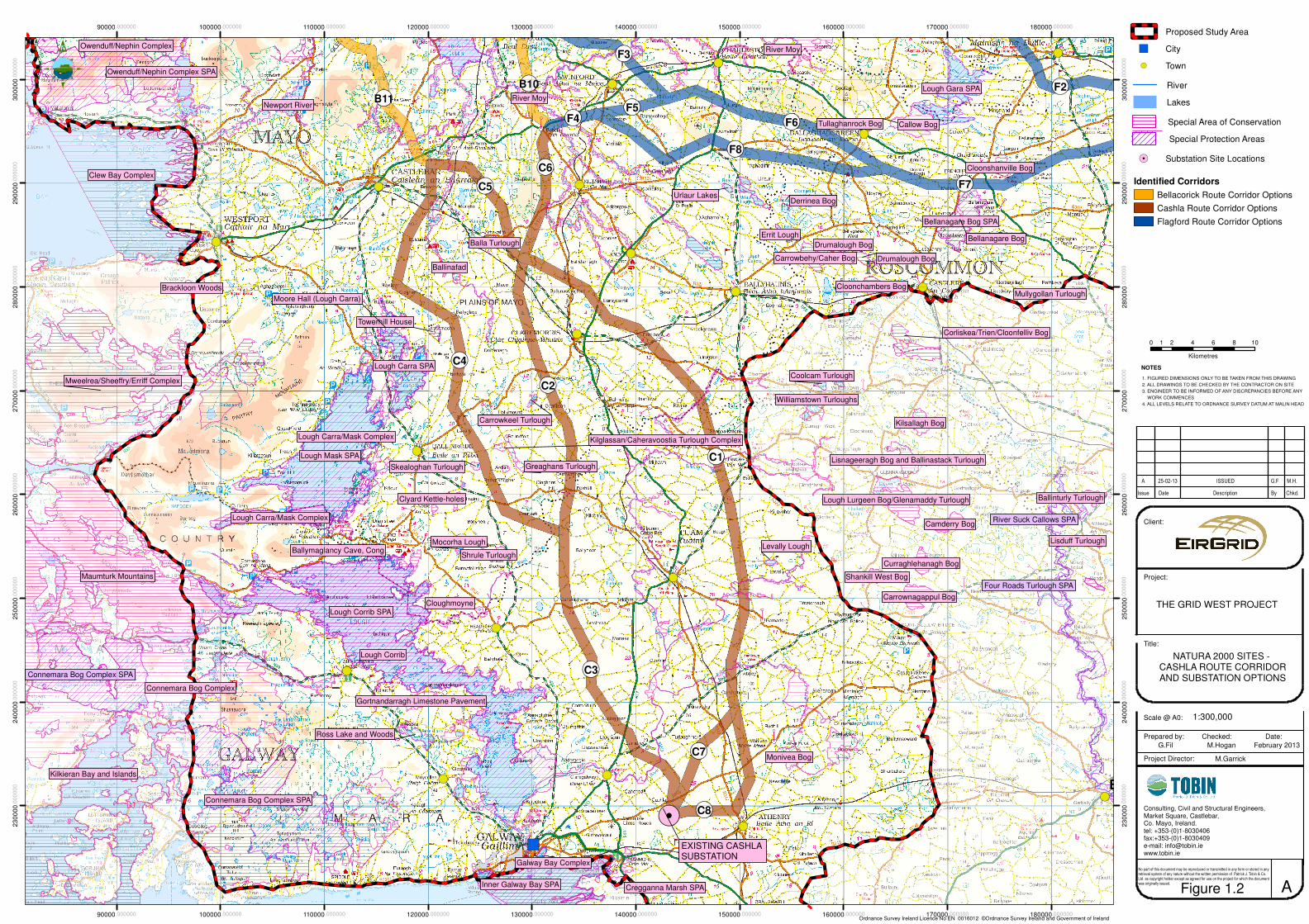
!.
!(
!(
!(!(
!(
!(
!(
!(
!(
!(
!(
!(
!(
!( !(
!(
")
!(
!(!(
!(
!(
Kilglassan/Caheravoostia Turlough Complex
Ballinasloe
Lough Corrib SPA
Lough Mask SPA
Connemara Bog Complex SPA
Owenduff/Nephin Complex SPA
Connemara Bog Complex SPA
Inner Galway Bay SPA
Lough Carra SPA
Lough Gara SPA
Bellanagare Bog SPA
River Suck Callows SPA
Cregganna Marsh SPA
Four Roads Turlough SPA
Lough Corrib
Connemara Bog Complex
Clew Bay Complex
Maumturk Mountains
Kilkieran Bay and Islands
Mweelrea/Sheeffry/Erriff Complex
River Moy
Lough Carra/Mask Complex
Newport River
Bellanagare Bog
Callow Bog
Galway Bay Complex
Lough Carra/Mask Complex
Lough Lurgeen Bog/Glenamaddy Turlough
Carrownagappul Bog
Monivea Bog
Kilsallagh Bog
Camderry Bog
Cloonchambers Bog
Carrowbehy/Caher Bog
Ross Lake and Woods
Shrule Turlough
Corliskea/Trien/Cloonfelliv Bog
Curraghlehanagh Bog
Cloonshanville Bog
Lisnageeragh Bog and Ballinastack Turlough
Gortnandarragh Limestone Pavement
Ballinturly Turlough
Owenduff/Nephin Complex
Drumalough Bog
Shankill West Bog
Errit Lough
Cloughmoyne
Derrinea Bog
Drumalough Bog
Tullaghanrock Bog
Brackloon Woods
Lisduff TurloughMocorha Lough
Coolcam Turlough
Levally Lough
Urlaur Lakes
Towerhill House
Balla Turlough
Greaghans Turlough
Clyard Kettle-holes
Carrowkeel Turlough
Skealoghan Turlough
Mullygollan Turlough
River Moy
Williamstown Turloughs
Ballymaglancy Cave, Cong
Ballinafad
Moore Hall (Lough Carra)
¬«C1
¬«C4
¬«C3
¬«F8
¬«C2
¬«F6
¬«F7
¬«C8
¬«C5
¬«B11
¬«C6
¬«C7
¬«F2
¬«F3
¬«B10
¬«F5
¬«F4
90000.000000
90000.000000
100000.000000
100000.000000
110000.000000
110000.000000
120000.000000
120000.000000
130000.000000
130000.000000
140000.000000
140000.000000
150000.000000
150000.000000
160000.000000
160000.000000
170000.000000
170000.000000
180000.000000
180000.000000
23
00
00
.00
00
00
23
00
00
.00
00
00
24
00
00
.00
00
00
24
00
00
.00
00
00
25
00
00
.00
00
00
25
00
00
.00
00
00
26
00
00
.00
00
00
26
00
00
.00
00
00
27
00
00
.00
00
00
27
00
00
.00
00
00
28
00
00
.00
00
00
28
00
00
.00
00
00
29
00
00
.00
00
00
29
00
00
.00
00
00
30
00
00
.00
00
00
30
00
00
.00
00
00
0 2 4 6 8 101
Kilometres
THE GRID WEST PROJECT
NATURA 2000 SITES - CASHLA ROUTE CORRIDORAND SUBSTATION OPTIONS
G.Fil M.Hogan February 2013
M.Garrick
A
1. FIGURED DIMENSIONS ONLY TO BE TAKEN FROM THIS DRAWING
2. ALL DRAWINGS TO BE CHECKED BY THE CONTRACTOR ON SITE
3. ENGINEER TO BE INFORMED OF ANY DISCREPANCIES BEFORE ANY
WORK COMMENCES
4. ALL LEVELS RELATE TO ORDNANCE SURVEY DATUM AT MALIN HEAD
NOTES
A 25-02-13 ISSUED G.F M.H.
Ordnance Survey Ireland Licence No EN 0016012 ©Ordnance Survey Ireland and Government of Ireland
Scale @ A0:
Issue Date Description By Chkd.
Client:
Project:
Title:
Prepared by: Checked: Date:
Project Director:
Consulting, Civil and Structural Engineers,Market Square, Castlebar,Co. Mayo, Ireland.tel: +353-(0)1-8030406fax:+353-(0)1-8030409e-mail: [email protected]
No part of this document may be reproduced or transmitted in any form or stored in any retrieval system of any nature without the written permission of Patrick J. Tobin & Co. Ltd. as copyright holder except as agreed for use on the project for which the document was originally issued.
1:300,000
EXISTING CASHLA SUBSTATION
Figure 1.2
Proposed Study Area
") City
!( Town
River
Lakes
!. Substation Site Locations
M6
Identified Corridors
Bellacorick Route Corridor Options
Cashla Route Corridor Options
Flagford Route Corridor Options
Special Area of Conservation
Special Protection Areas


!.
!( !(
!(
!(
!(
!(
!(
!(
!(
!(
!(
!(
!(
!(
!(
!(
!(!(
!(
!(
!(
!(
!(
!(
!(!(
Lough Conn and Lough Cullin SPA
Lough Carra SPA
Ballysadare Bay SPA
Drumcliff Bay SPA
Lough Gara SPA
Cummeen Strand SPA
Lough Arrow SPA
Killala Bay/Moy Estuary SPA
Bellanagare Bog SPA
Lough Ree SPA
Ballykenny-Fisherstown Bog SPA
Ballintemple and Ballygilgan SPA
Lough Mask SPA
Ardboline Island and Horse Island SPA
Aughris Head SPA
Sligo/Leitrim Uplands SPA
River Moy
Ox Mountains Bogs
Lough Gill
Arroo Mountain
Cuilcagh - Anierin Uplands
Boleybrack Mountain
Cuilcagh - Anierin Uplands
Ballysadare Bay
River Moy
Cummeen Strand/Drumcliff Bay (Sligo Bay)
Lough Arrow
Lough Hoe Bog
Bellanagare Bog
Lough Ree
Unshin River
Ben Bulben, Gleniff and Glenade Complex
Callow Bog
Bricklieve Mountains & Keishcorran
Kilsallagh Bog
Corbo Bog
Killala Bay/Moy Estuary
Cloonchambers Bog
Clooneen BogCarrowbehy/Caher Bog
Lackan Saltmarsh and Kilcummin Head
Corliskea/Trien/Cloonfelliv Bog
Templehouse and Cloonacleigha Loughs
Urlaur Lakes
Cloonshanville Bog
Corratirrim
Flughany Bog
Errit Lough
Glenade Lough
Brown Bog
Lough Forbes Complex
Derrinea Bog
Annaghmore Lough (Roscommon)
Tullaghanrock Bog
Union Wood
Doocastle Turlough
Towerhill House
Balla Turlough
Lough Nabrickkeagh Bog
Turloughmore (Sligo)
Cloonakillina Lough
Coolcam Turlough
Carrowkeel Turlough
Mullygollan Turlough
Drumalough Bog
Williamstown Turloughs
River Moy
Kilglassan/Caheravoostia Turlough Complex
River Moy
Knockalongy and Knockachree Cliffs
Ballinafad
Moore Hall (Lough Carra)
¬«F2
¬«C4
¬«F8
¬«F7
¬«C1
¬«F6
¬«B9
¬«C2
¬«C5
¬«F3
¬«C6
¬«B11
¬«B10
¬«F5
¬«F4
¬«B3
¬«B6
¬«F1
120000.000000
120000.000000
130000.000000
130000.000000
140000.000000
140000.000000
150000.000000
150000.000000
160000.000000
160000.000000
170000.000000
170000.000000
180000.000000
180000.000000
190000.000000
190000.000000
200000.000000
200000.000000
210000.000000
210000.000000
27
00
00
.00
00
00
27
00
00
.00
00
00
28
00
00
.00
00
00
28
00
00
.00
00
00
29
00
00
.00
00
00
29
00
00
.00
00
00
30
00
00
.00
00
00
30
00
00
.00
00
00
31
00
00
.00
00
00
31
00
00
.00
00
00
32
00
00
.00
00
00
32
00
00
.00
00
00
33
00
00
.00
00
00
33
00
00
.00
00
00
34
00
00
.00
00
00
34
00
00
.00
00
00
0 2 4 6 8 101
Kilometres
THE GRID WEST PROJECT
NATURA 2000 SITES - FLAGFORD ROUTE CORRIDOR
AND SUBSTATION OPTIONS
G.Fil M.Hogan February 2013
M.Garrick
A
1. FIGURED DIMENSIONS ONLY TO BE TAKEN FROM THIS DRAWING
2. ALL DRAWINGS TO BE CHECKED BY THE CONTRACTOR ON SITE
3. ENGINEER TO BE INFORMED OF ANY DISCREPANCIES BEFORE ANY
WORK COMMENCES
4. ALL LEVELS RELATE TO ORDNANCE SURVEY DATUM AT MALIN HEAD
NOTES
A 25-02-13 ISSUED G.F M.H.
Ordnance Survey Ireland Licence No EN 0016012 ©Ordnance Survey Ireland and Government of Ireland
Scale @ A0:
Issue Date Description By Chkd.
Client:
Project:
Title:
Prepared by: Checked: Date:
Project Director:
Consulting, Civil and Structural Engineers,Market Square, Castlebar,Co. Mayo, Ireland.tel: +353-(0)1-8030406fax:+353-(0)1-8030409e-mail: [email protected]
No part of this document may be reproduced or transmitted in any form or stored in any retrieval system of any nature without the written permission of Patrick J. Tobin & Co. Ltd. as copyright holder except as agreed for use on the project for which the document was originally issued.
1:300,000
EXISTING FLAGFORDSUBSTATION
Figure 1.3
Proposed Study Area
") City
!( Town
River
Lakes
!. Substation Site Locations
M6
Identified Corridors
Bellacorick Route Corridor Options
Cashla Route Corridor Options
Flagford Route Corridor Options
Special Area of Conservation
Special Protection Areas


Page 5
2 STATUTORY CONTEXT The Appropriate Assessment process (AA) is an assessment of the potential effects of a plan or project, in combination with other plans or projects, on a European Site (Natura 2000 site). In Ireland, these sites consist of Special Areas of Conservation (SACs) and Special Protection Areas (SPAs) which provide for the protection and long-term survival of Europe’s most valuable and threatened species and
habitats. The requirement of AA is defined in Article 6(3) and 6(4) of the European Union Habitat Directive. Article 6(3) of the Habitat Directive requires that:
“Any plan or project not directly connected with or necessary to the management of the site but likely to have a significant effect thereon, either individually or in combination with other plans or projects, shall be subject to appropriate assessment of its implications for the site in view of the site's conservation objectives. In the light of the conclusions of the assessment of the implications for the site and subject to the provisions of paragraph 4, the competent national authorities shall agree to the plan or project only after having ascertained that it will not adversely affect the integrity of the site concerned and, if appropriate, after having obtained the opinion of the general public.”
And Article 6(4) of the Habitat Directive requires that:
“If, in spite of a negative assessment of the implications for the site and in the absence of alternative solutions, a plan or project must nevertheless be carried out for imperative reasons of overriding public interest, including those of a social or economic nature, the Member State shall take all compensatory measures necessary to ensure that the overall coherence of Natura 2000 is protected. It shall inform the Commission of the compensatory measures adopted.”
The EU Habitats Directive was transposed into Irish law by the European Communities (Natural Habitats) Regulations, SI 94/1997, recently amended by the Birds and Habitats Regulation SI No 477 of 2011.

Page 6
3 GUIDANCE This Screening Report for AA has been carried out with reference to the following guidance:
Appropriate Assessment of Plans and Projects in Ireland, Guidance for Planning Authorities, Department of the Environment, Heritage and Local Government DOHLG (2009);
Environmental Protection Agency (EPA) Ireland guidelines1 ; Managing Natura 2000 Sites: the provisions of Article 6 of the ‘Habitats’ Directive 92/43/EEC,
Office for Official Publications of the European Communities, Luxembourg (EC 2000); Assessment of Plans and Projects Significantly Affecting Natura 2000 Sites: Methodological
guidance on the provisions of Article 6(3) and (4) of the Habitat Directive 92/43/EEC, Office for Official Publications of the European Communities, Luxembourg (EC 2001);
Guidance document on Article 6(4) of the 'Habitats Directive' 92/43/EEC – Clarification of the concepts of: alternative solutions, imperative reasons of overriding public interest, compensatory measures, overall coherence, opinion of the commission. Office for Official Publications of the European Communities, Luxembourg (EC 2007);
Eirgrid 2012. Ecology Guidelines for Electricity Transmission Projects. A Standard Approach to Ecological Impact Assessment of High Voltage Transmission Project; and
National Roads Authority (2009). Guidelines for Assessment of Ecological Impacts of National Road Schemes.
The assessment procedure is based on a four stage approach, the outcome at each successive stage determines whether a further stage in the process is required. Stage One: Screening / Test of Significance Screening determines whether Appropriate Assessment is necessary by examining:
1. Whether a plan or project can be excluded from AA requirements because it is directly connected with or necessary to the management of the Natura 2000 site and
2. The potential effects of a project or plan, either alone or in combination with other projects or plans, on a Natura 2000 site in view of its conservation objectives, and considering whether these effects will be significant
Screening is normally undertaken without the inclusion of mitigation. This report deals with Stage 1 Screening for Appropriate Assessment, only. The other Stages of the AA procedure are: Stage Two: Appropriate Assessment (AA) The consideration of whether the project, alone or in combination with other projects or plans will have an adverse effect on the integrity of a Natura 2000 site and includes any mitigation measures necessary to avoid reduce or offset negative impacts.
1 http://www.epa.ie/downloads/forms/lic/wwda

Page 7
If adverse impacts can be satisfactorily avoided or successfully mitigated at this stage, then the process is complete. Stage Three: Assessment of Alternative Solutions The process which examines alternative ways of achieving the objectives of the project or plan that avoid adverse impacts on the integrity of the Natura 2000 site. Stage Four: Imperative Reasons of Overriding Public Interest (IROPI) This is main derogation process of Article 6 (4) which examines whether there are imperative reasons of overriding public interest (IROPI) for allowing a project to proceed where adverse effects on the integrity of a Natura 2000 site have been predicted. Compensatory measures must be proposed and assessed as part of this stage and the EU Commission must be informed of the compensatory measures.
Page 8
4 ASSESSMENT METHODOLOGY To inform a decision on which Natura 2000 sites require inclusion in the AA process for this phase of the Grid West project, a list of all Natura 2000 sites within the overall study area was produced. This included all Natura 2000 sites within each corridor and all Natura 2000 sites within 15km of the corridor boundary. To determine if a Natura 2000 site was relevant regarding screening for AA for this stage of the project, an initial “filtering” procedure was followed. This was carried out as follows:
All Natura 2000 sites were checked regarding their location with respect to corridors using the NPWS Mapviewer2 and GIS mapping produced for the project, which displays all designated site boundaries relative to the corridors.
Qualifying interests (i.e. habitats/ species) for all Natura 2000 sites in corridors, and within 15km of corridors, were reviewed and possible linkage (or not) to corridors was assessed, so as to determine if there is a potential for significant impacts.
Additional considerations informed this risk assessment regarding potential impacts including; knowledge on the scale/ type of development, understanding that a best practice approach will be implemented regarding design/ construction, nature of terrain, sensitivity of habitat, connectivity/linkage of non-designated habitat (within corridors) to designated habitats, degree of existing road access etc.
Hence the outcome of this initial filtering process was to list Natura 2000 sites, relevant for further consideration as to likely requirement for further AA. These Natura 2000 sites were considered based on the information available to date on these Natura 2000 sites which may be relevant to the project. A precautionary approach regarding recommendations for further AA requirements is followed in this report. This is because more information is required e.g. through site surveys to complete an adequate assessment of impacts on qualifying interests. For example, if it is determined that there is a potential for significant bird flightlines relevant to an SPA, then these Natura 2000 sites cannot be screened out based on current information and further AA will be required. A system of assessment in terms of likely requirements for Appropriate Assessment for corridors and potential impacts Natura 2000 sites has been developed based on a numerical score as detailed in Table 4-1 below.
2 http://webgis.npws.ie/npwsviewer/

Page 9
Table 4-1 Description of Score and AA requirements
Score Assessment of Corridors: requirement for AA
1 Likely to be screened out for stage 2 AA 2 Likely to require stage 2 AA with specific mitigation measures 3 Likely to have adverse effect in spite of mitigation measures
This scoring system was developed based on the following principles: Firstly the conservation objectives and qualifying interests of Natura 2000 sites were carefully reviewed. It was then considered whether potential impacts to these Natura 2000 sites could arise if a high voltage overhead line were to be located somewhere within these broad corridors. It must be recognised that at this stage no line design has been carried out, so there is no definition yet around issues such as tower locations, cable spans, access for construction and the like. Potential impacts on the following were considered, in addition to obvious potential direct impacts such as the crossing of a Natura 2000 site;
Key sensitive qualifying habitats in the area are wetland habitats including; lowland and upland blanket bog, raised bog, lakes, rivers, turloughs and fens/ mires. Remote impacts such as localised drainage works outside Natura 2000 sites to groundwater / surface flows were considered
Species not necessarily always located inside the Natura 2000 site network require consideration, regarding potential impacts. Examples are mobile wintering bird species such as Greenland White Fronted Geese in the Lough Corrib SPA which move outside this area to non designated areas on a regular basis.
Activities outside the designated Natura 2000 sites e.g. works in the vicinity of streams linked to downstream SAC rivers.
In addition it should be noted that field survey work is being carried out, or has been initiated in the vicinity of the Natura 2000 sites highlighted in this report. This information has informed, and will continue to inform the AA process for the project.

Page 10
5 SCREENING The following section details the high level screening assessment process for all corridor and substation options in the Bellacorick, Flagford and Cashla study areas based on information available to date. It is presented in the format detailed in DOHLG (2009) guidelines. 5.1 BRIEF DESCRIPTION OF PROJECT EirGrid proposes to build a new high voltage electricity transmission line (400kV) from the Bellacorick area of County Mayo to connect to the existing national grid, at either the existing Flagford substation in County Roscommon, or the existing Cashla substation in County Galway. New 400kV substation infrastructure which will be located at or close to the existing substations will also be required at Bellacorick, and either Cashla or Flagford. For the purposes of this report a number of alternative corridors are being considered between Bellacorick and Flagford and Bellacorick and Cashla. These are all identified in Figure 1-1, 1-2 and 1-3 and listed in Table 5-1.
Table 5-1 Route Corridor Options
Route Corridor Options
Bellacorick
B1/B2/B3/B9 B1/B2/B4/B8/B11
B1/B5/B6/B9
B7/B11
B1/B5/B8/B11
Cashla
B10/ C6/C1/C7
B10/ C6/C1/C8
C5/C1/C8
C5/C2/C3
C5/C1/C7
B10/ C6/C2/C3
C4/C3
Flagford
F1/F2
F1/F3/F6/F7 B10/ F4/F5/F6/F7
B10/ F4/F8/F7
The final route selected will include a corridor from Bellacorick and one corridor from either Flagford or Cashla. The Stage 1 Route Corridor Evaluation Report has identified a least constrained corridor based on a very detailed assessment of all constraints in the study area. Corridors were evaluated across a range of criteria, with ecological impact in particular being an important evaluation criterion. This Least Constrained Corridor option is between Bellacorick and Flagford and consists of B1/B2/B3/B9 (Bellacorick area, see Figure 1.1) and F1/F3/F6/F7 (Flagford area, see Figure 1.3).
Page 11
5.2 IDENTIFICATION OF RELEVENT NATURA 2000 SITES Based on the initial filtering assessment of Natura 2000 sites; a number of sites have been identified for consideration as to further likely AA requirements. These are detailed in Section 5.3. A description of the key considerations as to why further AA is likely to be required is also provided. 5.3 ASSESSMENT OF LIKELY EFFECTS This report details an initial “high level” screening report for Appropriate Assessment of numerous potential corridors within which a line route could be located. Further AA screening will be conducted at preferred corridor selection stage to assess potential impacts on Natura 2000 sites and to inform the line design and final EIS stages. Typical examples of potential impacts from a high voltage overhead transmission line development in the context of the Grid West study area may include:
Direct impacts (loss/ damage) to qualifying habitats associated with the construction of support towers, access tracks and possibly stringing areas. Typical impacts include habitat loss/degradation and /or changes to qualifying habitat species composition.
Water pollution risks during the construction phase. These risks significantly increase in sensitive habitats/ soils e.g. peatland habitats and in particular in upland areas with high concentrations of small streams linked to or included in Natura 2000sites.
Possible impacts to groundwaterflows linked to designated wetland sites caused by construction activities and tower foundations.
Fragmentation of non designated habitats linked to similar qualifying habitat in a designated area.
Disturbance / displacement of qualifying species in and outside designated sites e.g. wintering and breeding birds and Lesser Horseshoe Bat.
Introduction of non native/invasive species or creation of conditions that allow the spread of non-native/ invasive e.g. through soil disturbance
collision / displacement risks to bird species. Disturbance during management/ maintenance.
These potential impacts associated with developing a high voltage overhead transmission line within broad corridors (1km wide) are considered with respect to Natura 2000 sites. As this is a high level assessment of broad corridors, prior to any detailed line design, the potential for in-combination effects (with plans/project external to Grid West) is at an early stage of consideration. Ongoing consultation is being conducted regarding the GRID West project and potential relevant developments in particular around Belacorrick. This consultation process will inform the corridor selection process and final line design. In this regard potential in-combination impacts (with other developments) to Natura 2000 sites are an ongoing consideration. As the focus of the project develops, and an actual line route is selected for assessment, in-combination effects will be further taken into account for AA.

Page 12
For the purpose of this report, each corridor element is assessed in terms of potential impacts (direct and indirect) to Natura 2000 sites and their qualifying interests so as to determine the likely requirement for Appropriate Assessment if these corridors are taken forward in the project. The final alignment will be located within a combination of two of these corridor elements, including one from Bellacorick, along with one to Flagford or Cashla. The final line route will have a level of flexibility in where towers and other works areas will be located thereby further minimising potential risks to ecological receptors. This information will be detailed in further environmental and AA reporting as the project progresses. As already stated, this is an initial high level screening for AA, designed to flag likely impacts that would be associated with the various corridor options. . Further AA will be conducted throughout the project as the design develops, and more information becomes available. . 5.3.1 Bellacorick Route Corridor Options Five route corridor options have been developed within the Bellacorick area including; B1/B2/B3/B9; B1/B2/B4/B8/B11; B1/B5/B6/B9, B7/B11 and B1/B5/B8/B11, refer to Figure 1-1.The projects is defined by this nodal point and one of these corridors will be taken forward in the project. The assessment as to likely AA requirements and key ecological considerations is detailed in Table 5-2.

Page 13
Table 5-2 High Level Appropriate Assessment Screening and likely Appropriate Assessment requirements for Route Corridor Options: Bellacorick
1. Likely to be screened out 2. Likely to require stage 2 AA with specific mitigation measures 3. Likely to have adverse effect in spite of mitigation measures
Natura 2000 Site Corridor B1/B2/B3/B9 Corridor B1/B2/B4/B8/B11
Corridor B1/B5/B6/B9
Corridor B7/B11
Corridor B1/B5/B8/B11
Bellacorick Bog SAC 2 2 3 3 3
Bellacorick Iron Flush SAC 2 2 1 1 1
Lough Dahybaun SAC 1 1 1 2 1
Lough Conn and Cullin
SPA 2 2 2 2 2
Lower River Moy SAC 2 2 2 2 2
Key Considerations
informing AA Assessment
Corridor partially includes
Bellacorick Bog SAC.
Potential impact risk to
qualifying habitat may
arise.
Risks identified to surface
water and sensitive
qualifying receptors in
River Moy. Potential
impact to sensitive flush
Corridor partially includes
Bellacorick Bog SAC.
Potential impact risk to
qualifying habitat may arise.
Risks identified to surface
water and sensitive
qualifying receptors in River
Moy. Potential impact to
sensitive flush habitat,
including Bellacorick Iron
Stretches of corridor entirely
within Bellacorick Bog SAC
(at least 1km). Adverse
impact will arise to
qualifying blanket bog
habitat.
Risks identified to surface
water and sensitive
qualifying receptors in River
Stretches of corridor entirely
within Bellacorick Bog SAC
(at least 1km). Adverse
impact will arise to qualifying
blanket bog habitat.
Risks identified to surface
water and sensitive
qualifying receptors in River
Moy and Lough Dahybaun.
Potential impact to sensitive
Stretches of corridor entirely within
Bellacorick Bog SAC though at a
relatively less sensitive section
with a high proportion of of ‘non’
qualifying habitat. High Risks of
adverse impact to qualifying
blanket bog habitat where it exists
may arise.
Risks identified to surface water
and sensitive qualifying receptors

Page 14
Natura 2000 Site Corridor B1/B2/B3/B9 Corridor B1/B2/B4/B8/B11
Corridor B1/B5/B6/B9
Corridor B7/B11
Corridor B1/B5/B8/B11
habitat, including
Bellacorick Iron Flush.
Lough Conn and Cullin
SPA require further
information regarding
qualifying bird species.
Flush. Lough Conn and
Cullin SPA require further
information regarding
qualifying bird species.
Moy. Potential impact to
sensitive flush habitat
including Bellacorick Iron
Flush. Lough Conn and
Cullin SPA require further
information regarding
qualifying bird species.
flush habitat including
Bellacorick Iron Flush.
Lough Conn and Cullin SPA
require further information
regarding qualifying bird
species.
in River Moy. Potential impact to
sensitive flush habitat including
Bellacorick Iron Flush. Lough Conn
and Cullin SPA require further
information regarding qualifying
bird species.

Page 15
5.3.2 Cashla Route Corridor Options Seven route options have been developed to link to the Cashla area including; B10/C6/C1/C7; B10/C6/C1/C8; C5/C1/C8; C5/C2/C3; C5/C1/C7; B10/C6/C2/C3 and C4/C3 refer to Figure 1 - 2. The assessment as to likely AA requirements and key ecological consideration is detailed in Table 5-3 . Table 5-3 High Level Appropriate Assessment Screening and likely Appropriate Assessment requirements for Route Corridor Options: Cashla
1. Likely to be screened out 2. Likely to require stage 2 AA with specific mitigation measures 3. Likely to have adverse effect in spite of mitigation measures
Natura 2000
sites/
Designated
Site
Cor
ridor
B10
/ C6/
C1/
C7
Cor
ridor
B10
/ C6/
C1/
C8
Cor
ridor
C5/
C1/
C8
Cor
ridor
C5/
C2/
C3
Cor
ridor
C5/
C1/
C7
Cor
ridor
B10
/ C6/
C2/
C3
Cor
ridor
C4/
C3
Lough Corrib
SAC 2 2 2 2 2 2 2
Lough Corrib
SPA 2 2 2 2 2 2 2
Lough Carra /
Mask Complex
SAC
1 1 1 1 1 1
1
Lough Carra
SPA
1 1 1 1 1 1 2
Towerhill
House SAC
1 1 1 1 1 1 2

Page 16
Natura 2000
sites/
Designated
Site C
orrid
or
B10
/ C6/
C1/
C7
Cor
ridor
B10
/ C6/
C1/
C8
Cor
ridor
C5/
C1/
C8
Cor
ridor
C5/
C2/
C3
Cor
ridor
C5/
C1/
C7
Cor
ridor
B10
/ C6/
C2/
C3
Cor
ridor
C4/
C3
Greaghans
Turlough * SAC
1 1 1 1 1 1 1
Kilglassan/
Caheravoostia
Turlough * SAC
1 1 1 1 1 1
1
Ardkill Turlough * SAC
1 1 1 1 1 1 1
Skealoghan
Turlough * SAC
1 1 1 1 1 1 2
Shrule Turlough * SAC
1 1 1 1 1 1 1
Clyard Kettle-
Holes SAC
1 1 1 1 1 1 1
Carrowkeal
turlough SAC
1 1 1 1 1 1 1
Balla Turlough
SAC
1 1 1 1 1 1 1
Levally Lough
SAC
1 1 1 1 1 1 1
Lower River
Moy SAC
2 2 2 2 2 2 2

Page 17
Natura 2000
sites/
Designated
Site C
orrid
or
B10
/ C6/
C1/
C7
Cor
ridor
B10
/ C6/
C1/
C8
Cor
ridor
C5/
C1/
C8
Cor
ridor
C5/
C2/
C3
Cor
ridor
C5/
C1/
C7
Cor
ridor
B10
/ C6/
C2/
C3
Cor
ridor
C4/
C3
Key
Considerations
informing AA
Assessment
Potential Impacts to
Wintering Bird
populations and
River water quality
(Lower River Moy
and Lough Corrib
SAC). Potential
impacts on
turloughs in other
SACs sites detailed
e.g. Carrowkeal
Turlough require
further screening
when more
information is
available
Potential Impacts to
Wintering Bird
populations, and
River water quality
(Lower River Moy
and Lough Corrib
SAC). Potential
impacts on turloughs
in other SACs sites
detailed e.g.
Carrowkeal
Turlough require
further screening
when more
information is
available
Potential Impacts to
Wintering Bird
populations, River
water quality (Lower
River Moy and
Lough Corrib SAC).
Potential impacts on
turloughs in other
SACs sites detailed
e.g. Carrowkeal
Turlough require
further screening
when more
information is
available
Potential Impacts to
Wintering Bird
populations, River
water quality (Lower
River Moy and
Lough Corrib SAC).
Potential impacts on
turloughs in other
SACs sites detailed
e.g. Carrowkeal
Turlough require
further screening
when more
information is
available
Potential Impacts to
Wintering Bird
populations, River
water quality (Lower
River Moy and
Lough Corrib SAC).
Potential impacts on
turloughs in other
SACs sites detailed
e.g. Carrowkeal
Turlough require
further screening
when more
information is
available
Potential Impacts to
Wintering Bird
populations, River
water quality (Lower
River Moy and
Lough Corrib SAC).
Potential impacts on
turloughs in other
SACs sites detailed
e.g. Carrowkeal
Turlough require
further screening
when more
information is
available
Potential Impacts to
Lesser Horshoe Bats
forage habitat,
Wintering Bird
populations and River
water quality (Lower
River Moy and Lough
Corrib SAC). Potential
indirect and direct
impacts to adjacent
turlough SAC
(Skealoghan Turlough
SAC). Other turloughs
detailed require further
screening when more
information is available.
5.3.3 Flagford Route Corridor Options Four route corridor options have been developed to link to the Flagford area. These are: F1/F2, F1/F3/F6/F7, B10/ F4/F5/F6/F7, and B10/ F4/F8/F7 refer to Figure 1-3. The assessment as to likely AA requirements and key ecological consideration is detailed in Table 5-4.

Page 18
Table 5-4 High Level Appropriate Assessment Screening and likely Appropriate Assessment requirements for Route Corridor Options: Flagford
1. Likely to be screened out 2. Likely to require stage 2 AA with specific mitigation measures 3. Likely to have adverse effect in spite of mitigation measures
Natura 2000
sites/
Designated Site
Cor
ridor
F1/F
2
Cor
ridor
F1/F
3/F6
/F7
Cor
ridor
B10
/
F4/F
5/F6
/F7
Cor
ridor
B10
/ F4/
F8/F
7
Cloonakillina Lough SAC
2 1 1 1
Cloongoonagh Bog
1 1 1 1
Doocastle Turlough SAC
2 1 1 1
Flughany Bog SAC
2 1 1 1
Urlaur Lakes SAC
1 1 1 1
Derrinea Bog SAC
1 1 1 1
Lough Gara* SPA
2 2 2 2
Bellenagare Bog SAC
1 1 1 1
Bellenagare Bog * SPA
1 2 * 2 * 2 *
Cloonshanville Bog SAC
1 1 1 1
Lower River Moy SAC
2 2 2 2

Page 19
Natura 2000
sites/
Designated Site
Cor
ridor
F1/F
2
Cor
ridor
F1/F
3/F6
/F7
Cor
ridor
B10
/
F4/F
5/F6
/F7
Cor
ridor
B10
/ F4/
F8/F
7
Key Considerations informing AA Assessment
This corridor partly includes Cloonakillina Lough and Doocastle Lough SAC which host qualifying wetlands which could potentially be impacted by the development. Lough Gara SPA hosts significant Wintering Bird populations (in particular Greenland White Fronted Geese and Whooper Swan). These Natura 2000 sites are avoided however there is a potential for flightlines relevant to the corridor which require further consideration. The River Moy SAC and numerous non designated tributaries crossed are highly sensitive to water quality impacts and will require further AA.
Lough Gara and Bellenagare Bog SPA host significant Wintering Bird populations (in particular Greenland White Fronted Geese and possibly Whooper Swan). These Natura 2000 sites are avoided however there is a potential for flightlines relevant to the corridor which require further consideration. The River Moy SAC and numerous non designated tributaries crossed are highly sensitive to water quality impacts and will require further AA.
Lough Gara and Bellenagare Bog SPA host significant Wintering Bird populations (in particular Greenland White Fronted Geese and possibly Whooper Swan). These Natura 2000 sites are avoided however there is a potential for flightlines relevant to the corridor which require further consideration. The River Moy SAC and numerous non designated tributaries crossed are highly sensitive to water quality impacts and will require further AA.
Lough Gara and Bellenagare Bog SPA host significant Wintering Bird populations (in particular Greenland White Fronted Geese and possibly Whooper Swan). These Natura 2000 sites are avoided however there is a potential for flightlines relevant to the corridor which require further consideration. The River Moy SAC and numerous non designated tributaries crossed are highly sensitive to water quality impacts and will require further AA.

Page 20
5.3.4 Least Constrained Corridor Option The Least Constrained Corridor as detailed in the Stage 1 Report – Route Corridor Evaluation Report is B1/B2/B3/B9/F1/F3/F6/F7. This is a combination of the least constrained corridor from Bellacorick and a corridor to Flagford (the least constrained option of Flagford and Cashla options). This Stage 1 Report detailes and reviews all potential constraints, and based on this information, corridors have been located so as to avoid these constraints. Natura 2000 sites have been a primary consideration in this process and avoidance of ecological impact is one of the primary criteria in arriving at a least constrained corridor in the Stage 1 Report . For the least Constrained Corridor the assessment as to likely AA requirements and key ecological considerations are detailed in Table 5-5. Table 5-5 High Level Appropriate Assessment Screening and likely Appropriate Assessment requirements for
Least Constrained Corridor Option
1. Likely to be screened out 2. Likely to require stage 2 AA with specific mitigation measures 3. Likely to have adverse effect in spite of mitigation measures
Natura 2000 sites/ Designated Site Corridor
B1/B2/B3/B9/F1/F3/F6/F7
Bellacorick Bog SAC 2 Bellacorick Iron Flush SAC 2
Lough Dahybaun SAC 1 Lough Conn and Lough Cullin SPA 1
Lower River Moy SAC 2 Urlaur Lakes SAC 1 Derrinea Bog SAC 1 Lough Gara SPA 2
Bellenagare Bog SAC 1 Bellenagare Bog * SPA 2
Cloonshanville Bog SAC 1
Key Considerations informing AA Assessment
Corridor partially includes Bellacorick Bog SAC.
Potential impact risk to qualifying habitat may arise. Risks identified to surface water and sensitive qualifying
receptors in River Moy. Potential impact to sensitive flush habitat in Bellacorick Iron Flush identified. Lough Gara and Bellenagare SPA host significant Wintering
Bird populations (in particular Greenland White Fronted Geese and possibly Whooper Swan). These Natura
2000 sites are avoided however there is a potential for flightlines relevant to the corridor which requires further
consideration.

Page 21
5.3.5 Substation Options No substations are located within or immediately adjacent to Natura 2000 sites and given the scale of these developments it is considered that any potential impacts can likely be screened out for AA. However, further updated AA screening will be undertaken once information on final location/ design and pollution control measures etc become available.

Page 22
6 APPROPRIATE ASSESSMENT SCREENING FOR STAGE 1 - CONCLUSION
A summary of the likely requirements for Appropriate Assessment of route corridors which could be brought forward in the Grid West project is detailed in this section. This report is important in identifying corridors where adverse effects are likely even with the implementation of mitigation measures, and thus are flagged as being a significant risk to relevant Natura 2000 sites. This information is of key importance regarding the route corridor evaluation and has been fully considered in the Route Corridor Evaluation Report. It also flags a number of additional Natura 2000 sites which require further information/ studies before it can be determined what level of AA may be required. 6.1 ROUTE CORRIDOR OPTIONS In this section each corridor option is considered individually as to further AA requirements and key ones which are likely to present a significant risk regarding potential impacts to Natura 2000 sites are highlighted. 6.1.1 Bellacorick Route Corridor Options The Bellacorick route corridors include B1/B2/B3/B9; B1/B2/B4/B8/B11; B1/B5/B6/B9, B7/B11 and B1/B5/B8/B11. Key relevant Natura 2000 sites are outlined below and potential issues that are likely to arise from the project identified. Based on key issues identified, a conclusion is provided for each corridor as to whether they present a significant risk of adverse impacts to each Natura 2000 site detailed. Bellacorick Bog SAC It can be determined based on this assessment that corridors B1/B5/B6/B9 and B1/B5/B8/B11 present a risk of significant adverse effects to blanket bog, a qualifying feature of the Natura 2000 site and a priority habitat. These corridors are considered to have the highest potential for adverse impacts to Bellacorick Bog SAC. There is also significant risk of adverse effects to Bellacorick Bog SAC from corridor B7/B11, though less so than corridors B1/B5/B6/B9 and B1/B5/B8/B11. This is because less qualifying habitat occurs along this corridor (B7/B11) which may allow careful design to avoid significant adverse effects. Overall, corridors B1/B5/B6/B9, B7/B11 and B1/B5/B8/B11 are considered a risk to the integrity of Bellacorick Bog SAC. It is likely that further stages of AA would be required, including the potential for Stage 4 derogation under the IROPI process if this corridor were to proceed as part of the Grid West project. It is considered that the routing of a line through Corridor options B1/B2/B3/B9 and B1/B2/B4/B8/B11 may avoid significant adverse impacts to Bellacorick Bog SAC although further AA will be required to determine this.

Page 23
Dahybaun Lough SAC Corridor B7/B11 includes part of this Natura 2000 site while the other corridors avoid this site. Further information will be required regarding potential impacts to this Natura 2000 site to inform the AA if this corridor is brought forward. Bellacorick Iron Flush SAC Bellacorick Iron Flush is partly (<20% of corridor) included in corridors B1/B2/B3/B9 and B1/B2/B4/B8/B11. The vicinity of lands outside this site includes existing access tracks and consists of modified habitats and it is likely that significant impacts can be avoided. Further information will be required regarding potential impacts to this Natura 2000 site to inform the AA for all corridors and in particular B1/B2/B3/B9 and B1/B2/B4/B8/B11. Lower River Moy SAC; Further information is required for all corridor options before they can be fully assessed regarding potential impacts. Further AA will be required for these corridors regarding this Natura 2000 site if they are taken further in this project. It is important to highlight that effective avoidance/ mitigation can be implemented for any final development in all these corridors which avoids significant adverse impacts at river crossing points. Lough Conn and Cullin SPA Further information regarding distribution of birds and flightlines based on winter bird surveys (ongoing) utilising this Natura 2000 site is required before conclsions can be drawn regarding AA for this site. Based on existing information, it is unlikely that this site will pose an issue as the known distribution of qualifying species is well removed from all corridors. Further AA will be required regarding this Natura 2000 site for all corridors if they are taken further in this project. In conclusion at this stage of the project it is considered that B1/B5/B6/B9, B1/B5/B8/B11 and to a lesser extent, B7/B11; present the highest risk of adverse impacts to Natura 2000 sites. B1/B2/B3/B9 and B1/B2/B4/B8/B11 present a significantly lower risk of adverse impacts. For all corridors taken forward, the AA process will be reviewed as further information beomes available. 6.1.2 Cashla Route Corridor Options All Natura 2000 sites are avoided with the exception of a number of river crossings in River Moy and Lough Corrib SAC. All relevant sites are discussed below. Lough Corrib SAC and Lower River Moy SAC In the case of Rivers crossed which are linked to or included in the Corrib SAC and or Lower River Moy SAC, all corridors will require further careful consideration of potential impacts in AA regarding these Natura 2000 sites if they are taken further in this project. It is important to highlight that effective avoidance/ mitigation can be implemented for a final development in all these corridors which avoids significant adverse impacts at river crossing points.

Page 24
Skealoghan Turlough SAC This SAC turlough site is adjacent to C4/C3. In addition, a significant numbers of identified and non designated turloughs occur along this route. More information is required on groundwater flows in relation to this corridor to inform the AA as potential impacts could arise from the development. Further careful consideration of potential impacts will be required in the AA regarding this Natura 2000 site for C4/C3 if it is taken further in this project. Towerhill House SAC Lesser Horshoe bats will require further AA consideration in relation to Corridor C4/C3 as this route may impact foraging areas linked to the Towerhill SAC roost site and potentially other non designated roosts sites. Further careful consideration of potential impacts will be required in the AA regarding this Natura 2000 site for C4/C3 if it is taken further in this project. Lough Carra SPA Corridor C4/C3 is relatively the closest corridor to this SPA. It is adjacent to outlying non designated sites used by qualifying bird species potentially linked to this SPA. Ongoing Wintering studies are being implemented to get baseline information on distribution and potential flightlines. Further careful consideration of potential impacts will be required in the AA regarding this Natura 2000 site for C4/C3 if it is taken further in this project. Lough Corrib SPA All corridors will require further careful consideration of site specific potential impacts to inform the AA if they are taken further in this project regarding wintering birds (qualifying species) in particular qualifying Greenland Whitefronted Geese. This species is prone to collision with powerlines and decreasing rapidly in numbers internationally. It is widespread in the area moving between turlough sites potentially linked to Lough Corrib SPA. Ongoing Wintering studies are being implemented to get baseline information on distribution and potential flightlines to inform the AA. In conclusion it is considered at this stage that corridor C4/C3 has the highest potential to adversely effect Natura 2000 sites. For the rest of the corridors no significant difference can be determined based on current information. For all corridors taken forward, the AA process will be reviewed as further information beomes available. 6.1.3 Flagford Route Corridor Options Natura 2000 sites are largely avoided except for a number of river crossings and the edge of Doocastle Turlough and Flughany Bog SAC’s on Route Corridor F1/F2. Lower River Moy SAC In the case of Rivers crossed which are linked to or included in the Lower River Moy SAC; all corridors will require further AA if they are taken further in this project. In particular. the western upland section of the study area is sensitive to potential impacts from the development. No corridors can be determined at this stage as presenting higher/ lower risk of adverse effects regarding these Natura 2000 sites. It is

Page 25
important to highlight that effective avoidance/ mitigation can be implemented for a final development in all these corridors which avoids significant adverse effects at river crossing points. Doocastle Turlough SAC and Cloonakillina Bog These sites are partially included within Route Corridor F1/F2. Therefore, further information will be required to inform the AA as potential impacts could arise from the development. Further careful consideration of potential impacts will be required in the AA regarding this Natura 2000 site for F1/F2 if it is taken further in this project. Lough Gara SPA and Bellanagare Bog SPA All corridors will require further Appropriate Assessment if they are taken further in this project regarding potential impacts to wintering birds (qualifying species) in particular qualifying Greenland Whitefronted Geese. This species is prone to collision with powerlines and its population is decreasing rapidly internationally. These birds potentially may move between Bellanagare Bog SPA and Lough Gara although in recent years, existing data suggests that Bellenagare Bog is not significantly used thereby reducing this potential risk. Whooper Swans (qualifying species) may also fly along the Boyle River valley which bisects corridor F1/F2 and links to Lough Gara SPA. Ongoing Wintering studies are being implemented to get baseline information on distribution and potential flightlines to inform the AA. In conclusion it is considered at this stage that corridor F1/F2 has the highest potential to adversely effect Natura 2000 sites. For the rest of the corridors no significant difference can be determined based on current information. For all corridors taken forward, the AA process will be reviewed as further information beomes available. 6.2 EMERGING LEAST CONSTRAINED CORRIDOR The emerging Least Constrained Corridor option B1/B2/B3/B9/F1/F3/F6/F7 identified from the Route Corridor Evaluation Report, predominantly avoids direct crossing of Bellacorick Bog SAC and hence adverse impacts can be avoided. This avoidance of Bellacorick Bog SAC is the most important consideration for the project regarding AA at this stage. As with all corridor options, this option will require careful line design, and precautionary mitigation will be required, particularly in relation to water quality protection linked to Lower River Moy SAC. The final design must also consider Bellacorick Bog SAC and further wintering bird studies will be required to assess flightlines linked to Lough Gara, Lough Conn and Cullin and Bellanagare SPA’s. Overall, this corridor is considered to have adequate available provision for avoiding significant adverse impacts to Natura 2000 sites based on current information. However, more detailed site specific information will be required if this corridor is brought forward in the project to inform further iterations of the AA process.

Page 26
6.3 SUBSTATION OPTIONS All potential substation site options are located outside Natura 2000 sites. The final substation options, in particular any option located in and around Bellacorick, will contain precautionary water pollution control measures which will be deigned to avoid significant impacts to downstream Natura 2000 sites possibly linked to the development. This information will be detailed in further AA iterations depending on the final selected substation locations.


Revised September 2014