resolution mepc.202(62) - adopted on 15 july 2011 ...62).pdf · resolution mepc.202(62) adopted on...
TRANSCRIPT

RESOLUTION MEPC.202(62) - Adopted on 15 July 2011 AMENDMENTS TO THE ANNEX OF THE PROTOCOL OF 1997 TO AMEND THE
INTERNATIONAL CONVENTION FOR THE PREVENTION OF POLLUTION FROM SHIPS, 1973, AS MODIFIED BY THE PROTOCOL OF 1978 RELATING THERETO
RESOLUTION MEPC.202(62)
Adopted on 15 July 2011
AMENDMENTS TO THE ANNEX OF THE PROTOCOL OF 1997 TO AMEND THE INTERNATIONAL CONVENTION FOR THE PREVENTION OF POLLUTION FROM SHIPS, 1973, AS MODIFIED BY THE PROTOCOL OF 1978 RELATING THERETO
(Designation of the United States Caribbean Sea Emission Control Area and exemption of certain ships operating in the North American Emission Control Area
and the United States Caribbean Sea Emission Control Area under regulations 13 and 14 and Appendix VII of MARPOL Annex VI)
THE MARINE ENVIRONMENT PROTECTION COMMITTEE,
RECALLING Article 38(a) of the Convention on the International Maritime Organization concerning the functions of the Marine Environment Protection Committee (the Committee) conferred upon it by international conventions for the prevention and control of marine pollution,
NOTING article 16 of the Inlernalional Convention for the Prevention of Pollution from Ships, 1973 (hereinafter referred to as the "1973 Convention"), article VI of the Protocol of 1978 relating 10 Ihe International Convention for the Prevention of Pollution from Ships, 1973 (hereinafter referred to as the "1978 Protocol") and article 4 of the Protocol of 1997 10 amend the International Convention for the Prevention of Pollution from Ships, 1973, as modified by the Protocol of 1978 relating thereto (hereinafter referred to as the "1997 Protocol") , which together specify the amendment procedure of the 1997 Protocol and confer upon the appropriate body of Ihe Organization the function of considering and adopting amendments to the 1973 Convention , as modified by the 1978 and 1997 Protocols,
NOTING ALSO that, by the 1997 Protocol , Annex VI enlitled Regulations for the Prevention of Air Pollution from Ships was added to the 1973 Convention (hereinafter referred to as "Annex VI") ,
NOTING FURTHER that the revised Annex VI was adopted by resolution MEPC.176(58) and entered into force on 1 July 2010,
HAVING CONSIDERED draft amendments to the revised Annex VI,
1. ADOPTS , in accordance with article 16(2)(d) of the 1973 Convention, the amendments to Annex VI , the text of which is set out at annex to the present resolution ;
2. DETERMINES, in accordance with article 16(2)(I)(iii) of the 1973 Convention, that the amendments shall be deemed to have been accepted on 1 July 2012, unless prior to that date, not less than one third of the Parties or Parties the combined merchant fleets of which constitute not less than 50 per cent of the gross tonnage of the world's merchant fleet, have communicated to the Organization their objection to the amendments;
3. INVITES the Parties to note that, in accordance with article 16(2)(g)(ii) of the 1973 Convention, the said amendments shall enter into force on 1 January 2013 upon their acceptance in accordance with paragraph 2 above;
RESOLUTION MEPC.202(62) - Adopted on 15 July 2011 AMENDMENTS TO THE ANNEX OF THE PROTOCOL OF 1997 TO AMEND THE
INTERNATIONAL CONVENTION FOR THE PREVENTION OF POLLUTION FROM SHIPS, 1973, AS MODIFIED BY THE PROTOCOL OF 1978 RELATING THERETO
- 2 -
4. REQUESTS the Secretary-General, in conformity with article 16(2)(e) of the 1973 Convention, to transmit to all Parties to the 1973 Convention, as modified by the 1978 and 1997 Protocols, certified copies of the present resolution and the text of the amendments contained in the Annex;
5. REQUESTS FURTHER the Secretary-General to transmit to the Members of the Organization which are not Parties to the 1973 Convention, as modified by the 1978 and 1997 Protocols, copies of the present resolution and its Annex.
RESOLUTION MEPC.202(62) - Adopted on 15 July 2011 AMENDMENTS TO THE ANNEX OF THE PROTOCOL OF 1997 TO AMEND THE
INTERNATIONAL CONVENTION FOR THE PREVENTION OF POLLUTION FROM SHIPS, 1973, AS MODIFIED BY THE PROTOCOL OF 1978 RELATING THERETO
- 3 -
ANNEX
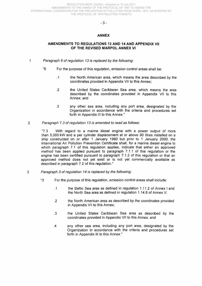
AMENDMENTS TO REGULATIONS 13 AND 14 AND APPENDIX VII OF THE REVISED MARPOL ANNEX VI
Paragraph 6 of regulation 13 is replaced by the following:
"6 For the purpose of this regulation , emission control areas shall be:
.1 the North American area, which means the area described by the coordinates provided in Appendix VII to this Annex;
.2 the United States Caribbean Sea area, which means the area described by the coordinates provided in Appendix VII to th is Annex; and
.3 any other sea area, including any port area, designated by the Organization in accordance with the criteria and procedures set forth in Appendix III to this Annex."
2 Paragraph 7.3 of regulation 13 is amended to read as follows :
"7 .3 With regard to a marine diesel engine with a power output of more than 5,000 kW and a per cylinder displacement at or above 90 litres installed on a ship constructed on or after 1 January 1990 but prior to 1 January 2000, the International Air Pollution Prevention Certificate shall , for a marine diesel engine to which paragraph 7.1 of this regulation applies, indicate that either an approved method has been applied pursuant to paragraph 7.1.1 of this regulation or the engine has been certified pursuant to paragraph 7.1.2 of this regulation or that an approved method does not yet exist or is not yet commercially available as described in paragraph 7.2 of this regulation ."
3 Paragraph 3 of regulation 14 is replaced by the following :
"3 For the purpose of this regulation , emission control areas shall include:
.1 the Baltic Sea area as defined in regulation 1.11 .2 of Annex I and the North Sea area as defined in regulation 1.14.6 of Annex V;
.2 the North American area as described by the coordinates provided in Appendix VII to this Annex;
.3 the United States Caribbean Sea area as described by the coordinates provided in Appendix VII to this Annex; and
.4 any other sea area, including any port area, deSignated by the Organization in accordance with the criteria and procedures set forth in Appendix III to this Annex"
RESOLUTION MEPC.202(62) - Adopted on 15 July 2011 AMENDMENTS TO THE ANNEX OF THE PROTOCOL OF 1997 TO AMEND THE
INTERNATIONAL CONVENTION FOR THE PREVENTION OF POLLUTION FROM SHIPS, 1973, AS MODIFIED BY THE PROTOCOL OF 1978 RELATING THERETO
- 4 -
4 A new subparagraph 4 is added to paragraph 4 of regulation 14 to read as follows:
".4 Prior to 1 January 2020, the sulphur content of fuel oil referred to in paragraph 4 of this regulation shall not apply to ships, operating in the North American area or the United States Caribbean Sea area defined in paragraph 3, built on or before 1 August 2011 that are powered by propulsion boilers that were not originally designed for continued operation on marine distillate fuel or natural gas."
5 Paragraph 7 of regulation 14 is replaced by the following :
"7 During the first twelve months immediately following entry into force of an amendment designating a specific emission control area under paragraph 3 of this regulation , ships operating in that emission control area are exempt from the requirements in paragraphs 4 and 6 of this regulation and from the requirements of paragraph 5 of this regulation insofar as they relate to paragraph 4 of this regUlation ."
6 Appendix VII is rep/aced by the following :
"Appendix VII Emission Control Areas (regulation 13.6 and regulation 14.3)
.1 The boundaries of emission control areas designated under regulations 13.6 and 143. other than the Baltic Sea and the North Sea areas, are set forth in this appendix .
. 2 The North American area comprises:
.1 the sea area located off the Pacific coasts of the United States and Canada, enclosed by geodesic lines connecting the following coordinates:
POINT LATITUDE LONGITUDE 1 32° 32' 10" N. 117° 06' 11" W. 2 32° 32' 04" N. 117° 01' 29" W. 3 32° 31' 39" N. 117° 14' 20" W. 4 32° 33' 13" N. 117° 15' 50" W. 5 32° 34' 21" N. 1170 22' 01" W. 6 32° 35' 23" N. 117° 21' 53" W. 7 32° 31' 38" N. 1170 49' 34" W. 8 31° 01' 59" N. 1180 36' 21" W. 9 30° 33' 25" N. 121° 41' 29" W.
10 31°46' 11" N. 1230 11' 22" W. 11 32° 21' 58" N. 123° 50' 44" W. 12 32° 56' 39" N. 124° 11'47"W. 13 33° 40' 12" N. 124° 27' 15" W. 14 34° 31' 28" N. 125° 16' 52" W. 15 35° 14' 38" N. 1250 43' 23" W. 16 35° 43' 60" N. 126° 18' 53" W. 17 36° 16' 25" N. 126° 45' 30" W. 18 37° 01' 35" N. 127° 01' 18" W. 19 37° 45' 39" N. 127° 38' 02" W.
RESOLUTION MEPC.202(62) - Adopted on 15 July 2011 AMENDMENTS TO THE ANNEX OF THE PROTOCOL OF 1997 TO AMEND THE
INTERNATIONAL CONVENTION FOR THE PREVENTION OF POLLUTION FROM SHIPS, 1973, AS MODIFIED BY THE PROTOCOL OF 1978 RELATING THERETO

- 5 -
POINT LATITUDE LONGITUDE
20 38° 25' 08" N. 127° 52' 60" W.
21 39° 25' 05" N. 128° 31' 23" W.
22 40° 18' 47" N. 128° 45' 46" W
23 41° 13' 39" N. 128° 40' 22" W.
24 42° 12' 49" N. 129° 00' 38" W.
25 42° 41' 34" N. 129° 05' 42" W
26 43° 26' 22" N. 129° 01' 26" W
27 44° 24' 43" N. 128° 41' 23" W
28 45° 30' 43" N. 128° 40' 02" W
29 46° 11' 01" N. 128° 49' 01" W
30 46° 33' 55" N. 129° 04' 29" W
31 47° 39' 55" N. 131° 15' 41" W
32 48° 32' 32" N. 132° 41' 00" W
33 48° 51' 47" N. 133° 14' 47" W.
34 49° 22' 39" N. 134° 15'51"W.
35 50° 01' 52" N. 135° 19' 01 " W.
36 51° 03' 18" N. 136° 45' 45" W.
37 51° 54' 04" N. 137° 41' 54" W.
38 52° 45' 12" N. 138° 20' 14" W.
39 53° 29' 20" N. 138° 40' 36" W.
40 53° 40' 39" N. 138° 48' 53" W
41 54° 13' 45' N. 139° 32' 38' W.
42 54° 39' 25' N. 139° 56' 19" W
43 55° 20' 18' N. 140° 55' 45' W
44 56° 01' 12' N. 141° 36' 18" W
45 56° 28' 32' N. 142° 11' 19" W
46 56° 31' 19' N. 142° 48' 57" W
47 58° 51' 04" N. 153° 15' 03" W
.2 the sea areas located off the Atlantic coasts of the United States, Canada , and France (Saint-Pierre-et-Miquelon) and the Gulf of Mexico coast of the United States enclosed by geodesic Jines connecting the following coordinates:
POINT LATITUDE LONGITUDE
1 60° 00' 00" N. 64° 09' 36' W
2 60° 00' 00' N. 56° 43' 00' W.
3 58° 54' 01 ' N. 55° 38' 05' W.
4 57° 50' 52" N. 55° 03' 47" W.
5 57° 35' 13' N. 54° 00' 59" W
6 57° 14' 20' N. 53° 01' 58' W
7 56° 48' 09' N. 52° 23'29" W
8 56° 18' 13" N. 51° 49' 42" W
9 54° 23' 21 " N. 50° 11'44" W
10 53° 44' 54" N. 50° 01' 17" W
11 53° 04' 59" N. 50° 10' 05" W
12 52° 20' 06" N. 49° 51' 09" W.
13 51° 34' 20" N. 48° 52' 45" W.
14 50° 40' 15" N. 48° 16' 04" W.
15 50° 02' 28" N. 48° 01' 03" W.
16 49° 24' 03" N. 48° 09' 35" W.
17 48° 39' 22' N. 47° 55' 17" W.
RESOLUTION MEPC.202(62) - Adopted on 15 July 2011 AMENDMENTS TO THE ANNEX OF THE PROTOCOL OF 1997 TO AMEND THE
INTERNATIONAL CONVENTION FOR THE PREVENTION OF POLLUTION FROM SHIPS, 1973, AS MODIFIED BY THE PROTOCOL OF 1978 RELATING THERETO

- 6 -
POINT LATITUDE LONGITUDE 18 47° 24' 25" N. 47° 46' 56" W 19 46° 35' 12' N. 48° 00' 54" W 20 45° 19' 45' N. 48° 43' 28' W 21 44° 43' 38" N. 49° 16' 50" W 22 44° 16' 38" N. 49° 51' 23" W 23 43° 53' 15" N. 50° 34'01" W 24 43° 36' 06" N. 51°20'41"W
25 43° 23' 59" N. 52° 17' 22" W 26 43° 19' 50" N. 53° 20' 13" W 27 43° 21' 14" N. 54° 09'20" W
28 43° 29' 41 " N. 55° 07' 41 " W 29 42° 40' 12" N. 55°31'44"W
30 41 ° 58' 19' N. 56° 09' 34" W
31 41° 20' 21" N. 57° 05' 13" W
32 40° 55' 34" N. 58° 02'55" W
33 40° 41' 38" N. 59° 05' 18" W
34 40° 38' 33" N. 60° 12'20" W
35 40° 45' 46" N. 61°14'03"W
36 41° 04' 52" N. 62° 17'49" W
37 40° 36' 55" N. 63° 10'49" W
38 40° 17' 32" N. 64° 08' 37" W
39 40° 07' 46" N. 64° 59' 31" W
40 40° 05' 44" N. 65° 53' 07" W 41 39° 58' 05" N. 65° 59' 51" W
42 39° 28' 24" N. 66° 21' 14" W
43 39° 01 ' 54" N. 66°48'33" W
44 38° 39' 16" N. 67° 20' 59" W
45 38° 19'20" N. 68° 02' 01 " W
46 38° 05' 29" N. 68°46' 55" W
47 37° 58' 14" N. 69° 34' 07" W
48 37° 57' 47" N. 70° 24'09" W
49 37° 52' 46" N. 70° 37' 50" W
50 37° 18' 37" N. 71° 08' 33" W
51 36° 32' 25" N. 71° 33' 59" W
52 35° 34' 58" N. 71° 26' 02" W
53 34° 33' 10" N. 71° 37' 04" W
54 33° 54' 49" N. 71° 52' 35" W
55 33° 19' 23" N. 72° 17' 12" W
56 32° 45' 31" N. 72° 54'05" W
57 31° 55' 13" N. 74° 12'02" W
58 31° 27' 14" N. 75° 15' 20" W
59 31° 03' 16" N. 75° 51' 18" W
60 30' 45' 42" N. 76° 31' 38" W
61 30° 12' 48" N. 77° 18' 29" W
62 29° 25' 17" N. 76° 56'42" W
63 28° 36' 59" N. 76° 47' 60" W
64 28° 17' 13" N. 76°40' 10" W
65 28° 17' 12" N. 79° 11' 23" W.
66 27° 52' 56" N. 79°28' 35" W
67 27° 26' 01" N. 79° 31' 38" W
68 27° 16' 13" N. 79° 34' 18" W
69 27° 11' 54" N. 79° 34' 56" W
70 27° 05' 59" N. 79° 35' 19" W
RESOLUTION MEPC.202(62) - Adopted on 15 July 2011 AMENDMENTS TO THE ANNEX OF THE PROTOCOL OF 1997 TO AMEND THE
INTERNATIONAL CONVENTION FOR THE PREVENTION OF POLLUTION FROM SHIPS, 1973, AS MODIFIED BY THE PROTOCOL OF 1978 RELATING THERETO
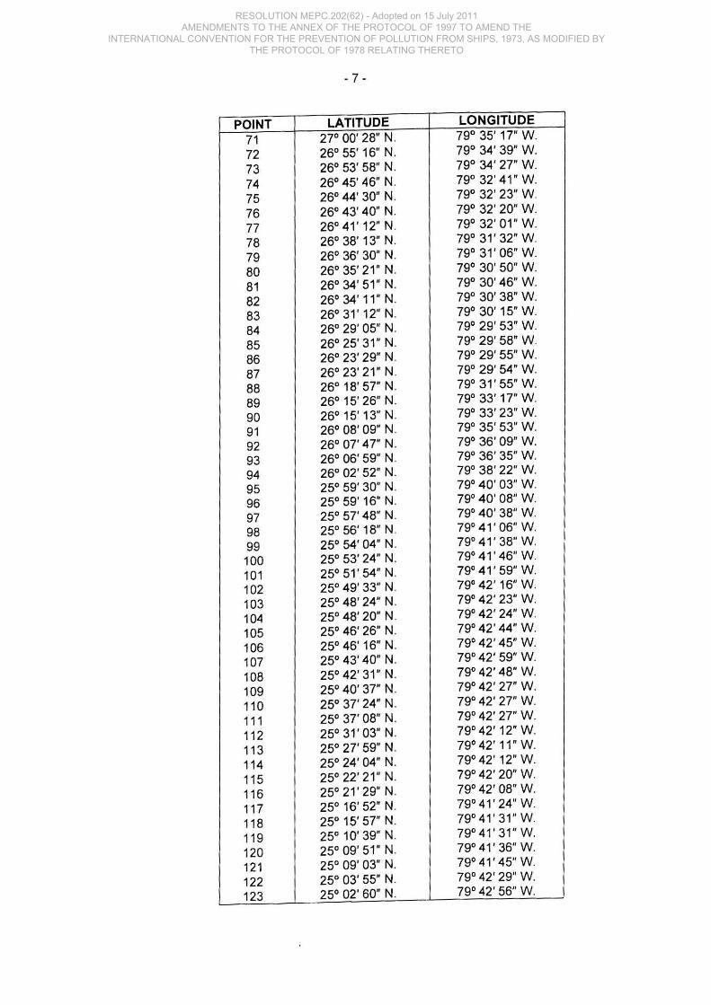
·7 ·
POINT LATITUDE LONGITUDE
71 270 00' 28" N. 790 35' 17" W.
72 260 55'16' N. 79° 34' 39' W.
73 260 53' 58" N. 79° 34' 27" W.
74 260 45' 46" N. 790 32' 41" W.
75 260 44' 30" N. 790 32' 23" W.
76 260 43' 40" N. 790 32' 20" W.
77 26°41'12' N. 79° 32' 01" W.
78 26° 38' 13" N. 790 31' 32" W.
79 26 0 36' 30" N. 79 0 31' 06" W.
80 26 0 35' 21" N. 79° 30' 50" W.
81 260 34' 51" N. 79° 30' 46" W.
82 260 34' 11" N. 79° 30' 38" W.
83 260 31' 12" N. 790 30' 15" W.
84 26° 29' 05" N. 790 29' 53" W.
85 260 25' 31" N. 790 29' 58" W.
86 260 23' 29" N. 79° 29' 55" W.
87 260 23' 21" N. 79° 29' 54" W.
88 260 18' 57" N. 79° 31' 55" W.
89 260 15' 26" N. 79° 33' 17" W.
90 260 15'13" N. 790 33' 23" W.
91 260 08' 09" N. 790 35' 53" W.
92 260 07' 47" N. 79° 36' 09" W.
93 26° 06' 59" N. 79° 36' 35" W.
94 26° 02' 52" N. 79° 38' 22" W.
95 25° 59' 30" N. 79° 40' 03" W.
96 25° 59' 16" N. 79° 40' 08" W.
97 25° 57' 48" N. 79° 40' 38" W.
98 25° 56' 18" N. 79° 41' 06" W.
99 25° 54' 04" N. 79° 41' 38" W.
100 25° 53' 24" N. 79° 41' 46" W.
101 25° 51' 54" N. 79° 41' 59" W.
102 25° 49' 33" N. 79° 42' 16" W.
103 25° 48' 24" N. 79° 42' 23" W.
104 250 48' 20" N. 79° 42' 24" W.
105 25° 46' 26" N. 79° 42' 44" W.
106 25° 46'16" N. 79° 42' 45" W.
107 25° 43' 40" N. 79° 42' 59" W.
108 25° 42' 31" N. 79° 42' 48" W.
109 25° 40' 37" N. 79° 42' 27" W.
110 25° 37' 24" N. 79° 42' 27" W.
111 25° 37' 08" N. 79° 42' 27" W.
11 2 25° 31' 03" N. 79° 42' 12" W.
113 25° 27' 59" N. 79° 42'11" W.
114 25° 24' 04" N. 79° 42' 12" W.
115 25° 22' 21 " N. 79° 42' 20" W.
11 6 25 0 21' 29" N. 79° 42' 08" W.
117 25° 16' 52" N. 79°41'24" W.
118 25° 15' 57" N. 79°41'31"W.
119 25° 10' 39" N. 79° 41' 31" W.
120 25° 09' 51" N. 79°41' 36" W.
121 25° 09' 03" N. 79° 41' 45" W.
122 25° 03' 55" N. 79° 42' 29" W.
123 25° 02' 60" N. 79° 42' 56" W.
RESOLUTION MEPC.202(62) - Adopted on 15 July 2011 AMENDMENTS TO THE ANNEX OF THE PROTOCOL OF 1997 TO AMEND THE
INTERNATIONAL CONVENTION FOR THE PREVENTION OF POLLUTION FROM SHIPS, 1973, AS MODIFIED BY THE PROTOCOL OF 1978 RELATING THERETO

- 8 -
POINT LATITUDE LONGITUDE 124 25° 00' 30" N. 79 0 44' 05" W
125 24° 59' 03" N. 790 44'48" W
126 24° 55' 28" N. 790 45' 57" W
127 24° 44' 18" N. 790 49' 24" W
128 24° 43' 04" N. 79 0 49' 38" W
129 24° 42' 36" N. 79 0 50' 50" W
130 24°41'47" N. 79° 52' 57" W 131 24° 38' 32" N. 790 59' 58" W
132 24° 36' 27" N. 800 03' 51" W
133 24° 33' 18" N. 80 0 12' 43" W
134 24° 33' 05" N. 80° 13'21"W
135 24° 32' 13" N. 800 15' 16" W
136 24° 31' 27" N. 800 16' 55" W
137 24° 30' 57" N. 80° 17' 47" W.
138 24° 30' 14" N. 80° 19'21"W
139 24° 30' 06" N. 800 19'44"W
140 24° 29' 38" N. 800 21' 05" W
141 24° 28' 18" N. 80° 24' 35" W
142 24° 28' 06" N. 800 25' 10" W
143 24° 27' 23" N. 80° 27' 20" W
144 24° 26' 30" N. 80° 29' 30" W.
145 24° 25' 07" N. 800 32'22" W
146 24° 23' 30" N. 80° 36' 09" W
147 24° 22' 33" N. 80° 38' 56" W.
148 24° 22' 07" N. 80° 39' 51 " W
149 24° 19' 31" N. 80° 45' 21" W
150 24° 19' 16" N. 800 45'47" W
151 24° 18' 38" N. 800 46'49" W
152 24° 18' 35" N. 80° 46' 54" W
153 24° 09' 51" N. 80° 59'47" W
154 24° 09' 48" N. 80° 59' 51" W
155 24° 08' 58" N. 81°01'07"W
156 24° 08' 30" N. 81° 01' 51" W
157 24° 08' 26" N. 81° 01' 57" W
158 24° 07' 28" N. 81° 03' 06" W
159 24° 02' 20" N. 81° 09' 05" W
160 23° 59' 60" N. 81° 11' 16" W
161 23° 55' 32" N. 81° 12' 55" W
162 23° 53' 52" N. 81° 19' 43" W
163 23° 50' 52" N. 81° 29' 59" W
164 23° 50' 02" N. 81° 39' 59" W
165 23° 49' 05" N. 81° 49' 59" W
166 23° 49' 05" N. 82° 00' 11" W.
167 23° 49' 42" N. 82° 09' 59" W
168 23° 51' 14" N. 82° 24' 59" W
169 23° 51' 14" N. 82° 39' 59" W
170 23° 49' 42" N. 82° 48' 53" W.
171 23° 49' 32" N. 82° 51' 11" W
172 23° 49' 24" N. 82° 59' 59" W
173 23° 49' 52" N. 83° 14' 59" W
174 23° 51' 22" N. 83° 25' 49" W
175 23° 52' 27" N. 83° 33' 01" W
176 23° 54' 04" N. 83° 41' 35" W
RESOLUTION MEPC.202(62) - Adopted on 15 July 2011 AMENDMENTS TO THE ANNEX OF THE PROTOCOL OF 1997 TO AMEND THE
INTERNATIONAL CONVENTION FOR THE PREVENTION OF POLLUTION FROM SHIPS, 1973, AS MODIFIED BY THE PROTOCOL OF 1978 RELATING THERETO
- 9 -
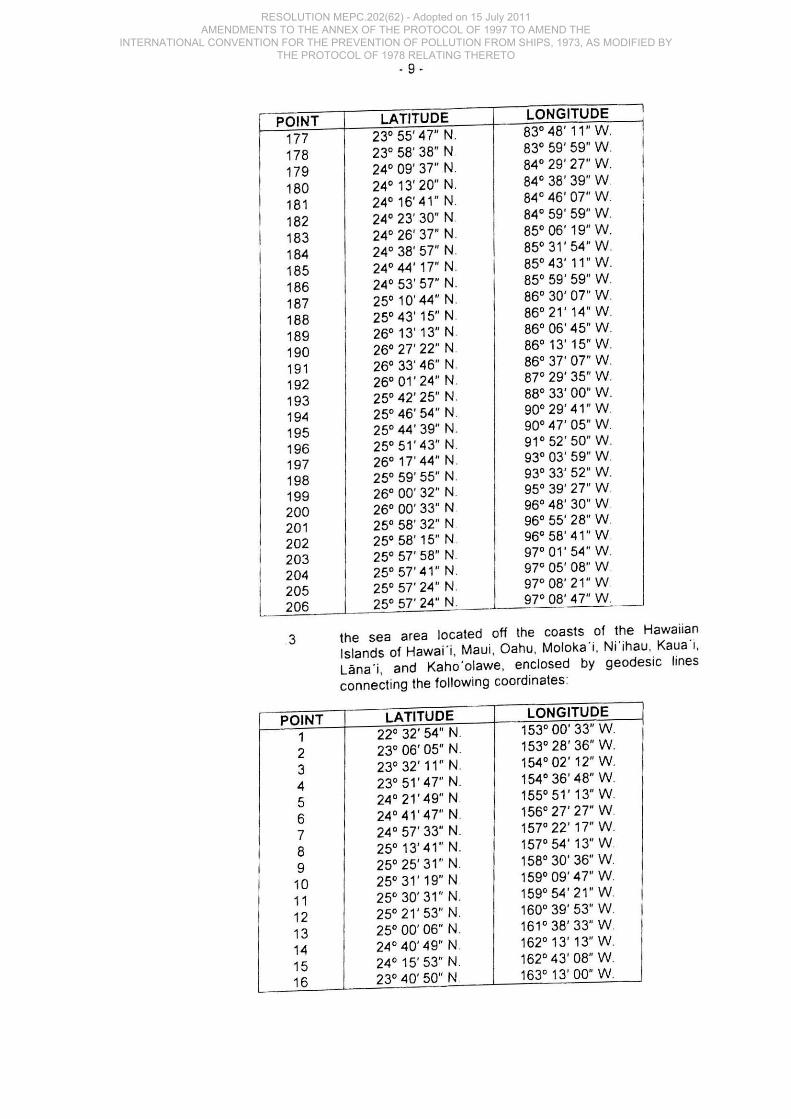
POINT LATITUDE LONGITUDE
177 23° 55' 47" N. 83°48' 11" W
178 23° 58' 38" N 83° 59' 59" W
179 24° 09' 37" N 84° 29' 27" W
180 24° 13' 20" N. 84° 38' 39" W
181 24° 16' 41" N. 84° 46' 07" W
182 24° 23' 30" N. 84° 59' 59" W
183 24° 26' 37" N. 85° 06' 19" W
184 24° 38' 57" N. 85° 31' 54" W
185 24° 44' 17" N. 85° 43' 11" W.
186 24° 53' 57" N. 85° 59' 59" W
187 25° 10' 44" N. 86° 30' 07" W
188 25° 43' 15" N. 86°21'14"W
189 26° 13' 13" N. 86° 06'45" W
190 26° 27' 22" N 86° 13' 15" W
191 26° 33' 46" N 86° 37' 07" W
192 26° 01' 24" N. 87" 29' 35" W
193 25° 42' 25" N 88° 33' 00" W
194 25° 46' 54" N 90° 29' 41" W
195 25° 44' 39" N. 90° 47' 05" W
196 25° 51 ' 43" N. 91° 52' 50" W.
197 26° 17' 44" N. 93° 03 ' 59" W
198 25° 59' 55" N. 93° 33' 52" W
199 26° 00' 32" N 95° 39' 27" W
200 26° 00' 33" N. 96° 48' 30" W
201 25° 58' 32" N 96° 55' 28" W
202 25° 58' 15" N 96° 58 ' 41 " W
203 25° 57' 58" N 97° 01' 54" W.
204 25° 57'41 " N 97° 05' 08" W
205 25° 57' 24" N 97° 08' 21" W
206 25° 57' 24" N. 97° 08' 47" W
3 the sea area located off the coasts of the Hawaiian Islands of Hawai "i, Maui , Oahu, Moloka 'i, Ni'ihau , Kaua"i, Ulna"i, and Kaho'olawe, enclosed by geodesic lines connecting the following coordinates:
POINT LATITUDE LONGITUDE
1 22° 32' 54" N. 153° 00' 33" W
2 23° 06 ' 05" N. 153° 28' 36" W
3 23° 32' 11 " N. 154° 02' 12" W
4 23° 51 ' 47" N 154° 36' 48" W
5 24° 21' 49" N 155° 51' 13" W
6 24°41'47"N. 156° 27' 27" W
7 24° 57' 33" N. 157° 22' 17" W
8 25° 13' 41" N. 157° 54' 13" W
9 25° 25' 31" N. 158° 30' 36" W
10 25° 31' 19" N 159° 09' 47" W
11 25° 30' 31" N. 159° 54' 21" W
12 25° 21' 53" N. 160° 39' 53" W
13 25° 00' 06" N. 161° 38' 33" W
14 24 ° 40'49" N. 162° 13' 13" W
15 24° 15' 53" N. 162° 43' 08" W
16 23° 40' 50" N 1630 13' 00" W
RESOLUTION MEPC.202(62) - Adopted on 15 July 2011 AMENDMENTS TO THE ANNEX OF THE PROTOCOL OF 1997 TO AMEND THE
INTERNATIONAL CONVENTION FOR THE PREVENTION OF POLLUTION FROM SHIPS, 1973, AS MODIFIED BY THE PROTOCOL OF 1978 RELATING THERETO
I POINT
i 1 2 ,
I 3 4
! 5 i 6 I I 7 I ,
8 ! 9 , I 10 I
11 ;
12 I 13 I 14 I i
I
I I I ,
I !
I I
I I i , I ,
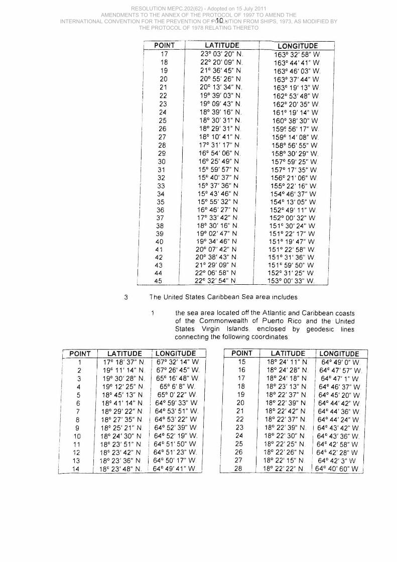
POINT 17 18 19 20 21 22 23 2~
25 26 27 28 29 30 31 32 33 3~
35 36 37 38 39 ~O
~1
~2
43 44 45
, I
I I
I I
· 10·
LATITUDE 23' 03' 20" N. 22' 20' 09" N 21' 36 ' 45" N 20' 55' 26" N 20' 13' 34" N. 19' 39' 03" N 19' 09 ' 43" N 18' 39' 16" N. 18'30'31"N 18'29'31"N 18' 10' 41 " N. 17'31'17"N 16' 54' 06" N 16' 25' 49" N 15' 59' 57" N 15' 40' 37" N 15' 31' 36" N 15' 43' 46" N 15' 55' 32" N 16' 46 ' 27" N 17' 33' 42" N 18' 30' 16'· N 19' 02 ' 47" N 19' 34' 46" N 20' 01' 42" N 20' 38' 43" N 21' 29' 09" N 22' 06' 58" N 22' 32 ' 54" N
I I
LONGITUDE 163' 32' 58" W 163' 44' 41" W 163' ~6 ' 03" W 163' 31' 44" W 163' 19' 13" W 162' 53' ~8" W 162' 20' 35" W 161' 19' 14" W 160' 38' 30" W 159~ 56' 17" W 159' 14' 08" W 158' 56' 55" W 158' 30' 29" W 157' 59' 25" W 157'lT35"W 156' 21 ' 06" W 155' 22'16" W 154' ~6' 37" W 154' 13' 05" W 152' ~9 ' 11" W 152' ~O' 32" W 151 ' 3~ ' 2~" W 151' 22' 17" W 151' 19' ~7" W 151' 22' 58" W 151' 31' 36" W 151' 59' 50" W 152' 31' 25" W 153' ~O' 33" W
3 T he United States Caribbean Sea area Includes
LATITUDE 17' 18' 37" N 19'11'14"N. 19' 30 ' 28" N. 19'12' 25" N. 18' 45' 13" N 18'41'14"N 18' 29' 22" N 18' 21' 35" N 18'25'21"N 18' 24' 30" N 18' 23' 51 " N 18' 23 ' 42" N 18' 23' 36" N 18' 23' 48" N.
the sea area located off the Atlantic and Caribbean coasts of the Commonwealth of Puerto Rico and the United States Virgin Islands . enclosed by geodeSIC lines connecting the following coordinates
I LONGITUDE POINT LATITUDE I LONGITUDE I 67' 32' 14" W ! 67' 26' 45" W I 65' 16' 48" W i 65' 6' 8" W ! 65' 0' 22" W ! 6~' 59' 33" W I 6~' 53' 51 " W I 64' 53' 22" W i 64' 52 ' 39" W I 6~' 52 ' 19" W ; 64'51'50"W I 6~ ' 51 ' 23" W I 6~' 50' 17" W ; 64'49'41 "W ,
15 18' 24 ' 11 " N I 64' 49' 0" W 16 18' 24' 28" N I 64' 47' 57" W 17 18' 24 ' 18" N , 64'47'1"W 18 18' 23' 13" N / 64 ' 46' 37" W 19 18' 22 ' 37" N 64' 45' 20" W 20 18' 22' 39" N I 64' 44' 42" W 21 18' 22' 42" N I 64' 44 ' 36" W 22 18' 22' 37" N. I 64' 44 ' 2~" W 23 18' 22 ' 39" N. I 64' 43 ' 42" W 24 18' 22 ' 30" N 64' 43' 36" W 25 18' 22 ' 25" N I 64' 42 ' 58" W
I 26 18' 22' 26" N I 64' 42 ' 28" W I 27 18' 22' 15" N I 64 ' 42' 3" W I
I 28 I 18' 22 ' 22' N I 64' 40' 60" W ,
RESOLUTION MEPC.202(62) - Adopted on 15 July 2011 AMENDMENTS TO THE ANNEX OF THE PROTOCOL OF 1997 TO AMEND THE
INTERNATIONAL CONVENTION FOR THE PREVENTION OF POLLUTION FROM SHIPS, 1973, AS MODIFIED BY THE PROTOCOL OF 1978 RELATING THERETO
- 11 -
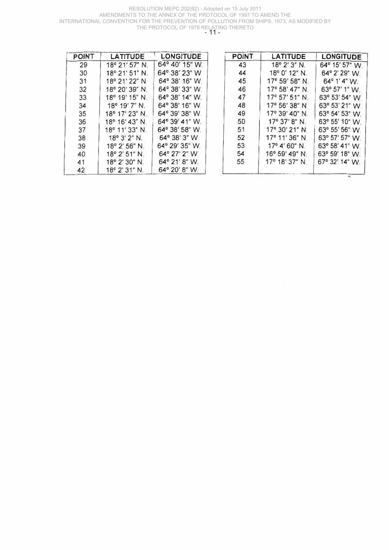
POINT LATITUDE LONGITUDE POINT LATITUDE LONGITUDE 29 18'21'57"N. 64' 40' 15" W. 43 18'2'3"N. 64' 15' 57' W. 30 18' 21' 51" N. 1 64' 38' 23" W 31 18'21'22"N 64' 38' 16' W.
44 18' 0' 12" N. 64' 2' 29" W 45 17' 59' 58" N. 64' l ' 4" W.
32 18' 20' 39" N. 64 ' 38' 33" W. 46 17' 58' 47" N. 63' 57' 1" W 33 18' 19' 15" N. 64' 38' 14' W. 47 17' 57' 51" N. 63' 53 ' 54" W 34 18' 19'7" N. 64' 38' 16" W. 48 17' 56 ' 38" N. 63' 53 ' 21 " W 35 18' 17' 23" N. 64' 39' 38" W. 49 17'39'40'N. 63' 54' 53" W. 36 18' 16'43" N. 64' 39' 41' W. 50 17' 37' 8" N. 63' 55' 10" W 37 18' 11' 33" N. 64' 38' 58" W. 51 17' 30' 21" N 63' 55' 56" W 38 18'3'2"N. 64' 38' 3" W 52 17' 11' 36" N 63' 57' 57" W 39 18' 2' 56" N. 64' 29' 35' W. 53 17' 4' 60" N. 63' 58' 41 " W. 40 18' 2' 51 " N. 64' 27' 2" W 54 16' 59' 49" N. 63' 59' 18' W. 41 18' 2' 30" N. 64' 21' 8" W. 55 17' 18' 37" N. 67' 32 ' 14" W. 42 18' 2' 31" N. 64' 20' 8" W.
RESOLUTION MEPC.202(62) - Adopted on 15 July 2011 AMENDMENTS TO THE ANNEX OF THE PROTOCOL OF 1997 TO AMEND THE
INTERNATIONAL CONVENTION FOR THE PREVENTION OF POLLUTION FROM SHIPS, 1973, AS MODIFIED BY THE PROTOCOL OF 1978 RELATING THERETO
RESOLUTION MEPC.202(62) - Adopted on 15 July 2011 AMENDMENTS TO THE ANNEX OF THE PROTOCOL OF 1997 TO AMEND THE
INTERNATIONAL CONVENTION FOR THE PREVENTION OF POLLUTION FROM SHIPS, 1973, AS MODIFIED BY THE PROTOCOL OF 1978 RELATING THERETO