research article - journalcra.com filekilometers of coastal wetlands and other lowlands could be...
TRANSCRIPT

SUSTAINABLE COASTAL ZONE MANAGEMENT STRATEGIES FOR THE UNCONSOLIDATED ODISHA
*,1Nilay Kanti Barman, 2Ashis Kumar Paul,
1Department of Geography, Hijli College, Kharagpur, 2Department of Geography and Environment Management, Vidyasga
3Department of Geography, Presidency University, Kolkata,
ARTICLE INFO ABSTRACT
Global climate change may increase sea level as much as 1m over the next century and in somestretches and also augmented the frequency and severity of storms. Hundreds of thousands of square kilometers of coastal wetlands and other lowlands could be submerged. Beaches could move back as much as a few hundred meters and protective structures may lives, agriculture, livestock, buildings and infrastructures. Saltwater would advance landward into aquifers and up estuaries threatening water supplies, ecosystems and agriculture in some areas. Some nations are particvulnerable to sea level rise, some areas could be dangerously threatened. Examples include India, Bangladesh and other areas economically dependent on fisheries or sensitive to chanhabitats. As a result of present population growth and development coastal areas worldwide are under rising pressure. In addition augmented exploitation of nonpurposes and values of coastal zones in manareas are becoming more and more susceptible to sea level rise and other impacts of climate change. Even a minute rise in sea level could have unfavorable effects. So the sustainable coastal zone managecoastal zone management are described in the present attempt.
Copyright © 2015 Nilay Kanti Barman et al. This is an open access article distributed under the Creaunrestricted use, distribution, and reproduction in any medium, provided the original work is properly cited.
INTRODUCTION
The perception of coastal zone management is a comparatively new one, promising less than four decades ago from the requirement to tackle a range of interrelated problems connected with population growth and development along our nation’s coasts. The coastal setting is enormous dynamic, this dynamism is the consequence of ‘constantly changing types of interactions among the ocean, atmosphere, land and people’ (Kusky, 2008). Coastlines are not inert entities but fluctuate at a short-term seasonal level as well as a longerchange level (Kusky, 2008). However, much development in the littoral zone occurs with the objective of ‘stabilising the shoreline’ creating an inconsistency between human use and the coastline’s natural processes (Kusky, 2008). The dynamic systems found on the coast are under escalating pressure by anthropogenic development (Nicholls, Developmental anxieties within the coastal zone are clearly set to augment as its population rises.
*Corresponding author: Nilay Kanti Barman, Department of Geography, Hijli College, Kharagpur, India.
ISSN: 0975-833X
Article History:
Received 20th July, 2015 Received in revised form 29th August, 2015 Accepted 15th September, 2015 Published online 31st October, 2015
Citation: Nilay Kanti Barman, Ashis Kumar Paul, Soumendu Chatterjee and Mihir Kumar Pradhan, Strategies for the Unconsolidated Odisha Coastal Tract, India
Key words: Climate Change, Sea Level Rise, Estuary, Sustainable Management, Vulnerable.
RESEARCH ARTICLE
SUSTAINABLE COASTAL ZONE MANAGEMENT STRATEGIES FOR THE UNCONSOLIDATED ODISHA COASTAL TRACT, INDIA
Ashis Kumar Paul, 3Soumendu Chatterjee and 2Mihir Kumar Pradhan
Department of Geography, Hijli College, Kharagpur, IndiaDepartment of Geography and Environment Management, Vidyasgar University, Midnapore, India
Department of Geography, Presidency University, Kolkata, India
ABSTRACT
Global climate change may increase sea level as much as 1m over the next century and in somestretches and also augmented the frequency and severity of storms. Hundreds of thousands of square kilometers of coastal wetlands and other lowlands could be submerged. Beaches could move back as much as a few hundred meters and protective structures may be breached. Flooding would threaten lives, agriculture, livestock, buildings and infrastructures. Saltwater would advance landward into aquifers and up estuaries threatening water supplies, ecosystems and agriculture in some areas. Some nations are particularly vulnerable. Even in nations that are not on the whole predominantly vulnerable to sea level rise, some areas could be dangerously threatened. Examples include India, Bangladesh and other areas economically dependent on fisheries or sensitive to chanhabitats. As a result of present population growth and development coastal areas worldwide are under rising pressure. In addition augmented exploitation of non-renewable resources is debasing the purposes and values of coastal zones in many parts of the world. Consequently, populated coastal areas are becoming more and more susceptible to sea level rise and other impacts of climate change. Even a minute rise in sea level could have unfavorable effects. So the sustainable coastal zone management is necessary instantly in the low lying coastal zone. The approaches of the sustainable coastal zone management are described in the present attempt.
. This is an open access article distributed under the Creative Commons Attribution License, which permits unrestricted use, distribution, and reproduction in any medium, provided the original work is properly cited.
coastal zone management is a comparatively new one, promising less than four decades ago from the requirement to tackle a range of interrelated problems connected with population growth and development along our
mous dynamic, this dynamism is the consequence of ‘constantly changing types of interactions among the ocean, atmosphere, land and people’ (Kusky, 2008). Coastlines are not inert entities but fluctuate at
term seasonal level as well as a longer-term climatic-change level (Kusky, 2008). However, much development in the littoral zone occurs with the objective of ‘stabilising the shoreline’ creating an inconsistency between human use and the coastline’s natural processes (Kusky, 2008). The dynamic
ems found on the coast are under escalating pressure by anthropogenic development (Nicholls, et al., 2007). Developmental anxieties within the coastal zone are clearly set
Department of Geography, Hijli College, Kharagpur, India.
Sale, et al., 2008 estimates by 2050 that, 91% of the world’s coast will be impacted by development. Pressure is not only exercised from within the coastal zone but increasingly at a broader, more global scale (Swaneywith population and development growing at a hurried rate the world’s coastal environments are under growing pressure. This pressure is exuberated by the growing menace of climate change and the significant impacts of such a climatic shift will have on the world’s coastal regions. Relative seapredicted to rise escalating the risk of erosion and inundation coupled with an increased likelihood of extreme weather events and storm surges (Nicholls, In the context of increasing apprehensions about those hazards, the growing importance of the coastal zones because of high efficiency of the ecosystems, concentration of population, industrial development, resource exploitation,activities etc. Demands effective coastal management.human occupancies of geo-morphologically hazard prone lands of the coastal belt are not circumvented at present around the
Available online at http://www.journalcra.com
International Journal of Current Research Vol. 7, Issue, 10, pp.21937-21953, October, 2015
INTERNATIONAL
Nilay Kanti Barman, Ashis Kumar Paul, Soumendu Chatterjee and Mihir Kumar Pradhan, 2015. “Sustainable Coastal Zone Management Strategies for the Unconsolidated Odisha Coastal Tract, India”, International Journal of Current Research, 7, (10),
z
SUSTAINABLE COASTAL ZONE MANAGEMENT STRATEGIES FOR THE UNCONSOLIDATED ODISHA
Mihir Kumar Pradhan
India r University, Midnapore, India
India
Global climate change may increase sea level as much as 1m over the next century and in some stretches and also augmented the frequency and severity of storms. Hundreds of thousands of square kilometers of coastal wetlands and other lowlands could be submerged. Beaches could move back as
be breached. Flooding would threaten lives, agriculture, livestock, buildings and infrastructures. Saltwater would advance landward into aquifers and up estuaries threatening water supplies, ecosystems and agriculture in some areas. Some
ularly vulnerable. Even in nations that are not on the whole predominantly vulnerable to sea level rise, some areas could be dangerously threatened. Examples include India, Bangladesh and other areas economically dependent on fisheries or sensitive to changes in estuarine habitats. As a result of present population growth and development coastal areas worldwide are under
renewable resources is debasing the y parts of the world. Consequently, populated coastal
areas are becoming more and more susceptible to sea level rise and other impacts of climate change. Even a minute rise in sea level could have unfavorable effects. So the sustainable coastal zone
ment is necessary instantly in the low lying coastal zone. The approaches of the sustainable
tive Commons Attribution License, which permits
2008 estimates by 2050 that, 91% of the world’s coast will be impacted by development. Pressure is not only exercised from within the coastal zone but increasingly at a
global scale (Swaney et al., 2011). Eventually with population and development growing at a hurried rate the world’s coastal environments are under growing pressure. This pressure is exuberated by the growing menace of climate
mpacts of such a climatic shift will have on the world’s coastal regions. Relative sea-levels are predicted to rise escalating the risk of erosion and inundation coupled with an increased likelihood of extreme weather events and storm surges (Nicholls, et al., 2008).
In the context of increasing apprehensions about those hazards, the growing importance of the coastal zones because of high efficiency of the ecosystems, concentration of population, industrial development, resource exploitation, recreational
effective coastal management. The morphologically hazard prone lands
of the coastal belt are not circumvented at present around the
INTERNATIONAL JOURNAL OF CURRENT RESEARCH
Sustainable Coastal Zone Management , 7, (10), 21937-21953.

Bay of Bengal shores due to augmented population pressure and available economic options in the sea and flanking lands. The dramatic increase in losses and casualties due to natural disasters like wind, storms surge induced flooding, seismic hazards and tsunami incidence of Bay of Bengal coasts during the previous decades has provoked a major national scientific enterprise into the probable causes and possible mitigation strategies. The study area Odisha coast is a part of unconsolidated alluviums originated by the huge sediments deposition by the numerous rivers like Subarnarekha, Mahanadi, Burahbalong, Brambrhani in this geomorphic part which extending between 21°35'48" Northern Latitude and 87°27'17" Eastern Longitude. Odisha’s coastal zone is endowed with a wide range of mangroves, salt marshes, sand dunes, estuaries, lagoons and a unique maritime flora and fauna. The profuse coastal and offshore marine ecosystems comprise with some 1435 sq km of mangroves forest in Bhitarkanika with more than 82 species which are among the largest mangroves in the world. There are most important reserves of fish, marine mammals, reptiles and Olive Ridley turtles, sea grass meadows and abundant sea weeds. 35 % of the coastal stretch is burdened with considerable placer mineral and heavy metal deposits. Cultural and archaeological sites, some with national and international significance pointed at the coast. Coastal fishing utilizes a large number of people fulltime. Rapid urban-industrialization, maritime transport, marine fishing, tourism, coastal and sea bed mining, offshore oil and natural gas production and aquaculture have guided to a noteworthy enhancement in demand for infrastructure resulting in the overexploitation of natural resources. General guidelines on managing coastal erosion and their options Understanding the key processes of coastal dynamics and how coasts developed in the past and present, as well as over the short and long term, is very important for managing coastal problems because coastal issues may occur without cause for concern. This can be very complex and possibly controversial where many conflicts of interests exist within the coastal environment. The main underlying principles for coastal erosion management are as follows (NRC, 1990; ARC, 2000): Identify and confirm coastal issue as a problem. Identify, confirm and quantify the cause of the problem and
ensure that any management option is well thought out before implementing coastal management measures.
Understand the key processes and characteristics of coastal dynamics and system boundaries that reflect the natural processes of the coastal problem.
Determine the coastal management measure options and implement them using proper design, construction and maintenance with careful evaluation of the effects on adjacent shores.
Consider the balance of the options’ costs and their associated benefits.
Existing Sustainable Coastal Zone Management Strategies for the Odisha Coast Integrated Coastal Zone Management Project, Odisha Sustainable management of coastal and marine resources is important to Odisha state’s economic growth. Odisha coast is subject to rigorous weather events such as tropical cyclones and super-cyclones imposing great loss of lives and property especially among the rural coastal communities that always had low flexibility to extreme weather variability mostly due to impoverishment. In this context Ministry of Forest and Environment, Government of India, The World Bank and Government of Odisha has come forward with an integrated approach to coordinate activities of various government agencies and departments for the sustainable management and usages of coastal resources for maintaining the natural environment (Fig. 1). The Integrated Coastal Zone Management Project on pilot basis will be executed in three states - Gujarat, Odisha and West Bengal. In Odisha state the project on pilot basis will be executed in two coastal stretches - Paradeep to Dhamra and Gopalpur to Chilika. For effectual management and carrying out of all project activities and coordination with 10 PEAs of ICZM Project Odisha, a society namely “Integrated Coastal Zone Management Society, Odisha” has been registered to meaning as State Project Management Unit (SPMU). The duration of the project is for a period of 5 years starting from September, 2010. The Department of Forest and Environment, Government of Odisha is the Nodal Department for execution of this 5 year project in Odisha. For smooth implementation of the project a Steering Committee under the chairmanship of the Chief Secretary Odisha is constituted. A Governing Body is also constituted under the Chairmanship of Principal Secretary Forest and Environment. About 4 lakhs people from 235 coastal villages of Kendrapara, Jagatsinghpur, Puri, Khurda and Ganjam would be directly benefitted from the project activities. Direct employment opportunity for the coastal fisher folks would be created through eco-tourism activities. Capacity building and empowerment of 600 Self Help Groups from 60 villages would be carried out through the project.
Coastal Laws and Policies and Geographical Limits of the Coastal Zone of Odisha The maritime region jacketing the both narrow coastal land and the coastal waters are dealt by a major umbrella National Legislation namely Environment Protection Act (1986). The two legal instruments Water Prevention and Control of Pollution Act (1974) and the Coastal Regulation Zone Notification (1991) are governing the coastal activities especially the pollution in the coastal waters and developmental activities in the narrow coastal zone up to 500m from the High Tide Line. The Water (Prevention and Control of Pollution) Act, 1974 The Water Prevention and Control of Pollution Act (1974) comprise with all basic features of water pollution and
21938 Nilay Kanti Barman et al. Sustainable coastal zone management strategies for the unconsolidated Odisha coastal tract, India

jurisdiction of the act has been constrained up to 5 km in the sea. The Central Pollution Control Board which is the zenith body is entrusted with the functions on advising the Central Government on matters recounting to control of pollution and co-ordinate the activities among the State Boards. The State Boards has the major responsibilities in dealing with pollution problems which have been praised with the functions for the obstruction, control or abatement of pollution of streams and wells in the State and also the coastal waters. Environmental Protection Act, 1986 It is an umbrella act concerning all aspects of environment in the country. The act contracts with air and water pollution, hazardous substances and regulations on coastal zone. The most significant part of this act is applicable to the Coastal Regulation Zone Notification (1991). Orissa Marine Fishing Regulations Act (OMFRA) and Rules, 1982 Orissa Marine Fishing Regulations Act is a unique one regarding fishing activities. It includes some criteria like mechanized fishing is forbidden within 5 km from the coast according to the OMFRA rules. Mechanized boats within 15m
length are legitimated beyond 5 km from the shore whereas the vessels above 15m in length are justifiable beyond 10 km from the coast for fishing. These regulations have been done in observance in mind that the turtles migrating towards the Orissa coast which normally move in the waters up to 5 km. The vessels above 15m in length are not legalized as most of use trawl or gill net in which the turtles get garroted during their movement and die. Under the OMFRA marine fishing has been proscribed in specified turtle gathering areas namely Devi River mouth, Rushikulya River Mouth and Dhamara River mouth by all the mechanized vessels within 20 km radius form the coast.
Wildlife Protection Act of 1972
The Wildlife Protection Act (1972) is a package of legislation endorsed in 1972 by the Government of India. Prior to 1972, The Act established schedules of sheltered plant and animal species, hunting or otherwise harvesting these species was principally outlawed. The Act provides for the protection of Wild animals, birds and plants. The Olive Ridley Turtle has been scheduled under Schedule I indicating it’s endangers.
21939 International Journal of Current Research, Vol. 7, Issue, 10, pp.21937-21953, October, 2015
Fig. 1. Co-operation sectors of integrated coastal zone management

21940 Nilay Kanti Barman et al. Sustainable coastal zone management strategies for the unconsolidated Odisha coastal tract, India
Fig. 2. Regulated coastal zone management strategies
Fig. 3. Copping processes against disaster

Forest Conservation Act, 1980 The Forest Conservation Act (1980) came in to force with effect from October 25, 1980. Under the provisions of this Act, prior endorsement of the Central Government is indispensable for diversion of forest lands for the non-forestry purposes. The basic goal of the Act is to regulate the logical balance between the developmental needs of the country and the conservation of natural heritage. Conservation A forestation Management and Planning Authority (CAMPA) are being constituted at the national level. A monitoring cell is also being set up in the Ministry of Environment & Forests to scrutinize the movement of proposals at various stages and the observance of the conditions predetermined in the forestry clearances by the user agencies. Orissa Prevention of Land Encroachment (OPLE) Act, 1954 The Orissa Prevention of Land Encroachment (OPLE) Act (1954) deals with cases of infringing the government lands. The requirements of the act are co-operative in preventing encroachment of buffer areas of the forest or coastal zone which are needed for quite a lot of protection related activities. Regulated Coastal Zone Management Strategies This Strategy provides direction and guidance for use of coastal resources to achieve coastal management outcomes.
It is primarily aimed at local government which is responsible for managing large areas of public coastal land and beaches. However State Government, traditional owners, national and state marine park managers, port authorities, and operators who manage specialist areas of the coast and tidal water will also find the policies and supporting information useful in guiding management decisions on the coast. The overall coastal management strategies are shown in Fig. 2. Regulated coastal management has mainly two strategies which are as follows Provide for the protection, conservation, rehabilitation and
management of the coastal zone including its resources and biological diversity and
Encourage the enhancement of knowledge of coastal resources and the effects of human activities on the coastal zone.
Suggested Sustainable Coastal Zone Management Strategies for the Odisha Coast Copping Processes As our knowledge of coastal dynamics and climate change gets better it has become gradually more apparent that solitary reliance on engineered ‘hard’ defenses is unlikely to be sustainable. Instead prominence is switching to a ‘coping strategy’ (Fig. 3 and 4) based on a mixed approach with protection focused on strategic and high value areas and the rest of the coastline left to acclimatize to change more naturally. In exercise, because of the variety of stakeholders
21941 International Journal of Current Research, Vol. 7, Issue, 10, pp.21937-21953, October, 2015
Fig. 4. Aid of pre-disaster protection and post hazard recovery

and challenging resource usages typical of coastal areas a number of challenges need to be immediately addressed. The politics of coastal management has become more and more polarized and contested (Fletcher, 2003).
21942 Nilay Kanti Barman et al. Sustainable coastal zone management strategies for the unconsolidated Odisha coastal tract, India
Fig. 5. Configuration and micro Zonation of coastal environment
Fig. 6. Proposed environmental zoning approach
of coastal areas a number of challenges need to be immediately addressed. The politics of coastal management has become more and more
Three coastal adaptation strategies have been recognized these are protected, accommodate, and retreat. In structural shore-protection methods have been rethere has been greater concentration in managing coastal retreat.
Barman et al. Sustainable coastal zone management strategies for the unconsolidated Odisha coastal tract, India
Configuration and micro Zonation of coastal environment
Fig. 6. Proposed environmental zoning approach
coastal adaptation strategies have been recognized these are protected, accommodate, and retreat. In the past few years’
protection methods have been re-evaluated and there has been greater concentration in managing coastal
Barman et al. Sustainable coastal zone management strategies for the unconsolidated Odisha coastal tract, India

Improvement of biophysical and socioeconomic flexibility in coastal regions is gradually more regarded as an enviable adaptive strategy but appears not to be practicable in many of the world’s coastal zones. Supplementary insights can be gained by understanding adaptation to natural inconsistency. Although some countries and coastal communities have the adaptive capacity to diminish the impacts of climate change, others have fewer options. Geographic and economic unevenness leads to inequity in the vulnerability of coastal communities and potentially in intergenerational access to food, water and other resources. Environmental Zoning Approach for Coastal Zone Management Environmental zoning approach is an innovative coastal zone management approach in the present day situation. Environmental zoning approach is highly applicable for the vulnerable areas regarding the land use pattern (Fig. 5). In this context this approach may highly appropriate for the present study area as the zone situated in a coastal vulnerable area experienced with tropical cyclone and allied coastal hazards. The main theme of this approach is how to diminish the severity of vulnerability of a susceptible part introducing the pioneering land use pattern. According to researcher’s ground verification during the field survey the environmental zoning approach map has been prepared to show that whatever portions of the coastal stretch should be used for what purpose by the customary coastal dwellers to ensure the reduce of coastal hazard severity. If the indigenous coastal people of the Subarnarekha delta plain obey this approach then they would be benefitted from the brutality of upcoming coastal hazards. To prepare this map one should kept it mind that some places of the front face of the sea should be unoccupied which are treated as the natural processes and their modification actions. The Fig. 6 denotes the area where the natural processes are always plays their role to adjust the natural setting. Land use Land use pattern is directly related to coastal management strategies. The local people of the present low lying deltaic coast are frequently changing the land use pattern in accordance to their requirements without knowing the advent risk which associated with the land use practices. Now a day the wetland and marshy land altered into the industrial fish farming sectors and shrimp farming plots. Deltaic alluviums and sandy alluviums transformed into grazing ground and sand dune also used for economic activities like fish draying ground. So these unscientific land use patterns are immensely practicing in the studied coast and producing a number of vulnerable conditions which may accelerate the coastal hazardous conditions.In this context the coastal dwellers should follow the scientific land use practice and at the same time they should also be aware about the advent risks produced by the unscientific land use pattern.
Oil Spill Risk Management
Oil spills into the ocean comes from the collision, grounding and accident of ships. Collision and preparation can be evaded
through VTMS and also ensuring ample radar based instruments in ships and more importantly avoiding human error where applicable. Oil spills affect is going on in spite of all anticipatory measures and appropriate contingency plans should be available with the Ports to tackle oil spills involving spillage of about 100 tons of oil. It is essential to promote the equipment and manpower facilities to tackle spill at least up to 100 tons. Similarly, the two developing ports at Gopalpur and Dhamra need to have suitable oil spill contingency plans. Pollution/ Environmental Quality Management
In the Odisha coast consistent and effectual environmental management system with a strong component of monitoring of air and water quality has become very important. Consequently Solid Waste Management Scheme in Paradeep like collection, segregation and transport of solid waste, backfilling, plantation, vermin composting and consciousness generationand a well instrumented laboratory along with required manpower and monitoring strategy has been proposed to make sure long-term management of environment eminence in the region.
Vulnerability and Disaster Management
The Odisha coast being prone to tropical landfall and heavy rainfall during both the South-West and North-East monsoons face the predicaments of flooding of villages and experience severe damage to the property during cyclonic withstand conditions. Loss of life also occurs during certain conditions like the Super Cyclone of 1999, during which 8913 people lost their lives. Considerable population live in semi-permanent houses and thatched huts and often these structures get damaged during the landfall and floods making the coastal communities virtually homeless. Mitigation of Impact of Disasters Present Activities The Odisha coast frequently experiences with the impacts of tropical cyclone and allied storm surges. Therefore, the special buildings such as cyclone shelters with necessary facilities are most needed structures at the time of severe cyclone for the people who need shelter. Before 1999 Red Cross Society constructed 23 numbers of multipurpose cyclone shelter which saved thousands of life. Furthermore, the Govt. of Odisha has been constructed 97 shelters with the active participation of the Orissa Disaster Mitigation Authority (OSDMA) and 41 are under construction. The defense measures against the coastal erosion also adopted in form of rock armor, boulder pitching and sea dyke at Udaipur, Chandipur and Mahishali coastal sectors. Biodiversity Conservation To combat the increasing human impacts on natural ecosystems it has become paramount of significance to preserve and conserve biodiversity. The floral diversity of Bhitarkanika is known to be the largest biological diversity in India. To ensure the existence of biological diversity along with profusion in the long-term manner Odisha Government takes some important steps like.
21943 International Journal of Current Research, Vol. 7, Issue, 10, pp.21937-21953, October, 2015

i. Casuarinas plantation at Bhitarkanika and Rushikulya areas and also other coastal areas
ii. Intensive patrolling in the sea against intrusion of fishing trawlers in turtle breeding areas
iii. Patrolling in turtle nesting ground will be undertaken. Research to modernize the species level information on dolphin and birds will be commenced in Chilika. The environmental quality monitoring system will be also improved by reinforcement the laboratory facilities.
Protection of Olive Ridley Sea Turtles, Cetaceans, Estuarine Crocodiles and Other Aquatic Wildlife The site includes the most significant and considerable natural habitats for in-situ preservation of biological assortment containing several endangered species of outstanding universal value from the conservation point of view such as the Olive Ridley Sea turtles, the cetaceans, the estuarine crocodiles and other aquatic wildlife. Therefore, protection and conservation of these endangered species shall ensure and conservation of marine biodiversity of this expanse which is a worldwide significant biodiversity hot spot vicinity containing globally important population of sea turtles and crocodiles. The marine aquatic body is the mating and reproduction ground of the scarce Olive Ridley sea turtles. Sophisticated protection status has been accorded in the Odisha coast by the State and Central Govt. (1435 sq. km. near Bhitarkanika as a consequence of it being declared as a Marine Protected Area.) Since sea turtles and cetaceans are at the summit of ecological pyramid their conservation shall be ensured and also conservation of aquatic bio-diversity of this coastal marine ecosystem should be implemented.
Present Activities
In order to conserve the turtles and protect the sea area from illegal fishing and also to augment resources, following activities/actions have been carried out
1. Acquisition of two seas worthy vessels, speed boats and support patrol vessels for protection of sea turtles in their congregated mating and breeding grounds.
2. Regularization of fishing fleets in the coast by fixing maximum fleet size limits in each fish landing centre and fishing harbor.
3. Revenue generation from registration and license of fishing fleets.
4. Imposition of fishing ban in specified areas attributing to conservation
5. Availing central support for interests of fisher community such as development of model fishermen villages, motorization of country crafts, subsistence to fishermen during lean period of fishing etc.
6. Regulating coastal aquaculture to ensure sustained increase in aquaculture products while protecting environment.
7. No aquaculture activity is allowed within a distance of two kilometers from the High Tide Line of seas, rivers, creeks and backwaters.
8. Each brackish water aqua farm needs certificate of registration, granted by Coastal Aquaculture Authority (CAA), Chennai, established under the Coastal Aquaculture Authority Act (2005).
9. So far, 564 brackish water farms covering an area of 348.39 Hec. have been certified by the CAA., Chennai.
Proposed Activities
Protection Measures for Olive Ridley Turtles
Two sea worthy vessels though acquired for protection measures for Olive Ridley Turtles regarding this need funds for manning, running and maintenance of these vessels. These vessels shall be used for joint patrolling of the sea by the Forest and Fisheries Department. One of the major monitoring centers shall be established at Babubali with provision of solar lights, water supply and a jetty. For protection and patrolling purpose equipments such as DGPS, GPS, Night viewing binoculars, Binoculars with distance measurement facility, Eco-sounder, radar, VHF main sets, VHF handsets with electric and solar chargers, life jackets, life buoys etc. shall be procured for use in the sea worthy vessels, speed boats and support patrol vessels for protection of sea turtles.
Research and Monitoring Centre at Rushikulya Mouth
The Rushikulya river mouth area along the Chilika coast is also a mass nesting area of the endangered Olive Ridley Sea Turtles. The marine aquatic body which is treated as the mating and breeding ground of the species has been designated as a ‘No Fishing Zone’ under the Orissa Marine Fishing Regulation Act and Rule (1982). The area has been proposed to be designated as a marine sanctuary. It is proposed to have a research and monitoring centre at this site for facilitating long term research and monitoring. Strengthening of Crocodile Research and Rearing Centre at Dangamal Around mid-1970s population of salt water crocodiles had severely diminished throughout its assortment including in Orissa. After launching of the integrated GOI/FAO/UNDP project the population of this rare species has significantly augmented in the river systems of Bhitarkanika through the grow-rear and release programme. These nests are being shattered in the wild by predators such as the monitor lizards, wild pigs etc. Therefore, there is a need for reinforcement the existing facilities at Dangamal area for successful conservation of the endangered estuarine crocodiles. Bhitarkanika Habitat Centre at Dangamal There is also require of setting Bhitarkanika Habitat Centre at Dangamal where more information can be exhibited on Olive Ridley Turtles, Estuarine Crocodiles, Birds, Mangroves etc for education, research and consciousness purpose. Plantation of Mangroves/ Mangrove Associates and Other Suitable Species for Coastal Management Under the Annual Plan of Operation as well as Management Action Plan all forest blocks which are infringement free have been planted with mangroves. However, the areas along the many of the tidal rivers and creeks in the area which are non-
21944 Nilay Kanti Barman et al. Sustainable coastal zone management strategies for the unconsolidated Odisha coastal tract, India

forest lands are presently devoid of mangroves. It will therefore act as a natural cyclone shelter belt. The above will also help in stabilization of tidal river banks, avert soil erosion and act as a buffer zone. Plantation of mangroves/mangrove associates and other suitable species in village forest areas/private lands shall be done by way of rising of nurseries and allocation of seedlings etc. to the local villagers. The area that may be available for raising shelter belt of casuarinas will be 77 Hec. of private land. The mangrove plantation will be taken up in different manner. This is because in some of the refractory hyper saline areas and areas devoid of periodic inundation by tidal water, it is first compulsory to prepare the ground and reinstate the salinity level by allowing free flow of inter-tidal water into the area through digging of channels in fishbone type design. This is an important interference to ensure that the mangrove plantation has good chance of success at these sites. Further the plantation may be raised by putting hypocotyls of mangrove species or by planting nursery raised seedlings like the Bichitrapur mangrove.
Monitoring and Evaluation
A monitoring unit to oversee the implementation of the proposed activities and periodical review of progress should be adopted immediately in this region. Berhampur Division will be act as the monitoring unit. Engineered Structures for Coastal Zone Management Hard Engineering Methods Groynes Groynes are barriers or walls at right angles to the sea often finished of greenhearts, concrete, rock or wood. Beach material builds up on the down drift side where littoral drift is mostly in one direction which creating a wider and a more plentiful beach therefore enhancing the defense for the coast because the sand material filters and absorbs the wave energy. Sea Wall Walls of concrete or rock built at the base of a cliff or at the back of a beach are used to defend a settlement alongside erosion or flooding. They are generally about 3-5 m (10-16 ft) high. Contemporary seawalls aim to redirect most of the incident energy resulting in low reflected waves and much abridged turbulence and thus take the form of sloping revetments. Modern designs employ absorbent designs of rock, concrete protective covering with intermediary flights of steps for beach access. Revetments Wooden slanted or upright barricades built parallel to the sea on the coast generally towards the back of the beach to guard the cliff or settlement beyond. The most basic revetments consist of timber slants with a possible rock infill. Waves break alongside the revetments which disperse and absorb the energy. The cliff base is sheltered by the beach material held behind the barriers as the revetments trap some of the material. They may be watertight, covering the slope totally or porous to
allow water to filter through after the wave energy has been dissolute. Rock Armor Also well-known as riprap rock armor is large rocks mound or positioned at the base of dunes or cliffs with indigenous stones of the beach. This is generally used in areas prone to erosion to soak up the wave energy and hold beach material. Gabions Boulders and rocks are wired into interlock cages and generally placed in front of areas vulnerable to profound erosion. Occasionally at cliffs edges or jag out at a perpendicular to the beach like a large groyne. When the seawater breaks on the gabion the water drains through leave-taking sediments also the rocks and boulders absorb a moderate amount of the wave energy. Offshore Breakwater Massive concrete blocks and natural boulders are dashed offshore to change wave direction and to sieve the energy of waves and tides. The waves break further offshore and therefore decrease their erosive power.This guides to wider beaches which absorb the abridged wave energy protecting cliff and settlements behind. Cliff Stabilization Cliff stabilization can be proficient through drainage of surplus rainwater of through terracing, planting and wiring to hold cliffs in consign. Cliff drainage is used to hold a cliff together using plants, fences and terracing. This is used to help put off landslides and other confined to small area damage. Floodgates Storm surge barriers or floodgates were commenced after the North Sea Flood of 1953 and are a prophylactic method to prevent harm from storm surges or any other type of natural catastrophe that could harm the area. Soft Engineering Methods Beach Nourishment Beach replenishment or nourishment is one of the largely popular soft engineering techniques of coastal protection management designs. This engrosses introducing sand off the beach and supporting it on top of the existing sand. The imported sand must be of a similar quality to the existing beach material so it can put together with the natural processes occurring there without causing any unfavorable effects. Sand Dune Stabilization Vegetation can be used to encourage dune growth by trapping and stabilizing blown sand.
21945 International Journal of Current Research, Vol. 7, Issue, 10, pp.21937-21953, October, 2015

21946 Nilay Kanti Barman et al. Sustainable coastal zone management strategies for the unconsolidated Odisha coastal tract, India
Fig. 7. Proposed installation places of different hard and soft coastal engineering structures
Table 1. Proposed Structures with Appropriate Locations
Engineered Structures Proposed Place Location Why It should be Appropriate
Groynes Joydevkasba 86°56'45''E 21°23'55''N Beach erosion is very prominent with a strong long shore current Sea Wall Joydevkasba 86°56'45''E 21°23'55''N Beach erosion is very prominent with a strong long shore current Gabon Chandipur 87°1'30''E 21°28'40''N Dune basal erosion, high cross shore current Break Water Bichitrapur 87°26'35''E 21°33'45''N Terminated area of Subarnarekha river, vortex generated here Sand Dune Stabilization Dogra 87°17'55''E 21°32'45''N Dune washed out by storm surge. Human alteration is very high Rock Armor Rasalpur 86°55'20''E 21°18'45''N Beach erosion is very prominent, concentration of industrial fish
farming plots Revetment Kashaphala 87°9'55''E 21°30'55''N Beach width is very less, riverine action is very prominent by
Dugdugi river Flood Gate Bahawalpur 87°6'30''E 21°29'20''N Riverine effects is very high during the monsoonal season Cliff Stabilization Dogra 87°17'55''E 21°32'45''N Dune washed out by storm surge. Human alteration is very high Headland Chandipur 87°1'30''E 21°28'40''N Dune basal erosion, high cross shore current Jetty Balaramguri 87°1'30''E 21°28'55''N Fish landing station situated here, famous for tourist place Dune Fencing Parikhi 87°2'30''E 21°28'40''N Dune height is very less, human alteration is very high up Sandbag Structure Bichitrapur 87°26'35''E 21°33'45''N Terminated area of Subarnarekha river, vortex generated here Off shore Break Water Bichitrapur 87°26'35''E 21°33'45''N Terminated area of Subarnarekha river, vortex generated here Off shore Break Water (Floating) Choumukh 87°19'30''E 21°32'40''N Cross shore current is very high, depth of the water is also very high Beach Nourishment Joydevkasba 86°56'45''E 21°23'55''N Beach erosion is very prominent with a strong long shore current Dune Thatching Rasalpur 86°55'20''E 21°18'45''N Beach erosion is very prominent, concentration of industrial fish
farming plots Artificial Coral Building Kashaphala 87°9'55''E 21°30'55''N Beach width is very less, riverine action is very prominent by
Dugdugi river Beach Drainage Talsari 87°27'55''E 21°37'45''N Barrier bar topography present here with active chenier mechanism Sand Bypassing Bahawalpur 87°6'30''E 21°29'20''N Riverine effects is very high during the monsoonal season Beach Plantation Dogra 87°17'55''E 21°32'45''N Dune washed out by storm surge. Human alteration is very high

Beach Drainage Beach drainage or beach face dewatering lowers the water table locally underneath the beach face. This causes accumulation of sand on top of the drainage system (Graham et al., 2003). The beach in a drenched state grant proposed that backwash velocity is accelerated by the adding up of groundwater seepage out of the beach within the sewage zone (Turner et al., 2004). Sand Bypassing It is also a soft engineering method by which the water with suspended sediments penetrates into a sheltered bay and deposits the suspended materials into this bay. Monitoring Coastal Zones Coastal zone managers are faced with difficult and complex choices about how best to reduce property damage in the shorelines. One of the problems they face is error and uncertainty in the information available to them on the processes that cause erosion of beaches. Video-based monitoring lets collect data continuously at low cost and produce analyses of shoreline processes over a wide range of averaging intervals. The above structures (Soft and Hard) may also be helpful in the present study area to protect against the coastal erosion. These should be adopted in proper location for better results. The above table (Table 1) shows the proper location of these structures. The above figure (Fig. 7) also symbolizes the actual location of proposed structures in the map. Event Warning Systems Event warning systems such as tsunami warnings and storm surge warnings can be used to decrease the human impact of disastrous events that cause coastal erosion. Storm surge warnings can also be used to determine when to shut floodgates to decrease the physical impact of such events. Wireless sensor networks can be organized quickly to set up a coastal erosion observing system and scaled accordingly.
Shoreline Indicator - A Tool of Coastal Zone Management Shoreline indicators are based on water level as well as the high water line, mean high water line, wet/dry border line and the physical water line (Pajak and Leatherman, 2002). The high water line (HWL) defined as the wet/dry line is the most usually used shoreline indicator because it is visible in the field and can be construed on both colour and grey scale aerial photographs (Crowell et al., 1991). The HWL is portrayed on aerial photographs by the most landward change in colour or grey tone (Boak and Turner, 2005).
The location of the shoreline and its altering position over time is of fundamental significance to coastal scientists, engineers and managers (Boak and Turner, 2005; Pajak and Leatherman, 2002). The location of the shoreline also provides information regarding shoreline reorientation adjacent to structures, beach width, volume and rates of historical change (Boak, and Turner, 2005; Pajak, and Leatherman, 2002).
Historical Maps and Arial Photographs In the event that a study requires the shoreline position to be mapped before the coverage, it is necessary to employ historical maps in order to detail shoreline position (Moore, 2000). The main advantage and reason for using historical maps is that they are able to provide a historic record that is not available from other data sources. Many errors of historical map may be associated with scale, datum changes, distortions from uneven shrinkage, stretching, creases, tears and folds, different surveying standards, different publication standards, and projection errors (Boak and Turner, 2005). The severity of these errors depends on the accuracy standards met by each map and the physical changes that have occurred since the publication of the map (Anders and Byrnes, 1991). Remote Sensing and Geographic Information System Managing the coast involves monitoring changes and the handling of much information. Remote sensing involves making observations some distance from the subject and as far as the coastline is concerned includes aerial photography, LIDAR (light detection and ranging) and satellite imagery which can then be used in a GIS or a digital elevation or terrain model. This suite of techniques enables very long coasts to be surveyed and analyzed quickly providing comprehensive overviews. These techniques allow coasts to be mapped and changes monitored such a ecosystem changes (Yang, (2005) and the geomorphology of barrier islands, beaches and dunes (Saye et al., 2005). GIS techniques have even been applied to mapping Holocene coastal paleo-geography (Berendsen et al., 2007). These techniques not only allow physical changes to be measured but also pollution and water quality to be detected and monitored (Liu et al., 2003). They have been particularly useful in tracking the development of oil spills such as for the Exxon Valdez spill in Alaska (Stringer et al., 1992). A number of instruments have been introduced to monitor coasts such as NASA’s Coastal Zone Colour Scanner (CZCS). These data and information collected on the ground require storage and GIS are rapidly becoming the main storage and retrieval system for such information. GIS allows layers of information to be superimposed all of which can be interrogated by the user and used to inform management decisions (O’Regan, 1996). Used together remote sensing and GIS techniques are powerful tools in managing coastal problems (Populus et al., 1995).
Livelihood Security
The maritime communities in Orissa state particularly the people living close to the coast mainly work as agricultural laborers and involved in small to medium scale fishing in estuarine and marine areas. Due to restricted fishing prospects major fishing population look for alternate sources of employment and also often migrating to nearby urbanized areas and work as construction laborers. To ensure the livelihood security several alternate livelihood options such as crab fattening, diary and goattery, coir making, value added product development and eco-tourism should be adopted in the
21947 International Journal of Current Research, Vol. 7, Issue, 10, pp.21937-21953, October, 2015
study area. Eco-tourism prospects are also planned through pioneer methods in the Bhitarkanika area. Strengthening of Laboratory Facilities This component will deals with technical assistance and capacity building like Laboratory Infrastructure, Manpower Strengthening, Environmental Monitoring, Knowledge and Information, Updating of Skill and Software. To achieve the objectives the Board has to be reinforced in terms of up-to-date information, knowledge, man power, equipments and instruments. So it is projected to establish a Coastal Management Laboratory with the staff structure mostly project in nature and necessary analytical instrument/equipments at Paradeep. Software for preparation of coastal environmental database will be procured to comprehend the behavior of pollutants in estuarine and coastal waters and use this knowledge to predict eco-toxicological risks posed by their presence in these eco-systems. Pollution Abatement Strategies To reduce the deterioration of environment by the environmental pollution the pollution abatement strategies to be incorporated with the ICZMP for environmental management of Paradeep- Dhamra stretch. The pollution abatement strategy look for the removal of treated wastewater from existing and proposed industries at the respective outlets may have unfavorable impact on large area. The best discharge option is through widespread sewage drain to the marine outfall points without troubling the coastal water quality. Development of a common hazardous waste dumpsite is also necessary for treatment, storage and disposal of hazardous wastes generated from the industries operating in the stretch. Since the area is under the rapid state of industrialization which will be followed by urbanization, sewage treatment plant with proper sewage network is obligatory to discharge the treated wastewater of the urban settlements into coastal water body. Keeping in view the tourist potential of the
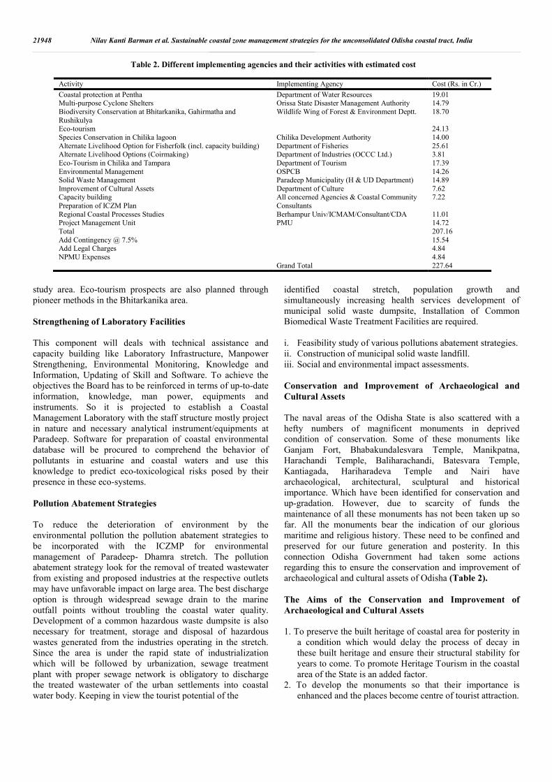
identified coastal stretch, population growth and simultaneously increasing health services development of municipal solid waste dumpsite, Installation of Common Biomedical Waste Treatment Facilities are required. i. Feasibility study of various pollutions abatement strategies. ii. Construction of municipal solid waste landfill. iii. Social and environmental impact assessments. Conservation and Improvement of Archaeological and Cultural Assets The naval areas of the Odisha State is also scattered with a hefty numbers of magnificent monuments in deprived condition of conservation. Some of these monuments like Ganjam Fort, Bhabakundalesvara Temple, Manikpatna, Harachandi Temple, Baliharachandi, Batesvara Temple, Kantiagada, Hariharadeva Temple and Nairi have archaeological, architectural, sculptural and historical importance. Which have been identified for conservation and up-gradation. However, due to scarcity of funds the maintenance of all these monuments has not been taken up so far. All the monuments bear the indication of our glorious maritime and religious history. These need to be confined and preserved for our future generation and posterity. In this connection Odisha Government had taken some actions regarding this to ensure the conservation and improvement of archaeological and cultural assets of Odisha (Table 2). The Aims of the Conservation and Improvement of Archaeological and Cultural Assets 1. To preserve the built heritage of coastal area for posterity in
a condition which would delay the process of decay in these built heritage and ensure their structural stability for years to come. To promote Heritage Tourism in the coastal area of the State is an added factor.
2. To develop the monuments so that their importance is enhanced and the places become centre of tourist attraction.
21948 Nilay Kanti Barman et al. Sustainable coastal zone management strategies for the unconsolidated Odisha coastal tract, India
Table 2. Different implementing agencies and their activities with estimated cost
Activity Implementing Agency Cost (Rs. in Cr.)
Coastal protection at Pentha Department of Water Resources 19.01 Multi-purpose Cyclone Shelters Orissa State Disaster Management Authority 14.79 Biodiversity Conservation at Bhitarkanika, Gahirmatha and Rushikulya
Wildlife Wing of Forest & Environment Deptt. 18.70
Eco-tourism 24.13 Species Conservation in Chilika lagoon Chilika Development Authority 14.00 Alternate Livelihood Option for Fisherfolk (incl. capacity building) Department of Fisheries 25.61 Alternate Livelihood Options (Coirmaking) Department of Industries (OCCC Ltd.) 3.81 Eco-Tourism in Chilika and Tampara Department of Tourism 17.39 Environmental Management OSPCB 14.26 Solid Waste Management Paradeep Municipality (H & UD Department) 14.89 Improvement of Cultural Assets Department of Culture 7.62 Capacity building All concerned Agencies & Coastal Community 7.22
Preparation of ICZM Plan Consultants Regional Coastal Processes Studies Berhampur Univ/ICMAM/Consultant/CDA 11.01 Project Management Unit PMU 14.72 Total 207.16 Add Contingency @ 7.5% 15.54 Add Legal Charges 4.84 NPMU Expenses 4.84 Grand Total 227.64

3. To keep alive the traditional temple buildings art and provide work for the dwindling class of traditional temple masons or Sathpatis of state Odisha.
4. The conservation works of monuments will add to the livelihood security by development of many self employment opportunities for the coastal people and this will also reduce pressure on the fragile environment of coastal region.
5. During natural calamities it can be used as shelter to save life and property of the people.
Capacity Building The UNDP outlines (2011) gives us the ideas regarding the capacity building, incorporates with individual level, institutional level and the societal level. Individual Level Community capacity-building on an individual level necessitates the development of conditions that permit individual contributors to construct and improve existing knowledge and skills. It also calls for the establishment of conditions that will allow individuals to engage in the "process of learning and adapting to change." Institutional Level Community capacity building on an institutional level should engross assisting pre-existing institutions in developing countries. It should not engage generating new institutions rather modernizing existing institutions and supporting them in forming sound policies, organizational structures, and effective methods of management and revenue control (Fig. 8). Societal Level Community capacity building at the societal level should maintain the establishment of a more "interactive public administration that learns equally from its actions and from feedback it receives from the population at large" (Fig. 9 and 10). Community capacity building must be used to develop public administrators that are responsive and accountable. Current Capacity Building Programmes – Achievements and Limitations The capacity building programmes of Odisha coast are mostly inadequate to fisheries and other rural industry sectors. The Chilika Development Authority performs training programmes to local communities on management characteristic and also livelihood options such as culture of fish, crabs etc. The training programmes of various required such as food processing, coir making among women through Self Help Groups are conducted by the rural industries. The Pollution Control Board confines its study to inland waters and due to lack of manpower and other laboratory facilities do not demeanor coastal water monitoring programmes and therefore no proficiency development is carried out. Tourism industry eager to promote eco-friendly tourism practices. The Forest Department has been conducting adequate training
programmes on aforestation to its own staff and has been creating consciousness among the coastal communities on conservation of coastal and other forests. NGOs also actively contribute in such awareness promotion camp. The state has well planned endorsement to save turtles and the beaches for nesting. The Wild Life division and the NGOs play a fundamental role in creating awareness among the local communities about the need to conserve the turtles. The foremost constraint in the state in capacity building is lack of satisfactory number of technical staff in most of the departments who can be trained in expert institutions in aquaculture, modern fishing practices, marine wild life management, eco-tourism etc.
Institutions and Authorities (Roles and Responsibilities) - Public and Government
Central Government Ministry of Environment and Forests (MoEF), Govt. of India is the Nodal Department for dealing with environmental facets of coastal zone. The MoEF is charged with the responsibility of endorsement of legislation to defend and conserve the coastal environment and for regulating the developmental activities from the angle of protection of coastal environment. MoEF is also developed the execution mechanisms to implement the provisions of the legislations relevant to the coastal zone. The Ministry of Earth Sciences conducts research on environmental, scientific and engineering aspects of the coastal zone. State Government Environment and Forests Department of Odisha state is the Nodal Department which deals with the management criterion of the coastal zone and implements strategies and programmes relating to environment, forests and Wild life besides enforcement of all environment related legislations. The other departments relevant to the coastal management activities are as follows:
Principal CCF (Wildlife) & Chief Wildlife Warden,
Odisha, Bhubaneswar: The right to execute guidelines and programmes of Government relating to wildlife its habitat and related issues and to enforce the various laws relating to wildlife and its habitat through its field functionaries.
The Fisheries and Animal Resources Development Department is responsible for implementing fisheries related programmes
Department of Tourism implements project relating to coastal tourism, lake tourism, eco-tourism etc.
Department of Water Resources is implementing programmes related to construction of embankment to prevent seawater imposition in coastal areas and shore protection measures against coastal erosion.
Odisha Disaster Mitigation Authority implements all programmes relating to construction of shelters for accommodating people during disasters like floods, storms etc. and also carry out other related activities
21949 International Journal of Current Research, Vol. 7, Issue, 10, pp.21937-21953, October, 2015

Department of Culture and its organization namely the Odisha State Archaeology take care of all archaeological conducts in the state.
Department of Industries is involved in promotion of establishment of small, medium and large scale industries along the coast.
National Institutions The major National institutions dealing with environmental aspects of the coastal zone are: National Institute of Oceanography, Goa and its regional
centers-conducts all coastal oceanographic and environmental studies along the coastal zone of the country.
National Institute of Ocean Technology, Chennai- conducts
environmental and engineering studies relating to coastal zone.
Integrated Coastal and Marine Area Management Project Directorate, Chennai-set up technical based integrated coastal zone management plans, carry out extensive R & D relating to coastal zone problems and suggest solutions. It delivers advises to the coastal states in resolving coastal zone problems and also communicate training on scientific and tools techniques of the coastal zone to the coastal states.
National Hydrographic Office, Dehradun - prepares bathymetric charts for navigation and scientific purposes and also designated as the agency to demarcate Low and High Tide Lines.
Zoological Survey of India, Kolkata-conducts wide range of surveys to maintain a database on animals of terrestrial and aquatic origin.
Botanical Survey of India, Kolkata-conducts wide range of surveys to maintain a database on terrestrial and aquatic plants.
Fishery Survey of India, Mumbai-conducts exploratory fisheries to assess the stocks and regional abundance of marine fishes available beyond 50 m depth.
Central Marine Fisheries Research Institute, Kochi-surveys abundance of fish in the coastal waters of India.
Central Inland Fisheries Research Institute, Barrakpore-studies the biology and abundance of fishes of inland, rivers and coastal lagoons.
Central Institute of Freshwater Aquaculture, Bhubaneswar-conducts research on culture of freshwater fish, develops methods to culture and disseminate the techniques to the users.
Central Institute of Brackish water Aquaculture, Chennai-conducts research on culture of freshwater fish, develops methods to culture and disseminate the techniques to the users.
Institutions in Orissa
Chilika Development Authority, Bhubaneswar. A state owned institution-Demeanour research on health of the Chilika lake, frequently monitors characteristics of the lake, plans environment friendly developmental activities such
as eco-tourism, alternative livelihood options etc. in the lake.
State Pollution Control Board-responsible for implementation of Water and Air Acts. Monitors pollution levels in industrial effluents and rivers.
Institute for Mineral and Material Technology, Bhubaneswar, a CSIR institution-monitors coastal pollution along the Orissa and West Bengal coasts.
Berhampur University-Academic programmes on marine and estuarine sciences and research on chemical and biological aspects of the coastal water bodies of Orissa.
Utkal University, Bhubaneswar. Paradeep Port Trust-Port activities and protection of eroded
coast, combating oil spills. Indian Rare Earths-mining of sand dues for illuminate. Private Sector Gopalpur Port-deals with anti-erosion measures to prevent likely erosion in north of the port Others Institutions NGOs in maritime Orissa mostly deal with preservation of turtles particularly around the turtle grounds in Rushikulya, Devi and Gahirmatha. A few of such NGOs are ‘A tree’, ‘Wild Life Society’ of Odisha are energetically concerned in observing of turtle nesting patterns. Integration and Co-ordination Interfaces in Coastal System Coastal zone is under the dynamic system in which a variety of human activities depends on the available natural resources of the diversified coastal habitats. Thus unsatisfactory interaction and outcomes (both economic and environment) of various resource uses are naturally symptoms of coastal systems. Potential gains can be achieved only if there is an integrated approach in coastal zone management. Particular focus should be there on interaction of level (local, regional, national and international) and resources demands that occur within the coastal zone and between coastal zone activities in other regions (Guidelines for integrated coastal zone management, 1996) (Fig. 6.12 and 6.13). Such treatment can be explained with the following examples
Management of Local Level Activities
The resource demands of local level activities like agriculture, aquaculture, forest conservation and recreation include coastal land, forest area, inland surface water and coastal water space. Conflicts between resource users demand management option policies at the local level.
Management of Regional Level Activities
Impacts of agriculture run-off on the coastal zone water quality, industrial waste disposal into the coastal plain, several other activities within the coastal hinterland areas and their impacts on the coastal zone water quality are considered. The resource demands for such activities include coastal plain rivers, estuaries and shallow seas or coastal waters.
21950 Nilay Kanti Barman et al. Sustainable coastal zone management strategies for the unconsolidated Odisha coastal tract, India

21951 International Journal of Current Research, Vol. 7, Issue, 10, pp.21937-21953, October, 2015
Fig10. Integration among different departments to execute the coastal protections
Fig. 9. Sea waters jurisdiction of coastal sectors in India

Management of National Level Activities Maintenance of the navigability of Subarnarekha river, dredging activities, river training project, various other activities of dam construction, tourism policies, nature conservation policies and several pollution control policies (within different parts of the coastal zone) need to co-ordination with them. Diversified coastal habitats are used for such activities at the national level. Management of International Level Activities Activities like sharing Subarnarekha water with Bihar, oil pollution and refuse disposal from the oil tankers on the Bay of Bengal, illegal fishing in the deep sea areas by countries involve usually an international focus as well as national one. Resource demands of such activities include river water and seawater. Different agencies with different interest are active in the coastal zones and various environmental damages take place in the absence of adequate co-ordination among these interest groups. Balasore development areas suffers from erosion due to the result of inadequate co-ordination among the Irrigation Department, Forest Department, Balasore Development Authority, Fishery Department, Zilla Parishad, strong lobby of Hoteliers Association and State Planning Department. Bichitrapur is a type of coastal zone that endangers many conflicts between various resource users and also provides the backdrop of several problems of interaction between coastal processes and natural systems and problems of transition between marine and terrestrial environment. Thus it is difficult to take consider decision about the interest of coastal settlements, conservation of the unique heritage systems and the solution of flooding and erosion risk. The polder lands of the Bichitrapur are prone to flooding and erosion risks. People suffer and environmental damages continue year after year due to inadequate co-ordination between the various organizations. There is significant lack of co-ordination between Forest Department and Fishery Department for the conservation of unique mangrove forest and various wetlands types. The physical processes at work on the complex coastal zones are many and varied. One must consider the time scale variation of these processes and their correlation with the geographical area for the purpose of successful management options. Many displaced people of eroded islands are rehabilitated on the premature tidal flats without taking into account the time scale variation of tidal processes and their correlation with the geographical spill basin area. Lack of co-ordination is also significant between Settlement Survey Department, Zilla Parishad, Forest Department and Village Panchayat in implementing rehabilitation projects. Coastal shelter belts are maintained by Forest Department. However, such coastal shelter belts of Balasore coast are degraded and are also depleted by local people or fishermen for fuel purposes due to inadequate co-ordination. Conclusion The dynamic courses that occur within the coastal zones create diverse and productive ecosystems which have been of great
significance historically for human populations. Coastal margins associate to only 8% of the world’s surface area but provide 25% of global productivity. Pressure on this environment comes with just about 70% of the world’s population being within a day’s walk of the coast. Two-thirds of the world’s cities occur on the coast. The coastal zone supplies an exclusive biodiversity which endorse the world ecosystem. Moreover, the coastal environment has huge historical and cultural connections with human activity. Its wealth of resources have provided for millennia. Enforcing restrictions or change to activities within the coastal zone can be difficult as these resources are often very important to people’s livelihoods. The idea of the coast being common property fouls ‘top-down’ approaches. The idea of common property itself is not all that clean; this perception can lead to cumulative exploitation of resources. This type of practice has led to a problem that has cumulative effects. The addition of other activities adds to the strain placed on this environment. As a whole, human activity in the coastal zone generally degrades the systems by taking unsustainable quantities of resources. The effects are further exacerbated with the input of pollutant wastes. This provides the need for above mentioned holistic approaches of management which have been obtained for a sustainable outcome due to the complex nature of human activity in this zone. Integrated Coastal Zone Management strategies are very much effective in Balasore as well as Odisha coast. Local inhabitants and other stockholders are playing a vital role to fulfill the ongoing Integrated Coastal Zone management programme around the entire Balasore coast. Some erosive parts of the present coast are subjected to need appropriate hard and soft engineering protection measures. At the same time environmental zoning approach should be very much effective in this disastrous coastal low lying stretch. On the other hand early alarming and adequate preparedness can be helping the indigenous people to cope with the disasters. It is also very much indispensable to build the co-operation and integration among the different coastal agencies as well as the department to ensure the sustainable development of the coastal environment. Last of all amendment of some coastal zone related act and ensure their strictly functioning is also much needed for coastal zone management for this region.
REFERENCES Anders, F.J. and Byrnes, M.R. 1991. ‘Accuracy of Shoreline
change rates as determined from maps and aerial photographs’, Shore and Beach, 59, 1, pp. 17–26.
Berendsen, R.L., Pieterse, C.M.J. and Bakker, P.A. 2007.The rhizosphere microbiome and plant health. Trends in Plant Science, August 2012, Vol. 17, No. 8
Boak, E.H. and Turner, I. 2005. ‘Shoreline Definition and Detection: A Review’, Journal of Coastal Research, 21, 4, pp. 688–703.
Coastal Regulation Zone Notification, 1991.Ministry of Environment and Forests, Government of India.
21952 Nilay Kanti Barman et al. Sustainable coastal zone management strategies for the unconsolidated Odisha coastal tract, India

Crowell, M., Leatherman, S.P. and Buckley, M.K. 1991. ‘Historical Shoreline Change: Error Analysis and Mapping Accuracy’, Journal of Coastal Research, 7, 3, pp. 839–852.
Fletcher, S. 2003. Stakeholder representation and the democratic basis of coastal partnerships in the UK. Marine Policy 27, 229-240.
Graham, D., Sault, M. and Bailey, J. 2003. ‘National Ocean Service Shoreline – Past, Present and Future’, Journal of Coastal Research, 38, pp. 14–32.
Integrated Coastal Zone Management, 1996. Ministry of Environment and Forests, Government of India.
Kusky, T. 2008. The Coast: Hazardous Interactions Within the Coastal Environment, Infobase Publishing, New York.
Liu, J., Schmidt, G.A., Martinson, D., Rind, D.H., Russell, G.L. and Yuan, X. 2003. Sensitivity of sea ice to physical parameterizations in the GISS global climate model, J. Geophys. Res., 108(C2), 3053, doi: 10.1029/2001J C001167.
Moore, J. 2000. ‘Shoreline Mapping Techniques: Journal of Coastal Research, 16, 1, pp. 111–124.
Nicholls, R. J., Wong, P. P., Burkett, V., Woodroffe, C. D. and Hay, J. 2008. Climate change and coastal vulnerability assessment: scenarios for integrated assessment, Sustainability Science, 3, 89–102.
Nicholls, R.J., Wong, P.P., Burkett, V.R., Codignotto, J.O., Hay, J.E., McLean, R.F. Ragoonaden, S. and Woodroffe, C.D. 2007. Coastal systems and low-lying areas. Climate Change 2007: Impacts, Adaptation and Vulnerability. Cambridge University Press, Cambridge, UK, 315-356.
O’Regan, P.R. 1996. The use of contemporary information technologies for coastal research and management: a review. J. Coast. Res., 12(1): 192-204.
Orissa Prevention of Land Encroachment (OPLE) Act, 1954.Ministry of Land and Land Revenue, Government of Odisha.
Pajak, M.J. and Leatherman, S.P. 2002. ‘The High Water Line as Shoreline Indicator’, Journal of Coastal Research, 18, 2, pp. 329–337.
Populus, J., Moreau, F., Coquelet, D. and Xavier, J.P. 1995. An assessment of environmental sensitivity to marine pollutions: solutions with remote sensing and geographical information systems. International Journal of Remote Sensing, Vol. 16, No. 1, 3-15.
Sale, P.F., Butler, M.J., Hooten, A.J., Kritzer, J.P., Lindeman, K.C., Sadovy de Mitcheson, Y. J., Steneck, R.S. and van Lavieren, H. 2008. Stemming Decline of the Coastal Ocean: Rethinking Environmental Management, United Nations, New York.
Saye, S.E., Van der Wal, D., Pye, K. and Blott, S. J. 2005. Beach–dune morphological relationships and erosion/accretion: An investigation at five sites in England and Wales using LIDAR data, Geomorphology, 72(1-4) : 128–155
Stringer, W.J., Dean, K.G., Guritz, R.M., Garbeil, H.M., Groves, J.E., Ahlnaes, Swaney, D. P., Humborg, C., Emeis, K., Kannen, A., Silvert, W., Tett, P., Pastres R., Solidoro, C.,Yamamuro, M., Hénocque, Y. and Nicholls, R. 2011. Five critical questions of scale for the coastal zone, Estuarine, Coastal and Shelf Science, In Press, 1-13.
The Coastal Aquaculture Authority Act, 2005. Ministry of Fisheries, Government of India.
The Environment Protection Act, 1986. Ministry of Environment and Forests, Government of India.
The Forest Conservation Act, 1980. Ministry of Environment and Forests, Government of India.
The Water Prevention and Control of Pollution Act, 1974. Ministry of Environment and Forests, Government of India.
The Wildlife Protection Act, 1972. Ministry of Environment and Forests, Government of India.
Turner, I.L., Aarninkhof, S.G., Dronkers, T.D.T., and McGrath. J., 2004. ‘CZM Applications of Argus coastal imaging at the Gold Coast, Australia’, Journal of Coastal Research, 20, 3, pp. 739–752.
Yang, X. 2005. Remote Sensing and Geospatial Technologies for Coastal Ecosystem Assessment and Management, Springer, 575, ISBN 3540881832, 9783540881834.
*******
21953 International Journal of Current Research, Vol. 7, Issue, 10, pp.21937-21953, October, 2015