research article assessing the suitability and...
TRANSCRIPT

Research ArticleAssessing the Suitability and Availability of Land forAgriculture in Tuban Regency East Java Indonesia
Widiatmaka1 Wiwin Ambarwulan2 Yudi Setiawan3 and Christian Walter4
1Department of Soil Science and Land Resources Bogor Agricultural University Jalan Meranti Kampus IPB DarmagaBogor 16680 Indonesia2Geospatial Information Agency Jalan Raya Jakarta-Bogor Km 46 Cibinong Bogor 16911 Indonesia3Center for Environmental Research Gedung PPLH Kampus IPB Darmaga Bogor 16680 Indonesia4UMR SAS Agrocampus Ouest INRA 65 Rue de Saint-Brieuc 35000 Rennes France
Correspondence should be addressed to Widiatmaka widiwidiatmakayahoocom
Received 16 March 2016 Revised 6 June 2016 Accepted 9 June 2016
Academic Editor Marco Trevisan
Copyright copy 2016 Widiatmaka et al This is an open access article distributed under the Creative Commons Attribution Licensewhich permits unrestricted use distribution and reproduction in any medium provided the original work is properly cited
Indonesian food production depends highly on Java Islandwhich holds themost fertile soils in the country but had limited areaTheobjective of the research was to analyse the availability of suitable land for agriculture in Tuban Regency an agricultural regencyin Java Island Land suitability was evaluated with spatial multicriteria analysis integrating soil order land capability elevationslope slope direction land useland cover accessibility and climate Land availability was analysed integrating the forest areastatus designation and the spatial pattern of regional official land use plan The results indicated that suitable land for agriculturecorresponds to 91 of the total study area confirming the high soil fertility Analysis of land availability then indicated that 18 ofthe areawas both suitable and available for agriculture Considering the actual land utilization the future development of agriculturein the region has less than 7 of the land area left for agricultural expansion The overall results showed the importance of lookingfor land allocated for agriculture outside Java Island to anticipate the need for food of a country with a high population growth rateand also developing planning for food production
1 Introduction
The world is increasingly felt smaller because of rapid pop-ulation growth that has resulted in an increasing need forland The fact that land has to be used by many sectors andthat there is the necessity to meet growing food demand ina sustainable way means that land use planning is necessary[1] The core of land use planning is the land suitability fora given utilization therefore it is necessary to evaluate landsuitability [2] Land evaluation is the assessment process ofland performance for specific purposes [2 3] Assessmentresults can then be used to predict the landrsquos potency forcertain utilizations [3] The selection of land is importantbecause using unsuitable land will have implication for lowproduction which in turn results in the inefficient utilizationof resources [4]
Land evaluation is done through assessment of landquality and land characteristics indicators in terms of physical
aspects as well as economic social and environmentalaspects [2 5] Facilitated by recent advances in technologyland evaluation was developed in integrated ways based onmulticriteria decision-making concept [6 7] The combina-tion of analytical hierarchy process (AHP) with geographicinformation system (GIS) in a method which is knownas multicriteria analysis (MCA) is one of the methods ofdecision-making in land use planning [8] MCA has beenused for various purposes including agriculture [9]
Practically land suitability alone would not be sufficientfor planning land utilization Land which is suitable for agiven use may actually have been used for or have beenallocated for another use Therefore when planning landutilization it becomes important to conduct land availabilityanalysis as well The problem for the agricultural sector isthat often the land utilization for agriculture is surpassed bythe use of a variety of other sectors because agriculture has
Hindawi Publishing CorporationApplied and Environmental Soil ScienceVolume 2016 Article ID 7302148 13 pageshttpdxdoiorg10115520167302148
2 Applied and Environmental Soil Science
a lower land rent for example compared with industrial andresidential land utilization [10]
Such a situation has occurred on Java Island Indonesiawhich is the most fertile island in the country The islandhas been the main food provider of the country howeverdue to increasingly rapid population growth nonagriculturalland utilization has increasingly put pressure on agriculturalland in turn putting pressure on national food security [14]The data from the last census indicated that the populationof Indonesia was 237 million in 2010 [15] and has beenestimated to become 255 million in 2015 [16] an increaseof 76 during last 5 years This number makes Indonesiabecome the fourth largest country in theworld by populationRice is the staple food for 95 of the Indonesian population[17] however most rice was produced from paddy fields inJava Island Of the total 138 million ha of paddy fields inIndonesia 65 million ha or 467 was in Java Island [18]The paddy fields in Java Island produced 526 of Indonesiarsquostotal rice production suggesting the very high Indonesiarsquosdependence on Javanese agricultureThe problem is that JavaIsland is an island with a limited area that is inhabited bythe majority of the Indonesian population More than 136million people or 575 of the population [17] lived on thisisland With the islandrsquos area making up less than 7 of thetotal area of Indonesia [17] the very high dependence onJavanese agriculture is very risky for future national foodsecurity In this most populous island there is high pressureon agricultural land due to the need for infrastructure suchas housing roads and industry
Tuban Regency is one of the agrarian regencies in JavaIsland with a population density of 701 person kmminus2 [19]which signifies that the regency is less populated for a Java-nese regency In comparison the average population densityof Java Island was 3408 person kmminus2 in 2014 [17] whilethe density of Jakarta Indonesian capital was 15015 personkmminus2 [17] The methodology for this study was developedto investigate whether lands with high suitability level areavailable for agriculture and if this agrarian regency still canbe developed for agriculture
Theobjectives of this studywere (i) to delineate the land atvarious levels of suitability for agriculture and (ii) to examinehow many of such suitable lands are available for agricultureThe output of the study may provide the information fordeveloping policy that needs to be set in relation to Indone-siarsquos high dependence on Javanese agricultural production
2 Materials and Methods
21 Research Area The study was conducted in TubanRegency East Java Province which is geographically locatedat 111∘3410158401110158401015840 to 112∘1310158402310158401015840 east and 6∘4510158401010158401015840 to 7∘910158405710158401015840 south(Figure 1) The study area has a wet tropical climate withan average annual rainfall of 21327mm [19] The monthlyaverage temperature ranges from 266∘C to 289∘C Theelevation of the study area ranges between 0m and 500mabove sea level (asl) The north and south parts of the studyarea are lowlandswith a height of 0ndash50m asl and are locatedaround the coast in the north part and along the Solo Riverin the south part The area with an altitude above 100m asl
9∘09984000998400998400S
8∘09984000998400998400S
7∘09984000998400998400S
6∘09984000998400998400S
111∘09984000998400998400E
112∘09984000998400998400E
113∘09984000998400998400E
114∘09984000998400998400E
115∘09984000998400998400E
116∘09984000998400998400E
100∘09984000998400998400E
110∘09984000998400998400E
120∘09984000998400998400E
130∘09984000998400998400E
140∘09984000998400998400E
10∘09984000998400998400S
0∘09984000998400998400
10∘09984000998400998400N
N
S
EW
East Java Province
290
290
45
0 580
870
1160(km)
N
S
EW 30
30
15
0 60
90
120
(km)
East Java Province
Tuban Regency
Figure 1 Study area of Tuban Regency East Java
is located at the centre of the region extending from west toeast [11 20]
Observation from 1 100000 geologicalmaps [21] showedthat the study area was developed from sedimentary rock thegeological formations are generally carbonate rocks Volcanicrock formations also appear and are formed by quaternary totertiary Oligocene rocksThe northern part of the region thecoastal area was developed from alluvium material
22 General Analysis Procedure Two groups of evaluationmethods were used namely land suitability evaluation andland availability evaluation (Figure 2) Land suitability evalu-ation was conducted using theMCA procedure Four param-eters were used consisting of eight criteria each criterionconsisted of several subcriteria The land availability wasanalysed using the spatial overlay of two parameters forestarea status designation (FASD) and land allocation in spatialpatterns of regional official land use plan (SP-ROLUP) Theresults of land suitability and land availability evaluationswere then analysed to obtain suitable land which is availablefor agriculture
23 Land Suitability Evaluation
231 Criteria Used and Data SourcesLand Parameter The land parameters used in this researchconsist of soil class and land capability class as criteria Soil
Applied and Environmental Soil Science 3
Topographic map
Soil survey
Landsat 8 OLI
Land availability evaluationForest area status designation map
Spatial pattern of regional official
land use plan map
Multicriteria land suitability evaluation
Elevation
Slope
Slope direction
Soil order
Land capability
Land useland cover
Pairwise comparisonand weightcalculation
Overlay(weighted sum)
Reclassification according to FAO
land suitabilityclassification
Suitable land for agriculture
Available land for agriculture
Suitable and available land for agriculture
Road
Climate
Rainfall
Production forest
Area for other uses
PF RR TO HA IW EFFM ML SW RV and LA
SA DL SH PA PP and PD
Hazardous area
No hazardous area
Figure 2 Procedure followed in generating suitable and available land for agriculture in Tuban Regency Note abbreviations used in spatialpattern of regional official land use plan (SP-ROLUP) PF production forests RR reserved land for residential PA paddy fields PP paddyfieldponds SA sustainable agricultural land DL dryland farming SH shrub TO tourism HA harbour IW industry and warehouse EPelectric power FM fish market ML mining land SW swamps PD ponds RV rivers and LA lake
class data was derived from a soil survey in 2014 resultingsoil map at scale of 1 25000 [11 20] The map presentsfive soil orders [22] Alfisols Entisols Inceptisols Ultisolsand Vertisols (Figure 3(a) and Table 1) Inceptisols occupythe largest area covering 831529 ha (452 of the region)Alfisols are also quite widely spread covering 419675 ha(228) The other soils Entisols Vertisols and Ultisolsrepresent less than 15 of the study area each [11]
Land capability was classified according to the USDArsquosland capability classification [23] The soil in Tuban Regencyranges from class II to class VIII (Figure 3(b) and Table 1)Areas with a land capability which supports agricultural uses(classes IndashIV) make up 783 of the total land area while theareas which should not be used for agricultural cultivation(classes VndashVIII) made up 217 of the total land area [11]
Topographic Parameter The topographic parameter includedelevation slope and slope direction as criteria All threecriteria were taken from the Indonesian Topographic Map ata scale of 1 25000 produced by the Indonesian GeospatialInformationAgency [11] Elevation slope and slope directionmaps were made from this topographic map using themodules available in the ArcGIS 102 software (Figures 3(c)3(d) and 3(e) and Table 1) According to slope the dominantlandform varies from undulating (3ndash8) gently sloping (8ndash15) and hilly (15ndash25) This relates to elevation whichis dominated by three altitude classes from 10m to 500masl For slope direction slopes facing north and south aredominant followed by slopes facing east and west
Ease of Management Parameter Two criteria used were landuseland cover and accessibility The land useland cover
4 Applied and Environmental Soil Science
N
S
EW
Soil order
EntisolsInceptisols
UltisolsVertisols
Alfisols
S
0 35 7 14 21
(km)
(a)
IIIIIIV
VIVII
Land capability class
N
S
EW
0 35 7 14 21
(km)
(b)
0ndash1010ndash4040ndash100
100ndash500gt500
Height (m asl)
N
S
EW
0 35 7 14 21
(km)
(c)
Slope ()0ndash33ndash88ndash15
25ndash4015ndash25
gt40
N
S
EW
0 35 7 14 21
(km)
(d)
Slope directionFlatNorthEast
SouthWest
N
S
EW
0 35 7 14 21
(km)
(e)
CloudWater bodyForestDry landAgriculture land
SettlementRice fieldShrubPondBare land
Land useland cover
N
S
EW
0 35 7 14 21
(km)
(f)
Figure 3 Continued
Applied and Environmental Soil Science 5
Distance to main road (meters)0ndash10001000ndash20002000ndash3000
3000ndash4000gt4000
N
S
EW
0 35 7 14 21
(km)
(g)
Rainfall (mmyear)1200ndash14001400ndash1600
1600ndash18001800ndash2000
N
S
EW
0 35 7 14 21
(km)
(h)
Figure 3 Criteria used for land suitability analysis in Tuban Regency (a) soil order1 (b) land capability class1 (c) elevation2 (d) slope12 (e)slope direction2 (f) land useland cover1 (g) distance to main road2 and (h) rainfall2 (source of figures 1[11] 2analysis for this paper)
criteria were obtained from analysis using the Landsat 8 OLIimagery from the year 2013 [11] (Figure 3(f) and Table 1)Image interpretation was done by supervised classificationusing the ERDAS Imagine software followed by field checksInterpretation of the Landsat 8 OLI imagery produced 10kinds of land useland cover based on national standardsclassification [24] The main land useland cover in TubanRegency regarding its area coverage are agricultural land for-est open land shrubs and paddy fields Dry land agricultureas well as residential areas occupies also a fairly wide area[11] The accessibility was represented by the distance to amain road obtained from the Indonesian Topographic Mapof 1 25000 (Figure 3(g) and Table 1)
Climatic Parameter Climatic parameter considered in thisstudy was the rainfall Rainfall data were taken from inter-polation of 35 rainfall stations in East Java Province inter-polated using geostatistical method Spatial overlay with theadministrativemap of Tuban Regency was then done in orderto obtain a rainfall map of Tuban Regency (Figure 3(h) andTable 1)
232 Weighting of Criteria and Scoring of SubcriteriaWeighting of Criteria All of the spatial data were classifiedand weighted according to their contribution relative to agri-culture to enable the creation of a suitability map for generalagriculture (Figure 2) Forweighting expert consultationwasconducted for which eight experts were involved Weightingwas performed using AHP [25] In this method a pairwisecomparison was done to obtain the relative importance ofcriteria considered The ratings were derived from a nine-interest scale with a value from 1 to 9 (Table 2) [7 25]
Scoring The scores were given according to the contributionof each subcriterion to agriculture the score ranges from
0 to 10 High scores were given to the subcriteria that areconsidered the most important for agriculture while lowscores were given to the least influential subcriteria [6ndash8]For some subcriteria a score of 0 was given as a constraintindicating that it is not suitable for agriculture Scoring wasdone by expertsrsquo consensus
233 Land Suitability Map After the criteria weights andthe subcriteria scores were appointed to the related layersin the ArcGIS 102 environment raster maps were overlaidusing the weighted sum overlay analysis and an agriculturalland suitability map was generated The weights of thecriteria were multiplied with the score of the subcriteriathis multiplication was performed in raster format on themapThe result was then reclassified using equal distances asfour classes of suitability [2] highly suitable (S1) moderatelysuitable (S2) marginally suitable (S3) and not suitable (N)according to the following formula [7 26]
LS =119899
sum
119894=1
119908119894
119904119894
(1)
where LS is land suitability 119908119894
is weight of land suitabilitycriteria 119904
119894
is score of subcriteria 119894 and 119899 is number of landsuitability classes
24 Land Availability Evaluation Two sets of spatial datawere used for the land availability analysis the spatial datafrom the FASD map at a scale of 1 250000 (Figure 4(a))[11 12 27] and the spatial data from SP-ROLUP map ofTuban Regency at a scale of 1 25000 (Figure 4(c)) [11 13]In the FASDmap various states of forest areas are presentedincluding information about the different areas that allowfor cultivation The SP-ROLUP of Tuban Regency is anofficial document where land has been officially allocated
6 Applied and Environmental Soil Science
Forest statusProduction forestArea for other uses
0 3 6 12 18 24
(km)
N
S
EW
(a)
Hazardous area
Landslide hazardNo hazardFlood hazard
0 3 6 12 18 24
(km)
N
S
EW
(b)
Spatial pattern of regional official land use planProduction forestIndustry and warehouseReserved land for residentialSustainable agriculture landTourismHarbourSettlementMining landElectric power
Fish marketSwampRice fieldRice fieldpondShrubRiverPondDry land farmingLake
(km)
N
S
EW
0 35 7 14 21
(c)
Figure 4 Maps used for analysis of land availability (a) FASD map13 (b) flood hazard and landslide hazard presented in SP-ROLUP2 and(c) land allocation in SP-ROLUP map23 (source of figures 1[12] 2[13] 3[11])
for different uses From the SP-ROLUP map the areas offlood hazard and landslide hazard (163873 ha and 8431 haresp) [13] were also used as a constraint in the preparationof land availability map assuming that areas with flood andlandslide hazard are deemed as unavailable for agriculture(Figure 4(b))
3 Results
31Weights of Criteria and Scores of Subcriteria Thepairwisecomparisons are presented so that the value of 9 indicates that
the line is relatively more important than the column whilethe value of one-ninth shows that the line has significantlyless importance than the column (Table 3) [6 20 25 28]Theresults indicated that the consistency ratio (CR) was 004This value was well within the ratio of being equal to or lessthan 010 [25]
The scoring of each subcriterion is shown in Table 4When evaluating soil orders a score of 10 was given toInceptisols which are soil which has a high natural fertility[22] A score of 8 was given to Entisols which are youngsoils [22] that have a high fertility as well but they are
Applied and Environmental Soil Science 7
Table 1 Distributions of the criteria and subcriteria in the study area of Tuban Regency
Parameter Criteria Subcriteria Areaha
Land
Soil order1
Alfisols 419675 228Entisols 153646 84
Inceptisols 831529 452Ultisols 212861 116Vertisols 222236 121
Land capability1
II 550893 299III 816018 444IV 78625 43VI 372698 203VIII 21713 12
Topography
Elevation2 (m asl)
0ndash10 188722 10310ndash40 440878 24040ndash100 618290 336100ndash500 592049 322gt500 07 00
Slope1 ()
0ndash3 168823 923ndash8 501118 2728ndash15 681155 37015ndash25 376039 20425ndash40 92966 51gt40 19846 11
Slope direction2
Flat 22708 12North 561219 305East 391091 213South 512659 279West 352270 192
Ease of management
Land useland cover1
Cloud 21901 12Water body 9287 05
Forest 366483 199Dry land 194896 106
Agricultural land 379085 206Settlement 111404 61Paddy field 211928 115
Shrub 221729 121Pond 9412 05
Bare land 313821 171
Distance2 to road (m)
0ndash1000 1064214 5781000ndash2000 448627 2442000ndash3000 187355 1023000ndash4000 78005 42gt4000 61745 34
Climate Rainfall2 (mmyearminus1)
1200ndash1400 101687 551400ndash1600 395979 2151600ndash1800 1241590 6751800ndash2000 100691 55
Total 1839946 1000Data source 1[11] 2analysis for this paper
8 Applied and Environmental Soil Science
Table 2 Rating for pairwise comparison [7 25]
19 17 15 13 1 3 5 7 9Extreme Very strong Strong Moderate Equal Moderate Strong Very strong Extreme
Less important More important
Table 3 A pairwise comparison matrix for assessing the weight (relative importance) of criteria for land suitability for agriculture in TubanRegency
SO LCC ELE SLP SD LU DR RF WeightSO 1 2 5 4 6 7 8 3 0327LCC 12 1 4 3 5 6 7 2 0227ELE 15 14 1 12 2 3 4 13 0073SLP 14 13 2 1 3 4 5 12 0108SD 16 15 12 13 1 2 3 14 0050LU 17 16 13 14 12 1 2 15 0034DR 18 17 14 15 13 12 1 16 0024RF 13 12 3 2 4 5 6 1 0157SO soil order LCC land capability class ELE elevation SLP slope SD slope direction LU land useland cover DR distance to road RF rainfallMax eigenvalue (120574max) = 8422770477 119899 = 8 consistency index (Ci) = (120574max minus 119899)(119899 minus 1) = 0060395782 random index (Ri) = 141 consistency ratio (Cr) =CiRi = 0042833888
not mature enough and thus they can be considered lessfertile than Inceptisols A score of 6 was given to Vertisolswhich are soils that have good chemical fertility but they areoften constrained by poor physical properties with respectto their high clay content [22] A score of 4 was givento Alfisols old soils that have sufficiently high pH so thatthey have sufficiently high nutrient availability while a scoreof 2 was given to Ultisols which are old soils they haveacidity constraints and high exchangeable aluminium [22]Agriculture is only permitted on land capability class I to classIV [23] therefore the highest to lowest scores were given toclass I to IV land and scores were 10 8 6 and 4 respectivelyFor land of class V and more a score of 0 was given theybecome constraints because they are not permitted to be usedfor agriculture [11 23]
For elevation the lowlands are more desirable for agri-culture and more suitable for the cultivation of variouscrops such as paddy thus a higher score was given Thehigher the elevation the lower the suitability for many cropsalthough of course there are still many plants that are moresuitable at high altitudes Slopes are very influential foragriculture In terms of ease of processing and low erosionflat land is better and so a score of 10 was given Accordingto Law number 26 of 2007 on Spatial Planning which isapplicable in Indonesia land with slopes gt40 is protectedand prohibited for agricultural uses so a score of 0 was givenFor slope direction flat land and land facing east toward therising sun are more suitable for agriculture and so a highscore was given to land with these slopes Slope directionis associated with several properties including exposure tosunlight drying winds and rainfall which determine thedifferent levels of suitability for agriculture
In terms of actual land useland cover the highest scorewas given to actual agricultural land and paddy fields Forsome land uses which are prohibited for agricultural use
such as water bodies and settlements a score of 0 wasgiven as a constraint The accessibility valuation was set bygiving out higher scores to lands that were closer to theroad this was for reasons of ease of access including betteraccess to agricultural inputs and production transport [29]The distance attributed was adapted according to the fieldconditions It should be noted that there was no area that wasgiven a score of 0 because almost all areas in Java Island arerelatively accessible
In terms of rainfall a higher scorewas given to high inten-sity rainfall due to its implication for water sufficiency foragriculture In this region the whole climate range remainedsuitable for agriculture therefore no extreme scores weregiven because of either too high or too low rainfall intensity
32 Land Suitability Of the whole Tuban Regency most ofthe area is suitable for agriculture (Figure 5 and Table 5)The suitable land for agriculture in the region includes1669163 ha or 907 of the entire area of the regency whichis 1839946 ha Of this suitable land the majority (331) island that is highly suitable (S1) for agriculture There is only93 of the area of the region where land was classified as notsuitable for agriculture
33 Suitable Land Available according to Forest Area StatusDesignation (FASD) In Indonesia the land utilization forany cultivation is restricted by Law number 411999 onForestry Land utilization for cultivation (residential indus-trial and others including agriculture) can only be doneoutside the FASD in the so-called area for other uses (AOU)Based on the FASD Tuban Regency area can be classifiedinto two classes namely production forest area and AOUProduction forest areas occupy an area of 51995 ha whichrepresents 265 of the entire study area while the other745 has the status of AOU Overlaying the land suitability
Applied and Environmental Soil Science 9
Table 4 Scores of the subcriteria used in Tuban Regency
Parameter Criteria Weight Subcriteria Score
Land
Soil order 0327
Inceptisol 10Entisol 8Vertisol 6Alfisol 4Ultisol 2
LCC 0227
I 10II 8III 6IV 4
VndashVIII 0
Topographic
Elevation 0073
0ndash10 1010ndash40 840ndash100 6100ndash500 4500ndash2000 2gt2000 0
Slope 0108
0ndash3 103ndash8 88ndash15 615ndash25 425ndash40 2gt40 0
Slope direction 0050
Flat east 10West 8North 6South 4
Ease of management
Land useland cover 0034
Agricultural land paddy field 10Dry land 8Bare land 6Shrub 4Forest 2
Cloud water body settlement pond 0
Infrastructure 0024
0ndash1000 101000ndash2000 82000ndash3000 63000ndash4000 4gt4000 2
Climate Rainfall 0157
1200ndash1400 41400ndash1600 61600ndash1800 81800ndash2000 10
Total 1000
map with map of FASD leaves an area of 155527 ha (846)which is suitable for agriculture at any different suitability (S1to S3) outside FASD (Figure 6(a) and Table 6)The unsuitableland outside FASD was 169887 ha An area of 11479 ha wasso unavailable for agriculture because it was inside FASDregardless of its suitability
34 Suitable Land Available according to Spatial Patternof Regional Official Land Use Plan (SP-ROLUP) Land useplanning in Indonesia should conform to Law number 26 of2007 on Spatial Planning Spatial land allocation of TubanRegency consists of land for production forests reservedland for residential paddy fields sustainable agriculture
10 Applied and Environmental Soil Science
Table 5 Distribution area of suitable land for agriculture in TubanRegency
Suitability levelTotal area classified by the suitability
analysisha
Highly suitable 608123 331Moderately suitable 538668 293Marginally suitable 522372 284Not suitable 170783 93Total 1839946 1000
Highly suitableModerately suitable
Marginally suitableNot suitable
0 3 6 12 18 24
(km)
N
S
EW
Figure 5 Suitable land for agriculture in Tuban Regency
tourism housing industry and warehouse plantation fishlanding centres ports mines swamps ponds and riversOf the allocation in the SP-ROLUP land which is availablefor agriculture includes sustainable agricultural land paddyfields and ponds Calculating from the 1839946 ha of studyarea the landwhich is available for agricultural use accordingto SP-ROLUP (ie inside the area permitted for agricultureuse) and free from flood and landslide hazards 34496 haor 187 of the total area is found (Figure 6(b) and Table 6)while 169887 ha is not available
35 Final Suitable and Available Land for Agriculture Theoverlay done between the FASD-based suitability map andthe SP-ROLUP-based suitability map gives the suitable landwhich is available for agriculture The final results showedthat the total area of suitable land which is available for agri-culture was 333853 ha or 182 of the total study area Thiscomprises 64 of highly suitable land 54 of moderatelysuitable land and 64 of marginally suitable land (Figure 7and Table 6)
4 Discussion
Theresults of the analysis showed that the unsuitable area cor-responds with high slopes falling under land capability class
V or more Our results which indicate the high percentage ofsuitable land for agriculture in Tuban Regency confirm theknown fact [30] that the study area has fertile soil
The results of the analysis showed that the area which issuitable and available for agriculture remains 182 In thecontext of SP-ROLUP it is logical that some of the land hadto be allocated to the various needs as agriculture is just oneof the various land utilizations Regarding the analysis resultsin this regency it can be stated that the suitable lands whichare available for agriculture are not many In the context ofthe country this fact was also found in other areas in JavaIsland [7 14] It is so becoming somewhat ironic and evenworrying that the availability of food in the country with thefourth largest population in the world depends on an islandthat constitutes less than 7 of the state territory of whichless than a fifth is suitable and available for agriculture
For the case of Tuban Regency a more detailed analysiscan be conducted by viewing the suitable and availableland which is actually being used for agriculture Basedon the data of land useland cover resulting from imageryinterpretation and field survey results (Table 1) it can bestated that the land useland cover that has actually beenused for agriculture consists of paddy fields (an area of211928 ha) agricultural land (an area of 379085 ha) andponds (an area of 9412 ha) This agricultural land includesstate plantations smallholdings plantations and ponds thatare permanent land utilization Overlaying the suitable andavailable land results from the final analysis with land actuallyused for agriculture leaves 111232 ha or 67 of the totalsuitable and available land area for agriculture This areaconstitutes the possibility for agricultural expansion whennecessary This expansion possibility constitutes a very smallarea considering the rapid growth of the population with itsneed for food as well as infrastructure
These results reveal that there is no longer as much landavailable in the regionwhich can be used for the developmentof agriculture although the area has the fertile and suitablesoil for agriculture The expansion of paddy fields for exam-ple which is absolutely necessary because of the increasingpopulation and its implications for increasing food demandseems to be hard to accomplish The implication is that thesearch for productive land outside Java Island is imperative
This research is also intended to provide broader aware-ness to the stakeholders and policymakers in the countrywhere the situation of land utilization in Java Island is com-pletely serious Although many parties claim to be aware ofthis situation in reality many controversial policies continueto be enacted An example is the policy actually applicable inIndonesia [31] In this policy the development of Indonesiais divided into six corridors of development one of whichis a corridor of Java Island whose main policy directionis to make Java Island the centre of industry and nationalservices Seeing that there is still a very high dependencein Indonesian food supply on the island of Java today thispolicy is feared to accelerate the conversion of agriculturalland into industrial land The implication is the danger offood insecurity of Indonesia in the medium- and long-termgiven that the development of the agricultural sector outsideJava Island will still take time Corrections to several current
Applied and Environmental Soil Science 11
Table 6 Distribution area of suitable land which is available for agriculture in Tuban Regency
Suitability level Taking into account FASD1 Taking into account SP-ROLUP2 Taking into account FASD and SP-ROLUP3
ha ha ha Highly suitable 593500 323 120197 65 117644 64Moderately suitable 488662 266 103880 56 98980 54Marginally suitable 473108 257 120883 66 117229 64Not suitable 169887 92 169887 92 169887 92Not available 114790 62 1325099 720 1336206 726Total 1839946 1000 1839946 1000 1839946 10001The suitability was measured only for the area outside the forest area status designation (FASD) while the area inside the FASD is considered as unavailable2The suitability was measured inside the area permitted for agriculture (outside the area not permitted for agriculture which is considered as unavailable)according to spatial pattern of regional official land use plan (SP-ROLUP) map3Combination of 1 and 2
Highly suitableModerately suitableMarginally suitable
Not suitableNot available
0 3 6 12 18 24
(km)
N
S
EW
(a)
Highly suitableModerately suitableMarginally suitable
Not suitableNot available
0 3 6 12 18 24
(km)
N
S
EW
(b)
Figure 6 Land in Tuban Regency which is both suitable and available for agriculture taking into account (a) FASD and (b) SP-ROLUP
Highly suitableModerately suitableMarginally suitable
Not suitableNot available
0 3 6 12 18 24
(km)
N
S
EW
(a)
117649898
11722
16988
133620
(area in ha)
(b)
Figure 7 Finalmap (a) and total area (b) of landwhich is suitable and available for agriculture inTubanRegencywhen considering constraintsfrom FASD and SP-ROLUP
12 Applied and Environmental Soil Science
government policies might be necessary in order to ensurefuture food security
The necessity of taking into account the FASD map canbe viewed from an environmental protection perspectiveAlthough a large proportion of the land is suitable foragriculture the area inside the FASD should not be usedfor agriculture This regulation is necessary in order forIndonesian forests to remain sustainable [20 32] As isknown Indonesian forests are one of the largest and mostbiodiverse tracts of tropical rainforest in the world hostingmega-biodiversity comparable to that of the Amazon inBrazil In the context of environmental sustainability land useplanning for agriculture needs to follow regulations
There are some limitations to the validity of this analysiswhich should be noted Firstly from the point of view of themethodology the suitability analysis depended on the AHPresult which is highly dependent on expertsrsquo opinions AHPhas the advantages of decomposing issues so that complexproblems can be structured nevertheless by its nature AHPis highly dependent on experts and as a result it is verysubjective Competent experts have been chosen for thisstudy and theAHP results have the consistency ratio requiredto be valid Nevertheless the subjective character of themethod still needs to be noted The second limitation to thevalidity of this suitability analysis lies on how the parameterand criteria are viewed upon In reality land suitability foragriculture should also consider social aspects In this studythe social aspect is accommodated within the parameters ofease of management which included criteria such as landuseland cover and distance from the road However therewere many other aspects which should also be consideredsuch as labor availability One of the obstacles to integratemore social aspects in this type of study is the difficulty inwhich to integrate social aspects into spatial representationConsequently other social aspects that are not exploredduring this study should be considered in further and othertypes of studies
5 Conclusion
The analysis in this study showed the suitable land whichis available for agriculture in a regency in Java IslandIndonesiarsquos most fertile island Land suitability analysis wasconducted by integrating the main influential parameters foragriculture which include soil class land capability classslope elevation slope direction present land use distance toroad and climate Integration using MCA produced suitableland corresponding to 907 of the total land area in TubanRegency Analysis of the land availability then indicated that182 of the area is suitable and available for agricultureWhen considering the suitable land which is now used foragriculture the development of agriculture in the regionhas only 67 of the land area in which to expand Theresults of this analysis show the importance of seeking theallocation of land outside Java Island to anticipate the needfor food in the area with a high population growth rate aswell as the development of policy in favour of agriculturaldevelopment
Competing Interests
The authors declare that there is no conflict of interestsregarding the publication of this paper
Acknowledgments
The authors acknowledge the Government of Tuban Regencyfor funding this research in collaboration with Bogor Agri-cultural University
References
[1] E A Law E Meijaard B A Bryan T Mallawaarachchi L PKoh and K AWilson ldquoBetter land-use allocation outperformsland sparing and land sharing approaches to conservation inCentral Kalimantan Indonesiardquo Biological Conservation vol186 pp 276ndash286 2015
[2] Food and Agriculture Organization (FAO) of the UnitedNations ldquoA framework of land evaluationrdquo FAO Soil Bulletin6 FAO Rome Italy 1976
[3] P Manna A Basile A Bonfante R De Mascellis and F Ter-ribile ldquoComparative land evaluation approaches an itineraryfrom FAO framework to simulationmodellingrdquoGeoderma vol150 no 3-4 pp 367ndash378 2009
[4] I Pilvere A Nipers and I Upite ldquoAgricultural land utilizationefficiency the case of Latviardquo International Journal of TradeEconomics and Finance vol 5 no 1 pp 65ndash71 2014
[5] Widiatmaka A Sutandi A Iswandi U Daras M Hikmatand A Krisnohadi ldquoEstablishing land suitability criteria forcashew (Anacardium occidentale L) in Indonesiardquo Applied andEnvironmental Soil Science vol 2014 Article ID 743194 14pages 2014
[6] H Akinci A Y Ozalp and B Turgut ldquoAgricultural land usesuitability analysis using GIS and AHP techniquerdquo Computersand Electronics in Agriculture vol 97 pp 71ndash82 2013
[7] Widiatmaka W Ambarwulan and Sudarsono ldquoMulticriteriadecision-making for delineating agricultural land in Jakartametropolitan arearsquos hinterland case study of Bogor RegencyWest Javardquo Agrivita Journal of Agricultural Science vol 38 no2 pp 105ndash115 2016
[8] J Malczewski ldquoGIS-based multicriteria decision analysis asurvey of the literaturerdquo International Journal of GeographicalInformation Science vol 20 no 7 pp 703ndash726 2006
[9] B Feizizadeh and T Blaschke ldquoLand suitability analysis forTabriz County Iran a multi-criteria evaluation approach usingGISrdquo Journal of Environmental Planning and Management vol56 no 1 pp 1ndash23 2013
[10] M Tratnik R Franic K Svrznjak and F Basic ldquoLand rents asa criterion for regionalizationmdashthe case of wheat growing inCroatiardquo Land Use Policy vol 26 no 1 pp 104ndash111 2009
[11] Widiatmaka W Ambarwulan M Y J Purwanto Y Setiawanand H Effendi ldquoLand capability based environmental carryingcapacity in Tuban East Javardquo Jurnal Manusia dan Lingkunganvol 22 no 2 pp 247ndash259 2015 (Indonesian)
[12] Ministry of Forestry Decree of Minister of Forestry No SK395Menhut-II2011 about Designation of Forest Area Status inEast Java Province Ministry of Forestry Jakarta Indonesia 2011(Indonesian)
Applied and Environmental Soil Science 13
[13] Government of Tuban Regency Regional Official Spatial Lan-duse Plan of Tuban Regency 2012ndash2032 Government of TubanRegency Tuban Indonesia 2012
[14] WidiatmakaW Ambarwulan I Firmansyah KMunibah P BK Santoso and Sudarsono ldquoLand suitability and dynamic sys-tem modelling to define priority areas of soybean plantation inpaddy fields in Karawang West Javardquo Agrivita Journal of Agri-cultural Science vol 36 no 1 pp 235ndash248 2014
[15] Indonesian Statistics Indonesian Population According to Pro-vince 2010 2010 (Indonesian) httpwwwbpsgoid
[16] Indonesian Statistics Indonesian Population Projection 2010ndash2035 National Development Planning Agency IndonesianStatistics United Nations Population Fund Jakarta Indonesia2013
[17] Indonesian Statistics Statistics of Indonesia 2015 IndonesianStatistics Agency Jakarta Indonesia (Indonesian)
[18] Indonesian Statistics ldquoHarvested Area-Productivity-Produc-tion Paddy Field of all Provincerdquo 2014 (Indonesian) httpswwwbpsgoid
[19] Statistic of Tuban Regency Tuban Regency in Figures TubanEast Java Indonesian Statistic 2012 (Indonesian)
[20] Widiatmaka W Ambarwulan Y Setiawan M Y J PurwantoTaryono and H Effendi ldquoLand use planning for brackishwater shrimp ponds in the North Coast of Tuban IndonesiardquoIndonesian Journal of Geography vol 47 no 2 pp 193ndash210 2015
[21] Hartono and Suharsono Geological Map of Tuban Sheet Scale1100000 Geological Center for Research and DevelopmentBandung Indonesia 1997 (Indonesian)
[22] Soil Survey Staff Keys to Soil Taxonomy United States Depart-ment of Agriculture 2010
[23] A A Klingebiel and P H Montgomery Land Capability Clas-sification Agriculture Handbook No 210 Soil ConservationService US Department of Agriculture Washington DCUSA 1961
[24] Indonesian National Standard (INS) ldquoLand cover classifica-tionrdquo Indonesian National Standard 7645 INS 2010 (Indone-sian)
[25] T L Saaty ldquoDecision making with the analytic hierarchyprocessrdquo International Journal of Service Sciences vol 1 no 1pp 83ndash98 2008
[26] T Cengiz and C Akbulak ldquoApplication of analytical hierarchyprocess and geographic information systems in land-use suit-ability evaluation a case study of Dumrek village (CanakkaleTurkey)rdquo International Journal of Sustainable Development andWorld Ecology vol 16 no 4 pp 286ndash294 2009
[27] Ministry of Forestry Regulation of Minister of Forestry of theRepublic of Indonesia No P50Menhut-II2009 Ministry ofForestry Jakarta Indonesia 2009 (Indonesian)
[28] M S Hossain and N G Das ldquoGIS-based multi-criteria eval-uation to land suitability modelling for giant prawn (Mac-robrachium rosenbergii) farming in Companigonj Upazila ofNoakhali Bangladeshrdquo Computers and Electronics in Agricul-ture vol 70 no 1 pp 172ndash186 2010
[29] O Dilly and R F Huttl ldquoTop-down and Europe-wide versusbottom-up and intra-regional identification of key issues forsustainability impact assessmentrdquo Environmental Science andPolicy vol 12 no 8 pp 1168ndash1176 2009
[30] E C J Mohr F A Van Baren and J Van SchuylenborghTropical Soils A Comprehensive Study of Their Genesis W VanHoeve Publishers The Hague The Netherlands 3rd edition1972
[31] Ministry of Economic CoordinatingMasterplan of IndonesianEconomic Development Speed-Up Ministry of Economic Coor-dinating Jakarta Indonesia 2011 (Indonesian)
[32] Widiatmaka W Ambarwulan A Sutandi K MurtilaksonoK Munibah and U Daras ldquoSuitable and available land forcashew (Anacardium occidentale L) in the island of LombokIndonesiardquo Journal of AppliedHorticulture vol 17 no 2 pp 129ndash139 2015
Submit your manuscripts athttpwwwhindawicom
Forestry ResearchInternational Journal of
Hindawi Publishing Corporationhttpwwwhindawicom Volume 2014
Environmental and Public Health
Journal of
Hindawi Publishing Corporationhttpwwwhindawicom Volume 2014
Hindawi Publishing Corporationhttpwwwhindawicom Volume 2014
EcosystemsJournal of
Hindawi Publishing Corporationhttpwwwhindawicom Volume 2014
MeteorologyAdvances in
EcologyInternational Journal of
Hindawi Publishing Corporationhttpwwwhindawicom Volume 2014
Marine BiologyJournal of
Hindawi Publishing Corporationhttpwwwhindawicom Volume 2014
Hindawi Publishing Corporationhttpwwwhindawicom
Applied ampEnvironmentalSoil Science
Volume 2014
Advances in
Hindawi Publishing Corporationhttpwwwhindawicom Volume 2014
Environmental Chemistry
Atmospheric SciencesInternational Journal of
Hindawi Publishing Corporationhttpwwwhindawicom Volume 2014
Hindawi Publishing Corporationhttpwwwhindawicom Volume 2014
Waste ManagementJournal of
Hindawi Publishing Corporation httpwwwhindawicom Volume 2014
International Journal of
Geophysics
Hindawi Publishing Corporationhttpwwwhindawicom Volume 2014
Geological ResearchJournal of
EarthquakesJournal of
Hindawi Publishing Corporationhttpwwwhindawicom Volume 2014
BiodiversityInternational Journal of
Hindawi Publishing Corporationhttpwwwhindawicom Volume 2014
ScientificaHindawi Publishing Corporationhttpwwwhindawicom Volume 2014
OceanographyInternational Journal of
Hindawi Publishing Corporationhttpwwwhindawicom Volume 2014
The Scientific World JournalHindawi Publishing Corporation httpwwwhindawicom Volume 2014
Journal of Computational Environmental SciencesHindawi Publishing Corporationhttpwwwhindawicom Volume 2014
Hindawi Publishing Corporationhttpwwwhindawicom Volume 2014
ClimatologyJournal of
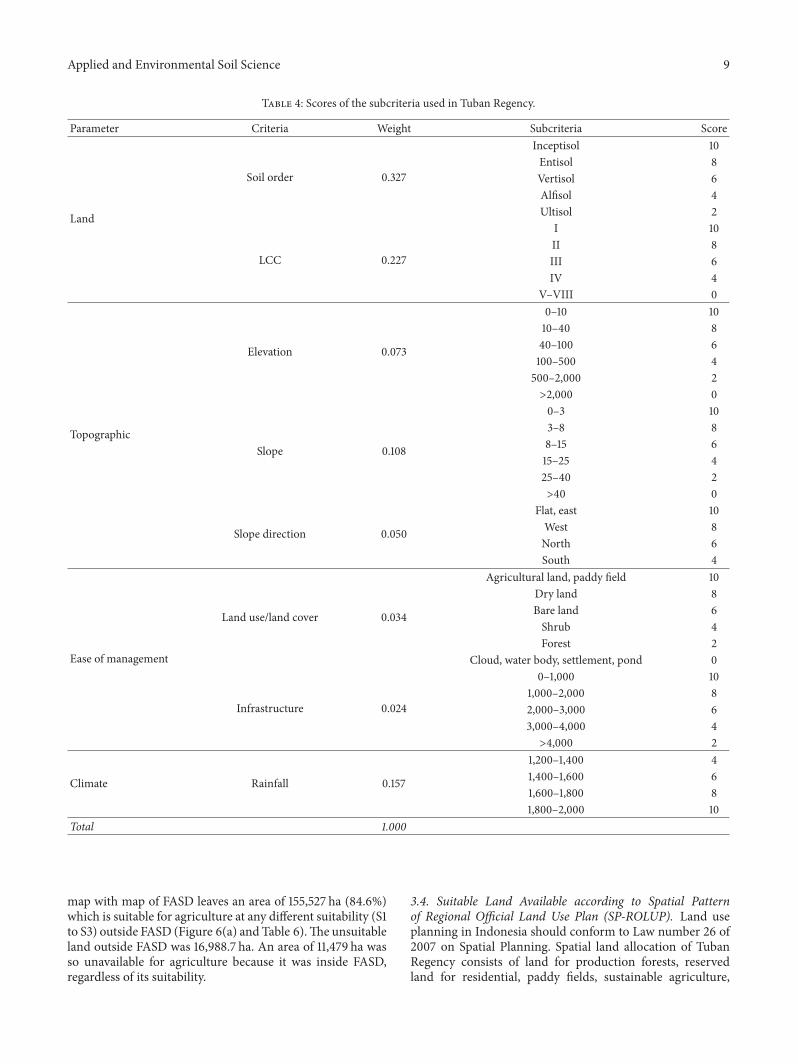