request for proposal (rfp) - jicauttarakhand.orgjicauttarakhand.org/tender/4.1473323627.pdf ·...
TRANSCRIPT
Request for Proposal
(RFP)
RFP No. 03/ 2016 dated 6th September, 2016
SELECTION OF AGENCY FOR PREPARATION OF GEO-DATABASE,
DEVELOPMENT OF WEB-GIS APPLICATION AND OPERATIONALIZATION OF UFRMP GIS FACILITY WITH MANPOWER SUPPORT
Uttarakhand Forest Resource Management Project (UFRMP)
(JICA Funded)
Office of Chief Project Director
Uttarakhand Forest Resource Management Project
24, IT Park , Sahasradhara Road , Dehradun P i n : 248001, Uttarakhand

Page 2 of 28
Office of the Chief Project Director
Uttarakhand Forest Resource Management Project
24, IT Park, Sahasradhara Road, Dehradun Pin:248001. [email protected]; Phone-0135-6543213; Fax-0135-2608576
RFP No. 03/2016 Dated: 6th September 2016
Request for Proposal (RFP) for Preparation of Geo-database, Development of WEB-
GIS application and Operationalization of UFRMP GIS facility with manpower
support
Uttarakhand Forest Resource Management Project (UFRMP), funded by Japan
International Cooperation Agency (JICA), proposes to operationalize its state-of-the art
GIS Data Centre in the Project Management Unit (PMU) and the Divisional Management
Units (DMUs) to facilitate generation, storage and management of the forest GIS database
for the project.
The Project Management Unit (PMU), UFRMP, now solicits techno-financial proposals, in
prescribed format only, as per RFP document, from reputed organisations, specializing
in GIS, Remote Sensing and Differential GPS, having successful track record in forestry
GIS systems for Community-based Forest Management, Web-GIS application
development and operationalization support.
Eligible organizations may submit their RFP, with supporting documents in the
Prescribed formats only. Sealed RFPs must be submitted along with Demand Draft of Rs.
25,000/- (Twenty-five thousand) only, as processing fee (non-refundable), payable to
Uttarakhand Forest Resource Management Project (UFRMP), payable at Dehradun, so as
to reach this office on or before 4.00 pm on 20 October, 2016. RFPs received in formats
other than the Prescribed Formats will not be entertained.
The RFP notice including Prescribed formats, which are required for submission of the
RFP are available on the website: www.jicauttarakhand.org
Anup Malik
Chief Project Director, UFRMP

Page 3 of 28
Request for Proposal
Selection of Agency for Preparation of Geo-database, Development of WEB-GIS
application and Operationalization of UFRMP GIS facility with Manpower Support
1. About the Project
The Uttarakhand Forest Resources Management Project (UFRMP) in being implemented
in Society mode. A Society by the name, Uttarakhand Forest Resource Management
Society has been registered under Society Registration Act, 1860, with the Registrar of
Societies, Uttarakhand. To oversee Project implementation at the State level, a Project
Management Unit (PMU) has been established. The overall goal of the Project is to
contribute to eco-restoration and development of forest resources, by empowering the
community through their improved livelihoods and income generation, and also
mitigating the risks of sediment disasters in highly vulnerable forest areas in future, by
capacity building of forest department and use of better technology for the treatment of
slope failures and land erosion.
Forestry and Livelihood Component of the Project is being implemented in participatory
mode by Van Panchayats (VPs) and Self Help Groups (SHGs). Implementation of the
Project at Forest Division level and Forest Range level would be facilitated by Divisional
Management Units (DMUs) and Field Management Units (FMUs) respectively. 13 forest
divisions and 37 forest ranges have been selected under the Project for addressing forest
degradation. These 13 divisions are Alakhnanda Soil conservation, Pauri Civil Soyam,
Tehri Dam I, Narendra Nagar, Lansdown Soil, Ramnagar Soil, Ranikhet Soil, Almora Civil
Soyam, Nainital Soil, Bageshwar, Champawat, Pithoragarh & Mussoorie Forest Divisions.
It is proposed to cover 750 Van Panchayats in these selected divisions/ ranges in 4
phases (150, 250, 250 and 100 VPs each in 1st, 2nd, 3rd and 4th phase respectively).
Erosion Control and Sediment Disaster related works are being executed in
departmental mode (by PMU and DMUs) in Uttarkashi, Rudraprayag, Chamoli,
Bageshwar and Pithoragarh districts that were most adversely affected in the disaster.
UFRMP has adopted use of GIS, Remote Sensing and Differential GPS for mapping forest
areas allocated to Van Panchayats (VPs) and preparation of different thematic maps for
the purpose of planning, monitoring and evaluations of the forestry interventions.
Integration of these GIS data in respect of VPs and their corresponding treatment areas
with other spatial information of the Forest Division such as management areas,
protected areas, administrative jurisdictions, forest cover maps, location of forest
infrastructure, forest fire locations, forest offence locations, disaster prone areas,
watersheds, forest fringe settlements, diverted areas, general topographic references,
Page 4 of 28
shall assist in evaluation, monitoring and reporting of project interventions, better
decision making and capacity enhancement of the Forest department.
The comprehensive geo-database generated in the process shall be utilized to facilitate
the following project related activities through development of customized Web-enabled
GIS
Project impact monitoring
Evaluation of project interventions
Monitoring of treatments
Satellite Based Forest Land Management
Forest Fire management
Disaster Management
Besides, the Web-GIS shall integrate relevant data and facilitate the following general
requirements of forest divisions, covered under the project:
Forest Protection & Forest area management
Forest boundary management
Forest Infrastructure management
Monitoring of hotspots (tourism and others)
Working Plan preparation
UFRMP is in the process of setting-up of state-of–the-art GIS facilities (Computer
Hardware) in the PMU as well as the DMUs to facilitate generation and management
of such forestry GIS data. It is proposed to deploy Web GIS based decision support
applications for the project and strengthen the GIS data management capacity of the
PMU/ DMU through professional support (operational support) leading to internal
capacity building in GIS based forest resource management.
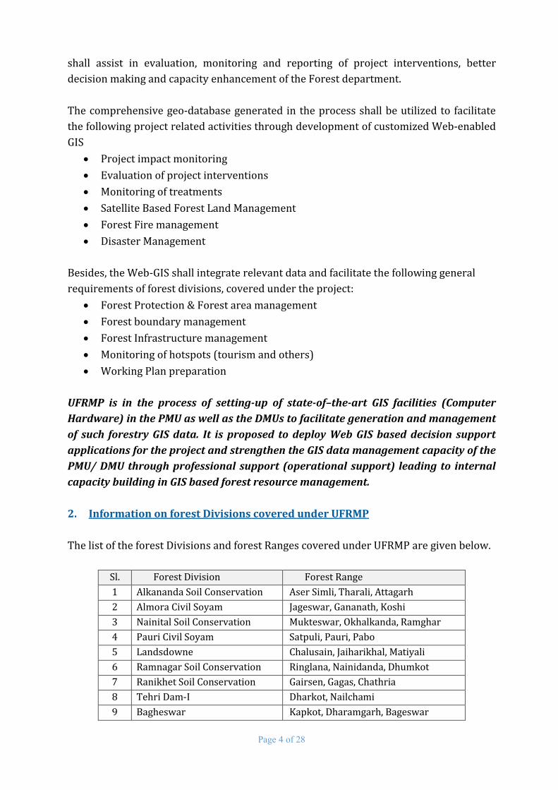
2. Information on forest Divisions covered under UFRMP
The list of the forest Divisions and forest Ranges covered under UFRMP are given below.
Sl. Forest Division Forest Range
1 Alkananda Soil Conservation Aser Simli, Tharali, Attagarh
2 Almora Civil Soyam Jageswar, Gananath, Koshi
3 Nainital Soil Conservation Mukteswar, Okhalkanda, Ramghar
4 Pauri Civil Soyam Satpuli, Pauri, Pabo
5 Landsdowne Chalusain, Jaiharikhal, Matiyali
6 Ramnagar Soil Conservation Ringlana, Nainidanda, Dhumkot
7 Ranikhet Soil Conservation Gairsen, Gagas, Chathria
8 Tehri Dam-I Dharkot, Nailchami
9 Bagheswar Kapkot, Dharamgarh, Bageswar

Page 5 of 28
Sl. Forest Division Forest Range
10 Champawat Lohaghat, Bhigrahrah, Debidhura
11 Narendranagar Manikanth Dangshura, Saklana
12 Pithoragarh Pithoragarh, Didihat, Gangolihat
13 Mussoorie Mussoorie, Raipur
Map showing list of forest divisions and forest ranges
Forestry and Livelihood Component

Page 6 of 28
Area under erosion control and Sediment Disaster Component
3. Objectives of the Assignment
a. Development of geo-database and Web enabled GIS for project monitoring, decision
support and efficient forest management in the UFRMP forest divisions.
b. Capacity building through operationalization of the geo-database and WebGIS
application by on-site professional support at the PMU & DMUs
4. Scope of the Work A. Development of geo-database, and Web-GIS Application
i. Preparation of the Forest Resource Geo-database:
It is proposed to generate a comprehensive geo-database of all forest resources and
interventions of forest divisions covered under UFRMP as may be required for
efficient and effective forest management and monitoring in UFRMP project divisions.
The activity shall involve, but not limited to, collection and collation of the various
spatial and non-spatial data being utilized/ generated by UFRMP such as SOI maps,
FSI forest cover maps, Cartosat & Resourcesat Satellite Images, DGPS boundary

Page 7 of 28
coordinates, land use and vegetation details of VP treatment areas, treatment plan/
micro-plans, JFM facilities (EPA asset, Nursery, WHS, Eco-tourism location, etc),
forest administrative boundaries (division, range, section, beat boundaries), forest
management boundaries (notified forest areas, block/ compartment, coupe
boundaries, etc.), working plan maps, areas vulnerable to forest fires with details of
occurrences of forest fires, plantation areas, afforestation areas, diverted areas,
forestry conservation/ restoration areas covered under different forestry
development schemes and programs.
The implementing agency shall be required to design a suitable geo-database for
organized storage/ retrieval of such geo-spatial information as may be required for
efficient project monitoring, evaluation and reporting based on comprehensive
assessment of data availability and data need.
ii. Development of Web-GIS Application
A Satellite Land Monitoring System in form of a Web-GIS application shall be
designed to integrate the Forestry Resource Geo-database to facilitate geo-data
processing, data query, data analytics and generation of map based decision support
information for monitoring, evaluation and reporting of Joint Forest Management
(JFM) and other forestry activities.
It is proposed to initially adopt Open source/cloud GIS servers for development and
operationalization of such Web-GIS with facilities for dissemination of need based
key information in handheld/ mobile devices.
Indicative list of the functional aspects to be covered under the Web GIS application
are given below:
Project impact monitoring
Evaluation of project interventions
Monitoring of treatments
Satellite Based Forest Land Management
Forest Fire management
Disaster Management
Besides, the Web-GIS shall integrate relevant data and facilitate the following general
requirement of forest divisions covered under the project:
Forest Protection & Forest area management
Forest boundary management
Forest Infrastructure management
Page 8 of 28
Monitoring of hotspots
Forest areas settled under FRA
Diverted areas/ Area proposed for diversion under Forest Conservation Act, 1980
Selected Agency/Firm will be required to propose a suitable system including system
architecture, design, hosting environment and operation so as to fulfill the above
objectives with following minimum application features and functionalities.
Distance and proximity Analysis & Area computation
Import and plotting of field (GPS) readings
Integration with various Web Map Services (WMS), FSI maps
GIS based Project Monitoring & Reporting
o Input of periodic progress status on project activities
o Periodic consolidated progress status report at administrative (Range/
Division/ Project) levels
o User defined query based reports in tabular, chart and map format
SMS based information dissemination / emergency reporting
SMS based Forest Fire Alert
Dissemination of Forestry knowledge base (forest management/ protection, etc.)
Reliable maps based on DGPS survey and GIS/ Remote Sensing mapping
Forest cover analysis – in notified areas, watersheds, administrative units,
plantation areas
Data visualization & thematic map generation
o Map based information on forest administrative/ management units
o Locations of JFM/ Forest Infrastructure
iii. System Commissioning:
The selected bidder shall be responsible for commissioning of the developed Geo-
database and the GIS Applications on the Hardware and Software Infrastructure
provided by the UFRMP in the designated GIS Data Centres.
iv. Warranty:
The GIS Application shall be covered under on-site warranty of 1 (one) year from the
date of installation and commissioning of the GIS Application. During the warranty
period, the selected bidder shall be responsible for trouble shoot the GIS application
software, in case an error occurs and shall take necessary immediate steps for
rectification of the GIS Application.
Page 9 of 28
v. System Maintenance
The selected bidder will provide 2 year annual support including charges towards
hosting and maintenance of the web-GIS portal beyond the 1 year warranty period.
This is extendable subject to negotiation and agreement of terms between UFRMP
and the selected bidder.
B. Capacity building: User Training and Operationalization of the geo-database
and Web-GIS application through on-site professional support at the PMU &
DMUs
The selected Bidder shall undertake training of the selected UFRMP Officials on
operationalization and utilization of the Forest Resource Geo-database and the GIS
Application at the PMU and DMU. The selected Bidder shall finalise necessary training
materials in consultation with the UFRMP.
The selected bidder shall provide necessary human resources for operationalization
of the GIS Data Centre. All support staff should have adequate qualification in GIS/
MIS (BE/ B. Tech / MCA/ PGDCA in RS & GIS) and hands on experience with the
system. An indicative list of human resources to be deployed during the operations
period is as follows.
Sr. No. Position Number
1 Project Manager for overall supervision (on site/ off site) 1
2 GIS developer for Application maintenance (off site) 1
3 Database administrator for Geo-DB maintenance(off site) 1
4 Sr. GIS Executives for operational support at PMU 1
5 Remote Sensing specialist for operational support at PMU 1
6 DGPS Surveyor for operational support at PMU 1
7 GIS Executives for operational support at field offices 17
8 GIS/ DGPS survey assistant at field offices 17
Note: For smooth implementation of Scope A (Geo-database & WebGIS application
development) and management of services at Scope B (Operation support), organizations
having domain experts and key resources persons with following qualification, expertise and
experience shall be considered. Details of such key resource persons are to be furnished at Tech
6 for evaluation of strength of organization to handle the assignment.
Sl. Position Key Qualification and Experience 1 Domain Expert
(Forestry) Masters in Science with specialization in Forestry & Remote Sensing and minimum 20 years of experience in Forest Management in India (Govt. of India/ Indian States/ Union Territories)
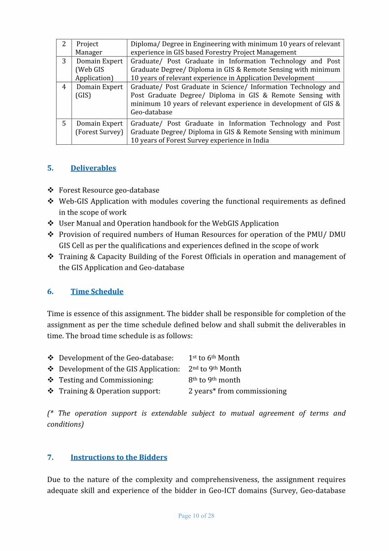
Page 10 of 28
2 Project Manager
Diploma/ Degree in Engineering with minimum 10 years of relevant experience in GIS based Forestry Project Management
3 Domain Expert (Web GIS Application)
Graduate/ Post Graduate in Information Technology and Post Graduate Degree/ Diploma in GIS & Remote Sensing with minimum 10 years of relevant experience in Application Development
4 Domain Expert (GIS)
Graduate/ Post Graduate in Science/ Information Technology and Post Graduate Degree/ Diploma in GIS & Remote Sensing with minimum 10 years of relevant experience in development of GIS & Geo-database
5 Domain Expert (Forest Survey)
Graduate/ Post Graduate in Information Technology and Post Graduate Degree/ Diploma in GIS & Remote Sensing with minimum 10 years of Forest Survey experience in India
5. Deliverables
Forest Resource geo-database
Web-GIS Application with modules covering the functional requirements as defined
in the scope of work
User Manual and Operation handbook for the WebGIS Application
Provision of required numbers of Human Resources for operation of the PMU/ DMU
GIS Cell as per the qualifications and experiences defined in the scope of work
Training & Capacity Building of the Forest Officials in operation and management of
the GIS Application and Geo-database
6. Time Schedule
Time is essence of this assignment. The bidder shall be responsible for completion of the
assignment as per the time schedule defined below and shall submit the deliverables in
time. The broad time schedule is as follows:
Development of the Geo-database: 1st to 6th Month
Development of the GIS Application: 2nd to 9th Month
Testing and Commissioning: 8th to 9th month
Training & Operation support: 2 years* from commissioning
(* The operation support is extendable subject to mutual agreement of terms and
conditions)
7. Instructions to the Bidders
Due to the nature of the complexity and comprehensiveness, the assignment requires
adequate skill and experience of the bidder in Geo-ICT domains (Survey, Geo-database
Page 11 of 28
Development, GIS based application development on multiple heterogeneous platforms
covering Web, Cloud, Standalone and Mobile platforms etc.) for forestry specific
applications.
The bidders are expected to be well versed and have adequate knowledge and
experience in forest resource mapping and forestry interventions as per the requirement
of the assignment. The bidders are required to deploy all necessary human resources
with minimum specified relevant qualification and experiences for providing the
operationalization support.
The bidders are suggested to meticulously go through the scope, deliverables,
understand the functional requirements while preparing their technical solutions. The
bidders are required to prepare the detailed approach, methodology and work plan for
execution of the work and submit the same along with the technical proposal.
RFP Document: The RFP document can be downloaded from the official website
www.jicauttarakhand.org of URFMP. The Bidder is expected to examine all
Instructions, Forms, Terms & Conditions, Specifications specified in the RFP. Failure
to furnish all information as specified in the RFP may result in rejection of the
Proposal.
Joint-venture/ consortium proposals are not acceptable.
The Bidder must submit the Technical Proposal and Financial Proposal for the
complete scope of work as specified under Section-4 of this RFP document, non-
compliance in this regard shall lead to declaration of the Proposal as non-
responsive and shall be summarily rejected. The proposal should be made using
English Language only. Conditional proposals also shall not be acceptable.
Cost of Bidding: The Bidder shall be responsible for all costs incurred in
preparation and submission of their Proposals. UFRMP shall not be liable for the
costs incurred by the Bidder in any way.
Tender Fee: Bidder is to submit a non-refundable tender fee of Rs. 25,000/-
(Twenty-five thousand only) along with the technical Proposal in the form of a
Bank Demand Draft drawn in favor of Chief Project Director, Uttarakhand Forest
Resource Management Project, payable at Dehradun, Uttarakhand from any
scheduled commercial bank and payable at Dehradun, Uttarakhand. Proposals
submitted without EMD will be summarily rejected.
Bid Security: The Technical Proposal document submitted by the bidder must be
accompanied by an Earnest Money Deposit (EMD) of Rs.2,00,000/-(Rupee two
lakh only) in the form of a Bank Demand Draft drawn in favor of Chief Project
Director, Uttarakhand Forest Resource Management Project, payable at
Page 12 of 28
Dehradun, Uttarakhand from any scheduled commercial bank and payable at
Dehradun, Uttarakhand. Proposals without EMD will be summarily rejected.
Bid Validity: The Proposal submitted, must be valid for a period of at least 180
days from the date of opening of the Technical Proposal.
Amendment of RFP Document: Any time prior to the last date of submission of
the Proposal, UFRMP, may for any reason, whether at its own initiative or in
response to clarification requested by a prospective bidder, modify the RFP
document. The same shall be notified on the official website of the UFRMP.
Terms of Execution:
o The selected bidder shall deliver the all deliverables as per the timeline
specified in Time Schedule of this RFP document.
o The selected bidder shall provide on-site service support as and when
required within the warranty period as specified in Instruction to Bidders of
this RFP document.
o The selected bidder shall provide necessary human resources as specified
under Scope of Work of this RFP document and shall be responsible for
operationalization of the GIS Cell at PMU/ DMU.
Submission of Bid:
o The Technical Proposal should be kept in a sealed envelope and shall be marked
as “TECHNICAL PROPOSAL” on the Top. The Financial Proposal should also be
kept in a sealed envelope and shall be marked as “FINANCIAL PROPOSAL DO
NOT OPEN WITH TECHNICAL PROPOSAL” on the Top. Both the sealed
envelopes should be kept in an outer envelope which shall be marked as
“Preparation of Geo-database, Development of WEB-GIS application and
Operationalization of UFRMP GIS facility with manpower support”.
o The Technical proposal should not include any information related to the
Financial Proposal. Technical proposals containing any indication of financial
quote shall be summarily rejected. All the inputs which are part of the Technical
Proposal, should be included in arriving at the cost of the project in the Financial
Proposal.
o Proposals, complete in all respect shall be addressed to Chief Project Director,
Uttarakhand Forest Resource Management Project, 24, IT Park,
Sahasradhara Road, Dehradun Pin:248001

Page 13 of 28
o The Proposals should reach the above address by Registered Post/ Courier/
By Hand on or before 20/10/2016 by 4:00 PM, after which no proposals
shall be accepted.
o Submission of Technical Proposal
The technical proposal of the bidder should contain the RFP Cost, EMD and information
in duly filled-in Forms with necessary supporting documents as proof of their eligibility,
capabilities and experiences as required for the project. List of Tech Forms is given
below:
Tech 1: Covering letter
Tech 2: Letter of Authorization for signing & submission of bid
Tech 3: Organization details
Tech 4: Auditor certified Annual Turnover and Net-worth statement
along with Copies of Audited balance sheet with original auditor
certified turnover statement
Tech 5: Strength of Organization to cater to the Project Objectives
Tech 6: Details of resource persons in Forestry data management with
details of experience and CVs of Key-resource Persons.
Tech 7: Past experience of the Bidder in execution of similar GIS projects
for Forestry Sector (top 10 projects in last 10 years) with
supporting work order/agreement/ completion certificate.
Tech 8: Past experience in development of similar Web based
applications for community forestry project monitoring/
management with supporting work order/agreement/
completion certificate.
Tech 9: Past experience in extending operational support in similar
forestry sector projects with supporting work order/agreement/
completion certificate
Tech 10: Past experience in DGPS/ GIS based Forest Surveys in last 10
years with supporting work order/agreement/ completion
certificate
Tech 11: Technical Solution (Methodology and Work plan)
The Technical Proposal document should be neatly page numbered and shall
have the section separators. Each page of the Technical Proposal shall be seal
stamped and signed by the Authorized Signatory. Quality of the Technical
Proposal shall also be considered during technical evaluation. Evaluation will
cover the quality of proposal and clarity in presenting the proposal before the
Evaluation Committee.
The Technical Proposal should be submitted in 5 copies (1 Original + 4
Copies)

Page 14 of 28
The Original Proposal should be clearly marked with “ORIGINAL” and the
copies should be clearly marked with “COPY”
The Earnest Money Deposit (EMD) should be kept with the “ORIGINAL”
technical proposal.
The Technical Proposal documents shall be enclosed in a sealed envelope
super scribed with “TECHNICAL PROPOSAL” on the top of the envelope
o Submission of Financial Proposal
The Financial Proposal must be submitted as per the specified format Fin-I.
Financial Proposal not submitted in the specified format, shall be summarily
rejected.
The Financial Proposal shall be valid for a period of at least 180 days from the
date of actual opening of the technical Proposal.
Each page of the Financial Proposal shall be seal stamped and signed by the
Authorized Signatory.
Submitted Forms with illegible, overwritten, erased, illegible rate or rates not
shown in both figures and words shall be rejected. Financial Proposals with
Clerical and/ or arithmetic errors shall be summarily rejected. In case of
mismatch between the quoted value in Figures and Words, the value quoted
in words shall be considered. Decision of the evaluating authority of the
UFRMP shall be final and binding.
o Incomplete, illegible and unsealed proposals shall be summarily rejected.
Telegraphic proposals shall not be accepted and no communication shall be
entertained in this regard.
o Chief Project Director, UFRMP reserves the right to accept/ reject any/ all
proposal(s) without showing any reason.
8. Eligibility Criteria:
Bidders are to meet the following eligibility criteria for evaluation of their bids. Bidders unable to meet the eligibility criteria shall not be considered for award of the work.
a) Bidders are to submit organization’s registration/ incorporation document.
Page 15 of 28
b) Bidder to submit RFP fee of Rs. 25,000/- (twenty five thousand) in shape of Demand Draft drawn in favour of ‘Uttarakhand Forest Resource Management Society’ payable at Dehradun.
c) Bidder to submit EMD for Rs. 2,00,000/- (two lakh only) in shape of Demand Draft drawn in favour of ‘Uttarakhand Forest Resource Management Society’ payable at Dehradun.
d) The bidder should be in the field of GIS services for at least 10 years as on date of submission of the bid. Copy of the work order on GIS services issued 10 years prior to the date of submission of bid is to be submitted as supporting documents, as per Technical Formats.
e) Bidder should have experience in execution of at least 1 (one) similar forestry sector GIS project for a value not less than Rs. 1 Crore. Copy of work order/ agreement along with completion certificate to be submitted as supporting.
f) Bidder should have minimum average annual turnover of Rs. 5.0 crore (five crore) during the last 3 financial years. Copies of audited balance sheet along with auditor certified turnover certificate for financial years 2013-14, 2014-15, 2015-16, to be submitted as supporting.
g) Bidder should have Net worth of at least Rs.3.0 crore (three crore) as on 31-Mar-2015. Auditor certificate on Net worth as on 31-Mar-2016 in original to be submitted as supporting.
h) Bidder to also submit a copy of the following: I. Service Tax Registration certificate;
II. IT return for FY: 2014-15;
III. Provident Fund registration certificate;
IV. ESI registration certificate
i) The Bidder should not be under a declaration of ineligibility for corrupt and fraudulent practices nor should have been blacklisted by any Govt. or Govt. undertaking organizations at the time of submission of the bid. Bidder to submit a Self-declaration certificate, signed by the authorized signatory
9. Opening of Bid:
The Technical Proposal document shall be opened on the scheduled data and time as
specified in the RFP document/ Subsequent notifications, if any. The Technical Proposal
shall be scrutinized to verify the eligibility of the Bidder as per the Eligibility Criteria.
Only those Technical Proposals, completely satisfying the Eligibility Criteria shall be
declared as responsive proposal and shall be considered for evaluation of Technical
Proposal.

Page 16 of 28
10. Evaluation of Selection Methodology
Quality and Cost Based Selection methodology shall be adopted for selection of the
successful bidder. The process shall assign weightages to both Technical Proposal as well
as the Financial Proposal in the following order.
Technical Proposal: 70%
Financial Proposal: 30%
The proposal shall be evaluated in a 2 stage process.
Stage-1: Technical Proposal Evaluation
Evaluation of the Technical Proposal shall be based on the past experiences and technical
expertise of the bidder in execution of similar assignments. The evaluation shall be
carried out as per the Technical evaluation criteria specified below.
Technical Evaluation Criteria
Sl. No Description Max. Marks
1 Past experience of the Bidder in execution of similar GIS
projects in Forestry Sector (top 5 projects in previous 3 years)
15
2 Past experience of the Bidder in execution of similar GIS
projects in Forestry Sector, top 5 projects in 7 years, prior to last
3 years
15
3 Past experience in development of similar Web based
applications for community forestry project monitoring/
management with scope, deliverables and end-user certificate
10
4 Past experience in extending operational and manpower
support in similar forestry sector projects
10
5 Past experience in DGPS/ GIS based Forest Surveys in last 10
years
10
6 Strength of Organization to cater to the project objectives
including details of Web-GIS facility, experience of resource
persons in forestry GIS to be submitted along with CVs of Key
resource persons for project development/ implementation.
20
7 Work Plan: Quality of proposal & Proposed Solution (presentation covering prototype demonstration, application features and functions, operational arrangement, etc.)
20
8 Total Marks 100
Page 17 of 28
Bidder scoring minimum 60 marks out of 100 in the Technical evaluation
process shall be declared as the Technically Qualified bidder. The Financial bids
shall be opened only for the Technically Qualified bidders. The marks secured by
the Technically Qualified bidder shall be considered as the Technical Score (TS).
Stage-2: Financial Proposal Evaluation
Financial proposal of the Technically Qualified Bidders only shall be considered
for evaluation. The technically qualified bidders shall be intimated the venue, date
and time of opening of Financial Proposals through publication of notice on the
website as well as through the email address provided by them for
communications. Financial Proposals shall be opened in presence of the Bidders
who may choose to be present during opening of the Financial Proposal.
The Financial Proposals shall be scrutinized for their adherence to the specified
format, company seal and signature of the authorized signatory. The Financial
Proposals which are found to be incorrect, not signed and sealed, not in specified
format shall be summarily rejected. Only those Financial Proposals found to be
valid after scrutiny, shall be considered for further evaluation.
The Financial Proposal with the lowest financial quote shall be awarded 100
marks. The marks obtained by the bidders in the financial proposal evaluation
shall be considered as Financial Score (Fs). The Financial Score (Fs) of the other
Technically Qualified Financial Proposals shall be computed as per the following
formula
Fs = 100 x (Fmin / Fb)
Where,
Fs = Financial Score for the Financial Proposal under consideration
Fmin = minimum price quoted by any bidder in their Financial Proposals
Fb = price quoted by the bidder under consideration in his Financial Proposal
Quality and Cost Based Selection (Technical and Financial)
The Technical Score (Ts) and the Financial Score (Fs) secured by each bidder in
their Financial Proposals shall be subjected to the Technical Weightage Wt = 0.70
(the weight given to the technical proposal); Wf = 0.30 (the weight given to the
financial proposal). The combined technical and financial score (S) for the bidder
shall be computed as per the following formula.
S = (Ts x 0.7) + (Fs x 0.3)
Proposal of the bidder securing the highest combined score (S) shall be declared
as the successful bidder and shall be considered for award of the contract.

Page 18 of 28
The unsuccessful bidders shall be duly intimated and their EMD will be returned
after a period of one month from the date of issue of work order to the successful
bidder.
11. Terms of Payment:
A. Development of Forest Resource Geo-database and Development of GIS
Application
30% of the payment will be paid after completion of development of
Forest Resource Geo-database
30% of the payment will be paid after Web-GIS application testing.
15% of the payment will be paid after commissioning at PMU
15% of the payment will be paid after commissioning at DMUs
10% of the payment will be paid on submission of Performance Bank
Guarantee for the 1-year Warranty Period.
Note: (1) Selected bidder may avail up to 20% of the Component-A cost as
Mobilization Advance against Bank Guarantee of equivalent amount. Such mobilization advance shall be adjusted against each subsequent payment on pro-rate basis.
(2) The selected bidder shall submit a Performance Bank Guarantee of 10% of the contract value on commissioning of the GIS application valid till end of 1 year warranty period. Such performance bank guarantee shall be returned to the selected bidder after the warranty period.
B. Extended Annual Maintenance (2 years after warranty)
Charges towards extended annual maintenance towards hosting and
Web-GIS application maintenance shall be payable on quarterly basis
on completion of each quarter
C. Operational Support at GIS Data Centres
Charges towards operational support will be payable on monthly
basis at end of every month.
12. Renewal of the Operationalization Contract
The selected Bidder shall sign the Annual Support Contract (ASC) with the UFRMP
to effect operationalization of the GIS Data Centre through provision of the
specified human resources. The ASC shall be renewed on mutual agreement of
terms and conditions between UFRMP and the selected Bidder. The decision of
the Chief Project Director, UFRMP in this regard shall be final and binding.

Page 19 of 28
13. Cancellation of Order
If the selected Bidder fails to deliver the services in terms of quality and time,
UFRMP reserves the right to cancel the purchase order and shall take appropriate
steps against the default bidder as deemed fit by law.
14. Force Majeure
Notwithstanding the above provisions, the selected bidder shall not be liable for
penalty or cancellation of purchase order for default if and to the extent that its
delay in performance or other failure to perform its obligations under the
contract is the result of an event of Force Majeure. For the purpose of this clause,
“Force Majeure” means an event beyond the control of the Bidder and not
involving the Bidder’s fault or negligence and not foreseeable. Such events may
include but not restricted to, wars or revolutions, epidemics and natural calamity.
In case a Force Majeure situation arises, the Bidder shall promptly notify UFRMP
in writing of such condition and the cause thereof. Unless otherwise directed by
UFRMP, the bidder shall continue to perform its obligations under the contract as
far as is reasonably practical, and shall seek all reasonable alternatives of
performance not prevented by Force Majeure.
15. Disputes & Arbitrations
All disputes arising out of the contract shall be amicably settled by both parties. In
the unfortunate event of any dispute or differences, breach and violation relating
to the terms of this agreement, the said dispute or difference shall be referred to
the sole arbitration of the Arbitrator appointed by Chief Project Director UFRMP.
The award of the arbitrator shall be final and binding on both the parties. The
adjudication of arbitrator shall be governed by the provision of the Arbitration
and Conciliation Act, 1996, or any statutory modification or re-enactment thereof
or any rules made thereof. All legal disputes are subject to the jurisdiction of
courts in Uttarakhand.
BID Response Formats Tech 1: Covering letter Tech 2: Letter of Authorisation for signing & submission of bid Tech 3: Organisation details Tech 4: Auditor certified Annual Turnover and Net-worth statement along with Copies
of Audited balance sheet with original auditor certified turnover statement
Page 20 of 28
Tech 5: Strength of ogranisation to cater to the project objectives including details of
WebGIS facility and experience in forestry GIS. Tech 6: Details of resource persons in Forestry data management with details of
experience and CVs of Key-resource Persons for for project development/ implementation.
Tech 7: Past experience of the Bidder in execution of similar GIS projects for Forestry
Sector (top 10 projects in last 10 years) with supporting work order/agreement/ completion certificate.
Tech 8: Past experience in development of similar Web based applications for
community forestry project monitoring/ management with supporting work order/agreement/ completion certificate.
Tech 9: Past experience in extending operational support in similar forestry sector
projects with supporting work order/agreement/ completion certificate Tech 10: Past experience in DGPS/ GIS based Forest Surveys in last 10 years with
supporting work order/agreement/ completion certificate Tech 11: Technical Solution (Methodology and Work plan)

Page 21 of 28
Tech I:
Covering Letter
(To be submitted on Organisation’s Letterhead only)
Date: _____________________
To
Chief Project Director
Uttarakhand Forest Resource Management Project (JICA Project)
24, IT Park, Sahasradhara Road, Dehradun Pin:248001
Sub: RFP for selection of agency for Preparation of Geo-database, Development
of WEB-GIS application and Operationalization of UFRMP GIS facility with
manpower support.
Ref: Your RFP no 03/2016 dated 6th September 2016.
Dear Sir,
Having examined the Request for Proposal (RFP), the receipt of which is hereby duly
acknowledged, we are pleased to submit our Bid along with all supporting documents,
requisite RFP Cost and EMD for your evaluation.
We confirm that the information contained in this response or any part thereof, including
its exhibits and other supporting documents & instruments delivered or to be delivered
to the PMU of UFRMP is true, accurate, verifiable and complete. This response includes
all the information necessary to ensure that the statements therein do not in whole or in
part mislead the PMU in its shortlisting process.
We fully understand and agree to comply that on verification, if any of the information
provided here is found to be misleading this shortlisting process, we are liable to be
dismissed from the selection process or termination of the contract during the Project, if
awarded to do so, for providing the said Services to the Project. We agree to
unconditional acceptance of all the terms & conditions set out in the EoI document.
We further unconditionally accept all the Terms & Conditions mentioned in the above
referenced RFP document. Deviations if any, to the Terms & Conditions mentioned in the
above referenced RFP document reflect in our Bid shall liable our Bid document to be
summarily rejected without any reference to us.
Page 22 of 28
Contacts Information
Name
Title
Name of the firm
Address of the firm
Web-site
Phone
Mobile
Fax
Facsimile
It is hereby confirmed that I/We are entitled to act on behalf of our firm and are
authorized to sign this document as well as such other documents, which may be
required in this connection.
Dated this day of ___________ Month, 2016
(Signature) in the capacity of
Name & address of the firm with seal stamp of the bidder
Witness signature
Witness name
Page 23 of 28
Tech – 2 Letter of Authorisation
(to be submitted on organisation’s letter head)
Date: _____________________
To
Chief Project Director
Uttarakhand Forest Resource Management Project (JICA Project)
24, IT Park, Sahasradhara Road, Dehradun Pin:248001
Sub: RFP for selection of agency for Preparation of Geo-database, Development
of WEB-GIS application and Operationalization of UFRMP GIS facility with
manpower support
Ref: Your RFP no 03/2016 dated 6th September, 2016.
Dear Sir, With reference to your RFP Notice No. 03/2016 dated 6th September 2016, we hereby authorize Mr/Ms <name>, <designation> of our organization whose signature is attested below, as our authorized representative to sign the bid documents including all documents in support of our bid on our behalf. We hereby agree to ratify the acts, deeds and things lawfully done by our aforesaid representative shall and shall always be deemed to have been done by us and accordingly binding on us ________________________________________________ (Signature of Authorised Representative)
Yours Sincerely, ________________________________________________ (Signature) Name: (Designation/ Head of the Organisation)

Page 24 of 28
Tech 3:
Organisation Details (to be submitted on letter head) Name of the Organisation
Year of Establishment
Address of Registered office
Location of works (address)
Telephone numbers
Fax numbers
Email address Web Site address
Name of Head of Organisation
Designation of Head of Organisation
Head of Organisation’s Mobile no.
Head of Organisation’s Email Id
Name of the Contact Person
Contact Person’s designation
Contact Person’s Mobile no.
Contact Person’s Email Id
Tech 4 Turnover & Net Worth statement
(to be submitted on letter head)
Sl. Financial Year Turnover from GIS related services (in Rs.)
Net Worth (in Rs.)
1. 2013-2014 2. 2014-2015 3. 2015-2016
Note: 1. Auditor certified Turnover and net-worth Certificate in original to be attached 2. Copy of the Balance sheet and P/L statement to be attached
Tech 5
Strength of ogranisation to cater to the project objectives including details of WebGIS facility and experience in forestry GIS.
Details of experiences, human resources and skill sets, infrastructure available with the organization pertinent to the assignment in 200 words. Please give an objective account.

Page 25 of 28
Tech 6 Details of resource persons in Forestry data management with details of
experience
Sl no Position Name Qualification Experience
(Years) 1 Project Manager 2 Domain Expert
(Geo-database and Web-Gis)
3 Domain Expert (Forestry)
4 Domain Expert (GIS)
5 Domain Expert (Forest Survey)
NB: CVs of Key-resource persons to be attached.
Tech 7 Past experience of the Bidder in execution of similar GIS projects for Forestry
Sector
Important projects (maximum 10); 5 projects executed in last 3 years and 5 projects executed during 7 years, prior to last 3 years.
Sl. Work
order/ agreement no and date
Name of Client Organisation
Name of the Project
Value of Work
(in Rs.)
Reference of
supporting work order
NB: Copies of work order/ agreement indicating scope of work and value for each of the above mentioned projects to be enclosed as attachments with attachment reference no indicated in the above form
Page 26 of 28
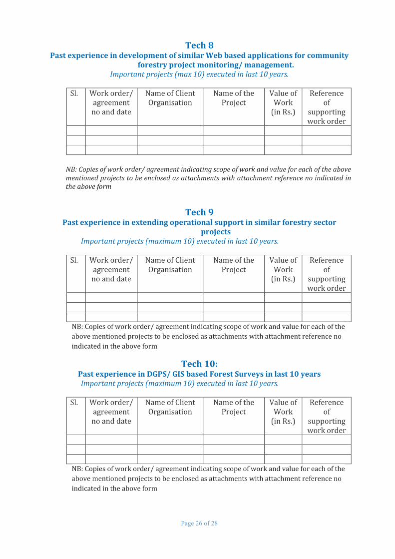
Tech 8 Past experience in development of similar Web based applications for community
forestry project monitoring/ management. Important projects (max 10) executed in last 10 years.
Sl. Work order/
agreement no and date
Name of Client Organisation
Name of the Project
Value of Work
(in Rs.)
Reference of
supporting work order
NB: Copies of work order/ agreement indicating scope of work and value for each of the above mentioned projects to be enclosed as attachments with attachment reference no indicated in the above form
Tech 9 Past experience in extending operational support in similar forestry sector
projects Important projects (maximum 10) executed in last 10 years.
Sl. Work order/ agreement no and date
Name of Client Organisation
Name of the Project
Value of Work
(in Rs.)
Reference of
supporting work order
NB: Copies of work order/ agreement indicating scope of work and value for each of the
above mentioned projects to be enclosed as attachments with attachment reference no
indicated in the above form
Tech 10: Past experience in DGPS/ GIS based Forest Surveys in last 10 years
Important projects (maximum 10) executed in last 10 years.
Sl. Work order/ agreement no and date
Name of Client Organisation
Name of the Project
Value of Work
(in Rs.)
Reference of
supporting work order
NB: Copies of work order/ agreement indicating scope of work and value for each of the
above mentioned projects to be enclosed as attachments with attachment reference no
indicated in the above form
Page 27 of 28
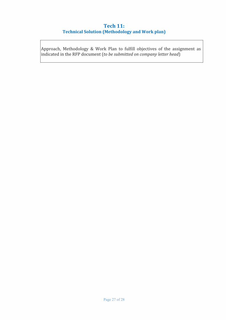
Tech 11: Technical Solution (Methodology and Work plan)
Approach, Methodology & Work Plan to fulfill objectives of the assignment as indicated in the RFP document (to be submitted on company letter head)

Page 28 of 28
FIN 1:
Financial Proposal (to be submitted on letter head) Date: __________________
To
Chief Project Director
Uttarakhand Forest Resource Management Project
24, IT Park , Sahasradhara Road, Dehradun Pin:248001
Sub: RFP for selection of agency for Preparation of Geo-database, Development
of WEB-GIS application and Operationalization of UFRMP GIS facility with
manpower support
Ref: Your RFP no 03/2016 dated 6th September, 2016
Dear Sir,
We the undersigned, offer to provide the services for Preparation of Geo-database, Development
of WEB-GIS application and Operationalization of UFRMP GIS facility with manpower support in
accordance with your Request for Proposal no 03/2016 dated 6th September 2016. Our
Financial Proposal, as given below, shall be binding upon us subject to the modifications, if any,
as a result of contract negotiations, up to expiration of the validity period as mentioned in the
RFP.
Sl. Description Amount (in Rs.) A. Development of Forest Resource Geo-database and Development
of Web GIS Application including 1 year warranty
B. Extended Annual Maintenance (2 years after warranty) C. Operation Support (Monthly charges)
- Project Manager - GIS developer - Database administrator - Sr. GIS Executives - Remote Sensing specialist - DGPS Surveyor - GIS Executives - GIS/ DGPS survey assistant
NB: Service Tax shall be paid extra at the applicable rates
We understand that you are not bound to accept any proposal that you receive.
We remain,
Yours Sincerely
Authorised Signature (in full and initials)
Name and Title of signatory:
Name of the Consultant (Company Name):
In the capacity of____________________
Address____________________________