report to eactor uranium mines limited … · geological, geophysical and diamond drilling program...
TRANSCRIPT

4ii05NEee93 0ea0 PORTER 010
REPORT TO EACTOR URANIUM MINES LIMITED
ON AGEOLOGICAL, GEOPHYSICAL AND
DIAMOND DRILLING PROGRAMFOR TOR TOWNSHIP
SUDBURY DISTRICT. ONTATIO
Toronto, Ontario ' December 3 1. 1 068
P. W. Green, M.Se.A., F.O.A.C.Project GeologistWatts, Griffis and McOuat Limited
iyM?.;*?;
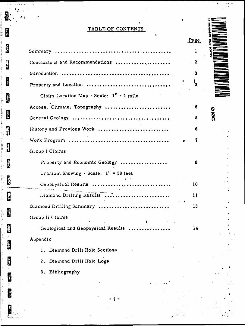
TABLE OF CONTENTS
Page
Summary .......t.................................... l 1
Conclusions and Recommendations . . . . . . . . . . .,... . . ... . . 2
Introduction . .... .... ......... ............... .......t 3i l
Property and Location . . . . . . . . . . . . . . . . . . . . . . . . . . , . . . , . 3
Claim Location Map - Scale: l" * l mile
Access, Climate, Topography t........................ '5 Q
General Geology ..................................... S Q
History and Previous Work . . . . . . . . . . . . . . . . . . . . . . . . . . . 6
l Work Program . . . . . . . . . . . . . , . . . . . . , . . . . . . . . . . . . . . . . . * 7
Group l Claims
Property and Economic Geology . . . . , . . . . , . . . . . . . . 8* \
Uranium Showing - Scale: l" * 50 feet
Geophysical Results . . . . . . . . . . . ... . . . . . . . . . . . . . . . . , 10
Diamond Drilling Results ..Y...................... 11' i
Diamond Drilling Summary . . . . . . . . . . . . . . . . . . . . . . . . . . . 13
Group n Claims- . C
Geological and Geophysical Results . . . . . . . . . . . . . .. . 14
Appendix
1. Diamond Drill Hole Sections
2. Diamond Drill Hole Logs
3. Bibliography
-l -

Table of Contents continued ...
4. Table of Formations
5. Instruments and Techniques
Certificate ......................
Page
JLi l
l l l l l l l l l l l l l l l l
•k: :
i V ; 'Vi
SUMMARY
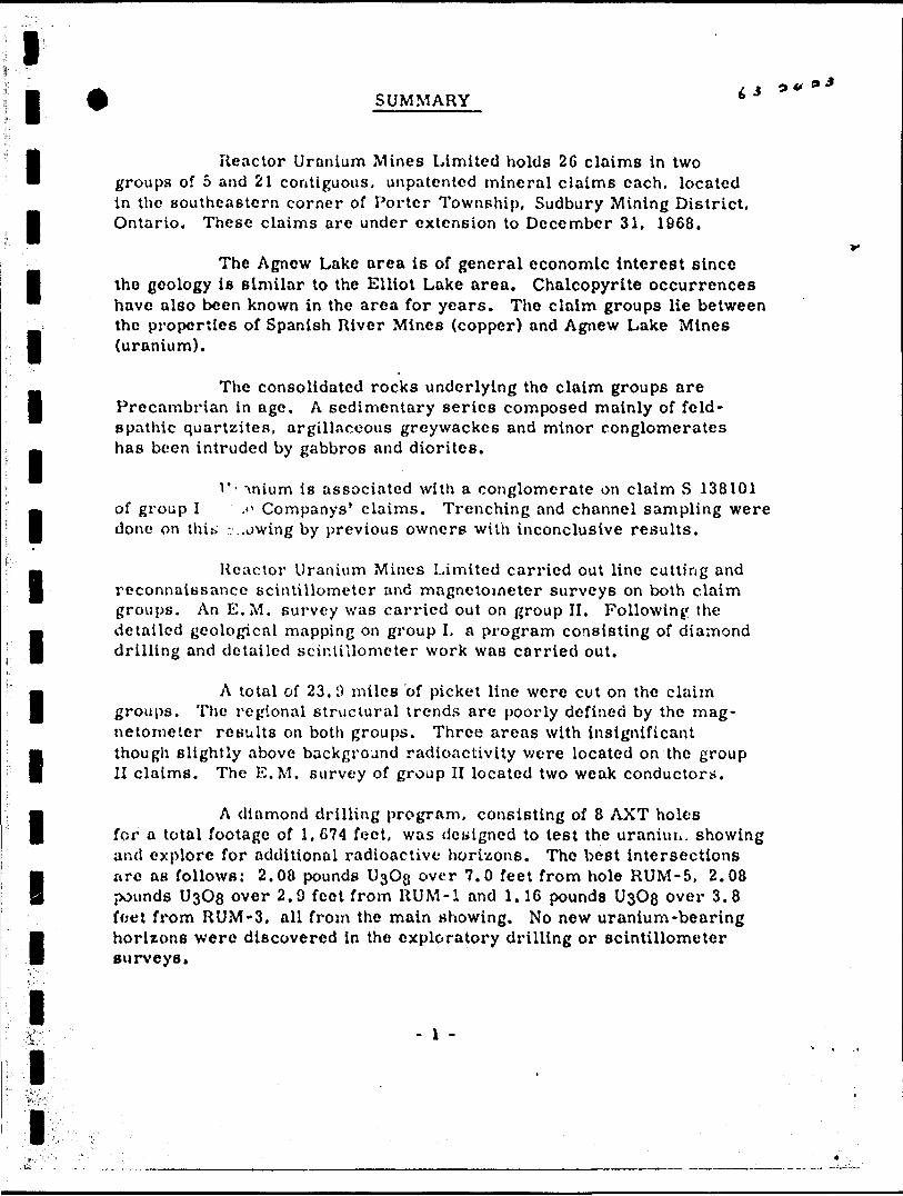
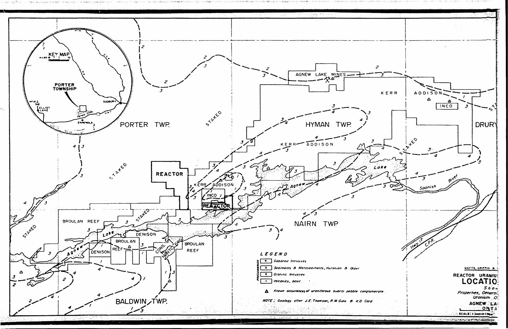
Reactor Uranium Mines Limited holds 26 claims in two groups of 5 and 21 contiguous, unpatented mineral claims each, located in the southeastern corner of Porter Township, Sudbury Mining District, Ontario. These claims are under extension to December 31, 1968.
The Agnew Lake area is of general economic interest since the geology is similar to the Elliot Lake area. Chalcopyrite occurrences have also been known in the area for years. The claim groups lie between the properties of Spanish River Mines (copper) and Agnew Lake Mines (uranium).
The consolidated rocks underlying the claim groups are Precambrian in age. A sedimentary series composed mainly of feld spathic quartzites, argillaceous greywackes and minor conglomerates has been intruded by gabbros and diorites.
T- "vnium is associated with a conglomerate on claim S 138101 of group I .f Companys 1 claims. Trenching and channel sampling were done on thi** ..owing by previous owners with inconclusive results.
Reactor Uranium Mines Limited carried out line cutting and reconnaissance scintillometer and magnetometer surveys on both claim groups. An E. M. survey was carried out on group II. Following the detailed geological mapping on group I. a program consisting of diamond drilling and detailed scintillometer work was carried out.
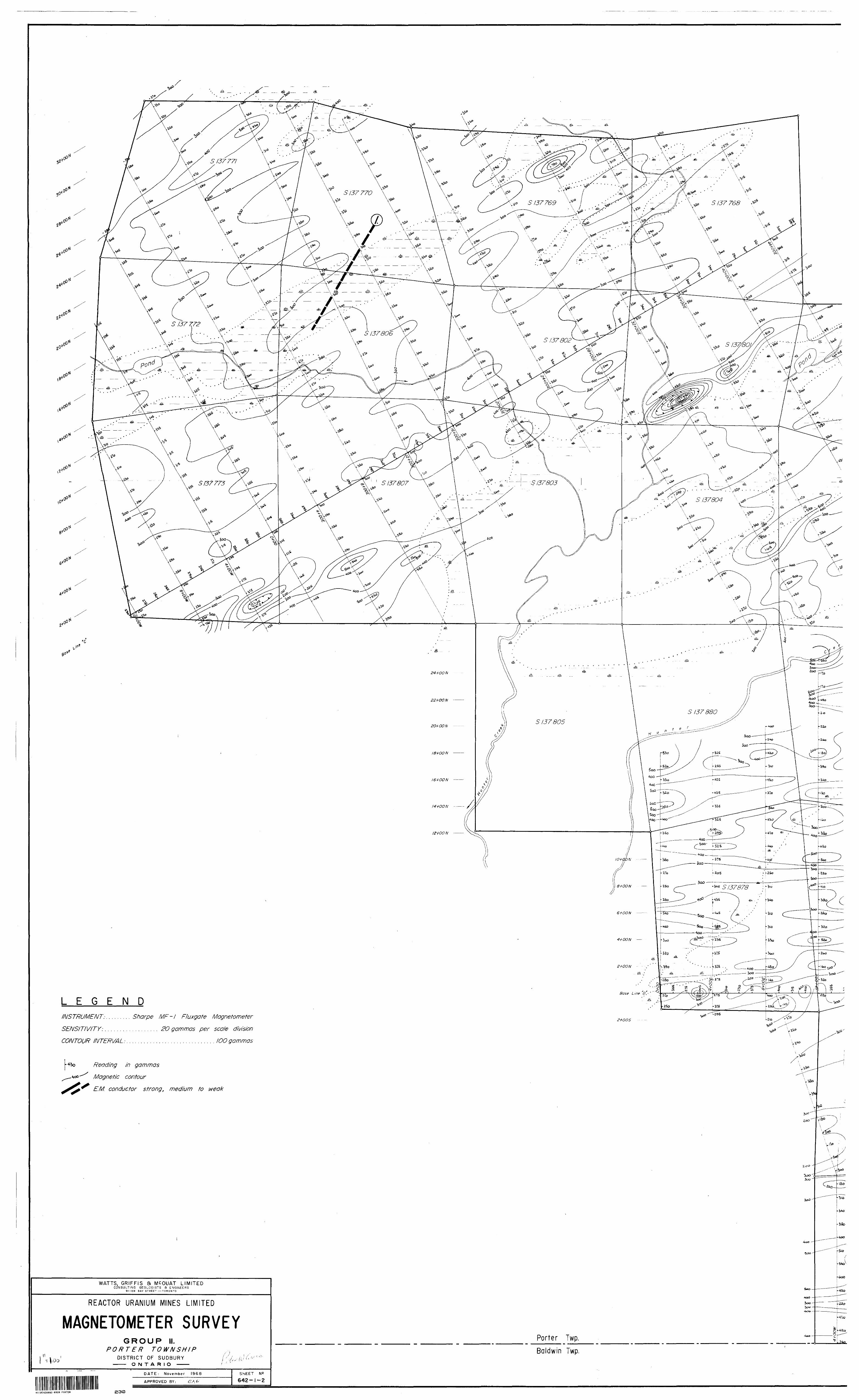
A total of 23. i) miles bf picket line were cut on the claim groups. The regional structural trends are poorly defined by the mag netometer results on both groups. Three areas with insignificant though slightly above background radioactivity were located on the group II claims. The E. M. survey of group II located two weak conductors.
A diamond drilling program, consisting of 8 AXT holes for a total footage of l, 674 feet, was deiiigned to test the uraniuu. showing and explore for additional radioactive horizons. The best intersections arc as follows: 2.08 pounds U ^O^ over 7.0 feet from hole RUM-5, 2.08 pounds UsOg over 2.9 feet from RUM-l and 1.16 pounds UsOg over 3.8 foet from RUM-3, all from the main showing. No new uranium-bearing horizons were discovered In the exploratory drilling or scintillometer surveys.
- l -

l l l l l l l
l
im
l
l
i
i•C*/
CONCLUSIONS AND RECOMMENDATIONS
No geophysical anomalies warranting diamond drilling were located on either claim group.
Diamond drilling of the Uranium showing on group I showed the geology to bc very complex. Uranium exists in ore-grade quantities and in favourable rock types but both "quantities" and "types" are too erratic and complex for correlation or interpretation based on present data.
It is, therefore, recommended that no further work be done at this time. A reassessment of the uranium showing may be warranted, pending developments, on adjoining claim groups which might clarify the structural geology.
Respectfully submitted,
WATTS, GRIFFIS AND McOUAT LIMITED
Toronto, Ontario. P. W. Green, M. Se. A., F. G. A. C. December 31, 1968. Project Geologist

l l i i i i i i i i i i i
INTRODUCTION
This report describes the diamond drilling and exploration program carried out during 1968 for Reactor Uranium Mines Limited on their Porter Township claim groups. Sudbury District, Ontario.
The writer was on the property from November 3rd to December lith, 1008 inclusive, during which time he directly supervised the diamond drilling program and personally examined the property and all the drill core.
The earlier geophysical program involving line cutting, magnetometer, electromagnetic, scintillometer surveys, done by Watts, Griffis and McOuat Limited, was directed by E. A. Tagseth, P. Eng., with whom the writer has had personal communication.
Full references are found in the bibliography. Another major source of information is "Geology of Porter Township" by R. M. Ginn, Ontario Department of Mines, Geological Report No. 5, 1961.
The writer thanks Mr. G. Whiddon, Manager, and the staff of Spanish River Mines for "barge transportation 1 across Agnew Lake during freeze-up.
PROPERTY AND LOCATION
The property of Reactor Uranium Mines Limited, located in Porter Township, Sudbury Mining District, Ontario, consists of two groups of 21 and 5 contiguous, unpatented, mineral claims more fully described as follows:
Claim No.
l i
roup I
1137891
Si38101
K 38102 38103
SI38l04
Lot
NE 1/4, S 1/2, Lot 4
SE 1/4, S 1/2, Lot 2 SW 1/4, S 1/2, Lot 2 SE 1/4, S 1/2. Lot l SW 1/4, S 1/2, Lot l
ConcessionDate
Recorded
September 2,1966
Dn11
II
Remarks
MRO. extension untilDecember 31, 1968MROMROMROMROi
l-)j.S
- 3 -

i i i i i i i i i i i i
iif
iB-.-'t
V'f
i
Claim N?o.
Group II
S 137768
S 137769 S 137770 S 137771 S 137772 S 137773 S 137800
137801137802137803137804137805137806137807
S 137875 S 137876
137877137878137879137880137881
Lot
S S S S S S S
S W 1/4, N 1/2. Lot 4
SE 1/4, N 1/2, Lot 5SW 1/4, N 1/2, Lot 5SE 1/4, N 1/2, Lot 6NE 1/4. S 1/2, Lot6SE 1/4. S 1/2, Lot 6NE 1/4, S 1/2, Lot 4NW 1/4, S 1/2, Lot 4NE 1/4, S 1/2, Lot 5SE 1/4, S 1/2, Lot 5SW 1/4, S 1/2, Lot 4NE 1/4, N 1/2, Lot 5NW 1/4. S 1/2, Lot 5S W 1/4, S 1/2, Lot 5SE 1/4. S 1/2, Lot 4NE 1/4. S 1/2, Lot 4SE 1/4, N 1/2. Lot 4S W 1/4. N 1/2, Lot 4NE 1/4, N 1/2, Lot 4NW 1/4, N 1/2, Lot 4SE 1/4, S 1/2. Lot 4
II
nIInnnniinuii
iuii
iiiiii
n
Date Concession Recorded
August 2, 1966
M
- II
II
II
II
II
M
II
II
II
M
II
II
li
M
II
II
M
II
M
Remarks
Extension toDecember 31, 1968.
nn n K itH
M
II
II
II
II
II
tt
tl
II
II
II
II
M
tl
The five claims In group I are subject to a Water Power Lease (wherein the land could be flooded) in addition to the regular 400-foot sur face rights that the Department of Lands and Forests retains along all lakes and rivers.
Inco, Kerr-Addison, Broulan Reef, Spanish River Mines, and others hold staked ground adjoining all sides of the claim groups.
Assessment credit has been applied for and if accepted will hold the 5 claims of group I in good standing until September l, 1971.
- 4 -

S'?s*3^':;Z'^l^3?^^s^!^^sS6?^^ f!.--.---1r
r —v^^^X^ —— - ———— ̂ r x . ^X? ^x \
\ •'-•^-\ ' : : l\
^ 'Vv . t
^:5^-:^--, ; ;- - - ;-.'----. ..- - : ..-- - --•-; - -. ' ;- -
" .. .. ... .. . . . . ,. . .. .
, . - v - : -- , . .^.**fcZ
AGNEW LAKE MINES——- — ———
PORTER TOWNSHIP
ADDISON
j INCO j J
HYMAN TWR
-—--"""jDRURY TVPORTER TWR
REACTOR
, K ERR/ ADDISON 7- ' J
8ROULAN REEF
JNAIRN TWP
i E G EN D
4 i Goobrotc
O Mfratfdimrnts. Huronian 9 Otcfer
REACTOR URANIUM MINILOCATION f
S fi o ^ i D y

.' t. '"
l l l l l l l l li
- 5 -
Application for extension to August l, 1969, has been made on 3 claims in group II. S 137800, S 137805 and S 137880. Assessment credit has been applied for on the remainder of the group II claims which if accepted will hold ihe 18 claims until August l, 1969. By August l, 1969. 100 days assessment credit on each of the 3 claims and 33 days credit on each of the 18 claims must be submitted or the claims will be forfeited.
Porter Township is located on the north side of Agnew Lake which is about mid-way between Sudbury and Elliot Lake.
The uranium showing on claim S 138101 is less than three miles from the chalcopyrite deposit of Spanish River Mines and about six miles from the uranium deposit of Agnew Lake Mines.
ACCES: . CLIMATE, TOPOGRAPHY
The claims were reached by driving six miles on township roads, north from McKerrow {on highway No. 17 about 40 miles west of Sudbury) to Espanola Bay on Agnew Lake and then by small boat onto the claims of group I.
Spanish River Mines Limited maintained a 700-foot long ice-f ree channi l across Agnew Lake using a compressed air bubbler system, to continue 'rucking development muck to their mill at Kidd Copper uninhibited by the ice. During freeze-up, November 30th to December 9th inclusive, this facility provided the only means of access.
Extremes of temperature for the period November 3rd to December lith, 19G8. are estimated to have been +400 F to O0 F. The first snow storm began on the night of November 9th. About a foot of hard-packed snow lay on the ground at the end of the diamond drilling program.
Prominent ridges which rise up to 200 feet above the general level of the area are generally underlain by quartzites. Lower, more gentle hills are generally underlain by basic intrusives. Largo areas of moraine occur in the area. Beaver dams have flooded much of the low land on the group II claims preventing complete ground geophysical coverage in the summer. Agnew Lake covers roughly 30ft of the group I claim area.

l l l l i i i i i i i i i
v'
J|
- 5 -
Application for extension to August l, 10C9, has been made on 3 claims in group II. S 137800, S 137805 and S 137880. Assessment credit has been applied for on the remainder of the group II claims which if accepted will hold the 18 claims until August l, 1969. By August 1. 1969, 100 days assessment credit on each of the 3 claims and 33 days credit on each of the 18 claims must be submitted or the claims will be forfeited.
Porter Township is located on the north side of Agnew Lake which is about mid-way between Sudbury and Elliot Lake.
The uranium showing on claim S 138101 is less than three miles from the chalcopyrite deposit of Spanish River Mines and about six miles from the uranium deposit of Agnew Lake Mines.
ACCESS, CLIMATE, TOPOGRAPHY
The claims were reached by driving six miles on township roads, north from McKerrow (on highway No. 17 about 40 miles west of Sudbury) to Espanola Bay on Agnew Lake and then by small boat onto the claims of group I.
Spanish River Mines Limited maintained a 700-foot long ice-free channel across Agnew Lake using a compressed air bubbler system, to continue trucking development muck to their mill at Kidd Copper uninhibited by the ice. During freeze-up, November 30th to December 9th inclusive, this facility provided the only means of access.
Extremes of temperature for the period November 3rd to December lith, 1968, are estimated to have been +400 F to O0 F. The first snow storm began on the night of November 9th. About a foot of hard-packed snow lay on the ground at the end of the diamond drilling program.
Prominent ridges which rise up to 200 feet above the general level of the area are generally underlain by quartzites. Lower, more gentle hills are generally underlain by basic tntrusives. Large areas of moraine- occur in the area. Beaver dams have flooded much of the low land on the group II claims preventing complete ground geophysical coverage in the summer. Agnew Lake covers roughly 30% of the group I claim area.
i lv 'H
Sfc•'•W*!, v:*it'feS";^.

l i i i i i i i i i i i t i l iii
- 6 -
GENERAL GEOLOGY
All the consolidated rocks in the Agnew Lake area are Precambrian in age.
The oldest rocks, considered to be Archean in age, are part or a volcanic complex including interbedded conglomerates, quart- zites and pelitic sediments.
An assemblage of sedimentary rocks, believed to lie un- conformably on the volcanic complex, has been classified as Huronian (Proterozoic). This assemblage, mainly of quartzites, greywackes and minor conglomerates is similar to the stratigraphy at Elliot Lake. In the Agnew Lake area, however, folding and faulting have resulted in steep dips and overturned beds. This sedimentary assemblage has been meta- morposed in general, to a lesser degree than the underlying volcanic sequence.
Granitic and basic intrusions occur in the area.
Uranium occurrences have been found in the quartz pebble conglomerates at or near the sedimentary-volcanic contact.
Base metal sulphides have been found in fault zones and associated basic intrusivcs.
HISTORY AND PREVIOUS WORK
Charred stumps aUest to the logging operations that were carried out in the Agnew Lake area early in the twentieth century.
Copper and nickel mineralization have been known in the Agnew Lake area for years.
Collins of the Geological Survey of Canada mapped the area on a scale of l inch to l mile and his map was .published in 1938.
The Porter-Baldwin Township line was resurveyed in 1949- 50. The rest of the Porter Township boundary was surveyed in the winter of 1955-56, and cross lines were run. The subdivision of Porter Township has been annulled except in the southeast and southwest corners. During 1968 the Porter-Baldwin Township line was recut.

ll l l l l l l l lll l l i l lli
- 7 -
The Ontario Department of Mines, in carrying out detailed township mapping in areas of economic interest has published geological maps of Baldwin, Porter, and Hyman Townships in 1952, 1961 and 1965 respectively.
A crash program by the government of the U.S.A. to stockpile uranium minerals for nuclear purposes in the early 1950*8, set off the Blind River staking rush which led to the opening of the Elliot Lake area mines.
Several uranium-bearing occurrences were located in the Agnew Lake area by Chemical Research Corporation (Canada) Limited in 1953 and 1954. One of these occurs on claim S 138101 of Reactor Uranium Mines Limited; the others are beyond the limits of the Companys 1 claim groups. Tho work program of Chemical Research Corporation (Canada) Limited involved line cutting, mapping, prospecting with a geiger counter checking with a scintillometer, trenching and channel sampling. File No. 63A-200 of the Ontario Department of Mines assessment records in Toronto, contains partial results of this work. The claims were allowed to lapse.
Claim groups I and II were staked in 1966 for Can-New-Mex Uranium Mines Limited, and acquired by Reactor Uranium Mines Limited during 1968.
WORK PROGRAM
The work program on each claim group involved line cutting and reconnaissance scintillometer and magnetometer surveys. An E.M. survey was carried out on group II. The geology of group II was checked by reconnaissance methods. No new mapping was done. The geology of group I, howover, was mapped in detail.
During the diamond drilling program, much detailed scintillo meter work wa'i done on outcrop and overburden of the group I claims to determine for each rock type, the background, and if possible, what con stituted significant readings. As examples, the background at the campsite varied from .004 to .012 milliroentgens per hour and readings up to .03 to .04 milliroontgen* per hour on and near the showing were meaningless due to the radioactive environment.
The diamond drilling was done by Continental Diamond Drilling Company Limited of Rouyn, Quebec, who drilled 8 AXT holes (l 3/16-inch core diameter) /or a total footage of l, 674 feet, from November 3*'d to December l lith, 1968. All the core is to be found at the campsite, approx imately 13 i 50 E, 10 f 50 N on group i .

i.;
l l lll l l l l l*
l l l
V
l l̂U'y
l
- 8 -
The core was checked in a standard manner with a scintillometer. The intensity of the radioactivity in a section was the main determining factor in sample length. The core was split and the samples shipped in specially constructed wooden boxes to Technical Service Laboratories where they were analyzed for l^Gg and ThO2 by radiometric methods. A few samples were checked by chemical methods.
A tape and brunton survey tied in the trenches and diamond drill holes In the area of the showing and gave elevations, with the datum plane being the high water mark of Agnew Lake.
Two previously located E. M. conductors on group II were detailed during the diamond drill program. Neither warrants diamond drilling.
GROUP I CLAIMS
Property and Economic Geology
The claims were mapped on a scale of l inch to 50 feet, later plotted at l inch equals 100 feet.
The basic intrusive rocks are massive; the rest are schistose.
Agnew Lake and glacial overburden cover most of the eastern three claims. A low hill composed of massive to schistose amphibolite, pyroxcne-amphibolo rock and gabbro (possibly all phases of a multiple intrusion) and quartzite occurs in the southwest corner of claim S 138104.
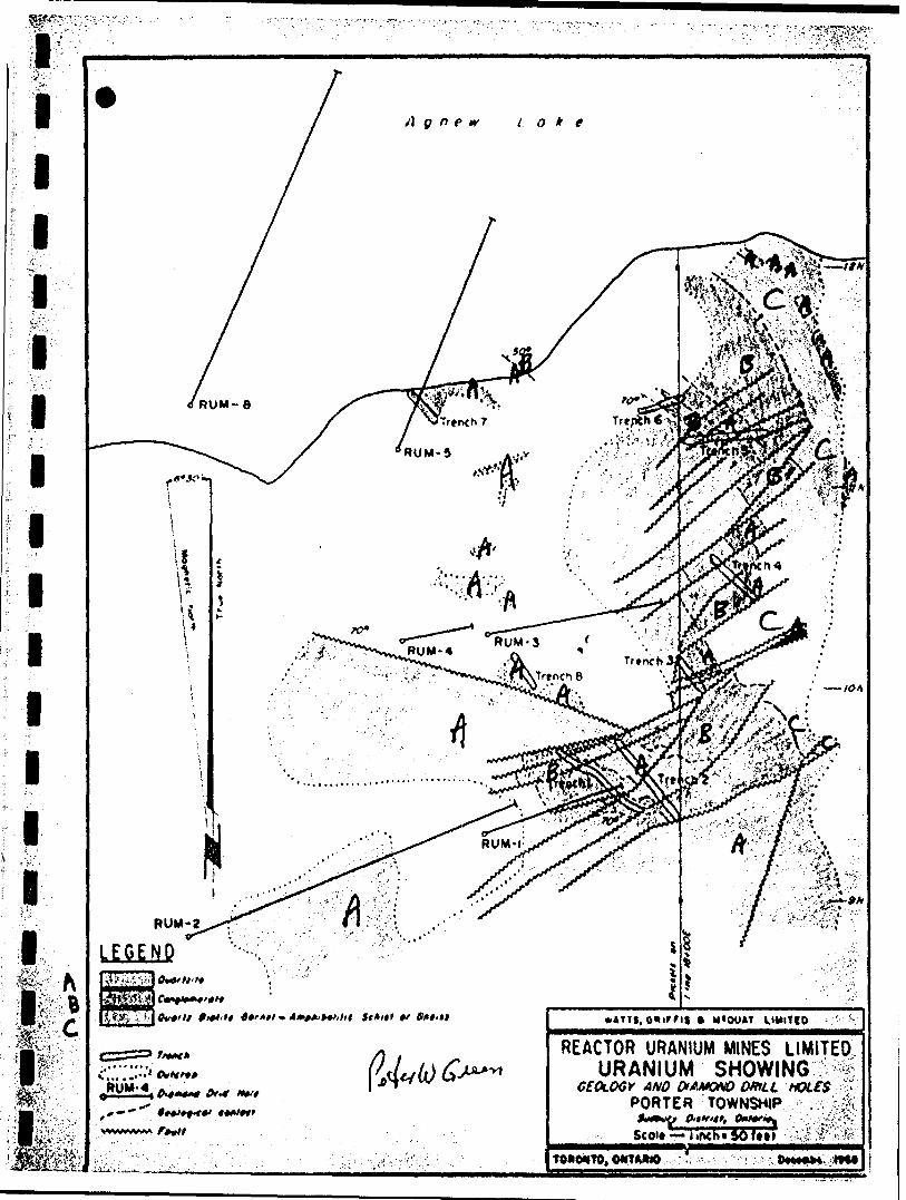
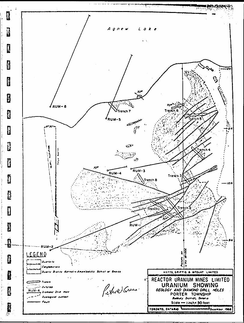
The quartzite ridge which occurs on claim S 138101 io about 90 feet above the datum line. The urorjum showing at the north end of this ridge was tested with six drill holes which returned inconclusive results.
The showing consists of a narrow conglomerate horizon with associated uranium values, separated from an underlying polymictic conglomerate by a few feet of quartzite. Overlying this "unit" is the quartzite mass that forms the spine of the ridge and beneath this unit is an assemblage of quartz -biotite -amphibolite -garnet schists, gneisses and quartzites. Trenches 5 and 6 show a similar rock sequence.
ft".V" -- * '
Agnew take
RUM-2
LEGEND
,,, . '
REACTOR URANIUM MINES LIMITED URANIUM SHOWING
AND &AMONO DRILL PORTER TOWNSHIP
TOA04TO, OWtMlO

l l l l l l l l l l l l l l lll
- 9 -
The mass of quartzites above the conglomerate are fine to medium-grained, grey to grey buff in colour, variably sericitic, feld spathic and weather white. Scattered insignificant, short, narrow lenses continuing radioactivity were located in these quartzites as well as occasional areas with patchy "granitic alteration".
The conglomerate of the showing and in trenches 5 and 6 con tains subrounded quartz pebbles and small, poorly defined altered basic rock fragments in a matrix that varies from relatively siliceous to quartz- mica-amphibole-game t-pyrrhotite schist. This matrix, which contains the uranium, is similar to the matrix in the polymictic conglomerate and the underlying schists and was probably derived from the same source as, or from the weathering of, these last two rock types.
Gummite, a weathering product of uranium minerals, was found along a few fractures or schistosity planes in the southern end of trench 2. No other uranium or thorium minerals wc.-re positively identified.
Beneath the uranium-associated conglomerate occurs a narrow quartzite band which in places is, very dark grey to black but otherwise, is similar to the quartzites described above. Minor radioactivity is associated with tills quartzite.
The polymictic conglomerate contains subrounded quartz pebbles, similar to the conglomerate above, quartzite pebbles, highly angular, schistose, basic rock fragments and rarely granitic or other acidic rock pebbles or boulders. The matrix is similar to the schist below or the conglomerate above. Practically no radioactivity was en countered in this horizon.
The contact between the polymictic conglomerate and the quartz- biotite-amphibolite-garnet schist is sharp where the matrix in the con glomerate is highly siliceous; otherwise it is gradational, since subrounded quartz fragments occur in the schist, some as pebbles, some related to the quartz stringers found in the area.
Quartzites within the schists are similar to the quartzites described above. Practically no radioactivity was detected in these quartzitos and schists.
A regional northeasterly striking schistosity, that was super imposed on the rocks of the area created healed breccia zones within the quartzites and masked primary sedimentary features except rock contacts.
,,
J

i i i ii ii i i i i i i i ir ~*
t""il
- 10 -
The Baldy Fault system ae shown on the "Geology of Porter Township" map by H. M. Ginn, is parallel to the regional schistosity. The accompanying Uranium Showing map illustrates the complex faulting caused by this regional schistosity and affected by the gabbro intrusion which outcrops less than 100 feet to the cast. This map also shows that the oranium-associated conglomerate could not be traced beyond the immediate area of trenches l and 2, and that the uranlferous upper conglomerate shown in trenches 5 and 6 is not necessarily the same conglomerate as is found in trenches l and 2. The conglomeratp-quartzite contact dips at 700 to the southwest at the southern end of trench l and in trenches 5 and 6, and at 50" to the northeast in an outcrop, which Is exposed only at very low water level, between trendies 6 and 7. Folding and drag folding effects on the structure have been masked by the faulting and schistosity. Lineation, most noticeably shown by the quartz pebbles, occurs in the plane of the schistosity with dips varying between over 80C to less than 700 in a northeasterly direction.
The greatest fault movement occurs at the southern end of the showing. Concentrations of uranium can occur in open fractures or schistosity associated with such areas of faulting, or folding.
A quartzite ridge which has been intruded by gabbro, occurs on claim S J38102 and is about 200 feet above the datum line. In the contact zone between the gabbro and the ^uartzite are small rounded slightly elongated fragments of quartz and quartzi.e in a dark quartz-biotite-amphibolite schist. This contact breccia highly resembles conglomerates in the area and on this ridge, the two units were mapped as one. Large blocks of quartzite, not shown on the geology map, occur in the contact breccia and in the gabbro and have the appearance of roof pendants.
Geophysical Results
Approximately 9. l miles of picket line were cut. A Sharpe MF-1 magnetometer was used to read 534 stations. The readings barely reflect the structural geology. A relatively large negative reading of -l, 320 gammas at 15 * 00 E, 5 -t- 00 N is probably caused by a concentration of pyrrhotite, common in the area.
A Precision De Luxe Scintillator was used for 260 readings on the reconnaissance survey. A detailed scintillometer survey was carried out during tho diamond drilling program to determine what con stituted background and significant readings for each rock type. Several readings wore taken on small areas outcrop or overburden and a range of readings established. Except for tho showing and the main quartzites
9km-\

:-:
l
l
l
i- *.
i i i i i i i i i i i i: 'r.
l'
-li
the background for the basic intrustives, conglomerates, contact breccias most of the overburden, the campsite, where the core was logged, the schists and lower qunrtzites, was .004 to .012 milliroentgens per. hour. The main quartzites had a background range of .010 to .025 milliroentgens per hour with minor scattered insignificant lenses, up to 20 feet long by 2 inches wide with readings up to .080 milliroentgens per hour.
Headings taken on or close to the showing were generally higher than the range of readings just mentioned. Many specimens wiih readings of .03 to .04 milliroentgens per hour when removed from the showing area failed to show sign? of radioactivity. The highest scintillo meter reading of 2.6 milllro; t^' ns per hour occurred in the southern end of trench 2 on a fracture or plane of schistosity containing gummite. The greatest fault movement is at the southern end of the showing area. The uranium concentrations of the showing may be due to such faulting or folding. Six drill holes were put down to test the showing. The diamond drilling results which are inconclusive are discussed separately. Radio activity in the overburden 30 feet east of the collar of RUM-3 can be ex plained by thuthole.
A conglomerate exposed in a trench at about 19 -f- 40 E, 7 -h 50 N is erratically radioactive. RUM-6 was drilled under this trench w.th negative results.
Xo new radioactive iones were located by the scintillometer survey.
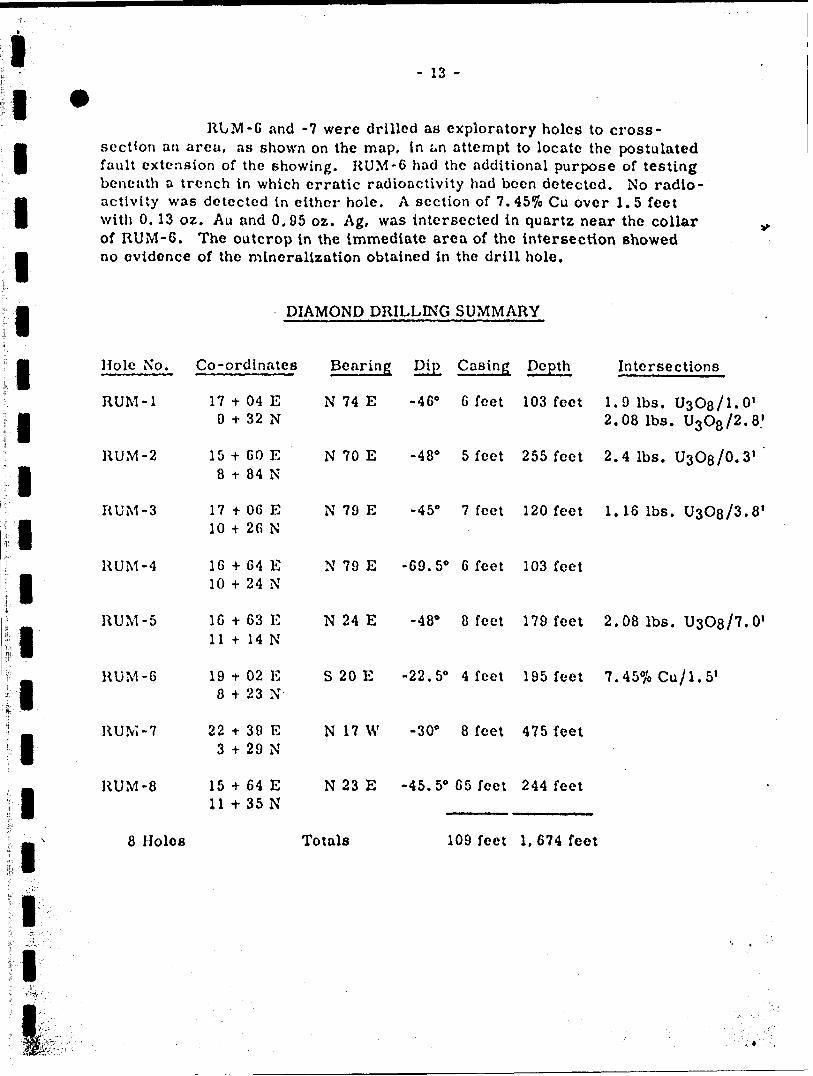
Diamond Drilling Results
Eight AXT {l 3/16-inch core diameter) holes were drilled between Xovembcr 3rd and December lith, 1968, for a total footage of 1,674 feet.
Six of these holes RUM-l to -5 inclusive and HUM-8 v/ere drilled to test the showing. The ctht.rs, RUM-6 and -7, were cross- sectional exploratory holes.
HUM-1 waa drilled to test the structure approximately 50 feet beneath trenches l and 2. As shown in the section two intersections occur. The first. 1.9 pounds ^Og over 1.0 feet, occurring in a conglomerate is assumed to correspond to values in trench 1. The other intersection, 2.08 pounds over 2. G feet occurs in the adjoining quartzite which is assumed to be the same one as in trenches l and 2.'

l l l l l l l l l l e i i i i i i
i' * ',-',i
- 12 -
RUM-2 was drilled under RUM-l to intersect the structure about 150 feet beneath the surface. An assay of 2.4 pounds UsOs over 0. 3 feet, as shown on the section occurs on the edge of a fault block containing the conglomerate.
RUM-3 was drilled to intersect the structure 100 feet to the north of RUM-1 and about 50 feet vertically beneath trench 4. As shown on section, the conglomerate was intersected close to the collar, and an intersection of 1.16 pounds V ^OQ over 3.8 feet obtained. Radioactivity detected in the overburden about 30 feet east of the collar can be explained by the intersection. RUM-4 was drilled on-line with RUM-3 to check the intersection. The drill hole remained in quartzite throughout its length. 11 shown on the same section as RUM-3 no significant values were obtained.
RUM-5 was drilled to test for a west extension of the conglomerate found in trench 6 and to check for radioacitvity. The best intersection of the diamond drilling program occurs in this hole where 2.08 pounds UsOg over 7.0 feet was obtained in the conglomerate. The structure shown in the section is schematic and the core length, 7.0 feet, may bear no close relationship to the true width.
RUM-8, the last hole in the drill program, was put rov.r. to check the westward extension of the uranium-bearing conglomerate found in RUM-5 but on a parallel section, 100 feet to the west. As shown in the drill section a non-radioactive conglomerate was intersected.
The results of drilling holes RUM-1 to -5 inclusive and RUM-8, have led to two hypotheses regarding the showing. The first is that a uri-nifcrous conglomerate horizon has been highly faulted as shown on the map and sections, and folded, with possible local enrichment through re- mobilization of uranium. Drill intersections would be explained by the drill hole cutting the appropriate fault block segment.
The second hypothesis is that the uranium is concentrated in fractures caused by, and associated with the faulting and these fractures occur mainly in the conglomerate at the conglomerate-quartzite contact. AB in the first hypothesis, remobilization of uranium from the conglomerate horizon may have caused some local enrichment. Significant values would be explained, in this case, by the drill hole having cut a uranium-bearing schistose or fractured area. The writer believes there is more merit in the ideas of the second hypothesis than in the first.
l ' : -
f
li
t
f
f.
fc
l[
i,i
l i,
- 13 -
RLM-6 and -7 were drilled as exploratory holes to cross- section an area, as shown on the map, in an attempt to locate the postulated fault extension of the showing. RUM-6 had the additional purpose of testing beneath a trench in which erratic radioactivity had been detected. No radio activity was detected in either hole. A section of T.45% Cu over 1.5 feet with 0.13 oz. Au and 0,95 oz. Ag, was intersected in quartz near the collar of RUM-6. The outcrop in the immediate area of the intersection showed no evidence of the mineralization obtained in the drill hole.
DIAMOND DRILLING SUMMARY
Hole
RUM
RUM
No. Co-ordinates Bearing
-1
-2
RUM -3
RUM
RUM
RUM
RUM
RUM
8
-4
-5
-6
-7
-8
Holes
17 * 9 t
15 t8 *
17 t 10 t
16 -f10 -h
1C * 11 *
19 t- 8 -f
22 t-
3 *
15 4-
11 t-
04 32
GO 84
06 26
64 24
6314
02 23
39 29
64 35
EN
EN
EN
E N
EN
EN :
EN
EN
N 74 E
N 70 E
N 79 E
N 79 E
N 24 E
S 20 E
N 17 W
N 23 E
Totals
Dip Casing
-460 6 feet
-480 5
-450 7
-69. 50 6
-480 8
-22. 50 4
-30' 8
-45. 50 65
109
feet
feet
feet
feet
feet
feet
feet
feet
Dej
103
255
120
103
179
195
475
244
3th Intersections
feet 1.9 Ibs. UsOe/l.O' 2,08 Ibs. U3O8/2.8 1
feet 2.4 Ibs. U3O8/0.3 1
feet 1.16 Ibs. U3O8/3.8'
feet
feet 2.08 Ibs. UsOs/T.O'
feet 7.45lfrCu7l.5l
feet
feet
1, 674 feet
i

l
*
If'):
l
GROUP II CLAIMS
Geological and Geophysical Results
Quartzite ridges rise from large areas of Jow land some of which has been further inundated by beaver dams on Hunter Creek.
Approximately 14.8 miles of picket lines were cut from 3 base lines, on this claim group.
The geology was checked in a reconnaissance fashion with the "Geology of Porter Township" map by R. M. Ginn. No significant differences were observed, and no new geology map was made.
A magnetometer survey was carried out with a Sharpe MF-1 magnetometer and 728 stations were read.
A few magnetic highs and lows occurring along the lines of the regional structural trends are probably caused by small concentra tions of pyrrhotite, common in the area.
A De Luxe Scintillator made by Precision Instruments Limited was used in the reconnaissance scintillometer survey. In significant, but slightly above background radioactivity was recorded i i three stations.
A Sharpe SE-250 was used in the E.M. survey in which 681 station readings were recorded. Two E.M. conductors were located, which when detailed, were considered insignificant.
m.

.l *liiii i i
APPENDK l
l DIAMOND DRILL HOLE SECTIONS
l
l
i
i
w-

HUM-
Molt N*
HWM-I
-
MUW-t
Semple Mr
ifi4J6f*910IIliU14'516
triti*toJittt)14tt16irr*t*10
v.u,o.*oot00*
(OOioowc
(001(001004
001O 01
(OOI006OJOC
M.I(001ooo*c001
002(00)oo*
(001006
(OCI004
MXootOlt001
iOOl00*
4001
V.ThO,Nil
00*NiMiMiM.MiMiMi
00NiMi
00}MlMiMI
00*Mil
0 16001017
Nil0 1001001009
NHNil
00)Nil
Urtfth
06Ot'
t *1 0i y4 6'
t r1 1 'X)i-*11 4'
1 V* r'Z4'1 9'i*'os'
1 4'05*891
o y6604-
JOj o;05'IT'VO'
oX*1
LEGEND
OvfU fithtt 6er**l-Ajnfi*iWir# Sc**t tt Gn+H
1C ltit Ctit
WATTS, * M*OOAT
REACTOR URANIUM MINES LIMITED DIAMOND DRILL HOLE SECTION
LOOKING HI8*W *~ PORTER TO-VNSHIP ^ -^ ' '
Scon,— lifKM Wft*V^^?tr':*TOUOMTO,

s r /-- * -lii tii i'.f *i i i i i i l1:s •r;*, 1 '' '-' ' r *.'. - ' V i r . .
RUM-S
Holt N*
IWM-4
r t t10
"it"it14
(OOI 00* OOI 0-04
(OOI 004 OOI 004
OOI 00* OOI
LEGENDA t o fithlf
Lttt C f t
Nil NU NU
N.I Nil
Nil Ntt
OOI Na
J*
O-*'or rt'*o'o*;or
t y
W*OUAT
REACTOR URANIUM MINES LIMITED DIAMOND DRILL HOLE SECTION
LOOKING Nll*W ;AJ PORTER TOWNSHIP v!f
Scott l intK t 9O fttt
TOWttTO, OttTMPO

RUM-5
LEGEND
Sc**r of Qn+u
HOI* Nl
HUM-*
V.UjO.
001 OO* 041 OOI 00* 01*
001oot
Mlo orNilNilN*
OO*
ooa 5*
WATT*, M'OUXT LI wit to
REACTOR URANIUM MINES LIMITED DIAMOND DRILL HOLE SECTION
LOOKING N66*W Wi^ PORTER TOWNSHIP; ^B*
SeoJ* — l inch" W Feet

RUM-e
ALEGEND
Qvomltt
S tt* rf
W AT T t, M*OUAT UMIUO
REACTOR URANIUM MINES LIMITEDDIAMOND DRILL HOLE SECTION
LOOKING /vtf^^r r^-ixPORTER TOWNSHIP 1 ? ?;^
QttlrHt,
OMTAMO

LEGEND
Hoi* NtKUM. t
SompUN*t ty
V.CuO-l) T-4J Oil
os. Au
MJ
oi. Ag
OM
Length4 -Vi-S1 *-*'
WAT'S, a W*OUAT
REACTOR URANIUM MINES LIMITED DIAMOND DRILL HOLE SECTION
LOOKING M?O*e PORTER TOWNSHIP
bllritl. ftfjfie
lincn* SOft*f
TOftOMTO, ONTAIDO l**9

^"^^K* ''f'^-^S-^^.
VATTS, 0*l*FIS a M^OUAT LMHTCO
REACTOR URANIUM MINES LIMITED^ DIAMOND DRILL HOLE SECTION
PORTER TOWNSHIP

l l l l l l l l l l l l l l i i
ift ~-
i i i
No.
642-1-1
642-1-2
642-1-3
642-1-4
642-1-5
642-1-6
LIST OF MAPS
(Bound Separately)
Electromagnetic Survey
Magnetometer Survey
Scintillometer Survey
Magnetometer Survey
Scintillometer Survey
Geological Map
Description
Group
Group
Group
Group
Group
Group
II
II
II
I
I
I
claims
claims
claims
claims
claims
claims
Scale:
Scale:r
Scale:
Scale:
Scale:
Scale:
1"
1"
1"
1"
1"
1"
* 100
* 100
- 100
* 100
* 100
* 1 00
feet
feet
feet
feet
feet
feet
- Ul -
i i i i i i i i i t i i i i i i
.t:'.
l
i
APPENDIX 5
INSTRUMENTS AND TECHNIQUES
A model 11 IB De Luxe "Scintillator" by Precision Radiation Instruments Incorpox'ated was used in the scintillometer survey.
In the principal of scintillation, when gamma rays penetrate certain crystals, minute flashes of light are given off. These flashes of light are transformed into electrical energy which when converted and averaged are read in milliroentgens per hour.
The instrument uses a l 1/2" by l" podium iodide crystal hermetically scaled in an aluminum can and an RCA 6199 photomultiplier tube. 1
The sensitivity of the scintillator is .0005 milliroentgens per hour and it has an accuracy of 5^o of 3/4 full scale reading. The highest reading is 5 MR/1IR. The instrument, it is claimed, can be operated effectively from -25" C to +400 C and over 15, 000 feet altitude.
Calibrations were checked more often than the one hour continuous operating time suggested in the operations manual. Readings wore taken with the instrument held on outcrop and overburden, perpen dicular to the general surface at each place of measurement.
The specifications of the Sharpe MF-l magnetometer are reproduced separately. Readings were taken in the prescribed manner. The instrument measures the intensity of the vertical component of the earth's magnetic field. The contour lines enclose areas of equal vertical magnetic intensity. Erratic high or low areas can be explained in the area of the claim groups by the dipole effect of pyrrhotitic concentra tions.
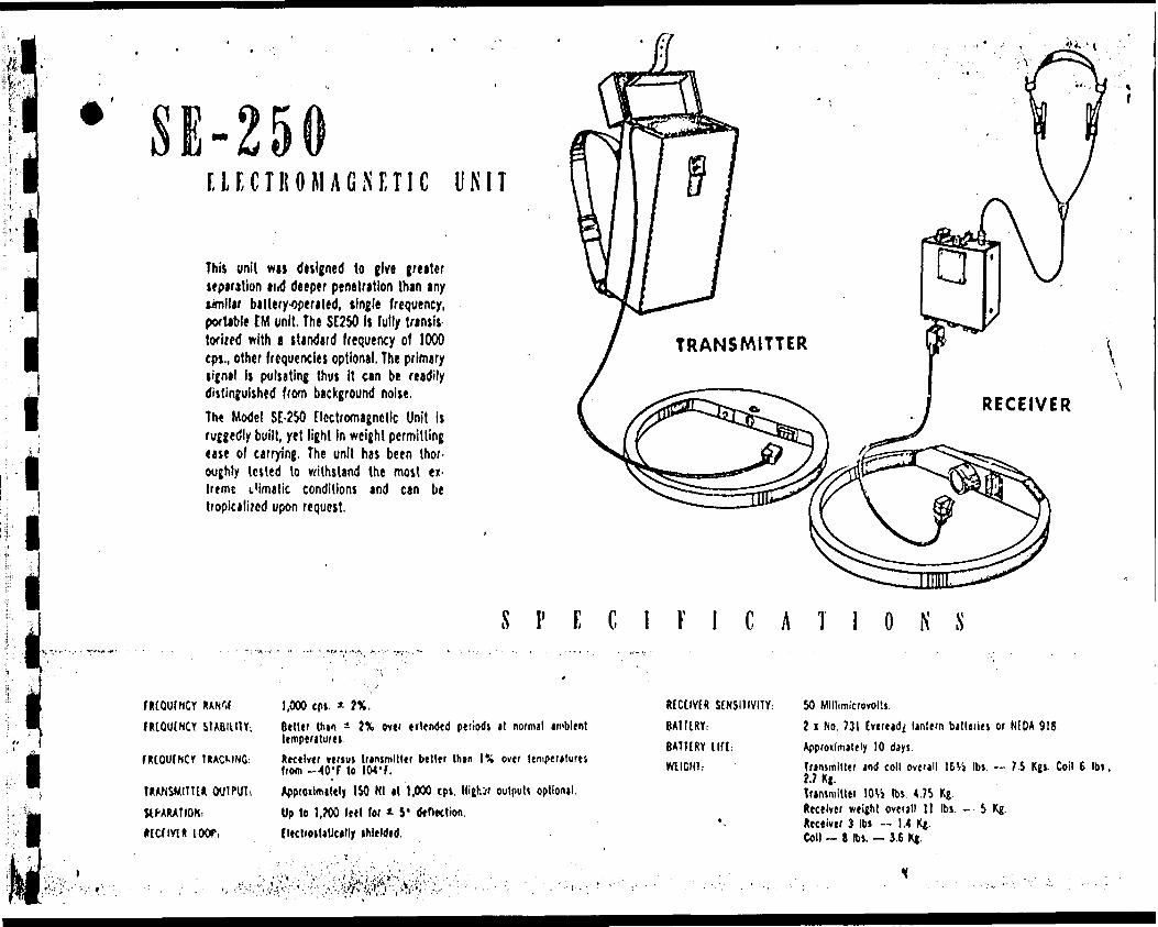
The principal of electromagnetic induction is used in ihe SE-250 instrument which was used in the electromagnetic survey of group II claims. The specifications of this instrument are reproduced separately. When a conductor is placed in an audio-frequency alternating magnetic field, eddy currents flow within the conductor creating a secondary field which distorts the primary field. The Instrument measures this distortion.
On the electromagnetic jurvey the Broadside or Parallel Line Method was used wherein the transmitter coil at each station was held . vertically and aimed at the receiver coil, 400 feet away, at the same

l l l l l l il
station on the next line. The receiver coil was rotated around an imaginary axis joining the two coils, until a null was heard. The breadth of the null, the angle of dip of the coil and the resultant shape of the curve are indicative of the character of the conductor located.
In the detailed survey the Fan Method was used where the trans - mittor coil remains at a specific location and is aimed at the receiver coil, on the next line, which is then moved from station to station until readings have been taken up to 400 to 500 feet each side of the suspected conductor. Again, the breadth of the null, the angle of dlp; and shape of the curve are indicative of the character of the conductor.

"I FLUXGATE MAGNETOMETER
A first order fluxgate type verlical com ponent magnetometer. Advanced transis torized circuitry and extensive temperature compensation is the core of its accuracy comparable to precision tripod mounted Schmidt type magnetometers.
It Is a hand held instrument and needs only coarse levelling and no orientation. Features such as direct reading of gamma values and the possibility of accurate zero setting at base stations ensure simplicity of operation and higher field economy,
The Model MM Fluxgate Magnetometer is designed for accurate ground surveys In the mining industry as well as a basic component for air surveying by small aircraft. Technical data and comparison charts available on request.
SPECIFICATIONS
MAXIMUM SUISIIIYIIY:
tlAOAOILirY,
RANCIS: tfUU SCMl)
?0 ttmmai (ptr Kilt division) on 1000 gamma ring*.5 t*mmit (W K ile divltlon on 1000 gamma nnjt,
1,000 |*mmtt3,000 timmis
10,000 {immttJO.OOO t*mmtt
100,000 iimmit
MAXIMUM
UWUDE ADJUSUUNT RANGIS,
DIMENSIONS: (INCLUDING DAHCRY CASH
WIGHT! (INCLUDING 8ATURY CASE) BAHCRIIS:
* 100,000 jammaj
10,000 to 75,000 jimmas, Norlhtfn htmisphtre eonvtrtible to;10,000 (o 75,000 {immas, Southern hemlsphert or * 30,000 gammas equato'ial.T \ 4" x IS"9 Ibs.
l? Flaihlifht Balttfles ("C" cell).
ii
ELECTROMAGNETIC UNIT
This unit w*i designed to give greater separation ai.d deeper penetration than any wnilar battery-operated, tingle frequency, pwUblt CM unit. The SE250 is fully transit tofi/ed with a standard frequency of 1000 epr, other frequencies optional. The primary signal is pulsating thus It can be readily distinguished from background noise.The Model SE-250 Electromagnetic Unit is ruggedly built, yet light In weight permitting ease of carrying. The unit has been thor oughly tested to withstand the most ex treme I'imalic conditions and can be tropicalized upon request.
S F E C l F l C A T l O N S
lMOUINCYHtOUlNCY STABILITY;
WOUlNCr UACUNG:
UANSMIW*. OUTPUT
JIPARATION.
MCHYl* l OOf,
1,000 tp*. * ?*.
(teller thin a ?\ ovti ertended periodt it normal ambient lempentureiDeceiver vtrtul transmitter better than l M over lemperjtures from ^O'f lo 104'f.AppfOilmitely ISO Nl tt 1,000 cpi. Hijhjr outputt optional. Up to l,W (eel for * S* tf*f)Ktion tlect/oiliticilly thleldtd.
RECllVtf! S[NSI1IVITY : BA1URY: eATT[RY lift: WllGHl.
SO MlllimicrovolU.
1 1 No. 731 tveready lantern bitleriei or NfOA 918.Approilmately 10 days.Transmitter and coil overall 16V, its. -- 7.S Kgt. Coil 6 Ibt,
Trtmniitter lO^i Ibs. 4.75 Kg. Receiver weijM overall 11 Ibs. -- 5 Kg. Receiver 3 Ibt — 1.4 K|. Coll - g Ibv - 3.6 Xj.
AGNEW LAKE MINES—- -4— ~ ————
PORTER TOWNSHIP
ADDISON
l ! NCO j J
HYMAN TWRPORTER TWR
K E R R-—^ ADDISON
REACTOR
9ROULAN REEF
3—. NAIRN TWP
VJBROULAN
REEFL E G EN D
4
5_l Sttiimrntt B Mftaseatmmrs , Huronian 9 Otffrr * l Granitic Intrusive*
i l Votccniet. done
WATT5. C*l'*IS ft ',
REACTOR URANIU
LOCATIOS t) o K
Properties,Uranium
AGNEWemr A
Knottft erfcurrtncn of uroniferous Quorrt p+bblr
NOTE:. Grotofr off+r J. e. Thomson. ff.M. Cmn a K. O CortfBALDWIN/TWP. f
SCAll: l IncKM IMr*
v.
REACTOR URANIUM MINES LIMITED URANIUM SHOWING
GEOLOGY AND DlAMOHO DRILL PORTER TOWNSHIP
Seon — l iftch* 90ft*t
0VJLJ ILJ
ft- r-
HO-
XO
oe*
TOR'*
Xw FOR M^
-:
^Sfe&^i-i^ ••'•'•'V'1 ''^ :'- : -'-: ' - K^v*i ji1"1 ':.^" J. 1:'';",''-i f'v ..''-'^ . ' ' ' ; ' '
WA
TT
S,
GR
IFF
IS
S
MC
QU
AT
L
IMIT
ED
CO
NS
UL
TIN
G
GE
OL
OG
IST
S
a
EN
GIN
EE
RS
91
1-1
59
B
AY
S
TR
EE
T
TO
RO
NT
O
REAC
TOR
URAN
IUM
MIN
ES
LIM
ITED
Roc
k ty
pes
Gab
bro
Pyr
oxen
e-A
mph
ibol
e ro
ck
Qua
rtz,
Bio
tite,
Am
phib
olite
, G
arne
t, S
chis
t an
d G
neis
s
Qua
rtzite
Con
glom
erat
e
Chl
orite
S
chis
t
Sym
bols
* * 'r ...y
Out
crop
Geo
logi
cal
cont
act
Fau
lt ve
rtic
al,
incl
ined
Y f
Str
ike
and
dip
of
Sch
isto
sity
in
clin
ed,
vert
ical
X X
X
Str
ike
and
dip
of
Bed
ding
in
clin
ed,
verti
cal,
dip
unkn
own
Bre
ccia
Str
uctu
rally
di
stur
bed
zone
, D
iam
ond
Dril
l H
ole
GEO
LOG
ICAL
M
APG
RO
UP
L
PO
RT
ER
T
OW
NS
HIP
DIS
TR
ICT
O
F
SU
DB
UR
Y
ON
TA
RIO
SH
EE
T
N?
642-1
-6D
AT
E:
No
vem
ber
19
68
DR
AW
N
BY
: J.
H
om
osi
ts
Min
ero
lizd
tio
n
S S
ulph
ide
occu
rren
ce
Py
Pyr
ite
Po
Pyr
rhot
ite
Cpy
C
halc
opyr
ite
Probably
de
ep
erb
urd
en
Le
ve
lg
r o
u \n
d
po
p l
a r
S137
89^
Ma
inly
Larg
eb
a l
s a
l mA
g
n e
w
A
GN
EW
K E
Pro
bably
de 9
p
SI38
Mostly
Sa
n d
y
SI38
IO4
SI38
IO3
Ag
ne
wA
gn
ew
g/a
c i
c l
p l a
i n
i
Port
er
Twp.
Hym
an
Twp
Bald
win
Twp.
Nairn
Tw
p.
4II
0S
NE
00
33
B
02
0
PO
RT
ER
200

WA
TTS
, G
RIF
FIS
a
MC
QU
AT
LIM
ITE
DC
ON
SU
LT
ING
G
EO
LO
GIS
TS
8,
E
NG
INE
ER
S
911-
159
BA
Y
ST
RE
ET
——
TO
RO
NT
O
REAC
TOR
URAN
IUM
M
INES
LI
MIT
ED
MAGN
ETOM
ETER
SUR
VEY
GR
OU
P
LP
OR
TE
R
TO
WN
SH
IPf^
w~
' tiJ
(Z*^
DIS
TR
ICT
O
F S
UD
BU
RY
—
——
O
NT
AR
IO
——
—
SC
ALE
?
. 5,0
.
T
T""
DA
TE
: N
ove
mb
er
19
68
DR
AW
N
BY
: J.
H
om
osi
ts
AP
PR
OV
ED
B
Y:
f*
cJ ,(
T-
SH
EE
T
N26
42
-1-4
LE
GE
ND
INS
TR
UM
EN
T:..
......
. S
harp
e M
F-l
Flux
gate
M
agne
tom
eter
SE
NS
ITIV
ITY
:...
. ..
. ..
. ........ 2
O g
amm
as p
er
scal
e di
visi
on
CO
NTO
UR
IN
TER
VA
L:..
.................. .
....
....
. /O
O g
amm
as
Rea
ding
in
ga
mm
as
Mag
netic
co
ntou
r
513
Ag
ne
w
K E
NE
W
S/38
S.I3
8IO
2SI
38IO
3SI
38/O
4
Porte
r Tw
p.Hy
man
Twp
Nairn
Tw
p.Ba
ldwi
n Tw
p.
41 I
05N
E0093
9020
PO
RT
ER
WA
TTS
, G
RIF
FIS
a
M
CQ
UA
T L
IMIT
ED
CO
NS
UL
TIN
G
GE
OLO
GIS
TS
a
EN
GIN
EE
RS
911-
159
BA
Y
ST
RE
ET
——
TO
RO
NT
O
REAC
TOR
URAN
IUM
MINE
S LI
MIT
EDLE
GE
ND
SCIN
TILL
OM
ETER
SURV
EYIN
ST
RU
ME
NT
:.....
.P
reci
sion
R
adia
tion
Inst
rum
ents
, Inc
. S
cint
illom
eter
M
odel
lII
B
SE
NS
ITIV
ITY
:...
.... .
.. .
...
. ...
....
....
....
...
...
.OO
/ M
illiro
entg
ens
pe
r ho
ur
Rea
ding
in
M
illiro
entg
ens
per
hour
GR
OU
P
l.P
OR
TE
R
TO
WN
SH
IPD
IST
RIC
T
OF
SU
DB
UR
Y
ON
TA
RIO
DA
TE
: N
ove
mb
er
196
8
DR
AW
N
BY
: J
. H
om
osit
s
S13.
Ag
ne
w
A
GN
EW
K E
SI38
S138
, O2
S138
IO 4
SI38
O3
Agnew
Porte
r Tw
p.Hy
man
Twp
Bald
win
Twp.
Nairn
Tw
p.
41 I
05
NE
0C
I93
0
02
0
PO
RT
ER
22
0
00'
.8*0(
-6*'
.o*1
rf
6*1
.0*o" 1
,oc
"C
Base Line D.-
LEGENDINSTRUMENT:.,....... Sharpe MF-1 Fluxgate Magnetometer
SENSITIVITY:... . ... .., ........ 2O gammas per scale division
CONTOUR INTERVAL: .............................. IOOgammas
Reading in gammas
Magnetic contour
EM. conductor strong, medium to weak
2+OOS
•^ao
\
t
WATTS, GRIFFIS a MCQUAT LIMITEDCONSULTING GEOLOGISTS ft ENGINEERS
911-159 BAY STREET —— TORONTO
REACTOR URANIUM MINES LIMITED
MAGNETOMETER SURVEYGROUP II.
PORTER TOWNSHIP }) n I QO ! DISTRICT OF SUDBURY f'\f,^k* ^ l "* "r ' " ^ ——— ONTARIO ——— ; - ~ ^
DATE : November 1968 SHEET N*
llllllllllllllllllllllUIIIIIIIIIIIIIIIIIIIIII APPROVED BY: G*V 642-1-2
"\tTO "i
3to-
3^0-"
t
4oo ~~
•5oo --
STO —
400 —
3i3O —•SjjpC, -
4cto-
Porter Twp. ^JBaldwin Twp.
^I—J^^00^
^-~~~~~~^
-^^
_ ___ —^ —— — — '
- — —— —. — ———— — —
1 — - — .
- ———— — — —
is-*
*itoO
——— -v -I&0——— --
•^10
-i*o
-iSo
-40o
•Sloxf
•5tov
•600
r 42o
• 22o
•4to
•4Eo
.34o
4II05NE0093 0020 PORTER 230

1 '
LEGENDInstrument: Sharpe S.E-25O EM. unit
Strong conductor
Medium to weak conductor
Indefinite conductor
Conductor number
Broadside profile
-o—'" Fan method profile
sto.-2 Transmitter station
Pro f//e from Station 2
-WATTS, GRIFFIS B MCQUAT LIMITEDCONSULTING GEOLOGISTS 8 ENGINEERS
-9H-159 B AY STREET —TORONTO
REACTOR URANIUM MINES LIMITED
ELECTROMAGNETIC SURVEY
II \oo
GROUP II.PORTER TOWNSHIP
ISTRICT OF SUDBURY ——— - ONTARIO ———
'•1
DATE November 1968
APPROVED BY:
SHEET
642-
Porter Twp.
Baldwin Twp.
4ll05NEOe93 01320 PORTER 240

.0(
.o*1
.0.0"
,oc
fi*
Base Line "o"- '
LEGENDINSTRUMENT.-..,. ..Precision Radiation Instruments, Inc. Scintillometer Model IIl B '
SENSITIVITY: ... .... ...... .. ......... .. .. .. .. .. .. . OO/ Milliroentgens per hour
' - 014 .,.. .... ..,. . . . .. . . . .. . .... . ...... Reading in Milliroentgens per hour
WATTS, GRIFFIS a MCQUAT LIMITEDCONSULTING GEOLOGISTS 6 ENGINEERS
911-159 BAY STREET ——TORONTO
REACTOR URANIUM MINES LIMITED
SCINTILLOMETER SURVEYGROUP II..
FOR TER TOWNSHIPDISTRICT OF SUDBURY
ONTARIO ———
DATE: November !968
APPROVED BY:
SHEET M2
642-1-3
Porter Twp.
Baldwin Twp.
I05NE0093 0020 PORTER aso

Base Line *D*- ' "~

•cir"
5 137-J68
Twp.
/l

s t̂^\J- -- IO+OON
8+OON6+OON
4+QON
\*
Os .
^*
.t1
0
I