report to: council - waitomo district - agenda... · report to: council meeting date: 6 march 2014...
TRANSCRIPT
Document No: 328429 File No: 037/048A
Report To: Council
Meeting Date: 6 March 2014
Subject: Progress Report: Road Map Work
Programme Monthly Monitoring Schedule
Purpose
1.1 The purpose of this business paper is to present Council with the monthly update
on progress against the Road Map Work Programme adopted by Council on 27
August 2013.
1.2 Attached to and forming part of this business paper is the Road Map Monitoring
Schedule which reports progress against the Road Map as at 6 March 2014.
Background
2.1 This Road Map sets out the identified work programme leading up to adoption of
the 2015-2025 LTP in June 2015.
2.2 In addition to projects relating to the LTP, there are a number of other important
projects that must also occur over this period and it is important that Council does
not focus on the LTP process to the detriment of other important commitments.
2.3 It should also be noted that many of the projects of work contained in the Road
Map are legislative requirements with statutory timelines which Council has no
influence over.
2.4 The majority of the non-LTP commitments are of importance to the functional
roles of Council which feed into the decision making process.
2.5 The Road Map details identified projects of work, including a brief commentary for
each project. Other issues will come up over time that will need to be tested
against the Road Map work programme and organisational capacity to identify
priority ranking against the established work programme.
2.6 The Road Map is a ‘living document’ subject to change, both through further
planning required for certain work streams and also by way of Council review as
other issues arise over time which affect priorities.
Commentary
3.1 The current Road Map (as at 27 August 2013) includes work programmes required
by legislation and projects identified in the 2012-2022 LTP.
3.2 The full Road Map Work Programme document is presented to the Council on a
“needs” basis to ensure that it is kept as up to date as possible.
3.3 In the interim period a Monthly Monitoring Schedule is presented to Council. The
Monitoring Schedule is a direct extract from the Road Map of the Key Milestones
1
for the current year (2013/2014) and includes the indicative timeframe and a
commentary on progress for each project of work.
3.4 Amendments to Timelines and Projects of Work
3.5 Any amendments to Project timelines are noted in the monthly Monitoring
Schedule. Updates are highlighted in red font. All completed projects are moved
to the end of the Schedule and are highlighted in blue font.
New Projects
4.1 As new projects are identified, they will be detailed in future versions of this
business paper and will be included in the next edition of the full Road Map Work
Programme document.
Suggested Resolution
The Road Map Monitoring Schedule as at 6 March 2014 be received.
MICHELLE HIGGIE
EXECUTIVE ASSISTANT
Attachment: 1 Road Map Monitoring Schedule as at 6 March 2014 (Doc 326816)
2

# 326816
Road Map
Monitoring
Schedule
Monitoring against Road Map adopted on 27 August 2013
as at 26 November 2013
3
# 326816
CONTENTS
Development of 2015-2025 LTP 5
Review of Development/Financial Contributions ..............................................................5
Leadership 6
Local Government Funding Agency (Debenture Trust Deed) .............................................6
Local Government Act 2002 – Amendment Act 2012 .....................................................49
Waikato Mayoral Forum Workstreams............................................................................6
Local Government Reform - Positioning of WDC ..............................................................7
Development of a WDC Stakeholder Engagement Strategy...............................................8
Review of Representation Arrangements (including Maori Representation) .........................9
2012/2013 Annual Report ..........................................................................................48
2013 Code of Conduct Review ....................................................................................49
2013 Governance Statement Review .............................................................................9
2013-2016 Triennial Agreements – Waikato and Manawatu-Wanganui Regions.................10
2014/2015 Exceptions Annual Plan..............................................................................10
Review Memorandum of Understanding between WDC and ICL .......................................11
Strategic Plan – Procurement Alignment between WDC and ICL ......................................11
Communications Strategy – Progress Report ................................................................11
Community Development 12
Community Development Partnership Fund ..................................................................50
Sport Waikato Services – Development of Performance Based Contract ...........................12
Economic Development Plan.......................................................................................12
Development of Customer Services Strategy ................................................................13
Youth Liaison/Youth Council .......................................................................................13
Community Events ....................................................................................................14
Review of Waitomo District Council Citizens Awards Policy .............................................50
Waitomo District Citizens Awards ................................................................................14
Regulation Services 15
District Plan Review...................................................................................................15
Urban Structure Plans................................................................................................16
Jurisdictional Issues ..................................................................................................16
Alcohol Reform Legislation .........................................................................................16
Waikato River Catchment Economic Studies .................................................................17
Te Maika Zone ..........................................................................................................17
2013/2014 Review of Dog Control Policy and Practices ..................................................17
Dog Control Review...................................................................................................17
Gambling Policy Review .............................................................................................17
Bylaws Review..........................................................................................................17
District Plan Rules – Audit of Signs/Hoardings ..............................................................18
Establishment of a Rural Fire Authority for Waikato Valley Operational Area .....................18
Community Services 20
4
# 326816
Te Kuiti Railway Building............................................................................................20
Centennial Park Drainage...........................................................................................21
Te Kuiti Library Roof Renewal .....................................................................................21
Civic Centre Upgrade : Stage 4 – Main Hall Ceiling ........................................................22
Sale of 6 Te Kumi Road .............................................................................................22
Sale of 6 Jennings Street – Community House ..............................................................22
Benneydale Hall Replacement / Disposal ......................................................................23
Parkside Subdivision Disposal .....................................................................................23
Mokauiti Hall Disposal................................................................................................24
Oparure Hall Disposal ................................................................................................24
Kopaki Hall Disposal ..................................................................................................24
Mokau Effluent Disposal Upgrade ................................................................................25
Quarry Resources Review...........................................................................................25
Review Lease/Licences ..............................................................................................26
Old Ministry of Works Building, Queen Street, Te Kuiti ...................................................26
Land Purchase – Te Kuiti Cemetery .............................................................................26
Riverview Heights Land Disposal .................................................................................27
Cemetery Maps and Records ......................................................................................27
Te Kuiti Mainstreet Garden Re-design ..........................................................................27
Walking Track Strategy..............................................................................................28
Te Kuiti Aerodrome Reserve Management Plan .............................................................28
Cultural and Arts Centre - Shared Parking Investigation.................................................29
Investigation into Provision of Joint Services Facility......................................................29
Library Building Renewal and Entrance ........................................................................29
Parks and Reserves AMP – Plan Improvement and Monitoring.........................................29
Recreation and Culture AMP – Plan Improvement and Monitoring....................................32
Public Amenities AMP – Plan Improvement and Monitoring .............................................34
Housing and Other Property AMP – Plan Improvement and Monitoring.............................37
Asset Management 40
Te Kuiti Wastewater Treatment Plant Upgrade ..............................................................40
Te Waitere Water and Wastewater Strategic Review......................................................40
Benneydale Sewerage ...............................................................................................40
Waitomo Water and Wastewater – Feasibility Studies ....................................................40
Te Kuiti Water Supply................................................................................................41
Mokau Water Supply .................................................................................................41
Benneydale Water Supply ..........................................................................................41
Cross Boundary Collaboration (WDC/RDC) ...................................................................41
Para Kore "Marae Working Toward Zero Waste" ............................................................41
Waitomo District Landfill ............................................................................................42
Water Supply AMP – Plan Improvement and Monitoring .................................................42
Wastewater AMP – Plan Improvement and Monitoring ...................................................43
Stormwater AMP – Plan Improvement and Monitoring....................................................44
Land Transport AMP – Plan Improvement and Monitoring...............................................46
5

# 326816
SWaMMP – Plan Improvement and Monitoring ..............................................................47
Completed Items 40
Leadership 48 Community Satisfaction Survey (for 2012/2013 Annual Report)......................................48
2013 Triennial Elections.............................................................................................48
2013 Elected Member Induction Process ......................................................................48
Community Development 50 Otorohanga District Development Board – Service Level Agreement................................50
6
�
Road�Map�Monitoring�Schedule� 5� as�at�–�6�March�2014�
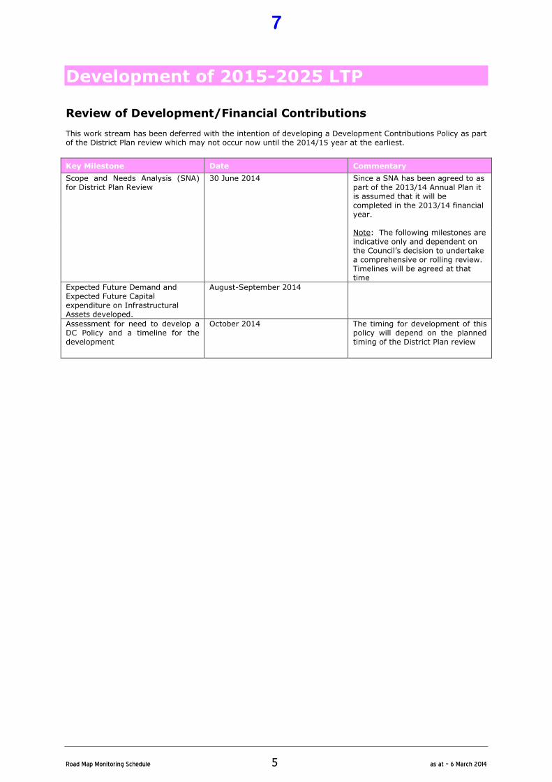
Development of 2015-2025 LTP
Review of Development/Financial Contributions This work stream has been deferred with the intention of developing a Development Contributions Policy as part of the District Plan review which may not occur now until the 2014/15 year at the earliest.
Key Milestone Date Commentary
Scope and Needs Analysis (SNA) for District Plan Review
30 June 2014 Since a SNA has been agreed to as part of the 2013/14 Annual Plan it is assumed that it will be completed in the 2013/14 financial year.
Note: The following milestones are indicative only and dependent on the Council’s decision to undertake a comprehensive or rolling review. Timelines will be agreed at that time
Expected Future Demand and Expected Future Capital expenditure on Infrastructural Assets developed.
August-September 2014
Assessment for need to develop a DC Policy and a timeline for the development
October 2014 The timing for development of this policy will depend on the planned timing of the District Plan review
7
�
Road�Map�Monitoring�Schedule� 6� as�at�–�6�March�2014�
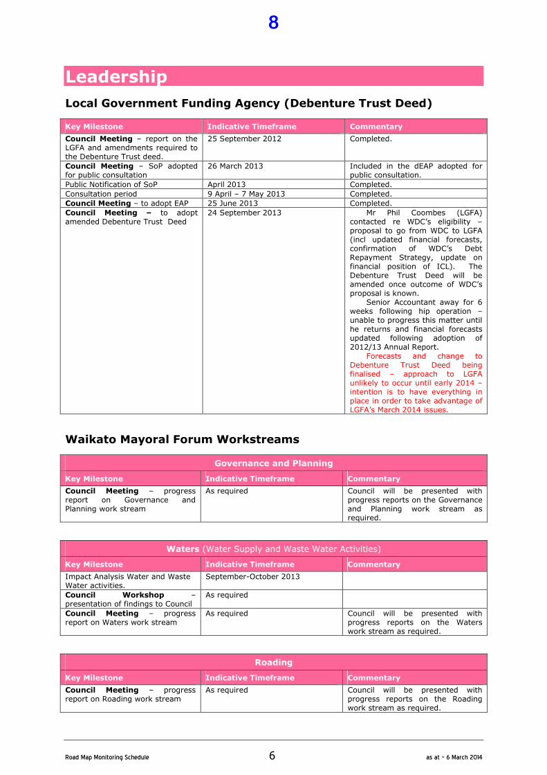
Leadership
Local Government Funding Agency (Debenture Trust Deed)
Key Milestone Indicative Timeframe Commentary
Council Meeting – report on the LGFA and amendments required to the Debenture Trust deed.
25 September 2012 Completed.
Council Meeting – SoP adopted for public consultation
26 March 2013 Included in the dEAP adopted for public consultation.
Public Notification of SoP April 2013 Completed.
Consultation period 9 April – 7 May 2013 Completed.
Council Meeting – to adopt EAP 25 June 2013 Completed.
Council Meeting – to adopt amended Debenture Trust Deed
24 September 2013 Mr Phil Coombes (LGFA) contacted re WDC’s eligibility – proposal to go from WDC to LGFA (incl updated financial forecasts, confirmation of WDC’s Debt Repayment Strategy, update on financial position of ICL). The Debenture Trust Deed will be amended once outcome of WDC’s proposal is known.
Senior Accountant away for 6 weeks following hip operation – unable to progress this matter until he returns and financial forecasts updated following adoption of 2012/13 Annual Report.
Forecasts and change to Debenture Trust Deed being finalised – approach to LGFA unlikely to occur until early 2014 – intention is to have everything in place in order to take advantage of LGFA’s March 2014 issues.
Waikato Mayoral Forum Workstreams
Governance and Planning
Key Milestone Indicative Timeframe Commentary
Council Meeting – progress report on Governance and Planning work stream
As required Council will be presented with progress reports on the Governance and Planning work stream as required.
Waters (Water Supply and Waste Water Activities)
Key Milestone Indicative Timeframe Commentary
Impact Analysis Water and Waste Water activities.
September-October 2013
Council Workshop – presentation of findings to Council
As required
Council Meeting – progress report on Waters work stream
As required Council will be presented with progress reports on the Waters work stream as required.
Roading
Key Milestone Indicative Timeframe Commentary
Council Meeting – progress report on Roading work stream
As required Council will be presented with progress reports on the Roading work stream as required.
8
�
Road�Map�Monitoring�Schedule� 7� as�at�–�6�March�2014�
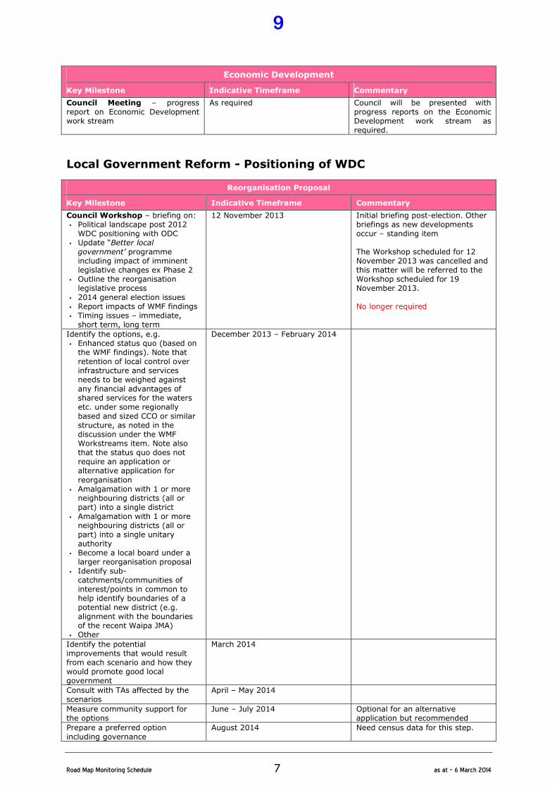
Economic Development
Key Milestone Indicative Timeframe Commentary
Council Meeting – progress report on Economic Development work stream
As required Council will be presented with progress reports on the Economic Development work stream as required.
Local Government Reform - Positioning of WDC
Reorganisation Proposal
Key Milestone Indicative Timeframe Commentary
Council Workshop – briefing on: • Political landscape post 2012 WDC positioning with ODC
• Update “Better local government’ programme including impact of imminent legislative changes ex Phase 2
• Outline the reorganisation legislative process
• 2014 general election issues • Report impacts of WMF findings • Timing issues – immediate, short term, long term
12 November 2013 Initial briefing post-election. Other briefings as new developments occur – standing item The Workshop scheduled for 12 November 2013 was cancelled and this matter will be referred to the Workshop scheduled for 19 November 2013. No longer required
Identify the options, e.g. • Enhanced status quo (based on the WMF findings). Note that retention of local control over infrastructure and services needs to be weighed against any financial advantages of shared services for the waters etc. under some regionally based and sized CCO or similar structure, as noted in the discussion under the WMF Workstreams item. Note also that the status quo does not require an application or alternative application for
reorganisation • Amalgamation with 1 or more neighbouring districts (all or part) into a single district
• Amalgamation with 1 or more neighbouring districts (all or part) into a single unitary authority
• Become a local board under a larger reorganisation proposal
• Identify sub-catchments/communities of interest/points in common to help identify boundaries of a potential new district (e.g. alignment with the boundaries of the recent Waipa JMA)
• Other
December 2013 – February 2014
Identify the potential improvements that would result from each scenario and how they would promote good local government
March 2014
Consult with TAs affected by the scenarios
April – May 2014
Measure community support for the options
June – July 2014 Optional for an alternative application but recommended
Prepare a preferred option including governance
August 2014 Need census data for this step.
9
�
Road�Map�Monitoring�Schedule� 8� as�at�–�6�March�2014�
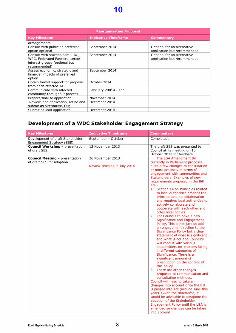
Reorganisation Proposal
Key Milestone Indicative Timeframe Commentary
arrangements
Consult with public on preferred option optional
September 2014 Optional for an alternative application but recommended
Consult with stakeholders – Iwi, WRC, Federated Farmers, sector interest groups (optional but recommended)
September 2014 Optional for an alternative application but recommended
Assess economic, strategic and financial impacts of preferred option
September 2014
Obtain formal support for proposal from each affected TA
October 2014
Communicate with affected community throughout process
February 20014 - end
Prepare/finalise application November 2014
Review lead application, refine and submit as alternative, OR;
December 2014
Submit as lead application December 2014
Development of a WDC Stakeholder Engagement Strategy
Key Milestone Indicative Timeframe Commentary
Development of draft Stakeholder Engagement Strategy (SES)
September – October Completed.
Council Workshop – presentation of draft SES
12 November 2013 The draft SES was presented to Council at its meeting on 10 October 2013 for feedback.
Council Meeting – presentation of draft SES for adoption
26 November 2013 Review timeline in July 2014
The LGA Amendment Bill currently in Parliament proposes quite a few changes to consultation or more precisely in terms of engagement with communities and Stakeholders. Examples of new requirements proposed in the Bill are - 1. Section 14 on Principles related
to local authorities amends the principle around collaboration and requires local authorities to actively collaborate and cooperate with each other and other local bodies.
2. For Councils to have a new Significance and Engagement Policy. This is not just an add on engagement section to the Significance Policy but a clear statement of what is significant and what is not and Council's will consult with various stakeholders on matters falling in different categories of Significance. There is a siginificant amount of prescription on the content of this policy.
3. There are other changes proposed to communication and consultation methods.
Council will need to take all changes into account once the Bill is passed into Act (around June this year). Given the timeframe, it would be advisable to postpone the adoption of the Stakeholder Engagement Policy until the LGA is amended so changes can be taken into account.
10

�
Road�Map�Monitoring�Schedule� 9� as�at�–�6�March�2014�
Review of Representation Arrangements (including Maori Representation) Maori Wards and Constituencies
Key Milestone Indicative Timeframe Commentary
Council Workshop: Consideration of briefing paper on Maori Wards and Constituencies
17 September 2014 Timeline amended by way of business paper to Council on 10 October 2013.
Council Meeting: Resolution to be taken in respect to Council’s consideration of Maori Wards and Constituencies
10 October 2014 Statutory Deadline 23 November 2014
Should Council resolve to consult on a proposal altering the current Representation Arrangement i.e. proposing the creation Maori Wards, a full review of the Representation Arrangements will be required.
Representation Arrangement
Key Milestone Indicative Timeframe Commentary
Council Workshop to consider options for representation arrangements
Pre-August 2014
Council Meeting – Resolution of proposed representation arrangements for consultation
26 August 2014
Public notice of proposal and invites submissions
September 2014
Submissions close October 2014
If no submissions then proposal becomes final
Council Meeting – consideration of submissions and possible amendment of proposal
28 October 2014
Public notice of Council’s “final” proposal
November 2014
Appeals and objections close December 2014
If no appeals or objections then proposal becomes final
If appeals/objections received, Council forwards appeals, objections and other relevant information to the Commission
December 2014
Commission considers resolutions, submissions, appeals and objections and makes determination
April 2014
Determination subject to appeal to High Court on a point of law
2013 Governance Statement Review
Key Milestone Indicative Timeframe Commentary
Review current Governance Statements (Doc No. 244068)
December 2013/January 2014 Completed.
Council Meeting to consider and review Governance Statement
25 February 2014 6 March 2014
A business paper is contained elsewhere in this Agenda.
11
�
Road�Map�Monitoring�Schedule� 10� as�at�–�6�March�2014�
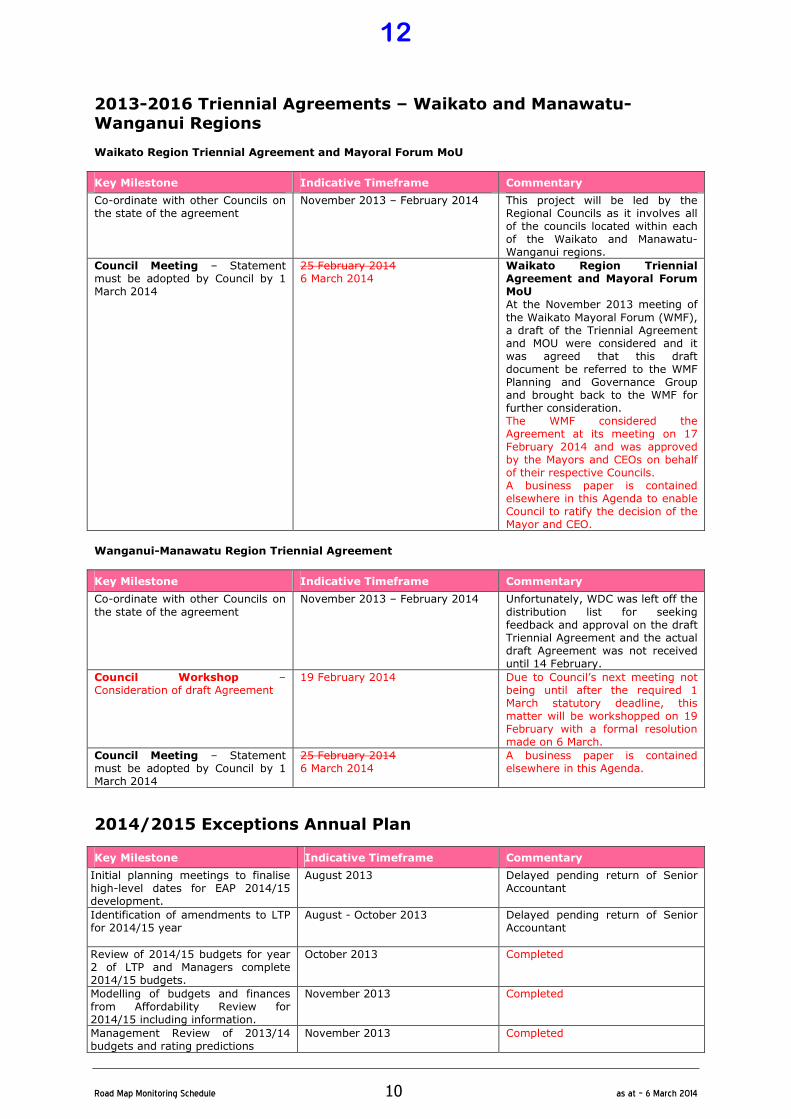
2013-2016 Triennial Agreements – Waikato and Manawatu-Wanganui Regions Waikato Region Triennial Agreement and Mayoral Forum MoU
Key Milestone Indicative Timeframe Commentary
Co-ordinate with other Councils on the state of the agreement
November 2013 – February 2014 This project will be led by the Regional Councils as it involves all of the councils located within each of the Waikato and Manawatu-Wanganui regions.
Council Meeting – Statement must be adopted by Council by 1 March 2014
25 February 2014 6 March 2014
Waikato Region Triennial Agreement and Mayoral Forum MoU At the November 2013 meeting of
the Waikato Mayoral Forum (WMF), a draft of the Triennial Agreement and MOU were considered and it was agreed that this draft document be referred to the WMF Planning and Governance Group and brought back to the WMF for further consideration. The WMF considered the Agreement at its meeting on 17 February 2014 and was approved by the Mayors and CEOs on behalf of their respective Councils. A business paper is contained elsewhere in this Agenda to enable Council to ratify the decision of the Mayor and CEO.
Wanganui-Manawatu Region Triennial Agreement
Key Milestone Indicative Timeframe Commentary
Co-ordinate with other Councils on
the state of the agreement
November 2013 – February 2014 Unfortunately, WDC was left off the
distribution list for seeking feedback and approval on the draft Triennial Agreement and the actual draft Agreement was not received until 14 February.
Council Workshop – Consideration of draft Agreement
19 February 2014 Due to Council’s next meeting not being until after the required 1 March statutory deadline, this matter will be workshopped on 19 February with a formal resolution made on 6 March.
Council Meeting – Statement must be adopted by Council by 1 March 2014
25 February 2014 6 March 2014
A business paper is contained elsewhere in this Agenda.
2014/2015 Exceptions Annual Plan
Key Milestone Indicative Timeframe Commentary
Initial planning meetings to finalise high-level dates for EAP 2014/15 development.
August 2013 Delayed pending return of Senior Accountant
Identification of amendments to LTP for 2014/15 year
August - October 2013 Delayed pending return of Senior Accountant
Review of 2014/15 budgets for year 2 of LTP and Managers complete 2014/15 budgets.
October 2013 Completed
Modelling of budgets and finances from Affordability Review for 2014/15 including information.
November 2013 Completed
Management Review of 2013/14 budgets and rating predictions
November 2013 Completed
12
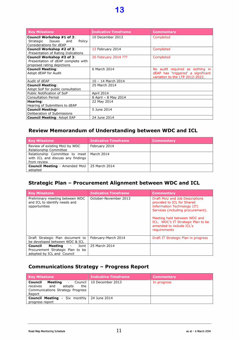
�
Road�Map�Monitoring�Schedule� 11� as�at�–�6�March�2014�
Key Milestone Indicative Timeframe Commentary
Council Workshop #1 of 3: Strategic Issues and Policy Considerations for dEAP
10 December 2013 Completed
Council Workshop #2 of 3: Presentation of Rating Indications
12 February 2014 Completed
Council Workshop #3 of 3: Presentation of dEAP complete with
proposed rating depictions
20 February 2014 ??? Completed
Council Meeting: Adopt dEAP for Audit
6 March 2014 No audit required as nothing in dEAP has ‘triggered’ a significant variation to the LTP 2012-2022.
Audit of dEAP 10 – 14 March 2014
Council Meeting: Adopt SoP for public consultation
25 March 2014
Public Notification of SoP April 2014
Consultation Period 8 April – 8 May 2014
Hearing: Hearing of Submitters to dEAP
22 May 2014
Council Meeting: Deliberation of Submissions
5 June 2014
Council Meeting: Adopt EAP 24 June 2014
Review Memorandum of Understanding between WDC and ICL
Key Milestone Indicative Timeframe Commentary
Review of existing MoU by WDC Relationship Committee
February 2014
Relationship Committee to meet
with ICL and discuss any findings from review
March 2014
Council Meeting - Amended MoU adopted
25 March 2014
Strategic Plan – Procurement Alignment between WDC and ICL
Key Milestone Indicative Timeframe Commentary
Preliminary meeting between WDC and ICL to identify needs and opportunities
October-November 2013 Draft MoU and Job Descriptions provided to ICL for Shared Information Technology (IT) Services (including procurement). Meeting held between WDC and ICL. WDC’s IT Strategic Plan to be amended to include ICL’s requirements
Draft Strategic Plan document to be developed between WDC & ICL
February-March 2014 Draft IT Strategic Plan in progress
Council Meeting - Joint
Procurement Strategic Plan to be adopted by ICL and Council
25 March 2014
Communications Strategy – Progress Report
Key Milestone Indicative Timeframe Commentary
Council Meeting - Council receives and adopts the Communications Strategy Progress Report
10 December 2013
In progress
Council Meeting – Six monthly progress report
24 June 2014
13

�
Road�Map�Monitoring�Schedule� 12� as�at�–�6�March�2014�
Community Development
Sport Waikato Services – Development of Performance Based
Contract
Key Milestone Indicative Timeframe Commentary
Finalisation of Sport Waikato Schedule of Services detailing required outcomes, activities and evidence of progress for the 2013/2014 year.
August 2013 Completed
In conjunction with Sport Waikato, develop a Contacts Register, identifying key Stakeholders.
August 2013 Completed
In conjunction with Sport Waikato develop a Projects Register for the 2013/2014 year as a supplement to the Schedule of Services.
August 2013 Completed
Council Meeting – Sport Waikato Contract for Services, Schedule of Services, Contacts Register and Projects Register presented to Council.
27 August 2013 Completed
Council Meeting Deputation – Sport Waikato Reporting on delivery of services against Schedule of Services and Projects Register.
24 September 2013 Completed - Representatives from Sport Waikato made a Deputation to Council at is September Council meeting.
Council Meeting Deputation – Sport Waikato Reporting on delivery of services against Schedule of Services and Projects Register.
25 March 2014
Economic Development Plan
Key Milestone Indicative Timeframe Commentary
Waitomo District Economic Development Plan scoping project completed.
October 2013 In Progress.
Research and Assessment: 1. Socio Demographic Profile for
the Waitomo District. 2. Economic and Industry Profile
for the Waitomo District. 3. Public and Social Service
Sectors Profile for the Waitomo District.
February 2014 In Progress.
Council Meeting – Regional Economic Development Strategy presented to Council.
March 2014 Advice received is that development of the Regional Strategy is running behind schedule. As WDC's Economic Development Plan will be informed by the Regional Strategy, the key milestones for beyond February 2014 will be reviewed in early 2014. A business paper is contained elsewhere in this Agenda.
Survey local community to establish “needs and wants”.
Form a Reference Group to inform the development of an Economic Development Plan for the Waitomo District.
14
�
Road�Map�Monitoring�Schedule� 13� as�at�–�6�March�2014�
Key Milestone Indicative Timeframe Commentary
Council Workshop – Consideration of the preliminary draft Waitomo District Economic Development Plan.
Draft Plan released for public consultation.
Finalise Waitomo District Economic
Development Plan.
Council Meeting – Draft Waitomo District Economic Development Plan presented for adoption by Council.
Assess the need and scope of a Board/Trust to deliver on the Waitomo District Economic Development Action Plan outcomes.
Waitomo District Economic Development Action Plan implemented.
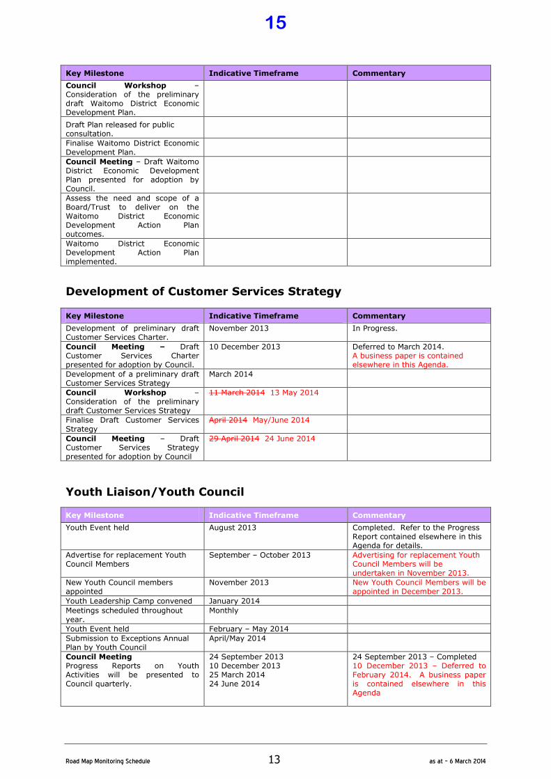
Development of Customer Services Strategy
Key Milestone Indicative Timeframe Commentary
Development of preliminary draft Customer Services Charter.
November 2013 In Progress.
Council Meeting – Draft Customer Services Charter presented for adoption by Council.
10 December 2013 Deferred to March 2014. A business paper is contained elsewhere in this Agenda.
Development of a preliminary draft Customer Services Strategy
March 2014
Council Workshop – Consideration of the preliminary draft Customer Services Strategy
11 March 2014 13 May 2014
Finalise Draft Customer Services Strategy
April 2014 May/June 2014
Council Meeting – Draft Customer Services Strategy presented for adoption by Council
29 April 2014 24 June 2014
Youth Liaison/Youth Council
Key Milestone Indicative Timeframe Commentary
Youth Event held August 2013 Completed. Refer to the Progress Report contained elsewhere in this Agenda for details.
Advertise for replacement Youth Council Members
September – October 2013 Advertising for replacement Youth Council Members will be undertaken in November 2013.
New Youth Council members appointed
November 2013 New Youth Council Members will be appointed in December 2013.
Youth Leadership Camp convened January 2014
Meetings scheduled throughout year.
Monthly
Youth Event held February – May 2014
Submission to Exceptions Annual Plan by Youth Council
April/May 2014
Council Meeting Progress Reports on Youth Activities will be presented to Council quarterly.
24 September 2013 10 December 2013 25 March 2014 24 June 2014
24 September 2013 – Completed 10 December 2013 – Deferred to February 2014. A business paper is contained elsewhere in this Agenda
15
�
Road�Map�Monitoring�Schedule� 14� as�at�–�6�March�2014�
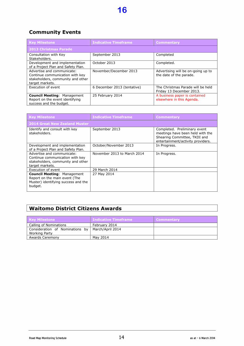
Community Events
Key Milestone Indicative Timeframe Commentary
2013 Christmas Parade
Consultation with Key Stakeholders.
September 2013 Completed
Development and implementation of a Project Plan and Safety Plan.
October 2013 Completed.
Advertise and communicate: Continue communication with key stakeholders, community and other target markets.
November/December 2013
Advertising will be on-going up to the date of the parade.
Execution of event 6 December 2013 (tentative) The Christmas Parade will be held Friday 13 December 2013.
Council Meeting: Management Report on the event identifying success and the budget.
25 February 2014 A business paper is contained elsewhere in this Agenda.
Key Milestone Indicative Timeframe Commentary
2014 Great New Zealand Muster
Identify and consult with key stakeholders.
September 2013 Completed. Preliminary event meetings have been held with the
Shearing Committee, TKDI and entertainment/activity providers.
Development and implementation of a Project Plan and Safety Plan.
October/November 2013 In Progress.
Advertise and communicate: Continue communication with key stakeholders, community and other target markets.
November 2013 to March 2014 In Progress.
Execution of event 29 March 2014
Council Meeting: Management Report on the main event (The Muster) identifying success and the budget.
27 May 2014
Waitomo District Citizens Awards
Key Milestone Indicative Timeframe Commentary
Calling of Nominations February 2014
Consideration of Nominations by Working Party
March/April 2014
Awards Ceremony May 2014
16
�
Road�Map�Monitoring�Schedule� 15� as�at�–�6�March�2014�
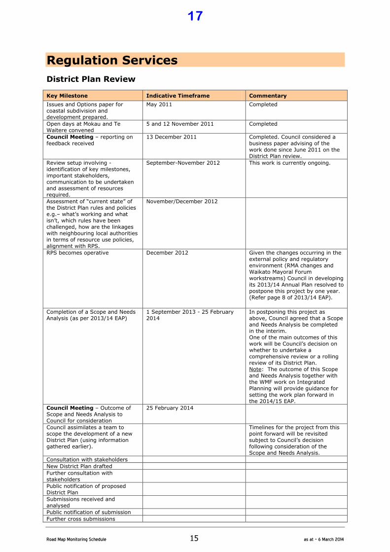
Regulation Services
District Plan Review
Key Milestone Indicative Timeframe Commentary
Issues and Options paper for coastal subdivision and development prepared.
May 2011 Completed
Open days at Mokau and Te Waitere convened
5 and 12 November 2011 Completed
Council Meeting – reporting on
feedback received
13 December 2011 Completed. Council considered a
business paper advising of the work done since June 2011 on the District Plan review.
Review setup involving - identification of key milestones, important stakeholders, communication to be undertaken and assessment of resources required.
September-November 2012 This work is currently ongoing.
Assessment of “current state” of the District Plan rules and policies e.g.– what’s working and what isn’t, which rules have been challenged, how are the linkages with neighbouring local authorities in terms of resource use policies, alignment with RPS.
November/December 2012
RPS becomes operative December 2012 Given the changes occurring in the external policy and regulatory environment (RMA changes and Waikato Mayoral Forum workstreams) Council in developing
its 2013/14 Annual Plan resolved to postpone this project by one year. (Refer page 8 of 2013/14 EAP).
Completion of a Scope and Needs Analysis (as per 2013/14 EAP)
1 September 2013 - 25 February 2014
In postponing this project as above, Council agreed that a Scope and Needs Analysis be completed in the interim. One of the main outcomes of this work will be Council’s decision on whether to undertake a comprehensive review or a rolling review of its District Plan. Note: The outcome of this Scope and Needs Analysis together with the WMF work on Integrated Planning will provide guidance for
setting the work plan forward in the 2014/15 EAP.
Council Meeting – Outcome of Scope and Needs Analysis to Council for consideration
25 February 2014
Council assimilates a team to scope the development of a new District Plan (using information gathered earlier).
Timelines for the project from this point forward will be revisited subject to Council’s decision following consideration of the Scope and Needs Analysis.
Consultation with stakeholders
New District Plan drafted
Further consultation with stakeholders
Public notification of proposed District Plan
Submissions received and analysed
Public notification of submission
Further cross submissions
17
�
Road�Map�Monitoring�Schedule� 16� as�at�–�6�March�2014�
Key Milestone Indicative Timeframe Commentary
Hearing of submissions
Decisions on District Plan notified
Subsequent appeal process to Environment Court
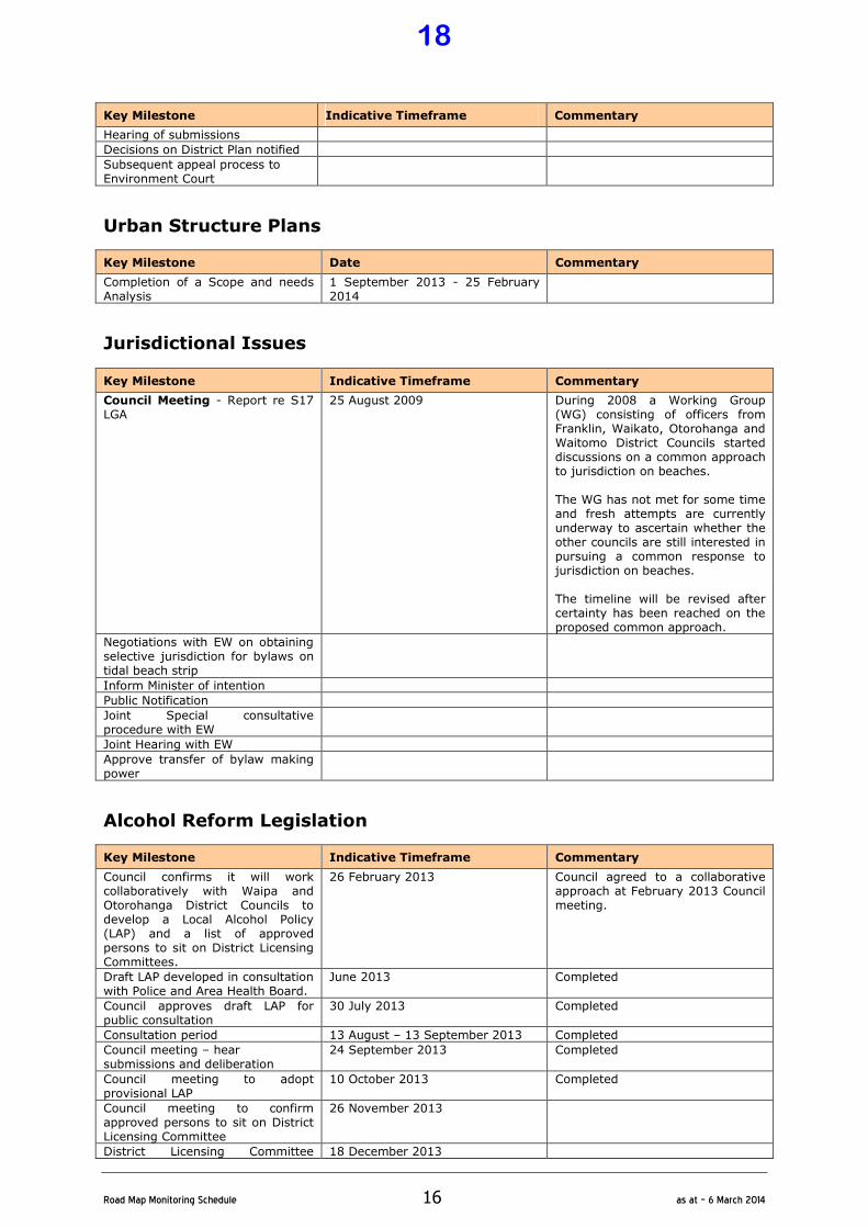
Urban Structure Plans
Key Milestone Date Commentary
Completion of a Scope and needs Analysis
1 September 2013 - 25 February 2014
Jurisdictional Issues
Key Milestone Indicative Timeframe Commentary
Council Meeting - Report re S17 LGA
25 August 2009 During 2008 a Working Group (WG) consisting of officers from Franklin, Waikato, Otorohanga and Waitomo District Councils started discussions on a common approach to jurisdiction on beaches. The WG has not met for some time and fresh attempts are currently underway to ascertain whether the other councils are still interested in pursuing a common response to jurisdiction on beaches. The timeline will be revised after certainty has been reached on the proposed common approach.
Negotiations with EW on obtaining selective jurisdiction for bylaws on tidal beach strip
Inform Minister of intention
Public Notification
Joint Special consultative procedure with EW
Joint Hearing with EW
Approve transfer of bylaw making power
Alcohol Reform Legislation
Key Milestone Indicative Timeframe Commentary
Council confirms it will work collaboratively with Waipa and Otorohanga District Councils to develop a Local Alcohol Policy (LAP) and a list of approved persons to sit on District Licensing Committees.
26 February 2013 Council agreed to a collaborative approach at February 2013 Council meeting.
Draft LAP developed in consultation with Police and Area Health Board.
June 2013 Completed
Council approves draft LAP for public consultation
30 July 2013 Completed
Consultation period 13 August – 13 September 2013 Completed
Council meeting – hear submissions and deliberation
24 September 2013 Completed
Council meeting to adopt provisional LAP
10 October 2013 Completed
Council meeting to confirm approved persons to sit on District Licensing Committee
26 November 2013
District Licensing Committee 18 December 2013
18

�
Road�Map�Monitoring�Schedule� 17� as�at�–�6�March�2014�
Key Milestone Indicative Timeframe Commentary
operational
Waikato River Catchment Economic Studies Once key milestones are identified an indicative timeline will be included in a future version of the Road Map document.
Te Maika Zone
Key Milestone Indicative Timeframe Commentary
Confidential Progress Reports to Council
Monthly
2013/2014 Review of Dog Control Policy and Practices
Key Milestone Date Commentary
Prepare Report September 2013 Completed
Council Meeting - considered 24 September 2013 Completed
Public notification October 2013 Completed
Dog Control Review
Key Milestone Indicative Timeframe Commentary
Clearly scope the proposed review detailing deliverables and timelines
August – September 2013 Completed
Council Meeting Progress Report
27 August 2013 Completed
Council Meeting Report detailing confirmed project and timelines
24 September 2013 Completed
Review of Dog Control Service
Delivery
October – November 2013 The review of WDC's Dog Control
Service delivery is currently ongoing.
Council Meeting Findings of Audit presented to Council with recommendations in terms of enforcement options.
26 November 2013
Gambling Policy Review
Key Milestone Date Commentary
Identification of Issues – review of Policy
March 2014
Council Meeting – Review and adoption of Policy by Council.
27 May 2014
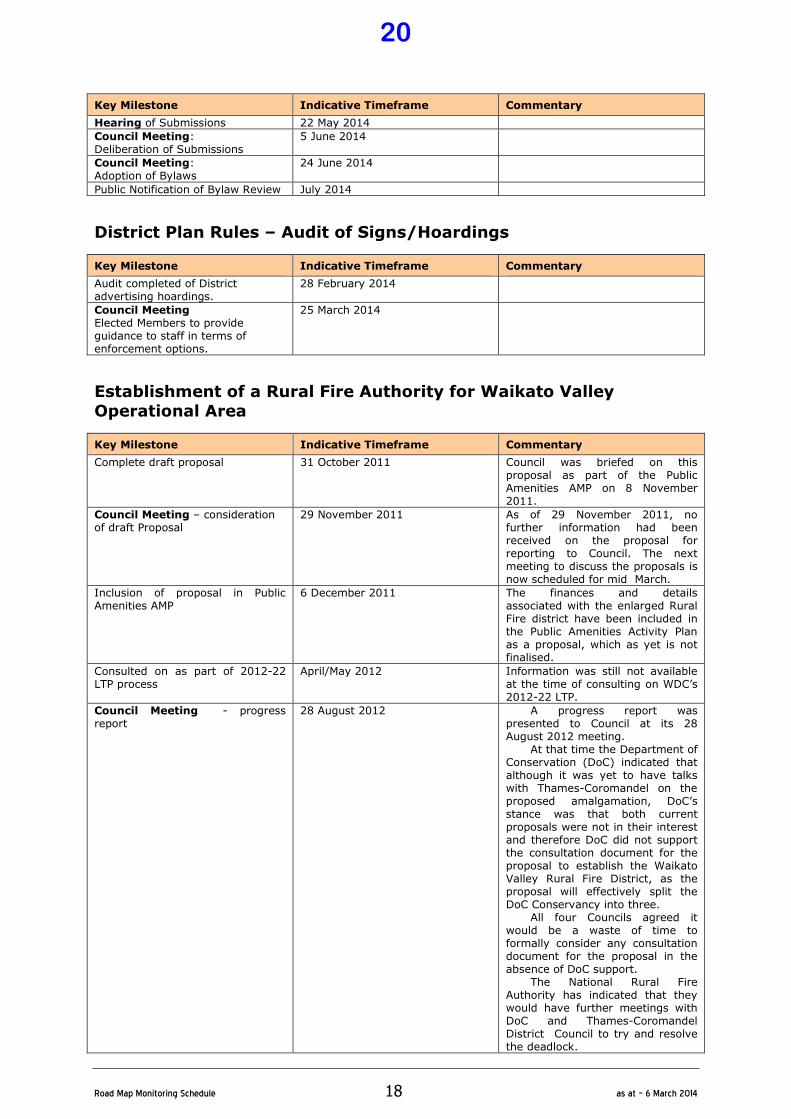
Bylaws Review This review process will run concurrent with the dEAP public consultation process.
Key Milestone Indicative Timeframe Commentary
Council Workshop: Review of Bylaws
18 March 2014
Council Meeting: Adoption for public consultation
25 March 2014
Public Consultation 8 April – 8 May 2014
19
�
Road�Map�Monitoring�Schedule� 18� as�at�–�6�March�2014�
Key Milestone Indicative Timeframe Commentary
Hearing of Submissions 22 May 2014
Council Meeting: Deliberation of Submissions
5 June 2014
Council Meeting: Adoption of Bylaws
24 June 2014
Public Notification of Bylaw Review July 2014
District Plan Rules – Audit of Signs/Hoardings
Key Milestone Indicative Timeframe Commentary
Audit completed of District advertising hoardings.
28 February 2014
Council Meeting Elected Members to provide guidance to staff in terms of enforcement options.
25 March 2014
Establishment of a Rural Fire Authority for Waikato Valley
Operational Area
Key Milestone Indicative Timeframe Commentary
Complete draft proposal 31 October 2011 Council was briefed on this proposal as part of the Public Amenities AMP on 8 November 2011.
Council Meeting – consideration of draft Proposal
29 November 2011 As of 29 November 2011, no further information had been received on the proposal for reporting to Council. The next meeting to discuss the proposals is now scheduled for mid March.
Inclusion of proposal in Public Amenities AMP
6 December 2011 The finances and details associated with the enlarged Rural Fire district have been included in the Public Amenities Activity Plan as a proposal, which as yet is not finalised.
Consulted on as part of 2012-22 LTP process
April/May 2012 Information was still not available at the time of consulting on WDC’s 2012-22 LTP.
Council Meeting - progress report
28 August 2012 A progress report was presented to Council at its 28 August 2012 meeting.
At that time the Department of Conservation (DoC) indicated that although it was yet to have talks with Thames-Coromandel on the proposed amalgamation, DoC’s stance was that both current proposals were not in their interest and therefore DoC did not support the consultation document for the proposal to establish the Waikato Valley Rural Fire District, as the proposal will effectively split the DoC Conservancy into three.
All four Councils agreed it would be a waste of time to formally consider any consultation document for the proposal in the absence of DoC support.
The National Rural Fire Authority has indicated that they would have further meetings with DoC and Thames-Coromandel District Council to try and resolve the deadlock.
20
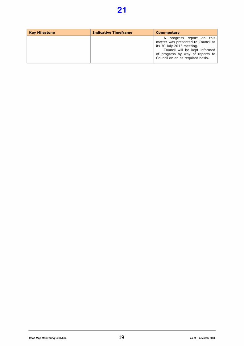
�
Road�Map�Monitoring�Schedule� 19� as�at�–�6�March�2014�
Key Milestone Indicative Timeframe Commentary
A progress report on this matter was presented to Council at its 30 July 2013 meeting.
Council will be kept informed of progress by way of reports to Council on an as required basis.
21
�
Road�Map�Monitoring�Schedule� 20� as�at�–�6�March�2014�
Community Services
Te Kuiti Railway Building
Key Milestone Indicative Timeframe Commentary
Development of Conservation Plan, Maintenance Plan and preliminary budget estimates for the restoration of the buildings
July 2012 Completed
Ownership / lease of the building and land to be secured from New Zealand Rail
July 2012 Completed by MOU only. Finalised lease to be submitted
Council Meeting Business/Positioning paper to Council for consideration and approval of the establishment of a working group to prepare a site and building development proposal
28 August 2012 Completed Council will be kept updated on progress through the presentation of progress reports to the monthly Council meetings.
Preparation of site and building development proposal
September – December 2012 Ongoing with Reference Group. Initial proposal included as part of the November Agenda.
Council Workshop # 5 Consideration the preliminary draft site and building development proposal
19 February 2013 Completed Council work shopped scenarios for the development including cost implications.
Council Meeting Business Paper to Council for financial programme and costings for approval and inclusion in dEAP
20 March 2013 Completed Business Paper adopted by Council for inclusion in dEAP documentation.
Council Meeting Adoption of EAP
25 June 2013 Completed Programme of restoration condensed to match proposal for funding from Lotteries Commission.
Council Meeting Monthly Ongoing A Monthly Progress report will be made to Council for the entire project i.e. Restoration, Roading and Revitalisation.
RAILWAY BUILDING: PROJECT 1 - RESTORATION
Key Milestone Indicative Timeframe Commentary
Engineering structural assessment of building 1,2 and 3
August 2013 Commenced. Engineers have advised this will be available to WDC 23 September 2013
Preparation of working drawings and contract documents for restoration of exterior, buildings
1,2 and 3
July – August 2013 Commenced Architect has advised these will be available to WDc in draft form 20 September 2012
Historic Places Trust Approval September 2013 Draft documents sent to HPT 10 October 2013. Awaiting response
KiwiRail Approval September 2013 Draft documents sent to HPT 10 October 2013. Awaiting response
Tender for works November - December 2013 (subject to approval of alternative funding services
Funding approval granted, documents due for completion last week in November
Construction works January 2013 – September 2014
RAILWAY BUILDING: PROJECT 3 – ROADING RENEWAL
Key Milestone Indicative Timeframe Commentary
Redesign of carriageway to align with Railway development proposals
August 2013 Commenced
Retendering negotiations August – September 2013
Roading construction October – November 2013
22

�
Road�Map�Monitoring�Schedule� 21� as�at�–�6�March�2014�
RAILWAY BUILDING: PROJECT 4 – COMMUNITY SPACE REVITALISATION
Key Milestone Indicative Timeframe Commentary
Expressions of Interest process August – November 2013 EOI document publicised October / November, closing 28 November 2013
Minor construction to allow temporary use of building
January 2014
Building useage by tenants February 2014
RAILWAY BUILDING: PROJECT 5– COMMERCIAL SPACE REVITALISATION
Key Milestone Indicative Timeframe Commentary
Expressions of Interest process October – November 2013 EOI document completed and will be available 22 November, closing 23 December 2013
Lease agreement negotiations November 2013 – January 2014
Application to NKCDT for funding to assist with document preparation and development associated with Cornerstone tenant.
November – December 2013
Preparation of working drawings and contract documentation of areas associated with Cornerstone tenant
December 2013 – February 2014 (subject to funding availability)
Tender process for works March – April 2014 (subject to funding)
Construction of internal work and site services associated with Cornerstone tenant
May 2014 – September 2014 (subject to funding)
Cornerstone tenant operational October 2014
Centennial Park Drainage
Key Milestone Indicative Timeframe Commentary
Confirm / finalisation of the design by the NZ Turf Institute
January – February 2013 Instructions given to NZTI August 2012 to complete design. Survey and design to be undertaken end of October 2012. Design completed.
Contractor pricing February 2013
Tender Committee approval
Implementation of the drainage network
February – March 2013 This project was deferred during the drought period due to the implications on mole drainage of very dry crumbly soils. Now that the soils are moister, discussions on timing of implementation are being held with the Te Kuiti Soccer Club.’ This has now been rescheduled
January – March 2014.
Rescheduled implementation of drainage networks
January – March 2014
Te Kuiti Library Roof Renewal
Key Milestone Indicative Timeframe Commentary
Obtain quotations for the roof renewal
October 2012 This project has been delayed pending outcomes of shifting Te Kuiti Community House to the building and the earthquake assessment outcomes.
Earthquake Assessment May 2013 Completed
23

�
Road�Map�Monitoring�Schedule� 22� as�at�–�6�March�2014�
Key Milestone Indicative Timeframe Commentary
Roof Renewal Works February – March 2014 (awaiting outcomes of TK Community House funding to combine works)
Civic Centre Upgrade : Stage 4 – Main Hall Ceiling
Key Milestone Indicative Timeframe Commentary
Council Meeting Business paper to review upgrade options / proposals for Stage 4 with Council
25 September 2012 Completed A business paper was presented to Council at the October 2012 Council Meeting.
Preparation of upgrade documentation
March - April 2013 Preliminary meeting held with Architects. Documents on hold
until March 2013. A second meeting with the architect was held 12 April to discuss the three options for the ceiling. These are currently being assessed by AECOM’s quantity surveyor to provide information relating to the most cost effective option before proceeding with working drawings. The QS confirmed that approval of the texture on the surface will be the most cost effective solution. Draft working drawings and tender documentation will be available 18 June.
Building Consent – Stage 4 as required
August 2013 Completed
Tenders August – September 2013 Completed
Construction – Stage 4 To be fitted to hireage timeframes Discussions are underway with successful tender to identify a window to complete the works Construction period agreed – 9 December 2013 to 30 January 2014
Sale of 6 Te Kumi Road
Key Milestone Indicative Timeframe Commentary
Letter to tenant advising of Councils intentions moving forward
August 2012 Completed A letter has been forwarded to the tenant advising WDC’s intention to dispose of the property in November.
Valuation of the property January 2013 Completed
Marketing of property through real estate company
March 2013 onwards The property has been listed for several months, with no enquiries to date. While the property is still on the market, the house has been tenanted in the interim to provide income
Sale of 6 Jennings Street – Community House
Key Milestone Indicative Timeframe Commentary
Preparation of services provision study undertaken by the Community House
May – June 2012 Completed
24
�
Road�Map�Monitoring�Schedule� 23� as�at�–�6�March�2014�
Key Milestone Indicative Timeframe Commentary
Council Meeting Business paper to present study findings to Council
May 2012 Completed Council has requested the study be expanded to include alternative locations and to confirm requirements
Council Meeting Business paper to seek funding to assist with the additional study
28 August 2012 Completed
Undertake the additional study by the community house
28 August 2012 – October 2012 Council resolved not to assist in the undertaking of the additional study but to support the Trust’s endeavours to raise funding for the use of the upstairs floor of the Library. Changes to the report are being worked through with a Consultant.
Council Meeting Report findings to Council
Council will be kept updated on progress through the presentation of progress reports to the monthly Council meetings. A draft floor layout has been agreed with TK Community House Trust.
Preparation of advanced sketch drawings and Quantity Surveyor costs
August – September 2013 Completed along with revised budget. Separately reported to Council
Application to Lotteries Community Facilities Fund for funding
February 2014
Benneydale Hall Replacement / Disposal
Key Milestone Indicative Timeframe Commentary
Council Meeting Progress Report on discussion within the community on alternatives for use as a community hall
Monthly Council will be kept updated on progress through the presentation of progress reports to the monthly Council meetings.
Community Consultation regarding establishment of community society and leasing of building.
August – September 2013 Completed with results separately reported to Council
Formation of Incorporated Society for the administration of Benneydale Hall as per Council resolution
October - November 2013 Draft document completed and will be discussed at Hall committee meeting 26 November 2013
Registration of Benneydale Hall Incorporated Society
December 2013 – January 2014
Asset Transfer document to for the transfer of Benneydale Hall assets to new Society
January – February 2014
Parkside Subdivision Disposal
Key Milestone Indicative Timeframe Commentary
Council Meeting Progress Reports
Monthly Council will be kept updated on progress through the presentation of progress reports to the monthly Council meetings.
Initial open day 30 June 2012 Completed
Finalisation of promotional material including bank display
August 2012 Completed
Open day 25 August Completed
Open day 1 September 2012 Completed
Open day 8 September 2012 Completed
Establish Real Estate Agreement for sales
September – October 2012 Completed
25
�
Road�Map�Monitoring�Schedule� 24� as�at�–�6�March�2014�
Key Milestone Indicative Timeframe Commentary
Provide Real Estate board onsite September – October 2012 Completed Agreement has been reached with Real Estate Agents. Real Estate boards will be installed by end of November.
Section Sales Ongoing One section sold in the 2013 calendar year (8 February 2013). Negotiations for the sale of Lot 36 completed with the sale going unconditional 20 September 2013. Lot 36 sale completed. Refer separate business paper for the sale of Lot 16
Mokauiti Hall Disposal
Key Milestone Indicative Timeframe Commentary
Council Meeting Progress report on discussion within the community on alternatives for use as a community hall
Monthly Council will be kept updated on progress through the presentation of progress reports to the monthly Council meetings.
Establish a committee to look at options for disposal.
October 2012 Hall Committee asked to nominate three working group members. Completed at hall meeting December 2012.
Meeting to discuss options for the hall
May 2013 Meeting scheduled for 12 June 2013 (telephone discussion)
Proposal developed and provided to committee for discussion
September 2013
Finalised proposal October 2013
Council Meeting Sign-off of proposal by Council
26 November 2013
Implementation December 2013 – January 2014
Oparure Hall Disposal
Key Milestone Indicative Timeframe Commentary
Letter to be sent to Department of conservation advising of WDC decision during the LTP process
September 2012 Council will be kept updated through the presentation of progress reports to the monthly Council meetings.
Adjust Councils records to remove WDC as the owner / ratepayer of the facility
September 2012 Completed A second letter forwarded to Department of Conservation 30 May 2013. As no response has been forthcoming from Dept. of Conservation it is assumed there is acceptance of the letter. This project is completed
Kopaki Hall Disposal
Key Milestone Indicative Timeframe Commentary
Consultation letter /survey distributed to local residents
august 2012 Completed
Council Meeting Resolution of council requesting the Minister of Conservation to revoke WDC control and manage status for this hall / Reserve
September 2012 Completed
Letter to Department of Conversation requesting revocation to be gazetted
October – November 2013 Completed Letter sent 20 November 2013
26

�
Road�Map�Monitoring�Schedule� 25� as�at�–�6�March�2014�
Mokau Effluent Disposal Upgrade
Key Milestone Indicative Timeframe Commentary
As-built preparation of existing system
August/September 2010 Completed McDonald Plumbing completed initial “As Built” sketches and DM Engineering completed detailed “As Built” Plans.
Review of system and identification of suitable upgrade treatments
April 2011 On site meeting scheduled for 27th June 2011. Completed
Letters to MOE and School BOT investigating potential land purchase
June – July 2011 Completed Mokau effluent disposal was work-shopped as part of the Public Amenities AMP on 8 November 2011. A direct approach to other parties is to be made.
Report to Council once response received from MOE
Contact has been established with MOE. Councillor Brodie and Group Manager Community Services attending BOT meeting in Mokau 12 June 2012. BOT approved in
principal the course of action to acquire land
Survey of the land to be undertaken to allow the quantification of land requirement
July 2012 Acceptance of Quotation from Arrow surveys to undertake this work has been accepted, with completion due 31 July 2012
Draft proposals prepared and presented to the Mokau School board of Trustees for signoff
August- September 2012 Council will be kept updated on progress through the presentation of progress reports to the monthly Council meetings.
Formal application to the Ministry of Education for land purchase
January – February 2013 Completed
Declaration of land as surplus to MOE requirements and available for sale
August 2013 Completed
Negotiations for purchase of land with government disposal team
August – October 2013 Commenced, proceeding through the sale process, with the process being undertaken by Darrochs
Valuation to be obtained for the land to be purchased
October – November 2013 Completed
Subdivision resource consent to be obtained
Detailed design of effluent field
Tendering of work
Implementation of works
Quarry Resources Review
Key Milestone Indicative Timeframe Commentary
Land status investigation for Quarries
September 2010/December 2011 Completed Including surveys for key leased quarries.
Desktop assessment of Quarries October 2010/March 2011 Progressing. Legal implications relating to lease renewals were identified and a legal opinion was obtained. Leases have not been renewed and are operating on a monthly system.
Council Workshop 15 – consideration of investigation and assessment outcomes
15 November 2011 Preliminary outcomes of site investigations will be presented as part of the new Investments AMP. Following this Workshop a detailed timeline of Key Milestones will be
developed. The newly developed working draft Investments AMP was presented to Council in December 2011.
27
�
Road�Map�Monitoring�Schedule� 26� as�at�–�6�March�2014�
Key Milestone Indicative Timeframe Commentary
Prepare a review of all land ownership/survey information and leases collated to date into a review document, identifying future discussion points and options
January 2013 Discussions have been held with a quarry consultant in relation to providing a desktop review of the quarry site information for Councils key quarries.
Council Workshop 5 – consideration of review document
19 February 2013 Completed A quarry resources review was presented to Council along with recommendations for inclusion in the dEAP. Council asked for the work to be reviewed with ICL in an endeavour for the work to be completed over time with a zero budget to WDC.
Review Lease/Licences
Key Milestone Indicative Timeframe Commentary
Identification of all property based Leases and Licenses
July 2011 – ongoing Leases and Licences are reviewed as they fall due.
Renewal of Leases and Licenses as required
July 2011 - ongoing
Input Leases and Licenses into new NCS property module
August 2012 – December 2012
Old Ministry of Works Building, Queen Street, Te Kuiti
Key Milestone Indicative Timeframe Commentary
Council Workshop 15 – presentation of background information to Council to enable informed decision on future of the building
15 November 2011 Following this Workshop a detailed timeline of Key Milestones will be developed for inclusion in the next version of the Road Map. Council agreed that it does not wish to expend any further funds on this building and proposes to consult with the community on the basis that Council will advise the Crown that the property is no longer of use to the Council and that Council wishes to relinquish its holding of the property.
Letter to Crown advising outcomes of the LTP consultation process and seeking approval to relinquish Councils involvement in the property
September 2012 Writing to the Crown was put on hold as an offer of finance with conditions was made through the LTP process. The conditions included WDC as well as the community matching the funding proposal. Council advised the submitter that it would not contribute to funding the renewals works but delayed contacting the Ministry to allow the community to match the proposal. As no correspondence has been received to date, it is proposed to write to the Ministry seeking approval to be released from Councils commitment.
Land Purchase – Te Kuiti Cemetery
Key Milestone Indicative Timeframe Commentary
Review of requirements and identification of suitable land
January 2012 Completed
Negotiation with Landholder February 2012 Completed
28
�
Road�Map�Monitoring�Schedule� 27� as�at�–�6�March�2014�
Key Milestone Indicative Timeframe Commentary
Council Meeting - Report to Council seeking resolution to purchase
24 April 2012 A business paper detailing options was presented to Council at the 24 April 2012 meeting.
Purchase/Settlement July – August 2012 Discussions have been held with an independent Purchaser with an approach to the land owner being made. Council will be kept updated on progress through the presentation of progress reports to the monthly Council meetings. Completed.
Discussions with adjacent land owner in an endeavour to improve the site
September – October 2013 First meeting held and topographical plan prepared for discussion purposes. Discussion is ongoing.
Riverview Heights Land Disposal
1.0 DESCRIPTION
Council, in 2006/2007 proceeded with the Section 40 offer back process for this land, to the previous owners, with each owner confirming that they did not wish to proceed with the repurchase of the land.
2.0 DISCUSSION / ISSUES
Council subsequently resolved in 2007, to review the land holding, taking account of the marketability of the available sections, and in particular in relation to the size of sections, building platforms, access and servicing.
The marketability review included realigning lot boundaries to create bigger, useable sections with each having an adequate building platform. The building platforms were confirmed by undertaking a geotechnical survey of each lot and a full cash flow analysis was undertaken on the total project and presented to Council in November 2008. In January 2009 Council resolved to remedy the informal situation whereby part of the Riverview Heights property is used as public road in the 2009/2010 year, and to defer the proposed disposal of the balance of the Riverview Heights land until the remedial work has been completed. As part of the draft 2010/11 EAP development, Council considered a preliminary estimate to form the entrance road into the proposed subdivision including the financial aspects of the subdivision proposal and resolved not to proceed with the proposal at that time. Ongoing assessment of economic conditions will be taken into consideration before reconsidering this project further.
Cemetery Maps and Records
Key Milestone Indicative Timeframe Commentary
Review mapping/record requirements for each cemetery/gathering base information
November – December 2011 This project is due to commence on 14 May 2012 when staff are available.
Prioritised List of Requirements May - December 2012 ( Te Kuiti) Priority has been given to Te Kuiti Cemetery and all the records for the cemetery are being collated into one data base for cross referencing.
Ongoing implementation of priorities
Te Kuiti Mainstreet Garden Re-design
Key Milestone Indicative Timeframe Commentary
Review of existing data relating to existing Main Street gardens
December 2011
29
�
Road�Map�Monitoring�Schedule� 28� as�at�–�6�March�2014�
Key Milestone Indicative Timeframe Commentary
Establish design team of Councillor, Community Services, TK Business Association and Roading.
January – February 2012 A business paper was presented to Council at the 4 April 2012 Council meeting.
Develop design proposals in conjunction with Consultant
March – April 2012 A Design Team has been established and an initial draft sketch proposal for a typical area is to be available for discussion mid June.
Finalised sketch plans to be completed for Stage 1 – the ANZ intersection and roundabout
August - September 2012 Council will be kept updated on progress through the presentation of progress reports to the monthly Council meetings. Detail drawings and costings received by WDC. Needs to be discussed by the working group prior to presentation to Council.
Council Meeting: Presentation of Design
30 October 2012 As reported previously to Council, revised plans to be sought.
Revised plans for Stage 1 preparation
August 2013 Commenced Mansergh Graham Landscape Architects Completed Working group yet to meet to sign off plans
Implement Stage 1 September – October 2013
Walking Track Strategy
Key Milestone Indicative Timeframe Commentary
Base information gathering November 2013 – April 2014
Council Meeting: Initial progress report on extent of asset and its condition to council including timeline for completion
27 May 2014
Te Kuiti Aerodrome Reserve Management Plan
Key Milestone Indicative Timeframe Commentary
Council Meeting Business paper for the establishment of Working Group for the development of the Aerodrome Reserve Management Plan
10 October 2013 Completed
Advertise intention to prepare Plan and calling for initial submissions
November – December 2013
Consultation Meeting 1 with aerodrome users
December 2013
Consultation Meeting 2 with aerodrome users
February 2014
Consultation Meeting 3 with aerodrome users
July 2014
Preparation of Management Plan January – June 2014
Council Meeting Adoption of Draft Aerodrome Plan by Council
August 2014
Public consultation September – October 2014
Hearing of submissions and consideration
November 2014
Council Meeting Deliberation of Submissions
November 2014
Council Meeting Adoption of Finalised Plan
December 2014
30
�
Road�Map�Monitoring�Schedule� 29� as�at�–�6�March�2014�
Cultural and Arts Centre - Shared Parking Investigation
Key Milestone Indicative Timeframe Commentary
Site topographical survey undertaken
June – July 2013 Completed
Development of concept design July – August 2013 On hold pending report to Council relating to making that section of road one way as this impacts on design . Report presented to Council 23 August 2013. Council resolved to make the road one way. Affected parties are currently being consulted as to this proposed change. Letter 4 November 2013 sent to major users of Civic centre and other property owners – no response has been received to date
Approval of design by “The Cottage”
September 2013 Instructions have been issued for the design layout to be developed Draft layout completed and forwarded to The Cottage. Site Geotech scheduled for completed by 28 November 2013
Council Meeting: Seeking Council’s approval of the Concept Design
24 September 2013
Detailed tender documentation prepared
October – November 2013
Tender process December 2013
Construction January – February 2014
Investigation into Provision of Joint Services Facility
Key Milestone Indicative Timeframe Commentary
Scope of project to determine parameters and outcomes
January – March 2014 (to align with Customer Services Strategy 2014)
Council Workshop Project scope and outcomes in conjunction with Customer Services Strategy
18 March 2014 13 May 2014
Future timelines dependant on outcomes of workshop
Library Building Renewal and Entrance 1.0 DESCRIPTION
This project is dependent on the future tenanting and use of the building.
Parks and Reserves AMP – Plan Improvement and Monitoring
Parks and Reserves AMP
Key Milestone Indicative Timeframe Commentary
AMP Improvement
1. Review AMP every three years. December 2014 To be conducted during the review of AMP in anticipation of the 2015-25 LTP planning cycle.
2. Review Levels of Service. December 2014 To be conducted during the review of AMP in anticipation of the 2015-25 LTP planning cycle.
3. Confirm corporate AM objectives.
December 2014 To be conducted during the review of AMP in anticipation of the 2015-25 LTP planning cycle.
31
�
Road�Map�Monitoring�Schedule� 30� as�at�–�6�March�2014�
Parks and Reserves AMP
Key Milestone Indicative Timeframe Commentary
4. Define current Levels of Service/performance measures.
December 2014 To be conducted during the review of AMP in anticipation of the 2015-25 LTP planning cycle.
5. Conduct external audit of AMP. December 2014 To be conducted during the final review of AMP in anticipation of the 2015-22 LTP planning cycle.
6. Identify and include any assets that are not included in this AMP.
Ongoing process to improve the integrity of asset base.
If and when assets are identified which are not already included in the AMP they will be added accordingly. Formation of Asset Appendix for
AMP.
7. Identify, development, renewal and maintenance strategies where required.
Ongoing process As maintenance contracts are reviewed and tendered the package of delivery of the maintenance strategy will be reviewed.
8. Link financial forecasts to the lifecycle management strategies.
2013-2018 Developed during preparation of an Advanced AMP for Parks and Reserves.
9. Include valuation results. December 2014 To be conducted during the review
of AMP in anticipation of the 2015-25 LTP planning cycle.
Data Improvements
10. Continue to collect asset attribute information.
Ongoing process Asset data is being collated on an ongoing basis to ensure the quality of planning and accuracy of financial projections is optimised.
11. Collect maintenance data against significant assets or asset groups.
Ongoing process Asset data is being collated on an ongoing basis to ensure the quality of planning and accuracy of financial projections is optimised.
12. Collect lifecycle costs for significant assets or asset groups.
Ongoing process Asset data is being collated on an ongoing basis to ensure the quality of planning and accuracy of financial projections is optimised.
13. Future prediction data. 2013-2018 Developed during preparation of an Advanced AMP for Parks and Reserves.
14. Monitor actual versus predicted growth.
2013-2018 Developed during preparation of an Advanced AMP for Parks and Reserves.
15. Measure performance in Levels of Service against targets.
Ongoing process Financial and Non-financial performance is reported to Council on a 3-monthly basis.
AM Process Improvements
16. Ensure operations and maintenance are competitively tendered
Ongoing process Where contracts are of a significant value they are competitively tendered. Small, isolated contracts are dependent on the availability of contractors.
17. Optimise operations to minimise lifecycle costs
Ongoing process The most optimum processes and procedures/operations are continually reviewed to minimise costs.
18. Documentation of operations and maintenance activities
Ongoing process Contract details to be recorded accurately for each Parks and Reserves contract.
19. Process in place for monitoring, analysing and reporting of performance against levels of service and other performance measures.
2012/13 Process developed to ensure accurate collection of KPI information based on new KPI regime.
20. Predict failure works 2013-2018 Predictive failure to be part of the Advanced AMP.
21. Assess risks and identify treatment options
December 2014 Review risk section of Parks and Reserves AMP and include any newly identified risks in review.
32
�
Road�Map�Monitoring�Schedule� 31� as�at�–�6�March�2014�
Parks and Reserves AMP
Key Milestone Indicative Timeframe Commentary
22. Determine and optimise lifecycle costs using NPV analysis for major new works.
2019 Onwards Outside the scope of this AMP.
23. Develop process for updating asset data with new assets and data collected via the
maintenance contract.
December 2012 Asset inventory processes to be created
24. Asset register available to all relevant staff
December 2014 Development of an Asset Appendix for the Parks and Reserves AMP.
25. Compile up to date information on leased reserves
December 2012 Part of Asset Appendix.
26. Complete reserves management plan
Ongoing process. The Brook Park Management Plan was finalised and adopted by Council in February 2010. Further Management Plans dependant upon funding.
27. Process in place for the condition assessment of assets including assets to be assessed, frequency and ranking procedures.
December 2014 Initial broad assessments conducted 2009. Detailed assessments for 2015-2025 LTP.
28. Designers to consider lifecycle costs and risk.
2013-2018 Part of Advanced AMP.
29. Audit CAPEX development plans
December 2014 New three year CAPEX programme included in review of AMP.
30. Processes in place to ensure identify current asset utilisation of significant assets
2013-2018 Process to be developed for recording parks utilisation.
31. Develop and assess options for non performing assets
2013-2018 Process to be developed for recording parks utilisation.
32. Develop disposal/rationalisation policy
2010/2011 (annually) Surplus property process review for land completed 2009/2010. Disposal/rationalisation policy to take into account of adopted processes.
33. Process in place for collecting costs against assets where appropriate
2013-2018 To be developed with accounting process and property AM System.
34. FRS-3 compliant valuation complete for Parks and Reserves assets
December 2014 Accurate compliant valuation will develop with ongoing update of asset inventory.
35. Process developed for the review of levels of service (inc. customer consultation procedures)
2013-2018 Additional resourcing required to fully test levels of service.
AM System Improvements
36. Develop database for all community facilities
December 2014 Development of Asset Appendix for AMP.
37. Financial system available to allocate maintenance costs against individual assets
2020/2021 Outside 2012-2015 planning period. Long term objective to effectively monitor the need for future capital expenditure.
38. Use AMS to store asset condition, performance and utilisation data where appropriate.
2020/2021 AMS to be developed in long term to cover community facilities assets.
39. Record all customer enquiries against individual assets
2020/2021 AMS to be developed in long term to cover community facilities assets.
40. Develop a risk register December 2014 Developed in conjunction with Item 21.
41. Investigate the integration of AMS with GIS and the financial system, integrate if appropriate.
2013-2018
Development as part of Advanced AMP.
42. Link electronic plans and records to GIS database
Ongoing To be developed over the life of the AMP.
Specific Improvement Projects 2009-2012
33
�
Road�Map�Monitoring�Schedule� 32� as�at�–�6�March�2014�
Parks and Reserves AMP
Key Milestone Indicative Timeframe Commentary
43. Underground services investigations.
2013; 2014; 2015 As built drawings to be compiled for key assets to improve asset base information.
44. Including building data in a “designed” Asset Management Programme such as SPM.
2013-2014 Dependent on Council’s ability to purchase an AM Programme suitable for buildings.
Options to be investigated and resources required.
45. Adoption and funding for three year improvement plan.
Annually Completed – included in Annual Plan budgets.
46. Asset Management planning miscellaneous.
2013; 2014; 2015- 20122 An allowance of funding for ongoing asset investigation.
47. Review of Leases and Licenses.
Register developed in NCS by 2013.
Leases/Licences Register to be developed and renewals as appropriate on an ongoing basis.
Recreation and Culture AMP – Plan Improvement and Monitoring
Recreation and Culture AMP
Key Milestone Indicative Timeframe Commentary
AMP Improvement
1. Review AMP every three years. December 2014 To be conducted during the review of AMP in anticipation of the 2015
2. Review levels of service December 2014 To be conducted during the review of AMP in anticipation of the 2015
3. Confirm corporate AM objectives
December 2014 To be conducted during the review of AMP in anticipation of the 2015
4. Define current levels of service/performance measures
December 2014 To be conducted during the review of AMP in anticipation of the 2015
5. Conduct external audit of AMP December 2014 To be conducted during the final review of AMP in anticipation of the 2015-25 LTP planning cycle.
6. Identify and include any assets that are not included in this AP
Ongoing process to improve the integrity of asset base.
If and when assets are identified which are not already included in the AMP they will be added accordingly. Formation of Asset Appendix for AMP.
7. Identify development, renewal, maintenance strategies where required
Ongoing process As maintenance contracts are reviewed and tendered the package of delivery of the maintenance strategy will be reviewed.
8. Link financial forecasts to the lifecycle management strategies
2013-2018 Developed during preparation of an Advanced AMP for Parks and Reserves.
9. Include valuation results December 2014 To be conducted during the review of AMP in anticipation of the 2015
AM Data Improvements
10. Develop and document formal asset classification system for all assets
2013-2018 Review of Biz Assets use as AM program will involve asset classification and hierarchy.
11. Continue to collect asset attribute information
Ongoing process Asset data is being collated on an ongoing basis to ensure the quality of planning and accuracy of financial projections is optimised.
12. Collect maintenance data
against significant assets or asset groups
Ongoing process Asset data is being collated on an
ongoing basis to ensure the quality of planning and accuracy of financial projections is optimised.
13. Collect lifecycle costs for significant assets or asset groups and recorded in Confirm
Ongoing process Asset data is being collated on an ongoing basis to ensure the quality of planning and accuracy of financial projections is optimised.
34
�
Road�Map�Monitoring�Schedule� 33� as�at�–�6�March�2014�
Recreation and Culture AMP
Key Milestone Indicative Timeframe Commentary
14. Monitor actual versus predicted growth
2013-2018 Developed during preparation of an Advanced AMP for Parks and Reserves.
15. Measure performance in levels of service against targets
Ongoing process Financial and Non-financial performance is reported to Council on a 3-monthly basis.
AM Process Improvements
16. Ensure operations and maintenance are competitively tendered
Ongoing process Where contracts are of a significant value they are competitively tendered. Small, isolated contracts are dependent on the availability of contractors.
17. Optimise operations to minimise lifecycle costs
Ongoing process The most optimum processes and procedures/operations are continually reviewed to minimise costs.
18. Documentation of operations and maintenance activities
Ongoing process Contract details to be recorded accurately for each Parks and Reserves contract.
19. Process in place for monitoring, analysing and reporting of performance against levels of service and other performance measures.
2012/13 Process developed to ensure accurate collection of KPI information based on new KPI regime.
20. Predict failure works 2013-2018 Predictive failure to be part of the Advanced AMP.
21. Assess risks and identify treatment options
December 2011 Review risk section of Parks and Reserves AMP and include any newly identified risks in review.
22. Determine and optimise lifecycle costs using NPV analysis for major new works.
2019 Onwards Outside the scope of this AMP.
23. Develop process for updating asset data with new assets and data collected via the maintenance contract.
December 2012 Asset inventory processes to be created during review for the 2015-2025 LTP.
24. Asset register available to all relevant staff
December 2014 Development of an Asset Appendix for the Parks and Reserves AMP.
25. Process in place for the condition assessment of assets including assets to be assessed, frequency and ranking procedures.
December 2014 Initial broad assessments conducted 2009. Detailed assessments for 2015-2025 LTP.
26. Designers to consider lifecycle costs and risk.
2013-2018 Part of Advanced AMP.
27. Audit CAPEX development plans
December 2014 New three year CAPEX programme included in review of AMP.
28. Processes in place to ensure identify current asset utilisation of significant assets
2013-2018 Process to be developed for recording parks utilisation.
29. Develop and assess options for non performing assets
2013-2018 Process to be developed for recording parks utilisation.
30. Develop disposal/rationalisation policy
2010/2011 (annually) Surplus property process review for land completed 2009/2010. Disposal/rationalisation policy to take into account of adopted processes.
31. Process in place for collecting costs against assets where appropriate
2013-2018 To be developed with accounting
process and property AM System.
32. FRS-3 compliant valuation complete for parks and reserves assets
December 2014 Accurate compliant valuation will develop with ongoing update of asset inventory.
33. Process developed for the review of levels of service (including customer consultation procedures)
2013-2018 Additional resourcing required to fully test levels of service.
35

�
Road�Map�Monitoring�Schedule� 34� as�at�–�6�March�2014�
Recreation and Culture AMP
Key Milestone Indicative Timeframe Commentary
34. Ensure operations and maintenance are competitively tendered
Ongoing process Where contracts are of a significant value they are competitively tendered. Small, isolated contracts are dependent on the availability of contractors.
AM System Improvements
35. Develop database for all community facilities
December 2014 Development of Asset Appendix for AMP.
36. System available to allocate maintenance costs against individual assets. Use AM System to generate valuation
2020/2021 Outside 2012-2015 planning period. Long term objective to effectively monitor the need for future capital expenditure.
37. Link maintenance history to significant assets or asset groups Criticality of assets identified in AM System
2020/2021 Outside 2012-2015 planning period.
38. Use AM System to store asset condition, performance and
utilisation data where appropriate
2012-2022 Review of Biz Assets will determine asset storage requirement during
2012-22 LTP.
39. Record all customer enquiries against individual assets
2020/2021 AMS to be developed in long term to cover community facilities assets.
40. Develop a risk register December 2014 Developed in conjunction with 37.
41. Investigate the integration of AMS with GIS and the financial system, integrate if appropriate.
2013-2018 Development as part of Advanced AMP.
42. Link electronic plans and records to GIS database
Ongoing To be developed over the life of the AMP.
Specific Improvement Projects 2009-2012
43. Underground services investigations
2013; 2014; As built drawings to be compiled for key assets to improve asset base information.
44. Undertake DRC valuation 2011 Review of valuation for Parks and Reserves assets in preparation for next asset valuation.
45. Include Building data in a “designed” asset management Programme such as SPM
2014 Dependent on Council’s ability to purchase an AM Programme suitable for buildings. Options to be investigated and resources required.
46. Expand recovery plans to sit with risk Analysis
2014 - 2015 Develop Recovery Plans in conjunction with Item 21.
47. Adoption of funding for three year improvement plan
Annually Completed – included in Annual Plan budgets.
48. Operation manual established for Library and Cultural and Arts Centre
2012 - 2013 Finalised Cultural and Arts Centre Manual on completing of Stage 1 renewal.
49. Asset Management planning 2016; 2022 Miscellaneous works.
Public Amenities AMP – Plan Improvement and Monitoring
Public Amenities AMP
Key Milestone Indicative Timeframe Commentary
AMP Improvements
1. Review AMP every three years. December 2014 To be conducted during the review of AMP in anticipation of the 2015
2. Review LOS December 2014 To be conducted during the review of AMP in anticipation of the 2015
36
�
Road�Map�Monitoring�Schedule� 35� as�at�–�6�March�2014�
Public Amenities AMP
Key Milestone Indicative Timeframe Commentary
3. Confirm corporate AM objectives
December 2014 To be conducted during the review of AMP in anticipation of the 2015
4. Define current LOS/performance measures
December 2014 To be conducted during the review of AMP in anticipation of the 2015
5. Conduct external audit of AMP December 2014 To be conducted during the final review of AMP in anticipation of the 2015-25 LTP planning cycle.
6. Identify and include any assets that are not included in this AMP
Ongoing process to improve the integrity of asset base.
If and when assets are identified which are not already included in the AMP they will be added accordingly. Formation of Asset Appendix for AMP.
7. Identify development, renewal, maintenance strategies where required
Ongoing process As maintenance contracts are reviewed and tendered the package of delivery of the maintenance strategy will be reviewed.
8. Link financial forecasts to the lifecycle management strategies
2013-2018 Developed during preparation of an Advanced AMP for Parks and Reserves.
9. Include valuation results December 2014 Update valuation/ depreciation information in AMP during review in anticipation of 2015-25 LTP planning cycle.
AMP Data Improvements
10. Continue to collect asset attribute information
Ongoing process Asset data is being collated on an ongoing basis to ensure the quality of planning and accuracy of financial projections is optimised.
11. Collect maintenance data against significant assets or asset groups
Ongoing process Asset data is being collated on an ongoing basis to ensure the quality of planning and accuracy of financial projections is optimised.
12. Collect lifecycle costs for significant assets or asset groups and recorded in Confirm
Ongoing process Asset data is being collated on an ongoing basis to ensure the quality of planning and accuracy of financial projections is optimised.
13. Monitor actual versus predicted growth
2013-2018 Developed during preparation of an Advanced AMP for Parks and Reserves.
14. Measure performance in LOS against targets
Ongoing process Financial and Non-financial performance is reported to Council on a 3-monthly basis.
AMP Process Improvements
15. Ensure operations and maintenance are competitively tendered where possible
Ongoing process Where contracts are of a significant value they are competitively tendered. Small, isolated contracts are
dependent on the availability of contractors.
16. Optimise operations to minimise lifecycle costs and Documentation of operations and maintenance activities
Ongoing process The most optimum processes and procedures/operations are continually reviewed to minimise costs.
17. Process in place for monitoring, analysing and reporting of performance against Levels of Service and other performance measures.
2012/13 Process developed to ensure accurate collection of KPI information based on new KPI regime.
18. Predict failure works and identify treatment options for risks
2013-2018 Predictive failure to be part of the Advanced AMP.
19. Determine and optimise lifecycle costs using NPV analysis for major new works.
2019 Onwards Outside the scope of this AMP.
37
�
Road�Map�Monitoring�Schedule� 36� as�at�–�6�March�2014�
Public Amenities AMP
Key Milestone Indicative Timeframe Commentary
20. Develop process for updating asset data with new assets and data collected via the maintenance contract.
December 2012 Asset inventory processes to be created during review for the 2012-2022 LTP.
21. Process in place for the condition assessment of assets
including assets to be assessed, frequency and ranking procedures.
December 2014 Initial broad assessments conducted 2009.
Detailed assessments for 2015-2025 LTP.
22. Designers to consider lifecycle costs and risk.
2013-2018 Part of Advanced AMP.
23. Audit CAPEX development plans
December 2014 New three year CAPEX programme included in review of AMP.
24. Processes in place to ensure identify current asset utilisation of significant assets
2013-2018 Process to be developed for recording parks utilisation.
25. Develop and assess options for non performing assets
2013-2018 Process to be developed for recording parks utilisation.
26. Develop disposal/rationalisation policy
2010/2011 (annually) Surplus property process review for land completed 2009/2010. Disposal/rationalisation policy to take into account of adopted processes.
27. Process in place for collecting costs against assets where appropriate
Ongoing process Asset data is being collated on an ongoing basis to ensure the quality of planning and accuracy of financial projections is optimised.
28. FRS-3 compliant valuation complete for public amenities assets
December 2014 Accurate compliant valuation will develop with ongoing update of asset inventory.
29. Process developed for the review of Levels of Service (including customer consultation procedures)
2013-2018 Additional resourcing required to fully test levels of service.
AM System Improvements
30. Develop database for all community services
December 2014 Development of Asset Appendix for AMP.
31. System available to allocate maintenance costs against individual assets
2020/2021 Outside 2012-2015 planning period. Long term objective to effectively monitor the need for future capital expenditure.
32. Use “System” to generate valuation
2020/2021 Outside 2012-2015 planning period.
33. Link maintenance history to significant assets or asset groups
2020/2021 Outside 2012-2015 planning
period.
34. Criticality of assets identified in “System”
2012-2022 Review of Biz Assets will determine asset storage requirement during 2012-22 LTP.
35. Use “System” to store asset condition, performance and utilisation data where appropriate
2020/2021 AMS to be developed in long term to cover community facilities assets.
36. Record all customer enquiries against individual assets
2020/2021 AMS to be developed in long term to cover community facilities assets.
37. Investigate the integration of “system” with GIS and the financial system, integrate if
appropriate.
2013-2018
Development as part of Advanced AMP.
38. Link electronic plans and records to GIS database
Ongoing Developed in conjunction with Item 31.
Specific Improvement Projects 2009-2012
39. Underground services investigations
2014; 2015; 2016 As built drawings to be compiled for key assets to improve asset base information.
38
�
Road�Map�Monitoring�Schedule� 37� as�at�–�6�March�2014�
Public Amenities AMP
Key Milestone Indicative Timeframe Commentary
40. Include Building data in a “designed” Asset management Programme such as SPM
2014-2015 Dependent on Council’s ability to purchase an AM Programme suitable for buildings. Options to be investigated and resources required.
41. Review AMP December 2014 To be conducted during the review
of AMP in anticipation of the 2015
42. Asset Management Planning miscellaneous
2015-2016 onwards Completed – included in Annual Plan budgets.
Housing and Other Property AMP – Plan Improvement and
Monitoring
Housing and Other Property AMP
Key Milestone Indicative Timeframe Commentary
AMP Improvements
1. Review AMP every three years. December 2014 To be conducted during the review of AMP in anticipation of the 2015
2. Review Levels of Service December 2014 To be conducted during the review of AMP in anticipation of the 2015
3. Confirm corporate AM objectives
December 2014 To be conducted during the review of AMP in anticipation of the 2015
4. Define current LOS/ performance measures
December 2014 To be conducted during the review of AMP in anticipation of the 2015
5. Conduct external audit of AMP December 2014 To be conducted during the final review of AMP in anticipation of the 2015-25 LTP planning cycle.
6. Identify and include any assets that are not included in this AMP
Ongoing process to improve the integrity of asset base.
If and when assets are identified which are not already included in the AMP they will be added accordingly. Formation of Asset Appendix for AMP.
7. Identify development, renewal, maintenance strategies where required
Ongoing process As maintenance contracts are reviewed and tendered the package of delivery of the maintenance strategy will be reviewed.
8. Link financial forecasts to the lifecycle management strategies
2013-2018 Developed during preparation of an Advanced AMP for Parks and Reserves.
9. Include valuation results December 2014 Update valuation/ depreciation information in AMP during review in anticipation of 2015-25 LTP planning cycle.
AM Data Improvements
10. Develop and document formal asset classification system for all assets
2013-2018 Review of Biz Assets use as AM program will involve asset classification and hierarchy.
11. Continue to collect asset attribute information
Ongoing process Asset data is being collated on an ongoing basis to ensure the quality of planning and accuracy of financial projections is optimised.
12. Collect maintenance data against significant assets or asset groups
Ongoing process Asset data is being collated on an ongoing basis to ensure the quality of planning and accuracy of financial projections is optimised.
13. Collect lifecycle costs for significant assets or asset groups and recorded in Confirm
Ongoing process Asset data is being collated on an ongoing basis to ensure the quality of planning and accuracy of financial projections is optimised.
14. Monitor actual versus predicted growth
2013-2018 Developed during preparation of an Advanced AMP for Parks and Reserves.
39
�
Road�Map�Monitoring�Schedule� 38� as�at�–�6�March�2014�
Housing and Other Property AMP
Key Milestone Indicative Timeframe Commentary
15. Measure performance in Levels of Service against targets
Ongoing process Financial and Non-financial performance is reported to Council on a 3-monthly basis.
AMP Process Improvements
16. Ensure operations and maintenance are competitively tendered
Ongoing process Where contracts are of a significant value they are competitively tendered. Small, isolated contracts are dependent on the availability of contractors.
17. Optimise operations to minimise lifecycle costs
Ongoing process The most optimum processes and procedures/operations are continually reviewed to minimise costs.
18. Documentation of operations and maintenance activities
Ongoing process Contract details to be recorded accurately for each Parks and Reserves contract.
19. Process in place for monitoring, analysing and reporting of performance
against LOS and other performance measures.
2012/13 Process developed to ensure accurate collection of KPI information based on new KPI
regime.
20. Predict failure works 2013-2018 Predictive failure to be part of the Advanced AMP.
21. Assess risks and identify treatment options
December 2014 Review risk section of Parks and Reserves AMP and include any newly identified risks in review.
22. Determine and optimise lifecycle costs using NPV analysis for major new works.
2019 Onwards Outside the scope of this AMP.
23. Develop process for updating asset data with new assets and data collected via the maintenance contract.
December 2012 Asset inventory processes to be created
24. Asset register available to all relevant staff
December 2014 Development of an Asset Appendix for the housing and Other Property AMP
25. Process in place for the condition assessment of assets including assets to be assessed, frequency and ranking procedures.
December 2014 Initial broad assessments conducted 2009. Detailed assessments for 2015-2025 LTP.
26. Designers to consider lifecycle costs and risk.
2013-2018 Part of Advanced AMP.
27. Audit CAPEX development plans
December 2014 New three year CAPEX programme included in review of AMP.
28. Processes in place to ensure identify current asset utilisation of significant assets
2013-2018 Process to be developed for recording parks utilisation.
29. Develop and assess options for non performing assets
2013-2018 Process to be developed for recording parks utilisation.
30. Develop disposal/rationalisation policy
2010/2011 (annually) Surplus property process review for land completed 2009/2010. Disposal/rationalisation policy to take into account of adopted processes.
31. Process in place for collecting costs against assets where appropriate
2013-2018 To be developed with accounting process and property AM System.
32. FRS-3 compliant valuation complete for public amenities assets
December 2014 Accurate compliant valuation will develop with ongoing update of asset inventory.
33. Process developed for the review of Levels of Service (including customer consultation procedures)
2013-2018 Additional resourcing required to fully test levels of service.
AM System Improvements
40

�
Road�Map�Monitoring�Schedule� 39� as�at�–�6�March�2014�
Housing and Other Property AMP
Key Milestone Indicative Timeframe Commentary
34. Develop database for all community facilities
December 2014 Development of Asset Appendix for AMP.
35. System available to allocate maintenance costs against individual assets
2020/2021 Outside 2012-2015 planning period. Long term objective to effectively monitor the need for future capital expenditure.
36. Use AM System to generate valuation
2020/2021 Outside 2012-2015 planning period. Long term objective to effectively monitor the need for future capital expenditure.
37. Link maintenance history to significant assets or asset groups
2020/2021 Outside 2012-2015 planning period.
38. Criticality of assets identified in AM System
2013-2018 Information available for inclusion in AM System chosen 2012-2022 LTP.
39. Use AM System to store asset condition, performance and utilisation data where appropriate
2012-2022 Review of Biz Assets will determine asset storage requirement during 2012-22 LTP.
40. Record all customer enquiries against individual assets
2020/2021 AMS to be developed in long term to cover community facilities assets.
41. Develop a risk register December 2014 Developed in conjunction with Item 36.
42. Investigate the integration of AM System with GIS and the financial system, integrate if appropriate.
2013-2018 Development as part of Advanced AMP.
43. Link electronic plans and records to GIS database
Ongoing To be developed over the life of the AMP.
Specific Improvement Projects 2009-2012
44. Underground services investigations
2013; 2014; 2015 As built drawings to be compiled for key assets to improve asset base information.
45. Independent review AMP 2014 To be conducted during the review of AMP in anticipation of the 2015
46. Include Building data in a “designed” Asset management Programme such as SPM
2014 Dependent on Council’s ability to purchase an AM Programme suitable for buildings. Options to be investigated and
resources required.
47. Adoption and funding for three year improvement plan
Annually Completed – included in Annual
Plan budgets.
48. Miscellaneous Asset Management
2016-2017 Miscellaneous Works.
49. Input leases and licences inot NCS System
2012-2013 Record data into NCS
41
�
Road�Map�Monitoring�Schedule� 40� as�at�–�6�March�2014�
Asset Management Note: The significant key projects for Water, Wastewater, Stormwater and Roading are capital works and
therefore detailed reporting on these is undertaken by way of a monthly progress report to Council on the Roading activity, and quarterly progress reports on each of the Water activities.
Te Kuiti Wastewater Treatment Plant Upgrade Key Milestone Indicative Timeframe Commentary Inlet control and bypass line, March 2008 Completed
Process supernatant return to front of Plant
April 2013 Complete
Aeration April 2013 Complete
Tertiary filter and UV disinfection May 2013 Complete
New inlet works and screen and Temporary treatment
April 2013 Completed
Activated sludge reactor upgrade and modification
May 2013 Complete
Final Full Commissioning June 2013 Complete
Sludge thickening, dewatering and handling.
Ongoing Complete Note: This process will be ongoing after 30 June 2013 and will result in the removal of the sludge build up from the previous 30 years over the following 15 years.
Te Waitere Water and Wastewater Strategic Review Options and forward planning are to be reviewed in the context of the 2012-2022 LTP.
Key Milestone Indicative Timeframe Commentary
Permeability tests to assess sustainability of existing land discharge of waste water and possible future development
Completed results show that additional land will have to be obtained for wastewater disposal. The whole future development project will be assessed as part of the District Plan
Development of detailed scoping and associated project plan for inclusion in the Road Map.
Outside 2022 Dependent on outcome of 1 above.
Consultation with landowners about development plans and land availability for land discharge
During the life of 2012-22 LTP Dependent on outcome of 1 above and available resources.
Consultation with all property owners on separator/septic tank maintenance service
During the life of 2012-22 LTP Dependent on available resources.
Report to Council on conclusions On completion of each action.
Benneydale Sewerage Key Milestone Indicative Timeframe Commentary
Reticulation renewal 2012-2015
Reticulation minor renewals 2012-2015
Waitomo Water and Wastewater – Feasibility Studies Key Milestone Indicative Timeframe Commentary
1. Development of detailed scoping and associated project plan for inclusion in Road Map.
Preliminary scope with indicative cost by end October 2013.
WDC condition assessment and valuation complete. Preliminary design and cost estimate complete Met with THL around existing asset value and cost new systems. Financial modelling complted. Results sent to THL
42
�
Road�Map�Monitoring�Schedule� 41� as�at�–�6�March�2014�
Key Milestone Indicative Timeframe Commentary
2. Define proposed planning map and develop development scenarios which will indicate demand
Structure plan by Beca Consultants considered in identifying area to be serviced.
3. Investigate high technology solutions with cost and establish economic feasibility
Estimated cost of refurbishment of systems not much different from replacement and have shorter expected asset life than total replacement
4. Report to Council on conclusions
On completion of each section Target report date May 2014 Council meeting
Te Kuiti Water Supply Key Milestone Indicative Timeframe Commentary
Funding Outcome October 2011 On 19 September 2011 WDC received written confirmation from the Minister of Health that the application for Drinking-Water Subsidy for Te Kuiti has been approved to the value of $780,820.56 excluding GST.
Council will be kept updated on progress through the presentation of quarterly progress reports.
Broad Upgrade Plan June 2014 Preliminary design revisited 2013. Documentation is in progress for completion of 1st of 4 phases by end December 2014
Filter & UV December 2014 Targeted completion date end December 2014
Identified Retic Renewals July 2012 – June 2015
Mokau Water Supply Key Milestone Indicative Timeframe Commentary
Dam Tender End December 2013 Completed
Dam Construction 2013/14 Summer Actual completion in that period very much weather dependent. Council will be kept updated on progress through the presentation of quarterly progress reports. Land purchase underway Tender documentation complete.
Treatment plant upgrade 2012/13 financial year Completed
Benneydale Water Supply
Key Milestone Indicative Timeframe Commentary
Treatment plant upgrade 2012/13 financial year Completed
Cross Boundary Collaboration (WDC/RDC) Once key milestones are identified, an indicative timeline will be included in a future version of the full Road Map document.
Para Kore "Marae Working Toward Zero Waste" Once key milestones are identified, an indicative timeline will be included in a future version of the full Road Map document.
43
�
Road�Map�Monitoring�Schedule� 42� as�at�–�6�March�2014�
Waitomo District Landfill Key Milestone Indicative Timeframe Commentary
Future Demand Study December 2015 A ‘whole of life’ study needs to be completed to determine:- • Where refuse will come from for the balance of the resource consent.
• The effects the statutory cost increases from the ETS will have on the landfill.
• The costs of further developing the landfill; and
• The financial viability of the landfill due to increased costs to the user following ETS legislation
• Purchase of NZU units (Carbon Credits) has reduced the impact of the cost of the ETS legislation for the next 3 years buying time to find a feasible way forward
Water Supply AMP – Plan Improvement and Monitoring
Water Supply AMP
Key Milestone Indicative Timeframe Commentary
1. Consultation to ascertain needs and preferences of the communities with regard to water supply services and to ensure their views are considered when selecting the best level of service scenario.
Next review due December 2014 Driven by raw water source, the DWS and risks as identified in PHRMP’s. Requires incremental improvement and updating of current knowledge.
2. Ensure the right level of funding is being allocated to maintain the asset service potential.
Monitored Considering the affordability/ sustainability the District finds itself in, Asset Service potential is monitored and just enough done to maintain the status quo.
3. Implement predictive modelling techniques that will allow consideration of alternative long term cost scenarios.
On-going Some work had been done and much catch-up work has been identified before further analysis will be of use. Considering the affordability/sustainability the District finds itself in, Asset Service potential is monitored and just enough done to maintain the status quo.
4. Initiate a long term zonal metering and leak detection programme, initially for Te Kuiti.
On-going process Monitor
5. Initiate a scheme proposal for Marokopa.
2015-25 LTP Unless legislative requirements force such a step.
6. Construct a new, larger raw water storage dam for Mokau.
2012-13 financial year Construction in progress – stalled by archeological finds
7. Install automated monitoring equipment at the Piopio water treatment plant to provide evidence for compliance with MoH gradings.
2012 Calendar year Completed.
8. Develop accurate and complete asset inventory registers for each scheme.
On-going process The improvement of accuracy of asset data is the first step and has become very important for effective efficient future asset management. To progress will require additional resource.
9. Develop a greater focus on risk identification and management for critical assets.
On-going process To progress will require additional resource.
44
�
Road�Map�Monitoring�Schedule� 43� as�at�–�6�March�2014�
Water Supply AMP
Key Milestone Indicative Timeframe Commentary
10. Prioritise the works developed from the risk assessment exercise.
Following 8 and 9 above To meet this will require additional resource.
11. Construct additional treated storage at Te Kuiti to meet 24 hours demand.
2020-21 No subsidy - considering the affordability/sustainability the District finds itself in, Asset Service
potential will continue to be monitored and just enough done to maintain the status quo. Structural assessment of existing reservoirs in conjunction with earthquake compliance / risk is needed and is now first priority
12. Evaluate groundwater test bores as a potential auxiliary source for Te Kuiti water supply.
After 2022 if ever Not regarded as a feasible option at this stage
13. Install SCADA and telemetry for automated monitoring and control of treatment and pumping/storage at Te Kuiti supply for compliance with MOH gradings and improved risk management.
July 2014 CAPS subsidy funding from MoH approved work has been put on hold for affordability reasons until 2013-14. Asset Service potential is monitored and just enough done to maintain the status quo. 1st phase tender documentation in process
14. Develop informal strategies for meeting more stringent water quality standards and consent
requirements.
On-going Benneydale and Mokau will comply from end October 2013 Piopio is fully compliant
15. Install coagulation to improve filtration, install UV and upgrade telemetry and SCADA at Mokau.
2013 Calendar year Part of 14 above.
16. Arrange a routine forum of adjacent councils' water supply officers to discuss trends, concerns, future developments that may affect neighbouring authorities, cost sharing of consultants or specialist providers, spare survey or design capacity in larger councils shared by others.
On-going Informal networking and structured training already occurs.
Unachievable due to Budget Restrictions
17. Upgrade supply main from Mokau to Awakino.
2013-16 MoH criteria have changed – No funding for renewals.
Wastewater AMP – Plan Improvement and Monitoring
Wastewater AMP – Plan Improvement and Monitoring
Key Milestone Indicative Timeframe Commentary
1. Consultation to ascertain the community’s service needs and preferences and to ensure their views are considered when selecting the best level of service scenario.
December 2014 The LOS survey is completed at about 2 year intervals
2. Ensure the right level of funding is being allocated to maintain the asset service potential.
Monitored Review frequency consistent with annual and long term planning cycle.
3. Implement predictive modelling techniques that will allow consideration of alternative long
term cost scenarios.
Monitored True modelling for waste water systems is not economically feasible. Sound engineering
judgement is used to formulate solutions.
45
�
Road�Map�Monitoring�Schedule� 44� as�at�–�6�March�2014�
Wastewater AMP – Plan Improvement and Monitoring
Key Milestone Indicative Timeframe Commentary
4. Initiate a long term infiltration and inflow investigation and reduction programme, initially for Te Kuiti.
On-going Start date August 2009. Eight catchments identified. Actual remedial work of one catchment is complete. Investigation to assess remedial work required in next two catchments has been done. Contracts for identified remedial work in the next catchments will commence in 2013-14. Work delayed due to workload around capital upgrades at water and wastewater treatment plants
5. Investigate a design concept for a wastewater scheme to service planned development at Mokau – Awakino.
Beyond 2022 Not economically feasible.
6. Investigate extension of the Te Waitere scheme to service a two stage development of the area with the 2nd stage encompassing the area not currently reticulated.
Beyond 2022 Discussed in more detail on page 6. Two main streams of thought in community that will require considerable consultation and mediation to reconcile.
7. Develop accurate and complete asset inventory registers for each scheme.
On-going Needs specific resource to improve asset data, that resource is now available and progress is being made. Expect will take at least two years to make significant advance
8. Develop a greater focus on risk identification and management,
obtaining more detailed information on critical assets.
On-going The improvement of accuracy of asset data is the first step and has
become very important for effective efficient future asset management. Will follow as data improves.
9. Prioritise the works developed from risk assessment exercises.
On-going Will follow as data improves.
10. Develop strategies to meet the community’s desire for higher environmental standards and anticipated more stringent resource consent requirements.
On-going To speed up will require specific additional resource and it is not economically feasible in the present and foreseeable future to carry out work identified.
11. Arrange a routine forum of adjacent councils wastewater officers to discuss trends, concerns, future developments that may affect neighbouring authorities, cost sharing of consultants or specialist providers, spare survey or design capacity in larger councils shared by others.
On-going Informal networking already occurs.
Stormwater AMP – Plan Improvement and Monitoring
Stormwater AMP – Plan Improvement and Monitoring
Key Milestone Indicative Timeframe Commentary
1. Consultation to ascertain the community’s service needs and preferences and to ensure their views are considered when selecting the best level of service scenario.
December 2014 The LOS survey is completed at about 2 year intervals.
2. Ensure the right level of funding is allocated to maintain the asset service potential.
Monitored Monitor – To refine requires detailed Catchment Assessments to be completed, which requires specific additional resources
3. Develop accurate and complete asset inventory registers for each urban drainage area.
On-going Needs specific resource that is not available at this stage to improve asset data
46

�
Road�Map�Monitoring�Schedule� 45� as�at�–�6�March�2014�
Stormwater AMP – Plan Improvement and Monitoring
Key Milestone Indicative Timeframe Commentary
4. Initiate a long term condition and performance assessment programme, initially for Te Kuiti.
Needs specific resource that is not available
5. Initiate a SW scheme proposal for Mokau- Awakino and Te Waitere during the planning period
Beyond 2022 Need structure plan
6. Develop a greater focus on risk identification and management, obtaining more detailed information on critical assets.
On-going The improvement of accuracy of asset data is the first step and has become very important for effective efficient future asset management. Resource is now available and progress is being made. Expect will take at least two years to make significant advance
7. Cost and prioritise the works developed from the risk assessment exercise.
On-going Needs specific resource that is not available at this stage to utilise the improved asset data that support such an exercise
8. Develop strategies to meet the community’s desire for higher environmental standards and anticipated more stringent Resource Consent requirements.
On-going To speed up will require specific additional resource and it is not economically feasible in the present and foreseeable future to carry out work identified
9. Review design standards for stormwater pipe sizing based on effects of climate change on rain storm intensity and frequency
Basic design has been completed to assist decisions on renewal. Greater detail needs specific resource that is not available at this stage.
10. Review design capacity of existing SW pipes and prepare plan for extension of network to areas currently not serviced using augmentation strategy
Follows item # 9 Completed
11. Arrange regular forum of adjacent councils stormwater officers to discuss trends, concerns, future developments, that may affect neighbouring authorities, cost sharing on consultants or specialist providers (e.g. spare survey or design capacity in larger councils shared by others).
On-going Monitor
12. Minor stormwater issues will be addressed as they become repaired.
June 2015 Each year new areas are raised by residents.
Unachievable due to Budget Restrictions
13. Implement predictive modelling techniques that will allow consideration of alternative long term cost scenarios.
Follow on from Catchment Management Plans beyond 2022
True modelling is not economically feasible. Sound engineering judgement will be used to formulate solutions. To progress will need additional resource
14. Prepare SW catchment assessments for each urban area beginning with Te Kuiti
Very basic work was done in 2011 Greater detail needs specific resource that is not available
15. Complete environmental impact studies for each stormwater drain and receiving water
Follows item # 16
16. Prepare Catchment Management Plans for each urban drainage area including calculation of design runoff, identify gaps and capacity limitations of the existing stormwater network at each location, identification and protection of (through use of easements, district plan rules etc) secondary flow paths and an assessment of the impact of each flow path on the relevant properties.
Follows item # 14
This is a much more detailed version of the proposed Catchment Assessments
47
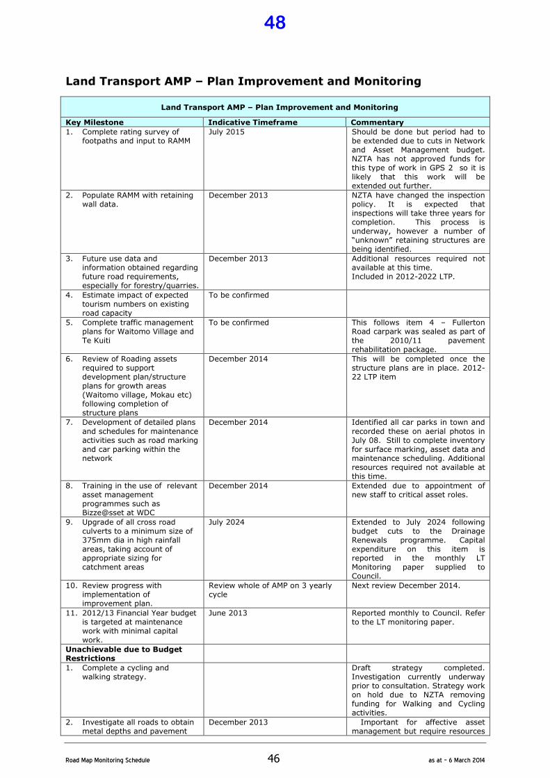
�
Road�Map�Monitoring�Schedule� 46� as�at�–�6�March�2014�
Land Transport AMP – Plan Improvement and Monitoring
Land Transport AMP – Plan Improvement and Monitoring
Key Milestone Indicative Timeframe Commentary
1. Complete rating survey of footpaths and input to RAMM
July 2015 Should be done but period had to be extended due to cuts in Network and Asset Management budget. NZTA has not approved funds for this type of work in GPS 2 so it is likely that this work will be extended out further.
2. Populate RAMM with retaining wall data.
December 2013 NZTA have changed the inspection policy. It is expected that inspections will take three years for completion. This process is underway, however a number of “unknown” retaining structures are being identified.
3. Future use data and information obtained regarding future road requirements, especially for forestry/quarries.
December 2013 Additional resources required not available at this time. Included in 2012-2022 LTP.
4. Estimate impact of expected tourism numbers on existing road capacity
To be confirmed
5. Complete traffic management plans for Waitomo Village and Te Kuiti
To be confirmed This follows item 4 – Fullerton Road carpark was sealed as part of the 2010/11 pavement rehabilitation package.
6. Review of Roading assets required to support development plan/structure plans for growth areas (Waitomo village, Mokau etc) following completion of structure plans
December 2014 This will be completed once the structure plans are in place. 2012-22 LTP item
7. Development of detailed plans
and schedules for maintenance activities such as road marking and car parking within the network
December 2014 Identified all car parks in town and
recorded these on aerial photos in July 08. Still to complete inventory for surface marking, asset data and maintenance scheduling. Additional resources required not available at this time.
8. Training in the use of relevant asset management programmes such as Bizze@sset at WDC
December 2014 Extended due to appointment of new staff to critical asset roles.
9. Upgrade of all cross road culverts to a minimum size of 375mm dia in high rainfall areas, taking account of appropriate sizing for catchment areas
July 2024 Extended to July 2024 following budget cuts to the Drainage Renewals programme. Capital expenditure on this item is reported in the monthly LT Monitoring paper supplied to Council.
10. Review progress with implementation of improvement plan.
Review whole of AMP on 3 yearly cycle
Next review December 2014.
11. 2012/13 Financial Year budget is targeted at maintenance work with minimal capital work.
June 2013 Reported monthly to Council. Refer to the LT monitoring paper.
Unachievable due to Budget Restrictions
1. Complete a cycling and walking strategy.
Draft strategy completed. Investigation currently underway prior to consultation. Strategy work on hold due to NZTA removing funding for Walking and Cycling activities.
2. Investigate all roads to obtain metal depths and pavement
December 2013 Important for affective asset management but require resources
48
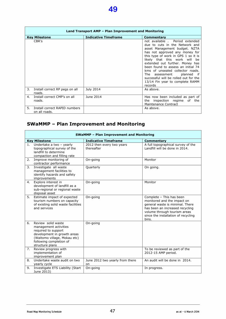
�
Road�Map�Monitoring�Schedule� 47� as�at�–�6�March�2014�
Land Transport AMP – Plan Improvement and Monitoring
Key Milestone Indicative Timeframe Commentary
CBR’s not available . Period extended due to cuts in the Network and asset Management budget. NZTA has not approved any money for this type of work in GPS 1 so it is likely that this work will be extended out further. Money has been found to assess an initial 74 kms of unsealed collector roads. The assessment planned if successful will be rolled out for the 13/14 Fin year to complete RAMM records
3. Install correct RP pegs on all roads.
July 2014 As above.
4. Install correct CMP’s on all roads.
June 2014 Has now been included as part of the inspection regime of the Maintenance Contract
5. Install correct RAPID numbers on all roads.
As above.
SWaMMP – Plan Improvement and Monitoring
SWaMMP – Plan Improvement and Monitoring
Key Milestone Indicative Timeframe Commentary
1. Undertake a two – yearly topographical survey of the
landfill to determine compaction and filling rate
2012 then every two years thereafter
A full topographical survey of the Landfill will be done in 2014.
2. Improve monitoring of contractor performance
On-going Monitor
3. Investigate all waste management facilities to identify hazards and safety improvements
Quarterly On going.
4. Explore interest in development of landfill as a sub-regional or regional waste disposal asset
On-going Monitor
5. Estimate impact of expected tourism numbers on capacity of existing solid waste facilities
and services
On-going Complete – This has been monitored and the impact on general waste is minimal. There
has been an increased recycling volume through tourism areas since the installation of recycling bins.
6. Review solid waste management activities required to support development in growth areas (Waitomo village, Mokau etc) following completion of structure plans
On-going
7. Review progress with implementation of improvement plan
To be reviewed as part of the 2012-15 AMP period.
8. Undertake waste audit on two yearly cycle
June 2012 two yearly from there on
An audit will be done in 2014.
9. Investigate ETS Liability (Start June 2013)
On-going In progress.
49
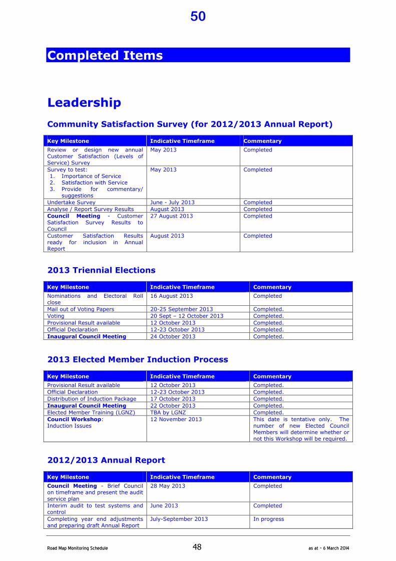
�
Road�Map�Monitoring�Schedule� 48� as�at�–�6�March�2014�
Completed Items
Leadership
Community Satisfaction Survey (for 2012/2013 Annual Report)
Key Milestone Indicative Timeframe Commentary
Review or design new annual Customer Satisfaction (Levels of Service) Survey
May 2013 Completed
Survey to test: 1. Importance of Service 2. Satisfaction with Service 3. Provide for commentary/
suggestions
May 2013 Completed
Undertake Survey June - July 2013 Completed
Analyse / Report Survey Results August 2013 Completed
Council Meeting - Customer Satisfaction Survey Results to Council
27 August 2013 Completed
Customer Satisfaction Results ready for inclusion in Annual Report
August 2013 Completed
2013 Triennial Elections
Key Milestone Indicative Timeframe Commentary
Nominations and Electoral Roll close
16 August 2013 Completed
Mail out of Voting Papers 20-25 September 2013 Completed.
Voting 20 Sept – 12 October 2013 Completed.
Provisional Result available 12 October 2013 Completed.
Official Declaration 12-23 October 2013 Completed.
Inaugural Council Meeting 24 October 2013 Completed.
2013 Elected Member Induction Process
Key Milestone Indicative Timeframe Commentary
Provisional Result available 12 October 2013 Completed.
Official Declaration 12-23 October 2013 Completed.
Distribution of Induction Package 17 October 2013 Completed.
Inaugural Council Meeting 22 October 2013 Completed.
Elected Member Training (LGNZ) TBA by LGNZ Completed.
Council Workshop: Induction Issues
12 November 2013 This date is tentative only. The number of new Elected Council Members will determine whether or not this Workshop will be required.
2012/2013 Annual Report
Key Milestone Indicative Timeframe Commentary
Council Meeting - Brief Council on timeframe and present the audit service plan
28 May 2013 Completed
Interim audit to test systems and control
June 2013 Completed
Completing year end adjustments and preparing draft Annual Report
July-September 2013 In progress
50
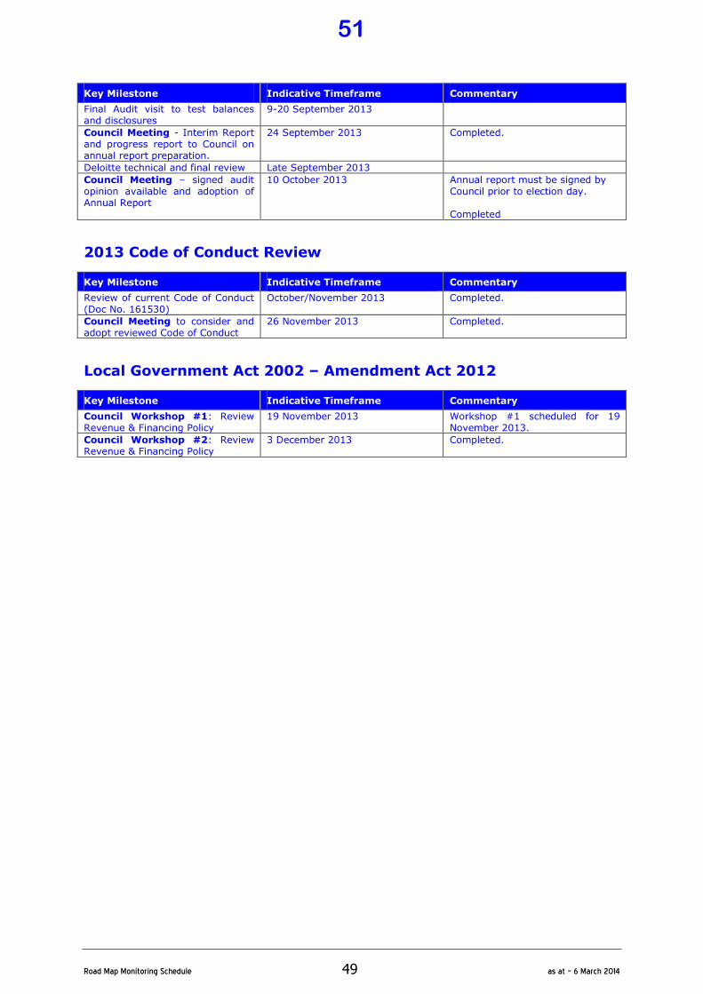
�
Road�Map�Monitoring�Schedule� 49� as�at�–�6�March�2014�
Key Milestone Indicative Timeframe Commentary
Final Audit visit to test balances and disclosures
9-20 September 2013
Council Meeting - Interim Report and progress report to Council on annual report preparation.
24 September 2013 Completed.
Deloitte technical and final review Late September 2013
Council Meeting – signed audit opinion available and adoption of Annual Report
10 October 2013 Annual report must be signed by Council prior to election day. Completed
2013 Code of Conduct Review
Key Milestone Indicative Timeframe Commentary
Review of current Code of Conduct (Doc No. 161530)
October/November 2013 Completed.
Council Meeting to consider and adopt reviewed Code of Conduct
26 November 2013 Completed.
Local Government Act 2002 – Amendment Act 2012
Key Milestone Indicative Timeframe Commentary
Council Workshop #1: Review Revenue & Financing Policy
19 November 2013 Workshop #1 scheduled for 19 November 2013.
Council Workshop #2: Review Revenue & Financing Policy
3 December 2013 Completed.
51
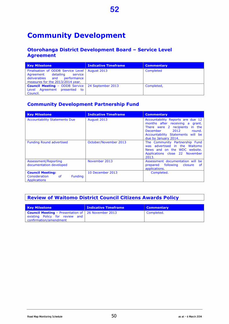
�
Road�Map�Monitoring�Schedule� 50� as�at�–�6�March�2014�
Community Development
Otorohanga District Development Board – Service Level
Agreement
Key Milestone Indicative Timeframe Commentary
Finalisation of ODDB Service Level Agreement detailing service deliverables and performance measures for the 2013/2014 year.
August 2013 Completed
Council Meeting – ODDB Service Level Agreement presented to Council.
24 September 2013 Completed,
Community Development Partnership Fund
Key Milestone Indicative Timeframe Commentary
Accountability Statements Due August 2013 Accountability Reports are due 12 months after receiving a grant. There were 2 recipients in the December 2012 round. Accountability Statements will be due by January 2014.
Funding Round advertised
October/November 2013 The Community Partnership Fund was advertised in the Waitomo News and on the WDC website.
Applications close 22 November 2013.
Assessment/Reporting documentation developed
November 2013 Assessment documentation will be prepared following closure of applications.
Council Meeting: Consideration of Funding Applications
10 December 2013 Completed.
Review of Waitomo District Council Citizens Awards Policy
Key Milestone Indicative Timeframe Commentary
Council Meeting – Presentation of existing Policy for review and confirmation/amendment
26 November 2013 Completed.
52
Document No: 327789 File No: 097/001B
Report To: Council
Meeting Date: 6 March 2014
Subject: Progress Report: Resource Consent
Applications
Purpose of Report 1.1 The purpose of this business paper is to provide Council with a progress report on
outstanding resource consent applications and those applications currently being processed.
Local Government Act S.11A Considerations 2.1 There are no Section 11A of the Local Government Act considerations relating to
this business paper.
Background 3.1 Most resource consent applications are dealt with by staff under delegated
authority. In such circumstances it is important that both the Chief Executive and Council are briefed on progress with such applications.
3.2 So as to ensure that Council is adequately briefed on all resource consent applications, a schedule is attached to and forms part of this business paper detailing progress of consent applications. This schedule also includes all completed consents processed in the current financial year.
3.3 Some resource consent applications are inevitably appealed to the Environment Court. Such a process is both expensive and time consuming and there is a need to ensure that Council is well briefed on applications being processed in this manner.
3.4 It is intended on a monthly basis to prepare a progress report for Council on all outstanding resource consents and those resource management issues impacting on this Council which are being dealt with by the Environment Court.
Commentary 4.1 Commentary on outstanding resource consents is provided below:
53
4.2 Mokau Sands Limited
4.3 In May 2012 Council received a resource consent application from Mokau Sands Limited seeking Councils approval to redevelop the Seaview Motor Camp at Mokau.
4.4 The applicant is proposing to redevelop the site to provide 31 holiday apartments and a 50 seat café/restaurant.
4.5 The application was publicly notified in August by both the Waikato Regional Council and WDC with submissions closing 4 September 2012.
4.6 A total of 39 submissions were received, some supporting the proposal while others opposed the development.
4.7 The applicant subsequently asked for the application to be placed on hold so as to allow ongoing discussions with the Department of Conservation and the NZ Transport Agency. Both organisations lodged submissions on the application and the applicant believed that it would be prudent if possible to resolve matters between the parties prior to a hearing.
4.8 Recently the applicant met with WDC staff where a revised proposal was outlined. The new proposal will involve the same no of units, however the buildings will be one level, capable of relocation in the event of further erosion and will be designed to blend into the coastal environment rather than intrude upon it.
4.9 When the amended application is received by Council the proposal will be reviewed and at that time a decision will be made in terms of the most appropriate way to process the revised proposal.
4.10 All submitters have been updated in terms of the delays presently encountered with the application.
4.11 In the meantime in order to expedite the application further meetings have been
held with the applicant. The applicant hopes to obtain the written approval for the development from key submitters with a view to providing all the necessary information to both the Waikato Regional and Waitomo District Councils by March 2014.
4.12 Because of the ongoing delays the applicant has been advised that the earliest a
hearing could now be scheduled (assuming all information is available in March) will be May/June 2014.
4.13 CANZ Resources Limited
4.14 In December 2013 CANZ Resources Limited applied to Council for a resource consent in order to undertake earthworks associated with the removal of overburden from a trial coal excavation pit on a very remote site approximately 12km inland from Awakau Road, Awakino.
4.15 At this time no coal is to be extracted however an assessment of the coals quality
and quantity will be carried out with a view to applying for further consents at a later date for a trial excavation of coal for export to China.
54
4.16 Should the trial excavation prove successful CANZ Resources Limited plan to develop an open pit coal mine on the site. Once again, if a coal mine is to be established on the site a range of additional consents will be required which will entail detailed consultation with a range of parties.
Suggested Resolution The Progress Report: Resource Consent Applications be received.
JOHN MORAN MANAGER – REGULATORY SERVICES
February 2014 Attachment: Resource Consent Schedule (Doc 327790)
55
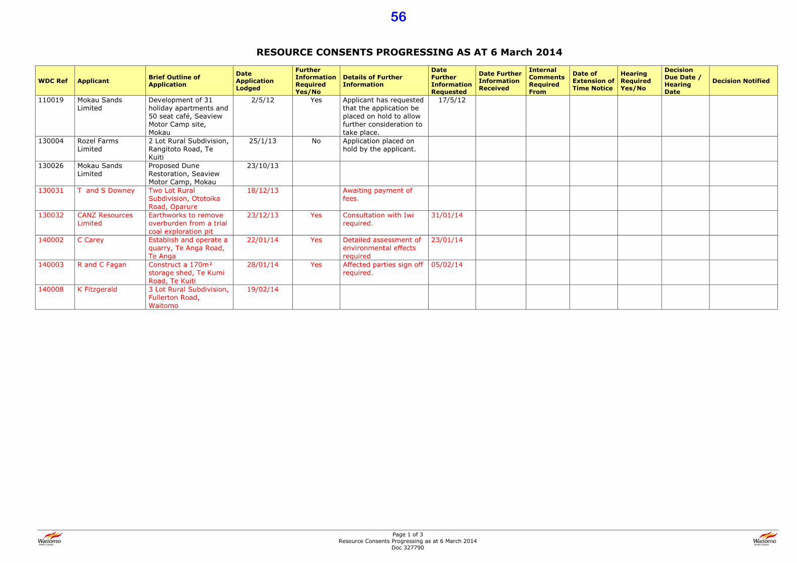
Page 1 of 3 Resource Consents Progressing as at 6 March 2014
Doc 327790
RESOURCE CONSENTS PROGRESSING AS AT 6 March 2014
WDC Ref Applicant Brief Outline of
Application
Date
Application
Lodged
Further
Information
Required
Yes/No
Details of Further
Information
Date
Further
Information
Requested
Date Further
Information
Received
Internal
Comments
Required
From
Date of
Extension of
Time Notice
Hearing
Required
Yes/No
Decision
Due Date /
Hearing
Date
Decision Notified
110019 Mokau Sands Limited
Development of 31 holiday apartments and 50 seat café, Seaview Motor Camp site, Mokau
2/5/12 Yes Applicant has requested that the application be placed on hold to allow further consideration to take place.
17/5/12
130004 Rozel Farms Limited
2 Lot Rural Subdivision, Rangitoto Road, Te Kuiti
25/1/13 No Application placed on hold by the applicant.
130026 Mokau Sands Limited
Proposed Dune Restoration, Seaview Motor Camp, Mokau
23/10/13
130031 T and S Downey Two Lot Rural Subdivision, Ototoika Road, Oparure
18/12/13 Awaiting payment of fees.
130032 CANZ Resources Limited
Earthworks to remove overburden from a trial coal exploration pit
23/12/13 Yes Consultation with Iwi required.
31/01/14
140002 C Carey Establish and operate a quarry, Te Anga Road, Te Anga
22/01/14 Yes Detailed assessment of environmental effects required
23/01/14
140003 R and C Fagan Construct a 170m: storage shed, Te Kumi Road, Te Kuiti
28/01/14 Yes Affected parties sign off required.
05/02/14
140008 K Fitzgerald 3 Lot Rural Subdivision, Fullerton Road, Waitomo
19/02/14
56
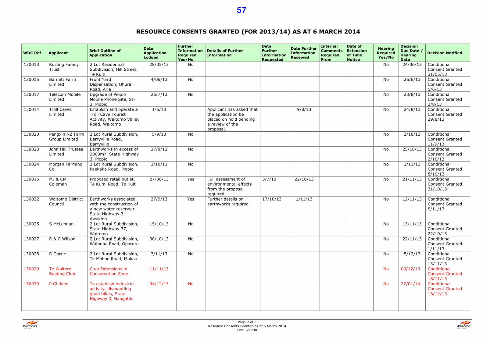
Page 2 of 3 Resource Consents Granted as at 6 March 2014
Doc 327790
RESOURCE CONSENTS GRANTED (FOR 2013/14) AS AT 6 MARCH 2014
WDC Ref Applicant Brief Outline of
Application
Date
Application
Lodged
Further
Information
Required
Yes/No
Details of Further
Information
Date
Further
Information
Requested
Date Further
Information
Received
Internal
Comments
Required
From
Date of
Extension
of Time
Notice
Hearing
Required
Yes/No
Decision
Due Date /
Hearing
Date
Decision Notified
130013 Rusling Family Trust
2 Lot Residential Subdivision, Hill Street, Te Kuiti
28/05/13 No No 24/06/13 Conditional Consent Granted 31/05/13
130015 Barnett Farm Limited
Front Yard Dispensation, Ohura Road, Aria
4/06/13 No No 26/6/13 Conditional Consent Granted 5/6/13
130017 Telecom Mobile Limited
Upgrade of Piopio Mobile Phone Site, SH 3, Piopio
26/7/13 No No 23/8/13 Conditional Consent Granted 2/8/13
130014 Troll Caves Limited
Establish and operate a Troll Cave Tourist Activity, Waitomo Valley Road, Waitomo
1/5/13 Applicant has asked that the application be placed on hold pending a review of the proposal.
9/8/13 No 24/8/13 Conditional Consent Granted 29/8/13
130020 Pengxin NZ Farm Group Limited
2 Lot Rural Subdivision, Barryville Road, Barryville
5/9/13 No No 2/10/13 Conditional Consent Granted 11/9/13
130023 John Hill Trustee Limited
Earthworks in excess of 2000mB, State Highway 3, Piopio
27/9/13 No No 25/10/13 Conditional Consent Granted 2/10/13
130024 Morgan Farming Co
2 Lot Rural Subdivision, Paekaka Road, Piopio
3/10/13 No No 1/11/13 Conditional Consent Granted 8/10/13
130016 MJ & CM Coleman
Proposed retail outlet, Te Kumi Road, Te Kuiti
27/06/13 Yes Full assessment of environmental effects from the proposal required.
3/7/13 22/10/13 No 21/11/13 Conditional Consent Granted 31/10/13
130022 Waitomo District Council
Earthworks associated with the construction of a new water reservoir, State Highway 3, Awakino
27/9/13 Yes Further details on earthworks required.
17/10/13 1/11/13 No 12/11/13 Conditional Consent Granted 5/11/13
130025 S McLennan 2 Lot Rural Subdivision, State Highway 37, Waitomo
15/10/13 No No 13/11/13 Conditional Consent Granted 22/10/13
130027 R & C Wilson 2 Lot Rural Subdivision, Waipuna Road, Oparure
30/10/13 No No 22/11/13 Conditional Consent Granted 1/11/13
130028 R Gorrie 2 Lot Rural Subdivision, Te Mahoe Road, Mokau
7/11/13 No No 5/12/13 Conditional Consent Granted 13/11/13
130029 Te Waitere Boating Club
Club Extensions in Conservation Zone
11/11/13 No 09/12/13 Conditional Consent Granted 18/11/13
130030 P Glidden To establish industrial activity, dismantling quad bikes, State Highway 3, Hangatiki
04/12/13 No No 22/01/14 Conditional Consent Granted 16/12/13
57

Page 3 of 3 Resource Consents Granted as at 6 March 2014
Doc 327790
WDC Ref Applicant Brief Outline of
Application
Date
Application
Lodged
Further
Information
Required
Yes/No
Details of Further
Information
Date
Further
Information
Requested
Date Further
Information
Received
Internal
Comments
Required
From
Date of
Extension
of Time
Notice
Hearing
Required
Yes/No
Decision
Due Date /
Hearing
Date
Decision Notified
140001 W Holmes 2 Lot Rural Subdivision, Taharoa Road, Taharoa
20/01/14 No No 20/02/14 Conditional Consent Granted 29/01/14
140005 M Frederikson 2 Lot Rural Subdivision, Te Anga Road, Waitomo
04/02/14 No 05/03/14 Conditional Consent Granted 12/02/14
140006 N Davie Erect a dwelling on a site zoned industrial, Rangitoto Road, Te Kuiti
11/02/14 No No 12/03/14 Conditional Consent Granted 19/02/14
58
Document No: 328324 File No: 508/003
Report To: Council
Meeting Date: 6 March 2014
Subject: Waitomo Caves Village Structure Plan
Stage 2 Concept Plan
Purpose of Report
1.1 The purpose of this business paper is to apprise Council of the Waitomo Caves
Village Structure Plan Stage 2 Concept Plan and to seek Council’s feedback, to be
provided to the Tere Waitomo Community Trust.
Background
2.1 The Tere Waitomo Community Trust (TWCT) formed in September 2012, has a
mandate from the Waitomo Caves village to facilitate planning and community
development.
2.2 TWCT in discussion with Council, identified a Structure Plan as the best way to
progress community planning and approached Council for funding the same in
2013.
2.3 Council recognises the significance of the Waitomo Caves village and agreed to
fund the development of a Structure Plan. TWCT commissioned Beca Consultants
to develop the Structure Plan.
2.4 It is our understanding that the development of the Structure Plan by Beca is a 3
stage process. Stage 1 being primarily a data collection and issue identification
stage. Stage 2 is to provide some design concepts for the future growth and
Stage 3 is intended to bring it all together in the form of a finalized Structure Plan
for the development of the Waitomo Caves area.
2.5 Waitomo Caves Village Structure Plan - Stage 2 Report (SP-2), attached as part of
this business paper, represents design concepts for future development in the
Waitomo Caves area.
2.6 TWCT has been seeking feedback from the community on the SP-2 and has
sought Council feedback on the same.
2.7 TWCT is looking to meet with the Beca project team in early March to progress to
stage 3 of the project.
59
Key Aspects of the Structure Plan
3.1 The SP-2 puts forward integrated design concepts for the future development of
the Waitomo Caves Village.
3.2 All concepts are underpinned by three overarching “structuring elements” referred
to as “Key Moves” in the SP-2. These are:
1. Encourage ongoing growth of Waitomo Caves Village as the community and
tourism hub of the area with strong connections to surrounding adventure
tourism ‘nodes’.
2. Consolidate the Village core as a vibrant, walkable visitor and community
destination.
3. Build upon the existing connections and boundaries to enhance the
Waitomo Caves Village experience for visitors and locals.
3.3 To achieve these “Key Moves” concepts and suggestions have been developed in
the following areas:
1. Land Use
2. Connectivity (includes walkways, cycleways, parking)
3. Landscape (Gateways, Town Centre)
3.4 Some options are provided for Water and Wastewater infrastructure, although at a
very ‘broad-brush’ level.
3.5 A phased approach to development and improvements is promoted in the SP-2
with suggestions in the categories of ‘quick wins’, ‘medium term’ and ‘medium to
long term’.
3.6 Land Use
• The Land Use concept is proposing to concentrate the majority of future
development into a consolidated centre, to avoid undermining the viability of
the centre.
• It suggests a diverse range of activities to be provided in this core like
investment into the Domain, club rooms and a new hall or chapel.
• The idea is to make the Village more vibrant in order to invite more visitors
and residents.
• The existing adventure tourism ‘nodes’ are proposed to be connected
appropriately and to be integrated with the rural environment. They should
be subject to appropriate development guidelines such that they compliment
the Village rather than compete with it.
• Future clusters of residential development are suggested to be located and
integrated within the surrounding rural landscape [of the Village].
• Framework Plan 1 illustrates the land use proposals
60
3.7 Connectivity
• SP-2 states that the connectivity within and around the Village is disjointed
and that ‘joining the dots’ of various activities will provide for a more
integrated Village centre.
• The design concepts promote connections to be built (like walkways,
cycleways, parking, signage) such that they encourage visitors to spend
more time in and around the Village.
• Some examples of ‘quick wins’ suggested for connectivity are – creation of
short-medium term off-road parking off Access Road, new native fern
planting along the Waitomo Walkway and establishing off-road cycleway
from the top of Access Road across farmland to Fullerton Road.
• Parking has been identified as a concern, especially during peak tourist
season and options for alternative parking have been suggested to alleviate
the problem.
• The accompanying ‘Technical Note’ to SP-2 provides further details of the
preferred options – Waitomo Caves Road, former Curly’s Bar site,
Community Hall site and off Fullerton Road.
• The proposal is to retain some on-road parking but to narrow the
carriageway, with the idea being to promote the village as a pedestrian hub.
3.8 Landscape
• The core principle in the suggested concepts is to better connect the village
and to provide a sense of identity that will strike the visitors upon arrival.
• The concepts propose reintroducing patches of native forest and planted
corridors to enhance the ecological network and also creating a
distinguishing gateway feature for the village. The idea being to promote
other experiences within the village environs.
• Examples of suggested development are – using feature planting at key
gateway points, community involvement to establish new planting ventures,
ongoing walking track establishment at the main entrance to the village,
enhancing visual experience for visitors as they enter the village. The
Gateway concept is to invite visitors to slow down and visit the village.
• SP-2 emphasises the consolidation of a village core – a town centre feel,
which is suggested as important in order to invite visitors to stay longer and
to enhance their experience.
• Two options are suggested – village core centred around a community heart
space or centred around a roundabout (at Access road and Waitomo Caves
road).
3.9 Infrastructure
• SP-2 provides some options for water and wastewater infrastructure
together with benefits and disadvantages and estimated costs.
• It states that it is difficult to consider and recommend infrastructure options
that will meet the current and future needs given the current uncertainty
around infrastructure.
• Three options are provided for water reticulation and four for Waste water.
61

Commentary
4.1 SP-2 is an ambitious plan for the development of the Waitomo Caves village with
some wide ranging concepts for improvement within and around the village.
4.2 As it stands, SP-2 is not only a long term land use conceptualisation but has a
large element of asset development concepts which pertain to public assets like
footpaths, cycleways, roads and public reserve and domain.
4.3 Council needs to be aware that if it were to adopt the structure plan with all of the
asset development components, that would mean accepting the defacto levels of
service and development expectations for the said public assets into the future.
This would have funding implications, that is, these investments would have to be
supported by public funds.
4.4 It is important to understand that Structure Planning is a process that considers
the natural and physical resources of land (or an area) and identifies future
patterns of land uses based on consideration of alternatives. An important part of
structure planning is the consideration of constrains to development, including
infrastructure constraints.
4.5 However, implementation of a structure plan has to be through incorporation into
statutory planning documents such as the District Plan and any land use concepts
are subject to legal processes such as negotiated agreements, acquisitions or
designations.
4.6 SP-2 discusses changing footpath widths, narrowing/widening roads,
changing existing parking arrangements, a roundabout option, new parking areas
(including coach stopping areas), signage, cycle-ways and crossing points, which
is an asset development exercise and has to be done within the wider strategic
planning and prioritizing for the District as a whole.
4.7 It is important to note that operationalising these concepts involve technical and
feasibility studies and consultation including sign offs from other regulatory
authorities such as NZ Transport Agency. The concepts/ options would only serve
as the starting point for further investigations and again, can only be initiated in
the context of asset management and development.
4.8 The critical aspect of any implementation has to be prioritizing and funding. Any
development has to be affordable for the residents and ratepayers of the
community and will have to be prioritized alongside other projects and activities.
There is no indication of costs in the document and therefore it is not clear how
realistic the options might be.
4.9 Although, some timeframes for development are provided (Quick Wins, Short to
Medium Term, Medium to Long Term), Stage 3 needs to be more definite about
when the developments can be expected. This will naturally lead to firming up on
prioritizing. Funding will influence investment choices and determine the rate of
progress. However, some key 'milestone' dates may be useful in terms of planning
and setting some realistic expectations in the community.
4.10 An important point to note is that the infrastructure section of SP-2, pertaining to
water and wastewater assets is inadequate and could in fact be misleading. The
options provided are generic and have not been tested in any manner for their
suitability to the Waitomo Caves village context. The cost information provided for
the options does not adequately consider the benefits and disadvantages. As an
example, Option 2 for Water reticulation (bore water) states that one of the
62

disadvantages is that it may require a backup source and that it may not be
sustainable and yet the cost for the option is suggested to be low to medium.
4.11 Although this section states the point that it is difficult to consider infrastructure
needs because of the lack of information on assets, however, better context is
required around the suggested options. In fact, since the options are
generalisations they might be best left out to avoid misinformation and setting up
non-feasible starting points.
4.12 Overall, moving in to Stage 3, the Structure Plan needs to identify the constraints
for development. It would be beneficial to the TWCT to have an idea of priorities
and timeframes. There needs to be recognition of the funding needs. Any options
for infrastructure should be adequately contextualized with realistic options if at
all.
Suggested Resolutions
1 The business paper Waitomo caves Village Structure Plan Stage 2-Concept Plan be
received.
2 Council’s views be drafted into a feedback letter to be sent to the Tere Waitomo
Community Trust.
VIBHUTI CHOPRA
STRATEGY AND POLICY ADVISOR
27 February 2014
1 Waitomo Caves Village Structure Plan Stage 2 – Concept Plan
Attachments
2 Technical Note
63
Waitomo Caves Village Structure PlanStage 2 - Concept PlanPrepared for Tere Waitomo Community Committee (Client)
By Beca Limited
6 September 2013
© Beca 2012 (unless Beca has expressly agreed otherwise with the Client in writing).
This report has been prepared by Beca on the specifi c instructions of our Client. It is solely for our Client’s use for the
purpose for which it is intended in accordance with the agreed scope of work. Any use or reliance by any person
contrary to the above, to which Beca has not given its prior written consent, is at that person’s own risk.
64
Issue / revision
Date Description Prepared by Checked by Approved by Signed On behalf of
A 5 June 2013 First draft for client feedback
Emily Kelly, Emily Auton, Carl Lucca
Annette Jones
Annette Jones Beca Ltd (Beca)
B 5 September 2013
Concept Plan report for client feedback and wider public consultation
Emily Kelly, Emily Auton, Carl Lucca
Annette Jones
Annette Jones Beca Ltd (Beca)
This document was prepared by:
65
Waitomo Caves Vi l lage Structure P lan - Stage 2 Concept P lan Report • September 2013 3
CONTENTS
Contents
1.0 Introduction ................................................................................................4
2.0 Key Moves ..................................................................................................7
3.0 Future Vision ..............................................................................................8
4.0 Land Use ...................................................................................................10
5.0 Infrastructure ............................................................................................14
6.0 Connectivity ..............................................................................................16
7.0 Parking Strategy .......................................................................................20
8.0 Gateways ..................................................................................................22
9.0 Landscape .................................................................................................24
10.0 Town Centre ..............................................................................................28
66
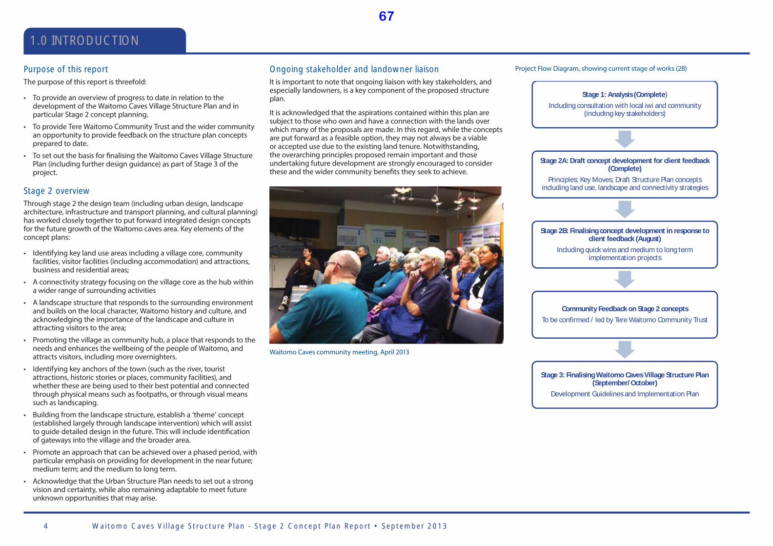
Waitomo Caves Vi l lage Structure P lan - Stage 2 Concept P lan Report • September 20134
1.0 INTRODUCTION
Project Flow Diagram, showing current stage of works (2B)Purpose of this reportThe purpose of this report is threefold:
• To provide an overview of progress to date in relation to the development of the Waitomo Caves Village Structure Plan and in particular Stage 2 concept planning.
• To provide Tere Waitomo Community Trust and the wider community an opportunity to provide feedback on the structure plan concepts prepared to date.
• To set out the basis for fi nalising the Waitomo Caves Village Structure Plan (including further design guidance) as part of Stage 3 of the project.
Stage 2 overviewThrough stage 2 the design team (including urban design, landscape architecture, infrastructure and transport planning, and cultural planning) has worked closely together to put forward integrated design concepts for the future growth of the Waitomo caves area. Key elements of the concept plans:
• Identifying key land use areas including a village core, community facilities, visitor facilities (including accommodation) and attractions, business and residential areas;
• A connectivity strategy focusing on the village core as the hub within a wider range of surrounding activities
• A landscape structure that responds to the surrounding environment and builds on the local character, Waitomo history and culture, and acknowledging the importance of the landscape and culture in attracting visitors to the area;
• Promoting the village as community hub, a place that responds to the needs and enhances the wellbeing of the people of Waitomo, and attracts visitors, including more overnighters.
• Identifying key anchors of the town (such as the river, tourist attractions, historic stories or places, community facilities), and whether these are being used to their best potential and connected through physical means such as footpaths, or through visual means such as landscaping.
• Building from the landscape structure, establish a ‘theme’ concept (established largely through landscape intervention) which will assist to guide detailed design in the future. This will include identifi cation of gateways into the village and the broader area.
• Promote an approach that can be achieved over a phased period, with particular emphasis on providing for development in the near future; medium term; and the medium to long term.
• Acknowledge that the Urban Structure Plan needs to set out a strong vision and certainty, while also remaining adaptable to meet future unknown opportunities that may arise.
Stage 1: Analysis (Complete)Including consultation with local iwi and community
(including key stakeholders)
Stage 2A: Draft concept development for client feedback(Complete)
Principles; Key Moves; Draft Structure Plan conceptsincluding land use, landscape and connectivity strategies
Stage 2B: Finalising concept development in response toclient feedback (August)
Including quick wins and medium to long termimplementation projects
Community Feedback on Stage 2 conceptsTo be confirmed / led by Tere Waitomo Community Trust
Stage 3: Finalising Waitomo Caves Village Structure Plan(September/October)
Development Guidelines and Implementation Plan
Waitomo Caves community meeting, April 2013
Ongoing stakeholder and landowner liaisonIt is important to note that ongoing liaison with key stakeholders, and especially landowners, is a key component of the proposed structure plan.
It is acknowledged that the aspirations contained within this plan are subject to those who own and have a connection with the lands over which many of the proposals are made. In this regard, while the concepts are put forward as a feasible option, they may not always be a viable or accepted use due to the existing land tenure. Notwithstanding, the overarching principles proposed remain important and those undertaking future development are strongly encouraged to consider these and the wider community benefi ts they seek to achieve.
67

Waitomo Caves Vi l lage Structure P lan - Stage 2 Concept P lan Report • September 2013 5
Summary of Stage 1 Analysis ReportStage 1 reporting provided an overview of the analysis undertaken in preparation of the proposed Waitomo Caves Village Structure Plan concepts detailed within this stage 2 report. The analysis focused on information review and collation, and identifying the key issues and, subsequently, design principles aimed at informing the proposed Structure Plan.
Undertaking site visits and meeting with Tere Waitomo Community Trust and wider stakeholders (in particular local Iwi) has been critical as part of the information gathering, particularly in terms of further understanding the outcomes of the community consultation process undertaken over the past two years.
Waitomo Caves Village and environs – key opportunities (refer Figure 1) summarises the key opportunities identifi ed through the analysis process. These opportunities were collated through inputs from the local knowledge of the community and the design team’s own expertise and experience. What is important is how these opportunities are carried forward and responded to within the structure plan preparation (as illustrated within the concepts contained within this report), and how they will assist the community in reaching their vision for Waitomo Caves:
“Kotahitanga” – A sense of unity, purpose, and direction that builds and supports the Waitomo Caves Village Community as a strong, sustainable, multi-cultural community, which provides an attractive environment in which to live, work, play and raise a family.
In summary, analysis included:
• Analysis of planning context and land use
• Identifi cation of local tourism drivers and opportunities
• Infrastructure analysis
• Existing landscape / streetscape / built form character and ‘sense of place’, including ‘gateways’, and vegetation patterns
• Land ownership patterns
• Topography, key views and landmarks
• Movement infrastructure, including quality of footpaths
• Access and connectivity
• Opportunities for ‘quick wins’ to improve functionality and amenity
• Identify existing and potential key community facilities
• Confi rm known stakeholders requirements
• Benchmarking against other NZ towns and tourism destinations to understand what has been successful in similar towns (including Hamner, National Park, Franz Josef and Piopio).
Structure Plan principles and strategiesAs part of the analysis and stage 1, the following key principles for future growth of Waitomo have been developed to assist and guide the concept design during stage 2.
History and tourism
• Continue to build the heritage of Waitomo by retaining and building upon the village core and ‘village feel’ of Waitomo Caves Village.
• Explore opportunities to sell the ‘full’ Waitomo Tourism off ering - other attractions of Waitomo Caves Village and the surrounding area should be emphasised – history, landscape, scenery, limestone, native bush and farmland.
• Continue to develop the Waitomo Caves ‘brand’ by working together to promote a consistent approach to signage and public realm treatment, derived from local character and history, to enhance a sense of place.
• Recognising the success of entrepreneurs of the past, provide new opportunities for new catalyst projects to help businesses grow and diversify.
Landscape
• Identify and promote the valuable views and vistas throughout the Village to enable people the opportunity to learn more about the area and spend more time exploring.
• Introduce way fi nding mechanisms and a built form elements along walkways and throughout the landscape to enhance sense of place.
• Ensure future development retains and builds upon valued views that provide Waitomo Caves Village with its sense of place.
Land use
• Provide land suffi cient to realise the potential for growth, and make Waitomo Caves Village an attractive place for tourism, business and residential activities.
• Build upon existing adventure and community activities in and around the village to encourage people to stay longer.
• Create more opportunities to encourage and enable people to live locally.
• Avoid undermining a viable centre through dispersed land uses.
Built form and public realm
• Use built form, public buildings and public open spaces to defi ne the public realm and the centre of the village, to establish a focal point for both residents and visitors to the area.
• Encourage a continuous building façade by fi lling existing gaps to create a ‘main street’ feel on Waitomo Caves Village Road.
• The scale of future buildings should refl ect and remain sympathetic to existing built structures in the Waitomo Caves area.
• Provide a visually consolidated village core that is exciting and will entice people to stop and look around rather than just keep driving through.
• Through appropriate streetscape design, allow people the opportunity to enjoy the views around them and to fully engage within the village.
Connectivity
• Provide consistent clear signage and information to visitors travelling to Waitomo Cave Village, to provide advance guidance and information on activities, attractions and accommodation.
• Establish clear arrival and departure points to the village, aided by built form, landscape and other cues.
• Improve the pedestrian network serving the village, and examine options to signifi cantly improve the pedestrian and cycle links between the village and near by nodes of activity.
• Enhance the availability of parking and the balance of parking provision to attract visitors to spend more time in the village.
Infrastructure
• Provide for infrastructure options that are sustainable, both economically and physically, in the long term and meeting the day to day commercial and living needs of the community.
1.0 INTRODUCTION
68
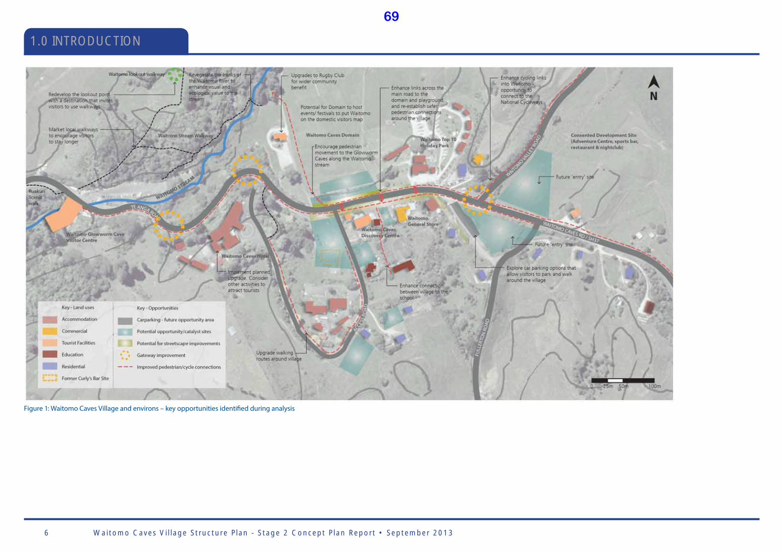
Waitomo Caves Vi l lage Structure P lan - Stage 2 Concept P lan Report • September 20136
1.0 INTRODUCTION
Figure 1: Waitomo Caves Village and environs – key opportunities identifi ed during analysis
69
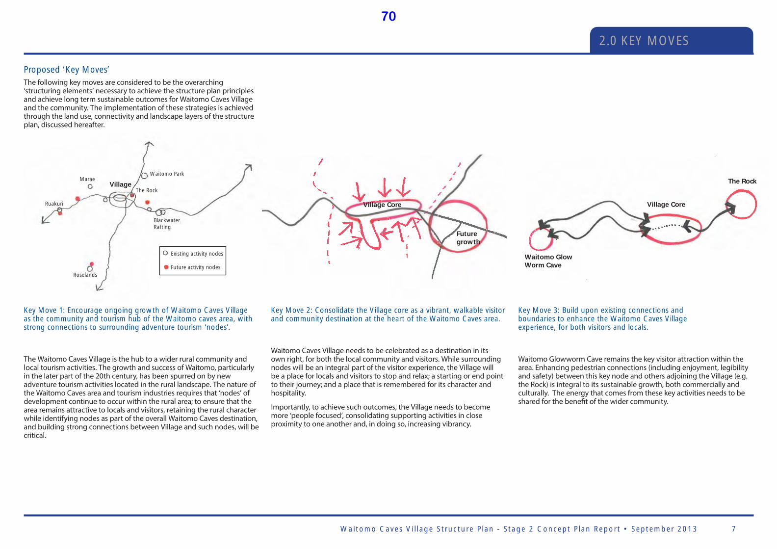
Waitomo Caves Vi l lage Structure P lan - Stage 2 Concept P lan Report • September 2013 7
2.0 KEY MOVES
Village
BlackwaterRafting
Roselands
The Rock
Marae
Ruakuri
Waitomo Park
Village Core
Future growth
Village Core
The Rock
Waitomo Glow Worm Cave
Proposed ‘Key Moves’ The following key moves are considered to be the overarching ‘structuring elements’ necessary to achieve the structure plan principles and achieve long term sustainable outcomes for Waitomo Caves Village and the community. The implementation of these strategies is achieved through the land use, connectivity and landscape layers of the structure plan, discussed hereafter.
Existing activity nodes
Future activity nodes
Key Move 1: Encourage ongoing growth of Waitomo Caves Village as the community and tourism hub of the Waitomo caves area, with strong connections to surrounding adventure tourism ‘nodes’.
The Waitomo Caves Village is the hub to a wider rural community and local tourism activities. The growth and success of Waitomo, particularly in the later part of the 20th century, has been spurred on by new adventure tourism activities located in the rural landscape. The nature of the Waitomo Caves area and tourism industries requires that ‘nodes’ of development continue to occur within the rural area; to ensure that the area remains attractive to locals and visitors, retaining the rural character while identifying nodes as part of the overall Waitomo Caves destination, and building strong connections between Village and such nodes, will be critical.
Key Move 2: Consolidate the Village core as a vibrant, walkable visitor and community destination at the heart of the Waitomo Caves area.
Waitomo Caves Village needs to be celebrated as a destination in its own right, for both the local community and visitors. While surrounding nodes will be an integral part of the visitor experience, the Village will be a place for locals and visitors to stop and relax; a starting or end point to their journey; and a place that is remembered for its character and hospitality.
Importantly, to achieve such outcomes, the Village needs to become more ‘people focused’, consolidating supporting activities in close proximity to one another and, in doing so, increasing vibrancy.
Key Move 3: Build upon existing connections and boundaries to enhance the Waitomo Caves Village experience, for both visitors and locals.
Waitomo Glowworm Cave remains the key visitor attraction within the area. Enhancing pedestrian connections (including enjoyment, legibility and safety) between this key node and others adjoining the Village (e.g. the Rock) is integral to its sustainable growth, both commercially and culturally. The energy that comes from these key activities needs to be shared for the benefi t of the wider community.
70
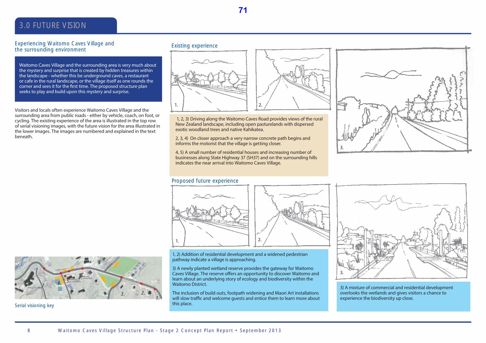
Waitomo Caves Vi l lage Structure P lan - Stage 2 Concept P lan Report • September 20138
3.0 FUTURE VISION
1. 2.
3.
Serial visioning key
1.2.3.
4.5.6.7.
Experiencing Waitomo Caves Village and the surrounding environment
Visitors and locals often experience Waitomo Caves Village and the surrounding area from public roads - either by vehicle, coach, on foot, or cycling. The existing experience of the area is illustrated in the top row of serial visioning images, with the future vision for the area illustrated in the lower images. The images are numbered and explained in the text beneath.
Waitomo Caves Village and the surrounding area is very much about the mystery and surprise that is created by hidden treasures within the landscape - whether this be underground caves, a restaurant or cafe in the rural landscape, or the village itself as one rounds the corner and sees it for the fi rst time. The proposed structure plan seeks to play and build upon this mystery and surprise.
Existing experience
Proposed future experience
1, 2) Addition of residential development and a widened pedestrian pathway indicate a village is approaching.
3) A newly planted wetland reserve provides the gateway for Waitomo Caves Village. The reserve off ers an opportunity to discover Waitomo and learn about an underlying story of ecology and biodiversity within the Waitomo District.
The inclusion of build outs, footpath widening and Maori Art installations will slow traffi c and welcome guests and entice them to learn more about this place.
1, 2, 3) Driving along the Waitomo Caves Road provides views of the rural New Zealand landscape, including open pasturelands with dispersed exotic woodland trees and native Kahikatea.
2, 3, 4) On closer approach a very narrow concrete path begins and informs the motorist that the village is getting closer.
4, 5) A small number of residential houses and increasing number of businesses along State Highway 37 (SH37) and on the surrounding hills indicates the near arrival into Waitomo Caves Village.
1. 2.
3.
3) A mixture of commercial and residential development overlooks the wetlands and gives visitors a chance to experience the biodiversity up close.
71
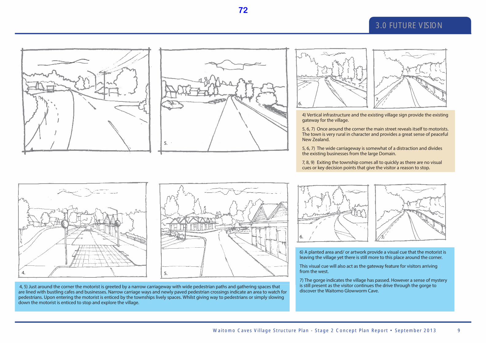
Waitomo Caves Vi l lage Structure P lan - Stage 2 Concept P lan Report • September 2013 9
3.0 FUTURE VISION
4.5.
6.7.
4. 5.
6. 7.
4) Vertical infrastructure and the existing village sign provide the existing gateway for the village.
5, 6, 7) Once around the corner the main street reveals itself to motorists. The town is very rural in character and provides a great sense of peaceful New Zealand.
5, 6, 7) The wide carriageway is somewhat of a distraction and divides the existing businesses from the large Domain.
7, 8, 9) Exiting the township comes all to quickly as there are no visual cues or key decision points that give the visitor a reason to stop.
4, 5) Just around the corner the motorist is greeted by a narrow carriageway with wide pedestrian paths and gathering spaces that are lined with bustling cafes and businesses. Narrow carriage ways and newly paved pedestrian crossings indicate an area to watch for pedestrians. Upon entering the motorist is enticed by the townships lively spaces. Whilst giving way to pedestrians or simply slowing down the motorist is enticed to stop and explore the village.
6) A planted area and/ or artwork provide a visual cue that the motorist is leaving the village yet there is still more to this place around the corner.
This visual cue will also act as the gateway feature for visitors arriving from the west.
7) The gorge indicates the village has passed. However a sense of mystery is still present as the visitor continues the drive through the gorge to discover the Waitomo Glowworm Cave.
72
Waitomo Caves Vi l lage Structure P lan - Stage 2 Concept P lan Report • September 201310
4.0 LAND USE
The proposed land use plan has been established around two guiding principles:
• Supporting the long term economic, social and cultural wellbeing of Waitomo Caves Village through its consolidation and ongoing growth; and
• Responding to and building upon the village’s location within the surrounding rural environment, including the karst landscape.
The land use concept for the Waitomo Caves Village proposes to concentrate the majority of future development into a consolidated centre and walkable destination that is attractive for both locals and visitors. The objective is to build upon existing activities both in and around the village, to extend opportunities for both locals and visitors.
When expanding the Waitomo Caves Village it is important to encourage development within the village core to avoid undermining the viability of the centre through dispersed land uses. This is not to say that the visitor activities that exist outside of the town centre should not grow and be added to; rather the village should remain the community and commercial core, acting as the primary destination and service core.
By concentrating the majority of development, services and amenities within and around the existing village centre, the village will become increasingly walkable and vibrant, thus becoming more inviting to visitors and locals.
Equally important is protecting the rural landscape that the village sits within. Waitomo Caves Village and associated tourism activities benefi t from the mystery and surprise of the landscape - hidden caves; framed views and vistas; wondering what is around the next corner; and a village nestled in the rural New Zealand landscape - are all important parts of the visitor (and local) experience. Accordingly, views and the natural topography have assisted to shape the proposed village boundaries.
Enabling people to move freely within and around their community, while undertaking their day to day activities, is integral to building a community that responds to the basic needs and desires of its people. The provision of excellent infrastructure at all levels – sports and recreation grounds, open space, pedestrian and cycle routes, safe roads, good access to the primary school, and ease of access to local tourism destinations – will assist Waitomo Caves Village in becoming an even better place to live and visit.
A diverse range of activities for locals and visitors of all ages need to be provided throughout the town, and should include a range of local recreation opportunities. For the Waitomo Caves Village this means continued use and investment into existing amenities, such as the Domain, club rooms, and public realm generally. In addition, a number of new community facilities are proposed, including a new hall or chapel, providing opportunities for events such as weddings.
Future Development Areas / TypesHaving regard to the above, three types of development or development areas are considered appropriate within the context of the wider Waitomo Caves area:
• Waitomo Village - the consolidated core and hub to the wider area.
• Adventure Tourism Nodes - nodes of tourism development located and integrated with the surrounding rural environment.
• Rural residential development - future clusters of residential development located and integrated within the surrounding rural landscape.
The above approach is considered appropriate to manage growth for the foreseeable future. Should the village reach a threshold, further planning would be appropriate at that time.
Infrastructure Infrastructure is discussed shortly hereafter. It is noted that the proposed land use approach is premised around the consolidation of activities, in part to reduce additional expenses that occur with dispersed development patterns. Infrastructure provision will benefi t from taking a holistic approach to development. i.e. planning and installing infrastructure for the future requirements now. This has the benefi t of. Potential decreased costs associated with physical infrastructure provision, and the ability to share costs amongst more stakeholders (whether privately or Council provided).
Waitomo Village (refer Figure 2)Key elements that have assisted to shape the proposed Waitomo Village land use area include:
• The Waitomo Caves Domain and Stream
• The western gorge between the village and the Waitomo Glowworm Cave
• The ridgeline running to the west of Waitomo Valley Road
• Using views as ‘cues’ for visitors entering the village, i.e. identifying ‘point of arrival’ (refer views 1 and 2 on Figure 2)
• Protecting and enhancing existing rural views in and around the village (refer views 3, 4, 5 and 6 on Figure 2)
• The southern ridgeline at the top of the access road, in particular to protect rural views when coming from the south along Fullerton Road (yet with potential to signal the village over the top of the hill with an appropriate community symbol (e.g. a church steeple).
Key land use activities for the village are proposed as follows:
Village Centre
Encouraged activities: Small scale retail; tourism ventures and information; offi ces; restaurants; cafes; licensed premises; community facilities; parking and transport facilities; healthcare; community facilities; visitor accommodation
Discouraged activities: Industry
Residential and Visitor Accommodation
Encouraged activities: visitor accommodation and ancillary activities; residential activities
Community Focus Areas
Encouraged activities: community activities including school; community halls; sports facilities; and other activities for wider public benefi t
Based on the above, three overarching rules can be summarised:
1. Consolidate the Village as the core hub - concentrate as much development in this area as possible and keep it tight
2. Provide for tourism nodes within the surrounding Waitomo Caves area, subject to appropriate guidelines for development
3. Allow for appropriately designed rural residential development clusters integrated into the surrounding landscape.
73

Waitomo Caves Vi l lage Structure P lan - Stage 2 Concept P lan Report • September 2013 11
4.0 LAND USE
Special Purpose Areas
Existing activities: Waitomo Glowworm Cave; Waitomo Caves Hotel; and The Rock
Encouraged activities: Adventure tourism and ancillary activities
Waitomo Caves Domain
Encouraged activities: Events/ festivals; sports; markets; community activities
Rural
Encouraged activities: Agriculture and horticulture
Conservation
Encouraged activities: Conservation; low impact recreation activities, e.g. walking, mountain biking, caving
‘Development Nodes’As described within the key moves, the Waitomo Caves Village is the hub to a wider rural community and local tourism activities; however, the nature of the Waitomo Caves area and tourism industries requires that ‘nodes’ of development continue to occur within the rural area. Importantly, nodal development should not compete with the Village, but rather complement it. Having regard to the above, the following activities are considered appropriate:
• Adventure tourism activities (where possible, point of departure should be from the Village)
• Bed and breakfast, over night huts or similar small scale visitor accommodation
With the exception of existing activities, the following activities are discouraged, as they have the potential to detract from the outcomes sought for the Village:
• Restaurants
• Hotels and similar medium to large scale visitor accommodation
• Retail stores (with the exception of good directly associated with adventure tourism activities being undertaken)
• Information centres
• Offi ces
While development nodes need not be hidden, design guidelines are suggested to ensure that they are undertaken in a manner that is sympathetic to and integrates with the surrounding rural landscape.
Rural Residential Land UseIt is important that development around the Waitomo Caves area follows appropriate principles to facilitate residential development that is sympathetic to the landscape, preserves natural features and delivers minimal visual impact (and thus upholding the unique character of the Waitomo Caves area). It is suggested that the Tere Waitomo Community committee works with the community to agree design standards that do not restrict growth but provides guidelines that will facilitate appropriate development in the rural area.
The design guidelines should be appropriate for the Waitomo area defi ning in more detail the principles below as well as providing guidance around desired built form, vegetation, densities, style and layout. Overarching design principles to be further developed include:
• Selecting suitable sites for subdivision and development that respond to the landform and other surrounding characteristics.
• Integrating development into the landscape with the use of both existing and proposed vegetation.
• Clustering lots to increase a sense of community and minimise the extent of required infrastructure and footprint on the land.
• Preserving heritage features of the area including any waahi tapu sites, natural areas and topographic features.
• Incorporating accessibility into the design to ensure that appropriate connections are made with the surrounding landscape. Ensure road design responds to the rural character.
• Avoiding unnecessary earthworks and maintaining the natural landform. Design and layout of the building platforms and roads should follow the lie of the land.
• Complementing the existing rural character. Maintain the rural feel upon the approach to Waitomo Caves Village, where possible integrate development within the landscape so it is not prominent from the main roads.
• Ensure important ecological systems are protected and enhanced particularly vegetation, water bodies and other natural elements.
Existing adventure tourism node
Existing Special Purpose Area
Rural residential cluster patterns (Source: Ministry for Environment)
74
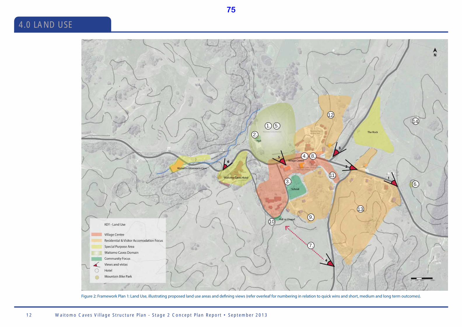
Waitomo Caves Vi l lage Structure P lan - Stage 2 Concept P lan Report • September 201312
Figure 2: Framework Plan 1: Land Use, illustrating proposed land use areas and defi ning views (refer overleaf for numbering in relation to quick wins and short, medium and long term outcomes).
1. 5.
12
4. 8.
11.
9.
7.
13.
6.
14.
2.
3.
10
4.0 LAND USE
75
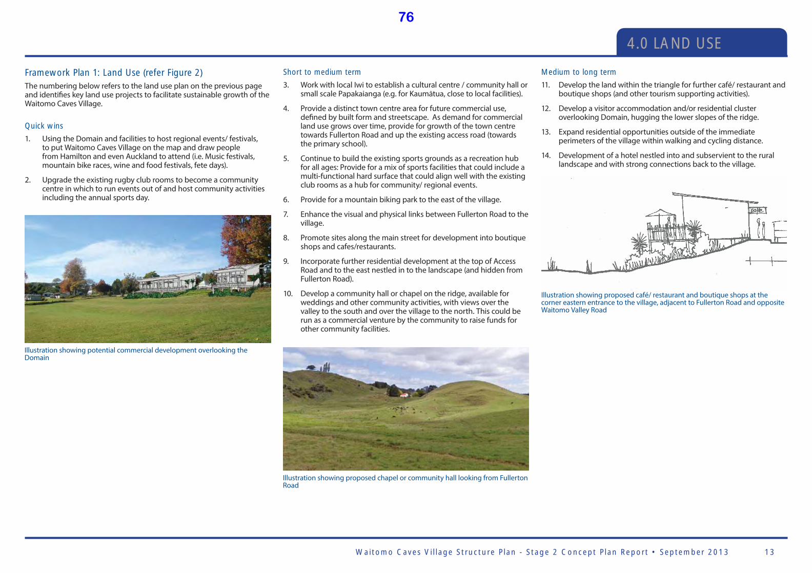
Waitomo Caves Vi l lage Structure P lan - Stage 2 Concept P lan Report • September 2013 13
Illustration showing proposed chapel or community hall looking from Fullerton Road
Illustration showing potential commercial development overlooking the Domain
Framework Plan 1: Land Use (refer Figure 2)The numbering below refers to the land use plan on the previous page and identifi es key land use projects to facilitate sustainable growth of the Waitomo Caves Village.
Quick wins
1. Using the Domain and facilities to host regional events/ festivals, to put Waitomo Caves Village on the map and draw people from Hamilton and even Auckland to attend (i.e. Music festivals, mountain bike races, wine and food festivals, fete days).
2. Upgrade the existing rugby club rooms to become a community centre in which to run events out of and host community activities including the annual sports day.
Short to medium term
3. Work with local Iwi to establish a cultural centre / community hall or small scale Papakaianga (e.g. for Kaumātua, close to local facilities).
4. Provide a distinct town centre area for future commercial use, defi ned by built form and streetscape. As demand for commercial land use grows over time, provide for growth of the town centre towards Fullerton Road and up the existing access road (towards the primary school).
5. Continue to build the existing sports grounds as a recreation hub for all ages: Provide for a mix of sports facilities that could include a multi-functional hard surface that could align well with the existing club rooms as a hub for community/ regional events.
6. Provide for a mountain biking park to the east of the village.
7. Enhance the visual and physical links between Fullerton Road to the village.
8. Promote sites along the main street for development into boutique shops and cafes/restaurants.
9. Incorporate further residential development at the top of Access Road and to the east nestled in to the landscape (and hidden from Fullerton Road).
10. Develop a community hall or chapel on the ridge, available for weddings and other community activities, with views over the valley to the south and over the village to the north. This could be run as a commercial venture by the community to raise funds for other community facilities.
Medium to long term
11. Develop the land within the triangle for further café/ restaurant and boutique shops (and other tourism supporting activities).
12. Develop a visitor accommodation and/or residential cluster overlooking Domain, hugging the lower slopes of the ridge.
13. Expand residential opportunities outside of the immediate perimeters of the village within walking and cycling distance.
14. Development of a hotel nestled into and subservient to the rural landscape and with strong connections back to the village.
Illustration showing proposed café/ restaurant and boutique shops at the corner eastern entrance to the village, adjacent to Fullerton Road and opposite Waitomo Valley Road
4.0 LAND USE
76
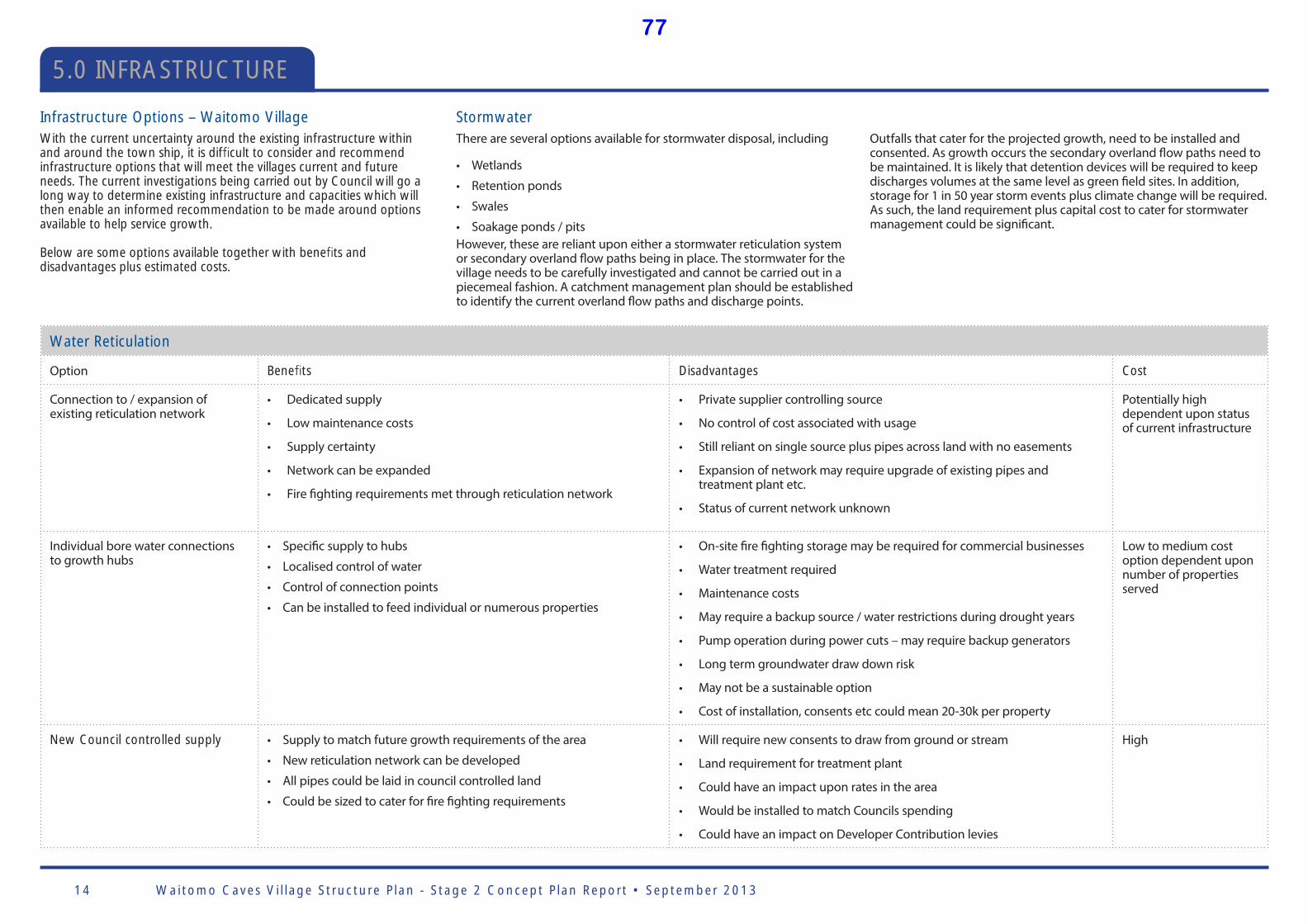
Waitomo Caves Vi l lage Structure P lan - Stage 2 Concept P lan Report • September 201314
5.0 INFRASTRUCTURE
Water Reticulation
Option Bene ts Disadvantages Cost
Connection to / expansion of existing reticulation network
• Dedicated supply
• Low maintenance costs
• Supply certainty
• Network can be expanded
• Fire fi ghting requirements met through reticulation network
• Private supplier controlling source
• No control of cost associated with usage
• Still reliant on single source plus pipes across land with no easements
• Expansion of network may require upgrade of existing pipes and treatment plant etc.
• Status of current network unknown
Potentially high dependent upon status of current infrastructure
Individual bore water connections to growth hubs
• Specifi c supply to hubs
• Localised control of water
• Control of connection points
• Can be installed to feed individual or numerous properties
• On-site fi re fi ghting storage may be required for commercial businesses
• Water treatment required
• Maintenance costs
• May require a backup source / water restrictions during drought years
• Pump operation during power cuts – may require backup generators
• Long term groundwater draw down risk
• May not be a sustainable option
• Cost of installation, consents etc could mean 20-30k per property
Low to medium cost option dependent upon number of properties served
New Council controlled supply • Supply to match future growth requirements of the area
• New reticulation network can be developed
• All pipes could be laid in council controlled land
• Could be sized to cater for fi re fi ghting requirements
• Will require new consents to draw from ground or stream
• Land requirement for treatment plant
• Could have an impact upon rates in the area
• Would be installed to match Councils spending
• Could have an impact on Developer Contribution levies
High
Infrastructure Options – Waitomo VillageWith the current uncertainty around the existing infrastructure within and around the town ship, it is dif cult to consider and recommend infrastructure options that will meet the villages current and future needs. The current investigations being carried out by Council will go a long way to determine existing infrastructure and capacities which will then enable an informed recommendation to be made around options available to help service growth.
Below are some options available together with bene ts and disadvantages plus estimated costs.
StormwaterThere are several options available for stormwater disposal, including
• Wetlands
• Retention ponds
• Swales
• Soakage ponds / pitsHowever, these are reliant upon either a stormwater reticulation system or secondary overland fl ow paths being in place. The stormwater for the village needs to be carefully investigated and cannot be carried out in a piecemeal fashion. A catchment management plan should be established to identify the current overland fl ow paths and discharge points.
Outfalls that cater for the projected growth, need to be installed and consented. As growth occurs the secondary overland fl ow paths need to be maintained. It is likely that detention devices will be required to keep discharges volumes at the same level as green fi eld sites. In addition, storage for 1 in 50 year storm events plus climate change will be required. As such, the land requirement plus capital cost to cater for stormwater management could be signifi cant.
77
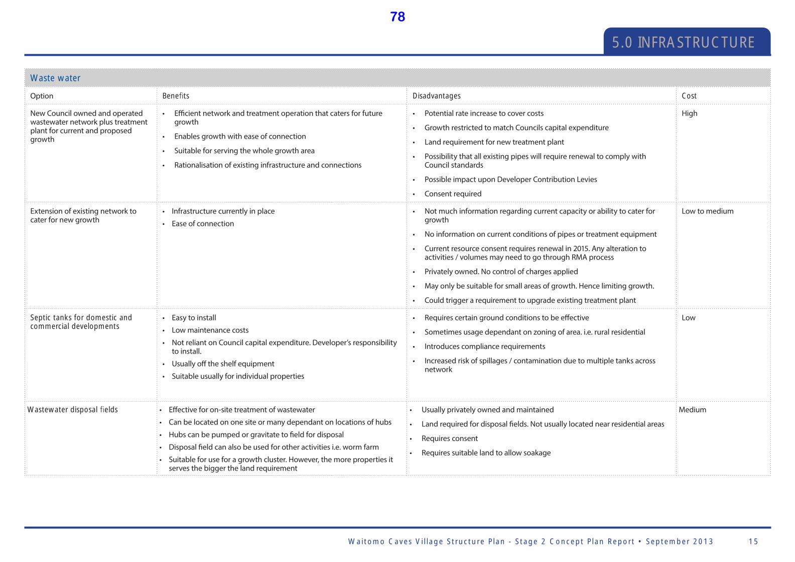
Waitomo Caves Vi l lage Structure P lan - Stage 2 Concept P lan Report • September 2013 15
5.0 INFRASTRUCTURE
Waste water
Option Bene ts Disadvantages Cost
New Council owned and operated wastewater network plus treatment plant for current and proposed growth
• Effi cient network and treatment operation that caters for future growth
• Enables growth with ease of connection
• Suitable for serving the whole growth area
• Rationalisation of existing infrastructure and connections
• Potential rate increase to cover costs
• Growth restricted to match Councils capital expenditure
• Land requirement for new treatment plant
• Possibility that all existing pipes will require renewal to comply with Council standards
• Possible impact upon Developer Contribution Levies
• Consent required
High
Extension of existing network to cater for new growth
• Infrastructure currently in place
• Ease of connection
• Not much information regarding current capacity or ability to cater for growth
• No information on current conditions of pipes or treatment equipment
• Current resource consent requires renewal in 2015. Any alteration to activities / volumes may need to go through RMA process
• Privately owned. No control of charges applied
• May only be suitable for small areas of growth. Hence limiting growth.
• Could trigger a requirement to upgrade existing treatment plant
Low to medium
Septic tanks for domestic and commercial developments
• Easy to install
• Low maintenance costs
• Not reliant on Council capital expenditure. Developer’s responsibility to install.
• Usually off the shelf equipment
• Suitable usually for individual properties
• Requires certain ground conditions to be eff ective
• Sometimes usage dependant on zoning of area. i.e. rural residential
• Introduces compliance requirements
• Increased risk of spillages / contamination due to multiple tanks across network
Low
Wastewater disposal elds • Eff ective for on-site treatment of wastewater
• Can be located on one site or many dependant on locations of hubs
• Hubs can be pumped or gravitate to fi eld for disposal
• Disposal fi eld can also be used for other activities i.e. worm farm
• Suitable for use for a growth cluster. However, the more properties it serves the bigger the land requirement
• Usually privately owned and maintained
• Land required for disposal fi elds. Not usually located near residential areas
• Requires consent
• Requires suitable land to allow soakage
Medium
78
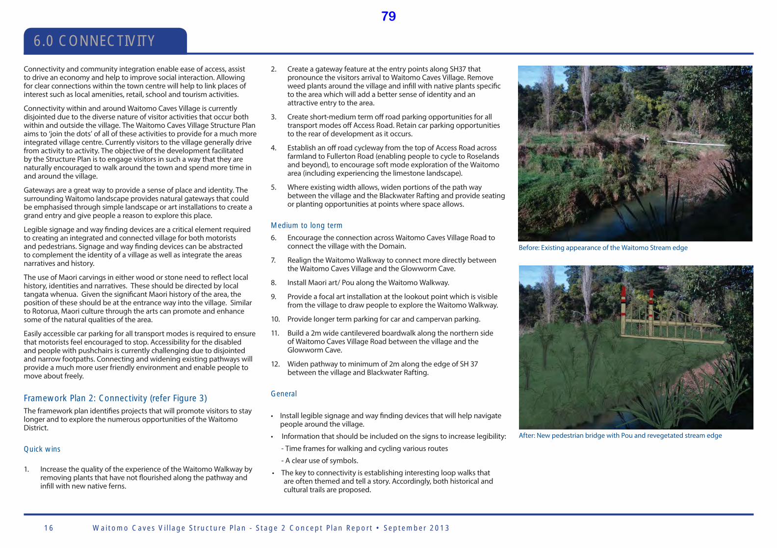
Waitomo Caves Vi l lage Structure P lan - Stage 2 Concept P lan Report • September 201316
2. Create a gateway feature at the entry points along SH37 that pronounce the visitors arrival to Waitomo Caves Village. Remove weed plants around the village and infi ll with native plants specifi c to the area which will add a better sense of identity and an attractive entry to the area.
3. Create short-medium term off road parking opportunities for all transport modes off Access Road. Retain car parking opportunities to the rear of development as it occurs.
4. Establish an off road cycleway from the top of Access Road across farmland to Fullerton Road (enabling people to cycle to Roselands and beyond), to encourage soft mode exploration of the Waitomo area (including experiencing the limestone landscape).
5. Where existing width allows, widen portions of the path way between the village and the Blackwater Rafting and provide seating or planting opportunities at points where space allows.
Medium to long term
6. Encourage the connection across Waitomo Caves Village Road to connect the village with the Domain.
7. Realign the Waitomo Walkway to connect more directly between the Waitomo Caves Village and the Glowworm Cave.
8. Install Maori art/ Pou along the Waitomo Walkway.
9. Provide a focal art installation at the lookout point which is visible from the village to draw people to explore the Waitomo Walkway.
10. Provide longer term parking for car and campervan parking.
11. Build a 2m wide cantilevered boardwalk along the northern side of Waitomo Caves Village Road between the village and the Glowworm Cave.
12. Widen pathway to minimum of 2m along the edge of SH 37 between the village and Blackwater Rafting.
General
• Install legible signage and way fi nding devices that will help navigate people around the village.
• Information that should be included on the signs to increase legibility:
- Time frames for walking and cycling various routes
- A clear use of symbols.
• The key to connectivity is establishing interesting loop walks that are often themed and tell a story. Accordingly, both historical and cultural trails are proposed.
Precedent image/ sketch/ diagram
Connectivity and community integration enable ease of access, assist to drive an economy and help to improve social interaction. Allowing for clear connections within the town centre will help to link places of interest such as local amenities, retail, school and tourism activities.
Connectivity within and around Waitomo Caves Village is currently disjointed due to the diverse nature of visitor activities that occur both within and outside the village. The Waitomo Caves Village Structure Plan aims to ‘join the dots’ of all of these activities to provide for a much more integrated village centre. Currently visitors to the village generally drive from activity to activity. The objective of the development facilitated by the Structure Plan is to engage visitors in such a way that they are naturally encouraged to walk around the town and spend more time in and around the village.
Gateways are a great way to provide a sense of place and identity. The surrounding Waitomo landscape provides natural gateways that could be emphasised through simple landscape or art installations to create a grand entry and give people a reason to explore this place.
Legible signage and way fi nding devices are a critical element required to creating an integrated and connected village for both motorists and pedestrians. Signage and way fi nding devices can be abstracted to complement the identity of a village as well as integrate the areas narratives and history.
The use of Maori carvings in either wood or stone need to refl ect local history, identities and narratives. These should be directed by local tangata whenua. Given the signifi cant Maori history of the area, the position of these should be at the entrance way into the village. Similar to Rotorua, Maori culture through the arts can promote and enhance some of the natural qualities of the area.
Easily accessible car parking for all transport modes is required to ensure that motorists feel encouraged to stop. Accessibility for the disabled and people with pushchairs is currently challenging due to disjointed and narrow footpaths. Connecting and widening existing pathways will provide a much more user friendly environment and enable people to move about freely.
Framework Plan 2: Connectivity (refer Figure 3)The framework plan identifi es projects that will promote visitors to stay longer and to explore the numerous opportunities of the Waitomo District.
Quick wins
1. Increase the quality of the experience of the Waitomo Walkway by removing plants that have not fl ourished along the pathway and infi ll with new native ferns.
6.0 CONNECTIVITY
After: New pedestrian bridge with Pou and revegetated stream edge
Before: Existing appearance of the Waitomo Stream edge
79

Waitomo Caves Vi l lage Structure P lan - Stage 2 Concept P lan Report • September 2013 17
6.0 CONNECTIVITY
Potential ‘Historical Walk’ taking the path user past the chapel, Waitomo Caves Hotel, Waitomo Glowworm Cave and back to the village via the Waitomo Stream Walkway
Potential ‘Cultural Walk’ (to be mapped with TWCT)
1.2.
2.
2.3.
4.
5.
6.
7.
9.
10.
11.
12.
8.
Waitomo Caves Domain
Waitomo Glowworm Cave Waitomo Caves
Hotel
Waitomo Caves Discovery Centre
WAITOMO CAVES ROAD
Waitomo Caves Top 10 Holiday Park
Waitomo General Store
WAIT
OMO V
ALL
EY R
OA
D
TE ANGA ROAD
WAITOMO STR
EA
M
FULL
ERTO
N R
OA
D
Figure 3: Framework Plan 2: Connectivity , illustrating proposed key connectivity moves at wider village scale
Consented Development Site - The Rock
Potential cycle tracks (to be mapped with TWCT)
80
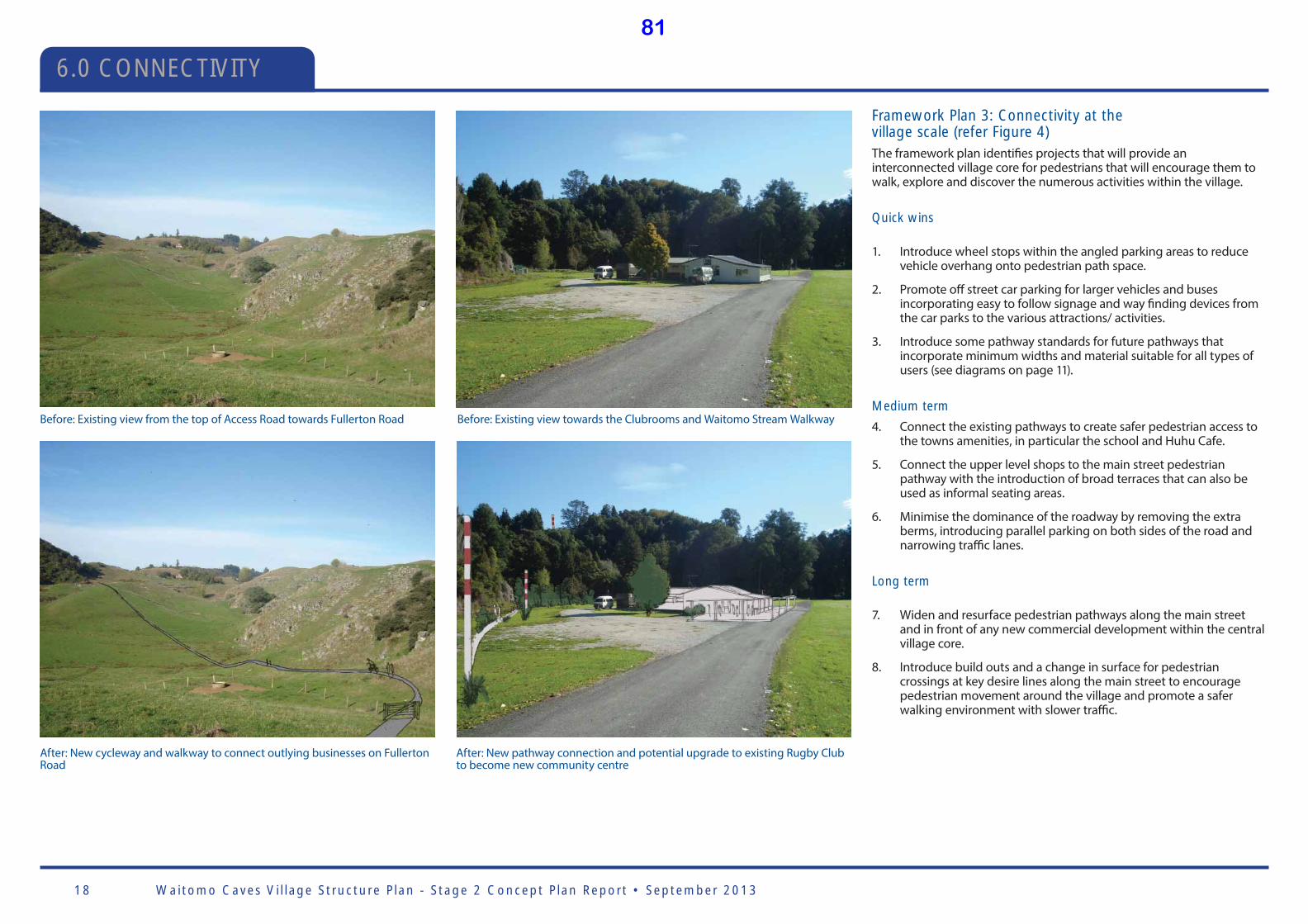
Waitomo Caves Vi l lage Structure P lan - Stage 2 Concept P lan Report • September 201318
6.0 CONNECTIVITY
After: New cycleway and walkway to connect outlying businesses on Fullerton Road
Before: Existing view from the top of Access Road towards Fullerton Road Before: Existing view towards the Clubrooms and Waitomo Stream Walkway
After: New pathway connection and potential upgrade to existing Rugby Club to become new community centre
Framework Plan 3: Connectivity at the village scale (refer Figure 4)The framework plan identifi es projects that will provide an interconnected village core for pedestrians that will encourage them to walk, explore and discover the numerous activities within the village.
Quick wins
1. Introduce wheel stops within the angled parking areas to reduce vehicle overhang onto pedestrian path space.
2. Promote off street car parking for larger vehicles and buses incorporating easy to follow signage and way fi nding devices from the car parks to the various attractions/ activities.
3. Introduce some pathway standards for future pathways that incorporate minimum widths and material suitable for all types of users (see diagrams on page 11).
Medium term
4. Connect the existing pathways to create safer pedestrian access to the towns amenities, in particular the school and Huhu Cafe.
5. Connect the upper level shops to the main street pedestrian pathway with the introduction of broad terraces that can also be used as informal seating areas.
6. Minimise the dominance of the roadway by removing the extra berms, introducing parallel parking on both sides of the road and narrowing traffi c lanes.
Long term
7. Widen and resurface pedestrian pathways along the main street and in front of any new commercial development within the central village core.
8. Introduce build outs and a change in surface for pedestrian crossings at key desire lines along the main street to encourage pedestrian movement around the village and promote a safer walking environment with slower traffi c.
81

Waitomo Caves Vi l lage Structure P lan - Stage 2 Concept P lan Report • September 2013 19
6.0 CONNECTIVITY
Existing footpaths
0.8m 3.0m 3.0m 1.8m min
Proposed footpaths: Retail area Proposed footpaths: Other areas Proposed cycleway Proposed off -road path
1.8m
Proposed typical standard footpaths widths for Waitomo Caves Village
Figure 4: Framework Plan 3: Connectivity at the village scale, illustrating proposed key connectivity moves at the local village scale
3.
ZOOMED IN CONNECTIVITY1. 5.
6.7.
8.8.
2. 4.
2.
2.
Waitomo Caves Domain
Waitomo Glowworm Cave
Waitomo Caves Hotel
Waitomo Caves Discovery Centre WAITOMO CAVES ROAD
Waitomo Caves Top 10 Holiday Park
Consented Development Site - The Rock
Waitomo General Store
WAIT
OMO V
ALL
EY R
OA
D
TE ANGA ROAD
FULL
ERTO
N R
OA
D
WAITOMO STREAM
Example of steps and terracing for the Main street to connect the buildings to the street while also providing informal seating
82
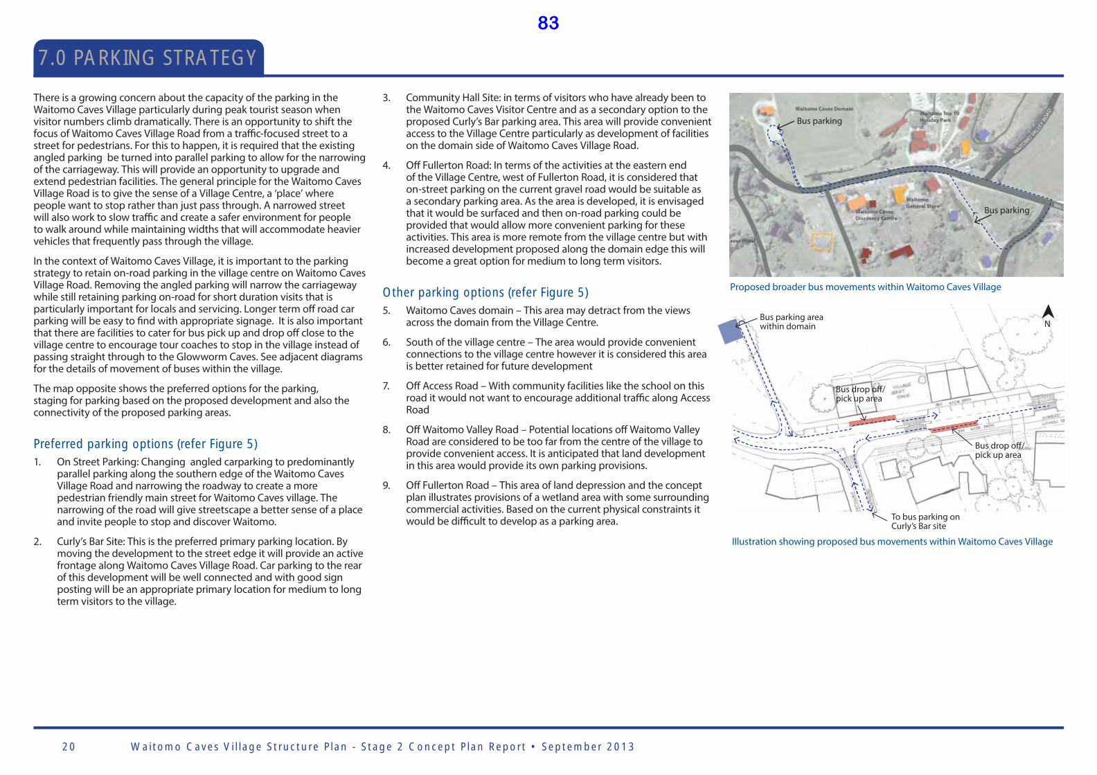
Waitomo Caves Vi l lage Structure P lan - Stage 2 Concept P lan Report • September 201320
7.0 PARKING STRATEGY
There is a growing concern about the capacity of the parking in the Waitomo Caves Village particularly during peak tourist season when visitor numbers climb dramatically. There is an opportunity to shift the focus of Waitomo Caves Village Road from a traffi c-focused street to a street for pedestrians. For this to happen, it is required that the existing angled parking be turned into parallel parking to allow for the narrowing of the carriageway. This will provide an opportunity to upgrade and extend pedestrian facilities. The general principle for the Waitomo Caves Village Road is to give the sense of a Village Centre, a ‘place’ where people want to stop rather than just pass through. A narrowed street will also work to slow traffi c and create a safer environment for people to walk around while maintaining widths that will accommodate heavier vehicles that frequently pass through the village.
In the context of Waitomo Caves Village, it is important to the parking strategy to retain on-road parking in the village centre on Waitomo Caves Village Road. Removing the angled parking will narrow the carriageway while still retaining parking on-road for short duration visits that is particularly important for locals and servicing. Longer term off road car parking will be easy to fi nd with appropriate signage. It is also important that there are facilities to cater for bus pick up and drop off close to the village centre to encourage tour coaches to stop in the village instead of passing straight through to the Glowworm Caves. See adjacent diagrams for the details of movement of buses within the village.
The map opposite shows the preferred options for the parking, staging for parking based on the proposed development and also the connectivity of the proposed parking areas.
Preferred parking options (refer Figure 5)1. On Street Parking: Changing angled carparking to predominantly
parallel parking along the southern edge of the Waitomo Caves Village Road and narrowing the roadway to create a more pedestrian friendly main street for Waitomo Caves village. The narrowing of the road will give streetscape a better sense of a place and invite people to stop and discover Waitomo.
2. Curly’s Bar Site: This is the preferred primary parking location. By moving the development to the street edge it will provide an active frontage along Waitomo Caves Village Road. Car parking to the rear of this development will be well connected and with good sign posting will be an appropriate primary location for medium to long term visitors to the village.
3. Community Hall Site: in terms of visitors who have already been to the Waitomo Caves Visitor Centre and as a secondary option to the proposed Curly’s Bar parking area. This area will provide convenient access to the Village Centre particularly as development of facilities on the domain side of Waitomo Caves Village Road.
4. Off Fullerton Road: In terms of the activities at the eastern end of the Village Centre, west of Fullerton Road, it is considered that on-street parking on the current gravel road would be suitable as a secondary parking area. As the area is developed, it is envisaged that it would be surfaced and then on-road parking could be provided that would allow more convenient parking for these activities. This area is more remote from the village centre but with increased development proposed along the domain edge this will become a great option for medium to long term visitors.
Other parking options (refer Figure 5)5. Waitomo Caves domain – This area may detract from the views
across the domain from the Village Centre.
6. South of the village centre – The area would provide convenient connections to the village centre however it is considered this area is better retained for future development
7. Off Access Road – With community facilities like the school on this road it would not want to encourage additional traffi c along Access Road
8. Off Waitomo Valley Road – Potential locations off Waitomo Valley Road are considered to be too far from the centre of the village to provide convenient access. It is anticipated that land development in this area would provide its own parking provisions.
9. Off Fullerton Road – This area of land depression and the concept plan illustrates provisions of a wetland area with some surrounding commercial activities. Based on the current physical constraints it would be diffi cult to develop as a parking area.
Bus drop off / pick up area
Bus drop off / pick up area
To bus parking on Curly’s Bar site
N Bus parking area within domain
Illustration showing proposed bus movements within Waitomo Caves Village
Proposed broader bus movements within Waitomo Caves Village
Bus parking
Bus parking
83
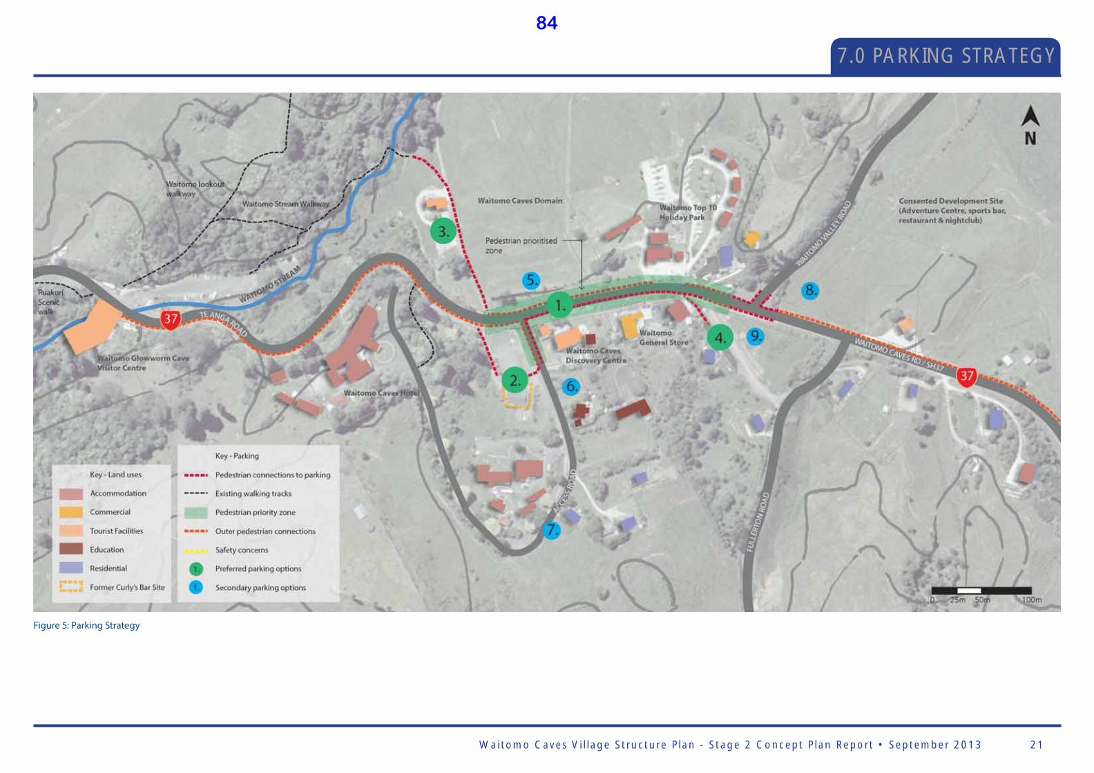
Waitomo Caves Vi l lage Structure P lan - Stage 2 Concept P lan Report • September 2013 21
7.0 PARKING STRATEGY
Figure 5: Parking Strategy
84

Waitomo Caves Vi l lage Structure P lan - Stage 2 Concept P lan Report • September 201322
8.0 GATEWAYS
Existing gateway experience along Waitomo Valley Road:
Illustrations 1 and 2 show the existing situation that is experienced upon the approach to Waitomo Caves Village along Waitomo Valley Road. This is an increasingly popular route for visitors travelling to the area.
The roadway provides some challenging aspects in creating a gateway that connects across Waitomo Valley Road. The narrow carriageway is enclosed by a steep embankment that is covered with groundcover weed species and some over grown vegetation at the top of the bank. To the
left of the road is a fence very close to the edge of seal but expansive views across the farmland towards the recently felled forest on the hill are very evident.
When travelling along the road - you are drawn to look towards the farmland therefore it is important to retain and enhance these views to provide visual amenity for visitors to the village.
Farmland
Wetland Park
Existing cross section Waitomo Valley Road
Proposed cross section Waitomo Valley Road
Proposed gateway experience along Waitomo Valley Road:
The illustrations above show the proposed views that will be seen by visitors travelling along the Waitomo Valley Road on the approach to the village. The proposed wetland views will display an inviting walkway and boardwalk, extensive native planting and local Maori Art. This will be complemented by ‘destination views’ of local shops at the end of Waitomo Valley Road .
Due to the narrow carriageway and existing terrain to the west there is little opportunity to create the link across to the west of Waitomo Valley Road however at the corner of Waitomo Caves Village Road a change in surfacing and a pedestrian link across Waitomo Valley Road will provide a physical cue for motorists they are entering a village area, inviting them to slow down and visit the village.
1.
1.
2.
2.
Experiencing Waitomo Caves Village and the surrounding environmentVisitors and locals often experience the entry to Waitomo Caves Village and the surrounding area from a number of public roads - either by vehicle, coach, on foot, or cycling. It is important when devising the masterplan that all of the entries to the village provide a sense of arrival that is memorable for visitors.
The existing experience of the area is illustrated in the following serial visioning images (annotated below), with the future vision for the area illustrated on within the serial images on the adjoining page.
Existing experience
Proposed future experience
Serial visioning key
1.
Cross section A-A’2.
85
Waitomo Caves Vi l lage Structure P lan - Stage 2 Concept P lan Report • September 2013 23
(Purposely left blank)
86
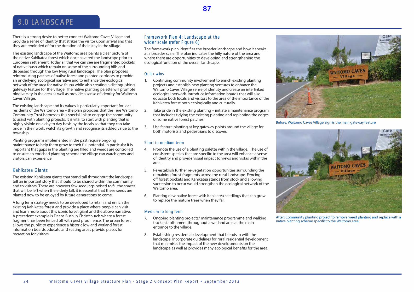
Waitomo Caves Vi l lage Structure P lan - Stage 2 Concept P lan Report • September 201324
9.0 LANDSCAPE
There is a strong desire to better connect Waitomo Caves Village and provide a sense of identity that strikes the visitor upon arrival and that they are reminded of for the duration of their stay in the village.
The existing landscape of the Waitomo area paints a clear picture of the native Kahikatea forest which once covered the landscape prior to European settlement. Today all that we can see are fragmented pockets of native bush which remain on some of the surrounding hills and dispersed through the low lying rural landscape. The plan proposes reintroducing patches of native forest and planted corridors to provide an underlying ecological narrative and to enhance the ecological network of the area for native fauna while also creating a distinguishing gateway feature for the village. The native planting palette will promote biodiversity in the area as well as provide a sense of identity for Waitomo Caves Village.
The existing landscape and its values is particularly important for local residents of the Waitomo area – the plan proposes that the Tere Waitomo Community Trust harnesses this special link to engage the community to assist with planting projects. It is vital to start with planting that is highly visible on a day to day basis by the locals so that they can take pride in their work, watch its growth and recognise its added value to the township.
Planting programs implemented in the past require ongoing maintenance to help them grow to their full potential. In particular it is important that gaps in the planting are fi lled and weeds are controlled to ensure an enriched planting scheme the village can watch grow and visitors can experience.
Kahikatea Giants The existing Kahikatea giants that stand tall throughout the landscape tell an important story that should to be shared within the community and to visitors. There are however few seedlings poised to fi ll the spaces that will be left when the elderly fall, it is essential that these seeds are planted now to be enjoyed by future generations to come.
A long term strategy needs to be developed to retain and enrich the existing Kahikatea forest and provide a place where people can visit and learn more about this iconic forest giant and the above narrative. A precedent example is Deans Bush in Christchurch where a forest fragment has been fenced off with pest proof fence. The urban forest allows the public to experience a historic lowland wetland forest. Information boards educate and seating areas provide places for recreation for visitors.
Before: Waitomo Caves Village Sign is the main gateway feature
After: Community planting project to remove weed planting and replace with a native planting scheme specifi c to the Waitomo area
Framework Plan 4: Landscape at the wider scale (refer Figure 6)The framework plan identifi es the broader landscape and how it speaks at a broader scale. The plan indicates the hilly nature of the area and where there are opportunities to developing and strengthening the ecological function of the overall landscape.
Quick wins
1. Continuing community involvement to enrich existing planting projects and establish new planting ventures to enhance the Waitomo Caves Village sense of identity and create an interlinked ecological network. Introduce information boards that will also educate both locals and visitors to the area of the importance of the Kahikatea forest both ecologically and culturally.
2. Take pride in the existing planting – initiate a maintenance program that includes tidying the existing planting and replanting the edges of some native forest patches.
3. Use feature planting at key gateway points around the village for both motorists and pedestrians to discover.
Short to medium term
4. Promote the use of a planting palette within the village. The use of consistent species that are specifi c to the area will enhance a sense of identity and provide visual impact to views and vistas within the area.
5. Re-establish further re-vegetation opportunities surrounding the remaining forest fragments across the rural landscape. Fencing off forest pockets and Kahikatea stands from stock and allowing succession to occur would strengthen the ecological network of the Waitomo area.
6. Planting new native forest with Kahikatea seedlings that can grow to replace the mature trees when they fall.
Medium to long term
7. Ongoing planting projects/ maintenance programme and walking track establishment throughout a wetland area at the main entrance to the village.
8. Establishing residential development that blends in with the landscape. Incorporate guidelines for rural residential development that minimises the impact of the new developments on the landscape as well as provides many ecological benefi ts for the area.
87
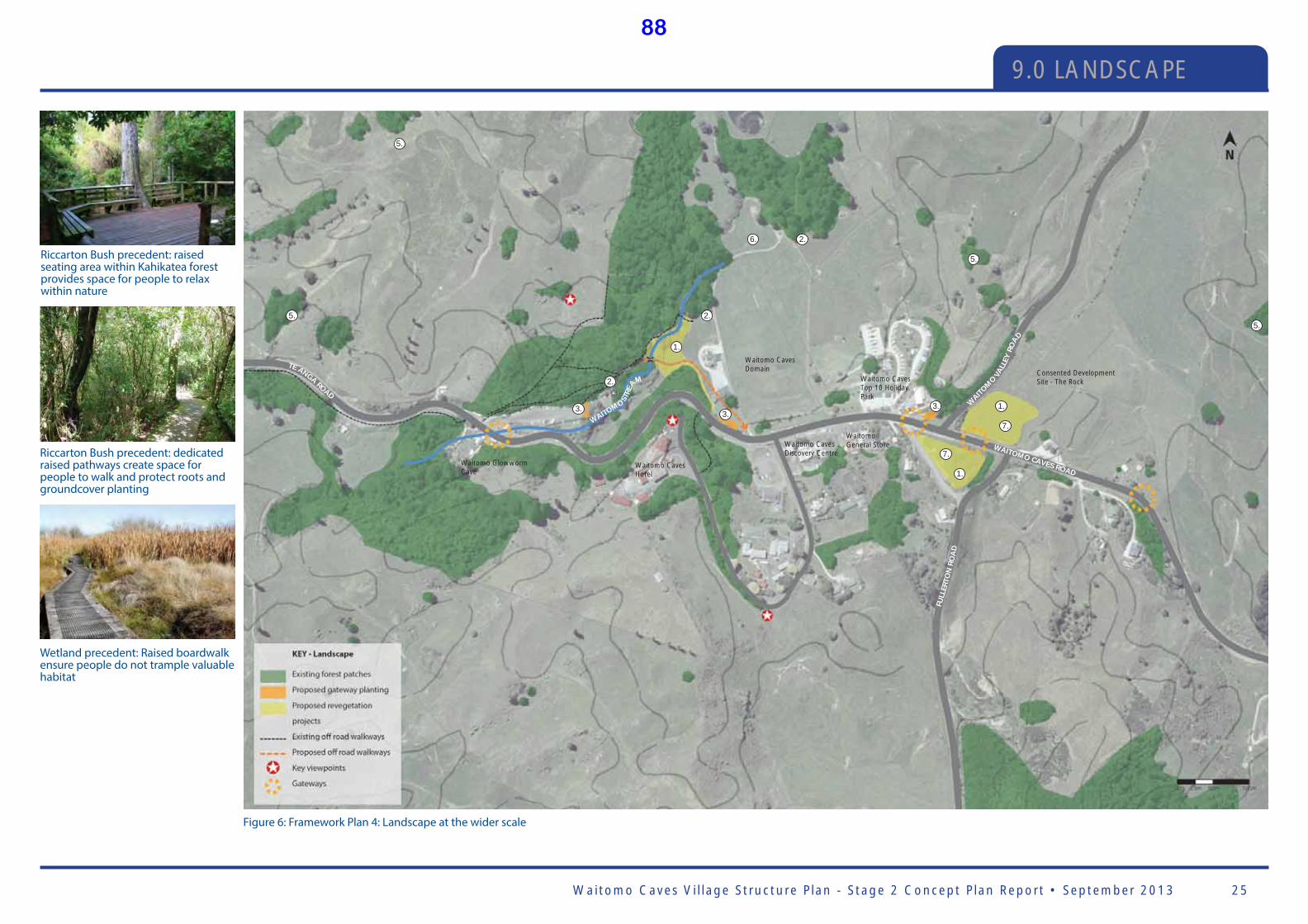
Waitomo Caves Vi l lage Structure P lan - Stage 2 Concept P lan Report • September 2013 25
9.0 LANDSCAPE
1.
7.
7.
1.
1.
2.
5.5.
5.
5.
2.6.
2.
3. 3.3.
Waitomo Caves Domain
Waitomo Glowworm Cave
Waitomo Caves Hotel
Waitomo Caves Discovery Centre
WAITOMO CAVES ROAD
Waitomo Caves Top 10 Holiday Park
Waitomo General Store
TE ANGA ROAD
WAITOMO STR
EA
M
FULL
ERTO
N R
OA
D
Consented Development Site - The Rock
WAIT
OMO V
ALL
EY R
OA
D
Riccarton Bush precedent: raised seating area within Kahikatea forest provides space for people to relax within nature
Riccarton Bush precedent: dedicated raised pathways create space for people to walk and protect roots and groundcover planting
Wetland precedent: Raised boardwalk ensure people do not trample valuable habitat
Figure 6: Framework Plan 4: Landscape at the wider scale
88
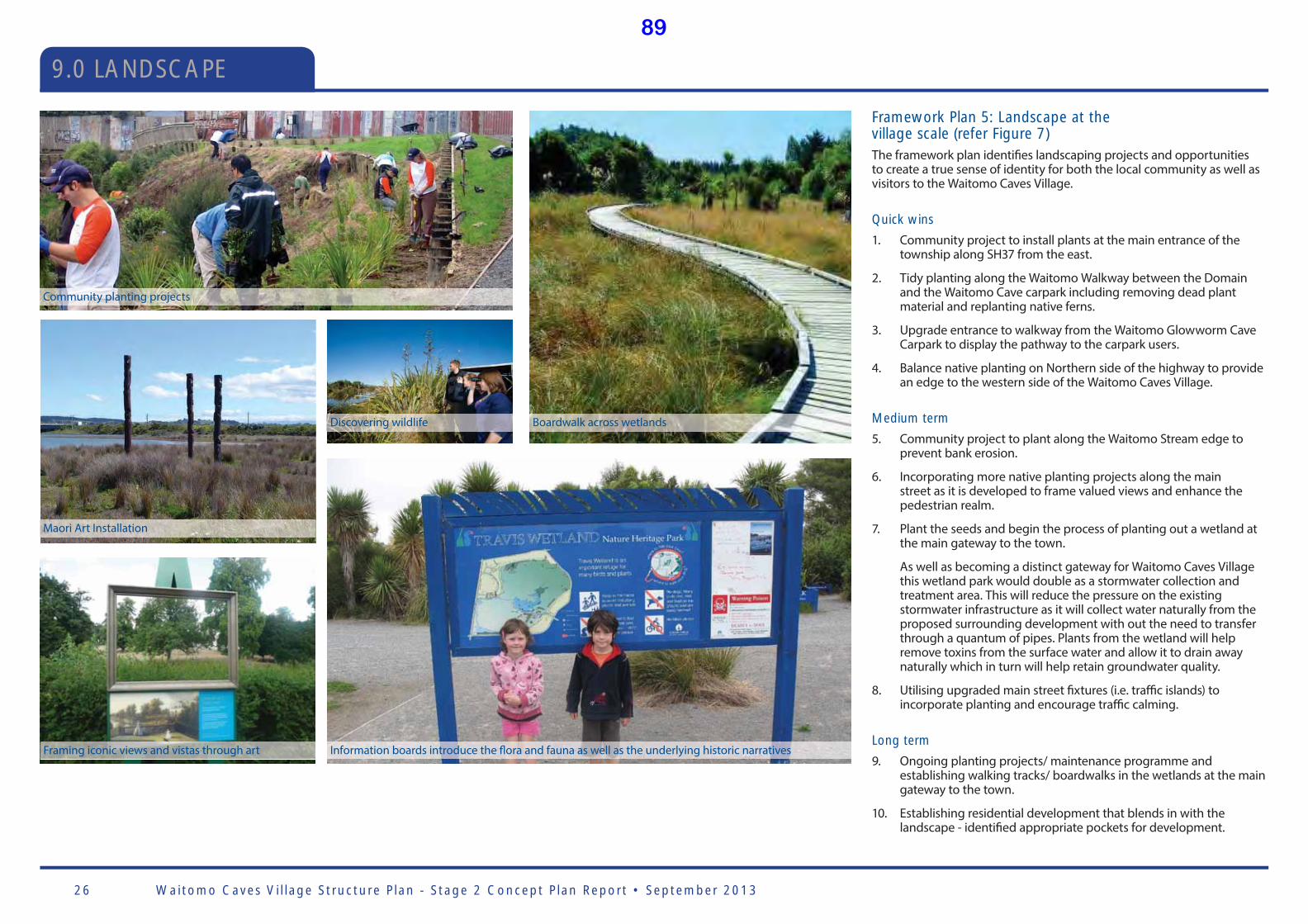
Waitomo Caves Vi l lage Structure P lan - Stage 2 Concept P lan Report • September 201326
9.0 LANDSCAPE
Framework Plan 5: Landscape at the village scale (refer Figure 7)The framework plan identifi es landscaping projects and opportunities to create a true sense of identity for both the local community as well as visitors to the Waitomo Caves Village.
Quick wins
1. Community project to install plants at the main entrance of the township along SH37 from the east.
2. Tidy planting along the Waitomo Walkway between the Domain and the Waitomo Cave carpark including removing dead plant material and replanting native ferns.
3. Upgrade entrance to walkway from the Waitomo Glowworm Cave Carpark to display the pathway to the carpark users.
4. Balance native planting on Northern side of the highway to provide an edge to the western side of the Waitomo Caves Village.
Medium term
5. Community project to plant along the Waitomo Stream edge to prevent bank erosion.
6. Incorporating more native planting projects along the main street as it is developed to frame valued views and enhance the pedestrian realm.
7. Plant the seeds and begin the process of planting out a wetland at the main gateway to the town.
As well as becoming a distinct gateway for Waitomo Caves Village this wetland park would double as a stormwater collection and treatment area. This will reduce the pressure on the existing stormwater infrastructure as it will collect water naturally from the proposed surrounding development with out the need to transfer through a quantum of pipes. Plants from the wetland will help remove toxins from the surface water and allow it to drain away naturally which in turn will help retain groundwater quality.
8. Utilising upgraded main street fi xtures (i.e. traffi c islands) to incorporate planting and encourage traffi c calming.
Long term
9. Ongoing planting projects/ maintenance programme and establishing walking tracks/ boardwalks in the wetlands at the main gateway to the town.
10. Establishing residential development that blends in with the landscape - identifi ed appropriate pockets for development.
Boardwalk across wetlandsDiscovering wildlife
Community planting projects
Maori Art Installation
Framing iconic views and vistas through art Information boards introduce the fl ora and fauna as well as the underlying historic narratives
89
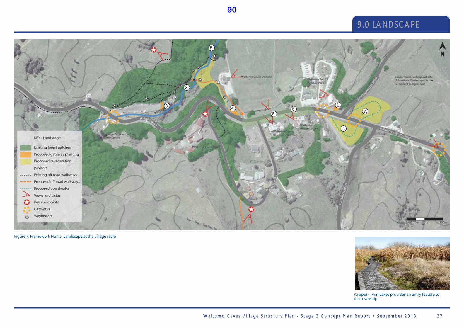
Waitomo Caves Vi l lage Structure P lan - Stage 2 Concept P lan Report • September 2013 27
9.0 LANDSCAPE
2.
5.
3. 4. 6.8.
7.
7.1.
Kaiapoi - Twin Lakes provides an entry feature to the township
Figure 7: Framework Plan 5: Landscape at the village scale
90
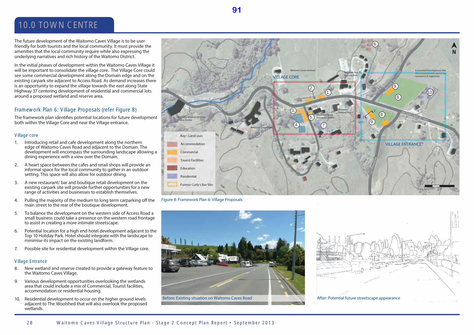
Waitomo Caves Vi l lage Structure P lan - Stage 2 Concept P lan Report • September 201328
10.0 TOWN CENTRE
After: Potential future streetscape appearanceBefore: Existing situation on Waitomo Caves Road
E
E’
The future development of the Waitomo Caves Village is to be user friendly for both tourists and the local community. It must provide the amenities that the local community require while also expressing the underlying narratives and rich history of the Waitomo District.
In the initial phases of development within the Waitomo Caves Village it will be important to consolidate the village core. The Village Core could see some commercial development along the Domain edge and on the existing carpark site adjacent to Access Road. As demand increases there is an opportunity to expand the village towards the east along State Highway 37 centering development of residential and commercial lots around a proposed wetland and reserve area.
Framework Plan 6: Village Proposals (refer Figure 8)The framework plan identifi es potential locations for future development both within the Village Core and near the Village entrance.
Village core
1. Introducing retail and cafe development along the northern edge of Waitomo Caves Road and adjacent to the Domain. The development will encompass the surrounding landscape allowing a dining experience with a view over the Domain.
2. A heart space between the cafes and retail shops will provide an informal space for the local community to gather in an outdoor setting. This space will also allow for outdoor dining.
3. A new restaurant/ bar and boutique retail development on the existing carpark site will provide further opportunities for a new range of activities and businesses to establish themselves.
4. Pulling the majority of the medium to long term carparking off the main street to the rear of the boutique development.
5. To balance the development on the western side of Access Road a small business could take a presence on the western road frontage to assist in creating a more intimate streetscape.
6. Potential location for a high end hotel development adjacent to the Top 10 Holiday Park. Hotel should integrate with the landscape to minimise its impact on the existing landform.
7. Possible site for residential development within the Village core.
Village Entrance
8. New wetland and reserve created to provide a gateway feature to the Waitomo Caves Village.
9. Various development opportunities overlooking the wetlands area that could include a mix of Commercial, Tourist facilities, accommodation or residential housing.
10. Residential development to occur on the higher ground levels adjacent to The Woolshed that will also overlook the proposed wetlands.
VILLAGE CORE
VILLAGE ENTRANCE
1.2.
3.
4.
5.
7.
6.
8.
8.9.
9.10.
Figure 8: Framework Plan 6: Village Proposals
91
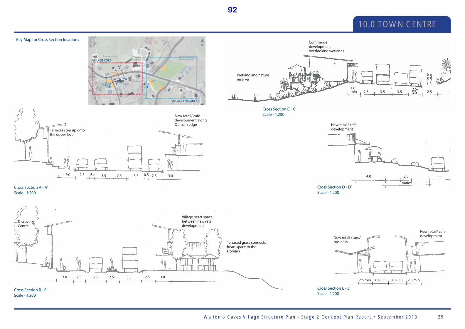
Waitomo Caves Vi l lage Structure P lan - Stage 2 Concept P lan Report • September 2013 29
10.0 TOWN CENTRE
Cross Section A - A’Scale - 1:200
Cross Section B - B’Scale - 1:200
New retail/ cafe developmentNew retail store/
business
3.0 - 3.5 3.0 - 3.52.5 min 2.5 min
Cross Section E - E’Scale - 1:200
Key Map for Cross Section locations
3.0
New retail/ cafe development along Domain edge
Terraces step up onto the upper level
Discovery Centre
Village heart space between new retail development
Terraced grass connects heart space to the Domain
2.3 3.5
3.5
Cross Section D - D’Scale - 1:200
New retail/ cafe development
2.04.0
varies
2.5 2.53.0 3.0
2.5
2.5
3.5
3.5
Cross Section C - C’Scale - 1:200
Wetland and nature reserve
Commercial development overlooking wetlands
3.5 3.52.51.8 min 2.5
2.5-3.0
0.5 2.3 3.00.5
AB
D E C
A’B’
D’
E’C’
VILLAGE CORE
VILLAGE ENTRANCE
92
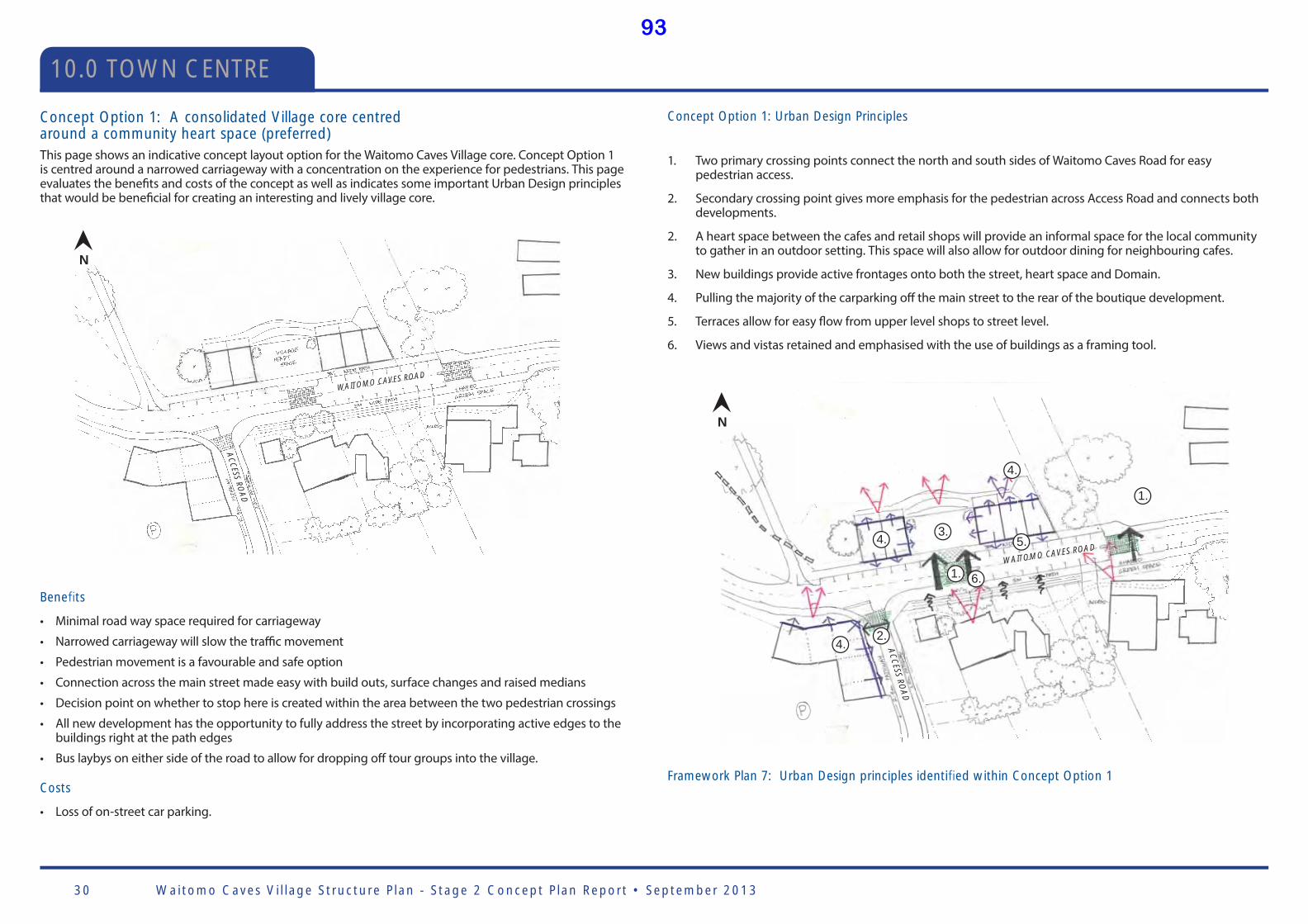
Waitomo Caves Vi l lage Structure P lan - Stage 2 Concept P lan Report • September 201330
Concept Option 1: A consolidated Village core centred around a community heart space (preferred)This page shows an indicative concept layout option for the Waitomo Caves Village core. Concept Option 1 is centred around a narrowed carriageway with a concentration on the experience for pedestrians. This page evaluates the benefi ts and costs of the concept as well as indicates some important Urban Design principles that would be benefi cial for creating an interesting and lively village core.
Bene ts
• Minimal road way space required for carriageway
• Narrowed carriageway will slow the traffi c movement
• Pedestrian movement is a favourable and safe option
• Connection across the main street made easy with build outs, surface changes and raised medians
• Decision point on whether to stop here is created within the area between the two pedestrian crossings
• All new development has the opportunity to fully address the street by incorporating active edges to the buildings right at the path edges
• Bus laybys on either side of the road to allow for dropping off tour groups into the village.
Costs
• Loss of on-street car parking.
Concept Option 1: Urban Design Principles
1. Two primary crossing points connect the north and south sides of Waitomo Caves Road for easy pedestrian access.
2. Secondary crossing point gives more emphasis for the pedestrian across Access Road and connects both developments.
2. A heart space between the cafes and retail shops will provide an informal space for the local community to gather in an outdoor setting. This space will also allow for outdoor dining for neighbouring cafes.
3. New buildings provide active frontages onto both the street, heart space and Domain.
4. Pulling the majority of the carparking off the main street to the rear of the boutique development.
5. Terraces allow for easy fl ow from upper level shops to street level.
6. Views and vistas retained and emphasised with the use of buildings as a framing tool.
WAITOMO CAVES ROAD
ACCESS RO
AD
1.
1.
2.
AC
CESS RO
AD
WAITOMO CAVES ROAD
3.4.
4.
4.
5.
6.
Framework Plan 7: Urban Design principles identi ed within Concept Option 1
N
N
10.0 TOWN CENTRE
93

Waitomo Caves Vi l lage Structure P lan - Stage 2 Concept P lan Report • September 2013 31
Concept Option 2: A consolidated Village core centred around a roundabout This page shows a secondary indicative concept layout option for the Waitomo Caves Village core. Concept Option 2 is centred around a large roundabout with a concentration on the experience for motorists. This page evaluates the benefi ts and costs of the concept as well as indicates some important Urban Design principles that may or may not be benefi cial for creating an interesting and lively village core.
Bene ts
• May slow traffi c and allow them to turn into one of the off road parking facilities
• Could be a feature within the village with the incorporation of Maori art and planting
• Provide a safer right hand turn for people exiting Access Road onto Waitomo Caves Road.
Costs
• Loss of on-street car parking
• Signifi cant amount of land required to get an appropriate roundabout suitable for buses/ heavy traffi c.
• Pedestrian movement more diffi cult at roundabouts
• Disconnect for pedestrians from Domain to new development adjacent to Access Road
• The roundabout would slow traffi c too late, it is past the main part of the village
• Straight through traffi c often not greatly slowed by roundabouts
• The future priority of the village should be on pedestrian movement as opposed to vehicular access
• Unnecessary to use road infrastructure as a key feature of the village when there is an amazing landscape that could lend itself to creating a stronger gateway link.
Concept Option 2: Urban Design Principles
1. Roundabout creates a decision point for drivers to stop and look around the Waitomo Caves Village.
2. Roundabout requires a signifi cant amount more land to maintain bus turning requirements.
3. A primary crossing point provides for ease of access across Waitomo Caves Road to the Domain.
4. Two secondary crossing points allow access at the eastern end of the village across Waitomo Caves Road and across Access Road.
5. A heart space between the cafes and retail shops will provide an informal space for the local community to gather in an outdoor setting. This space will also allow for outdoor dining for neighbouring cafes.
6. New buildings provide active frontages onto both the street, heart space and Domain.
7. Pulling the majority of the carparking off the main street to the rear of the boutique development.
8. Terraces allow for easy fl ow from upper level shops to street level.
9. Views and vistas retained and emphasised with the use of buildings as a framing tool.
Framework plan 8: Urban Design principles identi ed within Concept Option 2
AC
CESS RO
AD
WAITOMO CAVES ROAD
AC
CESS RO
AD
WAITOMO CAVES ROAD
SSSSSSSSSSSSSSROROORORO
AD
AD
ADDDDDDDDDD
WAIWAIWAIWAIWAIWA TOMTOMTOMTOMTOMTT O COOO CO CO CO CAVEAAAA S RRRS RROADOOOOMMMMMMMMMM CCCCCCCCAVEVEAVEVEAV S SSSSSSSS OAOAOAOAOAOAOAOOADADADADADDAA
AC
CCCA
CCC
AAC
CA
CC
AAAC
CC
CCC
CC
CCCCESSESSSSSSSSSSSSSSSSSS
AAAC
AAAAAAAAAAAAC
AA
1.
2.3.
4.5.6.
6.
6.
7.
8.
N
10.0 TOWN CENTRE
94

Waitomo Caves Vi l lage Structure P lan - Stage 2 Concept P lan Report • September 201332
SignsIn relation to signage, often ‘less is more’ and it is important that signage does not overpower the character of the village and surrounding area. Below outlines the three forms of signage that will be important in the accessibility and readability of Waitomo Caves Village.
Three forms of signage to be considered:
1. Business signage
2. Parking signage
3. Way fi nding signage
Business signage
A set of design guidelines should be proposed to ensure signage is appropriate for the location in respect to surrounding landscape and built form. A possibility to protect the Waitomo Caves Village character is to develop a design palette which does not enforce a particular style of sign but provides some options for businesses to create unique and characterful signs that don’t detract from the village feel.
Parking signage
With the attempt of promoting medium to long term parking users to utilise the off -street parking it is important that off -street parking is made obvious to the motorists. Parking signage needs to be clear, consistent and located appropriately to inform motorists in advance that a parking area is approaching. The timeliness of the parking signage is very important as it can be the diff erence between a motorist staying or just continuing straight through the village.
Way nding signage
The use of way fi nding signage will enable visitors to get around Waitomo Caves Village with little knowledge of the place at all. Way fi nding signage works best when it is provided at key decision points. It is also important that once the motorist has arrived in the car parking areas that they know where to go next. Further consistent signage targeting pedestrians should also be considered. Way fi nding requires a series of information to guide people to their destination. People do not require all the information at once – it is important to provide information to them along the way.
Wayfi nding signage example within a carpark
Wayfi nding signage examples for Waitomo
Signage incorporating Maori art. Used to enhance Waitomo Caves Village sense of place
PowerlinesThe undergrounding of powerlines in Waitomo Caves Village will provide aesthetic benefi ts for the village however it is a question of whether the cost will outweigh the benefi ts for the village.
The cost of undergrounding power lines can be signifi cantly variable between jobs and it is diffi cult to place a cost bracket on the work due to limited knowledge of the current electrical layout within the village. Costs can vary between quite low and very high. The Tere Waitomo Community Committee would need to have further discussions with the lines company about the work involved. If there is no requirement for an upgrade to the lines system then it is likely that they will not pay for the work and it would become a cost for either the district council or local businesses. In the future as development increases, there may be a requirement for lines to be upgraded and negotiations would need to be made with the lines company around this. It is logical that the undergrounding work occurs when street upgrades commence so investigation into this before this occurs would be recommended.
10.0 TOWN CENTRE
95
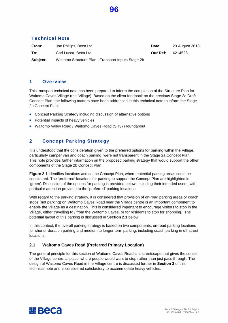
Beca // 30 August 2013 // Page 14214528 // NZ1-7908774-4 1.0
Technical Note From: Joe Phillips, Beca Ltd Date: 23 August 2013
To: Carl Lucca, Beca Ltd Our Ref: 4214528
Subject: Waitomo Structure Plan - Transport Inputs Stage 2b
1 Overview
This transport technical note has been prepared to inform the completion of the Structure Plan for Waitomo Caves Village (the ‘Village). Based on the client feedback on the previous Stage 2a Draft Concept Plan, the following matters have been addressed in this technical note to inform the Stage 2b Concept Plan:
Concept Parking Strategy including discussion of alternative options Potential impacts of heavy vehicles Waitomo Valley Road / Waitomo Caves Road (SH37) roundabout
2 Concept Parking Strategy
It is understood that the consideration given to the preferred options for parking within the Village, particularly camper van and coach parking, were not transparent in the Stage 2a Concept Plan. This note provides further information on the proposed parking strategy that would support the other components of the Stage 2b Concept Plan.
Figure 2-1 identifies locations across the Concept Plan, where potential parking areas could be considered. The ‘preferred’ locations for parking to support the Concept Plan are highlighted in ‘green’. Discussion of the options for parking is provided below, including their intended users, with particular attention provided to the ‘preferred’ parking locations.
With regard to the parking strategy, it is considered that provision of on-road parking areas or coach stops (not parking) on Waitomo Caves Road near the Village centre is an important component to enable the Village as a destination. This is considered important to encourage visitors to stop in the Village, either travelling to / from the Waitomo Caves, or for residents to stop for shopping. The potential layout of this parking is discussed in Section 2.1 below.
In this context, the overall parking strategy is based on two components; on-road parking locations for shorter duration parking and medium to longer term parking, including coach parking in off-street locations.
2.1 Waitomo Caves Road (Preferred Primary Location)
The general principle for this section of Waitomo Caves Road is a streetscape that gives the sense of the Village centre, a ‘place’ where people would want to stop rather than just pass through. The design of Waitomo Caves Road in the Village centre is discussed further in Section 3 of this technical note and is considered satisfactory to accommodate heavy vehicles.
96
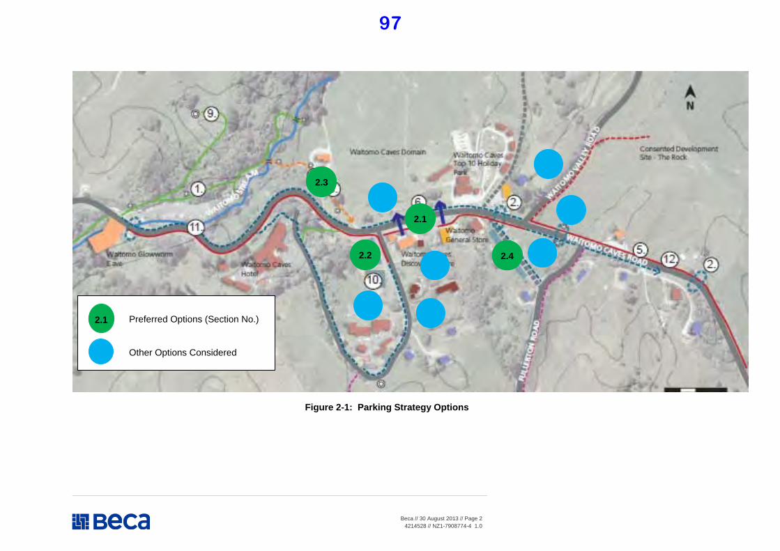
Beca // 30 August 2013 // Page 24214528 // NZ1-7908774-4 1.0
Figure 2-1: Parking Strategy Options
2.1
2.2
2.3
2.4
2.1 Preferred Options (Section No.)
Other Options Considered
97
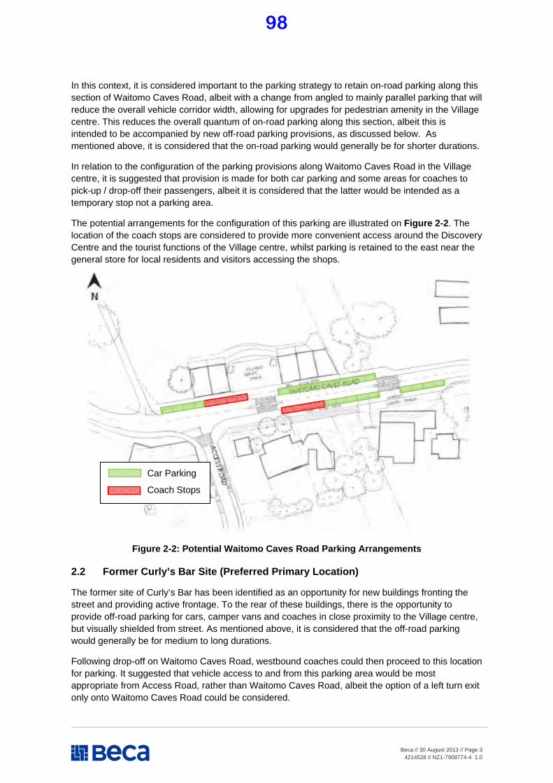
Beca // 30 August 2013 // Page 34214528 // NZ1-7908774-4 1.0
In this context, it is considered important to the parking strategy to retain on-road parking along this section of Waitomo Caves Road, albeit with a change from angled to mainly parallel parking that will reduce the overall vehicle corridor width, allowing for upgrades for pedestrian amenity in the Village centre. This reduces the overall quantum of on-road parking along this section, albeit this is intended to be accompanied by new off-road parking provisions, as discussed below. As mentioned above, it is considered that the on-road parking would generally be for shorter durations.
In relation to the configuration of the parking provisions along Waitomo Caves Road in the Village centre, it is suggested that provision is made for both car parking and some areas for coaches to pick-up / drop-off their passengers, albeit it is considered that the latter would be intended as a temporary stop not a parking area.
The potential arrangements for the configuration of this parking are illustrated on Figure 2-2. The location of the coach stops are considered to provide more convenient access around the Discovery Centre and the tourist functions of the Village centre, whilst parking is retained to the east near the general store for local residents and visitors accessing the shops.
Figure 2-2: Potential Waitomo Caves Road Parking Arrangements
2.2 Former Curly’s Bar Site (Preferred Primary Location)
The former site of Curly’s Bar has been identified as an opportunity for new buildings fronting the street and providing active frontage. To the rear of these buildings, there is the opportunity to provide off-road parking for cars, camper vans and coaches in close proximity to the Village centre, but visually shielded from street. As mentioned above, it is considered that the off-road parking would generally be for medium to long durations.
Following drop-off on Waitomo Caves Road, westbound coaches could then proceed to this location for parking. It suggested that vehicle access to and from this parking area would be most appropriate from Access Road, rather than Waitomo Caves Road, albeit the option of a left turn exit only onto Waitomo Caves Road could be considered.
Car Parking
Coach Stops
98

File Note
Beca // 30 August 2013 // Page 4
4214528 // NZ1-7908774-4 1.0
The location of the parking area would need to be well-signed from Waitomo Caves Road and advanced signing provided on entry to the Village. In addition, for all parking areas identified, the locations should be well illustrated on promotional material for Village visitors.
2.3 Community Hall Site (Preferred Secondary Location)
In terms of visitors who have already been to the Waitomo Caves Visitor Centre and as a secondary option to the proposed Curly’s Bar parking area, off-road parking could be provided in the vicinity of the Community Hall. This is also considered to provide convenient access to the Village Centre and would also provide parking in a location where visitors could access the new upgrades to the walkway along the Waitomo River.
This parking area would again need to be signed from both directions and would provide a good location for coaches that are returning from the Waitomo Caves Visitor Centre, travelling east into the Village, to stop prior to picking-up their passengers at the on-road stops in the Village centre. As mentioned above, it is considered that the off-road parking would generally be for medium to long durations.
2.4 Off Fullerton Road (Preferred Secondary Location)
In relation to the activities at the eastern end of the Village centre, west of Fullerton Road, it is considered that on-street parking on the current gravel road would be suitable as a secondary parking area. It is anticipated that this road would be surfaced and then on-road parking could be provided that would allow more convenient parking for these activities, given this area is otherwise more ‘remote’ from the other parking areas identified in the parking strategy. As mentioned above, it is considered that this on-road parking would generally be for shorter durations.
2.5 Other Locations
Other potential locations for parking that have not been identified as preferred locations as part of the strategy to support the Concept Plan are briefly discussed below, including the key reasons for not progressing these options:
Waitomo Caves Domain – Whilst in a location convenient to the Village centre, it is considered that providing parking in the Domain would be inconsistent with retaining this area as an attractive part of the Village centre for both residents and visitors.
South of the Village centre – The area to the south of the Discovery Centre would also provide convenient access to the Village centre activities. However, it is considered that these sites are better retained for future development and so that the connection between the Village centre and the school can be enhanced.
Off Access Road – It is considered that the other two locations further south off Access Road do not provide convenient visitor access to the Village centre. The provision of parking areas in these locations would also encourage additional traffic, particularly coaches, along Access Road where there are community facilities, such as the school.
Off Waitomo Valley Road – Potential locations off Waitomo Valley Road are considered to be too far from the centre of the Village to provide convenient access. It is also anticipated that land development in these areas would provide its’ own parking provisions.
Off Fullerton Road – This area is in a land depression and the Concept Plan currently illustrates provision of a wetland area with some surrounding commercial activities. Based on the current physical constraints, the site would be difficult to develop as a parking area. As discussed above, provision of on-road parking on the adjacent gravel road is considered to adequately provide for any commercial activity adjacent to this area.
99

File Note
Beca // 30 August 2013 // Page 5
4214528 // NZ1-7908774-4 1.0
3 Heavy Vehicles
In the wider context, State Highway 37 (SH37) provides a connection between State Highway 3 (SH3) and other areas that could not be conveniently served by other routes, hence its’ status as a state highway between Waitomo Caves Village and SH3. In the more local context, there do not appear to be any alternatives routes, without construction of new roads to enable heavy vehicles to bypass the Village centre.
On this basis, it is recognised there is a need to deal with buses/coaches, as well as logging and stock trucks passing through the Village. It would be expected that, even with an alternative route, buses / coaches carrying visitors would still wish to enter the Village and would be encouraged to do so provided suitable arrangements are made.
In relation to the Stage 2b concepts, it is considered that the proposed street layout illustrated on Figure 3-1 and Figure 3-2 can satisfactorily provide heavy vehicles without significant adverse conflict with parking and pedestrians, whilst also maintaining a streetscape within the Village centre that will provide improved amenity for residents and visitors. It is noted that the street perspective on Figure 3-2 does not illustrate the intended line marked (or hatched) median along the centre of the road carriageway.
Figure 3-1: Village Centre – Typical Cross Sections
Mid-Block Section
Pedestrian Crossing Section
100

File Note
Beca // 30 August 2013 // Page 6
4214528 // NZ1-7908774-4 1.0
Figure 3-2: Village Centre – Typical Perspective
In determining the proposed cross section, the AustRoads standard for on-road car parking area was used. This refers to a 2.3m wide parking space and a 0.5m separation being satisfactory for roads with speed limit of 60kph or less, as would be the case in the Village centre, which would allow a buffer for vehicles passing parking vehicles. It is considered that the adjacent 3.5m vehicle lanes would be more than adequate to accommodate heavy vehicles passing through the village, which would be operating at low speeds.
Whilst in general, it is recommended that parallel parking be provided along Waitomo Caves Road through the Village centre to align with the streetscape intent of the Concept Plan, it is understood that areas of angled parking are desired in some locations (such as in front of the shops). This would require a wider manoeuvring area for parking vehicles to provide a safe buffer, clear from through traffic. It is considered that the actual provision of different forms is more appropriately assessed at a later stage, once the overall Concept Plan has been further progressed.
Indeed the intention of the proposed cross section is to encourage a lower speed environment through the Village centre. In this regard, it is considered that some conflict between parking vehicles and through traffic would assist in encouraging a lower speed environment. In any event, it is considered that providing a line marked median in the centre of the road carriageway provides adequate opportunity for through traffic, including heavy vehicles, to pass any parking vehicles.
At the pedestrian crossing points in the Village centre (refer to Figure 2-2), the second cross section indicates that a minimum 2.5m wide central island would be provided to further emphasise the road narrowing and enable improved opportunities for pedestrians to cross at these locations. This is still considered to provide an adequate width of 3.5m vehicle lanes for heavy vehicles in both directions.
In terms of an example of a similar streetscape, Figure 3-3 below illustrates the current layout of State Highway 1, which runs through Helensville, north of Auckland. Similarly to SH37, this section of SH16 carries a similarly high proportion of heavy vehicles and is subject to seasonal peaks in traffic demand, as it is a busy alternative route for travelling between Auckland and the Northland. Furthermore, it is noted that in comparison to SH37, which has Annual Average Daily Traffic (AADT) volumes in the order of 1,300 vehicles, SH16 through Helensville has an AADT of around 5,000 vehicles.
101
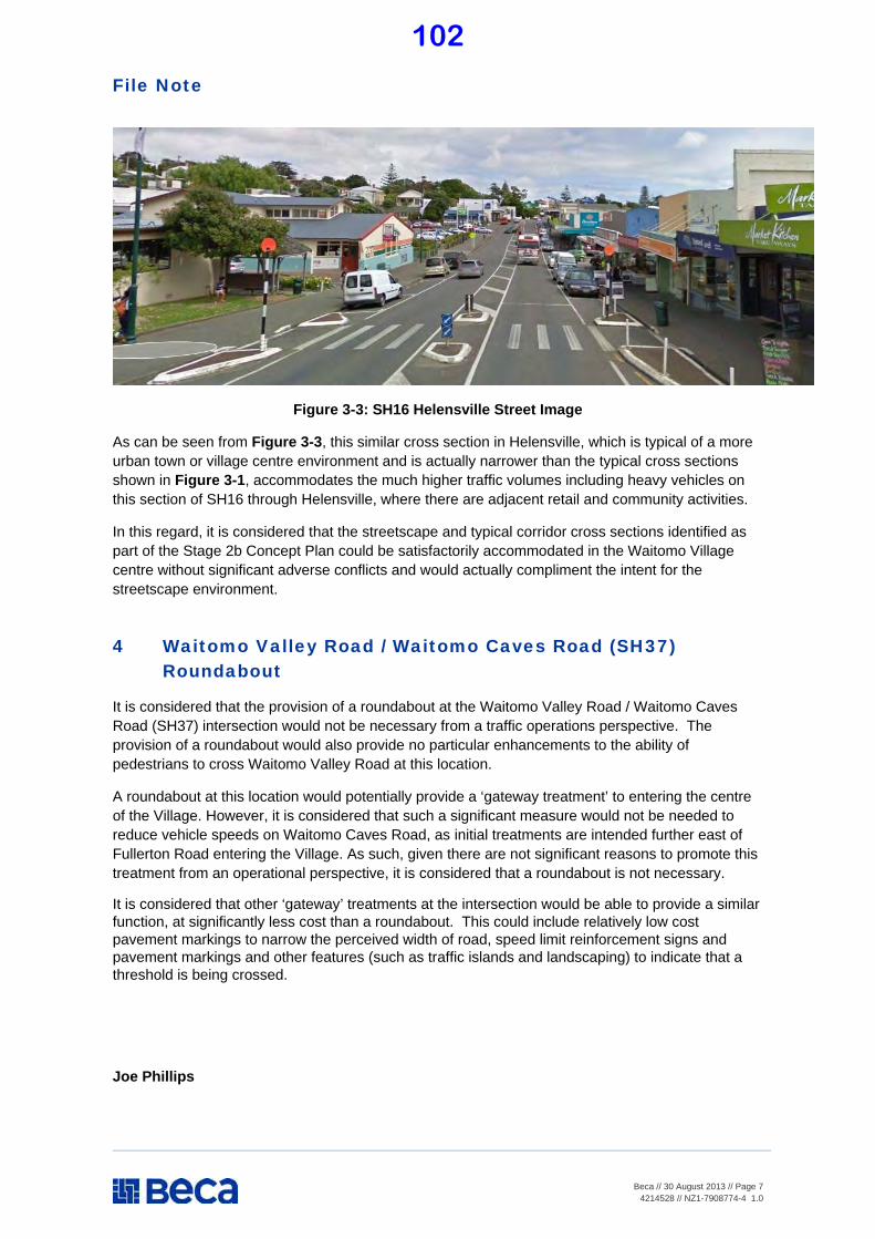
File Note
Beca // 30 August 2013 // Page 7
4214528 // NZ1-7908774-4 1.0
Figure 3-3: SH16 Helensville Street Image
As can be seen from Figure 3-3, this similar cross section in Helensville, which is typical of a more urban town or village centre environment and is actually narrower than the typical cross sections shown in Figure 3-1, accommodates the much higher traffic volumes including heavy vehicles on this section of SH16 through Helensville, where there are adjacent retail and community activities.
In this regard, it is considered that the streetscape and typical corridor cross sections identified as part of the Stage 2b Concept Plan could be satisfactorily accommodated in the Waitomo Village centre without significant adverse conflicts and would actually compliment the intent for the streetscape environment.
4 Waitomo Valley Road / Waitomo Caves Road (SH37) Roundabout
It is considered that the provision of a roundabout at the Waitomo Valley Road / Waitomo Caves Road (SH37) intersection would not be necessary from a traffic operations perspective. The provision of a roundabout would also provide no particular enhancements to the ability of pedestrians to cross Waitomo Valley Road at this location.
A roundabout at this location would potentially provide a ‘gateway treatment’ to entering the centre of the Village. However, it is considered that such a significant measure would not be needed to reduce vehicle speeds on Waitomo Caves Road, as initial treatments are intended further east of Fullerton Road entering the Village. As such, given there are not significant reasons to promote this treatment from an operational perspective, it is considered that a roundabout is not necessary.
It is considered that other ‘gateway’ treatments at the intersection would be able to provide a similar function, at significantly less cost than a roundabout. This could include relatively low cost pavement markings to narrow the perceived width of road, speed limit reinforcement signs and pavement markings and other features (such as traffic islands and landscaping) to indicate that a threshold is being crossed.
Joe Phillips
102

Document No: 321725 File No: 037/018/02
Report To: Council
Meeting Date: 6 March 2014
Subject: Benneydale Wastewater – Disclosure of
Perceived Resource Consent Condition
Breach
Purpose of Report
1.1 The purpose of this business paper is to provide Council with details of a sewage
overflow from the wastewater pipe reticulation at Benneydale resulting in a
perceived breach of the Discharge Consent conditions.
Local Government Act S.11A Considerations
2.1 Waitomo District Council, in performing its role as a Local Authority, must have
particular regard to the contribution that the network infrastructure makes to the
community.
2.2 The provision and maintenance of the water, sewerage and stormwater
infrastructure, is consistent with section 11A Local Government Act 2002
(including amendments).
Commentary
8.1 Over the weekend of 12 and 13 October 2013 a blockage in the wastewater pipe
reticulation occurred near the Benneydale Wastewater Treatment Plant (WWTP)
resulting in an overflow of untreated wastewater. The blockage in the reticulation
was not identified until the morning of Monday 14 October 2013 by WDC’s Water
Services Engineer during a routine inspection.
8.2 The overflow was at the last manhole just prior to the effluent entering the WWTP
and before any treatment occurs. This manhole is not visible from Benneydale
township.
8.3 The wastewater “reticulation” is not monitored by WDC’s SCADA system.
Residents are relied upon to notify WDC of any reticulation issues that arise when
they happen, or else issues are identified when WDC staff carry out routine
inspections.
8.4 As soon as the blockage was discovered, immediate notification was made to
Veolia Water to clear the blockage.
8.5 The cause of the blockage was determined to be clothing in the pipe. A child’s
T-Shirt and pants were found between the last manhole and the inlet of the
WWTP.
8.6 The wastewater overflow from the pipe reticulation, as observed, flowed into and
was contained within the WWTP Wetland.
103
8.7 Because the overflow went into the Wetland it was treated as a standard overflow,
with disinfection of the relatively small area along which the wastewater had
flowed to the Wetland.
8.8 The Discharge Consent is based on recreational values. This is why the discharge
of wastewater is to land during the summer and to water during the winter, when
there are relatively high flows in the receiving stream and therefore dilution is to
an appropriate level.
8.9 The WWTP Wetland at Benneydale discharges into the nearby Mangapehi Stream.
8.10 At the time of the overflow, the water level in the Mangapehi Stream was running
2.5 times higher than the normal dry weather flow.
8.11 A routine water quality test was carried out downstream of the Wetland outlet on
Monday 14 October 2013, the same day that the overflow was discovered.
8.12 The results from the quality test were received by WDC approximately 10 days
later. The test results showed higher than usual bacterial counts.
8.13 The bacterial component is not one of the parameters required for Discharge
Consent compliance and WDC do this for our own benefit to gauge the
effectiveness of the treatment and the water quality in the general area.
8.14 As soon as this was observed the aberration was notified to the Waikato Regional
Council (WRC) and with it the possible cause as described above.
8.15 WRC visited the site as part of their investigation and has issued WDC with a
“Warning” for the transgression of not notifying them within the 48 hour period of
the occurrence of the incident as required under the Discharge Consent.
8.16 The warning is a result, as stated above, of WDC having tested the sample for a
parameter not needed for consent compliance and being so conscientious to
inform WRC of a possible spill.
8.17 Following the alert identified by the higher than normal E coli count an analysis of
SCADA data showed that the spill, into the Wetland, was over a period of
approximately 48 hours at a maximum of 0.4 l/s during the worst period with a
maximum total of less than 80m3 for the whole incident.
8.18 The consequences of repeated transgressions can result in a fine being imposed
on the WDC for the transgression.
8.19 There are alarms from the WWTP that indirectly relate to the reticulation if the
operator on duty understands the system.
8.20 This was missed by Veolia and for that reason all alarms are now received and
interpreted by WDC operational staff and the required response is then initiated.
Suggested Resolution
The business paper on Benneydale Wastewater – Disclosure of Breach be received.
ANDREAS SENGER
MANAGER – WATER SERVICES
104
Document No: 325823 File No: 504/014B
Report To: Council
Meeting Date: 6 March 2014
Subject: Beach Road, Mokau - Seawall
Purpose of Report 1.1 The purpose of this report is to inform Council of developments regarding a
retrospective Resource Consent application for the construction of the temporary seawall at end of Beach Road, Mokau, the cost implications of the various options
and seeking Council’s direction as to which option should be pursued.
Background
2.1 Coastal dune regression at Mokau has been ongoing for more than a decade and the rate of erosion has become more pronounced in the last few years.
2.2 Approximately 10 years ago the option(s) for a Coastal Erosion Protection
Response was canvassed in detail with the Mokau Community by Waitomo District Council (WDC). The outcome of that consultation was an acceptance that such a response was not economically feasible.
2.3 As a consequence, WDC committed to a response strategy for a “managed
retreat” over time so as to allow property owners to remove assets and cap services as the natural erosion process progressed. (see attached - Waitomo News Extract from 13 June 2013 – under page 3, subheading “Watching Brief”).
Commentary 3.1 WDC has a part to play in giving effect to that response strategy. The key role
being to protect legal public access to the at risk properties so that bach owners can carry out a managed removal in a practicable way.
3.2 High tides with onshore winds during late Winter and early Spring of 2013
significantly increased the rate of erosion of both the formed and unformed legal road known as Beach Road.
3.3 To adhere to its commitment, WDC had to put in place some temporary rock
armoring at end the of Beach Road in an attempt to slow the erosion.
3.4 Waikato Regional Council (WRC) was informed that at the time this temporary work needed to go ahead as a matter of urgency.
3.5 Following the work, WDC needs to get a retrospective Resource Consent for the
work done – an application for consent for five years had been lodged.
105

3.6 CONSENT REQUIREMENTS AND OPTIONS
3.7 In liaising with WRC it became clear that the required consent will include at least
the following requirements as conditions of consent:- 3.8 Likely Conditions attaching to Resource Counsent
1. Bi-monthly Monitoring (site visit, photographs and narrative on observations)
2. Annual Topographical Survey 3. Consultation with DoC, Tangata Whenua and Neighbour (13A Beach Road).
The above, subject to agreement with potentially affected parties, will provide a temporary consent for up to five years which will require removal of the wall in the event that it becomes structurally unstable during this
period (assessed on the basis of the bi-monthly site inspections and annual topographical surveys).
4. At the end of the five year period the wall would require removal (assuming
it did not have to be removed earlier). 3.9 If not agreed to, the consent application will be notified which can be expected to
increase exposure and cost.
3.10 Options 3.11 Council has three options available –
1 Agree to Proposed Conditions
2 Seek a Notified Consent Application
3 Remove the wall immediately and let nature take its course 3.12 Costs 3.13 Option 1 - Agree to Proposed Conditions
3.14 Assuming the wall remains stable for the consent period, the costs for Council are
potentially -
1 Projected costs to liaise with DoC, Tangata Whenua and the Neighbour (13A
Beach Road): $5,000 2 Bi-monthly Monitoring and Annual Inspections over five years: $30,000
3 Removal of Wall at end of Consent period: $35,000-$45,000 (at todays rates)
4 Miscellaneous costs associated with liaising with WRC: $5,000 over 5 years
Estimated Cost over five years: $80,000 - $90,000
106
3.15 Option 2 – Seek a Notified Consent Application
3.16 Projected costs to liaise with DoC, Tangata Whenua and the Neighbour (13A
Beach Road); $10,000, plus all the costs as per Option 1 above, plus cost to comply with whatever other conditions comes out of the Notified Consent process.
3.17 One can only guess at the cost, however $150,000 plus, is quite possible.
3.18 Option 3 – Immediate Removal of Wall
3.19 Following advice from WRC, removal of the wall now would be a permitted activity (no consent required). For Council, costs to remove the wall now would be:-
Estimated Cost: Removal of the Wall: $35,000- $45,000
3.20 Sunk costs are not included in the above, and all above costs are exclusive of
GST.
3.21 Decision
3.22 Prior to progressing with the consent in terms of liaising with DoC, Tangata Whenua and the Neighbour (13A Beach Road), consideration is required by Council as to whether to continue with the limited consent (requiring removal of
the wall in five years or sooner if affected by storm action) or removal of the wall now at a significantly lower cost.
3.23 The deadline with WRC was 11 February 2014. WRC had been advised that WDC will require an extension of time beyond the current 12 February 2014 as the matter would have to be considered at the next Council meeting for a formal decision. Following the deferral of the Council meeting scheduled for 25 February,
WRC has been advised that Council will make a formal decision on this matter on 6 March 2014.
Suggested Resolutions
1 The business paper on Beach Road, Mokau - Seawall be received. 2 Council approve Option t
CHRISTIAAN VAN ROOYEN
GROUP MANAGER – ASSETS
Attachment: 1 Extract Waitomo News
107
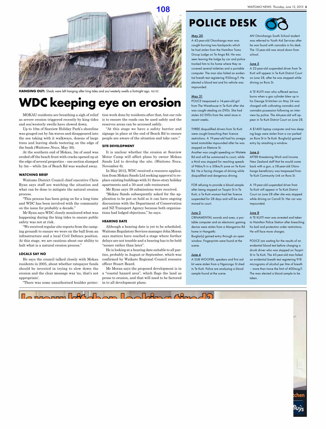
Waitomo NeWs Thursday, June 13, 2013 3
a: Cnr Ballance Street, Otorohanga p: 07 873 7465KIWITOWN
Is your kitchen looking tired?
Let us show you how to make your existing kitchen look new again, without the cost of a whole kitchen
MOKAU residents are breathing a sigh of relief as severe erosion triggered recently by king tides and sou’westerly swells have slowed down.
Up to 10m of Seaview Holiday Park’s shoreline was gouged out by 5m waves and disappeared into the sea taking with it walkways, dozens of large trees and leaving sheds teetering on the edge of the bank (Waitomo News, May 30).
At the southern end of Mokau, 3m of sand was eroded off the beach front with cracks opened up at the edge of several properties – one section slumped by 3m – while 2m of Beach Rd was washed away.
WATCHING BRIEF
Waitomo District Council chief executive Chris Ryan says staff are watching the situation and what can be done to mitigate the natural erosion process.
“This process has been going on for a long time and WDC has been involved with the community on the issue for probably a decade.”
Mr Ryan says WDC closely monitored what was happening during the king tides to ensure public safety was not at risk.
“We received regular site reports from the camp-ing groundt to ensure we were on the ball from an infrastructure and a local Civil Defence position. At this stage, we are cautious about our ability to halt what is a natural erosion process.”
LOCALS SAY NO
He says the council talked closely with Mokau residents in 2005, about whether ratepayer funds should be invested in trying to slow down the erosion and the clear message was ‘no, that’s not appropriate’.
“There was some unauthorised boulder protec-
tion work done by residents after that, but our role is to ensure the roads can be used safely and the reserves areas can be accessed safely.
“At this stage we have a safety barrier and signage in place at the end of Beach Rd to ensure people are aware of the situation and take care.”
SITE DEVELOPMENT
It is unclear whether the erosion at Seaview Motor Camp will affect plans by owner Mokau Sands Ltd to develop the site. (Waitomo News, November 6).
In May 2012, WDC received a resource applica-tion from Mokau Sands Ltd seeking approval to re-place existing buildings with 31 three-story holiday apartments and a 50-seat cafe-restaurant.
Mr Ryan says 39 submissions were received.“Mokau Sands subsequently asked for the ap-
plication to be put on hold so it can have ongoing discussions with the Department of Conservation and NZ Transport Agency because both organisa-tions had lodged objections,” he says.
HEARING DATE
Although a hearing date is yet to be scheduled, Waitomo Regulatory Services manager John Moran says matters have reached a stage where further delays are not tenable and a hearing has to be held “sooner rather than later”.
He is looking at a hearing date suitable to all par-ties, probably in August or September, which was confirmed by Waikato Regional Council resource officer Stuart Beard.
Mr Moran says the proposed development is in a “coastal hazard area”, which flags the land as prone to erosion, and that will need to be factored in to all development plans.
POLICE DESkMay 30a 42-year-old otorohanga man was caught burning two backpacks which he had stolen from the Hamilton tomo Group Lodge on te anga Rd. He was seen leaving the lodge by car and police tracked him to his home where they re-covered several toiletries and a portable computer. the man also failed an eviden-tial breath test registering 950mcg/l. He elected a blood test and his vehicle was impounded.
May 31PoLiCe trespassed a 14-year-old girl from the Warehouse in te Kuiti after she was caught stealing six DVDs. she had stolen 63 DVDs from the retail store in recent weeks.
THREE disqualified drivers from Te Kuiti were caught breaching their licence restrictions. a 19-year-old had his unregis-tered motorbike impounded after he was stopped on eketone st. another was caught speeding on Waitete Rd and will be summoned to court, while a third was stopped for reaching speeds of 96km/h in a 50km/h zone on te Kumi Rd. He is facing charges of driving while disqualified and dangerous driving.
FoR refusing to provide a blood sample after being stopped on taupiri st in te Kuiti, a te Kuiti woman had her licence suspended for 28 days and will be sum-moned to court.
June 3oRNameNtaL swords and axes, a por-table computer and an electronic gaming device were stolen from a mangarino Rd home in Hangatiki. Burglar(s) gained entry through an open window. Fingerprints were found at the scene.
June 4A SUB WOOFER, speakers and first aid kit were stolen from a Ngarongo st shed in te Kuiti. Police are analyzing a blood sample found at the scene.
aN otorohanga south school student was referred to Youth aid services after he was found with cannabis in his desk. the 12-year-old was stood down from school.
June 5a 22-year-old suspended driver from te Kuiti will appear in te Kuiti District Court on June 28, after he was stopped while driving on Rora st.
a te KUiti man who suffered serious burns when a gas cylinder blew up in his George st kitchen on may 24 was charged with cultivating cannabis and cannabis possession following an inter-view by police. the 44-year-old will ap-pear in te Kuiti District Court on June 28.
a $1400 laptop computer and two sleep-ing bags were stolen from a car parked on Rora st in te Kuiti. Burglar(s) gained entry by smashing a window.
June 6aFteR threatening Work and income New Zealand staff that he would come back with a gun, a 58-year-old otoro-hanga beneficiary was trespassed from te Kuiti Community Link on Rora st.
a 19-year-old suspended driver from te Kuiti will appear in te Kuiti District Court on June 28 after she was stopped while driving on Carroll st. Her car was impounded.
June 8a te KUiti man was arrested and taken to Hamilton Police station after breaching his bail and protection order restrictions. He will face more charges.
PoLiCe are waiting for the results of an evidential blood test before charging a drunk driver who was stopped on taupiri st in te Kuiti. the 45-year-old man failed an evidential breath test registering 918 micrograms of alcohol per litre of breath – more than twice the limit of 400mcg/l. the man elected a blood sample to be taken.
WDC keeping eye on erosionHANGING OUT: Sheds were left hanging after king tides and sou’westerly swells a fortnight ago. FILE PIC
108
Document No: 321646 File No: 037/020/12A
Report To: Council
Meeting Date: 6 March 2014
Subject: Progress Report: Monitoring Against
2012-2022 Long Term Plan – Water
Supply
Purpose of Report
1.1 The purpose of this business paper is to brief Council on progress with implementation of the Work Plan for the Water Supply activity as contained in year two (2013/2014) of the 2012-2022 Long Term Plan (LTP).
Local Government Act S.11A Considerations
2.1 Waitomo District Council, in performing its role as a Local Authority, must have particular regard to the contribution that the network infrastructure makes to the community.
2.2 The provision and maintenance of the water infrastructure, is consistent with section 11A Local Government Act 2002 (including amendments).
Introduction 3.1 This business paper focuses predominantly on capital expenditure projects i.e.
renewal and improvement works; however any issues arising in the maintenance area of the Water Supply activity will be reported to Council on a needs basis.
3.2 This business paper is intended to compliment the monthly and quarterly reporting to Council. It is designed to provide further detailed information on the
implementation of Council’s capital (improvement and renewal) expenditure programme.
Background 4.1 The Water Supply activity provides for the environmentally safe collection,
treatment and reticulation of WDC’s public water supplies. Water supply schemes
are provided by Council at:
• Te Kuiti • Benneydale
• Piopio • Mokau
4.2 There are also privately owned and operated water supply schemes at Waitomo
Village and Taharoa which do not form part of the 2012-2022 LTP.
4.3 There are three activities under the Water Supply activity:
• Maintenance
• Renewals • Improvements
109
4.4 Maintenance
4.5 Operation and maintenance involves the planned and reactive servicing of the water infrastructure – repairing leaks and broken mains, servicing pump stations,
cleaning reservoirs, repairing and replacing water meters, hydrants and valves, and operating the water treatment plants and intake systems.
4.6 Renewals
4.7 Renewal/replacement of water supply infrastructure (principally water supply
mains) involves replacement of these assets at the end of their effective lives. The timing of renewals is determined from the asset age, condition assessments and capacity assessments of the existing water supply networks based on the
available asset data.
4.8 Improvements
4.9 Improvement work involves the provision of additional water supply reticulation, storage or treatment plant capacity either by installing new or
extending/upgrading existing pipe networks, storage structures or treatment plants.
Te Kuiti Water Supply
5.1 Background
5.2 The Te Kuiti Water Treatment Plant (TKWTP) in its present form provides safe drinking water however its production does not meet the Drinking Water Standards (DWS) 2005 or the Drinking Water Act 2007 (as amended 2008) and
the TKWTP requires significant capital upgrade (for some components probably total replacement) to meet that standard. The reasons for not complying with the Standards mostly relate to the amount of risk that Water Quality Standards will
not be met consistently. Some risks however are significant and need to be addressed as soon as possible.
5.3 The main risks are:
1. The intake point is downstream of the main Te Kuiti industrial area
representing high risk of pollution.
2. The intake structure is of a floating boom type that takes water off the surface of the stream with the inherent risk of picking up floating
pollutants (scums, oils, etc). Similarly during periods of very low river flows it will take water from close to the bottom of the stream where there is risk of picking up pollutants travelling along the bottom of the stream.
3. All chemical dosing devices (and therefore processes) located within the
TKWTP are manually operated and therefore there is no means of automatically adjusting flow proportionality and therefore there is a risk of under dosing or overdosing as the intake flows varies with demand.
4. The configuration of the Flash Mixer and the Splitter Channels within the
TKWTP system is such that the treatment dosing chemicals are not used optimally and therefore removal of pollutants is not optimal.
5. The Clarifier equipment can be considered obsolete and parts are no longer
available. As a result the sludge blanket and control of sludge discharge
110
processes are operated on a manual basis which does not make for optimum removal of flocculated pollutants.
6. The dual media sand filters are the water last treatment barrier and the
operation of the filters is all manual, the backwash arrangement is by gravity from the storage reservoir and is often not fully effective. This means that sometimes the filters are not cleaned properly creating the risk of pollutant break through.
7. The Clear Water Wells which receive the final treated water from the filtration process are attached to the associated filters and the pipe work (including the backwash network for the filters). The backwash valve
glands are leaking into the clear wells contaminating the final treated water. Also the clear wells are open on top and the building is not vermin proof therefore there is the potential (high) risk of contamination.
8. The reservoir (1000m3) next to the TKWTP serves as the balancing tank
between treatment and distribution. It also services as the chlorine contact tank and filter backwash storage. Due to its size it is very difficult to control chlorine levels within the required dosage parameters. In addition,
the inlet and outlet pipe work is on the same side of the tank which creates the opportunity for short circuiting and therefore poor mixing of the chlorine with inadequate contact time before the treated water passes into the distribution system. When the water level gets below half full there is
insufficient hydraulic head to backwash the filters effectively. (See 6 above)
9. Treatment plant operation and control is not automated and the monitoring reporting required by MoH (through the Drinking Water Assessor (DWA))
does not meet the 2005 standards consistently. 5.4 Capital Expenditure Budget
5.5 Funding from MoH has been allocated - $780,820.56 excluding GST (Application $1,942,005). The application was for only that part of the total upgrade required to meet the Drinking Water Act (2007) that was eligible for subsidy.
5.6 As detailed design developed it soon become apparent that a holistic plan of the total
upgrade is needed to ensure the funding is optimised and the final product is the best that the available money can buy. This combined with the pressure of affordability meant that the work planned initially for 2012/13 has been moved to 2013/14. In the
mean time a final design of the whole plant that can be implemented incrementally has been done. MoH has been requested to accept delay of the spending by 12 months for above reasons.
5.7 The upgrade will have four phases that match four main treatment stages with 6
main components:
1. Intake in parallel with new water Take Consent 2. Refurbishment of clarifiers 3. Upgrade of filter backwash system 4. Installation of Ultra Violet 5. Renewal of main pump station 6. New storage reservoir
5.8 Construction sequence is different for two main reasons, to utilize MoH funding while available and address the components that are the most critical.
111
5.9 Phase One
• Upgrade of filter backwash system • Installation of Ultra Violet
• Renewal of main pump station
5.10 Phase Two
• Intake in parallel with new water Take Consent
5.11 Phase Three
• Refurbishment of clarifiers
5.12 Phase Four
• New storage reservoir
5.13 The amount in the 2013-14 budget for Phase One is $2.51 million.
5.14 Detailed design of Phase One has been completed and a detailed cost estimate is now being prepared.
5.15 The intention is that the project will be executed through a series of engagement of
smaller, and where possible, local contractors in an attempt to minimise cost and obtain optimum quality. High cost items will be purchased by WDC direct with contracts for installation only, where feasible.
Mokau Water Supply (MWS) 6.1 Background
6.2 The MWS is working reasonably well but does not meet the Drinking Water Act 2007 (as amended in 2008). It required coagulation and an Ultra violet disinfection unit.
6.3 The Plant has now been upgraded for a little less than the budgeted amount and
is working well. As a result of the changes to the dam position and design changes to structure levels due to the finding of a shell midden and hangi pit, the clarifier will have to be moved to a lower level to continue to have gravity feed.
6.4 The other issues to be addressed include - inadequate storage of raw water to meet summer demand which is also the dry period and the existing storage dams need work to meet the new building compliance standards as of 2010/2011. Funding has been approved by MoH ($725,790) and final design has been
completed.
6.5 The present estimate and budget is $800,000.
6.6 Capital Expenditure Budget
6.7 A dam site below the escarpment that is deemed geotechnical stable has been identified.
6.8 Design of new dam is complete and Consent applications to Waikato Regional Council (earthworks) and Waitomo District Council (Landuse) have been
approved.
112
6.9 Consultation with Iwi and the owners of the surrounding land is ongoing.
6.10 The proposed dam site has been pointed out to Iwi and a letter from the archeologist stating that there is no expectation that any artifacts will be found in
that area handed over.
6.11 An Archeological assessment required for the land use consent showed that the new site has no archeological significance. This proved wrong.
6.12 The position was discussed with the landowner and he has verbally accepted the
proposed position. Land has been bought from the landowner.
6.13 Construction started early February 2014 however came to a halt on 7 February 2014 when a shell midden was uncovered and on the following Wednesday a
hangi pit was also found.
6.14 There is a time consuming process to be worked through which includes the Historic Places Trust and the Archeologist as well as Iwi, WRC and WDC. The potential delay is in excess of three months.
6.15 In order to mitigate this, the design was changed and Iwi and WRC were consulted to get an earlier start.
6.16 Agreement was reached for limited construction to start the week commencing 3
March 2014, while other processes and negotiations goes on in parallel.
6.17 The additional cost with what is known at present is estimated between $35,000 and $50,000.
6.18 There are still dam safety remedial work to be done on the existing dams and
Mokau Ki Runga want to know what is proposed and the methodology that will be used.
6.19 This will be conveyed to them as soon as the detail is available since it now has to be scoped outside of the original contract.
Piopio Water Supply (PWS) 7.1 Background
7.2 The project is now complete and operating very well.
Benneydale Water Supply (BWS)
8.1 The BWS and reticulation is virtually new and in good condition, it does not meet Drinking Water Act 2007 (as amended 2008) because it requires an Ultra violet disinfection unit.
8.2 A funding application for a UV unit has been submitted to MoH for the 2012-2013
subsidy funding round which closed end of February 2012 and an amount of $67,107.50 has been allocated to WDC for Benneydale. This work has been completed under budget and the Plant is working well.
113
Waitomo Water Supply (WWS)
9.1 Background
9.2 An in-house assessment of the privately owned WWS was done in the 2008/09 year and the opportunity for potential WDC involvement was consulted on during the 2009-2019 LTCCP consultation process with a specific meeting in Waitomo
Village.
9.3 Proposed capital expenditure was originally moved to start in the 2013/2014 year spread over 3 years.
9.4 More detailed investigation work was done late 2013 and the assets valued by the WDC Group Manager Assets.
9.5 This information was conveyed to THL before the December 2013 break and discussed at a meeting on 13 January 2014.
9.6 Some adjustment to values were agreed and that together with best guess estimates by the Group Manager Assets for renewal/replacement of assets staged over 9 years was used to model per cubic metre rates for treated water and
treated waste water.
9.7 This information was conveyed to THL on 25 February 2014 to use in an assessment of financial impact on THL operations in Waitomo Village.
9.8 There is no funding in the 2012-22 LTP and $5,000 in the 2013-14 EAP for any
work on Waitomo Village infrastructure.
Suggested Resolution The Progress Report: Monitoring Against 2012-2022 Long Term Plan – Water Supply be received.
CHRISTIAAN VAN ROOYEN GROUP MANAGER – ASSETS
February 2014
114

Document No: 321645 File No: 037/020/12A
Report To: Council
Meeting Date: 6 March 2014
Subject: Progress Report: Monitoring Against
2012-2022 Long Term Plan – Stormwater
Purpose of Report 1.1 The purpose of this business paper is to brief Council on progress with
implementation of the Work Plan for the Stormwater activity as contained in year one (2013/2013) of the 2012-2022 Long Term Plan (LTP).
Introduction
2.1 This business paper focuses predominantly on capital expenditure projects i.e. renewal and improvement works, however any issues arising in the maintenance area of the Stormwater activity will be reported to Council on a needs basis.
2.2 This business paper is intended to compliment the monthly and quarterly reporting to Council. It is designed to provide further detailed information on the implementation of Council’s capital (improvement and renewal) expenditure programme.
Background 3.1 The Stormwater significant activity provides for the collection, diversion,
treatment and disposal of urban surface water runoff following rainfall. Surface water flooding can occur in the absence of an effective stormwater drainage
system.
3.2 Council is involved in this activity to fulfill its legal responsibilities for the control of its stormwater systems and to work towards the achievement of community outcomes. Efficient, environmentally safe and sustainable urban stormwater
services are essential for the social, cultural and environmental well-being of the District. Stormwater services ensure the protection of public health in urban areas through the collection and disposal of urban stormwater.
3.3 The Local Government Act 2002 empowers Council to be involved in the ownership and provision of stormwater assets.
3.4 The Stormwater activity covers the stormwater assets owned and operated by Council in urban areas including:
• Te Kuiti • Benneydale • Piopio
• Mokau • Awakino • Marokopa • Te Waitere
115
3.5 The majority of Council’s stormwater infrastructure is located at Te Kuiti, with limited infrastructure available at the remaining townships. The stormwater infrastructure servicing Waitomo Village and Taharoa is privately owned and does
not form part of this 2012-22 Long Term Plan.
3.6 WDC’s storm water reticulation design endeavors to meet a 2 year rainfall return period.
3.7 The main activity under this significant activity is stormwater reticulation and
disposal which comprises:
• Preparation of catchment assessments for each urban area to identify open drains, ephemeral water courses, permanent water courses, stormwater
and preliminary secondary flow paths is a definitive need to manage stormwater in Te Kuiti. This represents a significant amount of work which Council voted funding to start it in the 2011-12 year.
• Reporting on stream environmental impacts as demanded by comprehensive discharge consent. This reporting is completed annually.
• Finding stormwater pipe work not on record, assess condition and record in asset register. This is an activity that takes place as general maintenance works occur. It really requires a special project to provide information to improve the information for the Activity Management Plan flowing into the
2012-22 Long Term Plan and further into the future to inform the work that needs to be done in the Catchment Assessments.
• Providing, maintaining and upgrading Council’s urban stormwater network
comprising the urban open drains, pipes and manholes, downstream from surface channels, sumps and sump leads (the latter, together with all rural drainage assets, are included under the Land Transport significant
activity). 3.8 The main elements of this activity are:
3.9 Maintenance
3.10 Operation and maintenance involves the planned and reactive servicing of the stormwater infrastructure – clearing drains, emptying sumps, repairing damaged asset components.
3.11 During recent investigation of sewer reticulation it has been identified that there are a number stormwater pipes that are partially blocked with accumulated debris. Investigation showed that cleaning of the system will be fairly costly and will have to addressed through maintenance over a long time
3.12 Council approved a modest budget for four years starting 2012-13 for maintenance cleaning of reticulation. Work is done bit by bit and asset information collected as it progresses. Several minor repair/renewal projects had already been identified. A programme to do this work will be compiled on a
Catchment by Catchment basis and brought into the budgets as it can fit.
3.13 Renewals
3.14 Renewal/replacement of stormwater infrastructure (principally stormwater pipes)
involves replacement of these assets at the end of their effective lives. The timing of renewals is determined from the asset age, condition assessments and capacity assessments of the existing drainage networks based on the available asset data. This has shown a large spike in required renewals for the period 30 to
60 years from now. Using replacement values, the renewals costs have been
116
smoothed to flatten this peak in the 2012-22 LTP. As asset information improves, specific renewals will be individually assessed to verify that the renewal is actually needed before the work is done.
3.15 The average renewal works expenditure based on current information is approximately $100,000 per annum in the 2012-22 LTP, starting 2016-17.
3.16 The renewal funding for the past years has actually been spent on installation of new reticulation to solve critical spots that become apparent during each year.
3.17 Two specific problem areas had been identified since and will be addressed this financial year – renewal of section in George Street budget estimate $92,340 and renewal of section of Duke Street budget estimate $117,420.
3.18 This is trend is expected to continue as critical points are identified during the special maintenance cleaning programme.
3.19 Improvements
3.20 This involves the provision of additional stormwater drainage capacity either by
installing new or extending existing drainage networks, or by increasing the size of existing pipes on the same alignment. Where possible, any identified shortfall in existing pipe capacity will be addressed at the time of the pipe replacement so
that any existing undersized pipes will be replaced with larger diameter pipes.
3.21 Completion of urban catchment assessments may identify capacity shortfalls in the existing stormwater network. Similarly, concept design work proposed somewhere in the future for Mokau-Awakino and structure planning for Te Waitere
may result in new drainage works proposed for these areas.
Te Kuiti Stormwater 4.1 Capital Expenditure Budget
4.2 The budget for capital works for 2013-2014 is $90,000 for minor renewals and $209,000 for construction work on Duke and George Street.
4.3 Key Projects and Programmes for the 2013/2014 Year
4.4 Rora Street
Work delayed to go with Rora Street pavement rehabilitation to minimise disruption is now complete.
4.5 Minor renewal funding is allocated to address stormwater in Cotter Street.
4.6 The major issues identified through the previous CCTV work are on Duke and George Street. Design and documentation is in process and tenders is expected to be advertised in next two weeks.
4.6 In King Street East a 1000mm pipeline from Taupiri Street to the river has been identified to have significant differential settlement to the extent that the pipe sections have moved apart. Investigation showed that water going through the
joints has created tomo’s and the whole section of pipe is suspect. It is not possible to exactly determine the size of the tomo’s but they are significant and there is risk that sections of the pipe may drop into one or more of these. The pipe will have to be dug up and re-laid. Because of the depth (over 2m) it will be
117

an expensive project. Initial estimate is $180,000 excluding GST. This is being investigated further to see if there is a way to repair at lesser cost.
4.7 Catchment Assessments
4.8 The First Stage of the Basic Catchment Assessment is complete.
4.9 Exceptions Project
None
Rural Stormwater
5.1 Capital Expenditure Budget
5.2 Introduction
5.3 Minor renewals are small improvement works (mainly unforeseen) that may come up during a year and are identified by staff, the Maintenance Contractor or
ratepayers.
No budget provision made in LTP
Budget for 2013/14 .................................................................................................................................................... $5,195
Expenditure to 31 February 2014 ........................................................................................................................... $0
Suggested Resolution The Progress Report: Monitoring Against 2012-2022 Long Term Plan – Stormwater be received.
CHRISTIAAN VAN ROOYEN
GROUP MANAGER – ASSETS
February 2014
118
Document No: 321644v2 File No: 037/020/12A
Report To: Council
Meeting Date: 6 March 2014
Subject: Progress Report: Monitoring Against
2012-2022 Long Term Plan – Sewerage
Purpose of Report
1.1 The purpose of this business paper is to brief Council on progress with implementation of the Work Plan for the Sewerage activity as contained in year two (2013/2014) of the 2012-2022 Long Term Plan (LTP).
Introduction
2.1 This business paper focuses predominantly on capital expenditure projects i.e. renewal and improvement works; however any issues arising in the maintenance area of the Sewerage activity will be reported to Council on a needs basis.
2.2 This business paper is intended to compliment the monthly and quarterly
reporting to Council. It is designed to provide further detailed information on the implementation of Council’s capital (improvement and renewal) expenditure programme.
Background
3.1 The Sewerage activity provides for the environmentally safe collection, treatment and disposal of the District’s sewage.
3.2 Council is involved in this activity to fulfill its legal responsibilities for the control of its sewerage systems and to work towards the achievement of Community
Outcomes. Efficient, environmentally safe and sustainable urban wastewater services are essential for the social, cultural and environmental well-being of the District. Sewerage services are essential for the protection of public health and environment in urban areas through the collection, treatment and disposal of
human and commercial/industrial wastewater.
3.3 The Local Government Act 2002 empowers Council to be involved in the ownership and provision of sewerage assets.
3.4 Sewerage (or wastewater) Schemes are provided by Council at:
• Te Kuiti • Benneydale • Piopio
• Te Waitere 3.5 Concept design work planned for Mokau-Awakino and structure planning for Te
Waitere has been moved outside the present 10 year plan due to lack of resources.
119

3.6 The privately owned and operated sewerage schemes at Waitomo Village and Taharoa do not form part of the 2012-22 LTP.
3.7 There are three activities under the Sewerage significant activity:
• Maintenance • Renewals and Replacements • Improvements
3.8 Maintenance
3.9 Operation and maintenance involves the planned and reactive servicing of the sewerage infrastructure – clearing blocked sewers, servicing pump stations, repairing damaged asset components and operating the sewage treatment plants
and disposal systems.
3.10 Renewals
3.11 Renewal/replacement of sewerage infrastructure (principally sewer pipes) involves replacement of these assets at the end of their effective lives. The timing of
renewals is determined from the asset age, condition assessments and capacity assessments of the existing drainage networks based on the available asset data. Renewal costs fluctuate between schemes with non–operational expenditure
“smoothing” applied in all cases to avoid major spikes in overall expenditure for each scheme from one year to the next.
3.12 Improvements
3.13 This involves the provision of additional sewerage reticulation or treatment plant
capacity either by installing new or extending existing pipe networks or treatment plants. Where possible, any identified shortfall in existing pipe capacity will be addressed at the time of the pipe replacement so that any existing undersized pipes will be replaced with larger diameter pipes.
Te Kuiti Sewerage 4.1 Capital Expenditure Budget
4.2 The budget for capital works to upgrade the Te Kuiti WWTP was originally
estimated to be $8.6 million.
4.3 A more detailed estimate for a design to treat 4,000m3 per day was $8,489,030.
4.4 To meet consent conditions as the consent application progressed required the
volume to be managed to move to 7,000m3 per day with more strict effluent quality parameters. This also increased the estimated cost by $1,838,540, bringing the total estimate to $10,327,570.
4.5 Actual construction cost is $9,360,345.
4.6 The upgrade is now complete and operating well. The Plant has required some
fine tuning which is still underway due to the highly variable discharge received from the Meat Works. The discharge received from the Meat Works varies
constantly due to changes in their operations and this in turn requires adjustment of treatment processes at the Plant.
120
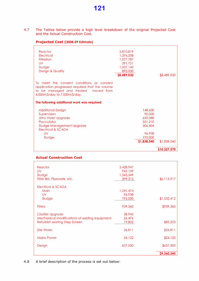
4.7 The Tables below provide a high level breakdown of the original Projected Cost
and the Actual Construction Cost.
Projected Cost (2008-09 Estimate)
Reactor 3,810,819
Electrical 1,376,558
Filtration 1,077,787
UV 291,721
Sludge 1,037,145
Design & Quality 895,000
$8,489,030 $8,489,030
To meet the consent conditions as consent
application progressed required that the volume
to be managed and treated moved from
4,000m3/day to 7,000m3/day.
The following additional work was required:
Additional Design 148,600
Supervision 90,000
Ultra Violet Upgrade 650,388
Flocculator 351,210
Sludge Management Upgrade 306,404
Electrical & SCADA 0
UV 96,938
Sludge 195,000
$1,838,540 $1,838,540
$10,327,570
Actual Construction Cost
Reactor 3,428,947
UV 942,109
Sludge 1,343,549
Filter Bld, Pipework, etc. 399,312 $6,113,917
Electrical & SCADA
Main 1,241,474
UV 96,938
Sludge 195,000 $1,533,412
Filters 939,360 $939,360
Clarifier Upgrade 38,945
Mechanical modifications of existing equipment 26,476
Refurbish existing Step Screen 19,802 $85,223
Site Works 26,811 $26,811
Mains Power 24,122 $24,122
Design 637,500 $637,500
$9,360,345
4.8 A brief description of the process is set out below:
121
1 Activated sludge process
• Provision for pH correction
2 Clarifier (4,000m3/day)
• Provision for chemical dosing to assist with flocculation i.e. suspended solids removal was added
3 Sand filter with continuous backwash (peak flow capacity 7,000m3/day) although outside normal design capacity
• Two banks each 3500m3/day short term capacity – normal use 2,900m3/day
4 Ultra Violet Treatment (peak flow capacity 7,000m3/day)
• Two units each 3,500m3/day
• Capability to ramp dose rate up or down to maintain minimum UVI at 254nm based on flow rate, turbidity and UVT, as measured between filters and UV units
5 Controls
• If the set limit for irradiation is not met, flow will divert from discharge to storage pond, alarm goes to operations controller, with flow returning to discharge once operational parameter is within limits again.
6 Excess influent storage
• During prolonged high rainfall events volume will be controlled to ensure that that no more than 4,000m3 per day is fed into the reactor and through the clarifier
• Flow exceeding that will go to storage; capacity of 35,000m3
• Storage capacity of 35,000m3 is calculated to meet AEP of about 25
years
7 Disposal of stored Influent
• Stored influent will be pumped to the inlet to pass through the full treatment process
8 During prolonged high rainfall events the diluted, stored influent will be fed into the system between the clarifier and the filters to provide maximum possible treatment i.e. sand filtration and ultra violet irradiation
• In event that storage reaches maximum capacity despite discharge at 7,000m3/day, the excess will flow into a stormwater ditch until the
maximum discharge (7,000m3/day) from the system catches up. This is to prevent potential catastrophic failure of storage pond banks.
9 Sludge management
• Supernatant and rainfall from sludge storage will be pumped to the inlet and pass through the full treatment process at all times
• Sludge will be removed at around 1,000m3 per year to slowly catch-up with previous decades of sludge storage
122

• Early laboratory results show that sludge will meet criteria for use as a soil conditioner.
• Consents for disposal will be sought once treatment plant has been commissioned.
4.9 Discharge Consent Application
4.10 Introduction
4.11 Existing (operative) consent expired in 2005 a new consent applied for was put on hold and present operations are under the old Consent. Request for information to inform the Discharge Consent applied for was submitted in June 2009 and further
information was required which led to fairly detailed discussion, mainly with regard to land disposal of treated waste water.
4.12 Consent Issues/Progress
4.13 A final s92 (reply to request for information) was lodged 13 December 2010 and
was processed by Waikato Regional Council. It was notified in June 2011 and six submissions had been received.
4.14 An intensive consultation process with Submitters is still being worked through.
4.15 Second Draft consent report by WRC including draft conditions was received and has been assessed and a reply returned to WRC.
4.16 A meeting was held on 5 April 2013 to further discuss points of difference between WRC and WDC.
4.17 Another meeting will be held on 17 May 2013 to try and finalise the Consent term,
the only remaining sticking point.
4.18 A further meeting was held on 14 August 2013 to discuss issues brought up by
one submitter who has “disappeared” for a period two years and surfaced again in late May 2013. These issues which are mainly about liaison and reporting had been resolved between WDC and WRC
4.19 WRC is now preparing a third draft report including draft conditions for circulation in essence nothing material has changed.
4.20 There is cautious optimism that a 25 year consent will be obtained
4.21 At this stage indications are that a hearing will not be required
123
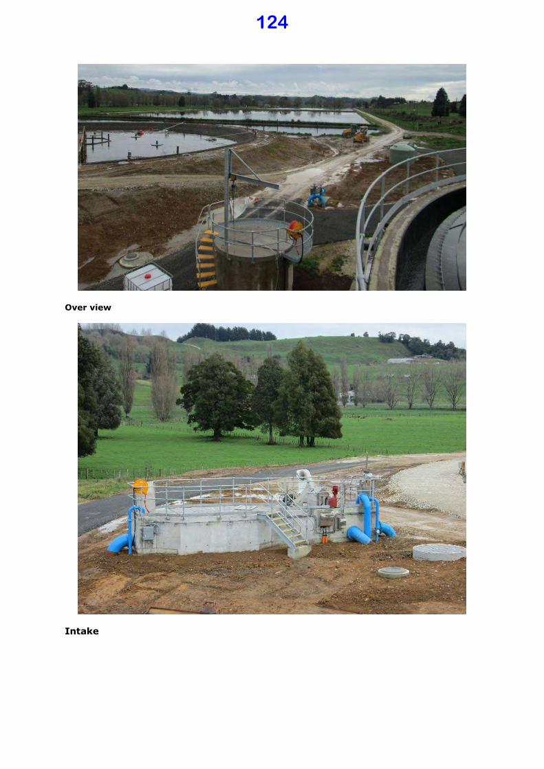
Over view
Intake
124

Reactor
Filters
125
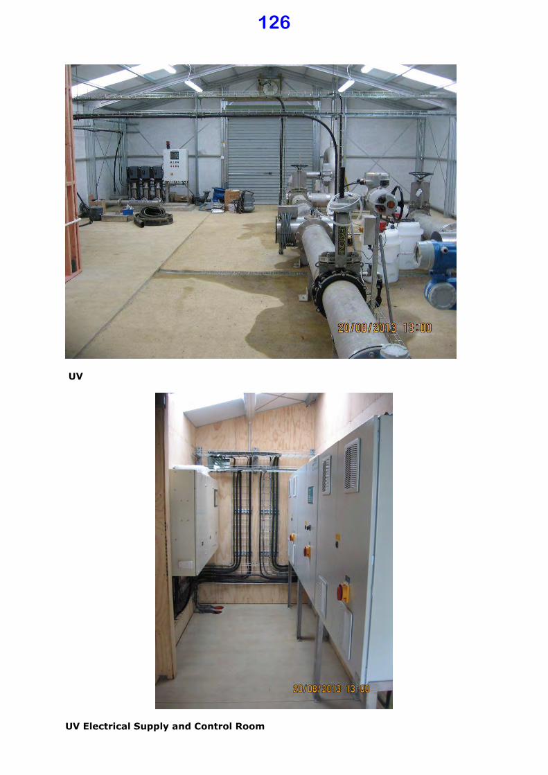
UV
UV Electrical Supply and Control Room
126

Te Waitere Sewerage
5.1 Key Projects and Programmes for the 2013-14 Year
5.2 Project Number One: Land for Soakage
5.3 Introduction
5.4 The Te Waitere sewerage system started as a system to service a subdivision of
eight houses. The domestic water supply is collected off roof tanks and therefore the volume of household waste water is quite low per connection. The consent is for a volume, and based on that, actual waste water generated could service more
houses. Several additional houses along with the Boat Club and public toilets were connected over time. On the basis of the low waste water quantities per household and a report that the capacity of the soakage is adequate as filed by a WRC Officer, it was calculated that up to 25 houses could be serviced.
5.5 There is demand for more sections and at least two owners of larger properties indicated their intent to develop more sections should waste water services be available.
5.6 Further investigation showed that the upgrade of the pump station to provide a reliable service for a larger community would not be a significant issue however the investigation into the capacity of the soakage field showed that it is utilized beyond its capacity already also that the ground along that hill slope is moving.
5.7 Design/Scope
5.8 A concept design that takes cognizance of the specific issues at Te Waitere needs to be developed. This will in all probability require negotiation with landowners for land to be used as soakage fields. Followed by consultation, preliminary design
and cost estimate with rates modeling followed by further consultation with probably an application to MoH for funding.
5.9 Consent Issues/Progress
5.10 The present consent is valid until September 2017. However with the knowledge recently obtained about the capacity of the existing soakage field there will be considerable pressure from WRC on Council to address the issues as soon as possible.
5.11 The Soakage field area had been surveyed to establish the exact position as part of upgrading the pump line and some rehabilitation work at the soakage field. The outcome showed that the land actually move in excess of 1.0m down slope in the
past 15 years.
5.12 Further work/expenditure had been put on hold until such time as a geotechnical investigation identified if there is any land that could be safely develop either through the District Plan or a specific scheme plan.
5.13 Pipeline Renewal Funding Sources and Expenditure to Date
5.14 There is $8,000 in the budget for renewal of a part of the pumpline.
5.15 There has been no expenditure to date.
5.16 A quote was obtained and a project awarded to replace 400m of pipe in
September 2013 which will fit within the $16,000 ($8,000 2012/3 and $8,000 2013-14) providing no major issues are found during construction.
127

5.17 Procurement
5.18 Quote was obtained.
5.19 The work was delayed but is now nearly complete
Benneydale Sewerage
6.1 Issues/Progress
6.2 Earlier work has been completed
6.3 The old network was regarded as being at the end of its economic life. During
affordability review the economic life of the old network was extended by 20 years
6.4 Inspection of the lines showed that there are repair work to be done to ensure that the reticulation last the 20 year period.
6.5 The information has been analysed and a repair/renewal programme developed to
ensure the integrity of the system for at least another 20 years.
6.6 The funding requirement has been placed in the 2013-14 EAP - estimate $78,000
6.7 No work done to date
Piopio Sewerage
7.1 Completed
7.2 Quality of final effluent is very good.
7.3 Some inflow and infiltration was experienced, mainly roof water directed into the sewer. The whole town was inspected and letters to rectify sent to properties
where needed. This has been checked recently and most have done what was asked. The few who did not will receive letters to comply or WDC will employ a plumber to rectify, at their cost.
128
Piopio Outfall
Suggested Resolution The Progress Report: Monitoring Against 2012-2022 Long Term Plan – Sewerage be received.
CHRISTIAAN VAN ROOYEN GROUP MANAGER – ASSETS
February 2014
129
Document No: 327194 File No: 037/020/12A
Report To: Council
Meeting Date: 6 March 2014
Subject: Progress Report: Monitoring Against
2012-2022 Long Term Plan – Land
Transport
Purpose of Report
1.1 The purpose of this business paper is firstly, to brief Council on implementation of the Work Plan for the Land Transport activity as contained in year two (2013/2014) of the 2012-2022 Long Term Plan (LTP) and secondly, to establish
a framework for monitoring the ongoing implementation of the 2012-22 LTP as part of the Road Map Work Programme.
Local Government Act S.11A Considerations
2.1 Waitomo District Council, in performing its role as a Local Authority, must have particular regard to the contribution that the network infrastructure makes to the community.
2.2 The provision and maintenance of the roading infrastructure, is consistent with section 11A Local Government Act 2002 (including amendments).
Introduction
3.1 This business paper focuses predominantly on capital expenditure (CAPEX) projects i.e. renewal and improvement works.
3.2 This business paper is intended to compliment the monthly and quarterly reporting to Council. It provides further information on the capital (improvement and
renewal) expenditure programme.
Background 4.1 The scope of Land Transport activities in the Waitomo District is almost entirely
related to the roading assets. This includes:
• Roads (excluding state highways),
• Footpaths, bridges,
• Traffic services,
3.1 There are no passenger transport services available other than the inter-regional bus connections operating on the state highway network.
130
4.2 The nature of Council’s roading activity is:
• Managing and maintaining the District’s road network.
• Undertaking road rehabilitation and upgrading of the roading structure and ancillary systems such as signs and road markings.
Subsidised Roading
5.1 New Zealand Transport Agency (NZTA), the national road funding authority, provides a financial assistance subsidy for works that meet agreed criteria via the Land Transport Programme.
5.2 Commentaries detailing progress on activities currently subsidised by NZTA in
the 2013/2014 year of the LTP are provided below.
5.3 2013/2014 CAPITAL EXPENDITURE BUDGET
The total budget for subsidised capital works for the 2013/2014 year as
contained in the 2012/22 LTP is $4,572,000.
5.4 STOCK EFFLUENT DISPOSAL FACILITY
5.4.1 Introduction
The Waikato Region Stock Effluent Disposal Facility Strategy indicated the need
for two stock effluent facilities to be built in the Waitomo District. That strategy proposes Waitomo District Council construct one effluent disposal facility on Cotter Street near the sale yards.
5.4.2 Design/Scope
The design of this facility is a standard design obtained from the RCA web site. It is consistent with a number of rural effluent disposal facilities in the Waikato and Taranaki Regions.
Final Design has been received.
5.4.3 Consent Issues/Progress
Water and Waste Water Connections have been applied for and granted.
5.4.4 Budget, Funding Sources and Expenditure to Date
NZTA has approved CAT 1 funding for this site. The approved FAR is 100% for the roading works and 50% for the construction of the facility. WRC will fund the ‘local share’ portion of the construction costs at 50% FAR. $160,000 has
been set aside for this work in the 2012/2013 financial year, with a carryover of funding of $130,000 into the 2013/14 financial year to complete construction.
The Waikato Regional Council provides a rate funding component, collected on behalf of the local authorities, in its LTP for the funding of Stock Truck Effluent
(STE) facilities within the Waikato Region. This rate is collected to cover the development of STE facilities for both construction and the ongoing maintenance of the facilities. Each Local Authority will manage the construction of the disposal facility within their network and take ownership of the asset. The Local
Authority will then invoice WRC to recover the local share. Note that this is contingent on the matched share being provided by NZTA.
131
The funding agreement has been signed and returned.
5.4.5 Construction Issues/Progress
5.4.6 Work is complete with commissioning of the unit on 5 March 2014.
5.4.7 Significant modifications had to be done to existing stormwater, wastewater and water reticulation make everything fit.
5.4.8 Final cost is being collated, but it is expected that the work will be close to the
budgeted amount.
5.1 WALKING AND CYCLING STRATEGY IMPLEMENTATION
5.1.1 Introduction
This item has not been approved as part of the NLTP.
5.2 WALKING AND CYCLING REVIEW
5.2.1 Introduction
This item has not been approved as part of the NLTP. Further progress on the
Walking and Cycling Strategy has been postponed until NZTA reintroduces funding for this work category.
5.3 DRAINAGE RENEWALS
5.3.1 Introduction
Drainage Renewals work covers the replacement of all culverts of up to 1800mm in diameter. Currently WDC is focusing on assessing our high risk roads, in addition to the assessment of existing 225mm dia culverts.
The expectation is all roads will slowly have culverts upgraded to meet the correct rainfall expectations and better assist in pavement maintenance through a substantial reduction in pavement subsidence during storm events.
5.3.2 Design/Scope
Catchment designs are done on all existing culverts over 600mm dia. All culverts of less than 600mm dia are upgraded to suit the surrounding environment and restrictions.
5.3.3 Consent Issues/Progress
Nil to report
5.3.4 Budget, Funding Sources and Expenditure to Date
The LTP budget for this category is $400,000 at a 59% FAR. To date WDC has
spent $216,000.
5.3.5 Procurement
This category is procured, in the main, through the Road Maintenance Contract
or through obtaining quotes or tenders for larger works and some small level of procurement through the Pavement Rehabilitation packages (as appropriate) as they are tendered.
132
5.3.6 Construction Issues/Progress
We are currently underway with our busy programme of drainage renewals and
upgrades across the network.
5.4 PAVEMENT REHABILITATION
5.4.1 Introduction
Three Pavement Rehabilitation Packages are to be let, these are Rora Street (let
2012), Aria Road (3 sites) and Rangitoto Road.
The site works generally involve vegetation clearing, culvert replacements to minimum 375mm dia, base course overlays, two coat sealing and new road
furniture as required.
5.4.2 Design/Scope
Spiire Consultants from New Plymouth were successful with their price for the design and procurement of the Rora Street package. The balance of Packages
once approved will be priced by invited tender. WDC will act as the Engineers Representative on these sites and manage the day to day operations.
5.4.3 Consent Issues/Progress
Nil consent required.
5.4.4 Budget, Funding Sources and Expenditure to Date
The LTP budget for this category is $930,000 with a FAR of 59%. The expenditure to date is $60,177.
This does not reflect committed work like Rora Street which will be completed by 14 March 2014 or Aria and Rangitoto which were tendered but lack of capacity in the industry means that it may not be done this financial year.
5.4.5 Procurement
All work under this category is purchased by way of open tender. This process ensures WDC compliance with the requirements of the NZTA procurement rules. It is intended to procure the work by way of four separate packages through this
process by the end of the 2012 year.
5.4.6 Construction Issues/Progress
Nil to report.
5.5 SEALED ROAD SURFACING
5.5.1 Introduction
The 2013/2014 Reseal Programme comprises approximately 43km of reseal including rural and urban sites.
5.5.2 Design/Scope
This contract was based on a P17 methodology which means that the Council identifies the work sites and specifies the required surfacing treatment. The actual seal design is the responsibility of the contractor.
133
5.5.3 Consent Issues/Progress
Nil.
5.5.4 Budget, Funding Sources and Expenditure to Date
The LTP budget for this category is $1.280M with a FAR of 59%. The expenditure to date is $192,390 (through the Maintenance Contract)
5.5.5 Procurement
This category has been procured through open tender. The tender was advertised on Tenderlink, 5 tenders were received for the contract. Higgins Construction Waikato were the successful tenderer.
5.5.6 Construction Issues/Progress
Seal design and other preparatory work has been completed. The actual resealing will start on 3 March 2014 and is expected to take four weeks.
5.6 STRUCTURES COMPONENTS REPLACEMENTS
5.6.1 Introduction
The 2013/2014 work plan provides for structural maintenance bridges in the Waitomo District.
5.6.2 Design/Scope
The bridges requiring maintenance have all been identified through the detailed inspections and repairs will be designed by Spiire Consultants.
5.6.3 Consent Issues/Progress
Nil to report
5.6.4 Budget, Funding Sources and Expenditure to Date
The LTP budget for this category is $350,000 with a FAR of 59%. The expenditure to date is $27,175.
This does not reflect committed work, Kawhia Harbour Road bridge replacement and Ordish Road culvert lining.
5.6.5 Procurement
Contracts will be procured through open tender.
5.6.6 Construction Issues/Progress
No issues to report.
134

5.7 TRAFFIC SERVICES RENEWALS
5.7.1 Introduction
Traffic Services Renewals provides for the replacement of all signs, edge markers posts, site rails and road marking.
5.7.2 Design/Scope
Compliance with NZTA and Austroads standards is required. Waitomo District is
working towards full compliance. Progress against this target is continually disrupted by vandalism, motor accidents and theft.
5.7.3 Consent Issues/Progress
Nil consents required.
5.7.4 Budget, Funding Sources and Expenditure to Date
The LTP budget for this category is $115,600 at a 59% FAR. To date we have spent $ 24,922 through the Roading Maintenance and/or Street Light
Maintenance Contract.
5.7.5 Procurement
This category is procured through the Road Maintenance Contract and the Street
Light Maintenance Contract.
5.7.6 Construction Issues/Progress
No issues to report
5.8 UNSEALED ROAD METALLING
5.8.1 Introduction
The unsealed road metalling work comprises all structural or overlay metal placed on unsealed roads.
5.8.2 Design/Scope
The maintenance contract has an annual programme which addresses roads requiring structural metal overlays.
5.8.3 Consent Issues/Progress
Nil required.
5.8.4 Budget, Funding Sources and Expenditure to Date
The LTP budget is $502,900 at a 59% FAR. Expenditure to date is $766,221. The difference is covered by unspent budget from 2012-13.
5.8.5 Procurement
This category is procured through the Roading Maintenance Contract.
135

5.8.6 Construction Issues/Progress
The drought delayed the start of our grading and metalling programme. This is
now 90% complete, with the balance of roads targeted for completion during October 2013.
5.9 EMERGENCY RE-INSTATEMENT, MINOR IMPROVEMENTS AND ASSOCIATED
IMPROVEMENTS
5.9.1 Introduction
These are categories that have been approved by NZTA and the NLTP but are on a capped charge up basis i.e. as work is identified or carried out it can be
approved and claimed. NZTA have advised that they have blown there budget for the 13/14 financial year, and are seeking additional funding.
5.9.2 Budget, Funding Sources and Expenditure to Date
The LTP budgets for these categories total $909,900 at varied FAR rates. To
date we have spent $461,431 through the Road Maintenance Contract, Pavement Rehabilitation and Emergency Works contracts.
5.9.3 Procurement
This category has previously been procured through the Roading Maintenance Contract. However a new focus is on best practice, best value tendering using NZTA guidelines. These will be carried out through an invited tender process to minimize costs.
Construction Issues/Progress
The major works completed to date this financial year are:
• RP 8410 Gribbon Road Slip. • RP 1152 Taharoa Road Emergency Reinstatement.
• Te Anga Road – RP 25 kms • Kumara Road – RP 3050-3800 • Beach Road Mokau, Road Termination Protection Works
Unsubsidised Roading
6.1 Work is carried out to ensure safe and efficient travel within and through the District as necessary for road or pedestrian safety and convenience, but are not subsidised by NZTA. The Council has sole financial responsibility for this activity.
6.2 Commentaries detailing progress on unsubsidised roading activities contained in
the 2013/14 year of the LTP are provided below.
6.3 2013/14 CAPITAL EXPENDITURE BUDGET
6.4 The total budget for unsubsidised capital works for the 2013/2014 year as contained in the 2012-2022 LTP is $265,476. This figure includes an allowance
of $25,000 for property purchase if required.
136
6.5 ROAD IMPROVEMENTS
6.5.1 Introduction
Unsubsidised Roading Improvements covers all roading work outside of the formed NZTA approved carriageway. An example of this is the re-construction of driveways following pavement rehabilitations or total new roads.
6.5.2 Design/Scope
Nil to date.
6.5.3 Consent Issues/Progress
Nil to date
6.5.4 Budget, Funding Sources and Expenditure to Date
The LTP budget for this category is $50,000. To date we have spent $2,591
6.5.5 Procurement
Nil to report
6.5.6 Construction Issues/Progress
Nil to report
6.6 FOOTPATH RENEWALS
6.6.1 Introduction
Following NZTA removing its support for walking and cycling activities WDC has reduced its programme for the construction of new footpaths. WDC are only replacing small areas of existing failed footpath this financial year.
6.6.2 Design/Scope
This work is in the process of being identified and programmed.
6.6.3 Consent Issues/Progress
Nil required.
6.6.4 Budget, Funding Sources and Expenditure to Date
The LTP budget for this category is $110,317. To date we have spent $82,805 This budget is being subsidised by the Unsubsidised Roading Improvement
budget. Expenditure to date is $ 83,661
6.6.5 Procurement
This category is procured through the Road Maintenance Contract and by quotations.
6.6.6 Construction Issues/Progress
No issues to report
137
6.7 RETAINING WALL REPLACEMENT
6.7.1 Introduction
WDC has identified several retaining walls that need replacing.
6.7.2 Design/Scope
Designs for 2 retaining walls have been completed. .
6.7.3 Consent Issues/Progress
Building consents for both sites have been obtained.
6.7.4 Budget, Funding Sources and Expenditure to Date
The LTP budget for this category is $55,159, with a carryover from 2012/2013 of
$40,000. To date we have spent $684.00
6.7.5 Procurement
The current project was tendered by invited tender. Two tenders were received. The successful bidder was Inframax Construction Limited.
6.7.6 Construction Issues/Progress
Construction is now complete.
Suggested Resolution The November 2013 Progress Report: Monitoring Against 2012-2022 Long Term Plan –
Land Transport be received.
CHRISTIAAN VAN ROOYEN GROUP MANAGER – ASSETS
February 2014
138

Document No: 327163 File No: 037/005A
Report To: Council
Meeting Date: 6 March 2014
Subject: Progress Report: Monthly Operation and
Maintenance Report for Water, Sewerage
and Stormwater – November 2013
Purpose of Report
1.1 The purpose of this business paper is to brief Council on progress for Operational
and Maintenance a monthly basis and to report on the performance by Council’s
contracted Service Provider for Maintenance (Veolia Water).
Local Government Act S.11A Considerations
2.1 Waitomo District Council, in performing its role as a Local Authority, must have
particular regard to the contribution that the network infrastructure makes to the
community.
2.2 The provision and maintenance of the water, sewerage and stormwater
infrastructure, is consistent with section 11A Local Government Act 2002
(including amendments).
Introduction
3.1 This business paper focuses predominantly on the maintenance area of the three
Waters activities of Council.
3.2 This business paper is intended to compliment the quarterly capital report to
Council.
Background
4.1 The Water Supply activity provides for the environmentally safe collection,
treatment and reticulation of WDC’s public water supplies. Water supply schemes
are provided by Council at:
• Te Kuiti
• Benneydale
• Piopio
• Mokau
4.2 There are three activities under the Water Supply activity:
• Planned Maintenance
• Service Requests / Complaints
• Emergency Repairs
139

4.3 Planned Maintenance
4.4 Operation and maintenance involves the planned servicing of the water
infrastructure –servicing pump stations, cleaning reservoirs, replacing old water
meters, hydrants and valves. These activities are predominantly performed by
Veolia Water by means of Schedule that is worked out in accordance with the
operating instructions from the manufacturer or best practices.
4.5 Service Requests / Complaints
4.6 Service requests are initiated by the Ratepayers or Business in the various towns
and are called in, emailed or they could be provided to the Customer Services by
means of walk-in. The Service Requests are then forwarded to Veolia Water to
resolve.
4.7 Emergency Repairs
4.8 Emergency Repairs are dealt with on an ad hoc basis and cannot be planned in
advance. They are usually dealt with immediately and this may result that
Planned Maintenance and Service Requests are postponed to a later time.
Te Kuiti
5.1 Water Supply
5.2 The Craig Terrace repair failed again and Veolia Water repaired this at their own
expense. The failure occurred due to a gibault that failed.
5.3 A short section of pipe underneath a driveway in Rata Street was replaced. This
pipe is relatively shallow and a stronger pipe, with more protection, has been
installed.
5.4 Water consumption has steadily increased and the WTP is coping with this
demand. The river level and flow are monitored daily to determine the state of the
water demand and availability.
5.5 Cyanobacteria was detected in the river water and the appropriate action were
taken to inform the Waikato DHB. Since then the tests for Cyanotoxins came back
negative and the subsequent tests for the Cyanobacteria showed a decline in the
population. There was no risk to the general public.
5.6 A small chemical spill occurred when a component failed and allowed additional
flocculant to enter into the plant. Some of the water with higher aluminium
sulphate concentration entered into the reticulation before the plant could shut
down. There is no health risk to this, but a nuisance factor and 3 residents
complained that water turned blue when using soap.
5.7 Routine flushing is being carried out to improve the water quality, but this
exercise will be review with the warm weather and lack of rainfall.
5.8 Wastewater
5.9 The WWTP is working well. Operational issues have surfaced with the UV
disinfection and these are dealt with. The supplier is closely working with WDC to
resolve the issue.
5.10 A contained overflow occurred at the outfall of Universal Beef Packers. The
blockage was cleared and it was found that insufficient access to the outfall pipe is
140
available. A new sewer inspection chamber is being installed to allow easier and
more efficient access to clear blockages.
5.11 The sewer pipe in South Street was replaced successfully. A longer section of pipe
was required to be replaced, as the section further toward the next chamber was
previously laid with a positive gradient. The pipe is now flowing correctly with no
ponding liquid. The downstream chamber was also upgraded.
5.12 Additional storm water ingress inspection were held and the owners have been
informed of remedial actions to be taken. A section of pipe underneath the river
was found to have ingress and a course of action is planned to rectify the matter.
5.13 Storm Water
5.14 The final portion of the Cotter Street storm water will commence mid-way into
March. This section will take the pipe underneath the road toward the existing
outfall.
5.15 No storm water issues were received during this period as the rainfall was low.
Mokau
6.1 Water Supply
6.2 The Mokau dam construction started well with good progress being made. Then
abruptly stopped, as a mussel midden and hangi pit was discovered and the
archeologist was called in. The construction was halted for a period until the site
can be assessed and the dam redesigned to work around these sites.
6.3 The level of the supply dam is low, but holding steady with the spring feeding into
it. The back dam has also been feeding water into the supply dam. Some work is
required to repair a siphon pipe to resume siphoning from the rear dam to the
water works when the dam levels go even lower.
6.4 Presently the water consumption has reduced, but the situation is being closely
monitored and the appropriate water conservation levels will be communicated
when the time comes that the dam levels are low enough for this course of action.
6.5 Storm Water
6.6 No issues were reported for storm water during this period.
Piopio
7.1 Water Supply
7.2 A routine service was done on the membrane filter. This is an annual service. A
number of small issues were corrected that will improve the water production and
supply. Notably a leak at the inlet pipe to the feed manifold.
7.3 The chlorine dosing has been troublesome and a fault finding exercise found that
a non-return valve was the cause. The ball had disintegrated and the valve only
functioned intermittently.
7.4 A leak in Aria Road at the Piopio College was repaired. When the area was
excavated, it was noticed that the fire hydrant was also in need of replacement.
As a result of the shut down, the opening and closing of valves caused pressure
differences to the extent that the lateral to the primary school cracked. A new
pipe was drilled underneath the road and the service was restored.
141
7.5 A new valve was installed in Aria Road to allow a smaller section of service to be
closed off when working at or near the schools. It was found that too many
consumers were affected when shutting down the feed to the college.
7.6 Several hydrants have been replaced in Piopio in consultation with the fire service.
7.7 Wastewater
7.8 No major issues were reported. Some minor blockages were reported and cleared
by the maintenance contractor. The Piopio public toilets had a septic tank
blockage that caused an overflow. This was cleared up and disinfected with lime
soon afterward. The tank had to be vacuum cleared at the same time, as large
objects were found.
7.9 Storm Water
7.10 No issues to report
Benneydale
8.1 Water Supply
8.2 No major issues were reported. Only routine maintenance has been carried out.
8.3 Wastewater
8.4 Additional protection against another overflow has been installed by fitting a pipe
from the sewer chamber to the biofilter. More regular maintenance trips have
been implemented as well.
8.5 Storm Water
8.6 Nothing to report.
Waitomo Village
9.1 Background
9.2 Nothing to report.
Te Waitere Sewer System
10.1 Background
10.2 After the contractor moved off site last year due to inclement weather, he has
resumed drilling of the pipe. Progress is not going as well as hoped, as rock has
been discovered and a rock drill has to be employed. It is now understood why a
long section of pipe was laid above ground in the past.
10.3 Two pipe bursts have occurred on the sewer outfall line that were repaired.
142

Suggested Resolution
The Progress Report: Monthly Operation and Maintenance Report for Water, Sewerage
and Stormwater – February 2014 be received.
ANDREAS SENGER
MANAGER – WATER SERVICES
143
Document No: 327851 File No: 400/010/2
Report To: Council
Meeting Date: 6 March 2014
Subject: Progress Report: Civil Defence Emergency
Management Joint Committee Minutes
Purpose of Report
1.1 The purpose of this business paper is to provide Council with information relating
to the Civil Defence Emergency Management (CDEM) Joint Committee meeting of
18 November 2013.
Background
2.1 Council is represented on the CDEM Joint Committee by the Mayor.
2.2 The Co-ordinating Executive Group (CEG) for Civil Defence has requested that all
minutes for the CDEMG and CEG be circulated to Council Members in an
endeavour to increase the profile of Civil Defence in our Region.
Commentary
3.1 Attached to and forming part of this business paper are the minutes of the CDEM
Joint Committee meeting of 18 November 2013.
Suggested Resolution
The Progress Report: Civil Defence Emergency Management Joint Committee Minutes be
received.
JOHN DE LUCA
GROUP MANAGER – COMMUNITY SERVICES
February 2014
Attachment: 1 Joint Committee Minutes – 18 November 2013 (doc 327853)
144

WAIKATO CIVIL DEFENCE EMERGENCY MANAGEMENT GROUP JOINT COMMITTEE
Minutes of the meeting of the Waikato Civil Defence Emergency Management Group Joint Committee, held in the Mystery Creek Event Centre "hosting room" 125 Mystery Creek Road, Hamilton 3240 at 1.00 pm on Monday 18 November 2013 MEMBERS PRESENT: Waikato Regional Council
Cr H Vercoe Hamilton City Council Representative
Cr L Tooman (in attendance) Hauraki District Council Representative
Mayor JP Tregidga Matamata Piako District Council Representative
Cr B Hunter Otorohanga District Council Representative
Mayor M Baxter South Waikato District Council Representative
Cr T Lee Taupo District Council Representative
Cr A Park Thames Coromandel District Council Representative
Cr P French Waikato District Council Representative
Cr J Church Waipa District Council Representative
J Bannon (in attendance) Waitomo District Council Representative
Mayor M Hanna
IN ATTENDANCE: Ministry of Civil Defence and Emergency Management J Titmus
STAFF CEG Chair
L Cavers Waikato Regional Council Manager GEMO (L Hazelwood), Team Leader GEMO (G Ryan), Committee Administrator (D Atkinson)
APOLOGIES
Accepted
145
Report of Waikato Civil Defence and Emergency Management Group Joint Committee – 18 November 2013 p2
CD13/69 Election of CDEM Group Joint Committee Chair and Deputy Chair 03 04 18, (Agenda Item 1) CEG Chair (L Cavers) took the Chair and called for nominations for the position of chair for the 2013 2016 term Mayor Tregidga moved/ Cr Lee seconded
CD 13/69 THAT Councillor H Vercoe be appointed Chair of the Waikato CDEM Group Joint Committee for the 2013-2016 Term.
The motion was put and carried (CD13/69)
In assuming the chair, Councillor Vercoe expressed appreciation to the committee for their confidence in him and then called for nominations for the position of Deputy Chair Chair moved/ Cr Tregidga
CD13/69.1 THAT Councillor P French be appointed Deputy Chair of the Waikato CDEM Group Joint Committee for the 2013-2016 term subject to the Thames-Coromandel District Council changing his appointment from alternate to member.
The motion was put and carried (CD13/69.1)
CD13/70 Minutes of Previous Meeting (2 September 2013)
File: 03 04 18 (Agenda Item 4) Docs#
Mayor Tregidga moved/Cr French seconded.
CD13/70 THAT the Minutes of the Waikato Civil Defence Emergency Management Group Joint Committee meeting of 2 September 2013 be received and approved as a true and correct record.
The motion was put and carried (CD13/70)
Committee induction
File: 03 04 18 (Agenda Item) The Chair welcomed all members to the meeting, noting a more than 50% turnover from the 2010-2013 term. Each member introduced themselves and advised any Civil Defence interests and related experience. Following a similar self introduction by staff present, CEG Chair (L Cavers) then delivered a power point induction presentation that included the following aspects:
An outline of matters contained in the Civil Defence Act 2002 and the obligations and responsibilities of local authorities relating to those matters.
The activities of the Waikato CDEM Group during the past term and the efforts that have been undertaken (or are in process) to raise the
146
Report of Waikato Civil Defence and Emergency Management Group Joint Committee – 18 November 2013 p3
Group to a position of being one of the best performing in New Zealand. It was noted that in 2009 MCDEM had conducted a capability assessment of the Waikato CDEM Group. This had resulted in a lowly capability rating of 44.7% and 76 recommendations to improve a poorly performing situation. To date 47 recommendations have been addressed, 17 are in progress and 7 are planned but not commenced. The remaining 5 are yet to be scoped. MCDEM has acknowledged a remarkable turnaround and a further capability assessment is now planned for mid 2014.
An outline of how the activities of the Waikato CDEM Group are funded and how this funding is met by ratepayers within the region.
Mayor Tregidga moved/ Cr French seconded
CD13/70 THAT the induction presentation from CEG Chair (L Cavers) be received for information.
The motion was put and carried (CD13/70)
CD13/71 Group Emergency Management Office (GEMO) Report File: 03 04 18 (Agenda Item 6) The purpose of this item presented by Team Leader GEMO (G Ryan) was to provide an update of work being undertaken by the GEMO. During the presentation, questions and answers the Committee noted:
The report is a business as usual item that will appear on all regular meeting agendas.
The MOU with the emergency services to further investigate the construction of a multi-agency all hazards centre is a unique opportunity that has occurred through current Police and Fire Service leases expiring at the same time.
Mayor Tregidga moved/ Cr French seconded
CD13/71 THAT the report “GEMO Report” (Doc #2892868, dated 8 November 2013) be received for information.
The motion was put and carried (CD13/71)
CD13/72 Summarised CEG Minutes File: 03 04 18 (Agenda Item 7) This item was presented by GEG Chair (L Cavers). Mayor Hanna moved/Cr Park seconded
CD/72 THAT the report “Summarised CEG minutes” (Doc #2892084 dated 8 November 2013) be received for information.
The motion was put and carried (CD13/72)
147

Report of Waikato Civil Defence and Emergency Management Group Joint Committee – 18 November 2013 p4
CD13/72 MCDEM Report File: 03 04 18 (Agenda Item 8) The report was presented by J Titmus (MCDEM). The Committee noted the following matters:
Implementing the corrective action plan derived from the review of the response to the Christchurch earthquake still dominates the MCDEM work programme.
Brendan Morris consulting has been engaged by MCDEM to review and develop a standard for sirens, specifically with a view on tsunami warnings. A report is expected by December 2013.
The proposed scope of the review of the legislation for recovery from an emergency has now been agreed by the Minister of Civil Defence.
Mayor Baxter moved/ Mayor Hanna seconded
CD13/72 THAT the report MCDEM update (Doc 2892455 dated 18 October 2013) be received for information.
The motion was put and carried (CD13/72)
Meeting adjourned at 2.58 pm During the adjournment the Chair and members went to a different part of the building for the “Expandable GECC MOU signing” referred to in Item 14 of the agenda.
Meeting resumed at 3.22 pm
Mayor Hanna, Mayor Baxter and Cr French out of meeting at 3.22pm
CD13/73 Proposed 2014/2015 GEMO work programme
File: 03 04 18 (Agenda Item 9) The purpose of this item presented by GEMO Manager (L Hazlewood) was to seek Committee approval of the 2014/2015 GEMO work programme and budget. Mayor Tregidga moved/ Cr Park seconded
CD13/73 THAT 1. The report “Proposed 2014/2015 GEMO work programme” (Doc
#2892517 dated 8 November 2013) be received (and) 2. The proposed 2014/2015 GEMO work programme and budget be
approved and adopted. The motion was put and carried (CD13/73)
148
Report of Waikato Civil Defence and Emergency Management Group Joint Committee – 18 November 2013 p5
CD13/74 Group Recovery Manager File: 03 04 18 (Agenda Item 10) The purpose of this item presented by CEG Chair (L Cavers) was to recommend the appointment of Greg Ryan to the position of Waikato CDEM Group Recovery Manager. The recommendation for the appointment had been brought about by the resignation of the Brendan Morris from the position. Bringing the position in house as proposed would enable work flows to be handled in conjunction with other structure changes. Chair moved/Cr Park seconded
CD13/74 THAT 1. The report “Appointment of Group Recovery Manager” (Doc
#2892929 dated 8 November 2013) be received (and) 2. The appointment of Greg Ryan (GEMO Programme Manager) as Group Recovery Manager be approved.
The motion was put and carried (CD13/74)
CD13/75 2013 Ministerial CDEM Awards File: 03 04 18 (Agenda Item 11) The purpose of this item presented by J Titmus (MCDEM) was to inform the Committee of the opportunity to make nominations for Ministerial Civil Defence Awards and the criteria applying for the awards. In addition J. Titmus also appraised the Committee of the ongoing opportunity to recommend appropriate individuals for long service awards. The view was expressed that subject to meeting the awards criteria, the generous corporate citizenship displayed by Mystery Creek Events in providing at no cost an expandable GECC facility for the Waikato CDEM Group was worthy of nomination. Cr J Church moved/ seconded Mayor Tregidga
CD13/75 THAT 1. The information advice from MCDEM “Update on Ministerial CDEM Awards” (Doc #2894095 dated 8 November 2013) be received. 2. Subject to the GEMO, the Committee Chair and the CEG Chair being satisfied the criteria for a Ministerial CDEM Award is met by the corporate citizenship of Mystery Creek Events, a nomination be made for a Ministerial CDEM Award. 3. Committee members ascertain for consideration at a future meeting proposed nominees for long service awards.
The motion was put and carried (CD13/75)
149
Report of Waikato Civil Defence and Emergency Management Group Joint Committee – 18 November 2013 p6
CD13/76 2014 Meeting dates
File: 03 04 18 (Agenda Item 12) It was noted confirmation of meeting dates would be forwarded to Members subject to the Waikato Regional Council confirming its 2014 schedule of meeting dates on 12 December 2014. Mayor Tregidga moved/ Cr Church seconded
CD13/76 THAT the report “2014 Waikato CDEM Group meeting dates” (Doc #2894099 dated 8 November 2013) be received and the proposed 2014 meeting dates outlined therein approved as scheduled below
Monday 3 March (1 pm) Monday 9 June (1 pm) Monday 1 September (1 pm) Monday 17 November (1 pm)
The motion was put and carried (CD13/76)
Items for next meeting File: 03 04 18 (Agenda Item) No items were noted
Meeting closed at 3.47 pm Doc #2896156
150
Document No: 328009 File No: 401/0588424200
Report To: Council
Meeting Date: 6 March 2014
Subject: Progress Report - Waitomo Cultural and
Arts Centre – Stage 4 Upgrade
Purpose of Report 1.1 The purpose of this business paper is to brief Council on progress for the Stage 4
upgrade of the Waitomo Cultural and Arts Centre.
Local Government Act S.11A Considerations
2.1 The provision of community infrastructure, such as the Cultural and Arts Centre, is consistent with Section 11A of the Local Government Act 2002 (including amendments).
2.2 Upgrading of the facility will lead, over time, to increased usage and subsequent
increased income, making the facility more cost effective to administer.
Background 3.1 Council in its 2012-2022 LTP continued the funding of the staged upgrade of the
Waitomo Cultural and Arts Centre. The upgrade to date has been well received by
the users and public.
3.2 The funding of the 2012-2013 financial year was $130,000 of which a minimal amount was used to complete the Supper Room upgrade, leaving approximately $114,000 for Stage 3.
3.3 It is to be noted that budgeting is not tagged to any specific project within the upgrade proposal due to the required funding being spread over six years as compared to the initial upgrade programme of 3 years. The change was
promoted for affordability reasons.
3.4 Council, at its meeting on 25 September 2012 reviewed several options for the next stages of the Arts & Cultural Centre upgrade and resolved to proceed with the renewal of the ceiling, lighting and aircon outlets in the main hall as stage four
at the end of the financial year, combining the remaining budget with the 2013/2014 allocation.
151
Commentary 4.1 25 June 2013
4.2 Ceiling to Main Hall
4.3 Renewal of the ceiling in the main hall involves several items of work:
• Battening and gibbing a new ceiling as per the foyer redevelopment. The original estimate for replacing the ceiling in the main hall was $48,000 with the quote from the stage 2 builder being $93,000.
• Removal of the texture coating from side walls (this could be done at a later
date). • Upgrading lighting, power points/emergency lights, which is estimated at
$65,000.
• Upgrading air conditioning outlets as well as fire and alarm requirements, estimated at $10,000.
4.4 A meeting was held on site with the architect on the 17 October 2012 to discuss
options for progressing this work, and the extent of specification required. The opportunity was taken at this early stage to coincide with the final inspections for stage two.
4.5 The contract documentation for Stage 4 is well advanced and the architects have indicated these will be completed by 21 June 2013.
4.6 Regarding the queries from the Shearing Committee, the following treatments have been undertaken:
a) A limited amount of ceiling can be raised on front of the stage due to the
steel truss construction. The raising of the first bay has been included in the documents.
b) All existing fixing points are retained. c) The modification to the exit door to the right of the stage has been
included as a separate item in the documentation. Changes to this door
could be expensive due to the exterior cladding and the progress of this item of work can be assessed at the time of tender assessment.
d) Banner fixing wires are included in these documents.
e) The stage height will be investigated and included in separate
documentation in the future.
f) Provision for LED lighting is still being investigated (since deleted by the
Shearing Committee)
4.7 A tentative construction period for this contract is 22 July – 13 August 2013, although finalising construction times would be negotiated with the successful tenderer and potential users of the hall.
4.8 It is anticipated that the project will be tendered on either 27 or 28 June, with
tender closing 10 July 2013.
152
4.9 27 August 2013
4.10 Unfortunately, the above timeline could not be met, however the project has now
been tendered for two weeks, closing 23 August 2013 with construction during September.
4.11 The construction period will be completed depending on the time to remove the
ceiling coating and availability of materials. Initial indication is that this will be considerably longer than allowed for in the timeline. If this is the case, the next window of opportunity is in December 2013.
4.12 24 September 2013
4.13 The tenders subcommittee is scheduled to receive a business paper on
Wednesday 17 September 2013 to review two tenders received for this project. 4.14 Considerable discussion has been had with the contractors around the time and
works required to remove the ceiling coating which contains asbestos. It became apparent during these discussions that the work could not be programmed around the existing bookings.
4.15 Further discussions will be held with the successful tenderer around establishing a window for the works over the December/January period when traditionally the centre has little use.
4.16 26 November 2013
4.17 An agreed programme has been committed by the contractor. Works will
commence Monday 9 December 2013 with the initial 10 days for the removal of the ceiling coating. The complete complex will be closed during that time.
4.18 The construction is due to be completed by 30 January 2014. A small break will
occur over Christmas. After the initial 10 day period the Civic Centre, except for the main hall, will be available for use.
4.19 6 March 2014 4.20 The project is at the practical completion stage and a defects meeting between
the contractor, architect and Group Manager – Community Services is scheduled
for 27 February 2014. 4.21 While the asbestos removal before Christmas progressed to schedule the actual
construction works proved to be much more difficult than envisaged, partly due to
the construction techniques and lack of as built plans from the time of the original development.
4.22 It is now planned to do a funding reconciliation since the refurbishment programme commenced before submitting further refurbishments stages to Council for approval. This will be presented to Council at its meeting in late March 2014.
153

Suggested Resolution The Progress Report : Waitomo Cultural and Arts Centre – Stage 4 Upgrade be received.
JOHN DE LUCA
GROUP MANAGER – COMMUNITY SERVICES
February 2014
154
Document No: 328470 File No: 037/043
Report To: Council
Meeting Date: 6 March 2014
Subject: Motion to Exclude the Public for the
Consideration of Council Business
Purpose of Report
1.1 The purpose of this business paper is to enable the Council to consider whether or
not the public should be excluded from the consideration of Council business.
Commentary
2.1 Section 48 of the Local Government Official Information and Meetings Act 1987
gives Council the right by resolution to exclude the public from the whole or any
part of the proceedings of any meeting only on one or more of the grounds
contained within that Section.
Suggested Resolutions
1 The public be excluded from the following part of the proceedings of this meeting.
2 Council agree the following staff, having relevant knowledge, remain in
attendance to assist Council with its decision making:
…
3 The general subject of each matter to be considered while the public is excluded,
the reason for passing this resolution in relation to each matter, and the specific
grounds under Section 48(1) of the Local Government Official Information and
Meetings Act 1987 for the passing of this resolution are as follows:
General Subject of each
matter to be considered
Reason for passing this resolution in
relation to each matter
Section
48(1)
grounds for
this
resolution
1. Mayoral Forum Work
Streams and Regional
Sheared Service
Initiatives
7(2)(i) Enable any local authority holding the
information to carry on, without prejudice or
disadvantage, negotiations (including
commercial and industrial negotiations)
48(1)(a)
2. Local Government New
Zealand – Special General
Meeting
7(2)(i) Enable any local authority holding the
information to carry on, without prejudice or
disadvantage, negotiations (including
commercial and industrial negotiations)
48(1)(a)
155
General Subject of each
matter to be considered
Reason for passing this resolution in
relation to each matter
Section
48(1)
grounds for
this
resolution
3. Progress Report:
Regulatory Enforcement
Issues
7(2)(i) Enable any local authority holding the
information to carry on, without prejudice or
disadvantage, negotiations (including
commercial and industrial negotiations)
48(1)(a)
4. Progress Report: Wool
Storage Facility
7(2)(i) Enable any local authority holding the
information to carry on, without prejudice or
disadvantage, negotiations (including
commercial and industrial negotiations)
48(1)(a)
5. Cultural and Arts Centre –
Shared Parking
Investigation
7(2)(i) Enable any local authority holding the
information to carry on, without prejudice or
disadvantage, negotiations (including
commercial and industrial negotiations)
48(1)(a)
6. Progress Report: Rural
Halls
7(2)(i) Enable any local authority holding the
information to carry on, without prejudice or
disadvantage, negotiations (including
commercial and industrial negotiations)
48(1)(a)
7. Progress Report:
Parkside Subdivision
7(2)(i) Enable any local authority holding the
information to carry on, without prejudice or
disadvantage, negotiations (including
commercial and industrial negotiations)
48(1)(a)
8. Progress Report: Brook
Park Entrance
7(2)(i) Enable any local authority holding the
information to carry on, without prejudice or
disadvantage, negotiations (including
commercial and industrial negotiations)
48(1)(a)
9. Progress Report: Te Kuiti
Railway Building
7(2)(i) Enable any local authority holding the
information to carry on, without prejudice or
disadvantage, negotiations (including
commercial and industrial negotiations)
48(1)(a)
10. Progress Report: Te Kuiti Mainstreet Re-Design
7(2)(i) Enable any local authority holding the
information to carry on, without prejudice or
disadvantage, negotiations (including
commercial and industrial negotiations)
48(1)(a)
11. Progress Report: Te Kuiti Community House
7(2)(i) Enable any local authority holding the
information to carry on, without prejudice or
disadvantage, negotiations (including
commercial and industrial negotiations)
48(1)(a)
12. Progress Report: Te Kuiti Cemetery
7(2)(i) Enable any local authority holding the
information to carry on, without prejudice or
disadvantage, negotiations (including
commercial and industrial negotiations)
48(1)(a)
13. Progress Report: Mokau Toilet Effluent Upgrade
7(2)(i) Enable any local authority holding the
information to carry on, without prejudice or
disadvantage, negotiations (including
commercial and industrial negotiations)
48(1)(a)
156
General Subject of each
matter to be considered
Reason for passing this resolution in
relation to each matter
Section
48(1)
grounds for
this
resolution
14. Progress Report: Marokopa Campground –
Renewals Work
7(2)(i) Enable any local authority holding the
information to carry on, without prejudice or
disadvantage, negotiations (including
commercial and industrial negotiations)
48(1)(a)
15. Progress Report: Marokopa Sea Wall
7(2)(i) Enable any local authority holding the
information to carry on, without prejudice or
disadvantage, negotiations (including
commercial and industrial negotiations)
48(1)(a)
16. Progress Report: Benneydale Water
Easements
7(2)(i) Enable any local authority holding the
information to carry on, without prejudice or
disadvantage, negotiations (including
commercial and industrial negotiations)
48(1)(a)
This resolution is made in reliance on Section 48(1)(a) of the Local Government
Official Information and Meetings Act 1987 and the particular interest or interests
protected by Section 6 or Section 7 of that Act or Section 6, Section 7 or Section 9
of the Official Information Act 1982 as the case may require are listed above.
MICHELLE HIGGIE
EXECUTIVE ASSISTANT
157