report on the · report on the geophysical surveys performed on douglas 2-80 douglas township...
TRANSCRIPT

2.NTS. 42-A-3
42A62NVM13 2.4425 DOUGLAS 010
REPORT ON THE
GEOPHYSICAL SURVEYS
PERFORMED ON
DOUGLAS 2-80
DOUGLAS TOWNSHIP
PORCUPINE MINING DIVISION
RECEIVED
(MINING LANDS SECTION
NOVEMBER 30, 1981 TIMMINS, ONTARIO
L.A. WADDELL
NORANDA EXPLORATION CO. LTD.

- l -
Douglas 2-80
INTRODUCTION
The property consists of 4 contiguous unpatented mining
claims numbered P-584843-P-584845 inclusive and P-586479. They are situated in the extreme southeast corner of Douglas Township.
The claim group is located approximately 18 miles southeast of Timmins, Ontario.
ACCESS
The property is reached via the Langmuir Mine road south of
South Porcupine, Ontario. Near the Croteau River a bush road is
taken to the southwest for 16 miles to the Fallon and Cleaver
Township line.
Final access is by foot along township line to the property which is \\ miles west from the road.
TOPOGRAPHY
The property is one of low relief with elevations ranging
between 1000 to 1075 feet above sea level. Open, flat lying,
swamp and grassy lowland areas mainly occupy creek flood plains.
Creeks are fast flowing and supply good drainage into Forks Creek.
Although spruce is the most abundant tree type found there
are also lesser amounts of birch, poplar, pine and cedar.
LINECUTTING
A base line 3200 feet long was cut on an azimuth of N60OW
from a point near bend in Forks Creek along Douglas, Fallon
Township line. Travers lines were cut normal to the base line at
400 foot intervals. A tie line at 24+00 south was cut to provide
additional control for the grid. The base line, tie line, and
traverse lines were all chained and picketed at 100 foot intervals

- 2 -
In all, 5.7 miles of line was cut, chained and picketed by Mike Wabano, linecutter, of Timmins, Ontario in the period March 27 - April 7, 1981.
MAGNETIC SURVEY
1) Assessment Data.
The instrument used was a McPhar M-700 Fluxgate Magnetometer. Base readings were taken along the base line and all readings were then adjusted relative to the base readings. Readings were taken at the base control stations at periodic intervals to discern day-to-day and diuranl drift. Any changes noted in the magnetic intensity were then applied as factors and progressive adjustments were made to each reading taken during that specific period of time.
Some 285 stations were read by Sigouin and Hussey, contractors, of Timmins, Ontario in the period June 8-10, 1981.
2) Magnetic Results.
The results of the magnetic survey are shown on prints accompanying this report.
Geological mapping has shown the property to be underlain by basic metavolcanic rocks (andesite) intruded by mafic rocks (olivine diabase).
One zone of negative magnetics was located by the survey. It traverses the property from 4+00 south on line 12 east to 8+00 south on line 20 west. Outcrops of olivine diabase have been found which correspond with this magnetic feature.
The area of higher magnetics along line 8 east may suggest that the line is parallel to a north trending diabase dyke.
No other magnetic anomalies of significance are present on the claim group.
- 3 -
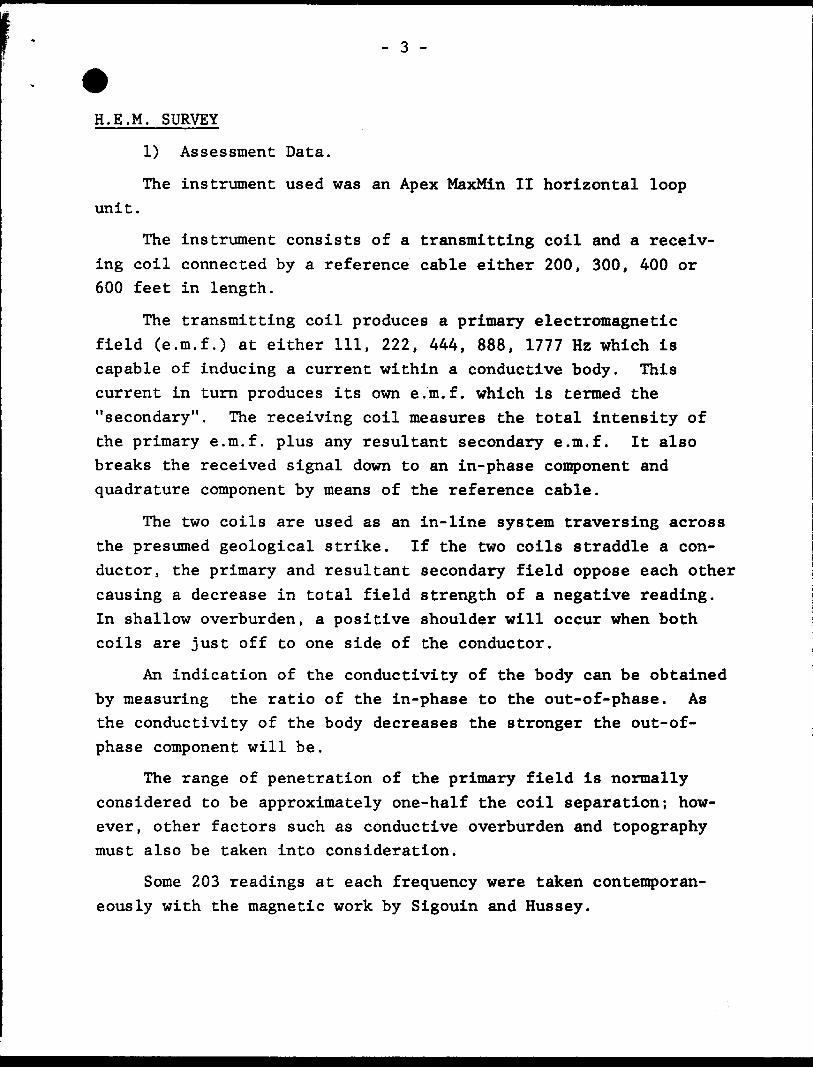
H.E.M. SURVEY
1) Assessment Data.
The instrument used was an Apex MaxMin II horizontal loop
unit.
The instrument consists of a transmitting coil and a receiv ing coil connected by a reference cable either 200, 300, 400 or 600 feet in length.
The transmitting coil produces a primary electromagnetic field (e.m.f.) at either 111, 222, 444, 888, 1777 Hz which is capable of inducing a current within a conductive body. This current in turn produces its own e.m.f. which is termed the "secondary". The receiving coil measures the total intensity of the primary e.m.f. plus any resultant secondary e.m.f. It also breaks the received signal down to an in-phase component and quadrature component by means of the reference cable.
The two coils are used as an in-line system traversing across the presumed geological strike. If the two coils straddle a con ductor, the primary and resultant secondary field oppose each other causing a decrease in total field strength of a negative reading. In shallow overburden, a positive shoulder will occur when both coils are just off to one side of the conductor.
An indication of the conductivity of the body can be obtained by measuring the ratio of the in-phase to the out-of-phase. As the conductivity of the body decreases the stronger the out-of- phase component will be.
The range of penetration of the primary field is normally considered to be approximately one-half the coil separation; how ever, other factors such as conductive overburden and topography must also be taken into consideration.
Some 203 readings at each frequency were taken contemporan eously with the magnetic work by Sigouin and Hussey.

- 4 -
2) H.E.M. Results.
The results of the H.E.M. survey are shown on prints accomp anying this report.
One weak two line conductor was located. There is some suggestion that it correlates with a very slight magnetic ex pression (50 gammas).
CONCLUSION
Due to the isolated nature of this conductor more closely spaced detail E.M. work should be done, i.e. lines 2W, 00, 2E, 4E and 6E should be read across conductor with vertical loop unit. When the zone has been defined a drill hole is recommended to determine cause of conductivity.
Waddell Noranda Exploration Company, Limited

Ministry ot Natural
urcesOntario
Re^u
OOH73 Report of Work(Geophysical, Geological, Geochemical and Expenditures)
The MiniiType of Survey(s)
GEOPHYSICAL (electromagnetic 4 magnetic)
42A*2NWMI3 2.4425 DOUGLAS
(Township or Area
DOUGLAS
300
Claim Holder(t)
Noranda Exploration Company, LimitedSurvey Company
Sigouin ft Hussey
Protpaetor'i Licence No.
A-3^387
Name and Address of Author (of Geo-Technical report)
L.A, Waddell, P.O. Box 1203, Timmins, Ontario
Survey Dates (linecutting to office)
SE i MI. , fei aa i L iTotal MilM of line Cut
5.1_______
Instructions
For first survey:
Enter 40 days. (This includes line cutting)
For each additional survey: using the same grid:
Enter 20 days (for each)
Geophysical
- Electromagnetic
- Magnetometer
- Radiometric
- Other
Geological
Geochemical
Days per Claim
20
1*0
Man DaysInstructions
Complete reverse side and enter total (s) here
Geophysical
- Electromagnetic
- Magnetometer
- Radiometric
- Other
Geological
Geochemical
Days per Claim
Airborne Credits
Note: Special provisions credits do not apply to Airborne Surveys.
Electromagnetic
Magnetometer
Radiometric
Days par Claim
Expenditures (excludes power;'Type of Work Perfor^r,^ Q Q ft
Performed on Claim( viov -
Calculation of Expen
Total ExpendituresTotal
Days Credits
InstructionsTotal Days Credits may be apportioned at the claim holder's choice. Enter number of days credits per claim selected in columns at right.
Report CompletedData of Report
Nov. 17/81EHflGXaeUBHMlt!6KAgent,(Signature) '"
Certification Verifying Reporfof Work
Mining C laims Traversed (List in numerical sequence)
l hereby certify tHat l have a personal and intimate knoyvledge of the facts set forth in tha Report of or witnessed same during and/Of after its completion and the annexed report is true.
Total number of mining claim* covered by this
work.
Name and Postal Address of Person Certifying
L.A. Waddell V ./ ;
P, O, Box , Tissnin3, OntarioData Certified
Nov. 17/811362 (81/2)

*Ministryof GeotechnicalNatural p rtResources "
Ontario ^^ Approval
File
Mining Lands Comments
Geophysics
Comment*
pproved D Wish to cee again with correction*
To: Geology - Expenditures
Comments
Approved With to sea again with correctionsDate Signature;
To: Geochemistry
Comments
\
Approved Wish to see again with correctionsDate Signature
j fro: Mining Lands Section. Room 6462. Whitney Block. (Ttl: 5-1380)
1693(81/10)

January 15, 1982 2.4425
Office of the Mining Recorder Ministry of Natural Resources 60 Wilson Avenue Tlnrnilns, Ontario P4N 2S7
Dear Sin
We have received reports and maps for a Geophysical (Electromagnetic and Magnetometer) Survey submitted under Special Provisions (credit for Performance and Coverage) on Mining Claims P.584843 et al, in the Township of Douglas.
This material will be examined and assessed and a statement of assessment work credits will b* issued.
Tours very truly,
E.F. AndersonDirectorLand Management Branch
Whitney Block, Room 6450Queen's ParkToronto, OfltarioM7A 1W3Phone: 416/965-1380
J. Skura/bk
CO L.A. WaddellTimmins, Ontario

Ontario
Ministry of Natural Resources
GEOPHYSICAL - GEOLOGICAL - GEOCHEMICAL TECHNICAL DATA STATEMENT
File.
TO BE ATTACHED AS AN APPENDIX TO TECHNICAL REPORTFACTS SHOWN HERE NEED NOT BE REPEATED IN REPORT
TECHNICAL REPORT MUST CONTAIN INTERPRETATION, CONCLUSIONS ETC.
\oa
lbU.O
Type of Survey (s) Geophysical (electromagnetic S magnetic)
Township or Area Douglas^—^——^-^————^———————Claim HolHer(s) Noranda Exploration Company, Limited_____
Suite ^00, 5 5 Yonge Street, Toronto, Ontario Survey Company Sigouin 4 Hussey——————^-—.————
Author of Report L. A. Waddell————————————————Address of Amhnr P-O- Box 1205. Timmins, Ontario_______ Covering Dates of Survey March 27 - June 10, 1981_________
(linecutting to office)
Total Miles of Line Cut. 5.7
SPECIAL PROVISIONS CREDITS REQUESTED
ENTER 40 days (includes line cutting) for first survey.ENTER 20 days for each additional survey using same grid.
Geophysical
—Electromagnetic.
—Magnetometer—.
—Radiometric———Other——————
DAYS per claim
20
UO
Geological.
Geochemical.
AIRBORNE CREDITS (Special provision credits do not apply to airborne surveys)
Magnetometer. . Electromagne tic Radiometric
MINING CLAIMS TRAVERSED List numerically
P
P
..5.8Ji.8!iL.....""""(BunAorV
58U8UU
P
P 586U79
(enter days per claim
nATF .Nov. 30/81 SIGNATURE:
Res. Geol.. .Qualifications.
Previous Surveys File No. Type Date Claim Holder
TOTAL CLAIMS.

GEOPHYSICAL TECHNICAL DATA
GROUND SURVEYS — If more than one survey, specify data for each type of survey
285Number of Stations Station interval ——
Profile scale ———-Contour interval.
100'Number of Readings Mag 285 HEM ko6
Line spacing ____400*___________l" = 2 01,200 gammas
C
tuZC
Instrument McPhar M-JOO Fluxgate Magnetometer
Accuracy - Scale constant 20 gammas per scale divisionDiurnal correction method closed loops of less than l hour duration and progressive factoring Base Station check-in interval (hours) 2 hours or less^,———^^-———-———^.^—-,—^——— Base Station location and value Line 00/Base line 110 gammas
U
Sz;
i-,b t:
InstrumentCoil configuration
Coil separation ——
Accuracy ^———Method:
Frequency
Apex Parametrics MaxMin II EM
horizontal loopHOO 1
per scale division
O Fixed transmitterHz, 1T77 Hz______
l Shoot back
Parameters measured In~Phase
In line O Parallel line
(specify V.L.F. station)out-of-phase components of secondary electromagnetic field.
ai O
Instrument.Scale constant
Corrections made.
Base station value and location .
< sS -*
SQaS
t/3
Instrument —————.—— Method Q Time Domain Parameters — On time ^——
- O ff time ———— Delay time ———— Integration time.
r~l Frequency Domain _ Frequency _____ _ Range————————
Power.
Electrode .spacing Type of i

Eldorado Twp.- M.276
00o*OJ
l Q-
O
42A02NW0ai3 2 .4425 DOUGLAS
Geikie Twp.- M.320S00
ooh- co
Bob K.
THE TOWNSHIP
f.)F
DOUGLAS
DISTRICT OFTIMISKAMING
PORCUPINEMINING DIVISION
SCALE: 1-INCH 40 CHAINS
LEGEND
PATENTED LAND
CROWN LAND SALE
LEASES
LOCATED LAND
LICENSE OF OCCUPATION
MINING RIGHTS ONLY
SURFACE RIGHTS ONLY
ROADS
IMPROVED ROADS
KING'S HIGHWAYS
RAILWAYS
POWER LINES
MARSH OR MUSKEG
MINES
CANCELLED PATENTED S.R.O.
C.S.
Lac.
LO.
M.R.O.
S.R.O.
-O
c.e
NOTES
400' Surface Rights Reservation along the shores of all lakes and rivers.
PLAN NO. M. 274ONTARIO
MINISTRY OF NATURAL RESOURCES
SURVEYS AND MAPPING BRANCH

20W
I2E
o
IQO
Oovalatt Two Fotlon Tup
2OW
tew
12 W
8W
I2E
f
DREVISED
PROJ. No. .920. .
N.T.S.
DWG. No.
LOCATION PLAN
Douglas 2-8OScale i"-?64O'
LEGEND
INSTRUMENT. Me Ptiar Fluxgate .V-7CC
READINGS: Directly in gammas
Isomagnetic Contours
Magnetic Depression
Magnetic- Base Station
Contoured at:
No. of readings:
Dates of Survey:
20O gammas
ff99
Magnetic SurveyDouglas 2-80
Douglas Twp. Ontario
PROJECT:
SURVEYED. BY- . . ... , .. . . .. DATE:
DRAWN BY: . L..LqF(9c*9 . . . .... SCALE:'" 4 OO'
NORANDA EXPLORATION CO. LTDOFFICE . T/mmins,
Oi-*-Ji't t t X 3TBHAR12.4425 DOUGLAS

2OW
ew
I2Ef
L EG E N'D
( 1777 Hi JINSTRUMENT: Max-Min ' n
HEADINGS: In percentage
IN- Phase: Plotted dose to the 'ine
Out of Phase: " remote from the line
Profile Scale: /"? 2096 ; (plus to lett, minus to right)
in-Phase : Solid Line; Out of Phase; Dashed
Detine'd Conductor Axis ^f^^*-^^-**^
Inferred Conductor Axis ^ ̂ * •""* O ^.^ **
Area of Conductivity ---— ̂ —
No of Readings: eat In- Phase, t&s Out of Phase
Dates of Survey-
Co i t Separation; 4OO'
2OW
I6W
fI2W
58647S .594843
-P \ l P' l ,584S44
. . f Twit. CIsavir Twp
LOCATION PLAN
Douglas 2-80
Scats l"; 2640'
LEGEND
f 444 H f.INSTRUMENT: Max-Min JJ
READINGS: in percentage
IN-Phase: Plotted close to the tine
Out of Phase: " remote from the'line
Profile Scale: l"- 20*54, l (ft/us to left; minus to right)
In-Phase -' So/iff Line; Out of Phase, Dashed
Defined Conductor Axis
Inferred Conductor Axis
Area of Conductivity
No of leadings: SOS tn-Phase, tO9 Out of Phase
Oates of Survey:
Cot! Separation ;
12 e
42AaaNW00!3 2 .4425 DOUGLAS 220
REVISED
PROJ. No. 9ZO. .
N.T.S. .DWG. No.
H.EM SurveyDouglas 2-80
Douglas Twp. Ontario
PROJECT: . y?r. 9*.-P0 ou.r. . J0. irJf.
SURVEYED BY:
DRAWN BY: . L
DATE:
SCALE: - 400'
NORANDA EXPLORATION CO. LTDOFFICE TJmmJns, Qnt.
o*-t - - f X i -aki fi" l