report on national programme of vietnam on monitoring
TRANSCRIPT

MINISTRY OF AGRICULTURE AND RURAL DEVELOPMENT
FORESTRY INVENTORY AND PLANNING INSTITUTE
Report on
National Programme of Vietnam on
Monitoring, Assessment, and Reporting on Forests
under the Project: Strengthening Monitoring, Assessment,
and Reporting on Sustainable Forest Management in Asia
(GCP/INT/988/JPN)
Ha Noi, April 2009

2
TABLE OF CONTENT
TABLE OF CONTENT ........................................................................................... 2
ACRONYMS .......................................................................................................... 3
SUMMARY............................................................................................................. 4
PART 1: CURRENT SITUATION ON FOREST MONITORING, EVALUATION AND
REPORTING.......................................................................................................... 6
1. The development of the monitoring, evaluation, and reporting tasks in forestry
in Vietnam ........................................................................................................... 6
2. Current status of forest indicator system for monitoring, evaluation, and
reporting .............................................................................................................. 9
3. Organization system for monitoring, evaluation, and reporting in forestry......13
4. Obstacles to monitoring, evaluation and reporting in forestry.........................18
PART 2: PROPOSAL AND TESTING OF A MONITORING, EVALUATION AND
REPORTING SYSTEM HAMORNIZED BETWEEN VIETNAM AND FAO ...........21
1. Proposal of a monitoring, evaluation and reporting system in forestry ...........21
2. Explanation of the transition of indicators to FAO system ..............................29
3. Proposal of the structure of monitoring, evaluation and reporting system in
forestry ...............................................................................................................31
PART 3: PROPOSAL OF A MONITORING, EVALUATION AND REPORTING
SYSTEM IN FORESTRY IN VIETNAM .................................................................33
1. On the indicator system..................................................................................33
2. Proposal of the structure of monitoring, evaluation and reporting system in
forestry ...............................................................................................................35
PART 4: PROPOSAL ON MODIFYING REGULATIONS FOR COLLECTING
DATA RELATED TO MONITORING, EVALUATION AND REPORTING IN
FORESTRY...........................................................................................................37
1. Proposal on regulations for collecting data.....................................................37
2. Proposal for improving the capacity of the monitoring, evaluation and reporting
system in forestry in Vietnam .............................................................................41
3
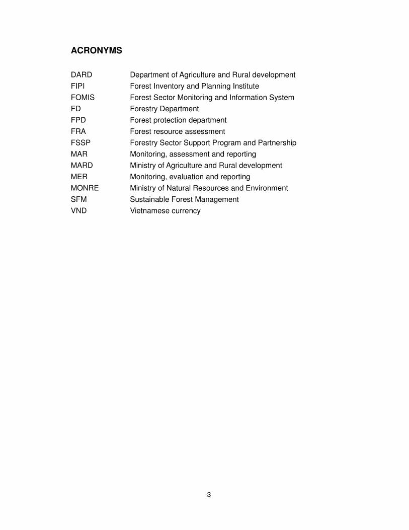
ACRONYMS
DARD Department of Agriculture and Rural development
FIPI Forest Inventory and Planning Institute
FOMIS Forest Sector Monitoring and Information System
FD Forestry Department
FPD Forest protection department
FRA Forest resource assessment
FSSP Forestry Sector Support Program and Partnership
MAR Monitoring, assessment and reporting
MARD Ministry of Agriculture and Rural development
MER Monitoring, evaluation and reporting
MONRE Ministry of Natural Resources and Environment
SFM Sustainable Forest Management
VND Vietnamese currency

4
SUMMARY
A study was carried out on current MAR situations and mechanisms for its
harmonization in Vietnam to propose alternative methods and regulations on forest
data collection. In 2006, the Ministry of Agriculture and Rural Development (MARD)
issued a decision on a statistical indicator system in which 18 indicators are used
as a foundation for monitoring, evaluation and reporting (MER) in forestry (e.g.
areas of existing or destroyed forests and forest plantations, areas of land for
natural regeneration, protected forest areas, volume and value of timber, etc.). The
Forestry Sector Support Program and Partnership (FSSP) has developed totally 72
indicators, covering bio-physical, environmental, socio-economic, and financial
aspects and a database for the Forest Sector Monitoring and Information System
(FOMIS), out of which 55 are currently feasible for data collection. However,
considerable costs and time would be required to collect data for these indicators.
Forest-related data are distributed among ministries, but data for forest monitoring,
evaluation and reporting are collected mainly by the Forestry Department, the
Forest Protection Department, the Forest Inventory and Planning Institute (FIPI),
local inventory and planning sub-institutes.
The FIPI conducts a national forest resource inventory, evaluation and change
program every 5 years from 1991 to contribute to forest status data. Local forest
inventory and planning units of forest-rich provinces help local agencies and forest
enterprises in monitoring and planning of forest management.
The study identified obstacles to MER on forestry in Vietnam. Firstly, agreements
have not yet been made among various stakeholders on concepts, definitions,
indicators, and methods for forest MAR. Secondly, no agreement has been
reached between the MARD and the Ministry of Natural Resources and
Environment (MONRE) on classification of forests and forest lands, either. Thirdly,
it is very difficult to search for required forest information among many agencies
holding related data separately without coordination. Fourthly, forest inventory data
are not accurate or objective, affected by directions of specialized management
agencies and local managers for their benefits or shortage of time and budget.
Data were often collected using old methods with low reliabilities. Fifthly, it is
difficult to buy high-resolution satellite imagery due to budget limitations. Lastly,
there are differences in measurement of some indicators like forest definitions and
classifications between the country and international organizations.
The study proposed improvement of a national forestry MER system in better
consistency with the FAO system through development of a principal indicator set,
linking a national indicator set with FAO’s indicators under FRA2010. The indicators

5
should focus on forest status, forest management owners, forestry activities,
institutional aspects (e.g. policy, labour, training, etc.), and forest investments. The
proposed indicator set will have to be tested to verify its viability. The study
recommended restructuring of the MER system using a modular model with
appropriate database software in which monitoring and evaluation methods will be
supplemented and updated by related ministries and other stakeholders to improve
consistency of forest information. Then the study advocated modification of
regulations for effective collection of data in the national MER system by improving
forest indictors, data collection and analysis procedures including inventory surveys
at central and local levels, and building institutional capacities for data collection
and analysis through mutual collaboration.

6
PART 1: CURRENT SITUATION ON FOREST MONITORING,
EVALUATION AND REPORTING
1. The development of the monitoring, evaluation, and reporting tasks in
forestry in Vietnam
Vietnam is a country which has passed a long time of war and division. Only after
the union of the country (in 1975) and the participation of Vietnam to the United
Nations, has Vietnam started activities on monitoring, evaluation, and reporting in
forestry following the requests of international organizations in which it participated.
In order to have data on forests and forest lands throughout the country, since 1981
Vietnam has carried out several general surveys and inventories of the national
forests.
1.1 Survey of national forest resources during 1981-1983
With FAO’s support (project VIE 76/014), this was the first time Vietnam carried out
a survey of national forest resources. This survey was conducted by Forest
Inventory and Planning Institute (FIPI) in 3 years, and the results were published in
1983.
The purposes of this survey were to provide data with a scientific foundation to
build forestry development strategies; to create a general picture of production
force distribution; and to build long-term and short-term plans on forestry
development. This was a large-scale and thorough survey of forest resources
following a united system of technical regulations and forms, using satellite images
and aerial photographs in combination with ground surveys to create forest current
status maps and land use maps for the whole country.
The results has been classified and summarized according to 10 main indicators on
national forests and forest lands, including: (1) areas of each land type; (2) areas of
each forest type; (3) areas of each economical forest type (now called production
forest); (4) areas of each protection forest type; (5) volumes of each forest type; (6)
volumes of each economical forest type; (7) volumes of each protection forest type;
(8) areas and volumes of each bamboo forest type; and (10) lands without forests.
In each main indicator, the survey analyzed in details the area distribution of each
forest type: natural broad-leaved forest (rich, medium, and poor), natural
fallen-leaved forest, natural needle-leaved forest, broad-leaved and needle-leaved

7
mixed forest, wooded and bamboo mixed forest, bamboo forest, wooded plantation
forest, bamboo plantation forest, land without plants layer, and bared land.
1.2 Inventory of natural forest during 1990-1992
According to the Decision No. 165-CT issued by the Prime Minister, Vietnam has
carried out a general inventory on area, volume, and value assessment of natural
forests in the whole country. This inventory was implemented by FIPI and local
inventory organizations (regional/provincial forest inventory and planning
sub-institutes/units).
The purpose of this inventory was to re-evaluate natural forest resources and forest
lands in the whole country, which in turn served as foundations for developing
forest plantation plans of concentrated raw material providing areas and at the
same time for continuing the land and forest allocation process to all economical
entities. (A Vietnam’s characteristic was that, before changing to the
market-oriented economy, land was owned only by the state or communities such
as state co-operatives.)
This inventory focused on following indicator groups: (1) Determining areas and
volumes of natural forests according to their economical uses (wood business,
forest special product business), nursery forests, and protection forests; (2)
Classifying natural forests according to their quality (rich, medium, and poor) and
tree species, and at the same time assessing the value of forests according to their
current prices; and (3) Classifying bared land areas into either land with forest
production ability and land without forest production ability.
Methodology: For inventory of forest and forest land areas, satellite or aerial
images were used in combination with site investigation, area delineating and
drawing directly at fields. For inventory of forest volumes, counting was carried out
using the systematic sample drawing method (for nursery forests and special
product forests, thorough counting was used).
1.3 Inventory of national forests during 1998-2000
According to the Instruction No. 286/TTg issued by the Prime Minister on
strengthening of urgent measures for forest protection and development, Vietnam
has carried out a general inventory on all kinds of forests and forest lands. This
inventory was mainly implemented by FIPI and local inventory organizations
(regional/provincial forest inventory and planning sub-institutes/units). Besides,
forest owners also participated in this inventory process.
The purpose was to evaluate all kinds of forests (natural forests, plantation forests
etc.) and forest land without forest throughout the whole country, assisting the

8
Government to exactly know areas of all kinds of forests including natural forests,
plantation forests, and bared land so that they can be handed over to local
administration levels from communes to districts to provinces and forest owners for
forest management, protection and development.
This inventory was concentrated on criteria such as areas, volumes of each forest
type. They were analyzed according to (1) management owners and (2) functions
of 3 forest categories (special-use, protection, and production).
For inventory of forest and forest land areas, the inventory used data inherited from
the previous inventory (1990-1992) combining with supplement survey at fields. For
inventory of forest volumes, the inventory used results from the Program for
surveying, evaluating, and monitoring the changing of national forest resources
(cycle I implementation, 1991-1995)
1.4 Program for surveying, evaluating, and monitoring the changes of national
forest resources
This program was implemented by FIPI since 1991. The program for surveying,
evaluating, and monitoring the changes of national forest resources has been
implemented one every 5 years, with the long-term purpose of providing
adequately and thoroughly forest resources data as well as their changing trend in
an organic relationship to other socio-economical activities of the country, serving
the state’s forest resource management task and forest production activities in the
whole country as well as in each region. The main tasks include:
(1) To investigate and build national forest status map. Satellite images
(Landsat/TM, Spot), aerial images are used in combination with ground surveys to
build forest status maps for each province (scale 1/100,000), for each of the 6
forestry emphasized regions (scale 1/250,000), and for the whole nation (scale
1/1,000,000).
(2) To investigate and collect characteristics of forests. Planners have
arranged 3,300 standard plots with the area of 100 ha (1,000m x 1,000m). The
volume capacities of these standard plots have been calculated such that the
volume error per ha < 10%. The standards plots are arranged permanently as a
grid of 8km x 8km in all the area planned for forests in the whole country. Every
year, 660 plots are investigated, the locations of these plots are arranged uniformly
throughout the country, and the process is repeated every 5 years. In each 100 ha
primary plot, 2 bands of secondary plots are created following a predetermined
direction, with each secondary plot having an area 500 m2 (20m x 25m).
In each primary and secondary plot, information is collected one every 5 years. The

9
content of the collected information include:
• Areas of each type of forest or forest land in the plot;
• Forest fauna, pests and tree diseases;
• Soil formation characteristics;
• Determining tree species for every wood tree having D1.3m ≥ 6cm and
measuring indications such as tree diameter (at the tree height of 1.3m –
D1.3), height of the top layer (Hvn), height of the bottom layer (Hdc); and
evaluating the growth status, timber quality of the tree’s body. For bamboo
forests, counting the number of trees and measuring the diameter of tree
foot;
• Collecting regenerative indicators of wooded trees (having D1.3 < 6cm) in
each plate-shaped plot having an area of 25 m2;
• Investigating special product tree species;
• Investigating socio-economical factors relating to the area investigated.
(3) In order to evaluate the quality of forest resources, besides data collected
from primary plots, the Program also carries out supplementary surveys on
subjects such as silviculture, forest fauna, pests and diseases, non-timber forest
products.
Based on the collected data, changes in forest resources are processed, analyzed,
and evaluated: the trends and levels of (i) change in area of each forest status, (ii)
change in forest quality (forest structure such as tree species composition, density,
layers, wood quality, etc.; volume, cross-section area per ha), and (iii) change
following socio-economical factors. The main causes of these changes are
investigated.
2. Current status of forest indicator system for monitoring, evaluation, and
reporting
Currently, indicators for monitoring, evaluation, and reporting in forestry are not
systematic. They were established differently depending on requirements at each
level, each sector, and each program/project. Hereafter, only 2 indicator sets, which
were established for monitoring, evaluation, and reporting at the central level, are
presented.
2.1 The 2006 indicator set issued by the Ministry of Agriculture and Rural
Development (MARD).
In 2006, MARD issued Decision no. 71/2006/QD-BNN, dated on 14/09/2006 on

10
promulgating Statistical Indicator System in Agriculture and Rural Development
Sector. In this system, 18 indicators are used as foundations for monitoring,
evaluation and reporting in forestry. The details are given in the table below:
Indicator System in Forestry according to Statistical Indicator System in Agriculture
and Rural Development Sector
No. Criterion Cycle Lead organization
for collection
Data sources
1 Forest land use current status Year FPD Sub-FPD
2 Area of existing forests Year/ 5 years
FPD/FIPI Sub-FPD/FIPI
3 Forest cover Year FPD Sub-FPD
4 Area of destroyed forests Month FPD Sub-FPD
5 Forest protection force Year FPD Sub-FPD
6 Rate of special-use forest area preserved
Year FPD Sub-FPD
7 List of endangered and rare animal and plant species
Year FPD Sub-FPD
8 Forest volume 5 years FD FIPI
9 Area of new concentrated forest planting
Month FD Sub-FD; DARD
10 Area of forest replanted after harvesting
Month FD Sub-FD; DARD
11 Area of land for natural regeneration Month FD Sub-FD; DARD
12 Area of land for natural regeneration and already become forest
Month FD Sub-FD; DARD
13 Number of scattered trees Quarter FD Sub-FD; DARD
14 Area of forest protected and cared Month FD Sub-FD; DARD
15 Outputs of timber and forest product harvested
6 months
FD Sub-FD; DARD
16 Area of plantation forest completely harvested
Year FD Sub-FD; DARD
17 Volume, value of timber and other forest production processing industry
6 months
FD Sub-FD; DARD
18 Implementation value of silviculture investment fund
Year FD Sub-FD; DARD

11
2.2 The indicator set of the Forestry Sector Monitoring and Information System
(FOMIS)
This indicator set was built by Forestry Sector Support Program and Partnership
(FSSP). The indicator set and databases are important modules of the Forest
Sector Monitoring and Information System (FOMIS), which is now being built.
This indicator set was developed since 2004 with 36 indicators for which their data
can be obtained. In 2006, this indicator set was revised and supplemented to
become a 72-indicator set, in which data of 55 indicators can be collected. Data of
the other 17 indicators are either not being able to collect or not having condition for
processing data in the forestry sector. These indicators are called “future”
indicators.
The FOMIS indicator set is divided into 4 main groups.
1. Group of general indicators: 4 indicators (all have data now);
2. Group of specific indicators, which are classified according to objectives,
including:
- Economical objective: 5 indicators (in which 3 indicators have data; 2
indicators will have data in the future)
- Social objective: 4 indicators (all have data)
- Environmental objective: 4 indicators (none have data)
3. Group of implementation indicators, which are classified according to
implementation programs, including:
- Sustainable forest management and development program: 11 indicators
(in which 10 indicators have data now, 1 indicator will have data in the future)
- Program on forest protection, biodiversity conservation and environmental
services development: 8 indicators (in which 7 indicators have data now, 1
indicator will have data in the future)
- Forest products processing and marketing program: 11 indicators (in which
7 indicators have data now; 4 indicators will have data in the future)
- Program on forestry research, education, training and extension: 7
indicators (in which 4 indicators have data now, 3 indicators will have data in
the future)
- Program on renovating the forest sector policy, institutions, planning and
monitoring: 9 indicators (in which 7 indicators have data now, 2 indicators will
have data in the future)

12
4. Group of input indicators, include:
- Financial investment: 5 indicators (all have data now)
- Human resources development investment: 3 indicators (in which 2
indicators have data now, 1 indicator will have data in the future)
2.3 Overall assessment on the two indicator sets
The 2006 MARD indicator set and the FOMIS indicator set are used to monitor key
programs and activities in the forestry sector such as the Vietnam Forestry
Development Strategy period 2006-2020, the 5-year plan 2006-2010, and the 5
Million Hectare Reforestation Program.
Using the collected indicators, it is able to monitor and evaluate activities,
outcomes and impacts of forestry policies and on this basis, improving the forestry
sector management, planning and policy building task. In a broader context, the
indicators have contributed to monitor and evaluate the implementation of the
national socio-economic development plan.
Besides, the collected indicators have provided basis and systematic information
on the forestry sector to develop national reports according to Vietnam’s
commitments and conventions to the international community. In the report
“Evaluation of global forest resources in 2005 in Vietnam”, 15 indicators were
proposed.
The current reality in Vietnam has shown that a general indicator system for
monitoring, evaluation and reporting in forestry has not existed yet. The forest
sector monitoring indicator set (FOMIS) reflects information in a broad range,
mentioning many fields in the forest sector. Therefore, the task of gathering
indicator data is complicated and costly. The statistical indicator system in forestry
(in the statistical indicator system in agriculture and rural development sector) has
narrower limit, and is currently being used in monitoring, evaluation and reporting
by forestry management agencies.
Overall, the above-mentioned indicator sets have already reflected the face of the
Vietnam forestry sector. However, when they are used to develop reports on
evaluation of global forest resources, it is required to have processing and
converting steps that are very costly and time-consuming due to incompatible
issues. Besides, there exist some indicators for which data have not been collected
in Vietnam yet. Therefore, it is necessary to construct a monitoring, evaluation and
reporting system in forestry (including construction of a system of indicators and a
system of collecting databases) harmonized between Vietnam and outside.

13
3. Organization system for monitoring, evaluation, and reporting in forestry
In Vietnam, data related forestry locate in different ministries. However, the
collection of data to calculate indicators for monitoring, evaluation and reporting in
forestry is mainly done by some agencies such as Forestry Department, Forest
Protection Department, Forest Inventory and Planning Institute, local forest
inventory and planning sub-institutes, the Coordination Office of the Forest Sector
Support Program (FSSP). Besides, some other organizations such as the
Informatics and Statistics Center – MARD and Vietnam Forest Science Institute
also contribute to the data collection but only at a limited level.
3.1 Forestry Department and its local sub-departments
Forestry Department is the agency implementing state management functions on
forest planting, forest development, forest resources exploitation and use in the
whole country.
The organization structure to carry out Forestry Department’s tasks at local level
includes Forestry Sub-departments (34 Sub-department in provinces with large
area of forests) or Forestry Sections, Department of Agriculture and Rural
Development (in provinces with small area of forests). These Forestry
Sub-departments and Forestry Sections hold the data sources on forestry in line
with the management functions of the Forestry Department.
According to the functions and tasks assigned by the Ministry, the Forestry
Department should manage the following information:
- Conduct inventory and statistical work on forest seedlings; collect, protect
and use forest seedlings; promulgate regulations, procedures, techniques, and
technologies on forest seedlings.
- Conduct data collection, summarizing and reporting, database construction
to serve the management tasks in forestry sector.
- Organize the collection and management of science and technology
information of the forestry sector.
- Monitor changes of forest resources and forest land.
At present, Forestry Department is conducting data collection and summarization
on forest management, development and use, forest product processing industry,
investments in forestry, the 5 Million Hectare Reforestation Program. According to
“the Statistical Indicator System in the Agriculture and Rural Development Sector”
(Decision no. 71/2006/Qð-BNN), Forestry Department is assigned to monitor,
evaluate and report forestry indicators ordered from 8 to 18.

14
In order to conduct monitoring, evaluation and reporting, Forestry Department
selects statistical indicators and determines data collection frequency based on the
Statistical Indicator System in the Agriculture and Rural Development Sector (Table
1) and assigns to provincial agencies (Forestry Sub-department or DARD’s
Forestry Section) the tasks of synthesizing data collected from district and
commune levels and reporting the results to Forestry Department. The order of
steps is as follows:
Agencies at district and commune levels (Agriculture and Rural Development
Section, forestry units belonging to Forestry Sub-department) synthesize the
collected data following the indicator system and periodically report the
implementation results of their forest production tasks to agencies at the provincial
level (Forestry Sub-departments or DARD’s Forestry Sections).
Agencies at the provincial level (Forestry Sub-departments, DARDs) synthesize the
collected data following the indicator system and periodically report to the central
level (Forestry Department).
Data reporting based on the statistical indicators from the provincial level (Forestry
Sub-departments/DARDs) to the Forestry Department is carried out periodically.
Reports can be submitted in papers (in line with the predefined forms) or
electronically via the Department own website (http://dof.mard.gov.vn) by using a
forest statistical software developed by the Department itself.
Report frequencies vary depend on indicators. Some indicators have to be reported
once a month (areas of new and concentrated forest plantations, reforestation after
harvesting, forest land zoned for regeneration, forest land zoned for regeneration
and already become forests, forests having protection and tending etc.), some
indicators need to be reported once in three months (scattered planted trees etc.)
or once in 6 months (volume of harvested timber and forest products) and some
indicators need to be reported once every 5 years (forest reserves etc.).
The data reported by Forestry Department are mostly collected using the numerical
statistical method. Some indicators (forest reserves etc.), however, need
collaboration from other agencies (Forest Inventory and Planning Institute, Forest
Protection Department) and be conducted using specialized inventory methods.
3.2 Forest Protection Department and its local sub-departments. Website
http://www.kiemlam.org.vn
Forest Protection Department is the agency implementing state management
functions in the sector on forest resources protection, law execution of forest
management, forest protection and forest product management in the whole

15
country.
The organization structure of Forest Protection Department include 60 Local Forest
Protection Sub-departments (60/63 provinces, cities have Local Sub-departments).
These Sub-departments hold the data sources on forestry in line with the
management functions of the Forest Protection Department.
According to the functions and tasks assigned by the Ministry, the Forest Protection
Department should manage the following information:
- Carry out the annual monitoring on forest and forest land changes;
- Organize data collection, inventory, reporting, and database construction to
serve to the management task of forest protection.
- Organize the collection and management of science and technology
information on forest protection;
Currently, Forest Protection Department is collecting and synthesizing data on
forest protection, biodiversity conservation, and coordinates with Forest Inventory
and Planning Institute to conduct annual inventory and survey on forest and forest
land. According to “the Statistical Indicator System in the Agriculture and Rural
Development Sector”, Forest Protection Department is assigned to monitor,
evaluate and report forestry indicators ordered from 1 to 7 (Table 1).
Similar to Forestry Department, in order to carry out monitoring, evaluation and
reporting, Forest Protection Department will build statistical indicators and
periodical reports (on the basis of the Statistical Indicator System in the Agriculture
and Rural Development Sector). The Department assigns to its provincial agencies
(Sub-departments) the task of conducting inventory and survey in the province on
the basis of synthesizing data gathered from district and commune levels and
reporting the results to the Forest Protection Department. The order of steps is as
follows:
- Agencies at the district, commune levels (Forest Protection Stations,
National Parks, Nature Conservation Zones) synthesize data following the indicator
system and report the results to agencies at the provincial level (Forest Protection
Sub-departments/DARDs).
- Agencies at the provincial level (Forest Protection Sub-departments/
DARDs) synthesize the collected data following the indicator system and report the
results to agencies at the central level (Forest Protection Departments).
Data reporting based on the statistical indicators from the provincial level to the
Forest Protection Department can be done using two ways:

16
- Periodically send reports in paper format following predefined forms.
- Periodically create electronic reports using the softwares provided by the
Forest Protection Department, save them in CDs and send them to the
Department.
Current softwares for reporting in the Forest Protection field include: software for
reporting monthly statistical data, software for monitoring changes on forest and
forest land, software for managing violations of Forest Protection and Development
Law, forest statistical software, and software for alarming forest fires (run
independently on a computer). However, many localities have not yet conducted
reporting using the Department private website.
The data for monitoring, reporting in the Forest Protection field are also reported
using different frequencies. Some indicators have to be reported monthly (area of
plantation forest destroyed by fires, diseases etc.) and some indicators need to be
reported yearly (forest land use current status, area of existing forests, forest cover
etc.).
The data reported by Forest Protection Department are collected following different
methods. Some data are collected using the numerical statistical method (forest
protection force, number of forest fires, number of cases violating forest law etc.)
but some data are collected using specialized inventory method or collaborating
with other agencies (Forest Inventory and Planning Institute, Forest Science
Institute etc.).
One example of monitoring annual changes on forest and forest land done by the
Forest Protection force: A Forest Protection Station collects information on changes
of forest and forest land areas at the fields (using GPS for supplementary
measuring and drawing) and the updates these changes (including tables and
maps) to the database. The basic unit for monitoring and updating is the forest
stand in compartment/ forest district/ commune. Based on the database of forest
and forest land changes, the Forest Protection Sub-department periodically
synthesizes the data and reports the results to the Provincial People’s Committee
for releasing of provincial data on forest and forest land. Forest Protection
Department synthesizes the data and reports the results to MARD for releasing of
national data on forest and forest land.
Due to the limited budget, however, data on areas of forest and forest land at the
district and commune levels are mainly gathered using the estimated statistical
method, and very few districts/communes have conditions and abilities to use
satellite images combined with measuring and drawing by using GPS for adjusting
changes on forest and forest land. Local forest protection officers are an important

17
force for collecting site data but they are inadequately trained. The lack of technical
equipments leads to low quality of information.
3.3 Forest Inventory and Planning Institute and Local Forest Inventory and
Planning Sub-institutes
3.3.1 Forest Inventory and Planning Institute. Website http://www.fipivn.org.vn
Forest Inventory and Planning Institute is a specialized agency functioning as state
forest management tool. Forest Inventory and Planning Institute conducts forest
inventory, planning and research programs in line with the assignments or orders
from MARD, Forestry Department, Forest Protection Department, local forest
agencies, and forest enterprises. Key programs have been implemented/ being
implemented by Forest Inventory and Planning Institute that serve the tasks of
monitoring, evaluation and reporting include:
- The national forest resource inventory program: is being implemented in 5 –
10 year cycles comply with the guidance of the Government or MARD (the contents
and method are mentioned in sections 1.1, 1.2, and 1.3 above). The results of the
national forest resource inventory program are original documents used and
updated by functional agencies to develop reports evaluating global forest
resources.
- Program for surveying, evaluating, and monitoring the changes of national
forest resources: already completed for three cycles (Cycle I: 1991 – 1995, Cycle II:
1996 – 2000, Cycle III: 2001 – 2005) and is currently being deployed for Cycle IV
(2006 – 2010). The contents and method are already summarized in section 1.4.
Besides, the Institute is one of the three MARD’s agencies participated in the
project “Natural Resources and Environment Monitoring System in Vietnam”, which
is lead by Ministry of Natural Resources and Environment. The function of this
project is to ensure receiving, processing, and supplying satellite images and
developing applications for sectors in Vietnam, and at the same time operating the
satellite images utilized natural resources and environment monitoring system in
Vietnam.
Forest Inventory and Planning Institute have 9 sub-institutes located at various
economical and ecological regions in the country: the South, South Central and
Central Highlands, Central, North Central, North West, North East, and the Red
River Delta regions. The institute has nearly 400 staff, including doctors, masters,
engineers, and technical staff with many experiences.
3.3.2 Local Forest Inventory and Planning Sub-institutes
Each province or city having a large area of forest and forest land has a local forest

18
inventory and planning unit (there are 34 local forest inventory and planning units
throughout the country). These units help local state agencies in forest
management, helping forest enterprises in planning production and commercial
projects or designing forest production such as forest planting, forest harvesting,
zoning for regeneration etc. DARDs and sub-units of Forestry Department (Forestry
Sub-departments) when developing reports on forest and forest land are all based
on data provided by their local forest inventory and planning units.
A common feature of forest inventory and planning organizations (Forest Inventory
and Planning Institute and local units) in Vietnam is that they operate not
completely independent on the financial issue as well as data publication. This is
the main reason that cause the collected indicators (e.g., forest area) being often
distorted.
3.4 Coordination Office of the Forest Sector Support Program (FSSP). Website
http://www.vietnamforestry.org.vn
The information system which FSSP formulated to serve the tasks of monitoring,
evaluation and reporting in the forest sector is the Forest Monitoring and
Information System (FOMIS):
Sector monitoring indicator database: data are collected following the monitoring
indicator set of the forest sector. Data are gathered from the existing sources in
agencies of MARD as well as other ministries and sectors. Most of them are
synthesized at the central level and only some of them are collected at the regional
level.
Forestry ODA database: the data collected are data on ODA projects in the forest
sector, including general data of each project, details of assistance funds and
specialized fields deployed by the project. Data are collected via data collection
forms designed using MS Excel. These data collection forms are sent to agencies
and organizations, both domestic and international, which manage or sponsor ODA
projects in the forest sector.
4. Obstacles to monitoring, evaluation and reporting in forestry
In Vietnam, agreements have not been reached among ministries, sectors,
research institutes and policy-making and implementing agencies at different levels,
or even within a ministry, regarding the concepts, definitions, and calculation
methods for some existing indicators. Some indicators are very difficult to get
because currently no ministry or sector has the main responsibility for updating and
storing their data.
No agreement has been reached between the Ministry of Nature Resources and

19
Environment and the Ministry of Agriculture and Rural development regarding the
classification of forests and forest lands. MoNRE classified forests and forest lands
into 3 functional forest categories and 4 land categories: land with natural forests,
land with plantation forests, land zoned for natural forest regeneration and land
planned for forest plantation while MARD classified forests and forest lands into 3
functional forest categories and 3 land categories: land with natural forests, land
with plantation forests and land without forest. Due to this difference, the use and
management of forest resource and forest land is still inconsistent, especially for
the differentiation between “land without forest” with “land not used”, “forest land”
and “agriculture land”.
Many data sources and information systems currently exist in the forestry sector.
They are scattered in many agencies in many ministries and even in a ministry (e.g.,
Informatics and Statistics Center, Forestry Department, Forest Protection
Department, Planning Department, Personnel and Organization Department,
Science and Technology Department, Forest Inventory and Planning Institute in
MARD). Hence, the searching for needed information is very difficult,
time-consuming, and the results are inconsistent. Currently, the collaboration
between agencies in MARD for providing information in the forestry sector is very
limited.
Inventory data for monitoring forest resources do not reflect exactly the reality but
affected by specialized management agencies, managers (especially at the local
levels) due to the performance epidemic and local benefits, or due to time and
budget limitations. This situation leads to the use of collection method based mainly
on old documents with low reliability. At present, Vietnam forest resource data have
been based mainly on the forest inventory data in 1998 and then updated by Forest
Protection Department by conducting statistics of the data received from local
Forest Protection agencies or supplementally surveyed by Forest Inventory and
Planning agencies. However, since the inventory data have consisted errors, the
use of these data to update and calculate annual data of the following years has
introduced systematic errors in the data.
Buying high density satellite images to serve forest resource inventory meets many
obstacles due to the budget limitation or the specialized agency (Forest Inventor
and Planning) cannot buy images directly from aeronautics and space
organizations but only indirectly via MoNRE.
There are differences regarding calculation methods of some indicators (for
example, the concept of forests) between Vietnam and international organizations.
Besides, the classification system of Vietnam is also different to those applied by

20
FAO and other international organizations. This situation creates constrains for
data comparison and sharing possibilities between ministries and sectors in
Vietnam with international organizations, especially when using Vietnam data to
develop reports to international organizations.

21
PART 2: PROPOSAL AND TESTING OF A MONITORING,
EVALUATION AND REPORTING SYSTEM HAMORNIZED
BETWEEN VIETNAM AND FAO
1. Proposal of a monitoring, evaluation and reporting system in forestry
In order to build a monitoring, evaluation and reporting system in forestry suitable
with Vietnam conditions and at the same time being harmonious with FAO’s system,
it is necessary to have a suitable way of approaching from indicator set proposal to
overall structure of the system.
1.1 Principles of the indicator set
The indicator set should include indicators reflecting thoroughly the forest activities
in each period. It serves as both information supplying and forecast roles to support
management at the state and sector levels making decisions exactly and in a timely
manner.
The indicators need to have clear meanings. Qualitative indicators should be
quantified and ease to collect at given times. Furthermore, the indicators could
support and determine the process directed to sustainable development targets.
The indicator set should try to inherit as much as possible the Vietnam forestry
indicator set currently used for monitoring and evaluation, and at the same time try
to harmonize with FAO’s indicators on evaluation of global forest resources. It
should be suitable with Vietnam current conditions and capacities, be used and be
converted easily from Vietnam existing data to FAO’s indicator set.
1.2 Proposal and testing of the indicator system
Based on requirements about the above-mentioned indicator set, and based on 18
forestry indicators on monitoring and evaluation in the National Statistical Indicator
System of the agriculture and rural development sector promulgated by MARD
(mentioned in Section – part 1), and at the same time based on the indicator set in
17 sample tables FRA – 2005 which Vietnam has reported together with FAO as
well as 59 indicators (under 7 criterions) of ASEAN system , the indicators for
monitoring, evaluation and reporting in Vietnam forestry sector and being
harmonized with FAO’s and ASEAN’s system are proposed in the table below:

22
The proposed monitoring, evaluation and reporting system in forestry include 49
main indicators. Based on the information features they reflect, the indicators are
arranged into 5 groups of basis indicators:
1) Group of indicators on forest status. The indicators in this group only
reflect areas of each land type and forest volumes. These indicators are often
surveyed, counted meticulously and in details, are newly updated once a year or
every 5 year based on interpolation of satellite images and data collected from
permanent sample plots.
2) Group of indicators on forest management owners. Land and forest land
in Vietnam is classified into:
- Special-use forests. Special-use forests are mainly used for conservation
of nature, specimens of national forest eco-systems and forest biological gene
sources; for scientific research; conservation of historical and cultural relics as well
as famous landscapes and scenes; in service of recreation and tourism in
combination with protection, contributing to environmental protection. This forest
category includes: national parks; natural conservation zones; scenic landscapes
protection areas; and scientific research and experiment forests.
- Protection forests. The main functions of protection forests are to protect
water sources and land, prevent soil erosion and desertification, restrict natural
calamities and regulate climate, thus contributing to environmental protection. This
forest category includes: watershed protection forests; wind- and sand-shielding
protection forests; protection forests for tide shielding and sea encroachment
prevention; and protection forests for environmental protection, historical forest.
- Production forests. The main functions are to produce and trade timbers
and non-timber forest products in combination with protection, contributing to
environmental protection. It includes: natural production forests; planted production
forests; seeding forests including natural forests and the selected and recognized
planted forests.
Regarding the forest management owners, there exist 7 kinds of management
owners in Vietnam. They can be classified according to owner forms as follows: (1)
state-owned form (state forest management boards, state economical
organizations, army forces, scientific research organizations, communities); (2)
private-owned form (households, individuals); and (3) others (Vietnamese citizens
living in foreign countries or international organizations/individuals invested in
Vietnam).
3) Group of indicators on forestry activities. This group includes indicators
23
reflecting forest production activities and processes such as: plantation, zoning for
regeneration, forest harvesting, pests and diseases etc. These indicators are
collected and reported monthly, quarterly or yearly.
4) Group of indicators on policy, labor and training in forestry. These are
indicators for which data are already available but difficult to process and analyze
when reporting due to the unprofessional behavior of laborers and the unclear
vocation boundary. For example, a laborer often takes part in agriculture production
and at the same time joins forestry production, especially in the period when the
economy is changing from the concentrated management economy to a
market-oriented economy.
5) Group of indicators on forest investments. These indicators are divided
similarly to FAO’s indicators such as domestic and international investment funds.
However, the classification of investment funds according to silviculture solutions
such as: forest planting, forest restoration, forest improvement etc. like in FAO’s
table 17B is difficult to implement. This is because in Vietnam, even in a business
company these indicators are still difficult to monitor.

24
Table of forestry indicators system proposed and tested
No. Proposed indicators Equivalent to Vietnam indicators (in line with 18 MARD’s indicators)
FAO’s indicators converted from the proposed indicators
(according to indicators in 17 table forms)
ASEAN’s indicators compared to proposed indicators
I- Group of indicators on forest status
1 1- Area of natural broad-leaved forests
2 2- Area of natural needle-leaved forests
3 3- Area of natural bamboo forests
4 4- Area of broad-leaved timber plantations
5 5- Area of needle-leaved timber plantations
6 6- Area of bamboo plantations 7 7- Area of mangrove forests 8 8- Area of rubber plantations 9 9- Grass land with scattered
timber trees (IC) 10 10- Grass land (IB)
11 11- Wetlands (IA)
Equivalent to indexes indicator 1 – Forest land use status and indicator 2 – Area of existing forests
- Forest categories (table 1) - Rubber plantations (table 3) - Primitive forests, secondary forests, plantation forests, bamboo forests, mangroves, rubber plantations (table 4)
- Extent (area) and percentage of
total land area under
comprehensive land-use plans
(Indicator 1.1)
- Extent (area) and percentage of
total land area under each
forest type (indicator 1.3)
- Forest condition of the PFE and
non-PFE (indicator 1.6)
12 12- Timber volume of natural
broad-leaves forest 13 13- Timber volume of natural
needle-leaves forest
14 14- Volume of plantation forests 15 15- Volume of bamboo forests
Equivalent to indexes in indicator 8 – Forest volume
- volumes of natural forest, plantations, pine forest, commercial trees, 10 most popular species (table 6) - Above- and
- Carbon stored in forest stands
(indicator 4.4)

25
No. Proposed indicators Equivalent to Vietnam indicators (in line with 18 MARD’s indicators)
FAO’s indicators converted from the proposed indicators
(according to indicators in 17 table forms)
ASEAN’s indicators compared to proposed indicators
below-ground biomass (table 7) - Carbon in above-ground biomass, carbon in below-ground biomass, carbon in litter, soil carbon (table 8)
II- Group of indicators on forest management owners
16 1- Area of production forests 17 2- Area of protection forests
Production forest; protection forest (belong to indicator 1 – forest land use status)
18 3- Area of conservation forests 19 4- National parks and scenic
landscape forests
Conserved protection forest (indicator 6)
20 5- Multi-function forests Other forests (belong to indicator 1 - forest land use status)
Production forest, protection forest, conservation zones, national parks and scenic landscape forest, multi-function forest (table 3)
- Indicators: 1.2, 2.1, 5.1, 5.5, 6.10,
6.11, 7.2
- Percentage of PFE with
boundaries physically demarcated
(indicator 1.4)
21 6- State-owned forests (forest
management boards, state forest enterprises, scientific research stations)
22 7- private-owned forests 23 8- Forests owned by others
(community forest etc.)
Equivalent to indexes in indicator 1 - forest land use status
State owned forest, private-owned forest, others (table 2)
- Forest tennure and onwnership (Indicator 7.2)
III- Group of indicators on

26
No. Proposed indicators Equivalent to Vietnam indicators (in line with 18 MARD’s indicators)
FAO’s indicators converted from the proposed indicators
(according to indicators in 17 table forms)
ASEAN’s indicators compared to proposed indicators
forestry activities
24 1- New concentrated plantation Area of new concentrated plantation (indicator 9)
25 2- Reforestation after harvesting Area of reforestation after harvesting (indicator 10)
Indicators of plantation, reforestation, natural forest regeneration (table 5)
- Indicator 1.2
26 3- Zoning for regeneration (natural, man-made); forest with protection and tending
Area of forest zoned for regeneration (indicators 11, 12, 14)
- Indicator 2.1
27 4- Plantation of scattered forest trees
Number of scattered forest trees planted (indicator 13)
Indicators of plantation, reforestation, regeneration of natural forest (table 5)
28 5- Volume of natural timber, bamboo harvested
29 6- Volume of planted timber, bamboo harvested
30 7- Volume of fuel-wood harvested 31 8- Area of plantation forest
harvested 32 9- Value of timber/bamboo
harvested from natural forest 33 10- Value of timber/bamboo
harvested from plantation forest 34 11- Volume, value of timber and
other forest products processing
- Volumes of timber and other forest products (indicator 15) - Area of plantation forest completely harvested (indicator 16) - Indicators on volumes, values of timber & other forest product processing industry (indicator 17)
- indicators on volumes of trimmed wood, fuel wood, plantation wood; wood value, other forest special products (tables 11, 12)
Indicators: 4.1, 4.2, 4.3
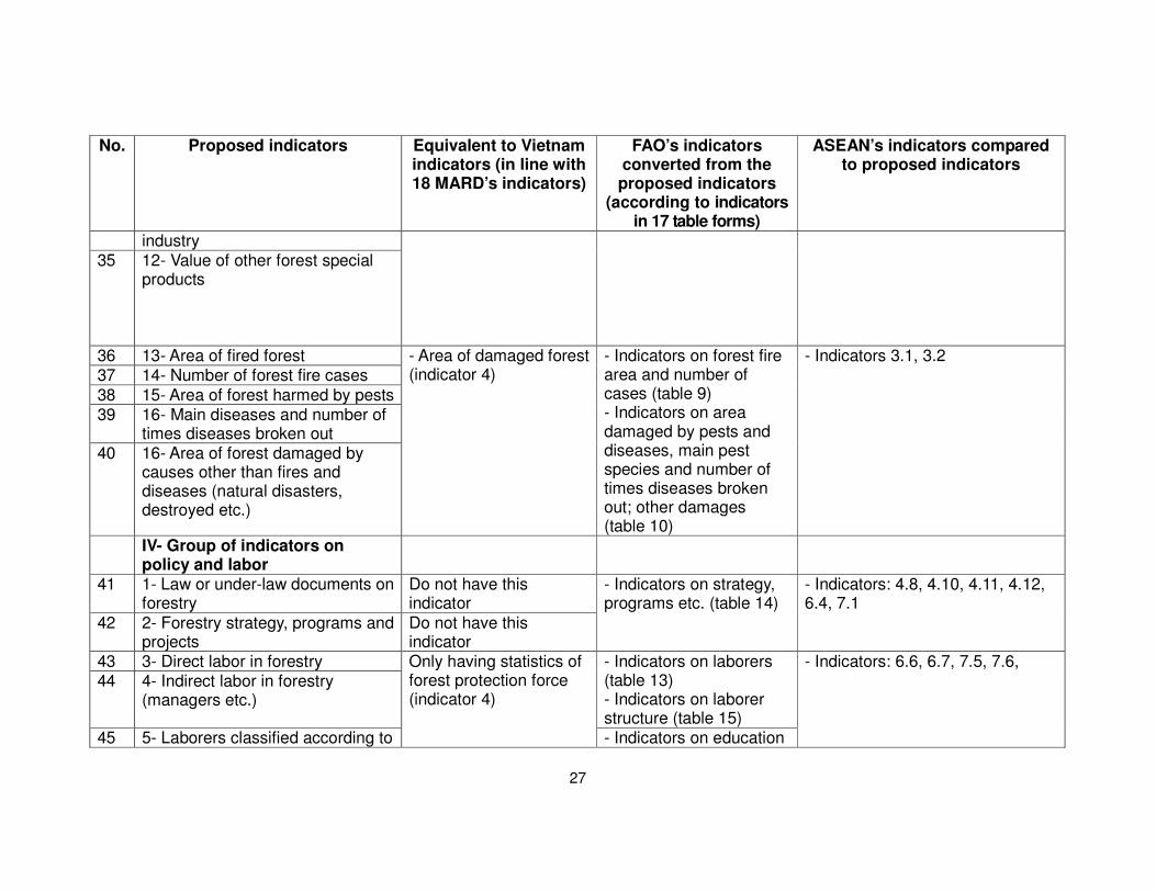
27
No. Proposed indicators Equivalent to Vietnam indicators (in line with 18 MARD’s indicators)
FAO’s indicators converted from the proposed indicators
(according to indicators in 17 table forms)
ASEAN’s indicators compared to proposed indicators
industry 35 12- Value of other forest special
products
36 13- Area of fired forest 37 14- Number of forest fire cases
38 15- Area of forest harmed by pests 39 16- Main diseases and number of
times diseases broken out 40 16- Area of forest damaged by
causes other than fires and diseases (natural disasters, destroyed etc.)
- Area of damaged forest (indicator 4)
- Indicators on forest fire area and number of cases (table 9) - Indicators on area damaged by pests and diseases, main pest species and number of times diseases broken out; other damages (table 10)
- Indicators 3.1, 3.2
IV- Group of indicators on policy and labor
41 1- Law or under-law documents on forestry
Do not have this indicator
42 2- Forestry strategy, programs and projects
Do not have this indicator
- Indicators on strategy, programs etc. (table 14)
- Indicators: 4.8, 4.10, 4.11, 4.12, 6.4, 7.1
43 3- Direct labor in forestry 44 4- Indirect labor in forestry
(managers etc.)
- Indicators on laborers (table 13) - Indicators on laborer structure (table 15)
45 5- Laborers classified according to
Only having statistics of forest protection force (indicator 4)
- Indicators on education
- Indicators: 6.6, 6.7, 7.5, 7.6,

28
No. Proposed indicators Equivalent to Vietnam indicators (in line with 18 MARD’s indicators)
FAO’s indicators converted from the proposed indicators
(according to indicators in 17 table forms)
ASEAN’s indicators compared to proposed indicators
education level and training (table 16) V- Group of indicators on forest
investments
46 1- Value of fixed assets of forest enterprises
47 2- Growth of investment fund in forestry
48 3- Domestic investment funds 49 4- International investment funds
ODA, FDI etc. (signed and implemented)
- Implementation value of silviculture investment funds (indicator 18)
- Indicators on domestic and international forest investments (table 17a)
- Indicators: 6.1, 6.2, 6.3, 7.3

In general, ASEAN’s indicator set is not as detailed as two of FAO’s and the
proposed indicator’s set. In addition, ASEAN’s indicator set is more concentrated
on biological diversity. Therefore, the explanation belows will present only the
transition between indicators of FAO and Vietnamese proposed indicators.
2. Explanation of the transition of indicators to FAO system
2.1 General comments on system of monitoring and evaluation indicators
The proposed and tested indicators for monitoring, evaluation and reporting in
forestry (hereafter, the proposed indicators) as well as the indicator system
currently used for monitoring, evaluation and reporting in forestry by MARD
(hereafter, the Ministry’s indicators) are all based on practical results of inventory
and statistics works conducted in the past and at present in Vietnam. The essential
difference is that the Ministry’s indicators have been simplified while the proposed
indicators are divided in more details and being more harmonious with the FAO’s
indicators.
FAO’s indicators are very detailed but being repeated again and again in tables.
For example, area of rubber plantation appears in tables 1, 3 and 4. Some FAO’s
indicators have not been collected in Vietnam yet due to technical limitations, low
business level or lack of fund. These are main obstacles when collecting and
processing data for developing Vietnam forestry reports comply with FAO
requirements.
2.2 Method for converting the proposed indicators to FAO indicators
In the 49 indicators proposed, most of them can be converted directly to indicators
in FAO system without any adjustment such as, for example, in Table below:

30
Extent of Forest and other Wooded Land
FRA category Forest area (1,000 ha)
1990 2000 2005 2007
Natural forest 8,396 9,675 10,283 10,284
Plantation forest 745 1,683 2,334 2,553
Rubber plantations 222 412 460 550
Other wooded land i.d. 1,816 1,791 1,524
Other land 23,186 19,008 17,532 16,976
Other land with trees n.d.a. n.d.a n.d.a. n.d.a.
Inland water body 620 620 620 620
Total area of country 33,169 33,169 33,020 32,507
For indicators monitored and reported monthly such as area of fired forest and
number of cases of fired forest, area of concentrated forest planting, etc. or every 6
month such as timber volume harvested, the value amount of processed industrial
timber will be converted to annual value.
For indicators that do not have directly collected data such as above-ground
biomass, below-ground biomass etc., they will be converted using coefficients.
Below is the method for converting FAO’s Tables 7 and 8 indicators, which do not
have directly collected data in Vietnam.
Computation results of Table 8 (FAO)
• Above-ground biomass = timber volume x coefficient
The coefficient of tropical forest is 2.0; of needle-leave forest (pine) is 0.9
• Below-ground biomass = above-ground biomass x coefficient (0.275)
Biomass stock
Biomass (million metric tones oven-dry weight)
Forest Other wooded land
FRA 2010 category
1990 2000 2005 2010 1990 2000 2005 2010
Above-ground biomass
1,297.300 1,546.253 1,601.485 1,655.932
Below-ground biomass
356.758 425.220 440.408 455.381
Dead wood na na na na
TOTAL 1,654.058 1,971.472 2,041.893 2,111.313

31
Computation results of Table 8 (FAO)
• Carbon in above-ground biomass = above-ground biomass x 0.47
• Carbon in below-ground biomass = below-ground biomass x 0.47
• Carbon in litter = forest area x 5.2
• Soil carbon = forest area x 0.47
Carbon stock
Carbon (million metric tones)
Forest Other wooded land
FRA 2010 category
1990 2000 2005 2010 1990 2000 2005 2010
Carbon in above- ground biomass
609.731 726.739 752.698 778.288
Carbon in below- ground biomass
167.676 199.853 206.992 214.029
Sub-total: Living biomass
777.407 926.592 959.690 992.317
Carbon in dead wood
na na na na
Carbon in litter 47.713 58.836 65.608 70.200
Sub-total: Dead wood and litter
47.713 58.836 65.608 70.200
Soil carbon 431.253 531.786 592.994 634.500
TOTAL 1,256.373 1,517.214 1,618.292 1,679.017
3. Proposal of the structure of monitoring, evaluation and reporting system in
forestry
The monitoring, evaluation and reporting system in forestry is built following
principles that can be linked and shared with compatible information. This system is
designed using a modular model in which the monitoring and evaluation modules
will be supplemented and updated by departments, institutes, corporations, and
universities etc.

32
Structure of the monitoring, evaluation and reporting system in forestry
The department level managing sub-sectors/fields, based on the sector’s general
indicator set, will collect and report sub-sectors targeted indicators, inputs and
results of programs and projects.
Data collected for the monitoring and evaluation system at each level are stored in
a database to process, synthesize and make reports at this level and then send to
the higher level. The systems at all levels are connected together so that data can
be directly exchanged and shared among departments and institutes.
In order to operate the monitoring, evaluation and reporting system in forestry, it is
necessary to construct a forestry information gate, which includes database
designs and softwares for processing the monitoring and evaluation data. The
system needs to be extended to all provinces having forests and forest lands.
Indicato
rs, grap
hs, rep
orts
Info
rmatics an
d S
tatistics Cen
ter, MA
RD
Collected indicator
1- Group of indicators
on forest status
2- Group of indicators
on forest management
owners
3- Group of indicators
on annual forestry
activities
4- Group of indicators
on policy and labor
5- Group of indicators
on forest investments
Collection organization
FIPI, FPD, FD
FIPI, FPD, FD
FD, FPD, PMB, Planning
Department
Legislation Department,
POD, STD
Planning Department,
Financial Depart., PMBs
Output Statistics &
summarizing

33
PART 3: PROPOSAL OF A MONITORING, EVALUATION AND
REPORTING SYSTEM IN FORESTRY IN VIETNAM
1. On the indicator system
Based on the monitoring, evaluation and reporting system harmonized between
Vietnam and FAO, proposed and tested in part 2, select indicators that in one hand
have clear concept, definition, collection method, calculation method and in the
other hand reflect best the activities of the sector. These indicators should be able
to monitor and evaluate the National Forestry Development Strategy, the 5-year
plan and other key projects/programs in the sector as well as meet some
requirements in national reports to multilateral agreements on environment.
The monitoring indicators should focus on the following evaluation contents:
- Evaluate the political, economical, social, and environmental changes
related to objectives of the Forestry Development Strategy;
- Provide information on implementation results of the Strategy objectives
like biodiversity conservation, protection capacity enhancement, livelihood
improvement, and contribution of the forestry sector to the socio-economical
development process at all levels;
- Evaluate the degree of coordination between implementation of the
Strategy and local socio-economical development plans;
- Evaluate the changes on policy environment and the impacts of policy
solutions;
- Evaluate the impacts of the forestry sector on hunger elimination and
poverty alleviation;
- Evaluate environmental impacts, including impacts to global environment
such as carbon absorption;
- Quantify the contribution of the forestry sector to the national economy,
local economy, international trade and job creation;
- Evaluate the deployment and implementation of Vietnam commitments to
the international communities
Besides, the proposed indicators should be collectable in Vietnam specific

34
conditions or they should have converting coefficients. Below are the proposed
indicators:
The indicator set in forestry in Vietnam
No. Indicator name Unit a) Group of indicators on forest status 1 1- Area of existing forest Ha 2 2- Forest cover % 3 3- Area of protection forest Ha
4 4- Area of special-use forest Ha 5 5- Area of production forest Ha 6 6- Area of natural forest Ha 7 7- Area of plantation forest Ha 8 8- Area of special-product forest Ha 9 9- Volume of natural forest m3
10 10- Volume of plantation forest m3 11 11- Volume of bamboo forest 1000 trees b) Group of indicators on annual forest activities 12 1- Protection and special use forest plantation Ha 13 2- Production forest plantation Ha 14 3- Zoning and maintenance for regeneration (natural,
man-made) Ha
15 4- Zoning and maintenance for protection Ha
16 5- Plantation of scattered forest trees 1000 trees 17 6- Timber harvesting in natural forest Ha and m3 18 7- Timber harvesting in plantation forest Ha and m3 19 8- Bamboo harvesting Ha, 1000 trees 20 9- Non-timber forest product harvesting Kg 21 10- fuel-wood harvesting Ste 22 11- Violation of Forest Protection and Development
Law (illegal logging, burning and destroying forest, and illegal trade of wildlife animals)
No. of cases
23 12- Area of damaged forest Ha 24 13- Outputs of main silviculture processing industrial
products m3, kg, little,
no. of products 25 14- Total value of forestry production Mil. VND/year 26 15- Total value of forestry goods exported Mil. VND/year 27 16- Total value of wood materials imported Mil. VND/year
c) Group of indicators on labor structure, income and living standard
28 1- Number of laborers in state forest companies and enterprises
Person
29 2- Number of laborers in forestry administrative institutions
Person
30 3- Number of private forestry households Household 32 4- Number villages and communities participated in
forest protection and management and the area managed
Villages/Ha
35 5- Average income/person in provinces with a large VND/person/mo

35
No. Indicator name Unit area of forests nth
36 6- Rate of poor household in provinces with a large area of forests
% of poor households
d) Group of indicators on science & technology, education, training, and forestry extension
37 1- Number of graduated and post-graduated staff in forestry specialty
Person
38 2- Number of college-graduated staff and technical workers in forestry
Person
39 3- Number of forestry seedling species having certification
Species
40 4- Number of scientific projects being checked, accepted and applied
No. of projects
41 5- Number of agro-forestry extension staff Person e) Group of indicators on investment in forestry 42 1- Value of fixed assets of forest enterprises Mil. VND/year 43 2- Growth of investment fund in forestry %
44 3- Total actual fund invested in forestry Mil. VND/year 45 4- Number of ODA projects in forestry (signed,
implemented) Mil. VND/year
46 5- Number of FDI projects in forestry (signed, implemented)
Mil. VND/year
47 6- Investments for research on forestry science and technology
Mil. VND/year
48 7- Investments for forestry extension Mil. VND/year 49 8- Implementation value of silviculture investment
funds Mil. VND/year
2. Proposal of the structure of monitoring, evaluation and reporting system in
forestry
The monitoring, evaluation and reporting system in forestry is built following
principles that can be linked and shared with compatible information. This system is
designed using a modular model in which the monitoring and evaluation modules
will be supplemented and updated by departments, institutes, corporations, and
universities etc.

36
Structure of the monitoring, evaluation and reporting system in forestry
Indicato
rs, grap
hs, rep
orts
Info
rmatics an
d S
tatistics Cen
ter, MA
RD
Collected indicator
1- Group of indicators
on forest status
2- Group of indicators
on annual forest
activities
3- Group of indicators
on labor and incomes
4- Group of indicators
on science and
technology
5- Group of indicators
on forest investment
Collection organization
FIPI, FPD, FD
PMB, FPD, FD, Customs,
Agro-forestry Processing &
Salt Industry Department
POD, FPD, FD, Agro-
forestry Extension Centers
POD, STD, FSI, Universities
& Colleges, Agro-forestry
Extension Centers
Planning Department,
Financial Depart., PMBs
Output Statistics &
synthesizing

37
PART 4: PROPOSAL ON MODIFYING REGULATIONS FOR
COLLECTING DATA RELATED TO MONITORING, EVALUATION
AND REPORTING IN FORESTRY
1. Proposal on regulations for collecting data
Regulations for collecting data related to monitoring, evaluation and reporting in forestry is built based on principles of both classified by groups following the indicator set and classified by level to determine the mechanism of collecting data, responsibility of collecting collection, responsibility of processing data, and responsibility to analyze, evaluate and develop reports. Below, only regulations of collecting data related to indicators mentioned in part 3 – Monitoring, evaluation and reporting system in forestry in Vietnam – are proposed.
1.1 Indicators on forest status
There are 11 indicators on forest status. The regulations for collecting data are as follows:
- Regulations for collecting data related to monitoring, evaluation and reporting forest status indicators are classified on the basis of 4 administrative management levels: commune, district, province and nation. Below is the order of steps:
(1) Establish forest management system based on forest districts. This is the division unit of the forestry sector to serve the task of production management. The average area of forest districts is 1,000 ha (when conditions allow, it is possible to divide forest districts into smaller division unit – forest compartments, which have the average area of 100 ha). The forest district system (boundary, id number) is specified on a topographic map belonging to the VN-2000 projection system. This task is implemented mainly by inheriting results of re-examining and planning three forest categories and at the same time adding supplementary revision to match with the VN-2000 map.
(2) Collect data on forest status in forest district.
* To collect data on forest areas, it is necessary to use high resolution remote sensing images (satellite images, aerial photographs) in combination with ground surveys.
* For data on volumes of timber and other forest products, use data surveyed in primary plots and positioned plots, which are arranged throughout the country in the Program for surveying, evaluating and monitoring changes of nation forest resources, to calculate the average values per ha.
Based on areas and average volumes of each forest category, calculate volumes of timber and other forest products.
(3) The statistics and synthesis works are conducted as follows: Forest status data of the higher administrative level are collected and synthesized based

38
on forest status data of the lower administrative level, with the order commune -> district -> province -> nation. Forest status data at the commune level are synthesized based on forest status data of forest districts (compartments).
- Frequency of data collection: indicators on forest status are collected every year and every 10 years. The concurrent collection of data in the whole country with 10-year cycles is called General Inventory of National Forests. Results of General Inventory of National Forests form an initial reliable dataset, which is used as the basis for monitoring, updating and evaluating data on annual forest status.
- Implementing agency: The collection of forest status data should be conducted by specialized agencies having enough capacity and profession. Agencies taken part in collecting data include Forest Inventory and Planning Institute (FIPI), Forest Protection Department (FPD), and Forestry Department (FD). Among these agencies, FPD is the lead agency; FD works as the coordinating agency; FIPI and provincial Forest Inventory and Planning agencies play the consultant role, directly collect and guide the collection of forest status data. Agencies directly collecting documents and reports include: sub-FIPIs, Provincial Forest Inventory and Planning Unit, Forest Protection Station, forest owners (State forest enterprises, households etc.). These agencies coordinate to implement together under the direction of a general steering committee. Below is the flowchart for constructing indicators on forest status.
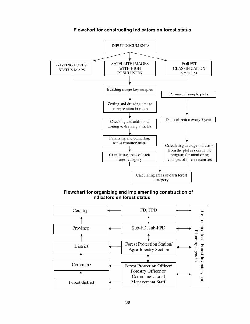
39
Flowchart for constructing indicators on forest status
Flowchart for organizing and implementing construction of indicators on forest status
Country
Province
District
Commune
Forest district
FD, FPD
Sub-FD, sub-FPD
Forest Protection Station/
Agro-forestry Section
Forest Protection Officer/
Forestry Officer or
Commune’s Land
Management Staff
Cen
tral an
d lo
cal Fo
rest Inv
ento
ry an
d
Plan
nin
g ag
encies
Calculating average indicators
from the plot system in the
program for monitoring
changes of forest resources
INPUT DOCUMENTS
SATELLITE IMAGES
WITH HIGH
RESULUSION
Building image key samples
Zoning and drawing, image
interpretation in room
Checking and additional
zoning & drawing at fields
Finalizing and compiling
forest resource maps
Calculating areas of each
forest category
Calculating areas of each forest
category
EXISTING FOREST
STATUS MAPS
FOREST
CLASSIFICATION
SYSTEM
Data collection every 5 year
Permanent sample plots

40
1.2 Indicators on annual forest activities
Only data on forestry activities implemented in the year are collected. There are 16 indicators, divided into small groups as follows:
- Indicators on forest development, include indicators: New plantation of protection forest; New plantation of production forest; Zoning and maintenance for regeneration (natural, man-made); Zoning and maintenance for protection; and Plantation of scattered forest trees. These indicators are collected and synthesized by forest project management boards, forest business enterprises and periodically reported to Forestry Department using standard report forms.
- Indicators on forest use and exploitation, include 5 indicators: Timber harvesting in natural forest; Timber harvesting in plantation forest; Bamboo harvesting; Non-timber forest product harvesting; and Fuel-wood harvesting. These indicators are collected and synthesized by Forestry Department and Forest Protection Department on the basis of reports received from agencies at local levels (Forest Protection Sub-departments, Forest Protection Stations, Nature Resource and Environment Sections/Agriculture and Rural Development Sections, Forest Project Managements Boards etc).
- Indicators on forest protection, including 2 indicators: Number of cases violating Forest Protection & Development Law; and Area of damaged forest. These two indicators are collected by Forest Protection Department based on periodic reports received from agencies at the local levels.
- Indicators on values of forest production industry, including 4 indicators: Outputs of main silviculture processing industrial products; Total value of forestry production; Value of forestry goods exported; and Value of wood materials imported. These indicators are synthesized by Forestry Department, Customs, Agro-forestry Processing & Salt Industry Department on the basis of data received from their local agencies.
1.3 Indicators on labor structure, income and living standard
Include 6 following indicators: Number of laborers working in state’s forest companies and enterprises; Number of laborers working in forest administrative agencies; Number of forest private households; Number of communities and villages participating in forest management and protection and the forest area managed; Average income per capita in provinces having a large area of forests; and rate of poor households in provinces having a large area of forests.
These indicators will be synthesized by Personnel and Organization Department, Forest Protection Department, Forestry Department and Agro-forestry Extension Center based on annual reports received from provincial agencies.
1.4 Indicators on science, technology, training and forestry extension
Include 5 indicators: Number of forestry science and technology researchers; number of college-graduated staff and technical workers; number of research projects in the forestry sectors; Number of certified forestry seedlings; and Number of forestry extension staff. These indicators will be collected by Personnel and Organization Department in collaboration with Science and Technology Department, Forest Sciences Institute, DARDs, and Forestry Corporations.
1.5 Indicators on forest investments

41
Include 8 indicators: Value of fixed assets of forest enterprises; Growth of investment fund in forestry; Total actual fund invested in forestry; Number of ODA projects in forestry (signed, implemented); Number of FDI projects in forestry (signed, implemented); Investments for research on forestry science and technology; Investments for forestry extension; and Implementation value of silviculture investment funds.
These indicators are collected and synthesized by Financial Department in collaboration with Project Management Boards, Planning Department, and Science and Technology Department.
2. Proposal for improving the capacity of the monitoring, evaluation and
reporting system in forestry in Vietnam
2.1 Improve the quality of the forest and forest land inventory data
Quality of forest inventory/statistics data and maps as well as the monitoring of forest resources changes is not satisfactory to meet the management requirement at the macro level. The major constrains are the lack of inventory data and accurate maps at the commune level to be used as the basis of 5-year forest inventory and annual forest statistics. In order to ensure data consistency and improve the quality and efficiency of forest and forest land inventory, it is recommended that MARD and MoNRE collaborate closely to develop a joint plan and submit it to the Government for approval. The two ministries would co-organize forest and forest land inventory detailed to the commune or forest district levels, using MoNRE’s new VN-2000 projection system. The two ministries need to reach agreements on concepts, criteria on land types so that they can be used in forest and forest land statistics/inventory. Existing satellite and aerial images should be used to improve the accuracy, but they should be used in combination with ground surveys to meet the objective of collecting initially a more reliable dataset to be used as the basis for forest inventory every 5 years, and annual forest and forest land statistics.
2.2 Collaborate among sectors in surveying and investigating subjects related to forestry
Many indicators related to the forestry sector are collected by other ministries and sectors, for example, indicators on population, labor, employment, economical and administrative agencies, investments, national account, trade, price, science and technology, education and training, living standard, environment protection etc. The ministries/sectors providing these data, however, only have general synthesized data but not forestry specific data for many indicators. Therefore, it is recommended to assign specific and clear obligations and to issue a collaboration mechanism (promulgated by the Government) on data provision and sharing between MARD and other related ministries/sectors.
The Informatics and Statistics Center together with the Forestry Department collaborate closely with the General Statistics Office and MoNRE when conducting statistics and inventory to get the statistical data to be used by the Ministry and the forestry sector.
2.3 Collaborate among relevant agencies of the Ministry of Agriculture and Rural Development in collecting, synthesizing, and providing forest data
To improve the capacity of MARD’s agencies, the agencies in charge of conducting

42
statistics work need a mechanism, which would make it compulsory for relevant agencies to provide statistical information.
MARD needs to assign specific tasks and allocate adequate budget to each agency participating in the process of collecting, synthesizing and providing forestry information. For example, the Informatics and Statistics Center will be the lead agency in collecting, synthesizing and providing forestry data collected and synthesized by other ministries and sectors such as the General Statistics Office, MoNRE etc.; the Forestry Department will collect and synthesize data on forest management, development and utilization, forest product processing industry, investments in the forestry sector, the 5 Million Hectare Reforestation Program etc.; the Forest Protection Department will collect and synthesize data on forest protection, biodiversity conservation, and collaborate with Forest Inventory and Planning Institute to conduct annual statistics and inventory on forest and forest lands.
2.4 Apply and deploy information technologies in the forestry sector
The forestry information system needs to be built to be modern, to be consistent from the central to the local level, and to meet requirements on information used in state management and business production activities of enterprises and local people. The main tasks include:
- Modernize the inventory works with the specific tasks: (1) developing a forestry statistical system consistent from the central to the local levels; (2) finalizing the forest sector indicator set in line with information demands, data collection and international integration capacities; and (3) developing and providing the annual forest sector statistical data in both printed and electronic formats.
- Develop and consolidate the system on forest sector information collection, synthesis, and monitoring for agencies in MARD and some relevant ministries/sectors (General Statistics Office, MoNRE).
- Develop and consolidate key forest sector databases, especially paying attention to databases on forest resources, forest product processing industry, and handicraft production villages using forest materials.
- Develop training curricula for capacity improvement, with focus on using statistical software, exploring information in databases, using GIS software etc.
2.5 Revise, supplement and finalize the collection, synthesis, analysis, and provision of data for the existing indicators
- Develop mechanisms for collaboration and information sharing among ministries/sectors and among agencies in MARD with the aim of collecting and synthesizing information for the calculation of indicators. Especially, the collaboration among MARD, MoNRE, and the General Statistics Office is emphasized.
- For some indicators which have previously calculated by adding up data from agriculture, forestry and fishery, MARD needs to collaborate closely with the General Statistics Office to develop separate indicators for the forestry sector (e.g., the production value of the forestry sector, the structure of production value of the forestry sector, the forestry GDP etc.).
- Finalize the statistical reporting system, which is applied to Department of

43
Agriculture and Rural Development (provincial level), and sections/units assigned for management of Agriculture and Rural Development sector (district level), to ensure the continuity and consistency of information.
2.6 Develop, pilot, and finalize the collection and synthesis of data for new indicators
For forest sector data not yet collected, they need to be piloted and added to the existing statistics and inventory programs (e.g., the program for monitoring changes of national forest resources, the forest and forest land inventory program etc.). For indicators necessary but not under the MARD’s competency, MARD needs to collaborate with other ministries, sectors and the General Statistics Office to synthesize and include such indicator data into the National Statistical and Inventory Program and then submit it to Prime Minister for issuance.