report on 1956 cooperative study program
TRANSCRIPT

I
STATE OF CALIFORNIA
DEPARTMENT OF WATER RESOURCES DIVISION OF RESOURCES PLANNING
REPORT ON 1956 COOPERATIVE STUDY PROGRAM
ATER USE AND WATER RIGHTS ALONG S CRAMENTO RIVER AND IN SACRAMENTO
SAN JOAQUIN DELTA
By
United States Department of the Interior, Bureau of Reclamation
Department of Water Resources, Division of Resources Planning
Sacramento River and Delta Water Association
VOLUME I
OODWIN J. KNIGHT Governor
MARCH 1957
cAUf0R~1.~\'( STATELIBn
HARVEY 0. BANKS Director of Water Resources

TABLE OF CONTENTS
LETTE OF TRANSMITTAL 0 0 0 0
ORGAN
CHAPT R I - INTRODUCTION
emorandum of Understanding
Distribution Agreements
0 •
of 1956 Cooperative Study Program
Investigation o o 0 0 0 0 0 0 0
CHAPT MODIFIED NATURAL FLOWS 0
of Estimation o o o o
CHAPT R III - ASSUMED WATER RIGHTS 0
hysically Riparian Lands o
ppropriative Water Rights 0
verlap Between Physically Riparian Lands and Places of Use Under Appropriative Rights
0 0 0 0
0
•
0 0
0
•
• 0
ther Water Rights 0 • 0 • • •
alinity Control 0 0 0 0 0 0 0 0 0 0 0 0 0 0
R IV - YIELDS OF ASSUMED WATER RIGHTS • 0
'A" Series 0 0 0 0 0 0 •
'B" Series 0 0 0 •
omparison of Average Yields of Water Rights Under "A" and "B" Series o • o • 0 0
'C" Series 0 0 0 0 0 0 0 0 0 0 0 0 0
X
1
3
6
7
8
11
15
15
19
20
23
25
26
26
29
30
35
36
39
CHAPT R V - DEFICIENCIES AND SUPPLEMENTAL WATER REQUIREMENTS 43
eficiencies 0 0 0 0 0 0 0 0 0 0 •
upplemental Water Requirements 0 0 0 0 0
iii
0 0 0
0 0 0 0
44
45

CH PTER VI ~ ALLOCATION STUDIES ooooooaoooo
A.llt)Cati.on of Responsl.bilit-:r .f'.Jr Supplemental Water· Requirements for Irrigation and Municipal P1lrpo s e s ., " ., o " " " " " " " o ., c " " " " "
Allocation of Responsi::,ility for Salinity Control
Allocation Under Operating Condit:i.ons
CHi PTER VII ·~ S UlVUV!ARY, CONCLUSIONS, AND RECOMMENDATIONS
s urr.nna_r·y r (
c~Jncl. usi.on.s
Recommendations •
TABLES
l
•
Summary of Valuec: and 3l··Year Average Yields of Assumed Rights fo~' Sal:i..nity Control • , , • • . , .
2
3
4
Summary of Vu.::.ues and ;ll~Year Average Yields of Assumed Riparian and Pre-1927 Appropriative and Other Rights of Local Water Users Along the Sacramento River Above Saeramento " ., " " " o "
Summary of Values and .:n~Year Average Yields of Assumed Riparian ar.d Pre~l927 Appropriative and Other Rights of Lcc:al Water Users in the Delta UpJ.ands and Lowlands ~ c• " " " o , ~ " " o " .., "
Summary of Values and .H~Year Average Yields of Assumed 1927-1938 Appropriative and Other Rights of Local Water Users Along the Sacramento River Above Sacramento " " " " " " " " " " " " "
5 Summary of Values and Jl-Year Average Yields of Assumed Post.-1938 Appropriative and Other Rights of Local Water Users Along the Sacramento River Above Sacramento o Q o .. o 0 D o ~ o o o o o o ~
6 Summary of Values and 3l~Year Average Yields of Assumed Post~l938 Appropriative and Other Rights of Local Water Users in the Delta UplaiJds , ,
7
. .
• •
. .
• •
• 0
Summary of Values and 31~Year Average Yields of Assumed Rights of All Local Water Users Along the Sacramento River Above Sacramento and in the Delta Uplands and Lowlands ••• o ••••
0 0 ,,
:tv
'?'!
I I

Table No.
9
10
11
ummary of Values and 31-Year Average Yields of All Assumed Rights of Local Water Users Along the Sacramento River Above Sacramento, in the Delta Uplands and Lowlands and the Assumed Right for Salinity Control o o • o • • • o • • • o , o • o
ummary of Values and 3l~Year Average Yields of the Assumed 1927 Direct Diversion Right of the United States at Shasta Dam for 8,000 second-feet
ummary of Values and 31-Year Average Yield of the Assumed 1927 Storage Right of the United States at Shasta Dam " " " " " " " " " " ., " " " " ~ "
ummary of Values and Assumed 1938 Direct States in the Delta
3l~Year Average Yields of the Diversion Right of the United ouooooooaooooo
12 'ummary of Values and 3l"'Year Average Yields of Assumed 1927 Direct Diversion and Storage Rights of the United States at Shasta Dam and of the Assumed 1938 Diversion Right of the United States
·~·-
83
•
in the Delta , , , , . o • , o o o • • • , • , , o 86
14
15
ummary of the 31-Year Average Yields of Assumed Water Rights of Major Entities and of Others Along the Sacramento River Above Sacramento and in the Delta Uplands and Lowlands ( C-1) . • , , , , ,
ummary of the 31-Year Average Yields of Assumed Water Rights of Major Entities and of Others Along the Sacramento River Above Sacramento and in the Delta Uplands and Lowlands (C~2)o 0 , , ,
ummary of the 31-Year Average Difference Between the Yield of All Assumed Rights of the Local Water Users Along the Sacramento River Above Sacramento and the 1954 Level of Diversions. Sacramento River Irrigation Deficiency , , , , , . , o , o o
16 ummary of the 31-Year Average Difference Between the Yield of All Assumed Rights of the Local Water Users in the Delta Uplands and Lowlands and the 1955 Level of Diversions. Delta Irrigation
0
$$
Deficiency , ~ " " " " ., .,. , " o " " " .. " " , o o " 89
17 ummary of the 31-Year Average Difference Between the Yield of All Assumed Rights of the Local Water Users Along the Sacramento River Above Sacramento and in the Delta Uplands and Lowlands and the 1954-55 Level of Diversions. Total Irrigation Deficiency " " " .. " , " " ., , " " " " " " o " " " " 90

T ble
2
2
22
8 Summary of the 3l,,Year Average Differencs Between the Yield of the Assumed Right for Salinity Control and the Required Flow, Salinity Control Deficiency ., " ~ ~ 3 " " a " "
9 Summary of the 31-·Year Average Difference Between the Yield of All Assumed Hights of the Local Water Users Including the Yield for Salinity Control Outflow and the 1954·,55 Level of Diversions Including the Required Salinity Control Outflow. Total Deficiency o • o , •
Summary of the 31-Year Average Difference Between the Yields of and the Net Values of All Assumed Water Rights of Major Entities and of Others Along the Sacramento River Above Sacramento and in the Delta Uplands and Lowlands. Total Irrigation Deficiency (C-1) •.•.•••...
0 0
Summary of the 31-Year Average Difference Between the Yields of and the Net Values of All Assumed Water Water Rights of Major Entities and of Others Along the Sacramento River Above Sacramento and in the Delta Uplands and Lowlands.. Total Irrigation Deficiency (C-2) ... , .•..•.•. , •.••
Summary of the 31-·Year Average Values of Supplemental Water Required to Firm the Yield of the Assumed Rights of Local Water Users Along the Sacramento River Above Sacramento to the 1954 Level of Diversions 0 0 0 D 0 0 0 0 0 a 0 0 0 0
23 Summary of the 31-Year Average Values of Supplemental Water Required to Firm the Yield of the Assumed
Page
90
91
92
93
94
Rights of Local Water Users in the Delta Uplands and Lowlands to the 1955 Level of Diversions . . • • 95
24 Summary of the 31-Year Average Values of Supplemental Water Required to Firm the Yield of the Assumed Rights of Local Water Users Along the Sacramento River Above Sacramento and in the Delta Uplands and Lowlands to the 1954-55 Level of Diversions . . o o 95
25 Summary of the 31-Year Average Values of Supplemental Water Required to Firm the Yield of the Assumed Right for Salinity Control at the Required Flow 96

Table No.
26 wmnary of the 3l~>Year Average Values of Supplemental Water Required t.o Firm the Yield of the Assumed Rights of the Local Water Users to the 1954-55 Level of Diversions Along the Sacramento River Above Sacramento and in the Delta Uplands and Lowlands and to Firm the Yield of the Assumed Right for Salinity Control at the Required Flow , , , •• , , 96
27 llustrative Allocations of Supplemental. Water Required for Irrigation and Mupicipal Purposes Along the Sacramento River and in the Delta and Unallocated Supplemental Water Required for Salinity Control , , 97
28 ummary of Estimated Average Irrigation Season Values of Yields, Deficiencies, and Supplemental Water Requirements 1924 through 1954 • • • • • • • • • • 99
Plate No.
PLATES
l ocation of Sacramento River-Delta Service Area
2 ssumed Physically Riparian Lands and Boundaries of Major Entities North of Sacramento
3 oundaries of Major Entities in and Subdivisions of Sacramento-San Joaquin Delta
4 ssumed Water Rights, Yields and Supplemental Water Requirements 1924-1954 Under Study A-2
5 ssumed Water Rights, Yields and Supplemental Water Requirements 1924-1954 Under Study B-2
6 ssumed Water Rights, Yields and Supplemental Water Requirements 1924-1954 Under Study B-3
7 ssumed Water Rights, Yields and Supplemental Water Requirements 1924-1954 Under Study B-4
8 1-Year Average Yields of Assumed Rights of Bureau of Reclamation and Local Water Users
9 1-Year Average Differences or Deficiencies Between the Yields of All Assumed Local Water Rights and the 1954-55 Level of Diversions and Supplemental Water Requirements by Local Water Users
10 ssumed Water Rights on the Sacramento River and in the Delta and Yields Thereof
vii

B
c
D
E
APPENDIXES
Memorandum of Understanding Relating to a General Approach to Negotiations for Settlement of Water Diversions From the Sacramento River and Sacramentu San Joaquin Delta With the Objective of Avoiding Litigation . . . . ..•.. , •. , A-1
Agreement for Trial Distribution of Water of the Sacramento River During 1954 . • . • . . .
Sacramento River and Delta Trial Water Distribution Agreement for 1955 ..••
Assumed Values of Water Rights
Monthly Parameters for Allocation of Supplemental Water Requirements for Irrigation and Municipal Purposes Along the Sacramento River and in the Delta Based on Studies C-1 and C-2 . . . . .
viii
B-1
C-1
D-1
E-1

l
LETTER OF TRANSMITTAL
Sacramento, California March 1, 1957
The Diverters of Water Along the Sacramento River nd in the Delta
Gen lemen:
The attached publication entitled "Report on 1956 Coo erative Study Program, Water Use and Water Rights Along Sac amento River and in Sacramento-San Joaquin Delta" is pre ented for your information and use, This report has been pre ared through the cooperative effort of the United States Bur au of Reclamation, the California State Department of Wat r Resources, and the Sacramento River and Delta Water Ass ciation.
It is believed that the information contained in this report will be useful in negotiations aimed at reaching an greement on water rights along the Sacramento River and in e Delta, The Bureau of Reclamation and the Department of ater Resources will make available the services of their res ctive staffs for consultation or for the provision of dat and information as required prior to and during negotiatio
Clyde H. Spencer Regional Director, Region 2 United States Bureau of Reclamation
~.~---,. ,. H:;v:~ J. Banks
Director of Water Resources State of California
/'P. W. H. Baber President Sacramento River and Delta Water
Association
ix

..... '
iJi
" t, ' ,, I
ll •a 'I
1i· I' ,,,
'li
'i! i'
1.;'1'·
'
. I I
I ij
l
'
'
w
ORGANIZATION
BUREAU OF RECLAMATION Rl~GION :; , SACRAMENTO, CALIFORNIA
Clyde H. Spencer, ~o~""""<>Qooo Regional DL ' , , ~
Ivan P. Head • 0 0 Chief, Regional Project Development Div131on
Supervisor of activities covered by this report
eland K. Hill •.. Chief, Water Rights Engineering Branch
Assisted by
ohn M. Schaser . , . • • 0 0 0 0 0
o o • Hydraulic Engineer
and
ake Osoffsky 0 . Chief, Hydrology Branch
erbert W. Finke Hydraulic Engineer
oward E. Wittig Hydraulic Engineer
eodore B. Kukkola 0 Hydraulic Engineer gh A. Pennebaker • • Hydraulic Engineer ward V. Rawlings
General Engineer hn F. Mathews .
General Engineer lliam D. Koogle
• General Engineer
X

ORGANIZATION
STATE DEPARTMENT OF WATER RESOURCES DIVISION OF RESOURCES PLANNING
Harv y Q, Banks .. , , M. J. Shelton . . Will'am L, Berry Carl B. Meyer . .
, . , . . Director of water Resources o • Deputy Director of Water Resources Chief, Division of Resources Planning
o •• Chief, Special Activities Branch
Supervisor of activities covered by this report
Wayn MacRostie . .
Rage R. Lindholm • . . .
Gear e W, Deatherage Walte H. Fisher, Jr.
Principal Hydraulic Engineer
assisted by
and
Associate Civil Engineer
Assistant Hydraulic Engineer Assistant Hydraulic Engineer
Computations were performed by
Bruce Fred Paul Darr
J. Baker o Swanson arcia • .
C. McCalister
John • James . • 1 1. Emery Quan • . .
A. Flagler m G. McKane ibata , tafford • .
Delineation
Engineering Aid II Engineering Aid II Engineering Aid I Engineering Aid I
Supervisor of Drafting Services Senior Delineator Senior Delineator
Delineator Delineator Delineator Delineator
Adminstration
F. Ja es Murphy . Acting Chief of the Division of Administration Isabe C. Nessler . . • • . . . . . . Coordinator of Reports
xi
• ORGANIZATION
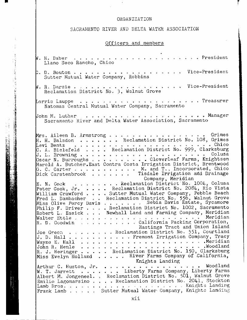
SACRAMENTO RIVER AND DELTA WATER ASSOCIATION
Officers and members
H. Baber ....•... . . . . . . President Llano Seco Rancho, Chico
Do Bouton .. . .. .. .. . . .. .. .. . .. . .. Vice-President Sut.ter Mutual Water Company, Robbins
R~ IJarsie . " ............... ¢ .. .. . . . Vice-President Reclamation District No. 3, Walnut Grove
orris Lauppe ......... ~ . ~ ... ~ ~ " .... e " .. Treasurer Natomas Central Mutual Water Company, Sacramento
John JtL Luther .. .. . , " . .. ., n ~ .. .. .. .. .. .. {' ., ., .... Manager Sacramento River and Delta Water Association, Sacramento
s. Aileen B. Armstrong .. .. .. a .. .. .. .. .. .. .. .. .. Grimes • • Reclamation District No. 108, Grimes • H. Balsdon •
Levi Bentz • C. A. Bielefeld J. L. Browning • Oscar N. Burroughs Harold A. Butcher.East G .. C .. Carter ... ~
Dick Carstenbrook
E. N. Cook Peter Cook, Jr. William Crawford Fred L. Dambacher
•
Miss Olive Percy Davis Philip F, Driver Robert L. Essick Walter Ettle R. D. Goodwin
Joe Gr·eer-. • , J. D. Hall • . Wayne E. Hall John R. Henle R. J. Heringer • Miss Evelyn Holland
Arthur C. Huston, Jr. W. T. Jarrett ••• Albert M. Jongeneel. Emilio Lagomarsino Lamb Bros. Frank Lamb . . . •
.. .. .. .. . .. .. .. ., .. .. .. Chico • Reclamation District No. 999, Clarksburg
, .. " .. " , .. .. .. .. .. o .. .. .. .. .. Colusa ••• , ••• Cloverleaf Farms, Knightsen
Contra Costa Irrigation District, Brentwood • M. and T., Incorporated, Chico
Tisdale Irrigation arid Draina,ge Company, Meridian
Reclamation District"No. 1004, Colusa Reclamation District No. 2084, Rio Vista
Sutter Mutual Water Company, Pebble Beach Reclamation District No. 556, Walnut Grove
. • • • , • . Sebia Davis Estate, Sycamore • Reclamation District No. 1002, Sacramento
•
Newhall Land and Farming Company, Meridian . .. " .. .. ~ .. , . ~ ~ ~ , .. Meridian
. . • , California Packing Corporation, Hastings Tract and Union Island
Reclamation District No. 551, Courtland ..• ~remont Irrigation Company, Tracy • ~ .. " .. .. .. .. .. .. .. , .. " ~ t!' Meridian .. ., .. .. .. .. .. ,. .. " , .. .. . " .. Woodland
Reclamation District No. 150, Clarksburg River Farms Company of .California,
Knights Landing do do .. .. o .. .. .. .. .. .. .. " .. • Woodland • Liberty Farms Company, Liberty Farms
Reclamation District No. 501, \Valnut Grove •• Reclamation District No, 2041, Stockton ~ • ~ m • ~ ~ Knights Landll1g
Sutter Mutual Water Company, Knie;hts Landj_;,g
xii
r

J. R Gord Doug Wall S, A Gus
Lauritzen • n J. Leiser as McCormack ce McCormack wood McKeehan.
• Reclamation District No. 1601, R ··· ~ .. .. .. .. .. " ., . " " " Knights o o o <> <> <> e <> • "' o ~ ~ o o f{i '-)
• • • Reclamation District No. 341, Rio Butte· Sloughulrrigation Gompany, Ltd, M,'.
Fran S, Reage:r, 'Jr. • • . Mrs, Elizabet.h Jii, Heimer
Reclamation District No. 999, Clarkc:o, :; o .. • " .. • .. ., ~ ., " .. " " " ., G·J ·_-:, :lr.l
" " • • ~ • b ~ • , o " ~ .. " • " Co1 \1s a Terr"ll Sartain • Reclamation District No. 1004, Colusa B. K, Schorr • • . . . . . • • • • • , • Rose Orchard, Bryte Will"am S. Towne ••• Staten Island Land Company, Staten Island A. D rwin Tuttle • • • • • • • • • Tuttle Land Company, Colusa Char es W ... Tuttle, Jr.. ., .. .. .. " ., .. " .. ., " ., " .... , " " Colusa Char es B. Weeks. East·Contra Costa. Irrigation District, Brentwood Miss Alice E .. West .. " ., .. ., ., ., ., .... ., ., .. .. Sacramento John F. Wilcox ••••• Reclamation District No. 2067, Rio Vista L. D. Wood. • • • • • ••••• Woodland Farms, Inc., Woodland Hora e B. Wulff • • Reclamation District No. 10$, Sacramento
Engineers
Prior to December 5, 1956, the Association retained the firm ifuss, Greenwood and Hostetter, Consulting Engineers, and uent to January 1, 1957, the Association retained the firm ifuss, Hostetter and Associates (Incorporated).
Supervisor of activities covered by this report
L. A. Hostetter ooooooooooooo<>o Civil Engineer
assisted by
K. B. Mayo oeoo<><J6ooooooooooo<> Civil Engineer
Subsequent to January 1, 195~ the Association also retained:
Geral H. Jones • o •• o ••••• o o o • Consulting Engineer
xiii

Foreword
This report covering water use and water rights along
Sacramento River and in the Sacramento-San Joaquin Delta,
sents the results of a cooperative effort among engineers
resenting the United States Bureau of Reclamation, the
C ifornia State Department of Water Resources, and the Sacramento
er and Delta Water Associationo Each group has contributed
s stantially through the making of decisions as to technical
ails of the work and through actual performance of the compre
sive computations involved in these studieso These engineers
h e agreed upon the basic hydrology, water right assumptions
d in the studies, and computation procedures by which the
ults were achievedo In many cases certain assumptions were
s gested by one or more of the parties in order that the infor
m ion desired by those parties might be obtained and the agree
t by the remaining parties to participate in studies of such
umptions demonstrates their willingness to cooperate in the
d elopment of all pertinent factso
The cooperating engineering group wishes to emphasize
t t water right assumptions made for study purposes may differ
c siderably from the rights as they might be determined by a
c urt of lawo The purpose of these assumptions was to demonstrate
t e effect of variation of water right criteria on the yields of
t water rights and on amounts of supplemental water required to
f"rm up the yields to meet the 1954 or 1955 level of diversionso
l

The purpose of this report is to present a c:ur"
»l'Biation believed to be essential for commencing net·
be al.med at reaching an agreement on water r l.,
~·•wto River and in the Delta. It is anticipatced t.na ..
be many questions left unanswered by this report. How-
~he findings presented herein will provide a basis for eval-
ing the relative importance of alternative assumptions as to
water rights. Those that appear worthy of further study may be
in additional computations as the negotiations proceed.
Information in this report is presented in two volumes.
I contains brief descriptions of the methods and summaries
findings of the various analyses under the 1956 Cooperative
Program. Volume II contains 606 tables which present in
the salient results of the studies.
Basic data and detailed explanations of assumptions and
the studies described in this report, as well as
not shown herein, will be made available for limited dis
a later date. Original copies of supporting data and
are filed in the office of the Department of Water
in Sacramento.
2
! j

I - INTRODUCTION
The question as to the relative rights of water users
alo the Sacramento River and in the Sacramento-San Joaquin
Del has long been a significant one in the affairs of this
n. As early as 1920 there was indication of an inadequate
supply to satisfy all water requirements in summer months
the river. In that year the City of Antioch sought an in
june ion to prevent appropriators of water from the Sacramento
Rive from reducing the flow past the City of Sacramento below
cubic feet per second so as to prevent impairment of the
qual"ty of water available for diversion by the City of Antioch.
porary injunction was ordered by the superior court, but
the rder was reversed by the Supreme Court of the State of
ornia, This was followed by the filing of a similar action
e Holland Land Company and other water users in the Delta
st the Williams Irrigation District and other upstream in
ts. However, this case was never brought to trial.
The dry year of 1924 caused serious concern among water
in the area and led to the first Sacramento-San Joaquin
problems conference held in that year. This conference re-
d in an agreement whereby the water users pledged to exer
their respective rights to the use of water in such a manner
accomplish the maximum degree of water conservation. The
mente-San Joaquin Water Supervisor was appointed in the State
eer's staff as a result of this conference in order that a rec
ord f the diversions and streamflow might be obtained and in order
3

o promote maximum conservation of water" The water sur •r" s
was again called upon to assist in prevention of ~
ter during the critical year of 1931. However, it was appa 0nt
at this method alone would not solve the problem with respect
the Delta and that a more positive limitation of upstream di-
v rsions in accordance with water right criteria would be necessary i the Delta were to get its share of the water supply.
Members of the staff of the State Engineer's office
r cognized as early as 1924 that the Sacramento River was over-
a propriated at that time with respect to low flow conditions that
o cur in such critical years as 1924. It was also recognized that t
solution to this situation was the construction of projects
ich would store water in months of surplus runoff and release it
f r use during the summer months. This fact was an important con-
eration in the recommendation by the staff of' the Division of
er Resources for implementation of The State Water Plan presented
to the Legislature in l93L In l927, anticipating the present,ation
1,j of this plan, the Department of Finance of the St,ate of California 1/' lli.'i
. fi ed upon unappropriated waters of the Sacramento River and other
rna or tributaries of the Central Valley in order that ·water rights
mi ht be obtained to permit such storage of surplus water.
Although it was contemplated that the Central Valley
Pr ject, the initial unit of The State Water Plan, would be built
by the State of California, it was found necessary to call upon
th Federal Government for assistance in implementing this project.
As the United States Bureau of Reclamation commenced con-
st. ction of the Central Valley Project in 1937" Applications for
4

wat r rights that had been filed by the State Department of ' · -,ce
in 927 were assigned to the United States for project pur;'
In ddi tion the State Department of Finance filed supplement .. L "C'l i-·
cat ons required for Central Valley Project operation in 1938 and
the e filings were also assigned to the United States. Subsequently
the Bureau of Reclamation made independent application for water
rig its Central Valley Project. The present status of these
wat r right applications held by the Bureau of Reclamation is that
the have been protested by various parties along the Sacramento
Riv in the Delta, and action granting permits is being with-
hel pending the outcome of current negotiations which this report
is esigned to assist.
Subsequent to 1944 the Bureau of Reclamation began to
inte view diverters along the Sacramento River with the view of
atte pting to settle the water rights problem. Results of the
inte views and exchange of correspondence with individuals and
with water user organizations appeared to indicate that such at
temp s would be fruitless. Subsequently it became the conviction
of m ny persons involved in the water rights problem that litiga-
tion would be required in order to determine the various water
righ priorities and quantitative entitlements thereunder including
the riority of the right of the United States to divert and store
wate for purposes of the Central Valley Project.
This fact was called to the attention of various leaders
in t e Congress and the State Legislature and the result was the
so-c lled "Engle Committee Hearing."* At this hearing apprehension
Hea ings at Sacramento, California, before a Special Subcommittee on rrigation and Reclamation of the Committee on Interior and Ins lar Affairs, House of Representatives, 82nd Congress, 1st Ses ion, and a ,Joint Interim Committee on Water Problems of the Cal fornia State Legislature on Central Valley Project, California, wat r Rights, Supplies and Uses, October 29, 30, 31, 1951.
5

as expressed by representatives of the water users, by 3 '"·
egislators, and by Congressmen in attendance as to thu
ies, expense and time that would be involved in a lawsu1 c 1e
agnitude required to settle the water right problems along !,tl\;
acramento River and in the Delta. It was the general conclusion
f the hearing that a lawsuit should be avoided if at all possible
nd that a practical operating agreement should be obtained by
egotiation.
morandum of Understandin
Subsequent to the Engle Committee Hearing, an exchange
o correspondence took place between the Secretary of the Interior
a d the Governor of California to discuss the means by which the
r ghts of various claimants to use of water along the Sacramento
Rver and in the Delta might be settled by negotiation. As a result,
t e Governor arranged a series of conferences among the various
c aimants to the waters involved which led to the execution on
J ly 7, 1952, of the "Memorandum of Understanding Relating to a
G neral Approach to Negotiations for Settlement of Water Diversions
f om the Sacramento River and Sacramento-San Joaquin Delta with the
0 jective of Avoiding Litigation." The parties who signed this
a were the Bureau of Reclamation, the Sacramento Valley
W Users Committee and the Division of Water Resources of the
te of California. A copy of the Memorandum of Understanding
presented in Appendix A. Under this memorandum the parties did
guarantee a final agreement, but they did "agree to explore the
fu 1 ramifications of the approach, with good faith and with hope
of agreement".
6
•
l

Tria Distribution A reements
Further negotiations among the water users, the L, · J
of R clamation, and the State Engineer, pursuant to the gene_~
appr ach set forth in the Memorandum of Understanding, resuJ "·'';
in t e "Agreement for Trial Distribution of Water of the Sacramento
Rive during 1954" and the "Sacramento River and Delta Trial Water
Dist ibution Agreement for 1955." Copies of these agreements are
pres nted in Appendixes B and C, respectively.
These agreements provided for a substantial increase in
the cope of hydrographic measurements within the service area of
the acramento River and Delta and for a number of analyses per
tain ng to data gathered during the Trial Distribution Program and
to d ta available as a result of earlier hydrographic measurements
by t e State and by agencies of the Federal Government. Monthly
repo ts of hydrographic data accumulated on a current basis were
subm tted by the State Engineer for the months of March through
Octo er in the years 1954 and 1955. In addition summary reports
enti led "Sacramento River Trial Water Distribution 1954, Summary
Repo t of Data" dated December 1954, and "Sacramento River and
Sacr ento-San Joaquin Delta Trial Water Distribution 1955,
Summ ry Report of Data" dated January 1956 were prepared by the
Stat Engineer. A report entitled "Sacramento River and Sacramento
San oaquin Delta Trial Water Distribution 1954 Report of Analyses"
date April 1955 was also submitted as a result of the studies pur
suan to the 1954 agreement.
There was a series of conferences among representatives
of t e water users, the Bureau of Reclamation,and the State Engineer,
whic took place in the fall of 1955 and the early part of 1956. The
7
c ncensus of these conferences was that sufficient data .,. <Jh 'Gl
cts were available to permit final computations of the
i formation which the conferees agreed should form the bac- , ,, '· n ·
of a water rights settlement. They believed chc.l "uch
gotiations should take place as early as possible. Specifically,
was thought essential that the studies include consideration of
er rights which had not been taken into account in earlier trial
tribution studies. Consequently, on May 14, 1956, engineer
resentatives from the then State Engineer's office began the
k program in cooperation with the consulting engineer for t,he
Sa ramento River and Delta Water Association. Following a meeting
on May 23, 1956, the United States Bureau of Reclamation designated
ineering personnel to participate in this program on its behalf.
has been designated the "1956 Cooperative Study Program."
erative Stud
Data on stream flows, diversions and return flows avail~
ab e from records of the United States Geological Survey and of the
wa er supervision activity of the Department of Water Resources were
d as a basis for estimating various facts relating to water right
ims along the Sacramento River and in the Sacramento-San Joaquin
De ta. Estimates were made of modified natural flows that would
ha e existed at the major gaging stations along the Sacramento River
an at other points if diversions from the river had not been made,
bu if certain assumed diversions from tributaries to the river and
to the Delta had been made. These estimates pertained to the months
of April through October from 1924 through 1954. Determinations of
la ds physically riparian to the Sacramento River upstream from
$

Sacr ento made by the Bureau of Reclamation on the basis of rL.
titl searches were spot-checked to satisfy the other partie:
engi eering representatives that the methods used were reason:Jr· \
These determinations included estimates of the net ar
that have been irrigated historically and of tnc;-.,e
land susceptible of irrigation by reason of their topography and
soil Information on appropriative water rights was tabu-
late files of the State Water Rights Board for those appro-
priat · ons :initiated subsequent to the Water Commission Act of 1914. In-
form
that
such
usee
exte
and
the
had
ion on appropriations initiated prior to the effective date of
obtained and assumptions were made as to the portions of
ater right claims that have been vested by reason of beneficial
Estimations originally made by the Bureau of Reclamation of the
of overlap between lands covered by appropriative water rights
ysically riparian lands were spot-checked in order to confirm
thod used and to permit an assumption of its accuracy. Studi.es
en made by the Bureau of Reclamation to determine areas irri
historically that were neither physically riparian nor covered
ropriative water rights.
operative study program.
These estimates were checked under
Tabulations of assumed water rights
for rposes of studies were made from the foregoing information
onthly basis under assumed demand schedules. Estimates of
modif"ed natural flows and assumed entitlements under various water
were used to estimate the yields of those rights, the defi
es or differences between the yields and the 1954 or 1955
of diversion, and requirements for supplemental water. Other
ation such as water remaining at various points in the
9

acramento River and in the Delta after satisfaction of ..
ights of various priority wa.s also computed. Tabulat. · f
.nformat.ion estimated by the various studies are presented in
olume II of this report,
Information on water right yields, deficiencies, and
upplemental water requirements were used by the engineers
epresenting the Department of Water Resources to arrive at a
umber of possible alternative allocations of responsibility for
ayment for supplemental water among individual major entities.
he division of responsibility for salinity control, which is
ssential to water utilization ~d thin the Delta and for export a-
ion from the Delta, was also considered. Findings of these
tudies and discussion thereof Hre presented as Chapter VI of
his report,
Not considered in this discussion of allocation of
esponsibility for payment are actual monetary considerations
hat might be involved by reason of the unit cost of supple-
ental water, Furthermore, no consideration is given in these
tudies to the capability of the Central Valley Project to meet
e level of local diversions corresponding to the 1954 or 1955
ndition which is assumed in the water deficiency and supple
ntal water requirement studieso However, it is generally con-
s"dered that the project is capable of supplying at least that
vel of local water utilization provided appropriate deficiencies
a e taken in critically dry years such as 1924, 1931, and 1934.
10
r

Area o Investi ation
The area covered by the 1956 Cooperative Study Prov.r
is sho n on Plate l, entitled ''Location of Sacramento River-u,_,
Servic Area." This area comprises roughly 1,600,000 acres, vf
which pproximately 900,000 acres are north of the latitude of
Sacram nto and approximately 700,000 acres are in the Delta" In
1954, pproximately 325,000 acres of that portion north of
Sacram nto were irrigated by direct diversion from the river, and
in 195 about 520,000 acres were irrigated in the Deltao Those
are th years when detailed land use surveys were made by the State
in the respective areas.
Within this general service area an extensive agricultural
indust y is locatedo There are many varieties of orchard, truck,
and fi ld crops, but north of Sacramento the major crop for many
years as been rice" In 1954, the year of maximum planting of that
crop, bout 185,000 acres of the aforesaid area irrigated from the
river as planted to rice alone, "Grain and hay" was the major
crop g oup in the Delta in 1955, covering about 96,000 acres.
Import nt urban areas within the Sacramento River service area are
the Ci ies of Redding and Sacramento. The City of Red Bluff is
also w thin this service area, and its industrial significance has
taken n added stature in recent years,
The source of the major water supply available to this
area i the snow deposited upon the mountains of the Sierra Nevada
and Ca cade Ranges during winter months, The melting snow in the
course of the season provides the water supplies of the Sacramento,
Feathe , American, Mokelumne, and San Joaquin Rivers and other minor
tribut ries, However, the largest part of the runoff occurs in the
ll

'! ;; !
inter, spring, and early summer months, and a relative'
amount occurs during late summer and early fall mont~h
ater is required for large irrigation demands~ Shasta fe,
n the Sacramento River north of Redding, Lake Almanor {)rr ' '(
eather River, and Folsom Reservoir on the American River "· ~ the
argest of the art-ificial storage units that have been provided to
tore winter and spring runoff in order that it may be available
or summer irrigation and for generation of hydroelectric power,
Water requirements in the Sacramento Ri.ver~Delta service
rea are of a number of different types, but the most important of
hese is the irrigation requirement. Diversions from the Sacramento
iver north of the City of Sacramento in 1954, the year of maximum
iversions, amounted to approximately, 2,088,000 acre~feet during
he seven-month irrigation season from April through October.
onsumptive use in the Sacramento~San Joaquin Delta Lowlands from
pril through October was estimated on the basis of a 1955 land
se survey to be approximately 1,059,000 acre-feet, Diversions
o the Delta Uplands in 1955 totaled about 385,000 acre-feet during
he same months. Neglecting the fact that one of the foregoing
uantities is a consumptive use value and that the remainder are
ross diversions, the water utilization totals approximately
, 53Z , 000 acre-feet during the seven-month irrigation season.
lso, over 1,000,000 acre-feet are presently being exported annu-
ly from the Delta through facilities of the Central Valley
oject and of the City of Vallejo. Of the foregoing quantities,
quirements for municipal and industrial use amount to in the
o der of only one per cent of the totals~
12
! '

. '
Other recognized requirements for water in the Sa0 1to
-Delta service area are the substantial requirements f, ~-
ity ontrol necessary to prevent water in the channels of th<' ' '·'"-
from being degraded by salt water from Suisun Bay, requiremenL[, for
navi ation to allow barge traffic between Knights Landing and the
vici ity of Colusa, requirements for protection and propagation of
fish life below the major reservoirs of the Central Valley Project
and equirements for power generation incidental to the other primary
wate requirements"
13

r II - MODIFIED NATURAL FLOWS
The first step in studies of the yields of assumud
wat r rights along the Sacramento River and in the Delta was
the estimation of modified natural flows at various points"
Mod'fied natural flows, as defined for use in these studies,
com rise flows that would have existed without diversions from
the Sacramento River but with historical impairment or with im
pai ment at an assumed present level of diversions on tribu
tar'es either to the Sacramento River or to channels of the
Del a" It was also defined to include those flows that would
existed without regulation by Shasta or Folsom Reservoirs"
of Estimation
Modified natural flows of the Sacramento River were
est'mated for points (l) at Shasta Dam, (2) above the mouth of
Drain near Knights Landing, taken as the point of
mi during the irrigation season, and {J) above the mouth
of he American River, assumed to be a point of inflow to the Delta"
Add'tional modified natural flows available to the Delta were taken
to e historical flows of all other Delta tributaries" A further
al wance was included for return flow from diversions to the Delta
Up ands at the 1955 level" Also estimated were quantities of modi
fi d natural flows of the Sacramento River at Red Bluff, Butte City,
Co sa, Wilkins Slough, Knights Landing, and Verona, but these were
no used in studies described hereinafter" Values of modified nat
ur l flows were estimated or taken from records for the period April
th ough October of each year from 1924 through 1954"
15
f1

I li ..
The months of November through March were excltH';:·
e study period because sufficient flows were found to ,_-,
ring those months to satisfy all assumed local rights .·u
cramento River and in the Delta except during critically
ars" Local water rights are defined as all rights other t.,_-,
ose of the United States and those of the State of Californ •-
Estimations of modified natural flows at gaging sto.L 1 ;_;r,.,
other points along the Sacramento River were based upon
r cords of streamflow, diversions, and return flows maintained L-y
e United States Geological Survey and by the Department of \~&' :;r
sources and its predecessors under the Sacramento-San JoaquL
W ter Supervision activity. Historical streamflqw quftl1tities f1r
m nths in which no actual records of flow were available were c. t;.i~
m ted by correlation with flows o:f the river and/or tributary f 1 ows
b standard methods, Next, the historical diversions as recor-u·d
i the reports of the Sacramento~.San Joaquin Water Supervision •-ere
a ded to the recorded or estimated historical streamflows, Th'· •
t e return flows tributary to the river above each of the po]nr-
c nsidered were estimated by application of return flow factor:
t the historical diversions within the appropriate reaches of .he
rver, Finally, such return flows were subtracted from histort al
f ows. Return flow factors were taken as the ratios between a ·r-
a e measured accretions to the river, ot,her than accretions f_r, ·n.
n tural streamflows, and the corresponding average monthly di ·. ~
s ons within the same month for the period from 1950 through l" ;4,
H wever, for the dry years of 1924 and 1931 special return flc•'
f ctors were computed to reflect conditions under deficient w:?· -r
s pplies in those seasons.
16
'

The second adjustment to measured or estimated hif', ··i~
cal of the Sacramento River at the aforesaid points i L. 'd
for the operation of Shasta Reservoiro This adjust
ment as made for the years 1943 through l954o The amounts of in
or decrease in flow were estimated on the basis of the his-
1 monthly changes in Shasta Reservoir storage as corrected
aporation and precipitationo These data were obtained from
nthly reports of operation for Shasta Reservoir as published
United States Bureau of Reclamationo
The final adjustment to measured or estimated historical
flows of the Sacramento River was to reflect the effect of the 1954
level of diversions in the Feather and Yuba River service areas and
Butte Creek, Butte Slough and Sutter By-Pass areaso Flows
that istorically entered the Sacramento River through the Butte
outflow gates, in Sacramento Slough and in the Feather River
olaus were adjusted for the differences between historical
54 net diversions, to the extent that historical flows were
avail ble to meet such differenceso Net diversions were taken as
the d fferences between gross diversions and estimated return flows
there ramo Return flow estimates were based upon return flow fac
tors hich were computed by a method similar to that described for
the S cramento River,
Modified natural flows of the American River and other
tribu aries to the Delta were taken as historical flows of those
tribu arieso Changes in utilization of waters of those tribu
tarie during the study period from 1924 through 1954 has affected
water supplies available to the Delta to some extento However,
17

the amounts are relatively small, and are believed to r" ,-""gligible
or purposes of the present studies as compared to rna~:.·; i ,s of
odified natural flows of the Sacramento River and to V<·.nble
rrors in estimation of such natural flows.
Tables in Volume II indicate estimated quantities of modi
ied natural flows of the Sacramento River at Shasta Dam, at a point
bove the mouth of Colusa Basin Drain, and at a point above the mouth
f the American River, as well as histor.ical flows of the American
iver at. Sacramento and of other Delta tributaries. This information
overs the months of April through October from 1924 through 1954.
hese quanti ties indicate amounts of water that wen• initially avail~ ble to meet assumed diversion rights.
18

III - ASSUMED WATER RIGHTS
For purposes of the studies described hereinafter, it
was necessary to make assumptions as to the water rights of
diver ers along the Sacramento River and in the Delta, These
assum tions pertained to the extent of so-called physically ri
paria lands, to the extent of appropriative water rights initi
ated th before and after the Water Commission Act of 1914, and
extent of lands with a historical water use but not phys
ical! riparian and having no apparent claim of water right by
of a formal filing with the State, In addition, salinity
requirements and water right status thereof were assumed.
It is ecognized that the assumed rights may differ from rights
that uld be determined by the courts through legal processes,
Forth's reason, it is to be emphasized that no claim is made by
the pa ties to the 1956 Cooperative Study Program that these assump
tions efine the relative water rights involved, Nevertheless, it
is bel'eved essential that estimates of these rights be made in
order hat approximations may be developed of the extent to which
such r ghts may be satisfied from the modified natural flows avail
able,
Information in this chapter is discussed under the head
ings 11 hysically Riparian Lands," "Appropriative,Water.Rights,"
p between Physically Riparian Lands and Places of Use under
iative Rights," "Other Water Rights," and "Salinity Control."
19

p sls;a].,.ly:,,.Ri_parian_bi!r19:.!!
Decisions of the courts in Cali.fornia, ir;cludi< ,' "
firming the 1928 constitutional amendment,, have consist'"' : y
eld the right of owners of riparian land to divert from the
ad·acent streams those quantities of water reasonably required on
su h lands. Along the Sacramento River these riparian rights under
St te law are believed to be prior to any rights acquired by reason
of appropriation,
Estimates of the extent of physically riparian land along
th Sacramento River between Redding and Sacramento were based upon
ex ensi.ve work by the Bureau of Reclamation which began about 1950,
Th s work consisted of contracting with ti;:;le companies for title
re orts on each parcel of land believed to be physically riparian
to the Sacramento River. These reports indicated the smallest
pa eels of land abutting the river that have been in continuous
o ershtp since the date of patent, thereby meeting the ::-equire~
me ts for riparian status. Upon recei.pt of the title reports, the
Bu eau of Reclamation delineated the boundaries o:f such smallest
pl The boundaries of the physically riparian parcels were
th upon maps showing the extent of irrigation systems
in xistence at the time of study and showing the lands within the
bo daries that were considered to be irrigable.
The foregoing work by the Bureau of Reclamation was spot
under the 1956 Cooperative Study Program to confirm the
' val'dity of the methods used and the accuracy of the computations. :: ;; il Thi examination indicated that the basic studies had been care-" "i !! ful y performed, and they were taken as acceptable for use in the
~ 20 :~
r

coop rative studies, Plate 2, entitled "Assumed Physically
Ripa ian Lands and Boundaries of Major Entities North of
Sacr ento", indicates the backline of physically riparian laJ,dC>
alon the Sacramento River between Redding and Sacrarnento, as
dete mined by the method described heretofore"
The aforesaid determination indicated that there are
appr ximately 169,000 acres of physically riparian land along the
Sacr menta River between Redding and Sacramento, of which approxi
mate y 110,000 acres are either under existing water distribution
syst ms or are irrigable areas not now served with water, Water
requ ements of these lands were estimated by assuming that 85 per
cent of the irrigable area will be irrigated in any one year with
aunt duty of one second-foot per 70 acres. This is equivalent
to a diversion demand of approximately 82,000 acre-feet or 1,335
seco d-feet in the month of maximum demand.
It was assumed that all of the Delta Lowlands are
ripa ian to channels of the Delta, The boundaries of this area
are hown on Plate 3, entitled "Boundaries of Major Entities in
and ubdivisions of Sacramento-San Joaquin Delta". Furthermore,
in c rtain studies described hereinafter, it was assumed that such
land are riparian with respect to waters of the Sacramento River
and other tributary streams of the Delta. No search of indi-
vidu
Rive
The
title records, such as that described for the Sacramento
north of Sacramento, were made for this Delta Lowlands area.
undary of the Delta Lowlands is the same as that shown on
Plat 3 in the report entitled "Sacramento River and Sacramento
San aquin Delta Trial Water Distribution 1955 Summary Report of
Data," dated January 1956. The gross area of the Delta Lowlands
21

is approximately 469,000 acres, o.f which 386,000 acres Wfcrc
ld as ;:gricultural in a land use survey made by the St:J
er requirements for this area were estimated on the bas:i
as of land use given in Table 18 of the aforesaid report . r,,
t consumptive use o.f water .factors given in Table 20 o.f tb:.•.
orL Total amounts of consumptive use computed in that man:1r ·
e reduced to account for the estimated portion of the total cct·
s ptive use that may be supplied by precipitation to determine the
ne demand upon Delta channels. These estimates considered both
pr cipitation during the month in question and that carried ovec
as soil moisture from earlier precipitation. The net consumpt i ·: e
us in the Delta Lowlands in the months of maximum demand was esLi
ma ed to be 241,000 acre-feet or an average of 3,919 second-fee·
In the determination of physically riparian lands alone;
th Sacramento River above Sacramento and in the Delta Lowlandc>,
no study was made of the possible modification of the rights of
su h lands by reason of adverse use developing into a prescript e
ri ht. It is believed that such studies would be in the nature f
as
icial determinations and are, therefore, beyond the scope of ·n
ineering study of the type described in t.his report,
Table l of Appendix D summarizes the water requirements of
physically riparian lands north of Sacramento and in the.
ta Lowlands. It includes estimates of water requirements of
ri arian land within the service areas of major entities above
rarnento, the boundaries of which are among those delineated
on Plate 2.
22

A iative Water Ri hts
Appropriative water rights considered in the 1956
Cooper tive Study Program include those initiated by posting
and th se initiated by filing pursuant to the Water Commission
Act of l914o
Information on appropriations initiated prior to
Decemb 19, 1914, the effective date of the Water Commission
re taken from various sources including the factual
report by the Bureau of Reclamation, covering the Sacramento
River ervice Area Investigations, and Bulletin Noo 21 of the
State i vision of Water Resources entitled, "Report on Irrigation
Districts in California" published in 1929o The right of
n-Cottonwood Irrigation District was assumed to be 400
feet as indicated in a certificate issued by the Water
ion which confirmed their 1914 postingo The amount of
ropriative right for Glenn-Colusa and Jacinto Irrigation
Districts was assumed to be 2,400 second-feet or the capacity of
the main canalo
In studies of the rights of individual water users
described in the next chapter, pre-1914 posting information was
also o ained for several of the major diverters in the Delta
The assumed amounts of vested rights under these past
e taken as the maximum historical monthly average diver
ereunder.
Appropriations initiated under the Water Commission
914 were evaluated from the information given in the
ion,permit, or license on file with the State Water Rights
23

·I; ;':
~~
B ard 0 The assumed amounts of such rights were ~aken a;J · ce
v lues given in those documents without modification for ce
0 development or for loss of right by reason of non-· use" ,, "' · Lea-
t ons for water rights were considered and tabula<>;ed if the dc.d:;e
o application was December )1, 1954, or earlier. The values o.f
S ate Department of Finance filings made in 1927 and subsequently,
i eluding those assigned to the United States, ware also taken
f files of the State Water Rights Board.
Appropriative rights in the Delta Uplands were not
in detail for the first two series of studi.es described
i the following chapter. By inspection of records of diversions
i the Delta Uplands in 1955, i.t was found that approximately
7 percent of such diversions were made under appropriations
a edating the State filings of 1927. It was also found that
t remaining portion,or approximately 30 percent of the 1955
ersions, were made under water right applications subsequent
to 1938, the date of the second group of State filings assigned
to the United States for the Central Valley Project, In later
dies of individual water users in the Delta Uplands, applica~
and license data were taken as the bases for
ropriative water rights initiated subsequent to 1914"
Table 2 of Appendix D presents assumed values of
appropriative rights under postings and Table J of that
endix presents a chronological tabulation of the assumed
ropriative water rights initiated between 1914 and 1954.
se tables show the names of only those major appropriators
as umed to have pre-1927 water rights which were studied
24

indi v, dually as described in the next chapter. The present ho '
er applications, permits, or licenses were not determ] L,c,,
undaries of the properties and districts to which the m~:
27 appropriative water rights pertain are among those llicL
te 2. Table 5 of Appendix D presents information on the
vari0 s State filings considered in this report,
arian Lands and Places of Use
As indicated on Plate 2, the boundaries of certain of the
entit'es that have claimed appropriative water rights overlap the
physi ally riparian lands also shown on that plate. Therefore it
was n cessary to eliminate the duplication of coverage by appro~
priat've water right service areas and physically riparian lands,
The Bureau of Reclamation had made a study of the extent
overlap between lands covered by these two different cate-
of water rights, This study involved plotting the respective
areas on a set of maps similar to the maps shown as Plate 2 of this
repor , but at a larger scale, The determinations of the extent of
p were checked in the 1956 Cooperative Study Program to deter~
mine he reasonableness of the method of derivation and the accuracy
t work.
Water requirements for the overlap areas were estimated
by uming that such areas would retain the same duties of water
as cified in the applications, permits, or licenses covering
the a eas. The overlap allowance was then deducted from the total
allow nee for the area covered by the appropriation,
Table 3 of Appendix D also presents the estimated require
ments for overlap areas, and the net assumed appropriative water
right entitlements after correction for overlap. These assumed net
25

,, I
rights total 412,000 acre~feet or an average of 6,?00 second~fee-c
during the month of maximum demand.
ther Water Rights
It has been mentioned heretofore that records of water
se on lands along the Sacramento River between Redding and
acramento indicate that there are parcels of land which are not
overed by assumed riparian or appropriative rights but. which,
evertheless, have been irrigated from the ri.ver over long periods
f time and were irrigated in 1954. Whatever t.he basis or claim
f right may be for these lands, it was assumed in the 1956
ooperative Study Program that such lands do have a right to divert
ater. Further, it was assumed that such rights have a priority
n accordance with the approximate date on which the use of water
as initiated as shown by the historical records. The work of
etermining such "other" rights was originally done by the Bureau
f Reclamation and was checked in the cooperative studies.
Table 4 of Appendix D indicates the quantities of assumed
'other" water rights along the Sacramento River between Redding
These assumed rights total 16,780 acre-feet or
n average of 273 second~feet during the month of maximum demand.
Control
It has been indicated heretofore that use of water with~
the Delta Uplands and Lowlands and diversion of water from the
lta through facilities of the Central Valley Project and diver
s'on works of the City of Vallejo require salinity control in
o der to prevent harmful degradation of the quality of water in
D lta channels. Under natural conditions such salinity control
26
r t

was pr bably provided in most years by surplus outflow of fresh
water rom the large tidal swamp which then comprised the area
at the confluence of the Sacramento and San Joaquin Rivers, which
we now call the Delta, Gradually, as reclamation of the Delta
and de elopment of the use of water took place upstream, the amount
of wat r available for natural salinity control decreased until in
1924, other dry years, the encroachment of saline waters
reache serious proportions, During the late summers of those
years ·rrigation in a large part of the Delta was made impossible
by the degree of concentration of salinity in the waters of the
channe s,
One of the functions of the Central Valley Project is
to reg late surplus runoff from the Sacramento and American Rivers
so as o provide sufficient outflow from the Delta to repel salinit~
Since ctual operation of Shasta Reservoir commenced in 1944, in
cursio of sea water to the extent that took place in the former
years f uncontrolled runoff has been largely prevented, However,
1,000
water
Delta
recent years concentrations of chlorides have exceeded
per million in the channels adjoining some of the
Delta islands and have, therefore, exceeded the stand
t was adopted by the State as a minimum for use of the
agricultural and other purposes,
Bulletin No, 27 of the State Division of Water Resources
"Variation and Control of Salinity in Sacramento-San Joaquin
d Upper San Francisco Bay" and published in 1931, presented
of the historical records of saline water incursion and
that salinity control outflows from the Delta be main~
tained at a minimum constant flow value of 3,300 second-feet, It
27

w s estimated in that bulletin that such outflows would p1 c · ·
c rsion of chloride ion concentrations of 1,.000 parts pe1
b yond points in the San Joaquin and Sacramento Rivers app ··,. 1
-tenths of a mile west of Antioch.
In certain of the studies described in this report, !'!·.
, l as umption was made that salinity control flows of 3,300 second ; et
ha, in effect, a status as a riparian water right associated 'hl ·n
th assumed riparian rights of the Delta Lowlands since such sale; nity
co trol outflows would be required to make such riparian divers1ons
po sible. However, there is some question as to the economic v:;Jue
of providing a full 3,300 seconde>feet outflow for salinity control,
wh·ch would be required to protect diverters in the westernmost
pa of the Delta. It has been suggested by some investigators
th the amount of water allowed to waste to Suisun Bay for control
of alinity should be reduced below the amount of 3, 300 second .. feet
and that direct overland service of fresh water be provided to
tho e westernmost areas that would be unable to divert directly
fro the channels with such lesser amounts of salinity controL
The efore,certain of the studies described in this report were
bas d upon the assumption that salinity control flows having a
ri rian water right status would be 2,000 second"feet instead of
second~feet. In addition one of the cooperative studies was
upon the assumption that salinity control requirements of
second-feet would have a water right priority subsequent
54, following the priority dates of all appropriative rights
d for the studies. This assumption was made for illustra~
tive purposes only.
28
'~. ''''

r IV - YIELDS OF ASSUMED WATER RIGHTS
On the basis of estimated modified natural flows and
assum d water rights described in the preceding chapters, esti
mates were made of the yields of assumed water rights under
sever l combinations of assumptions. Three different general
group of studies were made in this connection. The so-called
"A" a d "B" Series of studies considered large groups of local
water right claimants separated by the priority dates in 1927
and 1 38 pertaining to the State filings which were assigned to
the U ited States for construction of the Central Valley Project.
In th se series, the yields of assumed local rights and of the
1927 nd 1938 filings assigned to the United States were esti
mated In addition, one study under each series produced
estim tes of yields of those State filings still retained under
the j isdiction of the State Department of Water Resources.
The " " Series of studies considered the yieldsof individual
major appropriative water right claims of 25 major entities along
the S cramento River above Sacramento and in the Delta Uplands,
as we l as the yield of assumed riparian rights of the Delta Low
lands and of other water users as a group. As indicated hereto
fore, assumptions as to the amounts and water right status of
requi ements for salinity control were made for the various studies.
The general procedure for making these studies involved
deduc ing gross diversions from amounts of modified natural flows
avail ble in various reaches and crediting amounts of return
29

ows from such diifersions to permit addit1.onal u.s.e or' ~"''''
rther details with respect to each of the stud·.Les lS r:
the following sections perta1n1ng specifically t.o each ,,_,
Svudy series.
Series
For purposes of the "A" Series of studies assumed
ter rights were divided into five groups in order of priority
follows: (1) riparian and pre~l927 appropriat:ve and other
r ghts of local water users, (2) 1927 State filings, (J) appro
p i.ative and other rights of local water users with prior:ity
tween 1927 and 1938, (4) 1938 State filings, and (5) post~l938
a propriative and other rights of local water users, These water
r · ghts were further subdivided geographically i_nto twa reaches
a ove Sacramento, namely, Redding t.o Knights Landing and Knights
nding to Sacramento. The pre~l927 rights assumed for the Delta
and Delta Uplands were taken as one geograph1cal group,
The general procedure for d-etermining yields which was
llowed in each study of the "A" Series involved th2 assumption
at local water rights wi.thin eacf: priority group would be satis~
ed in geographical order proceeding downstream from Redding,
dified natural flows in the reach Redding to Knights Landing were
a sumed to be available first for satisfar::tion of all rights of
t e first priority group within that reach. Return flows from
d versions under such rights were estimat-ed by using return flow
ctors previously described in the chapter on modified natural
Such return flows were assumed to be available for one
vel of rediversion i.f needed t.o meet the rights of the first.
30

rity group. Return flows from such rediversions were ac c',
to e unavailable for further diversions in the reach. It •d
eved that such return flows would occur in a manner tha-r ·,,.,
a second rediversion in the same reach impracticable. Thd
of any modified natural flows remaining after the aforesaio
rsions and return flows from upstream diversions was assumed
to e available to satisfy water rights of the first priority
p in the second reach between Knights Landing and Sacramento,
The extent of satisfaction of the assumed water rights for the
sec nd reach was then determined in the same manner as in the
reach, Finally, the assumed water rights of the first pri-
group in the Delta, including the requirements for salinity
rol at ),)00 second-feet, were assumed to be satisfied to the
possible from any residual modified natural flows and from
flows from diversions in the upper reaches,
Yields of assumed water rights in the second priority
p, the 1927 State filings, were estimated next. They were
n as being satisfied to the extent possible from any water
lable after satisfaction of all assumed water rights in the
priority group. At this point, the differences between the
e studies of the "A" series are to be found in part. For
y A-1, only the 1927 State filings on the Sacramento River at
ta Dam, which were assigned to the United States, were con
red. For that study, the portion of the demand under those
fil·ngs for diversion into the Delta-Mendota Canal was assumed
to omprise a constant diversion rate in all months studied,
nting to 4,600 second-feet,
)1
'I I ,,
i
!

:, ~
·
to sat sfy those filings in proportion to historical flows a+, ,_:
points referred to in the filingso 1934 State filings on the
Americ n River were considered along with 1927 filings because
there ere no assumed local rights having priorities between those
yearso
Yields of assumed appropriative and other water rights
of loc l water users in the third group, having priorities between
1927 a d 1938, were estimat-ed next" They were taken as being sat
isfied insofar as possible from water still available after satis
factio of the pre-1927 water rights of local water users and 1927
State ilingso The procedure was the same as that followed in
determ·ning yields of assumed pre-1927 water rights, in which as~
sumed ights were satisfied in geographical order beginning with
the on the river, proceeding downstream, and utiliz-
ing
Following this, yields of assumed water rights in the
fourth priority group, the 1938 State filings were determined"
The 1938 State filings in the Delta were considerably larger than
the ca of diversion works of the Central Valley Project"
Conseq ently those filings were assumed to be utilized only to the
ecessary to complete the satisfaction of demands for the
Delta- ndota and Contra Costa Canals not met under the assumed
1927-pr·ority rights at Shasta Dam"
As in the case of the assumed 1927-priority State filings,
there a e differences in assumptions as to amounts of the 1938
filings as among the three studies of the "A" Serieso In Study
A-2, am unts of water required to make up the differences between
33

e.:Lta~,Me:ndot,a Canal diversions under an irr.igat.:ion dt.:mar:, ·
iversions at a constant rate of 4,600 second-feet weze
lows available in the Delta. This ~aused yields of as6t.•
ights of the United States to be larger under Study A~·2 t.i'
tudy A-L In additJ.on, under the l93S State filings assigr:
he United States, it was assumed fer Studies A~2 and A-.2 (R;:L ·d)
hat the demand for municipal and industrial purposes would b'
, 000 second-feet instead of the figure of 100 second~feet as:: •.n:•·.:>d
or Study A-1. The basis for the 1,000 seGond-foot value is
pplication No. 9363 listed in Table 5 of Appendix D.
The final step of t.he "A" Series st.udies was to det.e ·. i.ne
e yields of the fifth group, assumed local. rights having pos~.
38 priorities. These local water rights were assumed to be -
'sfied by waters remaining after sati.sfaction of 1938 State fi 1 'ngs
geographical order starting with the highest reach on the t;.er,
oceeding downstream, and uti.l. .. Lz:Lng return flows.
Tables 1 through 12 present average monthly values c·'
- · elds of as sUllied rights of local water users and of the Bure:1·
Reclamation under the "A" Series for the years 1924 through
54. Those tables also show assumed water rights for the re•,, G-
t've studies to permit ready comparison wi"th corresponding vaJ• ·:s
o average yield, Included in Volume II are tables showing t)·, •
timated yields of the var:i.ous water right pr.iority groups f<·
e ch month of the 31-year period from 1924 through 1954. Pla.1 -'!,
e titled "Assumed Water Rights, Yields, and Supplemental Water
quirements 1924-1954 Under Study A-2" includes a graphical r·c·;Jre-
s ntation of the yields of the assumed rights of all local wa
u ers, those of the Bureau of' ReGlarnat.i.cm, and that for sal.i •
c ntrol.

"B" S ries
The computation procedures to estimate water right
under the "B" Series were similar to those described for the "I
Serie with one principal exception. In the ''B'' Series all of the
assum d riparian rights, both above Sacramento and in the Delta
Lowla ds, and the salinity control requirement, when it was assumed
to ha e a riparian water right status, were taken as being satis
fied efore any appropriative water rights. After such riparian
right were satisfied to the extent of available water supplies,
the r maining flows at points along the Sacramento River and in
the D lta were assumed to be available to satisfy appropriative
water rights, Yields of assumed appropriative rights of local water
users within each priority group were estimated by assuming that
right in the uppermost reach of the river between Redding and
Knigh s Landing would be satisfied first, followed in succession
in the reach between Knights Landing and Sacramento and
in the Delta Uplands. Return flows from diversions with
reach were treated in the same manner as that described for
the " " Series of studies in order to compute the total amount of
water available for diversion in each reach.
by ri
by ri
in ea
For Studies B-1, B-2, and B-2 (Modified), the water right
assum ions and computation procedures pertaining to rights under
State ilings assigned to the United States and State filings remain
ing u ssigned were the same as assumptions for the three studies
"A" Series, respectively. Water right assumptions for Study
lowed assumptions for Study B~2 with the exception that
salini y control outflows from the Delta assumed to have a riparian
35

,!:, i '
water right status were t.aken at 2;000 second ,fe,-:~t ln~·,;
3, 300 second~feet.. Assumpt.i ems for· Study B~"4 w2::s tb ·
those for Study B~2 except that a salin~ty contr·oJ requ~rPm nt;
of 3,300 second·~feet was assumed to have a water right p>·.~;Jri.ty
subsequent to 1954 following all appropriative rights considered
in the studies. As indicated heretofore, th: .. s assumpt.ion was
made for illustrative purposes only.
Average monthly values of water~right yields for the
period 1924 through 1954 for the studies of the "B" Series are
also summarized in Tables 1 through 12 of this rep:>rt. Included
in Volume II are tables sh0winE the y'Leids Df Chs ·<arious •1ater right
groups for each month c•f Ut8 ).l~year period 192h through 1954.
Plates 5,. 6, and 7, unde1· she general tit.Le "Assumed Water Rights,
Yields, and Supplemen~al Water Requiremen~s 1924-1954'', show
raphically the yields of the various water righcs gr0ups under
tudies E-2, B-3, and B-4, respectively.
om2_arison of Av.er.l!KL~4s .2f~j£ater~Rights_J!pder "A" and "!,l",_§~£ies
The studies of the "A" and "B" Series demonstrate the range
f yields that result from those variations of water right assump
ions used in the studies. As indicated heretofore, comparisons
f the yields are presented in Tables l through 12. Such compari
ons are also shown graphi,~ally on Plate 8, entitled ".Jl·~Year
verage Yields of Assumed Rights of' Bureau of Reclamation and Local
ater Users". Plate 9, ent'Ltled "JJ~Year Average Difference or
eficiencies Between the Yields of All Assumed Rights and the 1954
evel of Diversions and Supplemental Water Requirements by Local
ater Users", presents diagr;c,mma.t:l.cally a ccmparison of information

i
i
r
ts,
np-
3
ri-
Jcal
154
l
t.ion
ertaining to assumed water rights and yields thereof f.·
f the ''A" and ''B" Series,
A number of conclusions may be drawn from the'
f the various studies of the "A" and "B" Series preser:·,
foresaid tables and plates. Some of the more important c;
onclusions are as follows:
L The total-irrigation-season yields of the ass11 ,
Delta Lowlands rights are greater in the "B" St es
than in the "A" Series because in the "B" SerJ. c;
those rights are generally satisfied before an
appropriative water rights, Conversely, yiel;a
of assumed rights along the Sacramento River
above Sacramento are greater in the "A" Ser:iec'
than in the "B 11 Series.
2. The yields of all assumed local water rights 1; r
the first three studies of the "A" Series do c•
differ greatly because of the large percentap:c
such local water rights assumed to have a pre· 7
water right status and because variations in ac .mp
tions affected only water rights of 1927 and r
priorities. The same is true of the first th1
studies of the ''B" Series.
3. The yields of assumed 1927-38 and post-1938 r s
of local water users are small in the months
July through October,
4. The total yields of assumed rights of the Unii•
States under Studies A-2 and B-2 are greater , '
37
y

yields under Studie~ A=l. and B~l, respectJ
industrial purposes under the ).938 State l :. , '.1gs
were assumed j_n Studi.es A-~2 and B~2,
5" The total y-i8ld.s: of assumed water rights of' the
United States are low-er under Studies A~2 (Modified)
and B-2 (Modif: -?:11 than under A--2 and B-<:, res pee-
ti vely, because p:n·t.ions of the available water
supplies a..f't.er '"a·· ;::facti on of the ass urr.ed pre-1927
rights are r--.qul 22(; to s:.tpply the assumetl values
of unassi.gned StatP Jings"
6" The to~al yiel:'s J:' asEumed. rig.b.t3 fer both local
Stuciy B-3 than ir:. 3t:udy B-2, boti~ 0f which are based
largely on the "iame 'li'dter right as.oumpt J ons, because
riparian stat •-1E:~ ~·ft.~~·::: assumed t.o b·e ?. ~ 000 aecond-=feet
instead ~)f 3 ~ ·1c<·· secor.td=·feet ~ the~reby increasing
7" Similarly, t-he L>::.s.l. yields of as0umed rights of
local water us"Or3 and of thG Uni:ced States are
greater in Study B-,1+ than in the Study B-3 because
of the assumptior; f.:;r Study B~h that. all salinity
control reqvj rer:,ecc s have a .:~ate prior::. ty status"

11 C" eries
As previously discussed, the "A'' and "B" Series c~;
side ed only broad priority groups which were separated by the:
date in 1927 and 1938 when State filings were made which were
late assigned in part to the United States" An essential
obje tive of the 1956 Cooperative Study Program is the deriva
tion of methods of allocation of responsibility for purchase of
supp emental water among the individual water users so that each
migh pay for the water required to firm up the estimated yield
of h s right. Studies of the "G" Series were designed specifically
to p ovide parameter values for use in allocating responsibility
for upplemental water"
ass
ian
its
The "G'' Series produced estimates of the yields of
water rights of the Delta Lowlands and of assumed ripar
appropriative water rights of 26 major water diverters
the Sacramento River above Sacramento and in the Delta
The 26 water diverters were selected on the basis of
having large assumed riparian or appropriative water rights
e-1927 priority" One of these entities was assumed to base
right claim entirely upon its riparian status and the
remaining 25 were assumed to base their claims upon appropriation
alone or upon appropriation plus possession of riparian land.
Studies of the "G" Series also determined the collective yields
of w er rights of other water users not considered individually.
Two "G" Series studies were made. Study G~l was based
upon he first phase of Study B-1 up to the point of determining
the y·eld of assumed riparian rights, and Study G-2 was similarly
39

·;I
tudies then involved estimation of the yields of the ,,
ppropriative rights of each of the 25 major water diV<S< '.oc:.
rder of priority regardless of location along the Sacrcuuum,o ,1.lVer
r in the Delta Uplands"
The method involved first the tabulation of net require-
ents of assumed appropriative water rights with consideration
eing given to the appropriate return flow factor for the reach
o which the appropriation applied. All assumed net appropriative
ights 'l'lere then arranged in order of decreasing priority" The
xtent to which water remaining at various points along the river
nd in the Delta after satisfaction of riparian rights could satis-
y assumed appropriative rights was determined for each month by
eference to this tabulation. If there was water available in a
iven month after satisfaction of all pre~l927 appropriative rights,
he remainder was assumed to be available to satisfy the assumed
ights of the United States under the water right assumptions of
he corresponding "B" Series studies. Similarly if water remained
fter satisfaction of 1927 State filings assigned to the United
tates, the remainder was distributed among local rights of 1927
o 1938 priority, 1938 State filings, or post-1938 local water
ights, depending upon the amount of water available.
Tables 13 and 14 indicate the estimated average monthly
ater-right yields during the study period 1924 through 1954 for
ach of the 26 major water users and for the Delta Lowlands. The
abulatiom indicate the yields of assumed riparian rights of each
f the 26 major water users as well as yields of their appropriative
ights.
40

3S
rer
re
Ls-
ItS,
ive
Comparison of Tables 13 and 14 indicates that r
y"elds for the local water users result from the assurnpL ,,
s linity control requirements have a late priority status
S udy C-2, than if such requirements are assumed to have a
w ter right status, as in Study C-1.
41
_,1.:. ..... an

V - DEFICIENCIES AND SUPPLEMENTAL WATER REQUIREMENT:c
In order to evaluate the amount of water requirC>r,
lo al water users along the Sacramento River and in the DeL.~1 .. 1
p
rage facilities of the Central Valley Project,from other st r
facilities, or from importation it is desirable to determine
deficiencies in yields of assumed water rights from available
and amounts of supplemental water required in order to per-
a given level of diversions. "Deficiencies" are defined for
this report as the differences between the individual
or collective yields of assumed local water rights and the face
va ues of such rights or a given level of water utilization. For
mo t studies, the 1954 level of diversion along the Sacramento
Ri er, and the 195 5 level of water utilization in the SacrameLt~o
Sa Joaquin Delta for purposes other than salinity control were
se ected for determination of deficiencies. Those levels of water
ut"lization were chosen because they are the maximum historical
le In negotiation of an agreement the water users may w)sh
to different level of diverions from the 1954 and 19)5
le The effects of such different diversion levels may be
es imated on the basis of values given in this report.
The term "supplemental water requirement" is define\
fo purposes of this report as the actual release of water required
of the Central Valley Project or from any other
ervoirs or sources in order to overcome the aforesaid deficienw
Supplemental water requirements are less than corresp<;nding
43

:.-j"
Estimates of supplemental water r··squirement:s also pe: :. -.he
1954 level of diversions along the Sacramento River allli Lu !-.• ,e 1955
level of water utilization in the Delta.
Deficiencies fer the "A'' and "B" Series were taken as the
differences between the yields cf assumed water rights and the 1954
level of diversion along the Sacramento River or the 1955 level of
water utilization j_n the Delta. Values of those le·lels of diver-
sian and water u1;ilization are given :in Table 6 of Appendix D.
The aforesaid difference~: <r.rere aet2rmined for each of the three
priority groups of local water· :-;ghts as d:hr:i.ded by the years 1927
and 193EL Total deficbn::ies "'':re ccmpclted by adding together
t.he deficiencies for all of ~he priority groups,
Deficiencies we~~ a E:otimaeced for the various sub-
divisions of wat.er rights consj de red in the "C" Series. These
eficiencies we:::-e not based upon the 1954 or other recent level
f diversions but were assumed to be the differences between the
ields of the individual or c:~·: le c;t:l ve water rights considered
nd the full face value of t.h•x>e respective rights o This as sump-
ion was necessary because the pat->tern of indJ. vidual diversions
aries considerably from Year· to year making application of the
954 level of diversions by each ·w-ater diverter unrealistic over
long period of years o Therefor's deficiencies determined for
he "C" Series were used only for the purpose of computing
ossible parameters for all·Jcation or requirements for supple-
ental water as determined for the "A" and "B" Series,

on. Tables 15 through 19 present estimates of avera• •
c encies in yield of assumed local water rights as deten.1 1
55 t e "A" and "B" Series. Tables 20 and 21 present the esL; ·
d ficiencies for the "C'' Series.
he
54
f
7
Comparison of the average deficiencies in yields 01
r ghts of local water users, as shown by the results of the
v rious studies of the "A" and "B" Series, reveals that as the
a sumptions vary so as to increase the yields of the local water
r ghts the deficiencies decrease and vice versa. Similarly in
t e "C" Series, the individual water rights are satisfied to a
g eater extent and the deficiencies are less in the C-2 Study
t an in the C~l Study because the C~2 Study is based upon the
a sumpt.ion that all salinity control requirements have a late
p iority status.
S lemental Water Re uirements
Supplemental water requirements were estimated for both
t e "A" and "B" Series on the basis of the deficiencies described
i the preceding section. Such requirements were estimated by
r ducing the deficiencies to allow for reuse of return flows,
R turn flows were based upon application of return flow factors
p eviously discussed.
Tables 22 through 26 indicate the estimated supplemental
w ter requirements under the "A" and "B" Series. These are
a erage monthly values for the period of study from 1924 through
1 54 based upon the 1954 level of diversion along the Sacramento
R ver and the 1955 level of water utilization in the Delta.
45

No supplemental water requirement estimates w"'T 8 ; .
nder the "C" Series for reasons previously discussed ir; ,· , ' ion
i th deficiencies" Supplemental water requirements for i.nd, · al
ater users were estimated from the results of the "A" and nJ;·
eries by application of allocation parameter values based upon
esults of the "C" Series, These allocation studies are described
n the next chapter"
46

VI ~ ALLOCATION STUDIES
As indicated heretofore, various water right assump
tion were made in this report for study purposes, It has also
been indicated that the quantities of such rights as they might
be d termined by a court of law could differ substantially from
the alues presented in this report, Some of the reasons for
thes
the
wate
differences could could be consideration of diligence in
evelopment of beneficial use under the various appropriative
right applications, the loss of appropriative rights by
non- se, the actual extent of lands having a riparian right upon
wate s of the Sacramento River both above Sacramento and in the
Delt , the effect of prescription upon the various water rights
assu ed, and the status of water requirements for salinity con
trol with relation to other water rights along the river and in
the elta, These factors suggest the possible wide range in
amou ts of supplemental water supplies that each water user might
be c nsidered to be responsible for in view of the yield of his
wate rights and the level of diverion which he might wish to
main ain,
The foregoing consideration indicated to the cooperative
engi eering group the desirability of developing formulae for de
term ning (l) the amount of supplemental water that the water users
as a group should acquire and (2) the manner in which this obli ..
gati n should be distributed among the individual water users,
Beca se of the uncertainties as to the specific water rights
47
,:· '!'
' i I
involved, it is believed that the only practicable metho~ ~·
accomplishing those obje~tives "is by compromise based ill
mated requirements for supplemental water such as those 1.rJC' .:·· .;c,ed
by studies in this report. The studies described in the pncceding
sect.i ons are believed to present. a reasonable range of assumptions
with relation to the extent of water rights under State filings
and to the water right status of salinity control requirements.
As previously indicated no attempt has been made to evaluate the
effects of diligence or loss of right by nonuse or prescription.
This course was taken because (1) it was believed that such
matters are primarily of a legal and judicial nature beyond the
scope of an engineering sLudy and ( 2) ·che conceivable combination
of assumptions related to those matters was so great as to be
impract:icable within the l:!..mltations of time and personnel avail-
able for the 1956 Cooperative Study Program.
This sef'tion presents some of the possible ways by
whieh the deficiencies in yl.elds of assumed indi.vidual and collec-
tiv" rights, as estimated in the "C" Series, might be used to
allocate among the diverters the overall obligations of the water
users for purchase of supplemental water, as derived by the "A"
and "B" Series. Possible means of allocation and examples of
such allocations of responsibility for supplemental water require-
ments for irrigation and municipal purposes are discussed separate-
ly from possible allocations of the responsibility for salinity
control,

.ng
>ns
n
Allocation of Res for Irrigation
The following discussion pertains to the avec:,:
ion of responsibillty for supplemental irrigation and r;,:Jl ', 'n . .l
ater requirements based upon the historical water supply condi~
ions that prevailed during the months of April through October
·n the years 1924 through 1954, These quantities give an indica·~
ion of the average allocation that might apply over a long period
f years under conditions of water utilization approximating those
n 1954 and 1955,
The allocation procedure involved multiplying the total
ndicated requirements for supplemental water for all local water
sers by parameter values comprising ratios between the individual
eficiencies and the total deficiency of all water users under the
'C" Series, Parameter values are shown in Appendix E,
upplemental water requirements for all local water users as deter~
ined in Studies A-2, B-2, B-3, and B-4 were utilized together with
he results of studies C-1 and C"·2 to derive examples of possible
llocations. Other similar allocations might also have been made
·y application of parameter values given in Appendix E to total
s asonal values of' supplemental water requirements for Studies
A 1, B-1, A~2 (Modified), and B.,2 (Modified), as given in Table 24,
o to any other values,
Presented in Table 27, is a surr~ary of allocation
r sults which were obtained by applying the allocation parameters,
b sed upon Studies C~l and C~2, to the total supplemental irriga~
t on and municipal water requirements as determined by the various
s udies of the "A" and "B'' Series. In addition, unallocated total
49

s pplemental water requirements for salinity control ar'?' ,-;h --
study.
The aforesaid examples indicate relatively small ,, ; ,'e>r-
in allocations for most major water users as between the;
of applying the C-l and C-2 parameters. This is true
the significant differences between Studies C-1 and C-2
"th regard to assumptions of the wat,er right status of salinity
The principal exceptions to the aforesaid rule are in
of the Glenn-Colusa Irrigation District and of "Other
ter Usersno
A, location of Responsibility for Salinit_y Control
All of the uncertaint~:tes as to legal bases for final
a location of available natural flow described in the first
p agraph of this chapter are applicable to salinity controL
H ever, it may be said in general that the Delta 'l'tater users
a the Central Valley Project now receive,and that the State's
F ther River Project will receive direct benefits from salinity
c trol. It may also be said that upstream water users along the
S cramento River and other tributaries of the Delta receive
tain indirect benefits from such control. Thus an interrela-
nship exists among the aforesaid benefits.
There may be differences of opinion both as to the
ative responsibilities for salinity control among the govern
tal agencies concerned and among groups of water users and as
to the degree of control that should be provided. There may also
be various opinions regarding alternative economical and reason-
ab e methods of providing water of good quality for diversion
50

f'r m the Delta, No attempt is made to in this report to ,,.
th se matters, because it appears that such determinatio1
be ond the scope of an engineering study and are in the r·e·
ar itrary compromise, Therefore no specific method of al,;,r·
of responsibility for flood control is suggested in this rep.c·
Al ocation Under Conditions
It has been indicated that the methods of allocation of
re ponsibility for supplemental water requirements, suggested ln
average conditions under water supplies
vailing in the years from 1924 through 1954, It has also been
st ed that this procedure permits the water users to view the
age results of the various assumptions as to allocation me•~.hods
might apply over such a period,
This does not preclude use of this type of allocation
edure under operating conditions, if~ it is decided to base the
al payment for supplemental water upon anticipated water supply
itions and conditions of demand occurring during each speclf'i·~
• rOn the basis of these conditions, estimation of the total
onsibility of all local water users could be accomplished
out difficulty at the beginning of each irrigation season,
mber of possible alternatives are available for allocation
his overall responsibility. One would involve multi.plyinf
the total requirement for supplemental water for all local wat r
use s by average allocation parameter values, such as those
men ioned previously, to determine the obligation of each water
use during the year in question, This might be considered
51

easonable if each water user were willing to concede t;h:', r a
eriod of years his water diversions with relation to ci·
y other water users would average about the same as thE, J
pon which the parameter values were based.
A second method of allocation under actual operating
onditions might be based upon parameters computed specifically
or each season. Such parameters would depend upon each water
ser's contemplated diversions and the probable yield of his
-ater rights for the season in question as compared to such data
or all local water users. It is believed practicable to devise
formula whereby parameters, such as those described in this
hapter, might be modified in an approximate manner to accomplish
his end.
52
a
sh
VII ~· SUM!>1ARY, CONCLUSIONS, AND RECOMMENDATIONS
This chl;lpter presents a brief summary of the a2:' .
procedures in studies under the 1956 Cooperative Study l· 'I .. >m
the more significant conclusions resulting therefrom" Recorn~
mt;~tlU<<v~ons for :future action on matters with which this report is
are presented.
The 1956 Cooperative Study Program was commenced in May,
, cooperatively by the United States Bureau of Reclamation,
State Department of Water Resources, and the Sacramento River
Delta Water Association. The purpose of these studies was to
the effects upon the United States and upon local wat€r
of different assumptions as to water rights, particularly as
Sacramento River and in the Sacramento~-San Joaquin
, with respect to the adequacy of unregulated stream flow to
current needs of the water users for irrigation and for
control in the Delta and conversely the need for supple~
water from the Central Valley Project under these varying
It was intended for these studies to produce informa
would be used to further negotiations aimed at reaching
~l~eElment on water rights along the Sacramento River and in the
A total of ten complex studies was made to evaluate, under
erent assumptions as to water rights, yields of water rights
monthly quantities of water available for satisfaction of such
53

ights from flows of the Sa':Tamento River and from Delta , mnels
ithout regulation by reservoirs of the Central Valley Pr "' c·t 1n
he Sacramento Valley. The 31.~-year period 1924 through 1954 was
sed for study purposes because essential hydrographic records
ere available in sufficient detail for that period. The years
955 and 1956 were not included because a number of final hydro-
raphic records were not available. Only the months of the irri-
ation season from April through October of each of those 31-years
ere studied because it was found that unregulated water supplies
'n all other months were generally ample for all requirements.
verage values for the irr:igat.ion seasons in those years are
eferred to in this chapter as "31-year.,average-irrigation-season"
alues. Monthly deficiencies were also estimated for each study
s the differences between water right. yields and the 1954-55
iversion level or, in several cases, the values of assumed rights,
onthly quantities of supplemental water required to firm the
ater right, yields to the 1954-55 diversion level were also esti-
ted. Finally, quantities of water remaining at the various
along the River aft.er satisfaction of various water rights
ere computed. These results are shown in Volume II of this
eport but are not discussed in Volume I.
The water right assumptions, which were made for this
eport, were solely for the purpose of evaluating the effects of
hese assumptions upon water right yields, deficiencies, and sup-
lemental water requirements, and no implications as to the legal
tatus of such assumed rights are intended. Assumed quantitative
alues, or "face" values, of water rights were based upon
54

s
"
So
est mated water requirements for areas of physically ripar
lan along the Sacramento River p.bove Sacramento as deri V'''
fro title search records; upon records of historical use c
wat r under appropriations by postings made prior to 1914, as
sho n in county records; upon records of appropriation made
sub equent to 1914, as shown in the files of the State Water
Rig ts Board; and upon records of water use over a substantial
per"od of years on lands not assumed to be physically riparian
and having no apparent claim of appropriative water right re
fer ed to hereinafter as "other" water rights. It was assumed
that all Delta Lowlands as shown on Plate 3 are riparian to
the hannels of the Delta and to waters of tributary streams.
ation requirements along the Sacramento River were ig
For purposes of studies of the "A" and "B" Series,
ibed hereinafter, the assumed water rights were assembled
into five priority groups as follows:
Priority Group 1 - Assumed local rights of pre-1927
(July 30, 1927) priority including water requirements of
assumed physically riparian lands along the Sacramento
River north of Sacramento and in the Delta Lowlands,
pre-1914 appropriations by posting, 1914-1927 appropria
tions under the Water Co~ission Act of 1914 and assumed
pre-1927 "other" water rights, In some studies, salinity
control requirements of 3,300 or 2,000 second-feet were
assumed to be analogous to riparian rights and were con
sidered in this priority group.
55

ment of Finance appll.c ationE' f":Lled July 30, 192
those at Shasta Dam assigned t? the United State~ '
Central Valley Project and in some studies other S'"'.
filings on the Feather, Yuba, Bear, American, Stanislaus,
and San Joaquin Rivers.
Priority Group 3 - Assumed local appropriative and
"other" rights of priority between July 30, 1927 and
August 2, 1931L
Priority Gro1!P_lt - Assumed rights under State Depart
ment of Finance applications filed on August 2, 1938, and
assigned to the Un~.tec. States for the Central Valley
Project.
Priority Gr:QJdP.. . ..-~ ~ Assumed local appropria.ti ve and
"other" rights of prio:::oit.y between August 2, 1938 and
December 31, 1951., and in some st.udies assumed right.s
under State filings on the Feather River in l95L In
two studies a salinity control requirement of 3,.300
second-feet was assumed t·J have a status analogous to
an appropriative water right of post,-1951. priority.
Several of the assumptions were the same for each
study but other assumptions -,~ere varied among the studies. In
all studies, the face value of 1927 State Application No. 5626
at Shasta Dam, assigned to the United States, was assumed in
full but with variation in the monthly distribution of demand
as explained hereinafter. The 1938 State Applications No.
9361., 9366, 9367, and 9368, a.ssi.gned to the United States, were

ed to augment the direct diversions under the af"r.,
but, limited to the face value c'
The requirement for the Contra Costa Canal,
the assumed 1927 and 1938 rights of the United States
under a municipal and industrial demand schedule with ,,
value of 350 second-feet in July and with lesser va~1 ·
other months. Variable assumptions as to demands under
rights of the United States are discussed subseguent:l y
The basic difference between studies of the "A" and
Series is that under the "A" Series all water rights in
rity Group 1 were assumed to be satisfied in geographical
proceeding downstream without regard to any possible
status of assumed riparian rights, while under the "B"
~Hl.k~s, assumed riparian rights within that priority group
assumed to be satisfied before any appropriative rights
ess of location in the service area. Studies of the
differed from those of the "A" and "B" Series in
all assumed rights were taken as being satisfied in chro··,
cal order in accordance with their priorities. The sali
and computation procedures that differ among the
described as follows:
"A" Series - Assumed local water rights within
Priority Groups l, 3, and 5 were assumed to be satis
fied to the extent of available unregulated modified
natural flows along the River and in the Delta in geo-
graphical order proceeding downstream from Redding,
without regard to priorities in each group, and with
57

credit being given for r·eturn flows from thCJ es':-irrk. ·
diversions under these assumed rights. The full f,
values of local >later rights shown in Tables l thrc: c.~h
4 of Appendix D were assumed in each study except that
70% of historical 1955 Delta Uplands diversions were
taken as pre-1927 water rights and 30% of such diver
sions were taken as post-1938 water rights. These
percentages were based upon a cursory examination of
the 1955 diversion records and upon information as to
water rights under which such diversions were made.
Salinity control requirements of 3,300 second-feet were
assumed to have a status analogous to a riparian right.
Study A-1 - The requirement. for the Delta
Mendota Canal was assumed to be a constant demand
of 4,600 second-feet under both 1927 and 1938
assumed rights of the United States. Municipal
and industrial requirements of the United States
in the Delta under State Application No. 9363
(made in 1938) were assumed to be 100 second-feet.
Study A-2 - The requirement for the Delta
Mendota Canal, under assumed 1927 rights of the
United States, was taken on an irrigation demand
schedule, with a maximum value of 4,600 second
feet in July and with lesser values in other
months. The differences between the irrigation
demand and a constant demand schedule were taken
as being made up under assumed 1938 rights of the

United States" Municipal and industrial require~
ments of the United States in the Delta under Stat
Application No" 9363 were assumed to be 1000 second
feet"
Study A-2 (Modified) - Assumptions and pro~
cedures were the same as in Study A-2 except that
certain other State filings on the Feather, Yuba,
Bear, American, Stanislaus, and San Joaquin Rivers,
as listed in Table 5 of Appendix D, were assumed to
share the water available for Priority Group 2 with
assumed rights of the United Stateso 1951 State
applications on the Feather River were assumed to
be satisfied after assumed 1954 local water rights
because appropriations between 1951 and 1954 were
smallo
"B" Series ~ Within Priority Group 1, rights of
assumed physically riparian lands above Sacramento and
in the Delta Lowlands and salinity control requirements,
when assumed to have a status analogous to riparian rights,
were taken as being satisfied before any assumed appropria
tive or "other" water rightso The remaining assumed local
appropriative and "other" water rights within Priority
Groups 1, 3, and 5, were assumed to be satisfied in geo
graphical order proceeding downstream from Redding without
regard to priorities in each group" The full face values
of local water rights shown in Tables 1 through 4 of
Appendix D were assumed in each study except that 70% of
59

historical 1955 Delta Uplands diversions •rere t.&.kc ,,
pre-1927 rights and 30% of such diversions we:te t ·
post-1938 rights.
Studies B-1, B-2, and B-2 (ModifiecJl - Asoct·.,p
tions were the same with respect to assumed rights
of the United States and other State filings as in
corresponding studies of the "A" Series. Salinity
control requirements of 3,300 second-feet were
assumed to have a status analogous to a riparian
right.
Study B-3 - The requirements for the Delta
Mendota Canal, under assumed 1927 rights of the
United States, were taken on an irrigation demand
schedule with a maximum value of 4,600 second-feet.
The differences between the irrigation demand and
a constant demand of 4,600 secane-feet were taken
as being made up under assumed 1938 rights of the
United States. Municipal and industrial require
ments of the United States in the Delta under State
Application No. 9363 were assumed to be 1,000 second
feet. A salinity control requirement of 2,000
second-feet was assumed to have a status analogous
to a riparian right.
Study B-4 - Assumptions and procedures were
the same as for Study B-3 except that salinity
control requirements of 3,300 second-feet were
assumed to have a status analogous to a post-1954
appropriative water right.
60
"C" Series - Rights of assumed physically riparic;
ands above Sacramento and in the Delta Lowlands and
alinity control requirements, when assumed to have a
tatus analogous to a riparian right, were satisfied before
ny assumed appro pri ati ve or "other" water rights. Follow·~
ng this all assumed local appropriative and "other" water
ights and assurhe.d rights of the United States were taken
s being satisfied in chronological order of priority re
ardless of location along the Sacramento River and in the
elta Uplands. The full face values of local water rights
hown in Tables 1 through 4 of Appendix D, including those
or the Delta Uplands, were assumed in each study. In
hese studies the degrees of satisfaction of assumed ripar
an and appropriative water rights of each of 26 major
ater users along the Sacramento River and in the Delta
plands were estimated. The following are the differences
etween Studies C-1 and C-2:
Study C-1 - Assumptions were the same with re
spect to assumed rights of the United States as in
Studies A-1 and B-1. Salinity Control requirements
of 3,300 second-feet were assumed to have a status
analogous to a riparian right.
Study C-2 - Assumptions were the same with re
spect to assumed rights of the United States as in
Studies B-3 and B-4. Salinity control requirements
of 3,300 second-feet were assumed to have a status
analogous to a post-1954 appropriative water right.
61

Table 28 presents a summary of' the imp:>rt.ar..t , :
af·n·ese.id ten :atudies that pertain to yields of
ater rights of the l:Jcal water users and of' the Un.i:ted ~.~
and supplemental water requirements. r<-.. : .. ng
assumed rights of the local water use1·s. It is to be no .. c'd
at deficiencies computed for studies of the "A" and "8" Series
differences between estimated y.ields of the respective
rights and the 1954-55 level of diversions. Similarly
s pplemental water requirements under studies of the "A" and
" " Series are the net amounts of water required to firm the
y'elds of the respective assumed water rights to the 1954-55
vel of diversions, with credit being given for ret~rr.. flows
om use of such supplemental water supplies. Only deficien~
were computed for studies of the "C" Ser:J.es, and those
r fer to the differences between yields of assumed ~r:a.tel.' rights
face values of those rights. These defic:iencies were
u ed to compute parameters, or factors, to derive illustrative
e amples of allocations of responsibility for supplemental
w ter requirements, estimated in the "A" and "8" Series, among
m jar local water users.
C nclusions
The following conclusions have been reached as a
r sult of the analyses of data and information pertaining to
w ter supplies, water use, and water rights along the
S cramento River, in the Sacramento-San Joaquin Delta, and
o certain tributaries thereof, which are described in this
r porto
62

as
ac
l, The total of face values of all local water
for studies of the "A" and "B" Series was 4,044,0
during the irrigation season.
2. The total 1954-55 level of local diversions RL '
the Sacramento River and in the Delta was about 3, 532,000 acre;-
fee during the irrigation season excluding water required for
sal"nity control.
3. Studies of the "A" Series indicate that the 31-
-average-irrigation-season yields of all assumed local
r rights for beneficial use other than salinity control
wou d have been about 3,200,000 acre-feet, with salinity con
tra assumed to have a status analogous to a riparian right to
ava lable flows up to a maximum of 3,300 second-feet. Esti
mat d yields of all assumed local water rights under the three
stu ies of the 11 A11 Series do not differ greatly from one
ano her because of the large percentage of such rights which
wer assumed to have a pre-1927 priority and because variations
in ater-right assumptions affect only water rights of 1927 and
lat r priorities.
4. Studies of the 11B11 Series indicate that the 31-
yea -average-irrigation-season yields of all assumed local
wat r rights would have been about 2,700,000 acre-feet, with
sal"nity control requirements up to a maximum of 3,300 second
fee assumed to have a status analogous to a riparian right;
abo 2,850,000 acre-feet, with salinity control requirements
a maximum of 2,000 second-feet assumed to have a status
gous to a riparian right; and about 3,150,000 acre-feet
63

ith salinity concrol requirements up to a maximum of J
ecor.:d~feet assumed to have a sT.Jat-,J.s analog0us to a pc .. _,' .
ppropriative water right, Es:oim2.·~ed yields of all assume"'
ocal water rights under the first three studies of the "B"
eries do not differ greatly from one another because of the
arge percentage of such rights which were assumed to have a
re-1927 priority and because variations in water-right as sump-
ions affect only water rights of 1927 and later priorities,
5, Estimated yields of assumed local water rights
f pre-1927 priority above Sacramento al'e greater under the
'A" Series than under the "B" Series because such rights in
he "A" Series were assumed to be satisfied in geographical
rder proceeding downstream from Redding, thus leaving the
atisfaction of rights in the DeJ.ta to last pricrity within
he pre-1927 priority group. C0nversely, estimated yields of
ssumed local water rights of pre~l927 priority in the Delta
e greater under the "B" Series t:han under the "A" Series,
6. Estimated yields of a.3sumed 1927-1933 and post-
38 rights of local water users are small in the months of
through October,
7. The total requirements for salinit;y control during
e irrigation season, April through October, are 1,400,000
are-feet for a constant outflow from the Delta of ),300 second
at and 350,000 acre-feet for a constant outflow of 2,000 acre~
B. Studies of the "A" Series indicate that the 31~
y ar-average-irrigation-season quantities of 1/{ater availabJe
t meet requirements for salinity control up to a maximum of
61.;.

of ,300 second-feet, taken as having a status analogous
rian right, would have been about 960,000 acre-feeto
9o Studies of the ''B" Series indicate that the 3
yea -average-irrigation-season quantities of water available
to eet requirements for salinity control would have been a bout
0,000 acre-feet with such requirements up to a maximum of
3,3 0 second-feet assumed to have a status analogous to a ri
par an right; about 740,000 acre-feet with such requirements
up o a maximum of 2,000 second-feet assumed to have a status
ana ogous to a riparian right; and 590,000 acre-feet with such
req irements up to a maximum of 3,300 second-feet assumed ~o
hav a status analogous to a post-1954 appropriative water right.
abo
10. Assumed irrigation season totals of water rights
United States under 1927 direct diversion and storage
gs and under 1938 direct diversion filings amounted to
3,550,000 acre-feet for Studies A-1 and B-1 and about
,000 acre-feet for all other studies of the "A" and "B"
s.
11. Total 31-year-average-irrigation-season yields
of a 1 assumed rights of the United States would have been
abou 1,500,000 acre-feet for Studies A-1, A-2 (Modified),
B-1, and B-2 (Modified) with salinity control up to a
maxi urn requirement of 3,300 second-feet assumed to have a
stat s analogous to a riparian right. Lower yields than li'ou1 normally be expected for greater assumed rights in the !liodi ied studies are caused by part of the available supply llnde these studies being required for State filings on the

"Summary""
12., Total 3J.-year-average-irrigatio~=season ~~ .. 1 .. ·3
of all assumed rights of the United States under Studi.ec; A-·2
and B-2 would have been about l, 700,000 acre~·feet with salinity
control requirements up to a maximum of 3,300 second-feet assumed
to have a status analogous to a riparian right. Gr·eater esti-
mated yields under these studies than under Studies A-1 and B-1,
respectively, are due to the a2sumption of great.er municipal
and industrial demands under the 1938 direct diii"el'Sion rights
in the Delta.
13. Total 31-year-average-irrigation .. season yields
of all assumed rights of the Ur..~1ted States under Study B-3 would
haYe been about 1,800,000 acre-feet, with salinity control re
quirements up to a maxi. mum of 2, 000 second-feet assumed to have
a status analogous to a riparian l'ight.
14. Total 31-year-average-irrigation-season yields
of all assumed rights of the United States under Study B-4
would have been about 2,100, 000 acre-feet, with salini t.y control
requirements up to a maximum of 3,300 second-feet assumed to
have a status analogous to a post~l954 appropriative water right,
15. Study C-1, with salinity control requirements
up to a maximum of 3, 300 second-.feet assumed to have a status
analogous to a riparian right, indicates that the total 31-
year-average-irrigation-season yield of assumed riparian and
appropriative water rights of 26 major entities along the
Sacramento River above Sacramen~o and in the Delta Uplands
66

would
yield
ve been about 1,330,000 acre-feet; that the average
r the Delta Lowlands would have been about 1,040,000
t; that the average yield for water users other than
going would have been about 420,000 acre-feet; and
that th total average yield of all assumed local water rights
would h ve been about 2,790,000 acre-feet.
16" Study C-~with salinity control requirements
up to a maximum of 3,300 second-feet assumed to have a status
analogo s to a post-1954 appropriative water right, indicates
that th total 31-year-average-irrigation-season yield of
assumed riparian and appropriative water rights of 26 major
entitie along the Sacramento River above Sacramento and in
the Del a Uplands would have been about 1,750,000 acre-feet;
that average yield for the Delta Lowlands would have
been ut 1,040,000 acre-feet; that the average yield for
other ter users not considered in detail would have been
about 0,000 acre-feet; and that the total average yield of
all ass ed local water rights would have been about 3,250,000
The greater yields under Study C-2 than under
Study C 1 are due to differences of assumptions regarding
salinity controL
17o The average irrigation deficiency, or the
total 31 year-average-irrigation-season difference between
the yiel s of all assumed local water rights and the 1954
level of diversions north of Sacramento and the 1955 level
of water utilization in the Delta, would have been about
480,000 ere-feet as estimated by studies of the "A" Series
67
- -- ---- - +------

and 990,000 acre-~eet as estimated by the first three 0 '
of the nsu Series, with salinity control requirements ,·~
maximum of' 3 ,300 second~feet assumed to have a status an-;_c " ,_,us
to a riparian right, The average irrigation deficiency would
have been about 830,000 acre~feet as estimated by Study B-3, with
sali_nJ.ty control requirements up to a maximum of 2, 000 second-
eet assumed to have a status analogous to a riparian right.
fhe average irrigation deficiency would have been about 560,000
ere-feet as estimated by Study B~4 with salinity control re~
uirements up to a maximum of 3,300 second-feet assumed to have
status analogous to a post-~1954 appropriative water right,
18, The average salinity control deficiency, or the
otal 3l~year~average-irrigation-season difference between the
alinity control requirements and the quantities of water avail-
ble to meet those requirements, would have been about 430,000
ere-feet as estimated by studies of the "A" Series and 240,000
ere-feet as estimated by the first three studies of the "B"
eries, with salinity control requirements up to a maximum of
,300 second-feet assumed to have a status analogous to a ri
arian right, The average salinity control deficiency would
been about 110,000 acre-feet, as estimated by Study B-3,
salinity control requirements up to a maximum of 2,000
econd-feet assumed to have a status analogous to a riparian
ater right; and about 780,000 acre-feet as estimated by Study
-4, with salinity control requirements up to a maximum of
3,300 second-feet assumed to have a status analogous to a post-
1 54 appropriative water right.
6$
~:

19. The average irrigation deficiencies for th.
Se ies were taken as the 31-year-average-irrigation~seas<
di ferences between yields of assumed water rights and tl:
va ues of such rights. Study C-1, with salinity control r,•·
qu' rements up to a maximum of 3, 300 second-feet assumed to ll.TJ.
a tatus analogous to a riparian right, indicates that the av ·
ge irrigation deficiency for 26 major entities along the
ramento River above Sacramento and in the Delta Uplands
ld have been about 1,100,000 acre-feet; that the average
ir igation deficiency for the Delta Lowlands would have been
ab ut 16,000 acre-feet; that the average irrigation deficiency
water users other than the foregoing would have been about
,000 acre-feet; and that the total average irrigation de
fi iency for all local water users would have been about
1, 30,000 acre-feet. The value of 1,530,000 acre-feet is
gr ater than the corresponding irrigation deficiency for Study
B- , amounting to about 990,000 acre-feet, because the former
is based upon the full assumed rights of local water users anu
th latter is based upon the lesser 1954-55 level of diversio·n
20. Study C-2, with salinity control requirements ,, :
to a maximum of 3,300 second-feet ~ssumed to have a status ana
og us to a post-1954 appropriative water right, indicates tha".
th average irrigation deficiency for the 26 major entities
al ng the Sacramento River above Sacramento and in the Delta
Up ands would have been about 690,000 acre-feet; that average
ir igation deficiency for the Delta Lowlands would have been
ab ut 16,000 acre-feet; that the average irrigation defi ciew· •
69

for wat;er users other than the foregoing would have ,,,_
370,000 acre~faet; and that the t-Jtal average irriga
ciency for all local water users would have been abou~ ;• -
' --' )00
acre~feet. The value of l ,070, 000 acre-feet is greater -~iJ~W the
corresponding f'igure for Study B-h, amounting to about 560,000
acre-feet, because the former is based upon the full assumed
rights of local water users and the latter is based upon the
lesser 1954-55 level of diversions.
21. The average supplemental irrigation water re-
quirements, or those quanti tj_es o.f water needed to firm the
31-year-average-irrigation season yields of all assumed rights
of local water users to the 1954-55 level of diversions, would
have been about 420,000 acre-feet as estimated by studies of
the 11 A" Series and about 670,000 acre-feet as estimated by the
first three studies of the "B" Series, with salinity control
requirements up to a maximum of 3,300 second-feet, assumed to
have a status analogous to a riparian right. The average sup-
plemental irrigation water requirement would have been about
580,000 acre-feet as estimated by Study B-3, with salinity con-
trol requirements up to a maximum of 2,000 second-feet assumed
to have a status analogous to a riparian right. The average
supplemental irrigation water requirement would have been about
410,000 acre-feet, as estimated by Study B"·4, with salinity
control requirements up to a maximum of 3,300 second-feet
assumed to have a status analogous to a post-1954 appropriative
water right.
70
------------ -+--
2:2, The 31-year-average-irrigation-season-supple
mental water requirements for salinity control would have beE.'
about 30,000 acre-feet as estimated by studies of the "A"
Series and about 220,000 acre-feet as estimated by the first
three
ments
of the "B" Series, with salinity control require
maximum of 3,300 second-feet assumed to have a
status analogous to a riparian right, The average supplemental
water quirement for salinity control would have been about
acre-feet, as estimated by Study B-3, with salinity
control requirements up to a maximum of 2,000 second-feet
assumed to have a status analogous to a riparian right; and
0,000 acre-feet as estimated by Study B-4, with sa
linity ontrol requirements up to a maximum of 3,300 second
gat ion
umed to have a status analogous to a post-1954 appro-
water right.
23, Total supplemental water requirements for irri
d salinity control under each study would have been
about 2.5 times the foregoing 31-year-average values during
the cri ically dry year of 1931 and an average of about 1,4
times s ch values during the critically dry period from 1928
through 1934.
24, The results of illustrative allocations among
al water users of total supplemental irrigation water
ents are shown in Table 27, These we~e derived by
applyin allocation parameter values based upon deficiency in
formati n from the 11 C11 Series to supplemental water require
.;!itents a estimated by several studies of the 11 A11 and "B" Series.
t ta le indicates for most of the 26 major entities
71
·----·-·· -----+------------ ..

_ elat:ively small di,fferenees between allocatior1s derivec~
sing parameters based upo:1 defic ie<lcy information from
and those based upon C=2 in.formationa In soma cases --tl~
parameters result in a greater allocation of responsib.c.uty
supplemental water to a given water divert.er and in other
C-2 parameters result in the greater all0cated respon-
sibility, However, results for the Glenn-Colusa Irrigation
District indicate a substantial reduction of the allocated re-
s onsibility based upon C-2 parameters as compared to the re-
onsibility based upon C-l parameters" The result for all
o her appropriators not ;;onsidered in detail indj_cate a sub-
s antial increase of the allocated responsibilit.y based upon
e C-2 parameters as compared to the responsibility based
on C-l parameters"
25, Other illustrative allocations of responsibility
supplemental water might be made by applying the parameter
v lues given in this report, o-~ similar values, to results of
of the ''A" and "B" Series not shown on Table 27 or to
of any other similar studies,
26, The illustrative allocations of responsibility •
supplemental irrigation water, mentioned above, are for
erage condi.t:J.ons during the period 1924 through 1954. It is
lieved that this allocation approach with modification might
be used under operating conditions if it is decided to
se the annual payment for supplemental water upon anticipated
ter supply conditions and conditions of demand occurring
ring each specific year,

Recomrne dations
It is recommended:
lo That representatives of the water user associati.:,·
study i detail the results contained in this report, and if
necessa y the detailed computations on file with the Department
of Wate Resources, in order to evaluate the conclusions and the
adequac and soundness of the underlying assumptions and compu
tation rocedureso
2o That representatives of the Bureau of Reclamation,
the Dep rtment of Water Resources, and all interested water
user or anizations meet as soon as possible to discuss the
adequac of the findings contained herein for negotiations to
follow d, if necessary, to recommend certain minimum addi
tional tudies in order that the essential data may be made
availab eo
3o That negotiations among representatives of the
interes ed parties be commenced as soon as possible on a con
tinuous basis o
4o That the various problems facing the parties in
reachin and negotiating an agreement on water rights and on
provisi n of a supplemental water supply to the water users be
identif ed and that special permanent committees be established
to dete mine ways and means of solving each problem including
possibl compromise proposalso
5o That water users begin study of the types of
distric , districts, or other legally constituted entities
necessa y to negotiate and enter into an agreement and that
73

steps nscassary to accomplish the formation be inici
suant to terms of the Memorandum of Understanding cJ
eluded as Appendix A to thls reporto
74