report of the acoustic ground-truthing technical working group
TRANSCRIPT

Report of the Acoustic Ground-Truthing Technical Working Group
Part of the 2015–2016 Seismic Code of Conduct Review process

Technical Working Group Members, in alphabetical order:
Sei-Him Cheong (Gardline); Alec Duncan (Curtin U); Craig Fitzgerald (Marshall Day Acoustics); Bob Gisiner (IAGC); Matthew Hatch (Woodside); Brian Heath (Seiche); Stuart Henrys (GNS); Yoann Ladroit (NIWA); Robert McCauley (Curtin U); Craig McPherson (JASCO); Ariana Ochoa (Anadarko); Matiu Park (OMV); Matthew Pine (Styles Group); Simon Robinson (Anadarko); Andrew Saunders (PEPANZ); Joana Torres (Gardline).
Support from: Andrew Wright, Dave Lundquist and William Arlidge (Department of Conservation) Cite as: DOC (Ed) 2016. Report of the Acoustic Ground-Truthing Technical Working Group. Marine Species and Threats, Department of Conservation, Wellington, New Zealand. 21 p.
Publishing information:
Author: Department of Conservation (Ed) Published by: Marine Species and Threats Department of Conservation, National Office PO Box 10420, Wellington 6143 [email protected] ISBN: 978-1-98-851407-9
This work is licensed under the Creative Commons Attribution 4.0 international licence. In essence, you are free to: share ie, copy and redistribute the material in any medium or format; adapt ie, remix, transform and build upon the material. You must give appropriate credit, provide a link to the licence and indicate if changes were made. To view a copy of this licence, visit http://creativecommons.org/licenses/by/4.0/nz/.
Cover photo: Checking PAM equipment. Photo: © Blue Planet Marine

Contents Preface: background to the Technical Working Group 4
Part 1: Applications for acoustic ground-truthing 7
1.Introduction 7
2.Ground-truthing requirements 7
2.1 Merits of ground-truthing 7 2.1.1 Supporting model accuracy 7 2.1.2 Quality of ground-truthing 8
2.2 Conditions influencing the need for ground-truthing 8 2.3 Costs of ground-truthing 9
2.3.1 Operational considerations for ground-truthing 9 2.3.2 Limits of usefulness for ground-truthing 9 2.3.3 An example of ground-truthing: Anadarko in Pegasus Basin 10
2.4 Balancing merits and costs of ground-truthing 10
3.Ground-truthing reporting and adaptive management 10
3.1 Important data outcomes 11 3.2 Ground-truthing to inform mitigation zones 12 3.3 Ground-truthing reporting times 13
4.Cross-project ground-truthing 14
4.1 Sharing data to bring wider research benefits 14
5.Ground-truthing of new sources and mitigation sources 15
Part 2: Ground-truthing methodologies and technologies 16
6.Matching models, conditions and ground-truthing 16
7.Ground-truthing equipment 16
7.1 Autonomous recorders 16 7.2 Streamers 17 7.3 Drifting systems 18 7.4 Fixed real-time systems 18
7.4.1 Real time G-T in practice 19 7.4.2 Results 19
References 21

Page 4 of 21
Preface: background to the Technical Working Group
The review of the Code
In 2012, the Department of Conservation (DOC) developed a voluntary Code of Conduct for Minimising Acoustic Disturbance to Marine Mammals from Seismic Survey Operations (‘the Code’), in consultation with international and domestic stakeholders representing industry, operators, observers and marine scientists. The Code (and its supporting reference document) aims to provide effective, practical measures to minimise the acoustic disturbance of marine mammals during seismic surveys. It was updated in 2013 after being incorporated by reference into the Exclusive Economic Zone and Continental Shelf (Environment Effects – Permitted Activities) Regulations 2013 (‘the EEZ Regulations’; see SR2013/283).
At the time the 2012 Code was implemented, DOC committed to the Code being reviewed after three years. Accordingly, the review of the 2013 Code began in July 2015, with a request for feedback from numerous stakeholders (the Seismic Code Review Group; SCRG). In August 2015, this feedback was combined with that obtained during the three years since implementation.
Role of the Technical Working Groups
In August 2015, DOC established nine technical working groups (TWGs) to address the technical issues raised in the feedback and to provide expert advice on the most suitable methods for addressing them. It was intended that DOC would then draw on this advice when redrafting the Code. The TWGs were:
1. Marine Mammal Observer/Passive Acoustic Monitoring Requirements
2. Marine Mammal Observer/Passive Acoustic Monitoring Observer Data
3. Marine Mammal Impact Assessments/Marine Mammal Mitigation Plans
4. Consultation Requirements for Operators
5. Sound Propagation and Cumulative Exposure Models
6. Acoustic Ground-truthing
7. Non-Standard Surveys
8. Non-Commercial Surveys
9. Biologically Relevant Sound Levels
The work of these TWGs was supplemented by two workshops that were co-hosted by DOC in association with scientific conferences in 2015, to discuss the appropriate mechanisms to facilitate the integration of methodological and technological advances into the revised Code.

Page 5 of 21
The nine TWGs worked until January 2016 to provide feedback on the issues assigned to them. This is the report of the sixth TWG: Acoustic Ground-truthing.
Scope of work for the Acoustic Ground-Truthing TWG
The need to ground-truth acoustic propagation model results has been noted as an area where the 2012/2013 Code could be improved, with the need for formal guidelines highlighted. Acceptable methodology for achieving such field verification must be outlined, including the timing and frequency of verification activities. Acknowledging that sound levels do not decline smoothly from a source, the group was asked to discuss an appropriate number of stations at which verification should be undertaken and their various distances from the source. This TWG is also responsible for proposing workable processes where mitigation zones might be revised within-survey if field-based results do not match modelled predictions (either under or over-estimating them).
This report discusses the:
• Applications for acoustic ground-truthing
• Methodologies and technologies currently available for acoustic ground-truthing
The output of this TWG will be combined with that of the Sound Propagation and Cumulative Exposure Models TWG, to advise DOC and the steering group on Code elements pertaining to impact assessment requirements, field verification and reporting requirements. Advice will be delivered as a report containing two or more options (where appropriate) for addressing the specific issues raised within this subject area in the Revised Code.
Specific issues raised to date have indicated the need for the following tasks:
1) Provide an opinion on:
a) Whether experience suggests it is necessary to undertake ground-truthing for every survey
b) How models and ground-truthing could be published, if that is considered useful
2) Taking other recent guidelines and noise exposure criteria proposed internationally (eg Germany, Greenland, USA, Denmark) into account, review results of ground-truthing of sound transmission loss modelling, and establish options for formal guidelines for future ground-truthing in terms of:
a) Acceptable methodology that could be applied at a variety of distances from the source
b) Timing and frequency (ie how often) of ground-truthing during a survey
c) If and how the methodology would need to be adapted to cater to cumulative sound exposure level, peak pressure or other measurements that might be appropriate
d) Cross-project ground-truthing
3) How ground-truthing could be incorporated back into mitigation zones and other tools, if results differ from modelled predictions

Page 6 of 21
4) The potential for ground-truthing to confirm expected acoustic properties of any acoustically-active mitigation efforts, such as soft starts and acoustic alarms

Page 7 of 21
Part 1: Applications for acoustic ground-truthing
1. Introduction
The aim of the acoustic ground-truthing (G-T) TWG was to critically assess the current state and implementation of ground-truthing carried out under the Code of Conduct (the Code), and provide feedback on the importance, relevance and value in G-T to assist in minimising acoustic disturbance to marine mammals from seismic survey operations.
Currently the Code does not provide a clear rationale for the objectives of G-T. Throughout the discussions it was made clear that G-T can have many objectives, such as validation of propagation modelling, mitigation such as informing precaution/shutdown zones, and quantifying anthropogenic noise levels from multiple surveys at main receptor locations.
One of the primary interpretations of the purpose of G-T is to verify the propagation models (and their input parameters), so the models can then be used with confidence to interpolate the sound fields to wherever the biologists want to know them. Modelling and measurement are both essential components of this. Despite this, it was noted that the simple fact that G-T is referred to in the current Code should not in-and-of-itself be a justification for requiring G-T in future.
2. Ground-truthing requirements
2.1 Merits of ground-truthing
2.1.1 Supporting model accuracy
Better quality data in the models produces more accurate results overall. The TWG discussed the increased confidence in modelling over the last few years. Discussion flowed into other tools that might be used by operators other than ground-truthing, to help increase modelling accuracy. This included detailed geological profiles resulting from the seismic study being made available to other modelling studies – even confidentially – related particularly to the seabed reflectivity, and the SSP data gathered through the course of the survey being part of a wider database.
Important note: as more surveys occur in more areas, the resulting data should allow the seabed reflectivity to be better understood. In some areas, such as the Taranaki basin, sufficient data should be available to enable its accurate inclusion in propagation models. It is likely that regional similarities will be identified.

Page 8 of 21
2.1.2 Quality of ground-truthing
The feedback of G-T data was noted as being important for improving models going forward, and the TWG agreed it would be useful to publish such results. In the USA., NOAA releases the full reports that quantify the data and sometimes makes the raw data available. It was suggested the size of the raw data files, calibration, and synchronisation between recorders might make storage of all the raw data (which may be in a variety of formats) difficult, although for particular studies this would be possible. For all studies it would be easier to store specific analysis products and formats – standardised digital versions of the results should be included in the G-T reports to allow independent validation efforts.1 This would include mandated items such as sound exposure levels (SELs), 1 Hz energy density spectra and one-third octave sound exposure level spectra.
Although grey literature is good, peer-reviewed literature is better. Sound Transmission Loss Model G-T should be published in peer-reviewed journals when possible. This does not happen enough, often due to lack of funds to support publication efforts. DOC should consider expert reviews of G-T reports to ensure they meet scientific standards.
It was noted that it would be preferable to have a publicly-accessible, DOC-managed repository for all the raw data, although a repository for the ground-truthing reports would represent a minimum step forward for data management. A separate discussion of data standards for this repository would be needed. It was also suggested that a registry of data-users would be useful.
2.2 Conditions influencing the need for ground-truthing Despite the uses, many in the TWG felt that ground-truthing should not be required for individual surveys. The requirement for G-T as part of mitigation for surveys should be considered on a case-by-case basis, rather than as an overarching requirement. Those considerations should include the following:
• Specific locations within the survey area that are of most ecological concern. For example, industry representatives involved in the TWG supported consideration of G-T around areas such as Marine Mammal Sanctuaries and other areas of concern using border-deployed noise loggers. It was envisaged this would typically not be on a ‘per activity’ basis, although extended and intensive activities close to these areas of concern might warrant it. It was primarily discussed as a joint industry approach, involving at least seasonal cooperation between the operators in any given region.
• Seafloor topography features that can lead to significant and complex 3D propagation effects– ridges, canyons and fjords, and wedge (eg propagation toward sloping shores).
• G-T results taken in one location will only be relevant for survey areas that have similar bathymetry and geological profiles.
• At this stage G-T is not something that can be conducted in a dynamic fashion to inform adaptive mitigation. This will never be possible through autonomous recorders, but it may be achievable in the longer term with streamer-based G-T. This will depend upon the seismic vessel companies working with acoustic specialists.
1 One suggestion was that Matlab figures could be useful, as the actual data points can be extracted.

Page 9 of 21
• There can be disparity between in-situ noise levels and modelled noise levels where seabed reflectively is not well understood. However, this is more significant in long-range received levels (a few tens of kilometres) and not the near-field precaution zones (fewer than 2 km).
• In the event there are variations in the near field (fewer than 2 km) between G-T and modelling, this is probably due to unique isolated geological structures that are not necessary representative of the entire survey area. It is expected the mitigation zones applied to the survey would be conservative enough for the adoption of generic mitigation distances to sufficiently protect species that may be exposed to noise levels above the modelled levels (due to increased reflectivity associated with isolated geological structures).
2.3 Costs of ground-truthing
2.3.1 Operational considerations for ground-truthing
Some TWG members had several concerns with G-T from an operational perspective:
1. Significant cost implication for surveys that would require robust G-T as a mandatory requirement. Given the existence of generally-conservative default mitigation zones and the sound transmission loss modelling (STLM), the added value – and therefore cost/benefit – of a mandatory requirement is not clear.
2. Significant health and safety risk exposure may be introduced by G-T, particularly in marine environments like New Zealand where poor weather is commonplace.
3. The limited availability of vessels to conduct G-T.
2.3.2 Limits of usefulness for ground-truthing
The TWG noted that there is a need for a process to define how much G-T is enough, if required. This is in terms of:
• The number of G-T studies that are conducted
• The accuracy of the modelling predictions
• How the predicted and measured mitigation ranges compare to DOC mitigation ranges.
However, it was noted that field-validated mitigation zones only increase (but do not decrease) following measurements. There are also practical considerations if mitigation zones become too large for maintenance by MMOs. Furthermore, the validation process is not quick enough to feed back into immediate mitigation although it was recognised that – depending on the G-T method used – this process could be done faster or more efficiently in some cases. The method used can also greatly affect data quality and it may be difficult to compare across different methods.

Page 10 of 21
2.3.3 An example of ground-truthing: Anadarko in Pegasus Basin
A brief overview of the Anadarko G-T Pegasus Basin methodology was given:
• A more comprehensive G-T exercise was undertaken to try and capture all frequency ranges of relevance to marine mammals.
• Two types of receivers were employed: one moored on the sea floor with the source vessel passing over, the second on a scouting vessel.
• The G-T project and report cost $1 million. However, several TWG members noted that ground-truthing can be conducted to a sufficient standard at a considerably lower price.
2.4 Balancing merits and costs of ground-truthing The possibility of some collective effort to undertake G-T, rather than making individual operators carry out G-T every time they conduct a survey, was discussed. This would be important to validate seabed reflectivity in areas where no knowledge exists.
The potential creation of a decision tree, or similar flowchart, for when (or even what type of) G-T is necessary for DOC decision-making under the Code, was discussed. A decision tree would formalise some decisions that would otherwise be on a case-by-case basis, to give more certainty to operators. However, the TWG made no suggestions on how this might be structured.
It was noted that methodologies, measures, timing, frequency and depths would be determined in part by the Biologically Relevant Sound Levels TWG. This TWG will need to discuss these operational and technical characteristics with two other TWGs,2 as sometimes what is biologically interesting is not operationally achievable or affordable. It is never going to be possible to measure the sound field at all locations and depths potentially relevant to marine mammals, which highlights the primary aim of G-T: to verify the modelling. The verified models can then be used to predict marine mammal exposures.
Higher-frequency site surveys, such as shallow hazard surveys, are used in the oil exploration and extraction process. Although these could be incorporated into the Code, they are frequently Level 3 surveys using boomers and chirpers in shallow environments. Despite this, it was noted that shallow-environment surveys increase proximity to sensitive species and areas. Some argued that this increased the importance of ensuring that the models are correct, although the TWG did not agree on this point.
3. Ground-truthing reporting and adaptive management
The contents of reports from the studies must meet certain minimum benchmarks to be useful. Some ideas surrounding this are discussed below.
2 Specifically, the Sound Propagation and Cumulative Exposure Models (Sound Mod) TWG, and the
Acoustic Ground-truthing TWG.

Page 11 of 21
3.1 Important data outcomes • Calculate Peak sound pressure level (SPLpk), either 90% rms SPL (SPLrms90) or 125
ms fixed time SPL, and sound exposure level (SEL) for each pulse. Show plots of them versus slant range in both the endfire and broadside directions (eg Figure 1).
• Back-propagate and interpolate these results to determine the effective source level and spreading loss for the array and environment, to compute ranges to effects thresholds for Peak SPL, SPL or SEL.
• Examine the spectral behaviour of the airgun array at close and long ranges. Also examine the time series and spectrum to understand propagation effects such as pulse duration (Figure 2).
Propagation effects can lead to significant differences in received levels for certain time-averaged metrics, due to abrupt changes in the received pulse duration, and differences in the frequency composition of the pulses. The latter can change the perceived level of the pulses significantly for different marine mammal hearing groups, and needs to be understood to verify the modelling accurately.
Figure 1: Example of Peak SPL, rms SPL, and SEL v. slant range for airgun array pulses in the (left) endfire and (right) broadside directions. The solid lines are the best fits of the empirical function to the rms SPLs; the dashed lines are the best-fit lines shifted up to exceed 90% of the rms SPLs (ie the 90th percentile fit).
Figure 2: Example: (left) The 90% rms pulse duration and (right) 90% rms SPL as functions of range for pulses showing a sudden change in the multipath propagation.
Page 12 of 21
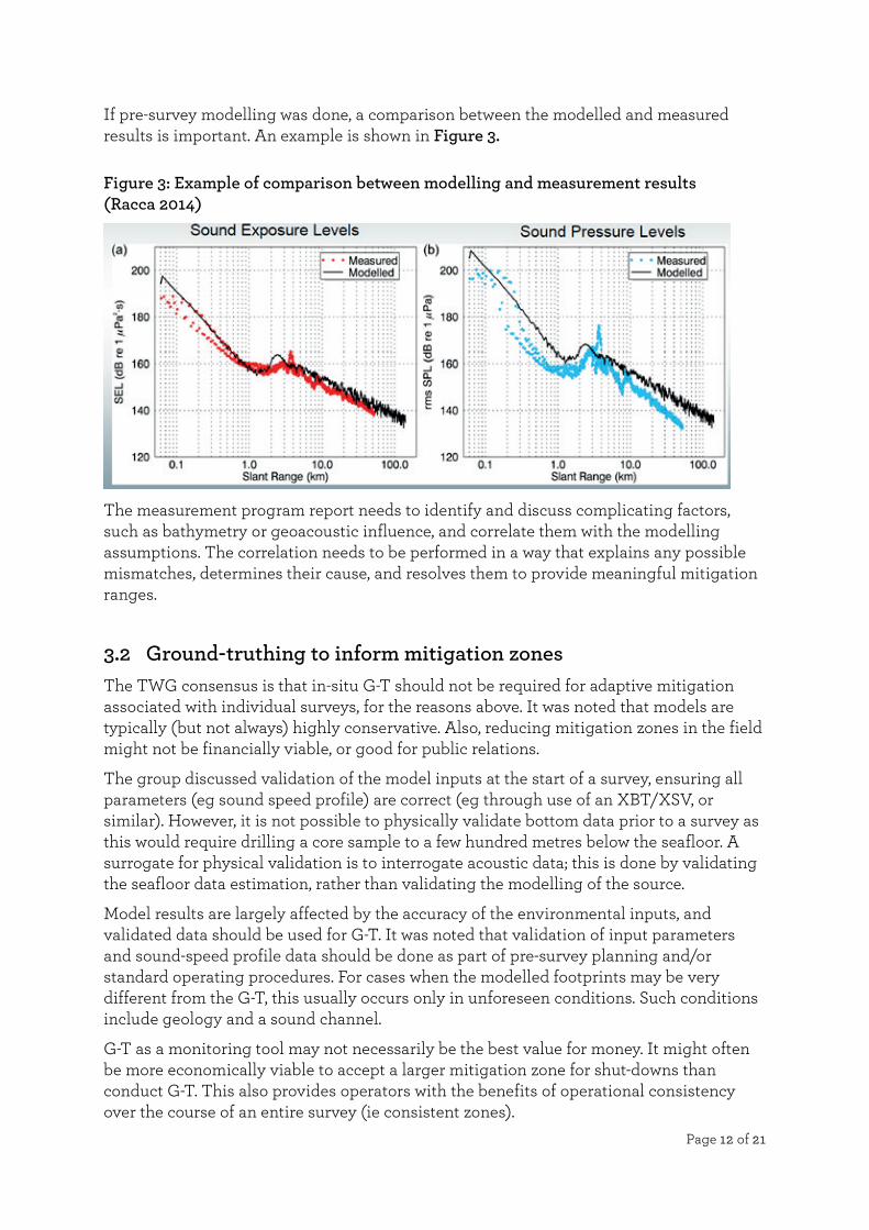
If pre-survey modelling was done, a comparison between the modelled and measured results is important. An example is shown in Figure 3.
Figure 3: Example of comparison between modelling and measurement results (Racca 2014)
The measurement program report needs to identify and discuss complicating factors, such as bathymetry or geoacoustic influence, and correlate them with the modelling assumptions. The correlation needs to be performed in a way that explains any possible mismatches, determines their cause, and resolves them to provide meaningful mitigation ranges.
3.2 Ground-truthing to inform mitigation zones The TWG consensus is that in-situ G-T should not be required for adaptive mitigation associated with individual surveys, for the reasons above. It was noted that models are typically (but not always) highly conservative. Also, reducing mitigation zones in the field might not be financially viable, or good for public relations.
The group discussed validation of the model inputs at the start of a survey, ensuring all parameters (eg sound speed profile) are correct (eg through use of an XBT/XSV, or similar). However, it is not possible to physically validate bottom data prior to a survey as this would require drilling a core sample to a few hundred metres below the seafloor. A surrogate for physical validation is to interrogate acoustic data; this is done by validating the seafloor data estimation, rather than validating the modelling of the source.
Model results are largely affected by the accuracy of the environmental inputs, and validated data should be used for G-T. It was noted that validation of input parameters and sound-speed profile data should be done as part of pre-survey planning and/or standard operating procedures. For cases when the modelled footprints may be very different from the G-T, this usually occurs only in unforeseen conditions. Such conditions include geology and a sound channel.
G-T as a monitoring tool may not necessarily be the best value for money. It might often be more economically viable to accept a larger mitigation zone for shut-downs than conduct G-T. This also provides operators with the benefits of operational consistency over the course of an entire survey (ie consistent zones).

Page 13 of 21
3.3 Ground-truthing reporting times The TWG discussed the turnaround time between collecting G-T data and producing the G-T report. Currently, in New Zealand G-T results are not provided early enough to influence survey design. However:
• In the USA there is a mandated five-day turnaround.3 For an autonomous recorder G-T program this is achieved through a support vessel retrieving the equipment and the data being processed on the vessel, or (if port is close enough) back on land. This typically relies on the support vessel being able to return the G-T team to port after the measurements, and not remain at sea for the seismic program.4 These results are then used to dynamically adjust the mitigation ranges for the surveys. This works through the initial ranges being determined through modelling, which are used for the commencement and first part of the survey. After the G-T is completed, the revised radii are submitted to the regulator for approval, and the survey changes to the revised radii for the remainder of the program.
• Although acquiring low-frequency G-T data through the use of streamers is fast, some operators at the meeting stated that it caused costly downtime, as they had to completely reconfigure the survey equipment to allow the G-T data to be collected – and then needed to change the setup back to survey parameters before commencing the survey. They were nervous about mistakes that would lead to invalid seismic data being collected. Also, most streamers are not able to receive all of the biological frequency ranges (low, mid and high).
• Operators noted there is little chance they would reduce the mitigation zones inside the defaults, should the G-T show that the model is conservative. Some TWG members felt there could be risks associated with reducing mitigation zones in accordance with G-T, in terms of how the operator would be perceived by the public. There was a discussion with respect to proportionality: considering the balance of G-T potentially reducing mitigation zones, operators would probably choose to avoid G-T due to the myriad secondary operational risk/issues that arise.
• The time it would take to G-T the model inputs (by measuring sound profiles and feeding into back into models) would depend on what was being re-modelled, time zones and communication. Accurate short-range modelling for the mitigation distances requires a fine frequency spacing, which would need to be done for both the single shot and the cumulative scenarios.5 Given the amount of modelling required and the need to quality control and report on the revised outputs, this could take anything from a few hours to a few days. Modelling larger areas, to include the behavioural extents, would add further running time. If the seabed reflectivity was a well-known quantity, then doing this for the SSP alone would be valid. If not, this reflectivity should also be validated and the model updated accordingly.
Finally, some TWG members suggested it is as easy for the G-T to be wrong as it is for the modelling (eg through non-calibration of gear or other errors). However, the chance of errors found in both areas is most likely due to inexperienced personnel unfamiliar with 3 To confirm mitigation zones: this does not include a full investigation of all input parameters, such as
bathymetry, oceanographic parameters, and other related elements. 4 There are potential delays using this methodology due to variable weather conditions. 5 See the Sound Mod TWG report for more information.

Page 14 of 21
the process, which would only require additional training. Including an appendix for calibration of gear was suggested as useful for reference. The need for proven equipment, operating to a set of minimum standards, is important here.
4. Cross-project ground-truthing
The TWG interpreted the mandate to explore cross-project G-T as one to look at the topic from a cumulative and chronic-effects monitoring perspective. The discussions thus focused on specific interest/concern areas (such critical habitats), in relation to basin-wide activities. Accordingly, cross-project G-T would require understanding the received levels from individual surveys, along with the cumulative received levels, and the resulting contribution to the noise floor.
The Code would need to encourage basin-wide or regional planning assessments, to assess possible cumulative effects from multiple temporally-overlapping, or consecutive, surveys. When they are planned to occur in the same general area, including multiple seismic sources (eg two vessels on one project, or multiple adjacent projects) and deemed appropriate by DOC,6 the Code would have to require strategic placement of long-term acoustic monitoring stations. Decisions on the number and placement of these stations would be made in consultation with DOC, but would likely focus on areas of ecological importance (AEIs). Some TWG members, however, noted that the AEIs’ massive size means this would offer little practical release from this requirement; they suggested the requirement might be better limited to sanctuaries instead.
Acoustic monitoring stations would be analysed to determine the:
• Ambient soundscape prior to commencing operations
• Contributions of each individual survey (assessed over hourly to monthly periods)
• Cumulative contribution from all surveys (assessed over hourly to monthly periods)
• Both the direct and indirect paths of pulses for impulsive sources, allowing the quantification of inter-pulse contributions
• Comparisons about biological impacts, such as calling rates and behavioural disturbance, against known information
The results of this work would assist DOC management decisions in future, and improve operators’ knowledge about a) what is operationally possible in terms of the effect of simultaneous surveys, and b) if different operational plans can minimise the cumulative and chronic acoustic effects in specific areas.
4.1 Sharing data to bring wider research benefits The data from these recorders could be made available to NIWA and research institutions for adding value to research (eg into marine mammal presence), and increasing the understanding of chronic effects.7 MBIE was suggested as a possible funding stream.
6 DOC should determine a decision tree for this, as discussed in section 2.4, above. 7 Although this analysis would be outside the scope of the Code.

Page 15 of 21
The recorders for these studies would need to be able to operate at high duty cycles for the period required, and record across a wide frequency spectrum corresponding to the marine mammals in the region. The recorders would be situated at biologically- relevant depths, and moored to minimise the impact of mooring and flow noise.
5. Ground-truthing of new sources and mitigation sources
This was noted to be more of an academic issue. Source characterisation should be done ahead of deployment. However, it was noted that G-T has not been applied to some currently-used mitigation sources, such as mitigation guns and soft starts.

Page 16 of 21
Part 2: Ground-truthing methodologies and technologies
6. Matching models, conditions and ground-truthing
Equipment used for G-T must be specified in detail in the G-T report/accompanying documentation. Reporting of certain characteristics should be mandated; these include: equipment sensitivity, noise floor, calibration details for the system and the hydrophone, sample rates, recording cycles, etc.
The receiver locations for the G-T study are linked to locations included in the modelling study. This includes seabed or suspended locations for autonomous recorders, and the tow depth for streamers.
The two primary measurement options for G-T are autonomous recorders and the use of streamers. Drifting buoys have been used in certain example projects, however these pose operational issues in rough New Zealand waters. Another method is real-time streaming from fixed sensor locations.
7. Ground-truthing equipment
7.1 Autonomous recorders The most common technique applied to G-T studies that are publicly available and easily accessible is the use of autonomous recorders. NMFS is the regulator most open with the information, and which stores the reports for public consumption.8 Other regulators also require this information, but not usually in a form as publicly accessible and easily-referenced as the NMFS reports. Anadarko provided an example of a G-T project using autonomous recorders from New Zealand waters for the TWG group to consider.
The methods associated with conducting G-T using autonomous recorders are well understood (see an example in Figure 4), and are able to deliver reliable results. The equipment can also measure at high sample rates and for long periods of time – allowing validation of biologically-relevant frequencies. They also allow measurements to be conducted in both broadside and endfire directions, and an entire line to be characterised. Additional sensors can be integrated into some autonomous recorders to allow measurement of non-acoustic data such as temperature and depth.
Often these recorders are mounted on the sea floor, which would require operators to comply with EEZ regulations. However, they can also be suspended in the water column on long moorings, and can either use hydrophone arrays or multiple independent recorders. As the equipment used for these studies generally comes from within the scientific field, it is important that it is fit for purpose.
8 Some examples include Ireland et al. (2007), Ireland et al. (2009), McPherson and Warner (2012), Austin et
al. (2013).

Page 17 of 21
Figure 4: Typical design of a measurement plan and spacing of recording systems for a bottom-deployed program
7.2 Streamers Streamers have not been utilised for many G-T studies, and there is little public information about this. CMST has conducted three G-T studies using them in New Zealand for Woodside and Shell, although none of these is public. It has been noted that while streamers are not a complete answer, they are very useful (in particular) for establishing whether the low frequency seabed reflectivity used in the modelling is accurate. Seabed reflectivity is one of the most important, and one of the most uncertain, input parameters to the propagation models, so a direct measurement like this indicates whether the modelling is likely to be accurate.
The streamer method is best looked at as a way to answer particular questions with limitations, but then extrapolate the knowledge gained to validate the modelling. Depending upon the operator of the vessel, some TWG members stated that it should be relatively easy to gather the data: the operator just changes their acquisition parameters for a short time as they commence the run-in to the start of one of their production lines, or the run-out at the end of a line. However, other TWG members noted that this wasn’t always the case.
It can be complex to process the data, mainly because of the directivity of the hydrophone groups, and initial projects have all involved long turnaround times onshore. However, it is considered possible to implement an automated or semi-automated system that could produce results on board the survey vessel in near real time. This would strongly depend upon seismic acquisition vessels and their operators.
The equipment specifications and geometry are very well known; however, they are limited to low-frequency recording, typically below 1 kHz.
10,000 m
9,000 m
B: ~1,500 m off line. Approx 171 dB SELSS
C: ~10,000 m off line. Approx 160 dB SELSS
Shooting with full airgun array
Design:
• 3 OBH moorings (filled circles)
• Forward end-fire direction 0 to approx.. 10 km
• Broadside direction 175 m to 7 km
• Aft endfire direction 0 to 1 km (minimum)
A: 1,000 m before end of line (min), 200 m off line. Approx 186dB SELSS
Sail direction

Page 18 of 21
There are potential issues with the method:
• It tends to underestimate received levels, as receiver locations are not accurately determining the maximum received levels across the entire water column at offset ranges (and are rarely replicated).
• It is also only possible to conduct measurements in the endfire direction, which is generally lower than the broadside.
In deeper water, the time of arrival between the direct and reflected waves become large, resulting in a sound field that is not a simple monotonically decreasing function over range when the reflected wave interferes with the direct signal. Thus, the streamer data may not be sufficiently accurate for all depths.
In summary, there is potential for this method for G-T seabed reflectivity, for a high proportion of surveys, to reduce (but not eliminate) the need for more extensive G-T using separate receivers. Again, this depends upon the seismic vessel’s operators and crew, and their willingness to cooperate.
7.3 Drifting systems Drifting systems can be complex, as they not only need to support the measurement system but also record GPS location, have a navigation beacon on them, and suspend the hydrophone at an appropriate measurement depth.
Benefits:
• Configuration does not depend on deployment depth.
• Deployment and retrievals are rapid if conditions are good.
• Avoids flow-noise associated with towed systems.
Drawbacks:
• Not being able to verify levels close to the seismic array due to streamers and safety offsets.
• Careful coordination with the seismic survey vessel is necessary to avoid collisions between the acoustic gear and the survey vessel and streamers. The measurement period may be restricted due to concerns of drifting and potential collision/entanglement with the seismic streamer.
• Strongly weather-dependent, as large seas will preclude its deployment/retrieval.
• Large seas will introduce LF noise into the recordings.
• Sensors need to be accurately located.
7.4 Fixed real-time systems Real-time G-T was used in the 2010 Sakhalin seismic survey (Nowacek et al. 2013) whereby the received pulse levels along a monitoring line of recorders were continuously compared to modelled estimates, and any discrepancy was compensated for in the model so that the predicted behavioural protection zones were calibrated by the real-time data.

Page 19 of 21
While this is a unique example of the methodology that is not applicable in every situation, it is worth including in any discussion of G-T that provides information about options. There is an ‘in press’ paper detailing the methodology that will be made available when possible.9 Details are also provided in Bröker et al. (2015), and a summary is provided below.
7.4.1 Real time G-T in practice
Real-time acoustic G-T for in-field dynamic calibration of model estimates was applied in the course of a 4D seismic survey that took place in the nearshore waters of NE Sakhalin Island in early summer 2010, in the vicinity of the feeding grounds for an endangered population of grey whales. The monitoring and mitigation plan (MMP) for the survey relied on visual sighting of animals and their geolocation relative to the estimated boundary of a sound level zone liable to induce behavioural disturbance, within which exposure curbing measures would be applied. Two types of model outputs were generated pre-season with a range of parametrisations, and brought into the field to implement a G-T verification of the exposure zone:
1. Area grids of per-pulse SEL, maximised over depth to yield the most precautionary estimate, for several tens of source points along each seismic survey line
2. Sequences, indexed by source position for each pulse along a survey line, of per-pulse SEL at the sea floor estimated at the sites of nine bottom-deployed acoustic telemetry stations
The per-pulse received level sequences for the nine receiving stations were used in real-time during the survey to select the model parametrisation that best matched the received data at the start of each line, and to verify the model accuracy throughout the acquisition of each line. At the start of each seismic line, the modelled pulse sequences were compared to the true sound levels received at the three recording stations closest to the start of the line during the first minute of acquisition (six or seven airgun pulses). These true levels were input into a spreadsheet utility that calculated the average received levels from each station, and determined which pre-computed model parametrisation yielded a pulse sequence with the least residual between the modelled and measured values for the respective source positions. The utility also output a fixed dB offset, if required, to improve the match for a given parametrisation. The same parametrisation and offset were then used to generate the appropriate exposure boundary contour from the pre-computed library of modelled footprints.
7.4.2 Results
During each survey line, the received pulse levels from each telemetry station were plotted in real-time, alongside a trace of the modelled pulse sequence for the currently selected parametrisation and offset. This allowed a direct comparison at a given sensor in real-time. The MMP stipulated that the measured pulse levels must remain within a stated tolerance band from the modelled trace. If not, the parametrisation and/or offset had to be revised and the boundary contour updated. As the survey line progressed, the comparison
9 Racca et al, “Monitoring the Gray Whale Sound Exposure Mitigation Zone and Estimating Acoustic
Transmission during a 4-D Seismic Survey, Sakhalin Island, Russia”.

Page 20 of 21
between measurements and model was focused on the receiving station closest to the broadside axis of the airgun array (as the strongest exposure, and thus the most critical need for model accuracy, would be in that region).

Page 21 of 21
References Austin, M.; McCrodan, A.; Wladichuk, J. 2013: Marine mammal monitoring and mitigation during
Shell’s activities in the Chukchi Sea, July–September 2013: Draft 90-Day Report. Chapter 3 in Reider, H.J.; Bisson, L.N.; Austin, M.; McCrodan, A.; Wladichuk, J.; Reiser, C.M.; Matthews, K.B.; Brandon, J.R.; Leonard, K.; Patterson, H.M. (eds). Underwater Sound Measurements. LGL Report P1272D–2. Report from LGL Alaska Research Associates Inc., Anchorage, AK, USA, and JASCO Applied Sciences, Victoria, BC, Canada, for Shell Gulf of Mexico, Houston, TX.
USA, National Marine Fisheries Service, Silver Spring, MD, USA, and U.S. Fish and Wildlife Service, Anchorage, AK, USA. 198 p, plus appendices. http://www.nmfs.noaa.gov/pr/pdfs/permits/shell_chukchi_openwater_90dayreport.pdf.
Bröker, K.; Gailey, G.; Muir, J.; Racca, R. 2015: Monitoring and impact mitigation during a 4D seismic survey near a population of gray whales off Sakhalin Island, Russia. Endangered Species Research 28(3): 187–208. http://www.int-res.com/abstracts/esr/v28/n3/p187-208/.
Ireland, D.; Hannay, D.; Rodrigues, R.; Patterson, H.; Haley, B.; Hunter, A.; Jankowski, M.; Funk, D.W. (Eds) 2007: Marine mammal monitoring and mitigation during open water seismic exploration by GX Technology in the Chukchi Sea, October—November 2006: 90-Day Report. Document Number LGL Draft Rep. P891-1. Report by LGL Alaska Research Associates Inc., LGL Ltd., and JASCO Research Ltd. for GX Technology and the National Marine Fisheries Service.
Ireland, D.S.; Rodrigues, R.; Funk, D.; Koski, W.; Hannay. D. 2009: Marine mammal monitoring and mitigation during open water seismic exploration by Shell Offshore Inc. in the Chukchi and Beaufort Seas, July–October 2008: 90-Day Report. Document Number LGL Report P1049-1. 277 p
McPherson, C.; Warner, G. 2012: Sound Sources Characterization for the 2012 Simpson Lagoon OBC Seismic Survey 90-Day Report. Document Number 00443, Version 2.0. Technical report by JASCO Applied Sciences for BP Exploration (Alaska) Inc. http://www.nmfs.noaa.gov/pr/pdfs/permits/bp_openwater_90dayreport_appendices.pdf
Nowacek, D.P.; Bröker, K.; Donovan, G.; Gailey, G.; Racca, R.; Reeves, R.R.; Vedenev, A.I.; Weller, D.W.; Southall, B.L. 2013: Responsible practices for minimizing and monitoring environmental impacts of marine seismic surveys with an emphasis on marine mammals. Aquatic Mammals 39(4): 356–377.
Racca, R. 2014: AASM and BELLHOP, RAM: use in MONM. Sound Exposure Modeling Workshop, Washington, DC.