report of the 6th ica mountain cartography workshop · 2015-09-14 · 6th ica mountain cartography...
TRANSCRIPT
6th ICA Mountain Cartography Workshop Mountain Mapping and Visualisation • 273
Report of the 6th ICA Mountain Cartography Workshop
Report of the 6th ICA Mountain Cartography Workshopat Lenk im Simmental (Switzerland), 11–15 February, 2008
Christian Häberling, Lorenz HurniETH Zurich, Institute of Cartography, Zurich, Switzerland
From February 11 to 15, 2008, the 6th edition of the tra-ditional ICA Mountain Cartography Workshop took place for the fi rst time in Switzerland. Th e workshops focused on mountain-related topographic and thematic aspects and their depiction on maps and map related representations. Every second year since 1998, cartographers and represen-tatives of other fi elds related to cartography and GIS (like geology, natural hazards, tourism, biology, etc.) are meeting in an inspiring mountain region to discuss their current sci-entifi c projects and work.
Under the lead of Prof. Lorenz Hurni, the Institute of Car-tography at ETH Zurich was in charge of the organisation
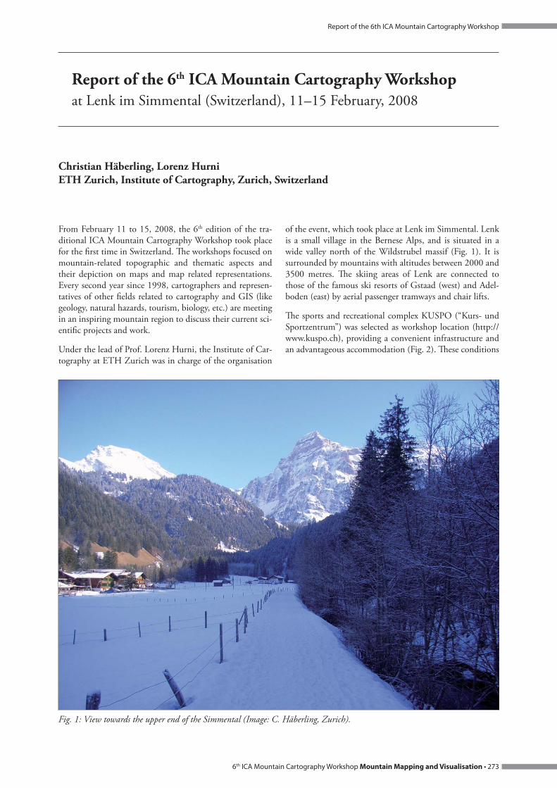
of the event, which took place at Lenk im Simmental. Lenk is a small village in the Bernese Alps, and is situated in a wide valley north of the Wildstrubel massif (Fig. 1). It is surrounded by mountains with altitudes between 2000 and 3500 metres. Th e skiing areas of Lenk are connected to those of the famous ski resorts of Gstaad (west) and Adel-boden (east) by aerial passenger tramways and chair lifts.
Th e sports and recreational complex KUSPO (“Kurs- und Sportzentrum”) was selected as workshop location (http://www.kuspo.ch), providing a convenient infrastructure and an advantageous accommodation (Fig. 2). Th ese conditions
View towards the upper end of the Simmental (Image: C. Häberling, Zurich).Fig. 1:

Report of the 6th ICA Mountain Cartography Workshop
274 • Mountain Mapping and Visualisation 6th ICA Mountain Cartography Workshop
made it the ideal place for a successful meeting of both pro-fessionals and friends.
During the whole week, the weather was perfect with blue skies and very mild day temperatures. For all participants, these conditions enormously inspired the discussions and activities.
Almost 60 participants and single-day guests from 15 coun-tries participated at the workshop (Fig. 3). Besides long-term members of the commission, also many new experts attended the workshop. We are therefore very pleased and hope for an increasing interest in the Commission on Mountain Cartography also in the future. Th e workshop and its participants were honoured by welcome addresses of William Cartwright, the President of the International Car-tographic Association (ICA), and Stefan Arn, the President of the Swiss Society of Cartography (SGK).
Th e workshop was comprised of three diff erent kinds of presentations: classic presentations by the participants talk-ing about their latest scientifi c results and developments, short presentations according to the Pecha-Kucha system (see http://en.wikipedia.org/wiki/Pecha_Kucha) covering production processes and new products, and last, a small map and relief exhibition allowing to show and compare the newest map products (Fig. 4).
Th e 34 presentations were structured in the following fi ve main thematic blocks: „Physical Geography“, „DEM and Terrain Modelling“, „Relief Depiction“, „History“ and „Multimedia and Mobile“.
In the “Physical geography” block, a number of scientifi c mapping and cartography projects as well as case studies from all over the world were described in detail (Michaela Kinberger, Uni Vienna; Manfred Buchroithner, TU Dres-den; Giorgio Vassena, Uni Brescia; Richard Ladstätter, TU Graz; Sabine Stäuble, Uni Lausanne). Other presentations covered concepts for terrain evaluation or monitoring tech-niques (Igor Drecki, Uni Auckland; Melanie Kunz, ETH Zurich; David Th eler, Uni Lausanne). Finally, developments of new interactive map and 3D-visualisation applications were discussed (Alexander Th imm, Swiss National Park; Karel Kriz, Uni Vienna; Christophe Lienert, ETH Zurich).
In the session „DEM and Terrain Modelling“, projects mak-ing use of latest laser technologies or high resolution satellite image data (Julien Vallet, Helimap.ch; Kirsten Wolff , ETH Zurich) as well as new approaches for the visualisation of hidden geological structures (Peter Jordan, Böhringer AG) or for the derivation of contour lines for small scale maps (Anna Leonowicz, ETH Zurich) were presented. A presen-tation by Maria Pla and Blanca Baella (ICC, Barcelona)
Conference room (Image: C. Häberling, Zurich).Fig. 2:

6th ICA Mountain Cartography Workshop Mountain Mapping and Visualisation • 275
Report of the 6th ICA Mountain Cartography Workshop
focused on requirements for database-driven relief represen-tations for topographic maps.
Th e sessions on „Relief Depiction“ covered the broadest variety of presentations. First, the needs of mountain map users, especially members of Alpine Clubs, concerning the accuracy and symbolisation of topographic maps were evalu-ated (Martin Gurtner, swisstopo). Two authors were dealing with the evolution of classic relief maps or perspective views for diff erent cartographic purposes (Alex Tait, International Mapping; Martin Gamache, National Geographic). Similar, but more technically oriented projects covered the develop-ment of new tourist maps with an integrated shaded relief (Roger Smith, Geographx NZ; William McNulty, National Geographic; Tom Patterson, US National Park Service). David Schobesberger (Uni Vienna) presented an evaluation of the use and eff ectiveness of 2-D or 3-D representations in National Park maps. Loïc Gondol (IGN Paris) talked about tests for new cliff drawings and scree representation in topo-graphic maps. Th e latter method could be compared with scree representations generated by a software developed by Bernhard Jenny (ETH Zurich). Tibor Tóth (Tóth Graphix) demonstrated his relief shading methods using Photoshop and a tablet device. Stefan Räber (ETH Zurich) presented various physical relief depiction techniques, including the production of physical relief models with modern comput-er-driven drilling machines for an Earth Science exhibition at ETH Zurich.
Th e session on the history of mountain mapping started with a biographical presentation of the Swiss topographer and cartographer Jacot-Guillarmod (1868–1925) and his infl uential cartographic cliff representations (Hans-Uli Feldmann, swisstopo), followed by a presentation about the cartographic tradition and the latest technological devel-opments at the Institute of Cartography of ETH Zurich (Lorenz Hurni). Alistair Pearson (Uni Portsmouth) reported about laser measurements and geometric analysis of the accuracy of a historic relief model.
A session on multimedia application and mobile devices for mountain mapping comprised presentations about Web applications for data acquisition (Dusan Petrovič, Uni Lju-bljana), spatial communication using Google tools, (Karel Kriz) and accessibility visualisation (Adrian Weber, ETH Zurich). Furthermore, an implementation of GPS technol-ogy for mountain mapping and tour planning was demon-strated by Juan Galera (Uni Leon).
Th e topics of the eight short presentations, which were grouped in two sessions, were obviously more diversifi ed. Th e authors covered topics like representation principles of rock representations (Jürg Gilgen, swisstopo), tourist map-ping activities in Romania (Gabriela and Marin Ilies, Uni Cluj-Napoca), the historic development of panoramic maps (Arne Rohweder, Gecko Maps), mobile trekking guide devices for the Rwenzori National Park, Uganda (Constante
Participants at the 6Fig. 3: th ICA Mountain Cartography Workshop at Lenk (Switzerland). (Image: K. Kriz, Vienna).

Report of the 6th ICA Mountain Cartography Workshop
276 • Mountain Mapping and Visualisation 6th ICA Mountain Cartography Workshop
Bonacina, Uni Brescia), smart interactive maps (Nathaniel Kelso, Th e Washington Post), Multidate habitat mapping approaches in Quebec (Guillaume Fortin, Uni Moncton), a topographic map of the Tatra Mountains (Rafal Jońca, RJ Carto) and traditional hill-shading for digital maps (Gizella Bassa, Gizimap).
A new kind of discussion forum was tried out for the fi rst time in the workshop series and immediately attracted the special interest of the audience due to its topic: Th e new graphic design of the National Swiss topographic maps. Led by Lorenz Hurni (ETH Zurich), Hans-Uli Feldmann and Martin Gurtner (both swisstopo), the participants dis-cussed vividly the new structure of the map content with new object classes and the displayed design specimens with diff erent symbolisation and labelling options.
Th e workshop was accompanied by various social events and activities which fostered the personal contact among the participants (Fig. 5). On Tuesday evening, the wel-come drink at the “Cinema Lenk” was accompanied by the display of two recent Swiss fi lms: “Heimatklänge” (“Homeland Sounds”) about contemporary yodelling and „Marmorera“ about scary events in the aftermath of the fl ooding of a mountain village by a reservoir. Due to the excellent weather on Wednesday, the opportunities for vari-ous outdoor like skiing, snow walking or simply relaxing on a restaurant’s sun deck used by everyone. At the curling
event on Wednesday evening, many newly formed interna-tional teams were establish to master this challenging sport. Finally, the „Raclette dinner“ – a traditional Swiss cheese dish – was very much appreciated by everyone on Th ursday evening (Fig. 6).
All papers and contributions for the workshop will be pub-lished in the workshop proceedings in Summer 2008. Th e contributions will also be accessible on the commission website.
Th e next ICA Mountain Cartography Workshop will be organised by Gabriela and Marin Ilies (Babes-Bolyai Uni-versity of Cluj-Napoca, Romania) and will take place in Borsa in the Maramures Mountains, Romania on 1–5 Sep-tember 2010.
For more information about the workshop please visit the website of the ICA Commission on Mountain Cartography (http://www.mountaincartography.org/).
Exhibition of mountain maps (Image: C. Häberling, Zurich).Fig. 4:

6th ICA Mountain Cartography Workshop Mountain Mapping and Visualisation • 277
Report of the 6th ICA Mountain Cartography Workshop
Participants discussing during a walk near the conference centre (Image: C. Häberling, Zurich).Fig. 5:
Everyone enjoyed the raclette dinner (Image: C. Häberling, Zurich).Fig. 6: