regional workshop on “climate information to enhance resilience of west africa protected areas”....
TRANSCRIPT

Regional Workshop on “Climate Information to enhance Resilience of West Africa Protected Areas”.
Freetown, Sierra Leone, 23- 26 April 2012
AYILARI-NAA JUATI GHANA METEOROLOGICAL AGENCY

Overview of available climate records and trends in Ghana OUTLINE
1-Eco-climatic zones in Ghana
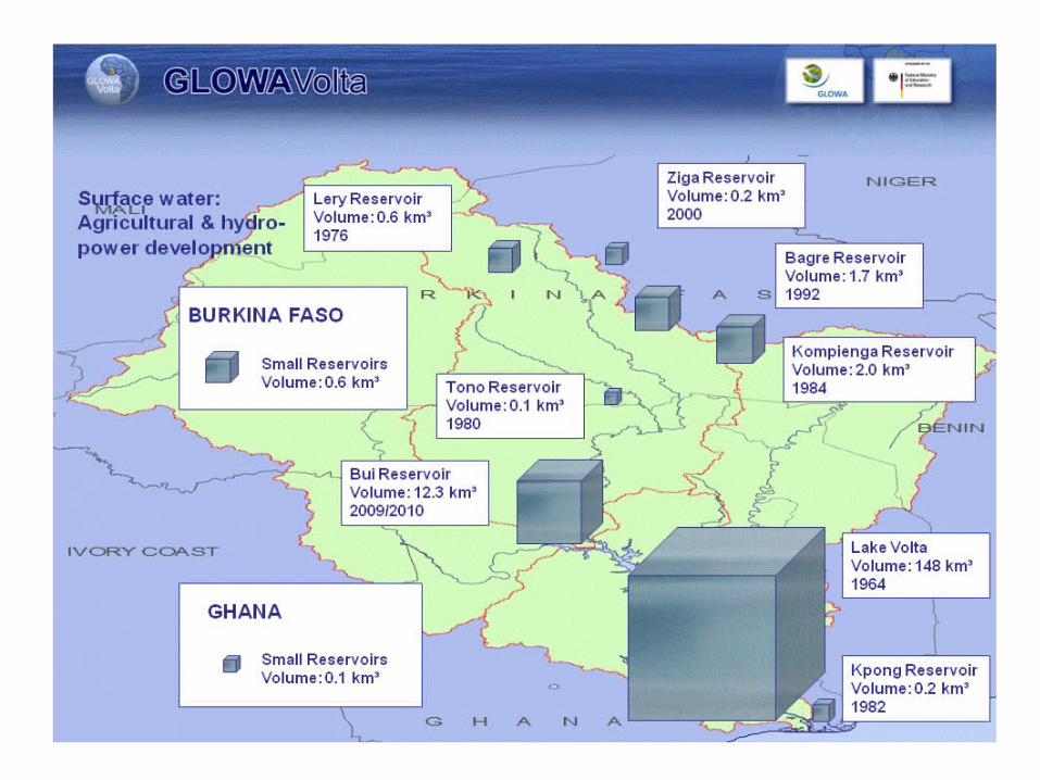
2-Dams within the Volta Basin .
3- Network of Observing stations in Ghana and data.
5- Decadal Seasonal Rainfall (1979-2008)
6- Mean yearly variability of rainfall in Ghana (1971-2007)
7 Annual rainfall and incidences of drought risk(1961-2007)8- Recommendations

Sudan Savannah
Deciduous Forest
Transitional Zone
Coastal Savannah
Guinea Savannah
Rain Forest
With Climate Change and variability these
Climatic zones are observed to be changing

THE VOLTA BASIN
The Volta Basin Authority (VBA)made up of Six Countries

National Observing Network
N avrongo
A kuse
Tem a
W a
Y endiTam ale
B ole
K ete K rach iW ench i
Sunyani
AbetifiK um asiH o
Sefw i Bekw ai
A kim O daK oforidua Akatsi
Takorad iA xim
S altpond
AccraAda
-3.0 -2.0 -1 .0 0.0 1.0
5.0
6.0
7.0
8.0
9.0
10.0
11.0
NETW ORK OF SYNOPTIC STATIONS
22

-3.0 -2.0 -1.0 0.0 1.0
5.0
6.0
7.0
8.0
9.0
10.0
11.0
N ETW O R K O F C LIM ATO LO G IC AL STATIO N S
61

-3 .0 -2.0 -1.0 0.0 1.0
5.0
6.0
7.0
8.0
9.0
10.0
11.0
NETW O RK O F AG RO M ETEO RO LO G ICAL STATIO NS
54

N ETW O RK O F R AIN FALL STATIO N S
-3.0 -2.0 -1.0 0.0 1.0
5.0
6.0
7.0
8.0
9.0
10.0
11.0
156

Additional Weather stations• Five(5) New Automatic Weather stations have
been installed since 2011 under the AAP and one (1) AWOS for Kotoka International Airport.
• Two (2) New Automatic Weather stations in Navrongo and Wa in March 2012.
• Eighteen (18) New Automatic Weather Stations since January 2012 under the Agricultural Crop Insurance project funded by GIZ.
• C-Band Dual Polarization Weather RADAR

Data Types• Wind Direction and Speed• Cloud amount and type• Air and Dew Point Temperatures, Soil Temps.• Maximum and Minimum Temperatures• QFE, QFF and QNH ( Pressures)• Sunshine duration and Solar Radiation• Piche and Pan Evaporation, Relative Humidity• Rainfall• Meta data.

Data Sharing issues• Selected data disseminated through the GTS• Challenges with Message Switching system for
effective data sharing using the GTS• QC and Homogeneity issues with data which
dates as far back as 1950s in many stations.• Lack of effective data gathering mechanisms
and database management.• No legal data access protocols between
stakeholders within the country and the sub-region

Average seasonal yearly Rainfall over Northern Ghana ( 1971 to 2007)
1965 1970 1975 1980 1985 1990 1995 2000 2005 2010600
700
800
900
1000
1100
1200
1300
North(Mean)Linear (North(Mean))
1983,1992, 2001
Rainfall variability here can be as high as 400mm

Yearly seasonal mean Rainfall in Transition belt in Ghana( 1971-2007)
1965 1970 1975 1980 1985 1990 1995 2000 2005 2010700
900
1100
1300
1500
1700
1900
2100
TransitionExponential (Transition)
1975, 1977,1983,1992,1999,2001
1991
Significant Variability exhibited in this zone

Yearly seasonal mean Rainfall in Forest areas in Ghana( 1971-2007)
1965 1970 1975 1980 1985 1990 1995 2000 2005 2010800
900
1000
1100
1200
1300
1400
1500
1600
Series1Linear (Series1)
1977, 1983,1992,1994,1998, 2005

Average yearly Rainfall over Coastal Ghana ( 1971 to 2007)
1970 1975 1980 1985 1990 1995 2000 2005 2010400
500
600
700
800
900
1000
1100
1200
1300
1400
S...
1977,1983,1986,1992,1998
Rainfall can vary as high as 650 mm

Mean decadal Rainfall for 25 stations across Ghana from 1979 to 2008
Rainfall Distribution similar in the three decades for the 21 stations

High Incidences of drought around Kete-Krachi (1961-2007)
High Incidences of drought around southern Central, Western and Volta Regions, like , Ada,Kpetoe, Tsito, Cape Coast etc
High Incidences of drought to the Western parts of northern Ghana
High Incidences of drought around Nkwanta area.
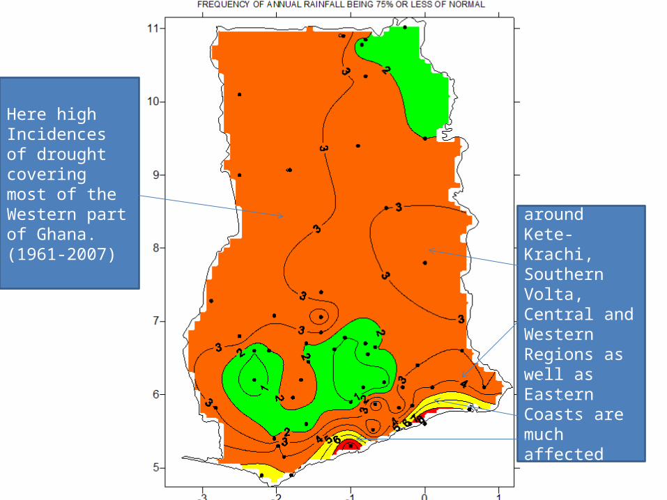
Here high Incidences of drought covering most of the Western part of Ghana.(1961-2007) Areas around
Kete-Krachi, Southern Volta, Central and WesternRegions as well as Eastern Coasts are much affected(1961-2007)

CLIMATE CHANGE SCENARIOS (SRES) SHOULD BE CUSTOMIZED AND RUN TO FIT DEVELOPMENTAL TIME FRAMES . E.G MDGS, VISION 2020, GPRS GSGDA ETC.
URGENT NEED FOR THE DEV’T OF HUMAN CAPITAL IN THE FIELD OF CLIMATE CHANGE STUDIES AND CLIMATE MODELLING IN AFRICA. EFFECTIVE DATA SHARING NEEDED FOR THIS TO SUCCEED.
NEED FOR CROSS-SECTORAL APPROACH TO CLIMATE CHANGE, DISASTER RISK REDUCTION, ADAPTATION AND INTEGRATED WATER RESOURCES MGT.E.G, EARLY WARNING SYSTEMS, THE VOLTA BASIN AUTHORITY, THE AAP , PARCC ETC
CRITICAL EDUCATIONAL DRIVE TO REDUCE ACTIVITIES WHICH IMPINGE NEGATIVELY ON CLIMATE AND WATER RESOURCES; MINING, SAND WINNING ,DEFORESTATION, LAND USE ETC.
GENDER MAINSTREAMING IN CLIMATE CHANGE ISSUES; CCA AND DRR.
A SECOND LOOK AT THE EXPANDING CARBON-DRIVEN ECONOMIES WITH INCREASING GHG EMISSIONS; RENEWABLE ENERGY.CARBON MARKETS???
REFORESTATION, CARBON CAPTURE/STORAGE, GREEN POLICIES, EDUCATION, COMS &TECH,WATER HARVESTING , CARE OF OUR ENVIRONMENT, ETC.
RECOMMENDATIONS

THANK YOU