recipes for the senses: landscape portfolio, matthew bossler
DESCRIPTION
Selected imagery and project descriptions from the landscape architecture and environmental planning career of Matthew Bossler, Associate ASLATRANSCRIPT

landscapeportfolio


26
10141822242830
as an environmental and landscape professional, I imagine myself in the kitchen: trusted tools at hand, and the visceral thrill of exploration loaded in my nerves.
Like a kitchen, the landscape architectural studio is a place that synthesizes a scientific comprehension of material components and the creative spark to put them together.
Like a good chef, I have kept a book of the tried and true recipes of my creation to refresh my memory as each new endeavor begins and to share with those with whom I would like to collaborate.
Welcome to my kitchen. Have a look around!
When I research and design,
1
Multi-Use Detention Basins: green infrastructure design guidelinesKolb Road Detention Basin: retrofit master plan
Tumacácori: cultural landscape inventoryFronteras: town revitalization plan
Health and Wellness: medical center extension master planBata de Cola: neighborhood traffic circle
Spiral of Growth: natural observatory master planSurvival on the Rio: land art conceptual master plan
Department of the Interior: natural resource planning

2
Intermediate Concepts:
Scale: development lot -to regional basinRisk v. reward -Broad spectrum of -programming goals
Ingredients:1 Local legacy of single-purpose design (above left)Numerous examples of multi-use design elsewhere (above center)Handful of local grass- roots community water-harvesting efforts in Tucson (above right)
Prep time: 2009-2010, part-timeSkills/traits required: conceptual simplification, must enjoy travelMakes about: 1/2 thesis, 1 design manual, 1 presentationServes: Pima County Regional Flood Control District, AZ
Begin with the problem at hand. Assess the state of recently-built detention basins in greater Tucson, and generally describe the limitations of single-purpose stormwater infrastructure design. Next, compare the local physical and design environment to similar southwestern U.S. municipal areas. Visit these municipal areas; interview regulators and designers of multi-use stormwater projects; visit exemplary sites; take pictures; sketch; take notes. Summarize findings generally into connectivity concerns (large scale), site grading, infiltration, and flow-routing strategies (medium scale), and structural enhancements (small scale). Prepare digital drawings to demonstrate site layout principles in plan view and section view design typologies. To convince the reader of feasibility, use site photos of built projects in multiple regions. Keep it simple! It’s going to be used as an off-the-shelf reference, so organize text and drawings in a consistent, easily-navigable manner. Summarize the few most important design directives into call-out boxes, and refer the reader to additional resources for more in-depth explanations.
Image (center, left of line): The Arizona Wildlife Linkages Group 2006

Final Product:
Design typology of -12 categories:
Riparian ecology -Adjacent parcels -Street-side basins -Lot-bottom -basinsInflow channels / -drop structuresSlope-tops -Safety and -educationSide-slopes -Hydraulic -structuresInternal channels -and outletsPlanting -recommendations
Each category -contains:
Summary intro -1-7 Primary -considerations, graphically illustratedKey questions for -design decisionPermitting, -maintenance, and monitoring pointsList of -additional resources
Figures (top): Recreational siting in relation to landscape ecologyFigure (middle): Street-side basin siting in relation to natural drainagesFigure (bottom left): Land-use factors of hydrologic condition and riparian habitatFigure (bottom right): Drainage problem areas adjacent to basin
3
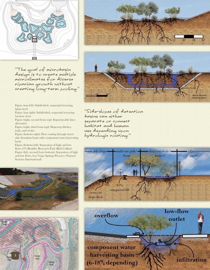
Figure (top left): Subdivided, sequential terracing (plan view)Figure (top right): Subdivided, sequential terracing (section view)Figure (right, second from top): Impermeable liner alternativeFigure (right, third from top): Slope-top ditches, trails, and swalesFigure (bottom right): Flow routing through street-side detention basin with component water-harvesting basinFigure (bottom left): Separation of high and low flows, CU-Boulder Research Park (Belt Collins)Figure (left, second from bottom): Separation of high and low flows, Las Vegas Springs Preserve (Natural Systems International)
4
“The goal of microbasin design is to create multiple microclimates for diverse riparian growth without creating long-term pooling.”
“Side-slopes of detention basins can either separate or connect habitat and human use depending upon hydrologic routing.”

Figure (top left): Large basin hardscape dimensionsFigure (top right): Lowry, CO structural channel bend (Wenk Associates)Figure (right, 2nd from top): Oro Valley Marketplace, AZ drop structures and sediment trap Figure (left, 2nd from top): Westerly Creek flow splitter (EDAW, Matrix Design Group)
Figure (right, 3rd from top): Las Vegas Springs Preserve, structural walking ramp along side-slope (Natural Systems International)Figure (bottom right): Vista Hermosa Park, CA side-slope, including trails, planting beds, and basin (Mia Lehrer Associates)Figures (bottom left; left, 2nd from bottom): Side-slope grade alternatives with structural, recreational, and planting possibilities
“Inflow channels convey runoff to a detention basin, and, along with drop structures, can absorb energy, connect habitat, assist with sediment deposition, and create intriguing drama.”
5

6
Intermediate Concepts:
Integration with -Tech Park master planService as a regional, -natural resource parkMultiple-use design -
Ingredients:Severe head-cutting of basin side-slopes (above left)Poor vegetative growth in unnatural topographic profile (above center)Needs for local public park; development restrictions on-site (above right)
Prep time: 2009-2010, part-timeSkills/traits required: attention to detail, collaborationMakes about: 1/2 thesis, 1 three-phased design proposalServes: Granite Construction Company, Tucson, AZ
To begin, define the opportunities and constraints of the existing detention basin. Note that flood inundation and an airport flight paddle restricts the development of inhabitable buildings and gathering areas throughout much of the site. Identify erosion rills along steep side-slopes, and the limited riparian habitat supported on the flat bottom. Determine that the public property is located in a recreational needs area between existing and planned residential communities and commercial developments, and along a planned greenway. In addition, note that it may serve as a patch of riparian habitat along an important biological corridor. Given these refined analyses, explore conceptual alternatives and settle upon a master plan design to support restored riparian habitat along the basin bottom, side-slopes and slope-tops, recreational trails surrounding these natural areas, and dramatic inflows of water over hydraulic structures. Be realistic! Subdivide the ultimate vision into manageable phases in order to immediately satisfy the client’s legal requirements while also setting the stage for the site’s expansion to a public park.
6
Intermediate Concepts:
Integration with -Tech Park master planIntegration with Tech Park master planIntegration with
Service as a regional, -natural resource parkService as a regional, natural resource parkService as a regional,
Multiple-use design-
Ingredients:Severe head-cutting of basin side-slopesSevere head-cutting of basin side-slopesSevere head-cutting of
(above left) basin side-slopes (above left) basin side-slopes
Poor vegetative growth in unnaturalPoor vegetative growth in unnaturalPoor vegetative growth
topographic profile (above center) topographic profile (above center) topographic profile
Needs for local public park; development restrictions on-site (above right)
Prep time: 2009-2010, part-timeSkills/traits required: attention to detail, collaborationMakes about: 1/2 thesis, 1 three-phased design proposalServes: Granite Construction Company, Tucson, AZMakes about: 1/2 thesis, 1 three-phased design proposalServes: Granite Construction Company, Tucson, AZMakes about: 1/2 thesis, 1 three-phased design proposal
Intermediate Concepts:
Integration with Tech Park master planIntegration with Tech Park master planIntegration with
Service as a regional, natural resource parkService as a regional, natural resource parkService as a regional,
Multiple-use design
To begin, define the opportunities and constraints of the existing detention basin. Note that flood inundation and an airport flight paddle restricts the development of inhabitable buildings and gathering areas throughout much of the site. Identify erosion rills along steep side-slopes, and the limited riparian habitat supported on the flat bottom. Determine that the public property is located in a recreational needs area between existing and planned residential communities and commercial developments, and along a planned greenway. In addition, note that it may serve as a patch of riparian habitat along an important biological corridor. Given these refined analyses, explore conceptual alternatives and settle upon a master plan design to support restored riparian habitat along the basin bottom, side-slopes and slope-tops, habitat along the basin bottom, side-slopes and slope-tops, recreational trails surrounding these natural areas, and dramatic recreational trails surrounding these natural areas, and dramatic inflows of water over hydraulic structures. Be realistic! Subdivide the ultimate vision into manageable Be realistic! Subdivide the ultimate vision into manageable phases in order to immediately satisfy the client’s legal requirements phases in order to immediately satisfy the client’s legal requirements phases in order to immediately satisfy the client’s legal requirements while also setting the stage for the site’s expansion to a public park. while also setting the stage for the site’s expansion to a public park. while also setting the stage for the site’s expansion to a public park.

7
Figure (top): Phase 1 riparian mitigation and passive recreational master plan
Figure (bottom): Phase 1 sectional profile of basin bottom, side-slope, and slope-top
Section AA:

“In phase 1, sixteen acres of xeroriparian habitat will be planted within four shallow basins excavated to a depth of 6”-1’ from the existing basin bottom. The amount of soil needed to be added to the proposed side-slope improvements of phase 2 will be available on-site from the stockpiled fill of phase 1.”
Figure (top): In phase 1, shallow mitigation basins are created, excavated fill is stored in berms along the side-slope, and drainage is concentrated into existing gullies. Figure (bottom): In phase 2, recreational trails, grading contours, and hydraulic structures are enhanced.
8

Section AA:
Figure (top): Phase 2 master plan (includes side-slope improvements and structural enhancements)
Figure (bottom): Phase 2 sectional profile of basin bottom, side-slope, and slope-top
9

10
Intermediate Concepts:
Historic, local -landscape eventsTechnological -evolutionRegional trends of -landscape change
Ingredients:1 Major expansion of park boundaries 2 Well-researched historic periods of significance (above left and center)3 Poorly-understood, confounding eras of landscape change (above right)
Prep time: 2008-2010, part-timeSkills/traits required: persistence, inquiry, summarizationMakes about: 1 in-depth analytical reportServes: Tumacacori National Historical Park, Tumacacori, AZ
To prepare a Cultural Landscape Inventory (CLI), first quickly define the historic period/s of significance (POS/s; in this case Mission and NPS Rustic Style / New Deal Era), and identify the primary landscape features characteristic of these periods. Next, analyze the extent to which these periods and features have been described by previous researchers. This is first done by a review of available 2° historic sources, after which point any 1° historic resources (interviews with previous residents and staff, archived reports, photos, maps, etc.) that are necessary for a complete chronological description of change to the identified historic features of the cultural landscape should be analyzed. Next, divide these bodies of research into 13 landscape characteristic themes, in which you will prepare diagrams and text describing the features of the POS/s, how they have been altered, and what, today, remains of them. Further prepare a separate description of the integrity of the cultural landscape, or its ability to represent a historic POS. Combine these analyses into a summarized report that will be used as a baseline for future programming at the site.
Images (from left): Tumacácori NHP; City of Tucson 1977; A. Konieczki and J. Heilman 2004

Final Product:
Statement of -significanceChronology and -physical history narrativeSeven aspects of -integrity description13 Landscape -characteristic descriptions (with graphics)
Figure (top right): Tumacácori Mission system land grants, 19th centuryFigure (right): Hydraulic function of Mission Period of Significance weir device (base image: J. Moss 2010)Figure (left): Mission compound circulation patterns (base image: J. Ivey 2007) Figure (bottom): Mission Period of Significance regional spatial organization
“Tumacacori is a nationally significant site in two ways. First, it is one of the northernmost Spanish mission settlements of New Spain, and, through the Jesuit and Franciscan religious orders of the Catholic Church, was instrumental in changing the culture and environment of what became Southern Arizona and the Southwest U.S., as a result of exploration and settlement...”
11

“Second, the Tumacacori mission site contains Rustic Style structures built by the NPS in the 1930s that represent a unique era of NPS design in historic monuments that emphasized the style and craftsmanship of the historic structures.”
Figures: Design evolution, cluster arrangement, and feature changes of NPS Rustic Style / New Deal Era Period of Significance (base images: C. Colby 1999; Tumacácori NHP)
Figure (bottom right): Feature change from NPS Rustic Style / New Deal Era POS to recent yearsFigure (bottom left): Small-scale feature change in Museum and Visitor Center pathways
12

“Because the lands on the first and second riparian terraces of the Santa Cruz River between the river channel and the mission compound, as well as those irrigable lands to the north and south of the mission, continued to be used as a productive agricultural landscape for much of the time since the abandonment of the mission, the design of the Mission Period agricultural landscape retains a low level of integrity. ”
Figure (top right): Alluvial systems of TumacácoriFigure (bottom right): Constructed water features and fields of TumacácoriFigure (bottom left): Reuse and naturalization of Mission Period of Significance fields, via drawing/photo series (base images: C. Schudard 1853; Tumacácori NHP)Figure (top left): Mission Period of Significance and contemporary farm unit layout (base images: M. Kay 1986)
13

14
Intermediate Concepts:
Junction function -Pedestrian laces -Inner and outer -radiance
Ingredients:1 Deteriorating Sonoran pueblo (above left)2 Residents dedicated to the town’s recovery (above center)2 Guiding professors 8 Enthusiastic students (above right)
Prep time: Spring 2009, intensive studio projectSkills/traits required: community engagement, street-smartsMakes about: 1 master-plan with modules of development Serves: Alice and Roberto Valenzuela, Fronteras residents
Fronteras, Sonora, MX presents the designer with an exciting and completely unique set of opportunities and constraints. Among these are a forgotten heritage of colonial history; the replacement of legitimate commerce by narcotraffic, corruption, and bypass by travelers; and stunningly beautiful, but neglected natural wonders. In order to develop a diversified economy, the ingredients of this analysis must be combined to create two cultural nodes announcing the town at its edges along the highways, drawing visitors inward to a prominent, centralized East/West axis. Design streetscapes along this junction, in order to welcome visitors into the town’s commercial heart. Place two educational/recreational nodes at the ends of this axis to further encourage visitors to explore the recreational, historical, and environmental resources surrounding the town. Locate pedestrian corridors, emanating from the central junction and activity nodes, along historic and contemporary canal alignments and breathtaking natural features. Selectively remove buildings along the east side of the highway to create “plazas miradores” or commercial gathering areas oriented to accent views across the agricultural and natural landscape.
All images of this project collaboratively developed by:O. Alicea, C. Alcala Avila, M. Bossler, D. Bradshaw, A. Foye, N. Sweeney, A. Wood, W. Wood
14
Intermediate Concepts:
Junction function-Pedestrian laces-Inner and outer -radiance
Ingredients:1 Deteriorating Sonoran pueblo 1 Deteriorating Sonoran pueblo 1 Deteriorating
(above left) Sonoran pueblo (above left) Sonoran pueblo
2 Residents dedicated to the town’s recovery (above center) recovery (above center) recovery
2 Guiding professors 8 Enthusiastic students2 Guiding professors 8 Enthusiastic students2 Guiding professors
(above right)
Prep time: Spring 2009, intensive studio projectSkills/traits required: community engagement, street-smartsPrep time: Spring 2009, intensive studio projectSkills/traits required: community engagement, street-smartsPrep time: Spring 2009, intensive studio project
Makes about: 1 master-plan with modules of development Skills/traits required: community engagement, street-smartsMakes about: 1 master-plan with modules of development Skills/traits required: community engagement, street-smarts
Serves: Alice and Roberto Valenzuela, Fronteras residents
Fronteras, Sonora, MX presents the designer with an exciting and completely unique set of opportunities and constraints. Among these are a forgotten heritage of colonial history; the replacement of legitimate commerce by narcotraffic, corruption, and bypass by travelers; and stunningly beautiful, but neglected natural wonders. In order to develop a diversified economy, the ingredients of this analysis must be combined to create two cultural nodes announcing the town at its edges along the highways, drawing visitors inward to a prominent, centralized East/West axis. Design streetscapes along this junction, in order to welcome visitors into the town’s commercial heart. Place two educational/recreational nodes at the ends of this axis to further encourage visitors to explore the recreational, historical, and environmental resources surrounding the town. Locate pedestrian corridors, emanating from the central junction and activity nodes, along historic and contemporary canal alignments and breathtaking natural features. Selectively remove buildings along the east side of the highway to create “plazas miradores” or commercial gathering areas oriented to accent views across the agricultural and natural landscape.
buildings along the east side of the highway to create “plazas miradores” or commercial gathering areas oriented to accent views across the agricultural and natural landscape.
All images of this project collaboratively All images of this project collaboratively developed by:developed by:O. Alicea, C. Alcala Avila, M. Bossler, O. Alicea, C. Alcala Avila, M. Bossler, D. Bradshaw, A. Foye, N. Sweeney, A. D. Bradshaw, A. Foye, N. Sweeney, A. Wood, W. WoodWood, W. Wood

“The ‘back porch’ of Fronteras would connect landscapes of agricultural and economic productivity.”
“‘Punched out’ placitas could introduce passersby to the rich natural heritage of productive pastures, a beautiful river, and impressive background mountain views.”
15
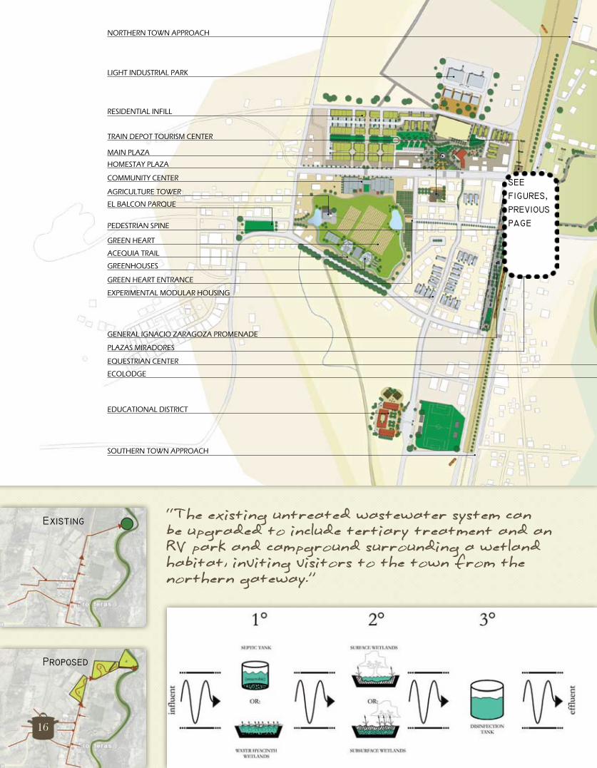
NORTHERN TOWN APPROACH
MAIN PLAZA
RESIDENTIAL INFILL
TRAIN DEPOT TOURISM CENTER
LIGHT INDUSTRIAL PARK
HOMESTAY PLAZA
GREEN HEART
ACEQUIA TRAIL
COMMUNITY CENTER
AGRICULTURE TOWER
PEDESTRIAN SPINE
EL BALCON PARQUE
GREEN HEART ENTRANCE
GREENHOUSES
GENERAL IGNACIO ZARAGOZA PROMENADE
PLAZAS MIRADORES
EXPERIMENTAL MODULAR HOUSING
EQUESTRIAN CENTER
ECOLODGE
EDUCATIONAL DISTRICT
SOUTHERN TOWN APPROACH
DESIGN124 DESIGN | Fronteras Master Plan 124
seefigures,previouspage
“The existing untreated wastewater system can be upgraded to include tertiary treatment and an RV park and campground surrounding a wetland habitat, inviting visitors to the town from the northern gateway.”
Existing
Proposed
16

DESIGN 125
DES
IGN
Fronteras Master Plan | DESIGN 125
DES
IGN
FRONTERAS MASTER PLAN
DES
IGN
“The untouched vistas and rural quality of the east of town, near the banks of Rio Fronteras, make in an ideal location for the development of tourist facilities. The proposed equestrian center and eco-lodge on the eastern edge of Fronteras mirror possible development on the west, each side functioning as an anchor - drawing visitor into and throughout town.”
seefigure,bottom,this page
17
Intermediate Concepts:
Sense of community -Sense of connection -Sense of wonder -
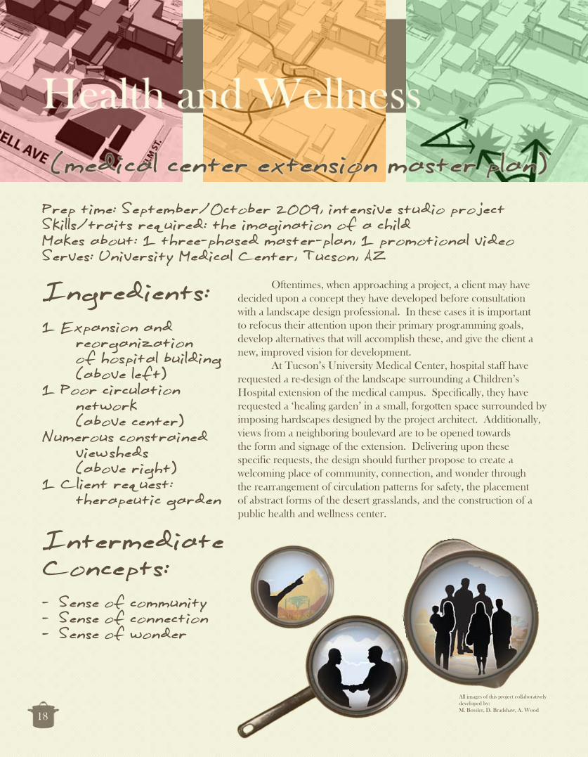
Ingredients:1 Expansion and reorganization of hospital building (above left)1 Poor circulation network (above center)Numerous constrained view sheds (above right)1 Client request: therapeutic garden
Prep time: September/October 2009, intensive studio projectSkills/traits required: the imagination of a childMakes about: 1 three-phased master-plan, 1 promotional video Serves: University Medical Center, Tucson, AZ
Oftentimes, when approaching a project, a client may have decided upon a concept they have developed before consultation with a landscape design professional. In these cases it is important to refocus their attention upon their primary programming goals, develop alternatives that will accomplish these, and give the client a new, improved vision for development. At Tucson’s University Medical Center, hospital staff have requested a re-design of the landscape surrounding a Children’s Hospital extension of the medical campus. Specifically, they have requested a ‘healing garden’ in a small, forgotten space surrounded by imposing hardscapes designed by the project architect. Additionally, views from a neighboring boulevard are to be opened towards the form and signage of the extension. Delivering upon these specific requests, the design should further propose to create a welcoming place of community, connection, and wonder through the rearrangement of circulation patterns for safety, the placement of abstract forms of the desert grasslands, and the construction of a public health and wellness center.
All images of this project collaboratively developed by:M. Bossler, D. Bradshaw, A. Wood
18

Figures (top): Final concepts; Figure (bottom): Master plan (note section A and enumerated viewpoints)
19

“The ‘Health and Wellness Campus Extension’ transforms the northeastern campus gateway into awalkable, restful, refreshing, and playful outdoor experience for patients of Diamond Children’s Medical Center, hospital staff and medical professionals, and the neighboring community.”
Figure (top): Urban plaza; Figure (bottom left): Kinetic grass lamp sculpture; Figure (center): Section A; Figure (top right): Children’s inspiration garden; Figure (bottom left): Hospital room view of green roof sculpture garden and grounds
20

21

Prep time: 2008-2010, periodic involvementSkills/traits required: patience, negotiation, inspirationMakes about: 2 presentations, 1 installed designServes: Jefferson Park Neighborhood Association, Tucson, AZ
22
Ingredients:1 Traffic flow analysis (above left)1 Element of local cultural tradition (above center)1 Vernacular material (above right)
Intermediate Concepts:
Revolution -Ascension -Leading of the eye -
Occasionally, opportunities to improve the communities to which one belongs come in the form of pro-bono service projects. In this instance, under the guidance of neighbor and landscape architect Jessie Byrd (Desert Green Design), and with financial support from the City of Tucson Department of Transportation, one can develop a traffic circle design for the downtown neighborhood of Jefferson Park, in which one lives. Given goals to create a safe, low-maintenance, locally-appropriate piece of public art, the design process begins. Inspired by a group of neighbors who practice and perform flamenco dancing, this design captures the concepts of revolution, ascension, and the leading of the eye in an abstraction of the triumphant, twisting form of the “bata de cola”, or ruffled dress train, of a flamenco dancer. Local vernacular materials, including oxidized, corrugated sheet metal, traffic reflectors, and native xeriscape plants, can be chosen for the design, and the sculpture can be constructed in consultation with neighbor Jerry Harris, aka “The Village Blacksmith”.

Final Product:
Sculptural form -rising from the earthSkirts of -corrugated steelCorrugated -ripples marked with reflectorsFrame of low- -maintenance, native, xeriscape trees, accent plants, and groundcover
Figure (top right): Final concept sketch of sculptural elementsFigure (middle right): Final graphic of complete design used for presentation to neighborhood associationFigure (bottom right): Design installed in traffic circle, Autumn 2010Figure (bottom left): Sculpture installed and adorned with roses by a neighborNOTE: (reflective material not yet installed)
23

Prep time: Spring 2008, two weeks intensiveSkills/traits required: collaboration with architectural designMakes about: 1 master plan, 1 planting planServes: Coronado National Forest (educational exercise)
24
Ingredients:1 Abandoned gravel pit (above left)Multiple outstanding valley views (above center)1 Diverse native plant palette (above right)
Intermediate Concepts:
Development -according to slopeBiotic community -planting zonesProcession of vistas -
When given a short timeline for design preparation, quickly inventory the site and identify areas for preservation (excellent viewpoints, surface natural features of distinction), and development opportunity (previously disturbed sites, monocultures of common plants). Next, formulate a few primary programming goals (gateway entry, interpretation of natural resources from the ground and above, universal accessibility). Working with a 3-D contour model, site parking areas and the building envelope within development opportunity areas, and conceptually regrade the surface in order to design a system of trails, picnic areas, overlooks, and plantings centered around previously located preservation areas. Create two trail networks for varying levels of engagement: one universally accessible and formal, the other strenuous and rustic. Design elevators, stairways, and ramps to lead the visitor through a procession of points of discovery. Between designed viewpoints, concentrate visitor attention on a variety of plant forms native to biotic communities at or near the site. Integrate built form with landscape through an interconnected green-roof ribbon rising from the earth to the sky.
All images of this project collaboratively developed by:M. Bossler, Y. Kim
Prep time: Spring 2008, two weeks intensiveSkills/traits required: collaboration with architectural designPrep time: Spring 2008, two weeks intensiveSkills/traits required: collaboration with architectural designPrep time: Spring 2008, two weeks intensive
Makes about: 1 master plan, 1 planting planSkills/traits required: collaboration with architectural designMakes about: 1 master plan, 1 planting planSkills/traits required: collaboration with architectural design
Serves: Coronado National Forest (educational exercise)Makes about: 1 master plan, 1 planting planServes: Coronado National Forest (educational exercise)Makes about: 1 master plan, 1 planting plan
24
Ingredients:1 Abandoned gravel pit (above left)1 Abandoned gravel pit (above left)1 Abandoned gravel pit
Multiple outstanding valley views Multiple outstanding valley views Multiple outstanding
(above center) valley views (above center) valley views
1 Diverse native plant palette (above right) palette (above right) palette
Intermediate Concepts:
Development -according to slopeBiotic community -planting zonesBiotic community planting zonesBiotic community
Procession of vistasplanting zonesProcession of vistasplanting zones
-
When given a short timeline for design preparation, quickly inventory the site and identify areas for preservation (excellent viewpoints, surface natural features of distinction), and development opportunity (previously disturbed sites, monocultures of common plants). Next, formulate a few primary programming goals (gateway entry, interpretation of natural resources from the ground and above, universal accessibility). Working with a 3-D contour model, site parking areas and the building envelope within development opportunity areas, and conceptually regrade the surface in order to design a system of trails, picnic areas, overlooks, and plantings centered around previously located preservation areas. Create two trail networks for varying levels of engagement: one universally accessible and formal, the other strenuous and rustic. Design elevators, stairways, and ramps to lead the visitor through a procession of points of discovery. Between designed viewpoints, concentrate visitor attention on a variety of plant forms native to biotic communities at or near the site. Integrate built form with landscape through an interconnected green-roof ribbon rising from the earth to the sky.
designed viewpoints, concentrate visitor attention on a variety of plant forms native to biotic communities at or near the site. Integrate built form with landscape through an interconnected green-roof ribbon rising from the earth to the sky.
Intermediate
according to slope
Procession of vistas
form with landscape through an interconnected green-roof ribbon rising from the earth to the sky.
All images of this project collaboratively All images of this project collaboratively All images of this project collaboratively developed by:developed by:developed by:M. Bossler, Y. KimM. Bossler, Y. Kim

Figure (top): Master site grading and planting layoutFigure (right): Arboretum and green-roof native plant list
25

Figure (top left): Architectural scheme of observation tower Figure (top right): Portal views along tower stairwayFigure (center left): Observation deck oculus views Figure (bottom): Arboretum entryway, green-roof ribbon courtyard
“The spiral course of the tower leads the visitor from the bedrock of the site to the open sky.’”
26
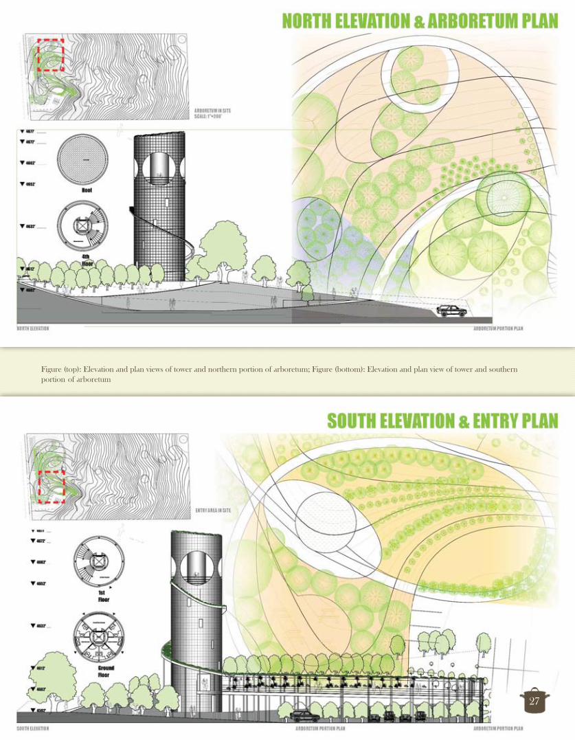
Figure (top): Elevation and plan views of tower and northern portion of arboretum; Figure (bottom): Elevation and plan view of tower and southern portion of arboretum
27

Prep time: Autumn 2008, one month intensiveSkills/traits required: extensive site analysisMakes about: 1 conceptual master plan, multiple sculpture conceptsServes: City of Albuquerque Open Space Division
28
Ingredients:1 Disturbed, engineered riparian area (above left)1 Public visitor center (above center)Multiple exotic plant species (above left)1 Call for land art
Intermediate Concepts:
Environmental -education through seasonal activationRestoration through -regradingSculpture with on-site -materials
Are land artists and landscape architects competitors in the same market or potential collaborators for transcendent designs? In this instance, in response to a request for proposals for land art installations between the levees of the Rio Grande River in Albuquerque, the landscape architect can define himself as the conceptual site planner, designing a thematic framework that engages the hydrologic dynamism of the river-bank. The individual artistic installations of this holistic design can be organized by a template for two thematic zones: “flow” and “control”. Those sculptures within the “flow” zone can become engaged by the rising springtime water levels of the river, while those within the “control” zone can demonstrate the ways in which structural enhancements can direct water for intended purposes. Further, the plan can suggest a material palette of on-site vegetation and the remains of a civil infrastructure used in previous eras of river control (jetty-jacks and levees). In sum, this design can create opportunities to educate the visitors to the Albuquerque Open Space Visitor Center on the past and future of the management and community use of the city’s living pulse - the Rio Grande River, the ultimate survivor.
Images on bottom, from left to right: Arroyo Seco Foundation / D. McCormick 2010; R. Ortiz 2004; New Mexico Natural Heritage Program 2007
Prep time: Autumn 2008, one month intensiveSkills/traits required: extensive site analysisMakes about: 1 conceptual master plan, multiple sculpture conceptsSkills/traits required: extensive site analysisMakes about: 1 conceptual master plan, multiple sculpture conceptsSkills/traits required: extensive site analysis
Serves: City of Albuquerque Open Space DivisionMakes about: 1 conceptual master plan, multiple sculpture conceptsServes: City of Albuquerque Open Space DivisionMakes about: 1 conceptual master plan, multiple sculpture concepts
28
Ingredients:1 Disturbed, engineered riparian area (above left) riparian area (above left) riparian area
1 Public visitor center (above center)Multiple exotic plant species (above left) species (above left) species
1 Call for land art
Intermediate Concepts:
Environmental -education through seasonal activationeducation through seasonal activationeducation through
Restoration through -regradingRestoration through regradingRestoration through
Sculpture with on-site regradingSculpture with on-site regrading
-materials
Are land artists and landscape architects competitors in the same market or potential collaborators for transcendent designs? In this instance, in response to a request for proposals for land art installations between the levees of the Rio Grande River in Albuquerque, the landscape architect can define himself as the conceptual site planner, designing a thematic framework that engages the hydrologic dynamism of the river-bank. The individual artistic installations of this holistic design can be organized by a template for two thematic zones: “flow” and “control”. Those sculptures within the “flow” zone can become engaged by the rising springtime water levels of the river, while those within the “control” zone can demonstrate the ways in which structural enhancements can direct water for intended purposes. Further, the plan can suggest a material palette of on-site vegetation and the remains of a civil infrastructure used in previous eras of river control (jetty-jacks and levees). In sum, this design can create opportunities to educate the visitors to the Albuquerque Open Space Visitor Center on the past and future of the management and community use of the city’s living pulse - the Rio Grande River, the ultimate survivor.
education through seasonal activationeducation through seasonal activationeducation through
Restoration through
on the past and future of the management and community use of the city’s living pulse - the Rio Grande River, the ultimate survivor. on the past and future of the management and community use of the city’s living pulse - the Rio Grande River, the ultimate survivor.
Images on bottom, from left to Images on bottom, from left to right: Arroyo Seco Foundation / D. right: Arroyo Seco Foundation / D. McCormick 2010; McCormick 2010; R. Ortiz 2004; New Mexico Natural Heritage Program Mexico Natural Heritage Program 2007
Sculpture with on-site Sculpture with on-site

Final Product:
Conceptual master -plan2 thematic zones: -
Control -Flow -
Siting and -conceptualization of 3-5 land art installations per zone
29

Prep time: Summer 2005-Summer 2007, full-timeSkills/traits required: independence, leadership, consensus buildingMakes about: multiple ecological reports and NEPA documentsServes: Bureau of Land Management & National Park Service
Ingredients:Various ecosystems (above left)Various planning frameworks (above center)Various ecological challenges (above right)
Intermediate Concepts:
Ecological assessment -Natural system -descriptionNative habitat -restoration
Prior to physical design, sustainable use of natural resources first requires the systematic description of major natural system processes, and the creation of appropriate policy mechanisms for their management. The effect of existing land management practices upon a certain biological system can also be analyzed through systematic review. In order to reach optimize these practices, one must first define the independent factors of causation of a dynamic lithosphere, atmosphere, hydrosphere, biosphere, and human systems, and the dependent factors of target populations and/or ecosystems. Adhering to a predefined experimental design, findings can lead to better management strategies and techniques for ecosystem restoration. Based upon the available science, appropriate environmental policy can be developed within available planning frameworks (Environmental Assessments, Categorical Exclusions, Resource Management Plans, etc.) In the process of development, consultation with program area specialists within the Department, Native American tribes, and the Fish and Wildlife Service should lead to consensus and result in strengthened policy.
Image (top right): W. Shattil & B. Rozinski 2007Image (bottom left): Yuma Crossing National Heritage Area 2007Image (bottom center): Pima County Flood Control District, 2008
30

Refuged/Unrefuged Site Comparison With 95% Confidence Intervals
0
100
200
300
400
500
600
Species
Average Height (cm)
Mt. Maple Chokecherry Aspen Oak
Refuged
Unrefuged
Final Products:Geostatistical elk herbivory -and fire effects study, Cerro Grande (Bandelier National Monument; this page)Ecological analysis of -Sonoran Pronghorn critical habitat (BLM, Phoenix Field Office, page 32)Categorical Exclusions for -Invasive Species Removal along Colorado River (BLM, Lake Havasu Field Office, page 32)Environmental Assessment -for programmatic herbicidal control of invasive species along Lower Colorado River (BLM, Colorado River District, page 33)
“Land managers should consider creating ‘jackstraw’ in order to deal with the combined effects of fire and ungulate browse in areas where fuel reduction is a high priority.”
Management Recommendation:
31

Figure (top): Sonoran Pronghorn critical habitat range assessment, Ajo, AZFigure (right): Fuel break proposed location, Needles, CAFigure (left): Tamarisk removal proposed location, Lake Havasu, AZ
GIS Analysis:
32

Figures (below): excerpts, Programmatic herbicide application Environmental Assessment, Lake Havasu, AZ
33


