recent tsunami and earthquake devastation - iit kanpur · on the substructure by a substantial...
TRANSCRIPT
January 2005 * The Indian Concrete Journal 11
Recent tsunami and earthquake
devastation
The Indian Institute of Technology (IIT),
Kanpur organised a reconnaissance
study of the affected areas of the recent
earthquake and the tsunami with a view
to document the scientific, engineering
and disaster management lessons from
this tragedy. A total of 13 investigators
were divided into six groups with
independent responsibilities: each of
the groups spent about eight days in
the field, during January 1 to January
13, 2005, as per Table 1.
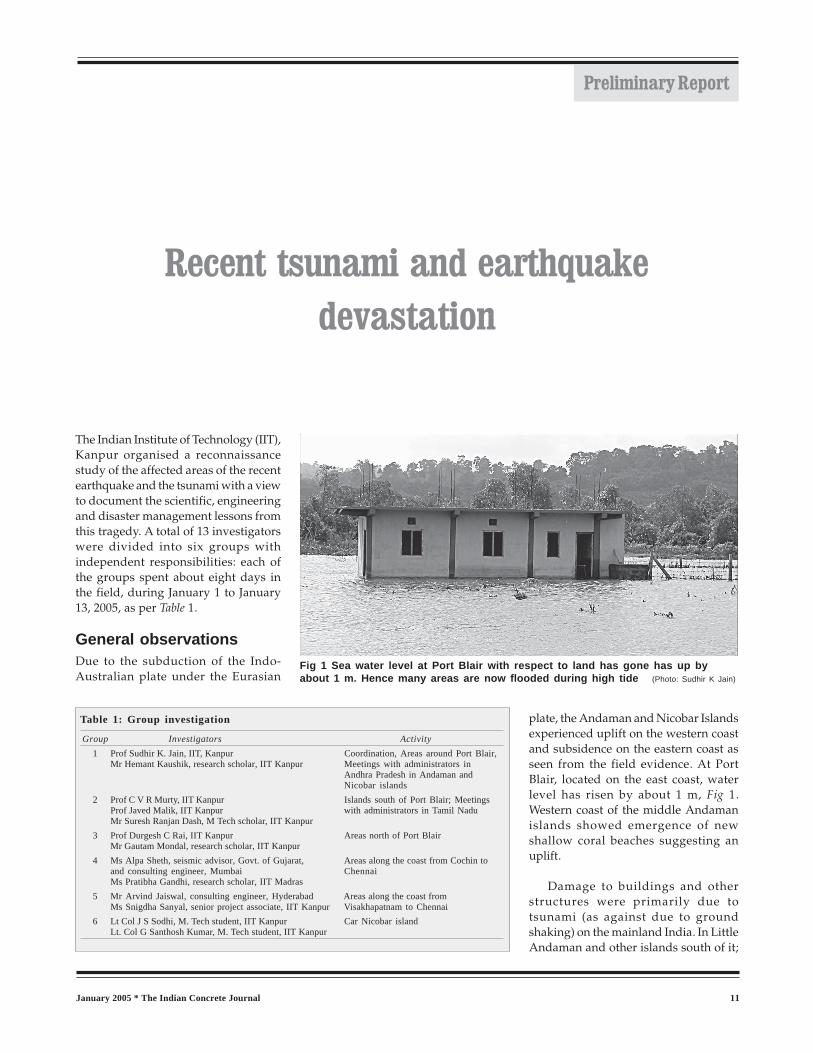
General observationsDue to the subduction of the Indo-
Australian plate under the Eurasian
plate, the Andaman and Nicobar Islands
experienced uplift on the western coast
and subsidence on the eastern coast as
seen from the field evidence. At Port
Blair, located on the east coast, water
level has risen by about 1 m, Fig 1.
Western coast of the middle Andaman
islands showed emergence of new
shallow coral beaches suggesting an
uplift.
Damage to buildings and other
structures were primarily due to
tsunami (as against due to ground
shaking) on the mainland India. In Little
Andaman and other islands south of it;
Table 1: Group investigation
Group Investigators Activity
1 Prof Sudhir K. Jain, IIT, Kanpur Coordination, Areas around Port Blair,Mr Hemant Kaushik, research scholar, IIT Kanpur Meetings with administrators in
Andhra Pradesh in Andaman andNicobar islands
2 Prof C V R Murty, IIT Kanpur Islands south of Port Blair; MeetingsProf Javed Malik, IIT Kanpur with administrators in Tamil NaduMr Suresh Ranjan Dash, M Tech scholar, IIT Kanpur
3 Prof Durgesh C Rai, IIT Kanpur Areas north of Port BlairMr Gautam Mondal, research scholar, IIT Kanpur
4 Ms Alpa Sheth, seismic advisor, Govt. of Gujarat, Areas along the coast from Cochin toand consulting engineer, Mumbai ChennaiMs Pratibha Gandhi, research scholar, IIT Madras
5 Mr Arvind Jaiswal, consulting engineer, Hyderabad Areas along the coast fromMs Snigdha Sanyal, senior project associate, IIT Kanpur Visakhapatnam to Chennai
6 Lt Col J S Sodhi, M. Tech student, IIT Kanpur Car Nicobar islandLt. Col G Santhosh Kumar, M. Tech student, IIT Kanpur
Fig 1 Sea water level at Port Blair with respect to land has gone has up byabout 1 m. Hence many areas are now flooded during high tide (Photo: Sudhir K Jain)
Preliminary Report

The Indian Concrete Journal * January 200512
and structural damage in islands north of Little
Andaman were primarily due to ground shaking.
Damages on the Andaman andNicobar islandsTsunami created giant waves as high as 10-12 m; in
several instances, objects were found on top of the
trees after the tsunami. In the islands of Great
Nicobar, Car Nicobar, and Little Andaman, buildings
constructed on the coast were washed away by the
great waves, while those located on high grounds
survived. When a number of rows of buildings
existed on the coast, buildings in the first row from
the sea suffered extensive damage
while those in the rear rows did better
due to the shielding provided by the
front row. In general, constructions
that were circular in plan (for example,
circular water tanks, light house) did
better under the onslaught of
tsunamis as the water could easily flow
around such objects. At Car Nicobar
about 100 personnel of air-force
(including the family members) lost life
or are missing. However, the
operational area and the airstrip
survived enabling rescue and relief
operations by the air force after the
event.
Fig 3 Collapse of a stilt plus one-storeyhouse in reinforced concrete near Port Blair(Photo: Sudhir K. Jain)
Fig 2 Severe damage to Passenger TerminalBuilding at Port Blair (Photo: Sudhir K Jain)
Fig 5 Collapse of a reinforcedconcrete scooter stand at Port
Management Board office inPort Blair (Photo: Hemant Kaushik)
Fig 4 Collapse of a stilt plus one-storey house in reinforcedconcrete near Port Blair (Photo: Hemant Kaushik)

January 2005 * The Indian Concrete Journal 13
Due to the ground shaking, the
wooden buildings have performed
very well as compared to the more
modern RC frame and concrete block
masonry buildings. The latter sustained
large damages wherever the seismic
codes were not complied with. For
instance, the passenger terminal
building at the Phoenix Bay in Port Blair
was recently constructed but did not
comply with the seismic codes. This
rather expensive building has been
irreparably damaged, Fig 2. At least two
houses built by local people using
reinforced concrete but without proper
engineering supervision and seismic
detailing collapsed, Figs 3 to 5. A three-
storey apartment building in Port Blair
on stilt columns, not complying with the codal requirements,
collapsed, Fig 6.
A number of jetties collapsed or were severely damaged in a
number of islands, Fig 7. This has severely affected the sea traffic
and hence the relief operations.
A new bridge between north and middle Andaman had to be
closed to even the light vehicles. The superstructure has moved
on the substructure by a substantial amount. As a result, currently
one has to cross from one island to the other by foot and leave
the vehicle behind. More interesting part of the story that Dr
C.V.R. Murty and Dr Durgesh C Rai of IIT Kanpur had visited this
region two years back after a moderate earthquake on
September 14, 2002 and in their published report had expressed
Fig 9 Foundation failure in Kerala dueto scouring of rather shallowfoundation (Photo: Alpa Sheth )
Fig 6 Collapse of three-storey reinforced concreteframe building at Port Blair (Photo: Sudhir K Jain)
Fig 7 Collapse of the 80-m segment of the approach to GreatNicobar island jetty at Cambell Bay. This has adverselyaffected the relief work (Photo: CVR Murty )
Fig 8 Ravaged houses at Nagapattinam due to poorconstruction (Photo: Alpa Sheth)

The Indian Concrete Journal * January 200514
concerns about this very bridge as
follows:
“Inadequate seating of bridge deck over
piers and abutments is a serious concern
for its safely during a stronger
earthquake in future. The bearings are
simple neoprene pads which are far from
satisfactory for a bridge located in
seismic zone V. Bridge deck restrainers
are the minimum that need to be
provided to ensure that the spans are
not dislodged from the piers in future
earthquakes.”
A free copy of the report can be re-
quested by sending an e-mail with com-
plete postal address to the National In-
formation Centre
of Earthquake Engi-
neering at IIT
Kanpur at
Damages onthe mainlandThe fishing commu-
nity living along the
shore suffered the
maximum damage:
to its housing, to its
boats and fishing
equipment, and in
terms of loss of life,
Fig 8. Most houses along the coast had
been non-engineered. In general, qual-
ity of construction had a major influ-
ence on the level of damage sustained
by the buildings. Buildings with low
foundation depth, those with poorer
building materials, poor integrity and
poor workmanship were worst suffer-
ers, Fig 9.
Several bridges suffered serious
damages. The superstructure of all four
spans of a bridge at Melmanakuddi
came off the sub structure and two of
the spans washed away to large
distances, Fig 10. A good connection
between the superstructure and the
substructure and the additional
provision of restraining upstands —
recommended features for seismic
design — would have helped these
bridges. Infrastructure in Nagapattinam
district was significantly affected: a
railway line on the shore,
telecommunication tower and control
panel room were irreparably damaged.
Compound walls upto 300 m inside the
shoreline were very extensively
damaged.
In ports and harbours, major
disturbance was caused by vessels
parting their ropes and becoming loose
and hitting other vessels and causing
damage. Small boats and ships were
tossed astray onto the land by the
incoming wave and thereby damaging
them. Some boats were sunk to the
basin due to the returning giant waves,
Fig 11.
Breakwaters generally did well, and
helped reduce the impact of waves.
Beaches shielded by landmass or by
rocky cliff sustained less damage. Sea-
water intrusion was less in area covered
with thick vegetation as compared to
those with bare lands. Sand deposits due
to tsunami in delta areas have damaged
standing crops and affected fertility of
the land.
— NICEE press release
•••
Fig 11 Small mechanised boat sunk into harbour basinbeing pulled out of water at Fishermen's Wharf,Chennai (Photo: Arvind Jaswal)
Fig 10 Complete loss of the four span of a RC bridge at Melmannakudi (Photo: Alpa Sheth)