exxon valdez restoration project annual report assessment ...restoration project annual report...
TRANSCRIPT

Exxon Valdez Oil Spill Restoration Project Annual Report
Assessment, Protection and Enhancement of Wildstock Salmon Streams in the Lower Cook Inlet
Restoration Project 98263 Annual Report
This annual report has been prepared for peer review as part of the Exxon Valdez Oil Spill Trustee Council restoration program for the purpose of assessing project progress. Peer review comments have not been addressed in this annual report.
Arvid J. Hall John L. Hall
Taiga Resource Consultants
Walter Meganack, Jr. Port Graham Corporation
for:
Alaska Department of Fish and Game Habitat and Restoration Division
333 Raspberry Road Anchorage Alaska 995 18
April 1999

Assessment, Protection and Enhancement of Wildstock Salmon Streams in the Lower Cook Inlet.
Restoration Project 98263 Annual Report
Studv Historv: The project effort was initiated under Restoration Project 97263 and was continued under 98263. This is the annual report for FY98 under the title Assessment, Protection and Enhancement of Wildstock Salmon Streams in the Lower Cook Inlet. FY98 was the implementation stage and FY 99 and FYOO will consist of monitoring enhancement projects and the final report.
Abstract: This project began in FY97 and was designed to replace lost subsistence services resulting from the Exxon Valdez oil spill. The first phase of this project was to conduct an inventory and assessment for enhancement projects on four major salmon streams in the Lower Cook Inlet (LCI) oil spill area. During FY98 two restoration and enhancement projects were implemented with instream fisheries habitat improvement techniques by the Port Graham Corporation. Project One was to construct a five dam fishpass on the Port Graham River to allow passage over a three meter falls, thereby removing a natural barrier to spawning and rearing habitat on the upper river. Project Two was to construct two wall-based rearing ponds on Windy Creek Left. These enhancement projects on both streams were primarily for coho salmon (Oncorhynchus kitusch).
Kev Words: Coho salmon, enhancement, Exxon Valdez oil spill, instream fisheries habitat, lower Cook Inlet, Oncorhynchus kitusch, restoration, subsistence.
Proiect Data: (will be addressed in the final report)
Citation: Hall, A.J., J.L. Hall, and W. Meganack, Jr. 1998. Assessment, protection and enhancement of
wildstock salmon streams in the lower Cook Inlet, Exxon Valdez Oil Spill Restoration Project Annual Report (Restoration Project 98263), Alaska Department of Fish and Game, Habitat and Restoration Division, Anchorage Alaska.

Table of Contents Page
STUDY HISTORYIABSTRACTIKEY WORDSICITATION ....................................................... 2 TABLES OF CONTENTS .............................................................................................................. 3 LIST OF TABLES ........................................................................................................................... 4 LIST OF CHARTS .......................................................................................................................... 4
........................................................................................................................... LIST OF PLATES 4 LIST OF APPENDICES .................................................................................................................. 4 EXECUTIVE SUMMARY ............................................................................................................. 5 INTRODUCTION ........................................................................................................................... 6
.................................................................................................................................. OBJECTIVES 7 METHODS ...................................................................................................................................... 8 RESULTS AND DISCUSSION .................................................................................................... 10 CONCLUSIONS ........................................................................................................................... 11 ACKNOWLEDGEMENTS .......................................................................................................... 1 2 LITERATURE CITED .................................................................................................................. 12 TABLE 1 ........................................................................................................................................ 13 CHART 1 ....................................................................................................................................... 15 MAPS 1-5 ...................................................................................................................................... 16 PLATES 1-18 ................................................................................................................................. 21 APPENDIX ................................................................................................................................... -36

List of Tables
Table 1 : Channel and Habitat Characteristics of Port Graham River, 1997.
List Of Charts
Chart 1 : Port Graham River Falls Profile, 1998.
List Of Maps
Map 1 : Vicinity Map.
Map 2: Port Graham Watershed Fish Pass.
Map 3: Aerial Photo of Port Graham River Falls and Fish Pass Area
Map 4: Windy Creek Left Watershed Location of Rearing Ponds
Map 5: Aerial Photo of Windy Creek Left and Rearing Ponds
List Of Plates
Plates 1-12: 35mm Photos Port Graham River Fish Pass Construction
Plates 13- 18: 3 5mm Photos Windy Creek-Left Rearing Ponds Construction
Appendix
Proposed 1999-200 1 Monitoring Plan

Executive Summarv
Subsistence users in the LC1 area and specifically the residents of Port Graham are heavily dependent on salmon from the Port Graham River, Windy Creek, Scurvy Creek and Rocky River. These four major salmon streams and their tributaries were inventoried and assessed with existing data from previous EVOS projects including aerial photo interpretation, ground truthing, and field inventories. The goal is to replace lost or damaged resources by replacing or enhancing the habitat of wildstocks of salmon important to the people who live in Lower Cook Inlet. Subsistence users were interviewed to assess the historical level of runs and the current, depressed level due to EVOS and preferences for replacing damaged subsistence resources. Existing data includes the baseline studies commissioned by the EVOS Trustee Council: Stream Habitat Assessment Project: Prince William Sound and Lower Kenai Peninsula Project No. R- 5 1, (Sundet & Kuwada, 1994), Fish Habitat and Channel Conditions for Streams on Forested Lands of Coastal Alaska: An Assessment of Cumulative Effects, (Martin, 1996), Survey and Evaluation of Instream Habitat and Stock Restoration Techniques for Wild Pink and Chum Salmon (Willette, Dudiak, Honnold, Carpenter, and Dickson 1995). Habitat Protection Information for Anadromous Fish Channel Type Classification Study (Olson & Zernke, 1993)
Field surveys were then conducted during FY 97 to augment existing data and to ground truth aerial photo inventories. As a result, eight specific enhancement and restoration projects were then developed from this field inventory. With the information from the interviews with local subsistence users and an evaluation of the existing species and available quantities, the decision was made to target coho salmon for enhancement and restoration for subsistence purposes. Of these eight projects, two were approved for funding by the EVOS Trustee Council: the Port Graham River Fishpass and the Windy Creek Left Rearing Ponds. The design and implementation of the specific projects were conducted with the assistance of Dr. Doug Martin and Dr. William Hauser, Assistant Fisheries Program Manager of the Alaska Dept. of Fish and Game Habitat and Restoration Division.
Environmental analysis was required by the National Environmental Policy Act (NEPA) and two EA's were written to document any impact. The environmental analysis for this project was coordinated with Region 10 of the USDA Forest Service. Ken Holbrook of the Chugach National Forest and Vic Starostka of the Chatharn Area of the Tongass National Forest were instrumental in coordinating environmental analysis' for this project.
For several decades fisheries biologists have successfully modified existing stream structures as a technique to improve habitat conditions for salmon spawning and rearing in Alaska and the Pacific Northwest. Fishpasses and wall based rearing ponds can be very effective in adding spawning and rearing habitat for the existing wildstock salmon. Both of these structures were installed with data and insight derived from a thorough inventory and analysis of the current habitat conditions in the entire watersheds and the specific needs of a particular salmon species (EVOS #97263). These enhancement and restoration projects will primarily target coho salmon with beneficial effects for pink, chum and sockeye salmon.

Introduction
These projects were conducted in two phases as part of a five year project commissioned by the Exxon Valdez Trustee Council, and are designed to promote the restoration and enhancement of salmon for subsistence. The freshwater streams and the associated riparian areas are critical habitat for several species of injured fish and wildlife resources. Coho, Pink and sockeye salmon and Dolly Varden use freshwater environments for important life functions such as spawning, rearing and overwintering. However, it is the restoration or the effective replacement of the subsistence resources relied on by the indigenous peoples which is the focus of this project.
Precipitation on the lower Kenai Peninsula, mostly rain, averages 25 to 100 inches per year, and increases to much higher levels on the mountains. The Gulf of Alaska is a noted originator of fierce storms, some approaching hurricane force. The lower Kenai Peninsula is characterized by steep slopes. The streams in our study area contained extensive and complex primary, secondary and tertiary spawning and rearing areas. Although intertidal spawning is quite common for pinks and chums, the primary spawning habitat of the coho salmon, the targeted species for this project extends to the headwaters of these watersheds.
The Alaska Earthquake of March 27, 1964, measuring 8.6 on the Richter scale created subsidence in the study area ranging from -3.0 to -5.0 feet. This subsidence had an undetermined effect on available spawning areas for pink and chum salmon. Chum runs in the study area have remained depressed but pink runs seem to have rebounded in the last three years in Rocky, Windy and Port Graham River (ADF&G Harvest and Escapement reports 1959-1 997). The absence of a commercial harvest and the capability of pink salmon to exploit any suitable spawning area with the inherent benefit of a two year life cycle has generated an accelerated recovery.

Obiectives
This project addressed these objectives in FY98:
1 . Conduct an Environmental Analysis (EA's) for Port Graham River Fish Pass and Windy Creek. Coordinate EA's with USDA Forest Service. Apply to Army Corps of Engineers for wetlands permits and Alaska Dept. of Fish Game Habitat for Title 16 permits. Contact State Office of Historical Protection (SHPO) for concurrence. Coordinate and receive approval from Cook Inlet Regional Planning Team (CIRPT.) Design and provide preliminary engineering for fishpass and rearing ponds (Phase I)
2. Improve the in-stream spawning and rearing habitat for Coho, Pink and Chum salmon through two enhancement projects: Port Graham River fishpass and two coho rearing ponds on Windy Creek Left. (Phase 11)
3. Enhance existing wildstocks of salmon to serve as substitution and compensation for the lost and damaged subsistence resources important to the subsistence users of Lower Cook Inlet.
Obiective One of this project concentrated on a compilation of the existing data and literature from the PGC Forest Stewardship Plan and EVOS Project #97263 for writing the two environmental analysis' required by NEPA. Apply for necessary permits from Army COE and ADF&G-Habitat. Attend meeting of CIRPT on and request approval of projects. Objective One was primarily contracted out to a resource consulting firm, Taiga Resource Consultants (TRC) who produced both EA's and conducted all permitting activities.
Obiective Two consisted of updating and refining the preliminary engineering with input from John F. Orsborn, P.E. a fisheries engineering consultant and a literature review of similar projects in Alaska, ( i.e. Little Waterfall Creek, Afognak, Is. AK) and Washington and Oregon by Dr. Douglas J. Martin, (Sunday Creek rearing ponds on the Mt Baker-Snoqualmie N.F. Washington,) OB2 also consisted of consulting with Tobben Spurkland, P.E. an Alaska Certified Engineer for final engineering approval. Construction of the Port Graham River Fishpass and Windy Creek Left Rearing Ponds by subcontractors was the final step of OB2.
Obiective Three consisted of monitoring both enhancement projects based on ground surveys.
Methods
Obiective One: Objective One focused on the compilation and review of all available fisheries information relevant to the EA's. The project team consulted with personnel in ADF&G (Fish & Habitat) and the USDA Forest Service. We then proceeded to acquire all available maps, aerial photos, ADF&G records and reports concerning these areas. Meetings were scheduled with ADF&G, CIRPT and the USDA Forest Service in January to March of 1998.
Obiective Two:
Phase I Environmental Analysis and Permitting: The EA's were approved on June 29, 1998 by James A. Caplan, the Acting Regional Forester in Juneau. On June 4, 1998 the Title 16 Permit was received on the Port Graham River Fishpass, however the Title 16 on the Windy Creek Rearing Ponds was delayed by ADF&G until August 26, 1998 pending more detailed engineering. Permits from the Army COE were approved and received on May 14 and June 1 1, 1998 for the fishpass and rearing ponds respectively. Phase Two funding was then approved by ADF&G the Trustee agency for 98263 on August 29, 1998. Contracts were then executed with Taiga Resource Consultants (TRC) of Girdwood for the construction of the fishpass and with CIC, an excavating and road building company based in Soldotna and an active subcontractor on the Port Graham Number One timber sale for Klukwan Forest Products (KFP) for construction of the rearing ponds. TRC also performed the field layout and supervised the construction of the rearing ponds. Engineering plans were drafted by TRC and reviewed and approved by Tobben Spurkland, P.E. of Anchorage.
Phase I1 Construction of Fishpass: During Sept 10-20 all construction materials were mobilized to Port Graham from Anchorage via trucks from Anchorage and then a local fishing boat from Homer to Port Graham. Procurement of all equipment and materials was accomplished by TRC as a subcontractor. Equipment and construction materials were then mobilized to a staging area located at the 8.5 mile spur of the Port Graham road approximately 300 meters from the construction site on the Port Graham River (Plates 1 & 2) .
The work crew for this project consisted of Arvid J. Hall and John L. Hall of TRC and Steve Anahonak and Bob Huntsman, full-time residents of Port Graham. TRC personnel also stayed at Huntmans Bed and Breakfast during the construction phase of this project. Two other residents of Port Graham provided day labor during the mobilization phase.
The fish pass was constructed out of 4" x 4" x 4" galvanized steel beams, 114" thick. These beams were then bolted to the bedrock by 1" drop in inserts and affixed with 518" grade 8 bolts. 4" x 8" and 4" by 12" Sitka spruce timbers of various lengths obtained from McMullen's sawmill in Port Graham were placed across the channel into the steel beams. Each timber was custom fit and then 114" plywood was affixed to the upstream side by zinc- coated screws and 114 inch x 4" flat steel was affixed to the downstream side on the dams in a vertical manner by 3116" galvanized lag bolts (Plates 3-6.) Holes for the inserts were drilled

into the bedrock with a Bosch 1 1230 SDS Max Rotary Hammer and a 1" carbide tipped drill bit (Plate 10.) The drop in inserts were then secured with a 2 lb sledge, driving a set pin to expand the insert into the bedrock (Plate 7.) The galvanized steel beams were cut and shaped using a Stihl TS 400 cut-off saw (Plate 8.) Bolts were affixed with either a Dewalt 112 hp impact wrench or a 314 inch drive ratchet. Timbers were trimmed and shaped with a Stihl 026 Pro chainsaw or a Milwaukee Sawzall (Plate 3 .) A Honda 2500 KWH generator provided power to the electrical tools. Weir dam locations were determined based upon the existing morphology of the bedrock and the engineering plan for the five dams (Plate 9.) Desirable weir locations were those where the rock was smooth, relatively on an even plane to the parallel bedrock wall and free of frost cracks or excessive protrusions. Based upon these parameters, the location and spacing for the five weir dams was marked prior to construction on the bedrock walls.
A temporary dam was created upstream of dam #1 using logs, tarps and approximately 30 sandbags (Plate 3.)
Due to high water and flood conditions encountered during the latter part of September by the remnants of Typhoon Stella (Plate 1 ,) construction on the fish pass was delayed until October 2, 1998. Construction was completed during the following ten days. On October 13, 1998 the fishpass was opened up during a mild rainstorm and approximately 10 Dolly Varden and eight coho salmon proceeded to ascend the fishpass within 1 hour of its initial operation (Plate 12.) On October 14, the pass was closed temporarily to adjust the height and contour of the notches for a more even flow of water. The shape and contour of the opening in each pass was designed with the recommendations of Dr. John Orsborn. Field modifications were made to customize each notch to maximize the performance based upon the pool and channel conditions of each dam. Demobilization was completed by October 14, 1998.
Phase I1 Construction of Rearing Ponds: During Sept 20-25 all field layout of both rearing ponds was accomplished by TRC. CIC was contracted to excavate both ponds using a Hitachi Super Model excavator and a Caterpillar D-6 bulldozer (Plate 3.) Excavation occurred over a five-day period. All permits were complied with fully during construction. Due to stipulations in the ADF&G Title 16 permit these ponds will not be opened up to the mainstem of Windy Creek Left until May/June of 1999. However, on Nov 4,1998 coho and Dolly Varden fry and fingerlings were observed in the area immediately below pond #2 and fry were observed in the mainstem of Windy Creek Left during the construction of pond #1 (Plate 18.)
Approximately 4,000 cu. yds of material was removed and placed in mounds on the uplands surrounding each pond (Plate 14.) Sod strips from the excavation of the top layer were then placed on the mounds to provide immediate revegetation. Each pond consisted of a center channel 50 to 75 meters long with side channels of 25 to 50 meters long (Plate 16.) These channels were designed to have a center of approximately two meters deep and shoulders of one meter deep on each side (Plate 17.)

These ponds will be revegated and underwater structure beneficial for anadromous juveniles will be installed during FY99. Grass and willows will be planted along the banks and woody debris will be added to the center and side channels for structure.
Obiective Three Phase 11:
Monitoring of the ponds will be delayed until FY99 due to the stipulations of the ADF&G Title 16 Permit not allowing opening up these structures until June of 1999. The monitoring on the Port Graham River fishpass consisted of the observations of the subcontractors during construction. The construction was completed near the end of the coho run in the river for 1998. Monitoring for FY99-01 will be more intensive (see detailed monitoring plan in Appendix B.)
Results and Discussion
Objective One:
The Ea's were approved on June 29, 1998. Permits for the Port Graham River Fishpass and the Windy Creek Rearing Ponds from the Army COE were received on May 14 and June 4, 1998 respectively. Title 16 permits for the Port Graham River Fishpass and the Windy Creek Left Rearing Ponds were receive on June 1 1 and August 26, 1998 respectively. Preliminary engineering was completed by TRC on April 1 5,1998 and modified on August 12, 1998 for the rearing ponds. Approval for both projects was received by the CIRPT on March 5, 1998. No other permits or approvals were necessary.
Objective Two:
Port Graham River Fishpass: On October 14, the barrier falls on Port Graham River were bypassed by the completion of the five dam fishpass. The falls consists of two channels which spilt around a large 6 by 10 meter bedrock outcropping in the center of the channel (Chart 1). The upper Port Graham reaches contain 23 percent of the total available spawning and 12 percent of the total available rearing habitat for the entire Port Graham River watershed. Satisfactory operation of the fish pass could result in a substantial increase in the number of additional coho spawners annually. Sufficient rearing habitat exists throughout the entire watershed to support the additional production from these spawners.

Windy Creek Left Rearing Ponds: Approximately 4,135 meters upstream from the mouth were two low wet meadows adjacent of the stream channel which showed evidence of being ancient abandoned stream channels. During our field survey these were investigated for the suitability for enhancement into wall based rearing habitat structures. Ground water was found in several small channels. Fry were observed in the shallow pools. There was excellent access to the main channel at the base of a large pool. The other meadow contained similar conditions. On the basis of the total amount of rearing habitat available on Windy Left, these enhancement projects should add critical off-channel winter rearing habitat for coho salmon and add a substantial amount of overall rearing habitat for coho salmon in this watershed.
Objective Three: Monitoring will be delayed on the rearing ponds due to stipulations in the Title 16 permit. The fish pass was constructed during or near the end of the fall coho run on the Port Graham River. Intensive monitoring is planned for both projects in FY99-01.
Conclusions
Instream restoration and enhancement were completed in the fall of 1998 (September 10 to October 15, 1998). Construction was coordinated with the ongoing timber sale (Klukwan Forest Products) and road building operators and their equipment in the Port Graham drainage. With the excellent road access and the availability of heavy equipment, PGC was able to implement these projects on a cost effective basis. Work crews for the fishpass project consisted of four people, two of whom were full-time residents of Port Graham.
Future monitoring will be critical to assess the rate of success and to determine which objectives have been met or exceeded. Monitoring will continue for ten years conducted by PGC with assistance from ADF&G COMFISH. A final report and data will be compiled in FY 2001. Further enhancement in the form of revegetation will occur during FY 99 and FY 00 on the rearing ponds. Hand tools and manual labor will be the primary method of revegetation and enhancement for FY99.
FYOO $1 1.5 $12.0 $23.5
FY99 $16.0 $26.0 $42.0
Estimated Project Summary Port Graham River Fish Pass Windy Creek L Ponds summary
FY98 $57.0 $50.0
$107.0

ACKNOWLEDGEMENTS
The authors wish to thank: Ken Holbrook, Anchorage and Vic Starostka, Sitka of USDA Forest Service, Don McKay and Dr. William Hauser of ADF&G, Dr. John Orsborn and Dr. Douglas J. Martin, fisheries consultants. Dean Robinson of CIC, Bob & Jean Huntsmans of Huntsmans Tipi B&B, Port Graham, Alaska. Greg McMullen of McMullen Enterprises, Tess Whalen and Jennifer Beckrnan of Kenai Peninsula Borough Economic DeveIopment District and Tom Hines of Klukwan Forest Products.
LITERATURE CITED
Willette, T.M., N.C. Dudiak, S.G. Honnold, G. Carpenter, and M. Dickson. 1995. Survey and evaluation of instream habitat and stock restoration techniques for wild pink and chum salmon, Exxon Valdez Oil Spill StatelFederal Natural Resource Damage Assessment Final Report, Alaska Department of Fish and Game, Commercial Fisheries Management and Development Division, Cordova, Alaska.
Martin, D.J. 1996. Fish habitat and channel conditions for streams on forested lands of coastal Alaska: An assessment of cumulative effects. Pentec Environmental.
Olson & Zemke. 1993. Habitat protection information for anadromous fish channel type classification study. USDA Forest Service.
Regional Interagency Executive Committee. 1995. Ecosystem analysis at the watershed scale: Federal guide for watershed analysis, version 2.2. U.S. Government Printing Office.

TABLE 1
Table 1 Clrarr~rel n~rd habitat elr~racterlstics in representative stream reaches of Port Graham River, Su~rmier 1997.
- 24 1-30- 10550
1055 1 PaR-MC 10550 PGK-MCT 10550-2024 PGR-MC 10550-3024 POR-MC 10550 POR-SF 10550-20 18 PGR-phoio 10550-201 8 POR-pholo 10550-3018 PGR-phoio I OSSC I POR-NF 10550 PGR-Photo 10550 PGR-Tri b I OS!jO-2018 PGR-Tri b 10550 PGR-Tri b 1 055( ) W'K-Tri b 10550 PGR-Tri b 10550-2024 POR-Tri b 10550-3,024 PGR-Trib 10550 PGR-Tri b 10550 PGR-Tri b 10550 PGR-Tri b 10550 PGR-Tri b
a Dorrli~ra~lt substrate is listed in order relative to the frequency of occurrency.
3oW PO tilkc P3-02 PO Pond 3-02 PX-0 1 PO Pond 8-01
I 2 4 4b 3a 3b 3c 3d 5a 5b T1 T2 T3 T4 T5 T6 T7 T8 T9 T i 0 T l i
L L L
ADF&G Ccdc
FP5 FP4 FP4 LC I Mhrl2 MM I MC I MMI FP3 MM 1 PA I PA 1 PA 1
MM 1 PA 1 MM I MMI PA 1 MC 1 PA 1 PA 1
L L L
ASA 1 ARA Culc [ 'J6
grv-pgrv grv-cob grv-cob grv-cob prv-cob grv-cob cob-grv grv-cob grv-cob grv-cob sd-sl-grv
grv-md-org sf -org-sd
grv-cob-sd m-sd-org
gnp-cobsd gw-cob-rb md-org-sl rb-cob-grv m-org-sd m-org-sd
Subbasin
m-org-sri 148,800 m-org-sd 2,239 m-org-scl 14,016
ARA Cnlc
Reach LWD I LWD # 1 Factor
Area 1 ASA .
M2 I % Channev Sun1ey
Type ILngth (m) Gndien( Stream
(%) IBF WiJtI. Bminant Subslrate

TABLE 1
105SO-2034 UP-PGR-MC 6 FP4 1,297 1 18 g r ~ 23,346 48% 11,206 45% 10,506 300 23.13 10550-2024 UP-FGR-MC 7 FP3 495 1 14 grv-~ob 6,930 48% 3,326 52% 3,604 93 18.79 10550-2024 UP-PQR-MC 8 MC2 290 4.0-9.0 12 ab-bdrk-b1J1 3,480 1% 35 11% 383 10 3.45 10550-2024 UP-PQR-MC 9 MC3 2,380 3.0 - 6.0 12 cob-bldr 28.560 1 % 2136 1 1 8 3,142 - 10550-2024 UP- WR-MC 10 MM I 2,135 3 i gnr-cob 2,135 11% 235 18% 384 10550-2024 UP-POR-MC I I FP3 920 t.5 10 gnl-cob 9,200 48% 4,416 52% 4,784 10550-2024 UP-WR-MC T 11 MC 1 420 6 5 cob-brk-bid 2, I 0 0 5% 105 15% 315 10550-2024 UP-PGR-MC T 12b PA 1 4-Xi 1 A 3 md-org 912 0% O 30% 182 10550-2024 UP-PGR-MC T 13 PA 1 539 1 2 md-or8 1,058 0% 0 20% 212 - - 10550-2024 UP-PGR-MC T 14 MC I 785 1 3 wb-gw 2,355 5% 118 158 353 10550-2024 UP-POR-MC T15 MM I 420 3 6 grtf-cob 2,520 i 1% 277 18% 494
10,127 1 20,004 24,3 18
TOTAL 29,660 Lower Port Graham River 65.86% Upper Port Grdham River (above the falls) 34.14%

CHART 1
Port Graham River Falls Profile Left & Right Channels (Upstream)
Station Distance RC Elevation RC Distance LC Elevatio LC 0 0 0 0 0
0 - 1 23 0.23 0 0 1 to 2 65 2.33 0 0 2 to 3 81.5 4.3 1 0 0 3 to 4 105.5 3.1 1 1 30.5 4.3 1 4 to 5 11 5.5 3.9 1 1 54.5 5.99 5 to 6 137.5 2.81 1 68.5 7.8 1 6 to 7 1 59.5 16.89 186.5 19.51 7 to 8 172.5 18.06 21 6.5 18.91 8 to 9 196.5 18.54 21 6.5 18.9 1
I

P.O. Box 5569 Port Graham, Alaskil99603-5569
Phone (907) 284-22 12 FAX (907) 284-22 19
Revised Monitoring P1an:EVOS Project -#99263 Location: Port Graham Lands-Port Graham River & Windy Creek Left
Introduction: The Port Graham River Fish Pass and the Windy Creek Left Rearing Ponds were completed during the fall of 1998. Monitoring on the fish pass to date has consisted of field observations of Dolly Varden and coho salmon ascending the fishpass within one hour of its initial opening. The rearing ponds will not have full access to Windy Creek Left until MaylJune 1999 due to stipulations in the ADF&G Title 16 permit.
Monitoring of these two structures during the nest three years to gauge their success is a part of this project. We propose the folIowing monitoring pIan for 1999-2001 .During the years 2000 and 2001 PGC will be cooperating with ADF&G COMFISH and Habitat to institute a long-term permanent monitoring and management program for the fisheries resources on PGC lands.
1999-2001 Revised Monitoring Plan and Procedures:
Port Graham River Fishpass FY99 Monitoring:
1. For FY99 monitoring designate stream reaches and prime spawning and rearing areas for cohoes on the ground, aerial photos and maps from stream reaches from FY97 stream inventory by Dr. Doug Martin and Arvid Hall.
Obtain historic fisheries information on Port Graham River and Bay fromeADF&G COMFISH in Homer and the Port Graham Hatchery.
1999 Inventory Procedure: Mark stream reaches for monitoring purposes and prime spawning and rearing habitat for cohoes on the ground. Develop forms for monitoring by foot surveys which will include the following information:
Location by reach and river mile All Anadromous Fish Species (coho targeted species) Number of fish and condition, number of red& (including carcasses in later surveys)
Method: The following is the proposed methodology.
Begin surveys in early July from 9.5 mile bridge to fishpass. From fishpass to 6.5 mile bridge and from 6.5 to river mouth. Proposed interval: 4 times during the coho run: early, mid, late and end. Conduct spot counts at fishpass during or after the above surveys .These will also be done with local knowledge at the time when the fish move upstream. Counts will be for hourly periods late in the day or at the appropriate river stage.
Coordination: Supply all dah and information collected to COMFISH and Port Graham Hatchery.

P.O. Box 5359 Port Graham, Alaska 99603-5569
Phone (907) 284-22 12 FAX (907) 72%-2319
5. 2000 Monitoring and Inventory: Refine the 99 program and do the same monitoring for the year 2000.
6. 2001 and Future. Refine the above monitoring and i n v e n t o ~ and cooperate with ADF&G and Port Graham Hatchery. Develop long term management goals.
Windy Creek Left Rearing Ponds FY99 Monitoring:
1. Establish staff. gauges in each pond to evaluate water height stability .
3. Measure dissolved oxygen, water height and water temperature on a seasonal basis, once each during spring, summer, fail and winter (under ice if desirable).
3. Conduct fry surveys in May and October using baited minnow traps to determine species composition, length and relative abundance. Five traps will be placed in each pond three in the main channel one at the outlet one at midway and one at the upper reach and then two will be placed midway in the side channels: one in the first channel and the other in the last channel. The soak time will be 24 hours. The fry surveys will be conducted in October of 1999 and 2000 and in May of 2000 and 200 1,
The data for the above surveys will be analyzed and a report will be prepared and provided to ADF&G COMFISH in Homer and Habilat in Anchorage as well as the EVOS office
Please note that the rearing ponds will not have full access to Windy Creek Left until MayfJune 1999 due to stipulations in the ADF&G Title 16 permit. '
.+

- ---+m&+-?g -. L t *


MAP 3

dsh ,-
MAP 4

I -
WINDY CREEK WATERSHED
1
I

PLATE 1
2 1

PLATE 2 22

PLATE 3 23

PLATE 4 7.4

PLATE 5 9 T

PLATE 6 26


PLATE 8
28

PLATE 9
29

PLATE 10 30

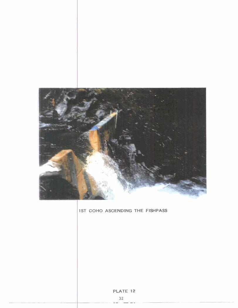
ST COHO ASCENDING THE FISHPASS

PLATE 13
33

PLATE 14
34
--

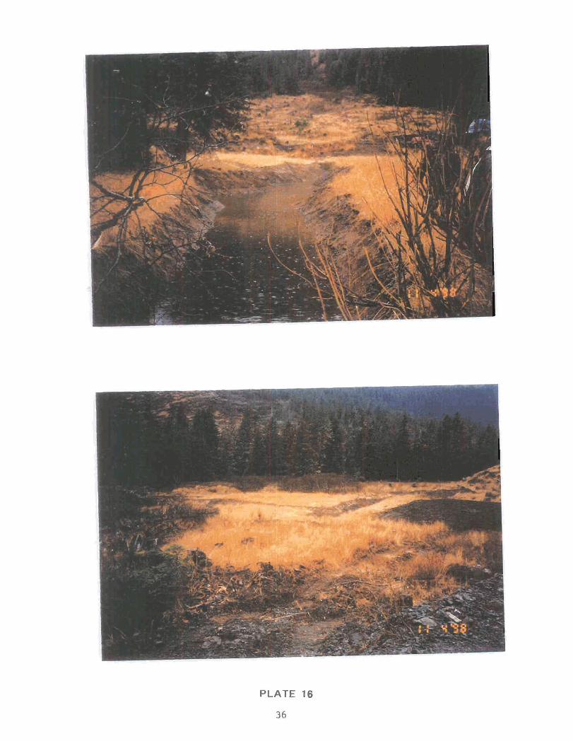
PLATE 16
36

