rainfall-induced landslides in nepal
TRANSCRIPT
Rainfall-induced Landslides in Nepal
Ranjan Kumar DAHAL1, 2
1 Department of Geology, Tribhuvan University, Tri-Chandra Campus (Ghantaghar, Kathmandu, Nepal)
E-mail: [email protected]
2 Ehime University Center for Disaster Management Informatics Research (Bunkyo-3, Matsuyama, Ehime, 790-8577, Japan)
The rainfall-induced landslides in the Nepal Himalaya extend tremendous damage to lives, property,
infrastructure, and environment, particularly in the monsoon season. This paper particularly discusses the
issues related to the rainfall-induced landslides in the Nepal Himalaya. All geological zones of Nepal were
evaluated from the landslide occurrence perspective. To evaluate the landslide processes and associated
hazards in Nepal, the rainfall-induced landslides were assessed from three perspectives: hydrological and
slope stability modelling, rainfall threshold of landslides, and landslide hazard. This paper is an outcome of
these evaluations and exclusively covers the major issues of rainfall-induced landslides in the Nepal
Himalaya.
Key words: rainfall-induced landslide, Nepal, Himalaya, rainfall threshold, landslide hazard
1. INTRODUCTION
Approximately 2,400 km long Himalayan
mountain chain is tectonically one of the most active
mountain ranges on the earth. These mountainous
terrains of the Himalaya are home to millions of
people in northern India, northern Pakistan, Nepal,
Bhutan, and parts of other Asian nations. Rugged
topography, unstable geological structures, soft and
fragile rocks, along with heavy and concentrated
rainfalls during monsoon periods collectively cause
severe land sliding problems and related phenomena
in the Himalayan region. The annual economic loss
due to landslide damages alone in this region is
estimated to exceed one billion US dollars,
including hundreds of human fatalities. Studies
indicate that the loss due to landslides and related
problems in the Himalayan region alone constitutes
about 30 percent of the world's total
landslide-related damage value [Li, 1990]. A large
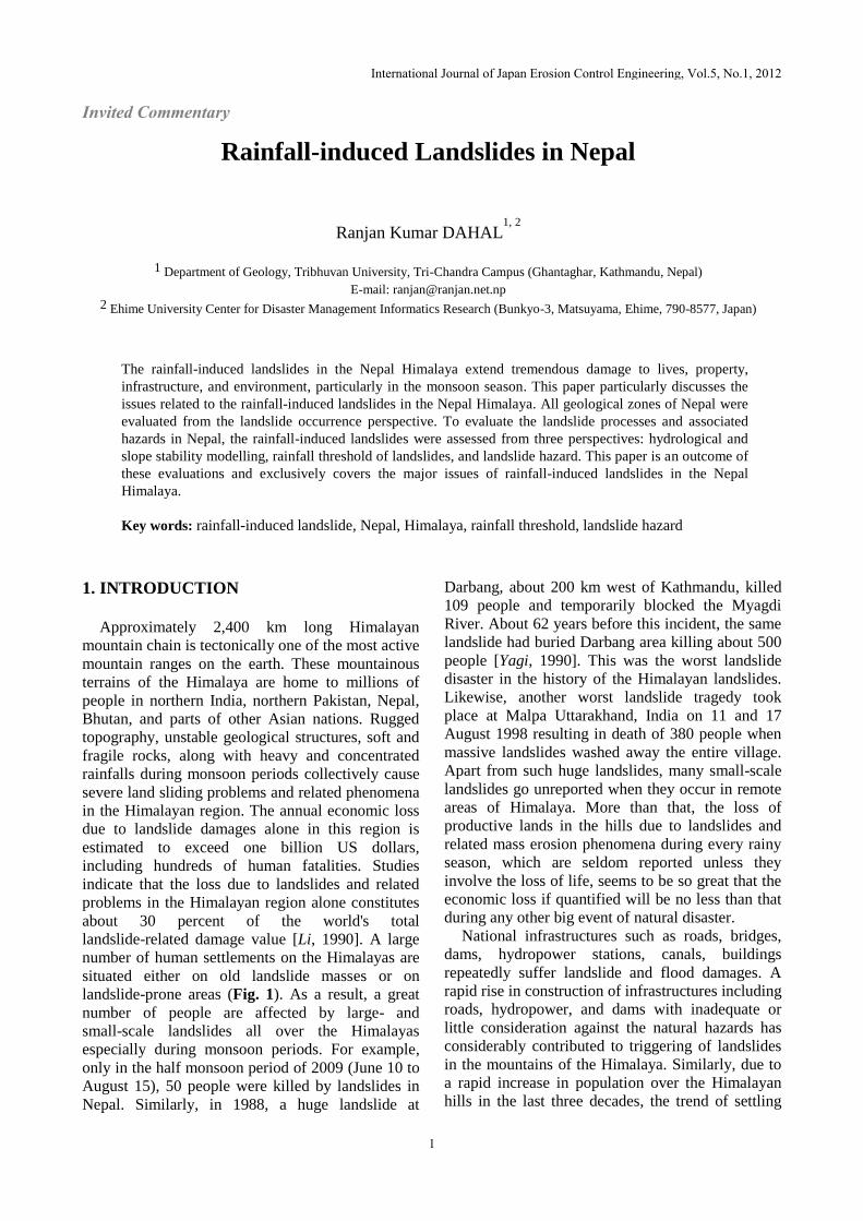
number of human settlements on the Himalayas are
situated either on old landslide masses or on
landslide-prone areas (Fig. 1). As a result, a great
number of people are affected by large- and
small-scale landslides all over the Himalayas
especially during monsoon periods. For example,
only in the half monsoon period of 2009 (June 10 to
August 15), 50 people were killed by landslides in
Nepal. Similarly, in 1988, a huge landslide at
Darbang, about 200 km west of Kathmandu, killed
109 people and temporarily blocked the Myagdi
River. About 62 years before this incident, the same
landslide had buried Darbang area killing about 500
people [Yagi, 1990]. This was the worst landslide
disaster in the history of the Himalayan landslides.
Likewise, another worst landslide tragedy took
place at Malpa Uttarakhand, India on 11 and 17
August 1998 resulting in death of 380 people when
massive landslides washed away the entire village.
Apart from such huge landslides, many small-scale
landslides go unreported when they occur in remote
areas of Himalaya. More than that, the loss of
productive lands in the hills due to landslides and
related mass erosion phenomena during every rainy
season, which are seldom reported unless they
involve the loss of life, seems to be so great that the
economic loss if quantified will be no less than that
during any other big event of natural disaster.
National infrastructures such as roads, bridges,
dams, hydropower stations, canals, buildings
repeatedly suffer landslide and flood damages. A
rapid rise in construction of infrastructures including
roads, hydropower, and dams with inadequate or
little consideration against the natural hazards has
considerably contributed to triggering of landslides
in the mountains of the Himalaya. Similarly, due to
a rapid increase in population over the Himalayan
hills in the last three decades, the trend of settling
International Journal of Japan Erosion Control Engineering, Vol.5, No.1, 2012
1
Invited Commentary

over comparatively hazardous areas is in rise. Thus,
the increasing levels of risk from the landslides
triggered by hydro-meteorological variability
perpetually entail considerable loss of life and
property losses and inflict significant damage on the
vital economic system of the nations in the
Himalayan Region. Landslides in the Himalaya are
size-dependent, from massive extent of whole
mountain ranges through failure of single peaks to
very minor slope failures [Shroder and Bishop,
1998].
Fig. 1 Living with landslides in Nepal, two typical
Himalayan landslides, a. Bhotekoshi River valley (north
east of Kathmandu) of Sindhupalchowk district, near to
the China border (photo courtesy B.N. Upreti) and b.
Laprak village, a famous village near to the Mt Manaslu
of Gorkha district (photo courtesy N. Gurung). See Fig. 2
for location.
Processes and causes that contribute to
landsliding in Nepal can be put in four categories:
(i) geological causes (weak, weathered, sheared
materials, and contrast in permeability of materials);
(ii) morphological causes (fluvial, erosion of slope
toe, tectonic uplift, erosion of marginal sides; (iii)
physical causes (intense rainfall, prolonged or
exceptional precipitation, earthquake, and
snowmelt); and (iv) human causes (deforestation,
irrigation, mining, road construction, water leakage,
land use changes).
In Nepal, intense rainfall may be regarded as the
main triggering factor of landslides because most
landslide disasters in the region occur in monsoon
period every year making a great number of people
suffer heavily in large- and small-scale landslides
throughout the country. With all this in the
background, this paper highlights monsoon rainfall
and landslides in the Nepal Himalaya.
2. GEOLOGY AND GEOMORPHOLOGY
IN BRIEF
Geomorphology, geology, and climate play the
most important role in preparatory process of
landslide initiation in any region. With 83% low to
high mountainous area, Nepal covers approximately
one third of the Himalayan mountain ranges (800
km) in the central Himalaya.
The Nepal Himalaya has eight well-defined
regional geomorphologic zones in north–south
direction: 1) Terai (the northern edge of the
Indo-Gangetic plain), 2) Siwalik (Churia) Range, 3)
Dun Valleys, 4) Mahabharat Range, 5) Midlands, 6)
Fore Himalaya, 7) Higher Himalaya, and 8) Inner
and Trans Himalayan Valleys [Hagen, 1969]. Each
of these zones has unique altitudinal variation, slope
and relief characteristics, and climatic pattern. A
digital elevation model (DEM)-based regional
geomorphologic map of Nepal is shown in Fig. 2.
The structural framework of the Himalaya is
characterized by three northerly inclined major
breaks in the upper crust of the Indian Plate namely,
the Main Central Thrust (MCT), the Main Boundary
Thrust (MBT) and the Main Frontal Thrust (MFT).
Fig. 2 Regional geomorphological map of Nepal
(modified after Dahal and Hasegawa, 2008). Inset shows
location of Nepal in the Himalaya.
These thrust faults distinctly separate the tectonic
zones in the Nepal Himalaya, which include the
Higher Himalayan Zone, Lesser Himalayan Zone,
International Journal of Japan Erosion Control Engineering, Vol.5, No.1, 2012
2

Siwalik Zone, and Terai Zone (Fig. 3). The MFT on
the south separates the sedimentary sequence of the
Sub-Himalayan (Siwalik) Zone and the alluvial
deposits of Gangetic Plains. The MBT separates the
low grade metamorphic rocks of the Lesser
Himalayan Zone and the Siwalik Zone. Likewise,
the MCT is a boundary between the high grade
metamorphic rocks of the Higher Himalayan Zone
and the Lesser Himalayan Zone [Schelling, 1992].
Moreover, the South Tibetan Detachment System
(STDS) marks the boundary between the Higher
Himalayan Zone and the overlying sedimentary
sequence of the Tibetan-Tethys Himalayan Zone.
Fig. 3 Geological map of Nepal (modified after Dahal 2006)
3. CLIMATE AND MONSOON RAINFALL
Climate of Nepal is extremely varied and
controlled by the monsoonal winds and the regional
geomorphology. It ranges from seasonably humid
subtropical to semiarid alpine. In Nepal, monsoon is
the major source of rainfall in summer and
approximately 80% of the total annual precipitation
takes place in June to September, whereas western
winds are responsible for limited precipitation in
winter beginning November until February.
Topography and aspect of mountain slope also make
local change in rainfall, wind and temperature. The
south facing slopes of Nepal Himalaya have a
higher rate of insolation and usually have higher
evaporation rates [Upreti and Dhital, 1996]. As a
result, such slopes always have less vegetation in
comparison with north facing slopes. In Nepal,
elevation is the most leading factor for climatic
changes. Travelling from south towards North,
variation in the climate can be experienced as being
hot, warm, cool, cold, and very cold. Based on this
climatic variation, Nepal can be divided into six
climatic zones: tropical, subtropical, warm
temperate, cool temperate, alpine, arctic or tundra.
In global sense, the climate of Nepal is tropical
monsoon, except for parts of the north of the
country, which are in the rain shadow of the
Himalayas and have a cold semi desert climate. The
wet monsoon is responsible for almost 90% of the
south Asian water demand.
The monsoon enters Nepal during the first week
of June and it brings extreme rain until September.
The duration of the monsoon and amount of rain
varies across Nepal, the western one third of the
country being drier than the east. Monsoon
depressions move from southeast to northwest, on
average at the rate of two per month, bringing
heavier bursts of rain. The monsoon is longest and
wettest in the eastern part of the country.
Conversely, winter monsoon due to frontal system,
generates more concentrated rainfalls in western
part of Nepal and very low in eastern part. These
rainfalls contribute to one fifth of the total annual
rainfall. Similarly, heavy rainfall in November and
December is rare. The Nepalese climate therefore
shows a very marked dry season lasting from mid
October until May, and during this period, many
locations experience severe drought.
The measured values of mean annual
precipitation in Nepal range from a low of
approximately 250 mm at a few areas on the north
of the Himalaya to many areas exceeding 6,000 mm
especially in an around Pokhara area. The annual
rainfall in the capital city of Kathmandu (central
Nepal) generally exceeds 1,350 mm. The mean
annual rainfall varying between 1,500 mm and
2,500 mm predominate over most of the country.
Daily distribution of precipitation during the rainy
season is also uneven. Sometimes, 10% of the total
annual precipitation can occur in a single day while
50% of the total annual rainfall can also occur
within 10 days of the summer. This type of uneven
distribution of precipitation plays an important role
in triggering landslides in Nepal.
The orographic effect of the mountains is the
main cause of extreme rainfall in Nepal during
monsoon. The prevailing winds (moisture-laden
vapor) from the Arabian Sea and the Bay of Bengal
get intercepted by the mountains. As the air hits a
higher land, it is forced to rise. When the air rises
above the dew point, it can no longer hold all its
water, and it starts to condense. This results in high
rainfall across the southern flanks of the Himalayan
range (windward face) and low rainfall behind
Himalaya (leeward face). The orographic effect of
the Mahabharat Range is also significant in whole
Nepal and windward face of the range usually
suffers much rainfall in monsoon. The orographic
effect of the Fore Himalaya is responsible for
extreme monsoon rainfall in Midland. The
topographic profiles of eastern, central and western
International Journal of Japan Erosion Control Engineering, Vol.5, No.1, 2012
3

Nepal clearly suggest this phenomenon (Fig. 4).
Moreover, in the southern part of central Nepal, the
elevation is relatively lower than other parts of the
country (Fig. 5) but abruptly rises in the north as
Dhaulagiri, Annapurna and Manaslu ranges. As a
result, Pokhara area generally gets much more
rainfall than other parts of Nepal because of strong
orographic effect of Annapurna and Dhaulagiri
ranges (Fig. 5b). Likewise, central Nepal always has
high values of both mean annual rainfall and
extreme 24-hour rainfall (Fig. 6).
Fig. 4 Topographic profile of eastern, central and western
Nepal. The location of profile lines are given in Fig. 7a.
Fig. 5 a. Relief map of Nepal, a lower altitude area is
situated inthe area between west of Kathmandu and
Pokhara. The topographical profile of line AA’, BB’ and
CC’ already given in Fig. 4. b. Topographical profile
(through line MM’ in Fig. 5a of Nepal Himalaya with
illustration of climatic zones, main geology and
geomorphology.
4. LANDSLIDES IN NEPAL
Brief scenario of landslide occurrences in various
geomorphic provinces are described below.
The Siwalik (Churia) Range is made up of
geologically very young sedimentary rocks such as
mudstones, shale, sandstones, siltstones and
conglomerates. These rocks are soft, unconsolidated
and easily disintegrable. The Upper Siwalik
contains thick beds of conglomerates and they are
loose and fragile. Similarly, Lower Siwalik and
Middle Siwalik have problem from alternating beds
of mudstones and sandstone.
Fig. 6 Rainfall distribution in Nepal. a. Mean annual
precipitation; b. Maximum rainfall of 24 hours.
In such alternating bands, mudstone can flow
when saturated with water which results in
overhanging sandstone beds. Such overhang jointed
sandstone beds easily disintegrate into blocks.
Similarly, throughout Nepal, the rainfall within
Churia Range is normally in the range of 2,000 to
2,500 mm per year. As a result, geological
conditions and the climate render the Churia Range
highly susceptible to landslides processes.
The Mahabharat Range belongs to the Lesser
Himalayan Zone. It is the most important barrier of
the monsoon clouds and it greatly influences the
rainfall distribution pattern in Nepal. Almost in
whole Nepal, the southern face of Mahabharat
Range gets extensive rainfall in comparison to
Midland. The annual rainfall in Mahabharat Range
area is comparatively higher and the frequency of
high intensity rainfall is also high. Thus, these areas
get extensive problem of floods, debris flows and
shallow landslides. These events periodically
International Journal of Japan Erosion Control Engineering, Vol.5, No.1, 2012
4

cause big disaster events. The disaster of south and
southeast Kathmandu in 1993 and the disaster of
Mugling-Narayanghat Road of central Nepal in
2003 are a few examples of such problems. Not only
rainfall but geological condition and very steep
slopes also play a major role in causing soil slips
and debris flows in the Mahabharat Range. From
field observation, it is noticed that in the area made
up of rocks such as limestone, dolomite marble and
granites, the slopes are comparatively stable in the
Mahabharat Range, whereas the area consisting of
rocks such as phyllites, slates, intercalation of
phyllites and quartzites render the terrain to be
heavily prone to landslides.
The Midlands also belongs to the Lesser
Himalayan Zone and is situated at the north of the
Mahabharat Range. It has a gentle topography
compared to Churia and Mahabharat ranges. The
slopes are also comparatively gentler than in other
zones of Himalaya. Thick soil formations are found
in slopes of the Midlands because of deeply
weathered rocks. As a result, the slopes are very
prone to landslides, especially after an intense
rainfall. Usually, Midlands is considered as rain
shadow zone of the Mahabharat Range, which only
receives a total annual rainfall of 1,000 to 2,000
mm. Most of the population of Nepal lives in the
Midlands, and for this reason, this zone is
intensively cultivated. Irrigation system can be
found in every terrace on slope as well as on old
landslide debris, and mismanagement of irrigation
canals can be noticed everywhere. These improper
agricultural practices generally contribute to land
sliding or reactivate old landslides and usually
damage whole settlement on the slope.
The Fore Himalaya is a northern part of Midlands
and it is the frontal portion of the Higher Himalaya.
Geologically, it is generally belongs to the Lesser
Himalayan Zone in many places but in some places
it is the Higher Himalayan Zone. Thus, main rock
types of this province are phyllites, schists, marble,
quartzites, and gneisses. Tectonically, this zone is
very active and uplifting at a high rate, and the
topography is steep and rugged (Upreti 2001).
Similarly, like the south faced slope of the
Mahabharat Range, the Fore Himalaya also gets
high rainfall in the range between 2,000 and 3,500
mm. This province is also another vulnerable area
for landslide occurrence, but because of less soil on
steep slope, mainly rock related failure problems are
very frequent. Some landslide dams are also noticed
in narrow river valleys of this province.
The Higher Himalaya province covers the highest
area of Himalaya. It includes all elevated peaks and
their slope exceeding 5,000 m in altitude.
Geologically, this province belongs to the Higher
Himalayan Zone and the Tibetan-Tethys Himalayan
Zone in some extent and main rock types of this
zone are gneiss, schist, marble and quartzite.
Vertical or steep rocky slopes are very common in
this province. Usually, the southern face of the
province generally receives high precipitation.
Mainly, in this province, there is no or little soil
cover on slopes and rock related failure phenomena
are very common, but because of very low
population and non-existent infrastructure
development, the degradations of the Higher
Himalaya are not attentive for planners and
researchers.
The province behind (north) the Higher Himalaya
is called Trans Himalaya. Geologically, this
province belongs to the Tibetan-Tethys Himalayan
Zone. This area is situated in the rain shadow zone
of the greater Himalayan Range. This zone has very
low average annual rainfall in comparison to the
Midlands and the Fore Himalaya. Thus, soil related
landslides are less frequent but debris flow in a
snow-fed stream is quite common. River banks
made of alluvial and glacial moraine possess bank
failure problem.
5. EVALUATION OF LANDSLIDE
PROCESSES AND HAZARDS
To understand landslide processes, mechanism
and associated hazard, rainfall-induced landslides of
the Nepal Himalaya are evaluated from three
perspectives: hydrological and slope stability
modeling, rainfall threshold of landslides, and
landslide hazard study. The findings of the research
are briefly described in following paragraphs.
The hydrological and slope stability study was
performed with the help of physically-based models
as per the physico-mechanical law of conservation
of mass, energy, momentum and the equilibrium of
forces. GeoSlope software package and
self-developed heuristic approach were used for
hydrological and slope stability modelling. For the
rainfall threshold for the landslides in the Nepal
Himalaya, empirical relationships were developed
and they were correlated with global rainfall
threshold for land sliding. Statistical and
deterministic hazard modelling has been done to
perform rainfall-induced landslides hazard
evaluation in the Nepal Himalaya.
When spatial distribution of landslides was
evaluated from a historical landslide record at 677
locations, it was found that greater number of
landslide events were concentrated (Fig. 7) in
central Nepal, in the area of high mean annual
International Journal of Japan Erosion Control Engineering, Vol.5, No.1, 2012
5

rainfall between Pokhara and Kathmandu. The
small-scale rainfall-triggered landslides in Nepal are
generally shallow (about 0.5 to 2.5 m thick) and are
triggered by changes in physical properties of slope
materials during rainfall. Relatively large-scale and
deep-seated landslides, on the other hand, are
affected by long-term variation in rainfall.
Fig. 7 Landslide distribution in Nepal. This map was
preparedusing more than 677 landslide events. The map
does not represent total landslides events in Nepal.
When monsoon rainfall and landslide
relationship was taken into consideration, it was
noticed that a considerable number of landslides
were triggered in the Himalaya by continuous
rainfall of 3 to 90 days. It has been noticed that
continuous rainfall of 5 days or 7 days or 10 days
are usually responsible for landsliding in the Nepal
Himalaya. Fig. 8 shows some examples of rainfall
and landslide occurrence time during monsoon
period in eastern Nepal. It clearly demonstrates the
relationship of progressive monsoon rainfall and
frequency of land sliding. Monsoon rains usually
fall with interruptions of 2–3 days and are generally
characterized by low intensity and long duration.
Thus, there is a strong role of antecedent rainfall in
triggering landslides. It is suggested that a moderate
correlation exists between the antecedent rainfalls of
3 to 10 days and the daily rainfall at failure in the
Nepal Himalaya [Dahal and Hasegawa, 2008].
When rainfall threshold of landslides is considered
for research, in total, 677 landslides occurring from
1951 to 2006 were studied to analyze rainfall
thresholds of landslide in the Nepal Himalaya (Fig
7). Out of the 677 landslides, however, only 193
associated with rainfall data were analyzed to yield
a threshold relationship between rainfall intensity,
rainfall duration, and landslide initiation. The
threshold relationship fitted to the lower boundary
of the field defined by landslide-triggering rainfall
events is I = 73.90 D-0.79
(I = rainfall intensity in
mm/hr and D = duration in hours), revealed that
when the daily precipitation exceeds 144 mm, the
risk of landslides on Himalayan mountain slopes is
high. Normalized rainfall intensity–duration
relationships and landslide initiation-thresholds
were also established from the data after
normalizing rainfall-intensity data with respect to
mean annual precipitation (MAP) as an index in
which NI = 1.10 D-0.59
(NI = normalized intensity
(h-1
) and D = duration in hours).
Fig 8. Illustration of cumulative rainfall and occurrence of
landslides in eastern Nepal. Cumulative rainfall of station
1006, situated at about 60 km north east of Kathmandu,
has a linear relationship with monsoon days.
When various threshold curves for
rainfall-triggering landslides proposed by different
researcher are compared with the curve of the Nepal
Himalaya (Fig. 9), the curve proposed by Larsen
and Simon (1993) for Puerto Rico (humid-tropical
region) has greater similarity with the rainfall
threshold of landslides in Nepal. Applications of
hydrological and stability model in the ideal terrains
of the Lesser Himalaya of Nepal suggested that soil
characteristics, low internal friction angle of fines in
soil, the presence of clay minerals, bedrock
hydrology, and human intervention were the main
contributing parameters for slope failures. The clay
mineralogy of slope materials is also a contributing
factor for rainfall-triggered landslides in the Nepal
Himalaya.
By modelling pore water pressure and slope
stability in the non landslide zone and the landslide
prone zone, it was found that shallow and highly
mobile landslides in zero order basins or
topographic hollows of the Lesser Himalayan slopes
are mainly triggered by transient positive pore water
pressure in response to intense monsoon rainfall and
bedrock seepage (Fig. 10). Antecedent rainfall
affects landslide stability by reducing soil suction
and increasing transient pore water pressure.
The study on landslide and monsoon rainfall
concluded that there was a significant role of
antecedent rainfall in the Nepal Himalaya especially
in the northeastern part of central Nepal, and such
International Journal of Japan Erosion Control Engineering, Vol.5, No.1, 2012
6

rainfall was basically responsible for large-scale
landsliding.
Fig. 9 Comparison of the landslide triggering; a. rainfall
intensity–duration from various studies [modified after
Dahal, 2009] for the Nepal Himalaya
Fig. 10 Change of factor of safety with rainfall in ideal
sites of the Lesser Himalaya in Nepal
Seepage analysis of antecedent rainfall in an
area (middle part of central Nepal) has shown slight
effects on build-up of pore water pressure on the
slope. Thus, in the Lesser Himalaya of central
Nepal, extreme rainfall of one or two days is usually
responsible for shallow slope failures.
For hazard analysis, both statistical and
deterministic landslide hazard modelling was
employed in the Lesser Himalaya of Nepal. For
statistical modelling, the weights-of-evidence
modelling and information value method were
applied, within a geographical information system
(GIS), to derive landslide susceptibility maps of the
ideal Lesser Himalayan terrain of Nepal (Fig. 11).
Relevant thematic maps representing various factors
(e.g. slope, aspect, relief, flow accumulation, soil
depth, soil type, landuse and distance to road) that
were related to landslide activity were generated
using field data and landslide hazard were evaluated
with GIS techniques. The success rates (Fig. 12)
were estimated to evaluate the accuracy of landslide
susceptibility and hazard maps, and it is found that
the models are useful in landslide susceptibility and
hazard mapping even in small catchment scale. The
Digital Elevation Model (DEM)-based deterministic
distributed analysis in GIS was carried out to
calculate the probability of slope failure in an ideal
terrain of the Nepal Himalaya. When normally
distributed failure probability value were
checked against existing landslides, it was found
that more than 50% of the pixels of existing
landslides coincided with a high calculated
probability of failure. Although the deterministic
distributed analysis has certain drawbacks, as
described by previous researchers, this study
concluded that the calculated failure probability
could be utilized to predict the probability of slope
failure in Himalayan terrain during extreme rainfall
events.
Fig. 11 Landslide hazard zonation map of the
south-western hills of the Kathmandu Valley after
weights-of-evidence modelling. VHH: very high hazard,
HH: high hazard, MH: moderate hazard, LH: low hazard,
VLH: very low hazard [modified after Dahal, 2009].
6. CONCLUDING REMARKS
An analysis of the 55-year record of landslides
and rainfall events in the Himalaya has suggested
that many landslides occurred under the influence of
International Journal of Japan Erosion Control Engineering, Vol.5, No.1, 2012
7

Fig. 12 Success rate curves of landslide hazard values
alculated from three types of landslide inventory maps.
[modified after Dahal, 2009].
a wide range of rainfall durations (5 hours to 90
days). Monsoon rains usually fall with interruptions
and are generally characterized by low intensity and
long duration. As a result, landslides are usually
initiated only after few days of first monsoon
rainfall and role of antecedent rainfall for
landsliding in Nepal is bona fide. Orographic effect of Himalayan range is responsible for extreme
rainfall in central and eastern Nepal. As a result,
central Nepal usually faces many landslides related
disaster than western Nepal.
Lastly, the findings of the research on
rainfall-induced landslides in Nepal are very useful
in reducing the loss of lives and properties due to
landslides in the Nepal Himalaya.
REFERENCES
Aleotti, P. (2004): A warning system of rainfall-induced
shallow failure. Engineering Geology, Vol. 73, pp.
247–265.
Caine, N. (1980): The rainfall intensity–duration control of
shallow landslides and debris flows. Geografiska Annaler
Vol. 62A, pp. 23–27.
Cancelli, A. and Nova, R. (1985): Landslides in soil debris
cover triggered by rainstorms in Valtellina (Central Alps
-Italy). Proc. IV International Conference and Field
Workshop on Landslides, Tokyo, August 1985, pp.
267-272.
Ceriani, M., Lauzi, S. and Padovan, N. (1992): Rainfall and
landslides in the Alpine area of Lombardia Region, central
Alps, Italy. In: Interpraevent Int. Symp, Bern, Vol. 2, pp.
9–20.
Crosta, G. and Frattini, P. (2001) Rainfall thresholds for
triggering soil slips and debris flow. Proc.of EGS 2nd
Plinius Conference 2000, Mediterranean Storms, Siena, pp.
463–488.
Dahal, R.K. (2006): Geology for Technical Students, Bhrikuti
Academic Publication, Kathmandu, Nepal, 756p.
Dahal, R.K. (2009): Evaluation of rainfall-induced landslides
from the perspectives of stability analysis, rainfall threshold
and hazard in the Nepal Himalaya and Shikoku, Japan,
Unpublished PhD thesis, Kagawa University, Japan, 247 p.
Dahal, R.K. and Hasegawa, S. (2008): Representative rainfall
thresholds for landslides in the Nepal Himalaya.
Geomorphology Vol. 100, No.3-4, pp. 429-443.
Guzzetti, F., Peruccacci, S., Rossi, M. and Stark, C.P. (2007):
Rainfall thresholds for the initiation of landslides in central
and southern Europe. Meteorol. Atmos. Phys. Vol. 98,
No.3-4, pp. 239-267.
Hagen, T. (1969): Report on the geological survey of Nepal
preliminary reconnaissance. Zürich Mémoires de la soc.
Helvétique des sci. naturelles, 185 p.
Larsen, M. C. and Simon, A. (1993): A rainfall
intensity-duration threshold for landslides in a
humid-tropical environment, Puerto Rico. Geografiska
Annaler Vol. 75, No.1–2, pp. 13–23.
Li, T. (1990): Landslide management in the mountain area of
China. ICIMOD Kathmandu, Occasion Paper No. 15, 50 p.
Saito, H., Nakayama, D. and Matsuyama H. (2010):
Relationship between the initiation of a shallow landslide
and rainfall intensity-duration threshold in Japan,
Geomorphology, Vol. 118, pp. 167-175.
Schelling, D., 1992. The tectonostratigraphy and structure of the
eastern Nepal Himalaya. Tectonics, Vol. 11, pp. 925–943.
Shroder, J. F. and Bishop, M.P. (1998): Mass movement in the
Himalaya: new insights and research directions.
Geomorphology Vol. 26, pp. 13–35.
Upreti, B.N. and Dhital, M.R., (1996): Landslide studies and
management in Nepal. ICIMOD, Nepal, 87 p.
Wieczorek, G.F. (1987): Effect of rainfall intensity and duration
on debris flows in central Santa Cruz Mountains, California.
In: Crosta, G., Wieczorek G.F. (Eds.), Debris flows/
avalanches: processes, recognition and mitigation. Reviews
in Engineering Geology, Geological Society of America,
Vol. 7, pp. 93–104.
Yagi, H., Maruo, Y., Saijo, K. and Nakamura, S., (1990): The
September 1988 large landslide in the vicinity of MCT,
Darbang, Nepal. Journal of the Japan Geological Society
Vol. 6, pp. 45–49.
Zêzere, J.L., Rodrigues, M.L., Reis, E., Garcia, R., Oliveira, S.,
Vieira, G. and Ferreira A.B. (2005): Spatial and temporal
data management for the probabilistic landslide hazard
assessment considering landslide typology, In Landslides:
Evaluation and Stabilization, Lacerda, Ehrlich, Fontoura
and Sayâo (eds), Taylor & Fancis Group, London, Vol. 1,
pp. 117-123.
International Journal of Japan Erosion Control Engineering, Vol.5, No.1, 2012
8