radioactive contaminated soil removal from the sites of ... · radioactive contaminated soil...
TRANSCRIPT
Radioactive contaminated soil removal from the sites of the former Azgir nuclear test site
D. G. Gilmanov & E. Z. Akhmetov National Nuclear Centre of the Republic of Kazakhstan (NNC RK), Institute of Nuclear Physics NNC RK, Kazakhstan
Abstract
The research and engineering operations performed to clean and remove radioactive contamination from the Azgir test site improved levels of radiation in and around the site. After the operations, the possibility of contamination of personnel and the local population from radiation doses in the soil that exceed maximal permissible values for radiation were eliminated. Keywords: Azgir nuclear test site, underground nuclear explosions, radionuclides, underground cavities from nuclear explosion, radioactive wastes.
1 Introduction
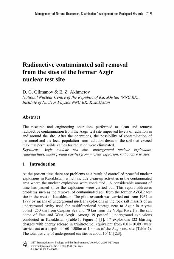
At the present time there are problems as a result of controlled peaceful nuclear explosions in Kazakhstan, which include clean-up activities in the contaminated area where the nuclear explosions were conducted. A considerable amount of time has passed since the explosions were carried out. This report addresses problems such as the removal of contaminated soil from the former AZGIR test site in the west of Kazakhstan. The pilot research was carried out from 1964 to 1979 by means of underground nuclear explosions in the rock salt massifs of an underground cavity used for multifunctional storage near to Azgir in Atyrau oblast (250 km from Caspian Sea and 70 km from the Volga River) at the salt dome of East and West Azgir. Among 39 peaceful underground explosions conducted in Kazakhstan (Table 1, Figure 1) [1], 17 explosions (22 blasting charges with energy release in trinitrotoluol equivalent from 0.01–103kt) were carried out at a depth of 160–1500m at 10 sites of the Azgir test site (Table 2). The total activity of underground cavities is about 106 Ci [2,3].
www.witpress.com, ISSN 1743-3541 (on-line)
© 2006 WIT PressWIT Transactions on Ecology and the Environment, Vol 99,
doi:10.2495/RAV060701
Management of Natural Resources, Sustainable Development and Ecological Hazards 719

Region Region Lira
Batolit
Mangyshlak
Meridian
Meridian
Meridian
Sary-Shagan
STS
ASTANA Azgir Kapustin Yar
Emba
Seismic Earth Sounding
Underground Reservoir Construction
Blasting Technology Development
Figure 1: Peaceful nuclear explosions in Kazakhstan territory.
Table 1: Chronology of underground nuclear explosions at the Bolshoi Azgir salt dome.
Site Explosion date Depth
of charge blasting, m
Explosion yield, trinitrotoluol equivalent, kt
А-I April 22, 1966 160 1.1 A-II July 1, 1968 600 27 А-III December 22, 1971 1000 up to 64 A-IV July 29, 1976 1000 up to 60 A-V September 30, 1977 1500 up to 10 A-VII October 17, 1978 1000 0.001 -20; 20-150 A-IX December 18, 1978 900 103 A-VIII January 17, 1979 1000 0.001 -20; 20-150 A-XI July 14, 1979 1000 20 А-Х October 24, 1979 1000 0.001 -20; 20-150
As a result of the explosions conducted in the rock salt massif, 9 relatively resistant cavities of different volumes (from 10,000–240,000 m3) were formed over a period of 3 decades (Figures 2 and 3). All the explosions were projected as having been fully confined i.e. without radioactive products reaching the surface. However, this was not achieved, as shown by the data of radioactive discharge duration (having become the reason for the test site contamination) from cavities over a period of some days up to months and of its total activities up to 1018 Bq. Site contamination also occurred as a result of some technological operations related to the opening of the cavity by means of additional boreholes, as well as radioactive gases with activity up to 107 Ci [4] that were injected into the atmosphere. Radioactive spots at the site were the source of secondary
www.witpress.com, ISSN 1743-3541 (on-line)
© 2006 WIT PressWIT Transactions on Ecology and the Environment, Vol 99,
720 Management of Natural Resources, Sustainable Development and Ecological Hazards

radioactive contamination of the environment (radionuclide transfer by way of wind and atmospheric fallout) and radiation risk to the public. Therefore the problem of the clearance of contaminated land was considered as current in terms of sanitary and ecological aspects.
Table 2: Peaceful nuclear explosions in Kazakhstan.
Date, years
Place (oblast) Condition Amount of
explosions
1966-1979 Guryev Construction of underground tanks of large volume in rock salt massif (А-1 – А-XI)
17
1969-1970 Mangyshlak Development of commercial explosion technology. Т-1, Т-2, Т-3 boreholes
3
1965-1974 Semipalatinsk Test Site
Experimental works on NET development in behalf of the national economy
7
1972 Ural Depth seismic “Region” sounding, Р-5 borehole 1
1972 Kustanai Depth seismic “Region” sounding, Р-5 borehole 1
1973 Turgai Depth seismic “Meridian” sounding, MN-1 borehole 1
1973 Shymkent Depth seismic “Meridian” sounding, MN-2, MN-3 borehole 2
1983-1984 Ural Construction of underground cavities “Lira” - 1÷6 6
1987 Aktyubinsk Development of nuclear explosion technology “Batolit”, BT-2 borehole 1
TOTAL 39 Research and practical measures regarding the removal of radioactive contamination at the test site were carried out according to the following activities: mapping of the contaminated area, determination of radionuclide concentration in the soil, location and arrangement of radioactive soil disposal, cleansing of the area from radioactive contamination, transfer and burying of contaminated soil, dosimetry and determination of soil specific activity at the contaminated site, refilling of excavation with pure soil, estimation of mass and total activity of removed soil.
Radionuclide concentrations, especially Cs-137, as the concentration of other radionuclides were comparatively low (at the level of natural background and global fallout), allowed to subsume excavated soil (with maximal specific activity up to 9 000 Bq/kg) to the category of low-level radioactive wastes with established intervention level –104 Bq/kg and more by Radiation Safety Standards in Kazakhstan. Under this approach specified soil just had to be removed to a nearby ground disposal location at a depth of 10 m.
www.witpress.com, ISSN 1743-3541 (on-line)
© 2006 WIT PressWIT Transactions on Ecology and the Environment, Vol 99,
Management of Natural Resources, Sustainable Development and Ecological Hazards 721

Figure 2: Cavity scheme A-VII and A-VIII.
Figure 3: Cavity scheme at site A-XI.
www.witpress.com, ISSN 1743-3541 (on-line)
© 2006 WIT PressWIT Transactions on Ecology and the Environment, Vol 99,
722 Management of Natural Resources, Sustainable Development and Ecological Hazards

2 Natural characteristics of AZGIR test site range
Geographical features of the region are its relative closeness to the Volga River and the Caspian Sea. The described area is situated in the north-west of the Caspian Sea lowlands. The test site is placed in semi-desert area on a sandy edge in a large basin with a size of approximately 15km × 20km. In geomorphological relation, the region is presented by a series of sand massifs divided by loamy plains. The basin bottom, where the test site is located, consists of clay and heavy loams alternating in some places by low-powered deposits of sand. Atmospheric fallout is accumulated in low relief, these reservoirs are completely dry from June to September. Ground waters underlie depending upon the season, the relief and geological structure at a depth of 0.1–16m from the surface. Soil cover of the territory is brown desert and salt soil. There is a definite differentiation on the genetic horizons: humus, carbonate, salt are characteristic of a brown soil profile. The thickness of the soil layer at the described area is insignificant (2-6 cm). The region’s climate is strongly continental, arid; it is formed under the predominant influence of arctic, Iranian and Turan air mass. The average annual fallout is more than 200mm. The average annual air temperature is 7.3°C. North (Summer) and East (Winter) parts steady wind at a speed of 15–20m/s and more are characterized for the region.
3 Characteristic of radioactive contaminated areas at the site
Site radiation control was carried out by a detailed method through ground survey on a grid 10m × 10m (orthogonally related directions with distances in 10m between them). At the surface of А-I, А-II, А-III, А-V and А-X sites radioactive contaminated 0.4–0.6 m2 areas (spots) are defined. These are the potential source of the second environment pollution. More contaminated sites are А-II and А-X, as by site quantity so by value of exposure (equivalent) dose rate (EDR), Figure 4. А-I, А-II, А-III, А-V and А-X sites in total amount of 200 spots are related to removal.
Soil samples selected from these spots were analyzed using alpha, beta and gamma-spectrometry methods. The following artificial radionuclides with specific activity: Am-241 up to 5.0 Bq/kg, Cs-137 up to 9 000 Bq/kg, Sr-90 up to 17 Bq/kg, Pu-239+240 up to 2.0 Bq/kg were identified; under the Radiation Safety Standards of Kazakhstan, these soils are not related to the radioactive waste category but to disposal at general industrial waste storage. In addition, Cs-137 content soil can determine the overrunning of the maximum permissible public dose because its specific activity is close to the criterion for radioactive waste (104 Bq/kg).
For the study of Cs-137 with soil particles degree of association the experiments on its leachability were carried out. Experiment results showed that no less than 95% Cs-137 was in linked form, which is not leachable with ammonium-acetated buffered solution [5].
www.witpress.com, ISSN 1743-3541 (on-line)
© 2006 WIT PressWIT Transactions on Ecology and the Environment, Vol 99,
Management of Natural Resources, Sustainable Development and Ecological Hazards 723

600
300
110
400
90130
70
100
220
180 120
100300
150
110100
100
110 150
230
190
190
100100
100 100110
900
100
100 100
90
130
100
100
50
170
N
– Emplacement Borehole – Contaminated Spots EDR > 40 mRg/h (0.4 mSv/h)
Figure 4: Radiation background at А-X site.
Even under infiltration waters, entry into the storage Cs-137 will not be leached by ground waters that exclude its further migration in solely unfavorable conditions.
Spots scheduled for elimination were located at topsoil. The total spot area does not exceed 90m2. These are formed during the process of cavity opening, under radioactive ground recovering, sampling of salt solution and different technological operations execution. The organization operating the test site (Russia) temporarily placed all the mentioned contaminations in a trench within the site and buried it in cavities А-III and А-X [6]. Analyses of layer-by-layer samples from local spots showed that basic activity was focused in the upper 10–15cm layer. Besides, maximal concentrations are defined in soil layer 5–10 cm, in comparison with 0–5 cm layer, from which the part of radionuclides was brought into the environment by the wind as well as the part that was washed by rain and melt waters. However, it is not possible to exclude the presence of radioactivity in more deep layers as excavation and re-disposal from the trench into cavity were carried out without proper quality controls. Consequently, soil cover was technologically damaged.
www.witpress.com, ISSN 1743-3541 (on-line)
© 2006 WIT PressWIT Transactions on Ecology and the Environment, Vol 99,
724 Management of Natural Resources, Sustainable Development and Ecological Hazards
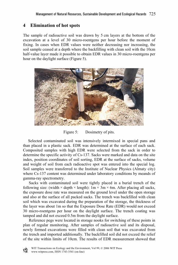
4 Elimination of hot spots
The sample of radioactive soil was drawn by 5 cm layers at the bottom of the excavation at a level of 30 micro-roentgens per hour before the moment of fixing. In cases when EDR values were neither decreasing nor increasing, the soil sample ceased at a depth where the backfilling with clean soil with the 10cm half-value layer made it possible to obtain EDR values in 30 micro-roentgens per hour on the daylight surface (Figure 5).
Figure 5: Dosimetry of pits.
Selected contaminated soil was intensively intermixed in special pans and than placed in a plastic sack. EDR was determined at the surface of each sack. Composited samples with high EDR were selected from the sack in order to determine the specific activity of Cs-137. Sacks were marked and data on the site index, position coordinates of soil sorting, EDR at the surface of sacks, volume and weight of soil from each radioactive spot was entered into the special log. Soil samples were transferred to the Institute of Nuclear Physics (Almaty city) where Cs-137 content was determined under laboratory conditions by meands of gamma-ray spectrometry.
Sacks with contaminated soil were tightly placed in a burial trench of the following size: (width × depth × length): 1m × 3m × 6m. After placing all sacks, the exposure dose rate was measured on the ground level under the open storage and also at the surface of all packed sacks. The trench was backfilled with clean soil which was excavated during the preparation of the storage, the thickness of the layer was about 1m so that the Exposure Dose Rate (EDR) would not exceed 30 micro-roentgens per hour on the daylight surface. The trench coating was tamped and did not exceed 0.5m from the daylight surface.
Reference pegs were located in storage nooks for switching of these points in plan of regular monitoring. After samples of radioactive soil and its disposal, newly formed excavations were filled with clean soil that was excavated from the trench and imported additionally. The backfilled soil did not exceed the relief of the site within limits of 10cm. The results of EDR measurement showed that
www.witpress.com, ISSN 1743-3541 (on-line)
© 2006 WIT PressWIT Transactions on Ecology and the Environment, Vol 99,
Management of Natural Resources, Sustainable Development and Ecological Hazards 725

the radiation situation in sites which had spots of radioactive contamination had significantly improved after taking some action on the decontamination of areas of sites. Values of EDR amounted to 900 micro-roentgens per hour before room works and they were between 20 to 30 micro-roentgens per hour after room works (Table 3).
Figure 6: Depositing of radioactive soil in trench storage.
Table 3: Dosimetry in А-X site after cleansing, EDR (mR/h).
before elimination
after elimination
before elimination
after elimination
before elimination
after elimination
April July August April July August April July August No of points EDR EDR EDR No of
points EDR EDR EDR No of points EDR EDR EDR
1 100 25 25 9 400 30 30 17 150 31 30 2 270 30 30 10 110 30 30 18 150 25 25 3 280 25 30 11 100 31 30 19 120 30 26 4 110 25 27 12 150 30 30 20 900 23 25 5 170 30 30 13 130 32 32 21 100 27 24 6 190 30 32 14 200 33 32 22 110 30 28 7 110 30 30 15 170 30 31 23 100 23 25 8 160 30 32 16 150 29 28 24 110 24 24
5 Conclusion
The total weight of the excavated radioactive soil was 5060kg. The average concentration and total activity of Cs-137 in the removed soil was 5000Bq/kg and 3×10⁷Bq. The research carried out and the engineering works on decontamination and the removal of radioactive contamination from the area of the Azgir test site made it possible to for the radiological situation at the test site and in surrounding areas to be improved. After performing the abandonment
www.witpress.com, ISSN 1743-3541 (on-line)
© 2006 WIT PressWIT Transactions on Ecology and the Environment, Vol 99,
726 Management of Natural Resources, Sustainable Development and Ecological Hazards
operations, danger to personnel and population from radiation doses which were previously over the safe rating values for radioactive soil contamination were excluded.
References
[1] S.A. Berezin, D.G. Gilmanov, Zh. R. Zhotabaev, K.K. Kadyrzhanov and others. NNC RK Bulletin, 3rd edition, 2001.
[2] A.S. Krivokhatsky and others. The main characteristics of radiation situation after completion of underground nuclear explosions in the interests of national economy in the salt- dome deposit land of Bolshoi Azgir (Kazakhstan). Preprint RI-223 SPA “Radium Institute”, CSRIatominform, 1992.
[3] E.Z. Akhmetov, D.G. Gilmanov and others. AZGIR testing site. Preprint 1-96, Institute of Nuclear physics, Almaty, 1996.
[4] A.S. Krivohatsky and others. Radionuclide effects due to peaceful underground nuclear explosions in the salt deposit land of Bolshoi Azgir. CSRIatominform Bulletin, M, 1993, No 9.
[5] E.Z. Akhmetov et al. The granulometrical fractions of soil, distribution of Cesium-137 on its and the fastening of soil surface contaminated by radionuclides at locations of the “Azgir test site”. International workshop. Effect of ionizing radiation on ecological situation of countries from Caucasian region and Caspian Sea basin. Azerbaijan, Baku, 2002, p. 92.
[6] Analysis and phased improvement of radiation situation near the object “Galit”. Report of SPA “Radium Institute” .S-P, 1994.
[7] Suitability evaluation of places and facilities in Degelen and Azgir in the Republic of Kazakhstan as location for radioactive waste burial. Report No D -1/96, NNC RK fund, 1997.
[8] D.G. Gilmanov, E.Z. Akhmetov, J. Ziegenhagen and others. West Azgir Salt Dome as Massif for Locating Radioactive Waste Burial. NNC RK Bulletin, 1st edition, 2005.
www.witpress.com, ISSN 1743-3541 (on-line)
© 2006 WIT PressWIT Transactions on Ecology and the Environment, Vol 99,
Management of Natural Resources, Sustainable Development and Ecological Hazards 727