radiation measurement by unmanned aircraft after … 1 sess… · radiation measurement by unmanned...
TRANSCRIPT

Radiation measurement by unmanned aircraft after Fukushima Daiichi
nuclear power plant accident
Remotely Piloted Aircraft Systems Symposium ICAO Headquarters, Montréal, Canada
23 – 25 March 2015
Japan Atomic Energy Agency (JAEA) Sector of Fukushima Research and Development,
Fukushima Environmental Safety Center,
Tatsuo TORII, and Yukihisa SANADA

➢ Time: 2:46pm on Friday, March 11, 2011. ➢ Epicenter : Offshore Sanriku coast (38ºN, 142.9ºE, 24km depth) ➢ Magnitude: 9.0 (maximum registered JMA intensity level was 7 at Kurihara, Miyagi prefecture)
Human damage as of March 14, 2014 ➢ Deaths : 15,884 ➢ Missing : 2,633
Source: Report of the Japanese Government to the IAEA Ministerial Conference on Nuclear Safety (June 18, 2011)
3/11/2011 Great East Japan Earthquake 1

Fukushima Daiichi NPP after Tsunami and H2 explosions 2

Nuclear safety research
Universal nuclear science and technology basis Basic nuclear engineering, state-of-the-art basic research, etc.
Securing long-term energy supply Solving global environmental issues
Creating science & technology Basis with international competency
Activities to secure safe and peaceful use of nuclear energy
Nuclear nonproliferation Cooperation with academia and industries, international collaboration, human resource development ・・・
Decommissioning & disposal of low-level waste
Quantum Beam Technology Research
HTGR and nuclear hydrogen production
Nuclear Fuel Cycles
Support of LWR cycle industry
Fusion Research & Development
FBR Cycle Technology
JAEA’s Main Missions
Geological Disposal technology for High-Level Radioactive Waste
Monju
J-PARC
Broader Approach
ITER
Mizunami Horonobe
Technology Development for the Environmental Remediation and Decommissioning of TEPCO’s Fukushima-Daiichi NPPs
3

JAEA Roles
JAEA : Japan Atomic Energy Agency
has the responsibility as the one and only institution dedicated to the
comprehensive research and development of nuclear energy-related technology in the country;
makes full use of our human resources and research facilities in responding to Fukushima-Daiichi NPPs accident, aiming at the greatest possible contribution, and
continues to be involved in the restoration effort from the accident from a mid- and long-term perspective.
4

Aerial Monitoring
Our Activity for Fukushima Remediation 5
Manned helicopter
Unmanned airplane (UARMS)
Radioactivity radiosonde
Unmanned helicopter
Multicopter (Drone)
Plastic scintillation fiber Spectrometer for bottom of water
Unmanned observation boat
Remote operatly vehicle
Development of remote radiation measurement for Fukushima area
- for decommissioning Fukushima Daiichi NPP
- for nuclear emergency (post-accident)
NPP

Manned helicopter
Unmanned airplane
Unmanned helicopter
Multicopter
Detector
Standard altitude of ground level 300 m* 150 m 80 m 10 m
Air Speed 185 km/h 108 km/h 28.8 km/h 7.2 km/h
Flight Time 90 min 360 min 90 min 10 min
Max. Payload 100 kg* 10 kg 10 kg 3 kg
Flight Range ~ 100 km > 10 km < 3 km < 1 km
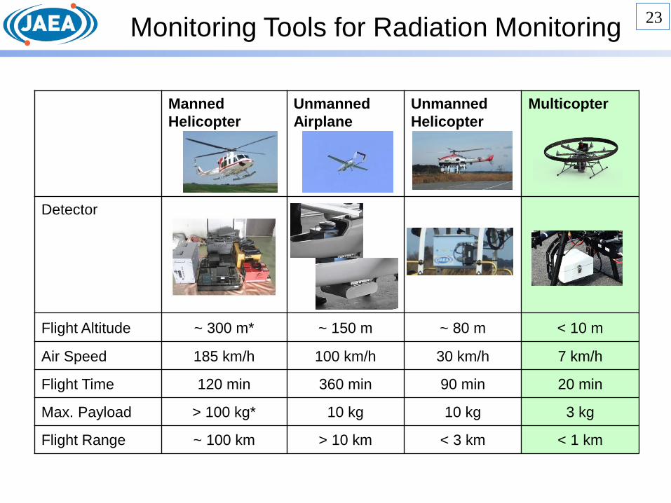
Monitoring Tools for Radiation Monitoring 6

Cesium Deposition and Air Dose-Rate Measured by Manned Helicopter
Dose rate 134Cs + 137Cs
Radiation monitoring in a wide range
7

Time Variation of Air Dose-Rate around Fukushima Daiichi NPP
8 After 24 months※
(2013.03.11) After 20 months
(2012.11.16) After 30 months
(2013.09.28)
After 7 months (2011.11.05)
After 15 months (2012.06.28)
After 11 months※ (2012.02.10)
8
Air dose-rate gradually decreased
8
Snow Area FDNPP FDNPP FDNPP
FDNPP FDNPP FDNPP
Air dose-rate at 1-m height above the ground (unit: micro Sv/h)

Monitoring Tools for Radiation Monitoring
Manned Helicopter
Unmanned Airplane
Unmanned Helicopter
Multicopter
Detector
Flight Altitude ~ 300 m* ~ 150 m ~ 80 m < 10 m
Air Speed 185 km/h 100 km/h 30 km/h 7 km/h
Flight Time 120 min 360 min 90 min 20 min
Max. Payload > 100 kg* 10 kg 10 kg 3 kg
Flight Range ~ 100 km > 10 km < 3 km < 1 km
9

Gamma-Rays
Above forest and cultivated land
Control signal
・Data of radiation dose ・GPS and ITV data
Ground station and antennas
Detector
DEVELOPMENT OF AUTONOMOUS UNMANNED HELICOPTER (AUH) RADIATION SURVEY SYSTEM
《Feature》 1. Measurement at the places (high dose
rate areas, forests, rice fields, etc.) which people cannot come into easily.
2. A ground base can be installed in a safe place (< several kilometers)
3. The image of a measurement place can also be grasped in real time.
4. Position information (GPS, video cam) 5. Programming flight. 6. Observation at a low altitude (below min. safety alt. of manned aircraft) 7. Hovering * Flight in the area where a person is not
below
For monitoring around the Fukushima Daiichi Nuclear Power Plant ・Mapping of dose-rate distribution ・Reduction of the operator’ exposure ・Small man-power For decontamination evaluation ・It can measure repeatedly the same place by programing flight.
10
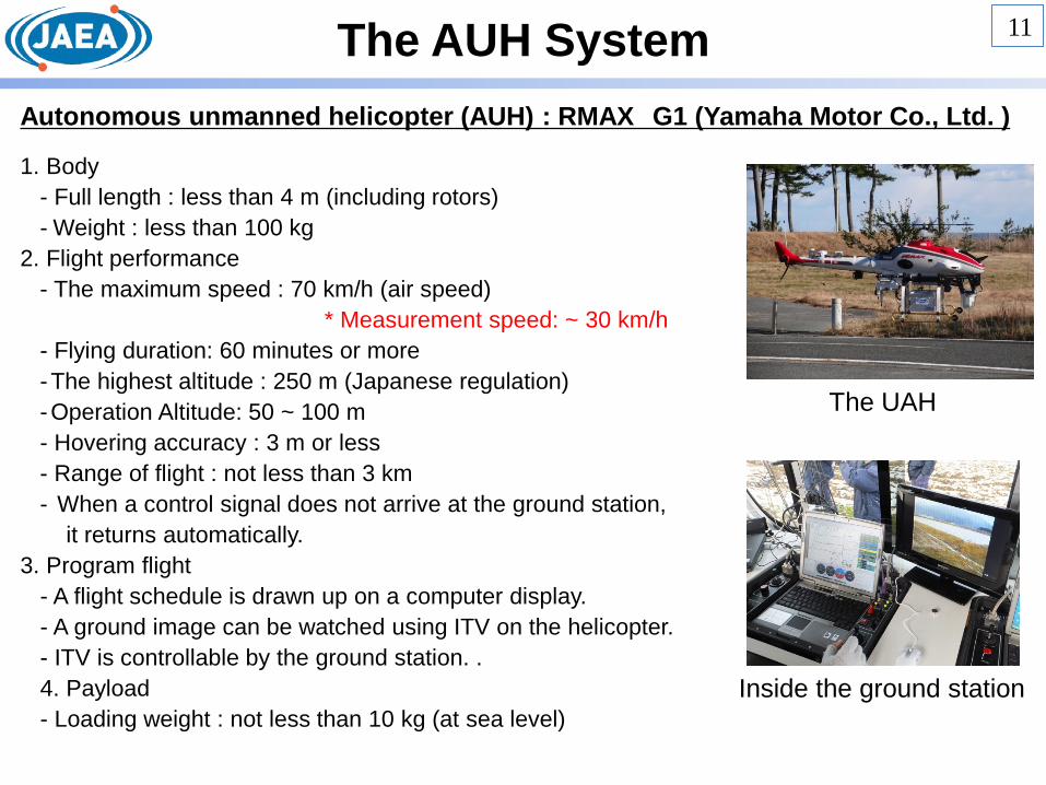
The AUH System Autonomous unmanned helicopter (AUH) : RMAX G1 (Yamaha Motor Co., Ltd. )
1. Body - Full length : less than 4 m (including rotors) - Weight : less than 100 kg
2. Flight performance - The maximum speed : 70 km/h (air speed) * Measurement speed: ~ 30 km/h - Flying duration: 60 minutes or more -The highest altitude : 250 m (Japanese regulation) -Operation Altitude: 50 ~ 100 m - Hovering accuracy : 3 m or less - Range of flight : not less than 3 km - When a control signal does not arrive at the ground station, it returns automatically.
3. Program flight - A flight schedule is drawn up on a computer display. - A ground image can be watched using ITV on the helicopter. - ITV is controllable by the ground station. . 4. Payload - Loading weight : not less than 10 kg (at sea level)
The UAH
Inside the ground station
11

Monitoring Results by the AUH
Oct. 25, 2012
Jan. 16, 2014
FDNPP
Around the FDNPP Around a River Bed
Movement and decrement of the radioactive cesium which deposited in the riverbed
Detection of traces of plume
12

Before After
Decontamination area Dose rate at 1m on the ground (mSv/h)
Dose rate at 1m on the ground (mSv/h)
Monitoring before/after decontamination work
Because we can fly many times by the same route, we can confirm an effect of decontaminating it in the AUH.
13

Monitoring Tools for Radiation Monitoring
Manned Helicopter
Unmanned Airplane
Unmanned Helicopter
Multicopter
Detector
Flight Altitude ~ 300 m* ~ 150 m ~ 80 m < 10 m
Air Speed 185 km/h 100 km/h 30 km/h 7 km/h
Flight Time 120 min 360 min 90 min 20 min
Max. Payload > 100 kg* 10 kg 10 kg 3 kg
Flight Range ~ 100 km > 10 km < 3 km < 1 km
14

Development the UARMS (Unmanned Airplane for Radiation Monitoring System)
JAXA JAEA
• Developing new radiation detectors for the URARMS
• Developing the analyzing and mapping method of the distribution of radioactive substances in the environment.
Collaboration with JAXA (Japan Aerospace Exploration Agency)
Aerial Standoff Detection (Autonomous UAV system)
Flight duration: 6 h Wide range monitoring of radiation
above the forest ( > 10 km) Measures in nuclear emergency
(atmospheric radioactivity)
• Developing the UARMS • Developing Terrain Following Mode Safety System • System Safety Design
15
Unmanned Airplane
Radiation Detector
Ground Station

Development of the UARMS
item spec UARMS prototype Additional Capability
weight ~ 50 kg ◎
engine Gasoline (16 L) ◎
Flight time 6 h ○ 6 h
speed 25~35m/s (90~126km/h) ◎
Ground run 200~300m ◎
Altitude Around 150 m (To fly below MSA) ◎
operation Programmed Flight Taking-off/landing: manual operation
○ Terrain Following
Safety Parachute, system redundant ○
(parachute,RTB) System redundant, etc.
payload 3-10 kg ○ upgrade
weather condition
Day time, even light rain is possible, wind speed: < 15
○ same
UARMS prototype UARMS
16

Flight Test around the Fukushima Daiichi NPP 17
FDNPP
Stricken by the tsunami

18
Mission Profile
(1)Preparation
(2)Takeoff
(3)Climb and Ingress
(4)Monitoring Mission
(5)Egress
(6)Descent & Approach
(7)Landing
(0)Flight Planning
If any malfunction occurs, ・RTB Mode (Return To Base) ・Forced Landing using Glide Mode ・Emergency Parachute ・Flight Termination(Applying Full Rudder)
Safety Procedure:
BVLOS (limited to un populated or lightly populated area) VLOS

Flight Data
Vertical Track
Flight On 2014.01.24
Z (m)
X (m) X (m)
Y (m)
Horizontal Track
Track: L=800m,W=50m x 21lines,Area=1km2) Altitude: 150mAGL,Airspeed: 30m/s,Flight Time: 26min
Altitude Error = ±5m Path Error =±2m
Ground Station

Monitoring Result by the UARMS
:Runway :Flight Trace
20
Air Dose-Rate
Flight trace and contour map of air dose-rate

Monitoring Flight followed the topography
The measurement range changes by altitude.
Improvement of the radiation measurement accuracy is expected by the flight that followed the topography.

Evaluation of count-rate properties during the flight
22
GPS Altitude Hold "Terrain Following"
118±27 cps 110±10 cps
Fluctuation of the count rate is small.
Monitoring Tools for Radiation Monitoring
Manned Helicopter
Unmanned Airplane
Unmanned Helicopter
Multicopter
Detector
Flight Altitude ~ 300 m* ~ 150 m ~ 80 m < 10 m
Air Speed 185 km/h 100 km/h 30 km/h 7 km/h
Flight Time 120 min 360 min 90 min 20 min
Max. Payload > 100 kg* 10 kg 10 kg 3 kg
Flight Range ~ 100 km > 10 km < 3 km < 1 km
23

24
Radiation detector
[feature] ・Safety (to fly residental areas) - Return to base - urgent stop function - small radiation detector - rotor guard - flight-log - 3D mapping
Flight in the forest and in the bldgs. of Fukushima Daiichi NPP
24

Aerial monitoring can grasp the distribution of the radioactive materials spread over a wide area by nuclear disaster visually.
We can measure the distribution of radiation level quickly by using various UAV systems depending on purposes.
As a tool measuring radiation influence in emergency, the system using UAVs which can measure radiation is effective for the safety of the researcher/engineers.
However, operators judge the ensuring safety in an altitude of 150 m or less that UAV flies now.
As a tool for nuclear energy disaster prevention effectively, it is necessary to build a system for safety flights and training flight crew continuously to use the UAVs.
Based on the Fukushima Daiichi NPP accident:
25
Thank you!