rabbit mountain management plan - boulder county
TRANSCRIPT

.. ,
~.
RABBIT MOUNTAIN
Management Plan
1. Genera 1 Description of Property
2. Management Objectives
3. Description of Property 3.A. Physical Characteristics
1. Location 2. Climate 3. Topography 4. Geology 5. Soils 6. Hydrology
3.B. Biological Environment 1. Ecosystem 2. Flora 3. Fauna
- 3.C. Cultural Environment 1. Prehistory 2. Recent History
3.D. Current Use 1. Acquisition/Lease Schedule 2. Easements
4. Management Considerations 4.A. Protection of Resource, Visitors & Neighbors
4.B. Resource Management 1. Forest Management 2.' Range Management 3. Wildlife Management
4.C. Recreation/Education 1. Outdoor Recreation 2. Special Recreation Use 3. Environmental Education
5. Bibliography
6. Appendices 1. Plants • " 2 . Birds 3. Mammals
1

\
.,'. .
. 1. GENERAL DESCRIPTION OF PROPERTYRabbit Mountain is situated on a peninsula of mountain topography which
extends from the foothills out into the plains. In addition to being theeasternmost point of the foothills in Boulder County, the Rabbit Mountain areais unique with six overlapping County Comprehensive Plan designations. Theseinclude a scenic area, a county landmark, a critical wildlife habitat, muledeer winter range, critical plant association and an archaeologically sensitive area.
Located approximately five miles northwest of Longmont, the RabbitMountain ridgetop provides a panoramic view of the Continental Divide, FrontRange and Great Plains. 'As a natural landmark it is visible from parts ofLarimer, Weld and Boulder Counties.
Two critical plant associations on the property have been identifiedthrough the Colorado Natural Heritage Inventory program. Both associationsare of state-wide and local concern.
There is a wide diversity of wildlife in the area including numeroussongbirds, raptors, small mammals, big game species and prairie rattlesnakes.Three uncommon species of birds and white-tailed deer combine to give RabbitMountain a critical wildlife habitat designation in the County ComprehensivePlan.
•
Rabbit Mountain has been widely recognized as an important geologic area ~because of its diversity of features within a small area. The Blue Mountain- ....Little Thompson fault is but one significant feature which crosses theproperty and extends into Larimer County where an adjacent 1andowner had itregistered as a Colorado Natural Area.
Preliminary surface surveys support the belief that the Rabbit Mountainarea was an important habitation site for Indians. Research is on-going to
. further our understanding of these early county .residents .
. .....
2
,. 'f"
• MANAGEMENT OBJECTIVESThe goals and policies
updated in December, 1983.Mountain property include:
of the County Comprehensive Plan were revised andThose goals of particular relevance to the Rabbit
B.1 Unique or distinctive natural features and systems and cultural featuresand sites should be conserved and preserved in recognition of theirreplaceable character of such resources and their importance to thequality of life in Boulder county. Other resources should be managed ina manner whi ch is cons i stent with sound conservati on practi ces, whi 1eenhancing compatibi11ty between natural and man-made characteristics.
B.3 Critical wildlife habitats should be conserved and preserved in order toavoid the depletion of wildlife and to perpetuate and encourage adiversity of species in the county.
B.4 Critical plant associations and rare plant sites should be conserved andpreserved to encourage a diversity of plant types within the county andto perpetuate the species.
C.1 Provision should be made for open space to meet human needs throughoutthe county in order to protect and enhance the quality of life and enjoyment of the environment.
C.2 Adequate parks and recreation facilities should be encouraged throughoutthe County and should be integrated whenever suitable with publicfacilities.
C.3 Open space should be promoted as an urban-shaping method and as a meansof protecting from development those areas which have significantenvironmental, scenic or cultural value.
C.4 A County-wide trail system shall be promoted to serve transportation andrecreation purposes.
In accordance with these adopted goals, the management objectives forthe Rabbit Mountain property include:
1. protect those plant and wildlife species which contributed to thecritical designations in the County Comprehensive Plan;
2. preserve the historical, geological and archaeological integrity of area;
3. retain as a natural open space buffer separating development in Boulderand Larimer counties;
4. manage as a wildlife sanctuary by encouraging and developing naturalfeed, cover, nesting and resting areas where appropriate;
5. restore range conditions from predominantly fair to good and excellentrange classes;
6. preserve and encourage regeneration of the ponderosa pine forest;
3

7. provide, where appropriate, on-site environmental education opportunities; 411'for the public and develop examples and demonstrations of the environ-mental ethic and proper land stewardship;
8. provide, as appropriate,· outdoor recreation opportunities which are of apassive nature and which require minimal development of the open space;
9. joi ntly develop protecti ve measures with the Northern Colorado WaterConservancy Di stri ct to warn pub1i c and 1essen hazards of the supplycanal;
10. provide a good neighbor policy to adjacent landowners.
••4

also are quite common due to the unique location of Rabbit MountainThompson Canyon on the north, plains on the east and Dowe Flats to
The warm chinook winds can be characterized by speeds of 50 to
•
('
. - 3. DESCRIPTION OF PROPERTY·3.A. Physical Characteristics
3.A1 LocationRabbit Mountain, elevation 5400' to 6060 1 above sea level, is a tract of
land in Sections 3, 10 and 11 in Township 3 North, Range 70 West, of the 6thP.M., Boulder County Colorado. It is situated in north central Boulder Countyand lies between State Hwy. 66 and the Larimer County line, northeast of lyonsand northwest of Longmont (see Map A). The actual top of Rabbit Mountain onlyreaches an elevation of 6006' and is on private land adjacent to that ownedby the County.
3.A2 ClimateSpecific temperature and precipitation data for the Rabbit Mountain area
is not available. Differences in altitude and exposure, however, generallycreate some vari ati ons in both temperature and preci pitati on. Temperaturesare likely to be slightly cooler at higher elevations of the property, andnorthern exposures slightly cooler than southern exposures. Mean annual airtemperature is estimated to be between 4]0 and 51°F, and the average frostfree period should range from 140 to 155 days.
The overall climate of the area is semi-arid with warm summers and mildto cold winters. Annual precipitation for the region ranges from about 16 11
to 20 11• Normally, there is a May precipitation maximum and a midwinter
minimum. The spring precipitation falls as rain or wet, heavy snow, whilethe summer moi sture can vary from gentl e showers to locally severe hail andelectrical storms. Some sign of lightning strikes on the pine trees has beenobserved. Winter storms can be accompanied by warm, drying chinook windswith little snow or by occasional blizzard conditions with deep and rapidaccumulations of snow.
Relative humidity in the area averages from 30 to 35% in the summer to40 to 50% during the winter months. The relatively arid conditions contributeto a high rate of evaporation.
Windsthe Littlethe south.100 mph.
3.A3 TopographyRabbit Mountain lies on the boundary of two great physiographic provinces
- the Great Plains and the Southern Rocky Mountains Province. The property isin the foothills zone of the Front Range, where the mountains rise abruptlyabove the plains. The area lies in a topographic zone two to four miles widethat is characterized by long, parallel north-south ridges separated byvalleys. The gradual rising of slopes on the east side of the ridges andthe shorter, steeper back slopes to the west produce the characteristicIIhogback ll appearance of the ridges.
The topographic relief of the County property is 660· with the highpoint (6060') on the hogback in the northwest corner and low point (5400') inthe southwest corner. The top of Rabbit Mountain, which is on private land,reaches an elevation of 6006 feet, and is conspicuous because it is surroundedby lower land on three sides. The northwest side of Rabbit Mountain is joined
5

""-.
•z
....CDN
PIKE RO
RD
OX FORO RD----_ .... --
RD
...VI
...III
:r.......CD
- .. _-- -.,,,,__ '!.E..Ll-(~.','!.S!o}E.RE .. _
ZNIWOT RD
z
oa::'"'CD
MINERAL
:rWOO LAND RD .......o
•TABLE TOP
MT VERMIL ION RD-- - - ----------
LOOKOUT RD
HWY 52
HWY 66 UTE R
...'" 1~ST
IIIR17TH r_' ~V~
,0~,~
~O a::.-;t. ...
AVE\ll'-~.
~'-VST 0-,L- a::
... ~~~'!t:rIII ...to~ ...
-0- III3RDQ. '":r a::
RDZ...
.q ROGERSIII....z
...VI
Z
:r...IIIlD
PIKE RDRD ,- ----_ __ J
i
Z
0\
~\ ,I.!":~..;.;..;.;.;....-iF;...--..;;;,---.:;:.:;1..----_t----,...---4_--P'l - -- DR%J LAKE,
t;,-J-,tD,.~ ,1YGIENE
:rl"'1
~I
Z'I... I1Ilr, .J0, VESTALa:: RD,",Ion,Z,
. ~HAYSTACK '"'
MT lD
VI,
:rl...,~,:--'__ ~T_ ~,!A.!~ .!le.. _.l. - _
:;;,I
:rlPOTATO ~l
HILL "'Izl ...
"'''l~.onZNELSON RD
~I
:rl...' ~Q.N~'!.C~ RDon lon l
I
N z,,",.--
III ...1 VI
, ,l z,
j...,Ill,
\... I,Ill ~1
onll:r on.I~ ~I'"' I.P!!O_S~Ef!., ~Z 1
PLATEAU RJj> a::)'
I C}, ~~J_'.'... ';
'Ill 3'I; OXFORD RD' :;;NEBORD 1"..;---- • _
--.., IZ1..---_ ..NIMBUS RD
I,, ----~----,.. NEVA RD , NIWOT RD- -- - - ;.:,::;....----~

•;r
(.
to the County property and the foothi 11 s to the '.'/est. Dowe Fl ats, a broad-.valley approximately one and one-half miles wide, lies southwest of Rabbit
Mountain and is surrounded on three sides by mountains.
3.A4 GeologyRabbit Mountain is a geographically complex area, with a number of
interesting structural features. The rocks of the property are sedimentary that is, rocks which have formed from pre-existing materials. The oldestrocks are part of a unit known as the Morrison formation and consist ofsandstone, limestone, shales and clays. The rocks were formed approximately140 million years ago from sediments that were laid down on ancient floodplains and large freshwater lakes. Following this, the land was inundated bya great interior sea that covered the area for millions of years, depositingover 8000 feet of sediment. These sediments compacted to form several of theformati ons found on the Rabbit Mountain property - the Dakota, Benton andNi obrara formati ons. They are made up of a vari ety of rock types, incl udi ngsandstone, limestone and shale. The formations were exposed when the seadrained off and the entire area pushed up during the great Rocky Mountainuplift that began 70 million years ago. After millions of years, the upwardmovements ceased and streams proceeded to wear down the 1andscape. Eros i onhas been the primary force acting on the mountains since the uplift, andalluvial material from streams and landslides has been left behind on portionsof the Rabbit Mountain property.
Rocks deposited as flat-lying sedimentary layers have been tilted anddip gently to the east. The westward slopes descend more abruptly from thesharp crest. These "hogbacks" have formed long, parallel north-trendingridges. The dips of the formations flatten out east of the hogbacks, merginginto the plains. The ridges are separated by parallel valleys that haveformed in the weaker, less resistant formations.
During the Rocky Mountain uplift, the rocks were not only tilted, butthe layers folded and faulted. Rabbit Mountain itself is an eroded anticline.Anticlines form when forces deep within the' earth compress the rock, forcingit to bulge upward. The Rabbit Mountain anticline is peculiarly differentfrom the other nearby anticlines in that the east side is much steeper thanthe west side. The Dowe Flats portion of the property is a syncline - atrough-like downfold of the rock layers that has produced a broad valley.Anti cl i nes and syncl i nes' alternate and generally occur ina northwestsoutheast direction in the area. Folding has formed successive offsets of thelocal Front Range foothills, and in the Rabbit Mountain area the foothillsdeviate approximately 30° to the east of their normal north-south trend.
Faulting of rock layers has also occurred in the area. A fault is simplya break in the rock along which movement has taken place. Faults and thesediments overlyi ng over them form some of the domi nant structural featuresof the area. A major fault is believed to extend across the north end ofRabbit Mountain and Dowe Flats, \-/ith several smaller faults present on theRabbit Mountain property. Faults have resulted in the repetiti on of severalrock layers to the east. Both folding and faulting have produced the geologiccomplexity of the area.' .
6

•.
The geology of the Rabbit Mountain area has been mapped in detail by the 41"",University of Colorado Geology Department, and it is considered to be an
ideal area to examine a variety of geologic formations (see Map B).
3.A5 SoilsSoils are the upper part of the mantle rock which furnishes the
substances for plant growth. The development of soil is a complex interplayof weathering and biologic processes. There are many different types ofsoil s. At fi rst it was thought that the parent rock determi ned the soiltype. Climate is now considered more important to soil type development thanis parent rock, but the situation is complex and other factors (particularlythe type of vegetation) ar:e involved. Since it takes a few hundred years fora soil to develop, conservation is very important. A combination of shallowsoils, reduced vegetation and wind can dramatically increase soil erosion.
The soils of Boulder County have been described and classified by theUnited States Department of Agri culture Soil Conservati on Servi ce. With oneexception, all of the soils in the Rabbit Mountain area (see Map C) areloams - soils composed of clay, silt and sand and organic material in varyingamounts. The predominant soil type on Rabbit Mountain is the Baller stoneysand loam (BaF). In Boulder County, the Baller series forms on the east·slopes of ridges. Large amounts of stone are on the surface and throughoutthe soil. There are small areas of rock outcrop present near ridgetops.Soils tend to be shallow and well-drained, and slopes are 9 to 35%. Runoff israpid on this soil, and the erosion hazard is high. Acreage is usually innative grass. ~
The Si xmil e stony loam (SmF) occurs in the northern part of the Rabbit'Mountain property. These soils formed on upland ridges and side slopes incalcareous loamy residuum weathered from shale. Included with this soil arenarrow bands of rock outcrop and rock escarpments .. Also included near thebase of slopes are small areas of colluvial land. Sixmile stony loam hasmoderate permeability, and slopes are 10 to 50%. Runoff is rapid and theerosion hazard is high. Soils are moderate·ly deep and are well-drained. InBoulder County, Sixmile soils support native range.
An elongate, narrow strip of the Nunn clay loam (NuD) occurs in thenorth-central area of the property. Nunn soils formed on terraces and valleyside slopes in loamy alluvium, and they are deep and well-drained. Runoff israpid on the Nunn clay loam, permeability is slow and the erosion hazard ishigh. Slopes range from 5 to 9%.· Most Boulder County acreage of this soil isused for irrigated and dryland crops and for pasture.
Two additional soils belonging to the Nunn series occur on the RabbitMountain property. Although all three are called Nunn clay loams and aredeep, well-drained soils that formed on terraces and valley side slopes inloamy alluvium, they differ in several ways. One of the remaining Nunn clayloams (NuB) occurs on the western part of the property, and has slopes of1 to 3%. Runoff is medium on this soil, permeability slow and the erosionhazard moderate. Most Boulder County acreage of this soil is used for,irrigated crops and pasture, and the r.est for dryland crops.
The other Nunn clay loam (NuC) occurs on both the eastern and westernportions of the Rabbit Mountain property, and has slopes of 3 to 5%. Runoff
7

.."
•

J;' •
Legend for Geology Map
Jm - Morrison Formation (Upper Jurassic)Klp - Dakota Group (Lower Cretaceous)
Plainview Sandstone Member of the South PlatteFormation and the Lytle Formation Undivided
Ksm - Dakota Group (Lower Cretaceous)Middle Shale Member of the South Platte Formation
Ksf - Dakota Group (Lower Cretaceous)First Sandstone Member of the South Platte Formation
Kb - Benton Shale Undivided (Upper and Lower Cretaceous)Knf - Niobrara FormRtion (Upper Cretaceous)
Fort Hays Limestone MemberKns - Niobrara Formatin (Upper Cretaceous)
Smoky Hill Shale MemberQtg - Gravel Deposits on Terraces and Pediments (Quaternary)Qc - Colluvium and Alluvium Undivided (Quaternary)
••
Syncline
Anticline
Contact - Solid where exposed; dashed where unexposed;dotted where concealed under younger units.
Fault or fracture zone - Dashed where approximatelylocated; queried whre inferred; dotted whereconcealed.
Well
Springs
i

'.,
SOILS
-I/
I
/
//
BaF/
/
SmF
./- -Vee
•

./~ .
is medium on this soil, permeability is slow and the erosion hazard moderate. ' 41'",Most Boulder County acreage of this soil type is used for irrigated and
dryl and crops and for pasture. Some areas located near Longmont are beingconverted to urban uses.
Irregularly-shaped areas of the Valmont cobbly clay loam (VcC) are foundalong the eastern and western boundari es of the property. Thi s soil formedon old high terraces and benches in gravelly and cobbly loamy alluvium. Theyare deep and well-drained, and slopes range from 1 to 5%. Runoff is medium,permeability is moderately slow and the erosion hazard slight to moderate.This soil is not well-suited to cultivation because it has too many cobblestones and too much grav~l on its surface. It is, however, a good grassproducing soil. Most Boulder County acreage of this soil is used for nativerange, and a few small areas for irrigated pasture.
A similar soil, the Valmont clay loam (VaB) is found on a small easterncorner of the Rabbit Mountain property. Thi s soil iss ituated on terracesand fans, and slopes range from 1 to 3%. Runoff is medium, and the erosion,hazard moderate. Most Boulder County acreage of this soil tpye is used forirrigated and dryland crops and for pasture.
The Laporte very fine sandy loam (LaE) is on the western edge of theproperty and forms on tops and sides of upland ri dges in loamy res i duum,derived from limestone and limey shale. Slopes are 5 to 20%, and runoff ismedium to rapid. Soils are shallow and well-drained, and the erosion hazardis high. This soil is too shallow to be cultivated. Nearly all of the LaEacreage in Boulder County is in range or pasture.
Sma 11 acreages of two Gaynor seri es soil s occur in the southwesterncorner of the Rabbit Mounta in property. These soil s formed on uplands in:loamy alluvium and windlaid materials. They are moderately deep and well-dra i ned. A very sma 11 area of Gaynor silty clay loam (GaB) is .found on theextreme southwestern corner of the property. Thi s soil is characteri zed byslopes of 1 to 3%, medium runoff and a slight to. moderate erosion hazard. Allof the acreage of this soil in Boulder County is used for irrigated and,dryland crops. Another Gaynor silty loam (GaD) occurs east of GaB on RabbitMountain. This soil has 3 to 9% slopes, runoff is rapid and the hazard ofwater erosion and soil blowing is high. Almost all of the Boulder Countyacreage of this soil is used for irrigated crops and for pasture. A few smallareas are used for dryland crops.
The only remaining soil (and only one that is not a loam) is the TerraceEscarpment (Te). Located on the eastern part of Rabbit Mountain, these soilsare on side slopes of old outwash fans and terraces. They consist ofundifferentiated shallow soils that have many cobbles and stones on the:surface. Soils may be somewhat deeper near the bottom of slopes. Runoff israpid, and the erosion hazard high. Terrace escarpments take in waterslowly, but in places intake of water is influenced by the amount of stonesand cobbles on the surface. Only limited moisture is available for plantsbecause the undifferenti ated soil s are shallow. In Soul der County, Terraceescarpments are not suited to cultivation, but used instead for native range.
8
. 'I'
•
•
3.A6 HydrologyStreams on the Rabbit Mountain property are intermittent - mainly
'gullies that contain water only during periods of melting snow or heavyrains. Most of the erosion occurring in the area is due to these intermittentstreams.
The Rabbit Mountain property falls within two watersheds - the LittleThompson River Basin and the St. Vrain Creek Basin. St. Vrain Creel< liesapproximately two miles south of the property, and runoff from Dowe Flats andRabbit Mountain flows into natural drainages that empty into the ~iver. TheSt. Vrain is a tributary of the South Platte River, and all but a few squaremiles of its headwaters lie within the mountains in western Boulder County.The St. Vrain .Creek Basin' occupies most of the northern half of the County.
Hi stori ca lly, . fl oodi ng has occurred on the St. Vra in Creek. Althoughsome of these floods have done extensive damage in the floodplain, the RabbitMountain property does not lie within an area subject to hazardous flooding.
The Little Thompson River lies just north of the Rabbit Mountainproperty. Gullies and ravines located on the northeast part of the propertydrain into the Little Thompson. The river is a tributary of the Big ThompsonRiver, and it drains an area of approximately 200 square miles. The headwaters of the Little Thompson River lie at the eastern edge of Rocky MountainNational Park near Twin Sisters Peak, and the river drains areas along thenorthern edge of the County before emptyi ng into the South P1 atte Ri ver.The Little Thompson River has flooded local areas in the past, but littlehistorical data is available. This is probably due to its rural nature, whichhas resulted in little real property damage during flood events. Floodplaininformation is not currently available for the Rabbit Mountain property,because it is located outside of the upstream limits of previous study areas.Given the nature of the topography of the property and location of boundarylines, it seems unlikely that flooding in the Little Thompson' River wouldhave adverse impacts on Rabbit Mountain.
Much of the precipitation that falls in the area returns to the atmosphere by evapotranspiration. Runoff makes its way to either the St. VrainCreek or the Little Thompson River. Some of the water seeps into the groundand recharges the aquifers - layers of permeable rock that store varyingamounts of water. Some years ago, an exploratory oil and gas well was drilledto a depth of 1571 feet in the SW! NW! of Section 10, T3N, R70W. Although nooil was found, the well penetrated two rock formations that are considered tobe aquifers in Boulder County (see Map B). The Dakota formation was penetra ted at a depth of 662 feet, and although excess i ve concentrations ofhardness are a problem, this aquifer is generally considered suitable for awater supply. Well yields of the Dakota are medium to small (5-100 gallonsper minute to less than 15 gallons per minute). Excessive concentrations ofdissolved solids, trace elements and bacteria have been problems locally inBoulder County.
A second aquifer - the Lyons formation - was hit at a depth of 1402 feet.The Lyons aquifer is generally suitable for use as a drinking water supply,hardness is a problem. Excessive concentrations of dissolved solids, sulfateand bacteria are also problems locally. Well yields of the Lyons aquifer aresmall; less than 15 gallons per minute.
9

J,.' .
Seven natural springs have been located on the Rabbit Mountain property ~(see Map B). Each has a va ryi ng amount of seepage depend i ng on season and
"general climatic conditions.
The St. Vrain Supply Canal crosses the Rabbit Mountain property (mostlyunderground) ina northeast-southwesterly di recti on, carryi ng water divertedfrom Carter Lake. The canal was constructed in 1954 as a part of theColorado-Big Thompson Project (C-BT). Initiated in 1938, the C-BT began withthe construction of the Green Mountain Dam above Kremmling on the westernslope of the Continental Divide. Since the plentiful water supply (primarilysnowmelt) was on the west and could not be brought over or around the mountains, the only workable option was to bore through the Continental Divide.Water could then be brought to the fertile land on the east slope. The firstwater was delivered through the 13 mile Adams Tunnel in 1947 for storage anddistribution. All authorized features of the C-BT project were completed by1959.
On the east slope of the Divide, six major reservoirs are connected by aseries of tunnels, canals and siphons. Operation and maintenance of all waterconveyance facilities south of Carter Lake and north of Horsetooth Reservoirwere transferred to the Northern Colorado Water Conservancy District in 1956.All other facilities are operated and maintained by the Bureau of Reclamation.
The Northern Colorado Water Conservancv Di stri ct allocates and di stri-butes Big T and Windy Gap water to some 1i5 water user organizations which'operate 60 reservoirs and many distribution canals, including the St. Vrain ASupply Canal. The Supply Canal consists of nearly 100 miles of water •conveyance canals interspersed with tunnels, chutes and inverted siphons. TheCanal tunnel openings that are located on the Rabbit Mountain property aresurrounded by a four-strand, barbed-wire fence and signs warning of the poten-tially dangerous conditions.
3.8 Biological Environment3.B1 EcosystemFew ecosystems can truly be referred to as undisturbed by man. Rabbit
Mountain has had its share of disturbances in the past including timbering,fire, plowing and grazing. A few species of plants have endured and are nowidentified as indicators of specific ecosystems.
The Plains ecosystem is found at the lower grassland sites and is'characterized by blue grama, buffalo-grass, needle-and-thread, sand dropseed, 'side~oats grama, western wheatgrass, June-grass and red three-awn.
The Foothills ecosystem is predominant from 5700 to 7000 feet. It ischaracterized by mountain mahogany at the lower elevations and ponderosa pinewith mixed grasslands at the higher elevations. Scenic vistas of the frontrange and the plains have placed heavy development pressure on the foothillsecosystem.
3.B2 FloraThe Rabbit Mountain property lies primarily within the foothills vegeta
tion zone with some spill-over from the plains grasslands. Plant density isrelatively sparse and consists principally of coarse grasses, herbaceousgrm'/ths and trees typical of the dry, rocky soil of the foothills belt. A
10
•
C. Reproducti on1. Little or no reproduction is occurring2. Good cone crops3. No topsoil or poor soil conditions
II. Shrubs - 375 acresA. Primary species .
1. Three-leaf sumac (Rhus trilobata)2. Mountain mahogany-rcercocarpus montanus)
III. Grasses -649 acresA. Comprise 78.7% composition of vegetation by weight while shrubs
and trees make up the remaining 21.3% of the plant community.Vegetation density on the property averages 17%.
B. Species composition (%) over entire acreage1. Western wheatgrass 21.9%2. Blue grama 10.4%3. Kentucky bluegrass 7.8%4. Sideoats grama 6.2%5. Cheatgrass 6.2%6. Griffith1s wheatgrass 5.9%7. Little bluestem 5.8%8. Sandberg bluegrass 5.8%9. Buffalograss 5.8%
10. Big bluestem 5.3%11. Japanese brome 4%12. Sun sedge 2.7%
11
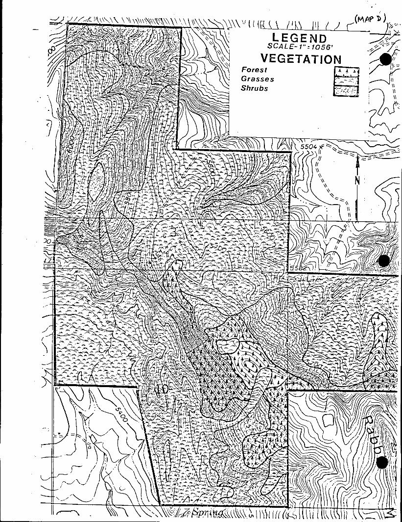
• 13. Needl eand.thread ·2.6%14. June grass 2.5%15. Yellow Indiangrass 2%16. Sleepy grass 1. 7%17. Red threeawn 1.3%18. Hairy grama 0.7%19. Six weeks fescue 0.7%20. Sand dropseed 0.7%21. Canada bluegrass trace22. Prairie dropseed trace23. Ring muhly trace
Two special plant associations of state concern have been recentlyidentified on the Rabbit Mountain property (see Map E). The plant associations are placed on the state list (C.N.H.I., 1983) when the known remainingexamples in Colorado, in a condition close to presettlement condition, arethreatened with alteration or extirpation.
The Cerocarpus montanus - Rhus tril obata/Andropogon gerardi i (Mounta inmahogany-Three 1eaf sumac/Bi g brue stem) associ ati on is ranked A2 becausethere are less than six known occurrences on small acreage; there are obviousthreats to the remaining occurrences and the range of the association is inless than three counties. This plant association is also of national concern.
The Pi nus ponderosa/Cercocarpus montanus/Andropogon gerardi i (Ponderosapine/Mountain mahogany/Big blue stem) association is ranked BU on the statelist for now and until more information is gathered. It is very likely to beuncommmon with more limited occurrences in the state.
A partial list of vegetation found at Rabbit Mountain is included in theappendix.
3.B3 FaunaThe Rabbit Mountain property is in many .respects a transitional belt
between the plains grasslands and the ponderosa pine forests of the foothills.The grasslands, shrublands and scattered forests on the site provide for agreater variety of animal associations than one might find at higher or lowerelevations. A preliminary mammal analysis completed recently by Dr. DavidArmstrong, CU Center for' Interdiciplinary Studies, has listed 72 potentialspecies at Rabbit Mountain. Of these, the habitat has or currently doessupport 53 hypothetical species, 13 species have been observed and 6 specieshave been extirpated from the County in recent times and would not likely befound unless reintroduced. A species list follows in the appendix.
Of particular note in the study given the large acreage of grasslands,was the low number of small mammals live-trapped in 500 trapnights eventhough there was abundant sign in all ecosystems. Poor weather conditionsare suspect for the dismal results of only three individuals trapped.
An additional peculiarity noted in the study was the absence of rabbitson the property. Only one i ndi vi dua 1 . of the genus Syl vil agus was spottedalthough droppings and tracks were observed on all transects. Two hypotheseshave been advanced and warrant further study. Di vi s i on of Wil dl ife harvestrecords point to cottontail population fluctuations in Boulder County with
12


• 1984 predicted as a low point in the cycle. Secondly, there has been some-. research which suggests that competition with livestock will drive leporids
out of an area. Further field work will be necessary to test these hypothesesand proVide a better data base on the mammal populations.
Avifaunal populations have yet to be subjected to extensive field work.Birds typical of the grasslands and foothills life zones would be expectedand a listing of potential species is included in the appendix. The surroundi ng regi on is excellent habitat for many of the bi rds of prey. Buteos,accipiters, prairie falcons, small kestrels and owls have all been seen on orover the property. Golden eagles also nested in the area in 1976, but therehas been little sign of si~ilar activity in recent years.
The critical wildlife habitat desiqnation for the Rabbit Mountain areawas based on documentation of two breeding bird species listed as rare inBoulder County (Say's phobe and scrub jay), presence of the white-taileddeer and reports of an uncommon mi ner bee. The property bei ng purchased bythe County is only a part of the larger critical wildlife habitat designatedon the County Comprehensive Plan.
Some historical accounts mention that Rabbit Mountain was once nicknamedII Rattl esnake Mounta i nil because of the presence of numerous snake's. Althoughthe population is considerably less than'what was reportedly on the property,prairie rattlesnakes can still be found during the warmer months. Furtherfield work will be necessary for a definitive data base on reptile species.
e·· 3.C Cultural EnvironmentThe Rabbit Mountain area is situated at the boundary between two of the
five major physiographic regions recognized as culturally relevant by theColorado Historical Society: the Plains and the Mountains. The locationprovi des the potenti a1 for important cultural resources research into theprehistoric and historic uses of the foothills region and the similaritiesand differences between cultural adaptations to mountains and plains environments.
•
3.el PrehistoryPaleoindian Stage - the Paleoindian Stage is characterized by a nomadic
lifestyle and a specialized hunting and gathering economy based upon theexploitation of large game animals that are now extinct, including bison,mammoth, bear and sloth, and undetermined species of flora.
Humans are thought to have entered Colorado prior to 10,000 B.C.,although interpretations of the scant evidence which dates to that time arecontroversial. The Paleoindian Period (10,000 to 5,000 B.C.) represents thefirst period of human occupation which is well-documented in Colorado.Variations of the large projectile points typical of Paleoindian Period sitescan be distinguished and are found to characterize tool assemblages whichcan be assigned to specific time periods: Clovis - 10,000 to 9,500 B.C.;Folsom - 9,500 to 8,000 B.C.; and Plano - 8,000 to 5,000 B.C.
Archa i c Stage - The Archaic Stage is cha racteri zed by a nomadi c 1ifestyle, the exploitation of mammals such as deer and modern bison and the useof a variety of floral resources. The procurement of foodstuffs wasapparently achieved through intensive exploitation of flora and fauna on a
13

,;, ....
specialized seasonal cycle of migration as each species became available. •.".Material remains include more varied tool kits, specifically more groundstone
implements, than those of the Paleoindian Stage. .
The Archaic Period (5,000 B.C. to A.D. 500) follows the PaleoindianPeriod, which ended with the termination of the last glaciation. Climatesbecame warmer and drier, and the large, ice-age animals became extinct. The I
Archaic Stage is presumed to have developed in response to this shift inenvironment. Subsistence strategies changed from concentration on these largeanimals and relatively few plant resources to exploitation of a wider varietyof available fauna and flora. Archaic Period cultural remains include largeprojectile points, most of which are triangular, and smaller and more crudethan Paleoindian Period types.
Late Prehistoric Period - Although A.D. 500 is the defined terminationof the Archaic Period, the Archaic Stage (lifeway) continued, with variousmodifications, throughout succeeding periods of aboriginal occupation inColorado. The Late Prehistoric Period (A.D. 500 to 1600) began with theadoption of the bow and arrow and the introduction of ceramics. LatePrehistoric remains are abundant in the mountains and foothills areas.Discovered sites include open camps, rock shelters, lithic scatters, tipi'ring sites, quarries and rock art.
Formative Stage - The Formative Stage of cultural development is characterized by the settlement of villages and a growing reliance on horticulture.In Colorado, three distinct cultures display variations of Formative Stage _lifeways: Anasazi or Pueblo, Fremont and Woodland. Sites associated with.the more prominent Formative stage cultures lie well outside the RabbitMountain area.
Occupants of the foothi 11 s appear to have been i nfl uenced by Formati ve .Stage developments which were centered further east. By A.D. 1, maizehorticulture and pottery began to appear on the plains of southeasternColorado. These developments are attributes. of the Woodland Culture, whichalso occurred over a large area on the plains to the east and southeast ofColorado. No direct evidence of settled villages has been discovered withinthe foothills of eastern Colorado, and it is currently believed that no trueFormative Stage developed within this area. Foothills occupations appear tohave decreased after A.D.' 1000; and by A.D. 1400, a confusing combination ofintrusions by various antecedents of modern aboriginal groups, such as the:Shoshone, Ute and Apache, has been indicated but not clearly defined.
Protohistoric Period - The Protohistoric Period (A.D. 1600 to 1800):represents the time duri ng whi ch contacts fi rst with the Spani sh, and 1aterwith trappers and Euroamerican explorers, resulted in the incorporation of.European items into the material culture of aboriginal peoples. These itemsinclude glass beads, metal projectile points and other implements, the horseand equestrian trappings. Hunting and gathering lifeways also continued,with acquisition of the horse enabl ing some groups to range over a widerterritory and place greater emphasis on certain species such as the buffalo. I
The Plains. AdPacbhe arhe the earfliestd
knowthn bOcctuhPancts of heastedrnUtco~oratdho •during this perlo, ut t ey were orce sou y e omanc e an e ln e llate 1700's. Early records indicate that the Shoshone were present in
14I
~~.>~~·__ i'~
------------------~~~------------------ --- ---
• Colorado. The Cheyenne and Arapaho are known to have hunted in the mountainparks, although the plains comprised their major territory until their
-restriction to reservations in the late 19th century.
Although aboriginal groups continued to practice the hunting andgathering strategies of the Archaic Stage of cultural development, extensivemodifications in lifestyle were necessary, due to the pressure and influenceof Euroamerican settlement of the region. Evidence of this influence can beseen in the increase of Euroamerican cultural materials found at aboriginalsites and in the gradual increase in restriction of aboriginal movement untilthe various tribes were assigned to reservations.
Rabbit Mountain Sites·According to current records, 24 archaeological sites have been found in
the Rabbit Mountain area by the University of Colorado Anthropology Department. Seven prehistoric sites have been recorded on the property, and oneis near the property line. Additionally, three historic sites and one prehistoric/historic site were recorded and at least ten prehistoric and threehistoric sites were located but not yet officially certified.
Prehistorically, there are artifacts which range from the Middle ArchaicPeriod (approximately 5000 years before present), pottery from around 600-800years ago, and the enigmatic stone circles, of which there are at least 80,and 2 rock shelters. Artifacts found include two projectile point fragmentsand several lithic flakes.
According to reports by some of the early residents of the RabbitMountain region, the property contained a large number 'of archaeologicalartifacts. For the most part, these have been collected by some of the earlyproperty owners, and many have undoubtedly been taken by "pot-hunters ll
• Oneearly resident of Dowe Flats, Mrs. Herbert Kincaid Jones, mentioned that DoweFlats was the site of an Indian campground and that an Indian hunting groundexisted on the northwest hill of Dowe Flats. A later resident of RabbitMountain, Jack Moomaw, is reported to have .accumulated quite an extensivecollection of artifacts from the area. These have been sold to a museum inHouston; some are on display at the Museum at the YMCA Camp near Estes Park;and some are now in private collections.
3.C2 Recent History·The settlement of the area now known as Colorado began around 1540, when
a Spaniard named Don Francesco de Coronado entered the region. He found manyIndi ans - the Ute, Arapaho and Cheyenne - inhabiting the area. Soon afterthe acquisition of lands by the Louisiana Purchase of 1803, several explorerswere commissioned to inspect the new territory. Pike, Long, Custer and othersbrought back such gloomy reports that little interest developed in settlingthe area. For the most part, fur traders and mountain men were the onlytravelers to brave the rugged mountains in the early 1800's.
Gold was discovered in the Rocky Mountains in 1858, initiating the goldrush that brought many people to Colorado. Gold seekers, merchants, farmersand ranchers came in droves and establ i shed permanent settlements. TheCityof Boul der was fi rst settl ed on October 17, 1858 and became an importantoutfitting spot for the gold mines; several hotels were constructed, saw
15
·' ,
, mi 11 s and stamp mi 11 s were erected, a schoolhouse was bui It and churches' •. .were organi zed.
Along the St. Vrain River, the town of Burlington was growing as well.By late 1862 a U.S. Post Office was established and farming was continuing toexpand over the valley. During the fall of 1870 a group of influentialChicago men and women organized the Chicago-Colorado Colony, which was laidout in the Spring of 1871 as the center of a cooperative agriculture venture.Persons joining the group paid an initiation fee of $5 and membership fee of$150 which entitled them to a tract of land from 5-40 acres outside thevillage limits or three building lots.
The first settlers in the Lyons vicinity came in the early 1860 1s.Mr. E.S. Lyon, for whom the town is named, arrived from Connecticut in 1880to improve his health. He quickly realized the value of the local red sand-'stone found on the land he had purchased. Lyon returned east to sell quarryshares and persuaded many to come to the vicinity where a townsite wasplotted in 1882. The quarries of Lyons sandstone have been the mainstay ofthe local economy throughout the years.
Christopher Columbus Weese (1845-1916) was the first white settler inthe Rabbit Mountain area. Born in Green County, Illinois, Weese lived therewith his family until his mother1s death in 1849. He then went to live with i
his uncle, William Baker, an Illinois farmer. Around 1858 Baker outfitted anox-drawn covered wagon and started for the gold fields of Californiaaccompani ed by hi s wife and Weese. Tired and di scouraged after along, slow, eri de across the pra i ri es of Nebraska and Colorado, they arri ved in the St.Vrain valley in July of 1859. The IIpleasant valleyll east of '.'/hat is now Lyonsappealed to them as a place to settle down for farming.
With the help of Weese, ~Jilliam Baker established a farm near McCallLake. After four years on the farm, Weese volunteered for the United StatesCavalry. As a member of the Colorado First Cavalry he took part in the SandCreek Massacre on November 29, 1864. Weese always regretted that he had apart in this sad event and rarely mentioned it. Having served the requiredtime, Weese was discharged in December bf 1864 and returned to the St. Vrainvalley. He homesteaded 160 acres of land west of McCall Lake and continued,to buy land around his homestead over the years. His property extended north'to Dowe Flats, including dry land called IIRabbit Hill ll . (A long-timeresident of Hygiene, Ruth McKnight, has stated that the spot was called"Rabbit Hill ll prior to "Rabbit Mountain ll , although a 1914 Boulder County map,1ists it as Rabbit Mountain.) Numerous abstracts show that Weese was theoriginal or second owner of much of the land in the area.
At age 37 Weese married Melinda Jane Baker and later fathered twochildren: Alvin in 1883 and Lila in 1894.
Jack Moomaw was born in Nebraska in 1982. In 1983 his family moved to afarm near Lyons but spent much of their ,time in the Estes Park Mountains.Jack joined the Navy but disliked it enough to return to Colorado after twoyears. He took various jobs in the -Estes Park area, guiding on Longs Peak abefore he became a Natlonal Park ranger. As a guide to world-famous, ~
scientists, Jack acquired a varied education, especially in archaeology. He'was an author, lecturer and world traveler but he always returned to the
16

•
Colorado mountains. Moomaw Glacier in Wild Basin (Rocky Mountain National. Park) is named after Jack Moomaw.
In 1917, Jack and Lila moved into the original Weese homestead, justwest of McCall Lake. The property included 1200 acres of river bottom landand parts of Rabbit Mountain. One daughter was born into thei r marri age.
In Apri 1 1964, Mr. and Mrs. Norman Stamp bought the 102-acre propertywest of McCall Lake from Jack Moomaw. The renamed it Rascal Ranch andcontinued farming it until recently when it was sold to John and GaynorToteve. Meanwhi 1e, Jack Moomaw moved to Lyons and was cared for by Ros i eMiller and her husband l,lntil he died in 1975. Moomaw1s Rabbit Mountainproperty was inherited by his granddaughter, Helen A. Motley.
Homestead claims that were filed in the general vicinity between 1858and the early 1900 l s include the names of David Wolpert, llohn Becker andArthur Chline. No information has been uncovered regarding these men.
Besides the obvious ranching activities, the plat records indicatemineral exploration occurred in the Rabbit Mountain area as early as 1902 bysuch outfits as the Lulu Oil and Gas Company, Webber Oil and Stone, and theSweet Group Placer.
C.S. Burford bought the Dowe Flats property in 1903-04. At this time,Dowe Flats numbered 2300 acres. According to Mrs. Herbert Kincaid Jones, agranddaughter of C.S. Burford, Dowe Flats was the site of an Indian campground, and a natural lakesite was present. In addition, an Indian huntingground existed on a hill northwest of Dowe Flats. She recalls how her familypulled sixteen plows behind a steam tractor to plant wheat. It appears thatthe area has historically had a number of reptiles because when the wheatshocks were thrown into the thresher that first year a rattlesnake was foundin each one. Indeed, Lila Moomaw and others had nicknamed Rapbit MountainIIRattlesnake Mountain ll
•
The Burford family sold Dowe Flats to Ideal Cement in 1957. In 1984,Ideal Cement sold much of the surface--rights to Marigold 41, a developmentpartnership of Bill Crowell and Michael Dollaghan.
The remains of a structure probably used for ranching and grazingpurposes is located on the eastern part of the property near the entrancegate. No information is available regarding this structure other than thatit is not present in a photograph taken in 1932.
A batch plant was located on the property during the 1950's for theconstruction of the St. Vrain Supply Canal. All that remains of the plantis a concrete slab and some cement pilings.
An inholding, recorded as Dowe Flats Sotrage Reservior #2, exists in thesouthern portion of the Rabbit Mountain property and is owned by Paul Zenobia.
3.0 Current UseThe Rabbit Mountain property is currently closed to publ ic use until
resources can be i nventori ed, boundari es marked and access secured. There
17

."
are no outstanding agricultural leases in effect, the last one having been _terminated June 22, 1984. ~
3.01 Acquisition/Lease ScheduleOn December 13, 1983, the County of Bou1 der entered into a purchase
contract and 1ease with opti on to purchase with Helen L. Mote1y for 1119.62acres of land on Rabbit Mountain. This arrangement allows the County tospread the payments over several years whil e yet contro 11 i ng use of theentire property through a lease until all parcels have been purchased. Thefollowing schedule gives particulars on the purchase and Map G_illustratesthe property boundaries with the five parcel options.
INTEREST LF..A~E PAYMENT
J,,\ST DATE FOR LAST D1\TE PURCHASE PAVHENT DUE AT CLOSING TOfALOPTION PARCELEXERCISE OF OPTION FOR CLOSING PRICE IN ARRl::1\RS DA1'E (PLUS ThXES) Phvm:NT"NUMBER NU1·tn!::R ACRES
373 12/14/83 261,100 0 $ 747 (1) $ 261,847
155 2/1/84 6/14/84 108,500 20,906 S 296(2) $ 129,702
180 2/1/85 6/14/85 126,000 33,131 $ 412 $ 159.543.
195 2/1/86 6/14/86 136,500 23,051 $ 217 $ 159,768
216.62 2/1/87 6/14/87 151,634 12,131 .Q. $ 163,765 .
1,119.62 $ 783,734 $ 89,219 $1,672 $ 874,625'l'OTAr,s:
"Purchase price plus interest and lease payment
{I) Lease payment throuqh December 13, 1984{2) For lease term December 14, 1984 through June 13, 1985
3.02 Easements/Leases ~
The fo 11 owi ng easements and 1eases have been recorded on the Rabbit-Mountain property (see Map H):
1. Right-of-way for ditches or canals constructed by the authority ofthe United States as reserved in United States patent of record;
2. An easement and ri ght-of-way for roads and ditches des i gnated asTracts F and G as granted to the United States in deed recorded April 1,1951;
3. Right-of-way for the operation and maintenence of certain works ofthe Colorado-Big Thompson project under the provisions of the "Cana1 Act"and designated as Tracts A, B, and I in document recorded October 10,1973;
4. An easement for an 'access road as granted to the United States bydeed recorded May 19, 1954;
5. A right-of-way for a ditch or ditches to and from the Dowe F1 atsStorage Reservoir No. 2 together with the right to enter upon said landfor the purpose of maintaining and repairing said reservoir and ditchesas granted in deed recorded June 3, 1913 and as reserved in deeQrecorded July 10, 1916. Mr. Paul Zenobia owns this 12.5 acre inholdingand it has never been built on or used as a reservoir;
6d
· Easements Afor 1i n2g2res
1s and eTghress, road and. util iti es
16aOs granted bY
1•
eed recorded pri ,981. is easement tl es to a -acre parce
18
----------- .__-l. .

. i .
•
~.

•'
(MAt> ~)"
EASEMENTSNCWCDRE A ••••••John Peper --•• -
.. ,
NCWCD OwnedPaul Zenobia Owner
.> ::.:::>
~~~
I
'-. ../"
•••
• • • •• • • •.'. .• ••
• • ••• I
•••• • •
• I I
•
• •
i
•
-..'\
I r-,/ \
~I \J \ N
/
I/ \/
/
/
\ //
/
'"
••••
.._ .
II.- ..
'-!.

of land southeast of the County Rabbit Mountain property which HelenMotley sold to an investment partnership;
7. Record affidavit of non-production as it pertains to that certainoil and gas lease recorded July 24, 1980 and amendment thereto recordedDecember 15, 1982.
Severa1 other oil test we 11 s have been dri 11 ed on the property.Two of these are located in the central part of the property; the third
. is to the southwest (see Map B).
8. A conservation easement between Helen Motley and Boulder Countyrecorded March 26, 1984.
Although there is no recorded easement, the Rural Electric Associationmaintains a power line which crosses the Rabbit Mountain property in aneast-west direction. In the northeast corner there is an additional linewhich runs north into the Parrish property. REA accesses Rabbit Mountain from55th Street and from the NCWCD road across the Parrish property.
19

. 4. MANAGEMENT CONSIDERATIONS4.A Protection of Resource, Visitors &Neighbors
When the Rabbit Mountai n property was acqui red by Soul der County, anumber of problems regarding use and access of the area were also inherited. I
The previ ous owner was an absentee 1andowner and many abuses to wi 1dl i fe, 'vegetation and archaeological artifacts occurred over the years. SinceBoul der County has contracted to purchase the property, there have been cut i
locks and chains, torn down fences, illegal road building, stray cattle,horses and dogs, illegal hunting and removal of rocks and vegetation.Additionally, there has been a considerable amount of trespass by adjacent1andowners and others even though the property has been closed to the pub1i cwhile a resource evaluation is undertaken.
In view of the problems, the following management considerations arerecommended:
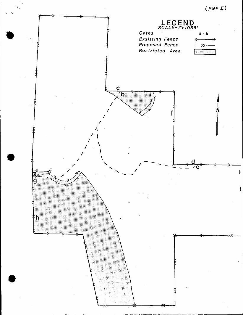
1. The exi sti ng entrance on 55th Street is owned by the NorthernColorado Water Conservancy District. A new publ ic parking area andentrance should be constructed on the parcel of land the County is'purchasing just north of the NCWCD land (see Diagram A). This entrancewould also serve as a trailhead and could include appropriate facilitiessuch as picnic tables, shelter, toilets and trash cans. Gate i would beconstructed at the east end of the parking lot to allow official vehicleaccess to the Rabbit Mountain property.
2. In order to keep livestock out, delineate the boundary andcompletely secure the area, the property should be surveyed and fencedaround the entire perimeter.
,
e'
3. In the event that stray livestock get on the proprety, provisionneeds to be made to herd them back through the fence. It is recommendedthat three new four-foot wide livestock channel gates (see Diagram B) beinstalled at points h, f and k (Map' I), to allow fence openings forlivestock to be herded back through.
4~ Existing gates a, (2 NCWCD gates on eigher side of canal), g, d, e'should be chained, locked and maintained for official access purposesonly. Gate c and b (cattle guard) should be locked to signify a barrierto public access if the NCWCD is in agreement. The road ending fromthis access point deadends at the canal siphon works.
5. Adequate numbers of boundary signs need to be posted around theperimeter of the property. A visual check should be made on an annualbasis to replace stolen or damaged signs.
6. A bulletin board should be installed near the trailhead at the eastend of the parking lot. It would contain maps of the open spacefacil iti es, rul es and regul ati ons and other perti nent recreati on userinformation.
7. Since there are rattlesnakes on the property, appropriate warning •signage is suggested.
20

•
" .,
.. N-----
SCALE-1"= 100'
..-
Entrance Sign~
N. 55TH St.•
. Shelter
Rest Rooms~ • \
Bulletin Board 0 rn...,
/< Parking
Pole Fence/Gate
1,)en0a: -en
c::01 enc:: (.)'--V).-V)
><lLJ

.('D\AG~Af{ &)
r
•
Ex isting Fence
It- 41l-f-f----- 20' ------~"I4' t X )( ), ~.)( X
l~ .~ New Fence
. . Pivoting Gate for
Livestock Removal
i
Livestock Gates
•
•
.1
X
LEGENDSCALE-I": 1056'
a-kX
GatesExsisting FenceProposed FenceRestricted Area
J
~
1
•
i
--I
/- - - - - d " :( x
1

8. It is suggested the NCWCD post additional warning signs at theentrance/exit outlots of the St. Vrain Feeder Canal. Chain link fencemay also be necessary at some point in time to lower the level of dangerof someone falling into the canal, siphons or tunnels.
9. Maintenance and patrol of the property should be increased once itis open to the public. Enforcement of County Park and Open Space rulesand regulations should be continued.
10. Old buildings and miscellaneous junk found on both sides of thecanal just east of the 55th Street entrance should be removed. Photodocumentation of the buildings is suggested prior to removal.
11. Alternate access options should be explored with adjacent landowners I
southeast of County property who have recorded easements.
i12. Options for purchase of easements or additional buffers around theRabbit Mountain property should be explored in the future, with theobjective being to more closely match topographical features with theboundary and to add an additional measure of protection to those l
environmental resources identified on the larger scale in the CountyComprehensive Plan. Inholdings in the current purchase area should be,considered for acquisition. '
•
13. Extended/Intensive use of the property for research purposes should,fall within the guidelines established for such activities in the joint ~.City and County of Boulder research proposal format. Natural andcul tura 1 hi story research wi 11 be encouraged to the extent it adds to:the existing body of knowledge and does not compromise protection of theresources.
4.B Resource Management4.81 Forest ManagementThe ponderosa pine forest is in a state of decline with little or nOI
obvious reproduction. There is evidence of fire and major soil erosion atsome time in the past, and current contributors to the revegetation problem.include lack of adequate topsoil and extensive grazing. I
Due to very poor s i'te conditi ons, the trees in the pi ne forest havelittle or no timber value. Although firewood has been taken off the property'in the past, there is a limited amount of stock from which to continue thispractice. The remaining forest has its greatest value in providing for adiverse wildlife habitat, erosion control of the remaining topsoil, anddiversity in the aesthetics of the area.
Forest management considerations include:.1. Develop a reforestation plan which would include planting pottedstock in areas where trees currently exist and the soil is adequate forgrowth.
2. Keep domestic livestock grazing out of the forested zones and amonitor the area for natural reproduction. This recommendation also .,coincides with that suggested by the Colorado Natural Heritage InventoryProgram for protection of the rare plant association sites.
21

"
•
'I
3. Continually monitor the forest for insect and disease problems.
4. Particularly in areas where there are ladder fuels, evaluatefeasibility of pruning up trees.
5. Evaluate the feasibility of developing a fire break around the baseof the mountain (particularly the southwest side) to lessen the risk offorest loss through grassland fires.
4.B2 Range ManagementBased upon a recent range analysis conducted by the Soil Conservation
Service (SCS), the Rabbit Mountain property is presently in poor to goodcondition with the majority of the rangeland rated as fair compared towhat would be considered optimum for the site. There has been a long historyof grazi ng on the property, and the grass1 and has evo1 ved to those speci eswith more tolerance of domestic livestock. Desired objectives for the RabbitMountain property are to increase the overall range condition to good toexcellent and increase the species composition with more native grasses (i.e.,Indiangrass, switchgrass, big and little b1ueste~, sideoats grama and buffalograss).
Management considerations include:1. - For the immedi ate future, the enti re property shou1 d be kept free ofdomestic livestock grazing. This will allow the range condition toimprove while at the same time giving the Parks and Open Space Departmentadequate opportunity to complete a boundary survey and perimeter fencing.An additional side benefit of the rest period should be an increase infood and cover for wildlife.
2. Monitoring the grasslands can best be accomplished through anannual range analysis.' Reintroduction of a livestock grazing leasemight be a future option under the following conditions:
a. the analysis shows the range condition objectives are beingmet; .b. the forested area and rare plant association sites are fencedto exclude grazing;c. grazing take place only during the dormant season (Novemberthrough March) and within the stocking level recommended by the SCS;d. grazing be'deferred one out of every three growing seasons.
3. Springs and seeps which have been identified should be improved forwildlife water supplies as well as for livestock where needed. Underground tanks might be appropriate for emergency water storage in case ofwildland fire when other supply sources are not available.
4.83 Wildlife ManagementHistorically, a number of species of wildlife have been hunted on Rabbit
Mountain. According to Division of Wildlife reports, approximately thirtymule deer have been harvested annually since 1971. Another 20-30 deer aretaken from adjacent property. Records also indicate a deer winter rangedistribution of 32.7 individuals per square mile for big game unit 20, inwhich Rabbit Mountain is located, and a buck/doe/fawn ratio of approximately25/100/58. White-tailed deer have been seen on Rabbit Mountain but theirnumbers are few compared to mule deer. Observations over the past year
22

(,
I'
indicate both species move freely across the property boundaries, particularly ~. to the north.
During recent harsh winters, elk have been sighted on Rabbit Mountain.They probably di spersed from the herd whi ch normally wi nters near Lyons.There was also an undocumented report of black bear some years ago, but theyare unlikely to be in the area now.
Smaller wildlife which has been hunted or trapped on Rabbit Mountainincludes dove, cottontail rabbits, coyote and bobcat. Although there are noaccurate records of the coyote harvest, DOW reports show that 2-3 bobcats had'been trapped annually unti) 1981.
Two major management directions for Rabbit Mountain are to improve thehabitat for a diversity of wildlife and to provide a sancutary particularlyfor those species on the property that have been identified as rare in BoulderCounty.
Management considerations for wildlife include:1. There should be a permanent environmental monitoring schedule andrecord system on wildlife species present on the property and their,abundance. The wi 1d1 i fe transects whi ch have been set. up (Map F) wi 11 .also provide information on the relationship between habitat types and.wildlife usage and the relationship between human and wildlife use of theproperty.
2. The property should be maintained as a sanctuary with no hunting ortrappi ng allowed. Up until the present, conti nued hunti ng on adjacentprivate properties appears to help control the deer population. However,if careful monitoring of the habitat indicates resource damage is occur- i
ring (i .e., deer excess), management options to reduce overpopulationshould be considered.
3. Forage production for wildlife cou1<;i be improved by maintainingstrict control over domestic 1iv~stock use of the property.
4. It is essential to maintain and improve habitat critical to thosespecies for which the critical wildlife habitat designation was listed inthe County Comprehensive Plan.
5. Brush piles and more edge-effect islands can be used to createescape, refuge or travel corridors.
6. Permanent, undisturbed cover should be maintained along fences andodd corners.
7. Standing dead trees should be left for cavity nesters and raptors.·
8. Steps should be taken to improve the supply and quality of waterfor wildlife use throughout the year. Springs located at Rabbit Mountaincould be developed and become tremendously valuable to wildlife. Moni- i
taring should be done on a regular basis. ~
23

-~-~~~~~~~~~~~~~~~~~~~~~
;,
"• r,\_
•
••

9. Parks and Open Space rules and regulations which affect wildlife .'should be enforced, and the Parks and Open Space Department should workclosely with DOW on enforcement of state laws.
10. Development of further wildlife research on the site should beencouraged, as should programs relative to wildlife management.
11. Review of the management plan should be done periodically to assessprogram strategies as the needs and current situations dictate.
It has been determined that there are four major prairie dog towns on the!Rabbit Mountain property ,(see Map J). The smallest is approximately fiveacres and lies in the eastern part of the property (referred to as the easttown). The' south town is approximately ten acres and is located in thesouthern valley. The north town is approximately 30 acres in the northmeadow, and the largest colony is in the west town, which is 70 to 80 acresand located in the southwest corner of the property.
4. A monitoring program should be set up to determine when treatmentis necessary as well as its effectiveness. Only two control agents,zinc phosphide or aluminum phosphide, have been authorized for use onCounty lands. Neither agent passes through the food chain.
4.C Recreation/Education4.Cl Outdoor RecreationPrior to Boulder County's acquisition of Rabbit Mountain, the primary
types of recreation on the property included hunting, hiking and horsebackriding. The limited recreational use has been restricted to private groupsfor many years, but visitation will soon increase when the area is open tothe public.
Special plant associations, critical wildlife habitat and archaeologicalfeatures on the property have been identified in the Boulder County Comprehensive Plan as being significant and requiring protection. Every effort will bemade to lessen human impact on these resources and to direct visitors to less' •critical areas. Other facility devdeloPlment constraints includhe a~ceshs, ',/terrain, availability of utilities, an a ease-purchase contract w ereln t eCounty will not complete purchase until 1987.
24
~----------------'----------~---

, "..:'
•
•


....
• For recreational management purposes, the property can be divided into. three zones: (see Map L)
Maintained area - Area that requires continual maintenancePassive area - Area that has minimal disturbanceSpecial area - Area requiring various levels of maintenance and manage
ment, for example areas of archaeological and geological significance, andspecial wildlife and rare plant site areas
The following management is recommended for these zones:Maintained area A parking lot for the park visitor will be located at
the west entrance to the property. It will measure approximately 150 by 150feet, be fenced, and have .a pi pe gate just east of the lot whi ch wi 11 preventvehicular access to other roads on the property. These roads will serve thedual function of hiking/riding trails for the public and authorized vehicleaccess.
Just east of the parking lot (see Diagram B), a public picnic area willbe constructed. No trees are growing in this part of the property, so apicnic shelter should eventually be constructed to provide shade. Otheramenities would include picnic tables, charcoal grills, trash cans and a pittoilet. A two-sided kiosk/bulletin board adjacent to the parking lot wouldprovi de natural hi story i nformati on, park maps, trail i nformati on and rul esand regulations.
A spring located just north of the main entrance has signs of previoususe and should be explored as a possible source of drinking water.
Long-term maintenance requirements would include trash collections, pittoilet maintenance and fence and signing maintenance. The NCWCD willrna i nta in the roadways on the property as long as they are not opened forgeneral public use.
Passive area The following management objectives are proposed for areaszoned for passive recreation:
- Preserve unique, rare or endangered species, natural ·landmarks, communities or ecosystems.- Provide gene pools of the native plant and animal species.- Provide areas where' the general public can participate in passive formsof recreation, such as hiking, horseback riding, wildlife photography,birdwatching, sketching, etc.- Provide areas for more formalized environmental education activityincluding short field trips, outdoor research laboratories and extendinglearning experiences.- Provide areas for aesthetic and psychological appreciation of theRabbit Mountain property.- Provide areas where the public can experience and appreciate thehistorical background of the region.
To achieve these objectives, it is re~ommended that the following minimaldevelopment be implemented:
Two hiking trails should be developed on the central part of the property(see Map K). One of these trails would be developed as a shorter (3/4 mile),
25
------===~~~-~-------

LEGENDSCALE- I": 1056'
RoadsParkingTrailsProposed Trails ········1
•
/
J
//
/
i
e •
•• •. .•, ..
••••It' •
• ••• •• • • •-.....~
• ••• ••••••••'.•••.,
••••••••

J."-..\
self-guided nature trail loop. The trail would begin approximately t mile',beyond the parking lot, and signs posted along the pedestrian accessible
unimproved road leading to the trail would provide information to maintaininterest regarding the natural history of the park. Brochures for the selfguided trail could be placed in a mounted wooden box at the actual beginningof the trail. The second trail would consist of a longer loop of approximately four miles in length designed for day hikes and equestrian use.
Both trails woul d provi de access through some of the more scenic areasof the Rabbit Mountain property, as well as provide the opportunity toobserve some of the various plants and animals that exist in the area. Thisnot only allows public enjoyment of these resources, but also concentratesthe area of human impact so that wildlife and vegetation may remainrelatively undisturbed in other areas of the property. Maintenance onprimitive trails would be minimal. If markers were used on the self-guidedtrail, there would be an initial cost; but maintenance would require onlyreplacement of damaged or destroyed markers and annual painting.
A long-term possibility which warrants further investigation is that ofproviding a controlled camping area for youth groups within the passivezone. The historical significance of the area and uniqueness of the naturalenvironment lend themselves to possible overnight use in conjunction with aforma 1 outdoor adventure/envi ronmenta 1 educati on program (Note envi ronmenta 1education section). Facilities might include a pit toilet, open-air shelterand tepees.
Special area Those portions of the Rabbit Mountain property zoned asspecial areas would be posted and maintained as closed to the general public.These areas contain cricial wildlife populations, rare plants, archaeologicaland geo1ogi ca1 features that coul d be impacted by i ndi scrimi nate human useand high hazard areas associated with the St. Vrain Supply Canal.
The special areas also have potential for research sites by qualifiedindividuals or institutions. Proposals to use ,those areas will be evaluatedon a case-by-case basis.
".
~.C2 Special Recreation UseFrom time to time there will be requests by special interest groups/
commercial operators to' allow specific outdoor recreational pursuits onRabbit Mountain. Each request should be evaluated on its own merits keepingin mind the long-term stewardship responsibilities of the Parks and OpenSpace Department. The overriding objective in management of the property isto prevent loss of those natural and cultural resources identified ascritical/unique while yet allowing education and passive recreationalactivity which is compatible with protection of the resources and othervi s itors.
4.C3 Environmental EducationA United States Commissioner of Education once referred to environmental
education as "Education that cannot wait". The "hands-on" experiences of theoutdoor classroom are one of the -ways in which students can translatetextbook studi es into real situati ons. Thev can observe and evaluate theeffects of resource management in relation to'specific projects. The generalpublic can benefit from environmental education experiences as well. Partici-
26

~. ( --I<;
t.
. pants can gain knowledge in how to protect and care for 1imited resources as •".they learn about their natural environment and heritage.
Rabbit Mountain is rich in resources that lend themselves well to interpretation. The trails proposed in the Outdoor Recreation section would leadvisitors through ponderosa pine forests, a dry shrub ecosystem and an overlook i
area where there is a eagle's-eye view of the plains, foothills and FrontRange. The shorter, self-gui ded nature trail loop woul d provi de information,on natural and cultural history topics. These could include themes onforestry, wildlife, geology and history. The self-guided trail 'would beginapproximately t mile east of the parking lot, and hikers would follow signs i
leading to the actual trailhead. These signs could be designed in such amanner to hold the interest of the pedestrians in route to the trailhead, forexample by natural history riddles, IIfun facts ll
, etc. The self-guided trail I
booklets would be available at the trailhead, and kept in stock by the Parksand Open Space staff.
The four mile loop trail could be utilized for formal interpretive walks i
as well as general recreational hikes. Staff and Volunteer Naturalists couldlead groups on the trail, discussing such topics as flora, fauna, geology,prehistory, wildlife management, entomology, agriculture, etc. This trail'would also serve the needs of those wanting longer hiking routes in the RabbitMountain area (see Map K) .•
The environmental education bus being developed by staff could provideanother type of environmental education experience for groups and/or the ..general public. The bus could be driven to the parking lot at Rabbit Moun- ..-tain, and themes including Indians and archeology, geology, forestry, wildlife:management, birds, wildflowers, entomology, fungi and lichens, survivaltechniques, etc. could be interpreted.
A long-term environmental education direction is to tie programming andinterpretive materials/displays together with a proposed nature center on theLohr property, northwest of Longmont. The nature center coul d be used forgroup orientation and include displays dealing with the various resourcesfound on the Rabbit Mountain property, i-ncluding wildlife, flora, archaeology,geology, history, life zones, etc. Programming could be centered in thisfacility, and the proximity of the Rabbit Mountain property lends itself wellto follow-up activities after a visit to the center.
The archaeological importance of Rabbit Mountain relative to other sitesis not yet well understood by noted authorities. The surface survey isnearly complete, and it confirmed that most artifacts have already been i
removed from the site. Further research may be appropri ate ina sacri fi cedig area if it is determined that there is likely to be new informationuncovered about the peoples who once inhabited the property. Observations ofa di g and demonstrati ons of fl i nt-knappi ng techni ques and Indi an 1ifestyl escould be associated interpretive programming themes for the site .
./'
Another idea to be explored for the futu re is the proposed youth groupcamp area. It would provide primitive lodging limited to recognized youthorgani zati ons and sci ence/outdoor 1i vi ng students from Soul der County K-12 •schools. It is recommended that the camp area require a reservation and that, ~there be limited stay with a maximum of 25 persons using it at anyone time.
27

• Groups would be required to park in the west entrance parking lot and hike in. - to the camp. All food, water and overnight gear would be packed in and out by
-the group.
It is recommended that the overni ght experi ence be coordi nated with anenvironmental education experience which could be developed by the BoulderCounty Parks and Open Space Department staff, Volunteer Naturalists andBoulder County School Districts. The experfence could include intensiveprior instruction. and experience with environmental investigations andstudies, such as those given in local lI ou tdoor living ll and science classes,and for scout "wildlife badge II requirements. A curriculum guide could beprepared in conjunction with the overnight experience, and groups could applysome of the special skills learned and practiced in the IIpre-camp" sessions.
Goals of this curriculum would include:- Help youth and children learn about the total environment - biological,physical, social and cultural.- Enable groups to become sensitive to their own responsibility towardmaintaining a productive and liveable environment.- Motivate groups to work constructively toward the solution of environmental problems.
Topics that could be explored in a IIhands-on ll curriculum 1inked tospending several days on the Rabbit Mountain property include terrestrialecosystems, geologic and geographic studies, plot studies (analyzing a smallplot of ground), and wildlife ecology. During their stay, groups couldreceive instruction in camping survival techniques, first-aid, artwork, dramaand music.
In conclusion, Rabbit Mountain can provide a number of environmentaleducation opportunities. Environmental education and interpretation canincrease the effectiveness of resource management; informed visitors are morelikely to use resources with less impact. In addition, interpretation can beused to attract persons to the areas suited for use and away from those thatare easily impacted. .
28

i
•BIBLIOGRAPHY
Anderson, Allen E. Ex erimental Deer Inventory - Northeast Re ion". ColoradoDivision of Wildlife, Game Res. Dept., July 1 , 1978.
--------. Ex erimental Deer Inventory - Northeast Re ion. Colorado Divisionof Wildlife, Game Res. Dept., Ju y 2, 1980.
Baker, S.G., ed. IIBaseline Cultural Resource Surveys and Evaluations inPrimary Impact Areas of the Mount Emmons Project: 1978 and 1979 FieldSeasons, Volume 111. Heritage Resource Study Series for the Mount EmmonsProject of Amax, Inc., Gunnison County, Colorado. Unpublished report,Centuries Research, Inc., Montrose, Colorado, 1980.
Barkley, J.R. IINorthern Colorado \~ater Conservancy District".Benedict, J.B. and Olsen, B.L. liThe Mount Albion Complex: A Study of
Prehistoric Man and the Altithermal Research Report No. 111. Center forMountain Archaeology, Ward, Colorado, 1978.
Boddicker, Major L. IIPrevention and Control of Wildlife Damage B-75 11 •Extension Wildlife Service, Colorado State University, Fort Collins,Colorado.
Buckles, William G. liThe Archaeology of Colorado: Part III". IIArchaeologyin Colorado: Historic Tribes ll
• Southwestern Lore, 34(3):53-67. 1968.-------- liThe Uncompahgre Complex: Historic Ute Archaeology and Prehistoric
Archaeology on the Uncompahgre Plateau in West Central Colorado" . UnpublishedPh.D. dissertation. Dept. of Anthropology, University of Colorado, Boulder,Colorado, 1971. __
Buckles, William G. and Nancy B. Colorado Historical Archaeology Context. 'The State Historical Society of Colorado, 1984.
Colorado Geological Survey. IIWater Resources of Boulder County, Colorado ll•
Bulletin 42, 1980.Teague, Richard D. and Decke~, Eugene. Wildlife Conservation: Principles and,
Practices.Eiglimy, Jeffery L. Colorado Plains Prehistoric Context. The State Historical
Society of Colorado, 1984. ,Flood Plain Information, Volume IV, IIUpper St. Vrain Creek, Boulder County,
Colorado ll• 1972.
-------- IIBig Thompson and Little Thompson River ll• June 1977.
Guthrie, M.'R., Gadd, P., Johnson, R., Lischka, J.J. Colorado MountainsPrehistoric Context. The State Historical Society of Colorado, 1984.
Hunter, Zena Margret. Geologic Patterns in the Foothills of the Front Range: I
Boulder-Lyons Area, Colorado. Ph.D. dissertation, University of Colorado,Boulder, Colorado, 1947.
Husted, W.M. IIA Proposed Archaeological Chronology for Rocky Mountain NationalPark Based on Projectile Points and Pottery. Unpublished M.A. thesis, Dept.of Anthropology, University of Colorado, Boulder, Colorado, 1962.
Irwin, C. and Irwin H. IIExcavations at the Lokaiska Site in the Denver,Colorado Area ll
• Proceedings Number 8. Denver Museum of Natural History,Denver, Colorado, 1959.
Mann, Donald. Geology of an Area near Eldorado Springs, Colorado. M.A. thesis,University of Colorado, Boulder, Colorado, 1960.
Nelson, C.E. and Graeber, J.M. IIExcavations at Graeber Caul North Turkey Creek ll...
Southwestern Lore, 32(3):47-54, 1966. ..,Sharpe, Grant W. Interpreting the Environment.
29

•
•
Smith, Phyllis. A Look at Boulder. Pruett Publishing Co., 1981 .. Smith, Anne M. "Ethnography of the Northern Utes". Papers in Anthropology
No. 17. Museum of New Mexico Press, Albuquerque, N.M., 1974.Tice, John H. Over the Plains and on the Mountain. 1872.United States Department of Agriculture, Soil Conservation Service. "Soil
Survey of Boulder County, Colorado". 1975United States Department of the Interior, Bureau of Reclamation. "Colorado
Big Thompson Project" .
30

Acknowledgements
Ann Armstrong, Boulder County Volunteer NaturalistFrank Beck, Boulder County Volunteer NaturalistWilliam A. Braddock, University of Colorado Geology Dept.Colorado Division of Water ResourcesColorado Oil and Gas CommissionDave Essex, Rocky Mountain National ParkDawn Genes, Soil Conservation ServiceMrs. LaVerne Johnson, Curator of Lyons MuseumTed Johnson, Boulder County Public WorksKris Kranzush, Archaeology ConsultantRobert H. Nykamp, University of Colorado Anthropology Dept.Harvey Spreck, Soil Conservation Service
31
(
•

l
';'• '.V
Partial Plant List Found at Rabbit Mountain
Grasses
Common Namesandberg bluegrassblue gramabuffalo grasshairy gramalittle bluestemyellow Indiangrasssideoats gramaneedle &threadJunegrassJapanese bromedowney brome (cheatgrass)red three aunwestern wheatgrassKentucky bluegrassCanada bluegrassbig bluestemsix weeks fescussleepy grassGriffithls wheatgrasssand drop seedprairie dropseedring muhlycrested wheatgrassintermediate wheatgrassfoxtail barley
Forbs &Shrubshorsetailprickly pear cactussnakeweedLouisiana sagehairy goldasterwild onionwooly Indianwheatprairie sunflowernarl wortsalsifyfringe sagelate goldenrodpincushion cactuswild rosewax currentmountain mahoganyfreemont geranium (crainsbill)sun sedgecurly dockdandelion
Scientific NamePoa sandbergiiBouteloua gracilisBuchloe dactyloidesBouteloua hirsutaSchizoc~yrium scopariumSorqhastrum nutansBouteloua crutipendulaStipa comataKoeleria pyramidataBromus japanicusBromus tecto rumAristida longisetaAgropyron smithiiPoa patensisPoa compressaAndropogon gerardiiVulpia octofloraStipa robeustaAgropyron griffithsiiSporobolus cryptandrusSporobolus cryptandrusMuhlenbergia torreyiAgropyron cristatumAgropyron intermediumHordeum .iubatum
Equisetum arvenseOpuntia compressaGuierrezie sarothraeArtemisia ludovicianaChrysopsis villosaAllium cernuumPlantago patagonicaHelianthus nuttalliiParonychia phlyinataTragopogon dubiusArtemisia frigidaSolidago giganteaEchinocactus simpsoniiRose acicularisRibes cereumcercocarpus montanus
. Gerani urn fremonti iCarex heliophilaRumex crispusTaraxacum officinale
32
--- - --- --------------

Forbs &Shrubs (continued)".yellow evening primrose
yuccasilvery wormwoodgrass-leaved seneciogumweedwestern ragweedsedgegooseberryspring beautydotted gayfeatherrubber rabbitbrushtextile oniondeath camisbedstrawwiskbroom parsleyanens (prairiesmoke)asterwinged buckwheatphloxwil d wa llfl m'lerwaveyleaf thistlefoxweedplains larkspurblue bonnetsumaclocoweedsandlilyskunkbushpoison ivyshowy milkweedball cactuscommon harebellpasture sagebrushprairie sageCanada thistledaisy fleabaneblanket fl m'/ersunflower (2 kinds)coneflowerbindweedpepper grasschasping peppergrasswil d gerani urnground plummilk vetchscarlet globemallowprickly poppyplantainspiderwort (snotweed)rushmariposa lilygreat mullien
Oenothera brachycarpaYucca glaucaArteini si a fil Ho1iaSenecio spartioidesGrindelia SQuarrosaAmbrosia psflostachyaCarex spp.Ribes inermeClaYtonia lanceolataLiatris punctataChrysothamnus nauseosaAllium textileZYradenus gramineusGa ium borealeLomatium orientaleGeum triflorumAster falcatlJsErTQ90num alatumPhlox hoodiiErYSTusum wheeleriCirsium undulatumThlaspi arvenseDelphinium virescensLupinus plattensisRhus glabra cismontanaOxytropis lambertiiLeucocinum montanumRhus trilobataTOXlcodendron rydkergiiAsclepias speciosaCoryphantha viviparaCampanula rotundifoliaArtemisia frigidaArtemisia ludo vicianaCi rs; urn arvenseErigeron strigosusGaillardia aristataHelianthus annuusRatbida columniferaConvolvulus arvensisLepidium virginicumLepidium perfoliatumGeranium caespilosunAstragalus crassicarpaAstragalus sp.Sphaeralcea cuspidataArgemone polyarihmosPlantago pataqonicaTradescontia accidentalis
- Juncus sp.Calochortus gunnisoniiVerba scum thapsus
33
,',( ,
" ( .
•'
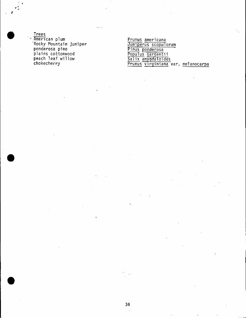
I <
Trees. - American plum
-Rocky Mountain juniperponderosa pineplains cottonwoodpeach leaf willowchokecherry
Prunus americanaJuniperus scopulorumPinus ponderosaPopulus sargentiiSalix amygdaloidesPrunus virginiana yare melanocarpa
34

Potential Birds of Rabbit Mountain ••Ordel"/Speci es
FalconiiformesTurkey VultureNorthern Harri erSwainson's HawkRed Tailed HawkFerruginous HawkRough Legged HawkGolden EagleAmerican KestrelPrairie Falcon
Peregrine Falcon
Ga 11 iformesRing Necked Pheasant
Time ofYear
SummerResidentSummerResidentResidentWinterResidentSummerSummer
Summer
Resident
Habitat
Mountain ValleysWetland, Open CountryOpen CountryOpen CountryOpen CountryOpen Country-Plains~lountai nsOpen CountryPlains, Open Valleys/
Cl iffsPlains, Open Valleys/
Cliffs
Plains-Roadsides
Frequency
Fairly CommonRateRareUncommonUncommonCommonUncommonCommonUncommon
Rare
Uncommon
ColumbiformesMourning Dove Summer Roadsides, Open Country Common
StrigiformesGreat Horned OwlBurrowing Owl
Long-eared OwlShort-eared Owl
CaprimulgiformesCommon Ni ghtha\'lkCommon Poor ~Ji 11
ApodiformesBl ack SwiftWhite Throated Swift
Pi ciformesLewis' WoodpeckerDowny WoodpeckerHa i ry \~oodpecker
Northern Flicker
PassiformesSay's Phoebe
AlauvidaeHorned Lark
ResidentSummer
WinterWinter
SummerSummer
SummerSummer
ResidentResidentResidentResident
Summer
Resident
ForestsGrasslands, Prairie
Dog TownsRiparian, SagebrushGrasslands, Wetlands
Dry ForestsJunipers
Cl iffsRock Outcrops
Open ForestsRiparian, ForestsRiparian, ForestsOpen Forests
. Open Country
Summer-AlpineWinter-Plains
35
Fairly Common I
Uncommon
UncommonUncommon
Fairly CommonFairly Common
Fairly CommonCommon
UncommonFairly CommonFairly CommonAbundant
Uncommon
Fairly Common : •

·'r'
•
, ('
- Order/Species
HirundinidaeCl iff Swa 11 ow
CorvidaeBlue JayScrub JayBlack Billed Magpie
American CrowCommon Raven
ParidaeBushtit
Sitti daePygmy Nuthatch
TroglodytidaeRock WrenCanyon WrenHouse Wren
SylviidaeBlue-gray Gnatcatcher
TurdidaeMountain BluebirdAmerican Robin
MimidaeNorthern Mockingbird
Brown Thrasher
BombycillidaeBohemian WaxwingCedar Waxwing
LaniidaeNorthern Shrike
VireonidaeSolitary Vireo
ParvlidaeVirginia's Warbler
IcteridaeWestern Meadowlark
Time ofYear
Summer
ResidentResidentResident
ResidentResident
Resident
Resident
SummerResidentSummer
Summer
SummerResident
Migrant/Winter
Migrant/Winter
WinterSpring/Fall
Winter
Summer
Summer
Resident
Habitat
Riparian, Open Country
Plains-Around HousesShrub Areas, JunipersAgricultural, Open
Areas, ForestsVa 11 eys-l owAlmost everywhere
Shrublands, Riparian
Ponderosa Pine
Rocky Cliffs, CanyonsCliffsShrub areas, Forests
Shrub areas
Open CountryAlmost everywhere
Open Forests, OpenCountry, Agricultural
Agricultural, Riparian
Shrub areasOpen Woods
Open Country, Riparian
Ponderosa Pine
Riparian, Open Country
Open Country
36
Frequency
Abundant
Fairly CommonRareAbundant
CommonCommon
Fairly Common
Abundant
Fairly CommonFairly CommonCommon
Casual
CommonAbundant
Rare
Uncommon
IrregularFairly Common
Fairly Common
Fairly Common
Fairly Common
Abundant

. Order/Spec ies
FringillidaeLazuli BuntingIndigo BuntingGreen-tailed TowheeRufous-sided TowheeTree SparrowChipping SparrowClay-colored SparrowVesper SparrowLark BuntingSavannah SparrowWhite Throated SparrowDark-eyed JuncoLapland LongspurRosy FinchCassin's FinchLesser GoldfinchAmerican Goldfinch
Time ofYear
SummerSummerSummerSummerWinterSummerMigrantSummerSummerSummerWinterResidentWinterResidentResidentSummerResident
Habitat
Shrub areasRiparian, ShrublandsRiparian, ShrublandsRiparian, ShrublandBrushy areasOpen WoodRiparian, GrasslandsGrasslands, ShrublandsGrasslands, Agricul.GrasslandsCliffsBrush near ForestsGrasslands, Agricul.Open CountryOpen ForestBrushy AreasBrush Areas
37
Frequency
CommonRareFairly CommonAbundantCommonCommonFairly CommonCommonRareRareUncommonCommonIrregularFairly CommonIrregularFairly CommonCommon
•
••

I- ------ ---- -- ---------
.' (. -:. ,-. (-
•Common Name
Potential Natural Fauna of Rabbit Mountain(O=Oocumented; H=Hypothetical; E=Extirpated)
Scientific Name
Insectivoresmasked shrew (H)montane shrew (H)dwarf shrew (H)Merriam's shrew (H)least shrew (H)
Batslittle brown bat (H)long-eared myotis (H)fringed myotis (H)long-legged myotis (H)small-footed myotis (H)silver-haired bat (H)big brown bat (H)hoary bat (H)Townsend's big-eared bat (H)
Rabbits & AlliesNuttall's cottontail (H)desert cottonta i 1 (0)white-tailed jackrabbit (H)black-tailed jackrabbit (H)
Rodentsleast chipmunk (H)Colorado chipmunk (0)yellow-bellied marmot (H)Wyoming ground squirrel (H)thirteen-lined ground squirrel (H)spotted ground squirrel (H)rock squi rrel (H)golden-mantled ground squirrel (H)black-tailed prairie dog (0)fox squirrel (H)Abert's squirrel (H)northern pocket gopher (0)plains pocket gopher (H)olive-backed pocket mouse (H)plains pocket mouse (H)silky pocket mouse (H)hispid pocket mouse (H)Ordls kangaroo rat (0)plains harvest mouse (H)western harvest mouse (0)
InsectivoraSorex cinereusSorex monticolaSorex nanusSorex iii'errlamiCryptotis parva
ChiropteraMyotis lucifugusMyotis evotisMyotis thysanodesMyotis volansMyotis leibiiLasionycteris noctivagansEptesicus fuscusLasiurus cinereusPlecotus townsendii
LagomorphaSylvilagus nuttalliiSylvilagus auduboniiLepus townsendiiLepus californicus
RodentiaTamias minimusTamiasguadrivittatusMarmota flaviventrisSp€rmophilus elegansSpermophilus tridecemlineatusSpermophilus spilosomaSpermophilus variegatusSpermophilus lateralisCynomys ludovicianusSciurus nigerSciurus abertiThomomys talpoidesGeomys bursariusPero9nathus fasciatusPerognathus flavenscensPerognathus flavusPerognathus hispidus
. Oi podomys ordi iReithrodontomys montanusReithrodontomys megalotis
38

( . I I,· .· ,<.J
Rodents Rodentia (continued) •"deer mouse (D) Peromyscus maniculatusrock mouse (H) Peromyscus difficilisnorthern grasshopper mouse (H) Onychomys leucogasterMexican woodrat (0) Neotoma mexicanameadow vole (H) Microtus pennsylvanicusmontane vole (H) Microtus montanuslong-tailed vole (H) Microtus longicaudusprairie vole (0) Microtus ochrogastermuskrat (H) Ondatra zibethicusmeadow jumping mouse (H) Zapus hudsonicusporcupine (0) Erethizon dorsatum
Carnivores Carnivoracoyote (0) Canis latransgray wolf (E) Cani s 1upusred fox (H) Vulpes vulpesswift fox (H) Vulpes veloxgray fox (H) Urocyon cinereoargenteusblack bear (H) Ursus americanusgrizzly bear (E) Ursus arctosraccoon (H) Procyon lotorri ngta il (H) Bassariscus astutusermine (H) Mustela erminealong-tailed weasel (H) Mustela frenatablack-footed ferret (E) Mustela nigripes -badger (H) Taxidea taxusspotted skunk (H) Spilogale putoriusstriped skunk (H) Mephitis mephitismountain lion (H) Felix concolorbobcat (0) Felis rufus----Even-toed Ungulates Artiodactylawapiti or elk (0) Cervus'elaphusmule deer (0) Odocoileus hemionuswhite-tailed deer (0) Odocoileus virginianuspronghorn (E) Antilocapra americanabison (E) Bison bisonbighorn sheep (E) Ovis canadensis
•39