r archaeological s the nashwaak, b tracadie and …€¦ · bunker op-1 (cidg32) ... barnabys nose...
TRANSCRIPT

Recent ARchAeologicAl SuRveyS on the nAShwAAk, Big tRAcAdie
And MAgAguAdAvic RiveRS
ReconnAiSSAnceS ARchéologiqueS RécenteS SuR leS RivièReS nAShwAAk,
Big tRAcAdie et MAgAguAdAvicBy
Vincent Bourgeois and Brent D. SuttieNEW BRUNSWICK MANUSCRIPTS IN ARCHAEOLOGY 42
parVincent Bourgeois et Brent D. Suttie
MANUSCRITS SUR L’ARCHÉOLOGIE 42 DU NOUVEAU-BRUNSWICK

Recent ARchAeologicAl SuRveyS on the nAShwAAk, Big tRAcAdie
And MAgAguAdAvic RiveRSBy
Vincent Bourgeois and Brent D. SuttieNEW BRUNSWICK MANUSCRIPTS IN ARCHAEOLOGY 42

2 New Brunswick Manuscripts in Archaeology 42
This series is designed to facilitate the distribution of manuscripts relating to New Brunswick archaeology. They will be published in small quantities and will generally be available by special request only.
© Vincent Bourgeois, Brent D. Suttie and the Province of New Brunswick
New Brunswick Manuscripts in Archaeology 42, 2005.
Published and edited by:
Archaeological Services, Heritage BranchCulture and Sport Secretariat
P.O. Box 6000Fredericton, N.B.E3B 5H1, Canada
ISBN 1-55396-471-3
Printed in CanadaCNB 7363

Recent Archaeological Surveys on the Nashwaak, Big Tracadie and Magaguadavic Rivers 3
List of Figures . . . . . . . . . . . . . . . . . . . . . . . . . . . . . . . . . . . . . .5Acknowledgments . . . . . . . . . . . . . . . . . . . . . . . . . . . . . . . . . . . 6Abstract . . . . . . . . . . . . . . . . . . . . . . . . . . . . . . . . . . . . . . . . . . . . . 6
Chapter 1 Introduction . . . . . . . . . . . . . . . . . . . . . . . . . . . . . . . . . . . . . . .7
Chapter 2 Phase I of the Lower Nashwaak River Survey . . . . . . . . .9
Introduction . . . . . . . . . . . . . . . . . . . . . . . . . . . . . . . . . . . . . . . . . 9Results . . . . . . . . . . . . . . . . . . . . . . . . . . . . . . . . . . . . . . . . . . . . . . . 9
Eroding Cellar site (CbDp1) . . . . . . . . . . . . . . . . . . . . . . . . . 9Taymouth site (CbDp2) . . . . . . . . . . . . . . . . . . . . . . . . . . . . . 9Durham Bridge site (CaDp2) . . . . . . . . . . . . . . . . . . . . . . . 10Penniac site (CaDp3) . . . . . . . . . . . . . . . . . . . . . . . . . . . . . . 10
Conclusion and Recommendations . . . . . . . . . . . . . . . . . . 10
Chapter 3 The Tracadie Range Archaeological Project . . . . . . . . .11
Introduction . . . . . . . . . . . . . . . . . . . . . . . . . . . . . . . . . . . . . . . . 11Results . . . . . . . . . . . . . . . . . . . . . . . . . . . . . . . . . . . . . . . . . . . . . . 11Military Sites . . . . . . . . . . . . . . . . . . . . . . . . . . . . . . . . . . . . . . . . 11
Bunker OP-1 (CiDg32) . . . . . . . . . . . . . . . . . . . . . . . . . . . . . 11Bunker OP-4 (CiDg34) . . . . . . . . . . . . . . . . . . . . . . . . . . . . . 12Bunker OP-8 (CiDg33) . . . . . . . . . . . . . . . . . . . . . . . . . . . . . 12
Non-military Sites . . . . . . . . . . . . . . . . . . . . . . . . . . . . . . . . . . . 12Pointe à Honoré site (CiDg35) . . . . . . . . . . . . . . . . . . . . . 12Barnabys Nose site (CiDg1) . . . . . . . . . . . . . . . . . . . . . . . . 13Alexander LeBreton site (CiDh2) . . . . . . . . . . . . . . . . . . . 13Nathalie site (CiDg19) . . . . . . . . . . . . . . . . . . . . . . . . . . . . . 13Cap Blanc site (CiDg36) . . . . . . . . . . . . . . . . . . . . . . . . . . . 14Duck Blind site (CiDg20) . . . . . . . . . . . . . . . . . . . . . . . . . . 14Point à Charles Comeau site (CiDg37) . . . . . . . . . . . . . . 14Pointe du Vieux Boom site (CiDg38) . . . . . . . . . . . . . . . 14Crossing site (CiDg39) . . . . . . . . . . . . . . . . . . . . . . . . . . . . . 15Small Spring site (CiDg40) . . . . . . . . . . . . . . . . . . . . . . . . . 15Trail site (CiDg41) . . . . . . . . . . . . . . . . . . . . . . . . . . . . . . . . . 15Embankment site (CiDg42) . . . . . . . . . . . . . . . . . . . . . . . . 15Shallows site (CiDg43) . . . . . . . . . . . . . . . . . . . . . . . . . . . . 15Magasin site (CiDg44) . . . . . . . . . . . . . . . . . . . . . . . . . . . . . 15Ditch site (CiDg25) . . . . . . . . . . . . . . . . . . . . . . . . . . . . . . . . 16Road Cut site (CiDg16) . . . . . . . . . . . . . . . . . . . . . . . . . . . . 16Blue Ribbon site (CiDg18) . . . . . . . . . . . . . . . . . . . . . . . . . 16Long Stretch Rock Shelter (CiDg21) . . . . . . . . . . . . . . . . 16Barney Comeau Shrine (CiDg45) . . . . . . . . . . . . . . . . . . . 16
Conclusion . . . . . . . . . . . . . . . . . . . . . . . . . . . . . . . . . . . . . . . . . . 17
Chapter 4 Phase I of the Magaguadavic River Survey . . . . . . . . . .19
Introduction . . . . . . . . . . . . . . . . . . . . . . . . . . . . . . . . . . . . . . . . 19Results . . . . . . . . . . . . . . . . . . . . . . . . . . . . . . . . . . . . . . . . . . . . . . 20Archaeological Sites on the Magaguadavic River . . . . . 20
Piskahegan Blockhouse site (BiDr1) . . . . . . . . . . . . . . . . 20Pomeroy site (BiDr2) . . . . . . . . . . . . . . . . . . . . . . . . . . . . . . 20Magaguadavic Esker site (BiDr3) . . . . . . . . . . . . . . . . . . . 21Piskahegan site (BiDr4) . . . . . . . . . . . . . . . . . . . . . . . . . . . . 21Grand Forks site (BiDr5) . . . . . . . . . . . . . . . . . . . . . . . . . . . 21McDougall Falls site (BhDq11) . . . . . . . . . . . . . . . . . . . . . 22Tent Island Portage (BhDr5) . . . . . . . . . . . . . . . . . . . . . . . 22
Archaeological Sites on McDougall Lake . . . . . . . . . . . . . 23McLean Cove site (BhDq12) . . . . . . . . . . . . . . . . . . . . . . . 23Back Meadow site (BhDq13) . . . . . . . . . . . . . . . . . . . . . . . 23Stranded Beach site (BhDq14) . . . . . . . . . . . . . . . . . . . . . 23McDougall Lake site (BhDq15) . . . . . . . . . . . . . . . . . . . . . 24McDougall Lake Inlet site (BhDq16) . . . . . . . . . . . . . . . . 24Turtle Islet site (BhDq17) . . . . . . . . . . . . . . . . . . . . . . . . . . 25Marsh-side site (BhDq18) . . . . . . . . . . . . . . . . . . . . . . . . . . 25
Conclusion . . . . . . . . . . . . . . . . . . . . . . . . . . . . . . . . . . . . . . . . . . 25
References Cited . . . . . . . . . . . . . . . . . . . . . . . . . . . . . . . . . .27
Table of Contents

4 New Brunswick Manuscripts in Archaeology 42
List of Figures
Figure 3.11 View of the Trail site (CiDg41).
Figure 3.12 View southeast of the Shallows site (CiDg43).
Figure 3.13 View southeast of the Magasin site (CiDg44).
Figure 3.14 View southeast of the Road Cut site (CiDg16).
Figure 3.15 View of the Long Stretch Rock Shelter (CiDg21).
Figure 3.16 View of Barney Comeau Shrine (CiDg45).
Figure 4.1 Area of the Magaguadavic River surveyed with recorded sites.
Figure 4.2 View north showing location of Piskahegan Blockhouse site (BiDr1).
Figure 4.3 Flood plain at the Pomeroy site (BiDr2), looking east.
Figure 4.4 Test Pit 1 at the Pomeroy site with quartzite flake in south wall profile.
Figure 4.5 Large secondary flake of purple/brown quartzite from test pit 1 at the Pomeroy site.
Figure 4.6 View north of the Magaguadavic Esker site (BiDr3).
Figure 4.7 Some of the artifacts recovered from the Magaguadavic Esker site a) large battered slate object; b) abrader; c) large secondary flake of opaque quartz.
Figure 4.8 View south of the Piskahegan site (BiDr4).
Figure 4.9 McDougall Falls site (BhDq11).
Figure 4.10 Test Unit 1 at the McDougall Falls site.
Figure 4.11 Profile of Unit 1 at the McDougall Falls site.
Figure 4.12 Representative sample of ceramic vessel fragments and an expedient biface recovered from Test Unit 1 at the McDougall Falls site.
Figure 4.13 Tent Island Portage (BhDr5) as recorded in 1797 and as observed during survey.
Figure 1.1 General location map of areas surveyed.
Figure 2.1 Area of Nashwaak River surveyed with sites located.
Figure 2.2 View to the west overlooking the Taymouth site (CbDp2) located on the inside bend in the foreground.
Figure 2.3 Brent MacEachern at the Durham Bridge site (CaDp2), flake is located adjacent to photo scale.
Figure 2.4 Bottom of boat ramp at Penniac site (CaDp3), flagging tape indicates find spot.
Figure 3.1 Area of Big Tracadie River surveyed with recorded sites.
Figure 3.2 View of the exterior of Bunker OP-1 (CiDg32).
Figure 3.3 View of the interior of Bunker OP-4 (CiDg34).
Figure 3.4 View of the exterior of Bunker OP-8 (CiDg33).
Figure 3.5 Selection of formal artifacts from Pointe à Honoré site (CiDg35) a) biface tip fragment; b-d) quartz uniface fragment.
Figure 3.6 View of the Pointe à Honoré site (CiDg35) in foreground and the Barnabys Nose site (CiDg1) on the point of land in background.
Figure 3.7 Formal tools from Barnabys Nose site (CiDg1) a) biface; b) ceramic sherd; c) abrader; d) ground stone implement.
Figure 3.8 Selection of formal artifacts from Nathalie site (CiDg19) a-b) quartz biface fragments; c) abrader.
Figure 3.9 Formal tools and tool fragments from the Cap Blanc site (CiDg36) a-d) stemmed bifaces; e) biface; f- i) biface fragments.
Figure 3.10 View of the stone lined cellar at the Point à Charles Comeau site (CiDg37).

Recent Archaeological Surveys on the Nashwaak, Big Tracadie and Magaguadavic Rivers 5
Figure 4.14 Looking north at the McLean Cove site (BhDq12).
Figure 4.15 Looking west towards the Back Meadow site (BhDq13), McDougall Lake is located 100 m north.
Figure 4.16 Flake scatter at the Stranded Beach site (BhDq14).
Figure 4.17 Looking east at the McDougall Lake site (BhDq15), figure standing next to find spots.
Figure 4.18 Projectile points from the McDougall Lake site.
Figure 4.19 Surface exposure at the McDougall Lake Inlet site.
Figure 4.20 View to the north at the Turtle Islet site (BhDq17).
Figure 4.21 View to the north at the Marsh-side site (BhDq18).
AcknowledgmentsThe authors wish to acknowledge the following individuals and institutions for their help during various stages of the projects: Brent MacEachern for volunteering his time during the Lower Nashwaak River survey: Vincent Comeau of Tracadie for providing logistical support during the Tracadie Range survey and for sharing his considerable knowledge of the area; Thierry Arseneau of Department of Natural Resources in Fredericton for his help during the initial planning of both the Tracadie Range and Magaguadavic River surveys; and finally David and Sharon Suttie for providing accommodations during the Magaguadavic River survey.
AbstractThis manuscript summarizes the results of three archaeological surveys conducted by the Archaeological Services Unit of New Brunswick between 2002 and 2004. All three projects focused on sections of river drainages within the Province. A total of four archaeological sites were recorded during the Lower Nashwaak River survey, which covered a 34 km length of the river between Nashwaak Bridge and Marysville. The second survey focused on a 21 km section of the Big Tracadie River within the former Tracadie Range property, in which 22 archaeological sites were recorded. The Magaguadavic River survey was conducted on a 13 km section of the river between Pomeroy and Lee Settlement, resulting in the recording of 14 archaeological sites.

6 New Brunswick Manuscripts in Archaeology 42

Figure 1.1 - General location map of areas surveyed.
Recent Archaeological Surveys on the Nashwaak, Big Tracadie and Magaguadavic Rivers 7
The following manuscript presents the results of three archaeological surveys conducted by the Archaeological Services Unit of New Brunswick between 2002 and 2004. All three projects focused on sections of river drainages within the Province (Figure 1.1). Although each project was conducted in response to varying circumstances and requests, and used different methodologies, the ultimate
goal of each was to identify historic and pre-contact archaeological sites to expand the resource management and research potential of the provincial sites registry.
The abbreviated survey reports which follow are presented in the order in which they were conducted, beginning with the Lower Nashwaak River survey, conducted in September of 2002. The survey covered
Chapter 1 Introduction

8 New Brunswick Manuscripts in Archaeology 42
a 34 km length of the Nashwaak River between Nashwaak Bridge and Marysville. The project was in response to a request by Saint Mary’s First Nation that archaeological sites be identified and included as a resource within the Saint Mary’s Rural Plan.
The second survey was conducted in July of 2003 and focused on a 21 km section of the Big Tracadie River within the former Tracadie Military Range property, currently managed by Department of Natural Resources. Archaeological Services Unit entered into an agreement with the Department of Natural Resources to identify any archaeological resources within the property for land use management purposes.
The last survey was conducted in June of 2004 on a 13 km section of the Magaguadavic River between Pomeroy and Lee Settlement. The project was initiated in response to recent research into Archaic Period sites in the interior of Charlotte County. The study area was selected based on elevated archaeological potential suggested by the topography and geomorphology of the river. Several references to historic camping locations and portages in an 18th century mapping survey were also used to determine high potential areas.

Recent Archaeological Surveys on the Nashwaak, Big Tracadie and Magaguadavic Rivers 9
IntroductionDuring the week of September 2-5, 2002, a pedestrian survey was conducted on the Lower Nashwaak River, from Nashwaak Bridge to Marysville (Figure 2.1). Because of the nature of the survey, only exposed archaeological material was located. The survey was conducted by Brent Suttie (principal investigator) and Brent MacEachern (undergraduate student, UNB).
The pedestrian survey was facilitated by low river levels which allowed access to both sides of the river. The majority of the finds were made on exposed gravel bars and in the shallows adjacent to eroding river banks. Overall, the river banks in the survey area were found to be quite stable. Very few recent erosional faces were observed.
Figure 2.1 - Area of Nashwaak River surveyed with sites located.
ResultsThe Lower Nashwaak survey resulted in the recording of four archaeological sites, three of which are
assessed as containing pre-contact components. A fourth site consisted of a historic building foundation. The sites are discussed briefly below.
Eroding Cellar site (CbDp1)The site consists of a stone-lined cellar measuring approximately 3.5 m by 5.2 m in length. The latter measurement should be viewed with caution as a large portion of the cellar appears to have fallen down the bank and onto the beach below. From objects observed in and around the cellar, it appears that this structure may have been used as recently as the mid-part of the 20th century. The cellar was recorded because of its precarious state and to provide a record of the rate of erosion along this stretch of river.
Taymouth site (CbDp2)This site is located on the Tay River approximately 250 m upstream from its confluence with the Nashwaak River. A secondary flake of dark, fine-grained volcanic and a primary flake of bleached fine-grained volcanic were recovered from a sand and gravel bar on the inside of a bend on the Tay River (Figure 2.2). The site is presently being disturbed by all-terrain vehicles which could be exposing some of the cultural material, as both flakes show little evidence of weathering.
Figure 2.2 - View to the west overlooking the Taymouth site (CbDp2) located on the inside bend in the foreground.
Chapter 2 Phase I of the Lower Nashwaak River Survey
Brent D. Suttie
10 New Brunswick Manuscripts in Archaeology 42
Durham Bridge site (CaDp2)A single artifact was recovered from what can only be interpreted as a recently deposited context, on a cobble and gravel bar just above the Durham Bridge crossing. The artifact is a complete secondary flake of a red and white, highly translucent chert with strain fractures. This flake is consistent with material which has been observed on the beaches along the southern shore of Washademoak Lake, in Queens County (Black and Wilson 1997; Black et al. 2003).
The flake was recovered from an environment which is most likely high-energy during certain periods of the year, judging from the surrounding substrate of large gravel and medium-sized cobbles (Figure 2.3). This observation suggests that the artifact may originate from an eroding site further upstream.
Figure 2.3 - Brent MacEachern at the Durham Bridge site (CaDp2), flake is located adjacent to photo scale.
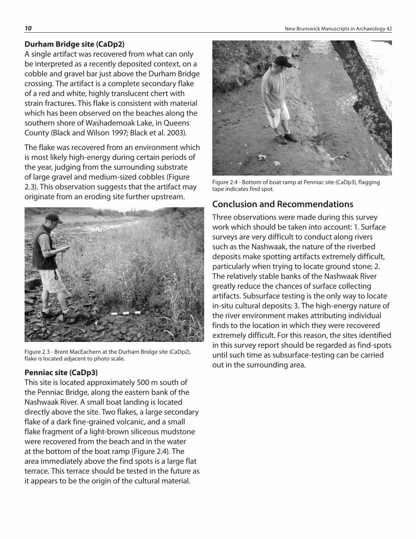
Penniac site (CaDp3)This site is located approximately 500 m south of the Penniac Bridge, along the eastern bank of the Nashwaak River. A small boat landing is located directly above the site. Two flakes, a large secondary flake of a dark fine-grained volcanic, and a small flake fragment of a light-brown siliceous mudstone were recovered from the beach and in the water at the bottom of the boat ramp (Figure 2.4). The area immediately above the find spots is a large flat terrace. This terrace should be tested in the future as it appears to be the origin of the cultural material.
Figure 2.4 - Bottom of boat ramp at Penniac site (CaDp3), flagging tape indicates find spot.
Conclusion and RecommendationsThree observations were made during this survey work which should be taken into account: 1. Surface surveys are very difficult to conduct along rivers such as the Nashwaak, the nature of the riverbed deposits make spotting artifacts extremely difficult, particularly when trying to locate ground stone; 2. The relatively stable banks of the Nashwaak River greatly reduce the chances of surface collecting artifacts. Subsurface testing is the only way to locate in-situ cultural deposits; 3. The high-energy nature of the river environment makes attributing individual finds to the location in which they were recovered extremely difficult. For this reason, the sites identified in this survey report should be regarded as find-spots until such time as subsurface-testing can be carried out in the surrounding area.

Figure 3.1 - Area of Big Tracadie River surveyed with recorded sites.
Recent Archaeological Surveys on the Nashwaak, Big Tracadie and Magaguadavic Rivers 11
IntroductionThe objective of the Tracadie Range Archaeological Project was to identify sites of archaeological significance within the former Tracadie Military Training Area (Figure 3.1). The property is currently managed by the Department of Natural Resources. The archaeological sites were to be identified so that they may be considered as fragile resources during future land use management decisions.
The archaeological survey was conducted between July 7th and 18th, 2003 by a two person crew. The survey focused almost entirely on the 21 km section of the Big Tracadie River that flows within the former Range property. The survey was conducted primarily by canoe; however, certain locations were accessed by vehicle. Exposed river banks were examined for eroding cultural materials and shovel testing was performed on level terraces deemed to hold high potential for archaeological resources.
ResultsA total of 22 archaeological sites were identified and recorded within the project area. With the exception of the three military features, all of the recorded sites were situated along the shores of the Big Tracadie River. The following presents a brief description of the sites investigated.
Military SitesThe first 1.5 days of fieldwork were devoted to locating and recording three military “bunkers” or observation posts, constructed shortly after the Range opened in the early 1940’s. The bunkers are low-lying concrete structures which extend underground approximately 2 m.
Bunker OP-1 (CiDg32)Bunker OP -1 is located south of the Big Tracadie River. It consists of a rectangular structure constructed entirely of concrete with flat roof (Figure
Chapter 3 The Tracadie Range Archaeological Project
Vincent Bourgeois

12 New Brunswick Manuscripts in Archaeology 42
3.2). The entrances to the structure consist of two rectangular doorways at either end of the west wall. Three rectangular observation windows are situated longitudinally between the two entrances. The bunker was used as an observation post during the air to ground ordinance testing operations as well as during ground ammunition testing. Currently the structure is almost completely buried.
Figure 3.2 - View of the exterior of Bunker OP-1 (CiDg32).
Bunker OP-4 (CiDg34)Bunker OP-4 is located north of the Big Tracadie River. Unlike Bunker OP-1, this structure is roughly triangular in shape and is completely exposed on a ridge top (Figure 3.3). It was likely used as a machine gun range observation bunker for ground forces training. The concrete has deteriorated considerably from weathering and presumably also from ammunition impact. Recent campfires were observed on the flat roof as well as considerable spray painted graffiti.
Figure 3.3 - View of exterior of Bunker OP-4 (CiDg34).
Bunker OP-8 (CiDg33)Bunker OP-8 is identical in shape and dimensions to Bunker OP-1 (Figure 3.4). It is also located south of the Big Tracdie River and is almost completely covered with fill and vegetation. Of the three bunkers recorded, Bunker OP-8 is the most isolated and therefore has suffered less damage from recent vandalism.
Figure 3.4 - View of interior of Bunker OP-8 (CiDg33).
Non-military SitesA total of 19 archaeological sites were recorded along banks of the Big Tracadie River within the former Range. Of these, seven were previously recorded sites that were revisited in order to record additional information. Sites with Borden designation between CiDg35 and CiDg44 represent newly discovered sites not previously recorded.
Pointe à Honoré site (CiDg35)The Pointe à Honoré site is a multi-component site located at the easternmost end of the former Military Range. The site is situated on the north bank of the Tracadie River estuary just east of Barnabys Nose Brook. A large cluster of pre-contact artifacts and a small assemblage of historic ceramics were collected along approximately 76 m of exposed beach below a narrow terrace on the east side of the jutting point (Figure 3.5). The site was considered separate from the previously recorded Barnabys Nose site (CiDg1) located on the tip of the point. Approximately 100 m of low-lying area, where no artifacts were observed, separates the two locations (Figure 3.6).

Recent Archaeological Surveys on the Nashwaak, Big Tracadie and Magaguadavic Rivers 13
Figure 3.5 - Selection of formal artifacts from Pointe à Honoré site (CiDg35) a) biface tip fragment; b- d) quartz uniface fragment.
Figure 3.6 - View of the Pointe à Honoré site (CiDg35) in foreground and the Barnabys Nose site (CiDg1) on the point of land in background.
Barnabys Nose site (CiDg1)The Barnabys Nose site is located on the tip of a point of land at the confluence of the Barnabys Nose stream where it feeds into the Big Tracadie River. The site is situated on a wide terrace which is largely open field grass with alder shrubs. The site was previously recorded in the 1970’s and further investigated in 1985 at which time a sizable collection of artifacts was recovered (Buxton-Keenlyside 1971; Keenlyside 1990). Keenlyside (1990) makes reference to a large wooden cross that had been erected on the site some time ago to mark a recent burial. This cross is still standing and was helpful in confirming the location of the site. During the 2003 survey, several lithic artifacts were recovered as well as pre-contact ceramic sherds, supporting the initial assessment of a Maritime Woodland affiliation at the site (Figure 3.7).
Figure 3.7 - Formal tools from Barnabys Nose site (CiDg1) a) biface; b) ceramic sherd; c) abrader; d) ground stone implement.
Alexander LeBreton site (CiDh2)The Alexander LeBreton site is the western-most site recorded within the project area. It was initially identified as a historic site based on the presence of a concrete and brick foundation sill within a clearing on the north bank of the river. A wooden sign post identified the location as the Alexander LeBreton camp site.
While no artifacts were observed along the eroding bank, several quartz flakes were recovered from a road cut on the terrace. Two shovel tests excavated in the vicinity of the concrete sill identified both historic and pre-contact artifacts. The few historic artifacts identified from the upper levels of the testing are most likely associated with the concrete sill which appears to date no earlier than the first half of the 20th century. Four flakes and two pre-contact ceramic sherds were recovered from one of the test units in what appeared to be an intact soil deposit between 12 cm and 64 cm below surface. From the same test pit, a single quartz flake was recovered within a deeper level at 93 cm below surface. Based on the contextual information from the limited testing of the site, this location has elevated potential for undisturbed and stratified cultural deposits.
Nathalie site (CiDg19)The Nathalie site was previously recorded and tested in the 1970’s (Buxton-Keenlyside 1971; Keenlyside 1990).
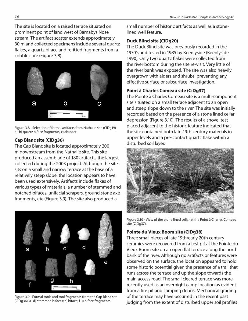
Figure 3.9 - Formal tools and tool fragments from the Cap Blanc site (CiDg36) a -d) stemmed bifaces; e) biface; f- i) biface fragments.
14 New Brunswick Manuscripts in Archaeology 42
The site is located on a raised terrace situated on prominent point of land west of Barnabys Nose stream. The artifact scatter extends approximately 30 m and collected specimens include several quartz flakes, a quartz biface and refitted fragments from a cobble core (Figure 3.8).
Figure 3.8 - Selection of formal artifacts from Nathalie site (CiDg19) a - b) quartz biface fragments; c) abrader
Cap Blanc site (CiDg36)The Cap Blanc site is located approximately 200 m downstream from the Nathalie site. This site produced an assemblage of 180 artifacts, the largest collected during the 2003 project. Although the site sits on a small and narrow terrace at the base of a relatively steep slope, the location appears to have been used extensively. Artifacts include flakes of various types of materials, a number of stemmed and notched bifaces, unifacial scrapers, ground stone axe fragments, etc (Figure 3.9). The site also produced a
small number of historic artifacts as well as a stone-lined well feature.
Duck Blind site (CiDg20)The Duck Blind site was previously recorded in the 1970’s and tested in 1985 by Keenlyside (Keenlyside 1990). Only two quartz flakes were collected from the river bottom during the site re-visit. Very little of the river bank was exposed. The site was also heavily overgrown with alders and shrubs, preventing any effective surface or subsurface investigation.
Point à Charles Comeau site (CiDg37)The Pointe à Charles Comeau site is a multi-component site situated on a small terrace adjacent to an open and steep slope down to the river. The site was initially recorded based on the presence of a stone lined cellar depression (Figure 3.10). The results of a shovel test placed adjacent to the historic feature indicated that the site contained both late 19th century materials in upper levels and a pre-contact quartz flake within a disturbed soil layer.
Figure 3.10 - View of the stone lined cellar at the Point à Charles Comeau site (CiDg37).
Pointe du Vieux Boom site (CiDg38)Three small pieces of late 19th/early 20th century ceramics were recovered from a test pit at the Pointe du Vieux Boom site on an open flat terrace along the north bank of the river. Although no artifacts or features were observed on the surface, the location appeared to hold some historic potential given the presence of a trail that runs across the terrace and up the slope towards the main access road. The small cleared terrace was more recently used as an overnight camp location as evident from a fire pit and camping debris. Mechanical grading of the terrace may have occurred in the recent past judging from the extent of disturbed upper soil profiles

Recent Archaeological Surveys on the Nashwaak, Big Tracadie and Magaguadavic Rivers 15
in the test unit. This could account for the lack of historic features on the surface.
Crossing site (CiDg39)A cluster of historic artifacts were observed along the south embankment adjacent to an abandoned river crossing on the south side of the river. The artifacts are of a late 19th century origin and are most likely associated with logging and/or fishing activities. No historic features were observed on the surface, however further investigation in areas back from the river bank could reveal additional information on site function.
Small Spring site (CiDg40)Several quartz flakes and a biface fragment were collected from the south bank of the river adjacent to a small freshwater spring which drains into the river. Testing above the embankment along a narrow terrace failed to identify any additional artifacts suggesting that the bulk of the site could be confined to the bank edge on either side of the spring. The remnant of an old road or trail was observed on the terrace running parallel to the river. This could account for the absence of artifacts on the terrace.
Trail site (CiDg41)The Trail site is located on the south bank of the Tracadie River approximately 200 m up river from the Small Spring site (Figure 3.11). Artifacts collected on the beach along the eroding embankment included historic ceramics, bottle glass, and a single chert flake. An extension of the overgrown trail above the Small Spring site (CiDg40) also runs across the narrow terrace approximately 2 to 3 m above the Trail site. Although no historic features were observed on the surface, the trail is likely an old access road associated with logging and/or fishing activities.
Figure 3.11 -View of the Trail site (CiDg41).
Embankment site (CiDg42)A total of 5 quartz flakes were collected and a few calcined bone fragments were observed at the Embankment site. The site is so-named because of the high embankment which appears to be the source of the cultural material. The entire artifact assemblage was collected from the river bottom given the absence of exposed beach. The terrace above the embankment is very narrow and small. Considerable erosion has occurred at the site and slumpage was observed along most of the bank edge. It is estimated that most of the site has eroded. Additional testing is needed to confirm this.
Shallows site (CiDg43)A large assemblage of historic ceramics and glass was observed on the beach and in the shallow water on the south side of the River within Long Stretch section (Figure 3.12). A quartz biface was also recovered, suggesting the site contains multiple components. Poor surface visibility from alder and shrub thickets made surface examination of the site difficult. No historic features were observed.
Figure 3.12 - View southeast of the Shallows site (CiDg43).
Magasin site (CiDg44)This site was previously identified as the Magasin site during a survey in 1997 but it was never registered with a Borden designation (Dillon Consulting Limited 1997). The site is located on the south bank of the River on a point of land (Figure 3.13). During the current survey only three quartz flakes were collected from the eroding bank. The previous 1997 survey describes the site as occupying an area of approximately 2500 m². The artifacts collected included a ground stone celt and a large flake scatter.

16 New Brunswick Manuscripts in Archaeology 42
Figure 3.13 - View southeast of the Magasin site (CiDg44).
Ditch site (CiDg25)In 1997, this site (CiDg25) was recorded as a historic site based on a series of historic trenches recorded above the southern embankment (Blair and Polchies 1997). During the 2003 survey, 7 quartz flakes were recovered on the beach below the eroding embankment. The presence of flakes on the site suggests a previously unrecorded pre-contact component. No historic artifacts were observed.
Road Cut site (CiDg16)Two quartz flakes and a late 19th or early 20th century ceramic sherd were collected from the eroding embankment on the south shore where a small stream empties into the River (Figure 3.14). The area was previously identified and recorded as the Road Cut site (Keenlyside 1990). The artifact scatter extends approximately 30 m.
Figure 3.14 - View southeast of the Road Cut site (CiDg16).
Blue Ribbon site (CiDg18)A quartz biface, 2 quartz flakes, and one historic pipe stem fragment were collected from a small clearing located on the south shore of the river. The site was previously recorded in the late 1990’s and described as a 19th century farmstead with a pre-contact spot find (Blair and Polchies 1997).
Long Stretch Rock Shelter (CiDg21)The Long Stretch Rock Shelter was previously recorded by Keenlyside (1990). The site was revisited during the current survey in the hopes of undertaking subsurface testing (Figure 3.15). The lack of soil deposition inside the shelter did not allow for standard testing. The shelter floor is largely composed of sandstone debris spalled from the bedrock ceiling. An attempt was made to excavate into the debris by trowel. No cultural materials were observed. Also noted was the smoke-stained ceiling of the shelter. A search for a second rock shelter identified by Dillon Consulting Limited (1997) was unsuccessful.
Figure 3.15 - View of the Long Strech Rock Shelter (CiDg21).
Barney Comeau Shrine (CiDg45)According to local informant, this stone shrine was erected in the 1940’s by Barney Comeau. Comeau was a resident of Tracadie-Sheila who often fished the Big Tracadie River at this location. Apparently, the religious shrine was constructed to ensure successful fishing ventures and is still being visited for the same purpose. The shrine is constructed of flat slabs of sandstone fashioned into a triangular shape with an opening in the front where some religious items are placed (Figure 3.16).

Recent Archaeological Surveys on the Nashwaak, Big Tracadie and Magaguadavic Rivers 17
Figure 3.16 - View of Barney Comeau Shrine (CiDg45).
ConclusionThe primary objective of this survey was to locate and record archaeological sites within the former Tracadie Military Training Area with particular focus on the 21 km section of the Big Tracadie River. The duration of the survey did not allow for extensive testing of site locations, hence, the majority of the sites recorded were located by surface collecting. This technique is considered insufficient for recovering representative artifact samples. Additional controlled testing would be required to provide more detailed account on site age or function.
Of the 22 archaeological sites recorded during this survey, six are historic, seven are pre-contact, and nine sites contained both historic and pre-contact artifacts. With the exception of the observation bunkers, the historic components recorded during the survey seem to relate to late 19th and early 20th century logging and fishing activities. These activities occurred before the area was used as a military range in 1940.
The archaeological data gathered from the pre-contact components supports the earlier notion of small seasonal/short term and task specific campsites (Keenlyside 1990). The location of the study area, beyond the upper reaches of the estuary, bears directly on the level of site intensity and occupation. As in most cases, the larger more permanent settlements are situated downriver, closer to the mouth of the drainage system. The smaller pre-contact sites recorded within the western and central portions of the study area likely represent specialized satellite locations. The larger sites recorded within the eastern end of the study area are clustered around the head of tide.
For the most part, the diagnostic artifacts from the pre-contact assemblages bear similarities to well dated Maritime Woodland Period examples in the region from 2500 to 500 years ago. The presence of ceramics and the small side and corner notched projectile points fit neatly within this time frame. The various small unifacially flaked scrapers and large bifacial knives could suggest fish processing activities at the sites.

Figure 4.1 - Area of the Magaguadavic River surveyed with recorded sites.
18 New Brunswick Manuscripts in Archaeology 42
IntroductionAs part of an initiative to investigate the potential for early pre-contact archaeological sites in the interior of the Province, Archaeological Services sponsored a two week research-oriented archaeological survey on a portion of the Magaguadavic River. With recent research having identified early pre-contact sites in the vicinity of interior lakes and river systems within Charlotte County (Suttie 2004), the current survey focused on investigating a section of the river system in search of comparable early pre-contact sites.
The initial objective of the project was to survey a 13 km section of the Magaguadvaic River between Pomeroy and Lee Settlement, an area largely managed as provincial Crown Lands (Figure 4.1).
Prior to the survey, a basic predictive model was developed to identify areas of high potential for investigation in the field. The model employed assessed areas as one of three values with “class 1” being the highest potential, “class 2” medium potential and “class 3” the lowest potential. Areas designated as class 1 were based on a selection criteria that included: areas adjacent to tributaries, falls and rapids, areas with level terraces and/or on prominent points of land. Locations identified in an 18th century historical account of a mapping survey of the Magaguadavic River (Ganong 1907) were also designated “class 1”. This document mentions favorable camping locations as well as portage routes around falls and rapids within the study area.
Class 2 designated areas were given to locations adjacent to prominent features on the landscape, but lacked obvious terraces for occupation. This designation was also assigned to areas along the river which appeared from mapping data to be flat and conducive to human occupation, but lacked any obvious associations with prominent features on the landscape (i.e. streams, springs, points of land, lookouts, and known portage routes).
Class 3 designations were assigned to areas which appeared to lack flat terrain and did not appear to be associated with areas of prominence on the
Chapter 4 Phase I of the Magaguadavic River SurveyVincent Bourgeois Brent D. Suttie

Figure 4.2 - View north showing location of Piskahegan Blockhouse site (BiDr1).
Figure 4.3 - Flood plain at the Pomeroy site BiDr2), looking east.
Figure 4.4 - Test Pit 1 at the Pomeroy site with quartzite flake in south wall profile.
Figure 4.5 - Large secondary flake of purple/brown quartzite from test pit 1 at the Pomeroy site.
Recent Archaeological Surveys on the Nashwaak, Big Tracadie and Magaguadavic Rivers 19
landscape. These areas were tentatively ascribed a low-potential classification.
ResultsPrior to entering the field, 19 locations within the Magaguadavic River were identified as class 1 or “high potential”, based on analysis of aerial photographs and topographic maps. Unfortunately the unusually low water levels restricted efforts to access all of the proposed study area and only a small section of the study area could be investigated effectively. The following provides a summary of the field results. The first half focuses on the sites recorded on the Magaguadavic River, and the second half describes the sites recorded along the shores of McDougall Lake.
Archaeological Sites on the Magaguadavic RiverPiskahegan Blockhouse site (BiDr1)This site is located at Pomeroy on the east bank of the Magaguadavic River, just south of the former military road once used by British soldiers to travel from St. Andrews to Fredericton. A Blockhouse was built in 1812 to protect this important travel route and line of communication. The structure is mentioned in several historical accounts and is shown on an early grant map of the area (Ganong 1899: 347). It is described as being on a high terrace overlooking the river. A surface reconnaissance identified a large circular depression which a former landowner later suggested had been thought to be the remains of the Blockhouse (Figure 4.2). The current land owner could not be contacted, therefore subsurface testing could not be undertaken. At present, it has not been determined how much of the feature still remains.
Pomeroy site (BiDr2)This site is located at Pomeroy on the west side of the Magaguadavic River and north of Route 770. The site is situated on the edge of a wide alluvial terrace that appears to have been farmed in the recent past, but is currently overgrown with tall grasses, shrubs and alder bushes (Figure 4.3). A single reworked primary flake of purple-brown quartzite (Figure 4.5) was recovered in situ from a shovel test pit at 48 cm

Figure 4.7 - Some of the artifacts recovered from the Magaguadavic Esker site a) large battered slate object; b) abrader; c) large secondary flake of opaque quartz.
Figure 4.6 - View north of the Magaguadavic Esker site (BiDr3)
20 New Brunswick Manuscripts in Archaeology 42
below surface (Figure 4.4). The artifact depth below the plowzone suggests that the site is most likely undisturbed. The shovel test was located 11.5 m from the river bank edge.
Additional testing would be required to interpret the significance of the site. Any proposed development such as future road improvements or bridge replacement projects would necessitate further testing.
Magaguadavic Esker site (BiDr3)This site is located south of Pomeroy along the east bank of the Magaguadavic River just north of the Piskahegan Stream junction (Figure 4.6). The site lies on a high bank bordered by a natural levee and the terminus of an esker that follows parallel to the Magaguadavic River. Two out of three shovel tests produced artifacts including several flakes of opaque quartz and a dark, fine-grained volcanic, a large tabular slate object, a possible ground stone
abrader, and fire cracked rock (Figure 4.7). One of the shovel tests contained artifacts from two distinct layers between 29 cm and 52 cm below surface. The possibility of two separate components is therefore suggested.
Piskahegan site (BiDr4)This site is situated along the east bank of the Magaguadavic River, just south of the Piskahegan Stream junction (Figure 4.8). Two flakes were recovered from a shovel test on the bank edge above the point bar that extends into the Magaguadavic River. A primary flake of medium grained volcanic was recovered at 13 cm below surface and the distal end of a secondary flake of a material consistent with Kineo-Traveler Mountain porphyry was obtained at 85 cm below surface. A second shovel test further upstream along the same terrace did not produce any cultural materials.
Figure 4.8 - View south of the Piskahegan site (BiDr4).
Grand Forks site (BiDr5)This site is located on a small terrace located along the west bank of the Magaguadavic River across from the Piskahegan Stream junction. The area was mentioned in the 1797 account as being one of the camping locations used during the mapping survey (Ganong 1907). Three out four shovel test pits within a 30 m line along the terrace edge produced both historic and pre-contact artifacts. The pre-contact artifacts included 3 flakes, fire cracked rock fragments, and a possible ground stone fragment. The historic component was identified by a glazed stoneware fragment, two clear glass fragments and a square nail fragment.
McDougall Falls site (BhDq11)This site is located on a narrow terrace at the north end of the portage route around McDougall Falls (Figure 4.9). A shovel test identified several pre-contact ceramic

Figure 4.9 - McDougall Falls site (BhDq11).
Figure 4.11 - Profile of Unit 1 at the McDougall Falls site.
Figure 4.10 - Test Unit 1 at the McDougall Falls site.
Figure 4.12 - Representative sample of ceramic vessel fragments and an expedient biface recovered from Test Unit 1 at the McDougall Falls site.
Recent Archaeological Surveys on the Nashwaak, Big Tracadie and Magaguadavic Rivers 21
sherds within a thin charcoal lens (figures 4.10 & 4.11). The shovel test was expanded to a 1m² unit in an effort to further expose the feature.
Several more ceramic sherds were recovered along with a few small flakes and a large preform (Figure 4.12). Disturbance from several rodent burrows were observed within the feature.
The site was interpreted as a short-term encampment based on the artifact yield and its location along an obvious travel route. Based on the ceramic attributes (CP2) (Bourgeois 1999; Peterson and Sanger 1991), the feature is assessed as part of a Middle Maritime Woodland period component. The portage was included on the map produced by the 1797 mapping survey (Ganong 1907).
Tent Island Portage (BhDr5)The Tent Island Portage was identified in the Peters and Campbell survey document of 1797. On the reproduced map of this survey (Ganong 1907), the portage is clearly defined and shows the portage extending through the forest from Tent Island to the stretch of river immediately above the rapids.

Figure 4.14 - Looking north at the McLean Cove site (BhDq12).
22 New Brunswick Manuscripts in Archaeology 42
The portage is currently overgrown, with several large tree-fall at the northern end of the portage. No testing was conducted at this site during the survey; however, the northern end of the portage is very flat and should be tested in the future.
Figure 4.13 - Tent Island Portage (BhDr5) as recorded in 1797 and as observed during survey.
From the aerial photographs, it appears that the northern end of the portage may have migrated to the east since 1797 (Figure 4.13). Further research is required to confirm the migration of the portage.
Archaeological sites on McDougall LakeDuring the course of the survey, three evenings were spent surface surveying the shores of McDougall Lake. Because most of the land surrounding McDougall Lake is privately owned, no subsurface testing was conducted. The following sites were recorded based on surface collected artifacts.
McLean Cove site (BhDq12)The McLean Cove site is located on a stretch of beach on the southeastern end of McDougall
Lake (Figure 4.14). This beach is currently the most densely-populated area of McDougall Lake and consequently sees the most human-induced disturbances. The whole beach has been cleared of cobbles and boulders, apparently to make the beach
more desirable for recreational use. The material removed from the beach has been used to reinforce the erosional face of adjacent camp properties.
The cultural material recovered from the site includes the proximal-end of a large biface-thinning flake of a medium-grained bleached volcanic, a medial fragment of a secondary flake of bleached gray chert, and a large utilized core fragment of red siliceous mudstone. None of the artifacts are currently deemed temporally diagnostic.
Back Meadow site (BhDq13)The Back Meadow site is located on a stranded beach ridge on the west side of a small cove at the southern end of McDougall Lake (Figure 4.15). The site is protected from the main part of the lake by a large gravel berm which projects to the west where it joins a small island.
Artifacts were recovered from the length of this beach ridge and include a number of utilized flakes of gray mottled chert. The artifacts are all slightly water-rolled, suggesting exposure on the surface for some time.
Figure 4.15 - Looking west towards the Back Meadow site (BhDq13), McDougall Lake is located 100 m north.

Figure 4.18 - Projectile points from the McDougall Lake site.
Recent Archaeological Surveys on the Nashwaak, Big Tracadie and Magaguadavic Rivers 23
Stranded Beach site (BhDq14)The stranded beach site represents a quartz lithic scatter strewn about a sandy blow-out (Figure 4.16). The site is located at the southwestern end of McDougall Lake on a stranded beach approximately 100 m west of the currently active beach.
A total of 7 small flakes and flake fragments, a large secondary flake, and a core fragment, all of opaque quartz were recovered from the site, along with a large primary flake of a fine-grained volcanic.
Figure 4.16 - Flake scatter at the Stranded Beach site (BhDq14).
McDougall Lake site (BhDq15)The McDougall Lake site is located on the western shore of McDougall Lake, on the southern side of a rocky peninsula which juts into the lake (Figure 4.17). The finds from the site include: a small, wide-side notched, concave-based projectile point of a fine- to medium-grained volcanic (Figure 4.18a); a portion of a second projectile point of a bleached medium-grained porphyritic volcanic (Figure 4.18b); a notched cobble (possibly a net weight); and two possible flake cores.
Figure 4.17 - Looking east at the McDougall Lake site (BhDq15), Figure standing next to find spots.
Based on the diagnostics, this site is tentatively attributed to the Terminal Archaic period (ca. 3800-3000 B.P.). While function of the site remains unknown, the lack of debitage and the presence of primarily complete artifacts suggest that an extended occupation seems unlikely.
McDougall Lake Inlet site (BhDq16)The McDougall Lake Inlet site is located on the eastern side of the mouth of McDougall Inlet. The site occupies a sandy ridge, surrounded by low-lying marshland. The site is currently exposed and is being impacted by all-terrain-vehicles (Figure 4.19).
The assemblage from the site is large and consists of: a flaked chopper; a small quartz end-scraper; 4 bipolar core fragments of opaque quartz; 16 blocks of opaque quartz; 8 quartz primary flakes; 22 secondary flakes of opaque and semi-translucent quartz; 2 large secondary flakes of bleached medium-grained volcanics; a core fragment; and 4 core/hammers of opaque quartz.
This assemblage is similar in composition to the assemblage which resulted from excavations at the Mill Lake Bluff site (BhDq8) on Mill Lake, approximately 8km to the south. Excavations at the Mill Lake Bluff site produced a small hearth feature dated to 6120±90 B.P. (Beta-185145) (Suttie 2004). The nature of this type of quartz-dominated assemblage, with very few formal tools, and no stratigraphic context, make it difficult to ascertain the age of these types of assemblages, but given the recent observations noted above, this site is tentatively assessed as a Early to Middle Archaic period quartz core and uniface-related site.

24 New Brunswick Manuscripts in Archaeology 42
Figure 4.19 - Surface exposure at the McDougall Lake Inlet site.
Turtle Islet site (BhDq17)The Turtle Islet site is located on a small island near the eastern side of McDougall Lake. The island is small (ca. 100 m across) (Figure 4.20) and is connected to the mainland by a sand bar during periods of low water.
The island appears to be unnamed, and was designated Turtle Islet for the purposes of this study because of the extensive evidence observed of turtle nesting and tracks on the island.
The assemblage from this site is small, but consists of a secondary flake of opaque quartz, and two flake fragments of a bleached, fine-grained volcanic. The artifacts were found strewn across the island, likely the result of the site being completely inundated in the past due to artificial high water-levels.
Figure 4.20 - View to the north at the Turtle Islet site (BhDq17).
Marsh-side site (BhDq18)The Marsh-side site is located at the northern end of a peninsula which juts into the lake and a marsh situated on the eastern side of the lake (Figure 4.21). The artifacts from the site include 4 flakes of a black, waxy chert and a possible ground stone tool.
Figure 4.21 - View to the north at the Marsh-side site (BhDq18).
ConclusionA total of 14 archaeological sites were recorded during a two week survey of a section of the Magaguadavic River. While the majority of the survey focused on a 2 km section of the river between Pomeroy and Piskahegan, other sites were found within the defined research area of Pomeroy to Lee Settlement.
Only a small portion of the study area could be investigated because of low water levels. Although an attempt was made to canoe the entire length of the study area to confirm the level of potential, the section of the river south of MacDougall Falls will need to be further investigated and tested. Several locations within the section between Piskahegan Stream and McDougall Falls should be revisited for additional testing.
Of particular interest to archaeological survey methods and predictive modeling is the fact that in almost all cases, the archaeological sites recorded on the Magaguadavic River were discovered through subsurface testing only, despite having thoroughly inspected the exposed river banks. This observation should be taken into consideration for the rest of the Magaguadavic River and other similar rivers in the province.
Recent Archaeological Surveys on the Nashwaak, Big Tracadie and Magaguadavic Rivers 25
Of further interest to predictive modeling is the fact that all of the sites which were tested that had been assessed as class 1, or high potential sites, produced archaeological material. Additional areas were added to the high-potential class, based on observations in the field. These additional sites which were not designated high-potential in our preliminary predictive model should be assessed to determine why they did not receive a high-potential designation in the predictive model.
In conclusion, the results of the Magaguadavic River survey suggest that the sites within the study area represent possible continuous occupations dating from the Early/Middle Archaic through to the Historic period. The possibility of intact Archaic and Woodland period sites would offer researchers the opportunity to contribute greatly to the understanding of these time periods in the region.
References Cited
Black D.W., and L.A. Wilson.1999 The Washademoak Lake Chert Source, Queens County, New Brunswick. Archaeology of Eastern North America, 27: 81-108.
Blair, C, and P. Polchies1997 Tracadie Range Archaeological Survey and Monitoring Program of ARA#1. Manuscript on file at Archaeological Services Unit, Fredericton, New Brunswick.
Buxton-Keenlyside, J.1971 North Shore Survey: An Archaeological Reconnaissance of the Northeastern New Brunswick. Manuscript 816, Archaeological Survey of Canada, National Museum of Man, Ottawa, Ontario.
Bourgeois, V.1999 A Regional Pre-Contact Ceramic Sequence for the Saint John River Valley. M.A. Thesis, University of New Brunswick, Fredericton.
Dignam & Associates1997 The Tracadie Range Archaeological Visual Survey Program for ARA 7. Manuscript on file at Archaeological Services Unit, Fredericton, New Brunswick.
Dillon Consulting Limited1997 Tracadie Range, New Brunswick: Unexploded Ordinance Survey and Clearance Plan, Stage I/II Report. Manuscript on file at Archaeological Services Unit, Fredericton, New Brunswick.
Ganong, W.F.1907 Journals and Maps of the Magaguadavic River in 1797. In Collections of the New Brunswick Historical Society, Vol.3, No.9, pgs. 167-203.1899 Monograph of Historic Sites in the Province of New Brunswick. From the Proceedings and Transactions / Royal Society of Canada ; series 2, v. 5
Keenlyside, D.L.1990 An Archaeological Survey of the Upper Reaches of the Tracadie Estuary, New Brunswick. New Brunswick Archaeology # 26, Fredericton, New Brunswick.
Suttie, Brent D.2004 Final Report - Charlotte County Archaic Project I: Mill Lake Island/Lake Utopia Testing and Research. Ms. on file Archaeological Services Unit, Fredericton.