protection trenton f/4 national. dam dept of … · englishtown lake dam, initially listed as a...
TRANSCRIPT
ADA&03 456 NEW jERSEY DEPT OF ENVIRONMENTAL PROTECTION TRENTON F/4 13/13NATIONAL. DAM SAFETY PRORGAM, ENGLIS4STOWN LAKE DAM (1NJO0619), RA-"ETC(U)AA. a1 J J WILLIAMS DACW61-79-1O
BAEN/NAP-53842/N.JO0619-BI/ pgL
.,MELEE E ,,,mhEEE IBBIIhIEEEEBIIIIIIIIIIIIIuEEEllllHlEEEEElllI llNlD
/- 'I

d1IEVELRARITAN RIVER BASINWEAMACONK CREEK,MONMOUTH COUNTY
NEW JERSEY
iENGULSI-ITOWN LAKEDAM
NJ 00619
PHASE 1 INSPECTION REPORTNATIONAL DAM SAFETY PROGRAM
'~TIcED ~u ~iJh~TD
DEPARTMENT OF THE ARMYPhiladelphia DistrictCorps oF Engineers
Philadelphia, Pennsylvania
JULY 1981.- 80 8,28 074
AuT.V-* -D60 I JA- 83S -/ WT o(.'t - k/ /ol

NOT ICE
THIS DOCUMENT HAS BEEN REPRODUCED
FROM THE BEST COPY FURNISHED US BY
THE SPONSORING AGENCY. ALTHOUGH IT
IS RECOGNIZED THAT CERTAIN PORTIONS
ARE ILLEGIBLE, IT IS BEING RELEASED
IN THE INTEREST OF MAKING AVAILABLE
AS MUCH INFORMATION AS POSSIBLE.

SECURITY LASSIFICATIOH OF TNwS PA.4E (When Doe f,- l.d)
J~(i~ EPORT DOCUMENTATION PAGE BFP OPEIGFR-P" OC 2.0VCCESSION NO. 3. RECIPIENT'S CATALOG NUMBER
in NI{A5384/No0619-81/07 lb-4I ) '/ '4. TITLE (andl RaUU*l .TP O EOTAPE OEE
Phase I Inspection ReportNational Damn Safety Program _________________
Englishtow!n Lake Damn, NJ00619 - j4 R.RPORT NUMBER
Monmouth County, New jerseyJ 7. - AU TNOR(e *. CONTRACT OR GRANT NOMIPER(e)
I, DACW6l-79-C-0O11 1
jwilliamsr John J., P.E.
9. PERFORMING ORGANIZATION NAME AND ADDRESS 10. PROGRAM ELEMENT. PROJECT. TASK
O'Brien & Gere Engineers Inc. A!E&0KUI UBR
suite 17601617 J.F. Kennedy Blvd.phiwe9'hia. PA 19101______________
I'. CONTROLLING OFFIC.E NAME AND ADDRESS Wk. REPORT OAT!NJ Deartment of Environmental Protection Jl,,18Division of Water Resources________________P.O. Box CN029Trenton, NJ 08625 50
14. MONITORING AGENCY NAME A ADORESS(ll differentI frot Controllni Offce) 1S. SECURITY CLASS. (of this lsPoFt
U.S. Army Engineer District, PhiladelphiaCustom House, 2d & Chestnut Streets UnclassifiedPhiladelphia, PA 19106 15a. DECLASSIFICATION/DOWNGRADING
SCHEDULE
16. DISTRIBUTION STATEMENT (of this Report)
Approved for public release; distribution unlimited. r
National Darn Safety Progra.EgihO~lLake Dam (Nj0061.9), Raritan River Basin, -
17. DiSTRIOUTIONj iWeamaconk Creek, monmou~th County, N
Jersey. Phase I Inspection Report. 1
IS. SUPPLEMENTARY NOTES
Copies are obtainable from National Technical Information ServiceCSpringfield, Virginia 22151.
,11. KEY wORDS (Co.tinu. an ve.,u.. side ifnecoeary mid Identtify by block noinbo,)
Dams National Dam Safety rogamEmbankments Englishtown Lake DVm N.JVisual Inspection SpillwaysStructural Analysis
20 A&STUAcr rcipne emeww ad N .. mw..er a" 10".Iilr by block smar)
This report cites results of a technical investigation as to the dam's adequacy.The inspection and evaluation of the damn is as prescribed by the National DamInspection Act, Public Law 92-367. The technical investigation includes visualInspection, review of available design and construction records, and preliminarystructural and hydraulic and hydrologic calculations, as applicable. Anassessment of the dam's general condition is included in the report.
SCCUlITY CLASSI FICATION OF TISt PAGE (Eke., Dote En oeed2

DEPARTMENT OF THE ARMYPHILADELPHIA DISTRICT. CORPS OF ENGINEERS
CUSTOM HOUSE-2 D & CHESTNUT STREETSPHILADELPHIA, PENNSYLVANIA 19106
IN REPLY NEFER TO
NAPEN-N
Honorable Brendan T. Byrne
Governor of New JerseyTrenton, New Jersey 08621 21 AUG 1981
Dear Governor Byrne:
Inclosed is the Phase I inspection [Report for Englishtown Lake Dam in
Monmouth County, New Jersey which has been prepared under authorization of
the Dam Inspection Act, Public Law 92-367. A brief assessment of the dam's
condition is given in the front of the report.
Based on visual inspection, available records, calculations and past
operational performance, Englishtown Lake Dam, initially listed as a highhazard potential structure, but reduced to a significant hazard potential
structure as a result of this itnspection, is judged to be in poor overallcondition. The dam's spillway is considered inadequate because a flowequivalent to 11 percent of the Spillway Design Flood - SDF - would cause
the dam to be overtopped. (The SDF, in this instance is one half of theProbable Maximum Flood). To ensure adequacy of the structure, the followingactions, as a minimum, are recommended:
a. The spillway's adequacy should be determined by a qualifiedprofessional consultant engaged by the owner using more sophisticated
methods, procedures and studies within six months from the date of approvalof this report. Within three months of the consultant's findings remedial
measures to ensure spillway adequacy should be initiated. In the interim,
during periods of urnusua ly heavy precipitation, around the clock
surveillance should be provided.
b. The following remedial actions should be initiated within six months
from the date of approval of this report:
(1) The concrete spillway and bridge abutments should be repaired to
limit further deterioration and assure structural integrity.
(2) The embankment should be cleared oi trees and brush and anyresulLing voids backlilled with suitable material and compacted. AvcguL taLlye covering !ihuul d he ,tLblislhed on the embankment.
... -- ~ ~ ~ ~ ~ ~ ~ ~ ~ ~ - --------- . . . .. . ._ . .. . . - -
iAPEN-N
Honorable Brendan T. Byrne
(3) The operational condition of the reservoir drain gate should beassessed and repaired if necessary.
(4) Protective fencing placed along the timber bulkhead should be
considered.
c. The owner should develop written operating procedures and a periodicmaintenance plan to ensure the safety of the dam, within one year from thedate of approval of this report.
d. An emergency action plan and warning system should be developed
which outlines actions to be taken by the owner to minimize the downstream
effects of an emergency at the dam within six months from the date of
approval of this report.
A copy of the report is being furnished to Mr. Dirk C. Hofman, New Jersey
Department of Environmental Protection, the designated State Office contactfor this program. Within five days of the date of this letter, a copy will
also be sent to Congressman Howard of the Third District. Under the
provision of the Freedom of Information Act, the inspection report will be
subject to release by this office, upon request, iive days after the date of
this letter.
Additional copies of this report may be obtained from the National Technical
Information Services (NTIS), Springfield, Virginia 22161 at a reasonable
cost. Please allow four to six weeks from the date of this letter for NTIS
to have copies of the report available.
An important aspect of the Dam Inspection Program will be the implementation
of the recomu(ndations made as a result of the inspection. We accordingly
request that we be advised of proposed actions taken by the State to
implement our recomnmendations.
Sincerely,
I Ici ROGER L. BALDWIN
As stated Lieutenant Colonel, Corps of EngineersCoumnander and District Engineer
Copit's furnished:Mr. Dirk C. Holman, P.E., Deputy Director
DiVision ot Water ResourcesN.J. Dept. of Environmental Protection
P.O. Box CN029fren ton, NJ 06h2")
Mr. John O'Dowd, Acting ,liCl14ure.a of Flood 'lain Rj;ulat ion
Division ot W;lLtr Re:;,ntrcesN.J. Dept. ot Environmenl l'rottcLiofl
I1.0. Box t'N U29 I
"ir enton, NJ 066D2'i

ENGLISHTOWN LAKE DAM (NJ00619)
CORPS OF ENGINEERS ASSESSMENT OF GENERAL CONDITIONS
This dam was inspected on 30 April 1981 by O'Brien and Gere Engineers, Inc.,
under contract to the U.S. Army Engineer District, Philadelphia, in
accordance with the National Dam Inspection Act, Public Law 92-367.
Englishtown Lake Dam, initially listed as a high hazard potential structure,but reduced to a significant hazard potential structure as a result of this
inspection, is judged to be in poor overall condition. The dam's spillwayis considered inadequate because a flow equivalent to 11 percent of the
Spillway Design Flood - SDF - would cause the dam to be overtopped. (The
SDF, in this instance is one half of the Probable Maximum Flood). To ensureadequacy of the structure, the following actions, as a minimum, arerecommended:
a. The spillway's adequacy should be determined by a qualifiedprofessional consultant engaged by the owner using more sophisticatedmethods, procedures and studies within six months from the date of approval
of this report. Within three months of the consultant's findings remedial
measures to ensure spillway adequacy should be initiated. In the interim,
during periods of unusually heavy precipitation, around the clocksurveillance should be provided.
b. The following remedial actions should be initiated within six months
from the date of approval of this report:
(1) The concrete spillway and brioge abutments should be repaired to
limit further deterioration and assure structural integrity.
(2) The embankment should be cleared of trees and brush and anyresulting voios backfilled with suitable material and compacted. Avegetative covering should be established on the embankment.
(3) The operational conditioti ut the reservoir drain gate should beassessed anu repaireu if necessary.
(4) Protective fencing placed along the timber bulKhead should be
cons idered.
c. Tn owner should develop writLten operating procedures and a periodic
maintenance plan to ensure th1 Safety of the dam, within one year from thedate of approval of this report.
d. An emergency action plan and warning system should be developedwhich outlines actions to be taken by the owner to minimize the downstream
eftects of an emergency at the dam within six months from the date of;Ipprovai of this reprt.
APPROVED: "ROGER L. BALDWIN
Lieutenant Colonel, Corps of EngineersConander and District Engineer
DATE:

PREFACE
This report is prepared under guidance contained in the RecommendedGuidelines for Safety Inspection of Dams, for Phase I Investigations. Copies of theseguidelines may be obtained from the Office of Chief of Engineers, Washington, D.C.20314. The purpose of a Phase I Investigation is to identify expeditiously those damswhich may pose hazards to human life or property. The assessment of the generalcondition of the dam is based upon available data and visual inspections. Detailedinvestigation, and anlayses involving topographic mapping, subsurface investigations,testing, and detailed computational evaluations are beyond the scope of a Phase IInvestigation; however, the investigation is intended to identify any need for suchstudies.
In reviewing this report, it should be realized that the reported condition ofthe dam is based on observations of field conditions at the time of inspection alongwith data availabe to the inspection team. It is important to note that the conditionof a dam depends on numerous and constantly changing internal and externalconditions, and is evolutionary in nature. It would be incorrect to assume that thepresent condition of the dam will continue to represent the condition of the dam atsome point in the future. Only through continued care and inspection can there beany chance that unsafe conditions be detected.
Phase I inspections are not intended to provide detailed hydrologic andhydraulic analyses. In accordance with the established Guidelines, the Spillway Testflood is based on the estimated "Probable Maximum Flood" for the region (greatestreasonably possible storm runoff), or fractions thereof. The test flood provides ameasure of relative spillway capacity and serves as an aid in determining the need formore detailed hydrologic and hydraulic studies, considering the size of the dam, itsgeneral condition and the downstream damage potential.
-I-

PHASE I REPORT
NATIONAL DAM INSPECTION PROGRAM
Name of Dam: Englishtown Lake DamState Located: New Jersey ID #NJ 00619County Located: MonmouthStream: Weamaconk CreekCoordinates: Latitude 400 17.6', Longitude 740 21.5'Date of Inspection: April 30 and June 3, 1981
ASSESSMENT
Based on visual observations made during the inspection, information providedby the New Jersey Department of Environmental Protection (NJDEP), andconversations with local residents, Englishtown Lake Dam is considered to be in pooroverall condition. The dam is an earth embankment about 325 feet long and 13 feethigh. The embankment has a crest width of about 48 feet. A paved roadway islocated on the dam crest. The spillway is a concrete gravity structure locatedapproximately 60 feet from the right abutment.
The dam is classified as "Small" size. Based on the potential for possible loss oflife and appreciable property damage as a result of a dam failure, the structure isjudged to be a "Significant" hazard. Accordingly the Spillway Design Flood (SDF)ranges from the 100 year flood and fifty percent of the Probable Maximum Flood(PMF). Fifty percent of the PMF was selected as the SDF. The SDF hydrograph wasdeveloped and routed through the structure. Based on a review of the results, thespillway is capable of passing five percent of the PMF prior to overtopping theembankment. The spillway is therefore classified as "Inadequate".
The Owner should retain the services of a licensed professional engineerexperienced in the design and construction of dams to assist in complying with thefollowing recommendations and remedial measures.
Recommendations and remedial measures which should be implemented soon
are as follows:
a. Facilities.
1. Further hydrologic/hydraulic analyses should be performed to determinethe extent of mitigating measures necessary to provide adequate spillwaycapacity.
2. The concrete spillway and bridge abutments should be repaired to limitfurther deterioration and assure structural integrity.
3. The embankment should be cleared of trees and brush and any resultingvoids backfilled with suitable material and compacted. A vegetativecovering should be established on the embankment.
Iii

4. The operational condition of the reservoir drain gate should be assessed and
repaired if necessary.
5. Protective fencing placed along the timber bulkhead should be considered.
b. Operation and Maintenance Procedures
1. The Owner should develop and implement a maintenance and inspectionchecklist to insure that all items associated with the structure aremaintained on a regular basis.
2. The structure should be monitored during periods of heavy discharges. Awarning system should be developed and implemented when necessary towarn downstream residents.
O'BRIEN & GERE ENGINEERS, INC.
Date: 71 1' 7ef'oh J. s, P. E.
d Jew Jersey Registration No. 24916
9i

UPSTREAM OVERVIEW, OF E;IGL ISHTUOWN LAIKE [NAM AS OESERVEL' FROM, TH LEFTABUTMENT. (4/30/Si1)
OMSREA',M OVERV I W OF LINIL I SHT0OWN LAKE DAM AS OBSEFRVED FROM THELIFT ABUTMENT. (4/30/81)
iv

TABLE OF CONTENTS
PAGE
SECTION 1 - PROJECT INFORMATION 1
1.1 General 11.2 Description 11.3 Pertinent Data 2
SECTION 2 - ENGINEERING DATA 4
2.1 Design 42.2 Construction 42.3 Operation 42.4 Evaluation 4
SECTION 3 - VISUAL INSPECTION 5
3.1 Findings 5
SECTION 4 - OPERATIONAL FEATURES 6
4.1 Procedures 64.2 Maintenance of the Dam 64.3 Maintenance of Operating Facilities 64.4 Warning System in Effect 64.5 Evaluation 6
SECTION 5 - HYDRAULICS AND HYDROLOGY 7
5.1 Evaluation of Features 7
SECTION 6 - STRUCTURAL STABILITY 9
6.1 Evaluation of Structural Stability 9
SECTION 7 - ASSESSMENT, RECOMMENDATIONS, PROPOSED 10REMEDIAL MEASURES
7.1 Dam Assessment 107.2 Recommendations, Remedial Measures 10
v

TABLE OF CONTENTS(Continued7
APPENDIX A - CHECKLIST, ENGINEERING DATA, DESIGNCONSTRUCTION. OPERATION, PHASE I
APPENDIX B - CHECKLIST, VISUAL INSPECTION, PHASE I
APPENDIX C - HYDROLOGIC & HYDRAULIC DATA
APPENDIX D - PHOTOGRAPHS
APPENDIX E - DRAWINGS
APPENDIX F - SITE GEOLOGY
vi
I - - vi-

PHASE I INSPECTION REPORTNATIONAL DAM INSPECTION PROGRAM
ENGLISHTOWN LAKE DAMINVENTORY NUMBER NJ 00619
SECTION 1
PROJECT INFORMATION
1.1 General
a. Authority. This report is authorized by the Dam Inspection Act, PublicLaw 92-367, and has been prepared in accordance with contract # DACW61-80-D-0013 between O'Brien & Gere Engineers, Inc. and the United States Army Corps ofEngineers, Philadelphia District.
b. Purpose of Inspection. The purpose of the inspection is to evaluate thestructural and hydraulic condition of Englishtown Lake Dam and appurtenantstructures and to determine if the dam consititutes a hazard to human life orproperty.
1.2 Project Description (Based on information provided by the New Jersey Depart-ment of Environmental Projection (NJDEP) and supplemented by field observations.)
a. Description of Dam and Appurtenances. Englishtown Lake Dam is an earthembankment approximately 48 feet wide at the crest, 13 feet high and 325 feetlong. County Route 527 is located on the crest of the dam embankment.
The upstream slope of the embankment is retained by a creosoted timberbulkhead, while the downstream face of the dam is constructed on a slope of about2.5H:1V.
A concrete gravity spillway about 45 feet long is located approximately 60 feetfrom the right abutment. Spillway discharge passes under a bridge to the naturaldownstream channel. A four-foot diameter reservoir drain is located at the rightside of the spillway. Discharge from the reservoir drain enters the spillwaydischarge channel. The operating mechanism for the drain valve is accessible fromthe spillway crest. A sketch of the structure is included as Figure 2, Appendix E.
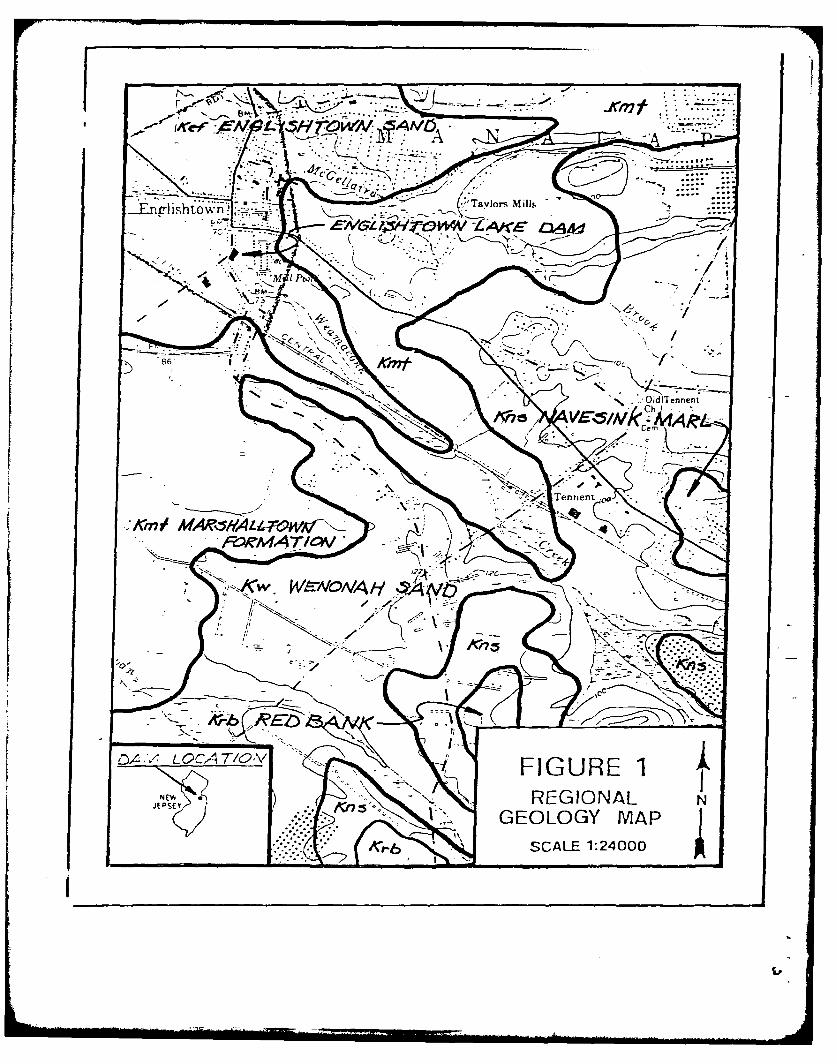
b. Location. Englishtown Lake Dam is located on Weamaconk Creek, inEnglishtown, Monmouth County, New Jersey, about 800 feet south of the inter-section of New Jersey County Routes 522 and 527. County Route 527 is constructedon the crest of the embankment. The dam site is shown on the USGS QuadrangleSheet entitled "Freehold, New Jersey" at coordinates N 400 17.6', W 740 21.5'. Aregional location plan of Englishtown Lake Dam is enclosed as Figure 1, Appendix E.
c. Size Classification. Englishtown Lake Dam has a maximum height of about13 feet and a storage capacity of 93 acre-feet at the low point of the top of thedam. Accordingly, the dam is classified as a "Small" size dam (height less than 40feet, storage less than 1,000 acre-feet).
- 1-

d. Hazard Classification. An auitomobile repair shop is located about 1,500feet downstream of the dam. The elevation of the shop is about four feet above thestream bed. An inhiabitable dwelling is also located in this area; its relativeelevation is about six feet above the streambed. Utility pipelines are located alongthe top of the dam. Since a failure of the dam would result in damage to only twoinhabitable structures, utility pipelines and the possible loss of a few lives, thestructure is classified as a "Significant" hazard potential dam.
e. Ownership. The dam is owned by Monmouth County, New Jersey, .1Lafayette Place, Freehold, N.J 077728.
f. Purpose of Dam. The dam was originally constructed to provide hydro-power for a mill which is no longer in existence. The dam is currently used toprovide a pond for recreation.
g. Design and Construction History. No information relative to the designand construction history of the dam is known to exist. Based on information gainedthrough interviews with local residents, the dam was constructed prior to 1920 forhydropower.
A correspondence file relative to this structure was provided by the State ofNew Jersey, Department of Environmental Protection (NJDEP). An inspectionreport dated May 1925, was included in this file. A review of this report revealsthat the mill for which the dam was constructed had been destroyed by fire.Further review of this file indicates that minor repairs consisting of guniting andpressure grouting of the structure were performed in 1968. The most recentcorrespondence included in this file, from July 1978, documents a request made bythe NJDEP for repair of the spillway. No response to this request is included in thefi le.
According to local residents, Monmouth County repaired the reservoir drainvalve approximately 5 years ago.
h. Normal Operating Procedure. A representive of the Owner was notavailable for the inspection of Englishtown Lake Dam. Normal operating proceduresare unknown. It does not appear that the reservoir drain is exercised on a scheduledbasis. The last time local residents recall a gate operation was during the repairsmade in 1976.
1.3 Pertinent Data
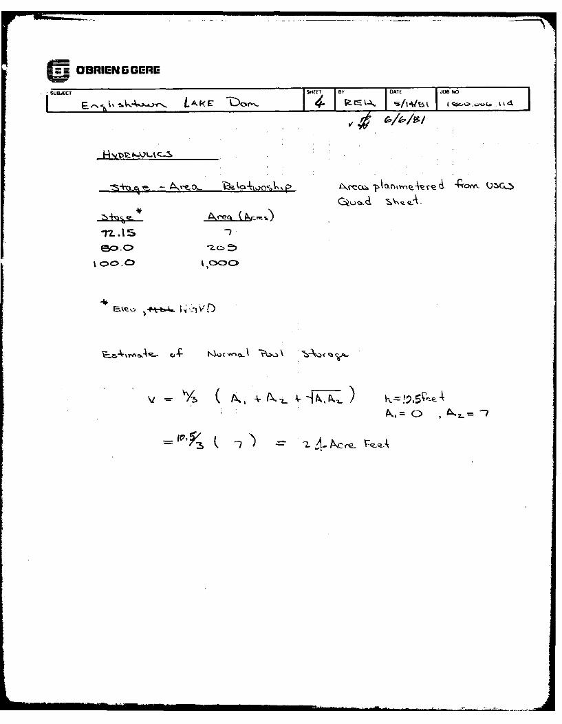
a. Drainage Area. (square miles) 7.2
b. Discharge at Dam Site. (cfs)
Low Point Top of Dam, Elev. 75.0 650
c. Elevations. (feet above NGVD, estimated from USGS Quad)
Spillway Crest 72.15Low Point Top of Dam 75.00
-2-

Reservoir Drain Invert 64.15Streambed at Toe of Dam 62.0Tailwater -64.5
d. Reservoir Length. (feet)
Normal Pool, Elev. 72.2 1,400Low Point Top of Dam, Elev. 75.0 3,900
e. Reservoir Storage. (acre-feet)
Normal Pool, Elev. 72.2 24.0Low Point Top of Dam, Elev. 75.0 93.0
f. Reservoir Surface Area. (acres)
Normal Pool, Elev. 72.2 7.0Low Point Top of Dam, Elev. 75.0 80.0
g. Dam.
Type Earth EmbankmentLength +325 feetHeight f13 feetCrest Width 48 feetSide Slopes Upstream Vertical (retained by timber bulkhead
Downstream 2.5H:IVZoning UnknownImpervious Core UnknownCutoff UnknownGrout Curtain Unknown
h. Spillway.
Type Concrete GravityLength f50 feetHeight 10 feet
i. Diversion and Regulating Structures
None
j. Reservoir Drain
The reservoir drain is a 48-inch diameter pipe which has a submergedintake. The outlet protrudes from near the right side of the spillwaystructure. The gate operator is accessible from the spillway crest. Theoperating wheel is stored at the Borough of Englishtown, Town Hall.
-3-

SECTION 2
ENGINEERING DATA
2.1 Design
a. Data Available. No engineering data, relative to the design of EnglishtownLake Dam, were provided for review.
2.2 Construction. No engineering data, relative to the construction of EnglishtownLake Dam, were provided for review.
2.3 Operation. No documented information, relative to operational features ofEnglishtown Lake Dam, was provided. According to local residents, no operationsare performed at the dam.
2.4 Evaluation
a. Availability. No engineering data were provided for this report.
b. Adequacy. Although design and construction information relative to theoriginal dam are not available, the observations made during the field inspection,the information in the correspondence provided by NJDEP and interviews with localresidents provided adequate data for a Phase I evaluation.
c. Validity. There is no reason to question the validity of the limited dataprovideUb-JJDEP.
-4-
yi

SECTION 3
VISUAL INSPECTION
3.1 Findings
a. General. Englishtawn Lake Dam was inspected on April 30 and June 3,I1981. At the time the inspections, the water surface elevation was less than 0.1feet above the spillway crest. No underwater areas were inspected. The observa-tions and comments of the field inspection team are in the checklist which isappendix B of this report. The appearance of the facility indicates that the dam andits appurtenances are inadequately maintained.
b. Dam. The horizontal and vertical alignment of the timber bulkhead whichretains the upstream slope of the embankment appears to be good. The faceplanking and timber support piles appear to be treated. No deterioration of themembers was observed above the waterline. No -cracks or settlement in thepavement were observed. A number of small trees are planted in the upstreamshoulder of the road. The remainder of the upstream shoulder is grass coveredexcept for a footpath which has been worn in the grass covered shoulderimmediately downstream of the timber bulkhead. The downstream face of the damis covered with brush and a number of small trees. No seepage was observed alongthe toe of the slope.
The upstream slope of the concrete spillway is submerged. The concrete slabson the crest of the spillway are cracked and badly spalled. Reinforcing steel isexposed on the crest and downstream face of the spillway and a number ofhorizontal cracks were noted in the downstream face. The concrete in the toe areaof the spillway is protected with a steel sheet-pile wall. The steel sheeting appearsto be in good condition.
The spillway appears to be structurally tied into the abutments of the highwaybridge. The bridge abutments appear to be a concrete/masonry composite. Crackswhich appear to be structural, were noted in both bridge abutments. Superficialcracking and spalling was also evident in the bridge abutments.
c. Appurtenant Structures. The gate structure for the reservoir drain appearsto be in good condition. No seepage was noted to be discharging from or along thegate. The concrete housing the gate is badly spalled.
d. Reservoir Area. The reservoir slopes are relatively flat and appear to beprotected with vegetative cover. No slope stability problems were observed alongthe perimeter of the reservoir.
e. Downstream Channel. Discharge from the spillway enters the naturalchannel downstream of the dam. The channel is about twenty feet wide with a mildslope. The overbanks are grass covered and relatively flat.
-5-

".
SECTION 4
OPERATIONAL FEATURES
4.1 Procedures
Based on a review of all available information, it appears that no formal orinformal operational procedures are established for Englishtown Lake Dam.
4.2 Maintenance of the Dam
Based on a review of all available information, it appears that no formal orinformal scheduled maintenance procedures are in effect for Englishtown Lake Dam.According to information contained in the correspondence files supplied by NJDEP,limited guniting and pressure grouting repairs were made on the spillway in 1968.According to local residents, Monmouth County repaired the reservoir drain valveapproximately five years ago.
4.3 Maintenance of Operating Facilities
Based on a review of all available information, it appears that no formal orinformal scheduled maintenance procedures relative to operating facilities are ineffect for Englishtown Lake Dam.
4.4 Description of Any Warning Systems in Effect
Based on a review of all available information, it appears that no warningsystem is in effect for Englishtown Lake Dam.
4.5 Evaluation of Operational Adequacy
The operational condition of the reservoir drain structure is unknown. Itappears that the dam would be accessible for all weather conditions.
-6-
---- ----

SECTION 5
HYDROLOGY AND HYDRAULICS
5.1 Evaluation of Features
a. Design Data Based on a review of the Reference Data sheet dated May 27,1925, in the correspondence file provided by NJDEP, the drainage area contributingto Englishtown Lake Dam is 7.2 square miles. The length of the spillway was 56.5feet and the available freeboard at the time of the report was one foot. Thedischarge capacity of the spillway was reported to be 23 cfs per square mile.
Presently, the spillway is about 45 feet long (crest Elevation 72.15) and thedischarge at the low point of the top of the dam, Elevation 75.0, is about 650 cfs.
For further information, refer to the calculations and computer printoutincluded in Appendix C of this report.
b. Experience Data. Based on a review of all available information, itappears that no reservoir stage or rainfall records are maintained for this dam.According to local residents, the embankment has not been overtopped during thepast fifty years.
c. Visual Observations. At the time of the inspections, the spillway appearedto be in poor condition with extensive cracking and spalling of the concrete as wellas exposed reinforcing bars.
The operational condition of the reservoir drain gate was not assessedduring the inspection. However, the gate appeared to be in good condition.
d. Overtopping Potential. Englishtown Lake Dam is classified as a "Small"size, "Significant" hazard structure. Accordingly, the Spillway Design Flood (SDF)ranges from the one hundred year flood to fifty percent of the Probable MaximumFlood PMF). The SDF selected is fifty percent of the PMF because of the chancefor appreciable damage and the possibility of loss of life at an automobile repairgarage and at an inhabited dwelling about 1,500 feet downstream of the dam. TheSDF hydrograph was developed and routed through the reservoir with the startingwater surface elevation at the spillway crest (Elevation 72.15). The results of therouting are presented in Appendix C.
A review of these results indicates that the spillway is capable ofdischarging about five percent of the PMF prior to overtopping the dam. The peakinflow and outflow for the SDF are about 8,219 and 7,874 cfs, respectively. Themaximum reservoir stage for this event is about 3.8 feet above the low point of thetop of the dam and the period for overtopping is about 12.33 hours.
e. Spillway Adequacy. The spillway is capable of discharging about fivepercent of the PMF prior to overtopping the embankment. The spillway is judged tobe "Inadequate".
- 7-

SECTION 6
STRUCTURAL STABILITY
6.1 Evaluation of Structural Stability
a. Visual Observations. The overall structural appearance of the embankmentat the time of the inspection was good. No evidence of slope settlement, instabilityor seepage was noted.
The condition of the spillway is poor. The concrete is cracked and badlyspalled. Reinforcing steel is exposed in the crest and in the downstream face of thespillway structure. The adjoining bridge abutments also appear to be in poorcondition. Cracks evident in the abutments appear to be structural in nature.
b. Design and Construction Data. No design or construction data was madeavailable.
c. Operating Records. Based on a review of all available information, itappears that no operating records are maintained for this dam.
d. Post-Construction Changes. Based on a review of all availableinformation, it appears that no post construction changes have been made.
e. Seismic Stability. Englishtown Lake Dam is located in Seismic Risk Zone 1of the "Seismic Zone Map of Contiguous States". A dam located in Seismic Zone 1 isgenerally considered to be structurally adequate for Zone 1 earthquake loading if itis structuraly adequate for static loading.
Based on observations made during the visual inspection, the dam appearsto be stable for any expected static load conditions.
9

SECTION 7
ASSESSMENT, RECOMMENDATIONS AND PROPOSED REMEDIAL MEASURES
7.1 Dam Assessment
a. Evaluation. Based on the visual inspection, Englishtown Lake Dam isjudged to be in poor condition. The concrete in the spillway is cracked and badlyspalled with reinforcing steel exposed in the crest and downstream face. Theadjoining bridge abutments appear to be structurally cracked. The operationalcondition of the reservoir drain is unknown.
The embankment portion of the dam appears to be in satisfactory conditionexcept for small trees and brush growing on the crest and downstream face.
The SDF chosen for Englishtown Lake Dam is fifty percent of the PMF. Areview of the hydrologic/hydraulic analyses indicates that the spillway is capable ofdischarging about five percent of the PMF prior to overtopping. The spillway isclassified as "Inadequate".
b. Adequacy of Information. Information gained from the field investigation,from the files of NJDEP and interviews with local residents provided adequate datafor a Phase I evaluation.
c. Urgency. The remedial measures recommended in Section 7.2 should beinitiated soon.
d. Necessity for Further Invstigation. Further investigations should beperformed in accordance with 7.2.a, items 1 and 2.
7.2 Recommendations and Remedial Measures
The Owner should retain the services of a licensed professional engineerexperienced in the design and construction of dams to assist in complying with thefollowing recommendations and remedial measures.
The recommendations and remedial measures should be initiated soon.
a. Facilities.
1. Further hydrologic/hydraulic analyses should be performed to determinethe extent of mitigating measures necessary to provide adequate spillwaycapacity.
2. The concrete spillway and bridge abutments should be repaired to limitfurther deterioration and assure structural integrity.
3. The embankment should be cleared of trees and brush and any resultingvoids backfilled with suitable material and compacted. A vegetativecovering should be established on the embankment.
-9-

4. The operational condition of the reservoir drain gate should be assessed and
the structure repaired if necessary.
5. Protective fencing placed along the timber bulkhead should be considered.
b. Operation and Maintenance Procedures
1. The Owner should develop and implement a maintenance and inspectionchecklist to insure that all items associated with the structure aremaintained on a regular basis.
2. The structure should be monitored during periods of heavy discharges. Awarning system should be developed and implemented when necessary towarn downstream residents.

SECTION 5
HYDROLOGY AND HYDRAULICS
5.1 Evaluation of Features
a. Design Data. Based on a review of the Reference Data sheet dated May 27,1925, in the correspondence file provided by NJDEP, the drainage area contributingto Englishtown Lake Dam is 7.2 square miles. The length of the spillway was 56.5feet and the available freeboard at the time of the report was one foot. Thedischarge capacity of the spillway was reported to be 23 cfs per square mile.
Presently, the spillway is about 45 feet long (crest Elevation 72.15) and thedischarge at the low point of the top of the dam, Elevation 75.0, is about 650 cfs.
For further information, refer to the calculations and computer printoutincluded in Appendix C of this report.
b. Experience Data. Based on a review of all available information, itappears that no reservoir stage or rainfall records are maintained for this dam.According to local residents, the embankment has not been overtopped during thepast fifLy years.
With the impoundment level at normal pool, Elevation 72.15, it would takeapproximately 4 hours to draw the reservoir down about 7.5 feet to Elevation64.65. This is essentially the level of the water in the impoundment with the 4-footdiameter reservoir drain gate fully open with the base flow discharging through thesite.
c. Visual Observations. At the time of the inspections, the spillway appearedto be in poor condition with extensive cracking and spalling of the concrete as wellas exposed reinforcing bars.
The operational condition of the reservoir drain gate was not assessedduring the inspection. However, the gate appeared to be in good condition.
d. Overtopping Potential. Englishtown Lake Dam is classified as a "Small"size, "Significant" hazard structure. Accordingly, the Spillway Design Flood (SDF)ranges from the one hundred year flood to fifty percent of the Probable MaximumFlood PMF). The SDF selected is fifty percent of the PMF because of the chancefor appreciable damage and the possibility of loss of life at an automobile repairgarage and at an inhabited dwelling about 1,500 feet downstream of the dam. TheSDF hydrograph was developed and routed through the reservoir with the startingwater surface elevation at the spillway crest (Elevation 72.15). The results of therouting are presented in Appendix C.
-7-

A review of these results indicates that the spillway is capable ofdischarging about five percent of the PMF prior to overtopping the dam. The peakinflow and outflow for the SDF are about 8,219 and 7,874 cfs, respectively. Themaximum reservoir stage for this event is about 3.8 feet above the low point of thetop of the dam and the period for overtopping is about 12.33 hours.
e. Spillway Adequacy. The spillway is capable of discharging about fivepercent of the PMF prior to overtopping the embankment. The spillway is judged tobe "Inadequate".
SECTION 6
STRUCTURAL STABILITY
6.1 Evaluation of Structural Stability
a. Visual Observations. The overall structural appearance of the embankmentat the time of the inspection was good. No evidence of slope settlement, instabilityor seepage was noted.
The condition of the spillway is poor. The concrete is cracked and badlyspalled. Reinforcing steel is exposed in the crest and in the downstream face of thespillway structure. The adjoining bridge abutments also appear to be in poorcondition. Cracks evident in the abutments appear to be structural in nature.
b. Design and Construction Data. No design or construction data was madeavailable.
c. Operating Records. Based on a review of all available information, itappears that no operating records are maintained for this dam.
d. Post-Construction Changes. Based on a review of all availableinformation, it appears that no post construction changes have been made.
e. Seismic Stability. Englishtown Lake Dam is located in Seismic Risk Zone 1of the "Seismic Zone Map of Contiguous States". A dam located in Seismic Zone 1 isgenerally considered to be structurally adequate for Zone 1 earthquake loading if itis structuraly adequate for static loading.
Based on observations made during the visual inspection, the dam appearsto be stable for any expected static load conditions.
-9-
[ .w

SECTION 7
ASSESSMENT, RECOMMENDATIONS AND PROPOSED REMEDIAL MEASURES
7.1 Dam Assessment
a. Evaluation. Based on the visual inspection, Englishtown Lake Dam isjudged to be in poor condition. The concrete in the spillway is cracked and badlyspalled with reinforcing steel exposed in the crest and downstream face. Theadjoining bridge abutments appear to be structurally cracked. The operationalcondition of the reservoir drain is unknown.
The embankment portion of the dam appears to be in satisfactory conditionexcept for small trees and brush growing on the crest and downstream face.
The SDF chosen for Englishtown Lake Dam is fifty percent of the PMF. Areview of the hydrologic/hydraulic analyses indicates that the spillway is capable ofdischarging about five percent of the PMF prior to overtopping. The spillway isclassified as "Inadequate".
b. Adequacy of Information. Information gained from the field investigation,from the files of NJDEP and interviews with local residents provided adequate datafor a Phase I evaluation.
c. Urgency. The remedial measures recommended in Section 7.2 should beinitiated soon.
d. Necessity for Further Invstigation. Further investigations should beperformed in accordance with 7.2.a, items I and 2.
7.2 Recommendations and Remedial Measures
The Owner should retain the services of a licensed professional engineerexperienced in the design and construction of dams to assist in complying with thefollowing recommendations and remedial measures.
The recommendations and remedial measures should be initiated soon.
a. Facilities.
1. Further hydrologic/hydraulic analyses should be performed to determinethe extent of mitigating measures necessary to provide adequate spillwaycapacity.
2. The concrete spillway and bridge abutments should be repaired to limitfurther deterioration and assure structural integrity.
3. The embankment should be cleared of trees and brush and any resultingvoids backfilled with suitable material and compacted. A vegetativecovering should be established on the embankment.
- 10 -

4. The operational condition of the reservoir drain gate should be assessed and
the structure repaired if necessary.
5. Protective fencing placed along the timber bulkhead should be considered.
b. Operation and Maintenance Procedures
1. The Owner should develop and implement a maintenance and inspectionchecklist to insure that all items associated with the structure aremaintained on a regular basis.
2. The structure should be monitored during periods of heavy discharges. Awarning system should be developed and implemented when necessary towarn downstream residents.
- 11 -

APPENDIX
A
Check List Engineering Data
Design, Construction, Operation
Phase I

-4
C)
L-
C)
fu Cu0- . - to -
I-CL) .0 a) a) to
C- .- a 0 -0E-) 0o L1 -o to
= L*) 3:CL 0 3: 4- 0
L.0 0 4- ) -
E -o'4 E
0 S- 0~ S-
li3C 0 3 3: 1 0
Lii0 0-c.
LA34- 4-Li0 4- 0 0 4-)
o~~ Cu0 C
C=,C)
C)- C)-F-~ Li
C) Ln i
0~C 0 C
-C L )*j A L
LI
Lii CD - l 5
- Li I--CC

4
C)
C)
<
-
CDO~
LJ -0a-4,-
CL
LL- _0 to. -D
-j E -D
W CL
A *L 4-) '0 '0 U 0
40 S
~(4- 4-- t
0 0 0 0)
-~~- CD S-S.
0)CC CD CD -
0.~~L 4- nin0 f-1/) Wo
C)- L (..0 LiJ
o~~: 0)0 0
Of,
CD FC
L--C--~ L)

IL00.
00 0 0 049-9- 4- 4- .4-
00 0 0 M:
2t -cl -o
LUL
rLn _j LO flU
o) 0o 0 0o
0-- 4~)
L.j ccL L w LnCLo oo Co L/)
'4.. __- 4- 4-i 0C) co C)V'4- MC
.- . a- .J C)--
0U 0) 0) 0~ m: 03Lj3: w : CD -: 0D
LD n v,)j :

4-o
LCACA CA Ln
4j S- - -
00 0 0 0
C, CL ) c C
C) U, a-un,
CD Co U CDCCM 0lU 3L -a
L" D .- LCD 4-ex'

a) a
to0
S-o
a) a
CL

APPENDIX
B
Check List
Visual Inspection
Phase I

o 00CC)
a/ C: 00r
.- S0
40 r4 -to .- . C,
$:=. 0
C C)
4-3 4-
L-) ;-CV) LL
E- 4-)'
) a
-o 4-)
I- 'U c
41L +1
U, L~JL
-0. -0
4-) co -4c. --~ CO--a, C
LI) 4
E >4-o
>44--
0 LIaC-i 4-
i) (U0 .)(E- 4- -s
0 u
00 tnILE 4-)A00 0C
cm cc a
-'- I)

co Z
en
C)
LJ.J
C>
di a)
00
V)Ito
4- 3LLi
r --~- CU
0, rO 0 4-E
L/) -0 0 0l
0o 0 0 0
Q) C)enD e
Of C) U C l I--CUC
enC: C)Ln L" 0Ii)JL
~~c m? LL0 UJ
- L bJC)1 L-
Lo 'ri -CE Li
F-a (D =
of- ~j t..Jj -
>- UnZ I L) LO J)C

0
Cl)
cu LJ
L.)LO
Li,
he,
ce.
cx,
Q)
S-o C
Li 0 4-)
a,.a-Cr
on Ini
LJ co o - -0 -0 -0C>00 0 0
Or(I 000
F>- W4 LiJ
CD LJ i
-l Ci,
CZ) M)Li
-F- e
C)L L5 LiJL) L.)
Li J F--
F- LD CD 4
I.) LL -
L, M MD Of-Z ::,3 Fd~x Cn

cc'
.)
Ln. 4 1
4JU 0
F- Ln
L'i cicc
4-- 4-)0) to )0
LiiL
4-) 0)
c Q 4) - C
1-4)c _ -) * 4-
S .- E . - -A
to ac =d -D. ro00 -0 S- 0E
-. L. to .2-j t 0 a)L
-0 toon
C)i C)
U)C C
C) Li;ri
LiU
w D Li C- V L
- rl I-- Li
3 j C) i
ofi ) i L CD) CiC>(1 C

4- I
Lo [
oi Co
CD1
V))
-E
S- ~ ~ ~ ~ - (V4JV)=tCC
(A r- C C- 9---
a ) r (0-0
-L .- L- O0J -o
C- u C 0 to4- LnE0 lOL uOt t4-Lf -- 4-(
C/ U,. 4-1 c0 CE3 -_g-_ u COD m S-4-'=
4- ( S- a)=-U 4-O )
Ln 4- L. u a0J) an 4- 4-)r_ CL -c- 0~ L
aLa U- ca) CaE(A S
4)c o - (v 4-'0-- S- 4-) 04J S- 44 S.. )OC E ra)4JC -)M4- ->,C 0) -CL
00 . C) CU CO r-3:,.f ,-0 CC 'CQo 00 0 a)rCl-
U -0 >1 (n0~ to )0-t4~ -CCO-00
fo-0) 4- V) 4-O0(V
C)
LCa
14 La C
La La -D
I- 14-J 14 W
c) U

cu C).r- L-,V) L.J
CD
LJ
aa)
V) C)C)o)C
C)LUC)C
-0 0 00
CUC
00 0 0
LI)n
uJALI))
L'i
2L 1- OfLU cl:Ln LU
FCDCLU
-C:).

a)
0 0
6-*E-
CU
004--)
27-- +- 4-4-'
CD ctoa L);1: EJ 4
- 0)
(0 c)
4-) fJ)
-' 0)4S
>0) (A0
(L)- CL) -'
- ea
to-4
CD
-
C-
J (aJU! -
C)(a CD LD- -~ U!

Ln
L'i
C),ajmDLC flO
tO) Ln' 4-0 LtoS- TCI S-~4 c 0-n
0)- DNL0JE)
Cu, o*-0 -)
aI C,- > *.- -tow u,00 >4
V)~~0 0)L =-
( 0) 0,4C-
IX,~ ~ LL 4 4-w
= M 4--'uE
:itC)4- CO C -)L
C> 0 -P U-4-)-Ca0)0 S-L4-3= ~ 0 (nE
a)C .rC D CO - Cu0 u -
j4-'f -tr4
~- Ln
I. Ln n)CD ui ' a :r
L.J CL
Ln C> CLL J ~C)L >0

APPENDIX
C
Hydrologic & Hydraulic Data

ENGLISHTOWN LAKE DAMAPPENDIX C
HYDROLOGIC AND HYDRAULICENGINEERING DATA
TABLE OF CONTENTS
Sheet No.
PMP Data 1
Lag Time Computations 1 through 3
Stage - Area Computations 4
Stage - Storage Computations 6
Stage - Discharge Computations 5
Drawdown Analysis 6
HEC-1, Dam Safety Version, Computer Printout 7 through 9
C 3 BRIEN 5 GERE
Er~.SHEET LABy> I DATE JOB NO
LA.4r oe -- l
* -T
4
Si1*~t I . r
- A- /ZV s~ --
11 --/
T- 4 4-. .--
*~t\~~ L-.C-4~ K

Mu m 1= BRIEN 5 GERE
SHEIU By AYEJO NO
&I-, E sw~owQ~ LAKE T)Ao-' 1 c/?L~~~.~ /C900 0 o O~w -11
T T- --I V T ~ //,/
*~~3 4 q1 '+---
A -
-Te 9. ?3?
idd
-I: ot Oo -1'
-?. 14 00
-F /o5&

i ORIEN 6GERE
JSHEE T ly DAT E 4 0 0 0 6 / 4E -J CL y ~ J L k 7 u II R A
_c
I L3{1
*~~~~o D4II~1~'\ p i, A1 -1 4 I
II
0 Fo
USE_ trw ,
* _OIRIEN 5 GERE
SUBJECT SHEET BY DATE JOB No
I ~ LA~ ~ I I I/I ~/4b k '
C>4
j C>1. 1 ,QIce~~4c rA~ 4 rr~~hL
A*~~z v\%Q
N1Qc n A ft

__OBRIENGGERE
.UW~l r-e- L~f.SHE(x1. I 2.A El f7A Ll .JUIH NO
_11
'4%
est5 Is13
ayA-- kIo lE.
Lp4
L, o u-I S.

ME m UBRIENG5GERE
SUBJECT SHETO DTE0 NO
++
- (cs (-s-cn
e,~ q,/ eL.(1 1Z5?&67,~o- 65- (0 , -,P41,15- 6 q /C)"/'-/ i/f
*4 lv,4 ~acxoL
0.L4 Z~

I-
0 InD
0f 0
*j q 0 Lij %A
:3j ~ - L
z 0 0
10 0 z z .-. wn, ...
LT 13 I: 12 3 UU2 -0 -
0 ' 1 21 rL ~~: -41. zu I: <
Lt t O ,_ccc
. -0 1 * L. -fU- -
-w -J c a
a:.C 17 US ~ NI I
a. En w ~ II.x o -
0I-Z 2 1i 0. I w
-. 1 I3 0 U. 0Ccle - m
Z IZ (' 0 0 o I ca I ~ a fm0 < WIzr
.'z~~ I < ZL~ -
Ii "-O I ,-oua oon 0 .Sm- rL" U 0
0 I zI 0 ( jn, I I z)- n -Q.
Iz~~~~- 0ra z,~a
US I r, I
0 Ges ra'a N~n bIfla.l 0 -
I * 1 I
n-: t 0 I N
44 _1t " , .4 a II
OF 0 * I
-I z Ii
40 U P-* I
'2b 4L I
Q)W r In 'j I
,P W . ,ci0 Am- .I ,G lm wI
40 cZI DC iCer -
4 1 I I

0 Ij00
m IlLO . -? 0
o 04~ 0
I~d r, o 1 .,-.
* I
t o -u o a
Inr) o- (P Ln j
-, c -f c; a_ c;~
x x
0 N 0*, [ I ie o x
(A It X L, o- ILO eo
7~ 00
4o .0 1" C
iL . o C o to 0
0.. 00 c z ,, 0 0 ,, I
4- 0 I o 0
nU o~a m~ 4 00 w-zXD 41 0:0 1-C* - Iy (Li cOz. e0 -C
(D 'm m. < En 4 0 'tI u) -T I 46. Z cu Q. z4 C 0 tLDf 0 I Ci Ir onu X
CO ccO fl 0 W32 0 -j Lo t2 L ar40 L) (3A- Z. tfID) 1 , ul~ 0n 0
D - o C~*0 m UJC w., * C Li x ' 1 0 0 1 ,
I' 0.w xTDc j000 u r k0 1- c o ct _j C,, 0 4- 0~ jo I
'-'* -1 - .4 0: 0 C
o~~~c WNw 0I
0 j180. I . Oi 304£ U. 10 o x 0 c3-o 2 4-" I o- I
LL c Li 00 lON r4J a I EnI x 4 .
0 L U.0Q <1 M o 0CL
k ,o I-C 00Ix j 0 -J
C. 0- 44r r
I 0
a1 I
LJ*1 ' I ~ i144J X
0., - 4Ul4. L
-a _j Iu _9- I. I
EA cc
Z

ri f
W) U) o o. c o0 A 0 o~o o
c,~L c: _j 000f
c ri ci '
0' 1r) c~ 10
~~~. ~ u u.. O4 .(l )!N0
0I r r -
o.- c 0t
CL: oL 0 oCC 0(C n* N~ .
u w Ix -J
_j -jf I >--C1 ) ; c
me LJ _jc.- C r1' . .-- u ~ I. x
I- <, 22~ r4~ C
I ccz Cr Ix
0j c, j j L o0 4cc~ I Cee -~ -L le
EL. 0 0 u
reA w1 c ) X C-'
0 0 4r o. r*2zl0 qrj cc o(L.C. 000
(n) U). 'nl CA) Co (I a
x cc, cc c l La
Zr I II' 0, m~Q I ~ ,
o~C S 00:C -~Z 4 -0~l o'. u w <01'
oI Ia I o CD ~
C-D co 0- 0- N' cc0 -
0- 0n 00 '0 o- m~ v1 o wlz 'oroo 0
La --.' r'r0
Cl) <r
co 3- -. 44N.D
C. F 0- 0 000 000,00
C4 ;! -a C -I
o j -o W0 0 0C0 0 0 I
0 D
L, LL LCa' U U L.A L.A U )-UM _j. ., C. L

APPENDIX
D
Photographs

APPENDIX D
SELECTED PHOTOGRAPHS OF THE SITE
Page No.
Site Plan A
PHOTOGRAPH NO.
1. Upstream face of the dam as observed from the right 1abutment. (4/30/81)
2. View of the deteriorated spillway looking towards the right 1abutment. (4/30/81)
3. View of the deteriorated spillway looking towards the left 2abutment. (4/30/81)
4. Spillway and reservoir drain gate as seen from beneath the 2highway bridge. (4/30/81)
5. Reservoir drain gate observed from the bridge deck. 3(4/30/81)
6. Reservoir drain gate and deteriorated concrete of the spill- 3way structure. (4/30/81)
7. General view of the impoundment from the crest of the dam. 4(4/30/81)
8. Looking upstream through the highway to the spillway. 4(4/30/81)
9. The left downstream abutment wall of the bridge. (4/30/81) 510. The right downstream abutment wall of the bridge. (4/30/81) 511. Potential damage area about 200 feet downstream of the dam. 6
(4/30/81)12. Potential damage area about 1,500 feet downstream of the dam. 6
(4/30/81)

D'BRIEN&GEREENGINEERS. INC
EkJGLISHTCWN' LAkE DNi j~~/~~ ic~
w
W~ At
A7 L
j- 0
o U ILI)
00H Hr

..........
1.UPSTREAM FACE OF THE DAM AS OBSERVED FROM THE RIGHT A3UTltMENT.(4/30/Si)
2. VIEW OF THE DETERIORATED SPILLWAY LOOK114G TO'AARDS THE RIGHTABUTM''ENT. (4/30/81)

3. VIEW OF THE DETERIORATED SPILLWAY LOOKING TOWARDS THE LEFTABUTMENT. (4/30/81)
4. SPILLWAY AD RESERVOIR DRAIN GATE AS SEEN FROM BENEATH THEHIGHWAY BRIDGE. (4/30/81)
-2-

5. RESERVOIR DRAIN GATE OBSERVED FROM THE BRIDGE DECK. (4/30/31)
6. RESERVOIR DRAIN GATE ANO DETERIORATED CONCRETE OF THE SPILLWAY
STRUCTURE AND THE HIGHWAY BRIDGE. (4/30/81)
-3-

7. GENERAL VIEW OF THE IMPUUNDEfNT FROM THE CREST OF THE DA'.
(4/30/81)
8. LOOKING UPSTREAM THROUGH THE HIGHWAY TO THE SPILLWAY.
(4/30/81)
-4-
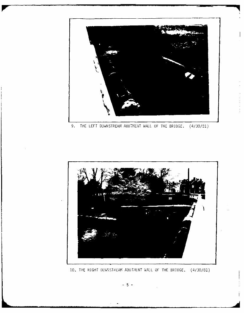
9.~~~ ~~~ TH ETDWSTEMAUMN WL FTEBIDE 43/1
10. THE LEFHT DOWNSTREAMA ABUTMENT WALL OF THE BRIDGE. (4/30/81)
-5-

11. POTENTIAL DAMAGE AREA ABOUT 200 FEET DOWNSTREAM OF THE DAM.(4/30/81)
12. POTENTIAL DAMAGE AREA ABOUT 1,500 FEET DO.WNSTREAM OF [ME UAM.(4/30/81)
-6-

APPENDIX
E
Drawi ngs

APPENDIX E
TABLE OF CONTENTS
DRAWINGS
Sheet No.
Regional Vicinity Map, Figure 1 1
Plan View of Dam Showing Problem Areas 2
Typical Embankment Section and Spillway Section 3

641
-1-0Taylor Mill

CO O'BRIEN&GEREENGINEERS. INC
EN L5IT\/'- LJOM DAMow
'f))
i- a -D
0 W-
2 V)~~~ 9
LL I-
22
uhi
oK
D 00
w 0< z Q-71o<0 P <0

W BRIEN&GEREENGINEERS INC.
jSdENGLO-*H70VJt, LAKE DAILA 1 3 &~~ /19/51_1B O
-TYPICAL- EP'AAjJVIAENT4 5EOTI10tkI
TIMB:::R tUL-KHEAD , DL-A
5SP ILLVWAY $E CT 10N
BP IDGE
ABUMENT
EL Lo, 7o
NOTFE: N-OTR T70CL

APPENDIX
F
Site Geology

SITE GEOLOGY
ENGLISHTOWN LAKE DAM
Englishtown Lake Dam is located in Monmouth County within the northwesterlylimits of the Atlantic Coastal Plain physiographic province. The site appears to beunderlain by Cretaceous age marine sediments consisting of the Marshalltownformation and the older Englishtown formation. Both formations strike aboutN.70 E. and dip about 18-20 feet per mile to the southeast. While the Englishtownis basically a fine to medium grain sand with some clay zones, the Marshalltownformation is generally a black sandy clay with considerable amounts of glauconite,an iron potassium silicate.
Bedrock is estimated to be about 300 feet below the ground surface in theproject area and consists of Paleozoic metamorphics, probably deeply weathered.
efA -f % 5Hr-OQW- -iAb~
-Tvo Mills
-En )I
4 -A'AftEZ:)/
