proposed energyybarn and 132 kv substation...
TRANSCRIPT

PROPOSED ENERGYYBARN AND 132 KV SUBSTATION AT BREACH FARM, NEAR CASTLE GRESLEY, SOUTH DERBYSHIRE
LANDSCAPE APPRAISAL
May 2017
Proposed Energy Barn at Breach Farme
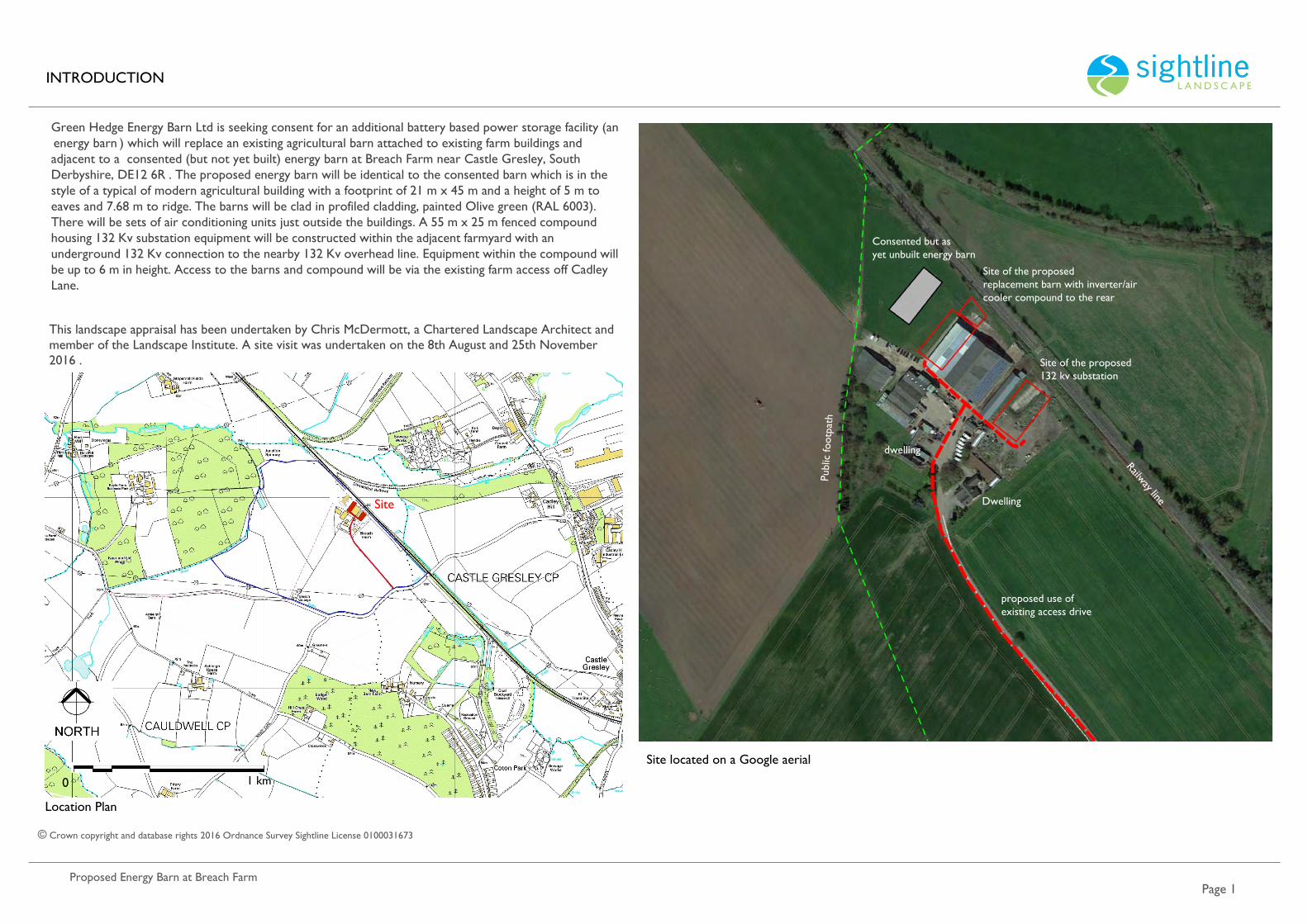
Green Hedge Energy Barn Ltd is seeking consent for an additional battery based power storage facility (an 'energy barn') which will replace an existing agricultural barn attached to existing farm buildings and adjacent to a consented (but not yet built) energy barn at Breach Farm near Castle Gresley, South Derbyshire, DE12 6RJ. The proposed energy barn will be identical to the consented barn which is in the style of a typical of modern agricultural building with a footprint of 21 m x 45 m and a height of 5 m to eaves and 7.68 m to ridge. The barns will be clad in profiled cladding, painted Olive green (RAL 6003). There will be sets of air conditioning units just outside the buildings. A 55 m x 25 m fenced compound housing 132 Kv substation equipment will be constructed within the adjacent farmyard with an underground 132 Kv connection to the nearby 132 Kv overhead line. Equipment within the compound will be up to 6 m in height. Access to the barns and compound will be via the existing farm access off Cadley Lane.
This landscape appraisal has been undertaken by Chris McDermott, a Chartered Landscape Architect and member of the Landscape Institute. A site visit was undertaken on the 8th August and 25th November 2016 .
ti
1 km0
INTRODUCTION
© Crown copyright and database rights 2016 Ordnance Survey Sightline License 0100031673
Site located on a Google aerial
Site
Consented but as yet unbuilt energy barn
Publ
ic fo
otpa
th
Site of the proposed replacement barn with inverter/air cooler compound to the rear
Railway line
Site of the proposed 132 kv substation
proposed use of existing access drive
Dwelling
dwelling

Proposed Energy Barn at Breach Farm.
PHOTOGRAPHS OF THE SITE
e 2
A: A general view of the farmyard illustrating the character of the existing barns.
The Energy Barn will replace a barn to the rear of these barns
B: The proposal is to demolish this barn and replace it with an Energy Barn.
C: This is the site of the proposed 132 kv substation which is currently used for the ad hoc storage of farm products and machinery.
D: A further illustration of the substation site.

Proposed Energy Barn at Breach Farm
S S S
e 3
VISUAL RECEPTORS
The Site does not lie within an area e e te ti e e i ti specifically relating to landscape and does not lie within Green Belt. There are no dwellings nearby other than two which are part of the Breach Farm landholding (the next nearest, Breach Cottage, lies 640 m to the south but will not afford views of the proposed development. There are no heritage assets nearby. The nearest road, Cadley Lane lies 500 m to the south but views of the site of the proposed barn are largely screened by existing buildings, hedge and tree cover. The proposed substation will be visible from a short section of Cadley Lane but it is proposed to screen the substation with tree planting.
A main line railway runs along the northwest boundary of the Site and the field on the other side of the railway is allocated within the development plan as Site Protected for Proposed Rail Freight (INF2D). A large sewage treatment lies to the northeast of this area. The existing farm barns and farmhouse lie immediately to the the south west and south east, providing substantial screening to the Site and strongly influencing the setting and local landscape character. The most significant potential receptors are users of public footpath Caudwell SD 11 8/2 which runs close to the southeast boundary of the Site (see Viewpoint 4). Footpaths Caudwell SD 11 8/1 and Caudwell SD 11 7/1 approach the Site from the south before converging on Caudwell SD 11/8/2 affording no views. The farm is visible from Caudwell SD 11 6/1 which crosses slightly higher ground 1.1 km to the south west but the proposed replacement barn and substation will not be. The Site is visually well enclosed to the northeast, benefiting from substantial tree and hedge cover along the existing railway and an abandoned spur to the northeast; mature woodland to the northwest and existing farm buildings to the southeast. As a result views from the north east will be negligible. The southwest boundary is open field but the land rises from around 60.5 m Above Ordnance Datum (AOD) by the railway to 66 m AOD within the field. The railway also passes the Site on a 1.7 m high embankment, further restricting views from the northeast.
LANDSCAPE CHARACTER
The Site lies within Landscape Character Area 72 Mease/Sence Lowlands which lie to the south west of the South Derbyshire and Leicestershire Coalfield (the railway line forms the boundary between these two areas). It is an area of typical rolling lowland becoming almost flat around the River Mease which forms the county boundary to the south. Much of the area remained in open field cultivation until the 18th and 19th centuries when it was enclosed into the regular field patterns that are still evident today. The area is predominantly an open agricultural landscape with small copses and spinneys on ridges, and occasional trees scattered along watercourses. This is a well-ordered, gently rolling agricultural landscape punctuated by discrete villages, scattered estate farmsteads and country houses. There are small game coverts and dense lines of trees along watercourses.
Woodland is becoming more visually prominent due to the National Forest Initiative. The underlying estate character is still reflected in the traditionally small scale plantations or game coverts often containing many non-native and ornamental species. The estate character is reinforced by occasional parkland trees associated with country houses scattered through the landscape and large estate farm complexes.
The landscape immediate to the Site is visually influenced by an overhead transmission line which heads northwest – southeast, 500 m to the west of the Site. Two large areas of woodland have been planted 415 m to the northwest of the Site and 790 m to the south which will increasingly provide further visual enclosure. The area is dominated by ash, oak, hawthorn, holly, hazel and field maple an to a lesser extent small leaved lime.
The relevant National Forest landscape and biodiversity objectives for open habitats within the Mease and Sense Lowlands are:
To increase the area of species-rich neutral grassland by 15ha by appropriate management and habitat recreation.
• Plant new hedgerow.
• Establish 2-6m margins on farms.
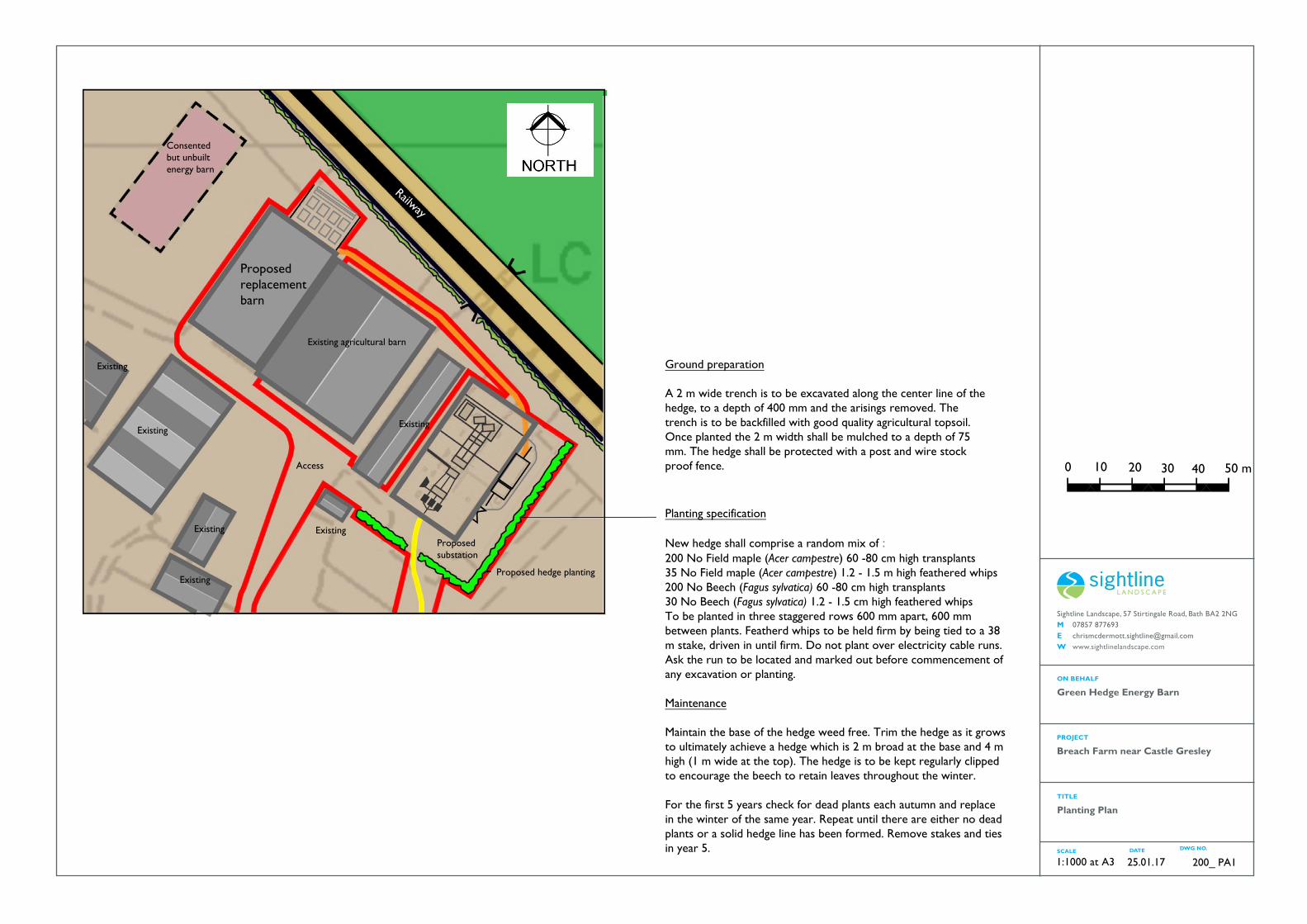
The Proposed Development includes native hedge planting as mitigation around the 2 open sides of the proposed development..
Sightline Landscape, 57 Stirtingale Road, Bath BA2 2NG M 07857 877693E [email protected] www.sightlinelandscape.com
ON BEHALF
TITLE
SCALE DATE DWG NO.
Green Hedge Energy Barn
PROJECT
Breach Farm near Castle Gresley
Planting Plan
25.01.17 200_ PA11:1000 at A3
Planting specification
New hedge shall comprise a random mix of :200 No Field maple (Acer campestre) 60 -80 cm high transplants35 No Field maple (Acer campestre) 1.2 - 1.5 m high feathered whips 200 No Beech (Fagus sylvatica) 60 -80 cm high transplants30 No Beech (Fagus sylvatica) 1.2 - 1.5 cm high feathered whipsTo be planted in three staggered rows 600 mm apart, 600 mm between plants. Featherd whips to be held firm by being tied to a 38 m stake, driven in until firm. Do not plant over electricity cable runs. Ask the run to be located and marked out before commencement of any excavation or planting.
Maintenance
Maintain the base of the hedge weed free. Trim the hedge as it grows to ultimately achieve a hedge which is 2 m broad at the base and 4 m high (1 m wide at the top). The hedge is to be kept regularly clipped to encourage the beech to retain leaves throughout the winter.
For the first 5 years check for dead plants each autumn and replace in the winter of the same year. Repeat until there are either no dead plants or a solid hedge line has been formed. Remove stakes and ties in year 5.
0 10 20 30 40 50 m
Ground preparation
A 2 m wide trench is to be excavated along the center line of the hedge, to a depth of 400 mm and the arisings removed. The trench is to be backfilled with good quality agricultural topsoil. Once planted the 2 m width shall be mulched to a depth of 75 mm. The hedge shall be protected with a post and wire stockproof fence.
Consented but unbuilt energy barn
Proposed replacement barn
Existing agricultural barn
Existing
Existing
Existing
Existing
Railway
Proposed substation
- Proposed hedge plantingExisting
Existing
Access

Proposed Energy Barn at Breach Farm
S
e 5
VCaudwell SD 8/2
7
V
9
V
Caudwell SD11 6/1
V
8V
10
1 km0
Proposed Energy Barn at Breach Farm
S S
e 6
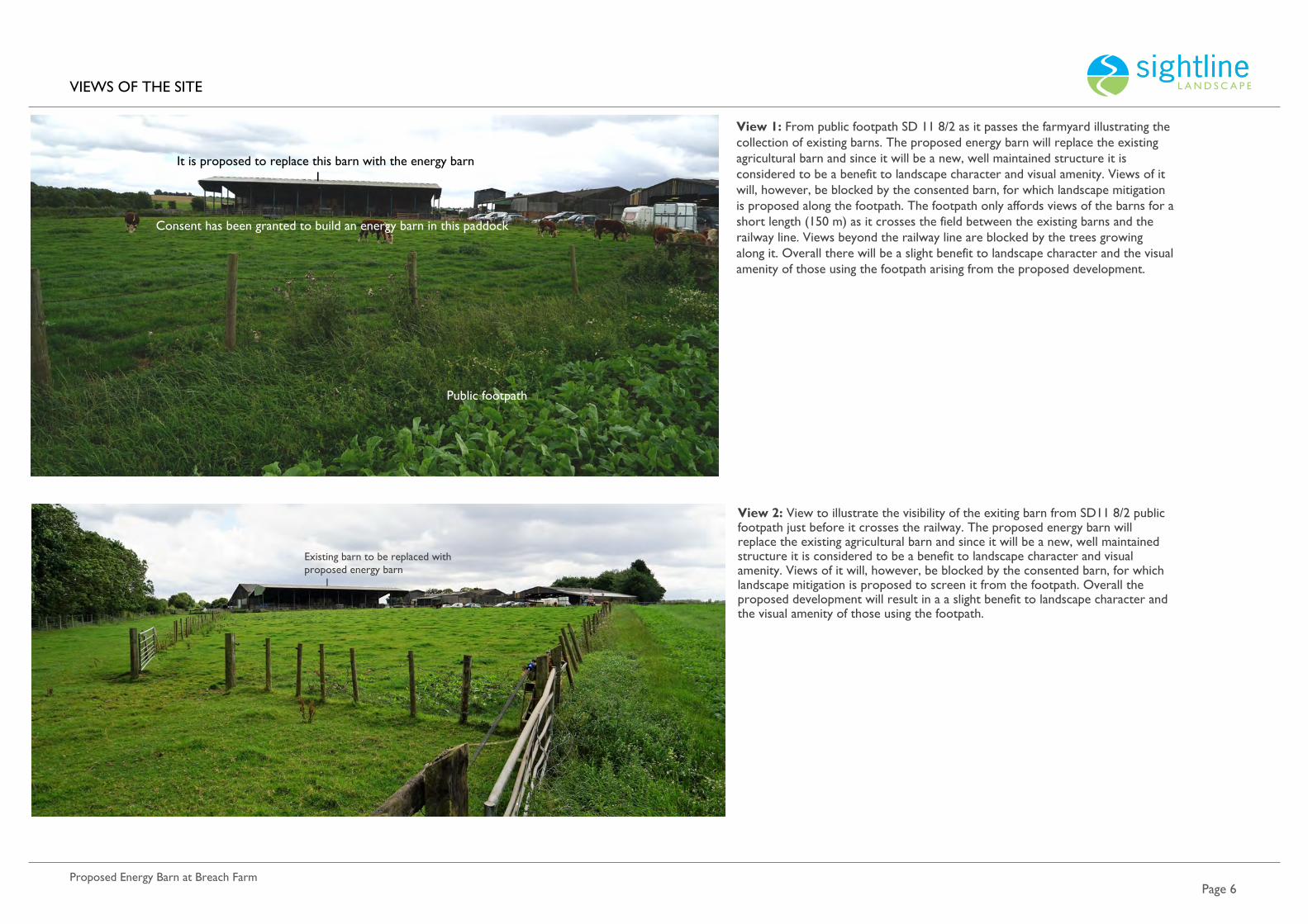
View 2: View to illustrate the visibility of the exiting barn from SD11 8/2 public footpath just before it crosses the railway. The proposed energy barn will replace the existing agricultural barn and since it will be a new, well maintained structure it is considered to be a benefit to landscape character and visual amenity. Views of it will, however, be blocked by the consented barn, for which landscape mitigation is proposed to screen it from the footpath. Overall the proposed development will result in a a slight benefit to landscape character and the visual amenity of those using the footpath.
Existing barn to be replaced with proposed energy barn I
View 1: From public footpath SD 11 8/2 as it passes the farmyard illustrating the collection of existing barns. The proposed energy barn will replace the existing agricultural barn and since it will be a new, well maintained structure it is considered to be a benefit to landscape character and visual amenity. Views of it will, however, be blocked by the consented barn, for which landscape mitigation is proposed along the footpath. The footpath only affords views of the barns for a short length (150 m) as it crosses the field between the existing barns and the railway line. Views beyond the railway line are blocked by the trees growing along it. Overall there will be a slight benefit to landscape character and the visual amenity of those using the footpath arising from the proposed development.
It is proposed to replace this barn with the energy barnI
Consent has been granted to build an energy barn in this paddock
Public footpath

Proposed Energy Barn at Breach Farm
EXTERNAL VIEWPOINTS
e 7
View 3: From Cadley Lane close to the junction with Sandy lane illustrating how the lack of a roadside hedge affords an open view to the farmyard and the Site. The barns within the farmyard are screened by the two dwellings and trees. The proposed replacement barn will not be visible. The 132 kv substation will largely be screened by the red brick dwelling. The land upon which ithe substation will sit is used for ad hoc storage of machinery, silage bales and other farm paraphernalia and the substation is likely to be less intrusive land use, even without mitigation. It is proposed to plant beech and field maple on the two exposed sides of the substation to screen it from view. The beech content will provide a degree of winter screening if the hedge is kept clipped so that the dead leaves are retained in winter.
View 4: From Cadley Lane opposite the entrance to the farm. The land between the lane and the farm rises slightly, evident by the fact that only the upper part of the barn is visible. The site of the 132 kv substation is not visible but with components up to 6 m high the upper part of the substation will just be visible (although seen against the backdrop of the grey barn. It is proposed to plant a beech and field maple hedge along this boundary which will not only screen the substation but will reduce the visibility of the barn. Views will in any case be fleeting as motorists pass the farm entrance.
The proposed replacement barn will not be visible since it lies behind all the other barns in the farmyard. Once the proposed mitigation has established the proposed development will be slightly beneficial in terms of landscape character and visual amenity since the proposed hedge will reduce the visibility of the existing buildings.
Site of the proposed substation
I

Proposed Energy Barn at Breach Farm
S
e 8
Viewpoint 5: This is the view from the west side of Breach Cottage, illustrating how the complex of existing barns and consented Energy Barn will be screened by tree cover. The proposed replacement barn and 132 kv substation will not be visible and so there will be no adverse effect on the visual amenity of residents.
Viewpoint 6: From a public footpath SD43 104/1 close to where it comes out onto the A444, illustrating how the scrub that has grown along the disused railway line blocks views towards Breach Farm. The proposed development will have no adverse effect on the visual amenity of walkers.
Site lies screened behind the disused railway
Site lies screened behind the mature evergreens
I

S
e 9Proposed Energy Barn at Breach Farm
Viewpoint 7: From the entrance to Cadley Hill Farm. Although Cadley Lane climbs Cadley Hill to the east of the Site it is slightly sunken and flanked by hedges and so does not afford views of Breach Farm. This is a minor, glimpsed view at the entrance to Cadley Hill farm illustrating how Breach farm is partially screened by trees. The proposed 132 kv substation will be partially visible, but will be seen set against the existing grey barns. The land upon which the substation will sit is used for ad hoc storage of machinery, silage bales and other farm paraphernalia and the substation is likely to be less intrusive, even without mitigation. The proposed field maple and beech hedge will screen the substation from view and will reduce the visibility of the exiting barns.
Zoomed in view
Site of the proposed 132 kv substation
I
Proposed replacement barn screened from view

Proposed Energy Barn at Breach Farm
S
e 10
8 View towards the Site footpath Caudwell SD 8/2 to the north of the railway line, after it has crossed the stream but before it passes under the disused railway spur. The existing barns are screened by the tree cover along the active and disused railway. Overall the proposed development will have no significant adverse effect on the visual amenity of walkers.
Viewpoint 9: From Footpath Caudwell SD8/2 once it has passed under the disused railway line. The view illustrates how the railway embankment and trees block views of the Site to walkers, even in winter.
The Site lies behind the tree line
The Site lies behind tree line

ropose ner arn at reach arm
T T
ite of consented Energy Barn
olar farm
I
I
The se e el e sh l e si e e i i i h he il se e se e e e el e s i he i i i i e s he l i e e e is l e i l s e h e s ell s he se e e e b and the current proposed barn replacement the e is ls il s l
The e e ie i s he e i ill e ssi le see ll he se se e e el e s e he l e s si ell ill l e ee he se e e e b he proposed replacement
barn ill h e le ie s h i l i he e is i il i s but because the proposed barn will replace an existing barn there will be no cumulative effect.
The s l is is ee l l e ill e isi le i h he he se e el e s li e s
View 10 from h ell S offers the only view in which there might be a cumulative effect and although the consented energy barn will be visible the proposed replacement barn and 132 kv substation will be screened from view and there will be no cumulative effect.
age 11
ie i 10: i h h ell S ill s i he e i l l i e e e he consented and proposed e el e s.
10
The se e energy barn will be visible but the proposed energy barn ill e s ee e he e is i tree cover around
the farm
I IThe proposed substation will be screened by the dwelling (and landscape mitigation)
Site of the proposed substation
Proposed barn to be replacedI

Proposed Energy Barn at Breach Farm.
S
e12
It is proposed to replace an existing fairly dilapidated barn with a new barn which will house batteries. It will sit alongside a consented but yet unbuilt energy barn. From the few publicly accessible areas from which afford views, the barns will be perceived as agricultural buildings on the northwest side of an existing cluster of barns within the farmyard. The proposed 132 kv substation will be located to the southeast of the same cluster of barns, on ground which is used for ad hoc agricultural storage; stored materials are often be visually intrusive, although typical of farmyards. It will be possible to see the upper section of the substation from Cadley Lane (but the view will be fleeting and it will be seen set against the existing grey barns). It is proposed to screen the substation by establishing a beech and field maple hedge along the two open sides. The hedge will also screen the substation from the two dwellings within the farmyard. Beech is included in the mix because, if it is kept trimmed, it retains its leaves (and screening function) in winter. The hedge will beneficially reduce the visibility of the barns in the landscape. The proposed replacement barn will will improve the quality of the built form and so will be beneficial.
There will be no adverse effects on the visual amenity of walker or to those within residential properties beyond the farm.