project development network (new) · illinois project development network september 2010 hard...
TRANSCRIPT
BUREAU OF DESIGN AND ENVIRONMENT MANUAL
Chapter Two
PROJECT DEVELOPMENT NETWORK
(New Alignment)


Illinois PROJECT DEVELOPMENT NETWORK September 2010
2-i HARD COPIES UNCONTROLLED
Chapter Two PROJECT DEVELOPMENT NETWORK
(New Alignment)
Table of Contents
Section Page 2-1 GENERAL ............................................................................................................... 2-1.1 2-2 PHASE I STUDIES ................................................................................................. 2-2.1
Activity No. 1: Scope Project ............................................................................ 2-2.5 Activity No. 2: Initiate/Program Project ............................................................. 2-2.6 Activity No. 3: Transfer/Assign to Project Study Group .................................... 2-2.7 Activity No. 4: Define Preliminary Purpose and Need ...................................... 2-2.8 Activity No. 5: Identify Preliminary Corridors .................................................... 2-2.9 Activity No. 6: Collect Data ............................................................................... 2-2.10 Activity No. 7: Analyze Existing Conditions ...................................................... 2-2.12 Activity No. 8: Initiate Early Coordination/Scoping ............................................ 2-2.13 Activity No. 9: Determine Reasonable Corridors .............................................. 2-2.14 Activity No. 10: Conduct Public Involvement Activities ....................................... 2-2.15 Activity No. 11: Conduct Further Analysis of Reasonable Corridors .................. 2-2.16 Activity No. 12: Identify Recommended Corridor ................................................ 2-2.17 Activity No. 13: Prepare Draft Corridor Report ................................................... 2-2.18 Activity No. 14: Conduct Corridor Public Hearing ............................................... 2-2.19 Activity No. 15: Identify Preferred Corridor ......................................................... 2-2.20 Activity No. 16: Prepare Final Corridor Report ................................................... 2-2.21 Activity No. 17: Review/Approval of Corridor Report .......................................... 2-2.22 Activity No. 18: Identify Preliminary Alignments within Selected Corridor .......... 2-2.23 Activity No. 19: Initiate EIS Process ................................................................... 2-2.24 Activity No. 20: Begin External Coordination for EIS .......................................... 2-2.25 Activity No. 21: Initiate Stakeholder Coordination ............................................... 2-2.26 Activity No. 22: Conduct Purpose and Need Coordination ................................. 2-2.27 Activity No. 23: Collect Data ............................................................................... 2-2.28 Activity No. 24: Conduct Environmental Survey (Field Phase) ........................... 2-2.29 Activity No. 25: Analyze Existing Conditions ...................................................... 2-2.30 Activity No. 26: Initiate Early Coordination .......................................................... 2-2.31 Activity No. 27: Determine Reasonable Alignments ........................................... 2-2.32 Activity No. 28: Plot Existing/Proposed Topography, Typical Sections, Plan and Profile ......................................................................... 2-2.33 Activity No. 29: Initiate Public Involvement ......................................................... 2-2.34 Activity No. 30: Conduct In-Depth Analysis of Reasonable Alignments ............. 2-2.35 Activity No. 31: Identify Recommended Alignment ............................................. 2-2.36 Activity No. 32: Prepare Drainage Report ........................................................... 2-2.37 Activity No. 33: Prepare Geotechnical Report .................................................... 2-2.38 Activity No. 34: Prepare Bridge Drawings/Hydraulics Report ............................. 2-2.39 Activity No. 35: Conduct Preliminary Utility Review ............................................ 2-2.40 Activity No. 36: Develop Transportation Management Plan ............................... 2-2.41 Activity No. 37: Obtain Detour Approval (if required) .......................................... 2-2.42

Illinois PROJECT DEVELOPMENT NETWORK September 2010
2-ii HARD COPIES UNCONTROLLED
Table of Contents (Continued)
Section Page
Activity No. 38: Initiate Local Agency Letters of Intent/Understanding ............... 2-2.43 Activity No. 39: Set Pre-Final Geometry and Right-of-Way ................................ 2-2.44 Activity No. 40: Prepare and Circulate Draft EIS ................................................ 2-2.45 Activity No. 41: Prepare Draft Design Report ..................................................... 2-2.46 Activity No. 42: Conduct Public Hearing ............................................................. 2-2.47 Activity No. 43: Select Preferred Alignment ........................................................ 2-2.48 Activity No. 44: Prepare/Circulate Final EIS (FEIS) ............................................ 2-2.49 Activity No. 45: Obtain Record of Decision ......................................................... 2-2.50 Activity No. 46: Prepare Final Design Report ..................................................... 2-2.51 Activity No. 47: Obtain Design Approval ............................................................. 2-2.52
2-3 PHASE II DESIGN .................................................................................................. 2-3.1
Activity No. 1: Approval of Phase I Report ........................................................ 2-3.4 Activity No. 2: Assign Project to Design Squad ................................................ 2-3.5 Activity No. 3: Prepare Structures Report and TS&L Plans .............................. 2-3.6 Activity No. 4: Prepare Geotechnical Report .................................................... 2-3.7 Activity No. 5: Initiate Land Acquisition Process and Plans .............................. 2-3.8 Activity No. 6: Process Railroad Agreements ................................................... 2-3.9 Activity No. 7: Compile and/or Review Project Data ......................................... 2-3.10 Activity No. 8: Conduct Field Survey (If Needed) ............................................. 2-3.11 Activity No. 9: Perform Detailed Pavement Design and Selection .................... 2-3.12 Activity No. 10: Process Local Agreements ........................................................ 2-3.13 Activity No. 11: Conduct Field Inspection ........................................................... 2-3.14 Activity No. 12: Coordinate Utility Plans ............................................................. 2-3.15 Activity No. 13: Refine Typical Sections, Plan and Profiles, Grades .................. 2-3.16 Activity No. 14: Develop Detailed Bridge Plans .................................................. 2-3.17 Activity No. 15: Develop Environmental Mitigation Plans ................................... 2-3.18 Activity No. 16: Set Right-of-Way Widths ........................................................... 2-3.19 Activity No. 17: Develop Detailed Plans ............................................................. 2-3.20 Activity No. 18: Develop Specialized Plans ........................................................ 2-3.21 Activity No. 19: Finalize Plotting on Cross Sections ........................................... 2-3.22 Activity No. 20: Approve Erosion Control Plans .................................................. 2-3.23 Activity No. 21: Assemble All Road Design Information ..................................... 2-3.24 Activity No. 22: Secure All Permits ..................................................................... 2-3.25 Activity No. 23: Process Utility Agreements or Adjustments ............................... 2-3.26 Activity No. 24: Implement Land Acquisition Process ......................................... 2-3.27 Activity No. 25: Assemble All Information Prepared by Others ........................... 2-3.28 Activity No. 26: Conduct Plan-in-Hand Field Inspection ..................................... 2-3.29 Activity No. 27: Prepare Schedules of Quantities ............................................... 2-3.30 Activity No. 28: Prepare Combined Summary of Quantities ............................... 2-3.31 Activity No. 29: Prepare Final Plans and Specifications ..................................... 2-3.32 Activity No. 30: Prepare Final Plan Submittal Estimate ...................................... 2-3.33 Activity No. 31: Circulate Plans for District Review ............................................. 2-3.34 Activity No. 32: Review all Project Commitments ............................................... 2-3.35 Activity No. 33: Submit PS&E to BDE ................................................................. 2-3.36 Activity No. 34: Process Contract ....................................................................... 2-3.37
Illinois PROJECT DEVELOPMENT NETWORK February 2016
2-1.1 HARD COPIES UNCONTROLLED
Chapter Two
PROJECT DEVELOPMENT NETWORK (New Alignment)
Chapters 2 and 3 document the basic approach used by IDOT in its project development process. Chapter 2 presents Phase I and Phase II networks for projects on new alignment. Chapter 3 presents combined Phase I and Phase II networks for projects on existing alignment requiring major right-of-way purchases (e.g., converting a two-lane facility to an expressway), minor right-of-way purchases (e.g., 3R projects), and projects with no right-of-way acquisition (e.g., Interstate Resurfacing, SMART, 3P). Chapters 2 and 3 present networks that graphically illustrate the development of “typical” highway projects.
2-1 GENERAL
Figure 2-2.A presents a network which graphically illustrates the general process for Phase I of a new alignment project which requires separate corridor and design studies. Figure 2-3.A illustrates the Phase II project development. Following each figure is a brief description of each activity within the network. When using these figures, consider the following:
1. Precedence Activity Network. The networks or flowcharts are precedence activity networks. An “activity” occurs when a significant, discrete event occurs and/or when the responsibility for the project (activity) is transferred from one unit to another. The “precedence” nature of the network implies that an activity cannot occur until all activities preceding that one have been completed. However, the user must be aware that some flexibility is necessary to apply this network to project development, especially during Phase I. For example, identifying new information during the public involvement stage may require the project study group to return to a previous activity and gather additional data.
2. Project Application. These networks represent an approximate process for a complex project on new alignment requiring an Environmental Impact Statement (EIS). Not every activity will be applicable to every project and not all activities are shown. However, the user should find that projects that are developed according to this process have fewer management problems.
The illustrated network assumes a project designed in-house. The process for a consultant-designed project will be similar, except that communication lines exist between IDOT and the consultant for IDOT review and approval.
3. Lines of Communication. The rigid application of the network would lead to predetermined, precise points at which communication occurs between units. This is neither realistic nor desirable. Communication between units must be continuous. This will result in fewer problems and fewer “surprises” in project development.
Illinois PROJECT DEVELOPMENT NETWORK February 2016
2-1.2 HARD COPIES UNCONTROLLED
4. Value Engineering. Refer to Section 11-7.03 for requirements and guidance on value engineering (VE) analyses. Where required, initiate the VE study no later than the time construction plans are 30% complete and allow for the implementation of the recommendations without delaying the project.
5. Project Approval. Districts are responsible for the review and approval of all projects except those projects involving major new alignments addressed by a Corridor Study, Feasibility Study, or Design Report. In these special circumstances, projects are approved by BDE. BDE may also review and approve projects where the Deputy Director/Regional Engineer has requested BDE assistance. See Section 12-5 for a discussion on the processing and approval of phase I reports.
6. Other Manual Chapters. The BDE Manual contains several other chapters that provide complementary information to Chapter 2. The designer should review these chapters for more information on the project development process. In particular, Chapter 2 should be used in combination with Chapter 4 “Project Coordination Responsibilities,” Chapter 11 “Phase I Studies,” Chapter 12 “Phase I Engineering Reports,” Chapter 19 “Public Involvement Guidelines,” and Chapter 25 “Environmental Impact Statements.”
Illinois PROJECT DEVELOPMENT NETWORK August 2017
2-2.1 HARD COPIES UNCONTROLLED
2-2 PHASE I STUDIES
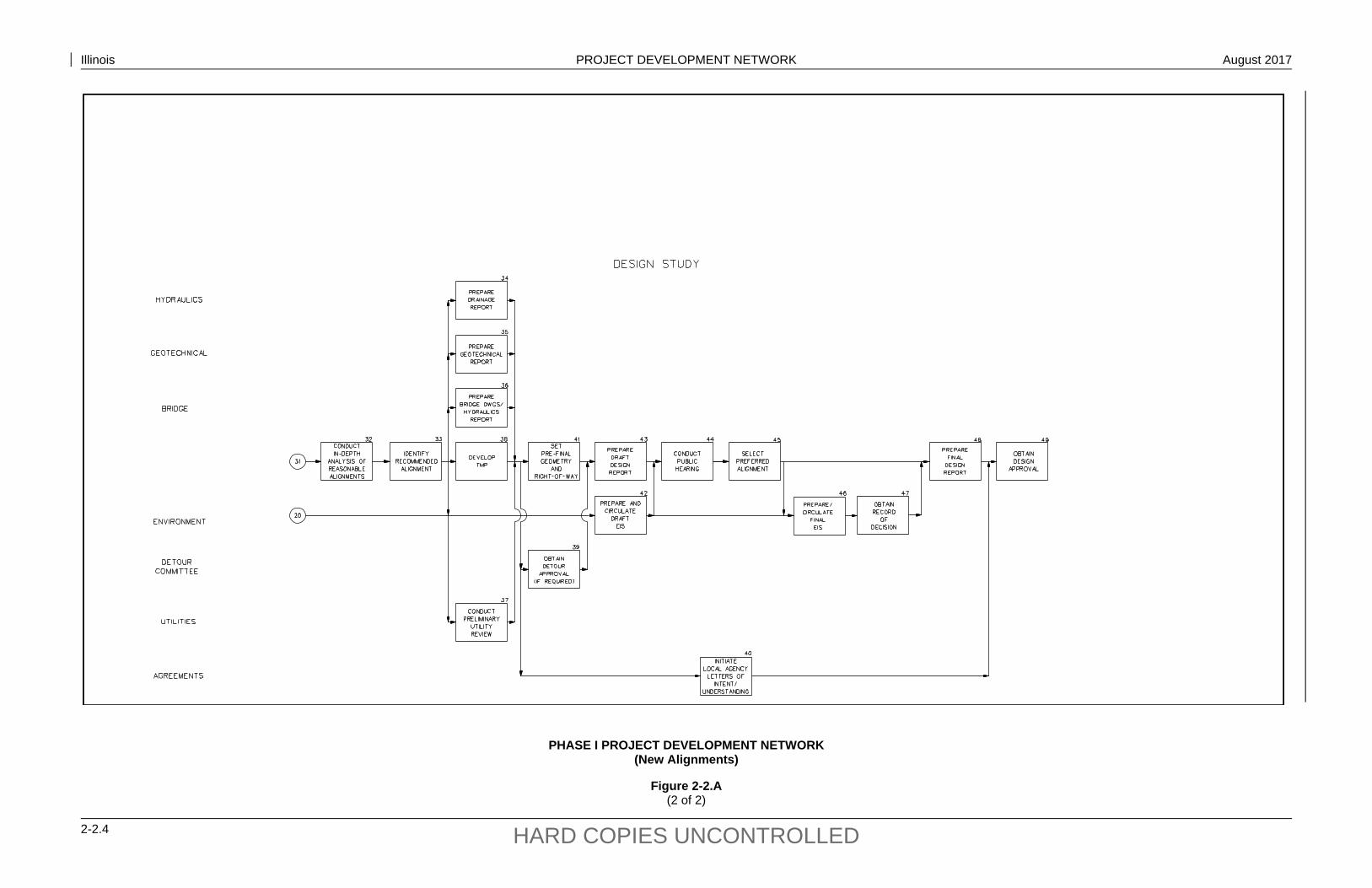
Figure 2-2.A illustrates a typical flowchart or network for a project on new alignment that will require both a corridor and a design study. Activities shown along the main axis of the chart represent items which are normally performed by the project study group. The other lines of the chart represent activities by other units or groups. For other project types, see the flowcharts in Chapter 3. Separate corridor studies are usually only prepared for new freeways, for new expressways where two or more existing routes are being considered for upgrading, or for a new two-lane highway proposed on new location. See Chapters 11 and 12. For projects deemed by FHWA as “Major Projects,” see Chapter 20.
This network assumes that EIS will be required for a project on new alignment requiring a corridor and a design study. If a project on new alignment does not appear to involve significant environmental impacts, the procedures for development of an Environmental Assessment (Chapter 24) should be followed.
The FHWA’s environmental regulations do not require a separate draft and final environmental document and record of decision at the corridor phase. The activity descriptions in this chapter reflect that corridor-phase environmental information will be incorporated in the corridor study report and will be coordinated with interested agencies and the public as a part of that document. Information from the corridor study will be summarized in the draft environmental document at the location-phase so that it will be covered under NEPA.
Illinois PROJECT DEVELOPMENT NETWORK August 2017
2-2.2 HARD COPIES UNCONTROLLED

Illinois PROJECT DEVELOPMENT NETWORK August 2017
2-2.3 HARD COPIES UNCONTROLLED
PHASE I PROJECT DEVELOPMENT NETWORK (New Alignments)
Figure 2-2.A (1 of 2)
Illinois PROJECT DEVELOPMENT NETWORK August 2017
2-2.4 HARD COPIES UNCONTROLLED
PHASE I PROJECT DEVELOPMENT NETWORK (New Alignments)
Figure 2-2.A (2 of 2)

Illinois PROJECT DEVELOPMENT NETWORK August 2017
2-2.5 HARD COPIES UNCONTROLLED
PROJECT ACTIVITY (Phase I)
Activity Title: Scope Project Activity No.: 01 Responsible Unit: District Bureau of Program Development
Activity Description:
A roadway project proposal can originate from a variety of sources, including local officials or metropolitan planning organizations (community-based need), directly from the IDOT districts (district-based need), from a bureau in the central office (Office of Planning and Programming, BDE, Operations, Bureau of Safety Programs and Engineering, etc.), and other sources targeting a special need or a Statewide need.
Before a project is entered onto the Department’s Proposed Highway Improvement Program, the district Programming Section initially develops and documents the project concept. Developing the project concept will typically involve the following:
establishing that there is, in fact, a need for the project;
making a preliminary determination of the project scope of work;
reviewing any available data and records;
conducting an initial evaluation of right-of-way, utility, and environmental impacts and the likely level of environmental evaluation;
developing a rough, preliminary cost estimate;
determining a proposed schedule (note that, for projects with both corridor and design study phases, the completion schedule may be greater than that of the multi-year program); and
developing a set of preliminary drawings/plans.
This information is forwarded for review and comment to district Program Development, district Operations, BDE, district Environmental Unit, the Bureau of Bridges and Structures, and other individuals, as appropriate. The district Programming will refine the scope based on the comments received.
Once the scope, cost, and schedule have been defined, district Programming will forward this information to the Office of Planning and Programming for incorporation into the Department’s multi-year program (Activity 02).
Illinois PROJECT DEVELOPMENT NETWORK August 2017
2-2.6 HARD COPIES UNCONTROLLED
PROJECT ACTIVITY (Phase I)
Activity Title: Initiate/Program Project Activity No.: 02 Responsible Unit: Office of Planning and Programming
Activity Description:
Candidate projects are submitted by the districts as a request for project programming to the Office of Planning and Programming. Based on a statewide assessment of highway improvement needs and available funds, the Office of Planning and Programming will develop the Department’s Proposed Highway Improvement Program. This will establish an individual project as an active project for further development.
The Office of Planning and Programming annually issues guidelines for multi-year programming criteria. This includes programming criteria for:
improvement categories, pavement surface conditions, deficient bridges, safety improvements, Interstate rehabilitation, widening narrow and deteriorated pavements, improving intersections and reducing traffic bottlenecks, new construction/reconstruction of major facilities, transportation enhancement projects, Congestion Mitigation Air Quality (CMAQ) projects, and bicycle accommodation.
Illinois PROJECT DEVELOPMENT NETWORK August 2017
2-2.7 HARD COPIES UNCONTROLLED
PROJECT ACTIVITY (Phase I)
Activity Title: Transfer/Assign to Project Study Group Activity No.: 03 Responsible Unit: Studies and Plans Engineer
Activity Description:
At this point, the project will be assigned to a project study group within the district Bureau of Program Development to begin the corridor study. The Studies and Plans Engineer will have the overall day-to-day responsibility for advancing the project through the Phase I study process. The Studies and Plans Engineer, or designee, will:
coordinate directly with other units within the Department;
attend all internal meetings and field inspections;
ensure that the project study meets all Department criteria and procedures;
report directly to the District Program Development Engineer on all significant project activities, problems, and developments; and
participate in the public involvement process.
The number and expertise of personnel initially assigned to the project study group will vary with the nature and scope of the proposed improvement. The personnel assigned will also vary over time relative to the priority for completion, the available lead time, and the activity in project development under study.
If the project is one which the Regional Engineer has determined will use the principles of Context Sensitive Solutions (CSS), the public involvement process should commence at this point. The project study group uses the Stakeholder Involvement Process (SIP) as outlined in Section 19-5.01 to conduct public involvement for CSS projects.

Illinois PROJECT DEVELOPMENT NETWORK August 2017
2-2.8 HARD COPIES UNCONTROLLED
PROJECT ACTIVITY (Phase I)
Activity Title: Define Preliminary Purpose and Need Activity No.: 04 Responsible Unit: Project Studies Group/BDE/FHWA/Office of Planning &
Programming
Activity Description:
For a major transportation project, the project study group must first define the project purpose and need, which will direct the process for the identification of alternatives, in- depth analyses and, ultimately, selection of the preferred alternative. This will consist of reaffirming the need for the proposed improvement, establishing project goals and objectives, and establishing the study area and logical termini. The feasibility of a corridor depends on the social, economic, environmental, and engineering effects of the proposed highway improvement within each corridor. Previous studies and decisions should be reaffirmed and/or updated as necessary. Other factors that must be considered include:
adequacy of the existing highway network, existing traffic volumes and capacity deficiencies, crash information, alignment and profile deficiencies, transportation demand, potential cost savings to the traveling public, enhanced economic development potential, improved access, programming guidelines, commitments to elected officials, and public input.
Further study may result in revisions to the preliminary purpose and need.
Prepare the purpose and need so that it can be transferred to the NEPA document. See Section 22-6.01 for more information on purpose and need.
Illinois PROJECT DEVELOPMENT NETWORK August 2017
2-2.9 HARD COPIES UNCONTROLLED
PROJECT ACTIVITY (Phase I)
Activity Title: Identify Preliminary Corridors Activity No.: 05 Responsible Unit: Project Study Group
Activity Description:
Based on the definition of the preliminary purpose and need (Activity 04) and the general design concept (Activity 01), the project study group should identify feasible corridors that could be used. Because this is an evolutionary process, the preliminary list will be narrowed during further evaluations. The evaluation of preliminary corridors should be sensitive to those environmental resources for which the analysis of alternatives for avoidance and minimization of adverse impacts is required (e.g., wetlands, flood plains, Section 4(f) properties, historic sites). All impractical corridors may be removed from the list with a brief description of why they were removed.
County or other area maps and USGS quadrangle topographic maps, combined with aerial photography, will furnish the locations of towns, streams, railroads, and other topographic features that will assist in defining the study area. Review these maps and locate feasible corridors with respect to local terrain, topographic features, and other controlling items.
The study area is determined through an office-based general overview of area maps and through field trips. Field trips may be facilitated by the prudent use of helicopter flights. The study area is defined as that part of the area of influence within which the facility will be investigated. The limits of the study area may not be the same as the area of influence. Lateral limits are dependent on the distance between the major termini, the function of the highway, and the character of the area traversed.
Illinois PROJECT DEVELOPMENT NETWORK August 2017
2-2.10 HARD COPIES UNCONTROLLED
PROJECT ACTIVITY (Phase I)
Activity Title: Collect Data Activity No.: 06 Responsible Unit: Project Study Group/Environmental Unit/BDE
Activity Description:
Once the preliminary corridors have been identified (Activity 05), the project study group must gather and inventory information and data on each corridor. All types of data, including social, economic, environmental, and engineering should be gathered simultaneously. The amount and type of information to be collected will vary with the nature and scope of the proposed improvement. Note that data collection is a continuous process throughout Phase I studies. As the process evolves, additional information must be collected.
Information can be obtained from the following sources: State, county, and city maps;
ASCS photography or IDOT photography;
USGS quadrangle topographic maps;
traffic maps and data;
functional classification maps;
Federal agency plans (e.g., Army Corps of Engineers, Coast Guard, Department of Interior, Department of Housing and Urban Development, FEMA);
special development plans (e.g., conservation, industrial, recreational, resource);
population growth trends;
utility maps;
urban area transportation studies;
other regional planning studies;
road inventory data from the Illinois Road and Inventory System (IRIS);
Illinois Department of Natural Resources;
meetings with local officials;
meetings with other IDOT units;
local agency plans and reports (land use maps); and
soil maps.
In addition, the project study group should review the additional sources listed in Section 11-4.02(b).

Illinois PROJECT DEVELOPMENT NETWORK August 2017
2-2.11 HARD COPIES UNCONTROLLED
PROJECT ACTIVITY (Phase I)
Activity Title: Collect Data Activity No.: 06 (Continued) Responsible Unit: Project Study Group/Environmental Unit/BDE
Activity Description:
In gathering environmental inventory data for the corridor study phase, the district will primarily use existing sources of information on known resources in the study area. Environmental inventory data can be obtained using the on-line GIS database or by contacting BDE. These information sources may include the following:
National Wetland Inventory maps;
IDNR Natural Heritage database;
NRCS wetland maps;
ASCS county soils survey maps;
flood plain maps;
listing of Wild and Scenic Rivers;
information on the locations of parks, recreation areas, and wildlife and waterfowl refuges;
IEPA stream water quality data; and
CERCLIS site listings.
This information will be supplemented by data provided by BDE in response to submittal of an environmental survey request form.
For additional guidance, see Chapter 27 “Environmental Surveys.”
Illinois PROJECT DEVELOPMENT NETWORK August 2017
2-2.12 HARD COPIES UNCONTROLLED
PROJECT ACTIVITY (Phase I)
Activity Title: Analyze Existing Conditions Activity No.: 07 Responsible Unit: Project Study Group
Activity Description:
Using county or other area maps, USGS quadrangle topographic maps, aerial photography, and other data collected in Activity 06, review the existing conditions within the proposed corridors. Items that should be reviewed include:
condition of the existing highway network;
existing traffic volumes and capacity deficiencies;
crash information;
alignment and profile deficiencies;
the locations of towns, streams, railroads, and other topographic features;
existing and proposed land use from local governments, MPOs, fire districts, schools, etc.;
environmental resources; and
sensitive environmental areas (e.g., wetlands, floodplains, natural areas, nature preserves).

Illinois PROJECT DEVELOPMENT NETWORK August 2017
2-2.13 HARD COPIES UNCONTROLLED
PROJECT ACTIVITY (Phase I)
Activity Title: Initiate Early Coordination/Scoping Activity No.: 08 Responsible Unit: Project Study Group/BDE
Activity Description:
Coordination with other Department and governmental agencies, as appropriate, is an important aspect during the corridor study process. This coordination should begin as early as practical in project planning.
The project study group and BDE will initiate early coordination with individuals, organizations, and appropriate local, State, and Federal agencies that have an interest in the project or have information or expertise concerning any issues the project may involve. The purpose of this coordination will be to assist in the identification of reasonable corridors and in the gathering of information for evaluating the social, economic, and environmental impacts of the proposed project corridors and possible impact mitigation measures. Early coordination will also identify the cooperating agencies.
Scoping is an early and open process for determining the scope of issues to be addressed in the corridor study and for identifying the significant issues related to the proposed improvement. Scoping is intended to focus the study effort on issues that are truly significant and avoid the collection of needless detailed information on insignificant issues.
Although scoping may be accomplished by a formal meeting, it is more frequently accomplished through less formal meetings and exchanges of written and verbal communications. Scoping is typically not an individual step, but an ongoing process as part of the overall coordination and public involvement process.

Illinois PROJECT DEVELOPMENT NETWORK August 2017
2-2.14 HARD COPIES UNCONTROLLED
PROJECT ACTIVITY (Phase I)
Activity Title: Determine Reasonable Corridors Activity No.: 09 Responsible Unit: Project Study Group/Environmental Unit
Activity Description: The determination of the reasonable corridors for further evaluation is an evolutionary process, which may be summarized as follows: identify preliminary corridors (Activity 05);
perform a rough evaluation of the potential impacts of these preliminary corridors on the inventory of the affected environment to identify, for example, “fatal” flaws;
incorporate input from agencies and/or the public (Activity 08) in the decision-making process;
estimate the overall reasonableness of each corridor under consideration;
ensure that each “reasonable” corridor will accommodate alternates that will satisfy the project purpose and need (Activity 04);
ensure location of connections can be adequately developed (e.g., interchanges, frontage roads) (see Section 11-4.02(e)); and
based on an appropriate level of re-evaluation and additional coordination, identify those selected reasonable corridors that are worthy of further evaluation considering:
+ the need to identify potential avoidance and minimization alternatives for environmental reasons,
+ that the cost of the studies for each corridor should be commensurate with its probability of implementation;
+ that, collectively, the selected corridors should cover the full spectrum of alternatives; and
+ that, collectively, the selected corridors should gain public acceptance that no reasonable corridor alternative has been omitted.
Typically, this process will yield two or three reasonable corridors for further evaluation. The “no-action” alternative also must be evaluated for presentation as part of the Corridor Study.
Illinois PROJECT DEVELOPMENT NETWORK August 2017
2-2.15 HARD COPIES UNCONTROLLED
PROJECT ACTIVITY (Phase I)
Activity Title: Conduct Public Involvement Activities Activity No.: 10 Responsible Unit: Project Study Group/Environmental Unit
Activity Description:
Once the reasonable corridors have been selected (Activity 09), the public should be provided an opportunity to become acquainted with the project and express its views. The public involvement program is first initiated by advising the public that a study is underway. As the project progresses, the district should offer opportunities for the public to receive updated information on the status of the project and provide input and comment. This will culminate in the corridor phase with Activity 14 “Conduct Corridor Public Hearing” when the public will be offered a formal opportunity to comment on the corridor alternatives under consideration. Public involvement should be an ongoing process as the project development evolves.
For projects which the Regional Engineer has determined will use the principles of CSS, the public involvement process should commence once the project is assigned to the project study group. The project study group uses SIP as outlined in Sections 19-5.01 to conduct public involvement for CSS projects.
For detailed information on public involvement activities, see Chapter 19.

Illinois PROJECT DEVELOPMENT NETWORK August 2017
2-2.16 HARD COPIES UNCONTROLLED
PROJECT ACTIVITY (Phase I)
Activity Title: Conduct Further Analysis of Reasonable Corridors Activity No.: 11 Responsible Unit: Project Study Group/Environmental Unit
Activity Description:
For each selected reasonable corridor (Activity 09), the project study group will identify and evaluate the socio-economic, environmental, and engineering issues, including those identified through agency coordination and public involvement that would be involved in the development of more detailed alternatives within the corridor. The evaluation of these issues must be presented at a comparable level of detail for each reasonable corridor and in a manner to facilitate comparison among the corridor alternatives. Some of the issues that should be evaluated include:
land use;
habitat;
drainage impacts and construction in flood plains;
projected ADTs;
fire districts, mail routes, school districts, drainage districts, and taxing districts;
recommendations from existing Geotechnical Reports;
locations of major utility installations;
other transportation facilities (e.g., commuter and freight railroads, airports, bus and trucking terminals);
urban area transportation study reports and other data;
regional planning agency reports;
interagency comments (Activity 08);
route planning considerations (see Section 11-3);
estimated cost for each alternative (See Section 11-4.03(d));
private and commercial property owner reports;
location of cemeteries, 4(f) land, wetlands, threatened and endangered species/habitat, historic structures, archaeological sites, and special waste sites;
water towers;
coal mines; and
other similar issues.
Illinois PROJECT DEVELOPMENT NETWORK August 2017
2-2.17 HARD COPIES UNCONTROLLED
PROJECT ACTIVITY (Phase I)
Activity Title: Identify Recommended Corridor Activity No.: 12 Responsible Unit: Project Study Group/Environmental Unit/BDE
Activity Description:
After conducting the analysis of each reasonable corridor (Activity 11), the project study group in conjunction with the district Environmental Unit will determine the recommended corridor alternative. In identifying a recommended corridor, give careful consideration to cost-effectiveness, potential socio-economic and environmental impacts, system connections, and potential for positive impact on affected communities as well as satisfying the purpose and need. The selected alternative corridor and description of why it was selected should be forwarded to BDE for review and approval prior to beginning the preparation of the draft Corridor Report (Activity 13) and before it is presented at the Corridor Public Hearing (Activity 14).
Illinois PROJECT DEVELOPMENT NETWORK August 2017
2-2.18 HARD COPIES UNCONTROLLED
PROJECT ACTIVITY (Phase I)
Activity Title: Prepare Draft Corridor Report Activity No.: 13 Responsible Unit: Project Study Group
Activity Description: Once the analyses have been sufficiently conducted and the information and data gathered, the project study group will prepare the draft Corridor Report. Chapter 12 presents the format that should be used to prepare a Corridor Report. Because the corridor study should be essentially complete, it should be possible to prepare the draft Corridor Report in near-final format. The discovery of new, significant information during the Corridor Public Hearing (Activity 14) should be rare if the corridor study has been properly developed. With the exception of changes necessary to reflect input from the public hearing, a final Report should only need information concerning the public involvement and the final conclusion/recommendation section. In general, the draft Corridor Report should be submitted to BDE for review prior to its availability to public viewing and inspection at the Corridor Public Hearing. Formal approval by BDE for release is not normally issued. Copies made available to the public should be marked as “draft” or “preliminary.” The Corridor Report should include: a discussion on the purpose and need for the project;
county maps in 11 in. x 17 in. sheets showing all corridors studied, all acceptable corridors, and existing and proposed land uses;
USGS quadrangle maps showing topography and other details;
existing and expected traffic data;
discussion on prior studies;
eliminated alternatives;
advantages and disadvantages of the selected corridor alternative;
environmental concerns;
impacts on existing communities;
results of public involvement and environmental coordination; and
estimate of costs.
Illinois PROJECT DEVELOPMENT NETWORK August 2017
2-2.19 HARD COPIES UNCONTROLLED
PROJECT ACTIVITY (Phase I)
Activity Title: Conduct Corridor Public Hearing Activity No.: 14 Responsible Unit: Project Study Group/Environmental Unit
Activity Description:
The Corridor Public Hearing is conducted at this stage of the study to present to the public, and other interested organizations and agencies, the corridor alternative under final consideration, a summary of the analyses of alternatives, and the criteria used to select the recommended corridor.
The project study group and the district Environmental Unit will evaluate all comments from the Public Hearing and will prepare responses to these comments as appropriate. Possible responses include:
modifying alternatives including the proposed action;
developing and evaluating alternative corridors previously given serious consideration;
supplementing, improving, or modifying analyses;
making factual corrections; or
explaining why the comments do not warrant further agency response, citing the sources, authorities, or reasons that support that position and, if possible, indicating those circumstances that would trigger reappraisal or further response.
Chapter 19 discusses the requirements for public hearings, public information meetings, and responding to comments received during the public hearing.
Illinois PROJECT DEVELOPMENT NETWORK August 2017
2-2.20 HARD COPIES UNCONTROLLED
PROJECT ACTIVITY (Phase I)
Activity Title: Identify Preferred Corridor Activity No.: 15 Responsible Unit: Project Study Group
Activity Description:
Based on the results of the Corridor Public Hearing (Activity 14) and previous study analyses, the project study group will select the preferred corridor for the project. The selected corridor, and its advantages and disadvantages, will be documented in the final Corridor Report (Activity 16).
Illinois PROJECT DEVELOPMENT NETWORK August 2017
2-2.21 HARD COPIES UNCONTROLLED
PROJECT ACTIVITY (Phase I)
Activity Title: Prepare Final Corridor Report Activity No.: 16 Responsible Unit: Project Study Group
Activity Description:
After analyzing the comments received from the public and other agencies, the project study group will determine if any changes are necessary in the draft Corridor Report and if any relevant issues have been overlooked. If an oversight has occurred, additional data and studies may be required to explain the resultant effects and to determine what changes, if any, are necessary.
After the review and analysis of comments is complete and the appropriate revisions incorporated, the final Corridor Report may be prepared. Activity 13 and Chapter 12 present the information and format that should appear in the Report.
Illinois PROJECT DEVELOPMENT NETWORK August 2017
2-2.22 HARD COPIES UNCONTROLLED
PROJECT ACTIVITY (Phase I)
Activity Title: Review/Approval of Corridor Report Activity No.: 17 Responsible Unit: BDE/Environmental Unit/FHWA
Activity Description:
Once the final Corridor Report has been completed, the project study group will forward the Corridor Report to BDE, the district Environmental Unit, and FHWA, if applicable, for review and approval. When approval is received for the Corridor Report, the corridor study portion of Phase I will be complete.

Illinois PROJECT DEVELOPMENT NETWORK August 2017
2-2.23 HARD COPIES UNCONTROLLED
PROJECT ACTIVITY (Phase I)
Activity Title: Identify Preliminary Alignments within Selected Corridor Activity No.: 18 Responsible Unit: Project Study Group
Activity Description:
This step initiates the design study portion of Phase I. Typically, some delay will occur between the corridor study and design study. Therefore, the project study group should review the Corridor Report and project files from the corridor study to become familiar with the decisions and determinations, commitments to local officials, and public input made during the corridor study. Also, the project study group will ensure that the corridor decisions are still valid. Throughout the design study process, reaffirm the approved corridor as contacts are made with planning agencies. Also, assess any changes in land use or development plans to determine if corridor modifications should be considered. This is especially important if several years have elapsed between the corridor and design studies or if new information is discovered during the more in-depth design analysis.
Using county maps, USGS quadrangle maps, and aerial photography, identify and lay out possible alignments within the corridor on base maps (see Chapter 11). Also include the no-action alternative in the design study. A possible alternative may include improving existing highways within the corridor. Set interchange locations and determine general horizontal alignment for each alignment. The selection of the preliminary alignments will define what information will be collected in Activity 23 and will initiate the EIS process in Activity 19.
At this stage, request project mapping based on the identified alignments. However, note that many times insufficient information will be available at the time mapping is requested and, therefore, some judgment must be used in deciding the width limits of mapping. Additional mapping can be requested later during the design study if needed for further alignment investigations.

Illinois PROJECT DEVELOPMENT NETWORK August 2017
2-2.24 HARD COPIES UNCONTROLLED
PROJECT ACTIVITY (Phase I)
Activity Title: Initiate EIS Process Activity No.: 19 Responsible Unit: BDE/Project Study Group/Environmental Unit/FHWA
Activity Description:
Once the information has been received on the preliminary alignments (Activity 18), the following actions are accomplished to initiate the process for preparing EIS. Actions 1 through 4 must be completed before Action 5, publication of a Notice of Intent:
1. The BDE sends a signed Project Initiation Letter to FHWA. FHWA and BDE encourage discussion of project initiation at coordination meetings.
2. The FHWA and IDOT develop negotiated timeframes for the project in accordance with the IDOT/FHWA 2005 Illinois Statewide Implementation Agreement for Establishment of Timeframes for Environmental Impact Statements and Environmental Assessments, giving consideration to input on the timeframes provided during development of the Stakeholder Involvement Plan (see Item 3).
3. The CSS project study group develops a draft plan for stakeholder involvement and coordination. The district contacts BDE for coordination plan examples. The project study group prepares one plan that addresses both requirements to promote a consistent and efficient process. This plan is called the Stakeholder Involvement Plan. FHWA and IDOT must agree on the content of the plan before it is distributed to external stakeholders. See Section 19-5.01(a) for further guidance.
4. The district Environmental Unit prepares a draft Notice of Intent and submits it to BDE for further action.
5. The BDE coordinates the draft Notice of Intent with FHWA for publication in the Federal Register. See Appendix B of FHWA Technical Advisory T6640.8A for more detailed information on the format, content, and processing of the Notice of Intent.
Illinois PROJECT DEVELOPMENT NETWORK August 2017
2-2.25 HARD COPIES UNCONTROLLED
PROJECT ACTIVITY (Phase I)
Activity Title: Begin External Coordination for EIS Activity No.: 20 Responsible Unit: Project Study Group/Environmental Unit/BDE/FHWA
Activity Description:
The project study group and district Environment Unit, in cooperation with BDE and FHWA, initiate the following external coordination actions:
1. The project study group, district Environmental Unit and BDE coordinate with FHWA to invite interested/affected Federal, State, and local agencies to be participating agencies or cooperating agencies. The invitation letters include a draft of the Stakeholder Involvement Plan and request input from the agencies contacted. IDOT and FHWA revisit the need for inviting additional agencies to be participating or cooperating agencies as new stakeholders are identified during project development.
2. The project study group and district Environmental Unit initiate identification of potential environmental resource issues, and may conduct one or more scoping meetings as a part of the identification effort.
3. The project study group and district Environmental Unit obtain input from participating agencies on the methodologies and level of detail planned for analysis of environmental issues for alternatives under study. Coordination with participating agencies on methodologies and level of detail for environmental analyses should be ongoing throughout development of the project. When new information warrants, the methodologies and level of detail may be revisited and modified.
The project study group and district Environmental Unit coordinate with BDE and FHWA to finalize the Stakeholder Involvement Plan after receiving and considering input from participating and cooperating agencies and the public.

Illinois PROJECT DEVELOPMENT NETWORK August 2017
2-2.26 HARD COPIES UNCONTROLLED
PROJECT ACTIVITY (Phase I)
Activity Title: Initiate Stakeholder Coordination Activity No.: 21 Responsible Unit: Project Study Group
Activity Description:
The project study group coordinates with stakeholders to complete a Context Audit.
The project study group also works with stakeholders to develop a clear statement of the transportation problem(s) the project will address. This problem statement is used in developing the project purpose and need.
See Section 19-5.01(b) for further guidance on Context Audits and development of project problem statements.
Illinois PROJECT DEVELOPMENT NETWORK August 2017
2-2.27 HARD COPIES UNCONTROLLED
PROJECT ACTIVITY (Phase I)
Activity Title: Conduct Purpose and Need Coordination Activity No.: 22 Responsible Unit: Project Study Group/FHWA
Activity Description:
The project study group, in cooperation with FHWA, accomplishes the following coordination regarding the statement of purpose and need for the project:
1. Provide participating agencies and the public opportunities to provide input for consideration in development of the statement of purpose and need for the project, in accordance with Section 6002 of SAFETEA-LU (23 U.S.C. 139).
2. Achieve consensus with CSS stakeholders on project purpose and need.
3. Obtain concurrence from NEPA/404 Merger Agreement signatories on project purpose and need.
Illinois PROJECT DEVELOPMENT NETWORK August 2017
2-2.28 HARD COPIES UNCONTROLLED
PROJECT ACTIVITY (Phase I)
Activity Title: Collect Data Activity No.: 23 Responsible Unit: Project Study Group
Activity Description: In this Activity, the collection of data for each alignment identified in Activity 18 will begin. Note that data collection is an on-going process throughout the design study phase. Data gathering may begin with a review of information available in the district and central offices. Some of the information that is gathered includes: roadway, field, aerial, and stream surveys; existing roadway classifications and truck routes; crash rate maps and collision diagrams; pavement and bridge condition reports; ADT traffic maps and DHVs for current and design year traffic (all affected routes); inventory of posted speed limits; detailed transportation maps and plans with all modes of travel included; utility installations and detailed maps from utility companies; hydraulics survey, drainage survey, sewer atlas, and flooding information tables; fire districts, mail and school bus routes, location of churches, drainage districts,
historic sites, and field-tile maps; commercial, agricultural, industrial, recreational, historic, and residential land use; conservation areas, archaeological sites, wetlands, special waste sites, etc.; local, State, and Federal agency coordination needs; maintenance information on existing routes; current topographic mapping at a scale of 1 in. = 50 ft (1:500 metric) in urban areas
and 1 in. = 200 ft (1:2500 metric) in rural areas on new alignment or 1 in. = 50 ft (1:500 metric) in rural areas where existing alignment is studied;
current aerial photographic mosaics at a scale of either 1 in. = 100 ft (1:1000 metric) or 1 in. = 200 ft (1:2500 metric) in urban areas and aerial photography at 1 in. = 400 ft (1:5000 metric) or 1 in. = 600 ft (1:7500 metric) in rural areas;
geotechnical investigations; highway geometrics, development of access control plans, and right-of-way issues; joint development uses, scenic easements, and aesthetics of highway (see Chapter
33); and cost estimate (see Section 11-2.15) and road-user benefits (see Section 11-7.01).
See Chapters 11 and 12 for further guidance on the information that should be collected for a design study. Also see Section 25-2.

Illinois PROJECT DEVELOPMENT NETWORK August 2017
2-2.29 HARD COPIES UNCONTROLLED
PROJECT ACTIVITY (Phase I)
Activity Title: Conduct Environmental Survey (Field Phase) Activity No.: 24 Responsible Unit: Project Study Group/Environmental Unit /BDE
Activity Description:
During the corridor study phase, BDE will have conducted a preliminary environmental inventory (Activity 06). For Activity 24, the project study group in conjunction with BDE will determine if further field work is necessary to verify or further evaluate the location, nature, and extent of potential resource involvement. For this Activity, the district forwards a request to BDE to conduct an environmental survey.
Based on the preliminary alignments identified in Activity 18, BDE will determine whether any further work is necessary to delineate the limits of or otherwise evaluate sensitive resources the project may affect. If determined necessary, BDE will coordinate, as appropriate, with the responsible agencies and the project study group for the field survey(s). BDE will provide the results of the reconnaissance survey(s) and any related studies for resource delineation or evaluation to the district.
The district will consider the environmental resource information in further development of the project and, for resources within the project limits (e.g., wetlands, natural areas, archaeological and historical sites), evaluate options for avoiding and minimizing the project’s effects on the resources. If adverse effects to environmental resources cannot be avoided, the project study group/Environmental Unit, in cooperation with BDE, will evaluate whether any further studies of the resources are necessary. If further studies are needed, BDE will initiate action to have the studies accomplished, considering program priority and project scheduling.
The BDE will provide information to the district regarding environmental study findings, results of coordination with outside agencies, and any recommendations for further coordination or action by the district. This information will also be used by the district Environmental Unit in preparing the draft EIS.
For additional guidance on field surveys, see Chapter 27.
Illinois PROJECT DEVELOPMENT NETWORK August 2017
2-2.30 HARD COPIES UNCONTROLLED
PROJECT ACTIVITY (Phase I)
Activity Title: Analyze Existing Conditions Activity No.: 25 Responsible Unit: Project Study Group
Activity Description: Using county or other area maps, USGS quadrangle topographic maps, aerial photography, the Corridor Report (Activity 17), data collected in Activity 23, and the environmental survey (Activity 24), the project study group will review and identify the following existing conditions: the locations of towns, streams, railroads, and other topographic features; condition of the existing highway network within the corridor; existing traffic and capacity deficiencies; crash information; alignment and profile deficiencies; existing and planned land uses from local governments, MPOs, fire districts, schools,
etc.; existing drainage patterns; sensitive noise receptors; wetlands and applicable 4(f), 6(f), and 106 sites, etc.; special waste sites; and tree and vegetation inventory. Upon receipt of the topographic mapping, plot the property lines, property names, names of roads, and all other important cultural features. Make paper copies of the mapping sheets and tape together. This procedure allows the project study group to review long lengths of the alignment in one view and to see how lines may best fit together. Begin laying out all feasible alignments. After an alignment is laid out, determine the State plane coordinates of all control points (POTs and PIs) from the project mapping. Input this information and the radii of horizontal curves into a computer file to mathematically describe each alternative. Once an alignment is mathematized and tied into digitized mapping files, the alignment can then be stationed from west to east or south to north and the information stored as a computer file for further design work. Provide the results of this activity to the district Environmental Unit to allow them to prepare the draft EIS.

Illinois PROJECT DEVELOPMENT NETWORK August 2017
2-2.31 HARD COPIES UNCONTROLLED
PROJECT ACTIVITY (Phase I)
Activity Title: Initiate Early Coordination Activity No.: 26 Responsible Unit: Project Study Group
Activity Description:
Activity 08 discusses early coordination within the context of a corridor study; the project study group will engage in a similar early coordinated effort for the design study.
At this stage of the design study process, the project study group will begin early coordination with other Department Units or Bureaus and governmental agencies (e.g., FHWA, Land Acquisition, Construction, Operations, Bridges and Structures, Utilities, environmental resource agencies). The purpose of this coordination will be to assist in the identification of reasonable alignment alternatives and in gathering information to evaluate the social, economic, and environmental impacts of the proposed project and possible impact mitigation measures. This coordination should begin as early as practical.
Provide the results of this activity to the district Environmental Unit to allow them to prepare the draft EIS.
Also see Section 25-2.
Illinois PROJECT DEVELOPMENT NETWORK August 2017
2-2.32 HARD COPIES UNCONTROLLED
PROJECT ACTIVITY (Phase I)
Activity Title: Determine Reasonable Alignments Activity No.: 27 Responsible Unit: Project Study Group/Environmental Unit/FHWA
Activity Description:
The project study group and district Environmental Unit, in cooperation with FHWA, accomplish the following coordination regarding development of the range of alternatives for the project:
1. Provide participating agencies and the public opportunities to provide input for consideration in development of the range of alternatives for the project, in accordance with Section 6002 of SAFETEA-LU (23 U.S.C. 139).
2. Achieve consensus with CSS stakeholders on the range of alternatives for the project. 3. Obtain concurrence from NEPA/404 Merger Agreement signatories on the range of
alternatives to be carried forward.
The project study group in conjunction with the district Environmental Unit considers the results of the coordination in reducing the number of alternatives to a reasonable number that are representative of the spectrum of possible alternatives that satisfy the project purpose and need. This will typically be two to three alternatives, including the no-action alternative. An in-depth analysis will be conducted on each of the remaining alternatives (Activity 30).
Using the base maps prepared in Activity 18, the information gathered in Activities 23 and 24, and the analyses conducted in Activity 25, the project study group and district Environmental Unit revise or eliminate any alternative alignments that are undesirable because of adverse engineering, environmental, economic, or social effects. An estimate of costs may be necessary to further determine which alternatives may warrant elimination. Document the reason(s) why an alignment has been discarded. Include this information in the final Design Report and EIS. Ensure that each of the remaining alternatives still meets the project’s defined purpose and need.
Also see Section 25-2.

Illinois PROJECT DEVELOPMENT NETWORK August 2017
2-2.33 HARD COPIES UNCONTROLLED
PROJECT ACTIVITY (Phase I)
Activity Title: Plot Existing/Proposed Topography, Typical Sections, Plan
and Profile Activity No.: 28 Responsible Unit: Project Study Group
Activity Description:
For each remaining alternative alignment identified in Activity 27, conduct the following:
If not already done, plot the existing topography including property lines, property owner names, business names and type, names of roads, and all other important geographic and cultural features.
Determine the proposed typical sections.
Determine the detailed horizontal alignment, including radii, stationing, and State plane coordinates of all control points (e.g., POTs, PIs, PCs, PTs).
Investigate alternative vertical profiles for each alignment. This may require designing two to three trial vertical profiles and performing several complete earthwork calculations; see Sections 11-2.05 and 11-5.04(d).
Once the geometric elements have been set, determine the preliminary right-of-way limits for each alternative.
Determine the rough quantities for each alternative and refine the cost estimate for each alternative. If no quantities are available, use a generalized cost (e.g., cost per mile (kilometer)); see Sections 12-4 and 65-1.02.
The IDOT uses the computer software program GEOPAK for laying out alignments, profiles, cross section designs, quantity calculations, and for determining construction limits. The GEOPAK also can be used to generate 3-D and perspective plots for any portion of the roadway. Use 3-D plots in the design process to assess potential safety problems and the aesthetics of each alternative.

Illinois PROJECT DEVELOPMENT NETWORK August 2017
2-2.34 HARD COPIES UNCONTROLLED
PROJECT ACTIVITY (Phase I)
Activity Title: Initiate Public Involvement Activity No.: 29 Responsible Unit: Project Study Group/Environmental Unit
Activity Description:
This Activity will allow the public an opportunity for input and comment on the alternatives selected in Activity 27. Typically, this will consist of informational letters, advertisements, and/or meetings with local government officials, fire districts, school districts, drainage districts, historic commissions, MPOs, residents, businesses, etc. These meetings or letters may include:
advising local, State, and Federal officials that a project has been initiated; procedures for developing possible coordination and public service involvement; a discussion on the project scope; a request for information (e.g., MPO plans, drainage problems, transit needs); a discussion with businesses, railroads, and utility companies; and talking with individuals at public information meetings about individual concerns.
Public coordination must be continuous throughout the project development.
For projects which the Regional Engineer has determined will use the principles of CSS, the public involvement process should commence once the project is assigned to the project study group. The project study group uses the SIP as outlined in Sections 19-5.01 to conduct public involvement for CSS projects.
For guidance on public coordination, see Chapter 19.
Illinois PROJECT DEVELOPMENT NETWORK August 2017
2-2.35 HARD COPIES UNCONTROLLED
PROJECT ACTIVITY (Phase I)
Activity Title: Conduct In-Depth Analysis of Reasonable Alignments Activity No.: 30 Responsible Unit: Project Study Group
Activity Description:
During the initial development of alignment alternatives, some analyses will have been conducted as attempts to fit various options into the project location. After the reasonable alignments have been identified (Activity 27) and the information is plotted on the plan sheets (Activity 28), further analyses will be necessary to assess the capability of each alternative to accomplish the project goals cost effectively. Conduct an in-depth analysis of each of the proposed alignments considering the social, economic, environmental, and engineering factors discussed in Part II “Project Development” and Part III “Environmental Procedures.” The engineering and environmental analyses may include: intersection design studies, interchange type and design studies, capacity analysis, initial impact and mitigation alternatives, wetlands involvement, air and noise impacts, impacts on cultural resources, tree and vegetation evaluation, water quality and natural resources impacts, and soils evaluation. After the results of these investigations have been analyzed, there may be legitimate reasons to eliminate one or more of the final alignment alternatives. Discuss the reason why these alignment(s) were not further considered in the Design Report and EIS. For instance, traffic estimates for the no-action alternative may overload existing routes creating unacceptable congestion and, thereby, eliminate this alternative. The results of this and previous Activities will be submitted to the Hydraulics Unit, Geotechnical Unit, Bureau of Bridges and Structures, Environmental Unit, and Project Support Section to allow these Units to prepare their applicable reports for the Design Report. Also see Section 25-2.
Illinois PROJECT DEVELOPMENT NETWORK August 2017
2-2.36 HARD COPIES UNCONTROLLED
PROJECT ACTIVITY (Phase I)
Activity Title: Identify Recommended Alignment Activity No.: 31 Responsible Unit: Project Study Group
Activity Description:
Considering the environmental, social, and economic impacts, engineering factors, and public input, the project study group will identify a preferred alignment through the corridor. If there are two or more alignments with essentially the same impact, the project study group still should select one recommended alignment. The final geometric and right-of-way design will be based on this recommended alignment. Also, this alignment should be presented as the recommended alignment at the public hearing (Activity 42).
Illinois PROJECT DEVELOPMENT NETWORK August 2017
2-2.37 HARD COPIES UNCONTROLLED
PROJECT ACTIVITY (Phase I)
Activity Title: Prepare Drainage Report Activity No.: 32 Responsible Unit: Hydraulics Unit
Activity Description:
Based on the information provided from the project study group (Activity 31), the Hydraulics Unit will perform the hydrology/hydraulics analysis, including the following:
culvert sizing, longitudinal encroachments, storm drainage facilities, stormwater management, and pump stations.
Based on its evaluation, the Hydraulics Unit will prepare a Drainage Report. The project study group will use this information in making the final alignment determinations. It will also incorporate the Drainage Report into the final Design Report. See Chapter 40 and the IDOT Drainage Manual for more information on Drainage Reports.
Illinois PROJECT DEVELOPMENT NETWORK August 2017
2-2.38 HARD COPIES UNCONTROLLED
PROJECT ACTIVITY (Phase I)
Activity Title: Prepare Geotechnical Report Activity No.: 33 Responsible Unit: Geotechnical Unit
Activity Description:
Based on the information provided from the project study group (Activity 31), the Geotechnical Unit will prepare the Geotechnical Report. The analyses may include:
basic soil properties (e.g., AASHTO soils classification); shrink/swell factors; properties of subsurface strata; potential for slides; slope stability at proposed cuts; and the development of a boring plan for any proposed bridges (e.g., location, spacing,
and depth).
Based on its evaluation, the Geotechnical Unit will prepare a Geotechnical Report. The project study group will use this information in making the final alignment determinations. In addition, the Geotechnical Report will be incorporated into the final Design Report. See the IDOT Geotechnical Manual for more information.

Illinois PROJECT DEVELOPMENT NETWORK August 2017
2-2.39 HARD COPIES UNCONTROLLED
PROJECT ACTIVITY (Phase I)
Activity Title: Prepare Bridge Drawings/Hydraulics Report Activity No.: 34 Responsible Unit: Bureau of Bridges and Structures/Project Study Group
Activity Description:
Based on the information provided from the project study group (Activity 31), the Bureau of Bridges and Structures will prepare the Proposed Structure Sketch for major structures, which will illustrate:
the type of structures, approximate horizontal and vertical alignment and skew, approximate pier locations, and typical bridge deck section.
The project study group will prepare this sketch for other than major structures.
See Chapter 39 for more information. The Bureau of Bridges and Structures will also prepare the Hydraulics Report for major structures. This will involve:
the hydraulic analysis to determine the necessary dimensions of the waterway opening to pass the design flood, to meet the backwater allowances, and to satisfy any regulatory flood plain requirements;
the hydraulic scour analysis to assist in determining the proper foundation design for the bridge; and
a suggested freeboard elevation.
The project study group will prepare this report for other structures and the Bureau of Bridges and Structures will approve the report.
Incorporate the Structure Sketch and Hydraulics Report into the final Design Report.

Illinois PROJECT DEVELOPMENT NETWORK August 2017
2-2.40 HARD COPIES UNCONTROLLED
PROJECT ACTIVITY (Phase I)
Activity Title: Conduct Preliminary Utility Review Activity No.: 35 Responsible Unit: Project Support Section
Activity Description:
The project study group will provide the district Project Support Section with copies of the plan sheets for the recommended alignment. The Project Support Section will work with the applicable utility companies to identify project impacts on existing utilities and inform them of environmental issues that may affect their adjustments and relocations. The following items of work are typically performed:
1. Underground. The Project Support Section will coordinate with the district survey crew and will, if needed, request an underground survey to determine the depths and location of existing underground utilities within the project limits, especially fiber optic cables, water supply, and sanitary lines in urban areas.
2. Overhead. Determine if any major above-ground utilities that may be impacted by the project. The Project Support Section may prepare a cost estimate to determine if a special effort should be exercised to avoid certain utilities.
3. Impacts. The Project Support Section will notify any utility companies that will be potentially impacted by the upcoming project, and the Section will request that the Utility contact IDOT if it plans any work in the vicinity of the project.
The Project Support Section will document its findings in a report or memorandum and submit it to the project study group. The project study group will use the information in making the final alignment determinations and document its findings in the Design Report.
For additional guidance on utility coordination, see Chapter 6.

Illinois PROJECT DEVELOPMENT NETWORK August 2017
2-2.41 HARD COPIES UNCONTROLLED
PROJECT ACTIVITY (Phase I)
Activity Title: Develop Transportation Management Plan Activity No.: 36 Responsible Unit: Project Study Group
Activity Description:
The maintenance of traffic flow during construction of a State highway will involve traffic and worker safety, public relations, and capital costs to the Department. A well-planned method for maintaining traffic flow can minimize complaints from the traveling public and from residents and businesses along the affected route. Each construction site must be evaluated on its own merits as to the appropriate method for maintaining traffic. The Design Report should contain a Transportation Management Plan (TMP) indicating an overall strategy for accommodating traffic during construction. Chapter 13 presents the goals and objectives for a TMP. The TMP should address the preferred traffic control method, alternative traffic control applications, geometric design criteria, the impact traffic will have on other facilities, local concerns, cost effectiveness of various alternatives, etc. Chapter 55 and the Highway Standards provide the design criteria to use when designing a traffic control plan. In addition, consider the following:
The TMP not only must address the alternatives confined to the project site, but it must also evaluate the impact traffic will have on the entire corridor.
For large projects, a TMP team may be organized during Phase I to study the traffic control alternatives and their effect on the corridor. Section 13-1.08 provides guidance on the makeup and responsibilities of the TMP team.
If improvements are required to other facilities (e.g., widening of detour routes), it is important that these improvements be implemented as soon as practical prior to construction of the mainline facility. Allow local agencies sufficient opportunity to complete their improvements before construction on the State route begins. Agreements or concurrence may be necessary between the State and local agencies to determine cost sharing arrangements and/or approval of a local road as a detour route (Activity 38).
No formal public involvement activity (e.g., design hearing) should occur until the recommended alternative in the TMP Report has been approved by district Detour Committee. However, informal public involvement will be necessary during the analysis of alternatives.
Illinois PROJECT DEVELOPMENT NETWORK August 2017
2-2.42 HARD COPIES UNCONTROLLED
PROJECT ACTIVITY (Phase I)
Activity Title: Obtain Detour Approval (if required) Activity No.: 37 Responsible Unit: Project Study Group
Activity Description:
In general, TMP (Activity 36) will be approved as part of the Design Report. Exceptions to the approved TMP must be approved by the Bureau of Safety Programs and Engineering. For all marked and unmarked detours or for a road proposed to remain open by either stage construction or a runaround, TMP will be approved by the district Detour Committee. For a closed unmarked State highway, also coordinate with the local county officials prior to the submittal of the Design Report.

Illinois PROJECT DEVELOPMENT NETWORK August 2017
2-2.43 HARD COPIES UNCONTROLLED
PROJECT ACTIVITY (Phase I)
Activity Title: Initiate Local Agency Letters of Intent/Understanding Activity No.: 38 Responsible Unit: Project Support Section
Activity Description:
Based on the public involvement, decisions made in Activity 29, and the selection of the recommended alignment (Activity 31), the Project Support Section will initiate the preparation of any necessary letters of intent or letters of understanding with local officials. These may be prepared for:
concurrence between the State and local agencies to determine cost sharing arrangements,
approval of a local road as a detour route,
determining maintenance responsibilities once the project is completed, and/or
letters of support for the improvement.
For additional guidance, see Chapter 5.

Illinois PROJECT DEVELOPMENT NETWORK August 2017
2-2.44 HARD COPIES UNCONTROLLED
PROJECT ACTIVITY (Phase I)
Activity Title: Set Pre-Final Geometry and Right-of-Way Activity No.: 39 Responsible Unit: Project Study Group
Activity Description:
Based on the previous analyses for the recommended alignment (Activity 31) and information provided by others (Activities 32, 33, 34, and 35), the project study group will:
make any necessary adjustments to the selected vertical and horizontal alignments;
make any necessary adjustments to the typical sections;
develop access control plans for freeways, expressways, and by-passes (see Section 11-5.04(f) and Chapter 35);
set preliminary construction limits;
set preliminary right-of-way limits;
determine any easement requirements; and
determine if any utility adjustments or displacements are necessary.
See Part IV “Roadway Design Elements” and Part V “Design of Highway Types” for detailed information on geometric design and the IDOT Land Acquisition Manual for guidance on right-of-way impacts.
Illinois PROJECT DEVELOPMENT NETWORK August 2017
2-2.45 HARD COPIES UNCONTROLLED
PROJECT ACTIVITY (Phase I)
Activity Title: Prepare and Circulate Draft EIS Activity No: 40 Responsible Unit: Environmental Unit/BDE/FHWA
Activity Description:
The district Environmental Unit, in cooperation with BDE and FHWA prepares the Draft EIS. To provide NEPA coverage of the corridor-phase study information, that information is summarized in the draft EIS.
When satisfied with the content, FHWA approves the Draft EIS for public availability. The district Environmental Unit coordinates with BDE and FHWA to have a Notice of Availability for the Draft EIS published in the Federal Register, which begins the minimum 45-day public comment period. See Chapter 25 for additional guidance on preparation of the Draft EIS, approval for public availability, and the Federal Register Notice of Availability.
Illinois PROJECT DEVELOPMENT NETWORK August 2017
2-2.46 HARD COPIES UNCONTROLLED
PROJECT ACTIVITY (Phase I)
Activity Title: Prepare Draft Design Report Activity No.: 41 Responsible Unit: Project Study Group
Activity Description:
Once the analyses have been conducted and the information gathered, the project study group will prepare the draft Design Report. Chapter 12 presents the format that should be used when preparing a Design Report. Because the design study should be essentially complete, it should be possible to prepare the draft Design Report in its near-final format. The discovery of new, significant information during the Public Hearing (Activity 42) should be rare if the design study has been properly developed. With the exception of changes necessary to reflect input from the public hearing (Activity 42), a final Design Report should only need information concerning the public involvement and the final conclusion/recommendation section.
In general, the draft Design Report for major new alignment projects should be submitted to BDE for review prior to its availability for public viewing and inspection at the Public Hearing. Formal approval by BDE for release is not normally issued. Copies made available to the public should be marked as “draft” or “preliminary.”
The Design Report should include:
a summary of purpose and need of the project; a list and results of prior studies; a list of all alternative alignments eliminated earlier and the reasons for their
elimination; a summary of major design features and policies; a discussion on the compatibility of the alternatives with existing streets and
highways; a summary of the environmental factors considered; a discussion on the advantages and disadvantages of the reasonable alignments
studied in-depth; the results of public involvement; the proposed maintenance and protection of traffic plan; a list of commitments made to the public; the reasons and determination for selecting the preferred alignment; plan and profile of the preferred alignment; the estimate of costs for each alternative; exhibits showing typical sections, aerial photography, mapping, etc.; copies of analyses; and documentation for approval of other reports conducted during the design study.
For further guidance on information to be included in the Design Report, see Chapter 12.

Illinois PROJECT DEVELOPMENT NETWORK August 2017
2-2.47 HARD COPIES UNCONTROLLED
PROJECT ACTIVITY (Phase I)
Activity Title: Conduct Public Hearing Activity No.: 42 Responsible Unit: Project Study Group/Environmental Unit
Activity Description:
No sooner than 15 days after publication of the Notice of Availability for the Draft EIS in the Federal Register, the project study group and district Environmental Unit conduct a Public Hearing. The purpose of the Public Hearing is to present to the public, and other interested organizations and agencies, the alignment alternatives under consideration and their anticipated social, economic, and environmental effects, a summary of the analyses for the various alternatives determined not to be feasible, and the criteria used to select the recommended alignment. Other Department Sections or Bureaus (e.g., Land Acquisition), as necessary, may attend the Public Hearing to answer specific questions relative to their expertise.
Corridor protection should also be addressed at the Public Hearing. Chapter 12 and the IDOT Land Acquisition Manual provide guidance on corridor protection.
The project study group and the district Environmental Unit evaluate all comments from the Public Hearing and prepare responses to these comments as appropriate. Possible responses include:
modifying alternatives including the proposed action;
developing and evaluating alternatives not previously given serious consideration;
supplementing, improving, or modifying analyses;
making factual corrections; or
explaining why the comments do not warrant further agency response, citing the sources, authorities, or reasons that support that position and, if possible, indicating those circumstances that would trigger reappraisal or further response.
Chapter 19 discusses the requirements for public hearings, public information meetings, and responding to comments received during the public hearing.
Also see Section 25-2.
Illinois PROJECT DEVELOPMENT NETWORK August 2017
2-2.48 HARD COPIES UNCONTROLLED
PROJECT ACTIVITY (Phase I)
Activity Title: Select Preferred Alignment Activity No.: 43 Responsible Unit: Project Study Group/FHWA
Activity Description:
Based on the results of the public hearing, circulation of documents, and written and verbal comments received, the project study group will select the preferred alignment within the corridor. This may require additional analyses to resolve issues and questions raised during the Public Hearing.
The project study group, in cooperation with FHWA, conducts CSS coordination to achieve consensus with stakeholders on the preferred alignment and coordinates with NEPA/404 Merger Agreement signatories to obtain their concurrence on the preferred alignment.
The selected preferred alignment is used to prepare the final Design Report (Activity 46) and, consequently, for the detailed Phase II design.

Illinois PROJECT DEVELOPMENT NETWORK August 2017
2-2.49 HARD COPIES UNCONTROLLED
PROJECT ACTIVITY (Phase I)
Activity Title: Prepare/Circulate Final EIS (FEIS) Activity No.: 44 Responsible Unit: Environmental Unit
Activity Description:
The district Environmental Unit, in cooperation with BDE and FHWA, prepares the Final EIS. The FHWA conducts a legal sufficiency review and, when satisfied with the content, approves the Final EIS. The district Environmental Unit coordinates with BDE and FHWA to file the Final EIS with USEPA for publication of a Notice of Availability in the Federal Register.
The district Environmental Unit has the primary responsibility for circulating the FEIS which, basically, will be distributed to any entity which made substantive comments on the Draft EIS or requested a copy of the FEIS. See Chapter 25 for IDOT-specific information on circulating the FEIS and the procedures for processing the FEIS by FHWA and USEPA.
Illinois PROJECT DEVELOPMENT NETWORK August 2017
2-2.50 HARD COPIES UNCONTROLLED
PROJECT ACTIVITY (Phase I)
Activity Title: Obtain Record of Decision Activity No.: 45 Responsible Unit: Environmental Unit/FHWA
Activity Description:
The FHWA will complete and sign a Record of Decision no sooner than 30 days after publication of the Final EIS notice in the Federal Register or 90 days after publication of a notice for the Draft EIS, whichever is later. See Chapter 25 for further guidance on preparation and processing of the Record of Decision.
For projects with a high potential of litigation, FHWA in consultation with the Regional Engineer and Office of the Chief Counsel may publish a notice in the Federal Register regarding the 180-day Statute of Limitations (§139(l) notice), established in Section 6002 of SAFETEA-LU (23 U.S.C. 139), on claims against USDOT and other Federal agencies for certain environmental and other approval actions. A notice may be very useful in cases where there are no known potential litigants, but where there are complex or controversial issues or impacts that may generate opposition in the future, as the project moves into an implementation phase. A §139(l) notice will define the time period during which such “newly” interested parties must act on their views. If a project has no substantial known or likely opposition, then there may be little benefit from publication of a §139(l) notice.

Illinois PROJECT DEVELOPMENT NETWORK August 2017
2-2.51 HARD COPIES UNCONTROLLED
PROJECT ACTIVITY (Phase I)
Activity Title: Prepare Final Design Report Activity No.: 46 Responsible Unit: Project Study Group
Activity Description:
The comments received from the public and other agencies should be analyzed to determine if any changes are necessary in the draft Design Report and if any relevant issues have been overlooked. If an oversight has occurred, additional studies may be required to explain the resultant effects and determine what project design changes, if any, are necessary. After the review and analysis of comments is complete and appropriate revisions effected, the final Design Report may be prepared. Activity 41 and Chapters 11 and 12 list the appropriate format, reports, and discussions that should be included in the Design Report. The final Design Report will also include or reference a copy of the FEIS received from the district Environmental Unit.
After completing all public involvement and environmental requirements, the original scaled mapping is reduced for insertion into an appendix of the Design Report. Prepare the reduced mapping sheets and other engineering exhibits on 11 in x 17 in sheets and place them in an Appendix. In addition, place the aerial photography (access control plans) showing the alternatives advanced for environmental analysis and any other environmental exhibits on 11 in x 17 in sheets and place them in an Appendix. This Appendix can be used in conjunction with a draft and final EIS. Use the 11 in x 17 in format in all cases. This size format provides for ease of use of all final exhibits by Planning, Design, and Land Acquisition personnel.

Illinois PROJECT DEVELOPMENT NETWORK August 2017
2-2.52 HARD COPIES UNCONTROLLED
PROJECT ACTIVITY (Phase I)
Activity Title: Obtain Design Approval Activity No.: 47 Responsible Unit: Project Study Group
Activity Description: The Regional Engineer reviews and approves most Phase I Engineering Reports. BDE reviews and approves Phase I Engineering Reports for those projects involving a major new alignment addressed by a Corridor Study, Feasibility Study, or Design Report, or where the Deputy Director/Regional Engineer has requested BDE assistance. See Section 12-5 for a discussion on the processing and approval of phase I reports.
Before submitting the final report for approval to the BDE/Regional Engineer, ensure that the following has been completed: the corridor has been approved; the applicable requirements in Part II “Project Development” and Part III
Environmental Procedures” have been met; public involvement activities as described in Chapter 19 have been completed; the FEIS and Record of Decision have been approved by the appropriate agencies; if applicable, coordination with and approval from FHWA has been completed; and all design exceptions have been approved by BDE and, where necessary, FHWA. Submit the following to the Regional Engineer or BDE: two copies of the Design Report and Appendices; the applicable number of copies of the FEIS as discussed in Figure 25-2.G; two copies of the Public Involvement Document; two copies of the Advisory Committee/Working Groups Document; and a memorandum describing the reasons for selecting the preferred alignment and
design features, the items submitted, and the request for design approval. For projects requiring the approval of the Bureau Chief of Design and Environment, approval will be granted with concurrence of the Director of the Office of Program Development. The Secretary of IDOT and the Director of the Office of Planning and Programming will also be contacted on their desire for a briefing meeting before design approval will be granted.

Illinois PROJECT DEVELOPMENT NETWORK August 2017
2-2.53 HARD COPIES UNCONTROLLED


Illinois PROJECT DEVELOPMENT NETWORK February 2016
2-3.1 HARD COPIES UNCONTROLLED
2-3 PHASE II DESIGN
Figure 2-3.A illustrates a typical Phase II flowchart or network for a complex project on new alignment. Following Figure 2-3.A are brief write-ups for each activity. For other project types, see the flowcharts in Chapter 3. Activities along the main axis are normally performed by the project design squad. The other lines of the chart represent activities performed by other units or groups.
Refer to Section 11-7.03 for requirements and guidance on value engineering (VE) analyses. Where required, initiate the VE study no later than the time construction plans are 30% complete and allow for the implementation of the recommendations without delaying the project. The designer should review any VE studies conducted during Phase I and update them as necessary.
For projects deemed by FHWA as “Major Projects,” see Chapter 20.

Illinois PROJECT DEVELOPMENT NETWORK February 2016
2-3.2 HARD COPIES UNCONTROLLED
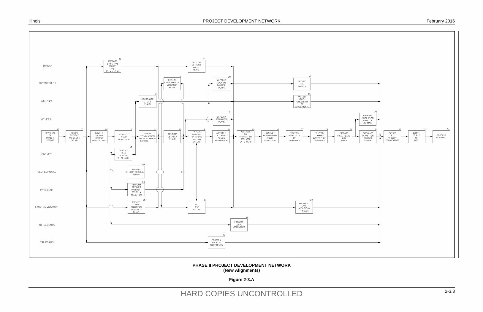
Illinois PROJECT DEVELOPMENT NETWORK February 2016
2-3.3 HARD COPIES UNCONTROLLED
PHASE II PROJECT DEVELOPMENT NETWORK (New Alignments)
Figure 2-3.A
Illinois PROJECT DEVELOPMENT NETWORK February 2016
2-3.4 HARD COPIES UNCONTROLLED
PROJECT ACTIVITY (Phase II)
Activity Title: Approval of Phase I Report Activity No.: 01 Responsible Unit: Regional Engineer (or BDE)
Activity Description:
Once the Phase I report has been approved, this will signify that Phase I is complete and that Phase II can begin. See Figure 2-2.A and the corresponding write-ups for Phase I work. For guidance on the approval of Phase I reports, see Section 12-5.
Illinois PROJECT DEVELOPMENT NETWORK February 2016
2-3.5 HARD COPIES UNCONTROLLED
PROJECT ACTIVITY (Phase II)
Activity Title: Assign Project to Design Squad Activity No.: 02 Responsible Unit: Studies and Plans Engineer
Activity Description:
This Activity begins Phase II of the project. At this point, the project will either be assigned to a design squad within the district Bureau of Program Development or to a consultant. The Studies and Plans Engineer will have the overall day-to-day responsibility for advancing the project through the Phase II project development process. The Studies and Plans Engineer, or designee, will:
coordinate directly with other units or sections within the Department;
attend all internal meetings and field inspections;
be responsible for ensuring that the project meets all Department criteria and procedures;
ensure the project is on schedule for the expected letting date;
report directly to the Program Development Engineer on all significant project activities, problems, and developments; and
participate in the public involvement process.
Illinois PROJECT DEVELOPMENT NETWORK February 2016
2-3.6 HARD COPIES UNCONTROLLED
PROJECT ACTIVITY (Phase II)
Activity Title: Prepare Structures Report and TS&L Plans Activity No.: 03 Responsible Unit: Bureau of Bridges and Structures/Design Squad
Activity Description:
Based on the approved Phase I report (Activity 01) and notification by the design squad that Phase II has begun (Activity 02), the district will prepare the Structures Report and the Bureau of Bridges and Structures will prepare the Type, Size, and Location (TS&L) Plans for any bridges within the project limits. TS&L Plans are detailed bridge configuration plans that are used to develop the detailed bridge construction plans. The TS&L Plans will present the following:
plan and profile of the bridge showing the proposed type of superstructure and foundation, bridge end elevations, location of expansion and fixed ends, highway approaches, and existing contours at the bridge site;
superstructure cross section showing pertinent structural details (e.g., number of beams, depth and width of bridge deck);
bridge curb, sidewalk, and/or shoulders;
design loadings, stresses, specifications, and other structural criteria;
controlling horizontal and vertical clearances;
hydraulic data, high and low water elevations, drift, ice, etc.; and
a small-scale location map to identify the location of the proposed bridge.
The Structures Report and TS&L Plans will be used in developing the detailed roadway plans (Activity 17). See Chapter 39 for more information on TS&L Plans and bridge sizing/geometrics.
For Phase II plans prepared by a Consultant, these activities may be the responsibility of the Consultant and approved by the Bureau of Bridges and Structures.
Illinois PROJECT DEVELOPMENT NETWORK February 2016
2-3.7 HARD COPIES UNCONTROLLED
PROJECT ACTIVITY (Phase II)
Activity Title: Prepare Geotechnical Report Activity No.: 04 Responsible Unit: Geotechnical Unit
Activity Description:
After being assigned the project (Activity 02), the design squad will request the Geotechnical Unit to investigate the geotechnical characteristics within the project limits based on the information provided in the approved Phase I report (Activity 01). The nature and depth of the investigation will be determined on a project-by-project basis. One of the primary factors which will determine the scope of the investigation will be the anticipated amount of earthwork for the project. The geotechnical investigation may include:
an in-depth subsurface investigation (e.g., to determine the hydrogeologic characteristics of the subsurface);
an evaluation of the potential for slides;
an investigation of any wetlands in the vicinity of the project;
for proposed cuts, a determination of the slope stability characteristics and the need for any special treatments (e.g., benching);
testing of materials from the site by Department laboratory tests;
an evaluation of any erosion potential within the project limits; and
an evaluation of foundations for bridges and long culverts.
The Geotechnical Unit will prepare a Geotechnical Report documenting the findings from its investigation. The Report will be submitted to the design squad for input into the final typical section design for the facility.
Illinois PROJECT DEVELOPMENT NETWORK February 2016
2-3.8 HARD COPIES UNCONTROLLED
PROJECT ACTIVITY (Phase II)
Activity Title: Initiate Land Acquisition Process and Plans Activity No.: 05 Responsible Unit: Land Acquisition Section
Activity Description:
Based on the approved Phase I report (Activity 01) and notification by the design squad that Phase II has begun (Activity 02), the Land Acquisition Section will initiate the land acquisition process and the preparation of the right-of-way plans. This includes obtaining the existing right-of-way plans and researching the existing right-of-way status within the project limits, including:
right-of-way titles and deeds, permanent easements, property lines and owners, and existing limits of access.
The preparation of right-of-way plans will include:
setting up the sheets and stationing for the right-of-way plans, recording the section corner information, recording property ownership information, plotting the existing right-of-way, and developing parcel plats.
The Land Acquisition Section will forward this information to the design squad for use in preparation of the detailed roadway plans (Activity 17).
Illinois PROJECT DEVELOPMENT NETWORK February 2016
2-3.9 HARD COPIES UNCONTROLLED
PROJECT ACTIVITY (Phase II)
Activity Title: Process Railroad Agreements Activity No.: 06 Responsible Unit: Project Support Section
Activity Description:
The district provides information to BDE for the preparation and negotiation of formal agreements between the Department and the Railroad. This includes both railroad grade separation and at-grade crossing projects on the State highway system. Based on the approved Phase I report, the design squad should submit the necessary crossing data with sufficient lead time to allow for negotiations. Typically, a year or more is required.
The Agreement will cover:
division of work and expense involved between IDOT and the Railroad for the crossing improvement;
responsibilities for the future maintenance of the improvement;
establishment of the Railroad’s share of the cost as determined under the provisions of any one of the several classifications provided in the Federal-Aid Policy Guide and Section 7-1.02;
reference to the acquisition of property rights (see Section 7-1.06);
reimbursement of the costs incurred by the Railroad according to the requirements of the Federal-Aid Policy Guide;
coverage of liability during construction operations; and
reference to or identification of plans and plan approval.
The Project Support Section will coordinate the transfer of information and plans between the design squad and the railroad companies. This will be a continuous process as the design plans are developed during the Phase II design. This process should be completed prior to the review of all project commitments (Activity 32).
For additional guidance on coordinating with railroads, see Chapter 7.
Illinois PROJECT DEVELOPMENT NETWORK February 2016
2-3.10 HARD COPIES UNCONTROLLED
PROJECT ACTIVITY (Phase II)
Activity Title: Compile and/or Review Project Data Activity No.: 07 Responsible Unit: Design Squad
Activity Description: The design squad may or may not include the same personnel as the project study group for Phase I. Also, there typically will be some delay between the Phase I and the Phase II portions of a project. Therefore, the design squad should review the Phase I report(s) and project files to become familiar with the decisions and determinations made during Phase I. Some of the information and decisions that should be reviewed may include:
any design variances, alignment and typical section plans developed during Phase I, any technical reports prepared for the Phase I study, crash and traffic data, aerial photographs, the commitment file, the proposed TMP, documentation on public hearings and/or private meetings, letters of understanding and/or letters of intent sent to local officials, any utility involvement, any railroad involvement, and existing conditions to assess any changes in land use or development plans. Based on this review, the design squad should evaluate what additional information and coordination with other units may be required to complete the project. The design squad also should ensure that other units as appropriate have initiated their work (e.g., Bureau of Bridges and Structures (Activity 03), Land Acquisition Section (Activity 05)). At this stage of the project, the design squad should request: if necessary, the Surveys and Photo Services Unit to conduct additional surveys
(Activity 08);
the Pavement Design Section to begin the pavement design and type selection (Activity 09); and
the Project Support Section to begin processing any necessary local agency agreements (Activity 10).
Illinois PROJECT DEVELOPMENT NETWORK February 2016
2-3.11 HARD COPIES UNCONTROLLED
PROJECT ACTIVITY (Phase II)
Activity Title: Conduct Field Survey (If Needed) Activity No.: 08 Responsible Unit: Surveys and Photo Services Unit
Activity Description:
In general, a survey should have been conducted during the development of the Phase I study. However, based on the review of the project data (Activity 07), the design squad may conclude that additional surveys are required. The needed survey information may include:
existing field conditions (topography, vegetation, existing structures and road design features, etc.);
drainage features (bodies of water, open channels, channel slopes and cross sections, existing drainage appurtenances, etc.);
existing field landmarks;
existing utilities (above and below ground);
existing right-of-way markers and property lines; and
alignment and cross section of any existing roads and driveways.

Illinois PROJECT DEVELOPMENT NETWORK February 2016
2-3.12 HARD COPIES UNCONTROLLED
PROJECT ACTIVITY (Phase II)
Activity Title: Perform Detailed Pavement Design and Selection Activity No.: 09 Responsible Unit: Pavement Design Section
Activity Description:
Based on the information provided by the design squad (Activity 07) and Phase I report (i.e., Geotechnical Report), the Pavement Design Section will perform the detailed pavement design analysis. For new or full-depth reconstruction, the objectives of the analysis will be to:
select the design methodology, pavement type, and design criteria (see Chapter 54);
determine the overall pavement thickness and thicknesses of individual layers; and
determine any special surfacing design features (e.g., high-stress intersections, subdrainage design, use of geotextiles).
The objective of Activity 09 is to develop and compare pavement design options. See Chapter 54 for additional guidance on pavement design and approval.
Illinois PROJECT DEVELOPMENT NETWORK February 2016
2-3.13 HARD COPIES UNCONTROLLED
PROJECT ACTIVITY (Phase II)
Activity Title: Process Local Agreements Activity No.: 10 Responsible Unit: Project Support Section
Activity Description:
The district Project Support Section is responsible for the preparation and negotiation of formal agreements between the Department and local governments. These agreements may cover:
division of work and expense involved between IDOT and the local agency in connection with the improvement,
responsibilities for the future maintenance of the improvement,
reference to the acquisition of property rights,
reimbursement of the costs incurred by the local agency,
coverage of liability during construction operations, and
reference to or identification of plans and plan approval.
The Project Support Section also will be responsible for coordinating the transfer of information and plans between the design squad and the local agency. This will be a continuous process throughout the design phase as the design plans are developed. The district Project Support Section also will coordinate with BDE for review and approval of any agreements. This process should be completed prior to the review of all project commitments (Activity 32).
For additional guidance on coordinating with local agencies, see Chapter 5.
Illinois PROJECT DEVELOPMENT NETWORK February 2016
2-3.14 HARD COPIES UNCONTROLLED
PROJECT ACTIVITY (Phase II)
Activity Title: Conduct Field Inspection Activity No.: 11 Responsible Unit: Design Squad
Activity Description:
After completing the in-house review of the Phase I report and other project data, the design squad should conduct a field inspection of the project. The objective is to review major design features and project-related issues and to identify any potential problems. The design squad will arrange the field inspection and invite, as appropriate, individuals from the following units to the field inspection:
district Bureau of Project Implementation, BDE, Bureau of Bridges and Structures, district Environmental Unit, district Bureau of Operations, Land Acquisition Section, FHWA, local officials, and others as deemed appropriate.
The design squad will document the findings and decisions in the minutes of the field inspection.
Illinois PROJECT DEVELOPMENT NETWORK February 2016
2-3.15 HARD COPIES UNCONTROLLED
PROJECT ACTIVITY (Phase II)
Activity Title: Coordinate Utility Plans Activity No.: 12 Responsible Unit: Project Support Section
Activity Description:
After conducting the field inspection (Activity 11) and any additional field surveys (Activity 08), the design squad will forward the preliminary construction plans with any known utilities plotted to the district Project Support Section. The design squad will also notify the Project Support Section of any unique issues (e.g., environmental, commitments). The Project Support Section will coordinate the transfer of information and plans between the design squad and the utility companies. The utility companies will review IDOT’s plans, plot their facilities if not already shown, and prepare the necessary utility adjustment/relocation plans. As the design squad refines the construction plans, this information will be submitted to the Project Support Section to be forwarded to the utility companies.
For guidance on preparing utility plans and coordinating with utility companies, see Chapter 6.
Illinois PROJECT DEVELOPMENT NETWORK February 2016
2-3.16 HARD COPIES UNCONTROLLED
PROJECT ACTIVITY (Phase II)
Activity Title: Refine Typical Sections, Plan and Profiles, Grades Activity No.: 13 Responsible Unit: Design Squad
Activity Description:
Based on the review of the plans (Activity 07), the field inspection (Activity 11), the field survey (Activity 08), the Phase I report, and the project’s commitment file, the design squad will refine and/or prepare the project’s:
cover sheet; general notes sheet; typical sections; the plan and profile sheets; alignment, ties, and benchmark sheet, and construction limits.
Section 63-4 provides guidance on the information that should be included on these plan sheets.

Illinois PROJECT DEVELOPMENT NETWORK February 2016
2-3.17 HARD COPIES UNCONTROLLED
PROJECT ACTIVITY (Phase II)
Activity Title: Develop Detailed Bridge Plans Activity No.: 14 Responsible Unit: Bureau of Bridges and Structures
Activity Description:
Based on the Phase I report (Activity 01), the Structure Report and TS&L Plans (Activity 03), and other information provided by the design squad, the Bureau of Bridges and Structures will perform the detailed structural design for any bridges and/or major structures on the project. The basic objective of the detailed design phase is to perform the in-depth structural analyses that are necessary to prepare a set of construction plans for any structures. The structural analyses, as applicable, may include the:
superstructure design (e.g., framing details, deck slab, camber diagram); substructure design (e.g., piers, abutments); foundation design; approach slab design; and bridge rail design.
Once the structural plan sheets are completed, the Bureau of Bridges and Structures will submit the full set of bridge plan sheets and the quantities, pay items, and specifications to the design squad for direct insertion into the final project plans. Activity 14 must be completed before the assembly of information prepared by others (Activity 25).
For Phase II plans prepared by a Consultant, these activities may be the responsibility of the Consultant and approved by the Bureau of Bridges and Structures.

Illinois PROJECT DEVELOPMENT NETWORK February 2016
2-3.18 HARD COPIES UNCONTROLLED
PROJECT ACTIVITY (Phase II)
Activity Title: Develop Environmental Mitigation Plans Activity No.: 15 Responsible Unit: Environmental Unit
Activity Description:
Based on the approved Phase I report (Activity 01) and the typical sections and plan and profiles sheets (Activity 13), the district Environmental Unit, in consultation with BDE, as appropriate, will prepare the environmental mitigation plans, quantities, and specifications for direct insertion into the final construction plans. This may include wetlands compensation plans, Special Provisions for management and monitoring of special wastes, purchase of replacement lands, memorandums of agreements, etc. The Environmental Unit will ensure that the commitments made in Phase I of the project are incorporated into the plans.
See Section 25-2.
Illinois PROJECT DEVELOPMENT NETWORK February 2016
2-3.19 HARD COPIES UNCONTROLLED
PROJECT ACTIVITY (Phase II)
Activity Title: Set Right-of-Way Widths Activity No.: 16 Responsible Unit: Land Acquisition Section
Activity Description:
Based on the information gathered in developing the Right-of-Way Plan Sheets (Activity 05) and the submittal of the construction limits by the design squad (Activity 13), the Land Acquisition Section will determine the right-of-way widths for the project. The Land Acquisition Section will forward this information to the design squad, which will incorporate this information on the plan and profile sheets.
This information also will be used to initiate the land acquisition process (Activity 24).
Illinois PROJECT DEVELOPMENT NETWORK February 2016
2-3.20 HARD COPIES UNCONTROLLED
PROJECT ACTIVITY (Phase II)
Activity Title: Develop Detailed Plans Activity No.: 17 Responsible Unit: Design Squad
Activity Description:
Once the design squad has received the Structure Report and TS&L Plans from the Bureau of Bridges and Structures (Activity 03) and the right-of-way plans from the Land Acquisition Section (Activity 05), the design squad can prepare the detailed sheets which will be incorporated into the construction plans. This may include the following:
stages of construction and temporary traffic control sheets; drainage sheets, including special drainage details; intersection details; interchange details; pavement marking details; grading plans; transition details; proposed cross sections, not including pavement template; special bikeway and trails plans; signing plans, if not prepared by the Bureau of Operations; environmental mitigation plans, if not prepared by others; highway lighting plans, if not prepared by others; and any other special details.
Section 63-4 presents guidance on what information should be included on each detail or plan sheet.
In addition, the design squad will:
determine the appropriate level of access control for the facility;
determine the need for construction permits, permanent right-of-way easements, and/or temporary easements;
perform the detailed drainage design;
perform a roadside safety analysis; and
incorporate any special experimental features into the plans.
Illinois PROJECT DEVELOPMENT NETWORK February 2016
2-3.21 HARD COPIES UNCONTROLLED
PROJECT ACTIVITY (Phase II)
Activity Title: Develop Specialized Plans Activity No.: 18 Responsible Unit: Various Units
Activity Description: Based on the typical sections, plan and profile sheets (Activity 13), and detailed plan sheets (Activity 17), various other units within IDOT will prepare their applicable plan sheets, quantities, and special provisions. This may include: district Bureau of Operations preparing the landscaping details;
district Bureau of Operations preparing the signing plans, if included within the project;
district Bureau of Operations (or Bureau of Electrical Operations in District 1) preparing the traffic signal plans;
Bureau of Operations, BDE, and design squad developing rest area plans (see Section 16-1);
Bureau of Operations, BDE, Bureau of Bridges and Structures, Capital Development Board, and the design squad developing weigh stations and weigh-in-motion plans; and/or
BDE (or Bureau of Electrical Operations in District 1) preparing the highway lighting plans.
In addition, the following units may review the detailed plans prepared by the design squad (Activity 17): district Bureau of Operations will review the pavement marking details and stage
construction and traffic control plans.
district Bureau of Project Implementation will review the stage construction and traffic control plans.
district Hydraulics Section will review the drainage plans and special drainage detail sheets.
BDE will review bikeway and trail plans.
district Environmental Unit will review the environmental mitigation plans, if prepared by the design squad.
Illinois PROJECT DEVELOPMENT NETWORK February 2016
2-3.22 HARD COPIES UNCONTROLLED
PROJECT ACTIVITY (Phase II)
Activity Title: Finalize Plotting on Cross Sections Activity No.: 19 Responsible Unit: Design Squad
Activity Description:
During Phase I, the cross sections may have been generated using GEOPAK to determine the earthwork quantities. Using the following information, update and plot the revised cross sections:
the TS&L Plans from the Bureau of Bridges and Structures (Activity 03); the environmental mitigation plans from the district Environmental Unit (Activity 15); information received from the Project Support Section on utility plans (Activity 12); the refined typical sections and plan and profile sheets (Activity 13); the detailed plans (Activity 17); the Geotechnical Report from the Geotechnical Section (Activity 04); the final pavement design from the Pavement Design Section (Activity 09); and right-of-way information provided by the Land Acquisition Section (Activity 16).
Also during Activity 19, develop the erosion control plans and specifications according to the criteria in Chapter 41 and the information provided in the Phase I report. These plans and specifications will be submitted to the district Environmental Unit for review and approval (Activity 20).

Illinois PROJECT DEVELOPMENT NETWORK February 2016
2-3.23 HARD COPIES UNCONTROLLED
PROJECT ACTIVITY (Phase II)
Activity Title: Approve Erosion Control Plans Activity No.: 20 Responsible Unit: Environmental Unit
Activity Description:
The district Environmental Unit will review and approve the erosion control plans and specifications prepared by the design squad (Activity 19). Once approval has been granted, the erosion control plans will be incorporated into the construction plans (Activity 25). Also, once the erosion control plans have been approved, the Environmental Unit can initiate the process of securing the necessary project permits (Activity 22).
Illinois PROJECT DEVELOPMENT NETWORK February 2016
2-3.24 HARD COPIES UNCONTROLLED
PROJECT ACTIVITY (Phase II)
Activity Title: Assemble All Road Design Information Activity No.: 21 Responsible Unit: Design Squad
Activity Description:
Throughout the design process, the design squad will have prepared the various plan sheets separately. In Activity 21, conduct the following:
plot a complete set of plans developed to date (e.g., cover sheet, typical plans, plan and profile sheets, detail plans, cross sections);
assemble the sheets in the recommended order as noted in Chapter 63;
review the plans and details to ensure that all necessary information has been included and that the plans and details are compatible with each other;
calculate the quantities for roadway design elements according to the criteria in Chapter 64 of the BDE Manual, the Coded Pay Items, and the Standard Specifications for Road and Bridge Construction for pay items, units of measurement, rounding conventions, etc.; and
prepare all required special provisions.
At this time, the Schedules of Quantities and the Summary of Quantities will not yet be prepared. For assembly purposes, blank Schedule of Quantities and Summary of Quantities may be included.

Illinois PROJECT DEVELOPMENT NETWORK February 2016
2-3.25 HARD COPIES UNCONTROLLED
PROJECT ACTIVITY (Phase II)
Activity Title: Secure All Permits Activity No.: 22 Responsible Unit: Environmental Unit
Activity Description:
After the cross sections have been finalized, the erosion control plans have been completed (Activity 19) and approved (Activity 20), the typical sections and plan and profiles sheets have been completed (Activity 13), and the detailed bridge plans have been completed (Activity 14), the district Environmental Unit will ensure all applicable permits and approvals required by the project are obtained. Depending upon the project-specific impacts, this may include any or all of the following:
Section 401 water quality certification and 402 permits from the Illinois Environmental Protection Agency;
U.S. Army Corps of Engineers, Section 404/Section 10 permit(s);
U.S. Coast Guard, Section 9 permit; and
permits issued by Illinois State agencies.
All permits, certifications, and approvals should be received by the Department prior to the review of all project commitments (Activity 32).
Chapter 28 provides a brief description of all Federal and State environmental permits and certifications.
Illinois PROJECT DEVELOPMENT NETWORK February 2016
2-3.26 HARD COPIES UNCONTROLLED
PROJECT ACTIVITY (Phase II)
Activity Title: Process Utility Agreements or Adjustments Activity No.: 23 Responsible Unit: Project Support Section
Activity Description:
Based on the roadway plans (Activities 13, 17, and 19), the detailed bridge plans (Activity 14), and the initial utility plans (Activity 12), the Project Support Section will work with the impacted utility companies and municipalities to implement the utility process. This process may include the following:
1. Plan Preparation. The utility companies are responsible for preparing all utility adjustment/relocation plans. The plans will be developed according to the criteria in Chapter 6.
2. Funding. Depending on the right-of-way ownership for existing and proposed utility locations, transportation funds may be eligible for utility adjustments/relocations required by the highway project; see Chapter 6. The Utilities pay for all betterments.
3. Agreements. The Project Support Section will prepare a Utility Agreement for each affected utility and will work with the utility companies to gain their input and approval. The Project Support Section will coordinate with BDE for review and approval of the agreements.
The Project Support Section will ensure that the utility process is completed before the review of all project commitments (Activity 32).
Illinois PROJECT DEVELOPMENT NETWORK February 2016
2-3.27 HARD COPIES UNCONTROLLED
PROJECT ACTIVITY (Phase II)
Activity Title: Implement Land Acquisition Process Activity No.: 24 Responsible Unit: Land Acquisition Section
Activity Description:
Based on the right-of-way plans (Activity 05), the final typical section and plan and profile sheets (Activity 13), and the right-of-way width determination (Activity 16), the Land Acquisition Section will implement the land acquisition procurement process. This will include the land acquisition functions of appraisal, negotiation, acquisition and, if necessary, condemnation. The Land Acquisition Section will also negotiate the terms of any construction permits, permanent easements, and/or temporary easements.
The Land Acquisition Section will ensure that the land acquisition procurement process is completed before the final review of all project commitments (Activity 32).
The Land Acquisition Section should coordinate with the design squad to ensure any negotiated considerations/commitments are included in the contract plans.

Illinois PROJECT DEVELOPMENT NETWORK February 2016
2-3.28 HARD COPIES UNCONTROLLED
PROJECT ACTIVITY (Phase II)
Activity Title: Assemble All Information Prepared by Others Activity No.: 25 Responsible Unit: Design Squad
Activity Description:
At this stage of project development, the design squad will have received the following completed plans, special provisions, pay items, and quantities from other IDOT units:
the bridge/structure plans from the Bureau of Bridges and Structures (Activity 14);
the landscaping details from the district Bureau of Operations (Activity 18);
if included in the project, the signing plans from the district Bureau of Operations (Activity 18);
the traffic signal plans from the district Bureau of Operations (or Bureau of Electrical Operations in District 1) (Activity 18);
rest area plans from the Bureau of Operations and BDE (Activity 18);
weigh stations and weigh-in-motion plans from the Bureau of Operations, BDE, Bureau of Bridges and Structures, and Capital Development Board (Activity 18); and
the highway lighting plans from BDE (or Bureau of Electrical Operations in District 1) (Activity 18).
In addition, the design squad will have received approval of the erosion control plans from the district Environmental Unit (Activity 20) and right-of-way widths from the Land Acquisition Section (Activity 16).
The design squad will review these materials 1) to identify and incorporate any information which must be incorporated directly into the detailed road design plans and 2) to assemble those plan sheets prepared by others into the overall set of construction plans.
Illinois PROJECT DEVELOPMENT NETWORK February 2016
2-3.29 HARD COPIES UNCONTROLLED
PROJECT ACTIVITY (Phase II)
Activity Title: Conduct Plan-in-Hand Field Inspection Activity No.: 26 Responsible Unit: Design Squad
Activity Description: At this stage of project development, all major design work has been completed, including roadway design, traffic items, structural elements, erosion control plans, right-of-way design, etc. The design squad is responsible for scheduling the Plan-in-Hand (PIH) review of the project. The PIH review is an in-depth office and on-site review of all project elements to ensure that all details and commitments have been satisfactorily incorporated into the construction plans and specifications, and that the project is nearly ready to advance to construction. As applicable, the design squad will invite the following to conduct an office and PIH field inspection: district Bureau of Project Implementation, BDE, district Bureau of Operations, Bureau of Bridges and Structures, FHWA, local officials, and others as deemed appropriate. Once the PIH office and field inspection has been completed, the design squad will prepare the PIH minutes to document all significant decisions made during the PIH review. After approval by the Program Development Engineer, distribute the PIH minutes to: all applicable Bureau Chiefs; Regional Engineer; all parties involved in the field review; FHWA, if applicable; and any other individuals or sections as deemed appropriate. All parties receiving a copy of the PIH minutes are requested to provide comments on the minutes. Concurrence of the minutes will be assumed if no comments are received by the specified date.
Illinois PROJECT DEVELOPMENT NETWORK February 2016
2-3.30 HARD COPIES UNCONTROLLED
PROJECT ACTIVITY (Phase II)
Activity Title: Prepare Schedules of Quantities Activity No.: 27 Responsible Unit: Design Squad
Activity Description:
Based on any modifications due to the Plan-in-Hand field inspection (Activity 26), the design squad will refine the project quantities for the roadway design items developed during Activity 21. Using these quantities and those provided by other IDOT units (Activity 25), the design squad will prepare the Schedule of Quantities sheets according to the criteria presented in Chapter 64. These quantities will be incorporated onto the Summary of Quantities Sheet (Activity 28).
Illinois PROJECT DEVELOPMENT NETWORK February 2016
2-3.31 HARD COPIES UNCONTROLLED
PROJECT ACTIVITY (Phase II)
Activity Title: Prepare Combined Summary of Quantities Activity No.: 28 Responsible Unit: Design Squad
Activity Description:
Using the quantities developed in Activity 21, refined in Activity 27, and those provided by other IDOT units (Activity 25), the design squad will prepare the Summary of Quantities sheets, which will summarize all pay items necessary to construct the improvement. It also should include the applicable construction and safety code items, pay item code numbers, units of measurement, total quantities, and quantity breakdown for each section. One or more summary sheets typically will be included in each set of plans. Do not show other data on the summary sheets (e.g., general notes). When preparing the Summary of Quantities sheets, it is important that all quantities be calculated and segregated accordingly prior to completing the Summary of Quantities.
The Design Squad should coordinate with the Project Support Section to ensure that the percentages and cost breakdown in the Summary of Quantities and the Local Agency agreements are identical.
For additional guidance on preparing the Summary of Quantities, see Section 63-4.

Illinois PROJECT DEVELOPMENT NETWORK February 2016
2-3.32 HARD COPIES UNCONTROLLED
PROJECT ACTIVITY (Phase II)
Activity Title: Prepare Final Plans and Specifications Activity No.: 29 Responsible Unit: Design Squad/Others
Activity Description:
Based on the Plan-in-Hand Review and minutes (Activity 26), all bureaus and sections responsible for their respective project plans will make all necessary plan and specifications revisions. This will produce the final set of project plans ready for construction. Specifically for the design squad, the design squad will be responsible for revising the roadway plans and specifications. Once completed, the plans will be distributed for district review (Activity 31) and will allow the District Estimating Engineer to prepare the Final Plan Submittal Estimate.
Complete quality control/quality assurance (QC/QA) prior to the plans being circulated for district review.
Illinois PROJECT DEVELOPMENT NETWORK February 2016
2-3.33 HARD COPIES UNCONTROLLED
PROJECT ACTIVITY (Phase II)
Activity Title: Prepare Final Plan Submittal Estimate Activity No.: 30 Responsible Unit: District Estimating Engineer
Activity Description:
Based on the information from the final plans and specifications (Activity 29), the District Estimating Engineer will prepare the final district cost estimate. This may be a new estimate or an update of an earlier cost estimate prepared during Phase I or a revised cost estimate prepared during Phase II. This estimate will be submitted to the BDE Project Management Unit, which will use it to develop the Engineer’s Estimate.
Chapter 65 provides guidance on the preparation of project cost estimates.
Illinois PROJECT DEVELOPMENT NETWORK February 2016
2-3.34 HARD COPIES UNCONTROLLED
PROJECT ACTIVITY (Phase II)
Activity Title: Circulate Plans for District Review Activity No.: 31 Responsible Unit: Design Squad
Activity Description:
Once all revisions from the Plan-in-Hand Review and minutes have been made to the plans and specifications, the design squad will submit a completed set of construction plans to the district units involved with the project for final review and comment. Typically, this review will consist of:
reviewing the plans to ensure the reviewer’s comments from previous reviews have been incorporated;
ensuring that the changes do not conflict with the bureau’s commitments; and
ensuring that the plans conform to the Department’s design criteria.
If changes are requested at this point which are desirable, but not mandatory, the Studies and Plans Engineer will determine if they should be incorporated. This will depend on other factors which may preclude the changes from being added to the plans. If another bureau determines the changes still should be incorporated, an appeal can be made to the Program Development Engineer for their incorporation.
Illinois PROJECT DEVELOPMENT NETWORK February 2016
2-3.35 HARD COPIES UNCONTROLLED
PROJECT ACTIVITY (Phase II)
Activity Title: Review all Project Commitments Activity No.: 32 Responsible Unit: Design Squad
Activity Description:
At this point in project development, the project design is essentially complete. The design squad must ensure that the following elements have been completed and/or have been incorporated into the plans:
all environmental permits have been secured (Activity 22);
all utility agreements and adjustments have been processed and signed (Activity 23);
the final district cost estimate has been completed (Activity 30);
the land acquisition process has been completed (Activity 24);
all local agreements and letters of understanding have been processed and signed (Activity 10);
all railroad agreements have been processed and signed (Activity 06); and
all commitments made during the project development, including those made during Phases I and II, have been incorporated.
The design squad must carefully review all minutes of meetings, transcripts of public hearings, and the project study files to ensure that all commitments have been incorporated. If there are any questions, the design squad should contact the preparer of the Phase I report or the Unit making the commitment during Phase II.
If it is discovered during the plan development that a change is required to the approved Phase I report or a commitment cannot be met, the design squad must immediately notify BDE and all other applicable units so that the appropriate action can be taken. Failure to provide the appropriate notification and review may result in project delay.
Illinois PROJECT DEVELOPMENT NETWORK February 2016
2-3.36 HARD COPIES UNCONTROLLED
PROJECT ACTIVITY (Phase II)
Activity Title: Submit PS&E to BDE Activity No.: 33 Responsible Unit: Design Squad
Activity Description:
Once the plans are complete and the design squad has ensured all commitments, agreements, permits, etc., are complete or have been incorporated, the design squad will submit the following items to the BDE Program Support Unit:
the Certification Acceptance/Project Status form, signed by the Regional Engineer;
a cover sheet signed by the Regional Engineer indicating his/her approval of the plans;
one complete set of full-size plans on reproducible paper, mylar, or vellum (see Chapter 63 for the Department's guidelines on preparing plan sheets);
one copy of each special provision required for the project, including a copy of the electronic file in Microsoft Word format (see Section 66-1.04 for the procedures on developing special provisions);
a completed Recurring Special Provision check sheet (see Chapter 66);
the project quantities on Form BD-213 or BDE approved equal (see Chapter 64 for the procedures on determining plan quantities);
the expected construction time for the project (see Section 66-2.03 for the Department's guidelines on determining the expected construction time); and
copies or originals of all permits and agreements.
To place an improvement on any specific letting, it is imperative that the plans and supporting documents be submitted according to the schedules established in Section 66-2 which indicate the minimum number of weeks prior to the letting date for the submittal or completion of a particular phase of work.
Illinois PROJECT DEVELOPMENT NETWORK February 2016
2-3.37 HARD COPIES UNCONTROLLED
PROJECT ACTIVITY (Phase II)
Activity Title: Process Contract Activity No.: 34 Responsible Unit: BDE
Activity Description:
Once BDE has received the plans and other information from the district (Activity 33), it will conduct the following:
prepare the Engineer’s Estimate; verify that the plans are on the list of recommended projects; check the Certification Acceptance /Project Status Form; verify the project is programmed and the scope of work is correct; determine the final funding source; check all agreements to ensure they are consistent with the project; submit the plans, special provisions, quantities, etc., for review and comment; prepare the Transportation Bulletin and advertise the project; if necessary, submit the PS&E to FHWA for approval; prepare the contract proposal; submit the proposal and plans to bidders; implement the letting process; review all bids; and execute the contract.
For additional guidance on the contract process, see Chapter 66.
Illinois PROJECT DEVELOPMENT NETWORK February 2016
2-3.38 HARD COPIES UNCONTROLLED