project a: ruataniwha reservoir restoration buffer and ... · project a: ruataniwha reservoir...
TRANSCRIPT

27 November 2013
Project A: Ruataniwha Reservoir Restoration Buffer and Catchment Enhancement Zone Project
Project Description
This project encompasses five primary objectives:
1. Replanting and natural regeneration management of a buffer around a large portion of the
new reservoir with indigenous vegetation – ‘Reservoir Restoration Buffer’;
2. Providing for targeted enhancement and restoration of remaining habitats on private land
within the catchment upstream of the dam structure – ‘Catchment Enhancement Zone’;
3. Protecting water quality in the reservoir through effective riparian management and
sediment control;
4. Providing facilities for a variety of recreation types on and around the reservoir; and,
5. Acknowledging the mana whenua of the Makaroro catchment and the history of the
Yeoman Mill site by providing public recreation space and visual displays commemorating
the history of the area.
The ecological objectives of this package are to:
27 November 2013
Recreate lost riparian margin indigenous vegetation (with a focus on special fauna resources
such as kowhai), which will provide habitats and ecological linkages for a wide range of
terrestrial and aquatic fauna and flora.
Maintain healthy aquatic habitat within the upper Makaroro River above the dam and other
reservoir tributaries such as Dutch Creek.
Restore and enhance marginal farmland and existing forest, scrub, treeland, shrubland and
wetland remnants within the sub-catchment above the dam to improve existing habitat for
flora and fauna as rapidly as possible, reinforce ecological linkages within the landscape and
provide refuge for species during and after the flooding process.
Proposed Delivery Mechanisms
In consultation with affected landowners, establishment of a 20m (minimum) buffer around
the reservoir margin where stock grazing is most likely to occur (total approx. 46ha).
Planting carried out using locally sourced indigenous plants with a kowhai focus.
Local bunding and support planting of some wetland areas where there is an opportunity to
retain water during drawdown periods (the proposed location of these wetland areas,
totaling approximately 14ha, is shown in Appendix 7).
In consultation with affected landowners, retirement of less productive suitable natural
features within the ‘Catchment Enhancement Zone’ where focused and sustained
restorative planting and pest control can occur.
Assistance with restoration projects on marginal land and remnant forest, scrub and
wetlands within the sub-catchment upstream of the dam (including fencing, animal/plant
pest control1, replanting, voluntary legal protection and ongoing monitoring).
Funding for the creation of walking/cycling tracks around the reservoir, where landowners
are amenable.
Construction of an access track around the top-end of the reservoir, linking to existing DOC
tracks in the Ruahine Forest Park via Makaroro Road.
In consultation with affected landowners and Iwi, construction of a new picnic/camping area
featuring historical/cultural information about the Yeoman Mill site and surrounding
landscape.
1 Note predator pest animal control (species other than rabbits and possums affecting planting) in these areas is managed under Project C.
27 November 2013
Construction of a boat ramp for public recreation access to the reservoir.
In consultation with affected landowners and Hawke’s Bay Fish and Game, construction of a
fisherman’s shelter for use by trout anglers.
Performance Targets
Landowner agreements to implement the proposed mechanisms.
Legal protection and restoration of at least 100 ha of land within the ‘Catchment
Enhancement Zone’.
Legal protection and restoration of at least 60ha of land (14ha wetland and 46ha reservoir
riparian areas).
Completion of the access track around the top-end of the proposed reservoir by the end of
the reservoir construction period.
Assistance with restoration projects on-going for 30 years.
Project A Budget Provision2
Mitigation/Offset Project Annual Budget Total Budget for Periods Identified
Restoration & Monitoring Plan Preparation N/A 20,000
Reservoir margin fencing (post-dam construction) NA NA
20m buffer restoration (170,000 plants over 10 years) $119,000 $1,190,000
Enrichment planting (97,000 plants over 10 years) $67,900 $679,000
Restoration and catchment enhancement (over 10 years) $20,000 $200,000
Site survey and relocation of major items from Yeoman Mill site (year 1) NA $75,000
Construction of new historic interpretation/picnic/camp site (once dam construction complete)
NA $30,000
Construction of access track around top-end of reservoir NA NA*
Development of walking/cycling tracks around reservoir (over 5 years) $30,000 $150,000
Construction of boat ramp (once dam construction complete) NA $25,000
Construction of fisherman’s hut shelter (post-dam construction) NA $30,000
Management and maintenance of recreation assets (over 30 years) $5,000 $150,000
Total Budget $241,900 $2,549,000 *Provision has been set aside for track construction around the top-end of the reservoir through the Scheme engineering budget. Additional budget has therefore not been included here.
2 All budget figures to be adjusted for CPI for the duration of the project.

27 November 2013
Explanatory Notes
Provision for the reservoir margin fencing has been included in the project engineering budget
(approximately $500,000); therefore no additional funding has been included in the budget for this
project.
The 20m buffer restoration cost component is based on an area of 34 ha (of the approx. 46 ha
fenced area), planting 1 plant/2m2 at a unit cost of $7 per plant (total of 170,000 plants).
Enrichment planting is based on an area of 100 ha, 97ha of which require restorative assistance, with
a planting regime of 1 plant per 10m2 at a unit cost of $7 (total of 97,000 plants). The unit cost of $7
per plant is all inclusive (includes the cost of plant purchase, planting and maintenance over 18
months to establishment) and is based on recent project costing experience of HBRC and Kessels &
Associates.
The restoration and catchment enhancement cost component provides an annual subsidy that can
be allocated to landowners in the reservoir area to assist with restoration projects on marginal land
and remnant forest, scrub and wetlands within the sub-catchment upstream of the dam. It is
envisaged that the subsidy will contribute towards the cost of fencing, animal/pest control,
replanting, voluntary legal protection and on-going monitoring.
Opportunities for local bunding of some wetland areas (Ca. 14 ha) to retain water during drawdown
periods will be investigated by the project engineers and physical works included in the earthworks
programme in consultation with Kessels & Associates, the project Terrestrial ecologist, and DOC
(Appendix 7 of the IOMA Report, May 2013 highlights the location of potential wetland bund areas
in relation to the proposed reservoir extent). As such, this component has not been separately
costed here.
A Project A Restoration and Monitoring Plan will be prepared to guide the instigation and ongoing
management requirements, such as exact planting specifications, fence line location, weed control
and monitoring regime and reporting. Oversight of this plan will be part of the Biodiversity Advisory
Board’s functions.
Investigations and relocation of any major items remaining at the Yeoman Mill site involves a
number of steps that have been provided for through the nominal sum of $75,000. Activities may
include: prior grazing of the area to enhance visibility of surface features; detailed mapping of
surface features (two people for a week); geophysical survey (two days); excavation of selected
areas or features such as the mill site, school area and residential area (team of five for two weeks);
oral history and archival research (two weeks); relocation of major items (the boiler etc.);
conservation/stabilization of large metal items; analysis (one person for two weeks); and report
writing (archaeologist/historian for one month). Costs may be reduced and funding applied

27 November 2013
elsewhere within Project A where there is an opportunity to get university involvement (e.g. a field
school) or other sources of sponsorship (e.g. a local firm involved in lifting and re-locating the boiler).
Provision for re-establishing access around the top-end of the reservoir, linking to existing DOC
tracks in the Ruahine Forest Park via Makaroro Road, is provided for through the separate Scheme
engineering budget. Additional budget provision has therefore not been included here.
Nominal costs associated with construction of the boat ramp are based on a cubic metre concrete
cost of $300 for a ramp measuring 100m long by 3m wide by 0.2m deep. The boat ramp will be
established once the dam construction is complete.
The cost associated with establishing walking/cycling tracks around the reservoir is based on a unit
cost of $5,000 per km of track for a low grade lime-sand track of 2.5 metres wide. A nominal length
of track of 30km is provided for; with construction over 5 years.
Recognising the need for on-going management and maintenance of recreation assets, $5,000 per
year has been provided for maintaining access tracks, camping facilities, the boat ramp, and the
fisherman’s shelter. It is anticipated that management will be overseen by HBRC (or Department of
Conservation where agreements are put in place for such) and maintenance work carried out by
suitably qualified contractors on an ‘as and when required’ basis. Where assets are located on
privately owned land, access agreements will need to be established to enable on-going public use
and access for maintenance.

27 November 2013
Project B: Ruataniwha Riparian Enhancement Zone (River Halo Project)
Project Description
This package involves implementation of four biodiversity enhancement objectives, to be funded
and managed as part of the Storage Scheme, working with willing landowners for a sustained period
of time. Objectives include:
Control of willows/lupins and other braided river weeds to maintain and enhance habitat for
wading birds, (particularly banded dotterel), within the active channel of the Waipawa and
Makaroro Rivers, to maintain indigenous vegetation, and to prevent the spread of weeds
further downstream.
Assisting landowners to enhance and protect existing areas of wetland, bush and scrub
within or contiguous with the 1km enhancement zone.
Protection and enhancement of riparian habitats alongside the Makaroro and Waipawa
Rivers that are affected by flow fluctuations resulting from the project.
Enhancing the water quality of the Makaroro and Waipawa Rivers through the establishment
of healthy riparian habitats within the Project area.

27 November 2013
Proposed Delivery Mechanisms
Fencing and restoring margins of the main stems of the two rivers, in consultation with
adjoining landowners. The primary target area for these works is the river bed habitat
extending from Caldwell Road approximately 10 km upstream.
Control of willow/lupin and other river weeds across an area of approximately 314 ha3.
Assisting landowners with fencing, replanting (as required), and legally protecting existing
areas of wetland, bush and scrub within or contiguous with the 1km enhancement zone,
prioritising management in a variety of remnant indigenous habitats, with a focus on areas
shown as Recommended Areas for Protection (RAPs) on Figure 37 of Kessels & Associates
(May 2013).
Performance Targets
Agreement with landowners to manage natural features for their biodiversity values.
Completion of stock-proof fencing of key natural features in primary target area.
Reduction in plant pest numbers within the enhancement zone.
Improved wader bird habitat.
Provide (or cause), after 30 years, 600 ha of protected (and management enhanced)
wetland, bush and scrub within the Project B spatial area.
Project B Budget Provision4
Mitigation/Offset Project Annual Budget
Provision
Total Budget Over Periods
Identified
Mitigation & Offset Prioritisation Plan Preparation $15,000
Targeted planting of the river margin (over 30 years) (equates to around 20 ha of revegetation)
$20,000 $600,000
Fencing the river margins of the main stem (over 5 years) $45,000 $225,000
Weed control on the river bed upstream of Caldwell Road (over 30 years) $10,000 $300,000
Protection and enhancement of existing areas of wetland, bush and scrub on private land (600ha over 30 years)
$20,000 $600,000
Total Budget $95,000 $1,740,000
3 Note predator pest animal control (species other than rabbits and possums) in these areas is managed under Project C.
4 All budget figures to be adjusted for CPI for the duration of the project.

27 November 2013
Explanatory Notes
An annual contribution of $20,000 over 30 years has been provided for restoring margins of the
main stems of the Waipawa and Makaroro River’s within the ‘Riparian Enhancement Zone’. Funds
for fencing key river margin areas are also provided for a five year period. The $225,000 proposed is
based on a unit price for fencing of $15 per metre, for a total length of 15km. It is noted that there
may be an opportunity to work collaboratively with landowners to extend the fenced area beyond
the 15km proposed, on the basis that landowners will be required to exclude stock from waterways
under the new stock exclusion rule proposed for the Tukituki Catchment.
Control of willow/lupins and other braided river weeds in the target area upstream of Caldwell Road
(an area of approximately 314 ha) is provided for at a rate of $10,000 per year. This is consistent
with costs incurred by HBRC in other parts of the region to manage plant pests in flood control and
drainage scheme areas.
A contribution towards protection and enhancement of existing areas of wetlands, bush and scrub
on private land is provided for (at a rate of $1,000 per hectare) involving 20 ha of
restoration/protection per year, i.e. 600 ha over a period of 30 years.
A Mitigation & Offset Prioritisation Plan will be prepared following a further detailed assessment of
the Project B area and key opportunities, after discussions with landowners to prioritise project
delivery. Oversight of this plan will be part of the Biodiversity Advisory Board’s functions.

27 November 2013
Project C: Ruataniwha Threatened Species Habitat Enhancement Project
Banded Dotterel Picture courtesy BML (M. Park). Long Tailed bat Picture courtesy of Stuart Parsons.
Project Description
Targeted assistance programme to foster research, advocacy and habitat
protection/enhancement for bats and their habitats throughout Hawke’s Bay.
Predator management programme to enhance the biodiversity values of indigenous forest
areas within Project A and B (around the reservoir and downstream of the dam structure to
Caldwell Road (inclusive of targeting wader bird habitats).
Trap and transfer programme focusing on native fish.
Proposed Delivery Mechanisms
Ongoing predator management programmes (trapping, poisoning etc) within the Project A
and Project B areas, and inclusive of braided river habitats downstream of the Dam (for
wader bird population enhancement).
One off donation to a local environmental mitigation initiative (to be agreed by the
Ruataniwha Biodiversity Advisory Board).
Implementation of an upstream trap and transfer programme to enable migratory native
fish (including eels) to access habitat upstream of the proposed dam and a downstream eel
trap and transfer programme.
27 November 2013
Performance Targets
Mammal pest (predator and herbivore) management across a total of at least 1074 ha of
habitat (bush, shrub/scrub,wetland and braided river) to be protected under Projects A and
B.5
Protection and long-term management of long-tailed bat habitats (securing also then other
“bush” fauna as well as increased awareness of their presence and habitats throughout the
region.
One-off donation provided to local mitigation initiative.
Increase in braided river wader bird breeding productivity.
Ensure that the trap and transfer programme is enabling successful recruitment of eels by
pre- and post-construction monitoring of the age-structure of the eel population upstream
and downstream of the dam (see Conditions 18 and 19 of HBRC Consent WP120371M).
Project C Budget Provision6
Mitigation/Offset Project Annual Budget
Provision
Total Budget for Periods Identifed
Animal Pest Control Plan Preparation $5,000
Targeted bat habitat enhancement (through predator control) on private land (over 10 years)
$5,000 $50,000
One-off contribution to environmental mitigation initiative for Threatened / At Risk Species (year 1)
NA $30,000
Braided river wader bird monitoring (over 10 years) $5,000 $50,000
Intensive animal pest control operation targeting (at least) 160ha of land, wetland and reservoir margin to be restored under Project A (over 30 years)
$10,000 $300,000
Targeted animal pest control over the 600 ha of wetland, bush and shrub as protected and enhanced (over 30 years) under Project B, and the 314 ha of braided river habitat managed for wader bird species (over 30 years) under Project B
$40,000 $1,200,000
Administration of the Ruataniwha Biodiversity Advisory Board $10,000 $300,000
Implementation of the upstream trap and transfer system for native fish and the downstream eel trap and transfer (over 30 years – includes year 1 trap system construction cost of $10,000)
$21,500 $655,000
Total Cost $91,500 $2,590,000
5 Made up as follows: At least 160 ha of land (including wetland and reservoir margin) to be restored under
Project A, the 314 braided habitat also subject of weed control (under Project B), and the 600ha of bush, scrub and wetland to be protected and enhanced under Project B).
6 All budget figures to be adjusted for CPI for the duration of the project.

27 November 2013
Explanatory Notes
The bat habitat enhancement provision allows for targeted assistance for landowners who have bats
on their properties. Where these areas are outside Project A or B then this also includes contribute
to fencing, and legal protection of known roosting sites, as well as pest control, as recommended by
Kessels & Associates (May 2013). It is a reduced sum reflecting a recent decision to enable re-
allocation of funding ($10,000 annually over 30 years) for the downstream eel trap and transfer, as
explained further below. This re-allocation is also facilitated by a decision to delete previous
provision for a 3 year district wide bat survey, which is no longer recommended to be necessary in
Kessels & Associates (May 2013) in light of more recent district wide bat survey work undertaken as
outlined in that report.
The mitigation cost associated with Threatened species mitigation is a provision to be assigned to
specific species. It is suggested that an environmental mitigation initiative (to be agreed by the
Advisory Board) receive a contribution towards work to enhance knowledge of falcons and other
Threatened/At Risk species such as fernbird and mistletoe and their habitats within the Hawke’s Bay
region.
The indirect braided river monitoring of key wader species for 10 years is based on a cost of $5,000
per annum. It allows for ongoing monitoring of wader species such as banded dotterels; and
research.
HBRIC Ltd and the Biodiversity Advisory Board will work in association with DOC and the Regional
Council to ensure that the pest programme/s complement existing pest control measures carried
out by DOC and the Regional Council over restoration and enhancement land (private subject to
landowner approval as well as public), within Project A and Project B areas .
While third party contributions from DOC or others to further support the programme would be
welcomed, such additional funding is seen as an enhancement beyond the level required to
appropriately offset the effects identified above. Animal pest control has been costed at $50/ha,
which provides scope to intensively control a range of animal pests, including possums, rats, stoats,
feral cats and hedgehogs. Sustained control of a suite of animal pests will provide benefits for
regeneration of indigenous vegetation, terrestrial invertebrates, birds and lizards as well as at risk
and threatened flora and fauna within the control area, including bats within the target areas of
Project A and Project B.
A figure of $10,000 has been provided for the trapping system proposed at the toe of the dam to
trap native fish for transporting upstream to the reservoir. This is a year one cost requirement. In
addition, $11,500 per year is included to provide for a local person to maintain the system and
transfer the fish from Point A to Point B, and a further $10,000 per year (total annual cost $21,500)
27 November 2013
over 30 years is provided for the downstream trap and transfer of native eel species i.e. transferring
adult eels from the reservoir downstream of the dam.
The addition of $10,000 (annually over 30 years) for the downstream eel trap and transfer was a
recent re-allocation of funds previously proposed for other activities in Project C. The effect of this
re-allocation is to reduce the previous provision for targeted bat enhancement on private land by
$200,000 (and results in deletion of the $100,000 bat survey provision as previously recommended
by Kessels &Associates). The Advisory Board would however have discretion in guiding the
prioritisation of activities to allocate funding within the project towards a greater level of targeted
bat enhancement on private land if considered warranted and supported by landowners (for
example, within the 600ha pest control area). This re-prioritisation of funds was also made in
response to specific additional advice from Cawthron and the Mana Whenua Working Party
regarding the significance of eels in the catchment from a biodiversity and cultural perspective, and
specifically their need to move downstream to the ocean to complete their life-cycle. This has been
discussed with HBRIC Ltd’s primary ecological advisors, Mr Kessels and Dr Young who support the
change. In particular, they both recognised the synergy between workers in the field who can multi-
task the pest control and trap and transfer work during the key downstream eel migration period
(April and May).
It is anticipated that the trap and transfer operation will be intensive for short periods of time over
the year; equating to approximately two months full time employment for one person per year. The
downstream trap and transfer of eels would occur seasonally to coincide with migratory patterns,
and may be carried out cost effectively by field personnel as an additional task to the ongoing pest
control activities. Provision has been made to cover the cost of implementation over 30 years,
noting that this will be an on-going annual cost. Should the Project Team and Biodiversity Advisory
Board identify a more effective way to mitigate the effects of the loss of native fish passage
upstream of the dam in future, the budget provision for the trap and transfer system noted above
will be transferred to the preferred option.
An Animal Pest Control Plan will be prepared to prioritise project delivery. Oversight of this plan will
be part of the Biodiversity Advisory Board’s functions.
27 November 2013
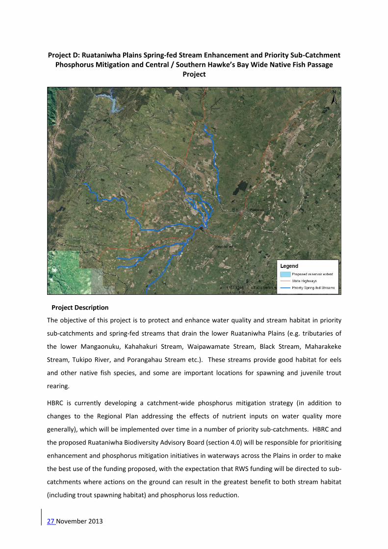
Project D: Ruataniwha Plains Spring-fed Stream Enhancement and Priority Sub-Catchment Phosphorus Mitigation and Central / Southern Hawke’s Bay Wide Native Fish Passage
Project
Project Description
The objective of this project is to protect and enhance water quality and stream habitat in priority
sub-catchments and spring-fed streams that drain the lower Ruataniwha Plains (e.g. tributaries of
the lower Mangaonuku, Kahahakuri Stream, Waipawamate Stream, Black Stream, Maharakeke
Stream, Tukipo River, and Porangahau Stream etc.). These streams provide good habitat for eels
and other native fish species, and some are important locations for spawning and juvenile trout
rearing.
HBRC is currently developing a catchment-wide phosphorus mitigation strategy (in addition to
changes to the Regional Plan addressing the effects of nutrient inputs on water quality more
generally), which will be implemented over time in a number of priority sub-catchments. HBRC and
the proposed Ruataniwha Biodiversity Advisory Board (section 4.0) will be responsible for prioritising
enhancement and phosphorus mitigation initiatives in waterways across the Plains in order to make
the best use of the funding proposed, with the expectation that RWS funding will be directed to sub-
catchments where actions on the ground can result in the greatest benefit to both stream habitat
(including trout spawning habitat) and phosphorus loss reduction.

27 November 2013
HBRC is undertaking a sub-catchment focus programme through 2013 to look at practical and
effective mitigation measures for phosphorus runoff; initially in the Porangahau, Papanui, and
Maharakeke Stream catchments. Similarly, over the last two years, Te Taiwhenua o Tamatea has
received funding from Nga Whenua Rahui to look at waterways within the Takapau area (including
the Porangahau and Papanui Streams) from an environmental and cultural perspective. There is
good opportunity for the mitigation measures identified through the sub-catchment programme to
be coordinated through this project.
An outcome of expert conferencing regarding the issue of native fish passage was a
recommendation from all parties that additional mitigation funding should be made available to
enhance native fish passage , with a focus on providing fish passage around existing structures which
limit such passage ,and hence habitat for native species. Provision has therefore been made for this
as an element of Project D, with additional funding agreed to by HBRIC Ltd.
Proposed Delivery Mechanisms
Annual funding package to contribute to physical works (e.g. fencing, replanting and
maintaining riparian margins) in priority waterways and sub-catchments. Work programme
and target priority areas to be confirmed by HBRC and the Ruataniwha Biodiversity Advisory
Board.
Landowner support for legally protecting and fencing existing wetlands.
Liaison with the HBRC freshwater ecology team to identify and prioritise expenditure
projects for enhancing native fish passage throughout Central and Southern Hawke’s Bay
Rivers (Tutaekuri, Ngaruroro, Karamu, Tukituki).
Performance Targets
Stock are permanently excluded from important spawning and juvenile trout rearing
waterways on the Ruataniwha Plains.
Stream aquatic and riparian habitats are enhanced through stock exclusion, riparian
management and planting, and wetland protection or creation.
Reduction in sediment/phosphorus inputs in important waterways.
Enhancement of native fish habitat through targeted removal of man-made barriers in
Central and Southern Hawke’s Bay Rivers(Tutaekuri, Ngaruroro, Karamu, Tukituki River
catchments).

27 November 2013
Project D Budget Provision7
Mitigation/Offset Project Annual Budget
Provision
Total Budget for Periods Identified
Funding contribution for stream enhancement and wetland protection (over 10 years)
$50,000 $500,000
Funding contribution for enhancing native fish passage throughout Central and Southern Hawke’s Bay Rivers - Tutaekuri, Ngaruroro, Karamu, and Tukituki River catchments (over 30 years)
$10,000 $300,000
Total Cost $60,000 $800,000
Explanatory Notes
An annual funding package of $50,000 per annum for 10 years is proposed to contribute to physical
works such as wetland enhancement, riparian planting and waterway fencing in priority sub-
catchments and spring-fed streams. It is anticipated that this fund will be supplemented by other
annual funding provided through Hawke’s Bay Regional Council’s Regional Land Scheme and Flood
Control Scheme; but such additional funding is seen as an enhancement beyond the level required
to appropriately offset the effects identified above.
Providing funding towards addressing a range of existing fish barriers in the region is an appropriate
and potentially effective mitigation option to complement the trap and transfer programme that is
already proposed to mitigate the effects of the Makaroro dam. Consideration was given to limiting
this expenditure to just the Tukituki Catchment, but the advice of Roger Young from Cawthron
Institute is that many of the potential projects with the best overall benefit in terms of native fish
habitat are in others Central and Southern Hawke’s Bay Rivers(Tutaekuri, Ngaruroro, Karamu,
Tukituki River catchments); hence the decision to allow this funding to be spent on priority projects
throughout the region.
The majority of the barriers that have been identified so far are culverts. Fish passage at culverts
can be addressed using a variety of methods ranging from fish friendly flood gates, culvert
replacement, structural alterations to the culvert, channel engineering to avoid culverts becoming
‘perched’, and providing fish ramps or other arrangements (e.g. mussel ropes) to help fish negotiate
their way through existing culverts.
The effectiveness of addressing these fish barriers will depend on the approach that is taken and the
species of fish involved. In some situations, modifications to the barriers will be effective for strong
migrants like eels, but less effective for weaker swimmers (e.g. smelt, inanga).
Project E: Old Waipawa River Bed and Papanui Stream Restoration Project
7 All budget figures to be adjusted for CPI for the duration of the project.

27 November 2013
Project Description
The objective of this project is to rehabilitate and enhance water quality and stream habitat in the
Old Waipawa River Bed and the Papanui Stream.

27 November 2013
A concept to use the old bed of the Waipawa River and the Papanui stream as a conduit for
supplying irrigation water to Zone M was proposed in the later stages of Scheme development (see
Zone M Primary Distribution Concept - EMS May 2013a). Key to this approach was the proposed
ecological restoration of the Old Waipawa River Bed and the Papanui stream. At a meeting of the
Mana Whenua Working Party on 17 April 2013, it was requested that the restoration of the Old
Waipawa River Bed and Papanui stream be included as part of the proposed integrated mitigation
and offset approach and this has now been included as Project E.
In the 1880’s, the Waipawa River was diverted to join the Tukituki River at its current confluence in
order to drain and farm previously flood prone land. The Old Waipawa River bed is now
predominantly dry and in some areas is used to support feedlot activities. Further downstream, the
Old Waipawa River Bed becomes the Papanui Stream which is more incised, and supports greater
water flow. The Papanui Stream ultimately converges with the Tukituki River.
Through nutrient contributions from surrounding agricultural land, low flow, lack of appropriate
riparian planting and shading and generally unrestricted stock access, the Old Waipawa River Bed
and the Papanui Stream are currently in poor ecological condition.
In the report Zone M Primary Distribution Concept (EMS May 2013a) the following objective is
defined:
“To provide for the efficient delivery of irrigation water to Zone M through the use of the Old
Waipawa River Bed and the Papanui Stream as the primary distribution system and to
rehabilitate and enhance the in-stream and riparian ecological values of the Old Waipawa
River Bed and the Papanui Stream.”
Project E seeks to implement ecological rehabilitation and enhancement objectives subsequent to
any works required to meet Zone M irrigation requirements e.g. channel shaping and sealing, stop
bank construction, etc.
In addition, Project E implements recommendations from the Cultural Impact Assessment Zone M
Addendum Report prepared by Te Taiwhenua o Tamatea ( April 2013)
Proposed Delivery Mechanisms
Annual funding package to contribute to physical works e.g. fencing, planting, creating
wetlands (where wetland creation is possible and supported by landowners) and
maintaining riparian margins. Work programme to be confirmed by HBRIC Ltd and the
Ruataniwha Biodiversity Advisory Board.

27 November 2013
Consultation with Tangata Whenua
Landowner support for riparian land and fencing requirements.
Landowner support for the creation of new wetland areas where this is feasible.
Landowner support for the development of walking / cycling paths where this is feasible.
Performance Targets
Tangata Whenua are consulted in the design and implementation of engineering and
restoration works for Zone M;
Aquatic and riparian habitats of the Old Waipawa River Bed and the Papanui Stream are
enhanced through stock exclusion, riparian management and planting, and (where feasible)
wetland creation.
The mauri of the Old Waipawa River Bed, the Papanui Stream and other connected
waterways and groundwater resources is improved;
Reduction in sediment/phosphorus inputs.
Engineering works associated the delivery of irrigation water to Zone M avoid wāhi tapu
sites including Ahu Pa, the ‘looking glass’ and Te Ihu o Te Kura as identified in the Addendum
Cultural Impact Assessment for Zone M (April, 2013).
Restoration works contribute to the protection of wāhi tapu sites where feasible, in
particular the ‘looking glass’.
Project E Budget Provision8
Mitigation/Offset Project Annual Budget
Provision
Total Budget for Periods Identified
Fencing (24km over 5 years) $72,000 $360,000
Riparian planting (85,000 plants over 10 years) $59,500 $595,000
Wetland creation fund (over 5 years) $30,000 $150,000
Development of walking/cycling tracks (over 3 years) $75,000 $225,000
Total Cost $236,500 $1,330,000
A funding package for fencing of $72,000 per annum for 5 years (total cost $360,000) is provided,
based on a per unit price for fencing of $15/m, for a total length of 24km; the Old Waipawa River
8 All budget figures to be adjusted for CPI for the duration of the project.

27 November 2013
Bed and the Papanui Stream have a combined length of approximately 17km, with both sides
requiring fencing, however there are existing areas of fencing that may be relied on so a
conservative estimate has been made of the total fencing requirement. It is noted that there may be
opportunities to extend fencing to encompass wāhi tapu sites where this is technically feasible and
supported by landowners and Tangata Whenua.
Riparian planting will be funded over 10 years at $59,500 per annum (total cost $595,000), based on
an area of 17 ha (5m width of planted area on both sides of the Old Waipawa River Bed and the
Papanui Stream), planting 1 plant/2m2 at a unit cost of $7 per plant (total of 85,000 plants). The unit
cost of $7 per plant is all inclusive (includes the cost of plant purchase, planting and maintenance
over 18 months to establishment) and is based on recent project costing experience of HBRC and
Kessels & Associates.
In addition, a fund of $150,000 has been allocated to wetland creation ($30,000 per year for 5
years). The location and extent of wetland areas will be determined through landowner consultation
and technical assessments. This fund is intended to provide flexibility to respond to opportunities to
create wetland areas associated with the Old Waipawa River Bed and the Papanui stream where
feasible and supported by landowners. If limited opportunities for wetland creation are identified,
any unspent funds from this budget provision will be transferred with direction from the Advisory
Board to other initiatives associated with the objective of Project E, if necessary.
The establishment of a walking/cycling track along riparian margins will be the subject of further
landowner discussions to confirm location and extent. A fund of $225,000 is provided over three
years ($75,000 per year), based on the establishment of a track to meet New Zealand cycle trial
standards: unit cost of $15 per lineal metre for a 100mm lime / sand compacted surface track of 2.5
metres wide. A nominal length of track of 15km is provided for.