prince william sound marine firefighting and prevention...
TRANSCRIPT
1
Prince William Sound
Marine Firefighting and Prevention
Plan
Commanding OfficerMarine Safety Office Valdez
P.O. Box 486Valdez, AK 99686
Revision 2March 15, 2004
2
Prince William Sound Marine Prince William Sound Firefighting andPrevention Plan
Table of Contents
100 Introduction
101 Purpose and Objective 102 Scope 103 Acronyms 104 Definitions
200 Policy and Responsibility
201 Federal Policy 202 COTP Responsibilities 203 State Policy 204 State Responsibilities 205 City Responsibilities 206 Responsible Party 207 Other Potential Participants
300 Planning
301 Local Geography 302 Hydrological and Climatic Considerations 303 Waterfront Facilities 304 Transportation Patterns 305 Hazardous Materials 306 Coast Guard Permits 307 Fire Fighting Areas 308 Control of Waterfront Areas
400 Response
401 Pre-designation of Responsibility for Various Scenarios 402 Response Resources 403 Response Action
500 Operational Response Actions
501 Command and Control 502 Communications ( Prince William Sound ) 503 Initial Response Actions
3
600 Exercises and Training
601 Responsibility 602 Exercises and Training
700 Resources Guide
Appendices
1. Authority2. Jurisdictional Zones3. Geographic Locations of Significant points
3-a. Fire Fighting Anchorages3-b. Fire Fighting Grounding Sites3-c. Fire Fighting Piers
4. Incident Commander Designation Decision Matrix

4
100 Introduction
This plan is based on the assumption that a major marine fire, particularly a vesselfire, may require resources beyond those locally available. Previous marinerelated incidents demonstrate this and the necessity for contingency planning.The explosion and fire on a gasoline tank barge in New York Harbor is anexample of such an incident, and associated problems (difficulty in getting properequipment on-scene, weather complications, etc.). Contingency planningidentifies the means and methods necessary to make resources available fromfederal, state, and local agencies.
Planning is particularly important to the Prince William Sound Area for severalreasons:
• The large geographic area of the Sound.
• Lack of accessible resources.
• Lack of clearly defined firefighting jurisdictions for many areas withinPrince William Sound.
• The wide variety of marine activities that take place at all times of the dayand night.
101 Purpose and Objective
This document provides for a coordinated response by the U.S. Coast Guard andother federal, state, local and civilian resources to fires on board vessels or atwaterfront facilities. It provides policies, responsibilities, and procedures forcoordination of on-scene assets. Response resources for the purposes of this planinclude but are limited to:
• Public Safety Agencies• Waterfront Facility Owners and Operators• Vessel Owners and Operators• United States Coast Guard• Other Military Branches or Federal Agencies• Private Companies and Individuals
102 Scope
This plan is effective within the designated area of area of responsibility assignedMarine Safety Office Valdez in accordance with 33 CFR 3.85-20 (Prince WilliamSound Captain of the Port Zone). Within this zone, this plan principally applies tothe navigable waters and adjacent waterfront facilities of Port Valdez and Prince William Sound. This excludes Whittier, Alaska which is in the Captain of the
5
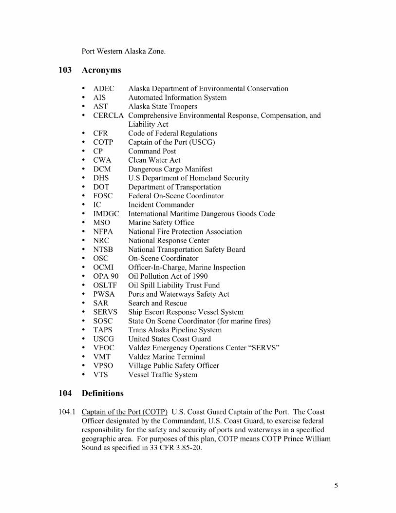
Port Western Alaska Zone.
103 Acronyms
• ADEC Alaska Department of Environmental Conservation• AIS Automated Information System• AST Alaska State Troopers• CERCLA Comprehensive Environmental Response, Compensation, and
Liability Act• CFR Code of Federal Regulations• COTP Captain of the Port (USCG)• CP Command Post• CWA Clean Water Act• DCM Dangerous Cargo Manifest• DHS U.S Department of Homeland Security• DOT Department of Transportation• FOSC Federal On-Scene Coordinator• IC Incident Commander• IMDGC International Maritime Dangerous Goods Code• MSO Marine Safety Office• NFPA National Fire Protection Association• NRC National Response Center• NTSB National Transportation Safety Board• OSC On-Scene Coordinator• OCMI Officer-In-Charge, Marine Inspection• OPA 90 Oil Pollution Act of 1990• OSLTF Oil Spill Liability Trust Fund• PWSA Ports and Waterways Safety Act• SAR Search and Rescue• SERVS Ship Escort Response Vessel System• SOSC State On Scene Coordinator (for marine fires)• TAPS Trans Alaska Pipeline System• USCG United States Coast Guard• VEOC Valdez Emergency Operations Center “SERVS”• VMT Valdez Marine Terminal• VPSO Village Public Safety Officer• VTS Vessel Traffic System
104 Definitions
104.1 Captain of the Port (COTP) U.S. Coast Guard Captain of the Port. The CoastOfficer designated by the Commandant, U.S. Coast Guard, to exercise federalresponsibility for the safety and security of ports and waterways in a specifiedgeographic area. For purposes of this plan, COTP means COTP Prince WilliamSound as specified in 33 CFR 3.85-20.
6
104.2 Cargo Information Card Refer to Section 305.3.
104.3 Command Post (CP) The single location from which incident operations aredirected.
104.4 Dangerous Cargo Manifest (DCM) Refer to Section 303.4.
104.5 Hazardous Materials These are materials which, when commercially transported,are designated by the U.S. Department of Transportation as presenting a risk tohealth, safety and property. When these materials are transported by vessel theyare required to be carried in accordance with DOT and USCG regulations.Regulations applicable to the transportation of hazardous materials by vesselinclude:
• Title 49, Code of Federal Regulations, Subchapter C (Packaged HazardousMaterials)
• Title 46, Code of Federal Regulations, Subchapter D (Tank Vessels).• Title 46, Code of Federal Regulations, Subchapter O (Certain Bulk
Dangerous Cargoes).
104.7 Incident Commander (IC) Under the Incident Command System, this person isresponsible for overall coordination and management of incident activities. Thisincludes but is not limited to the development and implementation of strategiesdesigned to mitigate the incident. The IC may be a senior officer of the agency,organization, or company having jurisdiction or responsibility for the incident.
• Depending on the incident location and other logistical considerations, the ICmust establish a Command Post upon arrival so that representatives fromother cooperating agencies may report to this location to provide arepresentative for the incident.
• The IC must establish the functional organization with personnel designated toassist in accomplishing the goals of the Incident Action Plan (IAP).
104.8 Incident Command System (ICS) ICS is a command and control system formanaging a single or multi-agency response to an emergency. It consists ofprocedures for managing personnel, facilities, equipment and communications.
104.9 Marine Safety Office (MSO) U.S. Coast Guard field level organizationresponsible for carrying out the Coast Guard’s marine safety missions in aspecified geographic area (COTP zone). The MSO is headed by a CommandingOfficer who is also designated COTP, OCMI and OSC. For the purposes of thisplan, MSO means MSO Valdez.
104.10 Officer in Charge, Marine Inspections (OCMI) U.S. Coast Guard Officer InCharge, Marine Inspection. That Coast Guard officer designated by theCommandant, U.S. Coast Guard to exercise responsibility for commercial vessel
7
inspection, marine casualty and personnel investigations, vessel and seamancertification, and vessel documentation. For purposes of this plan, the OCMI willbe the Commanding Officer, Marine Safety Office Valdez.
104.11 Federal On Scene Coordinator (FOSC) The federal official pre-designated tocoordinate and direct federal, public and private response efforts. For thepurposes of this plan, the FOSC will be the Commanding Officer, Marine SafetyOffice Valdez.
104.12 State On Scene Coordinator (SOSC) For fires aboard marine vessels, the stateofficial pre-designated by the governor to coordinate a state emergency responseis the State Fire Marshal’s Office. For the purposes of this plan, the State FireMarshal’s Office will be the SOSC. Refer to section 203.
8
200 – Policy and Responsibility
201 Federal Policy
The Coast Guard exercises primary federal responsibility for the safety andsecurity of the ports and waterways of the United States. The role of the COTP ina marine fire event is to ensure firefighting efforts are carried out in a mannerwhich does not threaten the safety of life, the environment, or property.
The Coast Guard will render assistance as available, commensurate with eat unit’slevel of training and the adequacy of equipment. The Commandant intends tomaintain this traditional “assistance as available” posture without conveying theimpression that the Coast Guard is prepared to relieve local fire departmentsof their responsibilities. Paramount in preparing for vessel or waterfront facilityfires is the need to integrate Coast Guard planning and training efforts with thoseof other responsible agencies, particularly local fire departments and portauthorities.
201.1 Request for Federal Resources All requests for federal resources or equipmentshould be made to the Coast Guard Captain of the Port (COTP) Prince WilliamSound. Refer to the Resource Guide (Section 700) for the telephone number.Significant federal resources include U.S. Navy salvage teams, foam, and CoastGuard stability experts.
202 COTP Responsibility
The COTP exercises primary federal responsibility for the safety and security ofthe port. This responsibility is exercised by enforcing dangerous cargoregulations, marine terminal safety regulations, pollution prevention regulations,and administering the Vessel Traffic Service (VTS). In emergencies, the COTPmay control the movement of ships and boats, establish safety zones and provideon scene personnel for situation assessment. Responsibilities of the COTP in amajor fire aboard a vessel or waterfront facility may include:
• Conduct notifications as described in section 502.2.• Assume IC for burning vessel underway or at anchor when:
-The fire department with jurisdiction is unable to respond.-No fire department has jurisdiction.-The responsible party does not take appropriate action.
• Participate in the Unified Command.• Assume operational control of all Coast Guard resources on-scene.• Establish safety or security zones, as necessary.• Provide information on involved waterfront facilities.• Provide information on the location of hazardous materials on the vessel, or at
the facility, if available.
9
• Provide technical data on a ship’s construction, stability and marinefirefighting techniques.
• Respond to oil or hazardous materials discharges. Actual removal may bedelayed until the firefighting operations are terminated.
• Obtain tugs to assist in relocating underway, moored or anchored vessels.• Alert owners/operators of terminal or vessel at risk.
203 State Policy
If state assistance is required, the State Fire Marshall’s Office (Department ofPublic Safety) will coordinate the firefighting response on the behalf of the stateas the (SOSC). The response by State agencies to a marine vessel fire couldinvolve several phases depending on the overall situation. With regard topotential situations associated with marine fires, there are four general criteriawhich will dictate a response by the State. These are listed below in priority orderfrom a response standpoint:
• Search and Rescue, Evacuation (AST)• Firefighting Operations (Local Fire Departments)• Local Emergency Declaration (DES)• Oil or Hazardous Substance Release (ADEC)
In situations where there may be concurrent emergency issues, (e.g., a cruise shiprequires firefighting assistance, SAR support, as well as spill responsecoordination) lifesaving efforts will take precedence over all other emergencyoperations. In this situation, the Department of Public Safety, (through the FireMarshal’s Office for marine firefighting and the Alaska State Troopers for SARoperations) will serve as SOSC.
203.1 Request for State Resources State Resources can be requested from the AlaskaDepartment of Public Safety through the Alaska Sate Trooper’s 24 hourdispatcher at 907-429-7200.
• Marine Firefighting Operations are coordinated by the Department ofPublic Safety, Fire Marshall’s Office. When notified, the Fire Marshal’sOffice will provide a qualified marine shipboard firefighting individual tocoordinate State firefighting response operations. Lifesaving and search andrescue efforts on board the ship during and immediately after the fire shall beconsidered as part of the fire operation and thus under direction of the StateFire Marshal. These activities shall continue to be under the direction of theFire Marshal as long as the atmosphere on board the vessel is unsafe andrequires entry by trained personnel in full protective clothing. If theatmosphere is unsafe due to any reason other than fire, the Fire Marshal shallalso be the lead State agency for lifesaving and search and rescue efforts onboard the ship.
10
• Search and Rescue is the responsibility of the Department of Public Safety,State Trooper Post when State resources are involved.
• Local Emergency/Disaster Support is provided by the Department ofMilitary and Veterans Affairs, Division of Emergency Services (DES). DESwill coordinate support to local communities in the event of an emergency ordisaster declaration (e.g., as a result of the marine fire, local resources areoverwhelmed).
• Oil or Hazardous Substance Release is the responsibility of the AlaskaDepartment of Environmental Conservation (ADEC). The Coast Guard willnotify ADEC whenever a vessel is in distress and a threat of oil or hazardousmaterials exists.
204 State Responsibility
• Participate in the Unified Command.• Provide a qualified marine shipboard firefighting individual to coordinate
State firefighting response operations.• Provide portable communications equipment to State response personnel, as
needed.• Assume operational control of all State resources on-scene.• Respond to oil or hazardous materials discharges. Actual removal may be
delayed until the firefighting operations are terminated.
205 City Responsibility
Valdez and Cordova City fire departments are responsible for fire protectionwithin their respective jurisdictions. In Valdez, this jurisdiction extends to theValdez narrows. For Cordova this jurisdiction encompasses the area inland of astraight line drawn from Shepard Point to Bluff Point. See Figure 4-2 in appendix4. Typical responsibilities of the city fire departments may include:
• Assume position of Incident Commander (IC) (may be VPSO in smallercommunities or villages).
• Participate in the Unified Command.• Establish and staff a Command Post when acting as IC.• Request necessary personnel and equipment, including boats, and appropriate
medical aid from the Unified Command members.• Determine the need for, and request mutual aid.• Make all requests for Coast Guard/Federal personnel, equipment, and
waterside security through the COTP.• Establish liaison with police department for land-side traffic and crowd
control, scene security, and evacuation.
206 Responsible Party
11
206.1 VesselThe vessel master is responsible for planning and directing firefighting effortsaboard the vessel as well as for the safety of the vessel and crew. The presenceof local firefighters and/or the Coast Guard does not relieve the master of hisor her command responsibilities. The master should work closely with the on-scene commander to coordinate firefighting efforts. This includes providinginformation regarding actions taken by the crew, the vessel’s layout, firefightingcapabilities and the location and types of cargo aboard.
If it has been determined the fire cannot be controlled by the crew, the fire chiefor designee, should take tactical control of the firefighting operations. The mastershould assist the fire chief in the performance of firefighting operations. Anyaction taken or planned which threatens the safety of the vessel, or crew, shouldimmediately be brought to the attention of the Fire Chief and the UC by theMaster.
206.2 Owners/Operators of Waterfront FacilitiesMost waterfront facilities within the Prince William Sound COTP Zone havelimited firefighting resources and rely on local fire departments for fire protection.Therefore in the event of a marine fire, facility operators are responsible forensuring the safety of facility personnel as well as for providing the IC withinformation regarding the facility’s layout and the location of dangerousmaterials. In the event of a fire onboard a vessel moored to the facility, thefacility operator shall provide assistance to the vessel’s mater the IncidentCommander (IC), and the COTP to the maximum extent possible.
207 Other Potential Participants
For vessel or facility fires within the Prince William Sound Captain of the PortZone, the following organizations have firefighting resources which may beavailable to respond with equipment (se resource guide) and personnel.
• VMT Fire Brigade• Petro Star Fire Brigade• Alyeska/SERVS• Crowley Marine Services• Alaska Department of Natural Resources Forestry Division• Private Contractors from outside the area (See Resource Guide)• Village Public Safety Officer (VPSO) – Tatitlek, Chengea
12
300 – Planning
301 Local Geography
Prince William Sound is an extensive body of water covering about 2500 squaremiles. Its perimeter is very irregular with may fjords, inlets, and bays. TheSound was glacier cut resulting in very deep waters with a mostly rocky bottom.The entrance, from Cape Hinchinbrook on the east to Cape Puget on the west, is58 miles across, but is dotted with islands. The Sound is divided into five mainareas:
• Hinchinbrook Entrance: is the main entrance to Prince William Sound. Itis about six miles wide and is a clear passage with exception of Seal Rocks.(Appendix 3, fig. 3-4)
• Central Prince William Sound: includes the open waters of the Sound fromMontague Island to just south of Bligh Reef. (Appendix 3, fig. 3-2)
• Valdez Arm: is the main northern arm of Prince William Sound and extendsabout 13 miles northeast from Busby Island and Point Freemantle to thenorthern end of the Valdez Narrows where it turns east for 11 miles to thehead of Port Valdez. The water is very deep and the only outlying danger isMiddle Rock near the northern end of the Narrows and two shoals near thewestern edge of the arm. (Appendix 3, fig. 3-1)
• Valdez Narrows: is about eight tenths of a mile with deep water and boldshores. Middle Rock, near the middle of the northern end of the narrows, isa pinnacle barely covered at extreme high tides. It is marked with a night.(Appendix 3, fig. 3-1)
• Port Valdez: extends from the Valdez Narrows to the head of the bay.(Appendix 3, fig. 3-1)
302 Hydrological and Climatic Considerations
Prince William Sound has a typical maritime climate with moderate airtemperatures for the sub-arctic. The Sound also receives a high amountof precipitation; annual precipitation amounts (liquid) in excess of 315inches have been recorded, with annual snowfall nearing 600 inches someyears. In the summer the temperatures range in the 50’s and 60’s with anoccasional high of 70 degrees. During the winter months, the temperaturesdrop down to the 20’s and 30’s with an occasional low of zero. Strong windsassociated with the storms that migrate onshore from the Aleutian low to thewest are frequent. The winds during the winter months frequently range from25-40 knots, but during the summer rarely exceed 30 knots.
13
Tides in Prince William Sound are of the mixed, semi-diurnal type, with amaximum range of 17 feet. The diurnal range of the tide within PrinceWilliam Sound is between 10 and 13 feet. The replenishment of water in theport is accomplished by means of daily tidal exchange, seasonal or annualexchange Prince William Sound, and the frequent but randomly occurringpassage of storms. More detailed tide and tidal current informationconcerning the Sound and Port Valdez is provided in the Tide Tables, theTidal Current Tables and the U.S. Coast Pilot.
303 Waterfront Facilities
Waterfront facilities supporting the local marine operators exist throughoutPrince William Sound. Information on the marine oil transfer facilities can befound in the facility files maintained at Coast Guard Marine Safety Office,Valdez. Fixed facilities within Prince William Sound include the ValdezMarine Terminal and in Cordova, Orca Oil.
304 Transportation Patterns
Prince William Sound hosts a wide variety of vessels and cargoes. Cruiseships and crude oil carriers are of particular interest to this plan because of thesignificant threat to life and/or environment posed by a fire aboard. Thebalance of shipping traffic usually includes refined product barges, fishingvessels, fishing tenders, a small amount of containerized freight barges, woodchip carries, tugs, escort vessels, oil spill response barges, and passenger/carferries.
The following sections describe in greater detail the patterns of waterbornetrade, and possible associated hazards, which occur in Prince William Sound.
304.1 Cruise Ships: Historically, cruise ships made an average of 90 port calls inValdez between May and September. Now most larger cruise ships transit theSound, en-route College Fjord, without making a port call in Valdez. Theseships routinely carry between 400 and 1400 passengers per vessel with a crewcomplement averaging 400. Possible Hazards associated with cruise shipsmay include refrigerants, bunker fuel, false ceilings, cable ways in theoverheads, blind alleys, large number of small compartments, large number ofpeople who will need assistance, non-fire resistant materials, firefightingequipment not compatible with shore connections and language barriers.Refer to Resource Guide for Foreign Language translators.
304.2 Crude Oil Tankers: An average of 45 crude oil tankers per month, ranging insize from 50,000 to 211,000 DWT, arrive at the VMT. These ships transit,laden, from the terminal through the Valdez Narrows to the Hinchinbrookentrance and then out into the Gulf of Alaska. Hazards associated with thecrude oil tankers include flammable cargo which is unrefined therefore the
14
volatile light ends are still present, small crew to fight the fire, and limitedresources on board.
304.3 Refined Product Carriers: Refined product carriers transit from areas outsideand throughout Prince William Sound to the Ports of Whittier, Cordova, andValdez. There are several commercial landing craft which ship refinedpetroleum tank trucks to remote villages and communities within PrinceWilliam Sound. There are also a large number of commercial fishing tenderswhich ship refined petroleum products in support of the commercial fishingindustry and conduct ship to ship fuel transfers throughout Prince WilliamSound. Hazards associated with these carriers may include few personnelwith minimal training to fight the fire, limited resources on board, tanks withexplosive atmospheres, and multiple cargoes which may be incompatiblewhen mixed.
304.4 General Freight Carriers:
- Various types of hazardous materials are transported through Prince William Sound bound for local and other destinations. A large amount of this cargo is
shipped by rail cars which are offloaded from a barge to the railway facility inWhittier.
- Military explosives transit through the Sound two or three times per year.Explosives are loaded and off loaded at the Valdez Container Terminal.
- Commercial explosives are also shipped through the Ports of Whittier,Cordova, and Valdez and remote sites within Prince William Sound onregularly scheduled freight carriers.
- Foreign bulk freighters carry wood chips from the Port of Valdez todestinations overseas. The hazards associated with this cargo include largefire load, toxic fumigants, and depleted oxygen levels from decaying organicmaterials.
The hazards associated with the general freight carriers may include fewpersonnel with minimal training to fight the fire, limited resources on board,and multiple cargoes which may be hazardous materials.
304.5 Fishing Vessels: There are approximately 500 commercial fishing vesselslocated in Cordova, Whittier and Valdez. There are also several commercialfishing vessels located in the villages of Tatitlek and Chenega. These vesselsare often made from wood and may carry ammonia or drums of fuel on board.
304.6 Alaska Marine Highway Vessels: The Alaska Marine Highway System is astate-operated ferry system which transports passengers, motorized vehicles,and general freight containers on a scheduled route between Whittier,
15
Cordova, Valdez and other ports throughout Alaska. The hazards associatedwith the ferries may include small crew to fight the fire, limited resources onboard, and up to 50 vehicles with full fuel tanks, possibly propane tanks,hazardous material as part of the cargo, and many passengers who will needassistance.
304.7 Charter/Tour Vessels: These include chartered vessels with less than 6 passengers and tour vessels with up to 250 passengers. These vessels carry very small crews and have very limited resources on board for firefighting.
304.8 Recreational Vessels: These are found throughout Prince William Sound, withincreased numbers during the summer months. Firefighting equipment onthese vessels is usually limited to portable fire extinguishers.
305 Hazardous Materials
Various DOT and USCG regulations require that hazardous materialsinformation be placed at waterfront transportation facilities, or on boardvessels, to improve the safe handling and identification of hazardous materialsinvolved in transportation. This information takes several forms and includesshipping papers, dangerous cargo manifests and cargo information cards.Containers carrying hazardous cargo are required by federal regulation to beplacarded.
305.1 Shipping Papers: Shipping papers are required for packaged hazardousmaterial cargoes, liquid bulk hazardous material cargoes, and flammable orcombustible bulk liquid cargoes. The shipping papers for packaged hazardousmaterial (49 CFR 172) is not required aboard the vessel but must bemaintained by the water carrier. This is usually at its U.S. port facility wherethe cargo is loaded or discharged. The shipping paper must, at a minimum,contain the following:
- Hazardous material description including proper shipping name, hazardclass or division, identification number, packing group and total quantity.- Shipper name.- 24 hour emergency response telephone number.
Shipping papers for bulk liquid cargoes must be carried on board thevessel.Required information includes:
- Name of consignee.- Location of delivery point.- Kind, grades, and approximate quantity of each cargo.
305.2 Dangerous Cargo Manifest: A listing of all hazardous material cargo on avessel and contains a great deal of information necessary to emergency
16
response teams. Vessel information includes name, call sign, flag, port ofloading and discharge and date. Cargo information includes proper shippingname gross weight of cargo, hazard class, type of package, storage locationsand emergency response telephone number. Only hazardous materials subjectto 49 CFR or the International Maritime Dangerous Goods (IMDG) code mustbe listed on the manifest.
- Holders and Location: Copies of dangerous cargo manifests are held onvessel and generally by the shipping company and terminal operator. Thevessel’s DCM is required to be held in a designated holder on the bridge.The shipping company or terminal operator should also hold a copy of themanifest in the local office.
- Accuracy during loading: During loading or unloading operations, themanifest will not indicate whether the cargo is on the vessel or on thedock.
305.3 Cargo Information Card: This, or its equivalent, must be available at thebridge or pilot house of any vessel or towing vessel transporting flammable orcombustible bulk liquid cargoes, barges loaded with bulk liquid hazardousmaterial cargoes. Cargo information for bulk, liquefied gas or compressedhazardous gas cargoes carried on board tank vessels requires
- Cargo identification and characteristics.- Emergency procedures.- Firefighting procedures.
306 Coast Guard Permits
A COTP approved “Application and Permit to Handle Hazardous Materials”,Form CG-4260, is required by 49 CFR 176.100 to load a vessel with Division1.1 or 1.2 explosives (Classes A and B Explosives) at a waterfront facility.
- Permit Information: Information concerning Coast Guard issued permits canbe obtained by calling the Port Operations Department at MSO Valdez. Seethe Resource Guide section for the telephone number. Local fire departmentsmay request permit information for a vessel or facility.
307 Firefighting Areas
17
A ship on fire may present immediate risks to adjacent life or property, and/orsubstantial logistical firefighting problems. The Unified Command willreview the facts of each event and determine if a ship should be moved, and ifso, where the ship should be best situated, either to fight the fire or minimizeassociated impacts. Ships may be moved to or from piers, to anchor, orpossibly in extreme cases to grounding or sinking sites. Possible sites havebeen identified for consideration by the Unified Command. Those sites aredescribed in greater detail, and are plotted on charts in appendix 3. Details tobe considered by the Unified Command are discussed below.
307.1 Piers: Although piers are not the only sites that can, or should be consideredfor positioning a burning vessel, they offer the greatest potential to maximizethe use of shore-based firefighting resources. The following factors should beconsidered when selecting a pier:
- The severity of the fire.- The proximity of the pier to populated areas.- Environmentally sensitive areas.- Availability of the pier for and extended period.- Availability of water and electricity.- Construction of the pier.- Prevailing winds.- Availability of firefighting staging area.- Presence of hazardous materials at the pier and on the vessel.- Availability of special equipment.
307.2 Firefighting Piers: The listing of a pier of facility in the plan does not meanthat the Coast Guard or any other agency will unilaterally direct a burningvessel to that facility. At a minimum, a decision of this nature must bediscussed with representatives of:
- The vessel- The facility- The appropriate Port Authority- The appropriate Fire Department- The Coast Guard- The South West Pilots Association- Other agencies, depending on the particular situation.
307.3 Anchorages: If a fire is deemed to pose a significant threat to a facility, pier,or the port, or the smoke poses a threat to nearby communities, a decision maybe made to move the vessel to a temporary anchorages.
307.4 Firefighting Anchorages: For planning purposes the following criteria wereconsidered when selecting potential anchorages within Prince William Soundand Port Valdez:
18
- Shelter from wind- Type of bottom- Depth of water at mean low tide- Adequate swing room for the largest vessels- Facilities for passengers and crew- Proximity to staging areas- Can the site be boomed off to limit environmental impact in the event of a
spill?
307.5 Grounding Sites: At some point it may become necessary to ground a vessel.Grounding should only be considered if it is determined the vessel may sink,or in other ways become derelict. Such events could become greater hazardsto the marine ecological system through resultant pollution than the total lossof a single ship in a pre-designated area.
In choosing grounding sites, several factors must be considered:
- Bottom material: Soft enough that the ship’s hull will not rupture.- Water depth: Shallow enough that the vessel will not sink below the main deck, yet deep enough that fire boats, salvage barges and tugs can approach.- Weather: Areas not known to have strong winds or currents which could hamper firefighting or salvage efforts.
307.6 Firefighting Grounding Sites: For planning purposes the following criteriawere considered when selecting potential grounding sites within PrinceWilliam Sound and Port Valdez:
- Shelter from wind- Type of bottom- Depth of water- Proximity to staging areas- Can the site be boomed off to limit environmental impact in the event of a spill?
The Unified Command will have to consider seasonal sensitivities per siteprior to making their decision.
307.7 Offshore Locations for Intentionally Sinking Vessels: When a vessel andcargo are deemed a total constructive loss it may be best to sink it in an areawhere environmental damage is minimized. These areas will be consideredby the Regional Response Team (RRT comprised of State and Federalrepresentatives.) The COTP will request this team be convened whenintentional sinking of a vessel is considered.
308 Control over Waterfront Areas

19
The COTP may find it helpful to control or restrict traffic in an affected areato provide safety for the waterfront facilities or vessels. 33 CFR 165 setsforth a procedure for establishing safety zones for the protection of vesselsand shore areas. The COTP has sole authority to establish a safety zone.Implementation and enforcement of the safety zone is a joint effort of MSOValdez, Vessel Traffic Service, and any Coast Guard asset involved in theenforcement of the zone.
20
400 – Response
401 Pre-designation of Responsibilities for Various Scenarios
Pre-designated organizational responsibilities may vary for various scenariosdepending upon the jurisdictional boundary, facility or vessel location andseverity of the incident. The PWS Fire Decision Matrix (Appendix 4, figure4-1) should be used to assist in determining the pre-designated organizationalresponse which could be expected within specific locations and various scenariosthroughout Prince William Sound. The PWS Boundaries (Appendix 4, figure4-2) identifies specific jurisdictional boundaries throughout Prince WilliamSound.
402 Response Resources
Equipment and resources necessary to respond to a major marine fire can varywidely in type and quantity depending on circumstances. A list of resources isincluded in the Resource Guide section.
402.1 Captain of the Port (COTP): The COTP will supply personnel for siteassessment. These personnel may be part of the AWAY team (Refer to 403.1).Other Coast Guard resources such as cutters, aircraft and small boats for SAR,medical evacuations, and on-site assessment can be requested by the COTP fromthe appropriate operational commander through the Seventeenth Coast GuardDistrict. The Coast Guard can also request other Federal Resources such asrescue helicopters and medical assistance from the U.S. Air Force, AlaskaCommand through the Seventeenth Coast Guard Distrcit.
402.2 Coast Guard Cutters: Coast Guard cutters may be utilized by the COTP if theyare available. These cutters have limited firefighting capability and are primarilyassigned law enforcement or search and rescue missions. Coast Guard cutters arenot normally employed in firefighting. The District Commander will consult withthe COTP prior to releasing any cutters to assist in marine firefighting response.Examples of services the cutters may perform are:
- Enforcing safety zones established by the COTP- Serving as a floating Command Post- Serving as on-scene communications center- Transporting response personnel; 378’ cutters have a helo pad on board
402.3 Vessel Traffic Service: The purpose of VTS is enhancement of safe navigationby reducing the potential for vessel collisions and groundings. This isaccomplished by monitoring movements through AIS, by radar, and positionreports. Collected information is then relayed to vessel masters to allow them tooperate their vessels most effectively and safely. During a major fire, VTS (underdirection of the COTP) may:

21
- Direct the movement of recreational boats and commercial shipping in the areaof firefighting operations.- Provide the COTP with up-to-date information on vessel movements/plans inthe area surrounding the response.- Act as alternate communications relay.- Issue security broadcasts as directed by the COTP.
402.4 Commander, Seventeenth Coast Guard District: The Seventeenth DistrictCommander is responsible for the operations conducted by the MSO and Cuttersthroughout the District. The search and rescue aspect of any response will becoordinated by the Command Center at the District Offices in Juneau. TheSeventeenth District includes all of Alaska. District assets also includehelicopters and fixed wing aircraft operating from Air Stations.
402.5 Commander, Coast Guard Pacific Area (PACAREA): The Pacific AreaCommander is responsible for the proper coordination and execution of all CoastGuard missions on the West Coast of the United States and Pacific. Thiscoordination is primarily exercised through extensive command, control andcommunications facilities to him at Point Reyes, California.
Aircraft assets directly controlled by PACAREA include all Coast Guard fixedwing aircraft stationed at: Sacramento, California; Barbers Point, Hawaii, andKodiak, Alaska.
Vessel assets directly controlled include four 378 foot cutters based at Alameda,California. These vessels may be assessed by the COTP’s request through the17th District to the PACAREA Command Center. The 378 foot cutters havelimited firefighting equipment and can muster damage control teams trained inshipboard firefighting. The also have a helo pad onboard, and sometimes carry aCG helicopter with crew. As with other Coast Guard afloat assets, these vesselsare primarily tasked with law enforcement or search and rescue.
402.6 Coast Guard Pacific Strike Team: The team, located at Hamilton Field in Novato,CA, has personnel trained in oil/hazardous chemical response and maintains anextensive inventory of protective equipment designed for chemical incidents. TheCOTP may request this team to assist in hazard evaluation, containment andcleanup when commercial or state resources are inadequate or unavailable.Requests should be made through the 17th District and the National Strike ForceCoordination Center, NSFCC.
402.7 Alaska Division of Emergency Services (ADES) must be kept informed of themagnitude and nature of the incident and problems encountered. Incident liaisonshould be accomplished and maintained by the local jurisdiction representativeinvolved. ADES will also notify other agencies within the state.
22
402.8 Vessel Crew are a valuable resource for assisting with a firefighting effort byparticipating in the response both as first responders, on scene technical advisorsand by supplying information to shore-side firefighting and the IC duringprolonged fire response. Vessel personnel will generally be knowledgeable aboutstatus of electrical systems, ventilation, fire boundaries, location of personnel,hazardous materials, vessel stability, damage assessment, and other safetyconcerns.
402.9 Vessels Fire Control Plan is stored in a weather tight container near the gangwayor the entrance to the house on USCG inspected vessels. For TAPS trade vessels,the plans are also held on file at the VMT. This plan is available for use by shore-side firefighting personnel. The plan shows the layout of each deck and the fireprotection systems and equipment aboard the vessel.
402.10 Vessel Owner/Operator Representative must be contacted as soon as possible and,if feasible, be present at the Command Post during the mitigation of the incident.The owner’s representative can provide technical data concerning the vessel,cargo and crew capabilities. Additionally, the owner’s/operators representativecan also identify other resources which might assist. Finally, theowner/operator’s representative should have the authority to obligate the owner’sfinancial resources. The owner’s/operator’s representative must be kept advisedof all actions taken.
402.11 Marine Chemist The on-scene assistance of a marine chemist may be vital toassure the safety of response personnel. A marine chemist should be immediatelyidentified and be available to conduct on board testing of spaces or tanks as maybe necessary. Marine chemists are listed in the Resource Guide section.
402.12 Outside Contractors could include firefighting and marine salvage experts. If itappears the firefighting response will be shifted to a salvage company, it isessential that this be coordinated through the ICS. The vessel owner willnormally be the party that hires outside contractors. A list of possible contractorscan be found in the Resource Guide.
402.13 National Transportation Safety Board (NTSB) investigators may arrive on sceneduring or immediately after firefighting operations. The NTSB investigators maybe tasked with determining the cause of the casualty, how effective the responsewas and what actions can be taken in the future to either prevent such an incidentor improve the response.
402.14 Facility Managers can provide data, equipment, and maps concerning the facilityto the IC. This information will assist during firefighting and cleanup operations.Refer to the Resource Guide section for phone numbers of facility managers.
23
403 Response Action
403.1 AWAY Team During the initial response, the COTP may initiate an AWAYteam. The Away Team is a pre-designated group of agency representativeassembled and activated by the COTP. The members of the Away Team are asfollows:
- Team Leader – U.S. Coast Guard- Marine Firefighting Advisor – Local Firefighter- Pollution Abatement Advisor – ADEC- State SAR Coordinator – AST- Emergency Medical Services (EMS) Advisor – TBD
This team serves as a vital link between the vessel, the on-scene commander andthe land based response agencies. The team works for the COTP and if possible,all communications from the team should be through the Team Leader to theCOTP.
403.2 Command Post: In situations which require response from personnel outside thevessel or facility, an on-scene command post (CP) must be established as soon aspossible.
403.3 Emergency Operation Center (EOC): For larger scale incidents, an emergencyoperations center may be required to accommodate all evolutions associated withthe response. The Primary EOC for Prince William Sound is the ValdezEmergency Operations Center (VEOC). Other potential EOC’s in Valdez are theCity Council Chambers, Civic Center, USCG Marine Safety Office, or forTankers at the VMT, the Valdez Marine Terminal’s EOC (TEOC) may be used.

24
500 – Operational Response Actions
501 Command and Control
A major waterfront or shipboard fire in Prince William Sound will involveresponse teams from Federal, State, and Local agencies. The nature and locationof the fire will be the deciding element in determining which agency assumesoverall command or lead agency in a unified command, see figure 4-1. Overallcommand or lead agency must be determined early in the incident to ensure theeffective use of personnel and equipment.
501.1 Overall Command and Control: Under the Incident Command System, theIncident Commander (IC) assumes overall command and control of the incidentresponse. Other responding agencies may, within limits of operationalcapabilities and internal policy, provide support to the IC by providing personneland/or equipment. If the fire department assumes command, a COTP liaisonofficer will be assigned to the fire department’s CP. If the COTP assumes overallcommand and control and fire department resources are used to assist the CoastGuard, the COTP will request that, at a minimum, a fire department liaison officerbe assigned to the COTP’s CP.
501.2 Transfer of Command: As circumstances of an incident become clear, it may beappropriate to shift command from one agency to another.
501.3 Unified Command: In instances when several jurisdictions are involved orseveral agencies have a significant management interest or responsibility, aunified command (UC) with a lead agency designation may be more appropriatefor an incident than a single command response organization. Generally, aunified command structure is called for when:
- The incident occurs within one jurisdiction but involves several agencies due tonature of the incident or the resources needed to respond. Such circumstanceswould pertain to almost any fire at a facility or a vessel at the pier or anchoragelocated in Prince William Sound.
- The incident is multi-jurisdictional in nature because it affects, or has thepotential to affect several jurisdictions. This circumstance could occur in PrinceWilliam Sound if a burning vessel was moved from one jurisdiction to another tobetter effect response operations. Towing a burning vessel from anywhere in theCOTP Prince William Sound zone to Whittier which is in the COTP, WesternAlaska zone is an example of this circumstance.
25
502 Communications (Prince William Sound)
An effective, well coordinated communications plan must cover the areas ofdesignated frequency, usage, responder compatibilities, outside communicationssupport and logistics. When dealing with multiple agencies at a marine incident,such factors must be addressed.
502.1 Response Communications: It is vital that all responders be able tocommunicate directly. Communications via a compatible network is the singlemost important factor in establishing a well organized operational response. TheIncident Commander will be responsible for establishing a communications planearly in the incident. There are several methods currently available for directcommunications between the responders: (1) use of VHF-radio, (2)landline/cellular communications, and (3) SSB/Satellite communication. Aconsiderable communications capability is available through various Stateagencies. The Department of Natural Resources (DNR) and DES are bothequipped with communications assets. DEC also maintains communicationsequipment. A detailed description is located in appendix 5 along with a chartindicating coverage provided by the State equipment. If there is a need foradditional communications support, an exchange of radio equipment may benecessary. Refer to the Resource Guide (700): Emergency CommunicationsEquipment. The State of Alaska has a large number of VHF radios which can beprovided to responders. A footprint of radio coverage can be found in appendix5.
502.2 Primary Emergency Radio Frequency: VHF channels 16 or 13 are usually theinitial contact frequency. Callers will then be directed to switch to a specificworking channel. The master of the stricken vessel may notify the Coast GuardVTS and request the Coast Guard initiate the remaining notifications to firedepartments, and the State. Notifications required by the individual companieswill not be made by the Coast Guard as the VTS will be working the fire incident.
502.3 Landline and Cellular Communications: Cellular communications may be ameans of communication between Coast Guard and fire department personnel on-scene. In most areas, the number of available lines is limited and may not beavailable. If a cell site is in range and is overloaded, contact the servicing cellularcompany to have special channels restricted for the exclusive use of responsepersonnel.
502.4 SSB/Satellite: Use of Single Side Band radios and the global satellite network areavailable for short and long range communications. “Iridium” Satellitetelephones have been purchased by the Coast Guard, SERVS, and many stateagencies and can provide communications in areas that are not served byVHF/UHF repeaters or cellular.
26
502.5 Circuit Discipline: The following guidelines must be adhered to during a majorcrisis in keeping communications problems to a minimum.
- Do not deviate from assigned working frequencies unless it is for the purpose of re-establishing communications.- Limit radio traffic to essential communications only.- Limit length of transmissions in keeping the frequency clear for emergency traffic only. Information containing lengthy operational details should be passed by alternate means whenever possible.
502.6 Communications Security: Secure communications systems available to MarineSafety Office Valdez and other Coast Guard units include STU III (SecureTelephone Unit), and data encrypted security (DES) VHF-FM radios. Use ofthese systems to communicate information will be at the discretion of the COTP.
503 Initial Response Actions
503.1 Priorities: It is difficult to anticipate every task or activity required to effectivelyrespond when dealing with a major marine fire. There are, however, several basicpriorities which must be addressed, particularly in the case of a vessel/facility fire.
- Initial notification must include as much information as is available forresponders to accurately assess the severity of the incident, including informationregarding injuries, missing persons etc. See section 502.2 for additionalinformation.- Mobilization of resources is essential in the initial stages of the response.- Complete required notifications.
27
600 – Exercises and Training
601 Responsibility
The Coast Guard Captain of the Port (COTP) is responsible for this plan and willkeep it current by consecutively numbering amendments or by issuing a revisedplan. The plan is scheduled to be updated on annual basis until further notice.Any errors, suggested improvements, or changes in equipment or facilities shouldbe communicated to:
Commanding OfficerMarine Safety Office ValdezP.O. Box 486Valdez, AK 99686
602 Exercises and Training
Joint exercises and training which include local fire departments, vessels,facilities and other agencies will enhance working relationships and contribute toa more effective response as well as demonstrate the capabilities of the variousorganizations involved. These exercises also point out possible conflicts orweaknesses in the plan.
602.1 Exercises: Periodic exercises with selected fire departments, port facilities andgovernment agencies will be conducted. The COTP recommends each firedepartment or response organization coordinate with port facilities and marineuses in their respective jurisdictions to establish a training and exercise schedule.The COTP will assist in coordinating with other organizations if a larger exerciseis required. For assistance in arranging an exercise, contact the COTP.
602.2 Training: Training is the cornerstone of effective response. Local firedepartments, port facilities, and government agencies will establish their owntraining programs. The contents of this plan, the resources available to PWS, thefirefighting systems installed on the various vessels, and basic vessel constructionshould be incorporated into training programs.
28
700 Resource Guide
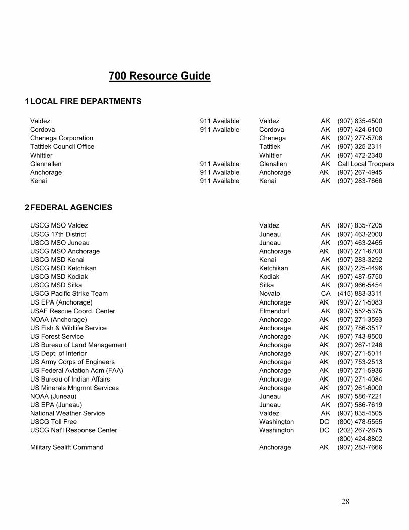
1LOCAL FIRE DEPARTMENTS
Valdez 911 Available Valdez AK (907) 835-4500Cordova 911 Available Cordova AK (907) 424-6100Chenega Corporation Chenega AK (907) 277-5706Tatitlek Council Office Tatitlek AK (907) 325-2311Whittier Whittier AK (907) 472-2340Glennallen 911 Available Glenallen AK Call Local TroopersAnchorage 911 Available Anchorage AK (907) 267-4945Kenai 911 Available Kenai AK (907) 283-7666
2FEDERAL AGENCIES
USCG MSO Valdez Valdez AK (907) 835-7205USCG 17th District Juneau AK (907) 463-2000USCG MSO Juneau Juneau AK (907) 463-2465USCG MSO Anchorage Anchorage AK (907) 271-6700USCG MSD Kenai Kenai AK (907) 283-3292USCG MSD Ketchikan Ketchikan AK (907) 225-4496USCG MSD Kodiak Kodiak AK (907) 487-5750USCG MSD Sitka Sitka AK (907) 966-5454USCG Pacific Strike Team Novato CA (415) 883-3311US EPA (Anchorage) Anchorage AK (907) 271-5083USAF Rescue Coord. Center Elmendorf AK (907) 552-5375NOAA (Anchorage) Anchorage AK (907) 271-3593US Fish & Wildlife Service Anchorage AK (907) 786-3517US Forest Service Anchorage AK (907) 743-9500US Bureau of Land Management Anchorage AK (907) 267-1246US Dept. of Interior Anchorage AK (907) 271-5011US Army Corps of Engineers Anchorage AK (907) 753-2513US Federal Aviation Adm (FAA) Anchorage AK (907) 271-5936US Bureau of Indian Affairs Anchorage AK (907) 271-4084US Minerals Mngmnt Services Anchorage AK (907) 261-6000NOAA (Juneau) Juneau AK (907) 586-7221US EPA (Juneau) Juneau AK (907) 586-7619National Weather Service Valdez AK (907) 835-4505USCG Toll Free Washington DC (800) 478-5555USCG Nat'l Response Center Washington DC (202) 267-2675
(800) 424-8802Military Sealift Command Anchorage AK (907) 283-7666
29
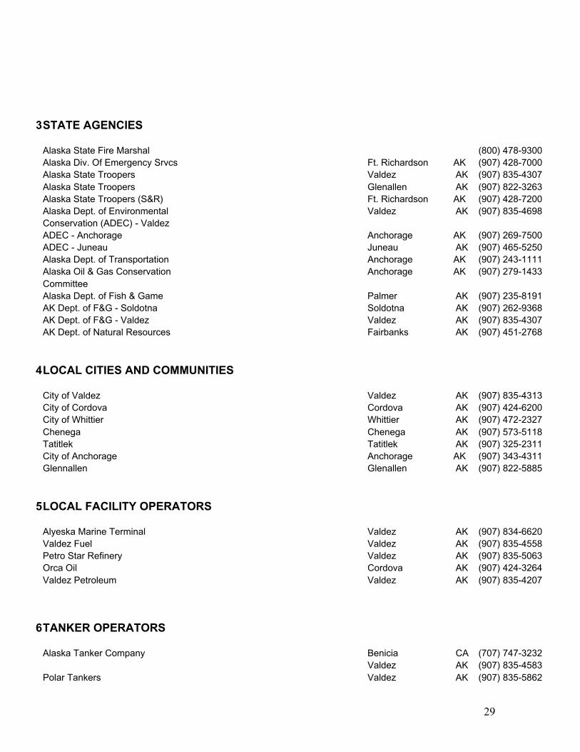
3STATE AGENCIES
Alaska State Fire Marshal (800) 478-9300Alaska Div. Of Emergency Srvcs Ft. Richardson AK (907) 428-7000Alaska State Troopers Valdez AK (907) 835-4307Alaska State Troopers Glenallen AK (907) 822-3263Alaska State Troopers (S&R) Ft. Richardson AK (907) 428-7200Alaska Dept. of Environmental Valdez AK (907) 835-4698Conservation (ADEC) - ValdezADEC - Anchorage Anchorage AK (907) 269-7500ADEC - Juneau Juneau AK (907) 465-5250Alaska Dept. of Transportation Anchorage AK (907) 243-1111Alaska Oil & Gas Conservation Anchorage AK (907) 279-1433CommitteeAlaska Dept. of Fish & Game Palmer AK (907) 235-8191AK Dept. of F&G - Soldotna Soldotna AK (907) 262-9368AK Dept. of F&G - Valdez Valdez AK (907) 835-4307AK Dept. of Natural Resources Fairbanks AK (907) 451-2768
4LOCAL CITIES AND COMMUNITIES
City of Valdez Valdez AK (907) 835-4313City of Cordova Cordova AK (907) 424-6200City of Whittier Whittier AK (907) 472-2327Chenega Chenega AK (907) 573-5118Tatitlek Tatitlek AK (907) 325-2311City of Anchorage Anchorage AK (907) 343-4311Glennallen Glenallen AK (907) 822-5885
5LOCAL FACILITY OPERATORS
Alyeska Marine Terminal Valdez AK (907) 834-6620Valdez Fuel Valdez AK (907) 835-4558Petro Star Refinery Valdez AK (907) 835-5063Orca Oil Cordova AK (907) 424-3264Valdez Petroleum Valdez AK (907) 835-4207
6TANKER OPERATORS
Alaska Tanker Company Benicia CA (707) 747-3232Valdez AK (907) 835-4583
Polar Tankers Valdez AK (907) 835-5862
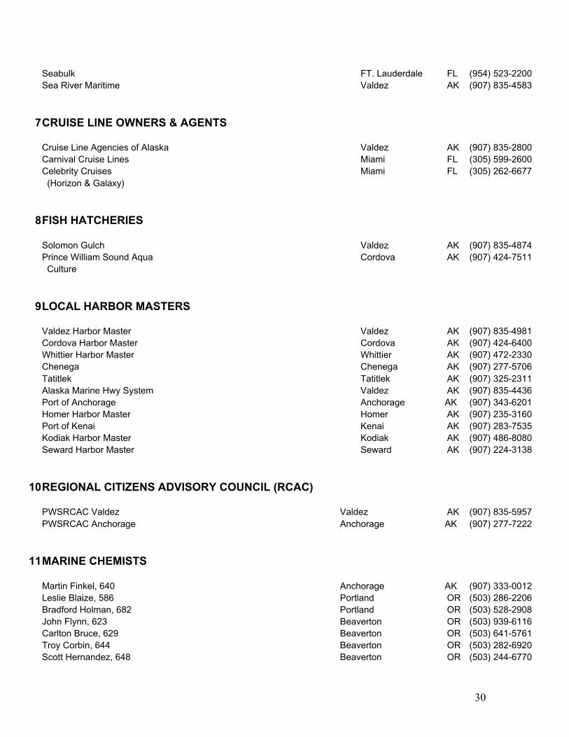
30
Seabulk FT. Lauderdale FL (954) 523-2200Sea River Maritime Valdez AK (907) 835-4583
7CRUISE LINE OWNERS & AGENTS
Cruise Line Agencies of Alaska Valdez AK (907) 835-2800Carnival Cruise Lines Miami FL (305) 599-2600Celebrity Cruises Miami FL (305) 262-6677 (Horizon & Galaxy)
8FISH HATCHERIES
Solomon Gulch Valdez AK (907) 835-4874Prince William Sound Aqua Cordova AK (907) 424-7511 Culture
9LOCAL HARBOR MASTERS
Valdez Harbor Master Valdez AK (907) 835-4981Cordova Harbor Master Cordova AK (907) 424-6400Whittier Harbor Master Whittier AK (907) 472-2330Chenega Chenega AK (907) 277-5706Tatitlek Tatitlek AK (907) 325-2311Alaska Marine Hwy System Valdez AK (907) 835-4436Port of Anchorage Anchorage AK (907) 343-6201Homer Harbor Master Homer AK (907) 235-3160Port of Kenai Kenai AK (907) 283-7535Kodiak Harbor Master Kodiak AK (907) 486-8080Seward Harbor Master Seward AK (907) 224-3138
10REGIONAL CITIZENS ADVISORY COUNCIL (RCAC)
PWSRCAC Valdez Valdez AK (907) 835-5957PWSRCAC Anchorage Anchorage AK (907) 277-7222
11MARINE CHEMISTS
Martin Finkel, 640 Anchorage AK (907) 333-0012Leslie Blaize, 586 Portland OR (503) 286-2206Bradford Holman, 682 Portland OR (503) 528-2908John Flynn, 623 Beaverton OR (503) 939-6116Carlton Bruce, 629 Beaverton OR (503) 641-5761Troy Corbin, 644 Beaverton OR (503) 282-6920Scott Hernandez, 648 Beaverton OR (503) 244-6770
31
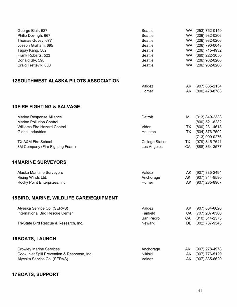
George Blair, 637 Seattle WA (253) 752-0149Philip Dovingh, 667 Seattle WA (206) 932-0206Thomas Govey, 677 Seattle WA (206) 932-0206Joseph Graham, 695 Seattle WA (206) 790-0048Tagay Kang, 562 Seattle WA (206) 715-4932Frank Roberts, 523 Seattle WA (360) 222-3050Donald Sly, 598 Seattle WA (206) 932-0206Craig Trettevik, 688 Seattle WA (206) 932-0206
12SOUTHWEST ALASKA PILOTS ASSOCIATIONValdez AK (907) 835-2134Homer AK (800) 478-8783
13FIRE FIGHTING & SALVAGE
Marine Response Alliance Detroit MI (313) 849-2333Marine Pollution Control (800) 521-8232Williams Fire Hazard Control Vidor TX (800) 231-4613Global Industries Houston TX (504) 876-7592
(713) 999-0276TX A&M Fire School College Station TX (979) 845-76413M Company (Fire Fighting Foam) Los Angeles CA (888) 364-3577
14MARINE SURVEYORS
Alaska Maritime Surveyors Valdez AK (907) 835-2494Rising Winds Ltd. Anchorage AK (907) 344-8580Rocky Point Enterprizes, Inc. Homer AK (907) 235-8967
15BIRD, MARINE, WILDLIFE CARE/EQUIPMENT
Alyeska Service Co. (SERVS) Valdez AK (907) 834-6620International Bird Rescue Center Fairfield CA (707) 207-0380
San Pedro CA (310) 514-2573Tri-State Bird Rescue & Research, Inc. Newark DE (302) 737-9543
16BOATS, LAUNCH
Crowley Marine Services Anchorage AK (907) 278-4978Cook Inlet Spill Prevention & Response, Inc. Nikiski AK (907) 776-5129Alyeska Service Co. (SERVS) Valdez AK (907) 835-6620
17BOATS, SUPPORT
32
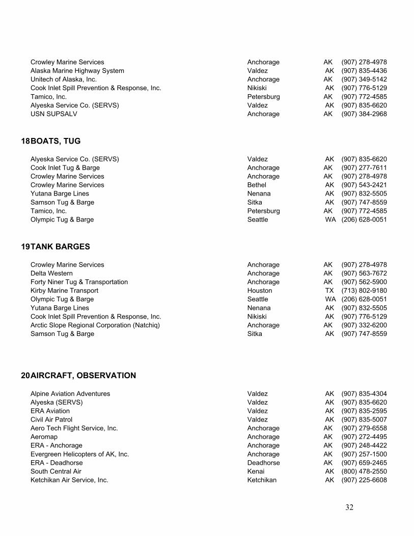
Crowley Marine Services Anchorage AK (907) 278-4978Alaska Marine Highway System Valdez AK (907) 835-4436Unitech of Alaska, Inc. Anchorage AK (907) 349-5142Cook Inlet Spill Prevention & Response, Inc. Nikiski AK (907) 776-5129Tamico, Inc. Petersburg AK (907) 772-4585Alyeska Service Co. (SERVS) Valdez AK (907) 835-6620USN SUPSALV Anchorage AK (907) 384-2968
18BOATS, TUG
Alyeska Service Co. (SERVS) Valdez AK (907) 835-6620Cook Inlet Tug & Barge Anchorage AK (907) 277-7611Crowley Marine Services Anchorage AK (907) 278-4978Crowley Marine Services Bethel AK (907) 543-2421Yutana Barge Lines Nenana AK (907) 832-5505Samson Tug & Barge Sitka AK (907) 747-8559Tamico, Inc. Petersburg AK (907) 772-4585Olympic Tug & Barge Seattle WA (206) 628-0051
19TANK BARGES
Crowley Marine Services Anchorage AK (907) 278-4978Delta Western Anchorage AK (907) 563-7672Forty Niner Tug & Transportation Anchorage AK (907) 562-5900Kirby Marine Transport Houston TX (713) 802-9180Olympic Tug & Barge Seattle WA (206) 628-0051Yutana Barge Lines Nenana AK (907) 832-5505Cook Inlet Spill Prevention & Response, Inc. Nikiski AK (907) 776-5129Arctic Slope Regional Corporation (Natchiq) Anchorage AK (907) 332-6200Samson Tug & Barge Sitka AK (907) 747-8559
20AIRCRAFT, OBSERVATION
Alpine Aviation Adventures Valdez AK (907) 835-4304Alyeska (SERVS) Valdez AK (907) 835-6620ERA Aviation Valdez AK (907) 835-2595Civil Air Patrol Valdez AK (907) 835-5007Aero Tech Flight Service, Inc. Anchorage AK (907) 279-6558Aeromap Anchorage AK (907) 272-4495ERA - Anchorage Anchorage AK (907) 248-4422Evergreen Helicopters of AK, Inc. Anchorage AK (907) 257-1500ERA - Deadhorse Deadhorse AK (907) 659-2465South Central Air Kenai AK (800) 478-2550Ketchikan Air Service, Inc. Ketchikan AK (907) 225-6608
33
Evergreen Helicopters - Nome Nome AK (907) 443-5334
20AIRCRAFT, OBSERVATION
Alaska Airlines Anchorage AK (907) 243-3322ERA - Anchorage Anchorage AK (907) 248-4422Northern Air Cargo Anchorage AK (907) 243-3331Lynden Air Transport (2 C-130's via SERVS) Anchorage AK (907) 456-7882Alaska Airlines Deadhorse AK (907) 659-2465ERA - Deadhorse Deadhorse AK (907) 659-2465Alaska Airlines Fairbainks AK (907) 456-4848South Central Air Kenai AK (800) 478-2550Ketchikan Air Service, Inc. Ketchikan AK (907) 225-6608ERA Aviation Valdez AK (907) 835-2595
21AIRCRAFT, FREIGHT
Alaska Airlines Anchorage AK (907) 243-3322ERA - Anchorage Anchorage AK (907) 248-4422Northern Air Cargo Anchorage AK (907) 243-3331Lynden Air Transport (2 C-130's via SERVS) Anchorage AK (907) 456-7882Alaska Airlines Deadhorse AK (907) 659-2465South Central Air Kenai AK (800) 478-2550Ketchikan Air Service, Inc. Ketchikan AK (907) 225-6608Alaska Airlines Kotzebue AK (907) 442-3477ERA Aviation Valdez AK (907) 835-2595
22COMMAND VANS/EQUIPMENT TRAILERS
Alaska Pollution Control Anchorage AK (907) 344-5036USCG MSO Anchorage Anchorage AK (907) 271-6700Northern Communications Company Juneau AK (907) 789-0008Cook Inlet Spill Prevention & Response, Inc. Nikiski AK (907) 776-5129Alyeska (SERVS) Valdez AK (907) 835-6620USCG Pacific Strike Team Novato CA (415) 883-3311USN SUPSALV Anchorage AK (907) 384-2968
23EMERGENCY COMMUNICATIONS EQUIPMENT
Alaska DEC Anchorage AK (907) 269-7500(907) 428-7000
Alaska DNRAlaska DOIAlaska Pollution Control Anchorage AK (907) 344-5036Northern Communications Company Juneau AK (907) 789-008Cook Inlet Spill Prevention & Response, Inc. Nikiski AK (907) 776-5129

34
USN SUPSALV Anchorage AK (907) 384-2968
24COMPRESSORS
Construction Machinery, Inc. Anchorage AK (907) 563-3822Don Abel Building Supply Juneau AK (907) 789-2155Ron's Rent-It Center Kenai AK (907) 283-4232
25GENERATORS
Alaska Pollution Control Anchorage AK (907) 344-5036Construction Machinery, Inc. Anchorage AK (907) 563-3822Unitech of Alaska Anchorage (907) 349-5142Don Abel Building Supply Juneau AK (907) 789-2155Ron's Rent-It Center Kenai AK (907) 283-4232
26TRANSFER/LIGHTERING EQUIPMENT
USN SUPSALV Anchorage AK (907) 384-2968Crowley Maritime Seattle WA (206) 443-8100Foss Maritime Seattle WA (206) 281-3800Global Diving & Salvage Seattle WA (206) 623-0621Fred Devine Diving & Salvage Portland OR (503) 283-5285J.H. Leitz & Associates Portland OR (503) 249-5062Clean Bay, Inc. Concord CA (925) 685-2800USCG Pacific Strike Team Novato CA (415) 883-3311Muldoon Marine Services Terminal Island CA (562) 432-5670Marine Pollution Control Detroit MI (810) 742-2599McAllister Towing Jacksonville FL (904) 751-6228Smit American Salvage Houston TX (281) 372-3500
27HOSES
Alyeska (SERVS) Valdez AK (907) 835-6620Alaska Pollution Control Anchorage AK (907) 344-5036Construction Machinery, Inc. Anchorage AK (907) 563-3822Unitech of Alaska Anchorage AK (907) 349-5142Alaska Chadux Corp. Anchorage AK (907) 278-3365
28FUEL SERVICE
Valdez Fuel Valdez AK (907) 835-4558Valdez Petroleum Terminal Valdez AK (907) 835-4207North Pacific Fuel Valdez AK (907) 835-8850Delta Western Fuels Anchorage AK (907) 276-2688

35
Taku Oil Sales Juneau AK (907) 586-1276
29EARTH MOVING EQUIPMENT
Haltness Equipment Valdez AK (907) 835-5418AK DOT Valdez AK (907) 834-1099Harris Sand & Gravel Valdez AK (907) 835-4756Wel-Aska Valdez AK (907) 835-2424USCG MSO Valdez Valdez AK (907) 835-7205Alaska Pollution Control Anchorage AK (907) 344-5036Construction Machinery, Inc. Anchorage AK (907) 563-3822Copper Valley Construction Glenallen AK (907) 822-3252Don Abel Building Supply Juneau AK (907) 789-2155Ron's Rent-It Center Kenai AK (907) 283-4232AK DOT Skagway AK (907) 983-3194
30HEAVY EQUIPMENT HANDLING
Alaska Pollution Control Anchorage AK (907) 344-5036Arctic Slope Regional Corporation (Natchiq) Anchorage AK (907) 332-6200Peeke Oilfield Haulers & Service Co. Anchorage AK (907) 263-7000Copper Valley Construction Glenallen AK (907) 822-3252Ron's Rent-It Center Kenai AK (907) 283-4232Haltness Equipment Valdez AK (907) 835-5418Harris Sand & Gravel Valdez AK (907) 835-4756
31RADIO REPAIR/SUPPLY
Anchorage Commercial Electronics Anchorage AK (907) 276-8244TSE Communications Anchorage AK (907) 561-6501Northern Communications Company Juneau AK (907) 789-0008
32UTILITIES, TELEPHONE
Copper Valley Telephone Valdez AK (907) 835-8000GCI Valdez AK (907) 835-4930Alascom, Inc. Anchorage AK (907) 264-7000GCI Anchorage AK (800) 770-7886
33ELECTRICAL CONTRACTORS
Northern Communications Company Juneau AK (907) 789-0008Island Electric Ketchikan AK (907) 225-5800McDermott Electric Valdez AK (907) 835-4361
36
Coastline Electric Valdez AK (907) 835-5750
34HYDRAULIC CONTRACTORS
Alaska Hydraulics, Inc. Anchorage AK (907) 562-2217Harbor Hydraulics Cordova AK (907) 424-3472
35LABOR
Alaska Pollution Control Anchorage AK (907) 344-5036VECO, Inc. Anchorage AK (907) 267-2635TCC Valdez AK (907) 835-2563
36MARINE SUPPLIES
Longs Marine Supply Valdez AK (907) 835-3920Murray Pacific Supply Corporation of AK Ketchikan AK (907) 225-3135
37SPILL CLEAN-UP CONTRACTOR/COOP
Alaska Pollution Control Anchorage AK (907) 344-5036VECO, Inc. Anchorage AK (907) 267-2635Cook Inlet Spill Prevention & Response, Inc. Nikiski AK (907) 776-5129SEAPRO Ketchikan AK (907) 225-7002Clean Seas Carpinteria CA (805) 684-3838Clean Coastal Waters (CCW) Long Beach CA (562) 432-1415Alaska Chadux Corp. Anchorage AK (907) 278-3365
38DISPERSANTS
Cook Inlet Spill Prevention & Response, Inc. Nikiski AK (907) 776-5129Ashland Chemical, Drew Ameroid Marine Div. Boonton NJ (973) 263-7600Exxon Chemical Houston TX (713) 460-6800Alyeska (SERVS) Valdez AK (907) 835-6620
39FOOD/CATERING SERVICES
Pipeline Club Valdez AK (907) 835-2750Totem Inn Valdez AK (907) 835-4443Mike's Palace Valdez AK (907) 835-2365
40PORTABLE TOILETS
37
Garness Industrial, Inc. Anchorage AK (907) 562-2933Alascans Anchorage AK (907) 562-1554Rent-A-Can Anchorage AK (907) 258-2267Alaska Portable Toilet Company Anchorage AK (907) 696-7500Ron's Rent-It Center Kenai AK (907) 283-4232
41DISPOSAL SERVICES
Alaska Waste Transfer Anchorage AK (907) 344-9490Commercial Refuse Anchorage AK (907) 562-3700Waste Management Anchorage AK (907) 563-3717
42Language Translators
Prince William Sound Comm. College Valdez AK (907) 834-1600
38
Appendix 1; Authority
The Ports and Waterways Safety Act of 1972 (PWSA) (33 USC 1221 et seq.)mandates an increased supervision of port operations is necessary to preventdamages to structures in, on, or adjacent to the navigable waters of the UnitedStates, and to reduce the possibility of vessel or cargo loss, damage to life,property, and the marine environment. This statute , along with the traditionalfunctions and powers of the Coast Guard to render aid and save property (14 USC88(b)), form the basis for Coast Guard firefighting activities.
42 USC 1856-1856(d) allows an agency charge with providing fire protection forany property of the United States to enter into reciprocal agreements with stateand local firefighting organizations to provide for mutual aid. This statute furtherprovides that emergency assistance may be rendered in the absence of a reciprocalagreement, when it is determined by the head of an agency to be in the bestinterest of the United States.
The Commandant (G-M), and the Commander, Seventeenth Coast Guard District,require the Captain of the Port Prince William Sound to maintain a vessel andwaterfront fire contingency plan. The purpose of the plan is to minimize theeffects of damage to life and property in Prince William Sound and waterfrontareas resulting from a major marine fire and/or explosion.

39
Appendix 2; Jurisdiction Zones
40
Appendix 3-a; Firefighting sites; Anchorages
Refer to the United States Coast Pilot, Vol. 9 for more detailed information.
Port Valdez: (See fig. 3-1)
A1. West Side of Sawmill Spit: Offers mixed sand and gravel beaches adjoiningsheltered rocky shoreline. Depths range from 660 feet at its deepest point andthen rise rapidly to a 100 ft. plateau followed by a gradual rise to a mean lowwater of 10 ft. around the spit. This site also offers shelter from southerly andeasterly winds.
A2. Anderson Bay: Offers a sheltered rocky shoreline and has a rocky gravelbottom with average mean low water of 80-100 feet. This site offers protectionfrom southerly, westerly, and easterly winds.
A3. Mineral Creek: Is bordered to the north by coarse grain sand beaches andsurrounding exposed rocky shoreline. Average depths at mean low water is 80feet. This site may offer shelter from northerly winds.
A4. Gold Creek: Is bordered to the north by coarse grain sand beaches andsurrounding exposed rocky shoreline. Average depths at mean low water is 80feet. This site may offer shelter from northerly winds.
A5. SERVS buoys:Port Buoy #1: White, unlighted buoy at Lat 61-06-52, Long 146-17-32, ratedmax capacity 50,000 lbs. Depth at mean low water is 419 feet. This site does notoffer any shelter from the wind.Port Buoy #2: White, unlighted buoy at Lat 61-06-41, Long 146-16-42, Ratedmax capacity is 142,000 lbs. Depth at mean low water is 370 feet.
Valdez Arm: (See fig. 3-1)
A6. Jack Bay, North (Vlaskoff Creek Delta): Is a sheltered cove bordered byexposed rocky shores to the South and mixed sand and gravel beaches to thenorth. Water depth at mean low water ranges from 30-40 feet.
A7. Heather Bay: Is a sheltered bay with mixed sand and gravel beaches, and asheltered rocky shoreline with a gravel bottom. The average depth at mean lowwater ranges from 25-90 feet. The bay offers protection from winds out of theeast and west.
A8. Tatitlek Narrows: Are bordered by mixed sand and gravel beaches andadjoining exposed rocky shorelines with a gravel bottom. Average depths atmean low water ranges from 6-30 feet. Due to its proximity to the village ofTatitlek, this site is beneficial if passengers and/or crew need to be evacuated.
41
A9. South of Bligh Island: Is bordered by exposed wave cut platforms andgravel beaches with a gravel bottom. Average depth at mean low water is 30-100feet. The site will offer shelter from northerly winds.
A10. Sac. Bay (60-50-44/146-40-13): Is a sheltered bay with mixed sand andgravel beaches, and a sheltered rocky shoreline with a gravel bottom. Theaverage depth at mean low water ranges from 25-90 feet. The bay offersprotection from winds out of the east and south.
Central Prince William Sound: (See fig. 3-2)
A11. Snug Harbor: Is surrounded by mixed sand and gravel beaches withsheltered rocky shores to the north, south, and east. The bottom is mud andgravel, prevailing depths range from 20-60 feet at mean low water. The siteprovides protection from northerly, easterly, and southerly winds.
A12. MacCleod Harbor Is a sheltered harbor with coarse grain sand beaches tothe north and south, and sheltered tidal flats to the west. The bottom is gravel andmud with depths at 40-60 feet at mean low water. The site is sheltered fromwinds out of the north, south, and west.
A13. McPherson Passage: Is a sheltered bay surrounded by exposed rockyshores and coarse brained beaches with some exposed tidal flats. Average depthat mean low water is 30-100 feet. The site offers protection from winds out of theEast, West, and South. This site contains a white, lighted mooring buoy at lat.60-40-21.9, Long 147-21-01.3 with max load of 125,000 lbs. in 180 feet of waterat mean low water.
A14. Between Smith and Little Smith Island: The area between Smith andLittle Smith Islands is bordered by gravel beaches and exposed rocky shorelinewith a mud bottom. The average depth at mean low water is 30-100 feet. Itoffers protection from northerly winds.
A15. Sheep Bay: Is bordered by mixed sand and gravel beaches along withexposed rocky shores. The bottom is gravel and mud with depths at mean lowwater ranging from 60-100 feet.
A16. Knowles Head: Is bordered to the North by exposed, wave cut platformsand rocky shores and to the east by exposed tidal flats. The bottom is mud andgravel with average depths at mean low water ranging from 60-120 feet. This sitemay offer protection from northerly winds.
A17. Shot Gun Cove: Is bordered on the east and west by mixed sand and gravelbeaches and sheltered rocky shores. The bottom is gravel. Average depth atmean low water is 18-20 feet. The site will offer shelter from easterly, southerly,and westerly winds. Crowley Marine has mooring buoys in this location.
42
A18. Outside Bay: Is a sheltered bay surrounded by exposed rocky shores andcoarse grained beaches with some exposed tidal flats with gravel and mud bottom.Average depth at mean low water is 30-100 feet. The site offers protection fromwinds out of the east, west, and north. SERVS maintains a white, lighted mooringbuoy at lat. 60-38-37, long. 146-27-43 with max load of 125,000 lbs. which is in186 feet of water at mean low water.
Hinchinbrook: (See fig. 3-2)
A19. Zaikof Bay: Is a sheltered bay surrounded by coarse grain sand beachesand exposed tidal flats with a muddy bottom. Average depth at mean low water is12-20 feet. This site offers shelter from northerly and southerly winds.
A20. Port Etches: Is a sheltered bay bordered by mixed sand and gravelbeaches. The average depth at mean low water is 12-20 feet. This site offersprotection from northerly and southerly winds. SERVS maintains a whiteunlighted mooring buoy at lat. 60-20-39, long.146-33-20 with max load of125,000 lbs. It is situated in 83 feet of water at mean low water.
The primary site recommendations for the Unified Command to consider,denoted with a star on figures 3-1 and 3-2, in each area are:
Port Valdez: Site A1. West side of Saw Mill Spit Site A4. Gold CreekValdez Arm: Site A6. Jack BayCentral Prince William Sound: Site A18. Outside BayHinchinbrook: Site A19. Zaikof Bay
43
Appendix 3-b: Firefighting sites; Grounding sites
Refer to the United States Coast Pilot, Vol. 9 for more detailed information.
Port Valdez: (See fig. 3-3)
G1. Lowe River mud flats: Are bordered by exposed tidal flats and marshes.The bottom is mud and gravel with depths, including the approaches, rangingfrom 0-100 feet at mean low water. This site does not offer wind shelter.
G2. Gold Creek (Bow first): Is bordered to the north by coarse grain sandbeaches and surrounding exposed rocky shoreline. Average depths at mean lowwater is 80 feet. This site may offer shelter from northerly winds.
G3. Saw Mill Spit: Offers mixed sand and gravel beaches adjoining shelteredrocky shoreline. Depths range from 660 feet at its deepest and then rise rapidly toa 100 ft. plateau followed by a gradual rise to a mean low water of 10 feet aroundthe spit. This site offers shelter from southerly and easterly winds.
G4. Weaver Dock: Is located in the Valdez Old Town site and is bordered byexposed tidal flats and marshes. The bottom is mud and gravel with depths,including the approaches, ranging from 0-100 feet at mean low water.
Valdez Arm: (See fig. 3-3)
G5. North side of Jack Bay: Is a sheltered cove bordered by exposed rockyshores to the south and mixed sand and gravel beaches to the north. Water depthat mean low water ranges from 30-40 feet.
G6. Sac Bay: Is a sheltered bay with mixed sand and gravel beaches, and asheltered rocky shoreline with a gravel bottom. The average depth at mean lowwater ranges from 25-90 feet. The bay offers protection from winds out of theeast and south.
Central Prince William Sound: (See fig. 3-4)
G7. Red Head north of Knowles Head: Is bordered to the north by exposedwave cut platforms and rocky shores and to the east by exposed tidal flats. Thebottom is mud and gravel with average depths at mean low water ranging from60-120 feet. This site may offer protection from northerly winds.
G8. Outside Bay: Is a sheltered bay surrounded by exposed rocky shores andcoarse grained beaches with some exposed tidal flats with gravel and mud bottom.Average depth at mean low water is 30-100 feet. The site offers protection fromwinds out of the east, west and north.

44
Hinchinbrook: (See fig. 3-4)
G9. Port Etches and G10. Constantine Harbor: Sheltered bays bordered bymixed sand and gravel beaches. The average depth at mean low water is 12-20feet. These sites offer protection from northerly and southerly winds.
45
Appendix 3-c; Firefighting sites; Piers
Refer to the United States Coast Pilot, Vol. 9 for more detailed information.
Port Valdez: (See fig. 3-5)
P1. Container Dock: The dock restrictions are 1200 feet of berthing space, witha depth of 50 ft at mean low water, and a max deck height of 14 feet. Firefightingequipment available includes a fixed fire main and portable fire extinguishers.
P2. VMT: Berth restrictions are as follows:
Berth #1: 16-120K, mean low water is 150 feet and the max deck height is 32feet.Berth #3: 16-120K, mean low water is 90 feet and max deck height is 38 feet.Berth #4: 16-120K, mean low water is 90 feet and max deck height is 38 feet.Berth #5: 16-120K, mean low water is 85 feet and max deck height is 38 feet.
Each dock is equipped with fire monitors and portable fire extinguishers.
P3. SERVS Dock: The dock restrictions are 560 feet of dock face, with a depthof 40 ft a mean low water, and a max deck height of 20 feet. The dock isequipped with a six inch portable/firemain. It also has portable fire extinguishers.
Prince William Sound: (See figures 3-5, 3-6 and 3-7)
P4. Tatitlek Ferry Dock: The dock restrictions are 513 feet of dock frontage,with a depth of 30 feet at mean low water, and a max deck height of 22 feet. Inaddition, this dock has two RoRo ramps. This dock does not contain any firesystems.
P5. Chenega Ferry Dock: The dock restrictions are 300 feet of dock frontagespace, with a depth of 50 feet at mean low water, and a max deck height of 21feet.
P6. Growler Island: The dock shaped like a “T” has restrictions of 100 feet ofberthing space, with a depth of 18 ft at mean low water and an additional 60 feetof berthing space with a depth of 20 feet at mean low water. Firefightingequipment available at this dock include portable dry chemical extinguishers anda gasoline powered pump for dock side firefighting.
P7. Cordova City Dock: L shaped pier; 408 foot outer face with about 25 feetalongside; inner face, 325 feet long, 16 feet alongside; max deck height 20.5 feet.
46
Appendix 4; Incident Commander Designation Decision Matrix
Type – 1 Organization: Involves a response to a marine fire emergency within thejurisdictional boundaries of a city. Initially, the response is limited to resourcesoriginating from the local city emergency response organization. This response couldinvolve mutual aid assistance from other available resources based upon the situation andthe request of the Incident Commander.
Type 2 – Organization: Involves a response to a marine fire emergency located at theValdez Marine Terminal, or aboard a vessel moored at the VMT which is within the cityjurisdictional boundaries of the City of Valdez. This response may involve mutual aidassistance from other available resources.
Type 3 – Organization: Involves a response to a marine fire emergency located outsidethe local city jurisdictional boundaries, yet is within the Captain of the Port PrinceWilliam Sound area of responsibility. This response may involve mutual aid andcommercial aid response based upon the situation and the request of the IncidentCommander.
Type 4 – Organization: Involves a response to a marine fire emergency located withinor outside the local city jurisdictional boundaries and is located within the area ofresponsibility of the Captain of the Port Prince William Sound. This response involvesthe resources from the affected facility or vessel and usually will not require mutual aidassistance.
47
Appendix 5; State of Alaska (DEC) Communications CoverageFootprint
1. General: ADEC currently operates an assortment of communications equipmentincluding a variety of hand held and base station radios and three portable satelliteterminals. Additionally, there are sixteen wide area mountaintop repeater sites in PrinceWilliam Sound, the Kenai Peninsula, the Anchorage area, Fairbanks, and Kodiak whichare available to enhance area communications.
2. Emergency Response Communications: The communications goal for emergencyresponse within the geographic boundaries of the State, regardless of size, location, ornature of the emergency is to:
a. Provide minimum initial off-site and on-site communications capability that isreliable, secure, and adequate to protect the public health, welfare, andenvironment. This minimum capability includes:
- Off-site communications: The ability to contact a home office from a remotesite using a portable two-radio, satellite phone system, existing landline, cellularphone, or other comparable and adequate means.
- On-site communications: The ability to communicate within the geographicarea affected by the release of at least two hand held, line-of-sight, two-wayradios or comparable and adequate equipment.
b. Provide for the safety of responding staff and ensure their ability to effectivelyand expeditiously execute the State’s responsibilities.
c. Rapidly provide additional off-site and on-site communications needed to keeppace with the escalation of an incident. This includes:
-Additional off-site telecommunication capability as needed to allow operationsto continue unimpeded using whatever array of equipment is appropriate for theincident,
- Additional on-site capability to allow effective communications across thegeography of the affected area.
3. Off-site communications: Off-site communications are those communications frompersonnel working in the field or at temporary field office sites to home offices or otherdispatch points such as State Troopers for emergency after hour’s calls. Off-sitecommunications play a critical role in initial emergency response activities, as the initialresponder will be relying entirely on the off-site system to gather and disseminateinformation, to initiate additional emergency response activities, and to manage theresponse mobilization while on-site communications systems are acquired and installed.
48
Potential off-site communications systems include public utility phone lines, two-wayradio links, cellular radio telephone links, and portable satellite telephone links. The bestoff-site communication link is based on the use of a dedicated two-way radio systembecause it allows maximum mobility for personnel, and can effectively function as thepreliminary on-site system while the response is mobilizing.
If a spill occurs outside the coverage area of existing radio systems, some other form ofcommunication must be used (i.e., cellular telephone, portable satellite telephone, or alocal landline telephone).
Current DEC off-site communication capability:
The current DEC off-site communication system consists of three portable, briefcase-sized remote area satellite terminals, and wide area VHF mountaintop repeaters, throughwhich a variety hand held and mobile radios communicate, and which are linked by aState-owned microwave system to dispatch centers. These systems are described below.
a. Remote Area Satellite Terminal: Three portable, briefcase-sized satellite terminals(INMARSAT-M) provides satellite linkage for telephone, telefax, and computer modemcapabilities. This system provides the only method of conducting off-sitecommunications from any location in the state (assuming line-of-sight access is availableto the satellite).
b. Wide Area VHF Repeaters: During the Exxon Valdez oil spill response, Exxonfunded efforts by the State to construct seven VHF fixed repeater sites covering the spillarea. At other sites, existing repeaters operated by State Parks and the Department ofFish and Game are jointly shared by DEC. Repeaters located near population centers(Pillar Mountain near Kodiak for example) are in commercial sites shared by many users.
Repeaters located in unpopulated remote areas (e.g., Prince William Sound) consist ofState-owned winterized shelters, each with a 20-foot tower, installed on concretefoundations set into mountaintop bedrock. Each shelter houses a VHF repeater batteryplant that is recharged during the fall, spring, and summer seasons by an array of solarpanels. The battery plant then operates the site through the winter months when there isvery little sunlight to recharge the batteries. The repeater sites are located at:
Prince William Sound S. Kenai Peninsula Kodiak
Jack Peak Gore Peak Shuyak IslandHeney Ridge Mount Bede Pillar MountainNaked Island Rugged Island Kitoi BayLa Touche Island Pipeline HillsEllamar Ski Hill
49
Fairbanks Cook Inlet
Ester Dome Hope Mt. Susitna
These sites require periodic maintenance visits to repair winter storm damage, conductFederal Communications Commission (FCC) required measurements on transmitters, andto fill the battery plants with water.
c. Hand Held Radios: DEC operates 33 Motorola Sabre II hand held radios which areprogrammable and capable of operating on any of 48 channels. One Motorola Sabre IIIhand held radio is also available (programmable with 108 channels). When DECpersonnel respond to a reported spill in the area covered by the existing wide arearepeater system, they can talk directly back to their own office. If the spill occurs in anarea where another State agency has a repeater that is monitored by a dispatch center, andif that frequency is programmed into the responders’ radios, they can relay message backto their office through the dispatch center.
4. On-site Communications: On-site communications are those communicationsbetween people working in the field, or between the field and temporary field office sitesset up to manage the response. Contractors and other State or Federal agencies may alsouse the DEC on-site system. On-site communications are used primarily to coordinateand manage ongoing operations, as will as to provide a conduit for health and safetymessages for all workers. Depending on the size of the spill response, more than one on-site communications system may be required.
On-site communications involve numerous personnel operating from unpredictable andconstantly changing locations both on land and on the water. Communications systemsbased on the use of the public telephone network (phones, cellular or satellite phonelinks) have a valid on-site support role for only a few personnel. Phone lines do notallow for free movement of personnel throughout the spill area. Satellite phones are tooexpensive for general distribution to many people. Cellular phones support a limitednumber of simultaneous conversations, are available only in the most populatedgeographic areas, and have a limited operating range when compared to mountaintoprepeaters. On-site communications can best be provided by a dedicated two-way radiosystem, where individual users are equipped with either hand held radios or base stations,and communicate with each other through a wide area repeater.
Three on-site communications functions must be supplied during operations, regardlessof the size of the operation, or geographic extent of the operation. The followingfunctions must be available during the mobilization phase as people begin working in thefield.
- A command and control channel to allow the Operations Section of the IncidentCommand Post to give direction and receive status reports from supervisory personnelworking in the field.
50
- A logistics channel to allow the Logistics Section of the Incident Command System(ICS) to coordinate material supply and distribution.
- A safety channel on which emergency calls for rescue or medical assistance can berelayed.
Current DEC On-site Communications Capability:
All the repeaters, hand held radios, and portable base stations (previously discussed underoff-site communications) can also be used for on-site communications systems. Thefollowing equipment can only be used for on-site communications systems, eitherbecause it lacks communications links back to a central dispatch point, or because it doesnot have sufficient channel selection capability to be useful with the existing network ofoff-site repeaters.
a. Portable Repeaters: DEC operates six Motorola suitcase repeaters (4 VHF and 2UHF systems). Compatibility must be addressed prior to deployment to ensure theproper repeaters and hand held radios are mobilized. These repeaters are deployed attemporary locations to improve communications between hand held radios operating inthe area. Direct communications between hand held radios are limited to line-of-sightpaths over distances of two to four miles. By installing a repeater on a tall structure ormountaintop, any two hand held radio users who can simultaneously see the repeater canthen communicate with each other.
The DEC repeaters normally operate from 120 VAC. For short periods (several hours),they can be operated at a reduced power level from a built in battery pack, DECmaintains 6 field 12 volt Gel-cell battery packs with integral chargers which can power arepeater for about one week on a single charge (depending on usage). The repeaters areweather resistant, but are not designed to operate unattended for long periods of timeexposed to heavy rain, high wind, or low temperatures. Unless there are existingmountaintop shelters in an area with existing AC or DC power that can be tapped, theserepeaters generally cannot be used where they can be most effective, on high terrainoverlooking the area. Instead, they must be used from vehicles, or from the top floors ofexisting buildings. This limits the effective range of any communication system builtaround their use.
b. Hand Held Radios: DEC operates five additional models of hand held radios inaddition to those discussed in the off-site communication section. These handheld radioswill most likely be used as scene of action (fly-away) support. Once a portable or otherrepeater is set up, these radios are equipped with sufficient channels to operate in a givenarea. They include:
- Eleven Motorola Sabre I Radios (VHF programmable, 12 channels)
- Nineteen Motorola P-100 Radios
51
(VHF, 2 channels)
- Seven Motorola MX-360 Radios (VHF, 6 channels)
- Seven Motorola HT-50 Radios (UHF programmable, 6 channels)
- Twenty-nine Motorola MT-500 (UHF, 8 channels)
As noted, several of these radios can be field programmed to operate on user selectablefrequencies if the proper programming equipment, test equipment, and an experiencedtechnician are available. These radios are best used with the portable repeaterspreviously discussed. When an on-site radio system is required for a spill, one or morerepeaters area selected, and the necessary number of compatible hand held radios are thenprogrammed to operate with the selected repeater, as well as on any other channels thatmight be in use at a fire. the repeater and hand held radios are then shipped to theresponse and placed in operation.
c. Portable VHG Base Stations: DEC operates five Motorola Syntor X9000 basestations each fitted into a small shipping case. These are small vehicular radios that havebeen equipped with base station antennas, an AC power supply, and DC Gel-cell batterieswith chargers. The base stations can be set up inside buildings at temporary commandposts for on-site communications. In this setting, they are more convenient than handheld radios, have a greater range, and have better signal quality. These base stations willoperate for several days on the internal DC Gel-cell batteries, depending on usage.
d. Base and Hand Held Ground –Air Radios: DEC has nine handheld and one baseVHF ground-air radios to spread out over the State. Ground-to-air radios are used tocommunicate with local aircraft for the purposes of dispatching, flight following, weatheradvisories, and clearing landing pads at staging areas or other loading areas.
e. Hand Held VHF Marine Radios: DEC operates three hand held and two base VHFmarine radios. Marine radios are used to coordinate activities between vessels and formarine logistics support. The Saber radios, MX360 radios, and the flyaway kits arepreprogrammed with some of the marine channels, depending on the primary uselocation.
5. Auxiliary Power Supply: DEC maintains four lightweight Honda 1000 wattgenerators (one for each response team area) for the purpose of recharging or poweringfield communication.
6. Other State Assets: DMVA/DES has mobile emergency communications systemsthat could be used in an emergency. In the initial stages of a response, these systemsmight be available the Unified Command, but only until commercial services are

52
established/reestablished and are adequate to handle the communications requirements ofthe fire. Although the DMVA/DES systems are primarily intended for use by Stateagencies, all members of the Unified Command would have access to thecommunications systems when deployed.