preliminary environmental information report appendix 9.6
TRANSCRIPT

Our northern runway: making best use of Gatwick
Preliminary Environmental Information Report Appendix 9.6.2: Ecology Survey Report September 2021

Preliminary Environmental Information Report: September 2021 Appendix 9.6.2: Ecology Survey Report Page i
Our northern runway: making best use of Gatwick
Table of Contents 1 Introduction 1
2 Methodology 1
3 Results 3
4 Evaluation 24
5 Conclusions 29
6 References 29

Preliminary Environmental Information Report: September 2021 Appendix 9.6.2: Ecology Survey Report Page 1
Our northern runway: making best use of Gatwick
1 Introduction 1.1.1 The document forms Appendix 9.6.2 of the Preliminary
Environmental Information Report (PEIR) prepared on behalf of Gatwick Airport Limited (GAL). The PEIR presents the preliminary findings of the Environmental Impact Assessment (EIA) process for the proposal to make best use of Gatwick Airport's existing runways (referred to within this report a 'the Project'). The Project proposes alterations to the existing northern runway which, together with the lifting of the current restrictions on its use, would enable dual runway operations. The Project includes the development of a range of infrastructure and facilities which, with the alterations to the northern runway, would enable the airport passenger and aircraft operations to increase. Further details regarding the components of the Project can be found in Chapter 5: Project Description.
1.1.2 This report provides details of ecological surveys undertaken on land within and around Gatwick Airport, Horley, West Sussex to inform the design of the Project, as detailed within Chapter 5: Project Description.
1.1.3 The areas surveyed included the Project site boundary and adjacent areas of potential ecological interest, where access allowed. Where an area is outwith the Project site boundary, this is signposted in the text and shown on the relevant figures.
1.1.4 The ecological surveys for protected or notable habitats or species included:
Phase 1 habitat surveys; National Vegetation Classification (NVC) surveys; hedgerow survey; breeding bird surveys; wintering bird surveys; reptile surveys; great crested newt Triturus cristatus surveys; dormouse Muscardinus avellanarius surveys; otter Lutra lutra surveys; water vole Arvicola amphibious surveys; badger meles meles survey; bat roost assessment; bat emergence/re-entry surveys; bat activity transect surveys; bat crossing point surveys; bat static/automated surveys; terrestrial invertebrate survey;
aquatic invertebrate survey; and fish survey.
1.1.5 Methodologies and results for the latter three are presented in Annexes 5 and 6 of this report.
1.1.6 Additional surveys have also been undertaken for bats, including thermal imaging of bat activity on the runway (to follow for ES), bat trapping and bat tracking (Appendix 9.6.3).
1.1.7 The methodologies and results of these surveys are described and presented within this report.
2 Methodology
2.1 Phase 1 Habitat Surveys
2.1.1 The methodology and habitat descriptions used have been based on the standard Joint Nature Conservation Committee (JNCC) Phase 1 Habitat Survey methodology ‘Handbook for Phase 1 Habitat Survey’ (JNCC, 2010).
2.1.2 The Phase 1 Habitat Survey was carried out on 18–22 March and 10 & 11 July 2019. The Phase 1 survey covered the area within the Project site boundary and adjacent habitats considered to be of potential ecological interest (Riverside Garden Park, for example).
2.1.3 Habitats identified during the survey were described using the categories set out in the Phase 1 handbook (JNCC, 2010).
2.2 NVC Surveys
2.2.1 A NVC survey was carried out following the methodology and guidelines detailed in the JNCC’s NVC User’s Handbook (Rodwell et al., 2006).
2.2.2 Fieldwork was carried out in April, July and August 2019 by Alex Powell Grad CIEEM (Chartered Institute of Ecology and Environmental Management), a qualified ecologist and botanist. The survey was undertaken during the optimal time for both grassland and woodland botanical surveys.
2.2.3 The survey methodology is detailed in full within Annex 1.
2.3 Hedgerow Surveys
2.3.1 A survey of all hedgerows within the Project site boundary was carried out in accordance with the methodology and guidelines
set out in the Hedgerow Survey Handbook (Department for Environment, Food and Rural Affairs (Defra), 2007) to identify Important hedgerows, as defined in the Hedgerow Regulations 1997.
2.3.2 The assessment was carried out on the 5–8 August 2019 by Sam Barker and Alex Powell.
2.3.3 Any protected hedges identified were noted.
2.3.4 The survey methodology is detailed in full within Annex 1.
2.4 Breeding Bird Surveys
2.4.1 The breeding bird survey undertaken was based on a standard territory mapping methodology as outlined in Gilbert et al. (1998) and Bibby et al. (2000).
2.4.2 This method is based on the principle that the majority of species are territorial during the breeding season. This takes into account birds occupying discrete territories and displaying various behaviours (eg conspicuous song, visual display and periodic disputes with neighbouring individuals), allowing their location and abundance to be estimated.
2.4.3 Surveys for breeding birds were undertaken in spring/summer 2019 with a total of seven survey visits taking place.
2.4.4 The survey area, as shown in Figure 2.4.1, was walked at a slow pace in order to locate and identify all individual birds. Visits were undertaken early in the morning, finishing before midday.
2.4.5 The survey methodology is detailed in full within Annex 1.
2.5 Wintering Bird Surveys
2.5.1 The wintering bird surveys were based on a transect survey methodology as detailed in Bibby et al. (2000) and Gilbert et al. (1998).
2.5.2 The transect route was selected to include all field boundaries and visit all areas of the Project to within 200 metres, where possible. Visits were undertaken early in the morning.
2.5.3 All bird species were recorded and mapped across the whole Project site area, where accessible.
2.5.4 The survey methodology is detailed in full within Annex 1.
Preliminary Environmental Information Report: September 2021 Appendix 9.6.2: Ecology Survey Report Page 2
Our northern runway: making best use of Gatwick
2.6 Reptile Surveys
2.6.1 The reptile survey followed the recommended methodology described in the Herpetofauna Worker’s Manual (JNCC, 2003) and Froglife’s Surveying for Reptiles (Froglife, 2016).
2.6.2 It was undertaken by experienced ecologists and was conducted within areas of the Project identified as containing the most favourable habitat for reptiles.
2.6.3 Reptiles are best surveyed from April following hibernation until June and then again in September and October.
2.6.4 The survey methodology is detailed in full within Annex 1.
2.7 Great Crested Newts Surveys
2.7.1 Each pond within the Project site boundary was assessed for its potential to support great crested newts, where accessible.
2.7.2 Surveys were undertaken following the advice given in Froglife's ‘Great Crested Newt Conservation Handbook’ (2001), English Nature’s ‘Great Crested Newt Mitigation Guidelines’ (English Nature, 2001) and the ‘Herpetofauna Workers Manual’ (Gent and Gibson, 2003).
2.7.3 The survey methodology is detailed in full within Annex 1.
2.8 Dormouse Surveys
2.8.1 A dormouse nest tube survey was undertaken based on methodology and best practice guidelines set out in the dormouse conservation handbook, second edition (Bright, Morris and Mitchell-Jones, 2006).
2.8.2 Survey visits have been undertaken regularly in suitable weather conditions between May and October.
2.8.3 The survey methodology is detailed in full within Annex 1.
2.9 Aquatic Mammal Surveys
Otter Surveys
2.9.1 The otter survey was undertaken on the 13 and 14 May 2019 by suitably experienced ecologists. The survey was loosely based on the methodology described in the Design Manual for Roads and Bridges (DMRB), Volume 10 Section 4, Part 4 (Highways Agency et al., 1999). Whilst it is acknowledged that the DMRB guidance has since been withdrawn and replaced by Volume 10,
Section 4, Part 1 (LA 118) (Highways England et al., 2019), no specific methodology in relation to otters has been revised. As such, the methodology contained within the former Volume 10, Section 4, Part 4 (Highways Agency et al., 1999) remains relevant. The methodology was developed for linear schemes which are likely to affect otter habitats or populations but was adopted for this site.
2.9.2 The suitable areas along the River Mole and Gatwick Stream were walked and examined in detail for evidence of the presence of otters in the form of characteristic field signs.
2.9.3 The survey methodology is detailed in full within Annex 1.
Water Vole Surveys
2.9.4 The water vole surveys were carried out on the 13 and 14 May 2019 by suitably experienced ecologists.
2.9.5 The survey was carried out in accordance with guidelines of best practice set out in the water vole Conservation Handbook – Third Edition (Strachan et al., 2011).
2.9.6 The suitable areas along the River Mole were walked and examined in detail for evidence of the presence of water vole in the form of characteristic field signs.
2.9.7 Wherever possible, the banks were inspected on both sides, from the water’s edge to the top of the bank.
2.9.8 The survey methodology is detailed in full within Annex 1.
2.10 Badger Surveys
2.10.1 The site was systematically searched for evidence of badgers during walkover surveys. This involved looking for setts, latrines, hairs, footprints, runs, and any other signs of badger activity. Any evidence recorded was mapped.
2.10.2 Further details regarding badger survey methodology and results can be found in confidential Appendix 9.6.4.
2.11 Preliminary Bat Roost Assessment
Buildings
2.11.1 An assessment of the suitability of the buildings for bat roosting potential, within the landside and airside areas of the Project site boundary, was undertaken at the same time as the Phase 1 Habitat Survey.
2.11.2 The survey included a thorough, ground level inspection of the exterior of all accessible buildings and the features of the building listed below were noted:
type; age; wall construction, in particular the type of material used; form of the roof, in particular the presence of gable ends,
hipped roofs etc and the nature and condition of the roof; and
the general condition of the building.
2.11.3 The methodology is detailed in full within Annex 1.
Trees
2.11.4 Details on the methodology for bat roost assessment of trees is to follow.
2.12 Bat Emergence/Re-entry Surveys
2.12.1 In order to comply with best practice guidelines (Collins, 2016) emergence surveys were carried out on any buildings considered to have bat roosting potential. Surveys were undertaken between May–October 2019. The aim of these surveys was to determine the use of the buildings (if any) by roosting bats, the species assemblage within the Project site boundary and the egress locations of any bats emerging from the buildings.
2.12.2 The methodology is detailed in full within Annex 1.
2.13 Bat Activity Transect Surveys
2.13.1 A total of five transect routes were devised to cover a broad range of the habitat types present on site but focusing on those likely to be of greatest value to bats, including woodland, woodland edges, river corridors and open grassland. Descriptions of each transect can be found in Annex 1.
2.13.2 Each transect was surveyed twice per month between April-October 2019.
2.13.3 The methodology is detailed in full within Annex 1.
2.13.4 In addition, further transects were completed in August to October 2020 within areas not surveyed in 2020. These surveys will be completed in 2021 and reported in the ES.

Preliminary Environmental Information Report: September 2021 Appendix 9.6.2: Ecology Survey Report Page 3
Our northern runway: making best use of Gatwick
2.14 Bat Static/Automated Surveys
2.14.1 A total of 11 Elekon Batlogger A units were deployed across the Project site between April-October 2019 for a minimum of five nights. The units were positioned at various locations, in order to sample a broad range of the habitat types present on site but focusing on those likely to be of greatest value to bats.
2.14.2 The methodology is detailed in full within Annex 1.
2.15 Bat Crossing Point Surveys
2.15.1 Crossing Point surveys were undertaken at two locations, River Mole corridor and Riverside Park, in August 2020, September 2020, May 2021 and June 2021.
2.15.2 The full methodology is provided in Annex 1.
2.16 Invertebrate Scoping Survey
2.16.1 The invertebrate scoping survey was carried out by Marcel Ashby and Tristan Bantock, for Colin Plant Associates.
2.16.2 The survey assessed the potential for the Project site to support Species of Principal Importance in England, as defined within Section 41 of the Natural Environment and Rural Communities (NERC) Act 2006, although species included in other conservation categories were also considered. Additional aquatic invertebrate and terrestrial invertebrate surveys are proposed, and this report will be updated with the findings.
2.16.3 The survey report, including methodology in full, is supplied within Annex 4.
2.17 Terrestrial Invertebrate Surveys
2.17.1 Walk-over surveys for terrestrial invertebrates were completed by Ecus Ltd. on six occasions during 2020 – 27 May, 19 June, 22 June, 30 June, 10 September and 14 September 2020. These focused on areas along the River Mole and the Gatwick Stream. On each occasion, the areas were walked by an experienced entomologist who sampled along each transect using sweep netting, a beating tray and stout trowel.
2.17.2 The survey concentrated on the following major groups (orders): Coleoptera (beetles), Diptera (flies), Hemiptera (bugs, froghoppers, etc), Hymenoptera (bees, wasps and ants) and Lepidoptera (butterflies and moths). Some examples of other groups were noted if found.
2.17.3 Samples were collected for later laboratory identification.
2.17.4 The survey report, including methodology in full, is supplied within Annex 5.
2.18 Aquatic Macroinvertebrate Surveys
2.18.1 Following an initial scoping walk-over, 100 m sections of both the River Mole and Gatwick Stream were identified for detailed survey as representative of the site. Three survey visits were undertaken during 2020 by Ecus Ltd.; 4 June, 29 July and 29 September. Samples were collected at each of the sites using the Whalley Hawkes Paisley Trigg (WHPT) method comprising a standard three-minute kick sample using a long-handled pond net with 1 mm mesh size, which was supplemented by a one-minute hand search.
2.18.2 The survey report, including methodology in full, is supplied within Annex 6.
2.19 Fish Survey
2.19.1 Fish surveys were undertaken by Ecus Ltd. using the catch depletion method in order to assess species composition, age structure and to estimate population size. Surveys were undertaken by an accredited electric fishing team comprising three members of staff. Surveys and analysis conformed to the relevant guidance outlined in BS EN 14011:2003 Water Quality: Sampling of Fish with Electricity (British Standards Institute, 2003).
2.19.2 Surveys were undertaken in spring (04 June) and autumn (29 September) 2020 along the same 100 m stretches used for the aquatic invertebrate surveys.
2.19.3 The survey report, including methodology in full, is supplied within Annex 6.
3 Results
3.1 Phase 1 Habitat Surveys
3.1.1 The Gatwick airport site is located on the Sussex/Surrey border, west of the M23 and east of Charlwood. The majority of the site is a working airport comprising large areas of hardstanding associated with the runways and taxiways, buildings including terminals, hangars and other buildings associated with airport
activities and well-maintained amenity grassland surrounding the runway, all of these areas were surrounded by security fencing.
3.1.2 Around the main airport the site comprised broadleaved and mixed woodland, neutral semi-improved, poor semi-improved, marshy and improved grassland, scattered and dense scrub, tall ruderal vegetation, running water, areas of standing water, dry ditches, species poor and species rich hedgerows, individual trees, dry ditches, fences, residential and commercial buildings and areas of hardstanding.
3.1.3 The site was divided into eight areas (A1-A8) that were loosely based on land use types and land ownership boundaries.
3.1.4 A description of the habitats identified, within each of the eight areas, during the survey is given below. The locations of each habitat within each survey area are shown on the Phase 1 habitat plan, Figures 3.1.1 and 3.1.2. The locations of ponds are shown on Figure 3.1.3.
3.1.5 A list of target notes is provided in Table 4 in Annex 2 and are referred to within the text. The locations of the target notes are shown of Figures 3.1.1 and 3.1.2.
A1 – Fields to the North and South of M23 for Construction Laydown Plus Link to J9
A1.2 Broadleaved Plantation Woodland
3.1.6 Along the embankments of Airport Way, highway associated planting of trees was present, from the B2036 in the east stretching to the railway boundary in the west. Trees in this area included semi-mature poplar Populus sp. around the northern edge of the roundabout, hawthorn Crataegus monogyna, pedunculate oak Quercus robur, ash Fraxinus excelsior and field maple Acer campestre.
3.1.7 Scattered through the trees, bramble Rubus fruticosus scrub was dense in patches.
3.1.8 In the far eastern end of the M23 spur, part of the junction had been planted with poplar and silver Birch Betula pendula, east of the scrub.
A2.1 Dense Scrub
3.1.9 Along the bottom of the southern M23 spur bank, dense bramble scrub over a wooden fence formed the boundary between highway land and the public footpath through the fields south of

Preliminary Environmental Information Report: September 2021 Appendix 9.6.2: Ecology Survey Report Page 4
Our northern runway: making best use of Gatwick
the road. Within the scrub there was occasional oak and ash saplings growing through the brambles.
3.1.10 Bramble scrub dominated the north western end of the spur road bank.
3.1.11 Directly south the scrub became less dense and the vegetation turned more ruderal with willowherb Chamerion angustifolium, taller swards of Yorkshire fog Holcus lanatus, thistle Cirsium sp. and broad-leaved dock Rumex obtusifolius.
A2.2 Scattered Scrub
3.1.12 Five areas of scattered scrub were present around the M23 and the spur road.
3.1.13 In the east, along the M23 scattered scrub was present in the piece of land between the motorway and the northbound slip road. Bramble scrub dominated here with occasional hawthorn and blackthorn Prunus spinosa.
3.1.14 On the western half of the junction where the spur meets the motorway, bramble and blackthorn scrub dominated with poor semi-improved grass in places.
3.1.15 In the south east of the M23 spur area, there was a small patch of bramble scrub (TN14) with yorkshire fog, perennial rye-grass Lolium perenne, cleavers Galium aparine, primrose Primula vulgaris, ivy Hedera helix and dock also present.
3.1.16 Along the field boundary next to the railway, north of the M23 spur, there was scattered scrub dominated by bramble, field rose and elder.
3.1.17 Along the northern boundary of Airport Way, bramble scrub was interspersed between young and semi-mature trees that was associated with highways planting.
A3.1 Scattered Broadleaved Trees
3.1.18 Within the roundabout that connects the M23 spur to Airport Way and north of the Long Stay South Car Park entrance, several Poplar trees had been planted as ornamental features.
3.1.19 Along the eastern edge of Car Park ‘B’ a planted treeline between the edge of the car park and the western edge of the public footpath within this area comprised ash, downy birch Betula pubescens, silver birch and immature sycamore Acer pseudoplatanus. Bramble and ivy were also present.
B2.2 Neutral Semi-improved Grassland
3.1.20 Directly south of the M23 spur road and east of the B2036, one field, with a public footpath going through, was dominated by cock’s foot Dactylus glomerata and Yorkshire fog. However, there were also a number of herbaceous species throughout the grass including white clover Trifolium repens, Cut-leaved cranesbill Geranium dissectum, stitchwort Stellaria sp., perennial rye-grass, shining cranesbill Geranium lucidum, vetch Vicia sp., buttercup Ranunculus sp., birds-foot trefoil Lotus corniculatus, cinquefoil Potentilla reptans, dock and pyramidal orchids Anacamptis pyramidalis. Bramble also ran through the grass.
B4 Improved Grassland
3.1.21 The improved grassland pasture fields north of the roundabout, east of the B2036 and the pasture fields south of the M23 spur were dominated by yorkshire fog and annual meadow-grass Poa annua grass with abundant dandelion Taraxacum officinale and occasional spear thistle Cirsium vulgare.
F1 Swamp
3.1.22 The area immediately surrounding Pond E11 was dominated by bulrushes creating a swamp habitat.
G1 Standing Water
3.1.23 An artificial attenuation pond (Pond E11) had been created at the eastern end of the spur road. The margins were dominated by bulrushes Typha sp. and reeds Phragmites sp.
J1.2 Amenity Grassland
3.1.24 Amenity grassland was present within some parts of the central reservation and associated with the roundabout linking the M23 spur and Airport Way.
J2.3.2 Species-poor Hedge with Trees
3.1.25 To the north of the M23 spur road, along the northern boundary of a public footpath, an old hedge with mature trees was present. The hedgerow was an oak and sycamore dominated treeline with a hawthorn hedge running underneath. Field rose Rosa arvensis was occasionally present.
3.1.26 A hedge with trees was present along the northern Project site boundary. This was located to the north of the roundabout linking the M23 spur to Airport Way and comprised oak, horse chestnut and copper beech.
J2.4 Fence
3.1.27 Around much of the area wooden fencing was present, mainly along the edge of public footpaths and road boundaries. Along the edge of the railway line and in staff Car Park B more secure metal fencing was used.
J2.6 Dry Ditch
3.1.28 At the time of survey seven field boundary ditches were dry. These ditches were mainly located in the land south of the M23 spur, three of these ran north to south within the improved grassland field. One dry ditch ran east to west along the south embankment of the spur road, one east to west under a treeline south of the neutral semi-improved grassland and one north to south along the east edge of the B2036 Balcombe Road.
3.1.29 One dry ditch was identified north of the spur road in a north to south direction along the western edge of the B2036 Balcombe Road.
3.1.30 No aquatic vegetation was present within the ditches. The two ditches along the B2036 had common nettle Urtica dioica and Hogweed Heracleum sphondylium growing out of them. The ditches under treelines were also choked with fallen leaf litter.
J4 Bare Ground
3.1.31 Part of the northern highway’s embankment had been cleared at the eastern end of the M23 spur. The ground here had been cleared to form a site compound for the M23 Smart Motorway upgrade works.
J5 Other (Hardstanding)
3.1.32 The M23, Airport Way, B2036 and staff Car Park B were all tarmacked surfaces with heavy use.
3.1.33 The main London to Brighton trainline ran north to south between the northern pasture field and staff Car Park B.
A2 – Eastern Car Parking and Associated Surface Water Features
A1.1.1 Semi-natural Broadleaved Woodland
3.1.34 To the south of the Long Stay South Car Park, there was a large area of semi-natural broadleaved woodland that formed the northern portion of Horleyland Wood and Lower Pickett’s Wood. These two areas have a similar range of species, with the canopy dominated by oak.

Preliminary Environmental Information Report: September 2021 Appendix 9.6.2: Ecology Survey Report Page 5
Our northern runway: making best use of Gatwick
3.1.35 West of Pentagon Field was a large triangular area of woodland, within Long Stay South Car Park. This area of woodland was predominantly on a raised earth bank with ditches around the northern and southern bases. An access track heading east to west split the woodland from a line of trees further north. Blackthorn, yew Taxus baccata and bramble scrub covered the eastern and southern banks.
3.1.36 Heading from this woodland south along the western edge of Pentagon Field, the woodland continued until it joined with Lower Pickett’s Wood.
A1.1.2 Plantation Broadleaved Woodland
3.1.37 Along the boundaries of the M23 spur strips, woodland had been planted on the bank of the carriageway. These areas spanned from the London to Brighton railway in the west to the B2036 in the East.
3.1.38 Forming the southern boundary and a sizable portion of the western boundary of Pentagon Field, oak and hazel Corylus avellana had been planted in rows. The western boundary planting being of older age than the southern boundary plantation.
3.1.39 Throughout Long Stay South car parks, woodland had been planted around remnants of old field boundaries with mature trees incorporated amongst the newer planting.
A3.1 Scattered Broadleaved Trees
3.1.40 Towards the eastern side of Pentagon Field, two isolated, mature oak trees were present.
3.1.41 Semi-mature and mature trees were planted around the roads, car parks and within the roundabout linking Long Stay South Car Park to the M23 Spur road. Trees were planted in small groups over non-native shrubs and amenity grassland.
3.1.42 Further young and mature trees were present throughout the Parking area east of the railway. Some of the tree lines were associated with old field boundaries with mature oak and beech. Some of the younger treelines were present over ornamental shrubs and amenity grassland.
B6 Poor Semi-improved Grassland
3.1.43 To the east of Long Stay South Car Park and west of the B2036, Pentagon Field was a large, open grazed field. The majority of the field was dominated cock’s foot and perennial rye-grass. Areas around the eastern boundary and in places through the
field were wetter and had rushes Juncus sp. and sedges Carex sp. colonising.
G1 Standing Water
3.1.44 Wet ditches surrounded the western, northern and eastern boundaries of Pentagon Field. These ditches were on the road and footpath side of the field boundary fences.
3.1.45 Pond G was located within the eastern car parking zone. Ditches that held water were also present around the majority of the car parks.
3.1.46 The majority of the water bodies were associated with flood management and were man made.
3.1.47 The northern most of these water bodies was a man-made holding lake with a barrier across it. The banks were vegetated with willow Salix sp., bulrush and common reed.
3.1.48 A description of the waterbodies can be found in Annex 1.
J1.2 Amenity Grassland
3.1.49 A large area of well kept, regularly mown grassland was identified within the roundabout. This connected the M23 spur to Airport Way.
3.1.50 Areas of shorter managed grass was a regular occurrence within the northern section of ring road south and a further area of grassland in the west of the site, between the railway and Pond F, was also identified as having regular management regime.
3.1.51 Pennyroyal Mentha pulegium was found growing within this area of grassland (TN1). Information on this species protected status can be found in Annex 1.
J1.4 Introduced Shrub
3.1.52 Within the parking areas and along some of ring road south, non-native shrubs and hedgerows had been planted in borders. All the shrubs were relatively low in height and well maintained. Due to the non-native planting species within these areas were not recorded.
J2.4 Fence
3.1.53 Around Long Stay South Car Park large metal security fences lined the boundary of GAL owned land and other land ownership boundaries, including highway land and the railway.
J2.8 Earth Banks
3.1.54 The majority of the woodland sections were on raised earth banks. The banks were approximately 1.5 metres high and ranged in width and length.
3.1.55 A larger earth bank (TN2) was identified within a section of woodland, in the east of Long Stay South Car Park. The bank here was approximately 3 metres high and 25 metres x 55 metres.
J3.6 Buildings
3.1.56 A range of building types were identified throughout the wider eastern carparking area. These buildings were associated with commercial practices, hotels, airport car parking and private office blocks. The majority of these were large multi-storey buildings.
J5 Other (Hardstanding)
3.1.57 The majority of the car parks were large open tarmacked areas with walkways and raised planting. The southern and western most car parks had steel multi-storey parking within the associated parking area perimeters.
3.1.58 A raised walkway ran along the western edge of Horleyland Wood connecting the wood to the car parks further north.
A3 – Land East of the Railway Line
A1.1.1 Semi-natural Broadleaved Woodland
3.1.59 Within the biodiversity area there were two distinct areas of semi-natural broadleaved woodland, which included areas of ancient and semi-natural woodland. These two areas are referred to as Horleyland Wood (TN3) and Upper Pickett’s Wood (TN4).
3.1.60 Both Horleyland Wood and Upper Pickett’s Wood were predominantly oak dominated with beech Fagus sylvatica, birch and ash Fraxinous excelsior also throughout. The understorey differs between the woodland however with Horleyland Wood have an understorey dominated with bracken Pteridium aquilinium. Upper Pickett’s Wood had a more diverse woodland understory with species such as wood vens Geum urbanum, enchanters nightshade Circea lutiana and ground ivy Glechomoa hederacea among others.
3.1.61 Located to the south of Upper Pickett’s two Notable species; solomon’s seal Polygonatum odoratum and narrow-lipped helleborine Epipactis leptochila was present (TN5), both of which

Preliminary Environmental Information Report: September 2021 Appendix 9.6.2: Ecology Survey Report Page 6
Our northern runway: making best use of Gatwick
were found within 20 metres of one another and are designated as Nationally Scarce. Bluebell Hyacynthoides non-scripta (a Schedule 8 species) were also found throughout the woodland.
3.1.62 South of the biodiversity car park an area of woodland surrounded a field on the western, eastern and southern boundaries. This area was dominated by oak and ash with occasional hawthorn, blackthorn, elder, beech and hazel present.
3.1.63 Little ground flora was present in this area of woodland, but occasional fern species were scattered through the understorey.
A1.1.2 Broadleaved Woodland Plantation
3.1.64 Multiple small areas of plantation woodland were recorded.
3.1.65 The area to the east of Gatwick Stream consisted of willow and alder Alnus glutinosa (TN6a).
3.1.66 The area to the south of the Crawley Sewage Treatment works consisted of coppiced hazel (TN6b).
3.1.67 The area located between these two areas consisted of beech (TN6c).
A2.1 Dense Scrub
3.1.68 Areas of scrub dominated by young stands of willow and alder with bramble, were situated throughout the attenuation fields. These stands had been planted between the retained earth banks and were fenced off by a wooden fence.
A3.1 Scattered Broadleaved Trees
3.1.69 Mature oak trees were scattered throughout the attenuation fields and sat upon earth mounds. There exact locations are shown on the phase one habitat plan.
B2.2 Neutral Semi-improved Grassland
3.1.70 The grassland to the south of the biodiversity area and around the perimeter of the attenuation fields were neutral semi improved grassland.
3.1.71 The grassland around the edge of the attenuation fields is herb rich and appears to originate from a seed mix. Here, wild carrot Daucus carota, black knapweed Centurea nigra, oxeye daisy Leucanthamum vulgaris and yellow rattle Rhianthus minor are the dominant herbs throughout with timothy grass Phleum pratense and false oat-grass Arrhenatherum elatior as the dominant grass species. Crested dogs-tail Cynosurus cristatus and sweet vernal-grass Anthoxanthum odouratum were also frequent throughout.
3.1.72 The northern most fields contained large patches of ruderal species with spear thistle and dock species being the dominant herbaceous species, false oat-grass was the dominant grass species in this area of the fields.
3.1.73 The field to the south of the car park differed in species composition with common bent Agrostic cappilaris being the dominant species with grass Vetchling Lathyrus nissola and birds-foot trefoil Lotus corniculatus the most dominant herbaceous species.
B5 Marsh/Marshy Grassland
3.1.74 The attenuation fields south of Crawley Sewage Treatment Works had a different species composition to that of the raised banks that ran around the perimeter of the area.
3.1.75 Species within the attenuation area was dominated by both hard rush Juncus inflexus and soft rush Juncus effuses with floating sweet-grass Glyceria fluitans and common water-plantain Alisma plantago-aquatica frequent within the wetter areas.
3.1.76 The drier areas within the attenuation fields had a varying species composition with graminoid species such as sweet vernal-grass, timothy grass, red fescue Festuca rubra and crested dog’s-tail abundant throughout.
3.1.77 Forb species such as knapweed, meadow buttercup Ranunculus acris and cuckoo flower Cardamine pratensis were also frequent throughout the attenuation fields.
3.1.78 Throughout Upper Pickett’s Wood were open areas of wet grassland. Young oak was scattered throughout with bramble growing around the edges of the openings. Both soft and hard rush were frequent throughout the grassland with species such as glaucous sedge Carex flacca, hairy sedge Carex hirta, marsh thistle Cirsium palustre and meadowsweet Filipendula ulmaria all indicative of marshy habitats. Other species found here were cock’s-foot, red fescue and common knapweed among others.
C3.1 Tall Ruderal
3.1.79 Multiple stands of ruderal species were identified across the fields in the biodiversity area.
3.1.80 A long stretch of tall ruderal vegetation ran along the eastern boundary of the rail line. The species here were predominantly a mix of spear thistle and broad-leaf dock.
3.1.81 Within the areas of semi-improved grassland south of the sewage works were multiple areas of ruderal dominant vegetation. These habitats were all similar in species composition with spear thistle, creeping thistle, ragwort Senecio vulgaris, burdock Arctium minor and various dock species present in varying levels of dominance.
G1 Standing Water
3.1.82 Multiple ponds are present throughout the biodiversity area.
3.1.83 Pond 8N8 was located north of the Old Lagoon and south of New Lagoon. See Annex 2 for the pond reference and description.
3.1.84 The Old Lagoon was located within the biodiversity woodland and formed part of the sewage works. See Annex 2 for the pond reference and description.
3.1.85 Ponds AA20 and AA21 were located within the area of mixed woodland to the south of Upper Pickett’s Wood. See Annex 2 for the pond reference and description.
3.1.86 Pond 1WH and NU1 were located to the south of the biodiversity area in a small patch of woodland located along the road to the Crawley Sewage Treatment Works. See Annex 2 for the pond reference and description.
3.1.87 Pond 30P was located within woodland south of Upper Pickett’s Wood. See Annex 2 for the pond reference and description.
3.1.88 The locations of the ponds are shown on Figure 3.1.3.
G2 Running Water
3.1.89 The Gatwick Stream ran between the attenuation fields and the neutral grassland to the east. The stream was around 5 meters across and was fast flowing. The banks were steep and covered in vegetation. Himalayan balsam Impatiens glandulifera, a Schedule 9 species, was found growing along the banks of the stream.
J1.2 Amenity Grassland
3.1.90 The grassland around the sewage works lagoon was heavily managed and cut short. The species here were predominantly grasses with species like perennial rye-grass being dominant.
J2.4 Fence
3.1.91 The raised banks throughout the attenuation field had a wooden fence around the outside.
Preliminary Environmental Information Report: September 2021 Appendix 9.6.2: Ecology Survey Report Page 7
Our northern runway: making best use of Gatwick
3.1.92 The areas of scrub in the attenuation fields had a wooden fence around the outside.
3.1.93 A wooded fence ran along the northern edge of the marshy grassland within the attenuation fields east of the rail line.
3.1.94 A metal security fence ran both sides of the Gatwick Stream between the Crawley Sewage Treatment Works and the attenuation fields east of the railway line. Security fencing also surrounded the Crawley Sewage Treatment Works and around the Old Lagoon and New Lagoon.
J2.8 Earth Banks
3.1.95 Throughout the attenuation fields were retained earth banks. Atop each bank stood a mature oak. The ground flora here differed to that of the surrounding habitat as woodland species such as dog’s mercury Murcuralis perenis and bracken were present. Other species included fox glove Digitalis purpurea, bramble and false oat-grass.
3.1.96 Numerous linear earth banks were also situated throughout the fields to the south of the Crawley Sewage Treatment Works.
J4 Bare Ground
3.1.97 An area of bare ground was identified in the biodiversity area. This was used as a car park by the biodiversity team.
3.1.98 A bare ground path also ran through Upper Picketts Wood, to the east of the Old Lagoon and continued through the woodland.
J5 Other (Hardstanding)
3.1.99 The access road to the Crawley Sewage Treatment works split the biodiversity area into two. The road was tarmacked with treelines down both sides.
A4 – Airside
A1.1.1 Semi-natural Broadleaved Woodland
3.1.100 Crawter’s Wood (TN13) was located along the southern boundary of the airside land parcel. The woodland had a high diversity of broadleaved species, the most dominant being sycamore, field maple, birch and ash among others. The ground flora was relatively species poor with a dense mat of ivy covering the ground.
A1.3.2 Mixed Plantation Woodland
3.1.101 To the north of the airside land parcel runs a raised earth bank. This has a ground cover of amenity grassland with mixed planted woodland growing along the bank. The tree species consist of mainly beech and oak with conifers growing throughout.
A2.1 Dense Continuous Scrub
3.1.102 An area of dense scrub was located around Pond FFJ, this was dominated by bramble and young shrubs such as hawthorn and willow.
A2.2 Scattered Scrub
3.1.103 The raised earth bank to the far east of the runway was covered in scattered scrub. Species such as young willow, gorse Ulex europea, and oak were scattered throughout with bramble and ruderal species such as sow-thistle Sonchus sp. and broad-leaved dock Rumex obtusifolius also present.
B6 Poor Semi-improved Grassland
3.1.104 An area of poor semi-improved grassland ran between Crawter’s Wood and the amenity grassland associated with the airfield. This section of grassland was much longer with a greater species diversity than that of the amenity grassland areas.
3.1.105 The species here consisted of yorkshire fog, false oat-grass, common bent, cock’s foot with flowering species such as white clover, red clover Trifolium pratense, thistle, knapweed, hogweed and bird’s-foot trefoil.
G1 Standing Water
3.1.106 Pond FFJ was located to the north of the runway near the fire training area. It was surrounded by dense bramble scrub and marginal vegetation such as pond sedge Carex riparia and bulrush.
G2 Running Water
3.1.107 Crawter’s Brook, a 3 metre wide stream, ran along the southern boundary of the main runway. The banks were regularly cleared of vegetation and the brook dredged. Some marginal vegetation was present in places with himalayan balsam and rushes growing along the bank.
J1.2 Amenity Grassland
3.1.108 The grassland surveyed around the runways was identified as being amenity grassland due to the high levels of management
that it undergoes. The grassland was regularly mown to around 10-14 cm with selective herbicide applied.
3.1.109 The grassland was made up of yorkshire fog, false oat-grass, common bent with flowing species such as clover, thistle, hogweed and bird’s-foot trefoil.
3.1.110 To the north of airside was a raised bank of well managed amenity grassland with planted trees.
J2.4 Fence
3.1.111 Around the airfield and building associated with the airfield, metal security gates topped with razor wire occurred.
J2.7 Earth Bank
3.1.112 Multiple earth banks were identified in the north west corner of the airfield.
3.1.113 The largest of the banks was dominated by scrub with gorse, bramble, hogweed and young oak as the dominant species.
3.1.114 Multiple smaller banks were also noted, these however were not scrubby in habit with the vegetation being consistent with the amenity grassland.
J3.6 Buildings
3.1.115 A large number of buildings were identified across the airside parcel, one of which was identified as having bat roost potential. All other building descriptions have been left out of the report.
3.1.116 Building D9H was a small single storey brick building with a flat roof that overhangs. A small open window was located on one of the walls.
J5 Other (Hardstanding)
3.1.117 All the runways, taxiways and roads airside were tarmacked and in good condition.
A5 – Non-Airside South and Land East of the Aviation Museum
A1.1.1 Semi-natural Broadleaved Woodland
3.1.118 The strip of woodland that ran between Gatwick Aviation Museum Field and the River Mole was dominated by oak, birch and sycamore with hawthorn and blackthorn understorey. The ground flora was sparse with ivy and bramble being common throughout.
Preliminary Environmental Information Report: September 2021 Appendix 9.6.2: Ecology Survey Report Page 8
Our northern runway: making best use of Gatwick
3.1.119 The woodland to the west of the Fire Training Ground was observed to be young woodland with the dominant species being a mixture of birch and sycamore. The understorey was dominated by dense patches of bramble. There was lots of deadwood present throughout the woodland.
3.1.120 Crawter’s Wood ran along the southern edge of the site. The species composition here was consistent with that of the woodland along the western side of the River Mole, with a mix of sycamore and oak among others.
A3.1 Scattered Broadleaved Trees
3.1.121 Along the northern perimeter of Car Park X, young willow and alder trees lined a wet ditch.
3.1.122 Lining the emergency access to Car Park X a mature treeline was present either side of the access track. The line was dominated by ash and oak.
3.1.123 Individual oak trees were scattered throughout Car Park X.
3.1.124 Within the land north of the Fire Training Ground there were a number of scattered mature oak trees along an old field boundary, north of the marshy grassland area.
A2.1 Dense/Continuous Scrub
3.1.125 A patch of dense scrub was located around Pond 29A, north east of the Fire Training Ground and west of the River Mole. These areas had long grasses mainly false oat-grass and cock’s foot with bramble and young hawthorn growing throughout.
A2.1 Scattered Scrub
3.1.126 There were multiple areas of scrub throughout the land east of the Aviation Museum all predominately dominated by bramble. The areas of scrub were situated along the margins of woodland and are shown on the Phase 1 Habitat plan (Figures 3.1.1 and 3.1.2a – 3.1.2l).
B6 Poor Semi-improved Grassland
3.1.127 The fenced off area to the west and north east of the Fire Training Ground Was a mix of habitat types, a large section of this was semi-improved grassland. The dominant species here were creeping thistle Circium arvense and false-oat grass. Hard rush were also frequent throughout the wetter areas.
B4 Improved Grassland
3.1.128 The fields across the land east of the Aviation Museum were consistent with that of improved grassland. The species composition consisted of mainly Yorkshire fog and perennial rye-grass with forbs such as daisy Bellis perennis frequent throughout.
B5 Marshy Grassland
3.1.129 An area of marshy grassland was found within the south of the land east of the Aviation Museum. This was seasonally wet with wet depressions throughout. The dominant species was false oat-grass with stands of rushes around the wetter areas. Ruderal species such as common nettle and thistle were also frequent throughout the grassland.
C3.1 Tall Ruderal
3.1.130 A large patch of tall ruderal vegetation dominated by spear thistle and broad-leaved dock was found within the fenced off section west of the Fire Training Ground.
G1 Standing Water
3.1.131 Pond 29A was located between the Gatwick Aviation Museum Field and the River Mole. The pond was man made with steep sides; minimal vegetation was growing within the pond with only a small amount of soft rush.
3.1.132 Pond AVF was located to the south of the Aviation Museum Field. Marginal vegetation surrounded the pond, the dominant species was bulrush.
3.1.133 A wet drainage ditch runs though the secure area to the west of the Fire Training Ground. The species here are typical of wet ground with soft rush and bulrush present.
3.1.134 Pond MHA was located in the south west of Car Park X. The pond was seasonal and held water during wetter times of the year. Woodland and scrub surrounded the pond.
J1.2 Amenity Grassland
3.1.135 Patches of heavily managed short amenity grassland was identified along the southern boundary as grass verges along roads and around car parks. The species were consistent throughout with perennial rye-grass, cock’s foot, buttercup, dandelion and dock throughout.
J2.1.1 Native Species-rich Hedge
3.1.136 One hedgerow within the land east of the Gatwick Aviation Museum Field was found to be species rich, it was located along the western boundary of the Project site. This contained hawthorn, blackthorn, dog rose Rosa canina, ash, dogwood Cornus sanguinius and oak. A hedgerow assessment was carried out and it was found not to be an important hedgerow.
J2.3.2 Species-poor Hedge with Trees
3.1.137 Within the land east of the Gatwick Aviation Museum Field, the majority of hedgerows were found to be species poor. They were predominantly made up of a mix of hawthorn and blackthorn. These hedgerows had mature oak and ash trees scattered throughout the hedgerow, some starting to take over and forming taller hedgerows. Especially along Man’s Brook and the hedgerows running south from here.
J2.4 Fence
3.1.138 Poorly kept wooden fences bordered the fields within land east of the Gatwick Aviation Museum Field. Hedges and trees had encroached and caused the fences to be in a state of disrepair.
3.1.139 Around the southern edge of Crawter’s Wood, metal security fencing was present.
J5 Other (Hardstanding)
3.1.140 Large areas of hardstanding were recorded throughout car parks and roads across the site.
A6 – The North West Zone, containing the River Mole Corridor and Brockley Wood Biodiversity Area
A1.1.1 Semi-natural Broadleaved Woodland
3.1.141 Brockley wood (TN7), located along the River Mole corridor, between Gatwick airside and the River Mole. The woodland was dominated with oak with birch also being present. The understorey was a mix of species typical of woodland habitats such as ivy, ground ivy and wood avens.
3.1.142 Along the northern bank of the Mole corridor runs a long continuous stretch of semi-natural broadleaved woodland. The species composition changes in dominance throughout with the more dominant species being sycamore, oak, ash, birch, willow. The understorey species consist mainly of hawthorn, dog rose, honeysuckle Lonicera periclymenum and bramble. The ground flora varies throughout the woodland with some areas of bare

Preliminary Environmental Information Report: September 2021 Appendix 9.6.2: Ecology Survey Report Page 9
Our northern runway: making best use of Gatwick
ground. The dominant species throughout the woodland were mainly ground ivy, ivy, common nettle, lords and ladies Arum maculatum and wood avens among others.
3.1.143 The woodland along the south of the River Mole was very similar in species composition to that of the woodland to the north. The main difference was the south bank was much more steeply sloping and the addition of black poplar Populus nigra.
A1.1.2 Broadleaved Plantation Woodland
3.1.144 The southern embankment of the River Mole flood plain was planted with native broadleaved tree species, after the River Mole realignment to its current course. The planting extends from Brockley Wood in the south to London Road in the north.
3.1.145 The trees have grown and filled in the space creating a dense woodland dominated by oak, silver birch, willow, poplar, hawthorn and blackthorn.
3.1.146 The understorey within this woodland comprised wild garlic Allium ursinum, hogweed, broad-leaved dock, bramble, lesser celandine Ficaria verna, daffodil Narcissus sp., cuckoo flower, perennial rye-grass, compact rush Juncus conglomeratus, blackthorn, willow, small-leaved nettle Urtica urens, bulrush, creeping cinquefoil Potentilla reptans, dove’s-foot crane’s-bill Geranium mole, cherry laurel Prunus laurocerasus, common vetch and Carex sp.
A2.1 Dense Continuous Scrub
3.1.147 An area of dense scrub was situated adjacent to Brockley Wood (TN8). The area contained stands of bramble with hawthorn present throughout. Areas of raised banks and ditches ran through this area with rushes growing in the wetter parts. False oat-grass was common throughout as well as thistle.
3.1.148 Areas of dense scrub were present in the field to the north of Longbridge Roundabout, comprising blackthorn, hawthorn and bramble, with occasional elder.
A2.2 Scattered Scrub
3.1.149 Scattered scrub was growing on the banks of a large earth bank, south of Brockley Wood. The species consisted of mainly bramble with young saplings such as willow, oak and hawthorn. false oat-grass, wild carrot and common knapweed were also frequent in the less scrubby areas.
3.1.150 Within the marshy area of Pond C24, scattered willow and alder scrub was growing.
3.1.151 Patchy areas of scattered bramble scrub were present along the eastern bank of the field to the north of Longbridge Roundabout.
A3.1 Scattered Broadleaved Trees
3.1.152 Scattered mature trees were present along the southern, eastern and northern boundaries of the field to the north of Longbridge Roundabout, with species comprising oak, ash, field maple and elder.
A3.3 Mixed Scattered Trees
3.1.153 Within Longbridge Roundabout a mix of semi-mature broadleaved and coniferous trees had been planted. Tree species included oak, silver birch and leylandii.
3.1.154 Around the north west corner of the roundabout, south east of Holiday Inn, coniferous trees lined the eastern side of the amenity grassland, west of the pavement. A single example of a leylandii, a sycamore and a cherry were within the line of conifers.
B2.2 Semi-improved Neutral Grassland
3.1.155 The semi-improved grassland along the mole runs along the south bank. The lower lying areas of grassland contained a higher number of water tolerant species associated with regular flooding.
3.1.156 The grassland had a diverse mix of species, the dominant grass species was tufted hair-grass Deschampsia cespitosa which dominated large swards. In areas where this was less dominant, other grasses such as false oat-grass, timothy grass and meadow foxtail Alopecurus pratensis were frequent. In these areas the most common forb species were wild carrot, ox-eye daisy, greater bird’s-foot trefoil Lotus pedunculatus and red bartsia Odontites vernus.
3.1.157 Lesser quaking grass Briza minor and ragged robin Lychnis flos-cuculi were both found within this area. They are both designated as Nationally Scarce and Near Threatened respectively (TN9).
B5 Marshy Grassland
3.1.158 There were multiple areas of marshy grassland present towards the south of the River Mole.
3.1.159 A large area of marshy grassland was located to the south of Brockley Wood (TN10a) (Figure 3.1.2j). The grassland here was seasonably wet and was relatively species poor, dominated with hard rush.
3.1.160 A smaller section of marshy grassland (TN10b) (Figure 3.1.2j) was located to south east of Brockley Wood. The species composition here differed from with the dominant species being common reed. Purple loose-strife Lythrum salicaria and thistle are also present throughout.
3.1.161 The southern margins of the River Mole were relatively diverse (TN10c) (Figure 3.1.2j). This area contained a range of species including purple loose-strife, common reed, marsh woundwort Staccys palustris and hard rush. Himalayan balsam a Schedule 9 species was also abundant in this area of the River Mole.
3.1.162 There was a small area of marshy grassland situated around Pond C24. The species here were dominated by common reed, bulrush was also present growing in the pond.
B6 Poor Semi-improved Grassland
3.1.163 A small section of poor semi-improved grassland was located around Pond M. The grass here was less diverse than the grassland along the River Mole and appears to be managed more heavily.
3.1.164 Longbridge Roundabout comprised managed grassland and mature trees. Species comprised cock’s-foot, ribwort plantain Plantago lanceolata, common speedwell Veronica persica, dandelion and dock.
3.1.165 To the north of Longbridge Roundabout, a semi-improved field was present. The field was divided into two separate areas; the western half was managed as a paddock for horses, dominated by annual meadow-grass, with occasional dandelion, yorkshire fog, bristly ox-tongue Helminthotheca echioides, field speedwell and red clover.
C3.1 Tall Ruderal
3.1.166 The eastern half of the paddock was less frequently managed and comprised a greater variety of ruderal and scrub species such as spear thistle, creeping thistle, oxeye daisy, broadleaved dock, ragwort, buttercup, ribwort plantain, shepherds purse Capsella bursa-pastoris, red dead nettle, hogweed, common nettle and cleavers. A large stand of himalayan balsam was present on the southern boundary of the field and adjacent to the River Mole, along the eastern boundary.
F2.2.1 Marginal Vegetation
3.1.167 Marginal vegetation ran along the edge of the River Mole. This was dominated with common reed and bulrush. Himalayan

Preliminary Environmental Information Report: September 2021 Appendix 9.6.2: Ecology Survey Report Page 10
Our northern runway: making best use of Gatwick
balsam and hemlock water-dropwort Oenathe crocata were also occasional along the Mole.
G1 Standing Water
3.1.168 Multiple ponds were present along the River Mole Corridor. See Annex 2 for the pond reference and description. The locations of the ponds are shown on Figure 3.1.3.
3.1.169 Pond A was situated south of Brockley Wood and east of the Fire Training Ground. Pond A was used as an attenuation pond to hold run-off from the airfield.
3.1.170 Pond M was located along the southern boundary of the River Mole. It was situated to the west of the north stay car park and used as a water reservoir.
3.1.171 Pond C24 was located along the northern edge of the River Mole. It was situated within semi-improved grassland.
3.1.172 Pond D was situated along the northern boundary of the River Mole near the Travelodge hotel. Both ponds were used as reservoirs.
3.1.173 Pond AAA4 was located along the northern edge of the River Mole. It was situated within the northern area of semi-natural broadleaved woodland.
G2 Running Water
3.1.174 The River Mole was fast flowing and up to 3 metres wide. It flowed north to south and, within the Mole corridor, had shallow banks with floodplains and marshy grassland areas to the east and woodland with public footpaths to the west.
J1.2 Amenity Grassland
3.1.175 Amenity grassland was identified in multiple areas, it was mainly situated around the reservoirs along the southern side of the River Mole. The grass in these areas was much more heavily managed.
J2.4 Fence
3.1.176 Around the southern edge of Brockley Wood, deer fencing had been erected.
3.1.177 Along the top of the southern section of the River Mole floodplain a wooden fence was present.
J2.8 Earth Bank
3.1.178 South of Brockley Wood and east of the River Mole a large 8 metre tall earth bank was located (TN11). The bank was steep sided with scattered scrub growing over semi-improved grassland.
3.1.179 An earth track led to the top of the bank, which was flat with pooling water in places.
J4 Bare Ground
3.1.180 Areas of bare ground were identified as earth tracks running along the southern section of the River Mole.
J5 Other (Hardstanding)
3.1.181 Areas of hardstanding are located along the River Mole. This included the Long Stay North car parking, parking off Charlwood Road, Perimeter Road North and the bridge spanning the River Mole.
A7 – Non-airside North
A1.1.1 Semi-natural Broadleaved Woodland
3.1.182 Dog Kennel Wood (TN12) was a small area of woodland in the north east of the non-airside north section. Canopy species within this area of woodland was dominated by oak, gorse chestnut Aesculus Hippocastanum and sweet chestnut Castanea sativa. downy birch, goat willow Salix caprea, cherry Prunus sp., ash and yew were also occasionally present within the canopy. The understorey comprised bramble, holly Ilex aquifolium, elder, rose, gorse and hazel with nettle, bluebell, dogs mercury, violet Viola sp., daffodil and arum comprised the ground flora.
A2.2 Scattered Scrub
3.1.183 Within the man-made ditches around the western most Long Stay North Car Parks scattered willow and silver birch shrubs dominated the banks. Willow herb was occasionally present.
3.1.184 Along the western most ditch a patch of bramble was identified.
A2.3 Dense Scrub
3.1.185 Bramble had choked the southern ditches between the hedgerows and treelines.
3.1.186 In the south east corner of Long Stay North, a triangle shaped area of dense bramble, elder and hawthorn scrub had grown up around a couple of lines of trees.
A3.1 Scattered Broadleaved Trees
3.1.187 Within the north of Long Stay North, there were three lines of mature trees including oak, lime and horse chestnut.
3.1.188 The southern most of these mature lines formed more of a shorter rectangle area and included beech and ash.
3.1.189 Along the northern side of the southern ditches, within Long Stay North, trees had been planted in rows. Most of the trees were ornamental or non-native and young to semi-mature in age.
3.1.190 Along the western edge of Long Stay North, six mature oak lined the fence.
B6 Poor Semi-improved Grassland
3.1.191 The grassland around the bottom of the Pond M and west of the security fence contained areas of taller less managed grassland with false oat-grass, cock’s foot and perennial rye-grass with occasional occurrences of birds-foot trefoil, ragwort, annual meadow-grass and dock.
3.1.192 The banks of the ditches in the west of Long Stay North were managed grassland with occasional bramble growing through.
F2.1 Marginal Vegetation
3.1.193 Within the bottom of Dog Kennel Pond a variety of marginal species dominated the lower banks and pond bed including willow, willowherb, pendulous sedge, water mint, field horsetail, bulrush, teasel, gypsywort Lycopus europaeus, soft rush, purple loosetrife Lythrum salicaria false fox-sedge Carex otrubae, redshank Persicaria maculosa, round-fruited rush Juncus compressus, common reed, marsh horsetail Equisetum palustre, common spike-rush Eleocharis palustris and wood club-rush Scirpus sylvaticus
G1 Standing Water
3.1.194 Pond M was present north east of Brockley Wood in the west of the non-airside north area. The banks of the pond were well kept grassland.
3.1.195 Dog Kennel Pond was a small manmade attenuation pond with steep banks showing high levels of maintenance. A diverse mix of aquatic and marginal vegetation was found within the pond.
3.1.196 Within the western most Long Stay North Car Park there was a man-made ditch. The ditch was present in the northern third of this area of car park and along the western and southern edge of
Preliminary Environmental Information Report: September 2021 Appendix 9.6.2: Ecology Survey Report Page 11
Our northern runway: making best use of Gatwick
the car park. The banks were 1 metre high made from crushed stone and tarmac. Less than 25 cm deep water was present, Bulrush dominated the wetter areas.
J1.2 Amenity Grassland
3.1.197 Around the banks of Dog Kennel Pond in the west of the non-airside area was well managed grassland with dominating species of cock’s foot, perennial rye-grass, annual meadow-grass, birds-foot trefoil, cut-leaved cranesbill and occasional bristly ox-tongue.
J1.4 Introduced Shrub (Ornamental Planting)
3.1.198 Areas of non-native ornamental planting had been planted within the Long Stay North Car Park.
J2.1.2 Species-poor Hedgerow
3.1.199 Along the southern boundary and some of the ditches native, blackthorn, silver birch, hazel and willow, hedgerows had been left to go patchy.
J2.3.6 Dry Ditch
3.1.200 Dry ditches were present throughout Long Stay North Car Park, these ditches were associated with flood alleviation and were predominantly in the west and south of the Car Park.
3.1.201 All had similar characteristics of being one to 2 metres deep with scattered scrub around the outside. Some had hedgerows and treelines along them as well.
J3.6 Buildings
3.1.202 A range of building types were identified around the northern area of the terminal.
3.1.203 All buildings were associated with airport activity such as offices, terminals and industrial sections of the airport. One building associated with the Police dog kennels was also identified.
J5 Other (Hardstanding)
3.1.204 The north east of the non-airside north area of Gatwick was the Long Stay North car parks and walkways.
3.1.205 A number of roads and access roads were located to the north of the airfield perimeter security fencing that linked Brockley wood in the east to the Airport Way/London Road slipway roundabout in the west. Several service roads and hardstanding linked to the industries around this area were also identified.
3.1.206 South of the new Boeing hangar, a material store for Tarmac was located.
A8 – Riverside Garden Park
3.1.207 Note that the majority of Riverside Garden Park is not included in the Project site boundary but was surveyed during an early phase of the Project. As such, details are provided below for context.
A1.1.1 Semi-natural Broadleaved Woodland
3.1.208 Riverside Garden Park are dominated by semi-natural broadleaved woodland (see Figure 3.1.2l). The woodland was dominated by oak and sycamore with ash, hazel, goat willow, cherry and alder also occurring. Turkish oak Quercus cerris was recorded around the lake and along the river in towards the southern edge of the park.
3.1.209 The understorey was dominated by fallen leaves and bramble. Other herb species occurred less frequently including lesser celandine Ficaria verna, herb robert Geranium robertianum, common nettle, dandelion, yorkshire fog, ivy, cleavers, holly, wild garlic Allium ursinum, geranium, lords and ladies, harts tongue Asplenium scolopendrium, pendulous sedge Carex pendula, lady fern Dryopteris Felix-femina and buddleja.
A1.1.2 Broadleaved Plantation Woodland
3.1.210 Where the highway embankment rose to approximately 4 metres high at the southern end of Riverside Garden Park, a mixture of young and semi-mature oak, sycamore, elder, blackthorn, hazel and field maple had been planted. Dog rose was occasional.
A2.1 Dense/Continuous Scrub
3.1.211 Patches of dense and continuous scrub was identified within the Riverside Garden Park survey area. Along the edge of the eastern London Road to Airport Way slip road banking, the most western 300 metres of the bank was continuous bramble and gorse scrub with elder and hawthorn occurring frequently. Ribwort plantain and young hazel were also recorded.
3.1.212 At the north western end of Riverside Garden Park, in the areas where tree cover was limited areas of bramble had colonised. The most prevalent area of scrub was a large section of the western bank of the Gatwick Stream that had become dominated by bramble and hawthorn. Himalayan balsam was also scattered through the scrub along the bank of the Gatwick Stream.
3.1.213 Bramble scrub formed a transitional habitat from woodland to grassland around the margins of some of the open glades, the
largest of these areas was around the top of the northern most glade.
3.1.214 A break in the tree cover had allowed brambles to take over and become dense within an old entrance to Riverside Garden Park from London Road.
3.1.215 An area of overgrown bramble and rose dominated part of the southern glade within Riverside Garden Park (TN15) (see Figure 3.1.2l).
3.1.216 Two further areas of dense scrub were identified within an old poorly kept paddock, east of the Gatwick Stream and south of the Riverside Road residential parking area. One area was located along the north eastern boundary of the paddock the other area of scrub was along the top of the eastern bank of the Gatwick Stream.
B6 Poor Semi-improved Grassland
3.1.217 There were several large open areas within the woodland that were managed and mown regularly, these areas were dominated by perennial rye-grass and annual meadow-grass. Other occasional grass species in these areas included rough meadow-grass Poa trivialis and sweet vernal-grass. Localised patches of cock’s foot, wall barley Hordium murialis and meadow foxtail was also present.
3.1.218 Herb species also occurred at varied distributions including white clover, creeping buttercup, creeping thistle, greater plantain, curled dock, spear thistle, dandelion, musk mallow Malva moschanta, cow parsley, agrimony Agrimonia eupatoria, cut-leaved cranesbill, white dead nettle Lamium album, common sorrel Rumex acetosa, square-stalked st. john’s wort Hypericum tetrapterum, Early forget-me-not Myostis ramossima and birds-foot refoil.
3.1.219 A track footpath passed through the north of the site, from the car park towards London Road, it acted as a ride as it passed through the woodland and generally had similar characteristics to the open grassland areas with a similar species composition. Some additional localised species were observed here including hedge woundwort Staccys sylvatica, dog rose, ribwort plantain, common Selfheal Prunella vulgaris, meadowsweet, wood avens and common knapweed.
3.1.220 Several footpaths that had been worn down to areas of bare ground though areas of open grass.

Preliminary Environmental Information Report: September 2021 Appendix 9.6.2: Ecology Survey Report Page 12
Our northern runway: making best use of Gatwick
C3.1 Tall Ruderal
3.1.221 Common nettle, cleavers, curled dock, hogweed and willowherb were present in an area along the western bank of the Gatwick Stream in the north of the site. This area was between the northern most glade and areas of continuous scrub further north towards the confluence of the River Mole and Gatwick Stream.
3.1.222 Ruderal vegetation was present on the earth banks surrounding the carpark these were localised to the north west corner and south west corner of the bank, species in these areas included common nettle, dock, hogweed, bindweed, white dead-nettle, white clover, dandelion and buttercup. Burdock was localised to the north west corner of the bank only.
3.1.223 Within the horse paddock east of Riverside Garden Park an area of dock and common nettle ruderal was present along the eastern boundary of the paddock.
G1 Standing Water
3.1.224 A large fishing lake with several wooded islands was located in the centre of the park, the banks of the river were shallow and bare, with occasional aquatic vegetation close to the margins.
G2 Running Water
3.1.225 The Gatwick Stream ran the length of the eastern side of the park. The stream was 3-5 metres wide and steep banked along the majority of its length. The stream was then culverted to the south of the park as it went under the trainline, terminals and airport car parks.
3.1.226 The Gatwick Stream formed a distributary of the River Mole that in the northern most part of the Riverside Garden Park splits from the Mole as the River Mole continues west towards the runways and down the Mole corridor.
3.1.227 Aquatic vegetation associated with the Gatwick Stream included yellow-flag Iris Iris psudoacorus, lesser water-parsnip Berula erecta and himalayan balsam.
J2.8 Earth Banks
3.1.228 Around the car park earth banks were present on all sides and either side of the car park entrance after the bridge. The banks were dominated by grasses and ruderal vegetation.
J2.3.1 Native Species-rich Hedge with Trees
3.1.229 Along the eastern side of the London Road footpath a planted native hedge dominated hazel, field maple and hawthorn
occurred. The planted hedgerow continued from the southern end of the park to approximately halfway along the park boundary. elder and ash was also occasional.
3.1.230 Towards the northern end of the hedgerow mature silver birch were spaced at regular intervals within the hedge.
3.1.231 The hedge was underlined by a mixture of hazel woven and wooden fencing.
J5 Other (Hardstanding)
3.1.232 A tarmac footpath/cycle way around the north-eastern side of Riverside Garden Park. This joined the underpass towards the short stay south carparks and bus station. The cycle way was lined by street lamps at approximately 50-100 metres apart.
3.1.233 West of the park London Road was aligned north to south with an associated footpath on the eastern carriageway. At the southern end of the park, where the slip road rose on an artificial bank, the tarmacked footpath continues south going through an underpass towards Gatwick train station.
J4 Bare Ground
3.1.234 Riverside Garden Park car park was a small rectangular car park, the ground of this was compacted earth and rubble with earth banks surrounding it. A worn-down footpath had been created in the western earth bank.
3.2 NVC Surveys
Site Description
3.2.1 The northern most stretch of the grassy habitat along the southern bank of the River Mole, as shown in the Phase 1 plan (Figures 3.1.1 and 3.1.2a – 3.1.2l), was identified as having a botanically interesting mix of grassland habitats and so a NVC survey was carried out.
3.2.2 The site consisted of multiple grassland habitats depending on the environmental conditions of the soils. In wetter areas such as along the edge of the River Mole and the more low-lying areas large continuous stands of marginal vegetation were dominant. In drier areas the species compositions changed with much more diverse grassland being present. At the upper most reaches the grassland gave way to scrub and woodland.
NVC Categories
S4 – Phragmites australis Swamp and Reed-beds
3.2.3 The marginal vegetation along the banks of the River Mole was consistent with the NVC category S4 Phragmites australis swamp and reed-beds. S4 is described as having an overwhelming dominance of P. australis. This was characteristic of the vegetation along the banks of the River Mole, as P. australis was the dominant species and in most cases the only species present.
3.2.4 S4 is described as being a species poor habitat with large continuous stands of P.australis, often clonal. Typha latifolia was also present in small stand along the River Mole. This was consistent with the S4 NVC community.
3.2.5 S4 shows a strong affinity with that of the habitat on site, as there were large stands of P.australis present.
MG9b - Holcus lanatus – Deschampsia cespitosa grassland. Arrhenatherum elatior Sub-community.
3.2.6 Multiple stands of MG9b Deschampsia cespitosa grassland. Arrhenatherum elatior sub-community were identified along the Mole corridor. These stands were found to be present on the dryer raised areas of ground.
3.2.7 MG9b is characteristic of permanently moist and periodically inundated soils in British lowlands. It is commonly found on sloping ground in pastures and meadows along water bodies. This matched the habitat surveyed along the stretch of the Mole corridor.
3.2.8 MG9b is described as being dominated by tussocky grasses such as D. cespitosa, H. lanatus, Dactylis glomerata and A. elatius. In shorter areas of vegetation, the species composition varies with Alopecurus pratensis and Agrostis stolonifera being present. Many forb species were also present such as Centurea nigra, Ranunculus acris, Lathyrus pratensis and Plantago lanceolate.
3.2.9 The species described were all found on site showing the grassland on site had a good affinity with MG9b.
3.2.10 The species composition within the quadrats observed are detailed within Annex 2.

Preliminary Environmental Information Report: September 2021 Appendix 9.6.2: Ecology Survey Report Page 13
Our northern runway: making best use of Gatwick
M27c - Filipendula ulmaria - Angelica sylvestris mire. Juncus effusus – Holcus lanatus Sub-community.
3.2.11 A small patch of M27c - Filipendula ulmaria - Angelica sylvestris mire. Juncus effusus – Holcus lanatus sub-community was identified on site. This area was located in a low-lying area that appeared to be a drainage ditch. This NVC community was very localised to the wet ditch so was therefore a result of its construction.
3.2.12 M27c is described as having F. ulmaria as a dominant to abundant species. This was not the case with the habitat recorded on site as although it was present (outside of the quadrats) it was not the dominant species. Other species described in M27c were, however, present and matched that described in ‘British Plant Communities Vol. 2’. Juncus effusus, Holcus lanatus, Mentha aquatica and Oenanthe crocata were all present in the stand.
3.2.13 M27c is described as occurring in moist, rich soils protected from grazing, being found across lowland Britain. It is typical of slow-moving streams, dykes and roadside ditches. This fitted the habitat on site as it was found along a low-lying wet ditch.
3.2.14 Although the dominant species does not match the description of M27c, the habitat description, and a large proportion of the less dominant species have a good match. M27c therefore shows an affinity with the habitat on site.
3.2.15 The species composition within the quadrats observed are detailed within Annex 2.
Calamagrostis epigejos Society
3.2.16 Across much of the surveyed area of the Mole corridor were continuous stands of C. epigejos. These stands were very species poor and in most cases were pure stands of this one species. When calculating these stands of vegetation using Modular Analysis of Vegetation Information System (MAVIS) no clear NVC community was agreed, and those that were suggested all had low co-efficiency values with the communities not matching that of the habitat on site.
3.2.17 The dominant species C. epegejos only appears within the floristic tables for S24, a community of tall herb and fen vegetation. This Category is a better fit than that of the three suggested and better described the habitat found on site. However, the species composition varies significantly with S24 described as species rich.
3.2.18 British Plant Communities Vol. 4 (Rodwell, 1995) describes many areas of swamp and tell herb fen as difficult to classify due to the species poor nature of these habitats. It suggests in cases where they do not fit any particular NVC category instead the area should be grouped and labelled as a society of the dominant species. This approach has been used for these areas of vegetation and the habitat has been labelled Calamagrostis epigejos societies.
3.2.19 The species composition within the quadrats observed are detailed within Annex 2. The classification areas are shown on Figure 3.2.1.
3.3 Hedgerow Surveys
3.3.1 None of the hedgerows surveyed comprised important hedgerows.
3.4 Breeding Bird Surveys
3.4.1 A total of 72 species were recorded during the survey of breeding birds in 2019. Of these species, 48 were confirmed to be breeding and three possibly breeding (peregrine, little ringed plover and firecrest).
3.4.2 Table 16 of Annex 2 provides a summary of the breeding and conservation status of the 72 species recorded during the course of the survey, with the numbers of territories identified (or estimated in the case of probable and possible records).
3.4.3 The locations of territories of NERC Act Species of Principal Importance and Birds of Conservation Concern (BoCC) Red or Amber listed species recorded breeding within the survey area are shown in Figures 3.4.1a and 3.4.1b. The location of Annex 1 and/or Schedule 1 species recorded as possibly breeding within the survey area are shown in Figure 3.4.1c.
3.4.4 Further results are detailed within Annex 3.
3.5 Wintering Bird Surveys
3.5.1 A total of 61 species were recorded during the wintering bird surveys undertaken between October 2018 and March 2019. A summary of the species recorded, together with the peak and mean counts of species is provided in Table 18, Annex 2.
3.5.2 Twenty-four species recorded during the surveys meet at least one of a range of criteria relating to conservation importance. These species, and the relevant list of conservation importance,
are shown below in Table 19, Annex 2 and their distribution is shown on Figure 3.5.1.
3.5.3 One species (red kite), afforded special statutory protection under Annex 1 of the EU Birds Directive (Directive 2009/147/EC), was recorded flying over the Project area during the winter bird surveys.
3.5.4 Nine species of principal importance listed under Section 41 of the NERC Act (2006), and also listed as UK Biodiversity Action Plan (BAP) Priority Species, were recorded during wintering bird surveys comprising bullfinch, dunnock, herring gull, house sparrow, lapwing, marsh tit, skylark, song thrush and starling.
3.5.5 Eleven species recorded during the wintering bird surveys are included on the BoCC Red List and 12 species are included on the BoCC Amber List.
3.5.6 Further discussion of the species of conservation concern identified within the Project site boundary is provided below.
Species Accounts
3.5.7 Bullfinch is a common resident breeding and wintering bird in the UK with an estimated population of 220,000 birds (Musgrove et al., 2013). As such the numbers recorded during the winter bird surveys are considered unremarkable and broadly representative of the species in the wider landscape.
3.5.8 Black-headed gull is a frequent breeding bird in the UK with an estimated breeding population of 140,000 birds (Musgrove et al., 2013). Over winter, the UK population of black-headed gulls significantly increases up to an estimated 2.3 million birds. As such the numbers recorded during the winter bird surveys are considered unremarkable and broadly representative of the species in the wider landscape.
3.5.9 Common Gull is a relatively frequent resident breeding bird in the UK, with an estimated population of 49,000 birds (Musgrove et al., 2013). Common gull is however a common winter visitor with an estimated winter population size of 710,000 birds (Musgrove et al., 2013). Only one observation of common gull was recorded during the surveys and therefore considered unremarkable and broadly representative of the species in the wider landscape.
3.5.10 Dunnock are common resident breeding and wintering bird in the UK with an estimated population size of 2,500,000 birds (Musgrove et al., 2013). As such the numbers recorded during
Preliminary Environmental Information Report: September 2021 Appendix 9.6.2: Ecology Survey Report Page 14
Our northern runway: making best use of Gatwick
the winter bird surveys are considered unremarkable and broadly representative of the species in the wider landscape.
3.5.11 Fieldfare are a rare breeding bird in the UK but a common winter visitor with an estimated winter population size of 720,000 birds (Musgrove et al., 2013). As such the numbers recorded during the winter bird surveys are considered unremarkable and broadly representative of the species in the wider landscape.
3.5.12 Green sandpiper is a rare breeding bird in the UK with only the occasional pair recorded breeding each year. Population estimates of wintering green sandpiper suggest that fewer than 1,000 birds spend the winter in the UK, although rather more are seen on passage (Musgrove et al., 2013). Only one observation of green sandpiper was recorded during the surveys and, therefore, considered unremarkable and broadly representative of the species in the wider landscape.
3.5.13 Greylag goose is a relatively frequent breeding bird in the UK, with an estimated breeding population of 46,000 birds. Greylag goose is however a common winter visitor with an estimated winter population size of 230,000 birds (Musgrove et al., 2013). As such the numbers recorded during the winter bird surveys are considered unremarkable and broadly representative of the species in the wider landscape.
3.5.14 Grey wagtail is a common resident bird in the UK with an estimated population of 38,000 birds (Musgrove et al., 2013). As such the numbers recorded during the winter bird surveys are considered unremarkable and broadly representative of the species in the wider landscape.
3.5.15 Herring gull are a widespread breeding bird in the UK and a common winter visitor with an estimated winter population size of 740,000 birds (Musgrove et al., 2013). As such the numbers recorded during the winter bird surveys are considered unremarkable and broadly representative of the species in the wider landscape.
3.5.16 House sparrow is a widespread but declining resident bird in the UK with an estimated population of around 5.3 million birds. As such the numbers recorded during the winter bird surveys are considered unremarkable and broadly representative of the species in the wider landscape.
3.5.17 Kestrel are a widespread resident breeding and wintering bird in the UK with an estimated population size of 46,000 birds (Musgrove et al., 2013). As such the numbers recorded during
the winter bird surveys are considered unremarkable and broadly representative of the species in the wider landscape.
3.5.18 Lapwing is one of the most widespread non-breeding wintering waders with an estimated over wintering population of around 650,000 birds. In general, lapwings tend to be concentrated in central and southern Britain during the winter (Lack, 1986). A high proportion of the birds that winter in Britain are of Scandinavian, Danish, Dutch and North German origin (Imboden, 1974). Lapwings respond rapidly to cold weather, and the numbers and distribution of non-breeding birds are strongly influenced by weather patterns in the UK as well as in continental Europe (Kirby and Lack, 1993). As such the numbers recorded during the winter bird surveys are considered unremarkable and broadly representative of the species in pastoral farmland in the South East of the UK. However, the site was considered likely to have some minor importance for wintering lapwing due to the likely suitable foraging habitat it supports.
3.5.19 Lesser black-backed gull is a widespread resident breeding and wintering bird in the UK with an estimated population size of between 110,000 and 130,000 birds. As such the numbers recorded during the winter bird surveys are considered unremarkable and broadly representative of the species in the wider landscape.
3.5.20 Mallard is a common and widespread resident breeding bird in the UK, with an estimated population of between 61,000 and 146,000 birds (Musgrove et al., 2013). Mallards are also a common winter visitor with an estimated winter population size of 710,000 birds (Musgrove et al., 2013). As such the numbers recorded during the winter bird surveys are considered unremarkable and broadly representative of the species in the wider landscape.
3.5.21 Marsh tit is a common resident breeding and wintering bird in the UK with an estimated population of 41,000 birds (Musgrove et al., 2013). As such the numbers recorded during the winter bird surveys are considered unremarkable and broadly representative of the species in the wider landscape.
3.5.22 Mistle thrush are a widespread resident breeding and wintering bird in the UK with an estimated population size of 170,000 birds (Musgrove et al., 2013). As such the numbers recorded during the winter bird surveys are considered unremarkable and broadly representative of the species in the wider landscape.
3.5.23 Meadow pipit are common resident breeding and wintering bird in the UK with an estimated population size of 2,000,000 birds
(Musgrove et al., 2013). As such the numbers recorded during the winter bird surveys are considered unremarkable and broadly representative of the species in the wider landscape.
3.5.24 Red kite are a restricted resident breeding and wintering bird in the UK with an estimated population size of 1,600 birds (Musgrove et al., 2013). As such the numbers recorded during the winter bird surveys are considered unremarkable and broadly representative of the species in the wider landscape.
3.5.25 Redwing are a rare breeding bird in the UK but a common winter visitor with an estimated winter population size of 690,000 birds (Musgrove et al., 2013). As such the numbers recorded during the winter bird surveys are considered unremarkable and broadly representative of the species in the wider landscape.
3.5.26 Skylark are a common resident breeding and wintering bird in the UK with an estimated population size of 1,500,000 birds (Musgrove et al., 2013). As such the numbers recorded during the winter bird surveys are considered unremarkable and broadly representative of the species in the wider landscape.
3.5.27 Snipe is a relatively frequent resident breeding bird in the UK, with an estimated population of 80,000 birds (Musgrove et al., 2013). Snipe is however a common winter visitor with an estimated winter population size of 1.1 million birds (Musgrove et al., 2013). As such the numbers recorded during the winter bird surveys are considered unremarkable and broadly representative of the species in the wider landscape.
3.5.28 Song Thrush are a common resident breeding and wintering bird in the UK with an estimated population size of 1,200,000 birds (Musgrove et al., 2013). As such the numbers recorded during the winter bird surveys are considered unremarkable and broadly representative of the species in the wider landscape.
3.5.29 Starling are a common resident breeding bird in the UK with an estimated population size of 1,800,000 birds (Musgrove et al., 2013) this population swells in the winter with an additional influx of continental birds although no official estimate of the wintering population is available. As such the numbers recorded during the winter bird surveys are considered unremarkable and broadly representative of the species in the wider landscape.
3.5.30 Woodcock are a restricted resident breeding bird and widespread wintering bird in the UK with an estimated wintering population size of 1,400,000 birds (Musgrove et al., 2013). As such the numbers recorded during the winter bird surveys are considered
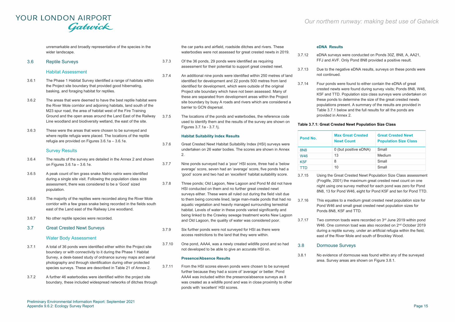
Preliminary Environmental Information Report: September 2021 Appendix 9.6.2: Ecology Survey Report Page 15
Our northern runway: making best use of Gatwick
unremarkable and broadly representative of the species in the wider landscape.
3.6 Reptile Surveys
Habitat Assessment
3.6.1 The Phase 1 Habitat Survey identified a range of habitats within the Project site boundary that provided good hibernating, basking, and foraging habitat for reptiles.
3.6.2 The areas that were deemed to have the best reptile habitat were the River Mole corridor and adjoining habitats, land south of the M23 spur road, the area of habitat west of the Fire Training Ground and the open areas around the Land East of the Railway Line woodland and biodiversity wetland, the east of the site.
3.6.3 These were the areas that were chosen to be surveyed and where reptile refugia were placed. The locations of the reptile refugia are provided on Figures 3.6.1a – 3.6.1e.
Survey Results
3.6.4 The results of the survey are detailed in the Annex 2 and shown on Figures 3.6.1a – 3.6.1e.
3.6.5 A peak count of ten grass snake Natrix natrix were identified during a single site visit. Following the population class size assessment, there was considered to be a ‘Good’ sized population.
3.6.6 The majority of the reptiles were recorded along the River Mole corridor with a few grass snake being recorded in the fields south east of the Land east of the Railway Line woodland.
3.6.7 No other reptile species were recorded.
3.7 Great Crested Newt Surveys
Water Body Assessment
3.7.1 A total of 36 ponds were identified either within the Project site boundary or with connectivity to it during the Phase 1 Habitat Survey, a desk-based study of ordnance survey maps and aerial photography and through identification during other protected species surveys. These are described in Table 21 of Annex 2.
3.7.2 A further 46 waterbodies were identified within the project site boundary, these included widespread networks of ditches through
the car parks and airfield, roadside ditches and rivers. These waterbodies were not assessed for great crested newts in 2019.
3.7.3 Of the 36 ponds, 29 ponds were identified as requiring assessment for their potential to support great crested newt.
3.7.4 An additional nine ponds were identified within 250 metres of land identified for development and 22 ponds 500 metres from land identified for development, which were outside of the original Project site boundary which have not been assessed. Many of these are separated from development areas within the Project site boundary by busy A roads and rivers which are considered a barrier to GCN dispersal.
3.7.5 The locations of the ponds and waterbodies, the reference code used to identify them and the results of the survey are shown on Figures 3.7.1a - 3.7.1j.
Habitat Suitability Index Results
3.7.6 Great Crested Newt Habitat Suitability Index (HSI) surveys were undertaken on 26 water bodies. The scores are shown in Annex 2.
3.7.7 Nine ponds surveyed had a ‘poor’ HSI score, three had a ‘below average’ score, seven had an ‘average’ score, five ponds had a ‘good’ score and two had an ‘excellent’ habitat suitability score.
3.7.8 Three ponds; Old Lagoon, New Lagoon and Pond M did not have HSI conducted on them and no further great crested newt surveys either. These were all ruled out during the field visit due to them being concrete lined, large man-made ponds that had no aquatic vegetation and heavily managed surrounding terrestrial habitat. Levels of water in these ponds varied significantly and being linked to the Crawley sewage treatment works New Lagoon and Old Lagoon, the quality of water was considered poor.
3.7.9 Six further ponds were not surveyed for HSI as there were access restrictions to the land that they were within.
3.7.10 One pond, AAA4, was a newly created wildlife pond and so had not developed to be able to give an accurate HSI on.
Presence/Absence Results
3.7.11 From the HSI scores eleven ponds were chosen to be surveyed further because they had a score of ‘average’ or better. Pond AAA4 was included within the presence/absence surveys as it was created as a wildlife pond and was in close proximity to other ponds with ‘excellent’ HSI scores.
eDNA Results
3.7.12 eDNA surveys were conducted on Ponds 30Z, 8N8, A, AA21, FFJ and AVF. Only Pond 8N8 provided a positive result.
3.7.13 Due to the negative eDNA results, surveys on these ponds were not continued.
3.7.14 Four ponds were found to either contain the eDNA of great crested newts were found during survey visits; Ponds 8N8, W46, K5F and TTD. Population size class surveys were undertaken on these ponds to determine the size of the great crested newts populations present. A summary of the results are provided in Table 3.7.1 below and the full results for all the ponds are provided in Annex 2.
Table 3.7.1: Great Crested Newt Population Size Class
Pond No. Max Great Crested Newt Count
Great Crested Newt Population Size Class
8N8 0 (but positive eDNA) Small
W46 13 Medium
K5F 8 Small
TTD 10 Small
3.7.15 Using the Great Crested Newt Population Size Class assessment (Froglife, 2001) the maximum great crested newt count on one night using one survey method for each pond was zero for Pond 8N8, 13 for Pond W46, eight for Pond K5F and ten for Pond TTD.
3.7.16 This equates to a medium great crested newt population size for Pond W46 and small great crested newt population sizes for Ponds 8N8, K5F and TTD.
3.7.17 Two common toads were recorded on 3rd June 2019 within pond W46. One common toad was also recorded on 2nd October 2019 during a reptile survey, under an artificial refugia within the field, east of the River Mole and south of Brockley Wood.
3.8 Dormouse Surveys
3.8.1 No evidence of dormouse was found within any of the surveyed area. Survey areas are shown on Figure 3.8.1.

Preliminary Environmental Information Report: September 2021 Appendix 9.6.2: Ecology Survey Report Page 16
Our northern runway: making best use of Gatwick
3.9 Aquatic Mammal Surveys
Otter Surveys
3.9.1 No evidence of otter was found along the River Mole, within the surveyed area, as shown on Figure 3.9.1.
Water Vole Surveys
3.9.2 No evidence of water vole was found along the River Mole, within the surveyed area, as shown on Figure 3.9.1.
3.10 Preliminary Bat Roost Assessment
Buildings
3.10.1 Two buildings within the Project site boundary were identified as having suitable features present to support roosting bats: one, a disused Control Tower (Building JW9) located in the north west of the Project site (landside), adjacent to Control Tower Road and east of the River Mole; and the second, a disused ancillary building (Building D9H) located along the southern boundary of the airside perimeter fencing, adjacent to Crawter’s Brook and Staff Car Park Z.
Trees
3.10.2 A description of the bat roost assessment for trees is to follow.
3.11 Bat Emergence/Re-entry Surveys
3.11.1 As recommended by the BCT guidance, three dusk emergence surveys were undertaken on each of the two buildings identified within the Project site boundary as having bat roosting potential.
3.11.2 The surveys were undertaken to determine whether a bat roost was present and to determine the species and number of bats using it.
3.11.3 A summary of the survey dates, weather conditions and sunset times is provided in Table 3.11.1 below.
Table 3.11.1: Bat Emergence Survey Dates, Weather Conditions and Survey Times
Building ref.
Date Weather Sunset time
Survey start
Survey end
D9H 15/07/19 22°C, light cloud, no rain
21:15 21:00 22:45
Building ref.
Date Weather Sunset time
Survey start
Survey end
D9H 20/08/19 16°C, light winds, dry, fair
20:20 20:05 21:50
D9H 26/09/19 17°C, windy, clear skies
18:55 18:40 20:25
JW9 15/07/19 22°C, light cloud, no rain
21:15 21:00 22:45
JW9 07/08/19 18°C, cloudy, dry 20:41 20:26 22:11
JW9 02/10/19 13°C, dry, clear, light winds
18:37 18:22 20:07
Building JW9 (Landside)
3.11.4 No bats were seen emerging from the building but were detected foraging nearby.
3.11.5 Bat activity was recorded at low levels during the emergence surveys on 15 July and 20 of August 2019.
3.11.6 On the emergence survey of 26 September 2019, bat activity was recorded at moderate levels during the survey; although no bats were seen, it was presumed that bats were foraging near to the grassland area to the west of the feature. Common pipistrelle, soprano pipistrelle, noctule, Leisler’s bat and Mytois species were recorded.
3.11.7 Further details regarding the results of these surveys can be found in Annex 2.
Building D9H (Airside)
Bat Emergence Survey 15 July 2019
3.11.8 The bat emergence survey on the 15 July commenced at 21:00, 15 minutes before sunset and finished at 22:45.
3.11.9 No bats were seen emerging from the building during any of the surveys, however bats were detected at low levels, forging and commuting nearby. Common pipistrelle and noctule were recorded.
3.11.10 Further details regarding the results of these surveys can be found in Annex 2.
3.12 Bat Activity Transect Surveys
3.12.1 A summary of the survey dates, weather conditions and sunset times is provided in Table 3.9.1 within Annex 2.
3.12.2 In order to gain a comparison of species assemblage and utilisation across different habitats over the entire season, the results for each transect route have been grouped into pre-maternity (April and May), maternity (June and July) and post-maternity (August-October) seasons.
3.12.3 The utilisation of different areas along the transect routes are shown on Figures 3.13.1a – 3.13.1f for the pre-maternity season, Figures 3.13.2a – 3.13.2f for the maternity season, and Figures 3.13.3a – 3.13.3f for the post-maternity season.
3.12.4 The locations of the transects are shown on the above mentioned figures and are briefly described below:
Transect 1: Horleyland Wood, Upper Pickets Wood and Lower Pickets Wood;
Transect 2: Gatwick BAP Area, Land East of the Railway Line (LERL);
Transect 3: Riverside Garden Park and Perimeter Road East;
Transect 4: Perimeter Road South; Transect 5: Museum Field and other land west of the River
Mole.
3.12.5 Overall, moderate levels of bat activity were recorded across all five transects during the pre-maternity, maternity and post-maternity seasons, except for Transect 4 which consistently recorded very low levels of activity.
3.12.6 The highest number of bat passes recorded in the pre-maternity season was along Transect 3, with 286 passes. In the maternity and post-maternity seasons, the highest number of passes was recorded along Transect 1, with 400 and 508 passes respectively. The fewest number of passes across all seasons was recorded along Transect 4 (24, 23 and 52 passes respectively).
3.12.7 Across transects 1 and 5, the overall levels of bat activity were considerably higher in the maternity season, compared to the pre-maternity season, whereas activity levels across Transect 3 were considerably lower. The activity levels along transect 2 and 4 remained constant across both seasons.
3.12.8 In the maternity season, significantly higher levels of bat activity were recorded along Transect 5, adjacent to the River Mole corridor and woodland strip, which are well connected with Brockley Wood.

Preliminary Environmental Information Report: September 2021 Appendix 9.6.2: Ecology Survey Report Page 17
Our northern runway: making best use of Gatwick
3.12.9 Generally, high levels of bat activity were recorded within the woodland areas associated with transects 1, 2 and 3, including Horleyland Wood and Upper Pickett’s Wood, adjacent to and north of the sewage treatment works and woodland associated with Riverside Garden Park, in the north east of the Project site boundary.
3.12.10 Higher levels of commuting activity were also recorded along linear features, notably the railway line adjacent to Transect 2, mature hedgerow and tree lines, and the river corridors, including the River Mole, Man’s Brook, Crawter’s Brook and Gatwick Stream.
3.12.11 Foraging activity was generally concentrated along mature hedgerows, through open canopy areas within woodland, woodland edges and adjacent/close to waterbodies, including the lake within Riverside Garden Park and the Crawley Sewage Treatment Works.
3.12.12 Lower levels of bat activity were observed in areas of open pasture, such as those associated with Transect 5 and habitat that comprised large, exposed areas of hardstanding with little canopy cover, such as those found along Transect 4.
3.12.13 Common pipistrelle Pipistrellus pipistrellus was the most frequently recorded species across all transect routes, with peak counts of 777, 1,005 and 1,232 passes recorded during the pre-maternity, maternity and post-maternity seasons respectively. Noctule Nyctalus noctula were also recorded in moderate numbers, with a peak count of 19 bats recorded along Transect 2 in the pre-maternity season. Lower numbers of soprano pipistrelle Pipistrellus pygmaeus, Myotis sp. and other big bat species (including serotine Eptesicus serotinus and Leisler’s Nyctalus leisleri bats) were detected throughout the transect surveys. A single Nathusius’ pipistrelle pass was recorded along Transect 2 in the maternity season and along Transect 3 in the post-maternity season.
3.12.14 Pipistrelle bats and Myotis sp. were generally associated with woodland areas and woodland edges, whereas bat passes from noctule, serotine and Leisler’s bats were more frequently recorded in open areas of grassland and pasture.
3.13 Bat Static/Automated Surveys
3.13.1 Within the project site boundary, 11 static bat detectors were set out in April. The locations of these detectors are shown on Figure 3.14.1.
Location 1 – Land West of the Fire Training Ground
3.13.2 A summary of the survey dates, number of nights deployed, and bat passes for Location 1 is provided in Table 3.13.1 below. A summary of the number and species of bats recorded at Location 1 is provided in
3.13.3 Table 3.13.2. Full details of passes per night are provided in Annex 2.
Table 3.13.1: Bat Static/Automated Survey Summary for Location 1
Survey dates
Number of nights detector deployed
Total number of bat passes
Average bat passes / night
24 April 2019 – 30 April 2019 7 59 8
10 May 2019 - 15 May 2019 6 566 94
11 June 2019 – 15 June 2019 5 189 38
12 July 2019 – 16 July 2019 5 745 149
13 Aug 2019 – 18 Aug 2019 6 282 47
25 Sept 2019 – 29 Sept 2019 5 357 71
14 Oct 2019 – 18 Oct 2019 5 138 28
Table 3.13.2: Species Summary for Location 1
Survey Month
Bb Pp Ppy Pn Psp Msp Pl Nn Nl Es Total
April 0 51 0 1 0 3 1 3 0 0 59 May 0 532 19 4 2 0 2 7 0 0 566 June 0 177 4 0 0 0 0 8 0 0 189 July 0 555 8 1 6 14 3 151 5 2 745 August 0 222 3 3 0 17 3 31 0 3 282 Sept 1 34 0 0 3 7 0 312 0 0 357 Oct 1 103 3 0 8 7 0 16 0 0 138 Species total
2 1,674 37 9 19 48 9 528 5 5 2,336
Bb – barbastelle, Pp -common pipistrelle, Ppy - soprano pipistrelle, Pn - Nathusius' pipistrelle, Psp - pipistrelle bats, Msp - Myotis bats, Pl - long-eared bats, Nn - noctule, Nl - Leisler's bat, Es - serotine bat
3.13.4 A total of 2,336 bat passes were recorded at Location 1 between April and October 2019.
3.13.5 The highest number of passes for all species was recorded in July (745 passes) during the maternity season. The fewest
number of passes was recorded in April (59 passes) during the pre-maternity season.
3.13.6 On average, higher numbers of bat passes were recorded during the maternity season (467 passes) than in the pre- and post-maternity seasons (313 and 259 passes respectively) at Location 1.
3.13.7 Common pipistrelle were the most frequently recorded species at this location across all seasons, with peak counts of 532 and 555 passes in May and July respectively. Although the overall number of passes at this location were comparatively fewer in April and June, common pipistrelle accounted for 72% of the overall species composition at this location. Fewer numbers of soprano pipistrelle were recorded at Location 1 and these accounted for between 1 and 3% of the species passes at this location.
3.13.8 Nathusius’ pipistrelle Pipistrellus nathusiusii was recorded in very low numbers throughout the year, with a peak count of eight passes, recorded in October.
3.13.9 Noctule accounted for 11% of the species composition at Location 1; a peak count 312 noctule was recorded in September.
3.13.10 Moderate levels of Myotis sp. were recorded throughout the season, with the highest counts recorded in July (14 passes) and August (17 passes).
3.13.11 Lower level of activity for long-eared Plecotus sp., serotine and Leisler’s bats were recorded at Location 1, with overall counts of nine, five and five passes respectively. Collectively, these species accounted for less than 1% of the overall species composition.
3.13.12 Barbastelle Barbastella barbastellus was recorded twice during the post-maternity season, with a single pass in September and October.
Location 2 – Land South West of the River Mole
3.13.13 A summary of the survey dates, number of nights deployed, and bat passes for Location 2 is provided in Table 3.13.3 below. A summary of the number and species of bats recorded at Location 2 is provided in Table 3.13.4. Full details of passes per night are provided in Annex 2.

Preliminary Environmental Information Report: September 2021 Appendix 9.6.2: Ecology Survey Report Page 18
Our northern runway: making best use of Gatwick
Table 3.13.3: Bat Static/Automated Survey Summary for Location 2
Survey dates
Number of nights detector deployed
Total number of bat passes
Average bat passes / night
24 April 2019 – 30 April 2019
7 110 15
10 May 2019 - 15 May 2019
6 1,101 184
12 June 2019 – 16 June 2019
5 730 146
12 July 2019 – 16 July 2019
5 1,269 254
13 Aug 2019 – 18 Aug 2019
6 330 55
25 Sept 2019 – 27 Sept 2019
3 291 97
14 Oct 2019 – 18 Oct 2019 5 35 7
Table 3.13.4: Species Summary for Location 2
Survey Month
Pp Ppy Pn Psp Msp Pl Nn Nl Es Total
April 96 5 0 0 8 0 1 0 0 110 May 948 48 0 0 7 1 97 0 0 1,101 June 66 5 0 3 13 1 642 0 0 730 July 1,183 20 0 1 18 2 41 0 4 1,269 August 149 15 0 39 53 16 69 13 12 330 Sept 42 1 0 1 7 2 238 0 0 291 October 24 5 0 0 5 0 0 1 0 35 Species total
2,508 99 0 44 111 22 1,088 14 16 3,866 Pp -common pipistrelle, Ppy - soprano pipistrelle, Pn - Nathusius’ pipistrelle, Psp - pipistrelle bats, Msp - Myotis bats, Pl - long-eared bats, Nn - noctule, Nl - Leisler’s bat, Es - serotine bat
3.13.14 A total of 3,866 bat passes were recorded at Location 2 between April and October 2019.
3.13.15 The highest number of passes for all species was recorded in July (1,269 passes) during the maternity season. The fewest number of passes was recorded in October (35 passes) during the post-maternity season.
3.13.16 On average, higher numbers of bat passes were recorded during the maternity season (1,000 passes) than in the pre- and post-
maternity seasons (606 and 219 passes, respectively) at Location 2.
3.13.17 Overall, common pipistrelle were the most frequently recorded species at this location with a total of 2,508 passes and a peak count of 1,183 passes recorded in July. However, the total number of passes of common pipistrelle showed a marked difference between the pre-maternity/maternity and post-maternity seasons.
3.13.18 In April, May and July, common pipistrelles accounted for between 86% and 93% of the total species composition at Location 2. However, in June, only 9% (66 passes) were from common pipistrelles. In the post-maternity season, the number of common pipistrelle passes averaged only 33%.
3.13.19 Fewer numbers of soprano pipistrelle were recorded at this location which accounted for between 1% and 14% of the overall species composition at this location. A peak count of 48 passes was recorded in May.
3.13.20 Noctule accounted for 28% (1,088 passes) of the overall bat assemblage at Location 2 with peak counts of 642 and 238 passes in June and September, respectively.
3.13.21 Rarer species including serotine and Leisler’s bats were also recorded at this location. The peak count for both species was in August with 12 and 13 passes, respectively.
3.13.22 Low numbers of long-eared bat species were recorded across all seasons, with a peak count of 16 passes recorded in August.
3.13.23 Nathusius’ pipistrelle was not recorded at Location 2.
Location 3 – Brockley Wood
3.13.24 A summary of the survey dates, number of nights deployed, and bat passes for Location 3 is provided in Table 3.13.5 below. A summary of the number and species of bats recorded at Location 3 is provided in Table 3.13.6. Full details of passes per night are provided in Annex 2.
Table 3.13.5: Bat Static/Automated Survey Summary for Location 3
Survey dates
Number of nights detector deployed
Total number of bat passes
Average bat passes / night
25 April 2019 – 1 May 2019 7 2,410 344
10 May 2019 – 14 May 2019 5 19,553 3,911
12 June 2019 – 16 June 2019 5 2,358 472
12 July 2019 – 16 July 2019 5 9,914 1,983
13 Aug 2019 – 18 Aug 2019 6 4,330 722
25 Sept 2019 – 29 Sept 2019 5 1,393 279
14 Oct 2019 – 18 Oct 2019 5 1,787 357
Table 3.13.6: Species Summary for Location 3
Survey Month
Pp Ppy Pn Psp Msp Pl Nn Nl Es Total
April 2061 228 0 1 117 0 3 0 0 2410 May 15612 529 0 3 3102 234 68 5 0 19553 June 1302 268 0 1 639 4 109 0 0 2323 July 7688 455 1 5 1728 3 34 0 0 9914 August 2339 904 0 535 541 3 6 0 2 4330 Sept 333 83 0 670 145 0 161 0 1 1393 October 455 268 0 53 1005 5 1 0 0 1787 Species total
29790 2735 1 1268 7277 249 382 5 3 41710 Pp -common pipistrelle, Ppy - soprano pipistrelle, Pn - Nathusius’ pipistrelle, Psp - pipistrelle bats, Msp - Myotis bats, Pl - long-eared bats, Nn - noctule, Nl - Leisler’s bat, Es - serotine bat
3.13.25 A total of 41,710 bat passes were recorded at Location 3 between April and October 2019, which is the highest number of passes recorded across all static detector locations.
3.13.26 The highest number of passes for all species was recorded in May during the pre-maternity season, with a total of 19,553 passes. The fewest number of passes was recorded in September during the post-maternity season, with 1,393 passes.
3.13.27 On average, higher numbers of bat passes were recorded during the pre-maternity season (10,982 passes) than in the maternity and post-maternity seasons (6,119 and 2,503 passes respectively) at Location 3.

Preliminary Environmental Information Report: September 2021 Appendix 9.6.2: Ecology Survey Report Page 19
Our northern runway: making best use of Gatwick
3.13.28 Very high levels of common pipistrelle and high levels of soprano pipistrelle and Myotis sp. were recorded across all seasons, with the highest proportion of common pipistrelle passes recorded in May (80%), for soprano pipistrelles in August (21%) and for Myotis sp. in October (56%).
3.13.29 A single pass from Nathusius’ pipistrelle was recorded in July.
3.13.30 Moderate levels of noctule activity were recorded at Location 3, with a peak count of 161 passes in September. Leisler’s bat and serotine were recorded in fewer numbers with a total of five and three passes respectively. Collectively, these species accounted for less than 1% of the overall composition at Location 3.
3.13.31 Consistently low levels of Plecotus sp. passes were recorded across all months, with the exception of May, when a total of 234 passes were recorded.
Location 4 – North of the Long Stay North Car Park
3.13.32 A summary of the survey dates, number of nights deployed, and bat passes for Location 4 is provided in Table 3.13.7 below. A summary of the number and species of bats recorded at Location 4 is provided in
3.13.33 Table 3.13.8. Full details of passes per night are provided in Annex 2.
Table 3.13.7: Bat Static/Automated Survey Summary for Location 4
Survey dates
Number of nights detector deployed
Total number of bat passes
Average bat passes / night
25 April 2019 – 30 April 2019
6 3,093 516
10 May 2019 – 15 May 2019
6 3,781 630
12 June 2019 – 15 June 2019
4 141 35
12 July 2019 – 16 July 2019
5 470 94
13 Aug 2019 – 18 Aug 2019
6 520 87
25 Sept 2019 – 27 Sept 2019
3 123 41
14 Oct 2019 – 18 Oct 2019
5 53 11
Table 3.13.8: Species Summary for Location 4
Survey Month
Pp Ppy Pn Psp Msp Pl Nn Nl Es Total
April 2795 147 5 1 96 39 6 1 3 3093 May 2405 1310 3 29 31 0 1 2 0 3781 June 99 2 1 0 9 4 26 0 0 141 July 299 23 2 5 78 18 36 0 9 470 August 385 13 0 6 67 3 32 10 4 520 Sept 38 4 0 0 12 6 63 0 0 123 October 16 2 0 0 15 0 20 0 0 53 Species total
6037 1501 11 41 308 70 184 13 16 8181 Pp -common pipistrelle, Ppy - soprano pipistrelle, Pn - Nathusius’ pipistrelle, Psp - pipistrelle bats, Msp - Myotis bats, Pl - long-eared bats, Nn - noctule, Nl - Leisler’s bat, Es - serotine bat
3.13.34 A total of 8,181 bat passes were recorded at Location 4 between April and October 2019.
3.13.35 The highest number of passes was recorded in May (3,871 passes) during the pre-maternity season. Only 141 passes were recorded in June and 53 passes were recorded in October.
3.13.36 On average, higher numbers of bat passes were recorded during the pre-maternity season (3,437 passes) than in the maternity and post-maternity seasons (306 and 232 passes respectively) at Location 4.
3.13.37 Common pipistrelle were the most frequently recorded species at this location with a total of 6,037 passes and a peak count of 2,795 passes recorded in May. Across all months, common pipistrelle accounted for between 63 and 90% of the total species composition at this location.
3.13.38 High numbers of both common and soprano pipistrelle were recorded in May with 2,405 and 1,310 passes respectively. Moderate numbers of Myotis and Plecotus sp. were recorded across all months, with peak counts of 96 and 39 passes recorded in April.
3.13.39 On average moderate numbers of noctule were recorded during the maternity and post-maternity seasons (31 and 38 passes, respectively) compared to the pre-maternity season (4 passes).
3.13.40 Low levels of activity were also recorded for Leisler’s and serotine bats with a total of 13 and 16 passes, respectively.
3.13.41 Low levels of activity were also recorded for Nathusius’ pipistrelle with a total count of 11 passes and a peak count of five passes in April.
Location 5 – Riverside Garden Park
3.13.42 Location 5 in Riverside Garden Park is outwith the Project site boundary. A summary of the survey dates, number of nights deployed, and bat passes for Location 5 is provided in Table 3.13.9 below. A summary of the number and species of bats recorded at Location 5 is provided in Table 3.13.10. Full details of passes per night are provided in Annex 2.
Table 3.13.9: Bat Static/Automated Survey Summary for Location 5
Survey dates
Number of nights detector deployed
Total number of bat passes
Average bat passes / night
10 May 2019 – 15 May 2019
6 3694 616
12 July 2019 – 16 July 2019
5 3321 664
13 Aug 2019 – 18 Aug 2019
6 564 94
25 Sept 2019 – 29 Sept 2019
5 305 61
14 Oct 2019 – 18 Oct 2019
5 68 14

Preliminary Environmental Information Report: September 2021 Appendix 9.6.2: Ecology Survey Report Page 20
Our northern runway: making best use of Gatwick
Table 3.13.10: Species Summary for Location 5
Survey Month
Pp Ppy Pn Psp Msp Pl Nn Nl Es Total
April 0 0 0 0 0 0 0 0 0 0 May 3461 35 0 0 6 7 1 0 0 3694 June 0 0 0 0 0 0 0 0 0 0 July 3060 144 0 2 8 0 16 0 91 3321 August 462 31 0 4 44 3 17 1 2 564 Sept 168 28 0 79 11 4 15 0 0 305 October 47 6 0 6 5 4 0 0 0 68 Species total
7198 244 0 91 74 18 49 1 93 7952 Pp -common pipistrelle, Ppy - soprano pipistrelle, Pn - Nathusius’ pipistrelle, Psp - pipistrelle bats, Msp - Myotis bats, Pl - long-eared bats, Nn - noctule, Nl - Leisler’s bat, Es - serotine bat
3.13.43 A total of 7,952 bat passes were recorded at Location 5 during May and between July and October 2019. No data was recorded during April or June due to equipment failure and malfunction.
3.13.44 The highest number of passes was recorded in May (3,694 passes) during the pre-maternity season. The lowest number of passes was recorded in October (68 passes), during the post-maternity season.
3.13.45 On average, higher numbers of bat passes were recorded during the pre-maternity season (3,694 passes) than in the maternity and post-maternity seasons (3,321 and 312 passes respectively) at Location 5.
3.13.46 Common pipistrelles accounted for the highest number of species passes at this location, with between 55% and 94% of the species composition across all seasons at Location 5.
3.13.47 Low numbers of soprano pipistrelles were recorded at Location 5, with a total of 244 passes (3% of total passes).
3.13.48 Moderate to low numbers of Myotis and Plecotus sp., serotine and noctule were also recorded at this location with a total of 91, 18, one and 93 passes respectively. A peak count of 91 serotine bat passes were recorded in July.
3.13.49 Nathusius’ pipistrelle was not recorded at Location 5.
Location 6 – Land West of the Railway
3.13.50 A summary of the survey dates, number of nights deployed, and bat passes for Location 6 is provided in Table 3.13.11 below. A summary of the number and species of bats recorded at Location
6 is provided in Table 3.13.12. Full details of passes per night are provided in Annex 2.
Table 3.13.11: Bat Static/Automated Survey Summary for Location 6
Survey dates
Number of nights detector deployed
Total number of bat passes
Average bat passes / night
25 April 2019 – 27 April 2019
3 269 89
10 May 2019 – 12 May 2019
3 5,093 1,698
12 June 2019 – 16 June 2019
5 7,876 1,575
12 July 2019 – 16 July 2019
5 4,691 938
13 Aug 2019 – 18 Aug 2019
6 7,897 1,316
24 Sept 2019 – 28 Sept 2019
5 2,920 584
14 Oct 2019 – 19 Oct 2019 6 379 63
Table 3.13.12: Species Summary for Location 6
Survey Month
Pp Ppy Pn Psp Msp Pl Nn Nl Es Total
April 266 2 1 0 0 0 0 0 0 269 May 4839 223 2 0 26 1 2 0 0 5093 June 7754 13 51 1 8 2 46 0 1 7876 July 4583 18 9 0 15 4 60 0 2 4691 August 7772 5 0 0 19 2 96 2 1 7897 Sept 2872 21 0 2 6 0 19 0 0 2920 October 346 29 0 0 2 0 2 0 0 379 Species total
28432 31 63 3 76 9 225 2 4 28845 Pp -common pipistrelle, Ppy - soprano pipistrelle, Pn - Nathusius’ pipistrelle, Psp - pipistrelle bats, Msp - Myotis bats, Pl - long-eared bats, Nn - noctule, Nl - Leisler’s bat, Es - serotine bat
3.13.51 A total of 28,845 bat passes were recorded at Location 6 between April and October 2019.
3.13.52 The highest number of passes was recorded in June (7,876 passes) during the maternity season. The lowest number of passes was recorded in April (269 passes), during the pre-maternity season.
3.13.53 On average, higher numbers of bat passes were recorded during the maternity season (6,284 passes) than in the pre-maternity and post-maternity seasons (2,681 and 3,732 passes, respectively) at Location 6.
3.13.54 Common pipistrelle were the most frequently recorded species at this location with a total of 28,432 passes across all months and a peak count of 7,772 passes recorded in August. Across all months, common pipistrelle accounted for between 95% and 99% of the total species composition at this location.
3.13.55 Generally low numbers of soprano pipistrelle were recorded across all months, except for May, where 223 passes were recorded. Noctule was also recorded in moderate numbers with peak counts of 60 and 96 passes in July and August, respectively.
3.13.56 Moderate numbers of Nathusius’ pipistrelle and Myotis sp. were recorded at Location 6 with a total of 63 and 76 passes respectively. In June, a peak count of 51 Nathusius’ pipistrelle passes was recorded.
3.13.57 Low activity levels were recorded for Plecotus sp., Leisler’s and serotine bats with nine, two and four passes, respectively.
Location 7 – Horleyland Wood
3.13.58 A summary of the survey dates, number of nights deployed, and bat passes for Location 7 is provided in Table 3.13.13 below. A summary of the number and species of bats recorded at Location 7 is provided in Table 3.13.14. Full details of passes per night are provided in Annex 2.
Table 3.13.13: Bat Static/Automated Survey Summary for Location 7
Survey dates
Number of nights detector deployed
Total number of bat passes
Average bat passes / night
25 April 2019 – 30 April 2019 6 8,459 134
10 May 2019 – 13 May 2019 4 12,878 3,220
12 June 2019 – 16 June 2019 5 8,221 1,644
12 July 2019 – 15 July 2019 4 5,250 1,313
13 Aug 2019 – 18 Aug 2019 6 2,421 404
25 Sept 2019 – 27 Sept 2019 3 250 83
15 Oct 2019 – 20 Oct 2019 6 488 81

Preliminary Environmental Information Report: September 2021 Appendix 9.6.2: Ecology Survey Report Page 21
Our northern runway: making best use of Gatwick
Table 3.13.14: Species Summary for Location 7
Survey Month
Pp Ppy Pn Psp Msp Pl Nn Nl Es Total
April 8021 337 0 0 98 3 0 0 0 8459 May 12570 290 1 0 11 4 2 0 0 12878 June 7883 250 0 0 61 7 20 0 0 8221 July 5104 38 0 5 12 19 8 0 64 5250 August 2154 27 0 72 116 16 0 0 25 2421 Sept 148 2 0 84 1 5 10 0 0 250 October 436 42 0 2 7 0 1 0 0 488 Species total
36316 986 1 163 306 54 41 0 89 37967 Pp -common pipistrelle, Ppy - soprano pipistrelle, Pn - Nathusius’ pipistrelle, Psp - pipistrelle bats, Msp - Myotis bats, Pl - long-eared bats, Nn - noctule, Nl - Leisler’s bat, Es - serotine bat
3.13.59 A total of 37,967 bat passes were recorded at Location 7 between April and October 2019.
3.13.60 The highest number of passes was recorded in May (12,878 passes) during the pre-maternity season. The lowest number of passes was recorded in September (250 passes), during the post-maternity season.
3.13.61 On average, higher numbers of bat passes were recorded during the pre-maternity season (10,669 passes) than in the maternity and post-maternity seasons (6,736 and 1,053 passes respectively) at Location 7.
3.13.62 Common pipistrelle were the most frequently recorded species at this location with a total of 36,316 passes and a peak count of 12,570 passes recorded in May. Across all seasons, common pipistrelle accounted for between 59% and 98% of the species composition at this location.
3.13.63 High activity levels of soprano pipistrelle were recorded in the pre-maternity season, which average 314 passes compared to the maternity and post-maternity seasons, which averaged 144 and 24 passes respectively.
3.13.64 A single Nathusius’ pipistrelle pass was recorded in May.
3.13.65 Activity levels of Myotis sp. remained relatively low throughout the season with a peak count of 116 passes in August and 98 passes in April. Only one Myotis sp. pass was recorded in September.
3.13.66 Moderate levels of activity were recorded for all other species at this location including for Plecotus sp. (54 passes), serotine (89
passes) and noctule (41 passes). Leisler’s bat was not recorded during surveys at this location.
Location 8 – Land East of the Railway Line Wetland
3.13.67 A summary of the survey dates, number of nights deployed, and bat passes for Location 8 is provided in Table 3.13.15 below. A summary of the number and species of bats recorded at Location 8 is provided in
3.13.68 Table 3.13.16. Full details of passes per night are provided in Annex 2.
Table 3.13.15: Bat Static/Automated Survey Summary for Location 8
Survey dates
Number of nights detector deployed
Total number of bat passes
Average bat passes / night
24 April 2019 – 1 May 2019 8 1,758 219
12 May 2019 – 15 May 2019 4 2,121 530
11 July 2019 – 16 July 2019 6 203 34
14 Aug 2019 – 18 Aug 2019 5 14 3
25 Sept 2019 – 29 Sept 2019 5 1,775 355
14 Oct 2019 – 19 Oct 2019 6 889 148
Table 3.13.16: Species Summary for Location 8
Survey Month
Pp Ppy Pn Psp Msp Pl Nn Nl Es Total
April 1,728 2 1 7 0 0 20 0 0 1,758 May 2,118 3 0 0 0 0 0 0 0 2,121 June 0 0 0 0 0 0 0 0 0 0 July 37 0 0 0 0 0 164 0 0 203 August 14 0 0 0 0 0 0 0 0 14 Sept 679 19 9 43 1 0 1,015 8 1 1,775 October 793 24 22 3 8 0 38 1 0 889 Species total
5,369 48 32 53 9 0 1,237 9 1 6,760 Pp -common pipistrelle, Ppy - soprano pipistrelle, Pn - Nathusius’ pipistrelle, Psp - pipistrelle bats, Msp - Myotis bats, Pl - long-eared bats, Nn - noctule, Nl - Leisler’s bat, Es - serotine bat
3.13.69 A total of 6,760 bat passes were recorded at Location 8 between April and May and between July and October 2019. No data was recorded during June due to equipment failure and malfunction.
3.13.70 The highest number of passes was recorded in May (2,121 passes) during the pre-maternity season. The lowest number of passes was recorded in August (14 passes), during the post-maternity season.
3.13.71 On average, higher numbers of bat passes were recorded during the pre-maternity season (1,940 passes) than in the maternity and post-maternity seasons (203 and 893 passes respectively), although in general, the number of bat passes at this location were comparatively lower than others.
3.13.72 Common pipistrelle were the most frequently recorded species at this location with a total of 5,369 passes and a peak count of 2,118 passes recorded in May.
3.13.73 Similar numbers of soprano pipistrelle and Nathusius’ pipistrelle were recorded at Location 8, with similar numbers of bats recorded in September (19 and nine passes, respectively) and October (24 and 22 passes, respectively).
3.13.74 In July and September, noctule were more frequently recorded than any other species, accounting for 81% and 57% of the species composition at this location.
3.13.75 There were no recorded passes from Plectous sp. and very few passes from serotine and Leisler’s bats (one and nine passes, respectively).
Location 9 – Perimeter Road South
3.13.76 A summary of the survey dates, number of nights deployed, and bat passes for Location 9 is provided in Table 3.13.17 below. A summary of the number and species of bats recorded at Location 9 is provided in Table 3.13.18. Full details of passes per night are provided in Annex 2.
Table 3.13.17: Bat Static/Automated Survey Summary for Location 9
Survey dates
Number of nights detector deployed
Total number of bat passes
Average bat passes / night
25 April 2019 – 1 May 2019 7 22 3
10 May 2019 – 15 May 2019 6 2,089 348
11 June 2019 – 16 June 2019 6 2,828 471
12 July 2019 – 16 July 2019 5 259 52
13th Aug 2019 – 18th Aug 2019 6 108 18
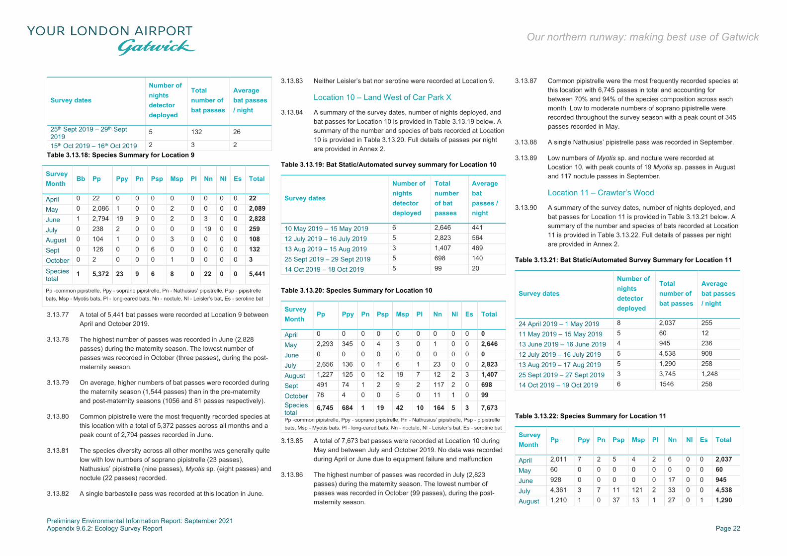
Preliminary Environmental Information Report: September 2021 Appendix 9.6.2: Ecology Survey Report Page 22
Our northern runway: making best use of Gatwick
Survey dates
Number of nights detector deployed
Total number of bat passes
Average bat passes / night
25th Sept 2019 – 29th Sept 2019
5 132 26
15th Oct 2019 – 16th Oct 2019 2 3 2 Table 3.13.18: Species Summary for Location 9
Survey Month
Bb Pp Ppy Pn Psp Msp Pl Nn Nl Es Total
April 0 22 0 0 0 0 0 0 0 0 22 May 0 2,086 1 0 0 2 0 0 0 0 2,089 June 1 2,794 19 9 0 2 0 3 0 0 2,828 July 0 238 2 0 0 0 0 19 0 0 259 August 0 104 1 0 0 3 0 0 0 0 108 Sept 0 126 0 0 6 0 0 0 0 0 132 October 0 2 0 0 0 1 0 0 0 0 3 Species total
1 5,372 23 9 6 8 0 22 0 0 5,441
Pp -common pipistrelle, Ppy - soprano pipistrelle, Pn - Nathusius’ pipistrelle, Psp - pipistrelle bats, Msp - Myotis bats, Pl - long-eared bats, Nn - noctule, Nl - Leisler’s bat, Es - serotine bat
3.13.77 A total of 5,441 bat passes were recorded at Location 9 between April and October 2019.
3.13.78 The highest number of passes was recorded in June (2,828 passes) during the maternity season. The lowest number of passes was recorded in October (three passes), during the post-maternity season.
3.13.79 On average, higher numbers of bat passes were recorded during the maternity season (1,544 passes) than in the pre-maternity and post-maternity seasons (1056 and 81 passes respectively).
3.13.80 Common pipistrelle were the most frequently recorded species at this location with a total of 5,372 passes across all months and a peak count of 2,794 passes recorded in June.
3.13.81 The species diversity across all other months was generally quite low with low numbers of soprano pipistrelle (23 passes), Nathusius’ pipistrelle (nine passes), Myotis sp. (eight passes) and noctule (22 passes) recorded.
3.13.82 A single barbastelle pass was recorded at this location in June.
3.13.83 Neither Leisler’s bat nor serotine were recorded at Location 9.
Location 10 – Land West of Car Park X
3.13.84 A summary of the survey dates, number of nights deployed, and bat passes for Location 10 is provided in Table 3.13.19 below. A summary of the number and species of bats recorded at Location 10 is provided in Table 3.13.20. Full details of passes per night are provided in Annex 2.
Table 3.13.19: Bat Static/Automated survey summary for Location 10
Survey dates
Number of nights detector deployed
Total number of bat passes
Average bat passes / night
10 May 2019 – 15 May 2019 6 2,646 441
12 July 2019 – 16 July 2019 5 2,823 564
13 Aug 2019 – 15 Aug 2019 3 1,407 469
25 Sept 2019 – 29 Sept 2019 5 698 140
14 Oct 2019 – 18 Oct 2019 5 99 20
Table 3.13.20: Species Summary for Location 10
Survey Month
Pp Ppy Pn Psp Msp Pl Nn Nl Es Total
April 0 0 0 0 0 0 0 0 0 0 May 2,293 345 0 4 3 0 1 0 0 2,646 June 0 0 0 0 0 0 0 0 0 0 July 2,656 136 0 1 6 1 23 0 0 2,823 August 1,227 125 0 12 19 7 12 2 3 1,407 Sept 491 74 1 2 9 2 117 2 0 698 October 78 4 0 0 5 0 11 1 0 99 Species total
6,745 684 1 19 42 10 164 5 3 7,673 Pp -common pipistrelle, Ppy - soprano pipistrelle, Pn - Nathusius’ pipistrelle, Psp - pipistrelle bats, Msp - Myotis bats, Pl - long-eared bats, Nn - noctule, Nl - Leisler’s bat, Es - serotine bat
3.13.85 A total of 7,673 bat passes were recorded at Location 10 during May and between July and October 2019. No data was recorded during April or June due to equipment failure and malfunction
3.13.86 The highest number of passes was recorded in July (2,823 passes) during the maternity season. The lowest number of passes was recorded in October (99 passes), during the post-maternity season.
3.13.87 Common pipistrelle were the most frequently recorded species at this location with 6,745 passes in total and accounting for between 70% and 94% of the species composition across each month. Low to moderate numbers of soprano pipistrelle were recorded throughout the survey season with a peak count of 345 passes recorded in May.
3.13.88 A single Nathusius’ pipistrelle pass was recorded in September.
3.13.89 Low numbers of Myotis sp. and noctule were recorded at Location 10, with peak counts of 19 Myotis sp. passes in August and 117 noctule passes in September.
Location 11 – Crawter’s Wood
3.13.90 A summary of the survey dates, number of nights deployed, and bat passes for Location 11 is provided in Table 3.13.21 below. A summary of the number and species of bats recorded at Location 11 is provided in Table 3.13.22. Full details of passes per night are provided in Annex 2.
Table 3.13.21: Bat Static/Automated Survey Summary for Location 11
Survey dates
Number of nights detector deployed
Total number of bat passes
Average bat passes / night
24 April 2019 – 1 May 2019 8 2,037 255
11 May 2019 – 15 May 2019 5 60 12
13 June 2019 – 16 June 2019 4 945 236
12 July 2019 – 16 July 2019 5 4,538 908
13 Aug 2019 – 17 Aug 2019 5 1,290 258
25 Sept 2019 – 27 Sept 2019 3 3,745 1,248
14 Oct 2019 – 19 Oct 2019 6 1546 258
Table 3.13.22: Species Summary for Location 11
Survey Month
Pp Ppy Pn Psp Msp Pl Nn Nl Es Total
April 2,011 7 2 5 4 2 6 0 0 2,037 May 60 0 0 0 0 0 0 0 0 60 June 928 0 0 0 0 0 17 0 0 945 July 4,361 3 7 11 121 2 33 0 0 4,538 August 1,210 1 0 37 13 1 27 0 1 1,290

Preliminary Environmental Information Report: September 2021 Appendix 9.6.2: Ecology Survey Report Page 23
Our northern runway: making best use of Gatwick
Survey Month
Pp Ppy Pn Psp Msp Pl Nn Nl Es Total
Sept 2,895 4 0 246 58 3 539 0 0 3,745 October 1,456 9 0 2 59 0 20 0 0 1,546 Species total
12,921 24 9 301 255 8 642 0 1 14,161 Pp -common pipistrelle, Ppy - soprano pipistrelle, Pn - Nathusius’ pipistrelle, Psp - pipistrelle bats, Msp - Myotis bats, Pl - long-eared bats, Nn - noctule, Nl - Leisler’s bat, Es - serotine bat
3.13.91 A total of 14,161 bat passes were recorded at Location 11 during between April and October 2019.
3.13.92 The highest number of passes was recorded in July (4,538 passes) during the maternity season. The lowest number of passes was recorded in May (60 passes), during the pre-maternity season, all of which were from common pipistrelle.
3.13.93 Overall, common pipistrelle were the most frequently recorded species at this location and accounted for 91% of the species assemblage at this location (12,921 passes).
3.13.94 Moderate to high levels of activity from Myotis sp. and noctule were recorded across all months, with a peak count of 121 Myotis sp. passes in July and 539 noctule passes in September. Low numbers of all other bat species were recorded including soprano pipistrelle (24 passes), Nathusius’ pipistrelle (nine passes), Plecotus sp. (eight passes) and serotine (one pass).
Bat Crossing Point Survey
3.13.95 A total of 2459 bat passes were recorded across both locations, 2437 of which were observed using the target features (ie passing within 5m distance of the feature). A breakdown of the total number of passes observed at each crossing point is provided in Table 3.13.23 below.
Table 3.13.23: Total Bat Passes
Crossing point Number of survey visits
Number of passes observed
Number of passes observed using the feature
River Mole 3 1298 1278
Riverside Garden Park
3 1161 1159
River Mole Crossing Point
3.13.96 A total of 1278 bat passes were observed using the feature, of which 220 (17.21%) were considered to be flying within the river corridor, 659 (51.57%) were considered to be flying directly above the river corridor and 399 (31.22%) were flying at a height above 5m from ground level. These data are presented per species / species group In Table 3.13.24 below.
Table 3.13.24 Breakdown of bat passes from River Mole
Species Number of passes
Number of passes using the feature
Number of passes within river corridor
Number of passes directly above river corridor
Number of passes at a height higher than 5m from ground level
Myotis species
26 26 1 23 2
Noctule 53 53 0 7 40
Brown long-eared bat
3 3 0 3 0
Common pipistrelle
1017 1003 213 573 217
Soprano pipistrelle
24 24 5 19 0
Pipistrelle species
5 0 0 0 0
Unknown 170 170 1 34 135
3.13.97 Bats of at least five species were observed using the feature including Myotis species, noctule, brown long-eared bat, common pipistrelle and soprano pipistrelle. No additional species were confirmed as present by sound analysis.
Riverside Garden Park Crossing Point
3.13.98 A total of 1159 bat passes were observed using the feature, of which 216 (18.64%) were observed passing at an “unsafe height” and 943 (81.36%) were observed passing at a safe height. These data are presented per species / species group In Table 3.13.25 below.
Table 3.13.25: Breakdown of bat passes from Riverside Garden Park
Species Number of passes
Number of passes using the feature
Number of passes at height below or equal to 5m height
%of passes at height below or equal to 5m height
Number of passes at height above 5m
% of passes at height above 5m
Myotis species
18 18 5 27.78 13 72.22
Brown long-eared bat
3 3 1 33.33 2 66.67
Common pipistrelle
655 653 142 21.75 511 78.25
Soprano pipistrelle
431 430 51 11.86 379 88.14
Pipistrelle species
10 10 7 70 3 30
Unknown 45 45 10 22.22 35 77.78
3.13.99 Bats of at least four species / species groups were observed using the feature including Myotis species, brown long-eared bat, common pipistrelle and soprano pipistrelle. An additional species, noctule, was confirmed by sound analysis as present, although not observed.
Invertebrate Scoping Survey
3.13.100 The results of the invertebrate scoping survey are detailed within Annex 4.
Terrestrial Invertebrate Survey
3.13.101 The results of the terrestrial invertebrate survey are detailed within Annex 5.
Aquatic Invertebrate Survey
3.13.102 The results of the aquatic invertebrate survey are detailed within Annex 6.
Fish Survey
3.13.103 The results of the fish survey are detailed within Annex 6.
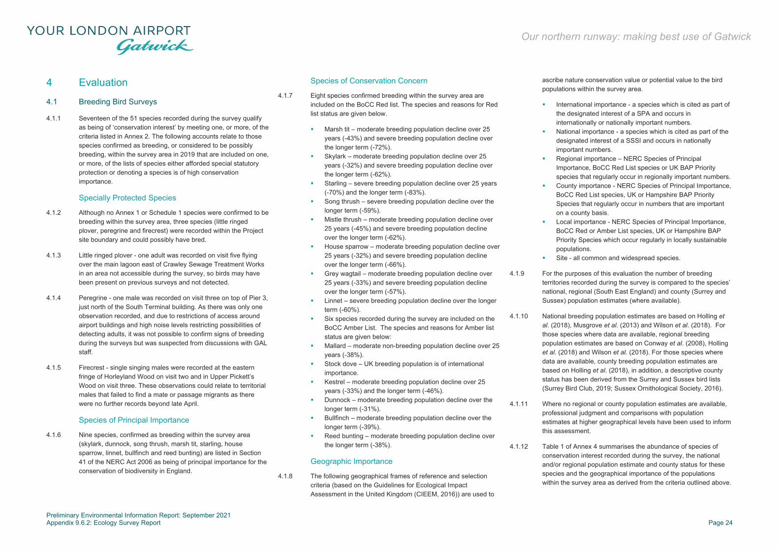
Preliminary Environmental Information Report: September 2021 Appendix 9.6.2: Ecology Survey Report Page 24
Our northern runway: making best use of Gatwick
4 Evaluation
4.1 Breeding Bird Surveys
4.1.1 Seventeen of the 51 species recorded during the survey qualify as being of ‘conservation interest’ by meeting one, or more, of the criteria listed in Annex 2. The following accounts relate to those species confirmed as breeding, or considered to be possibly breeding, within the survey area in 2019 that are included on one, or more, of the lists of species either afforded special statutory protection or denoting a species is of high conservation importance.
Specially Protected Species
4.1.2 Although no Annex 1 or Schedule 1 species were confirmed to be breeding within the survey area, three species (little ringed plover, peregrine and firecrest) were recorded within the Project site boundary and could possibly have bred.
4.1.3 Little ringed plover - one adult was recorded on visit five flying over the main lagoon east of Crawley Sewage Treatment Works in an area not accessible during the survey, so birds may have been present on previous surveys and not detected.
4.1.4 Peregrine - one male was recorded on visit three on top of Pier 3, just north of the South Terminal building. As there was only one observation recorded, and due to restrictions of access around airport buildings and high noise levels restricting possibilities of detecting adults, it was not possible to confirm signs of breeding during the surveys but was suspected from discussions with GAL staff.
4.1.5 Firecrest - single singing males were recorded at the eastern fringe of Horleyland Wood on visit two and in Upper Pickett’s Wood on visit three. These observations could relate to territorial males that failed to find a mate or passage migrants as there were no further records beyond late April.
Species of Principal Importance
4.1.6 Nine species, confirmed as breeding within the survey area (skylark, dunnock, song thrush, marsh tit, starling, house sparrow, linnet, bullfinch and reed bunting) are listed in Section 41 of the NERC Act 2006 as being of principal importance for the conservation of biodiversity in England.
Species of Conservation Concern
4.1.7 Eight species confirmed breeding within the survey area are included on the BoCC Red list. The species and reasons for Red list status are given below.
Marsh tit – moderate breeding population decline over 25 years (-43%) and severe breeding population decline over the longer term (-72%).
Skylark – moderate breeding population decline over 25 years (-32%) and severe breeding population decline over the longer term (-62%).
Starling – severe breeding population decline over 25 years (-70%) and the longer term (-83%).
Song thrush – severe breeding population decline over the longer term (-59%).
Mistle thrush – moderate breeding population decline over 25 years (-45%) and severe breeding population decline over the longer term (-62%).
House sparrow – moderate breeding population decline over 25 years (-32%) and severe breeding population decline over the longer term (-66%).
Grey wagtail – moderate breeding population decline over 25 years (-33%) and severe breeding population decline over the longer term (-57%).
Linnet – severe breeding population decline over the longer term (-60%).
Six species recorded during the survey are included on the BoCC Amber List. The species and reasons for Amber list status are given below:
Mallard – moderate non-breeding population decline over 25 years (-38%).
Stock dove – UK breeding population is of international importance.
Kestrel – moderate breeding population decline over 25 years (-33%) and the longer term (-46%).
Dunnock – moderate breeding population decline over the longer term (-31%).
Bullfinch – moderate breeding population decline over the longer term (-39%).
Reed bunting – moderate breeding population decline over the longer term (-38%).
Geographic Importance
4.1.8 The following geographical frames of reference and selection criteria (based on the Guidelines for Ecological Impact Assessment in the United Kingdom (CIEEM, 2016)) are used to
ascribe nature conservation value or potential value to the bird populations within the survey area.
International importance - a species which is cited as part of the designated interest of a SPA and occurs in internationally or nationally important numbers.
National importance - a species which is cited as part of the designated interest of a SSSI and occurs in nationally important numbers.
Regional importance – NERC Species of Principal Importance, BoCC Red List species or UK BAP Priority species that regularly occur in regionally important numbers.
County importance - NERC Species of Principal Importance, BoCC Red List species, UK or Hampshire BAP Priority Species that regularly occur in numbers that are important on a county basis.
Local importance - NERC Species of Principal Importance, BoCC Red or Amber List species, UK or Hampshire BAP Priority Species which occur regularly in locally sustainable populations.
Site - all common and widespread species.
4.1.9 For the purposes of this evaluation the number of breeding territories recorded during the survey is compared to the species’ national, regional (South East England) and county (Surrey and Sussex) population estimates (where available).
4.1.10 National breeding population estimates are based on Holling et al. (2018), Musgrove et al. (2013) and Wilson et al. (2018). For those species where data are available, regional breeding population estimates are based on Conway et al. (2008), Holling et al. (2018) and Wilson et al. (2018). For those species where data are available, county breeding population estimates are based on Holling et al. (2018), in addition, a descriptive county status has been derived from the Surrey and Sussex bird lists (Surrey Bird Club, 2019; Sussex Ornithological Society, 2016).
4.1.11 Where no regional or county population estimates are available, professional judgment and comparisons with population estimates at higher geographical levels have been used to inform this assessment.
4.1.12 Table 1 of Annex 4 summarises the abundance of species of conservation interest recorded during the survey, the national and/or regional population estimate and county status for these species and the geographical importance of the populations within the survey area as derived from the criteria outlined above.

Preliminary Environmental Information Report: September 2021 Appendix 9.6.2: Ecology Survey Report Page 25
Our northern runway: making best use of Gatwick
4.1.13 The level of geographical importance of the breeding populations of species of conservation interest is local for all species except little ringed plover, peregrine, marsh tit and firecrest. peregrine was possibly present in numbers of regional importance; little ringed plover was possibly present in numbers of county importance; firecrest was possibly present in numbers of county importance and marsh tit was confirmed as present in numbers of county importance.
4.1.14 A single adult little ringed plover was recorded on visit five near Crawley sewage treatment works (in an area of restricted access). The breeding population of little ringed plover is stable in the UK although, in recent decades, the species has expanded its range further into Wales, northern England and south and east Scotland.
4.1.15 A single observation of peregrine falcon was recorded just north of the South Terminal building during visit three. The UK population of peregrine has increased in recent years, particularly lowland populations as found in Surrey and Sussex. Reasons for increases in populations of peregrines in the lowlands include increasing use of human structures as breeding sites (eg pylons), abundant availability of prey and a lack of conflict with humans.
4.1.16 The confirmed marsh tit territory was recorded within Upper Pickett’s Wood on the eastern side of the Project area. Marsh tit populations in the UK (including Surrey and Sussex) have undergone severe declines. Contributory factors in these declines include habitat loss, increased woodland isolation, loss of woodland understorey and reductions in dead wood availability (Vanhinsbergh et al., 2001).
4.1.17 Two observations of singing firecrests were recorded during the survey; one on the eastern side of Horleyland Wood on visit two and the other in Upper Pickett’s Wood on visit three. Firecrest populations in the UK (including Surrey and Sussex) have increased rapidly in recent years.
4.1.18 With the exception of the four species discussed above, the bird community recorded during the survey was considered typical for the habitats present within survey area. Whilst the majority of species recorded are common and widespread in Surrey and Sussex, the habitats within the survey area do provide breeding habitat for an assemblage of species of conservation importance.
Diversity of the Breeding Bird Assemblage
4.1.19 The number of species recorded in an area is a simple measure of diversity that can indicate the site’s importance. Table 4.1.1
shows the criteria outlined in Fuller (1980) for breeding bird assemblages to indicate the importance of sites at various geographic levels.
Table 4.1.1: Breeding Bird Assemblage Diversity Criteria
National Importance
Regional importance
County importance
Local importance
Number of species
85+ 70-84 50-69 25-49
4.1.20 Based on Fuller’s criteria, the breeding bird assemblage of 48-51 species recorded within the survey area in 2019 was at the lower limit of county importance and upper limit of local importance. However, it should be noted that Fuller’s analysis was developed in the 1970’s since when species diversity has declined significantly. As a result, Fuller’s thresholds are considered too high for today’s breeding bird populations. Taking this into consideration, the diversity of the breeding assemblage should be considered as of county importance.
4.1.21 Overall, the breeding bird assemblage within the Project site boundary was considered to be of county importance due to the diversity of species present and the presence of three species breeding, or possibly breeding, in numbers of county importance and one species possibly breeding in numbers of regional importance.
Potential Impacts on the Breeding Bird Assemblage
4.1.22 If no mitigation measures were put in place, potential impacts of the Project on the bird populations identified during the survey include:
direct loss of habitat during the construction phase; indirect loss (through disturbance) of both on-site and
adjacent habitat during the construction phase(s); disturbance of breeding birds and their dependent young
(both on-site and within adjacent breeding habitat) during the construction phase;
indirect loss (through disturbance) of both on-site and adjacent habitat during the post-construction phase, eg due to additional activity within, or close to, retained habitats; and
fragmentation of natural/semi-natural habitats.
Conclusion
4.1.23 The survey of breeding birds recorded a breeding assemblage of 51 species in 2019. The survey undertaken from March-July 2019 was undertaken during the peak breeding period.
4.1.24 Of the 51 species recorded as breeding or possibly breeding within the survey area, 17 species meet at least one of a range of criteria relating to special statutory protection or conservation importance.
4.1.25 No breeding population of any species within the survey area approaches the 1% level of the national population. Therefore, no species considered to be breeding or possibly breeding are present in nationally important numbers.
4.1.26 One species (peregrine), possibly breeding within the survey area meets the 1% level of the regional population and was considered to be possibly breeding in regionally important numbers.
4.1.27 Two species (little ringed plover and firecrest), possibly breeding within the survey area meet the 1% level of the county (Surrey and/or Sussex) population and are considered to be possibly breeding in numbers of county importance.
4.1.28 One species (marsh tit) was confirmed breeding within the survey area and met the 1% level of the county (Surrey and/or Sussex) population and was considered to be breeding in numbers of county importance.
4.1.29 Records of black redstart were provided in the desk study data from 2013, with the last breeding records from 2012. Black redstart species were previously recorded around the Old Control Tower (landside). The habitat around this area was found to continue to provide some suitable breeding and foraging opportunities for black redstart; however, none were recorded during surveys undertaken between winter and spring 2019.
4.1.30 The diversity of species present within the survey area was at a level indicative of county importance for breeding birds.
4.1.31 If no mitigation or compensation measures were put in place the Project would cause direct and indirect loss of suitable breeding and foraging habitat.

Preliminary Environmental Information Report: September 2021 Appendix 9.6.2: Ecology Survey Report Page 26
Our northern runway: making best use of Gatwick
4.2 Wintering Bird Surveys
4.2.1 A total of 61 species were recorded within the survey area during the wintering bird surveys undertaken between October 2018 and March 2019.
4.2.2 There were no wintering species recorded in any numbers which were considered to be of national or international significance (ie >1% of the wintering population) and in all cases, the numbers of birds recorded were considerably below this threshold.
4.2.3 The area within the Project site boundary was considered to be of site-level importance for wintering lapwing based on the peak counts for these species and their current conservation status; lapwing were predominantly recorded around the Crawley Sewage Treatment Works in the east of the Project site. However, the overall wintering bird population within the site was considered as being of no more than local importance.
4.3 Reptile Surveys
4.3.1 A good size population of grass snake was identified in grassland habitats along the River Mole in the west of the Project site.
4.3.2 Individual grass snakes were also identified around wetland habitats in the east of the site suggesting a separate low sized population.
4.3.3 The two areas where grass snake were recorded were disconnected from each other. The habitats between them were associated with the airport and comprised low value habitats for grass snake. Therefore, the survey results indicate two separate populations are present.
4.4 Great Crested Newt Surveys
4.4.1 Thirty-six ponds were identified within the Project site boundary.
4.4.2 Four ponds were identified as having great crested newts present. Ponds W46 was identified as having a medium sized great crested newt population, Ponds K5F and TTD were identified as having small populations of great crested newt.
4.4.3 Although no great crested newt adults were identified within Pond 8N8, great crested newt eggs were identified within the marginal vegetation and an eDNA survey produced a positive result for great crested newt.
4.4.4 Both ponds K5F and TTD had great crested newt eggs recorded within their marginal vegetation meaning that these along with Pond 8N8 are viable populations.
4.4.5 The distribution of the ponds indicates two great crested newt metapopulations are present.
4.4.6 Common toad was also recorded in habitat within the survey area. The toads were located in Pond W46 and within the field south of Brockley Wood.
4.5 Bat Surveys
Bat Assemblage
4.5.1 From field surveys undertaken between April and October 2019, at least 12 species of bat have been confirmed within the Project site boundary and surrounding area. These include:
one very rare species – barbastelle; three rare species – Nathusius’ pipistrelle, Brandt’s bat and
whiskered bat; one scarce species – Leisler’s bat; two uncommon species – noctule and serotine; and five common species – common pipistrelle, soprano
pipistrelle, Daubenton’s bat, Natterer’s bat and Plecotus sp.
4.5.2 Although Myotis species are notoriously difficult to distinguish from sound analysis alone, a number of calls were characteristic to those of Brandt’s/whiskered bat, Daubenton’s bat and natterer’s bat. Therefore, these species have been included in the account below as they are likely to be present but from bat sound analysis alone their presence cannot be confirmed.
4.5.3 Desk study records confirmed the presence of two additional species within the search area, Bechstein’s Myotis bechsteinii and Alcathoe Myotis alcathoe, which are considered very rare and rare species.
4.5.4 Species classified as very rare, rare, scarce and uncommon are as such because of restricted distribution and/or low to moderate populations.
4.5.5 Bats unidentified to species level comprised pipistrelle bats and Myotis species.
4.5.6 The highest levels of activity were recorded at Location 3 (Brockley Wood) (41,710 passes), Location 7 (Horleyland Wood) (37,967 passes), Location 6 (Perimeter Road East) (28,845 passes) and Location 11 (Crawter’s Wood) (14,161 passes),
indicating the importance of these woodland habitats to the bat assemblage within the Project site boundary and wider area.
4.5.7 A total of three barbastelle passes were recorded during the static surveys, comprising two passes at Location 1 (Land west of the Fire Training Ground) in September and one pass at Location 9 (Perimeter Road South) in July. This indicates that barbastelle use the woodland and woodland edge immediately to the south and west of the airport. Barbastelle’s use a range of habitats and forage over a wide area.
4.5.8 Nathusius’ pipistrelle were recorded during both transect and static surveys. During static surveys peak counts of 63 and 32 passes were recorded at Location 6 (Perimeter Road East) and Location 8 (Land East of the Railway Line Wetland) respectively. The majority of passes (83) were recorded in June, July and August. This coincides with likely higher levels of activity associated with the maternity season. In general, higher numbers of Nathusius’ pipistrelle were recorded to the north and east of the Project site boundary, suggesting that they use the woodland associated with the Crawley Sewage Treatment Works, Riverside Garden Park and railway corridors for foraging and commuting.
4.5.9 Common and widespread species such as common pipistrelle and soprano pipistrelle were abundant throughout the survey area with moderate to high levels of activity recorded during both transect and static surveys. Common pipistrelle were the most frequently recorded species during static surveys, accounting for over 65% of the species composition across all locations. At Locations 6 and 9, common pipistrelle accounted for over 98% of all bat passes recorded between April-October.
4.5.10 Pipistrelle bats are generally flexible in their habitat requirements for foraging and commuting and are able to utilise a range of habitats in both urban and rural landscapes.
4.5.11 Plecotus species are generally a woodland species, although can be found utilising other habitats such as parkland. Peak counts of Plecotus species were recorded at Location 3 (Brockley Wood) (249 passes), Location 4 (North of the Long Stay North car park) adjacent to the River Mole corridor (70 passes) and Location 7 (54 passes). Plecotus species were recorded in generally low numbers throughout the Project site and were not recorded at either Location 8 or Location 9 during static surveys.
4.5.12 Higher numbers of Myotis species passes were generally associated with the woodland areas, such as Brockley Wood, Horleyland Wood, Upper Pickett’s Wood and Riverside Garden Park. A total of 7,277 Myotis passes were recorded at Location 3

Preliminary Environmental Information Report: September 2021 Appendix 9.6.2: Ecology Survey Report Page 27
Our northern runway: making best use of Gatwick
(Brockley Wood) with peak counts of 3,102 passes and 1,728 passes recorded in May and July respectively. These periods coincide with likely higher levels of activity associated with the pre-maternity and maternity seasons. A large number of Myotis bat passes were also recorded along the woodland edges associated with the River Mole Corridor in the west of the survey area. Although not confirmed through sound analysis, a proportion of these calls (particularly within the woodland) are likely to be from Bechstein’s, which are known to be present in the area and typically roost and forage within deciduous woodland.
4.5.13 Daubenton’s bats, which are commonly associated with habitats found within the area, including broadleaved woodland and standing water were detected during transect surveys, notably along Transect 2 and Transect 5.
4.5.14 Some of the Myotis sp. calls were characteristic of Whiskered and/or Brandt’s bats, which were recorded along Transects 1 and 5. Both species are characteristic of woodland habitat, although to a lesser extent for Whiskered bats. Brandt's bats tend to forage at low and medium heights in the woodland canopy and are more likely to forage over open water, whereas Whiskered bats favour more woodland edges, close to vegetation, hedgerows and open habitats, including flowing water.
4.5.15 Several calls of Myotis sp. bats were characteristic of natterer’s bat and recorded along Transects 1, 3 and 5. As much of the species prey is taken from foliage and normally fly at low altitudes (less than 5 metres), the woodland around Transects 1 and 3 and the woodland edge along the eastern and south western boundary of Transect 5 provide suitable foraging habitats for natterer’s.
4.5.16 Moderate to high levels of bat activity of scarce and uncommon species, Leisler’s, noctule and serotine, were recorded predominantly in areas of open riparian habitat, in comparison to those recorded along linear features (such as the river and railway corridors). These species often fly over open habitat, making them easier to detect.
4.5.17 Peak counts of noctules were recorded at Location 2 (Land south west of the River Mole) with 1,088 passes and Location 8 with 1,237 passes; the detectors in these locations were situated in more open areas of habitat. Noctules are a fast, high-flying species when foraging and commuting. They are typically associated with broadleaved woodland and open pasture and it
was unlikely that the fragmentation of habitats would impact upon this species.
Foraging Habitat
4.5.18 Areas of significant bat foraging activity were recorded within the woodland areas across the survey area and water bodies (Old Lagoon and New Lagoon) associated with Crawley Sewage Treatment Works in the east of the Project site. The patchy wooded landscape and associated riparian habitats are likely to provide optimum foraging habitat for a variety of species including Myotis bats, pipistrelles and long-eared bats.
4.5.19 High levels of foraging activity were recorded along Transect 5, adjacent to the Aviation Museum; the boundary habitats here comprised of mature trees and hedgerows, woodland edge and the River Mole along the eastern boundary of the transect route.
4.5.20 The landscape in the area generally comprised large areas of woodland and interconnecting hedgerows and other linear features which provide links to high value habitat across the wider area.
4.5.21 The presence of less common and rare species suggests that the overall quality of the habitats present are able to support populations of large numbers of bats and a high diversity of species, which contributes to the importance of foraging habitat in this area.
Commuting Habitat
4.5.22 The woodland compartments connected by watercourses, mature hedgerows and tree lines provided suitable habitat to support the bat assemblage in this area.
4.5.23 Significantly lower levels of commuting activity were recorded along Transect 4, with only a handful of common pipistrelle passes recorded. This was likely to be due to the lack of suitable habitat and the presence of strong artificial light and noise emanating from the airport and surrounding ancillary buildings.
4.5.24 Overall, the continuity of connective habitat was likely to provide an extensive network of habitat features suitable for a wide range of commuting bats, providing links to the wider landscape in this area.
Crossing Point Surveys
River Mole
4.5.25 A total of 1278 bat passes from at least five species were observed using the feature over three survey visits, with the highest total number of passes from common pipistrelle (1017) and the lowest total number from brown long-eared bat (3). This indicates that bats recorded foraging and commuting could be impacted by river diversion works and increased use of aircraft.
4.5.26 Nineteen roosting locations for Bechstein’s bats were identified in 2020 and 2021 using advanced bat survey techniques within Brockley Wood, which is located 30m to the north of River Mole.
4.5.27 The River Mole was identified as a core foraging area for this species from radiotracking surveys undertaken in 2019, 2020 and 2021. It was identified as a core foraging area in 2019 for a male and a peripheral foraging area for two males, out of the seven Bechstein’s bats which were radio-tracked in 2019. It was identified as a core foraging area for three out of the fourteen Bechstein’s bats which were radio-tracked in 2020 and 2021. These included a lactating female, a post-lactating female and an adult male.
4.5.28 Flightlines along the River Mole were identified for three males and one of the non-breeding females in 2019, out of the seven bats which were radio-tracked. No flightlines were recorded from bat roosts to foraging areas in 2020 and 2021 as the majority of bats were recorded close to their roosting locations
4.5.29 Twenty-four passes of Myotis species bats were recorded flying within the river corridor or directly above it. This, in conjunction with results of advanced bat survey techniques, indicates that Myotis bats species, likely including Bechstein’s bats, are using the River Mole corridor to move across the landscape and for foraging.
Riverside
4.5.30 A total of 1159 passes from at least five species were observed using the feature over three survey visits, with the highest total number form common pipistrelle (654) and the lowest from brown long-eared bat (2).
4.5.31 Of the passes observed using the feature, 18.64% were observed passing at an “unsafe height” and 81.36% were observed passing at a safe height. The definition of safe and unsafe height is based on the assumption that the proposed road improvements will be at the current height of the ground.

Preliminary Environmental Information Report: September 2021 Appendix 9.6.2: Ecology Survey Report Page 28
Our northern runway: making best use of Gatwick
4.5.32 The Riverside Park was identified as a core foraging area for Bechstein’s bats using advanced bat survey techniques in 2019. This area was identified for one of the seven Bechstein’s bats, an adult male radio-tracked in 2019. None of the fourteen Bechstein’s bats radio-tracked in 2020 and 2021 was recorded foraging within Riverside Park.
4.5.33 A total of 18 passes of Myotis species were recorded within Riverside Park. This, in conjunction with the results of advanced bat survey techniques, indicates that Myotis bats species, likely including Bechstein’s bats, are using Riverside Park for foraging and commuting.
Assessment of importance
River Mole
4.5.34 This location is confirmed as an important commuting route and foraging area for bats. River Mole is considered to be an important commuting route at regional level common pipistrelle, at county level for noctule and soprano pipistrelle, and at local level for brown long-eared bat. The River Mole is considered to be an important foraging area at county level for noctule and common pipistrelle, and at local level for brown long-eared bat and soprano pipistrelle.
4.5.35 Although it was not possible to distinguish between Myotis species om the basis of call parameters, twenty-four passes of Myotis species bats were recorded and the radio-tracking surveys confirmed that three Bechstein’s bats out of a sample size of seven bats used the Rive Mole corridor as a core or peripheral foraging area in 2019, and that three Bechstein’s bats out of a sample size of fourteen bats used the Rive Mole corridor as a core foraging area in 2020 and 2021. This indicates that the River Mole is likely to be an important foraging area for Bechstein’s at regional level.
4.5.36 The radio-tracking surveys confirmed the River Mole to be used as a flightline by three Bechstein’s bats out of a sample of seven bats. This indicates that the River Mole is likely to be an important commuting route for Bechstein’s at regional level.
4.5.37 The calculations used for the assessment of importance are presented by species in tables 5.3.1 and 5.3.2.
Riverside Park
4.5.38 This location is confirmed as an important commuting route and foraging area for bats. Riverside is considered to be an important commuting route at regional level for common pipistrelle and
soprano pipistrelle and at local level for brown long-eared bat. This feature is considered to be an important foraging area at county level for common pipistrelle and soprano pipistrelle, and at local level for brown long-eared bat.
4.6 Invertebrate Scoping Survey
4.6.1 Several of the sites under discussion present features of potential value to invertebrates which were considered to have a moderate invertebrate interest that would likely be raised above the expected regional background level.
4.7 Terrestrial Invertebrate Survey
4.7.1 Surveys of the NWZ and LERL identified a diverse assemblage of terrestrial invertebrates in these areas, including a range of scarce and unusual species.
4.8 Aquatic Invertebrate Survey
4.8.1 Several species designated under Section 41 of the NERC Act (2006) were identified by the desk study.
4.8.2 In 2019, the invertebrate habitat appraisal identified that Pond M and the ditches adjacent to Pentagon Field had features of moderate invertebrate interest above the expected regional background level.
4.8.3 Further detailed assessment of the River Mole and Gatwick Stream found both watercourses supported macroinvertebrate communities indicative of moderately polluted conditions, exacerbated by relatively low flow conditions and high levels of sedimentation. Dense macrophyte growth on the River Mole is contributing to acute reductions in dissolved oxygen which are impacting on the macroinvertebrate assemblage.
4.8.4 The presence of one record from 2013 of shining ram’s-horn snail, an IUCN Red List species and UK species of principal importance under the 2006 NERC Act. Although not recorded during the survey, there remains a possibility that the species may occur at the site of the 2013 record at the downstream end of the desk study area.
4.8.5 The Gatwick Stream appears to be impacted by both organic pollution and silt deposition, possibly from a storm water discharge outlet from a nearby industrial area.
4.8.6 The invasive New Zealand mud snail was identified at the River Mole and Gatwick Stream sites, and signal crayfish were observed at both the Gatwick Stream sites during each visit
4.9 Fish Survey
4.9.1 The desk study identified that brown trout had previously been recorded within the Project site boundary, although it was not recorded in surveys in 2020. Brown trout is listed under Section 41 of the NERC Act (2006).
4.9.2 Both the River Mole and Gatwick Stream had consistently high fish populations. This is likely to be a consequence of stable temperature and DO conditions caused by shading and potentially high abundances of pollution tolerant macroinvertebrates such as Oligochaete worms as a food source.
4.10 Limitations
4.10.1 A number of survey limitations occurred during the 2019 survey periods. The most frequently occurring limitations across a range of surveys included:
a lack of access to certain areas required to complete surveys;
unsuitable weather conditions; and high levels of noise and lighting.
4.10.2 Further details are given below of specific limitations effecting each survey.
Breeding Birds
4.10.3 There were some limitations to the 2019 Gatwick reeding bird survey, these included:
restrictions on land access from landowners and restricted areas airside. This included no access south of the runway during survey visit two, due to visibility restrictions in place at the time;
excessive noise levels from aircraft and associated activities, particularly during airside surveys, which may have reduced / impeded distance to which vocalisations were detected; and
moderate to poor weather conditions during the first day of both survey visits two and four.
4.10.4 In light of the above limitations to the survey methodology, consideration has been made during the analysis of survey data and in the writing of this report with regard to:

Preliminary Environmental Information Report: September 2021 Appendix 9.6.2: Ecology Survey Report Page 29
Our northern runway: making best use of Gatwick
the possibility of species presence not being detected during the survey; and
the likelihood of a reduced number of territories being detected.
4.10.5 The majority of ecological data remain valid for only short periods due to the inherently transient nature of the subject. The survey results contained in this report are considered accurate for one year.
Wintering Birds
4.10.6 During the sixth and seventh survey visits within part of area A3 Land East of the Railway Line, a group of travellers had gotten into the fields south of Upper Picketts Wood and left a lot of rubbish piled up and destroyed some of the refugia, so these areas were not surveyed in the last two surveys,
Great Crested Newt Surveys
4.10.7 Six ponds were not able to be accessed due to restriction on the surrounding land, therefore we cannot rule, without further surveys on these, that they are not suitable to support great crested newt.
4.10.8 Ponds C24 and 29A were not included within the original surveys. However, HSI conducted outside of optimal survey season (September 2019) identified that Pond C24 had a ‘good’ habitat score and Pond 29A had an ‘average’ habitat score for great crested newt.
4.10.9 The other waterbodies, which were mainly drainage and runoff ditches, were not surveyed but could be used by great crested newt and be impacted on by the Project.
Bat Transects
4.10.10 The routes for Transects 1, 3 and 5 were modified between April and May, and 3 and 5 were changed again from June onwards.
4.10.11 Along Transect 3, a minor deviation was made to the route through the Riverside Garden Park to include a broader range of habitats along the northern and southern boundaries of the park; for Transect 5, the route deviated to incorporate an area of land to the north of the original transect route, which included a large area of pasture land and wooded hedgerows adjacent to Man’s Brook. Transect 1 was changed due to the original transect being too complex to reliably duplicate over subsequent transects. The deviations from the original route are not thought to be a limitation to the results, as the new routes incorporate a larger and more
diverse area, which could potentially be utilised by a greater variety of species.
4.10.12 The first post-maternity survey along Transect 2 was cancelled due to access constraints. Although the survey was not rescheduled, this is not considered to be a limitation of the results.
4.10.13 A number of static detectors failed to record data for a minimum of five nights due to equipment failure and malfunction. Where this occurred, the species assessment is conservative to account for gaps in the information.
4.10.14 A proportion of species are likely to be underrepresented in the analysis, such as long-eared bats. This is likely due to their call characteristics, which are comparatively quiet compared to that of other species. In order for the detectors to record long-eared bat calls, bats must fly within 3 metres of the microphone.
4.10.15 In addition, the calls of Myotis and long-eared bat species are notoriously difficult to distinguish and therefore calls were only analysed down to species level where they were characteristic of that species and present within suitable habitat. Although Bechstein’s were not confirmed through sound analysis of activity data, it is likely that a proportion of unidentified Myotis bat calls are from Bechstein’s bat, which are known to be present within the woodlands surveyed.
4.10.16 Additional survey techniques, including bat trapping and radio-tracking surveys ensured that the presence of this species was accounted for and included within the assessment of the overall bat assemblage at Gatwick.
4.10.17 Sound analysis was not possible for a small number of transect surveys during the pre-maternity and maternity seasons due to equipment failure and malfunction, therefore some species’ accounts and interpretation are based on field observations only. This was not thought to be a limitation to the results and the species assessment was conservative to account for these gaps in information.
5 Conclusions 5.1.1 The ecology surveys undertaken on the Project site boundary
found that the majority of the centre of the site, associated with the airport and infrastructure, comprised buildings, areas of hardstanding, amenity grassland and introduced shrubs and
trees. They provided some areas of suitable habitat for breeding birds but were otherwise of overall low ecological value.
5.1.2 The habitats within the Project site boundary that surrounded the airport supported a number of higher value habitats, including semi-natural broadleaved woodland, scrub and trees, semi-improved neutral grassland, marshy grassland, ponds, rivers and hedgerows.
5.1.3 These areas were considered higher value habitats which supported a more diverse flora and fauna, especially within the associated Land East of the Railway Line wetland and woodland in the south east of the Project site boundary and the areas around the River Mole. They supported a variety of breeding birds, including species of conservation concern and were well used by foraging and commuting bats, including some rare bat species.
5.1.4 Populations of great crested newt and grass snake were found in these habitats within the Project site boundary.
6 References Bat Conservation Trust (2011) Statement on the impact and design of artificial light on bats. Bat Conservation Trust, London.
Bat Conservation Trust (2014) Artificial lighting and wildlife Interim Guidance: Recommendations to help minimise the impact of artificial lighting on bats. Bat Conservation Trust, London.
Berthinussen A. and Altringham, J. (2015). Development of a cost-effective method for monitoring the effectiveness of mitigation for bats crossing linear transport infrastructures. Defra Research Project WC1060]
Bibby, C.J., Burgess, N.D., Hill, D.A. & Mustoe, S.H. (2000) Bird Census Techniques, second edition. Academic Press, London.
Bicker, R. (2018) Gatwick Biodiversity Action Plan: Five Year Review 2012-2017.
CIEEM (2016) Guidelines for Ecological Impact Assessment in the UK and Ireland, second edition. Chartered Institute of Ecology and Environmental Management.
Collins J. (ed.) (2016) Bat surveys for Professional Ecologists: Good practice guidelines (3rd Edition). Bat Conservation Trust, London.
Preliminary Environmental Information Report: September 2021 Appendix 9.6.2: Ecology Survey Report Page 30
Our northern runway: making best use of Gatwick
Conway, G.J., Burton, N.H.K., Handschuh, M. and Austin, G.E. (2008) UK population estimates from the 2007 Breeding Little Ringed Plover and Ringed Plover Surveys, BTO Research Report No. 510. British Trust for Ornithology, Thetford, Norfolk.
Department for Environment, Food and Rural Affairs (Defra) (2007) Hedgerow Survey Handbook: A standard procedure for local surveys in the UK. DEFRA, London.
Eaton, M., Aebischer, N., Brown, A., Hearn, R., Lock, L., Musgrove A., Noble D., Stroud, D. and Gregory, R. (2015) Birds of Conservation Concern 4. The population status of birds in the United Kingdom, Channel Islands and Isle of Man. British Birds 108, 708-746
English Nature (2001) Great Crested Newt mitigation guidelines. English Nature, Peterborough.
Fawcett-Williams, K. (2019) Thermal Imaging: Bat Survey Guidelines. Bat Conservation Trust, London
Fuller, R. J. (1980) A Method for Assessing the Ornithological Interest of Sites for Conservation. Biological Conservation 17, 229-239.
Gilbert, G., Gibbons, D.W. and Evans, J. (1998) Bird Monitoring Methods: A manual of techniques for key species. RSPB/BTO/JNCC/WWT/ITE/The Seabird Group. RSPB/BTO, Sandy, Beds.
Holling, M. and the Rare Breeding Birds Panel (2018) Rare breeding birds in the United Kingdom in 2016. British Birds 111, 644-694.
Imboden, C. (1974) Resettlement and Breeding Season of the Northern lapwing Vanellus vanellus in Europe. Orn. Beob. 71, 5–134.
Joint Nature Conservation Committee (JNCC) (2010) Handbook for Phase 1 Habitat survey: a technique for environmental audit (revised reprint). Joint Nature Conservation Committee, Peterborough.
Kirby, S. and Lack. P, C. (1993) Spatial dynamics of wintering Lapwings and Golden Plovers in Britain and Ireland, 1981/82 to 1983/84. Bird Study 40, 38-50.Lack, P.C. (1986) The atlas of wintering birds in Britain and Ireland. T. &. A.D. Poyser, Calton.
Met Office (2021). Cool, wet May brings a Spring of marked contrasts. Available at: https://www.metoffice.gov.uk/about-
us/press-office/news/weather-and-climate/2021/cool-wet-may-concludes-spring-of-marked-contrasts [ Accessed 07.06.2021]
Musgrove, A., Aebischer, N., Eaton, M., Hearn, R., Newson, S., Noble, D., Parsons, M., Risely, K, and Stroud, D. (2013) Population estimates of birds in Great Britain and the United Kingdom. British Birds 106, 64-100.
Rodwell, S. (1995) British Plant Communities: Volume 4 Aquatic Communities, Swamps and Tall-Herb Fens. Cambridge University Press, Cambridge.
Surrey Bird Club (2019) The Surrey List https://surreybirdclub.org.uk/records/surrey-list/ [accessed September 2019].
Sussex Ornithological Society (2016) The Sussex List https://www.sos.org.uk/the-sussex-list [accessed September 2019].
Vanhinsbergh, D., Fuller, R.J & Noble, D.G. (2001) A Review of Possible Causes of Recent Changes in Populations of Woodland Birds in Britain, BTO Research Report 245. British Trust for Ornithology, Thetford, Norfolk.
Wilson, M. W., Balmer, D. E., Jones, K., King, V. A., Raw, D., Rollie, C. J., Rooney, E., Ruddock, M., Smith, G. D., Stevenson, A., Stirling-Aird, P. K., Wernham, C. V., Weston, J. M., & Noble, D. G. (2018) The breeding population of Peregrine Falcon (Falco peregrinus) in the United Kingdom, Isle of Man and Channel Islands in 2014. Bird Study 65: 1-19.

Preliminary Environmental Information Report: September 2021 Appendix 9.6.2: Ecology Survey Report Annex 1
Our northern runway: making best use of Gatwick
Annex 1
Survey Methodologies

Preliminary Environmental Information Report: September 2021 Appendix 9.6.2: Ecology Survey Report Annex 1
Our northern runway: making best use of Gatwick
A1.1 Survey Methodologies
National Vegetation Classification Surveys
A1.1.1 A National Vegetation Classification (NVC) survey was carried out following the methodology and guidelines detailed in the Joint Nature Conservation Committee’s (JNCC) NVC User’s Handbook (Rodwell et al., 2006).
A1.1.2 Fieldwork was carried out on the 8–12 April, 8–12 July and 6–8 August 2019 by Alex Powell Grad CIEEM (Chartered Institute of Ecology and Environmental Management), a qualified ecologist and botanist. The survey was undertaken during the optimal time for both grassland and woodland botanical surveys.
A1.1.3 A general walkover of the site was carried out to identify homogenous stands of vegetation within the survey boundary.
A1.1.4 Quadrat data was collected (1 metre x 1 metre quadrats) from within their represented stands of homogenous vegetation. Plant species within their quadrats were recorded following the nomenclature in Stace (2010). Percentage cover and DOMIN values were also recorded for each species. A breakdown of DOMIN values and their estimated percentage cover are outlined in Table 2.1.1.
A1.1.5 The habitat community was identified for each homogenous stand of vegetation using the computer programme TABLEFIT. The TABLEFIT programme computes ‘Goodness of Fit’ between quadrat data (from sampled vegetation) and the published NVC tables (which define the NVC communities and sub-communities). This gives an initial indication of which NVC types the data are most likely to have been drawn from – the highest coefficient does not necessarily indicate the correct NVC diagnosis.
A1.1.6 It was then necessary to identify the NVC type through careful consideration of the NVC descriptions in British Plant Communities (Rodwell, 1991, 1992, 1995, 2000; Rodwell et al., 2000). There is no guarantee that the highest coefficient corresponds to the ‘correct’ NVC diagnosis.
A1.1.7 DOMIN scale and percentage cover estimates:
Table A1.1.1: DOMIN Scale and Percentage Cover Estimates
Cover DOMIN value
<4 % (few individuals) 1
<4 % (several individuals) 2
<4% (many individuals) 3
4 – 10 % 4
11 – 25 % 5
26 – 33 % 6
34 – 50 % 7
51 – 75 % 8
76 – 90 % 9
90 – 100 % 10
Hedgerow Surveys
A1.1.8 The hedgerow survey followed the methodology and guidance set out in the Hedgerow Survey Handbook: A standard procedure for local surveys in the UK (Department for Environmental, Food and Rural Affairs (Defra), 1997) and involved surveying 30 metre lengths of hedgerow.
A1.1.9 A hedgerow is defined as any boundary line of trees or shrubs over 20 metres long and less than 5 metres wide at the base, provided that at one time the trees or shrubs were more or less continuous. All hedgerows consisting of at least one woody UK native species are UK BAP priority habitats.
A1.1.10 Hedgerow surveys were undertaken on 5–8 August 2019 and all hedgerows were surveyed for whether they were protected or not. The method is based on definable lengths of hedgerow between two end points, that were identified as:
any point of connection between two, or more, hedgerows or to other features eg fences, walls, ditches, roads;
the point at which a hedgerow stops and there is a gap of more than 20 metres to the next hedgerow (eg where the hedgerow ends in the middle of a field); and
the point at which the hedgerow links to a woodland or other semi-natural habitat such as a pond.
A1.1.11 Three additional end points were included in the assessment, where there was significant variation and the hedgerow needed refining, these were:
the point at which the hedgerow changes character from one hedgerow type to another for 20 metres or more;
where there is a distinct change in hedgerow height for lengths of 20 metres or more; and
the ends of lengths (20 metres or more) of recent planting, coppicing or laying.
A1.1.12 Each section between two end points was considered a separate hedgerow and was surveyed as such. 30 metre lengths of each hedgerow were identified where, either the hedge was 30 metres or less in length then the whole hedge was surveyed or, if the hedge was between 30-100 metres then the central 30 metres of hedgerow was surveyed; or, if the hedge was between 100-200 metres long then the hedgerow was divided into two and the central 30 metres of the two sections was surveyed; or finally, if the hedge was over 200 metres it was divided into three sections and the central 30 metres of each of the thirds was surveyed.
A1.1.13 To be considered protected, the hedgerow had to exhibit one of the following:
it had an average of seven or more woody species in the surveyed section(s);
it had an average of six woody species in the surveyed section(s) and three or more features from:
- a wall or bank along half or more of the length; - a ditch along half or more of the length; - an average of one standard tree or more per 50 metres of
hedgerow; - gaps which do not add up to more than 10% of the hedge; - three woodland understorey species; - a parallel hedge within 15 metres; or - connections scoring four points. Connections to a hedge
scores one point. Connections to a pond or wood score two points;
it has six woody species and one of the following rare trees – black poplar, large leaved lime, small leaved lime, wild service tree;
it has an average of five wood species on average in the surveyed section(s) and has four or more features listed above (bullet point two);
it has four woody species on average in the surveyed section(s); is adjacent to a footpath, bridleway, byway open to all traffic (but not necessarily a normal adopted vehicular highway unless it also is one of these) and has two or more features listed above (bullet point two).

Preliminary Environmental Information Report: September 2021 Appendix 9.6.2: Ecology Survey Report Annex 1
Our northern runway: making best use of Gatwick
Breeding Bird Surveys
A1.1.14 The breeding bird survey undertaken was based on a standard territory mapping methodology as outlined in Gilbert et al. (1998) and Bibby et al. (2000).
A1.1.15 This method is based on the principle that the majority of species are territorial during the breeding season. This results in birds occupying discrete territories and displaying various behaviours (eg conspicuous song, visual display and periodic disputes with neighbouring individuals) allowing their location and abundance to be estimated.
A1.1.16 The survey area (Project site boundary), as shown in Figure 2.4.1, was walked at a slow pace in order to locate and identify all individual birds. Visits were undertaken early in the morning, finishing before midday. All of the site was covered where land access was granted or where it was safe to do so given constraints of operational airport. There was no access airside on visit one of survey so an extra visit to site to make up for this was carried out on the 27th of June. On the second visit, there was no access to the south-side of main runway due to a necessary enforcement of a visibility restriction preventing movement of security vehicles. No extra visits were conducted to cover this. Suitable optical equipment was used to observe bird behaviour and all accessible parts of the survey area were approached to within 50-100 metres. Survey routes were mapped and the direction walked alternated on each visit, to ensure that all areas were covered at various times of morning across the duration of the survey. All species encountered within the survey area were recorded and mapped.
A1.1.17 Surveys for breeding birds were undertaken in spring/summer 2019 with a total of seven survey visits taking place. The survey visits and ornithologist undertaking the survey were as follows:
Visit 1: 27 and 28 March 2019 - Andrew Seth; Visit 2: 9 and 10 April 2019 - Andrew Seth; Visit 3: 23 and 24 April 2019 - Andrew Seth; Visit 4: 7 and 8 May 2019 - Andrew Seth; Visit 5: 21 and 22 May 2019 - Andrew Seth; Visit 6: 5 and 6 June 2019 - Andrew Seth; and Visit 7: 27 June 2019 (’airside’ only) - Andrew Seth.
A1.1.18 On each visit, registrations were recorded directly into ESRI Arcpad GIS software loaded on handheld PDA devices, with a 1:10,000 scale Ordnance Survey base map of the Project area and adjacent land. A fresh map was used for each survey.
Registrations of birds were recorded using standard British Trust for Ornithology (BTO) two letter species codes (BTO, 2009). Specific codes were also used to denote singing, calling, movement between areas, flight, carrying food, nest building, aggressive encounters and other behaviour.
A1.1.19 The expected outcome of a territory mapping survey is that mapped registrations fall into clusters approximately coinciding with territories. A cluster is generally a spatially distinct group of registrations that represent the activity of not more than one territorial male or pair. Ideally, clusters include registrations of territorial behaviour across all visits and are clearly demarcated from adjacent clusters by simultaneous recording of neighbouring birds. Where a species exhibits high territory density, the mapping of simultaneously singing birds becomes essential. Territory boundaries are assumed to be between such birds.
A1.1.20 Territory mapping methods produce analysis maps of non-overlapping ellipses encircling clusters of records thought to relate to separate territorial males or breeding pairs. These ellipses may not show the entire extent of a pairs’ actual breeding territory, which may be significantly larger; however, they are likely to show those areas in which the pair is most active.
A1.1.21 On completion of the surveys, analysis maps were produced for each species, consisting of all registrations recorded during the survey. From these species maps, the number of territories was calculated by identifying the number of clusters present.
A1.1.22 Standard registration mapping techniques were also used to record non-breeding species.
A1.1.23 The following definitions have been used to identify the breeding status of the species recorded.
Confirmed breeding: includes species for which territories were positively identified as a result of the number of registrations, the location of an active nest, and the presence of recently fledged young or downy young.
Probable breeding: includes a pair observed in suitable nesting habitat in breeding season, or agitated behaviour / anxiety calls from adults suggesting probable presence of nest or young nearby. Behaviour was observed on insufficient occasions to confirm the presence of a territory.
Possible breeding: includes species observed in breeding season in suitable nesting habitats or singing male present (or breeding calls heard) in breeding season in suitable breeding habitat.
Non-breeding: fly-over species observed but suspected to be on migration, or species observed but suspected to be summering non-breeder.
Assessment Criteria
A1.1.24 The assessment of the breeding bird community within the Project site boundary includes a focus on species that are afforded special statutory protection or those included on one, or more, of the lists of species of conservation interest, these include:
Species listed on Annex 1 of the EC Birds Directive (Directive 2009/147/EC).
Species listed on Schedule 1 of the Wildlife and Countryside Act 1981 (as amended).
Species included on the Section 41 list of Species of Principal Importance of the Natural Environment and Rural Communities (NERC) Act 2006.
Species included in the Birds of Conservation Concern (BoCC) Red and Amber Lists (Eaton et al., 2015).
Species occurring in nationally, regionally or locally important numbers.
A1.1.25 Annex 1 species are those for which the UK Government are required to take special measures, including the designation of Special Protection Areas (SPAs), to ensure the survival and reproduction of these species throughout their area of distribution.
A1.1.26 Schedule 1 species are those which, along with their nests, eggs and dependant young, are afforded additional protection during the breeding season.
A1.1.27 The NERC list of Species of Principal Importance is used to guide decision-makers such as public bodies, including local and regional authorities, in implementing their duty under section 40 of the NERC Act 2006; under Section 40 every public authority (eg a local authority or local planning authority) must, in exercising its functions, have regard, so far as is consistent with the proper exercise of those functions, to the purpose of conserving biodiversity. In addition, with regard to those species on the list of Species of Principal Importance prepared under Section 41, the Secretary of State must:
“(a) take such steps as appear to the Secretary of State to be reasonably practicable to further the conservation of the living
Preliminary Environmental Information Report: September 2021 Appendix 9.6.2: Ecology Survey Report Annex 1
Our northern runway: making best use of Gatwick
organisms and types of habitat included in any list published under this section”, or
“(b) promote the taking by others of such steps.”
A1.1.28 Species listed on the BoCC Red List are those that have declined in numbers by 50% over the last 25 years, those that have shown a historical population decline between years 1800 and 1995 and species that are of global conservation concern. The 67 species on the Red List are of the most urgent conservation concern.
A1.1.29 Species listed on the BoCC Amber List, of which there are currently 96, include those that have shown a moderate decline in numbers (25%-49%) over the last 25 years and those with total populations of less than 300 breeding pairs. Also included are those species which represent a significant proportion (greater than 20%) of the European breeding or wintering population, those for which at least 50% of the British population is limited to ten sites or less, and those of unfavourable conservation status in Europe.
A1.1.30 The remaining species are placed on the Green List, indicating that they are of low conservation priority. These species still receive full protection through the provisions of the Wildlife and Countryside Act 1981, as amended.
Wintering Bird Surveys
A1.1.31 The wintering bird surveys were based on a transect survey methodology as detailed in Bibby et al. (2000) and Gilbert et al. (1998).
A1.1.32 The survey area (Project site boundary) is shown on Figure 2.4.1.
A1.1.33 The transect route was selected to include all field boundaries and visit all areas of the Project site boundary to within 200 metres, where possible. Visits were undertaken early in the morning.
A1.1.34 On each visit the route was walked at a slow pace with start and finish times noted. All birds seen and heard were recorded directly onto an ArcGIS base map using ESRI software on hand-held PDA devices, with a 1:10,000 scale Ordnance Survey base map of the study area (and adjacent land). A fresh map was used for each survey. Registrations of birds were recorded using standard BTO two letter species codes.
A1.1.35 All bird species were recorded and mapped across the whole Project site, where accessible.
A1.1.36 Surveys for wintering birds were undertaken between October 2018 and March 2019. A total of five survey visits were undertaken, each over two consecutive days. The survey visits and ornithologist undertaking the survey were as follows:
Visit 1: 30 and 31 October 2018 - Andrew Seth; Visit 2: 22 and 23 November 2018 - Andrew Seth; Visit 3: 19 and 20 December 2018 - Andrew Seth; Visit 4: 23 and 24 January 2019 - Andrew Seth; and Visit 5: 20 and 21 March 2019 - Andrew Seth.
A1.1.37 An assessment of the ornithological importance of the survey area during the winter period was made by evaluating the species recorded against the following criteria:
Annex 1 of the EU Birds Directive; UK BAP priority bird species; NERC Species of Principal Importance; and BoCC Red and Amber Lists (Eaton et al., 2015).
A1.1.38 Reference is not made to species afforded special protection under Schedule 1 of the Wildlife and Countryside Act (1981) as the protection measures only apply to these species within the breeding season.
Reptile Surveys
A1.1.39 The reptile survey followed the recommended methodology described in the Herpetofauna Worker’s Manual (Joint Nature Conservation Committee (JNCC), 2003) and Froglife’s Surveying for Reptiles (Froglife, 2016). It was undertaken by experienced ecologists and was conducted in areas of the site identified as containing the most favourable habitat for reptiles.
A1.1.40 Reptiles are best surveyed from April following hibernation until June and then again in September. At this time of year, the sun is often shining but air temperatures are low, so reptiles spend a long time basking and are therefore more easily observed.
A1.1.41 The reptile survey was conducted using artificial refugia made from corrugated tin and roofing felt measuring 50 cm x 50 cm and 50 cm x 100 cm. These provide shelter and basking opportunities for reptiles, which can be recorded on or under the refugia in suitable weather conditions.
A1.1.42 On the 26-28 March, 29 May and 7 August reptile refugia was placed in areas identified as providing the greatest suitability for reptiles and which had optimal basking opportunities. The locations of the refugia are shown on Figures 3.6.1a – 3.6.1e.
A1.1.43 The refugia were left undisturbed for ten days prior to the first survey being undertaken in order to allow them to bed down and to give them time for reptiles to find them. In order to conform to best practice guidelines, the refugia was inspected on seven separate survey visits and a visual search was undertaken when the refugia were being laid.
A1.1.44 On each of the visits every refugia was inspected for reptiles basking on top and was then lifted to identify any reptiles beneath. The number, species, age class and where possible, sex of each reptile observed was recorded.
A1.1.45 Visit times were selected to coincide with suitable weather conditions and times of day when refugia would be acting as heat traps which would attract reptiles to use them whilst basking. Periods of strong wind or heavy rain were avoided, and surveys were typically undertaken during periods of sunshine and when air temperatures were between 10°C and 18°C.
A1.1.46 Froglife (1999) provides a basic index of relative abundance of reptiles based on peak survey counts (Table 1 of the guidance). The figures in the table refer to the maximum number of adults seen by direct observation and/or on or under refuges by one person in one day.
Great Crested Newt Surveys
Habitat Suitability Index (HSI)
A1.1.47 HSI assessments of all ponds within 250 metres of the Project scoping boundary were undertaken, where access was allowed. All ponds were reassessed to consider any changes since the original assessment, such as desiccation rate.
A1.1.48 An HSI is a numerical index, between 0 and 1 where 0 indicates unsuitable habitat and 1 represents optimal habitat.
<0.5: poor; 0.5 – 0.59: below average; 0.6 – 0.69: average; 0.7 – 0.79: good; and >0.8: excellent.
A1.1.49 The HSI methodology for great crested newts has been developed to assess the suitability of ponds for use as breeding sites. The assessments were made in accordance with the methodology set out in Advice Note 5 published by the Amphibian and Reptile Group UK (ARGUK) (ARGUK, 2010).

Preliminary Environmental Information Report: September 2021 Appendix 9.6.2: Ecology Survey Report Annex 1
Our northern runway: making best use of Gatwick
A1.1.50 The HSI incorporates ten suitability indices, all of which are factors thought to affect the likelihood of great crested newt presence. The ten indices are location, pond area, pond drying, water quality, shade, waterfowl, fish, other ponds within 1 km, terrestrial habitat and macrophytes.
eDNA
A1.1.51 The surveys were conducted by great crested newt license holders. The surveys followed the eDNA surveying and laboratory analysis techniques as described by Biggs et al. (2014).
A1.1.52 Water samples were collected using sampling kits supplied by NatureMetrics Ltd.
A1.1.53 Surveyors collected 30ml water samples from Ponds 30Z, 8N8, A, AA21, FFJ and AVF along the margins of the waterbody using a sterile ladle. Surveyors collected the sample from the bank edge and did not enter the water.
A1.1.54 Where access allowed, the samples were collected from points evenly spaced along the waterbody. Samples were spread out as much as possible to ensure a representative sample was collected and to ensure the effectiveness of the survey was not compromised.
A1.1.55 The surveyors used the ladle to gently agitate the water to mix the water column, whilst taking care not to disturb and collect any sediment. The samples collected were emptied into a sterile plastic bag and homogenised by gently shaking the bag to ensure eDNA was evenly mixed through the sample.
A1.1.56 A pipette was used to collect 15 ml subsamples of the pond water from the bag into sterile tubes already containing 35 ml of ethanol to preserve the eDNA sample.
A1.1.57 The samples were then removed from site and sent off to NatureMetrics Ltd for analysis. The water samples were analysed using the quantitative Polymerase Chain Reaction (qPCR) eDNA test.
A1.1.58 Biggs et al. (2014) has demonstrated the effectiveness of eDNA in the detection of great crested newt. In detailed field studies eDNA detected great crested newt 99.3% of the time in ponds where they were known to occur.
Bottle Trapping
A1.1.59 Bottle traps constructed from 2 L plastic drinks bottles supported on bamboo canes were located at approximately 2 metre
intervals around the edge of each pond. On each survey visit traps were set out before dusk and were emptied and removed the next morning before 10 am. Traps were always placed ¾ submerged so that they contained at least ¼ air; they also had air holes in the exposed ends. The species, number and sex of newts captured in the traps were recorded and the newts were carefully released back into the pond from which they were caught.
Torch Survey
A1.1.60 The shoreline of each water body was scanned after dusk using a high powered torch of 1,000,000 candlepower. The perimeter and centre of the pond were slowly scanned with the torch and the number, and where possible sex, of any amphibians seen was recorded.
Egg Searching
A1.1.61 Egg searches are undertaken by searching for folded leaves on marginal and aquatic vegetation around the perimeter of a pond and carefully opening them up to reveal newt eggs.
A1.1.62 The eggs of great crested newts can be distinguished from those of other species by their size and colour.
Dormouse Surveys
A1.1.63 A dormouse nest tube survey was undertaken based on methodology and best practice guidelines set out in the dormouse conservation handbook, second edition (Bright, Morris and Mitchell-Jones, 2006).
A1.1.64 A total of 684 dormouse tubes were set out on site 1– 8 April 2019 and 22 May. They were tied to suitable vegetation around the site following standard survey guidelines (English Nature 2006), to provide nesting opportunities for any dormice present (Figure 3.8.1).
A1.1.65 Survey visits have been undertaken regularly in suitable weather conditions between May and June, with additional monthly visits until November 2019. Following the table of probability of finding dormice in the Dormouse Conservation Handbook (Table 5 – English Nature, 2006) and assuming the tubes are in situ until September, this gives a score in excess of 20 which is considered an acceptable level of survey.
Aquatic Mammal Surveys
Otter Survey
A1.1.66 The otter survey was undertaken with regard to the methodology described in the Design Manual for Roads and Bridges, Volume 10 Section 4, Part 4 (Highways Agency et al., 2001). The methodology was developed for linear schemes which are likely to affect otter habitats or populations but was adopted for this site.
A1.1.67 The suitable areas along the River Mole were walked and examined in detail for evidence of the presence of otter in the form of characteristic field signs.
A1.1.68 The following field signs were searched for:
spraints; prints; holts and couches; slides and runs; and feeding remains.
Water Vole Surveys
A1.1.69 The water vole surveys were carried out on the 13 and 14 May 2019 by suitably experienced ecologists.
Describe Location of Survey/Surveys.
A1.1.70 Although they do not hibernate, water voles are not very active above ground during the winter, so surveys are best carried out between April and October when field signs are most abundant.
A1.1.71 The survey was carried out in accordance with guidelines of best practice set out in the water vole Conservation Handbook – Third Edition (Strachan et al., 2011).
A1.1.72 The suitable areas along the River Mole were walked and examined in detail for evidence of the presence of water vole in the form of characteristic field signs.
A1.1.73 Wherever possible, the banks were inspected on both sides, from the water’s edge to the top of the bank.
A1.1.74 American mink is a non-native, invasive species listed under Section 9 of the Wildlife and Countryside Act 1981 (as amended). They predate on water voles and are considered to be to one of the main reasons for the dramatic decline in the size of the water vole population in the UK. Therefore, incidental signs of this species observed during the survey were also noted.

Preliminary Environmental Information Report: September 2021 Appendix 9.6.2: Ecology Survey Report Annex 1
Our northern runway: making best use of Gatwick
A1.1.75 The following water vole field signs were sought during the survey work.
Field Signs
Latrines
A1.1.76 Droppings are the most distinctive field sign. These are about 8-12 mm long and 4-5 mm wide, cylindrical and symmetrical with blunt ends. Colouration varies from green, brown, black and even purple, depending on what food has been eaten and its water content. They have the texture of putty when fresh but when dry may show green concentric rings of fine plant material if broken open. Rat droppings are always larger than water vole droppings and have an unpleasant odour. Most droppings are deposited at discrete latrine sites near the nest, at range boundaries and where they enter and leave the water. Latrines are established and maintained from February to November. Scent from the lateral flank glands is deposited on the latrine when the vole drum marks with its hind feet, so that many latrines often show a flattened mass of old droppings, topped with fresh ones.
Feeding Stations
A1.1.77 Food items are often brought to favoured feeding stations along voles’ pathways or at haul-out platforms along the water edge. These show feeding remains as a neat pile of chewed lengths of vegetation. The sections are typically up to 10 cm long showing the marks of the two large incisors and are quite good field signs of the presence of water vole. These chopped sections of vegetation are often taken into the burrow entrances by the voles and laid up as stores along the tunnels or in chambers.
Burrows
A1.1.78 Water vole burrow entrances are typically wider than high with a diameter of between 4-8 cm. At the water’s edge the entrances may occasionally appear larger due to erosion, but the tunnel soon contracts down to the size of two fingers. Externally the burrow system appears as a series of holes along the water’s edge, some at or just above the water level on steep banks, some opening below the water line and others occurring within the vegetation up to five metres from the water’s edge (for access to food and for ventilation). At the water’s edge spoil excavated from the burrows tends to be washed away while those burrows opening high on the bank are probably dug from underground as no spoil can normally be found around them.
Lawns
A1.1.79 Around land holes, grazed ‘lawns’ can be found. These frequently occur when the female is nursing young and time away from the nest is kept to a minimum. The female grazes the vegetation short to the ground within easy reach of the hole; often by not fully leaving the hole and being wary to dart back should danger threaten.
Nests
A1.1.80 Both males and females take bedding underground to line nest chambers in the burrow system. Nurseries consist of a large ball of finely shredded grasses or reed and the chamber entrance may be plugged by the female with loose soil or grass. Where vegetation cover is dense and the water table is high, nests roughly the same size and shape of a rugby ball can sometimes be found above ground, often woven into the bases of rushes, sedges or reed.
Footprints
A1.1.81 Although footprints may be readily found along the soft margin of a watercourse (of many species besides water voles) they are not the easiest field sign to use. Large adult water vole tracks will appear very similar to those of juvenile rats. As with all rodents, the imprints show four toes in a star arrangement from the forefoot and five toes of the hind foot with the outer ones splayed, but often the tracks of the hind feet partially overlap those of the fore. The hind foot typically measures between 26-34 mm and is noticeably smaller than that of the Common Rat at 40-45 mm (heel to claw measurements). The Brown Rat is also heavier and so leaves a deeper impression.
Runways in Vegetation
A1.1.82 These are most often found within 2 metres of the water’s edge and take the form of low tunnels pushed through the vegetation. Pathway width may be 5-9 cm broad and often branch many times, leading to the water’s edge, burrow entrances or favoured feeding areas. Rat runs on the other hand are usually very obvious as clear or bare pathways linking burrows and often running along the bank away from the water’s edge.
Assessing Population Size
A1.1.83 Water voles live in colonies, but string themselves out along a watercourse through a series of contiguous territories. Breeding
female water voles are territorial but may share territory with their female offspring. Males have home ranges which overlap with the territories of a number of females and other males. A female’s territory length typically varies between 30 metres to 150 metres and a male’s home range from 60 metres to 300 metres.
A1.1.84 The number of water vole latrines present gives an indication of the strength of the water vole colony. Approximately six latrines are maintained per breeding female. However, larger and more robust populations show a large number of closely packed latrines. Typically, fewer maintained latrines are present when water vole populations are small and fragmented.
Preliminary Bat Roost Assessment
Buildings
A1.1.85 An assessment of the suitability of the buildings for bat roosting potential, within the landside and airside areas of the Project site, was undertaken at the same time as the Phase 1 Habitat Survey.
A1.1.86 The survey included a thorough, ground level inspection of the exterior of all accessible buildings and the features of the building listed below were noted:
type; age; wall construction, in particular the type of material used; form of the roof, in particular the presence of gable ends,
hipped roofs etc and the nature and condition of the roof; and
the general condition of the building.
A1.1.87 The above information would inform the potential for roost features to be present and identify potential bat access points and roost places and field signs of bats being present.
A1.1.88 When suitable features were identified, they were inspected for signs indicating use or possible use by bats including tiny scratches, staining and flies around the entry points, bat droppings and feeding remains in, around and below entrances, distinctive smell of bats and the smoothing of surfaces around cavities.
A1.1.89 Guidance from the Bat Conservation Trust (BCT) (2016) on the features of buildings which correlate with their use by bats was considered.

Preliminary Environmental Information Report: September 2021 Appendix 9.6.2: Ecology Survey Report Annex 1
Our northern runway: making best use of Gatwick
A1.1.90 Preliminary bat roost assessments of buildings can be carried out at any time of year; however, summer surveys are more likely to reveal signs of bat activity.
Trees
A1.1.91 Details on the methodology for bat roost assessment of trees is to follow.
Bat Emergence/Re-entry Surveys
A1.1.92 In order to comply with best practice guidelines (Collins, 2016) emergence surveys were carried out on any buildings considered to have bat roosting potential. Surveys were undertaken between May–October 2019. The aim of these surveys was to determine the use of the buildings (if any) by roosting bats, the species assemblage within the Project site and the egress locations of any bats emerging from the buildings.
A1.1.93 Observations were made outside the buildings from where it was considered bats might emerge. The dusk survey commenced 15 minutes before sunset, and lasted for approximately 90 minutes, to record any bats that may emerge from the buildings.
A1.1.94 During each survey visit, the building was continuously surveyed by up to three experienced ecologists and visual observations were made of the where bats emerged/re-entered and in what direction they were flying to or from. Behavioural observations were also recorded for any bats encountered on site or within the vicinity, including direction of flight and activity observed eg foraging or commuting.
A1.1.95 Elekon Batlogger and Anabat bat detectors were used to record bat echolocation calls of any emerging bats and identify species, where possible.
A1.1.96 Bat activity can be strongly dependent on weather conditions; therefore, the surveys were only carried out in favourable conditions when bat activity was deemed to be likely (sunset temperature 10ºC or above, no rain or strong wind).
Bat Activity Transect Surveys
A1.1.97 A total of five transect routes were devised to cover a broad range of the habitat types present on site but focusing on those likely to be of greatest value to bats, including woodland, woodland edges, river corridors and open grassland. A brief overview of each transect route is as follows.
Transect 1
A1.1.98 Transect 1 was devised to include potentially high value habitat in the south eastern part of the Project site (within the airport’s biodiversity area), including the old and new lagoons associated with the Crawley Sewage Treatment Works (hereafter referred to as ‘the sewage works’) and immediately surrounding woodland areas, including Upper Pickett’s Wood to the south east and Horleyland Wood to the north west.
A1.1.99 The lagoons and open water habitats were considered to provide good opportunities for a wide variety of bats to forage upon, so too the woodland. Additionally, the woodland habitat would provide foraging and roosting opportunities for a wide variety of species associated with this habitat type, including pipistrelle and Myotis species.
A1.1.100 The transect route also incorporated the corridors between woodland compartments, including those to the north of the Crawley Sewage Treatment Works and adjacent to the Long Stay South Car Park. These areas would likely be used for foraging and commuting bats.
Transect 2
A1.1.101 Transect 2 focussed on areas of potentially high value habitat, immediately to the south of Transect 1 and the Crawley Sewage Treatment Works.
A1.1.102 The transect route covered large areas of open grassland to the east of the railway corridor, the woodland edges and connecting habitat which linked woodland corridors and linear features, such as the Gatwick Stream and railway line, to the Crawley Sewage Treatment Works and Horleyland Wood.
A1.1.103 These linear features were considered to potentially provide good commuting corridors between woodland compartments, further linking to the wider area. The large areas of open grassland would likely provide foraging opportunities for larger species of bats, such as noctule, Leisler’s and serotine bats which typically exploit these types of habitats.
Transect 3
A1.1.104 Transect 3 covered areas of potentially high value habitat in the north eastern part of the Project site.
A1.1.105 The transect included a narrow strip of woodland between the railway line and A23 London Road, heading north towards the
main trunk road leading to the M23. From there, the transect covered Riverside Garden Park, which included areas of both dense and open canopy woodland, grassland and a large pond in the south of the park. Gatwick Stream ran adjacent to the transect route along the north eastern edge of the Project site boundary.
A1.1.106 The habitats present along the transect route were considered likely to provide a range of opportunities for both woodland and larger bat species to forage upon. The woodland edges, railway corridor and stream would likely provide linear features for bats to commute along to access areas of high value habitat to the north and south of the Project site boundary, including the woodland compartments adjacent to Crawley Sewage Treatment Works.
Transect 4
A1.1.107 Transect 4 covered an area in the southern part of the site, adjacent to buildings and car parks (X and Z) associated with the airport.
A1.1.108 The transect also included small strips of woodland located between the A23 London Road and Perimeter Road South, and between the staff car park and Charlwood Road. Part of the transect incorporated the length of Crawter’s Brook which sits between Perimeter Road South and the southern boundary of the airport.
A1.1.109 The transect route aimed to incorporate habitat which could potentially be used as commuting corridors between different woodland compartments, linking to further suitable habitat within the wider landscape.
Transect 5
A1.1.110 Transect 5 covered a broadly open area of habitat, Land East of the Aviation Museum, in the north west of the Project site.
A1.1.111 The transect incorporated areas of potentially high value habitat such as mature hedgerows and tree lines, Man’s Brook to the north of the Project site and the River Mole and woodland corridor along the east of the transect route. The River Mole and woodland corridor further linked to large areas of woodland to the north and south of the Project site, including Brockley Wood.
A1.1.112 The woodland corridor to the east of the transect route would likely provide strong commuting links, for all bat species, to areas of suitable foraging and roosting habitat within the wider are, particularly to the open and diverse mosaic of habitat to the north

Preliminary Environmental Information Report: September 2021 Appendix 9.6.2: Ecology Survey Report Annex 1
Our northern runway: making best use of Gatwick
west of the airport. The large areas of open grassland within the Project site boundary would likely provide foraging opportunities for larger bat species, such as noctule, Leisler’s and serotine bats which typically exploit these types of habitats.
Methods
A1.1.113 Each transect was surveyed twice per month between April-October 2019. Each visit commenced at least fifteen minutes before sunset and continued until at least two hours after sunset.
A1.1.114 On each visit, two ecologists walked along the transect at a steady speed starting at opposite points of the transect to ensure the full transect route was covered and to reduce bias associated with levels of bat activity at particular times of day/night. Several spot-sampling locations were included, distributed evenly along the transect route. The surveyors stopped at each of these points for between three and five minutes and recorded all bat activity seen and/or heard.
A1.1.115 Visual observations for bats were undertaken by scanning the skyline, and bat detectors were used to listen to and record echolocation calls. Elekon Batlogger and Anabat bat detectors were used, and recordings were made. For any bats encountered, notes were made on location, species or species group, behavioural observations (eg direction of flight, habitat) and activity heard (eg feeding buzzes or social calls).
A1.1.116 Bat activity can be strongly dependent on weather conditions; therefore, the surveys were only carried out in favourable conditions when bat activity was deemed to be likely (sunset temperature 10ºC or above, no rain or strong wind).
Bat Static/Automated Surveys
A1.1.117 A total of 11 Elekon Batlogger A units were deployed across the site between April-October 2019 for a minimum of five nights. The units were positioned at various locations, in order to sample a broad range of the habitat types present on site but focusing on those likely to be of greatest value to bats.
A1.1.118 The automated bat detectors were programmed to commence recording approximately 15 minutes before sunset and terminating 30 minutes after sunrise. This period covered the peak time bats would be commuting to and from their roosts.
Bat Data Analysis
A1.1.119 The bat passes were recorded, and all bats were identified to species level, where possible, on site. Echolocation calls were subsequently analysed using computer software (BatExplorer and Kaleidoscope) for confirmation of species. Where possible, additional notes on size, flight height, type of flight (such as commuting, foraging, fast or slow) and direction of flight were also recorded.
A1.1.120 All sound files were subject to manual analysis by an experienced bat ecologist. Where possible, identification was carried out to species level. Bats of the species group Myotis and long-eared bat species are notoriously difficult to distinguish and therefore calls were only analysed down to species level where they were characteristic of that species and present within suitable habitat.
A1.1.121 The number of bat passes recorded is not representative of the number of bats present within any given area, as a single bat may have made many passes. Therefore, descriptions of bat species assemblage represent the minimum number present rather than a definite list of all species present.
A1.1.122 Where several bat species were present within a call segment, then all the species were tagged in the results spreadsheet. For example, a common pipistrelle, soprano pipistrelle and Myotis bat all calling simultaneously would result in three individual bat registrations for calculating bat pass counts.
Bat Crossing Point Surveys
A1.1.123 The methods generally follow the standard best practice (Berthinussen and Altringham, 2015). Any specific deviations due to objectives of the surveys are detailed where necessary.
A1.1.124 Crossing Point surveys were undertaken at two locations, River Mole corridor and Riverside Park, in August 2020, September 2020, May 2021 and June 2021. Table A1.1.2 summarises survey dates, personnel and location (easting and northing) for both crossing point locations.
Table A1.1.2: Crossing Point Surveyors and Locations
Crossing Point location
Easting Northing Dates of surveys and personnel
River Mole A
525699 140500 18/08/2020 (Sophie Bracken), 01/09/2020 (Sophie Bracken),
Crossing Point location
Easting Northing Dates of surveys and personnel
05/05/2021 (not valid due to unsuitable weather, Rosanna Marston), 18/05/2021 (Rosanna Marston) and 01/06/2021 (Sophie Bracken)
River Mole B
526002 140589
18/08/2020 (Viola Zanetta), 01/09/2020 (Viola Zanetta), 05/05/2021 (not valid due to unsuitable weather, Viola Zanetta), 18/05/2021 Viola Zanetta), 01/06/2021 (Viola Zanetta)
Riverside Park A
527619 142393
19/08/2020 (Viola Zanetta), 22/09/2020 (Viola Zanetta), 06/05/2021 (Sophie Bracken), 02/06/2021 (Viola Zanetta)
Riverside Park B
527629 142392
19/08/2020 (Sophie Bracken), 22/09/2020 (Robin Searle), 06/05/2021 (Rosanna Marston), 02/06/2021 (Jennifer Crossman)
A1.1.125 The locations were selected using the results of trapping and radio-tracking surveys undertaken in 2019, which recorded Bechstein’s bats flying along the River Mole and foraging within Riverside Park as well as due to potential impacts to the areas in relation to a new flood mitigation strategy and North Terminal Junction improvements.
A1.1.126 The River Mole runs along a bare ground vehicle track and presents steep vegetated embankment at this crossing point location. Wildlife netting was present on both embankments at both locations A and B. It had also been installed across the river corridor at location A.
A1.1.127 Riverside Park is an area of public open space comprising broadleaved woodland with grassland glades and paths. It is bounded by Gatwick Stream which runs south-east to north-west. The crossing point is located in the north-west of Riverside Park along a public footpath, with woodland to the north, east and south, and Gatwick Stream to the west with its vegetated steep embankments covered in tall ruderals.
Preliminary Environmental Information Report: September 2021 Appendix 9.6.2: Ecology Survey Report Annex 1
Our northern runway: making best use of Gatwick
A1.1.128 The Defra research report (Berthinussen and Altringham, 2015) recommends undertaking a preliminary dusk and dawn survey at each location to determine if a feature can be considered a flight path when certain conditions are met. These conditions include that when surveying the feature at dusk and dawn on the same night more than either 10 bats of common species or five bats of rarer species must be recorded using the habitat feature per survey to consider it to be a flight path. After the first dusk visit these conditions were met and therefore it was considered that the lack of data at dawn is not a constraint to the survey results.
A1.1.129 Visits to each crossing point comprised observing bats at dusk, with surveys commencing 15 minutes before sunset and continuing for 120 minutes after sunset as advised by the Defra research report (Berthinussen and Altringham, 2015) when woodland-adapted bat species are present within the area.
A1.1.130 Two surveyors monitored each crossing point, one at either side of the habitat feature used by commuting bats.
A1.1.131 Each surveyor was provided with a Elekon Batlogger M full spectrum detector and with a thermal camera (FLIR T1020).
A1.1.132 The ultrasonic bat detectors were set to automatically record ultrasound between 13 and 155 kHz and signals were digitised at a rate of 312 kHz with 16-bit sampling depth. This allowed for the recording of any bat passes 1which were in close proximity of the surveyor.
A1.1.133 The thermal equipment was used with a combination of 45 degree lenses, thermal sensitivity <20mK at 30°C and an infrared resolution of 1024 x 768 pixels allowing for a maximum detection distance for a bat in flight to be of 104m (Fawcett-Williams, 2019).
A1.1.134 The data in radiometric format captured during the surveys was stored on an SD card inside the camera. Radiometric data allows analysis (Flir Tools) of thermal patterns in the images through thermal tuning and the use of different colour palettes. The object of interest can then be enhanced through thermal tuning with non-target objects falling outside the scale (Infrared Training Centre, 2017). The colour palettes allow different colours to be assigned to mark specific temperature levels. For this study, high contrast palettes were utilised to enhance small temperature
1 A single bat pass is defined as one or more clearly recognisable echolocation calls from a single species, separated from the next one by a gap of at least a second (Berthinussen and Altringham, 2015).
differences and improve the detectability of small moving objects (bats) against a varied background.
A1.1.135 Each surveyor/analyst recorded direct observation of bats, their species (where this could be accurately determined) and their flight behaviour, ground-level distance from the feature and height above the ground when observed. The closest distance the bat came to the feature was recorded, and for flight height during crossing, the lowest height was recorded. Incidental records of bat activity near the surveyor locations were also collected. Each passing bat was recorded as a separate observation, regardless of whether the same bat has clearly passed the surveyor more than once.
A1.1.136 Each pass was assigned species either by the surveyor in the field, or by matching recordings of the passing bat wither on the proforma, or the time the bat was observed during analysis. Recordings were analysed post-survey to determine the bat species they represent using Elekon BatExplorer. The output from sound analysis was subsequently checked against the surveyor’s identification, and changes made were necessary, favouring the identification made manually.
A1.1.137 For instances where recordings revealed more than one bat species present (eg a Myotis sp. and a Pipistrellus sp.) passes were included for each, but flight behaviour data was left as unknown for those which were not observed by surveyors/analysts.
A1.1.138 The output of sound and radiometric analysis was subject to a quality assurance process; a minimum of 10% of the sound files identified to each species / genus and a minimum of 30 minutes of radio-metric were verified by a principal grade analyst using BatExplorer of Flir Tools software.
A1.1.139 Data for each crossing point was categorised and presented the following information for each survey and location:
Total number of passing bats observed; Total number of passing bats observed per species; Number of bats using (passing within 5m distance of the
feature) and not using (passing further than 5m distance) the habitat feature;
2 This analysis is related to the proposed diversion of the River Mole and increase use of aircraft which would have potential impacts on commuting and foraging bats.
Number of bats flying at a ‘safe’ height at Riverside Park and therefore not at risk of collision, defined as passing at a height higher than 5m from the ground and based on the assumption that the proposed road improvements will be at the current height of the ground and any impacts from traffic would be within 5m height;
Number of bats using the River Mole (passing within 5m distance of the feature) at a height below or equal to ground level (within the river corridor), at a height comprised between ground level and 5m (directly above the river corridor) and at a height above 5m2; and
Species of bats heard but not seen.
A1.1.140 Safe and unsafe height are defined with reference to the maximum height for a heavy goods vehicle on UK roads which is 4.95m. It has been rounded to 5m for the purposes of analysis. Bats passing above this threshold were considered to not be at risk of collision.
Assessment of importance
A1.1.141 The value of the River Mole and Riverside Park as commuting routes and foraging areas for bat species have been calculated using Wray et al. (2010) where the rarity of the species involved, the approximate numbers of bats using them (based on crossing point survey data), the proximity of known roosts, and the nature and complexity of linear features in the landscape are all taken into account. The importance of the areas are assessed at a geographical level eg local, regional, national.
A1.1.142 It was not possible to carry out this assessment for species groups as rarity of single species within the groups varies greatly and sound analysis does not allow to separate species on the basis of call parameters. However, an assessment was made for Bechstein’s bats using crossing point survey data for Myotis species in conjunction with radio-tracking survey data from 2019, 2020 and 2021.
Data validity and limitations
A1.1.143 It is important to note that even where data are held, a lack of records for a defined geographical area does not necessarily mean that there is a lack of ecological interest; the area may be

Preliminary Environmental Information Report: September 2021 Appendix 9.6.2: Ecology Survey Report Annex 1
Our northern runway: making best use of Gatwick
simply under-recorded. Bats are highly mobile animals and can move roost sites both within and between years.
A1.1.144 Data from bat surveys should be considered to be valid for a period of 18 months, unless there are any meaningful changes to the buildings or other habitats within the site.
A1.1.145 Due to unseasonal low temperatures (below 7°C) and lack of bat activity the survey carried out at River Mole on 5th May 2021 is not considered valid. It was not possible to carry out a survey at River Mole on 17th May 2021 due to unsuitable weather conditions representative of rainfall being above the long-term averages for the month of May in the United Kingdom (Met Office, 2021). Both survey visits are scheduled to be repeated in July 2021. The report will need to be updated once these surveys are complete.
A1.1.146 The analysis of the data from surveys undertaken in early June in both locations has yet to be undertaken. The updated report will include the results from these surveys and will be presented in the ES.

Preliminary Environmental Information Report: September 2021 Appendix 9.6.2: Ecology Survey Report Annex 2
Our northern runway: making best use of Gatwick
Annex 2
Extended Results

Preliminary Environmental Information Report: September 2021 Appendix 9.6.2: Ecology Survey Report Annex 2
Our northern runway: making best use of Gatwick
A2.1 Extended Results
Phase 1 Habitat Surveys
Annex 2.1.1: Pond Descriptions
Gatwick Pond ID No.
Ecology ID number
Description
FCZ P1 No access was granted to this pond.
9VG P2 No access was granted to this pond.
Pond F P3 A Large man-made attenuation pond, a barrier crosses the middle running north to south and marginal vegetation was present around all the sides.
SM7 P4 Small pond behind services with poor water quality and little aquatic vegetation.
981 P5 Large pond within a woodland. No aquatic vegetation and little woodland ground flora. Mature trees surround pond and a film of algae across pond.
Pond G P6 Shallow pond with a silt bed that was mostly dry.
30Z P7 Large pond within Horleyland Wood. Pond has shallow banks and marginal vegetation.
8N8 P8 woodland pond flooded over into surrounding woodland and cutting off footpath to rest of woodland
W46 P9 Small man-made wildlife pond, lots of aquatic vegetation along the southern bank. Banks relatively steep sided with a fallen tree across middle.
Old Lagoon P10 Y shaped lagoon, man made, amenity grass banks and steep sided.
E11 P11 Long linear settlement pond, wider at eastern end, linked to the M23 spur road. Reeds and bulrush dominated.
Pond E P12 No access granted to this pond
A0A P13 Pond within Police training area, swamped with willow and surrounded by woodland.
MHA P14 Circular pond in the middle of the southern staff car park. The pond was surrounded with vegetation.
JCT P15 Outside Project boundary, no access granted.
Pond A P16 A pond located to the north of the runway near the fire training area. It was surrounded by dense bramble scrub and marginal vegetation such as pond sedge and bulrush
New Lagoon
P17 A circular sewage pond known as ‘New lagoon’ was a man-made, steep sided amenity grassland settlement lagoon.
Pond M P18 Settlement pond east of the biodiversity wall. A man made structure with steep concrete walls. Semi-improved grassland surrounded the pond. Only the eastern half of the pond held water.
WP9 P19 No access granted to this pond
AA20 P20 Awaiting further detail
AA21 P21 Awaiting further detail
K5F P22 A long pond with 0.5m high banks around the northern side. The southern bank was covered with scrub and inaccessible. Around all sides there was a large amount of aquatic vegetation.
TTD P23 A small circular man made pond surrounded by willow and pine trees. Aquatic vegetation was present around the eastern, northern and southern sides. A concrete outflow was identified in the south east corner of the pond.

Preliminary Environmental Information Report: September 2021 Appendix 9.6.2: Ecology Survey Report Annex 2
Our northern runway: making best use of Gatwick
Gatwick Pond ID No.
Ecology ID number
Description
C24 P24 Large pond around 30 metres x 20 metres Lots of marginal vegetation mainly bull rush completely dry willow and ash growing around edge
Pond D P25 A rectangular attenuation pond. It was concrete sided with an outflow into the Mole corridor.
Pond D P26 A triangular attenuation pond made from concrete and steep sided. The pond was surrounded by managed grassland.
293 P27 Large open fishing lake in middle of public park. Two islands within middle of the lake densely covered with trees.
FFJ P28 A small attenuation pond for the runway. Marginal vegetation was present here with rushes being dominant.
29A P29 A long thin man-made channel. 5m high sides with a fenceline around the top of it. Water was swamped by algae and had little aquatic vegetation, the banks were vegetated with tufted grass.
30P P30 Murky shallow pond with clear animal tracks leading to it.
AVF P31 A large pond within the Land East of the Aviation Museum covered with reeds and willowherb and algae topped. Nettle and willowherb ruderal surrounds the pond. Dog Kennel Pond
P32 A small manmade attenuation pond with steep banks showing high levels of maintenance. A diverse mix of aquatic and marginal vegetation was found within the pond.
Dog Kennel Pond
P33 A small manmade attenuation pond with steep banks showing high levels of maintenance. A diverse mix of aquatic and marginal vegetation was found within the pond.
AAA4 P34 Newly created pond along mole corridor.
1WH P35 Pond in centre of eastern part of woodland had a small amount of water in with a heavy covering of duckweed.
NU1 P36 Pond in centre of eastern part of woodland had a small amount of water in with a heavy covering of duckweed. Linked to Pond 1WH
Annex 2.1.2: List of Protected or Notable Species Identified During Botanical Survey
Species Name Common Name Protected or Notable Status Location
Briza minor Lesser quaking grass Nationally scarce River Mole
Epipactis lepochila Narrow-lipped helleborine Nationally scarce LERL Biodiversity area (woodland)
Hyacinthoides non-scripta Bluebell Schedule 8 LERL Biodiversity area (woodland, attenuation field)
Lychnis flos-cuculi Ragged robin Near Threatened River Mole
Mentha pulegium Pennyroyal UK BAP, Nationally Scarce, Endangered, Schedule 8, NERC S.41, Critically Endangered
Grassland along rail line
Polygonatum odouratum Solomon’s seal Nationally scarce LERL Biodiversity area (Woodland)
Annex 2.1.3: Invasive Plant Species Identified Across the Gatwick Project Boundary
Species Name Common Name Protected or Notable Status Location
Impatens glandifera Himalayan balsam Schedule 9 River Mole, Gatwick Stream, Airside Stream

Preliminary Environmental Information Report: September 2021 Appendix 9.6.2: Ecology Survey Report Annex 2
Our northern runway: making best use of Gatwick
Annex 2.1.4: Target Notes
Target Note Ref. Description
TN1 Location of pennypoyal
TN2 Large vegetated earth bank within Eastern Carparking
TN3 Horleyland Wood
TN4 Upper Pickett’s Wood
TN5 Solomons seal, narrow-lipped helleborine and bluebell locations
TN6a Plantation woodland 1
TN6b Plantation Woodland 2
TN6c Plantation Woodland 3
TN7 Brockley Wood
TN8 Large Area of Scrub near Brockley Wood
TN9 Lesser quaking grass, and ragged robin location
TN10a Western marshy grassland
TN10b Eastern marshy grassland
TN10c Marshy grassland along the River Mole
TN11 Large, 8 metres tall earth bank south west of Brockley Wood
TN12 Dog Kennel Wood
TN13 Crawter’s Wood
TN14 Area of isolated dense scrub
TN15 Area of dense, overgrown bramble and rose encroaching onto open grassy glade.
NVC Surveys
Annex 2.1.5: Q1
Homogenous Stand 1
Species Name Common Name % Cover
Lotus pedunculatus Greater bird’s foot trefoil 20 Juncus comglomeratus Compact rush 20 Dactylis glomerata Cock’s foot 20 Holcus lanatus Yorkshire fog 10 Centurea nigra Common knapweed 10 Carex otrubae False fox-sedge 10 Alopecurus pratensis Meadow foxtail 10 Vicia cracca Bird vetch >1 Poa trivialis Rough meadow-grass >1 Lathryrus nissolia Grass vetchling >1 Arrhenatherum elatius False oat-grass >1 NVC Category: MG9b Holcus lanatus – Deschampsia cespitosa grassland.
Arrhenatherum elatior sub-community.
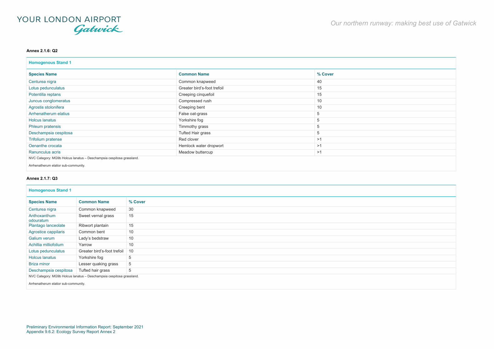
Preliminary Environmental Information Report: September 2021 Appendix 9.6.2: Ecology Survey Report Annex 2
Our northern runway: making best use of Gatwick
Annex 2.1.6: Q2
Homogenous Stand 1
Species Name Common Name % Cover
Centurea nigra Common knapweed 40 Lotus pedunculatus Greater bird’s-foot trefoil 15 Potentilla reptans Creeping cinquefoil 15 Juncus conglomeratus Compressed rush 10 Agrostis stolonifera Creeping bent 10 Arrhenatherum elatius False oat-grass 5 Holcus lanatus Yorkshire fog 5 Phleum pratensis Timmothy grass 5 Deschampsia cespitosa Tufted Hair grass 5 Trifolium pratense Red clover >1 Oenanthe crocata Hemlock water dropwort >1 Ranunculus acris Meadow buttercup >1 NVC Category: MG9b Holcus lanatus – Deschampsia cespitosa grassland.
Arrhenatherum elatior sub-community.
Annex 2.1.7: Q3
Homogenous Stand 1
Species Name Common Name % Cover
Centurea nigra Common knapweed 30 Anthoxanthum odouratum
Sweet vernal grass 15
Plantago lanceolate Ribwort plantain 15 Agrostice cappilaris Common bent 10 Galium verum Lady’s bedstraw 10 Achillia milliofolium Yarrow 10 Lotus pedunculatus Greater bird’s-foot trefoil 10 Holcus lanatus Yorkshire fog 5 Briza minor Lesser quaking grass 5 Deschampsia cespitosa Tufted hair grass 5 NVC Category: MG9b Holcus lanatus – Deschampsia cespitosa grassland.
Arrhenatherum elatior sub-community.

Preliminary Environmental Information Report: September 2021 Appendix 9.6.2: Ecology Survey Report Annex 2
Our northern runway: making best use of Gatwick
Annex 2.1.8: Q4
Homogenous Stand 1
Species Name Common Name % Cover
Plantago lanceolate Ribwort plantain 20 Centurea nigra Common knapweed 20 Stachys palustre Marsh woundwort 20 Briza minor Lesser quaking grass 20 Galium verum Lady’s bedstraw 10 Odontites vernus Red barista 10 Festuca rubra Red fescue >1 Agrostice stolonifera Creeping bent >1 NVC Category: MG9b Holcus lanatus – Deschampsia cespitosa grassland.
Arrhenatherum elatior sub-community.
Annex 2.1.9: Q5
Homogenous Stand 1
Species Name Common Name % Cover
Agrostice stolonifera Creeping bent 20 Briza minor Lesser quaking grass 20 Centurea nigra Common knapweed 15 Arrhenatherum elatius False oat-grass 15 Stachys palustris Marsh woundwort 10 Galium verum Lady’s bedstraw 10 Anthoxanthum odouratum Sweet vernal grass 10 Plantago lanceolate Ribwort plantain 10 Hypericum perforatum Perforate st john’s-wort 5 Agrimonia eupatoria Agrimony 5 Calamagrostice epigejos Hair grass 5 Agrostice stolonifera Creeping bent 20 NVC Category: MG9b Holcus lanatus – Deschampsia cespitosa grassland.
Arrhenatherum elatior sub-community.
*Other Species: Primula sp., Primrose, Cynosurus cristatus, Crested Dog’s Tail, Sanguisorba officinalis, Great Burnette.

Preliminary Environmental Information Report: September 2021 Appendix 9.6.2: Ecology Survey Report Annex 2
Our northern runway: making best use of Gatwick
Annex 2.1.10: Q6
Homogenous Stand 2
Species Name Common Name % Cover
Calamagrostice epigejos Wood small reed 80 Pleum pratense Timothy grass 10 Juncus conglomerate Compact rush 5 Lotus pedunculatus Greater bird’s-foot trefoil 5 Calamagrostis epigejos Society
Annex 2.1.11: Q7
Homogenous Stand 2
Species Name Common Name % Cover
Calamagrostice epigejos Wood small reed 80 Deschampsia cespitosa Tuffted hair grass 15 Alopecurus pratensis Meadow foxtail 10 Calamagrostis epigejos Society
Annex 2.1.12: Q8
Homogenous Stand 2
Species Name Common Name % Cover
Lotus pedunclulatus Greater bird’s-foot trefoil 40 Centurea nigra Common knapweed 15 Briza minor Lesser quaking grass 10 Calamagrostice epigejos Wood small reed 10 Arrhenatherum elatior False oat-grass 10 Holcus lanatus Yorkshire fog 10 Anthoxanthum odouratum Sweet vernal grass 5 Ranunculus acris Meadow buttercup 5 Calamagrostis epigejos Society
Annex 2.1.13: Q9
Homogenous Stand 3
Species Name Common Name % Cover
Lotus pedunculatus Greater bird’s-foot trefoil 20 Briza minor Lesser quaking grass 10
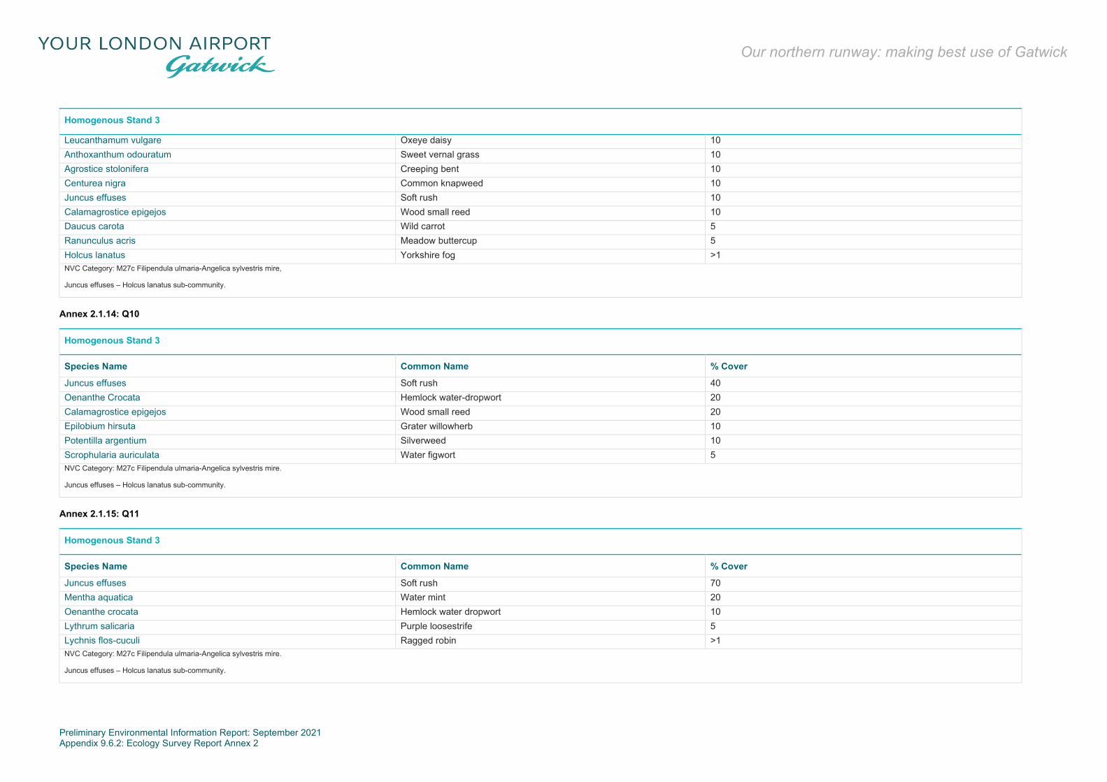
Preliminary Environmental Information Report: September 2021 Appendix 9.6.2: Ecology Survey Report Annex 2
Our northern runway: making best use of Gatwick
Homogenous Stand 3
Leucanthamum vulgare Oxeye daisy 10 Anthoxanthum odouratum Sweet vernal grass 10 Agrostice stolonifera Creeping bent 10 Centurea nigra Common knapweed 10 Juncus effuses Soft rush 10 Calamagrostice epigejos Wood small reed 10 Daucus carota Wild carrot 5 Ranunculus acris Meadow buttercup 5 Holcus lanatus Yorkshire fog >1 NVC Category: M27c Filipendula ulmaria-Angelica sylvestris mire,
Juncus effuses – Holcus lanatus sub-community.
Annex 2.1.14: Q10
Homogenous Stand 3
Species Name Common Name % Cover
Juncus effuses Soft rush 40 Oenanthe Crocata Hemlock water-dropwort 20 Calamagrostice epigejos Wood small reed 20 Epilobium hirsuta Grater willowherb 10 Potentilla argentium Silverweed 10 Scrophularia auriculata Water figwort 5 NVC Category: M27c Filipendula ulmaria-Angelica sylvestris mire.
Juncus effuses – Holcus lanatus sub-community.
Annex 2.1.15: Q11
Homogenous Stand 3
Species Name Common Name % Cover
Juncus effuses Soft rush 70 Mentha aquatica Water mint 20 Oenanthe crocata Hemlock water dropwort 10 Lythrum salicaria Purple loosestrife 5 Lychnis flos-cuculi Ragged robin >1 NVC Category: M27c Filipendula ulmaria-Angelica sylvestris mire.
Juncus effuses – Holcus lanatus sub-community.

Preliminary Environmental Information Report: September 2021 Appendix 9.6.2: Ecology Survey Report Annex 2
Our northern runway: making best use of Gatwick
Breeding Bird Surveys
Annex 2.1.16: Breeding Statur, Abundance and Conservation Status of Birds Recorded within the Gatwick Airport Survey Area in 2019
Species Breeding status No. of territories Annex 1 EU Birds Directive Schedule 1 WCA NERC Species of Principal Importance BoCC 4 Red and Amber species
Great Crested Grebe Non-breeding - - - - - Cormorant Non-breeding - - - - - Grey Heron Non-breeding - - - - - Greylag Goose Confirmed 3 - - - - 1 Canada Goose Confirmed 3 - - - - Mallard Confirmed 9 - - - Amber Red Kite Non-breeding - ■ ■ - - Common Buzzard Confirmed 2 - - - - Kestrel Confirmed 4 - - - Amber Peregrine Possible 1 ■ ■ - - Sparrowhawk Non-breeding - - - - - Red-legged Partridge Non-breeding - - - - - Pheasant Confirmed 3 - - - - Moorhen Confirmed 5 - - - - Coot Confirmed 3 - - - - Little ringed plover Possible 1 - ■ - - Snipe Non-breeding - - - - Amber Black-headed gull Non-breeding - - - - Amber Herring gull Non-breeding - - - ■ Amber Lesser black-backed gull Non-breeding - - - - Amber Feral rock dove Confirmed 6 - - - - Stock dove Confirmed 3 - - - Amber Woodpigeon Confirmed 37 - - - - Collared dove Confirmed 2 - - - - Swift Non-breeding - - - - Amber Ring-necked parakeet Non-breeding - - - - - Green woodpecker Confirmed 3 - - - - Great spotted woodpecker Confirmed 11 - - - - Skylark Confirmed 12 - - ■ Red Swallow Non-breeding - - - - - House martin Non-breeding - - - - Amber Pied wagtail Confirmed 5 - - - - Grey wagtail Confirmed 1 - - - Red Wren Confirmed 74 - - - - Dunnock Confirmed 18 - - ■ Amber
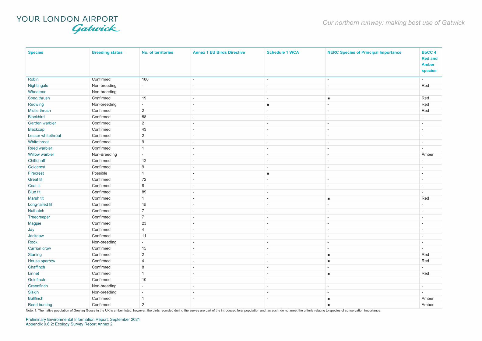
Preliminary Environmental Information Report: September 2021 Appendix 9.6.2: Ecology Survey Report Annex 2
Our northern runway: making best use of Gatwick
Species Breeding status No. of territories Annex 1 EU Birds Directive Schedule 1 WCA NERC Species of Principal Importance BoCC 4 Red and Amber species
Robin Confirmed 100 - - - - Nightingale Non-breeding - - - - Red Wheatear Non-breeding - - - - - Song thrush Confirmed 19 - - ■ Red Redwing Non-breeding - - ■ - Red Mistle thrush Confirmed 2 - - - Red Blackbird Confirmed 58 - - - - Garden warbler Confirmed 2 - - - - Blackcap Confirmed 43 - - - - Lesser whitethroat Confirmed 2 - - - - Whitethroat Confirmed 9 - - - - Reed warbler Confirmed 1 - - - - Willow warbler Non-Breeding - - - - Amber Chiffchaff Confirmed 12 - - - - Goldcrest Confirmed 9 - - - - Firecrest Possible 1 - ■ - Great tit Confirmed 72 - - - - Coal tit Confirmed 8 - - - - Blue tit Confirmed 89 - - - Marsh tit Confirmed 1 - - ■ Red Long-tailed tit Confirmed 15 - - - - Nuthatch Confirmed 7 - - - - Treecreeper Confirmed 7 - - - - Magpie Confirmed 23 - - - - Jay Confirmed 4 - - - - Jackdaw Confirmed 11 - - - - Rook Non-breeding - - - - - Carrion crow Confirmed 15 - - - - Starling Confirmed 2 - - ■ Red House sparrow Confirmed 4 - - ■ Red Chaffinch Confirmed 8 - - - - Linnet Confirmed 1 - - ■ Red Goldfinch Confirmed 10 - - - - Greenfinch Non-breeding - - - - - Siskin Non-breeding - - - - - Bullfinch Confirmed 1 - - ■ Amber Reed bunting Confirmed 2 - - ■ Amber
Note: 1. The native population of Greylag Goose in the UK is amber listed, however, the birds recorded during the survey are part of the introduced feral population and, as such, do not meet the criteria relating to species of conservation importance.

Preliminary Environmental Information Report: September 2021 Appendix 9.6.2: Ecology Survey Report Annex 2
Our northern runway: making best use of Gatwick
Annex 2.1.17: Alphabetical List of Bird Species Recorded During the Survey in 2019
English name Scientific name
Blackbird Turdus merula Blackcap Sylvia atricapilla Black-headed gull Chroicocephalus ridibundus Blue Tit Cyanistes caeruleus Bullfinch Pyrrhula pyrrhula Buzzard Buteo buteo Canada goose Branta canadensis Carrion crow Corvus corone Chaffinch Fringilla coelebs Chiffchaff Phylloscopus collybita Coal tit Periparus ater Collared dove Streptopelia decaocto Coot Fulica atra Cormorant Phalacrocorax carbo Dunnock Prunella modularis Feral Dove Columba livia Firecrest Regulus ignicapilla Garden warbler Sylvia borin Goldcrest Regulus regulus Goldfinch Carduelis carduelis Great crested grebe Podiceps cristatus Great spotted woodpecker Dendrocopos major Great tit Parus major Green woodpecker Picus viridis Greenfinch Chloris chloris Grey heron Ardea cinerea Grey wagtail Motacilla cinerea Greylag goose Anser anser Herring gull Larus argentatus House martin Delichon urbicum House sparrow Passer domesticus Jackdaw Coloeus monedula Jay Garrulus glandarius Kestrel Falco tinnunculus Lesser black-backed gull Larus fuscus Lesser whitethroat Sylvia curruca Linnet Linaria cannabina Little ringed plover Charadrius dubius Long-tailed tit Aegithalos caudatus

Preliminary Environmental Information Report: September 2021 Appendix 9.6.2: Ecology Survey Report Annex 2
Our northern runway: making best use of Gatwick
English name Scientific name
Magpie Pica pica Mallard Anas platyrhynchos Marsh tit Poecile palustris Mistle thrush Turdus viscivorus Moorhen Gallinula chloropus Nightingale Luscinia megarhynchos Nuthatch Sitta europaea Peregrine Falco peregrinus Pheasant Phasianus colchicus Pied wagtail Motacilla alba Red kite Milvus milvus Red-legged partridge Alectoris rufa Redwing Turdus iliacus Reed bunting Emberiza schoeniclus Reed warbler Acrocephalus scirpaceus Ring-necked parakeet Psittacula krameri Robin Erithacus rubecula Rook Corvus frugilegus Siskin Spinus spinus Skylark Alauda arvensis Snipe Gallinago gallinago Song thrush Turdus philomelos Sparrowhawk Accipiter nisus Starling Sturnus vulgaris Stock dove Columba oenas
Wintering Bird Surveys
Annex 2.1.18: Summary Count Data of Birds Recorded During Survey - October 2018 and March 2019
Species Peak Count Mean Count Species Peak Count Mean Count
Blackbird 54 44.4 Kestrel 4 3
Bullfinch 7 2.8 Red kite 1 0.2
Black-headed gull 110 34.6 Lapwing 240 48
Blue tit 140 98.2 Lesser black-backed gull 2 0.4
Buzzard 3 2 Long-tailed tit 58 24.4
Carrion crow 42 31.4 Mistle thrush 3 1.2
Chiffchaff 15 3 Mallard 17 14.2
Collared dove 2 0.6 Magpie 36 22.6
Canada goose 28 7.2 Moorhen 8 3.6
Chaffinch 6 2.6 Mandarin duck 2 0.4

Preliminary Environmental Information Report: September 2021 Appendix 9.6.2: Ecology Survey Report Annex 2
Our northern runway: making best use of Gatwick
Species Peak Count Mean Count Species Peak Count Mean Count
Common gull 1 0.2 Meadow pipit 31 7.8
Coal tit 10 5 Marsh tit 3 0.6
Dunnock 15 10.4 Nuthatch 11 6.4
Feral rock dove 9 2.2 Pheasant 3 0.8
Egyptian goose 2 0.4 Pied wagtail 10 5
Firecrest 1 0.2 Robin 81 57.8
Fieldfare 19 7.8 Reed bunting 1 0.2
Green woodpecker 3 1.8 Redwing 75 20.4
Goldcrest 33 16.4 Ring-necked parakeet 2 0.6
Green sandpiper 1 0.4 Rook 27 8
Greylag goose 5 1 Skylark 13 3.2
Grey wagtail 3 1.4 Starling 55 26.8
Goldfinch 12 7.4 Sparrowhawk 2 0.4
Greenfinch 2 0.4 Siskin 23 5.2
Great spotted woodpecker 11 7.6 Snipe 7 1.4
Great tit 83 64 Song thrush 17 14.2
Grey heron 3 1.4 Treecreeper 7 4.8
Herring gull 10 3 Woodcock 1 0.2
House sparrow 3 1.2 Woodpigeon 102 62.2
Jay 15 7.2 Wren 38 21.8
Jackdaw 175 75.6
Annex 2.1.19: Conservation Status of Birds Recorded within the Project Area - October 2018 and March 2019
Species Annex 1 EU Birds Directive UK BAP Priority Species NERC Species of Principal Importance Birds of Conservation Concern
Bullfinch ● ● Amber
Black-headed gull Amber
Common gull Amber
Dunnock ● ● Amber
Fieldfare Red
Green sandpiper Amber
Greylag goose Amber
Grey wagtail Red
Herring gull ● ● Amber
House sparrow ● ● Red
Kestrel Amber
Lapwing ● ● Red

Preliminary Environmental Information Report: September 2021 Appendix 9.6.2: Ecology Survey Report Annex 2
Our northern runway: making best use of Gatwick
Species Annex 1 EU Birds Directive UK BAP Priority Species NERC Species of Principal Importance Birds of Conservation Concern
Lesser black-backed gull Amber
Mallard Amber
Marsh tit ● ● Red
Mistle thrush Red
Meadow pipit Amber
Red kite ● N/A
Redwing Red
Skylark ● ● Red
Snipe Amber
Song thrush ● ● Red
Starling ● ● Red
Woodcock Red
Reptile Surveys
Annex 2.1.20: Reptile Survey Results
Survey Survey Area Date Weather Species recorded
1
A3, A5 17/04/19 15C, Wind F2, Cloud 3/8 None A6 River Mole Corridor 18/04/19 14C, Wind F3, Cloud 2/8 None A1 12/06/19 14C, Wind F1, Cloud 7/8 None A6 Field south of Brockley Wood 03/09/19 19C, Wind F1, Cloud 7/8 None
2
A3 01/05/19 10-11C, Wind F1, Cloud 1/8-3/8
None A5 None A6 River Mole Corridor 3 female grass snake, 1 sub-adult male grass snake, 3 juvenile grass snake and 3 grass snake A1 18/06/19 16C, Wind F2, Cloud 2/8 None A6 Field south of Brockley Wood 05/09/19 15C, Wind F2, Cloud 3/8 None
3
A3 13/05/19 15C, Wind F1, Cloud 2/8
None A5 None A6 River Mole Corridor 4 grass snake, 1 juvenile grass snake, 3 adult grass snake and 2 sub-adult grass snake A1 26/06/19 18C, Wind F1, Cloud 7/8 1 grass snake, 1 juvenile grass snake A6 Field south of Brockley Wood 10/09/2019 16C, Wind F1, Cloud 3/8 None
4
A5 03/06/19 19C, Wind F3, Cloud 3/8 2 juvenile grass snake A3, A6 River Mole Corridor 13/06/19 13C, wind F3, Cloud 6/8 None A1 08/08/2019 18C, Wind F1, Cloud 1/8 None A6 Field south of Brockley Wood 16/09/2019 15C, Wind F1, Cloud 5/8 None
5
A3 26/06/19 18C, wind F1, Cloud 7/8
1 grass snake, 1 juvenile grass snake A5 None A6 River Mole Corridor None

Preliminary Environmental Information Report: September 2021 Appendix 9.6.2: Ecology Survey Report Annex 2
Our northern runway: making best use of Gatwick
Survey Survey Area Date Weather Species recorded
A1 16/09/2019 15C, Wind F1, Cloud 5/8 None A6 Field south of Brockley Wood 19/09/2019 15C, Wind F1, Cloud 1/8 None
6
A5 06/08/19 20C, wind F4, Cloud 4/8 None A3
08/08/19 18C, Wind F3, Cloud 6/8 None
A6 River Mole Corridor 2 grass snake slough A6 Field south of Brockley Wood 19/09/2019 15C, Wind F1, Cloud 1/8 None
7 A1 26/09/2019 18C, Wind F3, Cloud 3/8 None A3, A5, A6 River Mole Corridor, A6 Field south of Brockley Wood 02/10/2019 14C, Wind F2, Cloud 1/8 None
Great Crested Newt Surveys
Annex 2.1.21: HSI Scores for All Ponds within Project Boundary
Pond No. Description HSI score
FCZ No access was granted to this pond. N/S
9VG No access was granted to this pond. N/S
Pond F A Large man-made attenuation pond, a barrier crosses the middle running north to south and marginal vegetation was present around all the sides.
Poor
SM7 Small pond behind services with poor water quality and little aquatic vegetation. Poor
981 Large pond within a woodland. No aquatic vegetation and little woodland ground flora. Mature trees surround pond and a film of algae across pond.
Below average
Pond G Shallow pond with a silt bed that was mostly dry Below average
30Z Large pond within Horleyland Wood. Pond has shallow banks and marginal vegetation. Average
8N8 Woodland pond flooded over into surrounding woodland and cutting off footpath to rest of woodland
Good
W46 Small man-made wildlife pond, lots of aquatic vegetation along the southern bank. Banks relatively steep sided with a fallen tree across middle.
Average
Old Lagoon Y shaped lagoon, man made, amenity grass banks and steep sided. N/S
E11 Long linear settlement pond, wider at eastern end, linked to the M23 spur road. Reeds and bulrush dominated. Average
Pond E No access granted to this pond, N/S
A0A Pond within Police training area, swamped with willow and surrounded by woodland. Below average
MHA Circular pond in the middle of the southern staff car park. The pond was surrounded with vegetation.
poor
JCT Outside Project boundary, no access granted. N/S
Pond A A pond located to the north of the runway near the fire training area. It was surrounded by dense bramble scrub and marginal vegetation such as pond sedge and bulrush
Good
New Lagoon A circular sewage pond known as ‘New lagoon’ was a man-made, steep sided amenity grassland settlement lagoon. N/S
Pond M Settlement pond east of the biodiversity wall. A man made structure with steep concrete walls. Semi-improved grassland surrounded the pond. Only the eastern half of the pond held water.
N/S
WP9 No access granted to this pond. N/S
AA20 Awaiting details. Poor

Preliminary Environmental Information Report: September 2021 Appendix 9.6.2: Ecology Survey Report Annex 2
Our northern runway: making best use of Gatwick
Pond No. Description HSI score
AA21 Awaiting details. Poor
K5F A long pond with 0.5m high banks around the northern side. The southern bank was covered with scrub and inaccessible. Around all sides there was a large amount of aquatic vegetation.
Excellent
TTD A small circular man made pond surrounded by willow and pine trees. Aquatic vegetation was present around the eastern, northern and southern sides. A concrete outflow was identified in the south east corner of the pond.
Excellent
C24 Large pond around 30 x 20 m. Lots of marginal vegetation mainly bull rush completely dry willow and ash growing around edge.
Good*
Pond D A rectangular attenuation pond. It was concrete sided with an outflow into the Mole corridor. Poor
Pond D A triangular attenuation pond made from concrete and steep sided. The pond was surrounded by managed grassland. Poor
293 Large open fishing lake in middle of public park. Two islands within middle of the lake densely covered with trees. Poor
FFJ A small attenuation pond for the runway. Marginal vegetation was present here with rushes being dominant. Good
29A A long thin man-made channel. 5m high sides with a fence line around the top of it. Water was swamped by algae and had little aquatic vegetation, the banks were vegetated with tufted grass.
Average*
30P Murky shallow pond, with clear animal tracks leading to it. Poor
AVF A large pond within the Land East of the Gatwick Aviation Museum Field covered with reeds and willowherb and algae topped. Nettle and willowherb ruderal surrounded the pond.
Good
Dog Kennel Pond A small manmade attenuation pond with steep banks showing high levels of maintenance. A diverse mix of aquatic and marginal vegetation was found within the pond.
Average
AAA4 Newly created pond along mole corridor. N/S
1WH Pond in centre of eastern part of woodland had a small amount of water in with a heavy covering of duckweed. Average
NU1 Pond in centre of eastern part of woodland had a small amount of water in with a heavy covering of duckweed. Linked to Pond 1WH
Average

Preliminary Environmental Information Report: September 2021 Appendix 9.6.2: Ecology Survey Report Annex 2
Our northern runway: making best use of Gatwick
Bat Emergence/Re-entry Surveys
Building JW9 (Landside)
Bat Emergence Survey 15 July 2019
A2.1.1 The bat emergence survey on 15 July commenced at 21:00 hours, 15 minutes before sunset and finished at 22:45 hours.
A2.1.2 No bats were seen emerging from the building but were detected foraging nearby. Bat activity was recorded at low levels during the survey.
A2.1.3 The following bat activity was recorded during the survey:
21:59 – noctule heard but not seen; 22:15 – noctule heard close by; 22:19 – noctule heard close by; and 22:22 – noctule heard close by.
Bat emergence survey 20 August 2019
A2.1.4 The bat emergence survey on the 20th August commenced at 20:00 hours, 15 minutes before sunset and finished at 21:45 hours.
A2.1.5 No bats were seen emerging from the building but were detected foraging and commuting nearby. Bat activity was recorded at low levels during the survey.
A2.1.6 The following bat activity was recorded during the survey:
20:56 – Leisler’s bat pass and foraging soprano pipistrelle heard nearby;
20:58 – soprano pipistrelle heard foraging; 21:19 – soprano pipistrelle foraging; and 21:49 – brief Leisler’s bat pass, not seen.
Bat Emergence Survey 26 September 2019
A2.1.7 The bat emergence survey on 26 September commenced at 18:55 hours, 15 minutes before sunset and finished at 20:30 hours.
A2.1.8 Not bats were seen emerging from the building but were detected foraging and commuting nearby. Bat activity was recorded at moderate levels during the survey; although no bats were seen, it was presumed that bats were foraging near to the grassland area to the west of the feature.
A2.1.9 The following bat activity was recorded during the survey.
19:18 – noctule heard but not seen.
19:28 – distant noctule call. 19:29 – brief Myotis call – not seen. 19:30 – noctule heard but not seen – made several passes
until 19:39, possibly over the grassland areas adjacent to building. Mainly foraging and social calls.
19:32 – faint common pipistrelle call heard. 19:39 – distant common pipistrelle call. 19:45 – distant common pipistrelle call. 19:46 – Myotis bat heard. 19:48 – at least two noctule’s foraging nearby. 20:03-20:14 – noctule, Myotis and pipistrelle heard
foraging nearby; calls gradually getting quieter towards the end of the survey.
Building D9H (Airside)
Bat Emergence Survey 15 July 2019
A2.1.10 The bat emergence survey on the 15 July commenced at 21:00 hours, 15 minutes before sunset and finished at 22:45 hours.
A2.1.11 No bats were seen emerging from the building but were detected forging and commuting nearby.
A2.1.12 The following bat activity was recorded during the survey:
21:49 – faint common pipistrelle bat pass; 22:04 – distant pass from common pipistrelle; 22:11 – common pipistrelle commuting east along building; 22:12 – common pipistrelle heard but not seen, foraging
nearby; 22:27 – noctule heard but not seen; 22:34 – brief noctule pass; 22:35 – brief noctule pass; 22:36 – brief noctule pass; and 22:39 – brief noctule pass.
Bat Emergence Survey 7 August 2019
A2.1.13 The bat emergence survey on 7 August commenced at 20:26 hours, 15 minutes before sunset and finished at 22:11 hours.
A2.1.14 No bats were seen emerging from the building and only a single Noctule was recorded briefly at 21:43 hours.
Bat Emergence Survey 2 October
A2.1.15 The bat emergence survey on 2 October commenced at 18:22 hours, 15 minutes before sunset, and finished at 20:07 hours.
A2.1.16 No bats were seen emerging from the building but were recorded foraging nearby. Bat activity was recorded at low
levels during the survey; noctule were heard making regular, brief passes between 19:11 and 20:03 hours.
Bat Activity Transect Surveys
Annex 2.1.22: Bat Activity Transect Survey Dates, Weather Conditions and Sunset Times
Survey date Sunset time
Survey start
Weather conditions
Transect 1
09/04/19 19:46 19:31 8°C, cloudy, light breeze, no rain
24/04/19 20:10 19:57 10°C, heavy cloud cover, light wind
08/05/19 20:33 20:26 11°C, dry, light cloud, light breeze
21/05/19 20:52 20:37 17°C, no cloud, light breeze
12/06/19 21:16 21:09 13°, overcast, occasional light rain
25/06/19 21:20 21:05 22°C, humid, cloudy, light wind
09/07/19 21:15 21:00 20°C, dry, warm, overcast
23/07/19 21:01 20:46 26°C, clear, hot, humid
06/08/19 20:41 20:25 18°C, cloudy, calm
28/08/19 19:56 19:40 20°C, cloudy, light breeze, no rain
03/09/19 19:41 19:36 18°C, dry, cloudy, light wind
25/09/19 18:55 18:40 16°C, patchy cloud, dry, light wind
15/10/19 18:09 19:50 16°C, clear sky, dry, light wind
30/10/19 16:41 16:25 10°C, light wind, clear, dry
Transect 2
09/04/19 19:46 19:31 8°C, cloudy, light breeze, no rain
24/04/19 20:10 19:58 10°C, heavy cloud cover, light wind
08/05/19 20:33 20:18 11°C, dry, light cloud, light breeze
21/05/19 20:52 20:37 17°C, no cloud, light breeze
12/06/19 21:16 21:09 13°, overcast, occasional light rain

Preliminary Environmental Information Report: September 2021 Appendix 9.6.2: Ecology Survey Report Annex 2
Our northern runway: making best use of Gatwick
Survey date Sunset time
Survey start
Weather conditions
25/06/19 21:20 21:05 22°C, humid, cloudy, light wind
09/07/19 21:15 21:00 20°C, dry, warm, overcast
23/07/19 21:01 20:46 26°C, clear, hot, humid
06/08/19 20:41 20:25 18°C, cloudy, calm
28/08/19 19:56 19:40 20°C, cloudy, light breeze, no rain
25/09/19 18:55 18:40 16°C, patchy cloud, dry, light wind
16/10/19 18:09 19:50 16°C, clear sky, dry, light wind
30/10/19 16:41 16:25 10°C, light wind, clear, dry
Transect 3
09/04/19 19:46 19:26 12°C, cloudy, no wind
24/04/19 20:10 20:00 Heavy cloud. damp
08/05/19 20:34 20:18 11°C, dry, light cloud, light breeze
21/05/19 20:52 20:43 17°C, no cloud, light breeze
18/06/19 21:19 21:00 16°C, dry, overcast, light wind
25/06/19 21:20 21:05 22°C, humid, cloudy, light wind
09/07/19 21:15 21:00 20°C, dry, warm, overcast
23/07/19 21:01 20:46 26°C, clear, hot, humid
06/08/19 20:41 20:25 18°C, cloudy, calm
29/08/19 19:54 19:46 19°C, light cloud, no rain
03/09/19 19:41 19:33 18°C, dry, cloudy, light wind
25/09/19 18:55 18:40 16°C, patchy cloud, dry, light wind
16/10/19 18:09 19:50 16°C, clear sky, dry, light wind
30/10/19 16:41 16:25 10°C, light wind, clear, dry
Transect 4
10/04/19 19:48 19:32 10°C, clear skies, light breeze
25/04/19 20:12 19:57 11°C, high cloud, light wind
13/05/19 20:42 20:27 11°C, light winds, fair
22/05/19 20:54 20:39 19°C, clear, dry, no wind
Survey date Sunset time
Survey start
Weather conditions
13/06/19 21:17 21:00 13°C, cloudy, occasional light rain
26/06/19 21:20 21:05 18°C, cloudy, windy
10/07/19 21:15 21:00 17°C, dry, light wind, patchy cloud
24/07/19 21:00 20:40 27°C, patchy cloud, no wind
05/08/19 20:41 20:20 20°C, light wind, no rain
29/08/19 19:54 19:46 19°C, light cloud, no rain
04/09/19 19:40 19:25 17°C, clear, breezy
24/09/19 18:55 18:40 18°C, light wind and light cloud
15/10/19 18:09 19:50 16°C, clear sky, dry, light wind
29/10/19 16:40 16:25 13°C, cloudy, light wind
Transect 5
10/04/19 19:48 19:32 10°, clear skies, light breeze
25/04/19 20:12 19:57 11°C, high cloud, light wind
14/05/19 20:43 20:28 12°C, moderate breeze, fair
22/05/19 20:54 20:39 19°C, clear, dry, no wind
13/06/19 21:17 21:02 13°C, cloudy, occasional light rain
26/06/19 21:20 21:05 18°C, cloudy, windy
10/07/19 21:15 21:00 17°C, dry, light wind, patchy cloud
24/07/19 21:00 20:40 27°C, patchy cloud, no wind
05/08/19 20:41 20:20 20°C, light wind, no rain
29/08/19 19:54 19:46 19°C, light cloud, no rain
04/09/19 19:40 19:25 17°C, clear, breezy
24/09/19 18:55 18:40 18°C, light wind and light cloud
15/10/19 18:09 19:50 18°C, clear sky, dry, light wind
29/10/19 16:40 16:25 13°C, cloudy, light wind
Pre-maternity
Transect 1
A2.1.17 A total of four visits were undertaken for Transect 1 during the pre-maternity season in 2019: 9 April, 24 April, 8 May and 21 May.
A2.1.18 A total of 240 bat passes were recorded during the surveys. These comprised passes from:
217 common pipistrelles; 19 soprano pipistrelles; Three Myotis sp. (including two characteristic of
whiskered/Brandt’s Myotis mystacinus/brandtii bat); and One noctule.
A2.1.19 Figure 3.13.1a shows the transect route and the number and location of species recorded during the surveys.
Transect 2
A2.1.20 A total of four visits were undertaken for Transect 2 during the pre-maternity season in 2019: 9 April, 24 April, 8 May and 21 May.
A2.1.21 A total of 217 bat passes were recorded during the surveys. These comprised passes from:
192 common pipistrelles; Two soprano pipistrelles; Three Myotis sp. (including two characteristic of
Daubenton’s bat Myotis daubentonii); One long-eared Plecotus sp. bat; and 19 noctule.
A2.1.22 Figure 3.13.1b shows the transect route and the number and location of species recorded during the surveys
Transect 3
A2.1.23 A total of four visits were undertaken for Transect 3 during the pre-maternity season in 2019: 9 April, 24 April, 8 May and 21 May.
A2.1.24 A total of 286 bat passes were recorded during the surveys. These comprised passes from:
242 common pipistrelles; 30 soprano pipistrelles; and 14 Myotis sp. (including three characteristic of Natterer’s
bat Myotis nattereri and one of Daubenton’s bat).
A2.1.25 Figure 3.13.1c and 3.13.3d shows the transect route and the number and location of species recorded during the surveys.

Preliminary Environmental Information Report: September 2021 Appendix 9.6.2: Ecology Survey Report Annex 2
Our northern runway: making best use of Gatwick
Transect 4
A2.1.26 A total of four visits were undertaken for Transect 4 during the pre-maternity season in 2019: 10 April, 25 April, 13 May and 22nd May.
A2.1.27 A total of 24 bat passes were recorded during the surveys. These comprised passes from:
21 common pipistrelles; and Three noctule.
A2.1.28 Figure 3.13.1e shows the transect route and the number and location of species recorded during the surveys.
Transect 5
A2.1.29 A total of four visits were undertaken for Transect 5 during the pre-maternity season in 2019: 10 April, 25 April, 14 May and 22 May.
A2.1.30 A total of 131 bat passes were recorded during the surveys. These comprised passes from:
77 common pipistrelles; 12 soprano pipistrelles; One pipistrelle species; 25 Myotis sp. (including three characteristic of
whiskered/Brandt’s bats, two of Daubenton’s bats and four of Natterer’s bats); and
16 noctule.
A2.1.31 Figure 3.13.1f shows the transect route and the number and location of species recorded during the surveys.
Maternity
Transect 1
A2.1.32 A total of four visits were undertaken for Transect 1 during the maternity season in 2019: 12 June, 25 June, 9 July and 23 July.
A2.1.33 A total of 400 bat passes were recorded during the surveys. These comprised passes from:
301 common pipistrelles; 56 soprano pipistrelles; 16 Myotis sp. (including one characteristic of
whiskered/Brandt’s bat and one of Natterer’s bat); 15 noctule; Six Leisler’s bats; Ten Nyctalus sp.; and
Six serotine bats.
A2.1.34 Figure 3.13.2a shows the transect route and the number and location of species recorded during the surveys.
Transect 2
A2.1.35 A total of four visits were undertaken for Transect 2 during the maternity season in 2019: 12 June, 25 June, 9 July and 23 July.
A2.1.36 A total of 218 bat passes were recorded during the surveys. These comprised passes from:
197 common pipistrelles; Two soprano pipistrelles; One Nathusius’ pipistrelle; 14 noctule; and Four serotine bats.
A2.1.37 Figure 3.13.2b shows the transect route and the number and location of species recorded during the surveys
Transect 3
A2.1.38 A total of four visits were undertaken for Transect 3 during the maternity season in 2019: 18 June, 2 June, 9 July and 23 July.
A2.1.39 A total of 252 bat passes were recorded during the surveys. These comprised passes from:
211 common pipistrelles; 31 soprano pipistrelles; Two Myotis sp. (including one characteristic of Natterer’s
bat); One noctule; One Nyctalus sp.; and Six serotine bats.
A2.1.40 Figure 3.13.2c and 3.13.2d shows the transect route and the number and location of species recorded during the surveys.
Transect 4
A2.1.41 A total of four visits were undertaken for Transect 4 during the maternity season in 2019: 13 June, 26 June, 10 July and 24 July.
A2.1.42 A total of 23 bat passes from common pipistrelles were recorded during the surveys.
A2.1.43 Figure 3.13.2e shows the transect route and the number and location of species recorded during the surveys.
Transect 5
A2.1.44 A total of four visits were undertaken for Transect 5 during the maternity season in 2019: 13 June, 26 June, 10 July and 24 July.
A2.1.45 A total of 333 bat passes were recorded during the surveys. These comprised passes from:
260 common pipistrelles; 32 soprano pipistrelles; 23 Myotis sp. (including three characteristic of
whiskered/Brandt’s bats and one of Daubenton’s bat); 15 noctule; Two Leisler’s bats; and One Nyctalus sp.
A2.1.46 Figure 3.13.2f shows the transect route and the number and location of species recorded during the surveys.
Post-maternity
Transect 1
A2.1.47 A total of six visits were undertaken for Transect 1 during the post-maternity season in 2019: 6 August, 28 August, 3 September, 25 September, 15 October and 30 October.
A2.1.48 A total of 508 bat passes were recorded during the surveys. These comprised passes from:
433 common pipistrelles; 46 soprano pipistrelles; Nine Myotis sp.; One Plecotus sp. 16 noctule; One serotine bat; and Two Nyctalus sp.
A2.1.49 Figure 3.13.3a shows the transect route and the number and location of species recorded during the surveys.
Transect 2
A2.1.50 A total of five visits were undertaken for Transect 2 during the post-maternity season in 2019: 6 August, 28 August, 25 September, 16 October and 30 October. One survey was cancelled in early September due to access constraints.

Preliminary Environmental Information Report: September 2021 Appendix 9.6.2: Ecology Survey Report Annex 2
Our northern runway: making best use of Gatwick
A2.1.51 A total of 243 bat passes were recorded during the surveys. These comprised passes from:
227 common pipistrelles; Four soprano pipistrelles; Five Myotis sp. (including one characteristic of
Daubenton’s bat); One Plecotus sp.; Four noctule; and Two Nyctalus sp.
A2.1.52 Figure 3.13.3b shows the transect route and the number and location of species recorded during the surveys.
Transect 3
A2.1.53 A total of six visits were undertaken for Transect 3 during the post-maternity season in 2019: 6 August, 29 August, 3 September, 25 September, 16 October and 30 October.
A2.1.54 A total of 378 bat passes were recorded during the surveys. These comprised passes from:
328 common pipistrelles; 37 soprano pipistrelles; One Nathusius’ pipistrelle; Five Myotis sp.; Three Leisler’s bats; and Four noctule.
A2.1.55 Figure 3.13.3c and 3.13.3d shows the transect route and the number and location of species recorded during the surveys.
Transect 4
A2.1.56 A total of six visits were undertaken for Transect 4 during the post-maternity season in 2019: 5 August, 29 August, 4 September, 24 September, 15 October and 29 October.
A2.1.57 A total of 52 passes were recorded during the surveys. These comprised passes from:
32 common pipistrelles; Four soprano pipistrelles; One Nathusius’ pipistrelle; 12 noctule; One Leisler’s bat; and Two Nyctalus sp.
A2.1.58 Figure 3.13.3e shows the transect route and the number and location of species recorded during the surveys.
Transect 5
A2.1.59 A total of six visits were undertaken for Transect 5 during the post-maternity season in 2019: 5th August, 29th August, 4th September, 24th September, 15th October and 29th October.
A2.1.60 A total of 297 bat passes were recorded during the surveys. These comprised passes from:
212 common pipistrelles; 16 soprano pipistrelles; 47 Myotis sp. (including 12 characteristic of
whiskered/Brandt’s bat, six Daubenton’s bats and six Natterer’s bats);
One serotine bat; Five Plecotus sp.; 14 noctule; and Two Nyctalus sp.
A2.1.61 Figure 3.13.3f shows the transect route and the number and location of species recorded during the surveys.

Preliminary Environmental Information Report: September 2021 Appendix 9.6.2: Ecology Survey Report Annex 2
Our northern runway: making best use of Gatwick
Bat Static/Automated Surveys
Annex 2.1.23: Bat Records at Location1
Survey Date Pp Ppy Pn Psp Msp Plsp Nn Nl Es Total
24/04/19 0 0 0 0 0 0 0 0 0 0 25/04/19 2 0 0 0 1 0 0 0 0 3 26/04/19 1 0 0 0 0 0 1 0 0 2 27/04/19 0 0 0 0 0 0 0 0 0 0 28/04/19 16 0 1 0 1 1 2 0 0 21 29/04/19 10 0 0 0 1 0 0 0 0 11 30/04/19 22 0 0 0 0 0 0 0 0 22 Species total 51 0 1 0 3 1 3 0 0 59
Survey Date Pp Ppy Pn Psp Msp Plsp Nn Nl Es Total
10/05/19 14 1 0 0 0 0 0 0 0 15 11/05/19 159 4 3 2 0 0 4 0 0 172 12/05/19 114 8 0 0 0 0 3 0 0 125 13/05/19 116 0 0 0 0 0 0 0 0 116 14/05/19 64 1 1 0 0 0 0 0 0 66 15/05/19 65 5 0 0 0 2 0 0 0 72 Species total 532 19 4 2 0 2 7 0 0 566
Survey Date Pp Ppy Pn Psp Msp Plsp Nn Nl Es Total
11/06/19 0 0 0 0 0 0 0 0 0 0 12/06/19 0 0 0 0 0 0 0 0 0 0 13/06/19 9 0 0 0 0 0 3 0 0 12 14/06/19 69 0 0 0 0 0 1 0 0 70 15/06/19 99 4 0 0 0 0 4 0 0 107 Species total 177 4 0 0 0 0 8 0 0 189
Survey Date Pp Ppy Pn Psp Msp Plsp Nn Nl Es Total
12/07/19 81 1 0 1 4 1 9 3 1 101 13/07/19 171 3 1 1 3 1 36 2 1 219 14/07/19 119 0 0 2 1 0 54 0 0 176 15/07/19 80 0 0 2 2 0 4 0 0 88 16/07/19 104 4 0 0 4 1 48 0 0 161 Species total 555 8 1 6 14 3 151 5 2 745

Preliminary Environmental Information Report: September 2021 Appendix 9.6.2: Ecology Survey Report Annex 2
Our northern runway: making best use of Gatwick
Survey Date Pp Ppy Pn Psp Msp Plsp Nn Nl Es Total
13/08/19 43 1 0 0 4 0 6 0 1 55 14/08/19 34 0 0 0 1 1 5 0 1 42 15/08/19 106 2 0 0 6 0 4 0 0 118 16/08/19 2 0 0 0 1 0 2 0 0 5 17/08/19 16 0 0 0 2 0 14 0 1 33 18/08/19 21 0 3 0 3 2 0 0 0 29
Species total 222 3 3 0 17 3 31 0 3 282
Survey Date Bb Pp Ppy Pn Psp Msp Plsp Nn Nl Es Total
25/09/19 0 15 0 0 3 1 0 0 0 0 19 26/09/19 0 5 0 0 0 2 0 53 0 0 60 27/09/19 0 1 0 0 0 2 0 158 0 0 161 28/09/19 0 2 0 0 0 1 0 31 0 0 34 29/09/19 1 11 0 0 0 1 0 70 0 0 83 Species total 1 34 0 0 3 7 0 312 0 0 357
Survey Date Bb Pp Ppy Pn Psp Msp Plsp Nn Nl Es Total
14/10/19 0 8 0 0 0 0 0 2 0 0 10 15/10/19 0 91 1 0 8 3 0 14 0 0 117 16/10/19 1 4 2 0 0 3 0 0 0 0 10 17/10/19 0 0 0 0 0 0 0 0 0 0 0 18/10/19 0 0 0 0 0 1 0 0 0 0 1 Species total 1 103 3 0 8 7 0 16 0 0 138
Annex 2.1.24: Bat Records at Location 2
Survey Date Pp Ppy Pn Psp Msp Plsp Nn Nl Es Total
24/04/19 0 0 0 0 0 0 0 0 0 0 25/04/19 4 2 0 0 1 0 0 0 0 7 26/04/19 2 0 0 0 0 0 1 0 0 3 27/04/19 13 0 0 0 1 0 0 0 0 14 28/04/19 35 2 0 0 5 0 0 0 0 42 29/04/19 28 1 0 0 1 0 0 0 0 30 30/04/19 14 0 0 0 0 0 0 0 0 14 Species total 96 5 0 0 8 0 1 0 0 110

Preliminary Environmental Information Report: September 2021 Appendix 9.6.2: Ecology Survey Report Annex 2
Our northern runway: making best use of Gatwick
Survey Date Pp Ppy Pn Psp Msp Plsp Nn Nl Es Total
10/05/19 58 2 0 0 0 0 4 0 0 64 11/05/19 173 6 0 0 3 0 7 0 0 189 12/05/19 135 10 0 0 1 1 16 0 0 163 13/05/19 241 22 0 0 1 0 4 0 0 268 14/05/19 217 8 0 0 0 0 20 0 0 245 15/05/19 124 0 0 0 2 0 46 0 0 172 Species total 948 48 0 0 7 1 97 0 0 1,101
Survey Date Pp Ppy Pn Psp Msp Plsp Nn Nl Es Total
12/06/19 7 0 0 0 0 0 25 0 0 32 13/06/19 15 3 0 0 6 0 131 0 0 155 14/06/19 16 2 0 3 3 1 224 0 0 249 15/06/19 11 0 0 0 1 0 90 0 0 102 16/06/19 17 0 0 0 3 0 172 0 0 193 Species total 66 5 0 3 13 1 642 0 0 730
Survey Date Pp Ppy Pn Psp Msp Plsp Nn Nl Es Total
12/07/19 390 6 0 0 5 2 12 0 1 416 13/07/19 348 5 0 0 6 0 8 0 0 367 14/07/19 245 1 0 0 2 0 7 0 0 255 15/07/19 99 3 0 1 4 0 5 0 2 114 16/07/19 101 5 0 0 1 0 9 0 1 117 Species total 1,183 20 0 1 18 2 41 0 4 1,269
Survey Date Pp Ppy Pn Psp Msp Plsp Nn Nl Es Total
13/08/19 28 7 0 1 10 9 29 5 1 90 14/08/19 0 0 0 0 0 0 0 0 0 0 15/08/19 80 4 0 1 22 1 2 8 2 120 16/08/19 2 0 0 0 1 0 2 0 0 5 17/08/19 38 3 0 0 17 6 33 0 8 105 18/08/19 1 1 0 1 3 0 3 0 1 10 Species total 149 15 0 39 53 16 69 13 12 330
Survey Date Pp Ppy Pn Psp Msp Plsp Nn Nl Es Total
25/09/19 18 0 0 0 2 0 53 0 0 73 26/09/19 21 1 0 0 5 2 96 0 0 125

Preliminary Environmental Information Report: September 2021 Appendix 9.6.2: Ecology Survey Report Annex 2
Our northern runway: making best use of Gatwick
Survey Date Pp Ppy Pn Psp Msp Plsp Nn Nl Es Total
27/09/19 3 0 0 1 0 0 89 0 0 93 Species total 42 1 0 1 7 2 238 0 0 291
Survey Date Pp Ppy Pn Psp Msp Plsp Nn Nl Es Total
14/10/19 8 3 0 0 3 0 0 0 0 14 15/10/19 5 2 0 0 2 0 0 1 0 10 16/10/19 1 0 0 0 0 0 0 0 0 1 17/10/19 0 0 0 0 0 0 0 0 0 0 18/10/19 10 0 0 0 0 0 0 0 0 10 Species total 24 5 0 0 5 0 0 1 0 35
Annex 2.1.25: Bat Records at Location 3
Survey Date Pp Ppy Pn Psp Msp Plsp Nn Nl Es Total
25/04/19 61 28 0 0 2 0 0 0 0 91 26/04/19 1 1 0 0 3 0 0 0 0 5 27/04/19 0 5 0 0 0 0 0 0 0 5 28/04/19 404 37 0 0 39 0 0 0 0 480 29/04/19 585 64 0 0 48 0 3 0 0 700 30/04/19 485 53 0 0 6 0 0 0 0 544 01/05/19 525 40 0 1 19 0 0 0 0 585 Species total 2,061 228 0 1 117 0 3 0 0 2,410
Survey Date Pp Ppy Pn Psp Msp Plsp Nn Nl Es Total
10/05/19 3,200 63 0 1 382 65 1 0 0 3,712 11/05/19 3,381 76 0 1 599 48 16 1 0 4,135 12/05/19 3,838 148 0 0 931 38 31 3 0 4,989 13/05/19 3,545 103 0 1 780 53 12 0 0 4,494 14/05/19 1,648 139 0 0 410 30 8 1 0 2,236 Species total 15,612 529 0 3 3,102 234 68 5 0 19,553
Survey Date Pp Ppy Pn Psp Msp Plsp Nn Nl Es Total
12/06/19 0 2 0 0 0 0 2 0 0 4 13/06/19 248 58 0 0 74 1 24 0 0 406 14/06/19 604 82 0 0 159 3 24 0 0 895 15/06/19 276 84 0 0 563 0 31 0 0 662

Preliminary Environmental Information Report: September 2021 Appendix 9.6.2: Ecology Survey Report Annex 2
Our northern runway: making best use of Gatwick
Survey Date Pp Ppy Pn Psp Msp Plsp Nn Nl Es Total
16/06/19 174 42 0 1 143 0 28 0 0 391 Species total 1,302 268 0 1 639 4 109 0 0 2,358
Survey Date Pp Ppy Pn Psp Msp Plsp Nn Nl Es Total
12/07/19 1,432 86 0 2 306 0 6 0 0 1,832 13/07/19 1,440 83 1 2 251 0 12 0 0 1,789 14/07/19 1,880 99 0 0 414 0 11 0 0 2,404 15/07/19 1,269 81 0 0 347 0 1 0 0 1,698 16/07/19 1,667 106 0 1 410 3 4 0 0 2,191 Species total 7,688 455 1 5 1,728 3 34 0 0 9,914
Survey Date Pp Ppy Pn Psp Msp Plsp Nn Nl Es Total
13/08/19 630 186 0 109 137 3 2 0 0 1,067 14/08/19 487 95 0 99 107 0 0 0 0 788 15/08/19 257 166 0 92 54 0 3 0 1 573 16/08/19 14 23 0 0 5 0 0 0 0 42 17/08/19 543 250 0 154 92 0 1 0 0 1,040 18/08/19 408 186 0 81 146 0 0 0 1 820 Species total 2,339 904 0 535 541 3 6 0 2 4,330
Survey Date Pp Ppy Pn Psp Msp Plsp Nn Nl Es Total
25/09/19 40 41 0 127 17 0 56 0 1 282 26/09/19 101 19 0 131 48 0 40 0 0 339 27/09/19 34 3 0 203 22 0 26 0 0 288 28/09/19 52 10 0 33 9 0 20 0 0 124 29/09/19 106 10 0 176 49 0 19 0 0 360 Species total 333 83 0 670 145 0 161 0 1 1,393
Survey Date Pp Ppy Pn Psp Msp Plsp Nn Nl Es Total
14/10/19 66 11 0 0 126 0 0 0 0 203 15/10/19 330 124 0 39 679 1 1 0 0 1,174 16/10/19 19 53 0 12 182 4 0 0 0 270 17/10/19 34 0 0 0 0 0 0 0 0 34 18/10/19 6 80 0 2 18 0 0 0 0 106 Species total 455 268 0 53 1,005 5 1 0 0 1,787

Preliminary Environmental Information Report: September 2021 Appendix 9.6.2: Ecology Survey Report Annex 2
Our northern runway: making best use of Gatwick
Annex 21.26: Bat Records at Location 4
Survey Date Pp Ppy Pn Psp Msp Plsp Nn Nl Es Total
25/04/19 662 27 1 1 42 18 0 0 0 751 26/04/19 354 25 0 0 7 0 0 0 1 387 27/04/19 14 8 0 0 3 0 0 0 1 25 28/04/19 272 10 1 0 13 3 3 1 0 303 29/04/19 400 31 0 0 18 8 0 0 1 458 30/04/19 1,093 46 3 0 14 10 3 0 0 1,169 Species total 2,795 147 5 1 96 39 6 1 3 3,093
Survey Date Pp Ppy Pn Psp Msp Plsp Nn Nl Es Total
10/05/19 31 4 1 0 6 0 0 1 0 43 11/05/19 52 15 1 0 7 0 1 0 0 76 12/05/19 142 18 0 4 2 0 0 1 0 167 13/05/19 138 512 0 6 1 0 0 0 0 657 14/05/19 1,214 375 0 7 10 0 0 0 0 1,606 15/05/19 828 386 1 12 5 0 0 0 0 1,232 Species total 2,405 1,310 3 29 31 0 1 2 0 3,781
Survey Date Pp Ppy Pn Psp Msp Plsp Nn Nl Es Total
12/06/19 4 0 0 0 3 0 0 0 0 7 13/06/19 30 0 0 0 4 0 1 0 0 35 14/06/19 37 2 0 0 2 4 23 0 0 68 15/06/19 28 0 1 0 0 0 2 0 0 31 Species total 99 2 1 0 9 4 26 0 0 141
Survey Date Pp Ppy Pn Psp Msp Plsp Nn Nl Es Total
12/07/19 59 9 0 1 15 2 4 0 6 96 13/07/19 56 3 0 1 25 8 5 0 1 99 14/07/19 54 0 0 1 11 4 4 0 2 76 15/07/19 62 4 1 0 8 0 5 0 0 80 16/07/19 68 7 1 2 19 4 18 0 0 119 Species total 299 23 2 5 78 18 36 0 9 470

Preliminary Environmental Information Report: September 2021 Appendix 9.6.2: Ecology Survey Report Annex 2
Our northern runway: making best use of Gatwick
Survey Date Pp Ppy Pn Psp Msp Plsp Nn Nl Es Total
13/08/19 85 2 0 3 23 0 15 9 2 139 14/08/19 53 2 0 3 7 0 2 0 0 67 15/08/19 102 0 0 0 28 3 10 1 2 146 16/08/19 32 0 0 0 4 0 0 0 0 36 17/08/19 56 3 0 0 1 0 5 0 0 65 18/08/19 57 6 0 0 4 0 0 0 0 68 Species total 385 13 0 6 67 3 32 10 4 520
Survey Date Pp Ppy Pn Psp Msp Plsp Nn Nl Es Total
25/09/19 19 1 0 0 4 0 21 0 0 45 26/09/19 10 3 0 0 5 4 21 0 0 43 27/09/19 9 0 0 0 3 2 21 0 0 35 Species total 38 4 0 0 12 6 63 0 0 123
Survey Date Pp Ppy Pn Psp Msp Plsp Nn Nl Es Total
14/10/19 0 0 0 0 0 0 0 0 0 0 15/10/19 11 0 0 0 2 0 8 0 0 21 16/10/19 3 1 0 0 3 0 12 0 0 19 17/10/19 0 0 0 0 0 0 0 0 0 0 18/10/19 2 1 0 0 10 0 0 0 0 13 Species total 16 2 0 0 15 0 20 0 0 53
Annex 2.127: Bat Records at Location 5
Survey Date Pp Ppy Pn Psp Msp Plsp Nn Nl Es Total
10/05/19 522 6 0 0 0 0 1 0 0 529 11/05/19 395 2 0 0 3 0 0 0 0 400 12/05/19 281 0 0 0 3 0 0 0 0 284 13/05/19 582 7 0 0 0 1 0 0 0 590 14/05/19 696 4 0 0 0 6 0 0 0 706 15/05/19 985 16 0 0 0 0 0 0 0 1,001 Species total 3,461 35 0 0 6 7 1 0 0 3,694

Preliminary Environmental Information Report: September 2021 Appendix 9.6.2: Ecology Survey Report Annex 2
Our northern runway: making best use of Gatwick
Survey Date Pp Ppy Pn Psp Msp Plsp Nn Nl Es Total
12/07/19 1,337 47 0 1 1 0 9 0 50 14,45 13/07/19 234 6 0 0 2 0 2 0 27 271 14/07/19 878 84 0 0 2 0 5 0 5 974 15/07/19 339 6 0 1 1 0 0 0 6 353 16/07/19 272 1 0 0 2 0 0 0 3 278 Species total 3,060 144 0 2 8 0 16 0 91 3,321
Survey Date Pp Ppy Pn Psp Msp Plsp Nn Nl Es Total
13/08/19 162 20 0 1 0 0 0 0 0 183 14/08/19 53 2 0 3 7 0 2 0 0 67 15/08/19 102 0 0 0 28 3 10 1 2 146 16/08/19 32 0 0 0 4 0 0 0 0 36 17/08/19 56 3 0 0 1 0 5 0 0 65 18/08/19 57 6 0 0 4 0 0 0 0 67 Species total 462 31 0 4 44 3 17 1 2 564
Survey Date Pp Ppy Pn Psp Msp Plsp Nn Nl Es Total
25/09/19 1 0 0 0 0 0 1 0 0 2 26/09/19 31 3 0 14 3 0 2 0 0 53 27/09/19 24 6 0 26 1 1 5 0 0. 63 28/09/19 20 2 0 3 0 0 1 0 0 26 29/09/19 92 17 0 36 7 3 6 0 0 161 Species total 168 28 0 79 11 4 15 0 0 305
Survey Date Pp Ppy Pn Psp Msp Plsp Nn Nl Es Total
14/10/19 0 0 0 0 0 0 0 0 0 0 15/10/19 25 3 0 2 3 1 0 0 0 34 16/10/19 14 2 0 4 2 2 0 0 0 24 17/10/19 0 0 0 0 0 0 0 0 0 0 18/10/19 8 1 0 0 0 1 0 0 0 10 Species total 47 6 0 6 5 4 0 0 0 68

Preliminary Environmental Information Report: September 2021 Appendix 9.6.2: Ecology Survey Report Annex 2
Our northern runway: making best use of Gatwick
Annex 2.128: Bat Records at Location 6
Survey Date Pp Ppy Pn Psp Msp Plsp Nn Nl Es Total
25/04/19 0 0 0 0 0 0 0 0 0 0 26/04/19 239 0 1 0 0 0 0 0 0 240 27/04/19 27 2 0 0 0 0 0 0 0 29 Species total 266 2 1 0 0 0 0 0 0 269
Survey Date Pp Ppy Pn Psp Msp Plsp Nn Nl Es Total
10/05/19 2,728 124 2 0 4 0 2 0 0 2,860 11/05/19 1,746 64 0 0 20 1 0 0 0 1,831 12/05/19 365 35 0 0 2 0 0 0 0 402 Species total 4,839 223 2 0 26 1 2 0 0 5,093
Survey Date Pp Ppy Pn Psp Msp Plsp Nn Nl Es Total
12/06/19 10 0 0 0 2 0 0 0 0 10 13/06/19 2,588 1 9 0 4 0 7 0 0 2,607 14/06/19 1,791 2 4 1 0 2 22 0 0 1,826 15/06/19 1,752 1 30 0 2 0 3 0 1 1,787 16/06/19 1,613 9 8 0 0 0 14 0 0 1,646 Species total 7,754 13 51 1 8 2 46 0 1 7,876
Survey Date Pp Ppy Pn Psp Msp Plsp Nn Nl Es Total
12/07/19 2,074 12 8 0 1 3 25 0 1 2,124 13/07/19 581 1 0 0 2 0 7 0 1 592 14/07/19 1061 4 0 0 7 1 10 0 0 1,083 15/07/19 866 1 1 0 5 0 18 0 0 891 16/07/19 1 0 0 0 0 0 0 0 0 1 Species total 4,583 18 9 0 15 4 60 0 2 4691

Preliminary Environmental Information Report: September 2021 Appendix 9.6.2: Ecology Survey Report Annex 2
Our northern runway: making best use of Gatwick
Survey Date Pp Ppy Pn Psp Msp Plsp Nn Nl Es Total
13/08/19 0 0 0 0 0 0 0 0 0 0 14/08/19 1,839 1 0 0 3 0 11 1 0 1,855 15/08/19 1,560 0 0 0 10 2 69 1 1 1,643 16/08/19 51 0 0 0 0 0 0 0 0 51 17/08/19 2,173 1 0 0 1 0 12 0 0 2,187 18/08/19 2,149 3 0 0 5 0 4 0 0 2,161 Species total 7,772 5 0 0 19 2 96 2 1 7,897
Survey Date Pp Ppy Pn Psp Msp Plsp Nn Nl Es Total
24/09/19 0 0 0 0 0 0 0 0 0 0 25/09/19 1,429 15 0 2 1 0 7 0 0 1,454 26/09/19 1,411 3 0 0 3 0 2 0 0 1,419 27/09/19 11 3 0 0 0 0 4 0 0 18 28/09/19 21 0 0 0 2 0 6 0 0 29 Species total 2,872 21 0 2 6 0 19 0 0 2,920
Survey Date Pp Ppy Pn Psp Msp Plsp Nn Nl Es Total
14/10/19 54 7 0 0 0 0 0 0 0 61 15/10/19 85 3 0 0 0 0 1 0 0 89 16/10/19 26 0 0 0 1 0 1 0 0 28 17/10/19 0 0 0 0 0 0 0 0 0 0 18/10/19 126 19 0 0 1 0 0 0 0 146 19/10/19 55 0 0 0 0 0 0 0 0 55 Species total 346 29 0 0 2 0 2 0 0 379
Annex 2.1.29: Bat Records at Location 7
Survey Date Pp Ppy Pn Psp Msp Plsp Nn Nl Es Total
25/04/19 1,966 38 0 0 38 1 0 0 0 2,043 26/04/19 559 18 0 0 4 0 0 0 0 581 27/04/19 201 98 0 0 1 0 0 0 0 300 28/04/19 1,815 81 0 0 34 2 0 0 0 1,932 29/04/19 1,577 72 0 0 14 0 0 0 0 1,663 30/04/19 1,903 30 0 0 7 0 0 0 0 1,940 Species total 8,021 337 0 0 98 3 0 0 0 8,459
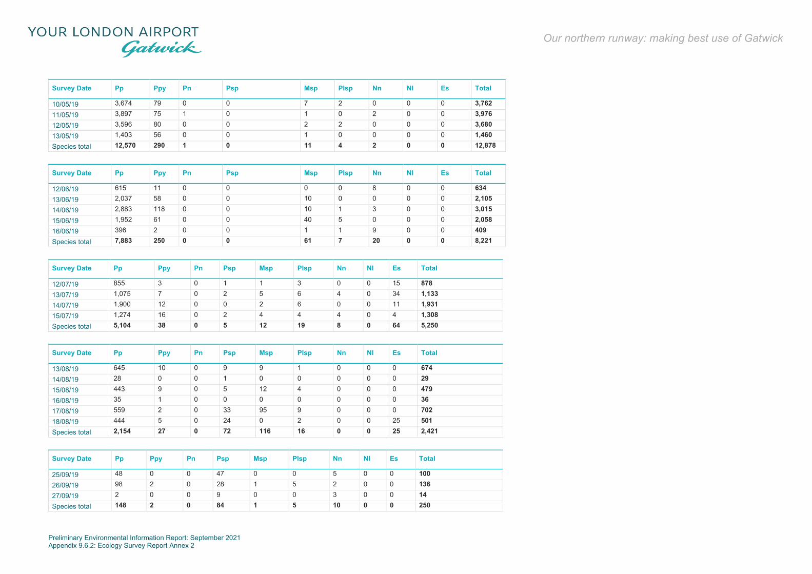
Preliminary Environmental Information Report: September 2021 Appendix 9.6.2: Ecology Survey Report Annex 2
Our northern runway: making best use of Gatwick
Survey Date Pp Ppy Pn Psp Msp Plsp Nn Nl Es Total
10/05/19 3,674 79 0 0 7 2 0 0 0 3,762 11/05/19 3,897 75 1 0 1 0 2 0 0 3,976 12/05/19 3,596 80 0 0 2 2 0 0 0 3,680 13/05/19 1,403 56 0 0 1 0 0 0 0 1,460 Species total 12,570 290 1 0 11 4 2 0 0 12,878
Survey Date Pp Ppy Pn Psp Msp Plsp Nn Nl Es Total
12/06/19 615 11 0 0 0 0 8 0 0 634 13/06/19 2,037 58 0 0 10 0 0 0 0 2,105 14/06/19 2,883 118 0 0 10 1 3 0 0 3,015 15/06/19 1,952 61 0 0 40 5 0 0 0 2,058 16/06/19 396 2 0 0 1 1 9 0 0 409 Species total 7,883 250 0 0 61 7 20 0 0 8,221
Survey Date Pp Ppy Pn Psp Msp Plsp Nn Nl Es Total
12/07/19 855 3 0 1 1 3 0 0 15 878 13/07/19 1,075 7 0 2 5 6 4 0 34 1,133 14/07/19 1,900 12 0 0 2 6 0 0 11 1,931 15/07/19 1,274 16 0 2 4 4 4 0 4 1,308 Species total 5,104 38 0 5 12 19 8 0 64 5,250
Survey Date Pp Ppy Pn Psp Msp Plsp Nn Nl Es Total
13/08/19 645 10 0 9 9 1 0 0 0 674 14/08/19 28 0 0 1 0 0 0 0 0 29 15/08/19 443 9 0 5 12 4 0 0 0 479 16/08/19 35 1 0 0 0 0 0 0 0 36 17/08/19 559 2 0 33 95 9 0 0 0 702 18/08/19 444 5 0 24 0 2 0 0 25 501 Species total 2,154 27 0 72 116 16 0 0 25 2,421
Survey Date Pp Ppy Pn Psp Msp Plsp Nn Nl Es Total
25/09/19 48 0 0 47 0 0 5 0 0 100 26/09/19 98 2 0 28 1 5 2 0 0 136 27/09/19 2 0 0 9 0 0 3 0 0 14 Species total 148 2 0 84 1 5 10 0 0 250

Preliminary Environmental Information Report: September 2021 Appendix 9.6.2: Ecology Survey Report Annex 2
Our northern runway: making best use of Gatwick
Survey Date Pp Ppy Pn Psp Msp Plsp Nn Nl Es Total
15/10/19 21 2 0 0 0 0 0 0 0 23 16/10/19 23 1 0 0 1 0 0 0 0 25 17/10/19 0 0 0 0 0 0 0 0 0 0 18/10/19 152 4 0 2 2 0 0 0 0 160 19/10/19 29 19 0 0 0 0 1 0 0 49 20/10/19 211 16 0 0 4 0 0 0 0 231 Species total 436 42 0 2 7 0 1 0 0 488
Annex 2.1.30: Bat Records at Location 8
Survey Date Pp Ppy Pn Psp Msp Plsp Nn Nl Es Total
24/04/19 0 0 0 0 0 0 0 0 0 0 25/04/19 173 0 0 0 0 0 0 0 0 173 26/04/19 23 0 0 0 0 0 0 0 0 25 27/04/19 13 0 0 0 0 0 0 0 0 13 28/04/19 280 0 1 0 0 0 3 0 0 284 29/04/19 367 0 0 4 0 0 0 0 0 371 30/04/19 267 0 0 0 0 0 10 0 0 277 01/05/19 603 2 0 3 0 0 7 0 0 615 Species total 1,728 2 1 7 0 0 20 0 0 1,758
Survey Date Pp Ppy Pn Psp Msp Plsp Nn Nl Es Total
12/05/19 71 0 0 0 0 0 0 0 0 71 13/05/19 1,118 1 0 0 0 0 0 0 0 1,119 14/05/19 787 2 0 0 0 0 0 0 0 789 15/05/19 142 0 0 0 0 0 0 0 0 142 Species total 2,118 3 0 0 0 0 0 0 0 2,121
Survey Date Pp Ppy Pn Psp Msp Plsp Nn Nl Es Total
11/07/19 0 0 0 0 0 0 0 0 0 0 12/07/19 5 0 0 0 0 0 7 0 0 12 13/07/19 7 0 0 0 0 0 39 0 0 46 14/07/19 14 0 0 0 0 0 101 0 0 114 15/07/19 8 0 0 0 0 0 0 0 0 8 16/07/19 3 0 0 0 0 0 20 0 0 23 Species total 37 0 0 0 0 0 164 0 0 203

Preliminary Environmental Information Report: September 2021 Appendix 9.6.2: Ecology Survey Report Annex 2
Our northern runway: making best use of Gatwick
Survey Date Pp Ppy Pn Psp Msp Plsp Nn Nl Es Total
14/08/19 1 0 0 0 0 0 0 0 0 1 15/08/19 2 0 0 0 0 0 0 0 0 2 16/08/19 0 0 0 0 0 0 0 0 0 0 17/08/19 7 0 0 0 0 0 0 0 0 7 18/08/19 4 0 0 0 0 0 0 0 0 4 Species total 14 0 0 0 0 0 0 0 0 14
Survey Date Pp Ppy Pn Psp Msp Plsp Nn Nl Es Total
25/09/19 227 4 0 31 0 0 113 0 0 375 26/09/19 138 6 0 4 0 0 175 2 0 325 27/09/19 9 0 0 0 0 0 39 0 0 48 28/09/19 125 1 9 6 0 0 46 0 0 187 29/09/19 180 8 0 2 0 0 642 6 1 840 Species total 679 19 9 43 1 0 1,015 8 1 1,775
Survey Date Pp Ppy Pn Psp Msp Plsp Nn Nl Es Total
14/10/19 21 3 0 0 0 0 11 0 0 35 15/10/19 332 16 22 2 1 0 14 1 0 388 16/10/19 38 0 0 0 0 0 2 0 0 40 17/10/19 1 0 0 0 0 0 0 0 0 1 18/10/19 217 3 0 0 7 0 5 0 0 232 19/10/19 184 2 0 1 0 0 6 0 0 193 Species total 793 24 22 3 8 0 38 1 0 889
Annex 2.1.31: Bat Records at Location 9
Survey Date
Bb Pp Ppy Pn Psp Msp Plsp Nn Nl Es Total
24/04/19 0 0 0 0 0 0 0 0 0 0 0 25/04/19 0 4 0 0 0 0 0 0 0 0 4 26/04/19 0 0 0 0 0 0 0 0 0 0 0 27/04/19 0 0 0 0 0 0 0 0 0 0 0 28/04/19 0 1 0 0 0 0 0 0 0 0 1 29/04/19 0 4 0 0 0 0 0 0 0 0 4 30/04/19 0 12 0 0 0 0 0 0 0 0 12 01/05/19 0 1 0 0 0 0 0 0 0 0 1 Species total
0 22 0 0 0 0 0 0 0 0 22

Preliminary Environmental Information Report: September 2021 Appendix 9.6.2: Ecology Survey Report Annex 2
Our northern runway: making best use of Gatwick
Survey Date
Bb Pp Ppy Pn Psp Msp Plsp Nn Nl Es Total
10/05/19 0 197 0 0 0 0 0 0 0 0 197 11/05/19 0 214 0 0 0 0 0 0 0 0 214 12/05/19 0 305 1 0 0 0 0 0 0 0 306 13/05/19 0 352 0 0 0 0 0 0 0 0 352 14/05/19 0 453 0 0 0 1 0 0 0 0 454 15/05/19 0 565 0 0 0 1 0 0 0 0 566 Species total
0 2,086 1 0 0 2 0 0 0 0 2,089
Survey Date
Bb Pp Ppy Pn Psp Msp Plsp Nn Nl Es Total
13/06/19 1 428 7 8 0 2 0 0 0 0 446 14/06/19 0 950 6 1 0 0 0 3 0 0 960 15/06/19 0 653 6 0 0 0 0 0 0 0 659 16/06/19 0 763 0 0 0 0 0 0 0 0 763 Species total
1 2,794 19 9 0 2 0 3 0 0 2,828
Survey Date
Bb Pp Ppy Pn Psp Msp Plsp Nn Nl Es Total
12/07/19 0 91 2 0 0 0 0 16 0 0 109 13/07/19 0 31 0 0 0 0 0 2 0 0 33 14/07/19 0 46 0 0 0 0 0 0 0 0 46 15/07/19 0 60 0 0 0 0 0 0 0 0 60 16/07/19 0 10 0 0 0 0 0 1 0 0 11 Species total
0 238 2 0 0 0 0 19 0 0 259
Survey Date Pp Ppy Pn Psp Msp Plsp Nn Nl Es Total
13/08/19 18 1 0 0 0 0 0 0 0 19 14/08/19 3 0 0 0 0 0 0 0 0 3 15/08/19 10 0 0 0 2 0 0 0 0 12 16/08/19 7 0 0 0 0 0 0 0 0 7 17/08/19 26 0 0 0 1 0 0 0 0 27 18/08/19 40 0 0 0 0 0 0 0 0 40 Species total 104 1 0 0 3 0 0 0 0 108

Preliminary Environmental Information Report: September 2021 Appendix 9.6.2: Ecology Survey Report Annex 2
Our northern runway: making best use of Gatwick
Survey Date Pp Ppy Pn Psp Msp Plsp Nn Nl Es Total
25/09/19 52 0 0 1 0 0 0 0 0 53 26/09/19 45 0 0 5 0 0 0 0 0 50 27/09/19 19 0 0 0 0 0 0 0 0 19 28/09/19 6 0 0 0 0 0 0 0 0 6 29/09/19 4 0 0 0 0 0 0 0 0 4 Species total 126 0 0 6 0 0 0 0 0 132
Survey Date Pp Ppy Pn Psp Msp Plsp Nn Nl Es Total
15/10/19 2 0 0 0 0 0 0 0 0 2 16/10/19 0 0 0 0 1 0 0 0 0 1 Species total 2 0 0 0 1 0 0 0 0 3
Annex 2.1.32: Bat Records at Location 10
Survey Date Pp Ppy Pn Psp Msp Plsp Nn Nl Es Total
10/05/19 33 0 0 1 0 0 0 0 0 34 11/05/19 118 2 0 2 1 0 1 0 0 124 12/05/19 133 23 0 0 0 0 0 0 0 156 13/05/19 670 1 0 0 2 0 0 0 0 673 14/05/19 736 112 0 1 0 0 0 0 0 849 15/05/19 603 207 0 0 0 0 0 0 0 810 Species total 2,293 345 0 4 3 0 1 0 0 2,646
Survey Date Pp Ppy Pn Psp Msp Plsp Nn Nl Es Total
12/07/19 289 20 0 0 0 0 6 0 0 315 13/07/19 324 9 0 1 2 0 5 0 0 341 14/07/19 1,243 68 0 0 3 1 3 0 0 1,318 15/07/19 369 39 0 0 1 0 9 0 0 418 16/07/19 431 0 0 0 0 0 0 0 0 431 Species total 2,656 136 0 1 6 1 23 0 0 2,823
Survey Date Pp Ppy Pn Psp Msp Plsp Nn Nl Es Total
13/08/19 459 93 0 1 6 2 4 2 2 569 14/08/19 305 1 0 0 1 0 2 0 0 309 15/08/19 463 31 0 11 12 5 6 0 1 529 Species total 1,227 125 0 12 19 7 12 2 3 1,407

Preliminary Environmental Information Report: September 2021 Appendix 9.6.2: Ecology Survey Report Annex 2
Our northern runway: making best use of Gatwick
Survey Date Pp Ppy Pn Psp Msp Plsp Nn Nl Es Total
25/09/19 248 17 0 2 2 0 57 2 0 328 26/09/19 109 13 1 0 2 1 12 0 0 138 27/09/19 1 0 0 0 0 0 2 0 0 3 28/09/19 25 8 0 0 2 0 37 0 0 72 29/09/19 108 36 0 0 3 1 9 0 0 157 Species total 491 74 1 2 9 2 117 2 0 698
Survey Date Pp Ppy Pn Psp Msp Plsp Nn Nl Es Total
14/10/19 30 1 0 0 1 0 4 1 0 37 15/10/19 6 0 0 0 2 0 3 0 0 11 16/10/19 6 1 0 0 1 0 4 0 0 12 17/10/19 10 0 0 0 0 0 0 0 0 10 18/10/19 26 2 0 0 1 0 0 0 0 29 Species total 78 4 0 0 5 0 11 1 0 99
Annex 2.1.33: Bat Records at Location 11
Survey Date Pp Ppy Pn Psp Msp Plsp Nn Nl Es Total
24/04/19 0 0 0 0 0 0 0 0 0 0 25/04/19 585 3 2 1 1 0 0 0 0 592 26/04/19 94 0 0 0 0 0 0 0 0 94 27/04/19 1 0 0 0 0 0 0 0 0 1 28/04/19 357 2 0 1 0 1 1 0 0 362 29/04/19 166 1 0 3 0 0 0 0 0 170 30/04/19 626 1 0 0 3 1 1 0 0 632 01/05/19 182 0 0 0 0 0 4 0 0 186 Species total 2,011 7 2 5 4 2 6 0 0 2,037
Survey Date Pp Ppy Pn Psp Msp Plsp Nn Nl Es Total
11/05/19 5 0 0 0 0 0 0 0 0 5 12/05/19 9 0 0 0 0 0 0 0 0 9 13/05/19 21 0 0 0 0 0 0 0 0 21 14/05/19 2 0 0 0 0 0 0 0 0 2 15/05/19 23 0 0 0 0 0 0 0 0 23 Species total 60 0 0 0 0 0 0 0 0 60

Preliminary Environmental Information Report: September 2021 Appendix 9.6.2: Ecology Survey Report Annex 2
Our northern runway: making best use of Gatwick
Survey Date Pp Ppy Pn Psp Msp Plsp Nn Nl Es Total
13/06/19 196 0 0 0 0 0 6 0 0 202 14/06/19 97 0 0 0 0 0 5 0 0 102 15/06/19 155 0 0 0 0 0 3 0 0 158 16/06/19 480 0 0 0 0 0 3 0 0 483 Species total 928 0 0 0 0 0 17 0 0 945
Survey Date Pp Ppy Pn Psp Msp Plsp Nn Nl Es Total
12/07/19 865 0 1 3 26 1 6 0 0 902 13/07/19 1,376 0 1 2 19 0 3 0 0 1,401 14/07/19 1,207 1 2 3 46 0 5 0 0 1,264 15/07/19 482 1 1 0 23 1 9 0 0 517 16/07/19 431 1 2 3 7 0 10 0 0 454 Species total 4,361 3 7 11 121 2 33 0 0 4,538
Survey Date Pp Ppy Pn Psp Msp Plsp Nn Nl Es Total
13/08/19 57 0 0 0 1 0 5 0 0 63 14/08/19 663 0 0 25 1 0 5 0 1 695 15/08/19 57 1 0 0 6 1 6 0 0 71 16/08/19 210 0 0 1 5 0 7 0 0 223 17/08/19 223 0 0 11 0 0 4 0 0 238 Species total 1,210 1 0 37 13 1 27 0 1 1,290
Survey Date Pp Ppy Pn Psp Msp Plsp Nn Nl Es Total
25/09/19 2,003 2 0 165 35 1 322 0 0 2,528 26/09/19 875 1 0 80 22 1 212 0 0 1,191 27/09/19 17 1 0 1 1 1 5 0 0 26 Species total 2,895 4 0 246 58 3 539 0 0 3,745
Survey Date Pp Ppy Pn Psp Msp Plsp Nn Nl Es Total
14/10/19 252 5 0 0 17 0 0 0 0 274 15/10/19 183 0 0 0 19 0 16 0 0 218 16/10/19 26 1 0 0 5 0 4 0 0 36 17/10/19 0 0 0 0 0 0 0 0 0 0 18/10/19 986 3 0 2 18 0 0 0 0 1,009 19/10/19 9 0 0 0 0 0 0 0 0 9 Species total 1,456 9 0 2 59 0 20 0 0 1,546

Preliminary Environmental Information Report: September 2021 Appendix 9.6.2: Ecology Survey Report Annex 3
Our northern runway: making best use of Gatwick
Annex 3
Evaluation

Preliminary Environmental Information Report: September 2021 Appendix 9.6.2: Ecology Survey Report Annex 3
Our northern runway: making best use of Gatwick
A3.1 Evaluation
Breeding Bird Surveys
Annex 3.1.1: Species of Conservation Interest, Number of Territories, National, Regional and County Status and Geographical Importance of Survey Area Population
Species No. of pairs UK Breeding Population Regional Breeding Population County Status Geographical Importance
Mallard 9 61,000-146,000 - Surrey: common breeding resident. Sussex: common resident and winter visitor. Local Little ringed plover1 1 1,115 123 Surrey: summer visitor breeding annually in small numbers and passage migrant
(estimated at 10 pairs in 2016). Sussex: scarce breeding summer visitor and passage migrant (14 pairs in 2016).
County
Stock dove 3 260,000 - Surrey: common breeding resident and passage migrant. Sussex: common resident and possible winter visitor.
Local
Kestrel 4 46,000 - Surrey: moderately common breeding resident. Sussex: Fairly common resident and passage migrant.
Local
Peregrine1 1 1,731 93 Surrey: increasing breeding resident, passage migrant and winter visitor (14 pairs in 2016). Sussex: scarce breeding resident (33 pairs in 2016).
Regional
Marsh tit 1 41,000 - Surrey: uncommon and declining breeding resident. Sussex: scarce resident. County Skylark 12 1,500,000 - Surrey: common but declining breeding resident, passage migrant and winter
visitor. Sussex: very common but declining resident; and probably common passage migrant and winter visitor.
Local
Starling 2 1,900,000 - Surrey: common breeding resident. Sussex: common but declining resident; and very common to abundant winter visitor.
Local
Song thrush 19 1,200,000 - Surrey: common breeding resident. Sussex: very common but decreasing resident and partial migrant; common passage migrant and winter visitor.
Local
Mistle thrush 2 170,000 - Surrey: common breeding resident. Sussex: common resident and partial migrant. Local Firecrest1 1 4,000+ c.250 Surrey: moderately common breeding resident, passage migrant and winter visitor
(estimated at 150 singing males in 2016). Sussex: scarce or possibly fairly common breeding resident; passage migrant; and winter visitor (estimated at 100 singing males in 2015).
County
House sparrow 4 5,300,000 - Surrey: common breeding resident. Sussex: very common but possibly declining resident.
Local
Dunnock 18 2,500,000 - Surrey: common breeding resident. Sussex: very common resident. Local Grey wagtail 1 38,000 - Surrey: moderately common breeding resident and passage migrant. Sussex:
scarce resident and fairly common passage migrant and winter visitor. Local
Bullfinch 1 220,000 - Surrey: moderately common breeding resident. Sussex: fairly common or common resident.
Local
Linnet 1 430,000 - Surrey: moderately common resident, passage migrant and winter visitor. Sussex: common but decreasing resident and partial migrant.
Local
Reed bunting 2 250,000 - Surrey: moderately common breeding resident. Sussex: fairly common resident; passage migrant and winter visitor.
Local
Note 1: Species considered to be possibly breeding

Preliminary Environmental Information Report: September 2021 Appendix 9.6.2: Ecology Survey Report Annex 4
Our northern runway: making best use of Gatwick
Annex 4
Invertebrate Scoping Survey


Colin Plant Associates (UK) Consultant Entomologists: continuation of correspondence
BiodiversityAreasaremanagedfornatureconservationandareknowntosupportimportantinvertebrateassemblages on the basis of recent records gathered by Gatwick Airport Biodiversity Consultant RachelBicker. These include various species of conservation significance such as Dingy Skipper Erynnis tages,GrizzledSkipperPyrgusmalvae,BrownHairstreakTheclabetulae,Long-hornedBeeEuceralongicornisandBlack-headedMasonWaspOdynerusmelanocephalus,allofwhichareSection41species(Bicker,2018).Inthelightoftheabove,eightareaswereselectedwhichwereconsideredtobeofpotential importanceforinvertebrates.ThelocationsoftheseareshowninFigures1and2.Thesitevisitwasundertakenon17thJuneinsunnyandwarmconditions.
Fig.1 Areasexaminedintheeasternsector(SitesA-C).

Colin Plant Associates (UK) Consultant Entomologists: continuation of correspondence
Fig.2 Areasexaminedinthewesternsector(SitesD-H).INVERTEBRATEHABITATSPRESENTINJUNE2019SiteA:PentagonFieldandadjacentditchesThisarealiesdirectlynorthofLowerPickettsWoodandcoversapproximately10ha.Thehabitatspresentcompriseanexpanseofdrysemi-improvedneutralgrasslandboundedbyawoodedhedgerowandaditchonthewesternmargin.Astripofimmatureplantationwoodlandispresentalongthesouthernboundary.Thegrassland isratheruniforminnatureandveryfewherbaceousspeciesarerepresented inthesward.Thislackofstructuralvariationcombinedwithitslowfloristicdiversitypredictsaspecies-poorinvertebrateassemblagedominatedbythosewithmoregeneralistecologicalrequirements,whichareusuallyoflowerconservationvalue.Thehedgerow includesnumerousovermatureoaks, someofwhichcontainobviousamountsof standingdeadwood and aerialwood decay features, including a large red rotten cavity at the base of one tree.Thesetreesofferarangeofpotentialnichesforinvertebrateswhicharebothphytophagousandsaproxylic.

Colin Plant Associates (UK) Consultant Entomologists: continuation of correspondence
InBritainalone,thereareat least700nativespeciesofbeetle(Coleoptera)andover700speciesoftwo-winged fly (Diptera)which appear tobedependentondecayingwoodat some stage in their life cycles.ManyoftheseareofhighconservationvalueandarelistedasSection41species.Theditchonthewesternmarginisopenandunshadedalongmuchofitslengthandheldahighwaterlevelon the day of examination. Theditch profile is gently shelvingwhich has allowed a diverse riparian andemergent floratodevelop, includingHemlockWater-dropwortandMeadowsweet,aswellassedgesandstands of bulrush. These are positive features that suggest its potential importance for invertebrates islikelytoberaised.OverallweconsiderthatSiteAhasamoderateintrinsicinvertebrateinterest.SiteB:PondFThisareacoversapproximately1.7haandliesbetweentheA23tothenorth,railwaylinestothewestandairportcarparkstothesouth.It comprises a single waterbody which is rather deep and steep sided and was probably originallyconstructedasabalancingpond.Thepondissurroundedbyanarrowzoneofalderandwillowscrub,butthereisonlyminimalemergentvegetationatthemarginsandthebanksidevegetationislargelydominatedby dense bramble scrub. Severalmats ofWhiteWater-lily are present. Thewater is subject to nutrientenrichmentbywildfowlandpresumablythereisalsosomerunofffromsurroundingroads.OverallweconsiderthatSiteBhasalowintrinsicinvertebrateinterest.SiteC:RiversideGardenParkandpondsThisareacoversapproximately11haandliesbetweentheA23tothesouthandtheurbanedgeofHorleytothenorth.The site presents as amosaic of densemature woodland interspersed with open areas of grassland. Arangeoftreespeciesarerepresentedincludingoak,hawthornandelderwhichoffernumerousnichesforphytophagousinvertebrates,butonlyaminimalstandingorfallendeadwoodresourceisapparentwiththeexception of a single dead barkless oak. The grassland is highly improved in nature and a minimalherbaceousfloraispresentintheopenareas.Inplacesthewoodlandunderstoreyisdominatedbydensestandsofstingingnettles,indicatinghighsoilfertility.Astockedfishinglakeispresentclosetothesouthernboundary.Thewatercolumnappearedturbidandispresumably subject to extensive nutrient enrichment from the large numbers of feral Greylag Geesepresent. Areas ofmarginal vegetation areminimal and emergentmacrophytes are represented only bysmallstandsofYellowFlagandsomecoverbyWhiteWater-lily.The Gatwick Stream runs through the Riverside Garden Park but the channel is very eroded and steep-sided,supportingminimalriparianvegetationanddominatedbydensebramblecover.OverallweconsiderthatSiteChasalowintrinsicinvertebrateinterest.SiteD:PondDThisareacoversapprox.2haandislocatedbetweenthenorthernairportperimeterandtheRiverMole.

Colin Plant Associates (UK) Consultant Entomologists: continuation of correspondence
Theeasternhalfofthesitecomprisesapondadjacenttoawatermanagementfacilitywhichmakesupthewesternsection.Thepondmarginswerebareandmuddyindicatingrecentfluctuationandthesurroundingbanks dominated by an improved grass sward which had recently been mown. It was not possible tophysically access the pond edges but themarginal flora appeared to be impoverished and representedsolelybysmallstandsofrushesandsedges.OverallweconsiderthatSiteDhasalowintrinsicinvertebrateinterest.SiteE:DogKennelWood,pondandditchThis area covers approximately 2.7 ha and is located very close to the northern airport perimeter andlargelysurroundedbythebuiltenvironmentoftheairportonallsides.Despitethisitcontainsarangeofhabitats,comprisingawaterbodyandasmallcopseofmaturewoodlandwhichenclosesthedogkennels.Thepondissetinadeepandroughlytriangulardepressionandisalmostentirelyvegetated,withonlyminimalstandingwaterapparentonthedayofexamination.ThewesternhalfisdominatedbyCommonReedandtheremainderbybulrush,HemlockWater-dropwort,Meadowsweet,rushesandsedges,withanumberofsmallwillowsalsopresent.The bankside flora comprises dry semi-improved neutral grassland with a range of herbaceous speciesincluding Creeping Cinquefoil, Common Bird’s-foot Trefoil, Self-heal and tall ruderal species such asragworts, docks, teasel and Perforate St John’sWort. The sloping nature of the bank presents a warmsouth-facing aspect across the northern section, a positive feature for invertebrates requiring a warmmicroclimateatthegroundsurface.Therelativelydiverse florawhich includesarangeofhostplants incombinationwiththetransition fromwet to dry soils provides a large rangeof potential niches for invertebrates. Thepresenceof a rangeofmaturetreesintheadjoiningwoodlandcontributestotheoverallinterest.OverallweconsiderthatSiteEhasamoderateintrinsicinvertebrateinterest.SiteF:PondMandtopofenvironmentbundThisareacoversapproximately6haandis locatedbetweenthenorthernairportperimeterandtheRiverMole.Varioushabitatsarepresentaroundaconcrete-sidedwaterbodywhichissplitintotwohalves.Thispondispresumablyused insiltextractionasthewesternhalfwasalmostentirelydryonthedayofexaminationandthebedentirelycoveredbysiltdeposits.Thisareahassomepotentialforinvertebrateswhichrequireveryfine-grainedsediments,althoughisunlikelytosupportarichfauna.Thesurroundingareacomprisesdrysemi-improvedneutralgrasslandwitharangeofherbaceousspeciesincludingCreepingCinquefoil,CommonBird’s-footTrefoil,MeadowVetchling,GrassVetchlingandTuftedVetch, as well as tall ruderal flora in the form of docks and thistles. The structural variationwithin thegrassland,combinedwith its floristicdiversity,predictsthatvariousplant-feedinggroupsof invertebratessuch as phytophagous beetles and true bugsmay have rich faunas. During the visit a single Section 41specieswerenoted, theSmallHeathCoenonymphapamphilus.Thisareapossibly lieswithin the foragingrange of the Long-horned BeeEucera longicorniswhich is known to nest along the adjacent RiverMolecorridoranduselegumessuchasvetchlingsandtrefoilsasitsprincipalforageplants.OverallweconsiderthatSiteFhasamoderateintrinsicinvertebrateinterest.
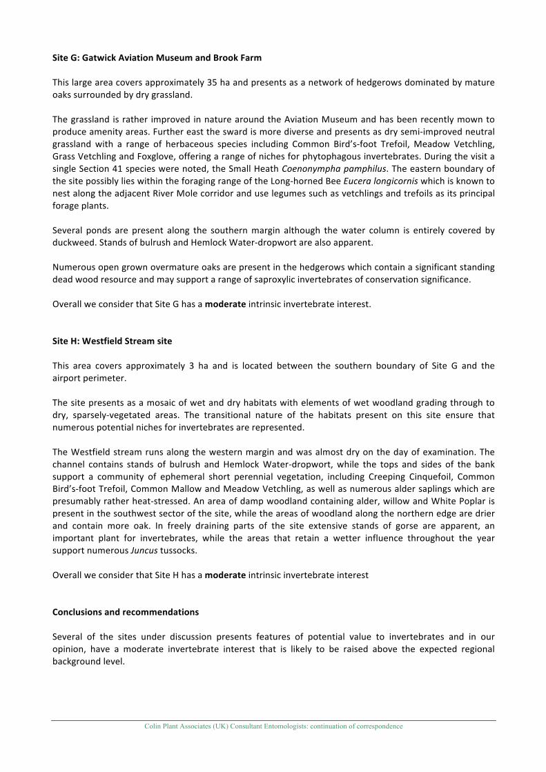
Colin Plant Associates (UK) Consultant Entomologists: continuation of correspondence
SiteG:GatwickAviationMuseumandBrookFarmThislargeareacoversapproximately35haandpresentsasanetworkofhedgerowsdominatedbymatureoakssurroundedbydrygrassland.Thegrassland israther improved innaturearoundtheAviationMuseumandhasbeenrecentlymowntoproduceamenityareas.Furthereasttheswardismorediverseandpresentsasdrysemi-improvedneutralgrassland with a range of herbaceous species including Common Bird’s-foot Trefoil, Meadow Vetchling,GrassVetchlingandFoxglove,offeringarangeofnichesforphytophagousinvertebrates.DuringthevisitasingleSection41specieswerenoted,theSmallHeathCoenonymphapamphilus.TheeasternboundaryofthesitepossiblylieswithintheforagingrangeoftheLong-hornedBeeEuceralongicorniswhichisknowntonestalongtheadjacentRiverMolecorridoranduselegumessuchasvetchlingsandtrefoilsasitsprincipalforageplants.Several ponds are present along the southernmargin although thewater column is entirely covered byduckweed.StandsofbulrushandHemlockWater-dropwortarealsoapparent.Numerousopengrownovermatureoaksarepresentinthehedgerowswhichcontainasignificantstandingdeadwoodresourceandmaysupportarangeofsaproxylicinvertebratesofconservationsignificance.OverallweconsiderthatSiteGhasamoderateintrinsicinvertebrateinterest.SiteH:WestfieldStreamsiteThis area covers approximately 3 ha and is located between the southern boundary of Site G and theairportperimeter.Thesitepresentsasamosaicofwetanddryhabitatswithelementsofwetwoodlandgradingthroughtodry, sparsely-vegetated areas. The transitional nature of the habitats present on this site ensure thatnumerouspotentialnichesforinvertebratesarerepresented.TheWestfieldstreamrunsalongthewesternmarginandwasalmostdryonthedayofexamination.Thechannel contains stands of bulrush and HemlockWater-dropwort,while the tops and sides of the banksupport a community of ephemeral short perennial vegetation, including Creeping Cinquefoil, CommonBird’s-footTrefoil,CommonMallowandMeadowVetchling,aswellasnumerousaldersaplingswhicharepresumablyratherheat-stressed.Anareaofdampwoodlandcontainingalder,willowandWhitePoplarispresentinthesouthwestsectorofthesite,whiletheareasofwoodlandalongthenorthernedgearedrierand contain more oak. In freely draining parts of the site extensive stands of gorse are apparent, animportant plant for invertebrates, while the areas that retain a wetter influence throughout the yearsupportnumerousJuncustussocks.OverallweconsiderthatSiteHhasamoderateintrinsicinvertebrateinterestConclusionsandrecommendationsSeveral of the sites under discussion presents features of potential value to invertebrates and in ouropinion, have a moderate invertebrate interest that is likely to be raised above the expected regionalbackgroundlevel.


Preliminary Environmental Information Report: September 2021 Appendix 9.6.2: Ecology Survey Report Annex 5
Our northern runway: making best use of Gatwick
Annex 5
Terrestrial Invertebrate Survey


Gatwick Airport Northern Runway Project Assessment of Terrestrial Invertebrate Interest
iii
Contents
SUMMARY ................................................................................................................................ IV
1. INTRODUCTION ............................................................................................................... 1
1.1 BACKGROUND ..................................................................................................................... 1
2. CONSERVATION STATUS AND LEGAL PROTECTION ................................................. 2
2.1 CONSERVATION STATUS ...................................................................................................... 2 2.2 LEGISLATION....................................................................................................................... 3
3. METHODOLOGY .............................................................................................................. 4
3.1 SURVEY VISITS ................................................................................................................... 4 3.2 SITE COMPARTMENTS ......................................................................................................... 4 3.3 LOCATION AND COLLECTION OF SPECIMENS ......................................................................... 4 3.4 TAXONOMIC COVERAGE ...................................................................................................... 4 3.5 LIMITATIONS ....................................................................................................................... 4
4. RESULTS ......................................................................................................................... 5
4.1 GENERAL............................................................................................................................ 5 4.2 NOTEWORTHY SPECIES ....................................................................................................... 5
5. SITE ASSESSMENT ....................................................................................................... 13
5.1 DISCUSSION ..................................................................................................................... 13
6. CONCLUSION ................................................................................................................ 14
7. REFERENCES ................................................................................................................ 15
FIGURE 1. SITE LOCATIONS (THREE SEPARATE PARCELS - GATWICK AIRPORT) .... .. 17
APPENDIX 1. FULL SPECIES LIST ........................................................................................ 18

Gatwick Airport Northern Runway Project Assessment of Terrestrial Invertebrate Interest
iv
Summary
Ecus Ltd was commissioned by RPS Group Plc in May 2020 to undertake terrestrial invertebrate surveys of three separate land parcels/compartments adjoining Gatwick Airport as part of the surface water management and flood alleviation for the Northern Runway Project development. The three survey areas comprised Compartment P: Riverside Park (National Grid Reference (NGR): TQ 28055 42020, Compartment M: River Mole Corridor NGR: TQ 25772 40623 and Compartment G: Gatwick Brook Grasslands NGR: TQ 29000 39799, hereafter referred to as ‘the Site’. The three land parcel locations are shown on Figure 1.
Although Gatwick Airport is now nominally in the County of West Sussex, for the purposes of biological recording it is in Vice-County 17, Surrey.
Six site field visits were made during 2020: 27th May, 19th June, 22nd June, 30th June, 10th September and 14th September. Six visits were made to cover all sites in total, however all three parcels were not covered on all six visits, but more on a rotation basis to cover each one at appropriate points across the 2020 season.
A list of 303 terrestrial invertebrate species was recorded in total (see Appendix 1). This total was considered a relatively diverse list for such a site.
Numerous unusual and scarce insects were found, including:
Acinia corniculata, a nationally rare fly that breeds in the seed-heads of knapweed.
Catoplatus fabricii, a nationally scarce lacebug that breeds on oxeye daisy.
Dioxyna bidentis, a nationally scarce fly that breeds on trifid bur-marigold.
Dorycera graminum, a nationally rare fly of damp meadows and floodplains.
Ectobius lapponicus, the dusky cockroach, a species of rough heathy grasslands.
Hylaeus cornutus, a nationally scarce yellow-faced bee.
Merzomyia westermanii, a nationally scarce picture-winged fly that breeds on ragwort.
Paraclusia tigrina, a nationally rare fly of old broad-leaved woodlands.
Podagrica fuscicornis, a nationally scarce leaf beetle that feeds on mallows.
Reptalus quinquicostatus, a nationally scarce frog-hopper of dry grasslands.
Rhinocyllus conicus, a nationally scarce weevil that feeds on thistles.
Squamapion vicinum, a nationally scarce weevil that feeds on water mint.
Tachys bistriatus, a nationally scarce ground beetle of damp muddy pond edges.
Uleiota planata, a nationally scarce beetle that breeds under fungoid tree bark.
Variimorda villosa, a nationally scarce flower beetle associated with ancient woods.
The diverse species list and numerous scarce and unusual insects recorded, reflect a diversity of habitat types present at the Site: river edge, flowery grassland, hedgerows, disturbed ground, woodland and scrub.
The individual parcels are suggested as having the following invertebrate interest:
Riverside Park — low.
River Mole Corridor — medium/high.
Gatwick Brook Grasslands — low/medium.

Gatwick Airport Northern Runway Project Assessment of Terrestrial Invertebrate Interest
1
1. Introduction
1.1 Background
1.1.1 Ecus Ltd was commissioned by RPS Group Plc in April 2020 to undertake terrestrial invertebrate surveys of three land parcels adjoining Gatwick Airport as part of the surface water management and flood alleviation for the Northern Runway Project development. The three land parcels (compartments), hereafter referred to as ‘the Site’, are described below and the location is shown in Figure 1.
1.1.2 Compartment P: Riverside Park. This is a public open space, mainly wooded, although likely more open in the past. It is heavily managed with plentiful short amenity grassland. Of little interest in terms of entomology, apart from a narrow corridor alongside the A23 which was the focus for survey here. This area is centred on National grid reference TQ 28055 42020.
1.1.3 Compartment M: River Mole Corridor. This is an irregular plot to the west of the airport, comprising brownfield zones, rough grassy areas, the River Mole and riverbanks, hedgerows and woodland edges. This area is centred on National grid reference TQ 25772 40623.
1.1.4 Compartment G: Gatwick Brook Grasslands. This is an irregular plot to the east of the airport, comprising rough grassy areas, a few mature trees, scrub, Gatwick Brook, hedgerows and woodland edges. This area is centred on National grid reference TQ 29000 39799.
1.1.5 This survey is part of a wider ecological assessment of the site to be undertaken by RPS Group Plc.


Gatwick Airport Northern Runway Project Assessment of Terrestrial Invertebrate Interest
3
2.2 Legislation
2.2.1 Three invertebrate species occurring in the UK are European protected species (EPS), so are therefore protected under European law. These species are Fisher’s Estuarine Moth (Gortyna borelii lunata), Large Blue Butterfly (Phengaris arion) and Lesser Whirlpool Ramshorn Snail (Anisus vorticulus).
2.2.2 It is an offence to capture, kill, disturb or injure these species. As well as to damage or destroy their breeding or resting places or to obstruct access to any such place (either deliberately or accidentally).
2.2.3 Forty invertebrate species occurring in the UK are included on Schedule 5 Section 9.1 of the Wildlife & Countryside Act 1981 (as amended). This it makes it an offence to kill, injure or take any of the species.
2.2.4 Four species are listed under Schedule 5 Section 9.4 of the Wildlife & Countryside Act 1981 (as amended). This makes it illegal to damage or destroy their breeding or resting places or to obstruct access to any such place.
2.2.5 Twenty seven species are listed under Schedule 5 Section 9.5 of the Wildlife & Countryside Act 1981 (as amended), which prevents them from being sold or transported.

Gatwick Airport Northern Runway Project Assessment of Terrestrial Invertebrate Interest
4
3. Methodology
3.1 Survey Visits
3.1.1 The surveys were undertaken by an experienced entomologist to the Site six times during 2020: 27th May, 19th June, 22nd June, 30th June, 10 h September and 14th September. Six visits were made to cover all sites in total, however all three sites were not covered on all six visits, but more on a rotation basis to cover each one at appropriate points across the 2020 season. A walk-over assessment of the Site, taking note of habitats and features in relation to invertebrates was complemented by the collection of specimens for either Site or subsequent laboratory analysis.
3.2 Site Compartments
3.2.1 Three broad compartments/parcels were identified which equated to three separate sites. These sites are described in Section 1.1 and illustrated in Figure 1. Each of these compartments was visited on at least three occasions during 2020. In the following species descriptions, reference is made of these compartments and 10-figure National grid references are also provided where appropriate.
3.3 Location and Collection of Specimens
3.3.1 A walk-over type survey was carried out. Invertebrates were located and collected by general methods using sweep net, beating tray and a stout trowel. Flowers, leaf surfaces, rocks, bare ground, logs and tree trunks were examined by visual searching. Others were found by finger-tip grubbing in loose soil, rubble, and plant roots, logs, stumps and animal dung. Squares of roofing felt left out for reptile monitoring were also examined. Voucher specimens of all but the most common and characteristic species were collected for examination later under the microscope.
3.4 Taxonomic Coverage
3.4.1 The survey concentrated on the following major groups (orders): Coleoptera (beetles), Diptera (flies), Hemiptera (bugs, froghoppers, etc), Hymenoptera (bees, wasps and ants) and Lepidoptera (butterflies and moths). Some examples of other groups were noted if found.
3.4.2 These are hugely numerous and diverse orders of insects, and identification to species is not always possible, especially in many of the microscopically small specimens. Consequently on any given site, there is much subjective selection of which families or genera are worth taking as sample specimens, for later study. This is often influenced by a knowledge of the groups for which useable identification keys are available, and for which the individual entomologist has particular experience. Nevertheless, a wide coverage of insect orders allows some assessment of just how important any given site may be for its invertebrate biodiversity.
3.5 Limitations
3.5.1 The surveys were undertaken during the optimal season for terrestrial invertebrates (April – September inclusive) and all areas of the land parcels could be accessed safely. It is therefore considered that the findings of the survey provide an accurate representation of the insect assemblages present.


Gatwick Airport Northern Runway Project Assessment of Terrestrial Invertebrate Interest
6
toleration of climate, including daily or yearly temperature or rainfall minima or maxima, or they only occur in niches where they can avoid serious competition, predation or parasitism from abundant and widespread species. The occurrence of these scarcer species gives a much clearer picture of the environmental health or conservation biodiversity status of a particular site.
4.2.4 The following species are highlighted as being especially noteworthy. Most are uncommon nationally. Criteria for allocation of accepted ‘nationally rare’ (previously red data book) and ‘nationally scarce’ (previously notable) statuses are varied and complex (originally published in Shirt, 1987; Hyman & Parsons, 1992 and recently updated in a series of ongoing reviews). Statuses continue to be assessed, reassessed and altered over time and a JNCC database is available giving an up to date summary overview. Every time a rare insect is found there are more records added to the scoring system (based on grid squares in which an insect is found) and it becomes less rare. These statuses are useful to gauge relative rarity, but despite the apparent objectivity of counting numerical records, there is still a subjective element of exactly how rare an organism may be. Those that are relevant to this Site are listed in brief here:
Endangered (RDB-1). The rarest taxa. Taxa in danger of extinction in Great Britain; species with very few recorded localities or living in especially vulnerable habitats.
Vulnerable (RDB-2). Very rare species. Taxa likely to move into the RDB1 category; species declining in their range.
Rare (RDB-3). Rare species. Taxa with small populations and which are at risk; species estimated to occur in 15 or fewer of the 10-km squares in the national Ordnance Survey grid since 1970, or nominated later date if applicable.
Insufficiently known (RDB-K). Species thought to be very rare in Britain, recorded from less than 15 of the 10-km squares of the national Ordnance Survey grid since 1970 or later date, and which warrant RDB classification of some sort, but for which there is a recognized lack of accurate information.
Nationally scarce (notable A). Very local species, thought to occur in 16 to 30 of the 10-km squares of the national Ordnance Survey grid since 1970, or later date.
Nationally scarce (notable B). Very local species, thought to occur in 31 to 100 of the 10-km squares of the national Ordnance Survey grid since 1970 or later date.
Nationally scarce status is sometimes not subdivided into categories A and B, (notable, occurring in 16 to 100 10-km squares).
Very local status is a much more subjective, but nevertheless useful, measure of scarcity and is based on personal experience, published and unpublished records. It is applied to species that are very limited in distribution or confined to very limited specialist habitats. This group includes species previously considered nationally rare or scarce, but which have had statuses reviewed following more recent study.
4.2.5 The following is a description of the more interesting and noteworthy species taken at the Site. Where possible a nominal 10-figure National grid reference is given to indicate the exact location(s) where they were found.
Acinia corniculata (Zetterstedt)
4.2.6 A small pink picture-winged fly, family Tephritidae. Status: endangered (red data book category 1, Shirt, 1987; Falk, 1991b). At the time of the national review this very rare fly was known only from a handful of localities in southern England, all National Nature Reserves. It breeds in the seed heads of common knapweed, but despite the abundance of its host plant, it remains very elusive. Until the late 1990s, it seemed to be primarily associated with a few East Anglian fens, but has recently been recorded from several localities in Sussex, London, Surrey, Hampshire, Dorset and

Gatwick Airport Northern Runway Project Assessment of Terrestrial Invertebrate Interest
7
Gloucestershire (Clemons, 1997, 2004, 2015). It may be increasing its range after a series of warm summers and mild winters. It remains, nevertheless, very elusive, but its status may need revision. Several specimens were found by sweeping knapweed, Gatwick Brook Grassland, dated 22.6.2020, at TQ 28941 40057.
Athous campyloides (Newman)
4.2.7 A medium-sized brown click beetle, family Elateridae. Status: nationally scarce (notable B, Hyman & Parsons, 1992). This very local species is associated with rough grassy places in south-east England (Mendel & Clarke, 1996). The larvae are thought to feed at the roots of grass and herbs. It was once regarded as an extremely rare species, but appears to have colonized Britain in the early 19th century, and is still spreading (Jones, 2001). Several specimens were found by sweeping, River Mole Corridor and Gatwick Brook Grassland, dated 27.5.2020 and 19.6.2020.
Bruchidius imbricornis (Panzer)
4.2.8 A tiny mottled bean weevil, family Chrysomelidae. Status: very local. A recent colonist to Britain, this small but distinctive beetle was first found, in Essex, in 2012. Its food plant is nominally goat’s rue, Galega officinalis, a widespread alien vetch that has become widely established in brownfield sites in England. Several specimens were found by sweeping, River Mole Corridor, dated 19.6.2020 and 10.9.2020.
Camarota curvipennis (Latreille)
4.2.9 A minute black ‘frit’ fly, family Chloropidae. Status: very local. Once much more widespread, breeding the heads of wheat, rye and barley, this species has declined dramatically in the last 50 years following ‘advances’ in agriculture. Although not accorded notable status in the national review by Falk (1991b), the decline of this fly has alerted dipterists to suggest that this species be monitored for possible future nationally scarce notification. Two specimens were found by sweeping, Gatwick Brook Grassland, dated 14.9.2020, at TQ 28976 39926.
Campiglossa malaris (Seguy)
4.2.10 A minute pink and grey picture-winged fly, family Tephritidae. Status: very local. Originally suggested to be nationally rare, but insufficiently known (red data book category K, Clemons, 1997), this status has not been official agreed by JNCC. This scarce fly is thought to feed on ragworts, but whether it forms stem or leaf galls, or breeds in the seed heads is not known. In the 1970s and 80s it was known from only two UK sites, both on the Kent coast, and was accorded endangered status (red data book category 1) by Shirt (1987) and Falk (1991b), but this was later revised to RDB-K by Clemons (1997, 2004) when further Kent localities were discovered. Since then further reports appear to document a spread into England and there are now numerous records from inland Kent, East Sussex and other Home Counties and outliers beyond into central England. This species often occurs in rough grassy places and disturbed ground where the food-plants grow. The fly remains very rare, but its status may need another revision. It is currently not accorded any conservation status by JNCC. Several specimens were found by sweeping, River Mole Corridor, dated 19.6.2020, at TQ 26064 40625.
Catoplatus fabricii (Stal)
4.2.11 A minute pale lacebug, family Tingidae. Status: nationally scarce (notable B, Kirby, 1992). This scarce lacebug feeds on ox-eye daisy, Leucanthemum vulgare and although the food-plant grows commonly and widely on disturbed ground, chalk downland, verges, railway cuttings and rough meadows, the bug is extremely local. It occurs in widely scattered localities in central and southern England, but its precise ecological requirements are unclear. A single specimen was swept from the roadside verge of Riverside Park, dated 27.5.2020, at TQ 28105 41966.
Coccidula scutellata (Herbst)
4.2.12 A small red and black ladybird, family Coccinellidae. Status: very local. Although widespread across much of England and parts of Wales, the localities for this beetle are widely scattered. It is

Gatwick Airport Northern Runway Project Assessment of Terrestrial Invertebrate Interest
8
confined to freshwater sites, stream banks, pond-sides, and marshes (Roy et al, 2011). Several specimens were swept from waterside vegetation, River Mole Corridor, dated 27.5.2020, at TQ 25573 40591.
Dioxyna bidentis (Ronbinaeu-Desvoidy)
4.2.13 A small grey picture-winged fly, family Tephritidae. Status: nationally scarce (Notable, Falk, 1991b). This very scarce fly occurs in a few widely scattered localities in England and South Wales, with an old record from Scotland (Clemons, 1997, 2004, 2015). It breeds in the flower heads of various composites (Asteraceae), particularly Bidens tripartita, the trifid bur-marigold. Several specimens were swept from vegetation bordering the stream, River Mole Corridor, dated 10.9.2020, at TQ 25565 40797.
Dorycera graminum (Fabricius)
4.2.14 A small mottled fly, family Ulidiidae. Status: nationally rare (red data book category 3, Shirt, 1987; Falk, 1991b). Dorycera is usually associated with herb-rich unimproved meadows, often in association with umbellifers and broad-leaved trees. The life history is unknown, but the larvae probably develop in decaying vegetable matter, possibly in the dead or dying roots of hogweed, Heracleum sphondylium or a near relative. It was once regarded as a fairly frequent insect, but appears to have declined dramatically in recent years. Threats are thought to come from loss of unimproved flowery meadows through drainage or lack of grazing leading to scrub invasion. Although there are old records from Hampshire and Worcestershire, most of the recent records are from the Thames Estuary where it regularly occurs on brownfield sites (Ismay, 2000; Jones, 2003, 2007). On a personal note, however, I have recorded this fly in many widely spread localities in the Home Counties in the last 5 years, indicating that it may be increasing and spreading in some areas at least. Two specimens were found sweeping, River Mole Corridor, dated 27.5.2020, at TQ 25825 40566.
Ectobius lapponicus (Linnaeus)
4.2.15 The ‘dusky cockroach’, family Blatellidae. Status: nationally scarce (notable B, Haes & Harding, 1997). This is one of Britain’s native cockroach species, not to be confused with the many domestic pest species that have been introduced into buildings. It is very uncommon, and in Britain it is confined to southern England and most colonies are either in the Sussex Weald or the New Forest (Marshall & Haes, 1988) or west Surrey (Baldock, 1999). It is an omnivorous scavenger, living in grass litter. Several specimens were found by sweeping, River Mole Corridor, dated 27.5.2020, at TQ 25570 40654.
Hippodamia (formerly Adonia) variegata (Goeze)
4.2.16 The Adonis ladybird, family Coccinellidae. Status: nationally scarce (notable B, Hyman & Parsons, 1992), but status may need revision. Until about 30 years ago, this species was always regarded as having a coastal distribution, occurring in warm sheltered locations such as chalk downs, dunes, undercliffs and other disturbed areas (Majerus et al., 1997). However, it is now known to be fairly widespread in England, especially in the London area and Thames Estuary, where it is associated with sparsely vegetated post-industrial brownfield sites, and it has also spread across central England (Roy et al., 2011). Several specimens were found by general sweeping of sparse herbage, River Mole Corridor, dated 10.9.2020, at TQ 25872 40560.
Hylaeus cornutus (Curtis)
4.2.17 A small black white-faced bee, family Colletidae. Status: nationally scarce (notable A, Falk, 1991a). This uncommon bee occurs in a variety of habitats, including woodland and fenland, but is mainly found in dry chalky areas, particularly in the Thames Estuary and Thames Valley (Edwards & Telfer, 2001) and Surrey (Baldock, 2008). It visits a variety of flowers after nectar and pollen and nests in the tough hollow stems of various dead plants such as dock and bramble. Several specimens were found visiting flowers, River Mole Corridor and Gatwick Brook Grassland, dated 27.5.2020 and 22.6.2020.

Gatwick Airport Northern Runway Project Assessment of Terrestrial Invertebrate Interest
9
Lasius brunneus (Latreille)
4.2.18 A small brown ant, family Formicidae. Status: nationally scarce (notable A, Falk, 1991a). This is a very local species restricted mainly to central and southern England from Essex to Shropshire. It seems to be centred on the Thames and Severn Valleys (Edwards, 1998), but appears to be spreading. It nests exclusively in dead wood (logs and standing timber) where it excavates its galleries, and it is particularly associated with ancient woodlands. Several were found crawling up tree trunks or under bark of dead trunks, Gatwick Brook Grassland, dated 22.6.2020, at TQ 28976 39926 and TQ 28874 39869.
Magdalis armigera (Geoffroy)
4.2.19 A small black weevil, family Curculionidae. Status: very local. This widespread, but scarce species breeds in the twigs and branches of elm trees. It is currently increasing again, after becoming extremely scarce following the disappearance of elm trees from the landscape after the ravages of Dutch elm disease in the 1970s. One was beaten from small elm trees, Riverside Park, dated 27.5.2020, at TQ 27924 42151.
Malthodes pumillus (Brebisson)
4.2.20 A minute soldier beetle, family Cantharidae. Status: very local. This beetle is usually found on herbage in old woodlands, and although recorded from numerous localities across much of the British Isles, it is very local and seldom seen. A single specimen was found by sweeping, Gatwick Brook Grassland, dated 22.6.2020, at TQ 29195 40057.
Merzomyia (formerly Icterica) westermanni (Meigen)
4.2.21 A medium-sized brown and orange picture-winged fly, family Tephritidae. Status: nationally scarce (notable, Falk, 1991b). This very local fly is known from an area south-east of a line from The Wash, to Gloucester to Weymouth. It breeds in the heads of ragwort, Senecio species, but despite the widespread abundance of its foodplant, it remains a scarce fly (Clemons, 1997, 2004, 2015). Several specimens were found by sweeping, River Mole Corridor, dated 10.9.2020, at TQ 26064 40625.
Metopoplax ditomoides (Costa)
4.2.22 A small black and white ground bug, family Lygaeidae. Status: very local, but spreading. A single specimen of this bug was first found in Britain on a rubbish tip in Hounslow in 1953, after its spread had been monitored across Europe. Regarded as a vagrant or adventitious species, it was not included in the review of British Hemiptera (Kirby, 1992), but was rediscovered in Britain, in Oxfordshire, shortly after publication. It feeds on various species of mayweed, Matricaria. It has since been found on a number of occasions on brownfield sites in south-east England and appears to be spreading (Jones, 2008). Several specimens found by sweeping, River Mole Corridor, dated 17.5.2020 and 19.6.2020.
Microlestes minutulus (Goeze)
4.2.23 A small black ground beetle, family Carabidae. Status: very local. This recent discovery in Britain was first found on the Suffolk coast in 1976, but was not recognized until 1995. It was later found in a few scattered coastal sites in Suffolk, Essex and Kent, usually in coastal litter (Luff, 1998). Since then it has continued to spread inland and is now known from numerous localities in southern and Eastern England. It seems to be associated with warm, well-drained soils with sparse vegetation. One specimen was found under rubble and broken bricks, Gatwick Brook Grassland, dated 14.9.2020, at TQ 29114 40000.
Neottiglossa pusilla (Gmelin)
4.2.24 A tiny brown shieldbug, family Pentatomidae. Status: very local. This is a scarce species of rough grassy places in central and south-eastern England (Bantock, 2018). It is a secretive, ground-dwelling species, and easily overlooked. A single specimen was found by sweeping, Gatwick Brook

Gatwick Airport Northern Runway Project Assessment of Terrestrial Invertebrate Interest
10
Grasslands, dated 22.6.2020, at TQ 29104 40030.
Ophonus ardosiacus (Luts)
4.2.25 A medium-sized blue-black ground beetle, family Carabidae. Status: very local. Although given nationally scarce (notable B) status by Hyman & Parsons (1992), this was not confirmed by Telfer (2016) after recent records show it to be more widespread, even increasing in numbers and geographic range. This is still an uncommon species of southern England, south of the Severn/Wash line, and most localities are coastal or estuarine, with a large series of localities on the north Kent and South Essex coast of the Thames Estuary and London area (Luff, 1998). Several specimens were found under rubble and by finger-tip grubbing, Gatwick Brook Grassland, dated 27.5.2020, at TQ 29114 40000.
Orchesia undulata (Kraatz)
4.2.26 A small mottled fungus beetle, family Melandryidae. Status: very local. A widespread, but rather local species found under the rotten bark of fungoid logs and trees. Originally listed as nationally scarce (notable B) by Hyman (1985), this was not confirmed by Hyman & Parsons (1992) or Alexander et al. (2014). A single specimen was found under the fungoid bark of a fallen/ cut tree trunk, Riverside Park, dated 14.9.2020, at TQ 28001 42089.
Paraclusia tigrina (Fallen)
4.2.27 A small pink fly, family Clusiidae. Status: vulnerable (red data book category 2, Shirt, 1987, Falk, 1991b). This small fly is thought to breed in dead and decaying timber and is associated with woodlands and parklands. Since the review of Diptera was published (Falk, 1991b), there have been many more records of this species, suggesting that it is either increasing in abundance and range, or was previously overlooked. Its status probably needs to be reviewed. One specimen was seen running on a dead tree trunk, Riverside Park, dated 14.9.2020, at TQ 27716 42294.
Podagrica fuscicornis (Linnaeus)
4.2.28 A small pink and blue leaf beetle, family Chrysomelidae. Status: nationally scarce (notable B, Hyman & Parsons, 1992; Hubble, 2014). A very local species, mainly of east and south-eastern England where it feeds on mallows, Malva species (Cox, 2007). Several specimens were swept from the foodplant, River Mole Corridor, dated 19.6.2020, at TQ 25987 40641.
Polydrusus formosus (Mayer)
4.2.29 A small metallic green weevil, family Curculionidae. Status: nationally scarce (notable A, Hyman & Parsons, 1992). This very local weevil occurs on various broad-leaved trees, including hazel, oak, beech, apple and sallow in southern England. Until recently (about 2000) it was only recorded from Sussex, Hampshire and Kent, but has apparently started to spread and is now widely recorded in southern England, London and Thames Gateway area, with a scatter of records throughout much of England and Wales and outliers in Scotland. Its status may need revision. One was beaten from bushes, River Mole Corridor, dated 27.5.2020, at TQ 25678 40692.
Reptalus quinquicostatus formerly Oliarus panzeri (Low)
4.2.30 A small brown plant hopper, family Cixiidae. Status: nationally scarce (notable, Kirby, 1992). This scarce bug has a very restricted south-eastern distribution and is thought to have declined dramatically in the last 50 years (Kirby, 1992). It has recently only been found in the extreme south-east, London, Thames Estuary, Sussex and Kent (Jones & Hodge, 1999). It seems to be associated with areas of rough ground, particularly where there are areas of bare soil, or where there is regular cracking in the ground during periods of drought. It may be a root-feeder during its nymph stage. A single specimen was found by sweeping, River Mole Corridor, dated 19.6.2020, at TQ 25650 40606.
Rhinocyllus conicus (Frohlich)
4.2.31 A small mottled brown weevil, family Curculionidae. Status: nationally scarce (notable A, Hyman &
Gatwick Airport Northern Runway Project Assessment of Terrestrial Invertebrate Interest
11
Parsons, 1992). Historically, this very scarce beetle was only known from a few scattered localities in south and south-west England, usually on disturbed ground. It was usually regarded as a coastal species, but appears to have been spreading in recent years, occurring at many inland sites right across central England. Its status may need revision. Several specimens were swept from thistles, River Mole Corridor, dated 27.5.2020 and 19.6.2020, at TQ 26064 40625.
Sermylassa halensis (Linnaeus)
4.2.32 A small pink and green leaf beetle, family: Chrysomelidae. Status: very local. This beetle feeds on bedstraws, in rough grassy places such as verges, heathland, downs and chalk pits, usually in warm dry places (Cox, 2007). Two specimens were found by sweeping, River Mole Corridor, dated 10.9.2020, at TQ 25936 40624.
Squamapion vicinum (Kirby)
4.2.33 A minute grey weevil, family Apionidae. Status: nationally scarce (notable B, Hyman & Parsons, 1992). This very local weevil breeds in the stems of water mint, Mentha aquatica, and although the food-plant is very common and widespread, the beetle seems very restricted. It is recorded widely, but sporadically, across England and Wales. Several specimens were found by sweeping water mint, River Mole Corridor, dated 27.5.2020, at TQ 25549 40781.
Stictopleurus abutilon (Rossi)
4.2.34 A medium-sized brown leaf bug (family Rhopalidae). Status: extinct (Kirby, 1992), but now recolonized (Bantock, 2016). At the time of the national review of the British Hemiptera in 1992, this bug had only been found in the UK on a handful of occasions, the last being in 1948 and it was regarded as being extinct. During 1996 it was found in several localities in southern England and appeared to have successfully recolonized Britain. Since then it has been recorded on many occasions. Like the following species it has become a species typical of dry, well-drained and sparsely vegetated rough grassy places and brownfield sites in southern England, but remains relatively scarce and localized (Bantock, 2018). Several specimens were found by sweeping, River Mole Corridor, dated 30.6.2020.
Stictopleurus punctatonervosus (Goeze)
4.2.35 A medium-sized brown leaf bug, family Rhopalidae. Status: extinct (Shirt, 1987, Kirby, 1992), but now recolonized and spreading across Britain (Bantock, 2016). At the time of the national review of British Hemiptera, this species was regarded as being extinct. It had been recorded from only two localities in Britain, the last in 1870. It appears to have successfully recolonized Britain since it was recorded in Essex in 1997. It has now become a species typical of the dry, well-drained and sparsely vegetated brownfield sites in and around urban London and the Thames Estuary (Jones, 2008) and is spreading widely across England (Bantock, 2018). Several specimens were found by sweeping, River Mole Corridor and Gatwick Brook Grasslands, dated 27.5.2020, 19.6.2020, 22.6.2020 and 10.9.2020.
Tachys bistriatus (Duftschmid)
4.2.36 A minute brown ground beetle, family Carabidae. Status: nationally scarce (notable B, Hyman & Parsons, 1992; Telfer, 2016). This scarce beetle occurs on damp clay or sand by freshwater pools and ditches; it is more or less confined to southern England, and most records are from near the coast (Luff, 1998). Several specimens were found running about on the muddy edges of the river, River Mole Corridor, dated 19.6.2020, at TQ 25528 40714.
Temnocerus (Rhynchites) nanus (Paykull)
4.2.37 A very small blue-black weevil, family Attelabidae. Status: very local. This scarce beetle breeds in the leaf buds of birch trees. Although recorded widely in England and Wales, records are scattered. One specimen was beaten from trees, Gatwick Brook Grassland, dated 27.5.2020, at TQ 29133 39913.

Gatwick Airport Northern Runway Project Assessment of Terrestrial Invertebrate Interest
12
Uleiota planata (Linnaeus)
4.2.38 A small flat bark beetle, family Cucujidae. Status: nationally scarce (notable A, Hyman & Parsons, 1992). This rare beetle occurs under the fungoid bark of broad-leaved trees, usually beech, elm, oak or birch, in ancient woodlands. It is listed in ancient woodland saproxylic fauna group 1 by Harding & Rose, 1986. Although recorded from Wales and Lancashire, most records are from central southern England: Hampshire, Surrey, Sussex and Berkshire. Several specimens were found under the bark of a large fallen/felled tree, Riverside Park, dated 14.6.2020, at TQ 28001 42089.
Variimorda villosa (Schrank)
4.2.39 A small grey and black flower beetle, family Mordellidae. Status: nationally scarce (notable B, Hyman & Parsons, 1992; Alexander et al., 2014). This scarce southern beetle is mostly found in Hampshire, Sussex and Kent. It is usually associated with old broadleaved woodland where it is thought to breed in dead fungoid wood, or wood mould, though it is most often found visiting flowers. Two specimens were found resting on hogweed flower heads, River Mole Corridor, dated 19.6.2020, at TQ 25937 40597.

Gatwick Airport Northern Runway Project Assessment of Terrestrial Invertebrate Interest
13
5. Site Assessment
5.1 Discussion
5.1.1 The terrestrial invertebrate value of the three Gatwick sites, as discussed below, is mixed. Each has its own contribution to local biodiversity for the different habitat types they represent.
Compartment P: Riverside Park
5.1.2 Much of this linear habitat is heavily shaded, secondary woodland, although several scarce species were recorded associated with living trees, fallen logs and rotten tree stumps: Magdalis armigera, Orchesia undulata, Uleiota planata and Paraclusia tigrina. The most unusual insect recorded was the scarce lace-bug, Catoplatus fabricii, swept from the narrow overgrown verge of the busy A23 on the south western perimeter.
Compartment M: River Mole Corridor
5.1.3 This large river corridor area contained a variety of habitat types: brownfield/disturbed ground, river edge, rough grassland, woodland edge and scrub. Many of the scarce and unusual insects were recorded in this area, highlighting its diversity and ecological value. The most interesting species were: Campiglossa malaris, Coccidula scutellata, Dioxyna bidentis, Dorycera graminum, Ectobius lapponicus, Hylaeus cornutus, Merzomyia westermanni, Reptalus quinquicostatus, Rhinocyllus conicus, Squamapion vicinum, Tachys bistriatus and Variimorda villosa. Several of these (Coccidula, Dioxyna, Squamapion, Tachys) are closely associated with the riverside habitat. Apart from the old woodland Variimorda, all the others are species of rough flowery, grassy places or disturbed ground.
Compartment G: Gatwick Brook Grasslands
5.1.4 This large rough grassland area belies the fact that it was recently re-profiled for surface water management and flood alleviation with ground levels significantly lowered, leaving the large mature trees (mostly oak) standing on tumulus-like hummocks. The unusual species found here — Acinia corniculata, Camarota curvipennis, Hylaeus cornutus, Microlestes minutulus, Neottiglossa pusilla, Ophonus ardosiacus — are mainly species of disturbed flowery and grassy land. However, Lasius brunneus is solely an old woodland species and must still occur on the mature trees in relic colonies, even though the land between the undisturbed tree mounds has been completely altered in approximately the last decade. Temnocerus nanus and Malthodes pumillus are mature hedgerow species.
5.1.5 The 303 species recorded across the combined Gatwick survey area is a relatively diverse overall assemblage. Considering the unusual and scarce species found, the biodiversity values of each of the three compartments is recommended as follows:
Compartment P: Riverside Park - Low. It should be noted that the survey effort here focussed on the narrow densely flowering zone alongside the A23 and its environs and not the heavily shaded amenity park.
Compartment M: River Mole Corridor - Medium/High.
Compartment G: Gatwick Brook Grasslands - Low/Medium.

Gatwick Airport Northern Runway Project Assessment of Terrestrial Invertebrate Interest
14
6. Conclusion
6.1.1 In total the three survey parcels associated with Gatwick Airport as part of this study, have provided a diverse and high value species list for the biodiversity of the area. All three parcels have varying diverse habitat types which provide for differing species and species groups. Numerous scarce, unusual and higher value species were recorded and should be taken into account during any development proposals.

Gatwick Airport Northern Runway Project Assessment of Terrestrial Invertebrate Interest
15
7. References
Alexander, K.N.A., Dodd, S. & Denton, J. 2014. A review of the beetles of Great Britain. The darkling beetles and their allies. Species Status Number 18. Natural England.
Baldock, D.W. 1999. Grasshoppers and crickets of Surrey. Woking: Surrey Wildlife Trust.
Baldock, D.W. 2008. Bees of Surrey. Woking: Surrey Wildlife Trust.
Baldock, D.W. 2010. Wasps of Surrey. Woking: Surrey Wildlife Trust.
Bantock, T.A. 2016. A review of the Hemiptera of Great Britain: the shieldbugs and allied families. Natural England/JNCC.
Bantock, T.A. 2018. Provisional atlas of shieldbugs and allies. Terrestrial Heteroptera Recording Scheme.
Clemons, L. 1997. A provisional atlas of the Tephritidae (Diptera) of Britain and Ireland. British Tephritidae Newsletter 6: 1-42.
Clemons, L. 2004. A provisional atlas of the Tephritidae (Diptera) of Britain and Ireland. Version 2. British Tephritidae Newsletter 8: 1-25.
Clemons, L. 2015. The Tephritidae of Britain and Ireland.
Cox, M.L. 2007. Atlas of the seed and leaf beetles of Britain and Ireland. Newbury: Pisces Publications.
Ecus Ltd. (2021). Gatwick Airport Northern Runway Project – Aquatic Ecology Surveys Report. Ecus Ltd, Basingstoke.
Edwards, R. 1998. Provisional atlas of the aculeate Hymenoptera of Britain and Ireland. Part 2. Abbots Ripton: Biological Records Centre.
Edwards, R. & Telfer, M. 2001. Provisional atlas of the aculeate Hymenoptera of Britain and Ireland. Part 3. Abbots Ripton: Biological Records Centre.
Falk, S. 1991a. A review of the scarce and threatened bees, wasps and ants of Great Britain. Peterborough: Nature Conservancy Council.
Falk, S. 1991b. A review of the scarce and threatened flies of Great Britain (part 1). Peterborough: Nature Conservancy Council.
Haes, E.C.M. & Harding, P.T. 1997. Atlas of grasshoppers, crickets and allies insects in Britain and Ireland. London: The Stationery Office.
Harding, P.T. and Rose, F. 1986. Pasture-woodlands in lowland Britain: a review of their importance for wildlife conservation. Abbots Ripton: Institute of Terrestrial Ecology.
Hubble, D.S. 2014. A review of the scarce and threatened beetles of Great Britain. The leaf beetles and their allies: Chrysomelidae, Megalopodidae, Orsodacnidae. Species Status Number 19. JNCC/Natural England.
Hyman, P.S. 1985. A provisional review of the status of British Coleoptera. Invertebrate Site Register Report Number 60. Peterborough: Nature Conservancy Council.
Hyman, P.S. & Parsons, M.S. 1992. A review of the scarce and threatened Coleoptera of Great Britain. Part 1. Peterborough: Joint Nature Conservation Committee.
Ismay, J.W. 2000. The status, distribution and biology of Dorycera graminum (Fabricius) (Diptera, Ulidiidae). English Nature Research Report Number 395.
Kirby, P. 1992. A review of the scarce and threatened Hemiptera of Great Britain. Peterborough: Joint Nature Conservation Committee.

Gatwick Airport Northern Runway Project Assessment of Terrestrial Invertebrate Interest
16
Luff, M.L. 1998. Provisional atlas of the ground beetles (Coleoptera, Carabidae) of Britain. Abbots Ripton: Biological Records Centre.
Majerus, M.E.N., Majerus, T.O., Bertrand, D. & Walker, L.E. 1997. The geographic distribution of ladybirds (Coleoptera: Coccinellidae) in Britain (1984–1994). Entomologist’s Monthly Magazine 133: 181-203.
Mendel, H. & Clarke, R.E. 1996. Provisional atlas of the click beetles (Coleoptera: Elateroidea) of Britain and Ireland. Ipswich: Ipswich Borough Council Museums.
Roy, H., et al. 2011. The ladybirds (Coccinellidae) of Britain and Ireland. Biological Recording Centre.
Shirt, D.B. (ed.) 1987. British red data books: 2. Insects. Peterborough: Nature Conservancy Council.
Telfer, M. 2016. A review of the beetles of Great Britain: ground beetles (Carabidae). Natural England Commissioned Report 189. Natural England.

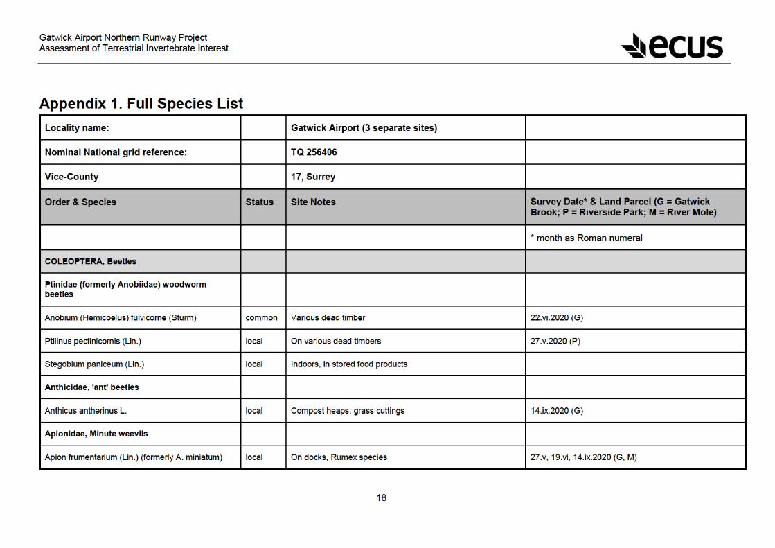

Gatwick Airport Northern Runway Project Assessment of Terrestrial Invertebrate Interest
19
Aspidapion radiolus (Mars.) common On mallows, Malva species. 22.vi.2020 (P)
Ceratapion gibbirostre (Gyll.) local On thistles, Cirsium and Carduus 22.vi.2020 (G)
Eutrichapion ervi Kirby common On vetches, Viccia, grassy places 19.vi.2020 (M)
Exapion ulicis (For.) common On gorse, Ulex europeus, etc. 10.ix.2020 (M)
Nanophyes marmoratus (Goeze) local On Lythrum salicaria 30.vi, 10.ix.2020 (M)
Perapion curtirostre Germ. common On docks, Rumes species 27.v.2020 (M, P)
Squamapion vicinum (Kirby) Nb On water mint 27.v.2020 (M)
Trichapion simile (Kirby) common On birch 10.ix.2020 (M)
Attelabidae, weevils
Temnocerus (Rhynchites) nanus (Payk.) v. local On birch, sallow and alder. 27.v.2020 (G)
Biphylidae, fungus beetles
Biphyllus lunatus (Fab.) local In Daldinia fungus on ash, ancient woodland indicator 30.vi.2020 (M)
Cantharidae, Soldier beetles
Cantharis lateralis (Lin.) local Woods, larvae predatory in rotten wood 27.v, 19.vi, 22.vi.2020 (M, G)
Cantharis flavilabris (formerly nigra (Deg.)) local Larvae predatory in rotten wood, soil, etc 27.v, 19.vi.2020 (G, M)
Cantharis nigricans Mull. common Larvae predatory in rotten wood, soil, etc 22.vi.2020 (G)
Cantharis pallida Goez common Larvae predatory in rotten wood, soil, etc 22.vi.2020 (G)

Gatwick Airport Northern Runway Project Assessment of Terrestrial Invertebrate Interest
20
Cantharis rustica Fallen common Larvae predatory in rotten wood, soil, etc 19.vi.2020 (M)
Malthodes marginatus Latr. local Woods and meadows 22.vi.2020 (G)
Malthodes minimus (Lin.) common Woods, larvae predatory in rotten wood 22.vi.2020 (G)
Malthodes pumilus (Breb.) v. local Woods and grassland 22.vi.2020 (G)
Rhagonycha fulva (Scop.) common Adults on flowers, larvae predators in soil layer 27.v, 22.vi.2020 (M, G)
Rhagonycha nigriventris (formerly limbata) local Adults on flowers, larvae predators in soil layer 27.v.2020 (M)
Carabidae, Ground beetles
Abax parallelepipedus (P. & M.) common Under logs, stones, etc, in woods 22.vi.2020 (G)
Acupalpus dubius local Damp grassy places 27.v.2020 (M, G)
Amara plebeja Gyll. common Various habitats 27.v.2020 (M)
Bembidion articulatum Panz. local River and stream banks 19.vi.2020 (M)
Bembidion biguttatum (Fab.) local Damp places, stream and pond sides 30.vi.2020 (M)
Bembidion mannerheimi Sahl. local Damp grasslands 27.v.2020 (M)
Demetrias atricapillus (Lin.) common Long grass 27.v.2020 (G)
Paradromius linearis Ol. common Dry grassy areas 27.v, 19.vi, 10.ix.2020 (M)
Harpalus ardosiacus Luts. v. local Chalk or limestone, usually coastal 27.v.2020 (G)
Microlestes minutulus v. local Dry sandy places, mostly East Anglia and London 14.ix.2020 (G)

Gatwick Airport Northern Runway Project Assessment of Terrestrial Invertebrate Interest
21
Poecilus (Pterostichus) cupreus (Lin.) common Open fields, bare ground 27.v.2020 (M)
Poecilus (Pterostichus) versicolor Sturm local Open ground, bare soil. 27.v, 14.ix.2020 (G)
Tachys bistriatus (Dufts.) Nb On damp clay soils. 19.vi.2020 (M)
Cerambycidae, Longhorn beetles
Pseudovadonia (Leptura) livida Fab. local Larvae in fungal hyphae in soil 19.vi.2020 (M)
Stenurella (Leptura) melanura (Lin.) local Larvae in dead timber or roots 19.vi, 22.vi.2020 (M, G)
Rutpela (Strangalia) maculata (Poda) common Larvae in dead wood of various trees 27.v.2020 (G)
Chrysomelidae, Leaf and flea beetles
Bruchidius varius (Ol.) local On red clover, recent colonist 27.v.2020 (M)
Bruchidius imbricornis Panz. v. local New colonist in Britain 19.vi, 10.ix.2020 (M)
Bruchidius villosus (Fab.) local Rough grassy places 27.v.2020 (P)
Bruchus atomarius (Lin.) local Various habitats 27.v, 10.ix.2020 (M)
Bruchus loti Payk. common On Lotus corniculata 19.vi.2020 (M)
Cassida flaveola Thunb. local Dry grassy places 27.v.2020 (M)
Cassida rubiginosa Mull. common On thistles, Cirsium species. 22.vi.2020 (G)
Cassida vibex Fab. local On Centaurea species 27.v, 22.vi.2020 (G)
Cassida viridis (Lin.) common On water mint etc, Mentha species 19.vi.2020 (M)

Gatwick Airport Northern Runway Project Assessment of Terrestrial Invertebrate Interest
22
Crepidodera (Chalcoides) aurea (Fourc.) common On willows, sallows, poplars etc 22.vi.2020 (P)
Crepidopdera (Chalcoides) fulvicornis (Fab.) common On willows, sallows, poplars etc 27.v.2020 (G)
Chalcoides plutus (Latr.) local On willows, sallows, poplars etc 19.vi, 10.ix.2020 (M)
Neocrepidodera transversa (Marsh.) common On thistles 22.vi.2020 (G)
Cryptocephalus fulvus Goeze local Dry grassy areas. 19.vi.2020 (M)
Cryptocephalus pusillus Fab. local On birch, sandy and chalky areas 14.ix, 19.vi.2020 (M, P)
Galerucella lineola Fab. common On alders, willows etc 19.vi.2020 (M)
Gastrophysa viridula Deg. local Wet meadows, marshes 19.vi, 22.vi.2020 (M, G)
Lilioceris lilii (Scop.) local On cultivated lilies, gardens and parks 14.ix.2020 (P)
Oulema obscura Steph. common Meadows and fields 22.vi.2020 (G)
Podagrica fuscicornis (Lin.) Nb Grassland, rough ground, on mallows. 19.vi.2020 (M)
Psylliodes chrysocephala (Lin.) common On crucifers 27.v.2020 (P)
Sermylassa halensis (Lin.) v. local On bedstraws 10.ix.2020 (M)
Sphaeroderma rubidum (Gra.) common On thistles, Cirsium species 19.vi, 22.vi.2020 (M, G)
Sphaeroderma testaceum Fab. common On thistles, Cirsium species 19.vi, 14.ix.2020 (M, G)
Coccinellidae, Ladybirds
Anisosticta 19-punctata (Lin.) local Water ladybird, near ponds 19.vi.2020 (M)

Gatwick Airport Northern Runway Project Assessment of Terrestrial Invertebrate Interest
23
Coccidula rufa (Herbst) local Marshy places, reed and sedge beds 19.vi.2020 (M)
Coccidula scutellata (herbst) v. local Marshes, reed beds, stream sides 27.v.2020 (M)
Coccinella 7-punctata Lin. common 7-spot. Wide variety of habitats. 27.v, 19.vi, 22.vi, 10.ix, 14.ix.2020 (G, M, P)
Harmonia axyridis Pallas common Recent arrival in Britain 27.v, 19.vi, 22.vi, 30.vi.2020 (M, G, P)
Hippodamia variegata Nb Adonis ladybird. Mainly coastal and London basin 10.ix.2020 (M)
Micraspis 16-punctata (Lin.) common 16-spot, mildew feeder, grassy places 27.v, 19.vi, 22.vi, 10.ix, 14.ix.2020 (G, M)
Propylea 14-punctata (Lin.) common 14-spot. Wide variety of habitats 19.vi, 22.vi, 10.ix, 14.ix.2020 (M, G, P)
Psyllobora 22-punctata (Lin.) common 22-spot. Wide variety of habitats, mildew-feeder. 10.ix, 14.ix.2020 (M, P, G)
Rhyzobius litura (Fab.) common Rough grassy places 27.v, 14.ix.2020 (G, P)
Subcoccinella 24-punctata (Lin.) common 24-spot. On false-oat grass 27.v, 19.vi, 10.ix, 14.ix.2020 (M, G)
Colydiidae, fungus beetles
Bitoma crenata local Under fungoid bark of broadleaved trees 14.ix.2020 (P)
Cryptophagidae, Fungus beetles, etc
Micrambe ulicis Steph. local General grassy places 27.v.2020 (G, P)
Cucujidae (fungus beetles)
Uleiota planata (L.) Na Under fungoid bark 14.ix.2020 (P)
Curculionidae (weevils)

Gatwick Airport Northern Runway Project Assessment of Terrestrial Invertebrate Interest
24
Ceutorhynchus obstrictus Marsh. (assimilis) common On various crucifers 27.v.2020 (M)
Ceutorhynchus pallidactylus = quadridens (Pz.) common On aliaria and other crucifers, woods and hedges 27.v.2020 (M)
Nedyus (Cidnorhynchus) 4-maculatus (L.) common On stinging nettles 22.vi.2020 (G)
Cionus alauda (Herbst) common On water figwort, Scrophulria aquatica 19.vi.2020 (M)
Curculio glandium (L.) common On oaks 27.v, 22.vi.2020 (P, G)
Archarius (Curculio) pyrrhoceras Mars. local On oaks 27.v, 22.vi.2020(P, G)
Gymnetron pascuorum Gyll. common On plantains, Plantago species 27.v, 19.vi, 22.vi.2020 (G, M, P)
Hypera nigrirostris 9Fab.) common Grassy places, on clovers 19.vi.2020 (M)
Hypera rumicis (Lin.) common Rough grassy places, on docks, Rumex species 19.vi.2020 (M)
Magdalis armigera (Geoff.) v. local Breeds in the twigs and branches of elm trees 27.v.2020 (P)
Miccotrogus picirostris (Fab.) common On clovers, Trifolium species 22.vi.2020 (P)
Polydrusus formosus (splendidus) (Mayer) Na On hazel, oak and other trees, spreading 27.v.2020 (M)
Rhamphus pulicarius local On sallow, birch, poplars, boggy places 19.vi.2020 (M)
Rhinocyllus conicus Froh. Na On thistles, southern England 27.v, 19.vi.2020 (M)
R. pericarpius (Lin.) common On Rumex species 22.vi, 10.ix.2020 (G, M)
Sitona hispidulus (Fab.) common On clovers and other legumes 10.ix.2020 (M)
Sitona humeralis Steph. common Dry grassy areas, on clover etc. 10.ix.2020 (M)

Gatwick Airport Northern Runway Project Assessment of Terrestrial Invertebrate Interest
25
Sitona lineatus (Lin.) common On clovers, and many other legumes 19.vi, 10.ix.2020 (M)
Trichosirocalus troglodytes (Fab.) common On ribwort plantain, Plantago lanceolata 27.v, 19.vi, 14.ix.2020 (G, M)
Dermestidae, Hide & larder beetles
Anthrenus verbasci (Lin.) common Museum beetle. Indoors in kitchens, carpets, outdoors on flowers
22.vi.2020 (P)
Elateridae, Click beetles
Agriotes acuminatus Steph. common Larvae in grass roots etc 22.vi.2020 (G)
Agriotes obscurus (Lin.) common Larvae in grass roots etc 19.vi.2020 (M)
Athous campyloides Newm. Nb Larvae in grass roots, rotten wood etc 27.v, 19.vi.2020 (G, M)
Hydrophilidae, Water beetles
Helophorus minutus F. common Wet areas, ponds, streams, marshes 22.vi.2020 (G, M)
Melandryidae, Fungus beetles
Orchesia undulata Kr. v. local Under rotten wood, in fungus 14.ix.2020 (P)
Melyridae, False soldier beetles
Axinotarsus marginalis (Lap.) common Various habitats, larvae probably in rotten wood or soil. 19.vi, 22.vi.2020 (M, G)
Malachius bipustulatus (Lin.) common Open grassy areas, on flowers, larvae predatory 27.v, 19.vi, 22.vi.2020 (P, M, G)
Malachius viridis Fab. common Open grassy areas, on flowers, larvae predatory 27.v, 19.vi.2020 (G, M)

Gatwick Airport Northern Runway Project Assessment of Terrestrial Invertebrate Interest
26
Mordellidae, Flower beetles
M. pumila (Gyll.) common Flowery places 27.v.2020 (G)
Variimorda villosa Schr. Nb Broad-leaved woodland, larvae in dead wood. 19.vi.2020 (M)
Nitidulidae, Pollen beetles
Brachypterus glaber (Steph.) common On stinging nettles 27.v.2020 (P)
Oedemeridae, Flower beetles
Oedemera lurida (Marsh.) common On flowers, leaves, etc. 27.v, 19.vi, 22.vi, 30.vi.2020 (G, P, M)
Oedemera nobilis (Scopoli) local On flowers 27.v, 19.vi, 22.vi.2020 (G, P, M)
Scarabaeidae, chafers and dung beetles
Onthophagus coenobita Herbst local In mammalian dung 19.vi.2020 (M)
Scirtidae, marsh beetles
Microcara testacea (L). local Marshy places 27.v.2020 (M)
Scraptiidae, Flower beetles
Anaspis maculata Fourc. common Adults on flowers, larvae in rotten wood 27.v, 22.vi.2020 (M, P)
Silvanidae, fungus beetles
Silvanus unidentatus (Ol.) local Under fungoid bark 14.ix.2020 (P)
Staphylinidae, Rove beetles


Gatwick Airport Northern Runway Project Assessment of Terrestrial Invertebrate Interest
28
Paraclusia tigrina Fallen RDB2 Breeds in dead timber 14.ix.2020 (P)
Conopidae, Thick-headed flies
Sicus ferrugineus (Lin.) common Parasitoid of various bumblebee species. 19.vi, 22.vi.2020 (M, G)
Dolichopodidae, long-footed flies
Poecilobothrus nobilitatus Lin. common Associated with wet areas, mud, etc 19.vi.2020 (M)
Scellus notatus Fab. local Damp woods and meadows 27.v, 19.vi, 22.vi, 30.vi.2020 (M, G)
Lauxaniidae, acalyptrate flies
Peplomyza litura (Meig.) common Hedgerows, woodland edges etc 22.vi.2020 (G)
Opomyzidae, minute flies
Geomyza tripunctata (Fall.) common Grassy places 22.vi.2020 (G)
Opomyza germiniationis (Lin.) common Grassy places 22.vi, 10.ix, 14.ix.2020 (G)
Sciomyzidae, snail-killing flies
Coremacera marginata (Fab.) common Biology unknown, probably snail parasitoid 27.v, 19.vi, 10.ix, 14.ix.2020 (M G)
Dichetophora obliterata (Fab.) local Biology unknown, probably snail parasitoid 10.ix.2020 (M)
Ilione albiseta (Scop.) local Attacks snails, moist places 19.vi, 30.vi.2020 (M)
Limnia unguicornis (Scop.) local Attacks snails, moist places 19.vi.2020 (M)
Pherbina coryleti (Scop.) common Attacks snails, moist places 10.vi, 10.ix.2020 (M)
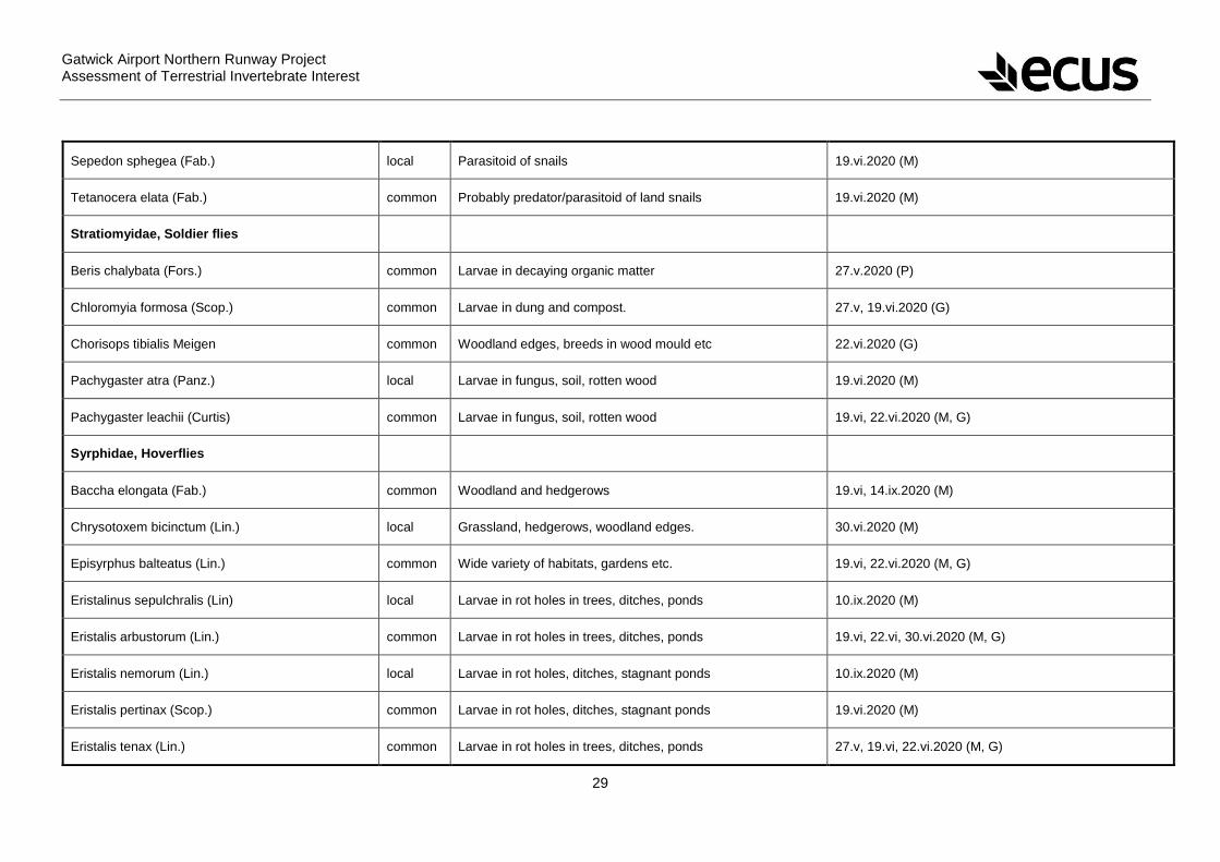
Gatwick Airport Northern Runway Project Assessment of Terrestrial Invertebrate Interest
29
Sepedon sphegea (Fab.) local Parasitoid of snails 19.vi.2020 (M)
Tetanocera elata (Fab.) common Probably predator/parasitoid of land snails 19.vi.2020 (M)
Stratiomyidae, Soldier flies
Beris chalybata (Fors.) common Larvae in decaying organic matter 27.v.2020 (P)
Chloromyia formosa (Scop.) common Larvae in dung and compost. 27.v, 19.vi.2020 (G)
Chorisops tibialis Meigen common Woodland edges, breeds in wood mould etc 22.vi.2020 (G)
Pachygaster atra (Panz.) local Larvae in fungus, soil, rotten wood 19.vi.2020 (M)
Pachygaster leachii (Curtis) common Larvae in fungus, soil, rotten wood 19.vi, 22.vi.2020 (M, G)
Syrphidae, Hoverflies
Baccha elongata (Fab.) common Woodland and hedgerows 19.vi, 14.ix.2020 (M)
Chrysotoxem bicinctum (Lin.) local Grassland, hedgerows, woodland edges. 30.vi.2020 (M)
Episyrphus balteatus (Lin.) common Wide variety of habitats, gardens etc. 19.vi, 22.vi.2020 (M, G)
Eristalinus sepulchralis (Lin) local Larvae in rot holes in trees, ditches, ponds 10.ix.2020 (M)
Eristalis arbustorum (Lin.) common Larvae in rot holes in trees, ditches, ponds 19.vi, 22.vi, 30.vi.2020 (M, G)
Eristalis nemorum (Lin.) local Larvae in rot holes, ditches, stagnant ponds 10.ix.2020 (M)
Eristalis pertinax (Scop.) common Larvae in rot holes, ditches, stagnant ponds 19.vi.2020 (M)
Eristalis tenax (Lin.) common Larvae in rot holes in trees, ditches, ponds 27.v, 19.vi, 22.vi.2020 (M, G)

Gatwick Airport Northern Runway Project Assessment of Terrestrial Invertebrate Interest
30
Eupeodes luniger (Meig.) common Wide variety of habitats, gardens. 22.vi.2020 (G)
Helophilus pendulus (Lin.) common Breeds in ditches and stagnant ponds. 27.v, 19.vi, 22.vi, 10.ix, 14.ix.2020 (G, M)
Myathropa florea (Lin.) common Larvae in rot holes in trees 27.v, 19.vi.2020 (G)
Pipizella viduata (Lin.) local Dry grassland, chalk and coastal 19.vi.2020 (M)
Platycheirus albimanus Fab. common Woods and fields 22.vi.2020 (G)
Rhingia campestris (Meig.) common Woodlands, hedgerows, in cow and horse dung 10.ix.2020 (M)
Scaeva pyrastri (Lin.) common Wide variety of grassy habitats 22.vi.2020 (G)
Sphaerophoria scripta (Lin.) common Wide variety of grassy habitats 19.vi, 22.vi, 30.vi, 10.ix.2020 (M, G)
Syritta pipiens (Lin.) common Wide variety of habitats, gardens etc. 27.v, 19.vi, 22.vi.2020 (M, G)
Volucella pellucens (Lin.) common Variety of habitats, breeds in wasp nests 22.vi.2020 (P)
Xylota sylvarum (Lin.) local Woodlands 22.vi.2020 (G)
Tabanidae, horseflies
Haematopota pluvialis (Lin.) local Adults suck blood, wet meadows 19.vi.2020 (M)
Tachinidae, parasitic flies
Eriothrix rufomaculata (Deg.) common Hosts unknown, even though fairly common 22.vi.2020 (G)
Exorista species — Several species, impossible to separate females 19.vi.2020 (M)
Lydella grisescens R.-D. common Parasitoid of various moth caterpillars 10.ix.2020 (M)

Gatwick Airport Northern Runway Project Assessment of Terrestrial Invertebrate Interest
31
Phasia obesa (Fab.) local Parasitoid of bugs 27.v, 22.vi, 10.ix.2020 (P, G, M)
Phasia pusilla Meig. local Parasitoid of shieldbugs 19.vi, 10.ix.2020 (M)
Siphona geniculata Degeer common Parasitoid of various insect larvae 19.vi, 22.vi.2020 (M, G)
Tachina fera (Lin.) common Parasitoid of various common moth caterpillars 10.ix.2020 (M)
Tephritidae, picture-winged flies
Acinia corniculata (Zett.) RDB1 Breed in heads of Centaura nigra 22.vi.2020 (G)
Campiglossa malaris Seguy RDB1 Larvae in heads of ragworts, spreading 19.vi.2020 (M)
Chaetorellia jaceae (R.-D.) local In heads of Centaurea 27.v, 19.vi, 22.vi.2020 (M, G, P)
Chaetostomella cylindrica (R.-D.) local Breeds in heads of Centaurea etc 22.vi.2020 (G)
Dioxyna bidentis N Breeds in flower heads of Bidens tripartita 10.ix.2020 (M)
Merzomyia (Icterica) westermanni (Meig.) N In heads of ragwort 10.ix.2020 (M)
Tephritis formosa (Loew) local Larvae in the heads of Sonchus species 27.v.2020 (M)
Terellia colon (Meig.) local In heads of Centauria scabiosa 22.vi.2020 (G)
Terellia ruficauda (Fab.) common Larvae in heads of Cirsium arvense 19.vi, 22.vi, 30.vi.2020 (M, G)
Terellia serratulae (Lin.) local Breeds in heads of thistles 19.vi.2020 (M)
Urophora cardui (Lin.) common Larvae in galls in stems of Cirsium arvense 27.v.2020 (M)
Urophora jaceana (Her.) common Larvae in galls in knapweed heads 19.vi, 19.vi.2020 (M, P)
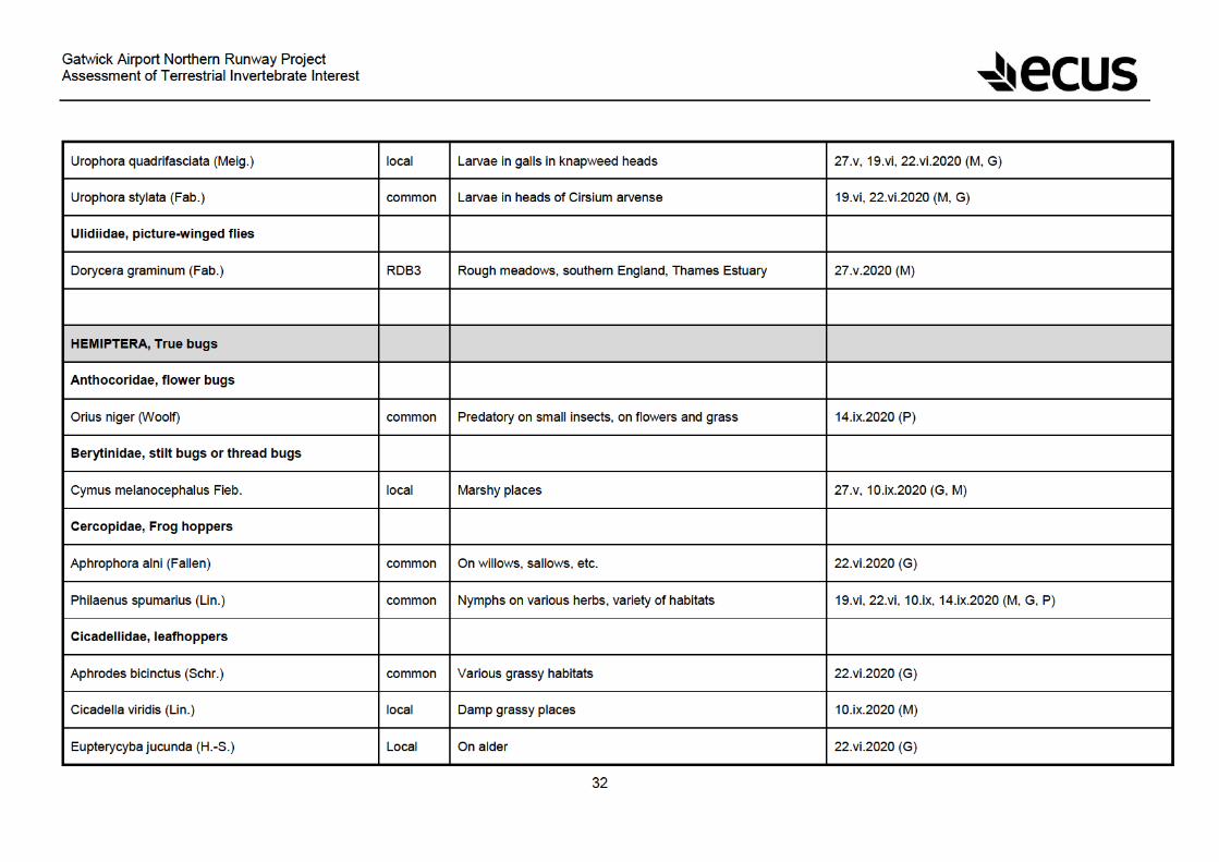

Gatwick Airport Northern Runway Project Assessment of Terrestrial Invertebrate Interest
33
Eupteryx aurata L. common On stinging nettles 14.ix.2020 (P)
Iassus scutellaris (Fieb.) local On elms 14.ix.2020 (P)
Cixiidae, froghoppers
Cixius cunicularius (L.) Local Rough grassy places 10.ix.2020 (M)
Reptalus quinquicostatus (formerly Oliarus) panzeri Low
N Dry grassy places 19.vi.2020 (M)
Coreidae, Leaf bugs
Coreus marginatus (Lin.) common Woods, meadows, gardens, on docks, Rumex species. 27.v, 19.vi, 22.vi, 10.ix, 14.ix.2020 (P, M, G)
Coriomeris denticulatus (Scop.) local On medicks, trefoils and melilots, dry areas. 27.v, 14.ix.2020 (G, M)
Delphacidae, Ground hoppers
Allygus mixtus (Fab.) common Usually on trees 22.vi.2020 (G)
Ditropis pteridis (Spin.) common On bracken, Pteridium aquilinum 22.vi.2020 (G)
Stenocranus minutus (Fab.) common Grassy places 10.ix.2020 (M)
Lygaeidae, Ground bugs
Heterogaster urticae (Fab.) common On stinging nettles 27.v, 19.vi, 22.vi, 14.ix.2020 (M, G, P)
Ischnodemus sabuleti (Fall.) common Grassy places, meadows and marshes 27.v, 19.vi, 10.ix.2020 (M)
Kleidocerys resedae (Panz.) common On wide variety of trees and shrubs 14.ix.2020 (P)

Gatwick Airport Northern Runway Project Assessment of Terrestrial Invertebrate Interest
34
Metopoplax ditomoides (Costa) v. local On chamomile and scentless mayweed 27.v, 19.vi.2020 (M)
Nysius senecionis (Schill.) local On Guernsey fleabane and ragworts 10.ix.2020 (M)
Peritrechus geniculatus (Hahn) common In leaf litter and grass roots 27.v, 14.ix.2020 (G, M)
Scolopostethus thomsoni Reut. common Under stones, bare ground, sparse vegetation 19.vi.2020 (M)
Miridae, Leaf bugs
Capsus ater (Lin.) common Various habitats on various plants 27.v, 19.vi, 22.vi.2020 (G, M)
Charagochilus gyllenhali (Fall.) common Dry places, on bedstraws 30.vi, 10.ix.2020 (M)
Deraeocoris flavilinea (Costa) local On maples and sycamores 19.vi, 22.vi.2020 (M, G, P)
Deraeocoris ruber (Lin.) common On stinging nettles and various other plants 22.vi.2020 (G)
Deraeocoris lutescens common On various low plants and trees 22.vi, 10.ix.2020 (G, P)
Dryophilocoris flavoquadrimaculatus common On oaks 27.v.2020 (G, P)
Heterotoma planicornis (Fab.) common On stinging nettles 19.vi, 22.vi.2020 (M, G)
Leptopterna dolobrata (Lin.) common Grassy places 19.vi, 22.vi.2020 (M, G, P)
Notostira elongata (Geoff.) common Grassy places 14.ix.2020 (G)
Orthops campestris (L.) common On umbellifers and other plants 30.vi.2020 (M)
Phytocoris varipes Boh. common Grassy places 10.ix.2020 (M)
Pithanus maerkeli (H.-S.) common Grassy places 19.vi.2020 (M)

Gatwick Airport Northern Runway Project Assessment of Terrestrial Invertebrate Interest
35
Nabidae, Damsel bugs
Nabis flavomarginatus Sch. common Rough grassland, damp areas 19.vi.2020 (M)
Nabis rugosus (Lin.) common Grassy areas, bare ground, predatory. 19.vi, 10.ix.2020 (M)
Pentatomidae, Shield bugs
Aelia acuminata (Lin.) local Various grassy habitats 27.v, 19.vi, 22.vi, 10.ix, 14.ix.2020 (G, M)
Dolycoris baccarum (Lin.) local Woodland edges and hedges, on variety of plants 27.v, 19.vi, 22.vi, 30.vi, 10.ix, 14.ix.2020 (G, M)
Eurydema oleracaea (Lin.) common On wild and garden brassicas and other crucifers 19.vi, 30.vi.2020 (M)
Neottiglossa pusilla (Gmel.) v.local Grassy places 22.vi.2020 (G)
Palomena prasina (Lin.) common On a variety of plants 22.vi, 10.ix, 14.ix.2020 (G, P, M)
Pentatoma rufipes Lin. common On a variety of trees, mainly oak 27.v, 22.vi.2020 (P, G)
Rhopalidae, Leaf bugs
Myrmus miriformis (Fall.) local Grassy places, chalk, sand and marshes 19.vi, 10.ix.2020 (M)
Stictopleurus abutilon (Rossi) v. local Open, sunny localities 30.vi.2020 (M)
Stictopleurus punctatonervosus v. local Open, sunny localities 27.v, 19.vi, 22.vi, 10.ix.2020 (M, G)
Scutelleridae, tortoise bugs
Eurygaster testudinaria (Geoff.) local Grassy and marshy places 27.v, 19.vi.2020 (M)
Tingidae, Lace bugs


Gatwick Airport Northern Runway Project Assessment of Terrestrial Invertebrate Interest
37
Colletidae, solitary bees
Hylaeus cornutus Curt. Na Woodland edges, chalky and sandy places 27.v, 22.vi.2020 (M, G)
Cynipidae, gall wasps
Andricus kollari common Makes marble galls on oak twigs 10.ix.2020 (M)
Diplolepis rosae (L.) common Robin pin cushion or bedeguar galls on wild roses 19.vi, 10.ix.2020 (M)
Neuroterus numismalis (Geoff.) common silk button galls on oak leaves 14.ix.2020 (P)
Neuroterus quercusbaccarum (Sch.) common spangle galls on oak leaves 14.ix.2020 (P)
Eumenidae, Potter wasps
Ancistrocerus parietum (Lin.) common Builds mud nest in cavities in walls, tree trunks, rocks etc 19.vi, 22.vi.2020 (M, G)
Formicidae, Ants
Formica fusca Lin. common England and Wales, widespread 19.vi, 22.vi.2020 (M, G)
Lasius brunneus (Latr.) Na Central England, Severn Valley, local, spreading 22.vi.2020 (G)
Lasius niger Lin. common Ubiquitous 22.vi.2020 (P)
Myrmica rubra (Lin.) common Various habitats, nests under stones, logs, etc. 27.v.2020 (G, M)
Ichneumonidae, ichneumon wasp
Amblyteles armatorius (Fab.) common Parasitoid of moth caterpillars 22.vi.2020 (G)
Melittidae, solitary bees


Gatwick Airport Northern Runway Project Assessment of Terrestrial Invertebrate Interest
39
Lycaena phlaeas (L.) common Small copper, larvae on trefoils and medics 14.ix.2020 (G)
Polyommatus icarus Rott. common Common blue. Grassy places, larvae of trefoils, clovers and medicks.
14.ix.2020 (G)
Lymantridae, tussock moths
Orygia antiqua (Lin.) common Vapourer, larvae on wide variety of plants 27.v.2020 (M)
Noctuidae, moths
Acronicta rumicis common Knotgrass moth, larvae on various food plants 22.vi.2020 (G)
Notodontidae, prominent moths
Cerura vinula common Puss moth, on willows and poplars. Cocoon. 30.vi.2020 (M)
Nymphalidae, Brush-footed butterflies
Aglais urticae (Lin.) common Small tortoiseshell. Larvae on stinging nettles. 22.vi.2020 (G)
Aphantopus hyperanthus (L.) local Ringlet, woods and woodland edges 30.vi.2020 (M)
Coenonympha pamphilus (L.) local Small heath, larvae on grasses 27.v, 19.vi, 22.vi, 10.ix, 14.ix.2020 (G, M)
Inachis io (Lin.) common Peacock, larvae on stinging nettles 27.v, 22.vi.2020 (M, G)
Maniola jurtina (Lin.) common Meadow brown. Grassy places, on various grasses. 19.vi, 22.vi, 30.vi, 10.ix.2020 (M, G)
Melanargia galathea (Lin.) Local Marbled white. Chalk and limestone downs 19.vi.2020 (M)
Pararge aegeria (Lin.) common Speckled wood. Woodland edges and rides, larvae on grasses 27.v, 22.vi, 14.ix.2020 (G, P)


Preliminary Environmental Information Report: September 2021 Appendix 9.6.2: Ecology Survey Report Annex 6
Our northern runway: making best use of Gatwick
Annex 6
Aquatic Ecology Survey


Gatwick Airport Northern Runway Project Fish and Aquatic Macroinvertebrate Surveys
iii
Contents
SUMMARY AND KEY RECOMMENDATIONS............................................................ 1
SUMMARY........................................................................................................................ 1 CONCLUSIONS ................................................................................................................. 2 KEY RECOMMENDATIONS ................................................................................................ 2
1. INTRODUCTION .................................................................................................. 4
1.1 DEVELOPMENT BACKGROUND ................................................................................ 4 1.2 THE OBJECTIVES ................................................................................................... 4 1.3 BACKGROUND TO THE WATERCOURSES ................................................................. 4
2. METHODOLOGY ................................................................................................. 5
2.1 AQUATICS DESK STUDY ......................................................................................... 5 2.2 SURVEY: AQUATIC MACROINVERTEBRATES ............................................................ 5 2.3 AQUATIC MACROINVERTEBRATE DATA ANALYSIS ................................................... 6 2.4 SURVEY: FISH ........................................................................................................ 7 2.5 LIMITATIONS ........................................................................................................... 8
3. RESULTS ............................................................................................................. 9
3.1 AQUATICS DESK STUDY ......................................................................................... 9 3.2 FIELD DATA .......................................................................................................... 12
4. DISCUSSION ..................................................................................................... 18
4.1 RIVER MOLE ........................................................................................................ 18 4.2 GATWICK STREAM ................................................................................................ 19
5. CONCLUSIONS AND RECOMMENDATIONS................................................. 21
5.1 CONCLUSIONS ..................................................................................................... 21 5.2 RECOMMENDATIONS ............................................................................................ 21 5.3 FURTHER SURVEY................................................................................................ 22
6. REFERENCES ................................................................................................... 23
APPENDIX 1: AQUATICS TEAM REPORT WITH FIGURES ................................... 24

Gatwick Airport Northern Runway Project
Fish and Aquatic Macroinvertebrate Surveys
1
Summary and Key Recommendations
Summary
ECUS Ltd was commissioned by RPS Group Plc in May 2020 to undertake fish and aquatic invertebrate surveys of two water courses adjoining Gatwick Airport as part of the surface water management and flood alleviation for the Northern Runway Project development. This will affect the two sites close to Gatwick Airport, one on the River Mole and the other on the Gatwick Stream (Gatwick Brook). The River Mole may be re-meandered and land close to the river may be re-profiled to increase flood storage. The Gatwick Stream has already had surrounding land re-profiled for flood storage in recent years, however this area may be expanded to encompass both sides of the river. The aquatics team at Thomson Environmental were commissioned to assist ECUS in undertaking aquatic macroinvertebrate and fish baseline surveys and a targeted aquatics desk study, to inform this report and the proposals.
The study area encompasses two watercourses; a 1.3km stretch of the River Mole immediately downstream of where it emerges from under the runway at Gatwick Airport and a 750m stretch of the Gatwick Stream (a tributary of the River Mole) upstream of the Crawley sewage works. A 100m survey section was identified on each watercourse from an initial walkover survey conducted in June 2020. Three survey visits during 2020 were undertaken for aquatic macroinvertebrates (spring, summer and autumn) and two for fish (spring and autumn). The spring survey visit was delayed until early July due to restrictions related to the Covid 19 outbreak. Desk study data was obtained from the Sussex Biological Records Centre and the Environment Agency on behalf of Ecus.
The desk study returned one record from 2013 of the shining ram’s-horn snail Segmentina nitida within the study section on the River Mole (TQ 25623 40908). The species is nationally scarce, a UK Priority Species under the UK Post 2010 Biodiversity Framework and listed on the Sussex Rare Species Inventory. It was not recorded during the surveys for this study, although the survey section did not coincide with the reach in which the snail was recorded. The desk study returned records of two fish species for the River Mole; bullhead Cottus gobio and brown trout Salmo trutta subsp. fario.
River Mole - A mean of 19.3 macroinvertebrate taxa were recorded at the River Mole site across the three
survey visits. Biotic indices measuring water quality (Biological Monitoring Working Party (BMWP) score and Average Score per Taxon) indicate moderately polluted conditions in the River Mole. Lotic invertebrate Index for Flow Evaluation (LIFE) scores suggest that the aquatic macroinvertebrate community is characteristic of sluggish flow conditions and low Proportion of Sediment intolerant Invertebrates (PSI) scores indicate heavily sedimented conditions.
A total of 415 fish were caught on the River Mole in spring after three survey ‘runs’ compared with only 28 fish caught in autumn with the same level of effort. Roach Rutilus rutilus were the most abundant fish species identified (252) in spring and in autumn (13). The study stretch on the River Mole lies within open floodplain grassland with no shading which means that water temperature, and therefore dissolved oxygen (DO), fluctuated considerably. Extensive stands of submerged and emergent macrophyte plants occur through the study section and their decomposition are likely to be contributing to low DO in the autumn. These dissolved oxygen conditions coupled with organic pollution from within the catchment is considered to be influencing the composition and abundance of both the macroinvertebrate and fish community. Predatory fish such as pike Esox lucius are able to exploit the dense macrophyte stands and are further reducing populations of cyprinid fish.
Gatwick Stream - Environment Agency data from 3 sites on the Gatwick Stream indicate that the study
section is of moderate to poor water quality, with sluggish flow and sedimented condition. Fewer macroinvertebrate taxa were recorded at the two Gatwick Stream sites compared with River Mole (mean of 10 taxa per visit). BMWP and ASPT scores indicate moderate water quality conditions at the upstream and poor to very poor at the downstream site. A high LIFE score for the upstream site during the spring visit suggests that velocities are high in the early part of the season and decline through the summer and

Gatwick Airport Northern Runway Project
Fish and Aquatic Macroinvertebrate Surveys
2
autumn. PSI scores for the upstream site fluctuated considerably across the three season, from only slightly sedimented conditions in spring to sedimented condition in autumn.
A total of 300 and 317 fish were caught in spring and autumn respectively at the Gatwick Stream site after three survey ‘runs’. Chub Squalis cephalus was the most abundant species in the spring survey and dace Leucisus leucisus in the autumn. Shading of the channel by overhanging trees meant that both water temperature and dissolved oxygen remained high throughout the three seasons.
Conclusions
Both watercourses supported macroinvertebrate communities indicative of moderately polluted conditions, exacerbated by relatively low flow conditions and high levels of sedimentation. Dense macrophyte growth on the River Mole is contributing to acute reductions in dissolved oxygen which are impacting on the macroinvertebrate assemblage.
The presence of one record from 2013 of shining ram’s-horn snail, an IUCN Red List species and UK species of principal importance under the 2006 NERC Act has implications for the design of the River Mole scheme. Although not recorded during the survey, there remains a possibility that the species may occur at the site of the 2013 record at the downstream end of the desk study area. A targeted survey is required to determine its potential presence.
The Gatwick Stream appears to be impacted by both organic pollution and silt deposition, possibly from a storm water discharge outlet from a nearby industrial area. Consistently high populations of fish caught in spring and in autumn are likely to be a consequence of stable temperature and DO conditions caused by shading and potentially high abundances of pollution tolerant macroinvertebrates such as Oligochaete worms as a food source.
Key Recommendations
The main recommendations are set out below:
River Mole
Undertake survey to establish presence/absence of shining ramshorn snail. Survey to focus initially on the site of the 2013 record and if found to be present, extended to incorporate the whole study section. Surveys should be scoped and undertaken by a specialist mollusc ecologist.
If shining ramshorn snail found to be absent from main channel, undertake vegetation removal/dredging from the central channel/thalweg of the River Mole in selected sections. Marginal berms should be retained on alternate sides of the channel throughout the dredged section for the re-establishment of emergent vegetation. Brushwood faggots or fascines anchored with wooden stakes can be used to maintain the riverward edge of the berm and prevent silt from slumping into the main channel.
Off-line scrapes and shallow pond could be created within the floodplain grassland area to provide habitat for wetland birds. If shining ramshorn snail is found to be present this recommendation can be adapted to incorporate new, permanently wet ditches supporting dense emergent reed vegetation.
If shining ramshorn snail is found to be absent it is advised that some level of routine maintenance of macrophyte and bankside vegetation is undertaken annually under an appropriate management plan.
Before any in-channel works begin it is advised that a fish rescue and exclusion or translocation is undertaken to safeguard fish populations.
Stop nets should be installed at either end of the site proposed for in-channel works to prevent access by any fish species whilst the works are on-going.

Gatwick Airport Northern Runway Project
Fish and Aquatic Macroinvertebrate Surveys
3
Gatwick Stream (Brook)
Identify point sources of pollution from industrial area associated with Crawley STW, including storm drains and surface water discharges points from roads and urban areas.
Consider a Sustainable Drainage System (SuDS) scheme to address these discharges, including settlement ponds and reedbed treatment systems which would have additional biodiversity benefit.
Before any in-channel works begin on either watercourse it is advised that a fish rescue survey is undertaken to safeguard fish populations in the affected area. It will also be necessary to install stop nets at either end of the reach where in-channel works will be undertaken to prevent access by any other fish species whilst the works are ongoing.
Hydrometric surveys should be undertaken at various points along both rivers to better understand present hydrological conditions and inform plans to modify the channels.

Gatwick Airport Northern Runway Project
Fish and Aquatic Macroinvertebrate Surveys
4
1. Introduction
1.1 Development Background
1.1.1 Two watercourses, the River Mole and Gatwick Stream (Brook), will be directly affected by proposals for a surface water management and flood alleviation scheme to the east and west of Gatwick Airport. The scheme may include proposals to re-meander the River Mole close to where it emerges from beneath the airport runway and create new flood attenuation areas to the west of the watercourse. New flood storage has already been created to the west of the Gatwick Stream, with further areas likely planned within the floodplain to the east of the watercourse.
1.1.2 The study area encompasses two watercourses; a 1.3 km stretch of the River Mole immediately downstream of where it emerges from under the runway at Gatwick Airport and a 750 m stretch of the Gatwick Stream (a tributary of the River Mole) upstream of the Crawley sewage works.
1.2 The Objectives
1.2.1 RPS commissioned ECUS in May 2020 to undertake fish and aquatic macroinvertebrate surveys of the two rivers within the proposed study area. The objectives were to:
Determine baseline populations for both fish and aquatic macroinvertebrates in these two watercourses over the course of a year (2020).
Carry out a targeted desk study for the surrounding areas of both sites including a 1 km perimeter.
Provide a report on the surveys giving the methods and results of the surveys, with recommendations, including opportunities for enhancement, mitigation and further survey recommendations.
1.3 Background to the Watercourses
1.3.1 The River Mole rises in Baldhorns Copse in West Sussex and discharges into the River Thames at the town of Molesey in Surrey. The Mole catchment flows over the Wealden and London clays, however, between Dorking and Leatherhead, the river cuts its way through the North Downs chalk. In this area part of the river water disappears through holes in the underlying chalk feeding into the groundwater aquifers before flowing back into the river near to Leatherhead. This action has been suggested as the origin to the name of this river, but is more likely attributed to the fact it meets the Thames at Molesey.
1.3.2 Approximately 7 miles downstream of the source, the River Mole reaches the boundary of Gatwick Airport where is passes beneath the runway in a culvert. The reach that will be affected by the proposed flood alleviation scheme extends 1.3 km downstream from where the river emerges from beneath the airport runway (see Figure 1a, in Appendix 1). The survey stretch on the Gatwick Stream surveyed (TQ 291 398) lies upstream of the Crawley sewage works (see Figure 1b, in Appendix 1).


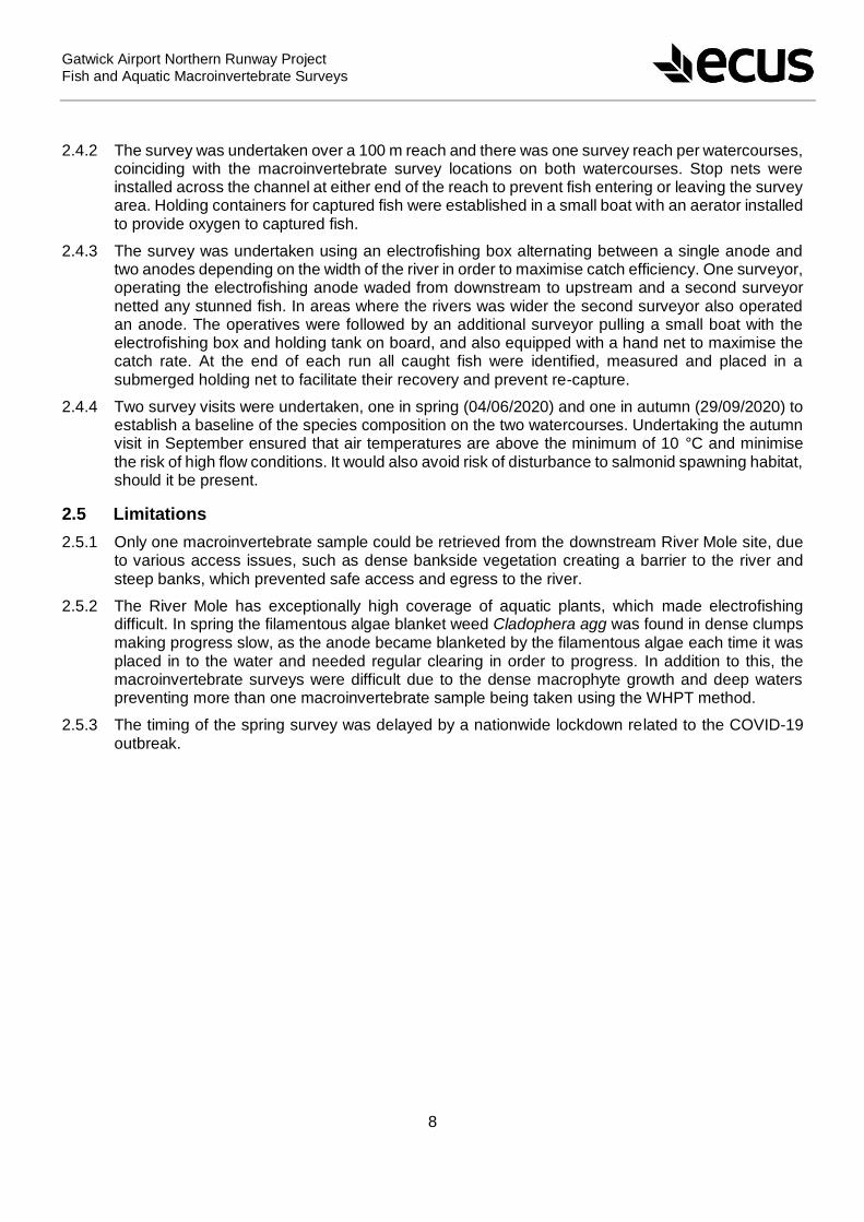
Gatwick Airport Northern Runway Project
Fish and Aquatic Macroinvertebrate Surveys
8
2.4.2 The survey was undertaken over a 100 m reach and there was one survey reach per watercourses, coinciding with the macroinvertebrate survey locations on both watercourses. Stop nets were installed across the channel at either end of the reach to prevent fish entering or leaving the survey area. Holding containers for captured fish were established in a small boat with an aerator installed to provide oxygen to captured fish.
2.4.3 The survey was undertaken using an electrofishing box alternating between a single anode and two anodes depending on the width of the river in order to maximise catch efficiency. One surveyor, operating the electrofishing anode waded from downstream to upstream and a second surveyor netted any stunned fish. In areas where the rivers was wider the second surveyor also operated an anode. The operatives were followed by an additional surveyor pulling a small boat with the electrofishing box and holding tank on board, and also equipped with a hand net to maximise the catch rate. At the end of each run all caught fish were identified, measured and placed in a submerged holding net to facilitate their recovery and prevent re-capture.
2.4.4 Two survey visits were undertaken, one in spring (04/06/2020) and one in autumn (29/09/2020) to establish a baseline of the species composition on the two watercourses. Undertaking the autumn visit in September ensured that air temperatures are above the minimum of 10 °C and minimise the risk of high flow conditions. It would also avoid risk of disturbance to salmonid spawning habitat, should it be present.
2.5 Limitations
2.5.1 Only one macroinvertebrate sample could be retrieved from the downstream River Mole site, due to various access issues, such as dense bankside vegetation creating a barrier to the river and steep banks, which prevented safe access and egress to the river.
2.5.2 The River Mole has exceptionally high coverage of aquatic plants, which made electrofishing difficult. In spring the filamentous algae blanket weed Cladophera agg was found in dense clumps making progress slow, as the anode became blanketed by the filamentous algae each time it was placed in to the water and needed regular clearing in order to progress. In addition to this, the macroinvertebrate surveys were difficult due to the dense macrophyte growth and deep waters preventing more than one macroinvertebrate sample being taken using the WHPT method.
2.5.3 The timing of the spring survey was delayed by a nationwide lockdown related to the COVID-19 outbreak.

Gatwick Airport Northern Runway Project
Fish and Aquatic Macroinvertebrate Surveys
9
3. Results
3.1 Aquatics Desk Study
River Mole
Environment Agency: Water Framework Directive Status
3.1.1 Under the Water Framework Directive (WFD) rivers and standing waters are termed waterbodies and are classified according to their ecological status. Ecological status is classified using five categories of high, good, moderate, poor and bad and is measured and classified via a range of inter-linked biological, physico-chemical and physical (morphological) parameters. The classification process is based primarily on the biological quality elements of the water body but considered alongside support elements covering physico-chemical standards and hydromorphological quality elements. Each of these supporting elements is assigned to a status category (i.e. high to bad). The overall status of the waterbody is based on the status category of the worst supporting element.
3.1.2 The affected reach of the River Mole falls within the WFD waterbody named ‘Mole Upstream of Horley (GB106039017481)’. There is little information relating to the stretch of the River Mole. It was first classified as good under the WFD classification system in 2015, although the most recent classification in 2019 designates it as moderate. Although the biological quality elements are classified as good (based on fish data only), one of the physico-chemical quality elements (phosphorous) is classified at moderate status, and therefore the overall waterbody status is classed as moderate.
3.1.3 No Environment Agency background records were received for the River Mole.
Sussex Biological Records Centre Data
3.1.4 A total of 3 records of fish species were returned from the Sussex Biological Records Centre for the River Mole within 1 km of the study section, comprising one record of bullhead approximately 0.5 km downstream from the study section in 2014, and a record of 2 adult brown trout within the survey section in 2016. Bullhead is listed as a non-priority species under Annexe 2 of the EU Habitats Directive and listed on the Sussex Rare Species Inventory. Brown trout is a UK Priority Species under the UK Post 2010 Biodiversity Framework, and Section 41 of the Natural Environment and Rural Communities Act 2006.
3.1.5 There is one record of the shining ram’s-horn snail within the study section (TQ 25623 40908; Figure 3, Appendix 1) from February 2013. The species was recorded as being ‘u/s Pond M and Tributary. The shining ram’s-horn snail is nationally scarce, a UK Priority Species under the UK Post 2010 Biodiversity Framework and listed on the Sussex Rare Species Inventory.
3.1.6 One notable dragonfly species, common darter Sympetrum striolatum was recorded within 1 km of
the site. The species is listed in the UK Red Data Book. A total of 44 observations were made of the species in the vicinity of the Gatwick airport, with a number of them within the study section. There are no records of the larvae in the River Mole, either from the Sussex Biological Records Centre or the Environment Agency and therefore breeding sites are unclear.
3.1.7 A number of invasive and non-native invertebrate and aquatic plant species occur within 1 km of the River Mole study section. Three records of signal crayfish Pacifastacus leniusculus were returned from within 1 km of the study section between 2011 and 2013. Two of the sites were on the River Mole within the study section and the third north of the Gatwick runway within a tributary of the River Mole. Signal crayfish is listed on Schedule 9 of the Wildlife and Countryside Act. Under Section 14 of the Act it is an offence ‘to release or allow to escape into the wild’ any species listed under Schedule 9’.

Gatwick Airport Northern Runway Project
Fish and Aquatic Macroinvertebrate Surveys
10
3.1.8 Records of several invasive aquatic/ riparian plant species were also recorded within 1 km of the site including Nuttall’s pond-weed Elodea nuttallii, Japanese knotweed Fallopia japonica and Himalayan balsam Impatiens glandulifera.
Gatwick Stream
Environment Agency: Water Framework Directive Status
3.1.9 The Gatwick Stream is a tributary of the River Mole and is approximately 12km in length. It, rises near Three Bridges and joins the River Mole near the centre of Horley. It falls within the Tilgate Stream and Gatwick Stream at Crawley WFD waterbody (GB106039017500). The overall waterbody status has remained moderate since 2013, although the biological quality elements are assigned bad status on the basis of fish data. This is a deterioration from poor status in 2016. Macroinvertebrates were classified at poor status in 2019 and have remained at that classification since 2013. Sewage discharges and the invasive signal crayfish are given by the Environment Agency as the reasons for poor biological quality in the brook.
Environment Agency: Macroinvertebrate Data
3.1.10 Macroinvertebrate data was received from the Environment Agency for 3 sites on the Gatwick Stream that lie within the study area (U/S Crawley STW (TQ 29160 39780); Downstream Tinsley Bridge (Flylife site) (TQ 29129 39864) and at Tinsley Bridge, Tinsley Green (TQ 29150 39800)). One sample was collected at U/S Crawley STW in October 2017, and duplicate samples were collected at Downstream Tinsley Bridge (Flylife site) and at Tinsley Bridge, Tinsley Green) in March 2019 (Figure 1b, Appendix 1). The Environment Agency have provided feedback that the 2019
samples were taken in response to a pollution incident and that the duplicate sample from both sites with lower number of taxa recorded was sorted on the bank. In comparing the data with this study only the laboratory sorted sample has been considered, although the results for both samples are presented in Table 4-1.
3.1.11 A total of 13 families were recorded during the survey at the U/S Crawley STW site in October 2017. The freshwater shrimp Gammarus pulex, a species indicative of moderate water quality, was the most numerous. However, the site also supported relatively high numbers of Oligochaete worms, a family highly tolerant of low oxygen conditions. BMWP and ASPT scores have been calculated since none were provided by the Environment Agency (Table 4-1). This site had a BMWP score of 43 with an ASPT of 4.3 indicating moderate to poor water quality.
3.1.12 Of the two duplicate samples taken at the Downstream Tinsley Bridge (Flylife site) (TQ 29129 39864) on 14th March 2019 a total of 22 families were recorded in one sample and 7 in the other. Midge larvae (Chronomidae) and Oligochaete worms were present in relatively high numbers in the second sample indicating poor water quality. Based on the second sample the site had a BMWP of 47 and ASPT of 3.92.
3.1.13 At the most upstream site at Tinsley Bridge (TQ 29150 39800) site a total of 8 families were recorded in one of the duplicate samples and 21 in the second. In general, the samples supported pollution tolerant families and species such as Oligochaeta (20 and 40 individuals respectively) and the water louse Asellus aquaticus (30 individuals in the second sample. However, the site also supported the damselfly larvae Calopteryx sp., a relatively pollution sensitive family. The
second sample at this site had a BMWP of 48 and ASPT of 4.


Gatwick Airport Northern Runway Project
Fish and Aquatic Macroinvertebrate Surveys
13
affected by organic pollution. This is confirmed by BMWP scores of 44, 46 and 49 and ASPT of 3.73, 3.45 and 3.43 in the spring, summer and autumn samples respectively indicating moderately polluted conditions.
3.2.4 LIFE scores for the River Mole ranged from 6.25 in the spring/early summer sample, 6.1 in the summer sample and 5.87 in the autumn sample, indicating sluggish flow conditions (Table 4-4). The decline in LIFE scores over the summer period are likely to be primarily a result of low flow conditions due to low summer rainfall, although extensive macrophyte beds in the channel may also be impeding flow. Low PSI scores of less than 20 also indicate heavily sedimented conditions. This correlates with low flow velocities in the channel indicated by the LIFE scores and is likely to be exacerbated by the extensive macrophyte plant beds.
3.2.5 CCI scores of between 5 and 10 indicate that the macroinvertebrate community is of moderate conservation value. The presence of Sigara limitata, a species of water boatman, contributed to a
slightly higher score of 9.62 in the autumn sample.
Table 4-4: Macroinvertebrate Biotic Indices
Fish
3.2.6 A total of 415 fish were caught on the River Mole in spring after three survey ‘runs’ compared with only 28 fish caught in autumn with the same level of effort. Roach were the most abundant fish species identified (252) in spring and in autumn (13).
3.2.7 The size range of species caught on the electrofishing surveys in spring (Table 4-5) suggests that there are multiple age classes of each species, ranging from juveniles to mature adults. The stretch of the River Mole sampled in this study appears to be a good breeding and spawning environment for roach and perch Perca fluviatilis, due to its slow flow environment and dense vegetation. The
mean size data in spring would suggest that this stretch also appears to be a good environment for juvenile and sub-adult chub and dace as well as providing optimal foraging habitat for predatory fish species such as pike.
Biotic Index
U/S River
Mole
Gatwick
Brook U/S
Gatwick
Brook D/S
River Mole
U/S
Gatwick
Brook U/S
Gatwick
Brook D/S
U/S River
Mole
Gatwick
Brook U/S
Gatwick
Brook D/S
01/07/2020 01/07/2020 01/07/2020 27/07/2020 27/07/2020 27/07/2020 29/09/2020 29/09/2020 29/09/2020
BMWP (TL1) 44 46 14 46 37 29 49 41 20
LIFE (TL5) 6,25 8,17 7,5 6,10 7,40 7,75 5,87 6,75 8
ASPT (TL2) 3,73 4,92 3,50 3,45 4,53 3,91 3,43 4,13 2,88
PSI (TL5) 10,00 66,67 14,29 5,00 41,67 50,00 6,25 21,05 33,33
CCI (TL5) 5,50 4,50 0 4,00 5,00 1,00 9,62 1,20 1
AutumnSummerSpring

Gatwick Airport Northern Runway Project
Fish and Aquatic Macroinvertebrate Surveys
14
Table 4-5: River Mole Fish Survey Data
Gatwick Stream
Water quality
3.2.8 Water temperature at the two Gatwick Stream sites remained relatively consistent across the three seasons (Table 4-6), peaking at 16.7°C at the downstream site during the summer visit on 29th
July. The lowest temperature was recorded at the upstream site (14.8°C) at the end of September. The sites are moderately shaded by overhanging trees, which will help to buffer water temperature. DO concentrations also remained relatively high at over 70% throughout the three seasons, reaching a maximum of 78.7% at the downstream site in autumn. Turbidity was relatively high compared with the River Mole site, with a minimum of 5.95 NTU at the upstream site in autumn and a maximum of 11.85 NTU at the upstream site in summer.
Species Latin name Abundance Mean size (mm) Min size (mm) Max size (mm)
Chub Squalis cephalus 45 166.55 77 386
Roach Rutilus rutilus 252 106.91 45 256
Dace Leucisus luecisus 37 127.86 59 203
Pike Esox lucius 14 344.86 108 595
Perch Perca fluviatilis 46 130.00 73 258
Bream Abramis brama 3 72.33 62 79
Tench Tinca tinca 2 89.0 85 93
Gudgeon Gobio gobio 13 93.1 82 109
Rudd Scardinus erythroplathalamus 2 138.50 81 196
Roach/
Bream
Hybrid 1 143 143 143
Species Latin name Abundance Mean size (mm) Min size (mm) Max size (mm)
Chub Squalis cephalus 3 217.67 181 289
Roach Rutilus rutilus 13 123 64 200
Tench Tinca tinca 7 198 153 248
Pike Esox lucius 4 121 110 127
Perch Perca fluviatilis 1 86 86 86
Spring
River Mole
Autumn


Gatwick Airport Northern Runway Project
Fish and Aquatic Macroinvertebrate Surveys
16
autumn sample (4.92, 4.53 and 4.13 for the spring, summer and autumn visit respectively).
3.2.11 At the downstream site of the Gatwick Stream the BMWP scores are classified as poor across all three visits, with the score of 14 for the spring visit being close to very poor (Table 4-4). The ASPT is also consistently lower for this site than the upstream site (3.50, 3.91 and 2.88 for the spring, summer and autumn visit respectively) over all three visits indicating the presence of pollution tolerant taxa only.
3.2.12 The PSI scores for the upstream site fluctuated considerably across the three season, with the maximum score of 66.67 in the spring indicating only slightly sedimented conditions (Table 4-4).
However, the scores dropped progressively at this site through the season to 41.67 in the summer (moderately sedimented conditions) and then to 21.05 (sedimented conditions) in the autumn. Assuming no changes in the inputs of sediment upstream of the site, this suggests that flow velocity dropped through the season, leading to increased sediment deposition. A high LIFE score for the upstream site of 8.17 during the spring visit also suggests that velocities are high in the early part of the season.
3.2.13 The PSI scores for the downstream site indicated heavily sedimented conditions during the spring season (score of 14.29), with a change to moderately sedimented conditions (score of 50) in the summer and a return to sedimented conditions in the autumn (score of 33.33). LIFE scores remained relatively high and consistent across the three seasons at the downstream site (7.5, 7.75 and 8 at the spring, summer and autumn visit respectively) suggesting relatively consistent flow velocities (Table 4-4).
3.2.14 CCI scores for both of the Gatwick Stream sites were relatively low indicating that rare and/or notable species are absent from the macroinvertebrate assemblage. Although scores for both sites were below 5 on all sampling occasions, the upstream site had scores of 4.5 and 5 in the spring and summer respectively, whilst the scores for the downstream site was either 1 or 0 on all occasions. This indicates that the assemblage at the upstream site is of marginally higher conservation value.
Fish
3.2.15 A total of 300 and 317 fish were caught in spring and autumn respectively in the Gatwick Stream after three survey ‘runs’. Chub were the most abundant fish species identified (111) in spring on the Gatwick Stream, whereas dace were the most abundant fish species identified (137) in autumn (Table 4-7).
3.2.16 The size range of species caught during the electrofishing surveys carried out on the Gatwick Stream in spring suggests that there are multiple age classes of each species, ranging from juveniles to mature adults all year round.

Gatwick Airport Northern Runway Project
Fish and Aquatic Macroinvertebrate Surveys
17
Table 4-7: Gatwick Stream Fish Survey Data
Species Latin name Abundance Mean size (mm Min size (mm) Max size (mm)
Chub Squalis cephalus 111 194.50 52 360
Dace Leucisus luecisus 74 145.35 63 220
Perch Perca fluviatilis 36 85.05 65 156
Roach Rutilus rutilus 11 105.45 72 153
Bream Abramis brama 6 146 92 279
Gudgeon Gobio gobio 57 107.24 75 197
Stone Loach Barbatula barbatula 3 127.33 97 179
Species Latin name Abundance Mean size Min size (mm) Max size (mm)
Chub Squalis cephalus 85 211.56 71 436
Dace Leucisus luecisus 137 149.38 50 204
Roach Rutilus rutilus 28 111.32 71 156
Perch Perca fluviatilis 21 113.14 80 213
Bream Abramis brama 10 158 132 284
Gudgeon Gobio gobio 36 118.55 52 146
Stone Loach Barbatula barbatula 3 86 65 98
Spring
Autumn
Gatwick Brook

Gatwick Airport Northern Runway Project
Fish and Aquatic Macroinvertebrate Surveys
18
4. Discussion
4.1 River Mole
4.1.1 The study stretch on the River Mole lies within open floodplain grassland with no shading from trees. This means that water temperatures and therefore DO, fluctuate considerably since oxygen is less soluble in warm water. Bacterial activity associated with organic pollution also depletes DO levels and therefore macroinvertebrate taxa which occur in organically polluted conditions are tolerant of low DO conditions. Both factors are likely to be influencing the macroinvertebrate community at the River Mole site.
4.1.2 Extensive stands of macrophyte plants covered approximately 90% of the channel surface, including submerged species such as water crowfoot Ranunculus aquatilis and the invasive non-native Canadian pondweed Elodea canadensis. Emergent species such as branched bur-reed Sparganium erectum, old world arrowhead Sagittaria sagittifolia and reed sweet-grass Glyceria maxima also dominated the channel. Although this channel vegetation will have contributed DO to the water during the summer through photosynthesis, their decay in autumn will contribute to organic pollution in reducing DO (28.2% and 3.03 mg/l during the autumn visit). Significant increases in conductivity such as those seen on the River Mole from spring to autumn (358 – 471 µS/cm) (Table 4-2) are likely attributed to the decay of macrophytes and the release of ions such as phosphorous.
4.1.3 Submerged and emergent macrophyte stands are also contributing to reduced flow velocity and increased sedimentation, reflected in the low LIFE and PSI scores for this reach.
4.1.4 The presence of one record from 2013 of shining ram’s-horn snail, an IUCN Red List species and UK species of principal importance under the 2006 NERC Act has implications for the design of the scheme (Figure 2, Appendix 1). Once abundant in ditch networks in the UK, the species has declined steeply and now only occurs in a restricted number of sites in Norfolk Broads, Pevensey Levels, Lewis Levels and East Kent (Clarke, 2011). The reasons for its decline are not fully understood, but are thought to be over-frequent ditch clearance, eutrophication due to fertiliser run-off and conversion of grazing levels to arable farming with associated water table lowering (Suffolk Biological Information Service, 2003).
4.1.5 In a study of the associations of the species with ditch vegetation communities Clarke (2011) only found the species in ditches supporting the Carex-Juncus-Eleocharis-Oenanthe community of
emergent vegetation. Although a full macrophyte survey was not undertaken during this study, incidental recording of macrophytes at the sampling location was undertaken and this community type was not present. However, the entire stretch from the boundary with Gatwick airport to the end of the study reach is heavily vegetated and largely impenetrable. More suitable habitat may therefore exist further downstream towards the location where it was recorded in 2013. Recommendations for further survey to determine the potential presence of the species within the study section are presented in Section 6.
4.1.6 The extensive macrophyte growth on the River Mole throughout the year made electrofishing difficult. In spring the filamentous algae, Cladophora created dense mats, which surrounded the anode each time it was placed into the water, making progress slow as the anodes regularly needed to be brought to the surface and cleared of the algae. In some cases, Cladophora can be beneficial to an ecosystem by providing a food source to aquatic organisms and providing a buffer to nutrification. However, excessive growth of Cladophora prevents aeration of deeper waters as the dense mats prevent circulation of water, which is detrimental to an ecosystem.
4.1.7 The high variability and remarkably low concentration of DO in the waters of the River Mole, likely contributed to the low catch in autumn where only 28 fish were caught in comparison to 415 in spring. The slow/sluggish flow of the River Mole, in combination with higher water temperatures in
Gatwick Airport Northern Runway Project
Fish and Aquatic Macroinvertebrate Surveys
19
summer (17.6°C) could be causing DO to disassociate faster from the water. The increased presence of tench Tinca tinca in the River Mole in autumn acted as an in-field indicator of low DO conditions, as tench are able to tolerate much lower DO conditions than most other UK fish species.
4.1.8 The abundance of predatory fish in summer such as pike and perch, may have been having a disproportionate impact on prey species on the River Mole. The prevalence of these predators has likely contributed to the significant decline in the fish population from 417 in summer to 28 in autumn. In total 14 pike were caught in summer ranging in size from 108 mm – 595 mm indicating the full range of age classes. Pike are very effective freshwater hunters and as ambush predators are aided by the abundant macrophyte growth. In addition to this 46 perch were caught in summer and ranged in size from 73 mm – 258 mm, also suggesting a full range of age classes. Perch also utilise macrophytes to aid in their hunting techniques, however, they are more temperature sensitive, retreating to deeper waters throughout the autumn and winter months, which has likely contributed to their decline in the area to one individual in autumn on the River Mole.
4.2 Gatwick Stream
4.2.1 The downstream site of the Gatwick Stream appears to be suffering from poorer biological water quality than the upstream site, with the LIFE and PSI scores indicating an influx of organic pollution somewhere between these sites. This is supported by the absence of Asellidae (isopod
crustaceans), which suggests that organic pollution is chronic and there has been no recovery between Spring and Autumn. Crawley sewage treatment works lies immediately east of the Gatwick Stream and although the discharge is directly into the River Mole, it is possible that storm water discharges from the associated industrial area enter the Gatwick Stream between the two sites. Relatively high turbidity levels of between 5.95 and 11.85 NTU compared with a maximum of 4.3 NTU at the River Mole site.
4.2.2 Differences in habitat quality and diversity between the two Gatwick Stream sites may also have influenced the macroinvertebrate community. Both sites were moderately shaded by overhanging trees, but the upstream sites was located on a tight bend with a small riffle section on the outer side of the bend and a shallow berm on the inside edge. These microhabitats are likely to support distinct macroinvertebrate communities, with the more pollution sensitive species present in the riffle section.
4.2.3 The considerable variation in PSI score between the three seasonal visits at the upstream sites (maximum of 66.67 in spring compared to a minimum of 21.05 in autumn) may indicate that the macroinvertebrate community at this site is sensitive to changes on sediment deposition. Equally, it may have resulted from small differences in sampling effort in each of the microhabitats leading to a higher number of sediment sensitive taxa in the spring sample. Limited conclusions can be drawn with only one sample per visit and data from a single visit and further sampling would be required to determine any trends in the data. Overall, both sites are moderately to heavily sedimented with likely potential storm water discharges resulting in greater sedimentation at the downstream site.
4.2.4 The invasive New Zealand mud snail Potamopyrgus antipodarum was identified at both sites except for the Gatwick Stream downstream site in autumn. The New Zealand pond snail is now one of the most common gastropods in the UK, its ability to avoid desiccation and its tolerance for a range of conditions enables it to dominate native gastropods, which may lead to disruptions in the food chain and effect native fish species. Currently the Gatwick Stream upstream site hosts the largest population of New Zealand mud snail, where abundances increased from 12 to 40 from spring to autumn in the samples collected. Signal crayfish were observed in relatively high numbers at both the Gatwick Stream sites during each of the visits.
4.2.5 The macroinvertebrate results from this study compare favourably with the Environment Agency data collected in 2017 and 2019 (Table 4-1). A slightly higher ASPT score of 4.92 was obtained for the upstream site in early July compared with values of 3.92 and 4.0 for the ‘At Tinsley Bridge,

Gatwick Airport Northern Runway Project
Fish and Aquatic Macroinvertebrate Surveys
20
Tinsley Green’ and ‘Downstream Tinsley Bridge (Flylife Site)’ in March 2019. However, this may reflect seasonal changes in the macroinvertebrate community between March and July. LIFE and PSI scores for both data sets indicate relatively sluggish and sedimented conditions.
4.2.6 The Gatwick Stream on first appearances seemed to be poor for fish species, but surprisingly a consistently healthy population of fish were caught in spring (300) and in autumn (317). This is likely due to the Gatwick Stream maintaining a relatively consistent water temperature (14.8-16.7°C) across all three seasons and dissolved oxygen concentrations >71%. Furthermore, although the macroinvertebrate community is poor on the Gatwick Stream, the abundance of Chironomids, Oligochaetes and Gastropods provide an excellent food source. There is also a diverse range of microhabitats present, such as shaded pools and undercut banks, interspersed with roots providing shelter for fish.
4.2.7 As a point of interest, a roach – bream Abramis brama hybrid was identified in spring. Hybridisation
between these two species is not uncommon as hybridisation between members of cyprinids is more widespread than in any other group of freshwater fish.
Gatwick Airport Northern Runway Project
Fish and Aquatic Macroinvertebrate Surveys
21
5. Conclusions and Recommendations
5.1 Conclusions
5.1.1 There are no Environment Agency WFD monitoring sites on this stretch of the River Mole and therefore no background data to compare the field data collected in this study with. Data from a single site on a single year, albeit across three seasons, does not enable a comprehensive assessment of trends in the macroinvertebrate assemblage. However, based on the analysis of macroinvertebrate data collected for this study, the River Mole exhibits moderate biological water quality. Dense macrophyte growth within the channel, exacerbated by organic pollution are causing acute reductions in DO are likely to be impacting on the macroinvertebrate assemblage.
5.1.2 The record from 2013 of shining ramshorn snail, an IUCN Red List species and UK species of principal importance under the 2006 NERC Act has implications for the design of the surface water management and flood alleviation scheme. The species was not recorded during the surveys for this study, although the survey section did not coincide with the reach in which the snail was recorded.
5.1.3 A targeted survey for the species is required to determine its presence or absence (Section 6.2). If the species is found to be present the marginal and channel macrophyte vegetation and flow conditions will need to be preserved in the section of the river in which the population occurs. Creation of new habitat, possibly in the form of off-line ditches supporting dense emergent vegetation is likely to be a requirement of the scheme if the species is found to be present.
5.1.4 The structure and abundance of the cyprinid fish community in the River Mole appears to be driven by sluggish flow conditions and high summer water temperatures which favour species such as tench. The dense stands of submerged and emergent macrophytes provide foraging habitat for predatory species such as pike. Periodic dredging of the macrophyte beds would help to establish larger areas of open and deeper water thus providing refuges for prey species, improving flow conditions and creating areas of deeper, cooler water.
5.1.5 Based on macroinvertebrate biotic scores the Gatwick Stream has biological quality ranging from moderate at the upstream site to poor at the downstream site. Nevertheless, it retains a natural sinuous course with a variety of microhabitats supporting a range of macroinvertebrate and fish species. However, the watercourse appears to be impacted by both organic pollution and silt deposition, possibly from a storm water discharge from a nearby industrial area.
5.1.6 The invasive New Zealand mud snail was identified at the River Mole and Gatwick Stream sites, and signal crayfish were observed at both the Gatwick Stream sites during each visit.
5.2 Recommendations
5.2.1 Both the Gatwick Stream and the River Mole retain natural sinuous channels characteristic of lowland rivers. It will be important to maintain and enhance this characteristic in both watercourses. The following recommendations for each watercourse are based on the findings from this study and will need refinement in light of the design of the surface water management and flood alleviation scheme and in the case of the River Mole, the findings of the survey for shining ramshorn snail. However, the habitat improvement measures recommended below are largely consistent with the requirements for this species.
River Mole
Undertake survey to establish presence/absence of shining ramshorn snail. Survey to focus initially on the site of the 2013 record and if found to be present, extended to incorporate the whole study section. Surveys should be scoped and undertaken by a specialist mollusc ecologist.

Gatwick Airport Northern Runway Project
Fish and Aquatic Macroinvertebrate Surveys
22
If shining ramshorn snail found to be absent from main channel, undertake vegetation removal/dredging from the central channel/thalweg of the River Mole in selected sections. Marginal berms should be retained on alternate sides of the channel throughout the dredged section for the re-establishment of emergent vegetation. Brushwood faggots or fascines anchored with wooden stakes can be used to maintain the riverward edge of the berm and prevent silt from slumping into the main channel.
Off-line scrapes and shallow pond could be created within the floodplain grassland area to provide habitat for wetland birds. If shining ramshorn snail is found to be present this recommendation can be adapted to incorporate new, permanently wet ditches supporting dense emergent reed vegetation.
Gatwick Stream
Identify point sources of pollution from industrial area associated with Crawley STW including storm drains and surface water discharge points from roads and urban areas. Consider a SuDS scheme to address these discharges, including settlement ponds and reedbed treatment systems which would have additional biodiversity benefit.
5.2.2 Before any in-channel works begin it is advised that a fish rescue survey is undertaken to safeguard fish populations in the affected area. It will also be necessary to install stop nets at either end of the reach where in-channel works will be undertaken to prevent access by any other fish species whilst the works are ongoing.
5.2.3 Currently the River Mole is choked with submerged and emergent macrophyte plant growth, which is impeding flow, increasing deposition of sediment and reducing the circulation of deeper waters preventing aeration and creating low DO conditions. It is therefore advised that there is some level of routine maintenance of macrophyte and bankside vegetation to aid in reducing the effects of flooding and contribute to increasing the biological water quality.
5.3 Further Survey
5.3.1 It is recommended that further macroinvertebrate and fish surveys are carried out on both the River Mole and the Gatwick Stream to provide a more robust baseline of community assemblage and therefore better advice on any schemes in the future.
5.3.2 To provide additional insight into the hydrological conditions of these rivers, it is recommended that further investigations are carried out to monitor the flow velocity and the discharge rates in order to better advice on any schemes in the future, which could include the installation of level loggers.
Gatwick Airport Northern Runway Project
Fish and Aquatic Macroinvertebrate Surveys
23
6. References
British Standards (2003). BS EN 14011:2003 Water Quality: Sampling of Fish with Electricity.
Chadd, R. Extence, C. (2004). The conservation of freshwater macroinvertebrate populations: A community based classification scheme. Aquatic Conservation Marine and Freshwater Ecosystems. Vol 14. Pp. 597-624.
Clarke, R. (2011). Hydroseral habitat requirement of the endangered Shining Ramshorn Snail Segmentina nitida. Aquatic Conserv: Mar. Freshw. Ecosyst. 14: 597–624.
Ecus Ltd. (2021). Gatwick Airport Northern Runway Project – Assessment of Terrestrial Invertebrate Interest. Ecus Ltd, Basingstoke.
Extence, C.A, Balbi, D.M. Chadd, R.P. (1999). River Flow Indexing Using British Macroinvertebrates: A Framework For Setting Hydroecological Objectives. Regulated Rivers: Research and Management 15. pp543-574.
Extence, C.A. Chadd, R.P. England, J. Naura, M. Pickwell, A.G.G. (2017). Application of the Proportion of Sediment-Sensitive Invertebrates (psi) Biomonitoring Index. River Research and Applications. Vol 33. Issue 10. December 2017. Pp. 1596 – 1605.
Paisley, M.F. Trigg, D.J. Walley, W.J. (2013). Revision of the Biological Monitoring Working Party (BMWP) score system: Derivation of present‐only and abundance‐related scores from field data. https://onlinelibrary.wiley.com/doi/abs/10.1002/rra.2686.
Suffolk Biological Information Service (2003). Shining Ram’s Horn Snail (Segmentina nitida) Biodiversity Action Plan. https://www.suffolkbis.org.uk/sites/default/files/biodiversity/priorityspecieshabitats/actionplans/shiningramshornsnail.pdf
Water Framework Directive – United Kingdom Advisory Group. UKTAG River Assessment Method. Benthic Invertebrate Fauna. Invertebrates (General Degradation): Whalley, Hawkes, Paisley & Trigg (WHPT) metric in River Invertebrate Classification Tool (RICT). July 2014. ISBN: 978-1-906934-49-1.
Gatwick Airport Northern Runway Project Fish and Aquatic Macroinvertebrate Surveys
24
Appendix 1: Aquatics Team Report with Figures

Fish and Aquatic Macroinvertebrate surveys
Gatwick streams
1
ECUS, Project No.: A-ECU-101/001/002
Electrofishing and Aquatic Macroinvertebrates Surveys
Gatwick Fish and Aquatic Macroinvertebrate Surveys
Final Report
For
ECUS Ltd
Project No.: A-ECU-101/001
June 2021

Fish and Aquatic Macroinvertebrate surveys
Gatwick streams
2
ECUS, Project No.: A-ECU-101/001/002
London & South East
Compass House
Surrey Research Park
Guildford
GU2 7AG . UK
t: +44 (0)1483 466 000
North & Borders
The Tannery
91 Kirkstall Road
Leeds
LS3 1HS. UK
t: +44 (0)113 247 3780
Wales & South West
Sophia House
28 Cathedral Road
Cardiff
CF11 9LJ UK
t: +44 (0) 2920 660180
Midlands
Edmund House
12-22 Newhall Street
Birmingham
B3 3AS
t: +44 (0) 121 726 3494
Scotland
20-23 Woodside Place
Glasgow
G3 7QF . UK
t: +44 (0)141 582 1333
Enquiries
e: enquiries@thomsonec com
w: www thomsonec com


Fish and Aquatic Macroinvertebrate surveys
Gatwick streams
4
ECUS, Project No.: A-ECU-101/001/002
Contents
1. Summary and Main Recommendations ............................................................................... 5
1.1 Summary ..................................................................................................................... 5
1.2 Conclusions ................................................................................................................. 6
1.3 Main Recommendations .............................................................................................. 7
2. Introduction ........................................................................................................................... 8
2.1 Development Background ........................................................................................... 8
2.2 The Brief and Objectives ............................................................................................. 8
2.3 Background to Watercourses ...................................................................................... 8
3. Methodology ....................................................................................................................... 12
3.1 Desk study ................................................................................................................. 12
3.2 Survey: Macroinvertebrates ...................................................................................... 12
3.3 Macroinvertebrate data analysis................................................................................ 13
3.4 Survey: Fish .............................................................................................................. 15
3.5 Limitations ................................................................................................................. 16
4. Results ................................................................................................................................ 18
4.1 Desk study ................................................................................................................. 18
4.2 Field data ................................................................................................................... 22
Fish ..................................................................................................................................... 27
5. Discussion .......................................................................................................................... 28
6. Conclusions and recommendations ................................................................................... 31
6.1 Conclusions ............................................................................................................... 31
6.2 Recommendations ..................................................................................................... 32
6.3 Further Survey ........................................................................................................... 33
7. References ......................................................................................................................... 34
Appendix 1 ................................................................................................................................. 35
Figure 1a: Sampling locations on R Mole
Figure 1b: Sampling locations on Gatwick Stream
Figure 2a: River Mole 1km desk study search area and priority habitats
Figure 2b: Gatwick Stream 1km desk study search area and priority habitats
Figure 3: Location of shining ramshorn snail (Segmentina nitida) record

Fish and Aquatic Macroinvertebrate surveys
Gatwick streams
5
ECUS, Project No.: A-ECU-101/001/002
1. Summary and Main Recommendations
1.1 Summary
1.1.1 ECUS Ltd are undertaking Ecological Assessment work for a proposed surface water
management and flood alleviation scheme that will affect two sites close to Gatwick Airport,
one on the River Mole and the other on the Gatwick Stream. The River Mole may be re-
meandered and land close to the river may be re-profiled to increase flood storage. The
Gatwick Stream has already had some surrounding land re-profiled for flood storage, however
this area may be expanded to encompass both sides of the river. Thomson Environmental
Consultants Aquatics Team were commissioned by ECUS to undertake aquatic
macroinvertebrate and fish baseline surveys and a desk study, to inform the proposals.
1.1.2 The study area encompasses two watercourses; a 1.3km stretch of the River Mole immediately
downstream of where it emerges from under the runway at Gatwick Airport and a 750m stretch
of the Gatwick Stream (a tributary of the River Mole) upstream of the Crawley sewage works.
A 100m survey section was identified on each watercourse from an initial walkover survey
conducted in June 2020. Three survey visits during 2020 were undertaken for aquatic
macroinvertebrates (spring, summer and autumn) and two for fish (spring and autumn). The
spring survey visit was delayed until early July due to restrictions related to the Covid 19
outbreak. Desk study data was obtained from the Sussex Biological Records Centre and the
Environment Agency on behalf of Ecus.
1.1.3 The desk study returned one record from 2013 of the shining ram’s-horn snail (Segmentina
nitida) within the study section on the River Mole (TQ 25623 40908). The species is nationally
scarce1, a UK Priority Species under the UK Post 2010 Biodiversity Framework and listed on
the Sussex Rare Species Inventory. It was not recorded during the surveys for this study,
although the survey section did not coincide with the reach in which the snail was previously
recorded. The desk study returned records of two fish species for the River Mole; bullhead and
brown trout.
1.1.4 River Mole - A mean of 19.3 macroinvertebrate taxa were recorded at the River Mole site
across the three survey visits. Biotic indices measuring water quality (Biological Monitoring
Working Party (BMWP) score and Average Score Per Taxon) indicate moderately polluted
conditions in the River Mole. Lotic invertebrate Index for Flow Evaluation (LIFE) scores
suggest that the macroinvertebrate community is characteristic of sluggish flow conditions and
low Proportion of Sediment intolerant Invertebrates (PSI) scores indicate heavily sedimented
conditions.
1.1.5 A total of 415 fish were caught on the River Mole in spring after three survey ‘runs’ compared
with only 28 fish caught in autumn with the same level of effort. Roach (Rutilus rutilus) were the
most abundant fish species identified (252) in spring and in autumn (13). The study stretch on
1 Occurring in 16‐100 hectads in Great Britain. Excludes rare species qualifying under the main IUCN criteria. This category replaces Notable, Notable A and Notable B.

Fish and Aquatic Macroinvertebrate surveys
Gatwick streams
6
ECUS, Project No.: A-ECU-101/001/002
the River Mole lies within open floodplain grassland with no shading, which means that water
temperature and therefore dissolved oxygen (DO), fluctuated considerably. Extensive stands
of submerged and emergent macrophyte plants occur through the study section and their
decomposition are likely to be contributing to low DO in the autumn. These DO conditions
coupled with organic pollution from within the catchment is considered to be influencing the
composition and abundance of both the aquatic macroinvertebrate and fish communities
present. Predatory fish such as pike are able to exploit the dense macrophyte stands and are
further reducing populations of cyprinid fish.
1.1.6 Gatwick Stream - Environment Agency data from 3 sites on the Gatwick Stream indicate that
the study section is of moderate to poor water quality, with sluggish flow and sedimented
condition. Fewer macroinvertebrate taxa were recorded at the two Gatwick Stream sites
compared with River Mole (mean of 10 taxa per visit). BMWP and ASPT scores indicate
moderate water quality conditions at the upstream and poor to very poor at the downstream
site. A high LIFE score for the upstream site during the spring visit suggests that velocities are
high in the early part of the season and decline through the summer and autumn. PSI scores
for the upstream site fluctuated considerably across the three seasons, from only slightly
sedimented conditions in spring to sedimented condition in autumn.
1.1.7 A total of 300 and 317 fish were caught in spring and autumn respectively at the Gatwick
Stream site after three survey ‘runs’. Chub was the most abundant species in the spring
survey and dace in the autumn. Shading of the channel by overhanging trees meant that water
temperature was relatively consistent and dissolved oxygen remained high throughout the
three seasons.
1.2 Conclusions
1.2.1 Both watercourses supported macroinvertebrate communities indicative of moderately polluted
conditions, exacerbated by relatively low flow conditions and high levels of sedimentation.
Dense macrophyte growth on the River Mole is contributing to acute reductions in dissolved
oxygen which are impacting on the macroinvertebrate assemblage.
1.2.2 The presence of one record from 2013 of shining ram’s-horn snail, an IUCN Red List species
and UK species of principal importance under the 2006 NERC Act, has implications for the
design of the River Mole scheme. Although not recorded during the survey, there remains a
possibility that the species may occur at the site of the 2013 record at the downstream end of
the desk study area. A targeted survey is required to determine its potential presence.
1.2.3 The Gatwick Stream appears to be impacted by both organic pollution and silt deposition,
possibly from a storm water discharge outlet from a nearby industrial area. Consistently high
populations of fish caught in spring and in autumn are likely to be a consequence of stable
temperature and dissolved oxygen conditions caused by shading and potentially high
abundances of pollution tolerant macroinvertebrates such as Oligochaete worms as a food
source.

Fish and Aquatic Macroinvertebrate surveys
Gatwick streams
7
ECUS, Project No.: A-ECU-101/001/002
1.3 Main Recommendations
1.3.1 The main recommendations are set out below:
River Mole
Undertake survey to establish presence/absence of shining ramshorn snail. Survey to focus
initially on the site of the 2013 record and if found to be present, extended to incorporate the
whole study section. Surveys should be scoped and undertaken by a specialist mollusc
ecologist.
If shining ramshorn snail found to be absent from main channel, undertake vegetation
removal/dredging from the central channel/thalweg of the River Mole in selected sections.
Marginal berms should be retained on alternate sides of the channel throughout the
dredged section for the re-establishment of emergent vegetation. Brushwood faggots or
fascines anchored with wooden stakes can be used to maintain the riverward edge of the
berm and prevent silt from slumping into the main channel.
Off-line scrapes and shallow ponds could be created within the floodplain grassland area to
provide habitat for wetland birds. If shining ramshorn snail is found to be present this
recommendation can be adapted to incorporate new, permanently wet ditches supporting
dense emergent reed vegetation.
If shining ramshorn snail is found to be absent it is advised that some level of routine
maintenance of macrophyte and bankside vegetation is undertaken annually under an
appropriate management plan.
Before any in-channel works begin, it is advised that a fish rescue and exclusion or
translocation is undertaken to safeguard fish populations.
Stop nets should be installed at either end of the site proposed for in-channel works to
prevent access by any fish species whilst the works are on-going.
Gatwick Stream
Identify point sources of pollution from industrial area associated with Crawley STW,
including storm drains and surface water discharge points from roads and urban areas.
Consider SUDS scheme to address these discharges including settlement ponds and
reedbed treatment systems which would have additional biodiversity benefit.
1.3.2 Before any in-channel works begin it is advised that a fish rescue survey is undertaken to
safeguard fish populations in the affected area. It will also be necessary to install stop nets at
either end of the reach where in-channel works will be undertaken to prevent access by any
other fish species whilst the works are ongoing.
1.3.3 Hydrometric surveys should be undertaken at various points along both rivers to better
understand present hydrological conditions and inform plans to modify the channels.

Fish and Aquatic Macroinvertebrate surveys
Gatwick streams
8
ECUS, Project No.: A-ECU-101/001/002
2. Introduction
2.1 Development Background
2.1.1 Two watercourses, the River Mole and Gatwick Stream will be directly affected by proposals
for a surface water management and flood alleviation scheme to the east and west of Gatwick
Airport. The scheme may include proposals to re-meander the River Mole close to where it
emerges from beneath the airport runway and create new flood attenuation areas to the west of
the watercourse. New flood storage has already been created to the west of the Gatwick
Stream, with further areas likely planned within the floodplain to the east of the watercourse.
2.1.2 The study area encompasses two watercourses; a 1.3km stretch of the River Mole immediately
downstream of where it emerges from under the runway at Gatwick Airport and a 750m stretch
of the Gatwick Stream (a tributary of the River Mole) upstream of the Crawley sewage works.
2.2 The Brief and Objectives
2.2.1 ECUS Ltd commissioned Thomson Environmental Consultants Aquatic Team in May 2020 to
undertake fish and aquatic macroinvertebrate surveys of the two rivers within the proposed
site. The brief was to:
To determine baseline populations for both fish and aquatic macroinvertebrates in these two
watercourses over the course of a year.
Carry out a desk study for the surrounding areas of both sites including a 1km perimeter.
Provide a report on the surveys giving the methods and results of the surveys, with
recommendations, including opportunities for enhancement, mitigation and further surveys.
2.3 Background to Watercourses
2.3.1 The River Mole rises in Baldhorns Copse in West Sussex and discharges into the River
Thames at the town of Molesey in Surrey. The Mole catchment flows over the Wealden and
London clays, however, between Dorking and Leatherhead, the river cuts its way through the
North Downs chalk. In this area part of the river water disappears through holes in the
underlying chalk feeding into the groundwater aquifers before flowing back into the river near to
Leatherhead. This action has been suggested as the origin to the name of this river, but is
more likely attributed to the fact it meets the Thames at Molesey,
2.3.2 Approximately 7 miles downstream of the source, the River Mole reaches the boundary of
Gatwick Airport where is passes beneath the runway in a culvert. The reach that will be
affected by the proposed scheme extends 1.3km downstream from where the river emerges

Fish and Aquatic Macroinvertebrate surveys
Gatwick streams
9
ECUS, Project No.: A-ECU-101/001/002
from beneath the airport runway (Figure 1a). The survey stretch of the Gatwick Stream
surveyed (TQ291398) lies upstream of the Crawley sewage works (Figure 1b).

Fish and Aquatic Macroinvertebrate surveys
Gatwick streams
10
ECUS, Project No.: A-ECU-101/001/002

Fish and Aquatic Macroinvertebrate surveys
Gatwick streams
11
ECUS, Project No.: A-ECU-101/001/002

Fish and Aquatic Macroinvertebrate surveys
Gatwick streams
12
ECUS, Project No.: A-ECU-101/001/002
3. Methodology
3.1 Desk study
3.1.1 A study area was defined as an area that encompassed the site and all land within 1 km of the
perimeter of each of the sites, (Figures 2a and 2b). Records of designated sites and protected
or otherwise notable species were then sought for both study areas.
3.1.2 Sources of information were as state in Table 3-1.
Table 3-1: Sources of data
Data type Source
Statutory sites for nature conservation related
to the river environment
Multi-Agency Geographical Information for
the Countryside (MAGIC)
(https://magic.defra.gov.uk/magicmap.aspx
Non-statutory sites for nature conservation,
protected and notable species and invasive
and non-native species (fish and
macroinvertebrates only)
Sussex Biodiversity Records Centre
Background information on Water Framework
Directive status
Macroinvertebrate, fish and invasive and
non-native species data
https://environment.data.gov.uk/catchment-
planning
Environment Agency data request (EA
Analysis and Reporting)
3.1.3 A request for information was sent to the Sussex Biological Records Centre on 07/10/2020 with
responses requested by 20/10/2020. The boundaries of any designated site and records of
species were sought for part of the study area encompassing the site and within 1km of the
perimeter of each of the sites.
3.1.4 The records included in this report are those relating to fish and macroinvertebrates. Records
over 10 years old have been excluded.
3.2 Survey: Macroinvertebrates
3.2.1 A representative 100m section on each watercourse was identified from a walkover survey
conducted prior to the spring sampling visit. Two sampling locations were identified on the
Gatwick Stream, one at the upstream and one at the downstream end of the 100m section
(Figure 1a and 1b). Only one sampling at the upstream end of the reach was safely
accessible on the River Mole.

Fish and Aquatic Macroinvertebrate surveys
Gatwick streams
13
ECUS, Project No.: A-ECU-101/001/002
3.2.2 Samples were collected at each of the sites using the Whalley Hawkes Paisley Trigg (WHPT)
method comprising of a standard three-minute kick sample using a long-handled pond net with
1mm mesh size, which was supplemented by a one-minute hand search (Environment Agency,
2017). Sampling of habitats within the three-minute kick/sweep sampling were in proportion to
their occurrence. Samples were then preserved in industrial methylated spirits (IMS) for
processing in the laboratory to the requirements outlined in EA Operational Instruction 024_08
Freshwater macroinvertebrate analysis of riverine samples (Environment Agency, 2014).
3.2.3 Macroinvertebrates were identified to Mixed Taxon Level 5, to enable evaluation of the
macroinvertebrate community and calculation of the relevant biotic indices including Biological
Monitoring Working Party (BMWP), Average Score Per Taxon (ASPT) and Lotic-Invertebrate
index for Flow Evaluation (LIFE). Proportion of Sediment-sensitive Invertebrates (PSI) and
Community Conservation Index (CCI).
3.2.4 Macroinvertebrate sampling was undertaken in spring, summer and autumn on the dates
presented in Table 3-2.
Table 3-2: Macroinvertebrate survey dates.
Macroinvertebrate survey visit Date
Spring 04/06/20
Summer 29/07/20
Autumn 29/09/20
3.3 Macroinvertebrate data analysis
3.3.1 The macroinvertebrate abundance data collected during the field surveys and background data
from the Environment Agency has been analysed using a range of biotic indices. Each of the
indices used in the analyses are summarised below.
Biological Monitoring Working Party (BMWP) score
3.3.2 The BMWP score is a method for indexing river water quality in England and Wales using
macroinvertebrate families. Originally published in the early 1980’s, the system was updated in
2013 based on a more robust baseline data set (Paisley et al, 2013). A score of between 1 and
10 is assigned to families found within a sample based on their tolerance to organic pollution,
with a score of 1 indicating high tolerance, and 10 indicating low tolerance. Low scoring
families include worms (Oligochaeta) and midge larvae (Chironimidae), whilst the presence of
mayfly (Ephemeroptera) and stonefly (Plecoptera) larvae is indicative of clean water
conditions. The scores for each family recorded in the sample are summed to give the overall
BMWP site score. Since the overall site score is influenced by the number of families as well

Fish and Aquatic Macroinvertebrate surveys
Gatwick streams
14
ECUS, Project No.: A-ECU-101/001/002
as the scores of the individual families in the sample, an average is taken by dividing the
overall BMWP score by the number of families/taxa in the sample. This is termed the Average
Score Per Taxon (ASPT).
Table 3-3 provides an interpretation of the BMWP scoring system.
Table 3-3: BMWP Scoring System
BMWP score Category Interpretation
0-10 Very poor Heavily polluted
11-40 Poor Polluted or impacted
41-70 Moderate Moderately impacted
71-100 Good Clean but slightly impacted
>100 Very good Unpolluted, unimpacted
River Invertebrate Classification Tool (RICT)
3.3.3 BMWP and ASPT has largely be superseded by the River Invertebrate Classification Tool
(RICT), which is one of the parameters used for classifying rivers according to their ecological
status under the Water Framework Directive (WFD). The scores derived for an individual site
under RICT are compared with those expected under unpolluted conditions (known as
reference conditions) in order to give an Environmental Quality Ratio (EQR). This aims to take
account of the variability of macroinvertebrate families in rivers resulting from environmental
parameter such as altitude, underlying geology and proximity to the river source.
Lotic invertebrate Index for Flow Evaluation (LIFE) Score
3.3.4 The LIFE score system links flow conditions in rivers, and specifically flow velocity, with
commonly identified macroinvertebrate species and families (Extence et al . 1999).
Macroinvertebrates are assigned to one of 6 groups depending on their tolerance to low flow
conditions. The groups range from I comprising taxa associated with rapid flow conditions
(>100cm s-1) to VI including those associated with drying or drought impacted sites. A flow
score is obtained for each species/taxon by combining the flow category with an estimated
abundance score as described by Extence et al (1999). The LIFE score for a sample is
obtained by summing the individual flow scores for each taxon by the number of taxa in the
sample. LIFE scores range from 1 to 12, with scores of 8 or above indicating moderate to high
flow conditions, and scores of 7 or below indicating sluggish conditions.
Proportion of Sediment sensitive Invertebrates (PSI)
3.3.5 The PSI index provides an indication of the extent to which watercourses have been impacted
by the deposition of fine sediment (Extence et al, 2017). Following the same principle as the
LIFE score system, invertebrates are assigned to one of four groups depending on their
sensitivity to fine sediment, with Group A comprising highly sensitive taxa, and Group D those

Fish and Aquatic Macroinvertebrate surveys
Gatwick streams
15
ECUS, Project No.: A-ECU-101/001/002
that are highly insensitive. The method also requires a log abundance category to be
estimated for all taxa identified in a sample (1–9, 10–99, 100–999 and 1000+ individuals
present). Scores range from 80 -100 for unsedimented sites down to 0-20 for highly
sedimented sites (Table 3-4).
Table 3-4:– Interpretation of PSI scores
PSI score River bed condition
81-100 Minimally sedimented/unsedimented
61-80 Slightly sedimented
41-60 Moderately sedimented
21-40 Sedimented
0-20 Heavily sedimented
Community Conservation Index (CCI)
The CCI combines the rarity of constituent species in a sample with the diversity of the
community, or community richness, to give a single integrated score which can be used as the
basis for site evaluating (Chadd and Extence, 2004). Species identified from a survey site or
area are given a Conservation Score (CS), based on standard rarity categories, with Red Data
Book 1 (Endangered) species scoring 10, and very common species scoring 1. The sum of
each of the conservation scores in the sample is then divided by the number of contributing
species to give the overall CCI score.
3.4 Survey: Fish
3.4.1 The surveys were undertaken using the catch depletion method in order to assess species
composition, age structure and to estimate population size. Surveys were undertaken by an
accredited electric fishing team comprising three members of staff. Surveys and analysis
conformed to the relevant guidance outlined in BS EN 14011:2003 Water Quality: Sampling of
Fish with Electricity (British Standards, 2003). An FR2 consent (application to use fishing
instruments other than rod and line) was sought from the Environment Agency prior to
conducting the survey.
3.4.2 The survey was undertaken over a 100m reach and there was one survey reach per
watercourses, coinciding with the macroinvertebrate survey locations on both watercourses.
Stop nets were installed across the channel at either end of the reach to prevent fish entering

Fish and Aquatic Macroinvertebrate surveys
Gatwick streams
16
ECUS, Project No.: A-ECU-101/001/002
or leaving the survey area. Holding containers for captured fish were established in a small
boat with an aerator installed to provide oxygen to captured fish.
3.4.3 The survey was undertaken using an electrofishing box alternating between a single anode
and two anodes depending on the width of the river in order to maximise catch efficiency. One
surveyor, operating the electrofishing anode waded from downstream to upstream and a
second surveyor netted any stunned fish. In areas where the rivers was wider the second
surveyor also operated an anode. The operatives were followed by an additional surveyor
pulling a small boat with the electrofishing box and holding tank on board, and also equipped
with a hand net to maximise the catch rate. At the end of each run all caught fish were
identified, measured and placed in a submerged holding net to facilitate their recovery and
prevent re-capture.
3.4.4 Two survey visits were undertaken, one in spring (04/06/20) and one in autumn (29/09/20) to
establish a baseline of the species composition on the two watercourses. Undertaking the
autumn visit in September ensured that air temperatures are above the minimum of 10 degrees
and minimise the risk of high flow conditions. It would also avoid risk of disturbance to salmonid
spawning habitat, should it be present.
3.5 Limitations
3.5.1 Only one macroinvertebrate sample could be retrieved from the downstream River Mole site,
due to various access issues, such as, dense bankside vegetation creating a barrier to the river
and steep banks, which prevented safe access and egress to the river.
3.5.2 The River Mole has exceptionally high coverage of aquatic plants, which made electrofishing
difficult. In spring the filamentous algae blanket weed (Cladophera agg.) was found in dense
clumps making progress slow, as the anode became blanketed by the filamentous algae each
time it was placed in to the water and needed regular clearing in order to progress. In addition
to this, the macroinvertebrate surveys were difficult due to the dense macrophyte growth and
deep waters preventing more than one macroinvertebrate sample being taken using the WHPT
method.
3.5.3 The timing of the spring survey was delayed by a nationwide lockdown related to the COVID-
19 outbreak.

Fish and Aquatic Macroinvertebrate surveys
Gatwick streams
17
ECUS, Project No.: A-ECU-101/001/002
Figure 2a. River Mole 1km desk study search area and priority habitats
Figure 2b. Gatwick stream 1km desk study search area and habitats priority habitats
Fish and Aquatic Macroinvertebrate surveys
Gatwick streams
18
ECUS, Project No.: A-ECU-101/001/002
4. Results
4.1 Desk study
River Mole
Environment Agency: Water Framework Directive status
4.1.1 Under the Water Framework Directive (WFD) rivers and standing waters are termed
waterbodies and are classified according to their ecological status. Ecological status is
classified using five categories of high, good, moderate, poor and bad and is measured and
classified via a range of inter-linked biological, physico-chemical and physical (morphological)
parameters. The classification process is based primarily on the biological quality elements of
the water body but considered alongside support elements covering physico-chemical
standards and hydromorphological quality elements. Each of these supporting elements is
assigned to a status category (i.e. high to bad). The overall status of the waterbody is based on
the status category of the worst supporting element.
4.1.2 The affected reach of the R Mole falls within the WFD waterbody named ‘Mole Upstream of
Horley (GB106039017481)’. There is little information relating to the stretch of the River Mole.
It was first classified as good under the WFD classification system in 2015, although the most
recent classification in 2019 designates it as moderate. Although the biological quality
elements are classified as good (based on fish data only), one of the physico-chemical quality
elements (phosphorous) is classified at moderate status, and therefore the overall waterbody
status is classed as moderate.
4.1.3 No Environment Agency background records were received for the River Mole.
Sussex Biological Records Centre data
4.1.4 A total of 3 records of fish species were returned from the Sussex Biological Records Centre
for the River Mole within 1km of the study section, comprising one record of bullhead (Cottus
gobio) approximately 0.5km downstream from the study section in 2014, and a record of 2 adult
brown trout (Salmo trutta subsp. Fario) within the survey section in 2016. Bullhead is listed as
a non-priority species under Annexe 2 of the EU Habitats Directive and listed on the Sussex
Rare Species Inventory. Brown trout is a UK Priority Species under the UK Post 2010
Biodiversity Framework, and Section 41 of the Natural Environment and Rural Communities
Act 2006.
4.1.5 There is one record of the shining ram’s-horn snail (Segmentina nitida) within the study section
(TQ2562340908; Figure 3) from February 2013. The species was recorded as being ‘u/s Pond
M and Tributary. The shining ram’s-horn snail is nationally scarce2, a UK Priority Species
2 Occurring in 16‐100 hectads in Great Britain. Excludes rare species qualifying under the main IUCN criteria. This category replaces Notable, Notable A and Notable B.

Fish and Aquatic Macroinvertebrate surveys
Gatwick streams
19
ECUS, Project No.: A-ECU-101/001/002
under the UK Post 2010 Biodiversity Framework, and listed on the Sussex Rare Species
Inventory.
4.1.6 One notable dragonfly species, common sympetrum (Sympetrum striolatum ) was recorded
within 1km of the site. The species is listed in the UK Red Data Book. A total of 44
observations were made of the species in the vicinity of the Gatwick airport, with a number of
them within the study section. There are no records of the larvae in the River Mole, either from
the Sussex Biological Records Centre or the Environment Agency, and therefore breeding
sites are unclear.
4.1.7 A number of invasive and non-native invertebrate and aquatic plant species occur within 1km
of the River Mole study section. Three records of signal crayfish (Pacifastacus leniusculus)
were returned from within 1km of the study section between 2011 and 2013. Two of the sites
were on the River Mole within the study section and the third north of the Gatwick runway
within a tributary of the R Mole. Signal crayfish is listed on Schedule 9 of the Wildlife and
Countryside Act. Under Section 14 of the Act it is an offence ‘to release or allow to escape into
the wild’ any species listed under Schedule 9’.
4.1.8 Records of several invasive aquatic plant species were also recorded within 1km of the site
including Nuttall’s pond-weed (Elodea nuttallii), Japanese knotweed (Fallopia japonica) and
Himalayan balsam (Impatiens glandulifera).
Gatwick Stream
Environment Agency: Water Framework Directive status
4.1.9 The Gatwick Stream is a tributary of the River Mole and is approximately 12km in length. It,
rises near Three Bridges and joins the River Mole near the centre of Horley. It falls within the
Tilgate Stream and Gatwick Stream at Crawley WFD waterbody (GB106039017500). The
overall waterbody status has remained moderate since 2013, although the biological quality
elements are assigned bad status on the basis of fish data. This is a deterioration from poor
status in 2016. Macroinvertebrates were classified at poor status in 2019 and have remained
at that classification since 2013. Sewage discharges and the invasive signal crayfish are given
by the Environment Agency as the reasons for poor biological quality in the brook.
Environment Agency: Macroinvertebrate data
4.1.1 Macroinvertebrate data was received from the Environment Agency for 3 sites on the Gatwick
Stream that lie within the study area (U/S Crawley STW (TQ 29160 39780); Downstream
Tinsley Bridge (Flylife site) (TQ 29129 39864) and At Tinsley Bridge, Tinsley Green (TQ-
29150-39800)). One sample was collected at U/S Crawley STW in October 2017, and
duplicate samples were collected at Downstream Tinsley Bridge (Flylife site) and At Tinsley
Bridge, Tinsley Green) in March 2019 (Figure 1b). The Environment Agency have provided
feedback that the 2019 samples were taken in response to a pollution incident and that the
duplicate sample from both sites with lower number of taxa recorded was sorted on the bank.
In comparing the data with this study only the laboratory sorted sample has been considered,
although the results for both samples are presented in Table 4-1.

Fish and Aquatic Macroinvertebrate surveys
Gatwick streams
20
ECUS, Project No.: A-ECU-101/001/002

Fish and Aquatic Macroinvertebrate surveys
Gatwick streams
21
ECUS, Project No.: A-ECU-101/001/002
4.1.2 A total of 13 families were recorded during the survey at the U/S Crawley STW site in October
2017. The freshwater shrimp Gammarus pulex, a species indicative of moderate water quality,
was the most numerous. However, the site also supported relatively high numbers of
Oligochaete worms, a family highly tolerant of low oxygen conditions. BMWP and ASPT
scores have been calculated since none were provided by the Environment Agency (Table
Table 4-1). This site had a BMWP score of 43 with an ASPT of 4.3 indicating moderate to
poor water quality.
4.1.3 Of the two duplicate samples taken at the Downstream Tinsley Bridge (Flylife site) (TQ-29129-
39864) on 14th March 2019 a total of 22 families were recorded in one sample and 7 in the
other. Midge larvae (Chronomidae) and Oligochaete worms were present in relatively high
numbers in the second sample indicating poor water quality. Based on the second sample the
site had a BMWP of 47 and ASPT of 3.92.
4.1.4 At the most upstream site at Tinsley Bridge (TQ-29150-39800) site a total of 8 families were
recorded in one of the duplicate samples and 21 in the second. In general, the samples
supported pollution tolerant families and species such as Oligochaeta (20 and 40 individuals
respectively) and the water louse (Asellus aquaticus) (30 individuals in the second sample.
However, the site also supported the damselfly larvae (Calopteryx sp.), a relatively pollution
sensitive family. The second sample at this site had a BMWP of 48 and ASPT of 4.
Table 4-1: EA macroinvertebrate biotic scores for Gatwick Stream
Site U/S Crawley
STW
Downstream
Tinsley
Bridge
(Flylife Site)
Downstream
Tinsley
Bridge
(Flylife Site)
At Tinsley
Bridge.
Tinsley
Green
At Tinsley
Bridge.
Tinsley
Green
Date 12/10/2107 14/03/2019 14/03/2019 14/03/2019 14/03/2019
BMWP (TL1) 43 15 47 20 48
ASPT 4.3 3.00 3.92 3.33 4
LIFE 7.5 7.0 7.11 7.00 7.00
PSI 40.00 28.57 36.00 36.36 32.14
CCI 1.00 N/A 1.00 N/A 1.00
4.1.5 LIFE scores for each of the 3 sites ranged from 7.0 to 7.5 indicating sluggish to moderate flow
conditions. PSI scores for all three sites indicate sedimented conditions, although the U/S

Fish and Aquatic Macroinvertebrate surveys
Gatwick streams
22
ECUS, Project No.: A-ECU-101/001/002
Crawley STW sites is close to moderately sedimented with a score of 40. CCI scores of 1
indicate low conservation value.
Sussex Biological Records Centre data
4.1.6 Records of two fish species, bullhead and brown trout were returned for the Gatwick Stream.
Bullhead from Sussex Biological Records Centre. One adult bullhead was recorded within the
study section in October 2015, and a brown trout in a similar location in July 2016.
4.1.7 A total of 15 records of adult common sympetrum dragonflies were returned for the study
section on the Gatwick Stream between 2012 and 2017, although there are no records of the
larvae. Six records of the downy emerald dragonfly (Cordulia aenea), and 2 of the brilliant
emerald dragonfly (Somatochlora metallica ) were returned from within the past 10 years.
Downy emerald dragonfly is a Red List species on the IUCN Red List, and a Priority Species on
the UK Post 2010 Biodiversity Framework. The downy emerald dragonfly is listed on the
Sussex Rare Species Inventory. None of the records were on the Gatwick Stream and there
are no records of the larvae.
4.1.8 There were three records of the invasive signal crayfish from within the study section on the
Gatwick Stream in 2017. The invasive aquatic plant, Nuttall’s pond weed was recorded within
the study section in 2016, and there are records of Japanese knotweed and Himalayan
balsam.
Environment Agency: Fish data (R Mole and Gatwick Stream)
4.1.9 Data provided by the Environment Agency indicates that both the Gatwick Stream and River
Mole were stocked in 2018 and 2019 with Roach, Barbel, Dace, and Chub. In 2018, 3200 fish
were added to the lower Gatwick Stream in response to a pollution event which occurred in
2017.
4.1.10 In 2019, 3600 fish were stocked in the River Mole in response to a prolonged dry weather
event in 2018, which occurred as a result of low flows and first flush effect, which was
estimated to have affected approximately 2000 fish.
4.2 Field data
River Mole
Water Quality
4.2.1 A maximum temperature of 17.6°C was recorded at the sampling site on the River Mole during
the summer visit on 29th July 2020 (Table 4-2). The temperature was only slightly lower on the
first visit (16.4°C on 1st July), which was delayed due to Covid 19 restrictions. Water
temperature dropped to 13.8°C by the autumn visit on 29th September 2020. Dissolved oxygen
concentrations dropped sharply between the first and second visits, from 60.8% in early July
to 17% on 29th July, before recovering slightly to 28.7% by end of September. Both

Fish and Aquatic Macroinvertebrate surveys
Gatwick streams
23
ECUS, Project No.: A-ECU-101/001/002
conductivity and turbidity increased progressively through the season. Conductivity increased
from 358.5 to 471µS/cm, whilst turbidity increased from 3.78 to 4.3NTU.
Table 4-2: Water quality data recorded at River Mole sampling site
Season Temperature (°C)
DO (%)
DO (mg/L) pH
Conductivity (µS/cm)
Turbidity (NTU)
Spring 16.4 60.8 5.94 7.3 358.5 3.78
Summer 17.6 17.0 1.6 7.19 341.0 4.02
Autumn 13.8 28.2 3.03 8.38 471.0 4.3
Macroinvertebrates
4.2.2 A mean of 19.3 taxa were recorded at the River Mole site across the three visits. There was
relatively little variation in the number of taxa recorded on each visit, with the maximum of 21 in
the spring/early summer sample, and a minimum of 17 in the summer sample (Table 4-34-3).
Of these, 12 taxa/species occurred in all three samples, including the water shrimp Gammarus
pulex, the pea mussel, Sphaereum corneum and the mayfly larvae Cloeon dipterum. However,
abundances of individual taxa within the samples varied considerably across the 3 visits, with
the crustacean Cladocera the most abundant in the early summer samples 01/07/20, replaced
by the water boatman, Coroxidae one month later. The most abundance taxa in the autumn
samples was the Isopod Asellus aquatica (waterlouse). These changes in abundance are
likely to be driven by seasonal changes in life stage from early to later (larger, and therefore
more readily sampled) larval instars as well as the availability of food resources.
Table 4-3 Number of macroinvertebrate species/taxa recorded at River Mole and Gatwick Stream sites
Spring Summer Autumn
River Mole 21 17 20
Gatwick Stream upstream 12 10 13
Gatwick Stream downstream 8 8 9
4.2.3 The consistent occurrence of low BMWP scoring (i.e. 3 or below) species and taxa such as the
waterlouse A. aquatica, Chironimidae and Oligochaeta on all three visits suggest that the
watercourse is affected by organic pollution. This is confirmed by BMWP scores of 44, 46 and
49, and ASPT of 3.73, 3.45 and 3.43 in the spring, summer and autumn samples respectively
indicating moderately polluted conditions.

Fish and Aquatic Macroinvertebrate surveys
Gatwick streams
24
ECUS, Project No.: A-ECU-101/001/002
Table 4-4. Macroinvertebrate biotic indices
4.2.4 LIFE scores for the R Mole ranged from 6.25 in the spring/early summer sample, 6.1 in the
summer sample and 5.87 in the autumn sample, indicating sluggish flow conditions (Table
4-44-4). The decline in LIFE scores over the summer period are likely to be primarily a result
of low flow conditions due to low summer rainfall, although extensive macrophyte beds in the
channel may also be impeding flow. Low PSI scores of less than 20 also indicate heavily
sedimented conditions. This correlates with low flow velocities in the channel indicated by the
LIFE scores, and is likely to be exacerbated by the extensive macrophyte beds.
4.2.5 CCI scores of between 5 and 10 indicate that the macroinvertebrate community is of moderate
conservation value. The presence of Sigara limitata, a species of water boatman, contributed
to a slightly higher score of 9.62 in the autumn sample.
Fish
4.2.6 A total of 415 fish were caught on the River Mole in spring after three runs compared with only
28 fish caught in autumn with the same level of effort. Roach (Rutilus rutilus) were the most
abundant fish species identified (252) in spring and in autumn (13).
4.2.7 The size range of species caught on the electrofishing surveys in spring (Table 4-54-5)
suggests that there are multiple age classes of each species, ranging from juveniles to mature
adults. The stretch of the River Mole sampled in this study appears to be a good breeding and
spawning environment for Roach and Perch, due to its slow flow environment and dense
vegetation. The mean size data in spring would suggest that this stretch also appears to be a
good environment for juvenile and sub-adult Chub and Dace as well as providing optimal
foraging habitat for predatory fish species such as Pike.
Biotic Index
U/S River
Mole
Gatwick
Brook U/S
Gatwick
Brook D/S
River Mole
U/S
Gatwick
Brook U/S
Gatwick
Brook D/S
U/S River
Mole
Gatwick
Brook U/S
Gatwick
Brook D/S
01/07/2020 01/07/2020 01/07/2020 27/07/2020 27/07/2020 27/07/2020 29/09/2020 29/09/2020 29/09/2020
BMWP (TL1) 44 46 14 46 37 29 49 41 20
LIFE (TL5) 6,25 8,17 7,5 6,10 7,40 7,75 5,87 6,75 8
ASPT (TL2) 3,73 4,92 3,50 3,45 4,53 3,91 3,43 4,13 2,88
PSI (TL5) 10,00 66,67 14,29 5,00 41,67 50,00 6,25 21,05 33,33
CCI (TL5) 5,50 4,50 0 4,00 5,00 1,00 9,62 1,20 1
AutumnSummerSpring

Fish and Aquatic Macroinvertebrate surveys
Gatwick streams
25
ECUS, Project No.: A-ECU-101/001/002
Table 4-5: River Mole Fish Survey Data
Gatwick Stream
Water quality
4.2.8 Water temperature at the two Gatwick Stream sites remained relatively consistent across the
three seasons (Table 4-74-6), peaking at 16.7°C at the downstream site during the summer
visit on 29th July. The lowest temperature was recorded at the upstream site (14.8°C) at the
end of September. The sites are moderately shaded by overhanging trees, which will help to
buffer water temperature. Dissolved oxygen concentrations also remained relatively high at
over 70% throughout the three seasons, reaching a maximum of 78.7% at the downstream
site in autumn. Turbidity was relatively high compared with the River Mole site, with a
minimum of 5.95NTU at the upstream site in autumn and a maximum of 11.85NTU at the
upstream site in summer.
Species Latin name Abundance Mean size (mm) Min size (mm) Max size (mm)
Chub Squalis cephalus 45 166.55 77 386
Roach Rutilus rutilus 252 106.91 45 256
Dace Leucisus luecisus 37 127.86 59 203
Pike Esox lucius 14 344.86 108 595
Perch Perca fluviatilis 46 130.00 73 258
Bream Abramis brama 3 72.33 62 79
Tench Tinca tinca 2 89.0 85 93
Gudgeon Gobio gobio 13 93.1 82 109
Rudd Scardinus erythroplathalamus 2 138.50 81 196
Roach/
Bream
Hybrid 1 143 143 143
Species Latin name Abundance Mean size (mm) Min size (mm) Max size (mm)
Chub Squalis cephalus 3 217.67 181 289
Roach Rutilus rutilus 13 123 64 200
Tench Tinca tinca 7 198 153 248
Pike Esox lucius 4 121 110 127
Perch Perca fluviatilis 1 86 86 86
Spring
River Mole
Autumn

Fish and Aquatic Macroinvertebrate surveys
Gatwick streams
26
ECUS, Project No.: A-ECU-101/001/002
Table 4-6: Water quality data for Gatwick Stream
Spring
Site Temperature (°C)
DO (%)
DO (mg/L) pH
Conductivity (µS/cm)
Turbidity (NTU)
Gatwick Stream US 15.4 73.5 7.34 7.53 276.2 11.21
Gatwick Stream DS 16.7 71.7 7.37 7.76 333.9 10.74
Summer
Site Temperature (°C)
DO (%)
DO (mg/L) pH
Conductivity (µS/cm)
Turbidity (NTU)
Gatwick Stream US 16.5 72.0 7.04 7.68 280.1 11.85
Gatwick Stream DS 16.7 73.5 7.13 8.00 269.1 10.92
Autumn
Site Temperature (°C)
DO (%)
DO (mg/L) pH
Conductivity (µS/cm)
Turbidity (NTU)
Gatwick Stream US 14.8 76.8 7.73 7.46 413.9 5.95
Gatwick Stream DS 16.0 78.7 7.73 8.2 387.8 11.64
Macroinvertebrates
4.2.9 Fewer taxa were recorded at the two Gatwick Stream sites compared with River Mole (mean of
10 taxa per visit, compared with 19.3)(Table 4-34-3). As with the R Mole, the number of taxa
recorded per visit remained relatively consistent, with a maximum of 13 in the autumn sample
and a minimum of 10 in the summer sample at the upstream site. Eight taxa were recorded at
the downstream site during spring and summer, and 9 in the autumn.
4.2.10 BMWP scores indicate moderate water quality conditions for the upstream site at the Gatwick
Stream in spring and autumn (46 and 41 respectively) but were classed as poor in summer
(37) (Table 4-4). The boundary between moderate and poor lies at 40, and therefore the
difference between the three visits is unlikely to be significant, and is due to the smaller
number of taxa recorded. However, an additional three species were recorded in the autumn
sample, including the coloniser species Asellidae, and the caddisfly, Polycentropus
flavomaculatus, suggesting an increase in water quality at this location, although both species
were found in low abundance. The ASPT for the upstream site is similar across the three visits
and is lowest in the autumn sample (4.92, 4.53 and 4.13 for the spring, summer and autumn
visit respectively).

Fish and Aquatic Macroinvertebrate surveys
Gatwick streams
27
ECUS, Project No.: A-ECU-101/001/002
4.2.11 At the downstream site of the Gatwick Stream the BMWP scores are classified as poor across
all three visits, with the score of 14 for the spring visit being close to very poor (Table 4-4).
The ASPT is also consistently lower for this site than the upstream site (3.50, 3.91 and 2.88 for
the spring, summer and autumn visit respectively) over all three visits indicating the presence
of pollution tolerant taxa only.
4.2.12 The PSI scores for the upstream site fluctuated considerably across the three season, with the
maximum score of 66.67 in the spring indicating only slightly sedimented conditions (Table 4-
4). However, the scores dropped progressively at this site through the season to 41.67 in the
summer (moderately sedimented conditions) and then to 21.05 (sedimented conditions) in the
autumn. Assuming no changes in the inputs of sediment upstream of the site, this suggests
that flow velocity dropped through the season, leading to increased sediment deposition. A
high LIFE score for the upstream site of 8.17 during the spring visit also suggests that
velocities are high in the early part of the season.
4.2.13 The PSI scores for the downstream site indicated heavily sedimented conditions during the
spring season (score of 14.29), with a change to moderately sedimented conditions (score of
50) in the summer and a return to sedimented conditions in the autumn (score of 33.33). LIFE
scores remained relatively high and consistent across the three seasons at the downstream
site (7.5, 7.75 and 8 at the spring, summer and autumn visit respectively) suggesting relatively
consistent flow velocities (Table 4-4).
4.2.14 CCI scores for both of the Gatwick Stream sites were relatively low indicating that rare and/or
notable species are absent from the macroinvertebrate assemblage. Although scores for both
sites were below 5 on all sampling occasions, the upstream site had scores of 4.5 and 5 in the
spring and summer respectively, whilst the scores for the downstream site was either 1 or 0 on
all occasions. This indicates that the assemblage at the upstream site is of marginally higher
conservation value.
Fish
4.2.15 A total of 300 and 317 fish were caught in spring and autumn respectively in the Gatwick
Stream after three runs. Chub (Squalius cephalus) were the most abundant fish species
identified (111) in spring on the Gatwick Stream, whereas Dace (Leucisus leucisus) were the
most abundant fish species identified (137) in autumn (Table 4-7).
4.2.16 The size range of species caught during the electrofishing surveys carried out on the Gatwick
Stream in spring suggests that there are multiple age classes of each species, ranging from
juveniles to mature adults all year round.

Fish and Aquatic Macroinvertebrate surveys
Gatwick streams
28
ECUS, Project No.: A-ECU-101/001/002
Table 4-7: Gatwick Stream Fish Survey Data
5. Discussion
River Mole
5.1.1 The study stretch on the River Mole lies within open floodplain grassland with no shading from
trees. This means that water temperatures, and therefore dissolved oxygen, fluctuate
considerably, since oxygen is less soluble in warm water. Bacterial activity associated with
organic pollution also depletes dissolved oxygen levels, and therefore macroinvertebrate taxa
which occur in organically polluted conditions are tolerant of low dissolved oxygen conditions.
Both factors are likely to be influencing the macroinvertebrate community at the River Mole
site.
5.1.2 Extensive stands of macrophytes covered approximately 90% of the channel surface, including
submerged species such as water crowfoot (Ranunculus aquatilis) and the invasive non-native
Canadian pondweed (Elodea canadensis). Emergent species such as branched bur-reed
(Sparganium erectum), old world arrowhead (Sagittaria sagittifolia) and reed sweet-grass
(Glyceria maxima) also dominated the channel. Although this channel vegetation will have
contributed dissolved oxygen to the water during the summer through photosynthesis, their
decay in autumn will contribute to organic pollution in reducing dissolved oxygen (28.2% and
3.03 mg/L during the autumn visit). Significant increases in conductivity such as those seen on
the River Mole from spring to autumn (358 – 471 µS/cm) (Table 4-2) are likely attributed to the
decay of macrophytes and the release of ions such as phosphorous.
Species Latin name Abundance Mean size (mm Min size (mm) Max size (mm)
Chub Squalis cephalus 111 194.50 52 360
Dace Leucisus luecisus 74 145.35 63 220
Perch Perca fluviatilis 36 85.05 65 156
Roach Rutilus rutilus 11 105.45 72 153
Bream Abramis brama 6 146 92 279
Gudgeon Gobio gobio 57 107.24 75 197
Stone Loach Barbatula barbatula 3 127.33 97 179
Species Latin name Abundance Mean size Min size (mm) Max size (mm)
Chub Squalis cephalus 85 211.56 71 436
Dace Leucisus luecisus 137 149.38 50 204
Roach Rutilus rutilus 28 111.32 71 156
Perch Perca fluviatilis 21 113.14 80 213
Bream Abramis brama 10 158 132 284
Gudgeon Gobio gobio 36 118.55 52 146
Stone Loach Barbatula barbatula 3 86 65 98
Spring
Autumn
Gatwick Brook

Fish and Aquatic Macroinvertebrate surveys
Gatwick streams
29
ECUS, Project No.: A-ECU-101/001/002
5.1.3 Submerged and emergent macrophyte stands are also contributing to reduced flow velocity
and increased sedimentation, reflected in the low LIFE and PSI scores for this reach.
5.1.4 The presence of one record from 2013 of shining ram’s-horn snail (S. nitida), an IUCN Red List
species and UK species of principal importance under the 2006 NERC Act has implications for
the design of the scheme (Figure 2). Once abundant in ditch networks in the UK, the species
has declined steeply, and now only occurs in a restricted number of sites in Norfolk Broads,
Pevensey Levels, Lewis Levels and East Kent (Clarke, 2011). The reasons for its decline are
not fully understood but are thought to be over-frequent ditch clearance, eutrophication due to
fertiliser run-off, and conversion of grazing levels to arable farming with associated water table
lowering (Suffolk Biological Information Service, 2003).
5.1.5 In a study of the associations of the species with ditch vegetation communities Clarke (2011)
only found the species in ditches supporting the Carex-Juncus-Eleocharis-
Oenanthe community of emergent vegetation. Although a full macrophyte survey was not
undertaken during this study, incidental recording of macrophytes at the sampling location was
undertaken and this community type was not present. However, the entire stretch from the
boundary with Gatwick airport to the end of the study reach is heavily vegetated and largely
impenetrable. More suitable habitat may therefore exist further downstream towards the
location where it was recorded in 2013. Recommendations for further survey to determine the
potential presence of the species within the study section are presented in Section 6.
5.1.6 The extensive macrophyte growth on the River Mole throughout the year made electrofishing
difficult. In spring the filamentous algae, Cladophora created dense mats, which surrounded
the anode each time it was placed into the water, making progress slow as the anodes
regularly needed to be brought to the surface and cleared of the algae. In some cases,
Cladophora can be beneficial to an ecosystem by providing a food source to aquatic organisms
and providing a buffer to nutrification. However, excessive growth of Cladophora prevents
aeration of deeper waters as the dense mats prevent circulation of water, which is detrimental
to an ecosystem.
5.1.7 The high variability and remarkably low concentration of DO in the waters of the River Mole,
likely contributed to the low catch in autumn where only 28 fish were caught in comparison to
415 in spring. The slow/sluggish flow of the River Mole, in combination with higher water
temperatures in summer (17.6°C) could be causing DO to disassociate faster from the water.
The increased presence of Tench (Tinca tinca) in the River Mole in autumn acted as an in-field
indicator of low DO conditions, as Tench are able to tolerate much lower DO conditions than
most other UK fish species.
5.1.8 The abundance of predatory fish in summer such as Pike (Esox Lucius) and Perch (Perca
fluviatilis), may have been having a disproportionate impact on prey species on the River Mole.
The prevalence of these predators has likely contributed to the significant decline in the fish
population from 417 in summer to 28 in autumn. In total 14 Pike were caught in summer
ranging in size from 108mm – 595mm indicating the full range of age classes. Pike are very
effective freshwater hunters and as ambush predators are aided by the abundant macrophyte
growth, In addition to this 46 Perch were caught in summer and ranged in size from 73mm –

Fish and Aquatic Macroinvertebrate surveys
Gatwick streams
30
ECUS, Project No.: A-ECU-101/001/002
258mm, also suggesting a full range of age classes. Perch also utilise macrophytes to aid in
their hunting techniques, however, they are more temperature sensitive, retreating to deeper
waters throughout the autumn and winter months, which has likely contributed to their decline
in the area to one individual in autumn on the River Mole.
Gatwick Stream
5.1.9 The downstream site of the Gatwick Stream appears to be suffering from poorer biological
water quality than the upstream site, with the LIFE and PSI scores indicating an influx of
organic pollution somewhere between these sites. This is supported by the absence of
Asellidae, which suggests that organic pollution is chronic and there has been no recovery
between Spring – Autumn. Crawley sewage treatment works lies immediately east of the
Gatwick Stream, and although the discharge is directly into the River Mole, it is possible that
storm water discharges from the associated industrial area enter the Gatwick Stream between
the two sites. Relatively high turbidity levels of between 5.95 and 11.85NTU compared with a
maximum of 4.3NTU at the River Mole site.
5.1.10 Differences in habitat quality and diversity between the two Gatwick Stream sites may also
have influenced the macroinvertebrate community. Both sites were moderately shaded by
overhanging trees, but the upstream sites was located on a tight bend with a small riffle section
on the outer side of the bend, and a shallow berm on the inside edge. These microhabitats are
likely to support distinct macroinvertebrate communities, with the more pollution sensitive
species present in the riffle section.
5.1.11 The considerable variation in PSI score between the three seasonal visits at the upstream sites
(maximum of 66.67 in spring compared to a minimum of 21.05 in autumn) may indicate that the
macroinvertebrate community at this site is sensitive to changes on sediment deposition.
Equally, it may have resulted from small differences in sampling effort in each of the
microhabitats leading to a higher number of sediment sensitive taxa in the spring sample.
Limited conclusions can be drawn with only one sample per visit and data from a single visit
and further sampling would be required to determine any trends in the data. Overall, both sites
are moderately to heavily sedimented with likely potential storm water discharges resulting in
greater sedimentation at the downstream site.
5.1.12 The invasive New Zealand mud snail (Potamopyrgus antipodarum) was identified at both sites
except for the Gatwick Stream downstream site in Autumn. The New Zealand pond snail is now
one of the most common gastropods in the UK, its ability to avoid desiccation and its tolerance
for a range of conditions enables it to dominate native gastropods, which may lead to
disruptions in the food chain and effect native fish species. Currently the Gatwick Stream
upstream site hosts the largest population of New Zealand mud snail, where abundances
increased from 12 to 40 from spring to autumn in the samples collected. Signal crayfish
(Pacifastacus leniusculus) were observed in relatively high numbers at both the Gatwick
Stream sites during each of the visits.
5.1.13 The macroinvertebrate results from this study compare favourably with the Environment
Agency data collected in 2017 and 2019 (Table 4-1). A slightly higher ASPT score of 4.92 was
Fish and Aquatic Macroinvertebrate surveys
Gatwick streams
31
ECUS, Project No.: A-ECU-101/001/002
obtained for the upstream site in early July compared with values of 3.92 and 4.0 for the ‘At
Tinsley Bridge, Tinsley Green’ and ‘Downstream Tinsley Bridge (Flylife Site)’ in March 2019.
However, this may reflect seasonal changes in the macroinvertebrate community between
March and July. LIFE and PSI scores for both data sets indicate relatively sluggish and
sedimented conditions.
5.1.14 The Gatwick Stream on first appearances seemed to be poor for fish species but surprisingly a
consistently healthy population of fish were caught in spring (300) and in autumn (317). This
likely due to the Gatwick Stream maintaining a relatively consistent water temperature (14.8-
16.7°C) across all three seasons and dissolved oxygen concentrations >71%. Furthermore,
although the macroinvertebrate community is poor on the Gatwick Stream, the abundance of
Chironomids, Oligochaetes and Gastropods provide an excellent food source. There is also a
diverse range of microhabitats present, such as shaded pools and undercut banks,
interspersed with roots providing shelter for fish.
5.1.15 As a matter of interest, a Roach – Bream hybrid was identified in spring. Hybridisation between
these two species is not uncommon as hybridisation between members of cyprinids is more
widespread than in any other group of freshwater fish.
6. Conclusions and recommendations
6.1 Conclusions
6.1.1 There are no Environment Agency WFD monitoring sites on this stretch of the River Mole and
therefore no background data to compare the field data collected in this study with. Data from
a single site on a single year, albeit across three seasons, does not enable a comprehensive
assessment of trends in the macroinvertebrate assemblage. However, based on the analysis
of macroinvertebrate data collected for this study, the River Mole exhibits moderate biological
water quality. Dense macrophyte growth within the channel, exacerbated by organic pollution
are causing acute reductions in dissolved oxygen are likely to be impacting on the
macroinvertebrate assemblage.
6.1.2 The record from 2013 of shining ramshorn snail (S. nitida), an IUCN Red List species and UK
species of principal importance under the 2006 NERC Act has implications for the design of
any surface water management and flood alleviation scheme. The species was not recorded
during the surveys for this study, although the survey section did not coincide with the reach in
which the snail was recorded.
6.1.3 A targeted survey for the species is required to determine its presence or absence (Section
6.2). If the species is found to be present the marginal and channel macrophyte vegetation,
and flow conditions will need to be preserved in the section of the river in which the population
occurs. Creation of new habitat, possibly in the form of off-line ditches supporting dense
emergent vegetation is likely to be a requirement of the scheme if the species is found to be
present.

Fish and Aquatic Macroinvertebrate surveys
Gatwick streams
32
ECUS, Project No.: A-ECU-101/001/002
6.1.4 The structure and abundance of the cyprinid fish community in the River Mole appears to be
driven by sluggish flow conditions and high summer water temperatures which favour species
such as tench. The dense stands of submerged and emergent macrophytes provide foraging
habitat for predatory species such as pike. Periodic dredging of the macrophyte beds would
help to establish larger areas of open and deeper water thus providing refuges for prey
species, improving flow conditions and creating areas of deeper, cooler water.
6.1.5 Based on macroinvertebrate biotic scores the Gatwick Stream has biological quality ranging
from moderate at the upstream site to poor at the downstream site. Nevertheless, it retains a
natural sinuous course with a variety of microhabitats supporting a range of macroinvertebrate
and fish species. However, the watercourse appears to be impacted by both organic pollution
and silt deposition, possibly from a storm water discharge from a nearby industrial area.
6.1.6 The invasive New Zealand mud snail was identified at the River Mole and Gatwick Stream
sites, and signal crayfish were observed at both the Gatwick Stream sites during each visit.
6.2 Recommendations
6.2.1 Both the Gatwick Stream and the River Mole retain natural sinuous channels characteristic of
lowland rivers. It will be important to maintain and enhance this characteristic in both
watercourses. The following recommendations for each watercourse are based on the findings
from this study and will need refinement in light of the design of any surface water
management and flood alleviation scheme and in the case of the River Mole, the findings of the
survey for shining ramshorn snail. However, the habitat improvement measures recommended
below are largely consistent with the requirements for this species.
River Mole
1. Undertake survey to establish presence/absence of shining ramshorn snail. Survey to
focus initially on the site of the 2013 record and if found to be present, extended to
incorporate the whole study section. Surveys should be scoped and undertaken by a
specialist mollusc ecologist.
2. If shining ramshorn snail found to be absent from main channel, undertake vegetation
removal/dredging from the central channel/thalweg of the River Mole in selected sections.
Marginal berms should be retained on alternate sides of the channel throughout the
dredged section for the re-establishment of emergent vegetation. Brushwood faggots or
fascines anchored with wooden stakes can be used to maintain the riverward edge of the
berm and prevent silt from slumping into the main channel.
3. Off-line scrapes and shallow ponds could be created within the floodplain grassland area
to provide habitat for wetland birds. If shining ramshorn snail is found to be present this
recommendation can be adapted to incorporate new, permanently wet ditches supporting
dense emergent reed vegetation.

Fish and Aquatic Macroinvertebrate surveys
Gatwick streams
33
ECUS, Project No.: A-ECU-101/001/002
Gatwick Stream
4. Identify point sources of pollution from industrial area associated with Crawley STW
including storm drains and surface water discharge points from roads and urban areas.
Consider SUDS scheme to address these discharges including settlement ponds and
reedbed treatment systems which would have additional biodiversity benefit.
6.2.2 Before any in-channel works begin it is advised that a fish rescue survey is undertaken to
safeguard fish populations in the affected area. It will also be necessary to install stop nets at
either end of the reach where in-channel works will be undertaken to prevent access by any
other fish species whilst the works are ongoing.
6.2.3 Currently the River Mole is choked with submerged and emergent macrophyte growth, which is
impeding flow, increasing deposition of sediment and reducing the circulation of deeper waters
preventing aeration and creating low DO conditions. It is therefore advised that there is some
level of routine maintenance of macrophyte and bankside vegetation to aid in reducing the
effects of flooding and contribute to increasing the biological water quality.
6.3 Further Survey
6.3.1 It is recommended that further macroinvertebrate and fish surveys are carried out on both the
River Mole and the Gatwick Stream to provide a more robust baseline of community
assemblage and therefore better advise on any schemes in the future.
6.3.2 To provide additional insight into the hydrological conditions of these rivers, it is recommended
that further investigations are carried out to monitor the flow velocity and the discharge rates in
order to better advise on any schemes in the future, which could include the installation of level
loggers.

Fish and Aquatic Macroinvertebrate surveys
Gatwick streams
34
ECUS, Project No.: A-ECU-101/001/002
7. References
7.1.1 British Standards (2003). BS EN 14011:2003 Water Quality: Sampling of Fish with Electricity.
7.1.2 Chadd, R. Extence, C. (2004). The conservation of freshwater macroinvertebrate populations:
A community based classification scheme. Aquatic Conservation Marine and Freshwater
Ecosystems. Vol 14. Pp. 597-624.
7.1.3 Clarke, R. (2011). Hydroseral habitat requirement of the endangered Shining Ramshorn
Snail Segmentina nitida. Aquatic Conserv: Mar. Freshw. Ecosyst. 14: 597–624.
7.1.4 Extence, C.A, Balbi, D.M. Chadd, R.P. (1999). River Flow Indexing Using British
Macroinvertebrates: A Framework For Setting Hydroecological Objectives. Regulated Rivers:
Research and Management 15. pp543-574.
7.1.5 Extence, C.A. Chadd, R.P. England, J. Naura, M. Pickwell, A.G.G. (2017). Application of the
Proportion of Sediment-Sensitive Invertebrates (psi) Biomonitoring Index. River Research and
Applications. Vol 33. Issue 10. December 2017. Pp. 1596 – 1605.
7.1.6 Paisley, M.F. Trigg, D.J. Walley, W.J. (2013). Revision of the Biological Monitoring Working
Party (BMWP) score system: Derivation of present‐only and abundance‐related scores from
field data. https://onlinelibrary.wiley.com/doi/abs/10.1002/rra.2686
7.1.7 Suffolk Biological Information Service (2003). Shining Ram’s Horn Snail (Segmentina nitida)
Biodiversity Action Plan.
https://www.suffolkbis.org.uk/sites/default/files/biodiversity/priorityspecieshabitats/actionplans/s
hiningramshornsnail.pdf
7.1.8 Water Framework Directive – United Kingdom Advisory Group. UKTAG River Assessment
Method. Benthic Invertebrate Fauna. Invertebrates (General Degradation): Whalley, Hawkes,
Paisley & Trigg (WHPT) metric in River Invertebrate Classification Tool (RICT). July 2014.
ISBN: 978-1-906934-49-1.


Fish and Aquatic Macroinvertebrate surveys
Gatwick streams
37
ECUS, Project No.: A-ECU-101/001/002
Brown Long-eared
Bat
Plecotus auritus

Fish and Aquatic Macroinvertebrate surveys
Gatwick streams
38
ECUS, Project No.: A-ECU-101/001/002
Table 2: Species records for River Mole derived from the desk study


Fish and Aquatic Macroinvertebrate surveys
Gatwick streams
40
ECUS, Project No.: A-ECU-101/001/002
12 Wildlife and Countryside Act 1981, as amended 13 Species of Principal Importance within the relevant country of the United Kingdom 14 Birds of Conservation Concern 4: the population status of birds in the United Kingdom, Channel Islands and the Isle of Man


Fish and Aquatic Macroinvertebrate surveys
Gatwick streams
42
ECUS, Project No.: A-ECU-101/001/002
15 Conservation of Habitats and Species Regulations 2010, as amended 16 Wildlife and Countryside Act 1981, as amended 17 Species of Principal Importance within the relevant country of the United Kingdom 18 Birds of Conservation Concern 4: the population status of birds in the United Kingdom, Channel Islands and the Isle of Man 19 Conservation of Habitats and Species Regulations 2010, as amended 20 Wildlife and Countryside Act 1981, as amended 21 Species of Principal Importance within the relevant country of the United Kingdom 22 Birds of Conservation Concern 4: the population status of birds in the United Kingdom, Channel Islands and the Isle of Man


Fish and Aquatic Macroinvertebrate surveys
Gatwick streams
44
ECUS, Project No.: A-ECU-101/001/002
Soprano
Pipistrelle Bat
Pipistrellus pygmaeus
NERC Act Annex 4
Habitats
Directive
23 Conservation of Habitats and Species Regulations 2010, as amended 24 Wildlife and Countryside Act 1981, as amended 25 Species of Principal Importance within the relevant country of the United Kingdom 26 Birds of Conservation Concern 4: the population status of birds in the United Kingdom, Channel Islands and the Isle of Man
