appendix preliminary engineering report including …
TRANSCRIPT

PRELIMINARY ENGINEERING REPORT INCLUDING TRAFFIC
IMPACT ANALYSIS REPORT
APPENDIX
I

R. M. TOWILL CORPORATIONS I N C E 1 9 3 0
2024 North King Street., Suite 200Honolulu, Hawaii 96819-3494
(808) 842-1133 ! Fax: (808) 842-1937��������������� �������
DRAFT FINAL
������������������������� ��
���� ������� �������� ������Lanai City, Lanai, HawaiiTMK: (2) 4–9–002:061 por., TMK: (2) 4–9–014:001por., TMK: (2) 4–9–014:009 por., and TMK: (2) 4–9–014:011 por.
JANUARY 28, 2019
PREPARED FOR:
Pūlama Lāna`i733 Bishop Street, Suite 2000
Honolulu, Hawaii 96813
��������� � ���
�������������������� � !�� ��"����#����� ����$ %��
��� �������
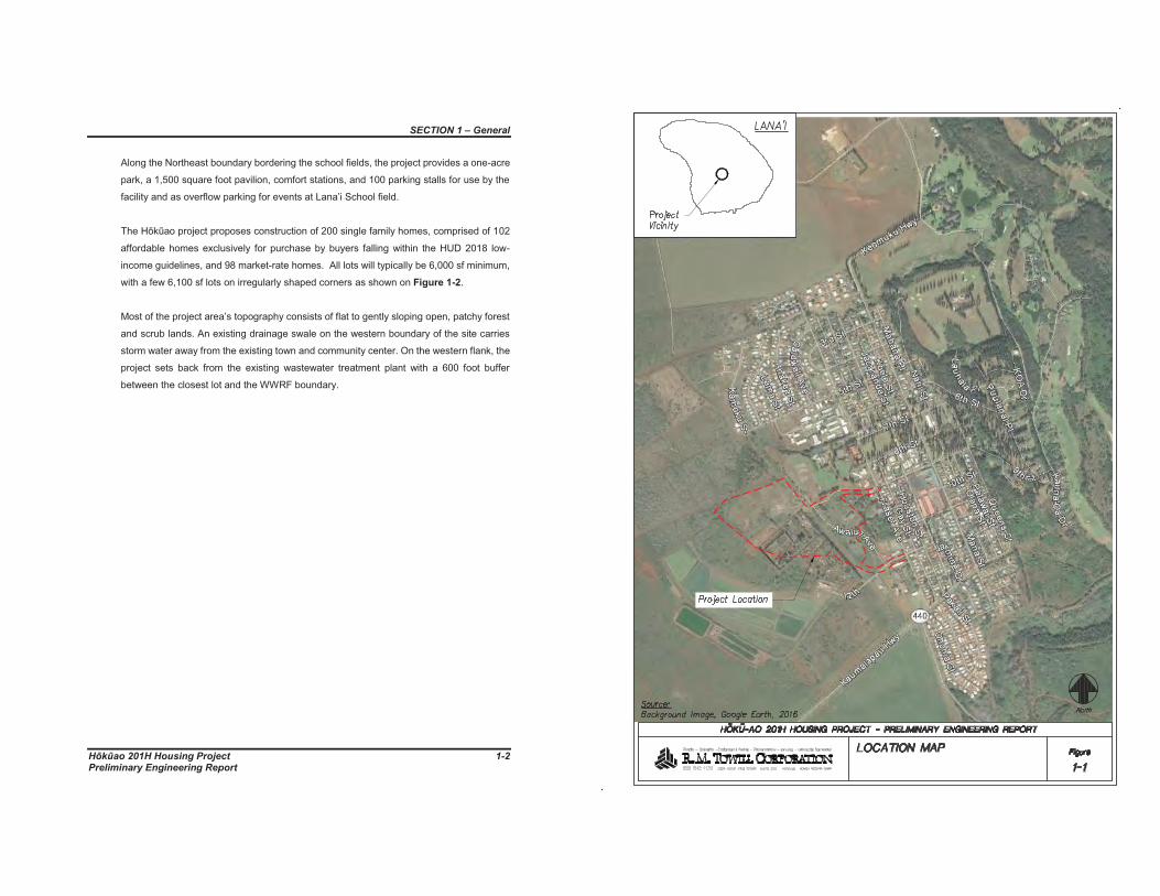
���� ����� !"#$The proposed Hōkūao 201H Housing Project comprises approximately 50 acres of land
in the Kamoku Ahupuaa of Lana‘i Island. The irregularly shaped project area is located
immediately west of and downslope from Lana‘i City center. The site is bounded on the
east by Fraser Avenue and two church parcels; on the north by 9th Street and a dirt road.
Most of the western boundary is marked by the chain-link fence boundary of the
wastewater treatment plant, while the southern boundary follows 12th Street and Awalua
Avenue as Shown on Figure 1-1.
The proposed project has been titled “Hōkūao 201H Housing Project” identified on tax
maps as TMK: (2) 4–9–002:061 por., TMK: (2) 4–9–014:001por., TMK: (2) 4–9–014:009
por., and TMK: (2) 4–9–014:011 por.
TMK: (2) 4–9–002:061 is a large parcel of approximately 16,124 ac. and includes both
undeveloped lands and abandoned pineapple fields.
TMK: (2) 4–9–014:001 is an approximately 84 ac. parcel that is currently used for storage,
the Pulama Lana‘i Nursery, and community gardens for Lana‘i residents.
TMK: (2) 4–9–014:009 comprises approximately 25.65 ac. and is the location of the
island’s original power plant, now abandoned, and the graded yard used to store shipping
containers.
TMK: (2) 4–9–014:011 is a smaller parcel of approximately 18.7 ac. Immediately abutting
the proposed enhancements to 9th Street extending into the project site.
The parcels comprising the proposed Hōkūao Housing project area are owned by Lana’I
Resorts, LLC?.
The project is sited close to Dole Park to take advantage of its walkable proximity to shops,
groceries, educational, and entertainment venues. The project visually and physically
connects to the town via 9th Street and 12th Avenue road extensions, continuing the
existing street grid pattern into the new development. 9th Street will also have a wide
concrete bike/walk path connecting the community to Fraser Avenue.
��������� � ���
�������������������� � !��� ��"����#����� ����$ %��
Along the Northeast boundary bordering the school fields, the project provides a one-acre
park, a 1,500 square foot pavilion, comfort stations, and 100 parking stalls for use by the
facility and as overflow parking for events at Lana’i School field.
The Hōkūao project proposes construction of 200 single family homes, comprised of 102
affordable homes exclusively for purchase by buyers falling within the HUD 2018 low-
income guidelines, and 98 market-rate homes. All lots will typically be 6,000 sf minimum,
with a few 6,100 sf lots on irregularly shaped corners as shown on %&�" '��(�.
Most of the project area’s topography consists of flat to gently sloping open, patchy forest
and scrub lands. An existing drainage swale on the western boundary of the site carries
storm water away from the existing town and community center. On the western flank, the
project sets back from the existing wastewater treatment plant with a 600 foot buffer
between the closest lot and the WWRF boundary.
� �

��������� � ���
�������������������� � !&�� ��"����#����� ����$ %��
���� )*'�+&,'-��#$���!.'This Preliminary Engineering Report provides a summary of the traffic, water, wastewater
and electrical/telecommunications demands and storm water runoff impacts due to the
proposed improvements. The report will identify impacts of the proposed improvements
on the existing offsite regional roadway, water, wastewater, drainage and
electrical/communication facilities.
�

����������'�� ������(� ����
�������������������� � �!�� ��"����#����� ����$ %��
��� �/�������� �0��� �������� �&+'��1� ��+' &-+&�-�
The study area (project) is in Lana‘i City and includes the undeveloped lands and
abandoned pineapple fields, Pulama Lana‘i Nursery and community gardens and an
abandoned power plant.
���� �!.!� �.12��#$��!&3�Most of the project area topography consists of flat to gently sloping open, patchy forest
and scrub lands as shown on %&�" '��(�. The approximate range of ground slopes and
elevations, estimated from a previous aerial topography map, is 3% to 20% and ~1520 ft.
to ~1610 ft. msl.
Based on the U.S. Soil Conservation Service Soil Survey (1972), the majority of existing
soils within the project site are classified as Waihuna Clay (WoA). Waihuna Clay has
slopes that range from 0%-3%. This type of soil generally has a surface layer, about 18-
inches thick, of dark brown, very sticky and very plastic clay. The lower layer can vary to
more than 50-inches thick and consists of dark brown, very stick and very plastic clay and
silty clay that has sub angular blocky structure. Permeability is moderately slow, runoff is
slow, and erosion hazard is no more than slight. The soil is strongly acid in the surface
layer as a result of pineapple culture, but it is neutral to medium acid in the rest of the
profile. It is prone to cracking when the soil dries.
The eastern and western portions of the site are classified as Lahaina Silty Clay (LaB).
Slopes range from 3%-7%, with a surface layer of dark reddish-brown, silty clay, about
15-inches thick. Permeability is moderate, runoff is slow, and erosion hazard is slight. The
soil is medium acid in the surface layer and slightly acid to medium acid in the subsoil.
Minute portions of the northern eastern and central part of the site are classified as
Lahaina Silty Clay 0%-3% (LaA) and Lahaina Silty Clay 7%-15% (LaC). These soils have
characteristics similar to Lahaina Silty Clay (LaB). On the portions with slopes ranging
from 0%-3%, the soil runoff is slow and the erosion hazard is no more than slight. On the
portions with slopes ranging from 7%-15%, the runoff is medium and the erosion hazard
is moderate. The soils map indicating the various types of soils within the project limits is
shown on %&�" '��(�.
����������'�� ������(� ����
�������������������� � �!��� ��"����#����� ����$ %��
��4� �3&5�+'�The project site is located in central Lanai, and receives a moderate amount of rainfall
each year. The average annual rainfall is approximately 34 inches. The wettest month is
January, with an average monthly total of approximately 5 inches. The driest month is
August, with an average total of 1.5 inches. The average annual air temperature is
approximately 69 degrees F.
��6� �7&-+&#���!�$8�2��2-+'5�The existing roadways in the vicinity of the project include Kaumalapau Highway (State
Department of Transportation, DOT), Fraser Avenue (County), 9th St. (County), and 12th
St. (County) as shown on %&�" '��(4. The existing traffic conditions are also discussed in
the attached Traffic Impact Analysis (Attachment 1).
��9� �7&-+&#��:�+' ��2-+'5�The Lanai Water Company (LWC) privately owns the domestic water system servicing the
proposed. The existing regional schematic water system consists of a 12-inch waterline
on Frasier Avenue.
The water for this system is provided by existing groundwater sources and the water
quality has met all State of Hawaii regulations for drinking water. All water quality
monitoring required by the State of Hawaii Department of Health, Safe Drinking Water
Branch, Annual Consumer Confidence Reports are provided to all customers.
��9��� �7&-+&#��:�+' �0'5�#$-�The site includes the Pulama Lana‘i Nursery and community gardens which are
the only users of water on the site. The nursery and community gardens will be
relocated south of the project site.
���9��� �7&-+&#��:�+' ��!" �'��#$��+! ��'�
The water system for Lanai is owned and operated by the Lanai Water Company
and is divided into nine (9) aquifer systems for the island. The Project falls within
the Leeward Aquifer.

����������'�� ������(� ����
�������������������� � �!)�� ��"����#����� ����$ %��
Water feeding the area is pumped primarily from Well No. 3, 6 and 8, which are
located to the east of the project site, on the slopes of Lanaihale. The pumped
water is stored in a 0.75 million gallon (MG) Koele Tank and the 2 MG tank. Water
pressure exceeds 80 psi in some areas of this system, and individual pressure
reducing valves are required. Fire flows are adequate for all service areas. The
existing water system and regional schematic water system are shown on %&�" '��(6 and %&�" '��(9.
� �

����������'�� ������(� ����
�������������������� � �!*�� ��"����#����� ����$ %��
��;� �7&-+&#��:�-+'8�+' ��2-+'5�The existing wastewater system flows through or adjacent to the proposed project to the
wastewater treatment plant. The existing wastewater system is shown on %&�" '��(;.
��;��� �7&-+&#��:�-+'8�+' �0'5�#$-�The project site does not presently generate any wastewater demand.
��;��� �7&-+&#��:�-+'8�+' �� '�+5'#+�Based on as-built plans of the Lanai Sewerage System and Waialua Annex
Subdivision, sewer mains are located in Fraser Ave., as well as the County’s major
sewer collector lines which are located through the proposed project. Existing 10-
inch and 12-inch sewer lines route sewage from the existing residential subdivision
along 5th Street to the 15-inch interceptor sewer which discharges to the
wastewater reclamation facility west of the project site. The existing main along
Fraser Avenue consists of an 8” pipe of unidentified material, and the collector
lines are a 10” vitrified clay pipe, and a 12” pipe of unidentified material.
The 8” main serves the portion of Lanai City below Ilima Ave., between 8th and
12th streets. The 10” collector line serves the entire half of Lanai City to the north
of 7th street. The 12” collector line serves the western portion of Lanai City, below
Fraser Ave. The collector lines merge and flow to the Lanai Wastewater
Reclamation Facility (WWRF). The existing 10-inch and 12-inch collector lines will
need to be relocated within proposed street right of ways and connected back to
the 15-inch interceptor sewer going to the WWRF. Easements within privately
owned residential lots will not be accepted by the County.
Per the County’s Department of Environmental Management, Wastewater
Reclamation Division, the capacity of the Lanai WWRF is 0.50 million gallons per
day (mgd). The actual average daily flow is approximately 0.315 mgd, and
allocations totaling 0.395 have been granted to existing development. The project
is located just north of the boundary of the WWRF.
�


����������'�� ������(� ����
�������������������� � �!+�� ��"����#����� ����$ %��
��<� �7&-+&#���+! 5�:�+' ��"#!==���++' #-�Runoff from the project area generally sheet flows west towards the Lanai City WWRF
and then south towards Kaumalapau Highway. Runoff from portions of the project flows
north towards 5th Street. The Koele and Lanai City drainage systems mauka of the project
area convey storm runoff away from the project. The Federal Emergency Management
Agency has designated the area as Zone X, Area of Minimal Flood Hazard as shown in
%&�" '��(<.
��<��� �7&-+&#���'�&!#�3�0 �&#��'��2-+'5�Based on the Lanai City DMP and Koele DMP, there are three major sub
watersheds that contribute flows to Kapano Gulch. Kapano/Lanai City, Kapano,
and Kaumalapau sub watersheds and consists of drainage areas greater than 100
acres and were studied for impacts to Lanai City and other downstream areas.
The Kapano/Lanai City sub watershed shown as Watershed Designation 2 on
%&�" '��(>, has an area of 161 acres that drains into an interceptor ditch along the
boundary between Lanai City and Koele Resort. The interceptor ditch starts at 6th
Street, runs above Queens Street, across 9th Street and the mauka extension of
Kaumalapau Road, and eventually drains into Kapano Gulch just above Lanai City.
The Kapano sub watershed shown as Watershed Designation 3 has an area of
386 acres and makes up Kapano Gulch. It begins approximately 1.6 miles mauka
of the project site, and drains into the Palawai Basin near the southern end of Lanai
City. The length to width ratio for Kapano Gulch is approximately 1.7.
The Kaumalapau sub watershed shown as Watershed Designation 6 has an area
of 105 acres, and lies between Dole Park and Kaumalapau Road.
���<��� �7&-+&#��0 �&#��'��2-+'5�
As described in the Lanai City Drainage Master Plan, runoff from the land mauka
of the project is conveyed by drain pipes and along Frasier Avenue, and streets
parallel to Frasier Avenue, to the ditch along Kaumalapau Road that turns south,
mauka of Manele Road, and which flows to Kapano Gulch. Kapano Gulch runs
along the south side of Lanai City and drains into two dry, abandoned reservoirs
before entering Palawai Basin through a series of abandoned irrigation ditches.
����������'�� ������(� ����
�������������������� � �!��� ��"����#����� ����$ %��
The Palawai Basin is a large plateau area, approximately 4.5 miles in diameter,
which floods for prolonged periods of time during the rainy season.
Runoff from the site generally sheet flows to the south-southwest, following the
existing ground slope towards the WWRF and then towards Kaumalapau Highway.
The northern areas flow towards 5th Street. The existing drain areas and drainage
system are shown on %&�" '��(?��#$��(��.
���>� �7&-+&#���3'�+ &��3��#$��'3'�!55"#&��+&!#-��2-+'5�
The sole electric utility serving the island of Lanai is Maui Electric Company which
operates and is regulated under a tariff approved by the State Public Utilities Commission
(PUC). Similarly, Hawaiian Telecom (HTCO) operates and is regulated under a tariff
approved by the PUC and was the sole provider of telecommunications services until the
advent of cable television. Subsequently, Spectrum (fka Oceanic Time Warner Cable),
which is not regulated by the State PUC but is a franchisee of the Department of
Commerce and Consumer Affairs (DCCA), has become a competitor to HTCO and, similar
to HTCO, can offer broadband, cable television and telephone signals.
��>��� �7&-+&#���!8' ��'#' �+&!#Maui Electric Co.’s (MECO) existing generation system, on the Island of Lanai, is
currently capable of providing approximately 9.4 Megawatts (Mw) of power (based
on MECO’s 30 January 2018 Availability of Supply letter). In 2017, peak demand
on the Island of Lanai, as indicated in their letter, was 5.4 Mw.
��>��� �7&-+&#���3'�+ &��3��#$��'3'�!55"#&��+&!#-�0&-+ &)"+&!#��2-+'5�Under rights granted under the Kingdom of Hawaii, in MECO’s case, and during
the government of the Territory of Hawaii, in HTCO’s case, the infrastructure of
both these companies may occupy public rights-of-ways. It has come to be
generally accepted that the term “infrastructure” includes both overhead and
underground facilities. Hawaii Revised Statute Article 440G-8.2, established the
ability for cable franchisees to occupy, subject to the rules and regulations imposed
on the PUC-regulated utilities, to occupy public rights-of-ways.
On Lanai, the majority of the land and roadways are privately owned. The utility
companies have received grants of easement from the landowner, formerly Lana’i
Company and presently Pulama Lana’I, for some of their joint utility poleline

����������'�� ������(� ����
�������������������� � �!�� ��"����#����� ����$ %��
installations on Lanai and utilize existing roadways in a manner similar to County-
dedicable roadways as shown on %&�" '��(��. It should be noted that some of
these grants of easement contain a “one-time” relocation clause, which obligates
the respective utility companies to relocate the existing overhead facilities, at their
cost, in exchange for a new perpetual grant-of-easement. It should further be
noted that as of mid-October 2018, under a PUC Decision and Order (D& O), with
the exception of the Island of Kauai, ownership of existing joint pole facilities was
concentrated into the respective electrical utility companies serving those Islands.
Existing utility pole lines that support only telecommunication cables are still owned
by HTCO. Under the same PUC D & O, all franchised telecommunications
companies desiring to attach to existing or new, overhead utility pole facilities
would now lease attachment space from the respective electric utility companies
instead of becoming joint pole owners.
To obtain approval to attach to existing telecommunication-only utility pole lines,
Spectrum must lease space from HTCO, as the utility pole owner.
MECO’s, HTCO’s, and Spectrum’s existing facilities serving Lanai consist mainly
of aerial cables attached to overhead utility pole lines along most of the roadways
in the Lanai City.
��>�4� �7&-+&#���3'�+ &��3��")-+�+&!#�A MECO 12.47-2.4 kV substation and incoming and outgoing overhead lines are
currently situated within the proposed subdivision footprint. This substation and
the 2.4 kV overhead lines currently provide service to the existing Lana’i City
residences and must be relocated outside of the proposed subdivision prior to
development occurring.
� �


2-11HOKU-AO 201H HOUSING PROJECT

�������)�,%%����-��(��� ���
�������������������� � )!�� ��"����#����� ����$ %��
4�� ��� ����0����������This report analyzes the estimated increase in traffic, water, wastewater and electrical
demand and drainage requirements due to the proposed residential housing. The
proposed increases for water are not reduced by the historical information to for the
nursery and community gardens which will be relocated. The existing nursery and
community gardens are metered.
Infrastructure is typically designed for maximum estimated usage. The proposed
improvements studied in this report consist of 200 single family housing units of which 102
are affordable homes and a 1-acre park.
4��� � �==&��The criteria for the Traffic analysis are provided in the attached Traffic Impact Analysis
(Attachment 1).
4����� � �==&���','3�!=��' ,&�'�Level of Service (LOS) is a qualitative measure used to describe the conditions of traffic
flow at intersections, with values ranging from free-flow conditions at LOS A to congested
conditions at LOS F. The Highway Capacity Manual (HCM), 6th Edition, includes methods
for calculating volume to capacity ratios, delays, and corresponding Levels of Service that
were utilized in this study.
4����� @'1&�"3� ��','3�!=��' ,&�'�=! ��&�#�3&A'$��#+' -'�+&!#-�B����;+1��$&+&!#C�
Level of service for vehicles at signalized intersections is directly related to delay values
and is assigned on that basis. Level of Service is a measure of the acceptability of delay
values to motorists at a given intersection. The criteria are given in the table below.
�','3(!=��' ,&�'�� &+' &��=! ��&�#�3&A'$��#+' -'�+&!#-��','3�!=��' ,&�'���������!#+ !3�0'3�2�.' �@'1&�3'�B-'��D,'1�C�
A < 10.0
B >10.0 and ≤ 20.0
C >20.0 and ≤ 35.0
D >35.0 and ≤ 55.0
�������)�,%%����-��(��� ���
�������������������� � )!��� ��"����#����� ����$ %��
E >55.0 and ≤ 80.0
F > 80.0
Delay is a complex measure, and is dependent on a number of variables, including the
quality of progression, the cycle length, the green ratio, and the v/c ratio for the lane group
or approach in question.
4���4� @'1&�"3� ��','3�!=��' ,&�'�=! ��#-&�#�3&A'$��#+' -'�+&!#-�B����;+1��$&+&!#C�
The level of service criteria for vehicles at unsignalized intersections is defined as the
average control delay, in seconds per vehicle.
LOS delay threshold values are lower for two-way stop-controlled (TWSC) and all-way
stop-controlled (AWSC) intersections than those of signalized intersections. This is
because more vehicles pass through signalized intersections, and therefore, drivers
expect and tolerate greater delays. While the criteria for level of service for TWSC and
AWSC intersections are the same, procedures to calculate the average total delay may
differ.
�','3�!=��' ,&�'�� &+' &��=! ��8!(:�2��+!.(�!#+ !33'$��#+' -'�+&!#-��','3�!=��' ,&�'� ,' ��'��!#+ !3�0'3�2�B-'�D,'1C�
A ≤ 10
B >10 and ≤15
C >15 and ≤25
D >25 and ≤35
E >35 and ≤50
F > 50
4��� :�+' �Proposed water demand estimates and water system design will be derived from the
County of Maui’s Department of Water Supply Water System Standards (����������).
Conformance with the County standards provides accepted criteria for water system
planning and design, although the water system, inclusive of water source, storage, and
piping, will remain privately owned and will not be subject to all County requirements.

�������)�,%%����-��(��� ���
�������������������� � )!)�� ��"����#����� ����$ %��
4����� :�+' �0'5�#$�� &+' &��The water demand criteria from the County of Maui Water Supply Standards is
provided in ��)3'�4(� and a summary of the water demand criteria is presented in ��.� )!���
��)3'�4(���!"#+2�!=���"&�:�+' ��"..32��+�#$� $-�
��)3'�4(�E�:�+' �0'5�#$�� &+' &��Flow Parameter Units Value Source ,' ��'�0�&32�:�+' �0'5�#$�)2���.&+��
Single Family or Duplex gpd/unit 600 1 DWSPark acre 1,7001 DWS
�'�'#$gpd/unit=gal / day / unitgpd/acre = gal / day / acreDWS = “County of Maui Department of Water Supply Standards)
�1 Single family or Duplex demands set at 600 gpd/unit and Park set at 1,700 gpd/acre per
(County of Maui Department of Water Supply Standards).
�������)�,%%����-��(��� ���
�������������������� � )!/�� ��"����#����� ����$ %��
�4�4� :�-+'8�+' �
The proposed wastewater demand estimates and wastewater system design will be
derived from the County of Maui’s Water Reclamation Division Wastewater (WRD) Flow
Standards (Reference 6), or WRD approved Sewer Studies for similar facilities where
practicable.
�4�4��� :�-+'8�+' �0'5�#$�� &+' &��
A summary of the wastewater demand criteria is presented in ��.� )!)��
��)3'�4(4E�:�-+'8�+' �0'5�#$�� &+' &��Flow Parameter Units Value Source ,' ��'�0�&32�:�-+'8�+' �0'5�#$�)2���.&+�
Average Daily Per Capita Demand- Single Family or Duplex (@ 4cpu) gpd/capita 80 1 WRD- Park (@ 4 cps) gpd/capita 51 Other1
�'�'#$gpd/capita = gal / day / capitacpu = capita / unitcps = capita / parking stallWRD = “County of Maui Standards of the Water Reclamation Division”
1 Per capita usage set at 80 for single family or duplex based on County of Maui
Standards of the Water Reclamation Division (Standards use 4 capita per single
family or duplex unit which equates to 320 gallons per day per unit). Per capita
usage set at 5 for park and capita per car set at 4 based on the approved Central
Maui Regional Park Sewer Study (the park study used 4 capita per vehicle which
equated to 20 gallons per day per parking stall and 50% usage at any given time).
4�6� 0 �&#��'��2$ !3!�2��#$��2$ �"3&�-�The hydrologic and hydraulic criteria used in this report conform to the requirements of the
������������������������������ �� ���! ���������������������"���� �� (County Drainage
Standards).
4�6��� �2$ !3!�2�

�������)�,%%����-��(��� ���
�������������������� � )!&�� ��"����#����� ����$ %��
The hydrologic criteria used in this report is described in 15-04-05 Hydrologic
Criteria of the County Drainage Standards. ��)3'� 4(6 describes the Strom
Recurrence Criteria of the County Drainage Standards and ��)3'�4(9 describes
the runoff coefficients used.
A composite runoff coefficient (C) is calculated by taking the weighted average of
the impervious and pervious land areas within the study area for both, the existing
and proposed conditions. The composite runoff coefficient will be used to calculate
the runoff value in both conditions. The increase in runoff will be derived from the
difference between the existing and proposed conditions (primarily due to an
increase in impervious area in the proposed condition). For the purpose of
calculating increases in runoff in the immediate onsite drainage areas, the
composite C method will be more conservative than applying the published
minimum runoff coefficients for built-up areas from Table 3 of the County Drainage
Standards.
��)3'�4(6E��+! 5��'�" '#�'�� &+' &��
0 �&#� '� �+! 5��'�" '#�' �'+1!$
Onsite Drain Area (< 100 acres)
10-Year, 1-Hour Rational Method
Regional Drain Area (> 100 acres)
100-Year, 24-Hour NRCS Hydrograph Method
��)3'�4(9E��"#!==��!'==&�&'#+����#$��-'�
��"#!==��!'==&�&'#+�B�C�
Unimproved Areas 0.30
Commercial 0.85
Residential Areas 0.50
Roadways 0.95
4�6��� �2$ �"3&�-�
�������)�,%%����-��(��� ���
�������������������� � )!*�� ��"����#����� ����$ %��
The hydraulic criteria used in this report is described in 15-40-06 Design Standards
of the County Drainage Standards.�
4�9� �3'�+ &��3D�'3'�!55"#&��+&!#-D�+ ''+��&�1+&#���
4�9��� �3'�+ &��3D�'3'�!55"#&��+&!#-�The electrical criteria used in this report conform to the planning practices of the
Maui Electric Company and Hawaiian Telcom.
�
4�9��� �+ ''+��&�1+&#��� Illumination for the roadways will be designed to meet County of Maui
requirements and Illuminating Engineering Society (IES) RP-8 criteria.

�������/����%�� (���(� ����
�������������������� � /!�� ��"����#����� ����$ %��
6�� �� � ��0�� �0��� ����6��� �'#' �3�
The Hōkūao project proposes construction of 200 single family homes, comprised of 102
affordable homes and 98 market-rate homes and a 1-acre park, a future 1,500 square foot
pavilion with 100-parking stalls. All lots will typically be 6,000 sf minimum, with a few 6,100
sf lots on irregularly shaped corners. The proposed improvements studied herein include
new roadway, water, sewer, drainage and electrical/telecommunication infrastructure to
serve the project.
6����� ==! $�)3'��!"-&#��The proposed project includes 102 affordable homes exclusively for purchase by
buyers falling within the HUD 2018 low-income guidelines.
6����� 0'-&�#��1� ��+' The character of the homes will reflect the existing design vernacular of Lana’i City.
House size will be between 900 and 1500 sf; with hipped or gable roofs, covered
front lanais, board & batten siding, large trim profiles, and other design details
matching historic Lanai buildings. The houses will also have enclosed garages
and driveway to minimize street parking.
6��� � �==&��6����� � !.!-'$�� �==&���!#$&+&!#-�
The Project entails the development of 200 residential units, one-acre park, 1,500
square foot pavilion, comfort station, and 100 parking stalls. Of the 200 single-
family homes, 133 will be comprised of affordable homes and 67 will be comprised
of market-rate homes. As a conservative measure, a 1-acre park will be assumed
to include the amenities identified. Vehicular traffic to the Project will be provided
by two (2) existing accesses along Fraser Avenue at 9th Street and at 12th Street.
The Project is anticipated to generate approximately 147(221) AM(PM) trips and
study intersections are forecast to operate at conditions similar to Base Year 2024
during both peak hours with all manual turning movements operating at LOS C or
better during the AM and PM peak hours of traffic.
�������/����%�� (���(� ����
�������������������� � /!��� ��"����#����� ����$ %��
The proposed traffic conditions are described in the attached Traffic Impact
Assessment.
6�4� :�+' ��
6�4��� � !.!-'$�:�+' �0'5�#$-�Based on the County of Maui Department of Water Supply Standards of 600
gallons per day per single family unit and 1,700 gallons per acre for a park, the
proposed average daily domestic water demand for the 200 single family units and
the 1-acre park with future 1,500 square foot pavilion with comfort stations and
parking is estimated to be 121,700 GPD.
��)3'�6(��:�+' �0'5�#$���3�"3�+&!#-�Use Type Number of Units or
Acres
Demand Per Unit or
Acre (gpd)
Demand
Residential Units 200 600 120,000
Park 1.0 1,700 1,700
Total 121,700
6�4��� � !.!-'$�:�+' ��2-+'5�The existing domestic water system will provide water service to the project
through a new connection to the 12-inch water main on Frasier Avenue. Proposed
water distribution mains along the new roads will be 8-inch to 12-inch in diameter
to ensure adequate fire protection flows can be provided. Water pressure exceeds
80 psi in some areas of this system and individual pressure reducing valves are
required. The proposed water system improvements shown on 0���� /!.
6�4�4� �5.��+-�+!��'�&!#�3�:�+' �%��&3&+&'-�The estimated total water demand of the project is 121,700 GPD. The LWC has
indicated in the attached letter dated ____ in Appendix 3, that “the project will have
a long-term, reliable supply of water in accordance with Chapter 14.12, Water
Availability, Maui Code, upon completion of new source development. The Lanai

�������/����%�� (���(� ����
�������������������� � /!)�� ��"����#����� ����$ %��
Company is in the process of permitting the development of Well #7 which is
anticipated to be the source of water for the project.”
�� �