preliminary decision - alaska department of natural resources
TRANSCRIPT

Preliminary Decision:
(As required under AS 38.05.035 (e))
Competitive Coal Lease Sale In the
Canyon Creek Area, Alaska ADL 553937
Alaska Department of Natural Resources
Division of Mining, Land and Water

Contents
1
Table of Contents Chapter 1: Introduction ......................................................................... 8
Proposed Action .......................................................................................................................... 8
Authority ..................................................................................................................................... 9
Administrative Record ................................................................................................................ 9
Scope of the Decision ............................................................................................................... 10
Use of Consultants in Preparing the Preliminary Decision ...................................................... 11
Chapter 2: Description ......................................................................... 12
Location and Geographic Description ...................................................................................... 12
Title ........................................................................................................................................... 14
Planning and Classification....................................................................................................... 14
Susitna Basin Recreation Rivers Management Plan ............................................................. 15
Matanuska-Susitna Borough Comprehensive Plans ............................................................. 16
Matanuska-Susitna Borough Code ....................................................................................... 16
Historical and Archeological Sites............................................................................................ 16
Access ....................................................................................................................................... 17
Waterways............................................................................................................................. 17
Roads and Trails ................................................................................................................... 18
Section Line Easements ........................................................................................................ 18
Survey Requirement.................................................................................................................. 18
Compensation ........................................................................................................................... 18
Bonding ..................................................................................................................................... 19
Hazardous Materials and Potential Contaminants .................................................................... 19
Geologic Hazards ...................................................................................................................... 20
Faults and Earthquakes ......................................................................................................... 20
Volcanic Hazards .................................................................................................................. 21
References ................................................................................................................................. 22
Chapter 3: Coal Resource Potential Evaluation for the Proposed Canyon Creek Lease Area .................................................................... 25
Introduction ............................................................................................................................... 25
Coal Potential Rating of State Lands for Coal Leases .............................................................. 26
Coal Potential Rating System ............................................................................................... 27

Contents
2
Geologic Setting of the Canyon Creek Area ............................................................................. 29
Coal-bearing Kenai Group .................................................................................................... 29
Summary of Geologic Units in Proposed Lease Area (depicted on Fig. 3.3) ........................... 31
Unconsolidated Quaternary Deposits ................................................................................... 33
Sedimentary Rocks, Tertiary Kenai Group ........................................................................... 33
Igneous Rocks – Intrusives and Volcanics ........................................................................... 34
Cretaceous Sedimentary Rocks............................................................................................. 35
Coal Resource Potential Evaluation.......................................................................................... 35
Available Geologic Data ....................................................................................................... 35
Coal Resource Potential Evaluation (Fig. 3.7) .............................................................. 40
References ................................................................................................................................. 43
Chapter 4: Statutory and Regulatory Background .......................... 46
Permitting .................................................................................................................................. 47
Other State of Alaska Permitting .............................................................................................. 48
Public Involvement ................................................................................................................... 49
Baseline Studies ........................................................................................................................ 50
Performance Standards ............................................................................................................. 51
Operation and Reclamation Plans ............................................................................................. 52
Bonding ..................................................................................................................................... 53
Inspections ................................................................................................................................ 53
Federal Regulation and Permitting ........................................................................................... 54
Chapter 5: Habitat, Fish, and Wildlife .............................................. 56
Terrestrial Habitats.................................................................................................................... 56
Needleleaf Forest .................................................................................................................. 57
Broadleaf Forest .................................................................................................................... 57
Mixed Needleleaf/Broadleaf Forest ...................................................................................... 57
Tall and Low Shrub .............................................................................................................. 57
Dwarf Shrub .......................................................................................................................... 58
Dry and Moist Herb .............................................................................................................. 58
Wet and Aquatic Herb .......................................................................................................... 58
Wetlands ............................................................................................................................... 58
Developed Areas ................................................................................................................... 60
Invasive Species .................................................................................................................... 60
Water Habitats .......................................................................................................................... 61
Contents
3
Freshwater Habitats .............................................................................................................. 61
Designated Habitat Areas ......................................................................................................... 66
Talachulitna State Recreational River .................................................................................. 66
Susitna Flats State Game Refuge .......................................................................................... 66
Trading Bay State Game Refuge .......................................................................................... 67
Fish and Wildlife Populations ................................................................................................... 68
Freshwater and Anadromous Fish ........................................................................................ 69
Birds ...................................................................................................................................... 72
Terrestrial Mammals ............................................................................................................. 78
References ................................................................................................................................. 82
Chapter 6: Current and Projected Uses of the Proposed Leasing Area ......................................................................................................... 87
Fish and Wildlife Uses and Value ............................................................................................ 87
Sport Fishing ......................................................................................................................... 87
Personal Use Fishing............................................................................................................. 89
Sport Hunting and Trapping ................................................................................................. 89
Subsistence Fishing, Hunting, and Gathering ....................................................................... 92
Water Rights and Public Water Supplies .................................................................................. 94
Water Rights ......................................................................................................................... 94
Public Water Supplies ........................................................................................................... 95
Forestry ..................................................................................................................................... 95
Agriculture ................................................................................................................................ 96
Mining ....................................................................................................................................... 97
Oil and Gas ............................................................................................................................... 99
Recreation ............................................................................................................................... 102
Hunting and Fishing ............................................................................................................ 102
Talachulitna State Recreation River ................................................................................... 102
Trails ................................................................................................................................... 103
References ............................................................................................................................... 103
Chapter 7: Coal Transportation ....................................................... 106
Potential Transportation Routes .............................................................................................. 106
Modes of Coal Transportation ................................................................................................ 107
Conveyor Systems .............................................................................................................. 108
Coal Pipelines ..................................................................................................................... 109
Contents
4
Unit Trains .......................................................................................................................... 111
Truck Road.......................................................................................................................... 114
Port Facilities ...................................................................................................................... 114
References ............................................................................................................................... 115
Chapter 8: Hydrology, Ground and Surface Water ....................... 116
Climate and Precipitation Patterns .......................................................................................... 116
Surface Water.......................................................................................................................... 117
Rivers, Creeks and Streams ................................................................................................ 117
Floods .................................................................................................................................. 118
Lakes ................................................................................................................................... 119
Ground Water.......................................................................................................................... 121
Local Water Supplies .............................................................................................................. 122
Water Quality .......................................................................................................................... 122
Contaminated Sites ............................................................................................................. 124
References ............................................................................................................................... 124
Chapter 9: Reasonably Foreseeable Effects of Leasing .................. 126
Exploration .............................................................................................................................. 127
Geophysical Exploration ..................................................................................................... 127
Exploration Drilling ............................................................................................................ 128
Development and Production .................................................................................................. 129
Statewide and Local Fiscal Effects ......................................................................................... 129
Statewide Fiscal Effects ...................................................................................................... 129
Regional and Local Fiscal Effects ...................................................................................... 131
Municipal and Community Effects ......................................................................................... 135
Commercial Fishing ............................................................................................................ 135
Infrastructure ....................................................................................................................... 135
Land Use ............................................................................................................................. 136
Physical and Biological Effects .............................................................................................. 136
Effects on Water Quality .................................................................................................... 136
Effects on Air Quality ......................................................................................................... 138
Effects on Terrestrial Habitat .............................................................................................. 138
Effects on Fish and Wildlife Populations and Their Uses ...................................................... 139
Effects on Fish .................................................................................................................... 139
Effects on Birds................................................................................................................... 140

Contents
5
Effects on Terrestrial Wildlife ............................................................................................ 141
Effects on Hunting and Fishing .......................................................................................... 142
Effects on Cultural and Historic Resources ............................................................................ 143
Effects on Recreational Resources.......................................................................................... 144
Cumulative Effects.................................................................................................................. 144
Summary ................................................................................................................................. 145
References ............................................................................................................................... 145
Chapter 10: Potential Measures to Avoid, Minimize, and Mitigate Negative Impacts ................................................................................. 147
Potential Mitigation Measures for Exploration Activities ...................................................... 148
Wildlife disturbance by aircraft .......................................................................................... 149
Exploration camps .............................................................................................................. 149
Seismic work ....................................................................................................................... 149
Drilling ................................................................................................................................ 150
Large scale sampling........................................................................................................... 151
Mine Development.................................................................................................................. 151
Potential Mitigation Measures for Mine Development and Mining Activities ...................... 152
Restriction of Public Access ............................................................................................... 152
Restoration of Mine Pits, Ponds, and Other Disturbances .................................................. 152
Habitat Protection and Restoration ..................................................................................... 152
Other Effects on Fish and Wildlife ..................................................................................... 154
Sediment Control Measures ................................................................................................ 156
Water Quality Protection .................................................................................................... 157
Waste Management ............................................................................................................. 159
Hazardous Materials ........................................................................................................... 159
Air Quality Protection ......................................................................................................... 161
Effects on aesthetic values and recreational resources ....................................................... 162
Protection of Cultural and Historical Sites ......................................................................... 162
Mitigation of Geologic Hazards .......................................................................................... 163
References ............................................................................................................................... 164
Chapter 11: Discussion, Alternatives, and Recommendation ....... 165
Discussion and Alternatives .................................................................................................... 165
Recommendation .................................................................................................................... 167
Appendix A: Agency Comments and Responses ............................ 168

Figures
6
List of Figures
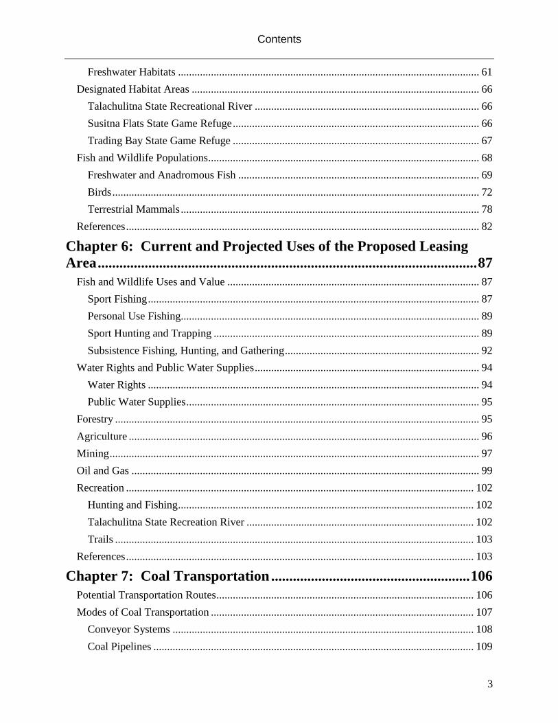
Figure 2.1. Plate 1: Proposed Canyon Creek Coal Leasing Area ........................................... 13
Figure 3.1. Map depicting coal fields in the Southern Alaska-Cook Inlet coal province ........ 29
Figure 3.2. Generalized stratigraphic column for Mesozoic through Cenozoic rocks in the Cook Inlet basin. ................................................................................................................. 30
Figure 3.3 Geology of the proposed Canyon Creek lease and surrounding areas ................... 32
Figure 3.4 Geologic mapping and locations of outcrops for Canyon Creek area described in Barnes, 1966, with overlay of proposed lease blocks. ......................................... 37
Figure 3.5 Locations of outcrops and drill holes with measured thickness of coal within or immediately adjacent to proposed lease area ............................................................ 38
Figure 3.6 Areas of Measured, Indicated and Inferred Coal Resources within the proposed Canyon Creek coal lease area.................................................................................... 39
Figure 3.7 Coal potential of areas within the proposed Canyon Creek area based on geology and outcrop and drill hole net coal thicknesses ........................................................... 42
Table 5.1. Hydrogeomorphic classification of Wetlands (adapted from Brinson 1993) .......... 59
Figure 5.1. Watersheds, Lakes, and Rivers in the vicinity of the proposed lease area. ............ 62
Figure 5.2. Location of Cook Inlet Aquifer System and location of wells sampled for USGS Water Quality Assessment Water-Resources Investigations Report 99-4116 .............. 63
Figure 5.3 Water Habitat in the vicinity of the proposed Canyon Creek lease area. Anadromous fish streams appearing in The Catalog of Waters Important for the Spawning, Rearing, or Migration of Anadromous Fishes ........................................................ 65
Figure 5.4. Duck and Swan Habitat types around the proposed lease area .............................. 74
Figure 5.5. ADF&G Game Management Units (GMUs) in and around the Canyon Creek proposed lease area. ........................................................................................................ 79
Figure 5.6. Moose habitat types around the proposed lease area.............................................. 81
Figure 6.1- ADF&G Game Management Units (GMUs) and relationship to the proposed lease area. .................................................................................................................. 91
Figure 6.2- Location of the Whistler Project Area and potential transportation routes relative to the Canyon Creek Proposed Lease area ................................................................... 99
Figure 8.1 Mean daily discharge during the 1982 water year at USGS streamflow gaging station 15294300, Skwentna River near Skwentna ..................................................... 118
Figure 8.2. Watersheds, Lakes and Rivers in the vicinity of the proposed lease area ............ 120
Figure 8.3. Location of Cook Inlet Aquifer System and location of wells sampled for USGS Water Quality Assessment Water-Resources Investigations Report 99-4116 ............ 121
Figure 9.1. Municipality of Anchorage and Matanuska-Susitna Borough Industry Employment Estimates 2010 .................................................................................................. 134

Figures
7
List of Tables
Table 3.1 Coal thickness in Mobil exploration wells .............................................................. 26
Table 3.2 Canyon Creek proposed lease coal volume ............................................................. 40
Table 5.1. Hydrogeomorphic classification of Wetlands.......................................................... 59
Table 5.2. Catalogued waters important for spawning, rearing, or migration of anadromous fishes located within 10 miles of the proposed lease area .................................... 64
Table 5.3. Species potentially found in the proposed lease area identified as State Species of Concern ................................................................................................................... 69
Table 6.1 Timber sales planned for the Mat-Su District, calendar years 2011-2015 .............. 96
Table 6.2. Estimated ultimate recovery and remaining oil and gas resources in Cook Inlet as of 10 / 2007 ................................................................................................................ 101
Table 8.1. Mean monthly and annual temperature, precipitation, and snowfall at Skwentna ................................................................................................................................. 117
Table 8.2.Monthly mean flow at USGS streamflow gaging station 15294300, Skwentna River near Skwentna .............................................................................................. 118
Table 8.3. Water-quality data from nine surface-water samples taken within 10 kilometers of the Skwentna FAA facility .......................................................................... 123
Table 9.1. Potential effects of coal exploration, development, and production .................... 127
Table 9.2. Summary of the Mining Industry’s Statewide Economic Impact, 2010............... 129
Table 9.3. Population of the Municipality of Anchorage and the Matanuska-Susitna Borough, 2000-2010 ............................................................................................................... 131
Table 9.4 - Municipality of Anchorage and Matanuska-Susitna Borough Industry Employment Estimates 2010 .................................................................................................. 133
Table 10.1. Activities that might occur during exploration ................................................... 148
Table 10.2. Activities that might occur during development, mining, and post-mining ....... 151
Plates Plate I: Proposed Canyon Creek Coal Leasing Area

Chapter 1: Introduction
8
Chapter 1: Introduction Proposed Action The proposed action is to hold a competitive coal lease sale for approximately 13,175 acres of land in the Canyon Creek area, south of the Skwentna River in townships T19-21N, R13 and 14W, Seward Meridian (See Figure 2.1, Plate 1: Proposed Canyon Creek Coal Leasing Area, and Chapter 2: Description, Location and Geographic Description). The proposed sale area lies along the southeastern flank of the Alaska Range, on the lower east flank of Dickason Mountain. The nearest community is Skwentna, approximately 18 miles to the northeast. The Department of Natural Resources (DNR) has received a request from Alaska Energy Corporation for a coal leases or prospecting permits in the proposed sale area. Under AS 38.05.150, 11 AAC 85.005, and 11 AAC 85.010, when the DNR receives requests for coal leasing or prospecting permits the Division of Geological and Geophysical Surveys (DGGS) evaluates the potential for commercial coal development and ranks that potential as high, moderate, or low. If the potential is found to be moderate or high, the land is designated competitive, and disposal of interest in coal must be through a competitive lease sale. If the ranking is low, coal prospecting permits may be issued. Mr. James Clough, of the DGGS, has performed the coal evaluation and assigned a rank of high for those portions of the proposed lease underlain by coal. The DGGS ranked portions of the area underlain by igneous and metasedimentary rocks as having low coal potential. (See Chapter 3: Coal Resource Potential Evaluation for the Proposed Canyon Creek Lease Area). Therefore, this decision addresses whether holding a competitive coal lease sale is in the best interest of the State.
This Decision does not permit future coal exploration, mining, or any physical activity within the proposed permit area, but only a competitive lease sale for the rights to coal. All future coal exploration, development, and mining activities will be regulated under the Alaska Surface Coal Mining Control and Reclamation Act (ASCMCRA) and the associated regulations (AS 27.21.010-999 and 11 AAC 90.001-911). The ASCMCRA mandates that coal exploration and mining activities are subject to public notice and comment, review, and written decision by the Commissioner of Natural Resources. The resultant permits will carry the appropriate operational stipulations. (See Chapter 4: Statutory and Regulatory Background) The public is invited to comment on this Preliminary Decision. Comments may be submitted to the Department of Natural Resources during the period for public comment, which will extend from October 16, 2012 through November 21, 2012. Comments must be in writing, email, or by testimony at a public hearing. A public hearing for the Canyon Creek Competitive Coal Lease Sale will be held at the Wendler Middle School cafeteria located at 2905 Lake Otis Parkway in Anchorage on Tuesday, November 13, 2012. The hearing will begin at 6:30 pm and end at 9:00 pm. Wendler Middle School is on the east side of Lake Otis Parkway approximately 1/4 mile south of Northern Lights Blvd. From

Chapter 1: Introduction
9
the Glenn Highway take Bragaw St. south to DeBarr Road. Take DeBarr Road west to Lake Otis Parkway, and follow Lake Otis south to Wendler Middle School. Written comments and emails should be sent to the attention of: Bill Cole Department of Natural Resources 550 West 7th St. Suite 900B Anchorage, AK 99501-3577 [email protected] Phone: 907-269-8648 All comments must be received by 5:00 PM on November 21, 2012.
After all comments have been considered and responded to, a Final Finding and Decision (FFD) will be issued. Persons eligible under AS 38.05.035 (i) can file an administrative appeal or request for reconsideration. A person is eligible to file an administrative appeal or a request for reconsideration if the person
1. meaningfully participated in the process set out in Chapter AS 38.05 for receipt of public comment by
a. submitting written comment during the period for receipt of public comment; or
b. providing comment at a public hearing, if a public hearing was held; and
2. is affected by the final written finding. Authority AS 38.05.150. Coal. 11 AAC 85 Coal. Administrative Record The administrative record for this case consists of casefile ADL 553937. Also incorporated by reference are:
• AS 38.05.035 (Powers and Duties of the Director) • AS 38.05.135-150 (Leasing and Coal) • AS 27.21 Alaska Surface Coal Mining Control and Reclamation Act • 11 AAC 85 Coal • 11 AAC 90 Surface Coal Mining • Matanuska-Susitna Borough Wide Comprehensive Plan • Matanuska-Susitna Borough Code • Susitna Matanuska Area Plan

Chapter 1: Introduction
10
• Susitna Basin Recreation Rivers Management Plan, • AS 16.20.036, Susitna Flats State Game Refuge, and the Susitna Flats
State Game Refuge Management Plan, • Department of Fish and Game’s Catalogue of Waters Important for
Spawning, Rearing, or Migration of Anadromous Fishes – Southcentral Region, Effective June 1, 2012. Special Publication No. 12-06, and
• Various references listed in the Reference sections of this Decision. Scope of the Decision The purpose of this Decision is to determine whether offering coal leases through competitive sale in the propose sale area is in the best interest of the State. (See Proposed Action, above) A coal lease sale is considered a disposal of interest in state land under AS 38.05.035(e), and requires a written best interest finding under that statute and 11 AAC 85.200. The scope of review is based on the facts and issues known, or made known, to the director and may address only reasonably foreseeable, significant effects of the uses proposed to be authorized by the disposal (AS 38.05.035(e)(1)). The scope of this Decision is further limited to the applicable statutes and regulations, material facts pertaining to the land, resources, and interest in them, and various issues that are material to the determination of whether the disposal is in the best interest of the State. Under 11 AAC 85.200 (b) this finding must be based upon the best available information and must consider, among other items; significant conflicts with surface use; significant social and environmental effects of coal exploration, development, and production; significant impacts on potentially affected communities; economic effects of coal exploration and development; and measures which may be required to mitigate identified impacts. At the time of this review, it is impossible to predict where exploration and mining might occur within the proposed lease area. Nor can the size of any coal deposits and the resulting mining operation be predicted. In particular, future methods and routes of coal transportation from the mine site to markets cannot be predicted at this time (See Chapter 7: Coal Transportation). AS 38.05.035 (h) expresses this concept: “In preparing a written finding under (e)(1) of this section, the director may not be required to speculate about possible future effects subject to future permitting that cannot reasonably be determined until the project or proposed use for which a written best interest finding is required is more specifically defined, including speculation about (1) the exact location and size of an ultimate use and related facilities;” Therefore, this review does not discuss specific mine plans, transportation routes, or transportation facilities. Any mitigation measures discussed are potential measures, since actual operational stipulations must depend on the specific circumstances of any future exploration or mining activity. The scope of this Decision will include, to the extent reasonably foreseeable, material issues related to exploration and mining. The foreseeable material issues for exploration and mining are:
Potential for economic development of coal

Chapter 1: Introduction
11
Economic effects on the area Economic benefits to the State Facilities necessary for coal exploration and development Effects of exploration and mining on wildlife and habitats Effects of exploration and mining on fish and habitats Effects of exploration and mining on flora and plant communities Effects of exploration and mining on wetlands Effects of exploration and mining on air quality Tundra damage/protection Public access Subsistence uses Other current uses of the area Potential conflicts between mining and current surface uses Historical and archaeological sites Potential effects of mining on communities and the culture of local
citizens Potential oil and gas development Potential mitigation measures
Use of Consultants in Preparing the Preliminary Decision The DNR employed a consulting firm to prepare initial drafts of four chapters of this preliminary decision. A Memorandum of Understanding was reached with Alaska Energy Corporation under which the corporation agreed to pay the cost of hiring the consultant and certain other costs of preparing the preliminary decision. The DNR was solely responsible for choosing and contracting with the consultant, and the job was offered through a competitive bidding process according to Departmental procedures. URS Corporation, Anchorage office, submitted the winning bid for the job, and was contracted to perform the work. URS prepared initial drafts of Chapters 5, 6, 8, and 9. All work was directed by DNR staff, and all chapters were edited and revised by DNR staff. Alaska Energy Corporation played no role in supervising URS or editing and approving their work.

Chapter 2: Description
12
Chapter 2: Description Location and Geographic Description The proposed lease sale area is located along the southeast flank of the Alaska Range, in a north-south belt approximately 10 miles long and 2 miles wide within townships T19-21N, R13 and 14W, Seward Meridian (See Plate I: Proposed Canyon Creek Coal Leasing Area). The sections to be offered for lease are as follows:
T19N, R13W, SM – Section 6 T19N, R14W, SM – Section 1 T20N, R13W, SM – Sections 6, 7, 18, 19, 30, and 31 T20N, R14W, SM – Sections 1, 12, 13, 24, 25, and 36 T21N, R13W, SM – Sections 19, 20, 29, 30, 31, and 32 T21N, R14W, SM – Section 24
The above 21 sections encompass approximately 13,175 acres.
The proposed lease area lies on the lower east flank of Dickason Mountain. Canyon and Contact Creeks are the major drainages within the sale area. Topography is moderately to very rugged, with elevations ranging from 800 feet at the confluence of Canyon and Contact Creeks in section 29, T21N, R13W, to 2,500 feet in the southern end of the area. Contact Creek and the lower portion of Canyon Creek cut a particularly steep, narrow gorge through the northern part of the sale area. There are a few small lakes within the proposed sale area, but no large bodies of water. Shell Lake lies approximately 6 miles to the northeast of the nearest point in the proposed lease area. Roughly two-thirds of the area is forested with white and black spruce, birch, black cottonwood, alder, willow, and aspen. Portions of the higher ground are covered with mixed shrubs and tundra. Several distinct types of wetlands may occur within the proposed lease area as well.
The proposed lease area has a climate that is transitional between maritime and continental (Hartman and Johnson, 1984). The region experiences cool summers and moderately cold winters. There are no weather stations within the project area, but data are available from Skwentna, 18 miles to the northeast. Annual precipitation at Skwentna is 28 inches, with around 114 inches of snowfall The mean annual temperature at Skwentna is 32°F (0.2°C), but temperatures range from a July mean maximum of 69° F (20.8° C) to a January mean minimum of -2° F (-19.1°C) (Leslie, 1989). However, the elevation of Skwentna is only around 200 feet, much lower than the sale area.
Chapter 2: Description
13
Figure 2.1. Plate 1: Proposed Canyon Creek Coal Leasing Area

Chapter 2: Description
14
Skwentna is the nearest community to the proposed sale area. The 2010 U. S. Census recorded a population of 65 residents of Skwentna. However, in 2011 the Alaska Department of Labor estimated the population of Skwentna to be 30 people (DCCED, 2012, Community Database Online, http://www.commerce.state.ak.us/dca/commdb/CF_BLOCK.htm ). There are several residences around Canyon Lake, in sections 22 and 23, T21N, R13W, and more residences in the Shell Lake/Onestone Lake area on the northeast side of the Skwentna River in T21-22N, R12-13W, SM.
Title A title report for the proposed coal leasing area has been prepared by the DMLW Realty Services Section, Title Unit. All land within the proposed lease sale area is patented to the State under the patents listed below. Certain reservations apply to the patents. Patent # State Case File # Land Patented Patent No. 50-66-0213 GS 243 T. 19 N., R. 13 W., S.M., Sec. 6 Patent No. 50-66-0188 GS 1251 T. 19 N., R. 14 W., S.M., Sec. 1 Patent No. 50-66-0124 GS 245 T. 20 N., R. 13 W., S.M., Sec. 6, 7, 18, 19, 30 and 31 Patent No. 50-66-0187 GS 1252 T. 20 N., R. 14 W., S.M., Sec. 1, 12, 13, 24, 25 and 36 Patent No. 50-66-0184 GS 247 T. 21 N., R. 13 W., S.M., Sec. 19, 20, 29 to 32 Patent No. 50-66-0174 GS 260 T. 21 N., R. 14 W., S.M.,
Sec. 24 Planning and Classification Under AS 38.05.300, AS 38.04.065, and 11 AAC 55.040 land must be appropriately classified before a disposal of the land or an interest in the land can take place. This includes a coal disposal, either through competitive leasing or granting of coal prospecting permits. Classification is generally accomplished through regional land use plans. The Canyon Creek project area is covered by the Susitna Matanuska Area Plan, which was adopted by the Commissioner of Natural Resources on August 11, 2011, replacing the 1985 Susitna Area Plan. Reconsideration of the Susitna Matanuska Area Plan by the commissioner was requested subsequent to its adoption. The Plan went through the reconsideration process, and reconsideration was denied. Consequently, the Plan is currently under litigation in the state superior court. However, since the plan has been adopted it is the operational area plan and guides the DNR decision making process. The current litigation does not involve the Canyon Creek area.

Chapter 2: Description
15
The proposed leasing area is within the Mount Susitna Region of the Susitna Matanuska Area Plan. Chapter 2, Areawide Land Management Policies, under Coal Resources, states that all areas are open to coal exploration, development, and extraction except legislatively designated areas that are closed to coal development. The largest portion of the lease sale area lies within Subunit M-06, which is classified as Wildlife Habitat Land and Public Recreation Land. The area is to be managed for recreational values, but is not closed to mineral entry or coal leasing. There are no known critical habitat areas within this subunit. Sections 19 and 20, T21N, R13W SM are contained within Subunit M-02, which is classified as Settlement Land. Approximately four sections of land along the western side of the proposed leasing area are within Subunit M-05. This subunit is classified as Resource Management Land, and is to be managed for multiple uses. Susitna Basin Recreation Rivers Management Plan The Recreation Rivers Act (AS 41.23.400-AS 41.23.510) established six state recreation rivers within the Susitna Basin area. Recreation rivers were designated along portions of the Little Susitna, Deshka, Talkeetna and Talachulitna Rivers, and Lake and Talachulitna Creeks. Although the proposed coal leasing area does not lie within any of the six legislatively designated state recreation rivers, access is potentially affected by several of these recreation river corridors. The Recreation Rivers Act is clearly intended to allow for multiple uses. Section 41.23.400 (c)(3) states that the primary purposes for management of the six recreation rivers include “multiple use management of upland activities within the recreation river corridor to ensure that mitigation measures to alleviate potential adverse effects on water quality and stream flow will take place.” AS 41.23.470 (c) mandates that, “The commissioner shall establish appropriate conditions for permits, operating plans, and leases to mitigate the effects of mineral development activities on the environment and to prevent to the extent practicable degradation of the recreation uses of the river.” The Susitna Basin Recreation Rivers Management Plan was adopted as regulation under 11 AAC 09.005 and became effective on May 12, 1991. According to the Areawide Land and Water Management Policies of the Susitna Basin Recreation Rivers Management Plan, uses may include bridges, roads, and utilities that must cross rivers as long as they are constructed consistent with the Upland Access guidelines provided in the management plan. However, the management plan also stipulates that private bridges are prohibited across certain stems of the recreation rivers frequently used for boating unless they are determined to be in the public interest. These stream sections include the Talachulitna State Recreation River from Judd Lake downstream to the mouth of the Talachulitna River, and the portion of Alexander Creek from Alexander Lake downstream to the Susitna River. The management guidelines, under Permits for Access to Private Land and Mining Locations, allow the issuance of permits for motorized access across closed areas to private lands or mine operations when there is no feasible and prudent alternative to provide access for this use.

Chapter 2: Description
16
Matanuska-Susitna Borough Comprehensive Plans The Matanuska-Susitna Borough has a borough-wide comprehensive plan, which was written in 1970 and amended in 2005, and a number of comprehensive plans developed by local communities and regions within the Borough. None of the local comprehensive plans covers the proposed coal leasing area. The Matanuska-Susitna Borough Comprehensive Development Plan makes no specific references to the proposed lease sale area or to coal mining. Matanuska-Susitna Borough Code The following elements of Borough code are relevant to potential UCG development:
• Under Title 28, Natural Resource Utilization, Purpose and Intent, Borough code establishes the following policy: It is the policy of the borough to promote the utilization of natural resources while protecting the health, safety, and welfare of its residents. This shall be done by utilizing the principals of best management practices that recognize social, environmental, and economic benefits when utilizing natural resources within the borough. None of these benefits is mutually exclusive of the others. The assembly recognizes that the extraction or harvest activities of natural resources vary widely from area to area, and resource to resource, depending on many natural or manmade factors. Natural resource utilization activities shall be based on the best available professional, scientific or technical standards to assure economic opportunities continue on both private and public land, while protecting the public's health, safety, and welfare.
• There is a 75’ setback from water bodies for habitable buildings. • Borough ordinance 17.20 requires a land use permit for many types of
development, including most buildings. • Title 8, Chapter 30 of the MSB Code establishes permitting requirements for
operations that emit certain air pollutants in excess of Borough standards. Historical and Archeological Sites Through knowledge of possible cultural remains prior to construction, efforts can be made to prevent unnecessary destruction of historical or archaeological sites and avoid project delays. Regulation 11 AAC 90.041 Cultural and Historical Information mandates that each application for a coal exploration or mining permit must describe cultural and historic resources listed or eligible for listing on the National Register of Historic Places, and known archeological features within the permit area and adjacent area. The description must be based on all available information, including data from state and local archeological, historical, and cultural preservation agencies. The description should include information provided by the Matanuska Susitna Borough and local residents, documentation of oral history regarding historic and prehistoric uses of such sites, evidence of consultation with the Alaska Heritage Resources Survey (AHRS) and the National Register of Historic Places, and site surveys. Under 11 AAC 90.041 the commissioner may also require the applicant to conduct field investigations or perform

Chapter 2: Description
17
other appropriate analyses in order to evaluate cultural, historical and archaeological resources. The Alaska Heritage Resources Survey is an inventory of all reported historic and prehistoric sites within the state of Alaska. This inventory of cultural resources includes objects, structures, buildings, sites, districts, and travelways, with a general provision that they be over 50 years old. For each individual site, the Office of History and Archaeology maintains a site record card containing such information as the site name, a description of the physical remains, data on the site's location, and list of bibliographic citations, as well as a variety of additional information relevant to management and research needs. Listing on the AHRS does not, in and of itself, provide protection for sites.
The Alaska State Historical Preservation Office has conducted a search for known historical, archaeological and paleontological sites within the proposed lease area. There are no known historical or archeological sites within the proposed lease sale area. Depending on the permitted activity, potential mitigation measures to protect historical and archeological sites might include the following:
• Stipulate that The State Historical Preservation Office (SHPO) and the
Matanuska-Susitna Borough (MSB) be consulted with regard to the need for protection of any existing historical or archaeological sites, and appropriate protective measures be put into place.
• Stipulate that prior to ground disturbing activities the affected area must be evaluated for significant objects or historical or archaeological sites. If new objects or sites are found work will be suspended until they can be evaluated, in consultation with the SHPO and the MSB, and appropriate protective measures can be put into place.
• Stipulate that in the event that any object or site of historic or archaeological significance is found in the course of exploration or mining, the operator will immediately report the finding to the Director of Mining, Land and Water. The Director, in consultation with the SHPO, would determine what actions must be taken to preserve the site if such actions are necessary.
Access As a matter of departmental procedure, the holder of a coal prospecting permit or lease may not restrict public access without permission from the DNR. Such permission is usually only granted for active mining operations where public safety is a concern. Waterways The proposed lease sale area includes Canyon and Contact Creeks, and their tributaries. The two named creeks, and possibly some of their tributaries, are public waters under AS

Chapter 2: Description
18
38.05.965 (18). Therefore, AS 38.05.127 (Access to Navigable or Public Water) and 11 AAC 51.035 (Determination of Navigable and Public Water) must be followed. 11 AAC 51.035 (a) requires a navigability determination and reservation of access easements under 11 AAC 51.045. However, this determination may be postponed for oil and gas or mineral leases. This decision is for a coal lease sale. The DNR determines that the navigability decision and associated access easement determinations may be postponed and will be made when and if exploration and/or development applications are submitted with a proposal by the prospective permittee showing activities within 100 feet upland from the ordinary high water mark. (See also AS 38.05.127(e)) It is noted that under the Alaska Constitution and AS 38.05.126 (Navigable and Public Water) the people of the state have a constitutional right to free access to and use of the navigable or public water of the state. This lease sale does not authorize any interference of this access. Roads and Trails There are no roads or named trails within the proposed coal leasing area. The Beluga Indian Trail, a qualified RS 2477 (RST 1862), traverses north-south approximately 6 miles to the east of the leasing area. Any coal activities will be subject to this right-of-way. Section Line Easements Pursuant to AS 19.10.010, 11 AAC 51.025 mandates that “before selling, leasing, or otherwise disposing of the surveyed or unsurveyed land estate, the department will reserve along each section line public easements in the following widths: (1) if the section line forms a boundary of the parcel being disposed, 50 feet measured from the section line; (2) if the section line runs through the parcel being disposed, 50 feet measured on each side of the section line, for a total width of 100 feet.” These section line easements must be reserved before the Department can permit a coal mining operation. However, under 11 AAC 51.065 (a) (4) they can be vacated, modified, or relocated in order to accommodate mining operations. Survey Requirement Under 11 AAC 82.640 a survey of lease boundaries may be required if it is determined that the survey is necessary to establish compliance with the lease, or to determine the extent of possible damage to adjacent lands from lease operations. However, the lessee is not required to pay the costs of a survey in excess of that required to establish that its operations are in compliance with the terms of the lease. Compensation Coal leases are subject to annual rental payments and royalties. The annual rental for all coal leases is $3 per acre, and is subject to adjustment by the commissioner not more

Chapter 2: Description
19
frequently than every 10 years. The royalty is based on the adjusted gross value of coal from the leased area that is sold, disposed of, or consumed by the lessee. The royalty rate must be no less than five percent for competitive leases where royalty is a bid variable, and no less than five percent nor more than 12 percent for competitive leases where royalty is not a bid variable. Annual lease rental is credited against the royalties as they accrue for that year. Bonding AS 27.21.160 and 11 AAC 90.201 mandate that, before any permit is issued for coal mining, the applicant must file a performance bond. Any successive phases of development or mining must also be bonded under the statute. The amount of the bond must reflect the probable difficulty of the reclamation considering the topography, geology, hydrology, revegetation potential, and similar factors relating to the area. The amount of the bond must be sufficient to assure the completion of the reclamation plan by the commissioner in the event of forfeiture, and for the entire permit area may not be less than $10,000. The bond is released in phases as recontouring, revegetation, and success of the revegetation are confirmed. The final bond is held for a sufficient period of time to ensure that the reclamation has been successful. Public notice and comment are required before any bond is released. Regulation 11 AAC 90.167 (b) provides for the commissioner to require a performance bond for coal exploration activities. Bonding is required for any activities that will cause substantial surface disturbance. Substantial surface disturbance is determined by the commissioner based on information provided by the applicant. Before conducting exploration, the applicant is required to submit a written notice of intent which includes:
• the boundaries of the exploration area, • a description of the exploration activities, including any major pieces of
equipment to be used, and • a description of how the environment will be protected from the adverse impacts
of the proposed exploration activities. If the commissioner determines that the exploration will result in substantial surface disturbance, the applicant must post a bond in an amount determined by the commissioner. The applicant must also comply with 11 AAC 90.165, which provides strict performance standards for environmental protection. Hazardous Materials and Potential Contaminants A search was conducted of the Department of Environmental Conservation’s Contaminated Sites database and no contaminated sites were found within the proposed leasing area.

Chapter 2: Description
20
Geologic Hazards Earthquake and volcanic hazards within the Cook Inlet area could pose potential problems for the proposed coal leasing area. The Cook Inlet trough is a forearc basin between the Aleutian Volcanic Arc to the west and the Kenai Mountains to the east. Subduction of the Pacific crustal plate beneath the Kenai Mountains and Aleutian Arc (North American plate) accumulates crustal stresses that are periodically relieved by deep-focused earthquakes. Magma generated during subduction comes to the surface through the Aleutian and Alaska Peninsular volcanoes. Faults and Earthquakes The Castle Mountain Fault is the only surface fault in the Cook Inlet region with unequivocal evidence of Holocene (The time period since the last glaciations, about 10,000 years) offset. The Castle Mountain Fault trends about north 60° east, passing just south of Mount Susitna in T15-16N, R8W, SM, approximately 30-35 miles southeast of the proposed coal lease area. Geologic evidence of four events in the past 2,700 years indicates an average recurrence interval of about 700 years for significant (magnitude 6-7) earthquakes on the fault. Considering that it has been 600-700 years since the last event, an event of this magnitude may be likely on the Castle Mountain fault in the near future (Haeussler et al., 2002). In 1984 a magnitude 5.7 earthquake with an epicenter in the Matanuska Valley, near the town of Sutton, was attributed to subsurface movement along the Castle Mountain Fault (Combellick et al., 1995, citing to Lahr and others 1986). The proposed lease area would feel the effects of strong movement on nearby portions of the Castle Mountain Fault. Any transportation route from the lease area to tidewater or the Rail Corridor would have to cross the trace of the fault. Geologic studies indicate that seven great (similar to 1964) subduction earthquakes have occurred in the Cook Inlet region during approximately the past 4,000 years, indicating an average recurrence interval of about 600 years (Shennan et al., 2008). Smaller but potentially damaging earthquakes (magnitude greater than 5.5) have occurred more frequently. There have been 119 earthquakes with magnitudes of 5.0 or greater in the Cook Inlet region since 1899. Most of these earthquakes had magnitudes of 5.0 to 6.0; four had magnitudes of greater than 7.0 (AEIC, 2008). Diffuse seismicity shallower than 35 km in the Cook Inlet area results from transpressional deformation. A 1933 magnitude 6.9 event near Anchorage which caused intensity VII effects on the Mercalli Scale1
may have been related to this shallow deformation. Some buried folds in the upper Cook Inlet area, such as at the Middle Ground Shoal Oil Field, are cored with blind (not extending to the surface) reverse faults that may be capable of generating magnitude 6-7+ earthquakes (Haeussler et al., 2000).
1 The Mercalli scale measures damage done by an earthquake on a scale from I (not felt) to XII (damage total).

Chapter 2: Description
21
The epicenter of the 1964 earthquake (moment magnitude 9.2) was in Prince William Sound. However, geologic effects were widespread in the Cook Inlet area and included seismic shaking, ground breakage, landslides and other surface displacements, liquefaction, falling objects, and structural failures (Combellick et al. 1995, citing to Waller 1966, Stanley 1968, Foster and Karlstrom 1967, Tysdal 1976). Future strong earthquakes can be expected to produce similar effects. Other types of ground failure include liquefaction and sliding of water saturated soils, rockfalls, translatory block sliding such as occurred at Anchorage in 1964, horizontal movement of vibration-mobilized soil which was the cause of extensive damage to Alaskan railways and highways in 1964, and ground fissuring and associated sand extrusions typical of areas where the ground surface is frozen. Extensive occurrence of all these phenomena has been documented for large earthquakes. (Plafker et al. 1969) Transportation facilities such as roads, railroads, slurry pipelines, or conveyor systems supporting a coal mine in the proposed lease area would be subject to the above types of damage where they cross earthquake susceptible ground. The USGS has a series of seismic hazard maps for Alaska, which are available on the USGS Website at http://earthquake.usgs.gov/research/hazmaps/. These maps depict earthquake hazard by showing, with contour values, the earthquake ground motions that have a given probability of being exceeded in 50 years. The ground motions being considered at a given location are those from all future possible earthquake magnitudes at all possible distances from that location. The ground motion coming from a particular magnitude and distance is assigned a probability based on the annual probability of occurrence of the causative magnitude and distance from the source. The method is based on historical earthquake occurrences and geological information on the recurrence rate of fault ruptures. To prepare these maps, the USGS analyzed all known seismic sources (surface faults, subduction zone and volcanic sources). Included in the computations are all historical and instrumental recordings of ground motions, gathered using a grid of 1 sq. km polygons. It is therefore possible to see the probabilistic ground motion for any location. The USGS seismic hazard maps are incorporated into the International Building Code for establishing the seismic design values for a selected location. Volcanic Hazards The western side of Cook Inlet contains seven volcanoes that have erupted in Holocene time. These are, from north to south, Mt. Hayes, Mt. Spurr, Mt. Redoubt, Mt. Iliamna, Augustine Volcano, Mt. Douglas, and Fourpeaked Mountain (about 8 miles southwest of Mt. Douglas). Three of these (Mt. Spurr, Mt. Redoubt, and Augustine) have erupted more than once this century and could well erupt again in the next few years or decades (Combellick et al. 1995). Augustine erupted recently with a series of explosive eruptions January 11-28, 2006, continuing with an effusive phase through late March. Fourpeaked had its first historic eruption on September 17, 2007, with an ash plume to 20,000 feet above sea level (Alaska Volcano Observatory 2008).

Chapter 2: Description
22
Study of tephras (deposits of fragmented volcanic material ejected violently into the air) in the Cook Inlet region indicates that eruptions have occurred every 1 to 200 years (Combellick et al. 1995, citing to Riehle 1985). In the 20th century, these events have occurred every 10 to 35 years, and for the last 500 years, tephras were deposited at least every 50 to 100 years, with Mt. Redoubt, Mt. Spurr, and Augustine Volcano being the most active (Combellick et al. 1995, citing to Stihler 1991, Stihler and others 1992, Beget and Nye 1994, Beget and others 1994). Augustine is one of the most active volcanoes in Alaska, with major eruptions in 1883, 1935, 1964, 1976, and 1986. Mt. Redoubt erupted in 1968 and 1989-90, and Mt. Spurr erupted in 1953 and 1992 (Combellick et al. 1995, citing to Wood and Kienle 1990). Mt. Redoubt also erupted in 2009. No historic eruptions are known for Mt. Douglas or Mt. Iliamna, although geologic evidence shows that each has erupted during the past 10,000 years (Combellick et al. 1995). Mt. Hayes, approximately 25 miles southwest of the proposed lease area, is the closest volcano. Hayes Volcano is a deeply eroded volcanic massif located in the northern Tordrillo Mountains. No historical eruptions of Hayes Volcano are known, and the last period of major eruptive activity occurred within a time interval of 4,400 to 3,600 years ago. During that period, explosive Plinian-style eruptions occurred that dispersed volcanic ash over large areas of interior, south-central, and southeastern Alaska. Pyroclastic flows produced during these eruptions descended Hayes Glacier and entered the Hayes River drainage. The pyroclastic flows initiated volcanic debris flows, or lahars, that flowed down the Hayes River, into the Skwentna River, and probably reached the Yentna River about 110 kilometers downstream from the volcano. The distribution and thickness of volcanic-ash deposits from Hayes Volcano in the Cook Inlet region indicate that volcanic-ash clouds from prehistoric eruptions were voluminous. (Waythomas and Miller, 2002) The timing of future eruptions of Hayes Volcano is undetermined. However, given the lack of activity over the past 3,600 years, the likelihood of a major eruption during the life of a coal mine is small. If a major eruption were to occur, likely effects for the mine and related infrastructure would include ash fall and lahars flowing down the Skwentna River, and possibly the Yentna River. Ash fall could hinder operations and damage equipment and vehicles. Lahars could damage transportation facilities at stream crossings. Air traffic would also likely be disrupted over a large area for an undetermined period. References AEIC (Anchorage Economic Development Corporation). 2008. AEIC earthquake database search. Geophysical Institute, University of Alaska Fairbanks. http://www.avo.alaska.edu Accessed July 2008.
Alaska Volcano Observatory. 2008. Alaska Volcano Observatory. U.S. Geological Survey and Geophysical Institute, University of Alaska Fairbanks. http://www.avo.alaska.edu Accessed July 2008.

Chapter 2: Description
23
Beget, J.E., and Nye, C.J., 1994. Postglacial eruption history of Redoubt Volcano, Alaska: Journal of Volcanology and Geothermal Research, v. 62, no. 1-4, p. 3 1-54.
Beget, J.E., Stihler, S.D., and Stone, D.B., 1994. A 500-year-long record of tephra falls from Redoubt Volcano and other volcanoes in upper Cook Inlet, Alaska: Journal of Volcanology and Geothermal Research, v. 62, nos. 1-4, p. 56-67.
Combellick, R. A., R. D. Reger and C. J. Nye, 1995. Geologic hazards in and near proposed State of Alaska oil and gas lease sale 85A (Cook Inlet). DGGS Public Data File 95-36. November 11, 1995.
Foster, H.L., and Karlstrom, T.N.V., 1967. Ground breakage and associated effects in the Cook Inlet area, Alaska, resulting from the March 27, 1964, earthquake: U.S. Geological Survey Professional Paper 543-F, 28 p., scales 1:24,850, 1:63,360, 1:250,000, and 1:1,000,000, 3 sheets.
Hartman, C.W., and Johnson, P.R., 1984. Environmental atlas of Alaska: University of Alaska Fairbanks, Institute of Water Resources/Engineering Experiment Station, 95 p.
Haeussler, P. J., T. C. Best and C. F. Waythomas, 2002. Paleoseismology at high latitudes: Seismic disturbance of upper Quaternary deposits along the Castle Mountain fault near Houston, Alaska. Geological Society of America Bulletin 114(10):1296-1310.
Haeussler, P. J., R. L. Bruhn and T. L. Pratt, 2000. Potential seismic hazards and tectonics of the upper Cook Inlet basin, Alaska, based on analysis of Pliocene and younger deformation. Geological Society of America Bulletin 112(9):1414-1429.
Lahr, J.C., Page, R.A., Stephens, C.D., and Fogleman, K.A., 1986. Sutton, Alaska, Earthquake of 1984: Evidence for activity on the Talkeetna segment of the Castle Mountain fault system, Bulletin of the Seismological Society of America, v. 76, p. 967-983.
Leslie, L.D., 1989. Alaska climate summaries (2d ed.): University of Alaska Anchorage, Arctic Environmental Information and Data Center, Alaska Climate Center Technical Note No. 5.
Plafker, G., R. Kachadoorian, E. B. Eckel and L. R. Mayo. 1969. Effects of the earthquake of March 27, 1964, on various communities. U.S. Geological Survey Professional paper 542-G. Port MacKenzie Rail Extension. 2011. Project Overview. http://www.portmacrail.com/index.html
Riehle, J.R., 1985. A reconnaissance of the major Holocene tephra deposits in the upper Cook Met region, Alaska: Journal of Volcanology and Geothermal Research, v. 26, p. 37-74.
Shennan, S., Barlow, N, and Combellick, R. 2008. Paleoseismological records of multiple great earthquakes in south-central Alaska - A 4000 year record at Girdwood. American Geophysical Union Geophysical Monograph Series, Volume 179: 185-199.

Chapter 2: Description
24
Stanley, K.W., 1968. Effects of the Alaska earthquake of March 27, 1964, on shore processes and beach morphology: U.S . Geological Survey Professional Paper 543-J, 2 1 p.
Stihler, S.D., 199 1. Paleomagnetic investigation of seismic and volcanic activity recorded in the sediments of Skilak Lake: Fairbanks, University of Alaska unpublished MS thesis, 197 p.
Stihler, S.D., Stone, D.B., and Beget, J.E., 1992. "Varve" counting vs. tephrochronology and 137Cs and 210P'b dating: A comparative test at Skilak Lake, Alaska: Geology, v. 20, no. 11, p. 1019-1022.
Tysdal, R.G., 1976. A preliminary evaluation of selected earthquake-related geologic hazards in the Kenai Lowland, Alaska: U.S. Geological Survey Open-File Report 76-270, 30 p.
Waller, R.M., 1966. Effects of the earthquake of March 27, 1964, in the Homer area, Alaska: U.S. Geological Survey Professional Paper 542-D, 28 p., scale 1:2,400, 1 sheet.
Wood, C.A., and Kienle, Jiirgen, 1990. Volcanoes of North America: Cambridge, Cambridge University Press, 347 p.
Waythomas, Christopher F., and Miller, Thomas P., 2002. Preliminary Volcano-Hazard Assessment for Hayes Volcano. Alaska, U. S. Geological Survey Open-File Report 02-072.

Chapter 3: Coal Resource Potential Evaluation for the Proposed Canyon Creek Lease Area
25
Chapter 3: Coal Resource Potential Evaluation for the Proposed Canyon Creek Lease Area Chapter 3: Coal Resource Potential Evaluation for the Proposed Canyon Creek Lease Area was written by Jim Clough, of the Division of Geological and Geophysical Surveys. His evaluation of the coal potential of the permitting area is reproduced here in its entirety. Introduction To assist in the evaluation of the proposed coal lease block for coal mining potential in the Canyon Creek area we used available drill logs from eight coal exploration drill holes drilled by Mobil Oil Corporation (Blumer, 1980; Mobil Oil Corp., 1977), thirteen outcrop localities from F.F. Barnes U.S. Geological Survey coal evaluation of the Beluga-Yentna region (Barnes, 1966), and three coal outcrop evaluations by R.D. Merritt (Merritt, 1990) (see Table 3.1). Net coal thicknesses within the Tertiary rocks inside the proposed lease blocks range from 5 feet to over 60 feet, with evidence from Barnes (1966) that some of the thicker deposits of coal may represent coal seams that are folded (and therefore thickened) or slumped. These data, along with the digital geologic map compilation of the Tyonek Quadrangle by Wilson and others (2009) were utilized to determine whether there are minable coals within the lease block area and to establish the coal potential on these state lands.

Chapter 3: Coal Resource Potential Evaluation for the Proposed Canyon Creek Lease Area
26
Table 3.1 Coal thickness in Mobil exploration wells, Barnes (1966) and
Merritt (1990) coal outcrop data. Coal Potential Rating of State Lands for Coal Leases 11 AAC 85.010 directs the State of Alaska Division of Geological & Geophysical Surveys to determine the coal potential of state land for commercial development for proposed lease areas:
11 AAC 85.010. COMPETITIVE DESIGNATION (a) Except as provided in (b) of this section, state land will be designated as competitive for coal leasing purposes if the coal potential of the land for commercial development has been determined to be high or moderate by the division of geological and geophysical surveys after reviewing all available data. Land will be ranked as high potential if potentially commercial reserves are proven by drilling or field investigation. Land will be ranked as moderate potential if the probable existence of potentially commercial reserves is indicated by proximity to coal outcrops or drill holes.
Well Number or Outcrop Designation
Net coal thickness in
feetApproximate
LatitudeApproximate
LongitudeMobil Drill HolesAL 75-2 25.5 61.763699 -151.71201AL 75-3 49.5 61.795101 -151.733AL 75-4 47 61.8654 -151.712AL75-8 5 61.8555 -151.701AL 75-12A 13 61.8032 -151.703AL 75-14 33 61.7703 -151.701AL 77-1 10 61.841202 -151.702AL 77-4 16.5 61.865398 -151.712Merritt outcrop localitiesM-CnC5 20 61.764444 -151.686944M-CnC7 10 61.802778 -151.71M-CnC8 14 61.801389 -151.693333Barnes outcrop localitiesB-18 13.7 61.86853 -151.7171B-19 16 61.87105 -151.71077B-20 10 61.87657 -151.687B-21 23 61.86911 -151.68753B-22 61 61.801217 -151.741796B-23 15 61.80037 -151.72406B-24 49.5 61.79416 -151.73443B-28 8 61.84603 -151.70673B-30 19.8 61.82675 -151.68587B-31 8 61.82121 -151.68825B-32 6 61.81263 -151.68909B-33 9 61.763669 -151.72292B-34 33 61.77041 -151.7059

Chapter 3: Coal Resource Potential Evaluation for the Proposed Canyon Creek Lease Area
27
(b) Land may not be designated as competitive for coal leasing purposes if the commissioner determines that there exists an irreconcilable conflict with surface use, and that coal development is not the highest and best use of the land. (Eff. 611 8/82. Reg. 82) Authority: AS 38.05.020; AS 38.05. I45; AS 38.05.150
Coal Potential Rating System Based on past practice the Department of Natural Resources, Division of Geological & Geophysical Surveys (DGGS) has previously established the criteria for assessing the coal potential for commercial development of state land as set forth in regulation 11A AAC 85.010. We use a coal-potential-rating system, which ranks four grades as High, Moderate, Low, and No potential, for commercial development of coal on state lands. This rating system is based on the published coal resources classification system of the United States Geological Survey (Wood and others, 1983) which is the standard for evaluating coal resources worldwide. 1.) HIGH POTENTIAL - Indicates a high potential for coal development and includes
areas where minable reserves have been proven by drilling or detailed investigations.
Land rated as high potential for coal development has an estimated 70 percent to more than 90 percent chance of locating minable coal resources. Resources of minable coal are very likely known based on drilling, detailed mapping, field observations, and/or outcrop measurements; tonnages of potentially minable coal resources can be estimated based on moderate and high degrees of geologic assurance in order to bracket the possible range of resource magnitude. These are based on the measured and indicated coal resource classifications of Wood and others (1983) as follows: a) measured resources - with a high degree of geologic assurance, the area of coal resource is within 1/4 mile of points of thickness measurement within geologic constraints; b) indicated resources - with a moderate degree of geologic assurance, the area of coal resource is extended 3/4 mile from points of thickness measurement within geologic constraints.
Generally, the thickness of a minable coal bed (by surface and underground techniques) is dependent on its coal rank, and should be ≥ 30 inches for lignite and subbituminous coal and ≥ 14 inches for anthracite and bituminous coal (Wood and others, 1983). However, coal seams thinner than these limits shall be considered in high potential ratings if currently being mined locally, especially on adjacent lands. Generally, minable coal beds within these thickness limits will have a total ash content of 15 percent or less on an as-received-basis. However, high-ash coal (more than 15 percent total ash on an as-received basis) shall be considered in high potential ratings if currently being mined locally.
Areas with proven minable coal bed thicknesses and coal quality may be assigned a moderate potential rating if the area is very small and therefore contains currently subeconomic coal reserves.

Chapter 3: Coal Resource Potential Evaluation for the Proposed Canyon Creek Lease Area
28
2.) MODERATE POTENTIAL - Indicates areas of moderate potential for coal development and probably warrants exploration. This classification may refer to areas that are reasonable distances from coal outcrops or drill holes so that significant reserves can be projected and inferred to be present at minable depths; or the area rates as such due to remoteness, complex geologic structure(s), or other constraints.
Land rated as moderate potential for coal development has an estimated 30-70 percent chance of locating minable deposits of coal. Resources of minable coal are likely based on the reasonable inference of the continuity of classifications of Wood and others (1983) as follows: a) inferred resources - with a low degree of geologic assurance, the area of coal resource is extended from 3/4 mile to 3 miles from points of thickness measurement; b) hypothetical resources - with a low degree of geologic assurance, the area of coal resources is extended beyond 3 miles from points of thickness measurement within geologic constraints. Generally, the thickness of a minable coal bed (by surface and underground techniques) is dependent on coal rank and should be ≥ 30 inches for lignite and subbituminous coal and ≥ 14 inches for anthracite and bituminous coal (Wood and others, 1983) However, coal seams thinner than these limits shall be considered in moderate potential ratings if currently being mined locally and are likely present based on the reasonable inference of the continuity of coal-bearing rock units. May include areas with proven minable coal bed thickness and coal quality if the area is very small and therefore contain currently subeconomic coal reserves.
3.) LOW POTENTIAL - Indicates areas where available evidence for the presence of significant economic coal at minable depths is either lacking or suggests that the areas has low potential for coal development.
Land rated as low potential for coal development has an estimated 10-30 percent change of locating minable coal resources. Resources of minable coal are unlikely based on the distant extrapolation of the continuity of coal-bearing rock units from more removed areas, or coal resources are known at considerable depth (>6000ft) and are currently noneconomic.
4.) NO POTENTIAL - Indicates areas where known coal-bearing formations are absent and hence, the presence of any coal resources is extremely unlikely, and there is no potential for coal production (based on currently available geologic data).
Land rated as no potential has an estimated 0-10 percent chance of locating minable coal resources, resources of minable coal are known not to be present or are extremely unlikely based on drilling, field observations, and/or outcrop measurements. In many cases, surface formations are restricted to basement igneous and/or metamorphic rock or other barren strata.

Chapter 3: Coal Resource Potential Evaluation for the Proposed Canyon Creek Lease Area
29
Figure 3.1. Map depicting coal fields in the Southern Alaska-Cook Inlet coal province. Yellow arrow shows location of Canyon Creek area. Modified from Flores and others, 2004.
Geologic Setting of the Canyon Creek Area The proposed coal lease area lies within the Southern Alaska – Cook Inlet coal province (Merritt and Hawley, 1986) that is a large coal-bearing region with four major Tertiary age coal deposits - the Broad Pass, Susitna-Beluga, Matanuska, and Kenai coal fields (Fig. 3.1) named by Barnes (1967). The Canyon Creek coal lease area is situated adjacent to the Susitna-Beluga coal field. The Southern Alaska – Cook Inlet coal province is situated on a deep (up to 25,000 ft deep), actively subsiding Cenozoic fore-arc basin that formed between the Aleutian volcanic arc and the Aleutian Trench. The Cook Inlet Basin is situated in the northwestern most part of this arc-trench gap. Three major reverse fault systems, the Castle Mountain, Lake Clark, and Bruin Bay faults form the northwestern margin of the Cook Inlet Basin. The northeast trending Castle Mountain fault, located south of the proposed lease area is considered to have Holocene (recent) motion based on historical seismicity and observations of fault scarps (Haeussler and others, 2000). The potential for active movement along the Castle Mountain fault should be considered in coal extraction activities including transportation in the vicinity of this fault. Coal-bearing Kenai Group Upper Tertiary coal-bearing rocks in the Southern Alaska-Cook Inlet coal province consist of the Kenai Group composed of, from bottom to top, Oligocene Hemlock Conglomerate, Oligocene to middle Miocene Tyonek, upper Miocene Beluga, and upper Miocene to Pliocene Sterling Formations (Fig. 3.2). The Kenai Group is over 25,000 ft thick within the Cook Inlet basin. All of these formations are coal bearing, with the Tyonek and Beluga Formations containing the thickest, minable coal seams (Flores and others, 2004). The Hemlock, Tyonek, Beluga, and Sterling Formations, especially the Tyonek and Beluga, thicken toward the central part of the Cook Inlet basin. The Tyonek Formation is generally sandstone dominated toward the western part of the basin. The Beluga Formation is generally sandstone dominated toward the eastern Cook Inlet basin, and the Sterling Formation appears to be sandy in the central and eastern parts (Flores and others, 2004). The Kenai Group rocks rest unconformably on Late Cretaceous age

Chapter 3: Coal Resource Potential Evaluation for the Proposed Canyon Creek Lease Area
30
Figure 3.2. Generalized stratigraphic column for Mesozoic through Cenozoic rocks in the Cook Inlet basin. Modified from Curry and others (1993) and Swenson (2003).
rocks (Fig. 3.2). In the region of the proposed Canyon Creek coal leases, only the Tyonek Formation is mapped (Tkt – see summary of geologic map units below). The coal occurrences of the Cook Inlet region formed during Tertiary time as part of a large river system that emptied into the Pacific Ocean through the Cook Inlet (Wahrhaftig and others, 1994). There were two major forks of this river system, the alluvial valley of which is now occupied by Cook Inlet, extended northward through the area now occupied by the Susitna Lowland and Broad Pass coal fields and a second branch extended eastward through the valley that contains the Matanuska coal field. Estimates of Identified coal resources in the Southern Alaska - Cook Inlet coal province range from 2,910 million short tons (Barnes, 1967) to 11,630 million short tons of coal (Merritt and Hawley, 1986). Barnes (1966), Mobil Oil Corp. (1977), Blumer (1980), and Merritt (1990) provide data on coal quality and petrography. In general, the coals range in BTU content from 5,400 to 9,450 BTU/lb and have Ash contents of from 6 to 40%. They are generally very low in sulfur (0.1 – 0.2%) with moisture contents consistent with subbituminous rank coal (2-30%). Based on the coal drilling and outcrop examinations, where present within the proposed Canyon Creek coal lease area, the coal is at relatively shallow and surface minable depths. Barnes (1966) indicates that there is evidence for slumping and therefore thickening of some coal seams, likely related to faulting in the area. Recent and current regional studies of Cook Inlet geology, along with detailed stratigraphic studies and geologic mapping by the Alaska Geological & Geophysical Surveys and the Division of Oil & Gas, are providing new insight into the depositional history of the Cook Inlet basin (see for example, LePain and others, 2008, 2009; Finzel and others, 2009; Shellenbaum and others, 2008, 2010; Gillis and others, 2009; and Helmold and others, 2011).
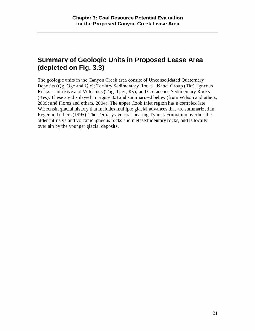
Chapter 3: Coal Resource Potential Evaluation for the Proposed Canyon Creek Lease Area
31
Summary of Geologic Units in Proposed Lease Area (depicted on Fig. 3.3) The geologic units in the Canyon Creek area consist of Unconsolidated Quaternary Deposits (Qg, Qgc and Qlc); Tertiary Sedimentary Rocks - Kenai Group (Tkt); Igneous Rocks – Intrusive and Volcanics (Thg, Tpgr, Kv); and Cretaceous Sedimentary Rocks (Kes). These are displayed in Figure 3.3 and summarized below (from Wilson and others, 2009; and Flores and others, 2004). The upper Cook Inlet region has a complex late Wisconsin glacial history that includes multiple glacial advances that are summarized in Reger and others (1995). The Tertiary-age coal-bearing Tyonek Formation overlies the older intrusive and volcanic igneous rocks and metasedimentary rocks, and is locally overlain by the younger glacial deposits.
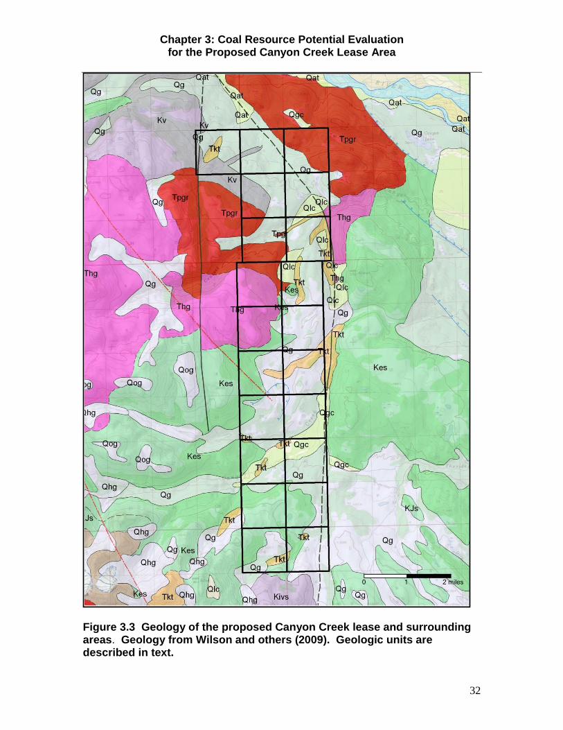
Chapter 3: Coal Resource Potential Evaluation for the Proposed Canyon Creek Lease Area
32
Figure 3.3 Geology of the proposed Canyon Creek lease and surrounding areas. Geology from Wilson and others (2009). Geologic units are described in text.

Chapter 3: Coal Resource Potential Evaluation for the Proposed Canyon Creek Lease Area
33
Unconsolidated Quaternary Deposits
Qg- Major moraine and kame deposits (Upper Pleistocene)—Diamicton, consisting of very poorly sorted sediment composed of gravel-sized grains and larger set in a matrix of fine grains, produced by glaciers that originated in the adjacent mountains. Moraines represent glacier readvances during the general retreat from maximum positions in the central part of the basin. Kame fields consist of irregularly shaped and relatively sharply defined hills as well as a few narrow and sinuous eskers that mainly consist of well-bedded to poorly bedded and sorted gravel and sand. Qgc- Glacioalluvium (Upper Pleistocene)—Gravel and sand that may be overlain by peat deposits; locally more than 1 m thick in channels within moraines. In some places, deposits may be lacking, and channel is floored by diamicton of the enclosing moraine. Thickness generally less than 16 ft (5 m). Qlc- Landslide and colluvial deposits (Holocene and Upper Pleistocene)—Irregularly mixed fragments of various sizes and types derived by gravity processes, commonly in fast-moving events but also in slower downslope movement. Include relatively large masses as well as deposits of smaller fragments of bedrock, diamicton, gravelly silt and sand, and relatively minor amounts of clay, boulders, and organic material.
Sedimentary Rocks, Tertiary Kenai Group
Only the coal-bearing Tyonek Formation of the Kenai Group is exposed at the surface in the Canyon Creek area. There may be Hemlock and West Foreland Formation rocks beneath the Tyonek Formation. However, in the Canyon Creek area the Tertiary rocks appear to be overlying fairly shallow igneous and metamorphic rocks. We include the description of the Sterling and Beluga formations as there is the possibility that these formations may be present in the area. Sterling Formation (Pliocene and Miocene)—Weakly lithified massive sandstone, conglomeratic sandstone and interbedded siltstone and claystone; includes interbedded lignitic coals typically less than 1 m thick in upper part of unit, but may be as much as 3 m thick in lower part of unit. According to Flores and others (1997) the sandstone grades upward from coarse grained to very fine grained in trough crossbedded sequences; siltstone is typically ripple laminated and contains roots or burrows. As much as 10,990 ft (3,350 m) thick (Flores and others, 2004). Beluga Formation (Miocene)—Nonmarine, interbedded, weakly lithified sandstone, siltstone, mudstone, carbonaceous shale, coal, and minor volcanic ash. Calderwood and Fackler (1972) reported a distinctive feature of Beluga Formation is its lack of massive sandstone beds and massive coal seams that characterize the underlying Tyonek Formation; however, lignitic to subbituminous coal seams can be as much as 4 m thick in the upper part of Beluga Formation. The contact between Beluga and overlying Sterling Formation may be an unconformity, but in any case can be difficult

Chapter 3: Coal Resource Potential Evaluation for the Proposed Canyon Creek Lease Area
34
to pinpoint (Calderwood and Fackler, 1972). The Beluga Formation is as much as 4,900 ft (1,500 m) thick. Tkt- Tyonek Formation (Miocene and Oligocene)—Carbonaceous nonmarine conglomerate and subordinate sandstone, siltstone, and coal. The Tyonek Formation is identified by massive sandstone beds and lignitic to subbituminous coal beds as much as 29.5 ft (9 m) thick (Calderwood and Fackler, 1972). The Tyonek formation is up to 7,640 ft (2,330 m) thick (Flores and others, 2004).Contact with overlying Beluga Formation is believed to be a disconformity where sandstone beds and coal beds become markedly thinner (Calderwood and Fackler, 1972). Hemlock Conglomerate, undivided (Oligocene)—Sandstone, conglomerate, and siltstone and minor coal deposited in a fluvial setting (Detterman and others, 1976). The Hemlock Conglomerate is unconformable, gradational, and interfingers with the West Foreland Formation (Flores and others, 2004). It consists mainly of pebble to boulder conglomerates containing quartz, chert, metamorphic, volcanic, and plutonic rock fragments. The Hemlock forms a variable sheet deposit that ranges in thickness from 655 ft (200 m) to 2,772 ft (845 m) thick (Flores and others, 2004).. West Foreland Formation (Eocene and Paleocene)—Exposed only on west side of Cook Inlet, unit consists of cobble conglomerate interbedded with lesser sandstone, laminated siltstone, and silty shale (Detterman and Hartsock, 1966). Thin coal beds are interbedded with the siltstone and shale. The West Foreland coal beds were deposited in abandoned braid belts and flood plains (Flores and others, 2004).Lower contact was described by Detterman and Hartsock (1966) as an angular unconformity with Upper Jurassic Naknek Formation; subsequent work by Magoon and others (1980) showed there to be an unnamed nonmarine Upper Cretaceous sedimentary unit between rocks of West Foreland and Naknek Formations.
Igneous Rocks – Intrusives and Volcanics
Thg- Hypabyssal granitic rocks (Paleocene?)— Medium- to fine-grained and usually porphyritic granitic rocks containing few mafic minerals. Miarolitic cavities commonly contain native sulfur. Commonly orange to reddish weathering. Age likely Paleocene, although few of these granitic rocks have been dated. These granitic rocks may be slightly younger than the most common Paleocene granitic rocks (Tpgr) of this region. Tpgr- Granitic rocks of Paleocene age (Paleocene)—Predominantly medium-grained composite plutons of granite, syenite, tonalite, quartz monzonite, quartz monzodiorite, quartz diorite, granodiorite, and minor diorite. Biotite is chief mafic mineral. Locally weakly foliated or containing flow structures. Numerous radiometric ages predominantly fall within the Paleocene epoch (53.2 to 64 Ma) and decrease eastward in an abrupt step at the approximate longitude of Cook Inlet. Plutons to the north of Castle Mountain Fault system intrude the so-called Kahiltna flysch but yield ages consistent with other plutons of this unit west of Cook Inlet.

Chapter 3: Coal Resource Potential Evaluation for the Proposed Canyon Creek Lease Area
35
Kv- Intermediate and felsic volcanic rocks (Cretaceous)—Andesite, dacite, and rhyolite flows and tuff. Includes massive and crystal-rich tuff, containing either hornblende or plagioclase as phenocryst phases as well as flow-banded rhyolite.
Cretaceous Sedimentary Rocks Kes- Turbiditic sedimentary and volcanic rocks (Cretaceous, Aptian or younger)—Largely silty to sandy graywacke in beds up to 2 m thick. Sandy beds are medium- to coarse-grained, with quartz, feldspar, and chert clasts. The younger part of the sequence may be age correlative with the Kuskokwim Group exposed southwest of the map area
Coal Resource Potential Evaluation Available Geologic Data Barnes (1966) provides the most comprehensive summary of the coal geology in the Canyon Creek area. Barnes measured numerous sections of coal bearing rocks and published the first geologic map of the Canyon Creek area (see Fig. 3.4) as part of a larger coal resource study of the Beluga – Yentna region (Barnes, 1966). Shallow exploration drilling conducted during the 1970s by Mobil Oil Corporation (Mobil Oil Corp., 1977; summarized in Blumer, 1980) provide subsurface data on the presence and thickness of coal deposits in the area. Studies in the Susitna lowlands by the Alaska Division of Geological & Geophysical Surveys in the 1980s provide additional information on coal outcrops (Merritt, 1990). Figure 3.5 shows the locations of the Mobil drill holes and Barnes (1966) and Merritt (1990) outcrop localities, along with the net coal thickness for each site, and are summarized in Table 3.1. Based on their drilling and field investigations of the Canyon Creek area, Mobil Oil Corporation identified up to five seams that are potentially minable (Blumer, 1980). Individual coal seams range in thickness from 10 to 45 feet thick, with one area where they report four seams come close together with a net coal thickness of 63 feet (Blumer, 1980). Based on Barnes observations, these thickened coals may represent folding related to faulting as well as slumping (Barnes, 1966). The coal seams in the Canyon Creek area have shallow to steep dips. Barnes (1966) noted a number of slumps along the north-south trending fault that intersects the southeastern boundary of the proposed lease block. Nevertheless, these thick deposits of coals provide an opportunity to mine a relatively large volume of coal. Mobil Oil Corporation estimated 500 million short tons of minable coal for both the Canyon Creek area and the Johnson Creek area, located to the north combined (Blumer, 1980). How much coal underlies the proposed coal lease blocks? Coal volume in short tons = acres x coal thickness x coal rank or density conversion factor (for example, 1,750 for lignite, 1,770 for subbituminous, 1,800 for bituminous, and 2,000 for semianthracite and anthracite. Utilizing the net coal thickness based on drill holes and outcrop localities, we have estimated the Measured, Indicated and Inferred coal resources within the proposed Canyon Creek lease area (Fig. 3.6, and Table 3.2). These categories are based on the coal

Chapter 3: Coal Resource Potential Evaluation for the Proposed Canyon Creek Lease Area
36
classification system of Wood and others (1983) which is based on distance and therefore reliability from a point source of data. Measured coal resources are ¼ mile from a point source of data and are the most reliable. Indicated (¾ mile) and Inferred (3 miles) are increasingly less reliable and together, the combined three categories out to 3 miles constitute the Identified coal resources of an area. Removing from consideration the areas within the Canyon Creek lease area where the bedrock geology is igneous and older metasedimentary rocks we have estimated the coal resources. Based on the available data, we estimate there are approximately 257.9 million short tons of Indicated coal resources within the proposed Canyon Creek coal lease area.

Chapter 3: Coal Resource Potential Evaluation for the Proposed Canyon Creek Lease Area
37
Figure 3.4 Geologic mapping and locations of outcrops for Canyon Creek area described in Barnes, 1966, with overlay of proposed lease blocks.

Chapter 3: Coal Resource Potential Evaluation for the Proposed Canyon Creek Lease Area
38
Figure 3.5 Locations of outcrops and drill holes with measured thickness of coal within or immediately adjacent to proposed lease area.

Chapter 3: Coal Resource Potential Evaluation for the Proposed Canyon Creek Lease Area
39
Figure 3.6 Areas of Measured, Indicated and Inferred Coal Resources within the proposed Canyon Creek coal lease area. The area of Measured, Indicated and Inferred “polygons” was calculated in acres and used in Table 3.2.

Chapter 3: Coal Resource Potential Evaluation for the Proposed Canyon Creek Lease Area
40
Table 3.2 Canyon Creek proposed lease coal volume
Coal Resource Potential Evaluation (Fig. 3.7) The coal rating system currently in place for coal lease assessments by DGGS considers state land rated as high potential for coal development if it has an estimated 70 percent to more than 90 percent chance of locating minable coal resources and coal. Land rated as moderate potential for coal development has an estimated 30-70 percent chance of locating minable deposits of coal. Land rated as low potential for coal development has an estimated 10-30 percent change of locating minable coal resources. Wood and others (1983, p. 24) define minable coal as “Capable of being mined under current mining technology and environmental and legal restrictions, rules, and regulations.” The available geologic information for the proposed Canyon Creek coal lease area indicates that there is considerable shallow and minable coal in most areas of the proposed lease block. These areas are considered to have High Potential for coal development, and are depicted in Figure 3.7. Based on the geologic map compilation of Wilson and others (2009), there are areas within the proposed lease block that are likely underlain by igneous and metasedimentary rocks (see Figure 3.3). Although there may be inliers of Tertiary coal-bearing rocks in these areas, the field investigations and drilling have not suggested otherwise. Therefore we consider these areas within the proposed
LEASE BLOCK AREA in ACRES
ESTIMATED AVERAGE NET COAL THICKNESS
(in feet) COAL RANK DENSITY FACTORCALCULATED SHORT TONS DENSITY FACTOR
INF-1 1,510.3 13.24 Subbituminous 1770 35,393,578.44 Lignite 1750INF-2 16.7 13.7 Subbituminous 1770 404,958.30 Subbituminous 1770INF-3 1.8 15 Subbituminous 1770 47,790.00 Bituminous 1800INF-4 668.8 55 Subbituminous 1770 65,107,680.00 Anthracite 2000INF-5 311.9 21 Subbituminous 1770 11,593,323.00INF-6 12.4 11 Subbituminous 1770 241,428.00IND-1 2,811.7 12.6 Subbituminous 1770 62,706,533.40IND-2 23.1 8 Subbituminous 1770 327,096.00IND-3 343.0 26.2 Subbituminous 1770 15,906,282.00IND-4 106.7 28.5 Subbituminous 1770 5,382,481.50IND-5 36.5 47.9 Subbituminous 1770 3,094,579.50M-1 81.1 10 Subbituminous 1770 1,435,470.00M-2 243.7 15.4 Subbituminous 1770 6,642,774.60M-3 97.9 23 Subbituminous 1770 3,985,509.00M-4 125.6 5 Subbituminous 1770 1,111,560.00M-5 224.3 9 Subbituminous 1770 3,573,099.00M-6 86.9 12.9 Subbituminous 1770 1,984,187.70M-7 66.7 6 Subbituminous 1770 708,354.00M-8 69.7 61 Subbituminous 1770 7,525,509.00M-9 506.8 12.4 Subbituminous 1770 11,123,246.40
M-10 104.2 33 Subbituminous 1770 6,086,322.00M-11 197.5 28 Subbituminous 1770 9,788,100.00M-12 44.8 25.5 Subbituminous 1770 2,022,048.00M-13 46.9 20 Subbituminous 1770 1,660,260.00
MEASURED COAL INDICATED COAL INFERRED COAL TOTAL COAL (short tons)57,646,439.70 87,416,972.40 112,788,757.74 257,852,169.84
Infe
rred
(3 m
iles)
Indi
cate
d(3
/4 m
ile)
Mea
sure
d(1/
4

Chapter 3: Coal Resource Potential Evaluation for the Proposed Canyon Creek Lease Area
41
lease block to have a Low Potential for coal development (see Fig. 3.7). Additional exploration may prove otherwise.
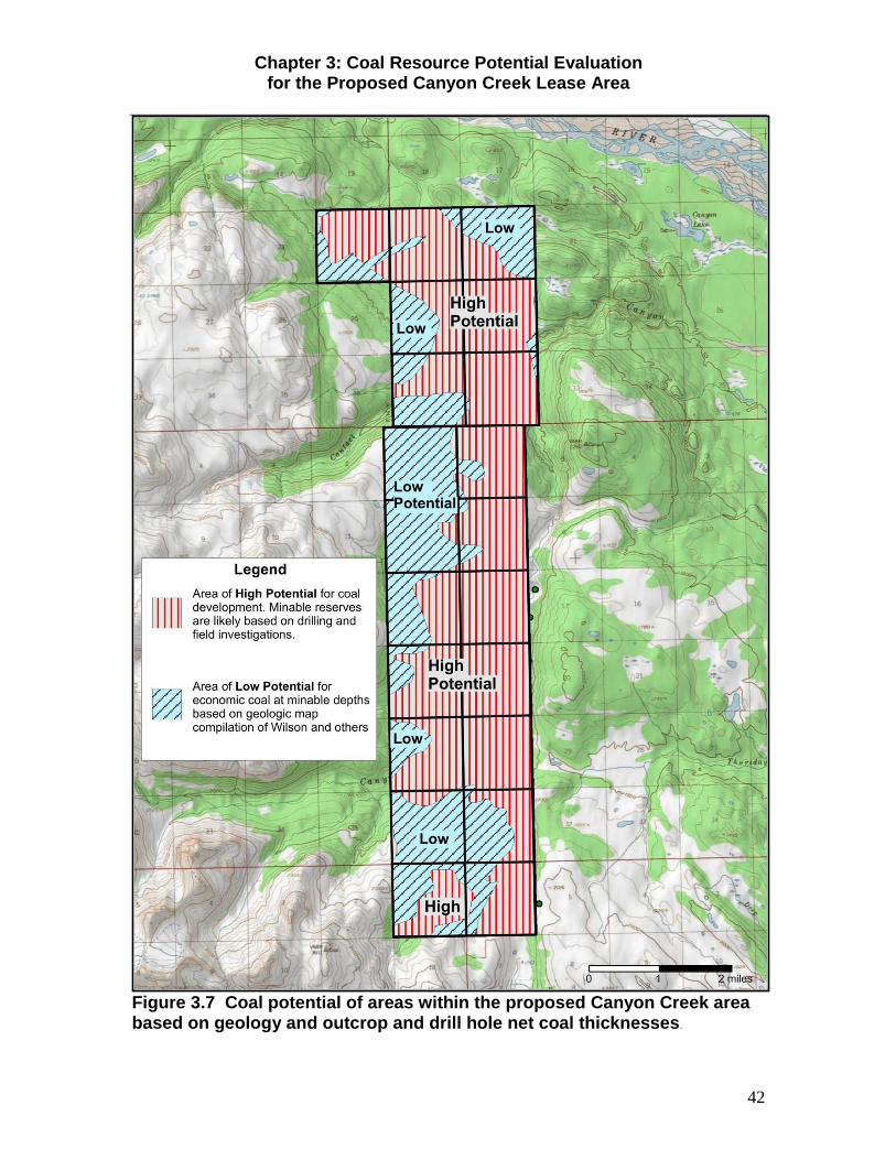
Chapter 3: Coal Resource Potential Evaluation for the Proposed Canyon Creek Lease Area
42
Figure 3.7 Coal potential of areas within the proposed Canyon Creek area based on geology and outcrop and drill hole net coal thicknesses.

Chapter 3: Coal Resource Potential Evaluation for the Proposed Canyon Creek Lease Area
43
References Barnes, F.F., 1966, Geology and coal resources of the Beluga-Yentna region, Alaska: U.S. Geological Survey Bulletin 1202-C, p. C1-C54, 4 sheets, scale 1:63,360.
Barnes, F.F., 1967, Coal resources of Alaska: U.S. Geological Survey Bulletin 1242–B, B1–B36, plate 1.
Blumer, J.W., 1980, Review of Mobile coal leases – Yentna Region, Alaska, in Rao, P.D., and Wolff, E.N., 1980, Focus on Alaska's coal '80, proceedings of the conference: University of Alaska Mineral Industry Research Laboratory Report No. 50, p. 122-126.
Calderwood, K.W., and Fackler, W.C., 1972, Proposed stratigraphic nomenclature for Kenai Group, Cook Inlet basin, Alaska: American Association of Petroleum Geologists Bulletin, v. 56, no. 4, p. 739-754.
Detterman, R.L., and Hartsock, J.K., 1966, Geology of the Iniskin-Tuxedni region Alaska: U.S. Geological Survey Professional Paper 512, 78 p., 6 plates.
Detterman, R.L., Hudson, Travis, Plafker, George, Tysdal, R.G., and Hoare, J.M., 1976, Reconnaissance geologic map along Bruin Bay and Lake Clark Faults in Kenai and Tyonek quadrangles, Alaska: U.S. Geological Survey Open-File Map 76–477, 4 p., scale 1:250,000, 2 sheets.
Finzel, E.S., Gillis, R.J., Ridgway, K.D., and LePain, D.L., 2009, Preliminary evaluation of basin margin exhumation and provenance of Cenozoic strata, Chuitna and Beluga rivers area, Cook Inlet forearc basin, Alaska: Alaska Division of Geological & Geophysical Surveys Preliminary Interpretive Report 2009-4, 16 p.
Flores, R. M., Stricker, G.D., and S.A. Kinney, S.A., 2004, Alaska coal geology, resources, and coalbed methane potential. U.S. Geological Survey Digital Data Series, DDS-77, 140 pp. http://pubs.usgs.gov/dds/dds-077/dds77text.html
Gillis, R.J., LePain, D.L., Reifenstuhl, R.R., and Helmold, K.P., 2009, Regional Paleocene-Eocene exhumation of the North American forearc basin margin, south-central Alaska, recorded by apatite fission-track thermochronology (poster): Geological Society of America Abstracts with Programs, Vol. 41, No. 7: Alaska Division of Geological & Geophysical Surveys, 1 sheet.
Gillis, R.J., LePain, D.L., Ridgway, K.D., and Finzel, E.S., 2009, A reconnaissance view of an unnamed fault near Capps Glacier, northwestern Cook Inlet basin, and its potential as a regional-scale, basin-controlling structure: Alaska Division of Geological & Geophysical Surveys Preliminary Interpretive Report 2009-3, 9 p.
Haeussler, P.J., Bruhn, R.L., and Pratt, T.L., 2000, Potential seismic hazards and tectonics of the upper Cook Inlet basin, Alaska, based on analysis of Pliocene and younger deformation: Geological Society of America Bulletin, v. 112, no. 9, p. 1,414–1,429.
Helmold, K.P., Lepain, D.L., Wartes, M.A., Stanley, R.G., Gillis, R.J., Peterson, Shaun, and Herriott, T.M., 2011, Reservoir potential of Tertiary and Mesozoic sandstones, Cook
Chapter 3: Coal Resource Potential Evaluation for the Proposed Canyon Creek Lease Area
44
Inlet, Alaska (presentation): AAPG Pacific Section Meeting, Anchorage, AK, May 10, 2011: Alaska Division of Geological & Geophysical Surveys, 28 p.
LePain, D.L., 2009, Preliminary results of recent geologic investigations in the Homer-Kachemak Bay area, Cook Inlet Basin: Progress during the 2006-2007 field season: Alaska Division of Geological & Geophysical Surveys Preliminary Interpretive Report 2009-8, 187 p.
LePain, D.L., Wartes, M.A., McCarthy, P.J., Stanley, R.G., Silliphant, L.J., Helmold, K.P., Shellenbaum, D.P., Gillis, R.J., Peterson, Shaun, Mongrain, Jacob, and Decker, P.L., 2008, Tertiary depositional systems in upper Cook Inlet, Alaska: Influence of fluvial style on reservoir geometries and stratigraphic trap potential (poster): AAPG 2008 Annual Convention and Exhibition, Abstract Volume 17, p. 119: Alaska Division of Geological & Geophysical Surveys, 1 sheet.
Magoon, L.B., Griesbach, F.B., and Egbert, R.M., 1980, Nonmarine Upper Cretaceous rocks, Cook Inlet, Alaska: American Association of Petroleum Geologists Bulletin, v. 64, no. 8, p. 1259-1266.
Merritt, R.D., 1990, Coal resources of the Susitna lowland, Alaska: Alaska Division of Geological & Geophysical Surveys Report of Investigation 90-1, 190 p., 3 sheets, scale 1:250,000.
Merritt, R.D., and Hawley, C.C., compilers, 1986, Map of Alaska’s coal resources: Fairbanks, Alaska Division of Geological & Geophysical Surveys, scale 1:2,500,000.
Mobil Oil Corporation, 1977, Request for Issuance of Coal Leases and Supplement to Request for Coal Lease Issuance; Unpublished documents and correspondence from 1976 to 1977 filed in support of the issuance of coal leases at Canyon Creek and Johnson Creek: On record at the Alaska Department of Natural Resources, Division of Mining, Land and Water; includes 47 pages of correspondence text (in two documents), coal quality analyses, numerous illustrations, and 22 exhibits of maps and cross sections.
Reger, R.D., Combellick, R.A., and Brigham-Grette, Julie, 1995, Late-Wisconsin events in the Upper Cook Inlet region, southcentral Alaska, in Combellick, R.A., and Tannian, Fran, Short notes on Alaska Geology 1995: Alaska Division of Geological & Geophysical Surveys Professional Report 117D, p. 33-45.
Shellenbaum, D.P., Gregersen, L.S., and Delaney, P.R., 2010, Top Mesozoic unconformity depth map of the Cook Inlet Basin, Alaska: Alaska Division of Geological & Geophysical Surveys Report of Investigation 2010-2, 1 sheet, scale 1:500,000.
Swenson, R.F., 2003, Introduction to Tertiary tectonics and sedimentation in the Cook Inlet basin, in Dallegge, T.A., compiler, 2001 Guide to the Petroleum, Geology, and Shallow Gas Potential of the Kenai Peninsula, Alaska: Alaska Division of Geological & Geophysical Surveys Miscellaneous Publication 128, 89 p., 1 DVD.
Wahrhaftig, C., Bartsch-Winkler, S., and Stricker, G. D., 1994, Coal in Alaska, in Plafker, G., and Berg, H. C., eds., The Geology of Alaska: Boulder, Geological Society of America, p. 937-378.

Chapter 3: Coal Resource Potential Evaluation for the Proposed Canyon Creek Lease Area
45
Wilson, F.H., Hults, C.P., Schmoll, H.R., Haeussler, P.J., Schmidt, J.M., Yehle, L.A., and Labay, K.A., 2009, Preliminary geologic map of the Cook Inlet region, Alaska--including parts of the Talkeetna, Talkeetna Mountains, Tyonek, Anchorage, Lake Clark, Kenai, Seward, Iliamna, Seldovia, Mount Katmai, and Afognak 1:250,000-scale quadrangles: U.S. Geological Survey Open-File Report 2009-1108, scale 1:250,000 [ http://pubs.usgs.gov/of/2009/1108/ ].
Wood, G.H., Jr., Kehn, T.M., Carter, M.D., and Culbertson, W.C., 1983, Coal resource classification system of the U.S. Geological Survey: U.S. G

Chapter 4: Statutory and Regulatory Background
46
Chapter 4: Statutory and Regulatory Background The Alaska Constitution provides that the state's policy is "to encourage . . . the development of its resources by making them available for maximum use consistent with the public interest" and that the "legislature shall provide for the utilization, development, and conservation of all natural resources belonging to the State, . . . for the maximum benefit of its people" (Alaska Constitution, art. VIII, §§ 1, 2). To comply with this provision, the legislature enacted Title 38 of the Alaska Statutes (AS 38) and directed ADNR to implement the statutes.
Alaska Statute 38.05.035 governs the disposal of state owned subsurface interests and includes public notice requirements referred to in this document (AS 38.05.035(e)(6) and AS 38.05.945). Under AS 38.05.035(e), ADNR may not dispose of state land, resources, property, or interests, unless the director first determines in a written finding (decision) that such action will serve the best interests of the State. This written finding is known as a best interest finding (or best interest finding and decision) and is a written analysis which describes for the public the facts and applicable law which are relevant to the disposal and gives a decision based on these factors. The finding does not deal in speculation about unforeseeable events. As 38.05.035 (e) (1) (A) requires that the finding, “shall establish the scope of the administrative review on which the director's determination is based, and the scope of the written finding supporting that determination; the scope of the administrative review and finding may address only reasonably foreseeable, significant effects of the uses proposed to be authorized by the disposal.” AS 38.05.35 (h) states, in part, “In preparing a written finding under (e)(1) of this section, the director may not be required to speculate about possible future effects subject to future permitting that cannot reasonably be determined until the project or proposed use for which a written best interest finding is required is more specifically defined…”
This section of the finding does not provide an exhaustive description of all laws and regulations that may be applicable to coal exploration and mining. However, it does provide an illustration of the broad powers of various government agencies to prohibit, regulate, and condition any activities related to coal development which may ultimately occur on prospecting permits or leases. Each project will require a variety of permits which may include operational stipulations according to the size, nature, location and other particulars of that project. Each agency has field monitors assigned to ensure that operations are conducted as approved. However, the major burden of inspecting and regulating coal exploration and mining operations lies with the Coal Inspection and Regulatory Program within the Alaska Department of Natural Resources, Division of Mining, Land and Water.

Chapter 4: Statutory and Regulatory Background
47
Regulatory requirements for coal mines are different than for other types of mining. Spurred by major environmental impacts from coal mining in the 1960's and 1970's, the United States Congress passed the Surface Mining Control and Reclamation Act (SMCRA) in 1977. The United States Department of the Interior’s Office of Surface Mining Reclamation and Enforcement (OSMRE) is responsible for ensuring that SMCRA’s goals are met. The federal Act allowed individual states to develop coal regulatory programs consistent with the federal legislation, and assume control (primacy) over the federal program. Because of Alaska’s vast coal resources and unique conditions the State developed its own regulatory program, and enacted the Alaska Surface Coal Mining Control and Reclamation Act (ASCMCRA, or the Act, at AS 27.21 and associated regulations at 11 AAC 90) on May 2, 1983. The purpose of the Act is to assure that coal mines are operated in a manner that protects citizens and the environment during mining, and to ensure that the land is restored to a stable condition for productive use following mining. The law also works to mitigate the effects of past mining by aggressively pursuing reclamation of abandoned mine lands (Abandoned Mine Lands Program).
The essential elements of the Alaska Coal Regulatory Program are as follows:
• All coal exploration and mining activities must be permitted under the Alaska
Surface Coal Mining Control and Reclamation Act. A variety of permits are required from other state and federal agencies as well.
• The permitting system is to make expectations known to and binding on the operator.
• The permitting process is public, with opportunities for public participation at various stages of exploration, development, production and bond release.
• Baseline studies of the site are required before any mining activity occurs. • There are 65 separate performance standards for a variety of coal mining
activities. • The program provides for reclamation performance bonds. • There are monthly inspections of each active mine site. • There are criminal and civil penalties for violations of the Act.
Permitting All coal mining and exploration must be permitted by the Alaska Department of Natural Resources. Pursuant to 11 AAC 90.002 (a), “A person may not conduct exploration activities or surface coal mining and reclamation operations without a permit from the commissioner.” Coal exploration activities are regulated under 11 AAC 90.161 - 11 AAC 90.167. Under paragraph (c) of 11 AAC 90.002, “A person who seeks to engage in surface coal mining and reclamation operations shall obtain a permit for those operations in accordance with 11 AAC 90.005 - 11 AAC 90.157.” The reader is referred to http://dnr.alaska.gov/mlw/mining/coal/coalreg.pdf for the full text of the ASCMCRA regulations.

Chapter 4: Statutory and Regulatory Background
48
Under AS 27.21.220 all surface effects of underground coal mining are subject to the Alaska Surface Coal Mining Control and Reclamation Act and associated regulations. In addition to the regulatory requirements of surface operations, regulatory protection is extended to effects of underground mining from subsidence, and changes to the quality and quantity of surface and groundwater. Alaska Administrative Code 11 AAC 90.321 states, “Operations must be planned and conducted to prevent long-term adverse changes in the hydrologic balance in both the permit area and adjacent areas.” Finally, under AS 27.21.998 Definitions, "surface coal mining operations" means, in part, an activity conducted on the surface of land in connection with a surface coal mine or, to the extent that the activity affects the surface of land, conducted in connection with an underground coal mine. This definition extends the protections of the ASCMCRA beyond the boundaries of any coal permit or lease to adjacent land. In addition to protecting the environment in and around the permit area, ASMCRA requires that all support facilities are also considered during the permitting process. 11 AAC 90.151 Facilities Outside Permit Area, which requires a permit for all roads, transportation, support facilities and utility installations included in 11 AAC 90.491, whether or not these facilities are outside the permit area of any particular mine. These facilities must comply with all performance standards of this chapter determined to be applicable by the commissioner and must comply with the appropriate bonding provisions of 11 AAC 90.201 - 11 AAC 90.207. Regulation 11 AAC 90.491 includes the following facilities: roads, railroad loops, spurs, sidings, surface conveyor systems, chutes, aerial tramways, airfields, ports, docks, or other transportation facilities, mine buildings, coal loading facilities at or near the minesite, coal storage facilities, storage facilities, fan buildings, hoist buildings, preparation plants, sheds, shops, and other support facilities. Other State of Alaska Permitting In addition to the Surface Coal Mining Permit, the Department of Natural Resources (DNR) and other state agencies issue a variety of permits. Water uses and rights are permitted by the DNR, Division of Mining, Land and Water (DMLW). Dam safety is also certified by the DMLW. The State Historical Preservation Office (SHPO) provides consultation in the inventory and evaluation of historical or archaeological artifacts or sites, and advises other agencies and operators with regard to their preservation. Right of way and access permits are issued by the DNR/DMLW and Department of Transportation (DOT). All fish habitat and fishway permits are issued by the Habitat Division of the Department of Fish and Game. Any construction in fish-bearing streams will require a Title 16 habitat permit. The Department of Environmental Conservation (DEC) is responsible for sewage treatment system and drinking water supply approvals, as well as solid waste disposal and air quality permits. The DEC also approves Storm Water Pollution Prevention Plans (SWPPP).

Chapter 4: Statutory and Regulatory Background
49
Since coal mines use and produce water they are subject to Section 402 of the Clean Water Act (CWA). As of October 31, 2010, the DEC assumed primacy over the Environmental Protection Agency’s National Pollution Discharge Elimination System program. As a result, any pollutant discharge into waters of the United States, including wetlands, now requires an Alaska Pollution Discharge Elimination System (APDES) permit. The permitting system is designed to ensure that discharges do not violate state and federal water quality standards by identifying control technologies, setting effluent limitations, and gathering information through reporting and inspections. Public Involvement The public is involved in the coal permitting process through both informal and formal channels. Although statutory and regulatory provisions for public meetings are limited, it is the procedural policy of the DNR and its Coal Inspection and Regulatory Program to reach out to the public early and often through communications with affected parties and public meetings. In addition, the DNR Coal Inspection and Regulatory staff members are available to answer questions and hear concerns. There are numerous opportunities for formal public comment. The backbone of the formal public process for coal exploration and mining is regulated under 11 AAC 90.907, Public Participation. It requires that all documents filed under the Act be available for public inspection and copying. These documents include: applications for various permits, notice of intent to conduct exploration, written comments and objections, request for bond release, and changes in any permits, applications or other documents. 11 AAC 90.907 also requires public notice, similar to AS 38.05.945, response to comments, and a written finding by the Commissioner of Natural Resources. Public notice is triggered by a variety of events, including: exploration with significant disturbance, applications for mine permits, renewals, major revisions, and bond release. Additionally, 11 AAC 90.113 states, “At the time an application for a permit, renewal of a permit, or major revision of a permit is determined to be complete, the commissioner will make the application available in accordance with 11 AAC 90.907(b) and provide notice as provided in 11 AAC 90.907(d)….” Paragraph (a) of 11 AAC 90.907 states that the section applies to all proceedings under the Alaska Surface Coal Mining Control and Reclamation Act, or the associated regulations. In practice, virtually all coal exploration and mining activities go through the public process of notice, comments and responses, and written decisions. Any activity involving surface disturbance beyond sampling or other minor surface disturbance triggers the public process. In the event that any person is adversely affected by a decision of the commissioner, review hearings will be conducted in accordance with AS 44.62, the Administrative Procedures Act. If the person is not satisfied with the results of the hearing they can appeal to the state courts. According to 11 AAC 90.131 (f), “Any applicant or any person with an interest which is or may be adversely affected and who has participated in the administrative hearings as an objector may appeal to a court of competent jurisdiction under AS 44.62.560 if (1) the applicant or person is
Chapter 4: Statutory and Regulatory Background
50
aggrieved by the decision of the commissioner in the administrative hearing; or (2) the commissioner fails to act within the time limits specified in the Act or this chapter.”
Baseline Studies Each application for a permit must include information on: cultural and historical resources, geology and hydrology, surface and groundwater quality and quantity, meteorology and air quality, vegetation, fish and wildlife, soils, wetlands, and land uses. The level of detail required depends on the type and extent of activity. Depending on the level of impact a permit allows, the requirements for providing baseline data can increase. Most exploration programs would cause little disturbance and would require no more than a compilation of existing information. For a more disruptive exploration program such as one requiring a large bulk sample, more information would be required, likely involving some level of field studies. Applications for mining operations require a full evaluation of all the above fields of interest, including any necessary field and laboratory studies. The regulatory requirements for these baseline studies are detailed. The regulations for land use, 11 AAC90.061, are copied below as an example. The reader is referred to the other baseline regulations at http://dnr.alaska.gov/mlw/mining/coal/coalreg.pdf, 11 AAC 90.041-065. 11 AAC 90.061. Land Use Information. (a) An application must describe the condition, capability, and productivity of the land proposed to be affected by surface operations or facilities, including (1) a map and supporting narrative of the uses of the land existing at the time of the filing of the application; if the premining use of the land changed within five years before the anticipated date of beginning operations, the historic use of the land must also be described; (2) an analysis of the land use description under this section in conjunction with other information required under 11 AAC 90.041 - 11 AAC 90.065, including, but not limited to, (A) soil and foundation characteristics, topography, vegetative cover and hydrology; and (B) the productivity before mining, expressed as average yield of food, fiber, forage, fish and wildlife, or wood products from the land obtained under high levels of management as determined by yield data or estimates for similar sites based on current data from appropriate federal or state agencies. (b) The application must state whether the proposed permit area has been previously mined and, if so, the following information, if available: (1) the type of mining method used; (2) the coal seam or other mineral strata mined; (3) the extent of coal or other minerals removed; (4) the approximate dates of past mining; and (5) the uses of the land preceding mining. (c) The application must contain a description of the existing land use classifications or zoning, if any, of the proposed permit area and adjacent area. (Eff. 5/2/83, Register 84)

Chapter 4: Statutory and Regulatory Background
51
Performance Standards The Alaska Administrative Code (regulations) mandates very detailed performance standards for 65 separate coal mining activities. The performance standards are coded under 11 AAC 90.301-501, and can be viewed online at http://dnr.alaska.gov/mlw/mining/coal/coalreg.pdf. A listing of the performance standards follows. 11 AAC 90. Section 301. Signs and markers 303. Capping, casing, and sealing of drilled holes 305. Temporary sealing of drilled holes 311. Removal of topsoil 313. Topsoil storage 315. Topsoil redistribution 317. Topsoil nutrients and soil amendments 321. Hydrologic balance 323. Water quality standards 325. Diversions and conveyance of flow 327. Stream channel diversion 329. Sediment control measures 331. Siltation structures 333. Discharge structures 335. Acid-forming and toxic-forming spoil 336. Impoundment design and construction 337. Impoundment Inspection 338. Permanent Impoundment criteria 339. Ground water protection 341. Underground mine entry and access discharges 343. Protection of ground water recharge capacity 345. Surface and ground water monitoring 347. Transfer of wells 349. Discharge of water into a mine 351. Postmining rehabilitation 353. Stream buffer zones 361. Coal recovery
371. Use of explosives 373. Preblasting survey 375. Public notice of blasting 377. Blasting signs, warnings, and access control 379. Control of adverse effects of blasting 381. Seismographic measurements 383. Records of blasting 391. Disposal of excess spoil or coal mine waste 393. Protection of underground mining 395. Coal mine waste, general requirements 397. Disposal area inspections 399. Hazardous coal processing waste, water control measures 401. Coal mine waste, refuse piles 403. Coal mine waste, fires 405. Burned waste removal 407. Coal mine waste, dams and embankments 409. Return to underground workings 411. Disposal of noncoal wastes 421. Air resources protection 423. Protection of fish and wildlife 431. Slides and other damage 433. Pipelines 435. Contemporaneous reclamation 441. Timing requirements for backfilling and grading 443. Backfilling and grading 445. Covering coal and toxic material

Chapter 4: Statutory and Regulatory Background
52
447. Backfilling and grading: auger mining 449. Stabilizing rills and gullies 451. Revegetation 453. Revegetation: timing 455. Revegetation: mulching 457. Standards for revegetation success 461. Subsidence control
463. Subsidence control public notice 471. Cessation of operations 481. Postmining land use 491. Construction and maintenance of roads, transportation and support facilities, and utility installations 501. Alluvial valley floor requirements
The performance standard for water quality, section 11 AAC 90.323, is copied below as an example. 11 AAC 90.323. WATER QUALITY STANDARDS. (a) Any discharge of water from an underground working to surface water and all surface drainage from the disturbed area, including any disturbed area that has been graded, seeded, or planted, must pass through one or more siltation structures before leaving the permit area, unless the commissioner finds that conditions such as permafrost or ice-covered ponds will allow the drainage to meet applicable state and federal water quality laws and regulations without treatment. (b) The operator shall maintain any siltation structure that treats surface drainage from the disturbed area or discharges from underground workings until the untreated drainage from the disturbed area meets, and is expected to permanently meet, the applicable state and federal water quality laws and regulations for the receiving stream, and removal is approved by the commissioner under 11 AAC 90.331(e). (c) The operator shall meet all applicable federal and state water quality laws and regulations for the mixed drainage from the permit area when there is mixing of drainage from disturbed and undisturbed areas. Chapter 10: Potential Measures to Avoid, Minimize, and Mitigate Negative Impacts contains additional details of the performance standards and other regulations under the ASCMCRA designed to protect fish and wildlife, habitat, and the environment during coal exploration and development. Operation and Reclamation Plans Before any coal exploration or mining project can be permitted, the following operational and reclamation plans must be submitted (if applicable) and approved by the Coal Inspection and Regulatory Program of the DNR.
• Operations plan • Blasting plan • Air pollution control • Fish and wildlife protection plan • Reclamation plan

Chapter 4: Statutory and Regulatory Background
53
• Post mining land use • Protection of the hydrologic balance • Protection of public parks and historic places • Relocation or use of public roads • Transportation facilities
The preparation of these various plans ensures that the applicant has designed an operation that will comply with the performance standards of the ASCMCRA and 11 AAC 90.301-501. Bonding AS 27.21.160 and 11 AAC 90.201 mandate that before any coal mining permit is issued the applicant must file a performance bond with the commissioner to cover the full cost of reclamation. AS 27.21.160 further provides that, “The bond must cover the area of land within the permit area on which the applicant will initiate and conduct surface coal mining and reclamation operations within the initial term of the permit. As succeeding increments of surface coal mining and reclamation operations are initiated and conducted within the permit area, the permittee shall provide an additional bond or bonds to cover those increments in accordance with this section. The amount of the bond required for an area within the permit area shall be determined by the commissioner and shall reflect the probable difficulty of the reclamation considering the topography, geology, hydrology, revegetation potential, and similar factors relating to the area. The amount of the bond must be sufficient to assure the completion of the reclamation plan by the commissioner in the event of forfeiture and, for the entire permit area, may not be less than $10,000.” Inspections Under AS 27.21.230 (c) all active coal mining operations must be inspected at least once per month. The inspections are to be conducted on an irregular basis, without prior notice to the permittee. At least one inspection per quarter must be a complete inspection. For a complete inspection the inspector must review the operator’s compliance with all permit conditions and requirements over the entire area affected by the mining operation. The other monthly inspections may be partial, reviewing only some of the permit requirements. A citizen can request an inspection by providing the commissioner with written evidence that a violation exists. If the Department does conduct an inspection as a result of a citizen request, the citizen will be allowed to accompany the inspector. Any violations must be reported in writing to both the commissioner and the operator immediately. If a violation of the Alaska Surface Coal Mining Control and Reclamation Act, or of any condition of a mining permit or exploration approval is found, a notice of violation will be issued by the commissioner. If violations are not corrected within a given period, they can ultimately lead to the suspension or revocation of the operator’s permit to mine. Civil and
Chapter 4: Statutory and Regulatory Background
54
criminal penalties may also be brought against the operator if serious violations are not ultimately corrected.
Federal Regulation and Permitting Within the federal government, the United States Department of the Interior’s Office of Surface Mining Reclamation and Enforcement is responsible for regulating coal mining and reclamation. However, with passage of the Alaska Surface Coal Mining Control and Reclamation Act (ASCMCRA) the Office of Surface Mining has transferred that authority to the State of Alaska. The ASCMCRA is administered by the Coal Inspection and Regulatory Program within the Mining Section of the Division of Mining, Land and Water in the Alaska Department of Natural Resources. As was indicated above, the Mine Health and Safety Administration regulates worker health and safety at surface and underground coal mining operations. A coal mine or exploration program may also need a Section 404 permit from the United Sates Army Corps of Engineers (USACE). The USACE program is authorized by Section 10 of the Rivers and Harbors Act of 1899, Section 404 of the Clean Water Act, and Section 103 of the Marine Protection, Research and Sanctuaries Act. The permit program authorizes activities in, on, or affecting, navigable waters as well as the discharge of dredge or fill material into waters of the United States. For purposes of administration, “waters of the United States” includes wetlands. In the event that endangered species are found within an area of potential coal exploration or mining, the Bureau of Ocean Energy Management, Bureau of Safety and Environmental Enforcement, National Marine Fisheries Service, and the U. S. Department of Fish and Wildlife are responsible for ensuring their protection. NOAA’s National Marine Fisheries Service (NMFS) and the U.S. Fish and Wildlife Service (USFWS) share responsibility for implementing the Endangered Species Act of 1973. Generally, USFW manages land and freshwater species, while NMFS manages marine and anadromous species. Furthermore, Section 7 of the Endangered Species Act, 16 U.S.C. § 1536(a)(2), requires all federal agencies to consult with the National Marine Fisheries Service (NMFS) for marine and anadromous species, or the United States Fish and Wildlife Service (FWS) for fresh-water and wildlife, if they are proposing an "action" that may affect listed species or their designated habitat. Action is defined broadly to include funding, permitting and other regulatory actions. Coal mining activities, or activities associated with transporting coal from the mine to a shipping facility, could fall under the National Environmental Policy Act (NEPA). Section 102 of NEPA requires federal agencies to incorporate environmental considerations in their planning and decision making through a systematic interdisciplinary approach. Specifically, all federal agencies are to prepare detailed statements assessing the environmental impact of, and alternatives to, major federal actions that significantly affect the environment. These statements are commonly referred to as environmental impact statements (EIS). Federal agencies are required to implement NEPA when: a project involves federal land; federal money is being used for the project; or a federal permit is involved. The NEPA requirements are implemented by the agency managing the land, providing financing, or issuing the permit.

Chapter 4: Statutory and Regulatory Background
55
There are three levels of analysis: categorical exclusion determination; preparation of an environmental assessment/finding of no significant impact (EA/FONSI); and preparation of an environmental impact statement (EIS). At the first level, an undertaking may be categorically excluded from a detailed environmental analysis if it meets certain criteria which a federal agency has previously determined as having no significant environmental impact. If an action is not categorically excluded from environmental analysis, the federal agency may prepare an environmental Assessment (EA) to determine whether the action would significantly affect the environment. The EA follows the same general format as the EIS, but in less detail. It includes a discussion of potential environmental impacts of the proposed action, alternative actions, and potential mitigation measures. If it is found that the activity would not have a significant effect on the environment a finding of no significant impact (FONSI) is issued, and no further analysis is done. The FONSI may address measures that may be taken to mitigate potentially significant impacts. The finding of no significant impact takes into account the effects of mitigation measures.
If the EA finds that the environmental consequences of a proposed action may be significant, an EIS is prepared. The EIS is a more detailed evaluation of the proposed action and alternatives. If a federal agency anticipates that an activity is likely to significantly affect the environment, or if a project is environmentally controversial, the agency may choose to prepare an EIS without first preparing an EA.
The area of the proposed lease sale is entirely state owned. However, transportation routes to carry the coal to market could cross federal lands, triggering NEPA. In that case the agency managing the federal land would make the determination as to whether an EA or EIS was required, and conduct the appropriate analyses. The more likely trigger for NEPA analysis is a federal agency permit requirement for coal mining or related activities. The U. S. Army Corps of Engineers (USACE) is the most likely federal agency to have a permitting role for coal mining or transportation. A permit for Section 404 of the Clean Water Act would be required for activities involving waters of the U. S., including wetlands. It would be the responsibility of the Corps of Engineers to determine the appropriate level of environmental analysis. The Environmental Protection Agency regulates fuel tanks with capacity above 1,320 gallons under Section 112.7 of the Clean Water Act. Under Section 112.7 operators could be required to write a Spill Prevention Control and Countermeasure Plan. (See Chapter 10: Potential Measures to Avoid, Minimize, and Mitigate Negative Impacts.) Finally, Cook Inlet Salmon are federally regulated and, as a result, habitat for these species is protected under the Magnuson-Stevens Fishery Management and Conservation Act.

Chapter 5: Habitat, Fish , and Wildlife
56
Chapter 5: Habitat, Fish, and Wildlife AS 38.05.035 directs that best interest findings consider and discuss the fish and wildlife species and their habitats in the lease area. The proposed lease area includes a variety of habitats and a diversity of fish and wildlife species.
Terrestrial Habitats The proposed lease area is located near Canyon Creek, south of the Skwentna River in townships T19-21N, R13 and 14W, Seward Meridian. The area lies within the Cook Inlet Basin Ecoregion and includes a variety of woodland and wetland habitats (Gallant et al. 1995; Nowacki et al. 2001). Forests and wetlands in the proposed lease area provide habitat for wildlife and perform valuable ecosystem services related to photosynthesis and nutrient cycling, air and water purification, and provision of riparian buffers that prevent erosion. Wetland plant communities in the proposed lease area provide habitat for terrestrial and aquatic life, regulate storm and flood water flows, and filter surface water. In addition to wetland vegetation, evergreen, deciduous, and mixed forest stands are abundant (Gallant et al. 1995). White spruce and black spruce are common in and around the proposed lease area. White spruce tends to dominate areas where soil drainage is good, while black spruce may occupy poorly-drained soils (USGS 1999). Mixed stands with both white spruce and black spruce often have shrub understories comprised of alder and willow, particularly in areas with colder and wetter soils (USDA 1986; Van Hees 1990; STB 2011). Mixed forests within the proposed lease area may consist of paper birch and quaking aspen mixed with black and/or white spruce, or, in some places, are dominated by white spruce and balsam poplar (USDA 1986; Van Hees 1990; STB 2011). Shrub communities typically found in floodplains are comprised predominantly of willow or alder, and in wet areas, such communities may include sedges, marsh fivefinger, and other wetland plants. Saturated areas are typically dominated by resin birch, willows, and typical bog plants like Labrador tea, bog blueberry, leatherleaf, sedges, and sphagnum moss. Tussock bogs dominated by cottongrasses are also present within the proposed lease area. Herbaceous wetlands along lake and pond margins within the proposed lease area are typically comprised of sedges, marsh fivefinger, horsetail, cinquefoil, and aquatic plants such as pond lily (USDA 1986; STB 2011). Riparian areas within the proposed lease area generally follow a clear successional sequence from bare alluvium to scattered willows and herbs, open willow shrub, closed alder and willow shrub, open balsam poplar forest with a dense alder understory, closed balsam poplar forest with alder understory, and mixed balsam poplar-white spruce forest to closed white spruce forest (Van Hees 1990; Viereck et al. 1992). Succession from the closed alder and willow shrub community to the mature balsam poplar forest typically occurs over a period of 75 to 90 years, and the transition from mixed balsam poplar white spruce forest to white spruce dominant forests usually
Chapter 5: Habitat, Fish , and Wildlife
57
occurs gradually over a period of about 100 years (USDA 1986; Van Hees 1990; STB 2011). Thus, succession from bare alluvium to mature white spruce dominant forest may take over 190 years. Dwarf shrub and dwarf scrub vegetation communities dominate higher elevations within the proposed lease area. Willow dwarf shrub tundra communities are common in alpine areas and other windswept tundra settings (Viereck et al.1992). They occupy a variety of habitats including snowbeds, alpine drainage channels, and exposed slopes in the western portions of the proposed lease area. Dryas spp. interspersed with mosses and lichens may also be present in tundra areas above the tree line. Soils within the proposed lease area are the product of historic glaciations of the region. The composition of soils and structure of plant communities in the region largely depend on elevation above sea level and proximity to the coast (Gallant et al. 1995). Flooding, fire, insect infestations, and moose browsing, may also affect vegetation in the proposed lease area. Needleleaf Forest Within the proposed lease area, mature needleleaf forests are characterized by a canopy of white spruce, with an understory of Labrador tea, prickly rose, and horsetails (USGS 1999). Fireweed is common in clearings and disturbed areas. White spruce tends to dominate mature needleleaf forests in flat to gently sloping areas with well-drained soils, while black spruce dominates needleleaf forest in poorly drained areas, such as bogs and muskegs. Shrubs including alders, willows, shrub birch, spirea, Labrador tea, blueberry and cranberry, rusty menziesia, devil’s club, currants, and mosses are typically present in the understory of needleleaf forests (USGS 1999). Broadleaf Forest Broadleaf forests within the proposed lease area include paper birch as the dominant canopy species, with an understory of prickly rose, highbush cranberry, fireweed, horsetails, and bluejoint reedgrass (USGS 1999). Broadleaf forests within the proposed lease area occur across wide, flat areas and on low hills with well-drained soils. Broadleaf forests may also include cottonwood and aspen with understory vegetation including spirea, Labrador tea, tall blueberries, and rusty menziesia on more moist sites, and prickly rose and highbush cranberry on drier sites (USGS 1999). Mixed Needleleaf/Broadleaf Forest The composition of mixed needleleaf/broadleaf forests within the proposed lease area includes white spruce and paper birch, with an understory of highbush cranberry, dwarf dogwood, lady fern, prickly rose, and fireweed (USGS 1999). This upland habitat type occurs over wide, flat areas with well-drained soil. Mixed forests may also include cottonwood, aspen, and black spruce with an understory of Labrador tea, horsetails and bluejoint reedgrass on more moist sites (USGS 1999). Tall and Low Shrub Within the proposed lease area, this habitat type is dominated by alder, with an understory of devil’s club, lady fern, horsetail, and bluejoint reedgrass (USGS 1999).
Chapter 5: Habitat, Fish , and Wildlife
58
Dwarf Shrub Dwarf shrub areas are dominated by plants generally less than one foot tall including dwarf birch and a variety of heath species. Mosses (primarily Sphagnum sp.) are often interspersed with dwarf shrub vegetation in peatland areas (USGS 1999). Mosses and lichens may be interspersed with dwarf shrub vegetation in upland areas. Dry and Moist Herb Upland herb meadows are dominated by bluejoint reedgrass, and may also include sedges, such as Carex aquatilis and C. bigelowii, as well as other grasses, rushes, and scattered willows. Prickly rose, devil’s club, red raspberry, red elderberry, mosses and lichens may also be present in the understory (USGS 1999). Wet and Aquatic Herb Wet herb habitat is found in low basins and tidal areas that are saturated throughout the growing season. Common species within the proposed lease area may include the grass Arctophila fulva, bluejoint reedgrass, and sedges. Aquatic herbs such as mare’s tail, pond lilies, duckweed, and marsh fivefinger may also grow along pond and lake shorelines (USGS 1999). Wetlands The U.S. Army Corps of Engineers has developed criteria for defining wetlands in order to provide a basis for determining whether a given area is a wetland for purposes of Section 404 of the Clean Water Act. The US Army Corps of Engineers Wetland Delineation Manual defines wetlands as: “those areas that are inundated or saturated by surface or ground water at a frequency and duration sufficient to support, and that under normal circumstances do support, a prevalence of vegetation typically adapted for life in saturated soil conditions” (USACE 1987). Wetlands generally include swamps, marshes, bogs, and similar areas. The delineation and classification of wetlands are based on diagnostic characteristics of vegetation, soil, and hydrology. According to the US Army Corps of Engineers Wetlands Delineation Manual (1987), wetlands have the following general diagnostic environmental characteristics: Vegetation “The prevalent vegetation consists of macrophytes that are typically adapted to areas having hydrologic and soil conditions described in “a” above. Hydrophytic species, due to morphological, physiological, and/or reproductive adaptation(s), have the ability to grow, effectively compete, reproduce, and/or persist in anaerobic soil conditions” (USACE 1987). Soil “Soils are present and have been classified as hydric, or they possess characteristics that are associated with reducing soil conditions. Indicators of soils developed under reducing conditions are listed elsewhere [in USACE 1987].” Hydrology “The area is inundated either permanently or periodically at mean water depths < 6.6 ft, or the soil is saturated to the surface at some time during the growing season of the prevalent

Chapter 5: Habitat, Fish , and Wildlife
59
vegetation. Indicators of hydrologic conditions that occur in wetlands are listed elsewhere [in USACE 1987].” Except in certain situations, evidence of a minimum of one positive wetland indicator from each parameter (vegetation, soil, and hydrology) must be found in order to make a positive wetland determination (USACE 1987). Delineation of wetlands in Alaska is further refined in the Regional Supplement to the Corps of Engineers Wetland Delineation Manual: Alaska Region (USACE 2007), to address regional wetland characteristics and differences such as climate, geology, soils, hydrology, plant and animal communities, and other factors important to the identification and functioning of wetlands in Alaska. Wetlands are more abundant in Alaska than in any other region of the United States (USACE 2007). The Cook Inlet-Susitna lowlands are comprised of 28 percent wetlands (USACE 2007), and several distinct types of wetlands may occur within the proposed lease area. Many wetlands in the Cook Inlet area have been classified and mapped as part of an ongoing project to better manage these resources. (http://cookinletwetlands.info). The Cook Inlet Classification uses a modified version of Brinson’s hydrogeomorphic classification system (Brinson 1993) to name these wetlands. Hydrogeomorphic classification of wetlands is based upon: 1) the position in the landscape, or geomorphic setting; 2) the dominant source of water; and 3) the hydrodynamics of water in the wetland (Brinson 1993). Seven hydrogeomorphic classes have been identified: riverine, depression, slope, mineral soil flats, organic soil flats, estuarine fringe, and lacustrine fringe. These classes are defined in Table 5.1 below.
Table 5.1. Hydrogeomorphic classification of Wetlands (adapted from Brinson 1993)
Classification Definition
Riverine Riverine wetlands occur in floodplains and riparian corridors in association with stream channels. Dominant water sources are overbank flow from the channel or subsurface hydraulic connections between the stream channel and wetlands. Additional water sources may include groundwater discharge from surficial aquifers, overland flow from adjacent uplands and tributaries, and precipitation. Riverine wetlands lose surface water by flow returning to the channel after flooding and saturation flow to the channel during precipitation events. They lose subsurface water by discharge to the channel, movement to deeper groundwater, and evapotranspiration.
Depressional Depressional wetlands occur in topographic depressions on a variety of geomorphic surfaces. Dominant water sources are precipitation, groundwater discharge, and surface flow and interflow from adjacent uplands. The direction of flow is normally from surrounding non-wetland areas toward the center of the depression. Elevation contours are closed, allowing for the accumulation of surface water. Depressional wetlands may have any combination of inlets and outlets or lack them completely. Dominant hydrodynamics are vertical fluctuations. Depressional wetlands lose water through intermittent or perennial drainage from an outlet, evapotranspiration, or contribution to groundwater.
Slope Slope wetlands normally occur where there is a discharge of groundwater to the land surface. They usually exist on sloping land surfaces from steep hillslopes to nearly level terrain. Slope wetlands are usually incapable of depressional storage. Principal water sources are groundwater return flow and interflow from surrounding non-wetlands as well as precipitation. Hydrodynamics are dominated by downslope unidirectional flow. Slope wetlands lose water by saturation subsurface and surface flows and by evapotranspiration. Channels may develop but serve only to convey water away from the waters/wetland.

Chapter 5: Habitat, Fish , and Wildlife
60
Mineral Soil Flats Mineral soil flats are most common on relic lake bottoms, areas between rivers, or large floodplain terraces where the main source of water is precipitation. They receive virtually no groundwater discharge, which distinguishes them from depressions and slopes. Dominant hydrodynamics are vertical fluctuations. They lose water by evapotranspiration, overland flow, and seepage to underlying groundwater. They are distinguished from flat upland areas by their poor vertical drainage and low lateral drainage.
Organic Soil Flats Organic soil flats, or extensive peatlands, differ from mineral soil flats, in part because their elevation and topography are controlled by vertical accretion of organic matter. They occur commonly on flat interfluves, but may also be located where depressions have become filled with peat to form a relatively large flat surface. Organic flats often expand beyond the areas where they started to form (usually depressions) to adjacent areas that were non-wetland or mineral soil flats. Water source is dominated by precipitation, while water loss is by saturation overland flow, seepage to underlying ground water, and evapotranspiration.
Estuarine Fringe Tidal fringe wetlands occur along coasts and estuaries and are under the influence of sea level. Tidal fringe wetlands seldom dry for significant periods. They lose water by tidal exchange, by saturation overland flow to tidal creek channels, and by evapotranspiration. Organic matter normally accumulates in higher elevation marsh areas where flooding is less frequent and is isolated from shoreline wave erosion by intervening areas of low marsh.
Lacustrine Fringe Lacustrine fringe wetlands occur adjacent to lakes where the water elevation of the lakes maintains the water tables in the wetlands. In some cases, they consist of a floating mat attached to land. Additional sources of water are precipitation and groundwater discharge. Surface flow is bi-directional, usually controlled by water level fluctuations in the adjoining lake. Lacustrine wetlands lose water by flow returning to the lake after flooding, by saturation surface flow, and by evapotranspiration. Organic matter normally accumulates in areas sufficiently protected from shoreline wave erosion.
The State of Alaska is reported to include 63 percent of the nation's wetland ecosystems (Hall et al. 1994). Activities in these wetlands are regulated under federal, state, and local ordinances because these ecosystems have been shown to perform vital and valuable physical, chemical, and biological functions. As a consequence of their functioning, Alaska’s wetlands help to support the state's diverse human communities, fish and wildlife populations, water resources, and economy. Developed Areas Very few, if any, developed areas exist within the proposed lease area. Developed areas may include trails, clearings, and other areas affected by human disturbance. Plant species in these areas could include invasive or weedy species adapted to frequent disturbances. Invasive Species Invasive species are defined in presidential Executive Order 13112 as, “an alien species whose introduction does or is likely to cause economic or environmental harm or harm to human health.” Nonnative plants that are common to the region, and may occur in the proposed lease area or expand into the proposed lease area when native plant communities are disturbed, include common dandelion, annual bluegrass, and white sweet clover (KABATA 2007). These plants and some other nonnative plant species common to the area are considered to be invasive species. Most invasive plants are pioneering species that prefer disturbed sites such as roadsides, trails, construction sites, and riverbanks (Krueger-Mangold et al. 2006). Once invasive plant species colonize an area, they may displace native plants and disrupt native plant communities. In some

Chapter 5: Habitat, Fish , and Wildlife
61
cases, invasive plants can affect ecosystem functions by alteration of nutrient cycles and animal habitats. The Alaska Natural Heritage Program has identified 114 nonnative species and ranked them using a numeric ranking system to classify the species’ invasiveness based on potential ecological impact, biological characteristics, dispersal ability, distribution, and feasibility of control (Carlson et al. 2008). It should be noted, however, that not all nonnative plant species are considered to be invasive. Most nonnative species are poorly suited to their new environments and fail to thrive in the areas where they are introduced. Establishment of viable populations depends upon ecological and climatic conditions, and most nonnative species are unable to establish viable populations in new environments. Of those that are able to establish viable populations, only small subsets are able to displace native species and invade new areas (Carlson et al. 2008). Noxious weeds, which include many invasive plant species, are regulated by both state and federal laws. The State of Alaska has identified and regulates 31 noxious weed species (11 AAC 34.020 and 11 AAC 34.030). State laws prohibit sale, transport, or planting of prohibited weed seed or restricted noxious weed seed in excess of the specified tolerances.
Water Habitats Freshwater Habitats The proposed lease area lies entirely within the Lower Skwentna River Watershed. The southern portion of the proposed lease area is in close proximity to the Talachulitna River Watershed, which lies to the south and east (Figure 5.1). Other major watersheds in the vicinity of the proposed lease area include the Hayes River and Trimble River Watersheds to the west, and the Yentna River and Johnson Creek Watersheds, which lie across the Skwentna River from the proposed lease area (Figure 5.1)

Chapter 5: Habitat, Fish , and Wildlife
62
Figure 5.1. Watersheds, Lakes, and Rivers in the vicinity of the proposed lease area.

Chapter 5: Habitat, Fish , and Wildlife
63
Major rivers near the proposed lease area include the Skwentna and Talachulitna rivers; nearby lakes include Canyon Lake, Hiline Lake, Trinity Lake, and Judd Lake. Shell Lake, Onestone Lake, Bob’s Lake, Hewitt Lake, and Whiskey Lake are located across the Skwentna River from the proposed lease area. The area also includes numerous smaller lakes and ponds. A large aquifer system is found beneath much of Cook Inlet including the northern portions of the proposed lease area. The aquifer is composed of unconsolidated glacial-outwash and alluvial deposits (Figure 5.2) (Glass 1999). Groundwater is also found in saturated fractures in the bedrock, and provides most of the water in streams in the proposed lease area during winter (Glass 1999). Detailed discussions of the hydrology, groundwater, and surface water resources of the proposed lease area are provided in Chapter 7 of this document.
Figure 5.2. Location of Cook Inlet Aquifer System and location of wells sampled for USGS Water Quality Assessment Water-Resources Investigations Report 99-4116 (Glass 1999; Miller et al. 1997).
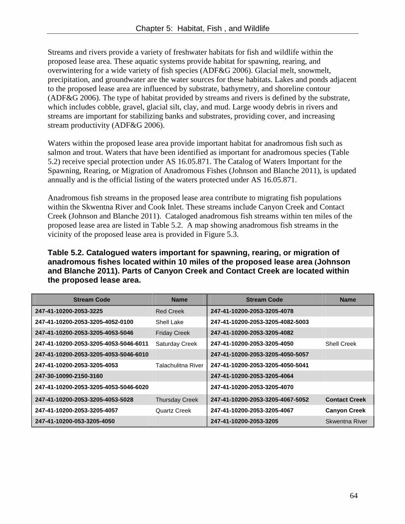
Chapter 5: Habitat, Fish , and Wildlife
64
Streams and rivers provide a variety of freshwater habitats for fish and wildlife within the proposed lease area. These aquatic systems provide habitat for spawning, rearing, and overwintering for a wide variety of fish species (ADF&G 2006). Glacial melt, snowmelt, precipitation, and groundwater are the water sources for these habitats. Lakes and ponds adjacent to the proposed lease area are influenced by substrate, bathymetry, and shoreline contour (ADF&G 2006). The type of habitat provided by streams and rivers is defined by the substrate, which includes cobble, gravel, glacial silt, clay, and mud. Large woody debris in rivers and streams are important for stabilizing banks and substrates, providing cover, and increasing stream productivity (ADF&G 2006). Waters within the proposed lease area provide important habitat for anadromous fish such as salmon and trout. Waters that have been identified as important for anadromous species (Table 5.2) receive special protection under AS 16.05.871. The Catalog of Waters Important for the Spawning, Rearing, or Migration of Anadromous Fishes (Johnson and Blanche 2011), is updated annually and is the official listing of the waters protected under AS 16.05.871. Anadromous fish streams in the proposed lease area contribute to migrating fish populations within the Skwentna River and Cook Inlet. These streams include Canyon Creek and Contact Creek (Johnson and Blanche 2011). Cataloged anadromous fish streams within ten miles of the proposed lease area are listed in Table 5.2. A map showing anadromous fish streams in the vicinity of the proposed lease area is provided in Figure 5.3. Table 5.2. Catalogued waters important for spawning, rearing, or migration of anadromous fishes located within 10 miles of the proposed lease area (Johnson and Blanche 2011). Parts of Canyon Creek and Contact Creek are located within the proposed lease area.
Stream Code Name Stream Code Name
247-41-10200-2053-3225 Red Creek 247-41-10200-2053-3205-4078
247-41-10200-2053-3205-4052-0100 Shell Lake 247-41-10200-2053-3205-4082-5003
247-41-10200-2053-3205-4053-5046 Friday Creek 247-41-10200-2053-3205-4082
247-41-10200-2053-3205-4053-5046-6011 Saturday Creek 247-41-10200-2053-3205-4050 Shell Creek
247-41-10200-2053-3205-4053-5046-6010 247-41-10200-2053-3205-4050-5057
247-41-10200-2053-3205-4053 Talachulitna River 247-41-10200-2053-3205-4050-5041
247-30-10090-2150-3160 247-41-10200-2053-3205-4064
247-41-10200-2053-3205-4053-5046-6020 247-41-10200-2053-3205-4070
247-41-10200-2053-3205-4053-5028 Thursday Creek 247-41-10200-2053-3205-4067-5052 Contact Creek
247-41-10200-2053-3205-4057 Quartz Creek 247-41-10200-2053-3205-4067 Canyon Creek
247-41-10200-053-3205-4050 247-41-10200-2053-3205 Skwentna River

Chapter 5: Habitat, Fish , and Wildlife
65
Figure 5.3 Water Habitat in the vicinity of the proposed Canyon Creek lease area. Anadromous fish streams appearing in The Catalog of Waters Important for the Spawning, Rearing, or Migration of Anadromous Fishes (Johnson and Blanche 2011) are shown in red.

Chapter 5: Habitat, Fish , and Wildlife
66
Designated Habitat Areas Although the proposed lease area does not include any designated habitat areas, several designated habitat areas are located nearby. Descriptions of these designated habitat areas are provided below because they would affect the choice and design of overland routes to and from the lease area. Talachulitna State Recreational River The Susitna Basin Recreation Rivers Management Plan (ADNR 1991) designated 64.5 miles of the Talachulitna River and 22 miles of Talachulitna Creek as State Recreation Rivers pursuant to the Recreation Rivers Act of 1988 (AS 41.23.400-510). The act establishes mile-wide river corridors along the designated rivers and outlines long-term management strategies on surrounding state-owned lands, establishes guidelines to reduce conflicts between users, provides opportunities for public use of the rivers, and protects the fish, wildlife, water, and other resources that drive visitation to these rivers. The Talachulitna River is located approximately eight miles east of the proposed lease area. Several tributaries of the Talachulitna River, including Deep Creek and Thursday Creek, extend to within about two miles of the proposed lease area boundary. The Recreation Rivers Act of 1988 established mile-wide river corridors along the Little Susitna, Deshka, Talkeetna, and Talchulitna rivers and Moose, Kroto, Talachulitna, and Alexander creeks, totaling about 243,000 acres of state-owned land along 460 river miles (ADNR 1991). The act specifies that these rivers remain in public ownership, identifies purposes and management intent of the designation, and provides a management plan and advisory board that guide access, commercial uses, and development within the recreational rivers area. One of the main purposes of the plan is “to manage, protect, and maintain fish and wildlife populations and habitat on a sustained yield basis. Areas that are important for fish and wildlife are identified and specific guidelines are designed to protect these important areas. The plan sets guidelines for reducing bear conflicts, protecting eagle and swan nesting sites, and enhancing habitat” (ADNR 1991). The plan includes riparian management areas, with guidelines to mitigate potential negative effects from overuse and development. To limit degradation of the water, recreational experience, and fish and wildlife habitats, the plan also includes guidelines for shoreline development, such as erosion control, diversion channels, docks, bridges, culverts, river crossings; and guidelines for upland development such as powerlines, pipelines, and airstrips. Motorized boat access is limited on some portions of some rivers to provide for a range of recreational experiences, especially during the summer fishing season. Susitna Flats State Game Refuge The Susitna Flats State Game Refuge lies approximately 36 miles southeast of the proposed lease area. The major portion of Susitna Flats State Game Refuge is a wetland that provides habitat for migrating waterfowl and shorebirds in the spring and fall. The refuge was established to “ensure the protection of fish and wildlife populations, particularly waterfowl nesting, feeding, and migration; moose calving areas; spring and fall bear feeding areas; and salmon spawning and

Chapter 5: Habitat, Fish , and Wildlife
67
rearing habitats. It was also established for public use of fish and wildlife and their habitat, particularly waterfowl, moose, and bear hunting; viewing; photography; and general public recreation in a high quality environment” (ADF&G 1988). Each year approximately ten percent of the waterfowl harvest in the state occurs on Susitna Flats, with about 15,000 ducks and over 500 geese taken. The refuge covers about 300,800 acres (ADF&G 1988). The refuge is particularly important for waterfowl nesting, feeding and migration. Large numbers of mallards, pintails, Canada geese, and Tule geese are seasonally present in the refuge, and in May as many as 100,000 waterfowl are present feeding, resting, conducting courtship, and preparing for nesting (ADF&G 1988). The refuge also supports several thousand sandhill cranes and more than 8,000 swans. An abundance of shorebirds uses the refuge, including northern phalaropes, dowitchers, godwits, whimbrels, snipe, yellowlegs, sandpipers, plovers, and dunlin. About 10,000 mallards, pintails, and green-winged teal ducks, as well as Tule geese, nest in the ponds and meadows. In the fall, the refuge’s sedge meadows, marshes, and intertidal mudflats are used heavily by migrating waterfowl and shorebirds for resting and feeding (ADF&G 1988). The refuge also provides habitat for calving moose, feeding bears, and spawning salmon. In the spring, the area is used by moose for calving; in the winter, moose move into the refuge to find food and respite from deep snow at higher elevations. Brown and black bears, beaver, mink, otter, muskrat, coyote, and wolf are also found on the refuge. Beluga whales congregate near the mouth of the Susitna River in late May and June (ADF&G 1988). The Susitna River and its tributaries support the second largest salmon producing system within Cook Inlet. In the summer, set net fishing sites dot the shoreline of the refuge. Other popular salmon streams are the Little Susitna, Theodore, and Lewis Rivers. (Alaska Department of Fish and Game, https://secure.wildlife.alaska.gov/index.cfm?adfg=refuge.susitna) Trading Bay State Game Refuge The Trading Bay State Game Refuge lies approximately 40 miles south of the proposed lease area. Trading Bay State Game Refuge encompasses an approximately 15-mile wide expanse of low relief wetlands and associated tidal flats and is best known for its prime waterfowl habitat. Trading Bay wetlands provide critical spring feeding, summer nesting, and fall staging habitat for thousands of ducks, geese, swans, and cranes. The first habitat to be used in spring is a narrow band of ice-free coast where large concentrations of waterfowl rest and feed. Canada geese (including the lesser, cackling, and Taverner's sub-species), lesser snow geese, Pacific white-fronted geese, Tule white-fronted geese, and trumpeter and tundra swans use the area in large numbers. Small numbers of Pacific brant are also found. As spring breakup moves inland, waterfowl disperse throughout Trading Bay to nest. Particularly high concentrations of nesting trumpeter swans are found along the Kustatan River. Nesting duck species include mallard, pintail, green-winged teal, wigeon, shoveler, common eider, merganser, scoter, scaup, and goldeneye. Loon, shorebirds, and bald eagle also nest on the refuge. In the fall, waterfowl populations once again concentrate in flocks on the refuge in preparation for their southward migration. The lowlands of Trading Bay provide important wintering habitat for approximately 500 moose. In addition to resident animals, these may include moose from the hills to the east and west

Chapter 5: Habitat, Fish , and Wildlife
68
where winter snow is too deep to obtain browse. Moose calve in bushy riparian habitat throughout the refuge in spring. Brown bear forage on the tidal flats each spring and summer. High numbers of black bear and brown bear feed on returning salmon in the Noaukta Slough from early summer through early fall. Healthy populations of coyote, mink, land otter, and weasels inhabit the wetlands year-round, and there is a resident wolf pack that ranges through the area. Five salmon-producing river systems cross the refuge: Kustatan, McArthur, Chakachatna, Middle, and Nikolai. Of these, the McArthur-Chakachatna system is probably the most productive. These systems all support coho salmon; Nikolai Creek and McArthur-Chakachatna rivers also support small runs of Chinook salmon, and the Chakachatna system is a large producer of sockeye salmon. Rainbow trout, Dolly Varden, and smelt are also found in refuge streams. Access to the refuge is by small plane or boat, or by road access from the nearby communities of Tyonek and Shirleyville. There are no developed public use facilities on the refuge. The refuge is a popular waterfowl and moose hunting area in the fall. Fly-in sport fishermen enjoy the refuge lakes and streams in summer months. A number of commercial set net fishing sites are operated along the coast in the summer. Trapping occurs in the winter. The residents of the nearby community of Tyonek hunt, fish, trap, and gather plants and berries on the refuge. An oil pipeline and a gas pipeline cross the refuge from West Foreland to Shirleyville (https://secure.wildlife.alaska.gov/index.cfm?adfg=refuge.tradingbay). Fish and Wildlife Populations The proposed lease area provides habitat for a wide variety of fish and wildlife species with a broad range of life histories and ecosystem requirements. Populations of the various species depend on many factors, including ecological parameters such as food and predator abundance, reproductive success and survival, and habitat availability, as well as on human factors such as harvest rates. Extensive information exists for a few species, such as salmon and moose. But limited information is available about the distribution, abundance, and habitat requirements of most species occurring in the proposed lease area, especially those that are not harvested by fisheries or sport hunting or trapping (ADF&G 2006). Populations of most fish and game species found in the proposed lease area are healthy but several species of birds potentially present in the proposed lease area have been identified as State Species Of Concern (SSOC) by ADF&G (Table 5.3). No species potentially present in the proposed lease area have been identified as threatened or endangered under the federal Endangered Species Act or AS 16.20.190.

Chapter 5: Habitat, Fish , and Wildlife
69
Table 5.3. Species potentially found in the proposed lease area identified as State Species of Concern (SSOC) in the Alaska Wildlife Action Plan http://www.adfg.alaska.gov/index.cfm?adfg=specialstatus.akconcern
Species Status
Olive-sided flycatcher SSOC
Gray-cheeked thrush SSOC
Townsend's warbler SSOC
Blackpoll warbler SSOC
American Peregrine Falcon SSOC
Arctic Peregrine Falcon SSOC
Freshwater and Anadromous Fish The waters of the proposed lease area support populations of several freshwater fish species. Species that have important recreational, commercial, or subsistence value are described below. Freshwater Species Rainbow trout (Oncorhynchus mykiss): In 1999 the Alaska Board of Fisheries recognized Canyon Creek as waters worthy of special management designation for trout. This designation perpetuates quality fishing in terms of maintaining historic age, size, and abundance. Because of this designation, special regulations apply to Canyon Creek allowing only one unbaited, single-hook, artificial lure. In addition, the sport fishery for rainbow trout in Canyon Creek is catch-and-release only; retention of rainbow trout is prohibited. The fishery is open year-round. Approximately 200 to 400 rainbow trout are caught annually from Canyon Creek (ADF&G 2012). Shell Lake, located approximately five miles northeast of the proposed lease area also supports a population of rainbow trout. Rainbow trout occur in lakes and streams near the proposed lease area including Shell Lake, Whiskey Lake, Hewitt Lake, and the Talachulitna River. Numerous smaller lakes and streams in the area support populations of rainbow trout. Rainbow trout remain in freshwater for the duration of their life. They spawn annually in the spring, and some individuals may spawn every year for up to five years (Morrow 1980). The migratory patterns of rainbow trout vary depending on their habitat. Stream resident rainbow trout tend to remain in the same sections of stream, while lake resident populations migrate to streams to spawn in the spring and then return to the lake within a few weeks (Morrow 1980). Dolly Varden (Salvelinus malma) are found in many rivers and streams throughout the Cook Inlet area. Canyon Creek is known to support a population of Dolly Varden, and additional lakes and streams near the proposed lease area, including Shell Lake and the Talachulitna River, provide habitat for Dolly Varden. Burbot (Lota lota) are found in deep rivers and lakes throughout the Cook Inlet area. Shell Lake, located north of the proposed lease area supports a population of burbot, and they are also believed to occur in smaller lakes and streams near the proposed lease area. Burbot spawn in moderately shallow waters of rivers or lakes under the ice from February through March (Armstrong 1996). Young burbot feed on invertebrates; as they grow, their diet also includes fish such as slimy sculpin, lampreys, and young salmon; by age five their diet is primarily fish

Chapter 5: Habitat, Fish , and Wildlife
70
(Armstrong 1996). Burbot become sexually mature at about age six or seven and can spawn multiple times. Burbot grow slowly and may live for up to 24 years (Armstrong 1996). Freshwater Sculpin are generally found on the bottoms of lakes and streams. Three species of sculpin are found in freshwaters of the Cook Inlet area: slimy sculpin (Cottus cognatus), prickly sculpin (C. aster) and coastrange sculpin (C. aleuticus). Sculpin mature at two to four years, and spawn in the spring, laying their eggs in nests guarded by the male (Armstrong 1996). Their lifespan is about seven years. They feed mostly on insects, although occasionally they eat fish and fish eggs. Arctic grayling (Thymallus arcticus) live and spawn in Canyon Creek, and are also present in lakes and streams near the proposed lease area, including Shell Lake and the Talachulitna River. Spawning takes place in the spring. Adult fish seek shallow areas of rivers with fine sand substrate and moderate current. Males are territorial and court females by flashing their colorful dorsal fins. Three-spine stickleback (Gasterosteus aculeatus) live in lakes, ponds, and slow-moving streams near the proposed lease area. They spawn in June and July, with the female laying eggs in a nest built by the male (Armstrong 1996). Their life span is only two years. Stickleback feed on zooplankton, insects, and occasionally on their own eggs and young. Northern pike (Esox lucius) are considered nonnative to the proposed lease area, but are present as an introduced species. Pike are top level predators in aquatic food chains and may pose threats to populations of trout, salmon, sticklebacks, and other native fish. Pacific Salmon Five species of Pacific salmon are found in the proposed lease area: Chinook (Oncorhynchus tshawytscha), sockeye (O. nerka), coho (O. kisutch), pink (O. gorbuscha), and chum (O. keta). Although salmon life histories can vary widely depending on species and population, most salmon spawn in freshwater streams between June and September. Some pink salmon also spawn in intertidal areas. Eggs are laid in the gravel where they remain through the winter. Growth and development of eggs and alevins in the gravel depends on water temperature, and requires good flow of clean water through the subsurface gravel (Armstrong 1996). Young salmon emerge from the gravel in the spring, and most species spend one or more subsequent years in freshwater. Juvenile salmon undergo significant physiological changes in preparation for migrating to the ocean, which usually occurs from mid-April through mid-July. Young salmon spend varying time in nearshore waters and then most move further offshore. During their ocean residence, salmon grow quickly as they feed on abundant marine food supplies. Some salmon species make long migrations on the high seas that span thousands of miles and up to seven years. When they reach maturity, salmon migrate back to their home stream. Salmon die after spawning, and their decomposed bodies provide nutrients that contribute to the productivity of the aquatic ecosystem. Juveniles and adults of all five Pacific salmon species are present in Canyon Creek, and the creek provides spawning habitat for king salmon and pink salmon (Johnson and Blanche 2011). In addition, Canyon Creek provides rearing habitat for king salmon. Silver salmon are present in Contact Creek, which extends through the northern portion of the proposed lease area. Several

Chapter 5: Habitat, Fish , and Wildlife
71
additional streams, lakes, and rivers near the proposed lease area, including the Skwentna River, Quartz Creek, Shell Creek, Shell Lake, and Whiskey Lake, as well as several unnamed tributary streams, are documented as important for Chinook, chum, coho, pink, and sockeye salmon under Alaska Statute 16.05.871(a). Chinook (king) salmon are the largest of the Pacific salmon species (ADF&G 2011c). Canyon Creek, in the eastern portion of the proposed lease area, the Skwentna River, and the Talachulitna River support populations of Chinook salmon (Johnson and Blanche 2011). Chinook salmon return to these streams from early May through early August (ADF&G 2011b). Females lay 3,000 to 14,000 eggs (Armstrong 1996). After hatching and emerging from the gravel, juvenile Chinook feed on plankton and insects while in freshwater (ADF&G 2011c). Most Chinook salmon remain in freshwater for one or two years before their seaward migration and they spend three to five years in the ocean (Armstrong 1996). In the ocean, Chinook feed on herring, pilchard, sandlance, squid and crustaceans as well as other available fish and shellfish (ADF&G 2011c). ADF&G annually monitors Chinook salmon escapement on Canyon Creek by aerial survey and has a record going back to 1977. Index counts have ranged from 279 to 1,075 and averaged 714 spawning Chinook salmon over that time. Typically aerial counts represent 40 to 60 percent of the actual escapement, meaning approximately 600 to 2,200 spawn in Canyon Creek annually. Sockeye (red) salmon usually spend one to two years in freshwater as juveniles (Armstrong 1996). Canyon Creek, in the eastern portion of the proposed lease area, the Skwentna River, and the Talachulitna River support populations of sockeye salmon (Johnson and Blanche 2011). Important food sources for sockeye in the proposed lease area include plankton and insects. After one to two years in freshwater, sockeye migrate into the North Pacific Ocean. After two or three years at sea, mature sockeye salmon return to the streams to spawn in mid-June, and runs continue through August (ADF&G 2011b). Coho (silver) salmon are present in Contact Creek, which extends through the northern portion of the proposed lease area (Johnson and Blanche 2011). Canyon Creek, in the eastern portion of the proposed lease area, Quartz Creek, Thursday Creek, Shell Creek, the Skwentna River, and the Talachulitna River, and other nearby streams also support populations of coho salmon. Coho begin entering rivers and streams from Cook Inlet in mid-July (ADF&G 2011b). Females deposit from 2,400 to 4,500 eggs in stream gravel (Armstrong 1996). Juvenile coho overwinter in deep pools and side channels of streams. Smolt migrate to the ocean in the spring, but in some systems the smolt migration is protracted, lasting all summer (King and Breakfield 1998). Coho salmon usually spend one year at sea before returning to spawn in streams (King and Breakfield 1998). Pink salmon occur in Canyon Creek, as well as in the Skwentna River, Talachulitna River, Thursday Creek, Shell Creek and other nearby creeks and streams (Johnson and Blanche 2011). They spawn from early July through August in the lower reaches of streams (ADF&G 2011b). Females deposit from 1,500 to 2,000 eggs in the gravel of spawning streams (Armstrong 1996). Juvenile pink salmon do not rear in freshwater, but immediately migrate to the sea. Pink salmon remain at sea for one year, feeding mainly on zooplankton, squid, and fish (Armstrong 1996). Because pink salmon migrate to sea shortly after emerging from the gravel and spend only one year at sea, they have a distinct two-year life cycle from egg to spawning.

Chapter 5: Habitat, Fish , and Wildlife
72
Chum (dog) salmon are found in Canyon Creek, as well as in the Skwentna River, Talachulitna River, and other nearby creeks and streams (Johnson and Blanche 2011). Chum salmon generally enter the area beginning in mid-July, and runs continue through mid-August (ADF&G 2008b). On average, females lay 2,000 to 4,000 eggs (Armstrong 1996). After hatching in the spring, young chum immediately migrate to the ocean. They form large schools and remain in estuaries and near-shore waters feeding on plankton until fall, when they migrate to the open ocean. After three to six years at sea, chum return to their home streams to spawn. Birds Over 450 species of birds are found in Alaska, including waterfowl, seabirds, shorebirds, and many species of land and water birds, most of which can be found in the Cook Inlet area (BLM 2006). Some species are present in the proposed lease area for the entire year, while most migrate into the area on a seasonal basis. Waterfowl Waterfowl potentially found in the proposed lease area include swans, ducks, cranes, and geese. Although important waterfowl breeding and migration areas are located in the general vicinity of the proposed lease area (Trading Bay State Game Refuge approximately 40 miles to the south; and Susitna Flats State Game Refuge approximately 36 miles to the southeast), the proposed lease area itself contains limited amounts of habitat for ducks, swans, geese, and cranes. Common mergansers, scaup, shovelers, bufflehead, goldeneyes, gadwalls, wigeons, and mallards have been observed feeding in the Susitna Basin area after breakup. The area is also used to some extent for resting and feeding during fall migration (ERT 1987). The numerous ponds, nearby lakes, and low-lying areas along the Skwentna, Hayes, and Talachuitna rivers contain nesting habitats and serve as feeding and resting areas during spring and fall (Figure 5.4). The estimated abundance of trumpeter swans (Cygnus buccinator) in the Cook Inlet area increased from 1,545 in 2000 to 2,670 in 2005 (Conant et al. 2007). Trumpeter swans congregate and are known to nest in the Susitna Flats State Game Refuge to the southeast of the proposed lease area (ADNR 2009). Trumpeter swans prefer shallow bodies of water and build their nests in areas of marsh vegetation (ADF&G 2011d). Breeding trumpeter swans arrive at their nests in April and May and eggs hatch during June and July. In Alaska, young trumpeter swans are unable to fly until 11 to 15 weeks of age (ADF&G 2011d). After leaving breeding areas, trumpeter swans gather on ponds and marshes along the coast in late summer and early fall. The swans typically depart by mid-October but in some years may remain until November (ADF&G 2011d). Trumpeter swans that breed in Alaska winter primarily on ice-free freshwater outlets in British Columbia, western Washington, Oregon, and occasionally as far south as California (Pacific Flyway Council 2006). The proposed lease area is likely to be of minor importance to trumpeter swans, although a few pairs may nest in low-lying areas along the Skwentna River. Potential swan nesting habitat includes 708 acres in the northeast corner of the proposed lease area (Figure 5.4).

Chapter 5: Habitat, Fish , and Wildlife
73
The project area is not important for sandhill cranes (Grus canadensis). There have been many sightings of cranes in the Trading Bay State Game Refuge 40 miles south of the proposed lease area; however the proposed lease would not be expected to substantially affect their habitat. Three populations of white-fronted geese breed in Alaska. Pacific Flyway white-fronts nest mainly on the Yukon-Kuskokwim Delta and Bristol Bay, and winter from central California to Mexico. The tule white-fronted goose (Anser albifrons gambelli), a larger and darker subspecies, numbers only about 7,000 birds and winters with Pacific birds in central California. Its Alaska breeding range has not yet been fully determined, but the west side of Cook Inlet is a known nesting area (ADF&G 2011d). Tule white-fronted geese are known to nest and molt in the Susitna Flats State Game Refuge 36 miles to the southeast of the proposed lease area (ADF&G 1988; 2011d). Studies indicate that Tule geese arrive in the Cook Inlet coastal areas and interior marshes from mid-April to early May, and then move to nesting areas (ADF&G 2011d; Densmore et al. 2006). Important locations include freshwater wetlands in the Susitna Valley and lowlands along the shores of Upper Cook Inlet (Densmore et al. 2006). Tule geese start to leave for wintering grounds in California by early fall, and are gone from Alaska by the end of September (ADF&G 2011d).

Chapter 5: Habitat, Fish , and Wildlife
74
Figure 5.4. Duck and Swan Habitat types around the proposed lease area (ADF&G 1985).

Chapter 5: Habitat, Fish , and Wildlife
75
Seabirds and Shorebirds Seabirds
Seabirds are birds that use coastal waters or the open ocean for most activities, but come to shore to nest. Alaskan waters provide habitat for upwards of 100 million seabirds from 66 species (USGS 2011). Several species of seabirds occur in Upper Cook Inlet adjacent to the proposed lease area including glaucous-winged gulls, herring gulls, Bonaparte’s gulls, and mew gulls (KABATA 2007). Shallow coastal habitats are particularly important for seabirds, as these areas have high densities of forage fish (Piatt and Roseneau 1997). Because the proposed lease area is located in foothill terrain approximately 40 miles from the nearest tidewater, it is not expected to include habitat important for seabirds.
Shorebirds A number of shorebird species may nest in the wetlands in and around the proposed lease area, including Hudsonian godwits, greater yellowlegs, solitary sandpipers, spotted sandpipers, short-billed dowitchers, and Wilson’s snipe (Gill and Tibbitts 1999; ADNR 2009). The Cook Inlet drainage is the preferred nesting site for Hudsonian godwits, and is an important wintering area for rock sandpipers, but most shorebirds use the area primarily during migration. During spring and fall migration, the Susitna Flats State Game Refuge, located 36 miles southeast of the proposed lease area, is an important feeding area for shorebirds due to the prevalence of accessible invertebrates and juvenile shellfish (Gill and Tibbitts 1999). Migrating shorebirds arrive in the Cook Inlet area in early May, their numbers increase rapidly, and then they depart abruptly by late May (ADNR 2009). Land Birds and Waterbirds A large variety of other birds rely on the land and freshwater habitats of the proposed lease area. These include eagles, hawks, owls, ravens, grouse, ptarmigan, loons, chickadees, warblers, thrushes, sparrows, and many others. Several species of land and water birds that occur within the proposed lease area are protected by the Migratory Bird Treaty Act, which prohibits the taking, killing, possession, transportation, and importation of migratory birds, their eggs, parts, and nests except as authorized under hunting regulations or a valid permit (50 CFR 21.11). A list of birds protected by the MBTA may be found at http://www.fws.gov/migratorybirds/RegulationsPolicies/mbta/mbtandx.html. Bald eagle (Haliaeetus leucocephalus) may reside and nest within the proposed lease area (KABATA 2007). These birds are protected by the federal Bald and Golden Eagle Protection Act, which prohibits damage to nest trees or disturbance to nesting eagles (50 CFR 22). They tend to congregate along salmon-spawning streams and shorelines where they search for fish (ADF&G 2011d). They also prey on waterfowl, small mammals, and carrion. Bald eagles nest in trees that are close to water, with a clear view of the surrounding area, often in old cottonwoods (ADF&G 2011d). They tend to use and rebuild the same nests and a breeding pair may have several nests to choose from within their territory. Nest building begins in April, eggs are usually laid in late April, and young hatch after about 35 days, and leave the nest after about 75 days. Bald eagles reach sexual maturity at about four or five years of age (ADF&G 2011d). Bald eagles winter in areas around Cook Inlet, and may be present in the proposed lease area throughout the ice-free months (KABATA 2007; ADNR 2009; STB 2011).

Chapter 5: Habitat, Fish , and Wildlife
76
Golden eagle (Aquila chrysaetos), also protected by the Bald and Golden Eagle Protection Act, are found throughout the Cook Inlet area. Golden eagles feed primarily on ground squirrels, hares, and other birds (ADF&G 2011d). Golden eagles may migrate through and hunt in the proposed lease area, but tend to nest in higher elevation rocky areas. Sharp-shinned hawk (Accipiter striatus) may occur in the proposed lease area (STB 2011). These birds nest in woodland forests, most frequently in spruce trees (ADF&G 2011d). Eggs hatch in late May or early June. Sharp-shinned hawks eat songbirds, small mammals and large insects (ADF&G 2011d). The boreal owl (Aegolius funereus) and northern hawk owl (Surnia ulula) inhabit the Cook Inlet area. They lay their eggs in old woodpecker nest cavities or holes in old trees (ADF&G 2011d). The boreal owl feeds at night on voles, mice, shrews, and small birds; population cycles of voles are a limiting factor in owl populations. Marten are the main predator of the boreal owl. The northern hawk owl hunts mostly during the day, and may nest close to human settlements. Its main predators are the great horned owl and northern goshawk (ADF&G 2011d). Common raven (Corvus corax) occur in the proposed lease area. They are a member of the Corvidae family, which also includes jays, crows, and magpies. Ravens use a wide variety of habitats; they feed on a variety of both plant and animal foods, and are also scavengers. Ravens breed at age three or four years, mate for life, and can live up to 30 years. Ravens congregate near human settlements during non-breeding seasons (ADF&G 2011d). Spruce grouse (Canachites canadensis) are common throughout the Cook Inlet area, including the proposed lease area, but are seldom seen. Preferred habitat includes spruce-birch forest with a thick understory of cranberry, blueberry, crowberry, and spirea, above moss-covered ground (ADF&G 2011d). During summer, spruce grouse eat flowers, green leaves, and berries. Insects provide food for newly hatched chicks. Ruffed grouse (Bonnasa umbellus) are common to woodlands along interior Alaska rivers but were recently introduced to the Matanuska-Susitna Valley, where they are now abundant in some areas. Ruffed grouse may inhabit the proposed lease area. Summer foods include blueberries, high-bush cranberries, rose hips, and aspen buds. In winter, they feed primarily on the buds and twigs of aspen, willow, and soapberry. Game bird populations in Alaska fluctuate widely and are probably influenced by climate, food and cover conditions, predators, and genetic factors (ADF&G 2011d). Willow ptarmigan (Lagopus lagopus), Alaska’s state bird, are found throughout the Cook Inlet area in high, treeless areas, along with rock and white-tailed ptarmigan (L. mutus and L. leucurus). Willow ptarmigan tend to live closest to the tree line. Hens nest on the open ground after snowmelt and hatchlings arrive in late June or early July. Ptarmigan populations fluctuate dramatically and the causes remain unknown (ADF&G 2011d). Common loons (Gavia immer) are found on lakes throughout the Cook Inlet area during the summer, and are likely to occur in the proposed lease area. They winter along the coast from the Aleutians to Baja California.

Chapter 5: Habitat, Fish , and Wildlife
77
The Pacific loon (G. pacifica) is distributed widely throughout the Cook Inlet area, and is the most common wintering loon on the coasts of Southcentral Alaska. Red-throated loons (G. stellata) are also common throughout the Cook Inlet area. Loons migrate to coastal areas in September or early October, and return to their freshwater nesting habitat in May. Loons mate for life and return each year to the same area to breed. Breeding success may be related to the presence of gulls, jaegers, and foxes. Loons are excellent divers and feed on small fish, aquatic vegetation, insects, mollusks, and frogs (ADF&G 2011d). Arctic terns (S. paridisaea) may be present in the proposed lease area during early summer, and are listed as a Bird of Conservation Concern by USFWS (USFWS 2008). Chickadees (Parus sp.) are common throughout Alaska’s forests with some species associated with conifers and others with deciduous forest cover. The two species of chickadees likely to be found in the proposed lease area are black-capped chickadees and boreal chickadees – both common. These small birds live an average of two to three years and feed on insects, including several considered to be forest pests (ADF&G 2011d). Hawks and other flying predators eat chickadees. State Species of Concern Several species of birds potentially present in the proposed lease area have been identified as State Species of Concern (SSOC) by ADF&G (Table 5.3). No species potentially present in the proposed lease area have been identified as threatened or endangered under the federal Endangered Species Act or AS 16.20.190. The olive-sided flycatcher, blackpoll warbler, gray-cheeked thrush, and Townsend’s warbler are all songbirds (passerines) that migrate between nesting habitats in the boreal and coastal forests of Alaska, and winter from California to South America. These species arrive in Alaska in May or early June, forage on insects during the breeding season, and start their southward migrations in August. Overall population levels for these species are not known but population trend indices appear to be declining in breeding areas (Sauer et al. 2008). A major conservation concern for these species is habitat loss in both nesting and wintering areas due to logging, fire suppression, and road building. Pesticide contamination and increased predation as a result of habitat fragmentation are also concerns (Boreal Partners in Flight 1999). Populations of Alaskan breeding olive-sided flycatchers have declined 2.3 percent per year from 1980-2004, and survey data show a consistent and widespread decline of 3.5 percent across the U.S. and Canada from 1966-2004, probably due to deforestation and forest fire suppression activities in their wintering habitat of Central and South America (ADF&G 2006). Blackpoll warbler populations have also declined in Alaska and across North America at similar rates. They are especially vulnerable to removal of tropical forests, and are of concern in Alaska because a high percentage of the species’ global breeding range is found here (ADF&G 2006).
Chapter 5: Habitat, Fish , and Wildlife
78
Townsend’s warbler migrates into the proposed lease area in May and June. This species breeds in northern coniferous forests, and may be sensitive to habitat disturbances affecting mature boreal forests (ADF&G 2006). Gray-cheeked thrush may occur in the proposed lease area in early summer in mixed-species deciduous and coniferous forests. Populations of this species have declined in recent years as a result of alterations to their breeding habitat of tropical broadleaf forests in Central America (ADF&G 2006). Peregrine falcon (Falco peregrinus) occur in small numbers throughout the state, migrating between nesting grounds in Alaska and wintering areas as far south as Argentina. The American peregrine falcon nests south of the Brooks Range while the arctic peregrine falcon nests in arctic tundra. Peregrines feed primarily on waterfowl, shorebirds, and passerines (songbirds). Nests are on cliffs or bluffs and are usually near rivers or lakes that provide habitat for their prey. This species suffered population declines due to the effects of DDT and other pesticides but have recovered after pesticide use was restricted in 1972 (ADF&G 2006). Terrestrial Mammals The relatively undisturbed nature of the proposed lease area provides habitat for numerous mammal species, including large and small game, furbearers, as well as nongame species. The main big game species found in the area include black bear (Ursus americanus), brown bear (Ursus arctos), and moose (Alces alces gigas). Wolves (Canis lupus) are also common to the area and are managed as big game (hunted) as well as furbearers (trapped). Because of resource and public interest, moose and bears are the primary focus of the terrestrial mammal discussion. Black Bear The proposed lease area represents a small portion of ADF&G game management unit (GMU) 16B, which is a subunit within GMU16 (Figure 5.5). Black bears are abundant in GMU 16 relative to most areas in Alaska. Management goals for black bears in GMU 16 include providing the greatest opportunity to participate in hunting and reduction of the overall population of black bears in the unit in order to reduce predation on moose calves (Peltier 2008). Using a mean density of 113 bears per 1000 km² in northern GMU 16, the black bear population of GMU 16B was estimated at 2,100 animals in spring 2000 and 2001 (McDonough 2002, ABOG 2004). This estimate was higher than the preceding range of 1,300–1,600 black bears in GMU 16B (ABOG 2004). Most recently, a line-transect survey conducted in May 2007 estimated a black bear population of 1888 bears in GMU 16B (Peltier 2008). This estimate is based on a density of 126.7 bears per 1000 km2 and a total area of 14,895 km2 of available bear habitat, comprised of all areas in GMU 16B below 3,500 feet elevation. Black bear distribution during spring, summer, and fall is largely determined by food availability, and dense populations of black bear are likely to occur in and around the proposed lease area due to suitability of habitat and abundant food resources. Black bear habitats within the proposed lease area may include broadleaf forest, mixed needleleaf-broadleaf forest, tall and low shrub, and sedge and grass wetlands (Mat-Su Borough 2007).

Chapter 5: Habitat, Fish , and Wildlife
79
Figure 5.5. ADF&G Game Management Units (GMUs) in and around the Canyon Creek proposed lease area.

Chapter 5: Habitat, Fish , and Wildlife
80
Brown Bear Brown bear are generally less common than black bears in GMU 16B, and the brown bear population in GMU 16B was estimated at 586 to 1,156 animals in the early 1990s (Del Frate 2003) and at 530 to 1,050 animals more recently (ABOG 2004), but documentation for both estimates is lacking. The similarity between these estimates runs counter to a reported increase in the brown bear population (Del Frate 2003). A more rigorous survey attempt was begun in spring 2000, yielding a preliminary density estimate of 23.3 brown bears/1,000 km² in northern GMU 16B (Del Frate 2003). Later estimates placed the mean density at 26.7 bears/1,000 km² in northern GMU 16B and perhaps as high as 150 bears/1,000 km² in southern GMU 16B, based on densities farther down the Alaska Peninsula in GMU 9A (Kavalok 2005). The amount of brown bear habitat in all of GMU 16 is estimated to be 24,206 km², defined as the area of the unit below 4,000 ft elevation (most of which is GMU 16B) (McDonough 2002). The coastal and foothill areas of Redoubt and Trading bays were presumed to have the highest densities in the unit (Del Frate 2003), suggesting that brown bear density is highest in areas south of the proposed lease area. Brown bears are often found along river drainages searching for fish, and may be seasonally present in relatively high concentrations along the Skwentna River and Talachulitna River corridors, located north and east of the proposed lease area. In the spring, brown bear may also use the salt marshes and sedge meadows in Redoubt and Trading bays as feeding habitat (ADF&G 1988). Moose The most recent moose population estimate for GMU 16B is 3,794 to 4,852 moose (Peltier 2010a). This number is substantially below the minimum management objective of 6,500 moose, and below what the habitat can support based on twinning rates and nutritional studies (Peltier 2010a). Moose likely numbered in excess of 10,000 in GMU 16B during the early 1980s (Griese 1996). However, the severe winter of 1989-1990 is thought to have resulted in a 15-20 percent decline in moose numbers in GMU 16B, and moose populations in the area have continued to decline, possibly in response to deep snow winters and increases in predation by bears and wolves (Griese 2000). The severe winter of 1999-2000 again negatively impacted the moose population in GMU 16B. In midwinter moose were observed struggling in snow depths exceeding five feet (Griese 2000). As the winter progressed, formation of a surface ice crust facilitated easy wolf travel and led to increased rates of predation by wolves. Figure 5.6 shows moose habitat types in and around the proposed lease area. The proposed lease area is comprised of general moose habitat. In winter moose may use portions of the lease area located at lower elevations near the Skwentna River, and moose are known to concentrate around the lower reaches of Canyon Creek during heavy snow years.

Chapter 5: Habitat, Fish , and Wildlife
81
Figure 5.6. Moose habitat types around the proposed lease area (ADF&G 1985).

Chapter 5: Habitat, Fish , and Wildlife
82
A control program to reduce wolf predation on moose in GMU 16B began in 2004 (Peltier 2010a). In addition, bear surveys conducted in spring 2007 indicated high densities of black and brown bears in GMU 16B (Peltier 2010a). Brown bear season and bag limits in the unit were liberalized, and a black bear control program began in the fall of 2007 in order to reduce predation pressure on moose populations in GMU 16B. As a result of these actions, black bear harvest in the Unit 16 Predator Control Area has been high and calf recruitment is being monitored to determine if predator control is having a positive influence on moose calf recruitment (Peltier 2010a). Other Terrestrial Mammals Numerous furbearers and small game species are also likely to be found in and around the proposed lease area, including beaver (Castor canadensis), northern flying squirrel (Glaucomys sabrinus), lynx (Lynx canadensis), martin (Martes americana), wolverine (Gulo gulo), muskrat (Ondatra zibethica), red fox (Vulpes vulpes), red squirrel (Tamiasciurus hudsonicus), weasel (Mustela nivalis), river otter (Lutra canadensis), and wolf (Canis lupus) (ADF&G1988; Mat-Su Borough 2007; KABATA 2007). Riparian, wetland, and forested habitats support populations of numerous furbearer and small game species (Mat-Su Borough 2007; KABATA 2007). Most recent trapper reports indicate that all species are common or abundant during the reporting period (2006-2009) except lynx, which were reported as scarce, and wolverine, which were reported as common in 2003-04 but have been reported as scarce each year since (Peltier 2010b). References
ABOG (Alaska Board of Game). 2004. Findings of the Alaska Board of Game, 2004-148-BOG: Authorizing predator control in the western Cook Inlet area in Unit 16B with airborne or same-day-airborne shooting; March 10, 2004. Alaska Department of Fish and Game, Boards Support Section, Juneau.
ADF&G (Alaska Department of Fish and Game) 1985. “Alaska Habitat Management Guide. Southcentral Region: Map Atlas.” Juneau, AK: Alaska Department of Fish and Game, Habitat Division.
ADF&G (Alaska Department of Fish and Game) 1988. “Susitna Flats State Game Refuge Management Plan.” Habitat Division.
ADF&G (Alaska Department of Fish and Game) 2006 Our wealth maintained: A strategy for conserving Alaska's diverse wildlife and fish resources. Alaska Department of Fish and Game, Juneau, Alaska. xviii+824p. http://www.sf.adfg.state.ak.us/statewide/ngplan/files/cover_and_acknowl.pdf
ADF&G (Alaska Department of Fish and Game) 2011a. “Hatcheries and Stocking.” http://www.adfg.alaska.gov/index.cfm?adfg=fishingSportStockingHatcheries.hatcheries
ADF&G (Alaska Department of Fish and Game) 2011b. “Sport Fish Run Timing.” http://www.adfg.alaska.gov/index.cfm?adfg=fishingSportFishingInforuntiming.main
ADF&G (Alaska Department of Fish and Game) 2011c. “Chinook Salmon (Oncorhynchus tshawytscha) Species Profile” http://www.adfg.alaska.gov/index.cfm?adfg=chinook.main

Chapter 5: Habitat, Fish , and Wildlife
83
ADF&G (Alaska Department of Fish and Game) 2011d. “Birds Species Profiles” http://www.adfg.alaska.gov/index.cfm?adfg=animals.listbirds
ADF&G (Alaska Department of Fish and Game) 2012. Canyon Creek Coal Best Interest Finding, Agency Comments. Habitat Case No. FH-12-IV-0073. April 2, 2012.
ADNR (Alaska Department of Natural Resources). 1991. “Susitna Basin Recreation Rivers Management Plan.” Division of Land and Water. Lands and Resources Section.
ADNR (Alaska Department of Natural Resources). 2009. Cook Inlet areawide oil and gas lease sale: Final finding of the Director. January 20, 2009.
Armstrong, R. H. 1996. Alaska's fish: A guide to selected species. Alaska Northwest Books, Seattle, WA.
BLM (Bureau of Land Management) 2006 Ring of Fire: Proposed resource management plan and final environmental impact statement. Prepared by: Anchorage Field Office, BLM, U.S. Department of the Interior. July 2006. http://dnr.alaska.gov/commis/resmgmtplans/rof.htm
Boreal Partners in Flight, 1999. Landbird Conservation Plan for Alaska Biogeographic Regions. Version 1.0. BPIF Working Group, B.A. Andres (chair). U.S. Fish and Wildlife Service, Anchorage, Alaska. 116 pp. Available on-line: http://www.absc.usgs.gov/research/bpif/conservation.html
Brinson, M.M. 1993. A Hydrogeomorphic Classification for Wetlands. U.S. Army Corps of Engineers, Waterways Experiment Station, Vicksburg, MS, USA. Technical Report WRP-DE-4. 103 pp. http://el.erdc.usace.army.mil/wetlands/pdfs/wrpde4.pdf
Carlson, M.L., Lapina, I.V., Shephard, M., Conn, J.S., Densmore, R., Spencer, P., Heys, J., Riley, J., Nielsen, J. 2008. Invasiveness Ranking System for Non-Native Plants of Alaska. United States Department of Agriculture, Forest Service, Alaska Region. R10-TP-143, August 2008.
Conant, B., Hodges, J.I., Groves, D.J., Kin, J.G. 2007. The 2005 Census of Trumpeter Swans on Alaskan Nesting Habitats. U.S. Fish and Wildlife Service, Waterfowl Management. Juneau, Alaska. http://alaska.fws.gov/mbsp/mbm/waterfowl/surveys/pdf/TRSW_Status_2005_Text.pdf
Del Frate, G. 2003. Unit 16 brown bear management report. Pages 161–173 in C. Healy (ed.) Brown bear management report of survey and inventory activities, 1 July 2000–30 June 2002. Alaska Department of Fish and Game, Juneau.
Densmore, R. V., C. R. Ely, K. S. Bollinger, S. Kratzer, M. S. Udevitz, D. J. Fehringer, and T. C. Rothe. 2006. Nesting habitat of the tule greater white-fronted goose Anser albifrons elgasi. Wildfowl 56: 37-51.
ERT. 1987. Diamond Chuitna Project North Road baseline studies report. Prepared for Diamond Alaska Coal Company, Anchorage, by Environmental Research & Technology, Inc., Fort Collins, CO.
Gallant, A. L., E. F. Binnian, J. M. Omernik, and M. B. Shasby. 1995. Ecoregions of Alaska. U.S. Geological Survey Professional Paper 1567.

Chapter 5: Habitat, Fish , and Wildlife
84
Gill, R. E., Jr. and T. L. Tibbitts, T.L. 1999. Seasonal shorebird use of intertidal habitats in Cook Inlet, Alaska. Biological Resources Division, Alaska Biological Science Center, USGS, OCS Study MMS 99-0012 for Mineral Management Service, Anchorage. Glass, R. L. 1999. Water-quality assessment of the Cook Inlet Basin, Alaska - summary of data through 1997. Water-Resources Investigations Report 99-4116, USGS National Water-Quality Assessment Program. http://ak.water.usgs.gov/Publications/pdf.reps/wrir99.4116.pdf
Griese, H. 1996. Unit 16B moose management report. Pages 208–221 in M. V. Hicks, ed. Moose management report of survey and inventory activities, 1 July 1993–30 June 1995. Alaska Department of Fish and Game, Juneau.
Griese, H. 2000. Unit 16B moose management report. Pages 224–236 in M. V. Hicks, ed. Management report of survey and inventory activities, 1 July 1997–30 June 1999. Alaska Department of Fish and Game, Juneau.
Hall, J. V., W. E. Frayer, and B. O. Wilen. 1994. Status of Alaska wetlands. Anchorage, AK: U.S. Fish and Wildlife Service.
Johnson, J. and Blanche, P. 2011. Catalog of Waters Important for Spawning, Rearing, or Migration of Anadromous Fishes- Southcentral Region, Effective June 1, 2011. Alaska Department of Fish and Game, Division of Sport Fish and Habitat. Special Publication 11-06.
KABATA (Knik Arm Bridge and Toll Authority) 2007. Knik Arm Crossing Final Environmental Impact Statement and Final Section 4 (f) Evaluation, including appendices and associated technical reports. Prepared for: Federal Highway Administration, Juneau, Alaska, Federal Project No: ACSTP-0001(277). December 18, 2007.
Kavalok, T. 2005. Unit 16 brown bear management report. Pages 157–168 in C. Brown (ed.). Brown bear management report of survey and inventory activities, 1 July 2002–30 June 2004. Alaska Department of Fish and Game, Juneau.
King, B. E. and J. A. Breakfield. 1998. Coded wire tagging of coho and chinook salmon in the Kenai River and Deep Creek, Alaska, 1996. Alaska Department of Fish and Game, Fishery Data Series No. 98-9, Anchorage. http://www.sf.adfg.state.ak.us/FedAidPDFs/fds98-09.pdf
Krueger-Mangold, J. M., Sheley R. L. and Svejcar T. J. 2006. "Toward ecologically-based invasive plant management on rangeland." Weed Science 54(3): 597-605.
Matanuska-Susitna Borough. (2007). Matanuska-Susitna Borough Coastal Management Plan.
McDonough, T. 2002. Unit 16 black bear management report. Pages 191–205 in C. Healy, ed. Black bear management report of survey and inventory activities, 1 July 1998–30 June 2001. Federal Aid in Wildlife Restoration Project 17.0. Alaska Department of Fish and Game, Juneau.
Miller, J.A., Whitehead, R.L., and Olcott, P.G., 1997. Ground water atlas of the United States, segment 13, Alaska, Hawaii, Puerto Rico and the U.S. Virgin Islands: U.S. Geological Survey Hydrologic Investigations Atlas 730-N, 36 p.
Morrow, J. E. 1980. The freshwater fishes of Alaska. Alaska Northwest Publishing Company, Anchorage, AK.
Nowacki, G., P. Spencer, M. Fleming, T. Brock, and T. Jorgenson. 2001. Ecoregions of Alaska: 2001. U.S. Geological Survey Open-File Report 02-297 (map).

Chapter 5: Habitat, Fish , and Wildlife
85
Pacific Flyway Council. 2006. Pacific Flyway management plan for the Pacific Coast Population of Trumpeter Swans. Pacific Flyway Study Comm. USFWS, DMBM. Portland Oregon. Unpublished Report.
Peltier, T. 2008. Unit 16 black bear management report. Pages 187-198 in P. Harper, editor. Black bear management report of survey and inventory activities 1 July 2004-30 June 2007. Alaska Department of Fish and Game. Proj 17.0. Juneau, Alaska.
Peltier, T. 2009. Unit 16 brown bear management report. Pages 168-178 in P. Harper, editor. Brown bear management report of survey and inventory activities 1 July 2006-30 June 2008. Alaska Department of Fish and Game. Juneau, Alaska.
Peltier, T. 2010a. Unit 16B moose management report. Pages 235-247 in P. Harper, editor. Moose management report of survey/inventory activities 1 July 2007-30 June 2009. Alaska Department of Fish and Game. Project 1.0. Juneau, Alaska.
Peltier, T. 2010b. Unit 16. Pages 192-211 in P. Harper editor. Furbearer management report of survey and inventory activities 1 July 2006-30 June 2009. Alaska Department of Fish and Game. Project 7.0. Juneau, Alaska.
Piatt, J. F. and D. G. Roseneau 1997. Cook Inlet seabird and forage fish studies(CISeaFFS). Sisyphus News 1997 (1), Alaska Science Center, Biological Resources Division, USGS, Anchorage. http://alaska.usgs.gov/science/biology/seabirds_foragefish/products/newsletters/sisyphs1.pdf
Sauer, J. R., J. E. Hines, J. E. Fallon, K. L. Pardieck, D. J. Ziolkowski, Jr., and W. A. Link. 2011. The North American Breeding Bird Survey, Results and Analysis 1966 - 2009. Version 3.23.2011 USGS Patuxent Wildlife Research Center, Laurel, MD. Available on-line: www.pwrc.usgs.gov/bbs
STB (Surface Transportation Board) 2011. Alaska Railroad Corporation Construction and Operation of a Rail Line Extension to Point Mackenzie, Alaska, Final Environmental Impact Statement. Docket No. FD 3509. Served on Parties and Delivered to U.S. EPA: March 25, 2011.
USACE (U.S. Army Corps of Engineers). 1987. US Army Corps of Engineers Wetland Delineation Manual. Vicksburg, MS.
USACE (U.S. Army Corps of Engineers). 2007. Regional Supplement to the Corps of Engineers Wetland Delineation Manual: Alaska Region (Version 2.0), ed. J.S. Wakeley, R.W. Lichvar, and C.V. Noble. ERDC/EL TR-07-24.Vicksburg, MS: U.S. Army Engineer Research and Development Center.
USDA (U.S. Department of Agriculture). 1986. Timber and Vegetation Resources of the Susitna River Basin-Alaska Report. Susitna River Basin Study In cooperation with State of Alaska.
USFWS (U.S. Fish and Wildlife Service). 2008 “List of Birds of Conservation Concern 2008.” Division of Migratory Bird Management, Arlington, Virginia. http://library.fws.gov/bird_publications/bcc2008.pdf
USGS (U.S. Geological Survey). 1999. “Alaska Interim Land Cover Mapping Project.” http://agdc.usgs.gov/data/usgs/erosafo/ak_int_lcc/int_statewide.html
USGS (U.S. Geological Survey). 2011. Seabirds, Foragefish, and Marine Ecosystems Research http://alaska.usgs.gov/science/biology/seabirds_foragefish/index.php

Chapter 5: Habitat, Fish , and Wildlife
86
Van Hees, W. W. S. 1990. "Boreal forested wetlands - What and where in Alaska." Forest Ecology and Management 33-34: 425-438.
Viereck, L.A.; Dyrness, C.T.; Batten, A.R.; Wenzlick, K.J. 1992. The Alaska vegetation classification. Gen. Tech. Rep. PNW-GTR-286. Portland, OR: U.S.Department of Agriculture, Forest Service, Pacific Northwest Research Station. 278 p.

Chapter 6: Current and Projected Uses of the Proposed Leasing Area
87
Chapter 6: Current and Projected Uses of the Proposed Leasing Area AS 38.05.035 directs that Best Interest Findings consider and discuss the current and projected uses in the proposed lease area. Specifically, this chapter describes the following categories of uses; fish and wildlife uses and value, water rights and public water supply, forestry, agriculture, mining, oil and gas, and recreation. Generally, land use patterns in the proposed lease area are related to the area’s remote nature, lack of infrastructure, geographical features, limited access, history of homesteading, and proximity to the Skwentna River. Land use includes a mix of public recreation and wildlife habitat on state lands. The proposed lease area provides habitat for moose, black and brown bear, birds, and several species of fish that form the resource base for a variety of fishing and hunting activities. These activities are integral to the history and culture of the area, and contribute to the local economy. Natural resources in the vicinity of the proposed lease area could potentially support mining or oil and gas development activity.
Fish and Wildlife Uses and Value Sport Fishing Creeks, ponds, and perennial and intermittent streams in the proposed lease area provide habitat for fish. Canyon Creek and Contact Creek flow through the proposed lease area and are listed in the ADF&G Catalog of Waters Important for Spawning, Rearing, or Migration of Anadromous Fishes (Johnson and Blanche 2011). All five species of salmon are present in Canyon Creek, and the creek provides spawning habitat for king and pink salmon, in addition to rearing habitat for king salmon (Johnson and Blanche 2011). Silver salmon are present in Contact Creek, which extends through the northern portion of the proposed lease area. Canyon Creek and Contact Creek are both tributaries of the Skwentna River, which lies outside the northern boundary of the proposed lease area. Additional rivers, creeks, and lakes in the region are documented as important for spawning, rearing, or migration of anadromous fishes pursuant to Alaska Statute 16.05.871(a). These waters include the Skwentna River, Talachulitna River, Quartz Creek, Shell Creek, and Shell Lake, as well as several unnamed tributary streams (see section 5.B: Water Habitats). The proposed lease area lies within the Westside Susitna Management Unit (WSMU) of the Northern Cook Inlet Sport Fish Management Area (NCIMA). Most of the freshwater rivers and streams in the area are open to sport fishing; regulations vary by location. Access to fisheries in the area is by air or water only because there is no road connection to the Alaska highway system. Helicopters may be used to access the upper reaches of streams, and airplanes, boats, and all-terrain vehicles are common modes of transportation for sport fishermen in the WSMU. Fish present in the proposed lease area include resident species (life cycle does not include migration into marine waters) and anadromous species (life cycle includes migrations to marine waters). The anadromous fish include all five species of Pacific salmon: Chinook (king), chum

Chapter 6: Current and Projected Uses of the Proposed Leasing Area
88
(dog), coho (silver), pink (humpy), and sockeye (red) (Johnson and Blanche 2011). Other fish present in nearby lakes and streams include trout, grayling, Dolly Varden, burbot, and northern pike. In 1999 the Alaska Board of Fisheries recognized Canyon Creek as waters worthy of special management designation for trout. This designation perpetuates quality fishing in terms of maintaining historic age, size, and abundance. Because of this designation, special regulations apply to Canyon Creek allowing only one unbaited, single-hook, artificial lure. In addition, the sport fishery for rainbow and steelhead trout in Canyon Creek is catch-and-release only; retention of rainbow/steelhead trout is prohibited. The fishery is open year-round. Approximately 200 to 400 rainbow trout are caught annually from Canyon Creek (ADF&G 2012). Currently the bag limit for WSMU Chinook fisheries is one fish daily and two in possession for fish greater than 20 inches, and 10 per day and 10 in possession for fish less than 20 inches. The sport fishery for Chinook salmon is open from January 1 through July 13, but fishing is not allowed between 11:00 pm and 6:00 am from May 15 to July 13. Only unbaited, single-hook artificial lures are allowed in several subareas within the WSMU including Canyon Creek, Lake Creek, and the Talachulitna River. The estimated 2009 Chinook salmon harvest from all WSMU streams was 4,700 fish, about one-third of the mean annual harvest during the early 2000s when harvest levels were stable (Oslund and Ivey 2010). Escapement goals were not met for Talachulitna River or Alexander Creek in 2010 (Oslund and Ivey 2010). Approximately 25 to 85 Chinook salmon are caught annually from Canyon Creek (ADF&G 2012). Coho salmon sport fishing is permitted throughout the year at most sites in the WSMU. These silvers are early-run stocks, with a normal run peak in early August. Coho salmon harvests averaged 17,143 fish in the WSMU from 2004-2008, and comprised 21 percent of the total coho salmon harvest from the NCIMA during the same time period (Oslund and Ivey 2010). In-season catch information received in 2010 indicated below average returns of coho salmon in the WSMU. Approximately 100 to 400 coho salmon are caught annually from Canyon Creek (ADF&G 2012). Sockeye salmon are targeted by sport fishers in the WSMU, however, harvests of sport-caught sockeye are generally lower in the WSMU compared to adjacent management units due to the remote nature of the management unit and the lack of streams that are readily accessible to anglers. A directed sport fishery for sockeye occurs on the Talachulitna River, located approximately seven miles east of the proposed lease area. Catch data indicated a below average sockeye harvest in 2009 in the Talachulitna River, but an average harvest in the WSMU overall (Oslund and Ivey 2010). Although northern pike are not native to Southcentral Alaska, they are present throughout most of the state, and have been documented in Shell Lake and Whiskey Lake, approximately six miles and 11 miles northeast of the proposed lease area, respectively (Oslund and Ivey 2010). Pike are considered an invasive species in the proposed lease area, and they may prey upon and displace native salmon and trout (ADF&G 2011a). Native fish such as sculpins, suckers, and sticklebacks may also be present in the proposed lease area, although these species are rarely sought as sport fish (ADF&G 2006).

Chapter 6: Current and Projected Uses of the Proposed Leasing Area
89
Personal Use Fishing Under AS 05 Alaska Administrative Code (AAC) 77.526, the Alaska Board of Fisheries established the Skwentna River personal use fishery in March 1996. This fishery was implemented as a personal use fishery during the 1996 and 1997 seasons. In 1998 the State of Alaska Supreme Court and the Board of Fisheries reinstituted the fishery as the Upper Yentna River subsistence salmon fishery. The Upper Yentna subsistence salmon fishery is discussed below in the subsistence section of this chapter. Sport Hunting and Trapping The proposed lease sale area is located in Game Management Unit (GMU) 16B (Figure 6.1). The proposed lease area provides habitat for numerous game species, including large and small game, furbearers, and waterfowl. Moose and bear may be hunted throughout the proposed lease area, and wetlands near the proposed lease area may provide areas for waterfowl hunting. Furbearers may also be trapped within the proposed lease area. Populations of game animals in and around the proposed lease area are discussed in Chapter 5: Habitat Fish and Wildlife. Moose hunting is the primary hunting activity in the area. Historically, hunting seasons were liberal in GMU 16B; from 1962 to 1974 the general season extended from August 20 to September 30 and from November 1 to November 30 for either sex moose (Peltier 2010). Through 1989 (except 1975), an antlerless moose hunt was held during September. Increasing numbers of hunters and lower moose recruitment caused late season hunts to be converted to permit hunts beginning in 1983. In addition Tier II permits were issued beginning in 1990 to assure local residents an opportunity to meet subsistence needs. Beginning in 1993, the bull moose harvest was restricted to moose with spike-fork antlers, or 50 inch antlers, or antlers with three or more brow tines on at least one side. The general season for moose was closed in 2001 and 2002, and then again in 2006 through 2008 due to decreased moose population size and poor recruitment, and Tier II permit levels were increased to provide for subsistence. The 2011 season for spike-fork bull moose was open from August 20 to September 25 in GMU 16B, and a bow and arrow only hunt for moose was conducted from August 10 to August 17. In addition, a permit hunt for moose was conducted from November 15 to February 28. Total annual moose harvest in unit 16B from 2005 to 2009 averaged 180 moose per year (Peltier 2010). Black bear are also hunted in the area. The hunting season for black bear is open all year in GMU 16, with a limit of three black bears per licensed hunter per year. In addition, baiting black bears may be allowed by registration permit in Unit 16B from April 15 to June 30 and August 10 to October 15. The average annual black bear harvest was 283 animals in GMU 16 from 2004 to 2006 (Peltier 2008). The 2006 harvest in GMU 16 was 415 black bears (Peltier 2008). The majority of the harvest occurs in late May and June; aircraft and boats are the most popular modes of transportation among successful black bear hunters in GMU 16 (Peltier 2008). Hunting regulations currently allow for the harvest of two brown bears per licensed hunter every regulatory year with no closed season in GMU 16B. Nonresident hunters in unit 16B must be accompanied by a guide, and the season is open only Sept 15 to May 31 in an area around the mouth of Wolverine Creek, located near Redoubt Bay, south of the proposed lease area. Approximately 60 percent of successful brown bear hunters in unit 16 report using airplanes for transportation. A smaller percentage (up to 10 percent) of successful brown bear hunters in unit 16 report using snowmachines for transportation. Hunter harvest of brown bears in GMU 16

Chapter 6: Current and Projected Uses of the Proposed Leasing Area
90
increased substantially in 1984 following a lengthening of the brown bear hunting season to allow hunting during den emergence in March and April. Prior to the liberalization, from 1961 to 1983, harvest ranged from 17 to 46 bears annually in all of GMU 16. In 1984, harvest increased to 66 bears. Additional liberalizations in 2003 and 2006 resulted in additional increases in the harvest, which averaged 114 bears annually for the years 2003-2007 (Peltier 2009). Furbearers potentially present in the proposed lease area include gray wolf, coyote, red fox, wolverine, river otter, marten, mink, ermine, least weasel, lynx, beaver, and muskrat. The proposed lease area provides a diverse mix of high-quality habitats for furbearers. Specific harvest regulations and bag limits for furbearers may be found at: http://www.adfg.alaska.gov/static/regulations/wildliferegulations/pdfs/trapping.pdf Waterfowl harvests within the proposed lease area are restricted to the fall season. Substantial waterfowl harvests occur in the Susitna Flats State Game Refuge, approximately 36 miles southeast of the proposed lease area, which encompasses the flats surrounding the mouth of the Susitna River (ADF&G 1988). ADF&G estimates that approximately 10 percent of all waterfowl harvests in Alaska occur in the Susitna Flats, with a total of more than 15,000 ducks and 500 geese taken each year (ADF&G 1988; STB 2011). The Trading Bay State Game Refuge, approximately 40 miles south of the proposed lease area, also provides important habitat and harvest opportunities for waterfowl. Although these important waterfowl breeding and migration areas are located in the general vicinity of the proposed lease area the proposed lease area itself contains relatively poor habitat for ducks, swans, geese, and cranes. Specific harvest regulations and bag limits for waterfowl may be found at: http://www.adfg.alaska.gov/static/regulations/wildliferegulations/pdfs/wfl-1.pdf

Chapter 6: Current and Projected Uses of the Proposed Leasing Area
91
Figure 6.1- ADF&G Game Management Units (GMUs) and relationship to the proposed lease area.

Chapter 6: Current and Projected Uses of the Proposed Leasing Area
92
Subsistence Fishing, Hunting, and Gathering Subsistence is part of the culture, tradition, and economy of many families and communities throughout Alaska. State and federal law define subsistence as the customary and traditional, noncommercial uses of wild resources for a variety of purposes. Food is one of the most important subsistence uses of wild resources; however, wild resources also are harvested and processed for clothing, fuel, construction materials, and other subsistence uses. Hunting, fishing, trapping, and gathering natural resources are major components of the local culture and economy. The State of Alaska, through the Boards of Fisheries and Game, manages subsistence resources on lands and waters in Alaska. The federal government, through the Federal Subsistence Board, is responsible for assuring a federal subsistence priority on federal public lands and waters. Since 1989, the state and federal laws governing subsistence in Alaska have differed. Due to this discrepancy, subsistence is managed differently on state and federal lands (ADNR 2009). The federal government recognizes subsistence priorities for rural residents on federal public lands. Only residents of rural communities are eligible for subsistence uses under the federal subsistence program. In contrast, Alaska considers all residents to have an equal right to participate in subsistence hunting and fishing when resource abundance and harvestable surpluses are sufficient to meet the demand for all subsistence and other uses (STB 2011). Because federal lands are not included in the proposed lease area, only the state subsistence program rules apply. Under the state subsistence program, the Alaska Board of Fisheries and Alaska Board of Game are required to provide subsistence fishing and hunting opportunities when possible, and if harvests must be restricted, subsistence uses must be given priority over other uses. If a fish or game population cannot support harvests for all users, then other consumptive uses must be eliminated first before subsistence uses are limited. If the fish or wildlife population cannot support all subsistence users, then the Boards may distinguish among subsistence users through a system known as “Tier II”. In this situation, subsistence users are prioritized based on a point system that takes into account: “1) the customary and direct dependence on the fish stock or game population by the subsistence user for human consumption as a mainstay of livelihood; 2) the proximity of the domicile of the subsistence user to the stock or population; and 3) the ability of the subsistence user to obtain food if subsistence use is restricted or eliminated” (ADNR 2009). The evaluation of potential impacts to subsistence includes the following variables: use areas, user access, resource availability, and competition. These variables are key components of subsistence that can be used to characterize subsistence uses of a particular area or region, and to measure impacts to subsistence uses (STB 2011). Subsistence Fishing Salmon are by far the most important fish taken by subsistence harvesters in the vicinity of the proposed lease area (Stanek et al. 2007). In addition to salmon, subsistence users may harvest trout, Dolly Varden, and northern pike within and adjacent to the proposed lease area. There are two subsistence fisheries in Upper Cook Inlet, both of which are located outside of the proposed lease area: the Upper Yentna, and Tyonek subsistence salmon fisheries. In both of these fisheries a subsistence fishing permit is required.

Chapter 6: Current and Projected Uses of the Proposed Leasing Area
93
The Upper Yentna River Subsistence Salmon Fishery (5 AAC 01.593) establishes a subsistence fish wheel fishery in the Yentna River downstream of its confluence with the Skwentna River east of the proposed lease area. This fishery was implemented as a personal use fishery during the 1996 and 1997 seasons, and was subsequently changed to a subsistence fishery beginning in 1998. Personal use fisheries differ from subsistence fisheries in that they do not meet the criteria established for customary and traditional fisheries (5 AAC 99.010) or they occur in nonsubsistence areas. Also, fish or shellfish harvested using a personal use permit cannot be sold or bartered (AS 16.05.940[24]). The Upper Yentna River subsistence fishery is limited to the use of fish wheels only and the fishery is open from July 15 through July 31 from 4:00 a.m. to 8:00 p.m. each Monday, Wednesday, and Friday. In 2011 the Alaska Board of Fisheries found that 400 to700 salmon, other than king salmon, are reasonably necessary for subsistence uses in the Yentna River drainage described in 5 AAC 01.593(2). The Tyonek Subsistence salmon fishery is a gillnet fishery open from May 15 through June 15 from 4:00 a.m. through 8:00 p.m. on Tuesdays, Thursdays, and Fridays, and June 16 through October 15 from 6:00 a.m. through 6:00 p.m. on Saturdays. In 2011 the Alaska Board of Fisheries found that 700 to 2,700 king salmon and 150 to 500 salmon other than king salmon, are reasonably necessary for subsistence uses in the Tyonek Subdistrict. Subsistence Hunting Subsistence hunting regulations apply to GMU 16B, where hunting is permitted for all Alaska residents. Subsistence activities within GMU 16B are evident in documented use areas and harvest permits for more than 20 communities (Stanek et al. 2007). Almost half of the moose harvesters in GMU 16B live in the Municipality of Anchorage. The remaining harvesters come from other population centers (such as Wasilla, Palmer, and Soldotna) or from communities whose residents live within the GMU 16B boundary (Stanek et al. 2007). Because of the large number of communities that rely on GMU 16B for harvests of moose, the potential for competition among communities and subsistence users is relatively large (STB 2011). Competition for subsistence resources would affect the communities within GMU 16B the most, including Skwentna, Tyonek, and Beluga, because those communities harvest most of their subsistence resources from GMU 16B. Subsistence hunting for black bear (Ursus americanus) usually occurs in spring as the bears emerge from winter hibernation and use river corridors and snow-free meadows in search of the first green grass. Having spent the winter in hibernation, these bears are prized for their thick winter coats and tender muscle (Stanek et al. 2007). Management goals for black bears in GMU 16 include providing the greatest opportunity to participate in hunting and reduction of the overall population of black bears in the unit in order to reduce predation on moose calves (Peltier 2008). Bait may be used to hunt black bear between April 15 and June 15, and may be used at other times of year in specific sections of GMU 16 as specified by ADF&G. Similarly, trapping and hunting for beaver (Castor canadensis) and muskrat (Ondatra zibethicus) may occur in late winter and spring when beaver may be found in open water areas and along river banks searching for food (Stanek et al. 2007). A few local residents of GMU 16B trap full time to generate income, primarily from marten and beaver (Kavalok 2004). A 2007 ADF&G Furbearer Management Report for GMU 16B summarized trapper transport methods within the

Chapter 6: Current and Projected Uses of the Proposed Leasing Area
94
unit for the past ten years (Peltier 2007) as follows: “Most Unit 16 trappers use snowmachines to access their trapping areas. Boats were used much more commonly for beaver and aircraft are used more frequently for wolverine than for any other species. The lack of roads in the unit limits the use of highway vehicles.” Subsistence hunting and trapping for coyote, fox, hare, lynx, marten, land otter, porcupine, squirrel, wolf, wolverine, grouse, and ptarmigan may also occur in Unit 16B. Subsistence hunting for waterfowl occurs in the spring, and is generally focused on Trading Bay and Susitna River flats, which are located approximately 40 and 36 miles respectively from the proposed lease area (Stanek et al. 2007). In addition, it should be noted that the Migratory Bird Treaty Act (MBTA) may allow harvest of certain migratory birds for subsistence uses by residents of certain villages located within subsistence harvest areas. Subsistence harvest of certain migratory birds regulated under the MBTA could potentially occur within the proposed lease area. Subsistence Gathering Subsistence users may use areas in the vicinity of the proposed lease area for gathering blueberries (Vaccinium spp.), currants (Ribes spp.), highbush cranberries (Viburnum edule), and several other varieties of berries and greens. Similarly, subsistence users may gather firewood from areas in the vicinity of the proposed lease area. However, due to the remote location and lack of transportation infrastructure, subsistence gathering activities are not expected to be substantial within the proposed lease area.
Water Rights and Public Water Supplies This section describes Water Rights and Public Water Supplies in the context of current and projected uses of the proposed lease area. Detailed descriptions of the hydrology, ground water, and surface water resources in the proposed lease sale area are provided in Chapter 7 of this document (Hydrology, Ground Water, and Surface Water). Water habitats are described in Chapter 5 (Habitat, Fish, and Wildlife). Water Rights In Alaska's Constitution, water is declared a public resource belonging to the people of the state to be managed by the state for maximum benefit to the public. All surface and subsurface waters on all lands in Alaska are reserved to the people for common use, and are subject to appropriation in accordance with the Alaska Water Use Act (AS 46.15). Under the Alaska Water Use Act, a water right allows a specific amount of water from a specific ground water or surface water source to be diverted, impounded, or withdrawn for a specific use. Water rights establish legal standing to assert those rights against conflicting water users who do not have water rights. A person or entity with water rights has priority to use water over persons or entities who later file for water rights from the same source.

Chapter 6: Current and Projected Uses of the Proposed Leasing Area
95
Water Rights and Reservations of Water were identified within the Townships and Ranges of the proposed lease area using the DNR Land Administration System (Alaska Mapper Version 2.3.2). These include one record related to Surface Water Rights, and no records related to subsurface water rights (ADNR 2012). The Surface Water Rights include the rights to use water from a source locally known as Carlson Creek, a tributary to the Skwentna River, located within the northwest quadrant of section 16, Township 21 north, Range 13 west, Seward meridian. Several additional surface and subsurface water rights are active around Shell Lake and Hiline Lake and along the Skwentna River, outside of the proposed lease area. The Surface Water Rights include the rights to use water from creeks and lakes. The Subsurface Water Rights include rights to use water from drilled wells for domestic use. Public Water Supplies No public water supplies or water distribution systems are located within the proposed lease area. The U.S. Army Corps of Engineers (1993) reports that drinking water at Skwentna, located approximately 18 miles northeast of the proposed lease area, is obtained from streams and lakes, and is not publicly treated. However, public facilities such as the Skwentna School have wells and some of the population is believed to obtain water from wells (Hall 1995). Near Skwentna, glacial and alluvial surficial deposits overlie marine sedimentary bedrock, and are likely the primary aquifer. Ground water is an important source of drinking water near Skwentna and the Skwentna FAA facility (Hall 1995). Alternative sources of drinking water include surface-water sources. However, the data are inadequate to characterize the quantity or quality of these sources (Hall 1995). The ADNR Web-based Well Log Tracking System (WELTS) contains ground water data for all known water wells in the state. At present, there are more than 30,000 water-well logs in the database. The WELTS database shows that there are no known wells within townships and ranges included in the proposed lease area. The WELTS database contains information for the Skwentna School well, located near the Skwentna River, approximately 18 miles from the proposed lease area. The Skwentna School well was drilled in 1990 to a depth of 33 feet and provides drinking water to some water users within the community of Skwentna.
Forestry There are no designated state forests in the proposed lease area, although much of the state’s public domain land is available for forestry activities (DOF 2006). Historically, the Cook Inlet basin has had relatively low economic value for forestry products, but in the Matanuska-Susitna area, interest is growing in pellet mills, ethanol plants and cogeneration plants that could provide alternative energy sources. Due to the rising price of fuel oil and natural gas, the firewood market is strong. Hardwoods in the area include Alaska birch (Betula papyrifer), and black cottonwood (Populus trichocarpa; also known as western balsam poplar); softwood species include white spruce (Picea glauca) and black spruce (Picea mariana).

Chapter 6: Current and Projected Uses of the Proposed Leasing Area
96
Although there have been attempts to develop a commercial market for wood products in the Matanuska-Susitna area, success has been limited by relatively low forest density and quality, and land-use practices in the area that balance logging with residential and recreational activities. In addition, a continuing infestation of spruce bark beetle has affected the industry. However, there are a few commercial operations in the Matanuska-Susitna area including about ten sawmills, most of which sell roughcut lumber or house logs. A large woodchip operation in the Mat-Su area was closed in 2008, due to high fuel prices, higher shipping costs, and flat market conditions (DOF 2009). Northwest Pacific Industries Inc. purchased two state timber sales of approximately 1600 acres in the Mat-Su valley in 2007, but subsequently turned both sales back to the State (DOF 2009). A total of 11,465 acres of timber sales were scheduled to be offered in the Mat-Su district from 2007-2011 (DOF 2007), and a total of 4,698 acres of timber sales are scheduled to be offered in the Mat-Su district from 2011- 2015 (Table 6.1) (DOF 2011). None of the scheduled timber sales are located close to the proposed lease area.
Table 6.1 Timber sales planned for the Mat-Su District, calendar years 2011-2015 (DOF 2011).
Calendar
Year Timber Block
Estimated Acreage
Calendar Year
Timber Block
Estimated Acreage
2012
Houston 411
2014
Houston 237
Willer-Kash 348 Willer-Kash 380
Rabideux 59 West Petersville 515
Subtotal 818 Subtotal 959
2013
Houston 596
2015
Houston 380
Willer-Kash 242 Willer-Kash 465
Rabideux 72 West Petersville 219
West Petersville 193 Subtotal 1,064
Subtotal 1,103
Agriculture Agriculture is not expected to be an important aspect of the environment in the immediate vicinity of the proposed lease area due to the lack of transportation infrastructure, low human population density, and relatively poor conditions for farming. Although the Mat-Su Comprehensive Economic Development Strategy recognizes agriculture as an important aspect of the borough’s economy, and identifies several opportunities to support the development of value-added agricultural production, these opportunities do not directly depend upon resources located within the proposed lease area (Metiva and Hanson 2008). Agriculture has had a strong historical influence in the Matanuska-Susitna Valley; important products include vegetables, beef/dairy, potatoes, oats, hay, and greenhouse plants. The Matanuska-Susitna Valley also produces value-added agricultural goods including honey, vodka,

Chapter 6: Current and Projected Uses of the Proposed Leasing Area
97
birch syrup, and candies; greenhouses in the area provide landscaping products for use in Alaska (Metiva and Hanson 2008). Following the closure of the Matanuska Maid Dairy in 2007, four dairy farms continued to operate in the Matanuska-Susitna Borough. However, the role of agriculture in the local economy has diminished because of the limited climate for farming, increasing costs of fuel and fertilizer, and other development that competes for agricultural lands (Metiva and Hanson 2008). In 2007, the value of agricultural production in the Matanuska Valley was $11.8 million (Metiva and Hanson 2008). None of the existing agricultural areas are located in close proximity to the proposed lease area.
Mining Mineral resources in the Cook Inlet area include coal, sand and gravel, gold, copper, silver, and zinc (ADNR 2009). Coal resources have been identified within the proposed lease area, and issuance of a coal lease on the proposed lease area was requested by the Mobil Oil Corporation in 1977 (See Chapter 3: Coal Resource Potential Evaluation for the Proposed Canyon Creek Lease Area). Historically gold and coal mining were extensive in the Matanuska-Susitna Borough, but mining in the area is now limited to a few small operations. Over the past decade, gravel extraction to supply the Anchorage construction market has increased (ADNR 2009). Expenditures for mineral exploration in Southcentral Alaska totaled $11.2 million in 2007, and $12.7 million in 2009 (Szumigala et al. 2008; Szumigala et al. 2010). This figure includes numerous operations outside the proposed lease area. However, statistics are not available for smaller geographic areas. Major projects include the 7,434 acre Wishbone Hill Mine located approximately 40 miles northeast of Anchorage and ten miles northeast of Palmer, near the community of Sutton. Surface mineable reserves at Wishbone are estimated at 14 million tons of clean bituminous coal (Carter 2010). In May 2007, the permitting process was begun for a drilling program in the Chickaloon portion of the Matanuska Coal Field, but plans for developing the Chickaloon Coal Field in the MatanuskaValley were subsequently abandoned. If the Chickaloon project were developed, coal could be exported through the port at Point MacKenzie. More recently, a permit to conduct underground coal mining at the Jonesville Mine near Sutton was renewed to Ranger Alaska LLC in May 2011. The Chuitna coal project, a large project that has been under consideration for the last three decades, is located on the west side of Cook Inlet, about 45 miles west of Anchorage and 40 miles south of the proposed lease area (Chuitna Coal Project 2011). The Chuitna project is being developed by PacRim Coal on land owned by a combination of public and private entities, including the State of Alaska, Mental Health Trust, Kenai Peninsula Borough, Tyonek Native Corporation, Cook Inlet Region, Inc., and individuals. The project is anticipated to include a surface coal mine, access road, coal transport conveyor, air strip, personnel housing, logistic center, and an export terminal that includes a 10,000 foot trestle from shore to load coal transport ships at Ladd Landing (Chuitna Coal Project 2011). If coal were to be mined from the Canyon Creek proposed lease area, one potential transportation route could involve the export terminal proposed for the Chuitna Coal Project. Potential coal transportation routes to Canyon Creek are
Chapter 6: Current and Projected Uses of the Proposed Leasing Area
98
discussed in Chapter 7: Coal Transportation, of this Finding. However, no specific transportation routes for coal from the Canyon Creek area have been proposed at this time. In 2009, the Cook Inlet Region Inc (CIRI) native corporation announced plans to build a 100 MW Underground Coal Gasification (UCG) plant on the west side of Cook Inlet Alaska. This plant would use coal from the Beluga coal field, the same field that contains the site of the prospective Chuitna Coal Mine. CIRI hopes to start producing gas as early as 2015 (http://www.cirienergy.com/Proposed_Project.html). The Alaska Mental Health Trust Authority has also recently announced plans to conduct a licensing program on their lands on the northern Kenai Peninsula, the Cook Inlet Basin, and in the Railbelt region of the state. The Alaska Mental Health Trust Authority granted over 181,000 acres of UCG coal exploration licenses in January 2011. In addition to potential uses related to coal mining, the region around the proposed lease area includes substantial resources of copper, gold, molybdenum, and silver. The Whistler Project is located approximately 100 miles northwest of Anchorage, 15 miles west of the proposed lease area, and is comprised of 440 km2 of Alaska state claims (Kiska Metals 2012). The project consists of the Whistler Zone, a gold-copper porphyry deposit with NI43-101 compliant Indicated and Inferred Resources of 2.25Moz and 3.35 Moz gold-equivalent, respectively (Figure 6.2). Work on the project to date has outlined 1.28 million ounces gold indicated, 1.85 million ounces gold inferred, 5.03 million ounces silver indicated, 8.21 million ounces silver inferred, 302 million pounds copper indicated, 467 million pounds copper inferred. An exploration program involving drilling and induced polarization geophysical surveys is underway. Exploration in 2011 led to the identification and definition of additional mineral resources related to the Whistler Deposit. Reconnaissance and shallow scout drilling have also revealed new and highly prospective target areas for the 2012 exploration season (Kiska Metals 2012). No plans for development or transportation access to the Whistler Project have been formalized.

Chapter 6: Current and Projected Uses of the Proposed Leasing Area
99
Figure 6.2- Location of the Whistler Project Area and potential transportation routes relative to the Canyon Creek Proposed Lease area (Kiska Metals 2012).
Oil and Gas Oil and gas exploration, development, and production have been ongoing in the Cook Inlet area since the late 1950s. The oil and gas industry is an important employer in the area and is essential to the area’s economy. The majority of oil and gas exploration and production have occurred in portions of Cook Inlet and the Kenai Peninsula Borough south of the proposed lease area (ADNR 2009). No prospects for oil or natural gas have been identified within the proposed lease area. However, oil and gas infrastructure in the Cook Inlet area is well developed. Existing Cook Inlet oil production is handled through the Trading Bay production facility located on the west side of Cook Inlet and the Tesoro Refinery located at Nikiski. The Trading Bay facility pipes crude oil production to the Drift River Terminal. Almost all of the Drift River crude is transported to the oil refinery in Nikiski (ADNR 2009). The Tesoro Refinery normally processes up to 55,000 bbl per day. Recent refinery production has been augmented by North Slope oil transported by tanker from Valdez. Almost the entire Tesoro refinery output is consumed within Alaska. A products pipeline links the Nikiski refinery with the Tesoro fuel depot located at the Port of Anchorage. A pipeline spur allows direct delivery into the airport’s tank farms. Tesoro's refined products include multigrades of gasoline, propane, Jet A, Diesel, No. 2 Diesel, JP4, and No. 6 fuel oil (MMS 1995). Asphalt produced at

Chapter 6: Current and Projected Uses of the Proposed Leasing Area
100
Nikiski is sold in Alaska. Nearly all of the remaining heavy oil, for which there is no local market, is exported to other states. The ConocoPhillips Kenai LNG plant is located in Nikiski on the Kenai Peninsula, approximately 60 air miles from Anchorage. The plant was constructed in 1969 and has the ability to produce at least 1.3 million tons of LNG annually. The Kenai LNG Plant complex includes docking and loading facilities to transport LNG by tanker. The facility receives feed gas primarily from the North Cook Inlet Gas Field. The raw gas travels via a 13 mile underwater pipeline, then to a 30 mile pipeline down the west shore of the Kenai Peninsula to the LNG plant site. Although the plant was mothballed in November 2011, the federal government has granted an extension of the LNG export license to 2013, and operations at the plant temporarily resumed in June, 2012. Additional natural gas produced from the Kenai Gas Field is transported by pipeline to Anchorage and Girdwood for domestic consumption. Gas from the Beluga River field is used on-site at the Chugach Electric Association Beluga River power plant and is also transported by pipeline to Anchorage via Wasilla and Palmer for domestic consumption (MMS 1995). Enstar Natural Gas Company has expanded its distribution system to encompass Palmer, Houston, and neighborhoods south of Soldotna. The Chugach Electric power plant at Beluga is the proposed initiation point for the gas line to the Donlin Gold Project in southwest Alaska. Table 6.2 shows the estimated ultimate recovery and remaining oil and gas resources in Cook Inlet as of 2007 (ADNR 2009).
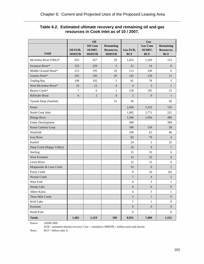
Chapter 6: Current and Projected Uses of the Proposed Leasing Area
101
Table 6.2. Estimated ultimate recovery and remaining oil and gas resources in Cook Inlet as of 10 / 2007.
Oil Gas Oil Cum Remaining Gas Cum Remaining Oil EUR. 10/2007, Resources, Gas EUR, 10/2007, Resources,
Field MMSTB MMSTB MMSTB BCF BCF BCF
McArthur River (TBU)* 655 627 29 1,452 1,329 123
Swanson River* 232 229 3 22 14 8
Middle Ground Shoal* 213 195 18 115 109 6 Granite Point* 165 145 20 142 130 11
Trading Bay 108 102 5 81 78 3
West McArthur River* 16 12 4 4 3 1
Beaver Creek* 7 6 1 218 195 23 ReDoubt Shoal 6 2 4 2 0 1
Tyonek Deep (Sunfish) 25 30 30
Kenai 2,458 2,332 126
North Cook Inlet 1,992 1,771 221
Beluga River 1,546 1,056 490
Under Development 389 389 Kenai Cannery Loop 186 159 28
Ninilchik 109 63 46
Ivan River 83 79 4
Kasilof 24 2 22 Deep Creek (Happy Valley) 16 9 7
Sterling 15 10 6
West Foreland 14 10 4
Lewis River 12 12 0 Moquawkie & Lone Creek 10 9 1
Pretty Creek 9 10 (0)
Nicolai Creek 7 4 2 West Fork 6 5 1
Stump Lake 6 6 0
Albert Kaloa 4 3 1
Three Mile Creek 2 1 0 Wolf Lake 1 1 0
Kustatan 0 0 0
North Fork 0 - 0
Totals 1,402 1,319 109 8,955 7,400 1,555
Source: ADNR 2009
Notes: EUR = estimated ultimate recovery; Cum = cumulative; MMSTB = million stock tank barrels; BCF = billion cubic ft.

Chapter 6: Current and Projected Uses of the Proposed Leasing Area
102
Various attempts have been made since the 1990s to develop coal bed methane (CBM) resources in the Mat-Su Borough (ADNR 2009). In 1994, the Division of Oil and Gas drilled Alaska’s first coal bed methane well, AK-94-CBM-1, near Wasilla. In 1998, the first commercial drilling for CBM occurred north of the proposed lease area near Houston by Growth Resources Inc. of Australia. Subsequently, Ocean Energy Resources Inc. drilled two CBM wells, and Evergreen Resources, Inc. drilled and set casing on eight wells in the area. Between December 2003 and May 2004, Evergreen made a second attempt to understand the CBM potential in the area by completing a five hole mineral exploration core drilling program. Later in 2004 Evergreen Resources Alaska (Evergreen) was merged into Pioneer Natural Resources Alaska, Inc. In September, 2005, at Pioneer Natural Resources request, the DO&G approved the termination of the Pioneer Unit and accepted the surrender of all Pioneer Unit leases (ADNR 2009). Recreation Recreation activities in the vicinity of the proposed lease area include hunting and fishing, trapping, boating, camping, hiking, and ATV and snow machine use. Some of these activities take place within, or use facilities in, state recreation areas. Others are more dispersed in nature, using air and boat access in the summer, and snow machine access in the winter. Hunting and Fishing Hunting and fishing are important recreational activities in the proposed lease area. Game harvest data collected by the ADF&G for Game Management Unit 16B, which includes Skwentna, Tyonek, and the Western Cook Inlet area, are presented in Chapter 5: Habitat, Fish, and Wildlife. Waterfowl hunting and furbearer trapping may also occur in the proposed lease area. In September, 2007 a trapping cabin construction permit was issued for section 30, T20N, R13W, SM. Additional information is presented above in Fish and Wildlife Uses and Value. Talachulitna State Recreation River The Talachulitna River is located approximately eight miles east of the proposed lease area, and several tributaries of the Talachulitna River, including Deep Creek and Thursday Creek extend to within about two miles of the proposed lease area boundary. The Susitna Basin Recreation Rivers Management Plan (ADNR 1991) designated 64.5 miles of the Talachulitna River and 22 miles of Talachulitna Creek as State Recreation Rivers pursuant to the Recreation Rivers Act of 1988 (AS 41.23.400-510). The act establishes mile-wide river corridors along the designated rivers and outlines long-term management strategies on surrounding state-owned lands. The Susitna Basin Recreation Rivers Management Plan (ADNR 1991) describes the Talachulitna River as follows: “The Talachulitna River begins in the Beluga Mountains and runs 65 miles to join the Skwentna River. Talachulitna Creek is the main tributary of the Talachulitna River. The lower half-mile of the following major tributaries are also included in the Recreation River: Grayling, Friday, Deep, and Thursday creeks. The management unit also includes about 3 miles of the Skwentna River. Important lakes include Judd, Talachulitna, and Wolf lakes. The clear water of Talachulitna Creek, good views of the Alaska Range and Beluga Mountain, and the steep-walled

Chapter 6: Current and Projected Uses of the Proposed Leasing Area
103
canyon of the Talachulitna River make this unit very scenic. The limited number of man-made improvements detract only slightly from the visual character.” Peaks in recreation and fishing activity on the Talachulitna River correspond with the king and coho salmon runs. These are approximately June 20 to July 4, and August 1 to August 21, respectively. The more popular fishing areas are the mouth, tributary junctions, the confluence with Talachulitna Creek, and the outlet of Judd Lake. Boats used on the river include canoes, kayaks, and rafts. Powerboats are prohibited on portions of the river between June 15 and August 20 (ADNR 1991). Float trips typically start at Judd Lake and end at the Skwentna River. Winter travel is limited primarily to local residents because of the area's distance from the railbelt. Trails There are no roads or named trails within the proposed lease area. The Beluga Indian Trail traverses north-south approximately six miles east of the leasing area. The Iditarod National Historic Trail crosses the Skwentna River approximately ten miles east (downstream) of the proposed lease area, near the Old Skwentna Roadhouse in T21N, R11W. The trail then continues along the north bank of the Skwentna River approximately five miles north of the proposed lease area. Most of the National Historic Trail is usable only during winter, when rivers and wetlands are frozen. Aside from the annual sled dog race, use of the Iditarod Trail is primarily recreational (e.g., ATV, snowmachining, cross-country skiing). The proposed lease area may include recreational trails to support dog sledding, skiing, snowmachining, all-terrain vehicle (ATV) riding, hiking, and canoeing. These trails are “unofficial,” and do not have easements. However, they may be important to trail users. References ADF&G (Alaska Department of Fish and Game) 1988. “Susitna Flats State Game Refuge Management Plan.” Prepared by the Divisions of Habitat and Game. March 1988, Anchorage.
ADF&G (Alaska Department of Fish and Game) 2006. Our wealth maintained: A strategy for conserving Alaska's diverse wildlife and fish resources. Alaska Department of Fish and Game, Juneau, Alaska. xviii+824p. http://www.sf.adfg.state.ak.us/statewide/ngplan/files/cover_and_acknowl.pdf
ADF&G (Alaska Department of Fish and Game) 2011a. “Invasive Pike in Southcentral Alaska, Overview.” http://www.adfg.alaska.gov/index.cfm?adfg=invasivepike.main
ADF&G (Alaska Department of Fish and Game) 2012. Canyon Creek Coal Best Interest Finding, Agency Comments. Habitat Case No. FH-12-IV-0073. April 2, 2012.
ADNR (Alaska Department of Natural Resources). 1991. “Susitna Basin Recreation Rivers Management Plan.” Division of Land and Water. Lands and Resources Section.
ADNR (Alaska Department of Natural Resources) 2009. Cook Inlet areawide oil and gas lease sale: Final finding of the Director. January 20, 2009.

Chapter 6: Current and Projected Uses of the Proposed Leasing Area
104
ADNR (Alaska Department of Natural Resources) 2012 - Information Resource Management Section. Alaska DNR Surface Water Rights and Subsurface Water Rights. Geospatial_Data_Presentation_Form: vector digital data.
Carter, Lorali. 2010. “Usibelli Coal Mine, Inc. Wishbone Hill Project Overview.” Lorali Carter, External Affairs Manager. Wishbone Hill Project. 27 October 2010. www.legis.state.ak.us/basis/get_documents.asp?session=26&docid=8597
Chuitna Coal Project 2011. Chuitna Coal Project SEIS, Current Project Description. Pacrim Coal. April 2011. http://www.chuitnaseis.com/documents/Current-Project-Description.pdf
DOF (Division of Forestry) 2006. 2006 annual report. Division of Forestry, Alaska Department of Natural Resources. http://forestry.alaska.gov/pdfs/07DOF2006report.pdf
DOF (Division of Forestry) 2007. Mat-Su Area and Kenai-Kodiak Area five-year schedule of timber sales CY 2007-2011. Division of Forestry, Alaska Department of Natural Resources. http://forestry.alaska.gov/pdfs/07MatSuKenaiFYSTS07092007.pdf
DOF (Division of Forestry) 2009. 2009 annual report. Division of Forestry, Alaska Department of Natural Resources. http://forestry.alaska.gov/pdfs/2009AnnualReport.pdf
DOF (Division of Forestry) Mat-Su Area and Kenai-Kodiak Area 2011. Five-Year Schedule of Timber Sales CY 2011-2015. Michael J. Curran, Regional Forester. State of Alaska Department of Natural Resources.
Hall, J.D., 1995. Overview of Environmental and Hydrologic Conditions at Lake Minchumina and Skwentna, Alaska. U.S. Geological Survey Open File Report 95-438, prepared in cooperation with the Federal Aviation Administration, Anchorage, Alaska.
Johnson, J. and Blanche, P. 2011. Catalog of Waters Important for Spawning, Rearing, or Migration of Anadromous Fishes- Southcentral Region, Effective June 1, 2011. Alaska Department of Fish and Game, Division of Sport Fish and Habitat. Special Publication 11-06.
Kavalok, T. 2004. Unit 16 furbearer management report. Pages 193–212 in C. Brown (ed.). Furbearer management report of survey and inventory activities, 1 July 2000–30 June 2003. Alaska Department of Fish and Game, Juneau.
Kiska Metals 2012. Whistler Project, project overview. accessed 18 April 2012 <http://www.kiskametals.com/s/Whistler.asp?ReportID=370036>
Metiva, M. and Hanson, D. 2008. Mat-Su Comprehensive Economic Development Strategy, December 2008 Update. Alaska Department of Commerce, Community, and Economic Development, Alaska Regional Development Organizations Program, and Matanuska-Susitna Borough.
MMS (Minerals Management Service) 1995. Cook Inlet Planning Area Oil and Gas Lease Sale 149, Final Environmental Impact Statement. OCS EIS/EA MMS 95-0066.
Oslund, S. and Ivey, S. 2010. Recreational Fisheries of Northern Cook Inlet, 2009-2010: Report to the Alaska Board of Fisheries, February 2011. Alaska Department of Fish and Game, Fishery Management Report No. 10-50, Anchorage.

Chapter 6: Current and Projected Uses of the Proposed Leasing Area
105
Peltier, T. 2007. Unit 16 furbearer. Pages 177-196 in P. Harper, editor. Furbearer management report of survey and inventory activities 1 July 2003-30 June 2006. Alaska Department of Fish and Game. Proj 7.0. Juneau, Alaska.
Peltier, T. 2008. Unit 16 black bear management report. Pages 187-198 in P. Harper, editor. Black bear management report of survey and inventory activities 1 July 2004-30 June 2007. Alaska Department of Fish and Game. Proj 17.0. Juneau, Alaska.
Peltier, T. 2009. Unit 16 brown bear management report. Pages 168-178 in P. Harper, editor. Brown bear management report of survey and inventory activities 1 July 2006-30 June 2008. Alaska Department of Fish and Game. Juneau, Alaska.
Peltier, T.C. 2010. Unit 16B moose management report. Pages 235-247 in P. Harper, editor. Moose management report of survey and inventory activities 1 July 2007-30 June 2009. Alaska Department of Fish and Game. Project 1.0. Juneau, Alaska.
Stanek, R.T., Holen, D.L., and Wassillie, C. 2007. Harvest and Uses of Wild Resources in Tyonek and Beluga, Alaska, 2005-2006. Alaska Department of Fish and Game, Division of Subsistence, Technical Paper No. 321, Juneau.
STB (Surface Transportation Board) 2011. Alaska Railroad Corporation Construction and Operation of a Rail Line Extension to Point Mackenzie, Alaska, Final Environmental Impact Statement. Docket No. FD 3509. Served on Parties and Delivered to U.S. EPA: March 25, 2011.
Szumigala, D.J., Hughes, R.A., and Harbo, L.A., 2008, “Alaska's mineral industry 2007: Alaska Division of Geological & Geophysical Surveys Special Report 62.” 89 p.
Szumigala, D.J., Harbo, L.A., and Hughes, R.A., 2010, “Alaska's mineral industry 2009: Alaska Division of Geological & Geophysical Surveys Special Report 64.” 81 p.
U.S. Army Corps of Engineers, 1993. Alaskan communities-Flood hazard data: U.S. Army Corps of Engineers, Alaska District, 335 p.

Chapter 7: Coal Transportation
106
Chapter 7: Coal Transportation
Potential Transportation Routes If coal were to be mined from the proposed lease area, it would have to be transported from the mine site to a shipping facility at tidewater, to the Parks Highway, or to the Alaska Railroad adjacent to the Parks Highway. No mine project or transportation routes have been proposed at this time, so coal transportation cannot be discussed in detail. AS 38.05.035 (e)(1)(A) states that the director’s written finding “shall establish the scope of the administrative review on which the director's determination is based, and the scope of the written finding supporting that determination; the scope of the administrative review and finding may address only reasonably foreseeable, significant effects of the uses proposed to be authorized by the disposal” Under AS 38.05.035 (h) in a written finding under AS 38.05.035 (e)(1) the director may not be required to speculate about possible future effects subject to future permitting that cannot reasonably be determined until the project or proposed use for which a written best interest finding is required is more specifically defined, including speculation about (1) the exact location and size of an ultimate use and related facilities; and (2) …the economic feasibility of ultimate development. Under the Alaska Surface Coal Mining Reclamation and Control Act (ASCMCRA) all future coal exploration, development, mining, and reclamation activities must be subjected to public notice and comment, and permitted under the ASCMCRA. The actual transportation route or mode of transport cannot be predicted with any level of certainty at this time. This chapter therefore will only discuss potential coal transportation in general terms. There are several possible routes and modes of coal transport. The nearest tidewater shipping location is the Tyonek/Ladd Landing area, approximately 50 miles south-southeast of the proposed coal leasing area. Ladd Landing is a few miles north of Tyonek on Cook Inlet, and is the proposed shipping point for the Chuitna Coal Project. The community of Beluga also lies eight miles northeast of Tyonek, and is connected to Tyonek and Ladd Landing by road. Chugach Electric Association has a gas-fired power plant at Beluga, and it is the proposed initiation point for the gas line to the Donlin Gold Project in southwest Alaska. A transportation route south to the Tyonek/Ladd Landing area would need to avoid the large wetlands area around the headwaters of the Talachulitna River and between Beluga Lake and Little Susitna Mountain. The route could pass to the west of the wetlands by Judd, Coal Creek, and Beluga Lakes, or it could go down the west side of Beluga and Little Susitna Mountains. Any transportation route south toward Tyonek would have to cross the Talachulitna State Recreation River. (See Planning and Classification/Susitna Basin Recreation Rivers Management Plan, in Chapter 2: Description) An alternative route would be to transport the coal to Port MacKenzie, or possibly to a point along the proposed Port MacKenzie Rail Extension. A route into the Port MacKenzie area would be roughly 60-70 miles long, and would require crossing the Talachulitna and Susitna Rivers. Other streams that might have to be crossed include Alexander Creek State Recreation River, and the Yentna and Little Susitna Rivers. One logical route to the Point MacKenzie area

Chapter 7: Coal Transportation
107
would generally track east from the proposed lease sale area across the Talachulitna River to the north end of Beluga Mountain, then along the east flank of Beluga and Susitna Mountains to near the Susitna River. The route would likely cross the Susitna River near the community of Susitna, then pick a route over the highest ground into the Point MacKenzie area. Such a route would pass to the north of the Susitna Flats State Game Refuge. Transportation to the Parks Highway/Alaska Railroad corridor would be similar to the Port MacKenzie route. Most of the land around the proposed lease area and south as far as the southern boundary of T17N is owned by the State. Further south any route to the Tyonek/Ladd Landing area would cross a mixture of native and Mental Health Trust land. There is also borough and private land in the area, including around Ladd Landing. Any route toward the Port Mackenzie area would probably cross areas of borough, University, private, and Mental Health Trust land beginning near the Susitna River. Access arrangements would have to be made with all non-state landowners. Modes of Coal Transportation Possible modes of coal transport include: conveyor system, slurry pipeline, railroad, and truck road. Port facilities would also be required for shipping to overseas markets. Since no mine plan or transportation routes and facilities have been presented, they cannot be discussed in detail at this time. The ASCMCRA applies to all transportation facilities needed to transport coal from the mine site to a public shipping facility. Under 11 AAC 90.155 Facilities Outside Permit Area, a permit is required for all roads, transportation, support facilities and utility installations included in 11 AAC 90.491, whether or not these facilities are outside the permit area of any particular mine. Regulation 11 AAC 90.491 includes the following facilities: roads, railroad loops, spurs, sidings, surface conveyor systems, chutes, aerial tramways, airfields, ports, docks, or other transportation facilities, mine buildings, coal loading facilities at or near the minesite, coal storage facilities, storage facilities, fan buildings, hoist buildings, preparation plants, sheds, shops, and other support facilities. These facilities must comply with all performance standards of 11 AAC 90 determined to be applicable by the commissioner, and must comply with the appropriate bonding provisions of 11 AAC 90.201 - 11 AAC 90.207. In determining which requirements of 11 AAC 90 are applicable, the commissioner will consider whether any given facility may be subject to the requirements of some other government permitting authority. In the event that a port facility is needed to be built, the ASCMCRA covers the port facility as well. In Alaska Supreme Court Case Trustees for Alaska v. Gorsuch the court found that the above regulation required that all facilities used by a coal mining operation up to a public conveyance or point of sale to another distinct entity must be covered by a coal permit. (http://www.touchngo.com/sp/html/sp-3879.htm) The modes of transport listed above are described briefly below. These descriptions are not intended as a plan of transport for coal from the Canyon Creek area.
Chapter 7: Coal Transportation
108
Conveyor Systems Long distance conveyor systems usually consist of one or more continuously cycling conveyor belts suspended on and driven by rollers. The system is either supported by a continuous framework along the ground or suspended between towers at intervals along its length. Electrical power and motors are needed for each section, or lift, of conveyor. There is often a road associated with the conveyor for maintenance and carrying supplies. The combination of the conveyor, road, and associated facilities creates a considerable linear ground disturbance. The longest conveyor system in the world transports phosphates from mines at Bu Craa, Western Sahara, to the Atlantic coast, a distance of 62.1 miles covered in 11 flights. The conveyor is 39.4 inches (1 meter) wide, with a capacity of 2,400 tons per hour. A 31.7-mile conveyor system transports bauxite (aluminum ore) from mines near Boddington, Western Australia, to Worsley Alumina Refinery at Worsley. That conveyor system is constructed in two flights, and has a 35.4- inch wide belt with a capacity of 3,030 tons per hour. (Fredericksen, 2009)
In recent years a new conveyor technology has been developed and patented by the Doppelmayr/Garaventa Group. The system is called RopeCon, and is a combination of rope (steel cable) and conveyor technologies. In the RopeCon system a conveyor belt is carried along steel “ropes” suspended between widely spaced support towers. The system employs two track ropes each in both the upper and lower belts via running wheels attached to the belt. There are support frames every 6 to12 meters along the system to maintain the position of the track ropes between towers and to maintain the spacing between the upper and lower belts. The frames also help stabilize the system in high winds. The conveyor has sidewalls to contain the transported material, and can be covered as well. When the conveyor reaches its destination it flips upside down for the return trip, preventing spillage of any material remaining on the belt. (Kessler, 2006)
The RopeCon type system has several advantages:
• Ground disturbance is minimal. • The system does not require a maintenance road. • Energy consumption is less than that for conventional conveyor systems. • It can be used to span terrain obstacles, such as rivers, with minimal
environmental disruption. • According to Doppelmayr, RopeCon can traverse up to 20 km in a single lift.
A number of RopeCon conveyor systems have been built around the world. To date, the longest systems are about 3.5 km. The Berber Cement RopeCon, in Sudan, Africa, transports limestone 3.465 km across the Nile River. In Jamaica, the Mt. Olyphant RopeCon carries bauxite (aluminum ore) a distance of 3.4 km. In 2007 this conveyor survived the category 4 hurricane Dean. The Jamaican system has a vertical drop of 470 m. The energy release from braking the downhill transport is used to generate 1,300 kw of electrical power, which is supplied to the local power grid. (http://www.doppelmayr-mts.com/en/doppelmayr-transport-technology/projects.html?country=all )

Chapter 7: Coal Transportation
109
The Chuitna Coal Project, which lies 12 miles from Cook Inlet in the Beluga Coal Field, proposes to transport coal to tidewater at Ladd Landing via a 12-mile RopeCon system. Although not yet built, the RopeCon conveyor has been designed by Doppelmayr engineers. The proposed conveyor will have a capacity to move 15 to 18 million tons of coal per year. The system is to be elevated a minimum of 20 feet above ground level, so as not to create a barrier to wildlife or recreational users. Tower structures to carry the conveyor will be between 60 and 100 feet tall, and spaced 1,200 feet apart. The conveyor belt itself will be three-sided with a cover to protect the coal from precipitation and wind. (Chuitna Coal Project SEIS – Current Project overview. http://www.chuitnaseis.com/documents/Chuitna-Coal-Project-Current-Project-Overview.pdf)
Coal Pipelines There are two types of coal pipelines, conventional slurry pipelines and coal log pipelines. Slurry pipelines involve the pumping of finely ground coal suspended in water or some other liquid medium through a pipe over a long distance. The process involves three major stages: 1) grinding the coal and mixing it with a liquid (generally water) to form the slurry, 2) transmission through the pipeline, and 3) dewatering the coal for use or for transloading to another mode of transportation. The slurry travels at a velocity just under 6 feet per second, but the precise speed also depends on the coal particle size distribution, pipe diameter, and other economic factors. Once started, the flow must continue uninterrupted, or the coal will gradually settle and possibly plug the pipe. Restarting the flow can be difficult. (National Technical Information Service, 1978) Facilities for a coal slurry pipeline include:
• Slurry preparation and watering equipment o Water facilities – extraction facilities from surface water sources or wells for
subsurface water, piping, pumps o Crushing, mixing and agitation equipment, and agitated tanks for storage
• Pipeline • Pump stations and electric power • Lined ponds • Dewatering equipment
o Mixing tanks, screens, centrifuges, flocculation tanks, water treatment facilities • Coal handling and shipping facilities • Power source
Approximately one ton of water is needed to transport one ton of coal through a slurry pipeline (Cox, 1983). That figure equates to a requirement of approximately 765 acre-feet of water to transport one million tons of coal. As an example, a ten million ton per year mine would therefore require roughly 7,650 acre-feet of water per year. Almost any type of water can be used in a slurry pipeline. Potential sources for slurry water in Alaska are surface waters, groundwater, or saline groundwater. The use of saline groundwater would eliminate the effects of using surface or potable groundwater. In addition, water usage could be reduced substantially if a return pipeline were built to recycle slurry water. Not all water could be recovered and recycled, however, since the coal is not completely dried in the dewatering process.

Chapter 7: Coal Transportation
110
If it were not recycled through a return pipeline, used water would have to be treated before it could be discharged to the environment. Cleaning would involve removing particulates, as well as any trace metals and sulfur leached from the coal. The degree of cleaning would depend on the final disposition of the waste water, but would have to satisfy all applicable water quality standards. Slurry water might be disposed of through injection into saline aquifers, in which case the injection wells would be regulated by the EPA as Class II injector wells. If a coal slurry pipeline transported coal to tidewater, discharge might be to the ocean. Any coal pipeline would be buried over most of its length. Although there would be a short term habitat disruption and obstacle to wildlife, there would be no long term disruption over most of the pipeline length. After the pipeline was in place the surface would be recontoured and revegetated according to the performance standards in the ASCMCRA (See Chapter 10: Potential Measures to Avoid, Minimize, and Mitigate Negative Impacts; Habitat Restoration). A potential economic advantage of coal pipelines is that the volume of coal that can pass through a pipeline increases approximately as the square of the pipeline diameter, while construction, power, and other operating costs do not rise proportionately (National Technical Information Service, 1978). Coal pipelines also have an advantage relative to railroads because they can be built on steeper grades. Coal pipelines can be built at up to 16 percent grades, whereas railroads are generally limited to grades of about 1 percent. As a result, pipelines should be able to take a less circuitous route, causing a smaller area of surface disruption, and requiring less cut and fill work. (National Technical Information Service, 1978) There are no coal pipelines currently operating anywhere in the world. However, there are more than 30 slurry pipeline systems in the world that transport copper, iron and zinc concentrates, limestone and phosphate (Marrero, 2000). Two coal slurry pipelines have operated in the U. S. in the past. The Black Mesa Pipeline transported coal from the Black Mesa Coal Mine, in Kayenta County, Arizona to the Mohave Generating Station at Laughlin, Nevada, a distance of 273 miles. The pipe diameter was 18 inches, and throughput was 4.8 million tons of coal per year. The pipeline was built in 1970, and continued operation until the Mohave Generating Station was shut down in 2005 due to the costs of meeting air quality standards. The black mesa pipeline experienced two spills in 12 years of operation. The first rupture spilled 1,200 tons of coal; the second spilled 100 tons. The 1,200-ton spill was never cleaned up because it was determined that the cleanup would cause more environmental damage than leaving the coal slurry in place. Five months after the spill 80 percent of the coal had been dispersed naturally. (National Technical Information Service, 1978, and Center for Land Use Interpretation, http://ludb.clui.org/ex/i/AZ3134/) The Black Mesa Pipeline used approximately 3,100 acre feet of water per year. The water was supplied from wells in the Navajo aquifer, underlying Black Mesa. (Surface Mining Reclamation and Enforcement Office, 2004) There were complaints that the water use affected groundwater sources as far as 50 miles away (Center for Land Use Interpretation, http://ludb.clui.org/ex/i/AZ3134/) . The other pipeline that operated in the United States was a 10-inch, 108 mile-long pipeline linking the Hanna Coal Company Georgetown preparation plant near Cadiz, Ohio with the

Chapter 7: Coal Transportation
111
Cleveland Electric Illuminating Company Eastlake Generating Station in Eastlake, Ohio. The pipeline began operation in 1957, and supplied about six million tons of coal to the power station before shutting down in 1963. The pipeline was shut down because railroad costs became cheaper, and because the water could not be returned to the Ohio River. Coal log pipelines are a relatively new technology, and none have ever operated commercially. The technology was researched by the Capsule Pipeline Research Center at the University of Missouri in the 1980s, 90s and early 2000s. Engineering staff at the University and one private company continue to study hydraulic pipelines to transport various types of freight, including coal. (Marrero, 2012) In order to transport coal through a coal log pipeline the coal is first compressed into “logs” with a length to diameter ration in the range of 1.5-2.0. The log diameter is approximately 0.9 times the diameter of the pipe. Logs are prepared using a compaction pressure of approximately 18,000 psi, and either heating the coal or using a binder. The logs are transported through the pipeline suspended by water. Reduced water consumption is a major advantage of coal log technology over a coal slurry pipeline. While the slurry pipeline requires 50 percent water, 50 percent coal by weight, the coal log pipeline uses 70 per cent coal and 30 per cent water by weight. (Liu, 2006) Unit Trains Unit trains are complete trains of dedicated cars operating on a regular schedule between a single origin and a single destination. This is in contrast with ordinary railroads in which many commodities are combined and recombined in one train as they are transported from many origins to many destinations. The unit train takes advantage of scale economies carrying a single commodity between two points in sufficient quantities to achieve cost savings. The cars are designed for automated loading and unloading, and the train is operated according to procedures which avoid switching and time consuming delays in freight yards. A typical coal unit train consists of six locomotives and 100 hopper cars with carrying capacities of 100 tons each. Roughly two such trains per week are therefore required to deliver one million tons of coal per year. Speeds vary, but are generally 20 to 50 miles per hour, depending on track conditions. (National Technical Information Service, 1978) Unit train facilities include:
• Track and associated facilities • Loading and unloading facilities at the mine and port • Locomotive engines • Coal cars
Unit trains may or may not be cost competitive with other methods of transport such as slurry pipelines, conveyor systems or roads (National Technical Information Service, 1978, and Cox, 1983). The Alaska Railroad Corporation’s proposed Point MacKenzie Rail Extension is similar in scope to a possible unit train from Canyon Creek to tidewater. The ARRC is proposing a 200 foot

Chapter 7: Coal Transportation
112
right-of-way (ROW) for the Point MacKenzie Extension. The length of a unit railroad to haul coal from the Canyon Creek area would, of course, depend on the route chosen. Steeper terrain would require that the route be more circuitous, and therefore require a greater amount of either fill or cut and fill during rail line construction than flatter terrain. A 200 foot ROW over a route length of 50 miles would occupy approximately 1,200 acres, although not all of the ROW would be disturbed by the railroad. Habitat alteration would be an issue during construction of a railroad. Areas of concern include:
• Streams, lakes, wetlands, and other water resources • Air quality • Vegetation • Wildlife • Fisheries
Potential impacts to water resources could result from clearing and grading; the excavation of fill material; construction of bridges and culverts; and use of transportation and staging areas. Potential impacts to surface waters from a rail line might include: changes to natural drainage and altered flood hydraulics near crossings; increased potential for debris jams and overbank flooding upstream of water crossings; and reduced floodplain area. If portions of the rail line were within a 100-year floodplain they would require fill placement and could reduce floodplain volume, constrict flood flow paths, and increase floodwater elevation upstream of the restricted floodplain area. Water crossings should be sized to convey the 100-year flow event. For larger stream and river crossings, bridges should be constructed as single- or multiple-span structures that would either completely or partially span the active river channel.
Rail line construction would directly affect wetlands within the rail line footprint and could also indirectly affect wetlands adjacent to and within the ROW by fragmenting wetland vegetation and hydrology. Rail line construction would likely require some degree of clearing, excavation, and placement of fill material in wetlands. Any railroad should be planned to minimize the crossing of wetlands.
The EPA national ambient air quality standards (NAAQS) regulations specify the maximum acceptable ambient concentration level for 6 primary or “criteria” air pollutants – ozone, nitrogen dioxide, carbon monoxide, sulfur dioxide, respirable particulate matter, and lead. The Alaska Department of Conservation (ADEC) has adopted the same standards for Alaska. For the proposed Port MacKenzie Rail Extension from Houston to Port MacKenzie, the OEA Office of Environmental Analysis (OEA, the environmental staff for the Surface Transportation Board.) estimated construction and operation emissions for the longest potential alternative, the 46-mile Mac West-Connector 1-Willow Alternative, and for the maximum average train length of 80 cars. OEA found that the estimated emissions of all criteria pollutants from construction and operation of the proposed rail line would be below the de minimis conformity thresholds established for each pollutant. To avoid or minimize the potential environmental impacts OEA is recommending requiring minimization of fugitive dust and construction-related emissions.
Chapter 7: Coal Transportation
113
The primary effects of railroad construction and operation to vegetation would be the destruction of vegetation cover and the replacement of some cover with gravel fill. Vegetation clearing would result in a long-term impact for forest communities, even with restoration, especially for late-succession forests and wetlands that would be slow to recover. In riparian areas the succession from bare alluvium to mature white spruce dominant forest may take over 190 years (See Chapter 5: Habitat, Fish, and Wildlife). Potential impacts to vegetation resources could also include altered vegetation communities due to soil compaction, the spread of invasive plant species, and altered vegetation succession caused by changes in fire cycles. Potential mitigation measures include minimization of ground disturbance and vegetation clearing, development and implementation of a nonnative invasive species control plan, and development of a restoration and revegetation plan for disturbed areas. The potential effects of railroad construction and operation on wildlife would be influenced by ecology and life history, the animals’ dependence on specific habitats, the availability of preferred and used habitats, the amount of preferred habitat the project would affect, and past and present population trends. Potential Construction impacts could include habitat alteration and loss, disturbance and displacement of wildlife, and direct mortality from construction vehicles and equipment. Common potential impacts related to the operation of a rail line include moose-train collision mortality, habitat fragmentation, and potential exposure to spills of toxic materials.
Habitat fragmentation occurs when large areas of contiguous core habitat are split into smaller pieces, thereby increasing the amount of habitat edge or the area where one habitat is bordered by a differing habitat. Habitat fragmentation can adversely affect wildlife by creating barriers to movement, leading to edge effects, reducing core areas of available habitats, facilitating predator movements, and increasing the intrusion of invasive species and humans. Construction of a rail line would require multiple stream crossings at locations that have fish or fish habitat. Project construction methods and timing, the type of stream crossing structures installed, and daily operation procedures would influence the severity and types of potential impacts to fish and fish habitat at each stream crossing. The more important potential impacts of crossing structures to fish and fish habitat would be loss and degradation of instream habitats due to placement of structures, alteration of stream hydrology and water quality, and blockage of fish movements. Potential measures to mitigate negative effects of constructing and operating a rail line on fish and wildlife include:
• Designing the rail line to minimize impacts to habitat areas • Implementing a strategy to reduce the moose-train collision mortality rate • Minimizing disturbance to migratory birds and bald eagle nests • Development of preferred habitat away from any rail line • Maintenance of natural water flow and drainage by installing appropriate bridges and
equalization culverts • Inspections of culverts to ensure fish passage
Chapter 7: Coal Transportation
114
• Limitation of construction in anadromous streams during low-flow conditions and following ADF&G timing recommendations
• Removal of debris from wetlands and waters at rail line crossings Truck Road A coal mine in the Canyon Creek area would require either a road or railroad for delivery of supplies, materials, and equipment. The road could also be used to truck coal from the mine to tidewater for shipping. The effects of a road would be similar to those of a railroad. Because of less restrictive grade requirements for roads, a road might take a shorter route between a mine and tidewater than a railroad. Through the life of the road traffic would cause more dust than a railroad. Regulation 11 AAC 90.421 regulates dust control and stipulates that the operation must comply with all state and federal air quality laws and regulations. The road might be reclaimed after mining had ceased, or maintained for local access, depending on the approved postmining land use. There are currently two examples of roads servicing large mines in Alaska, the Red Dog Mine road and the Pogo Mine road. The Red Dog Mine is a large, open-pit zinc-lead mine in the DeLong Mountains of northwestern Alaska. A 52-mile long, 30-foot wide all weather industrial haul road connects the mine to port facilities on the Chukchi Sea, about 12 miles south of Kivalina. The road and port facilities are part of the Delong Mountain Transportation System (DMTS), which is owned by the Alaska Industrial Development and Export Authority (AIDEA). The DMTS includes a shallow water dock, offshore conveyor concentrate loading facility, fuel distribution and storage systems, and other port facilities. Teck Alaska has contracted with AIDEA for a priority non-exclusive right to use the DMTS system until 2040 to ship ore concentrates over the road, store concentrates in the storage buildings, and transload concentrate onto ore ships. Lead and zinc concentrates are produced at the mine and hauled over the Red Dog Mine road year-round, and stored in two concentrate storage buildings at the port site for shipping during the three-month ice free summer season. Pogo is an underground gold mine located on state land 38 miles northeast of Delta Junction, and about 85 miles east of Fairbanks. The mine is supplied by a 49-mile all-weather road (the Shaw Creek Hillside All-Season Road) from Shaw Creek Road near the Richardson Highway. The road is an industrial haul road, and is access restricted. Road width is variable, with one-lane bridges and safety berms where needed. Grades are limited to 7%. At the close of the mine the first 23 miles of road will remain open for public use. The remaining 26 miles will be reclaimed along with the mine. Port Facilities The proposed Chuitna/Ladd Landing port facility is the best analogy to what might be needed for a Canyon Creek mine. The Ladd Landing facility is planned to have a logistics center, which will be the receiving, warehousing, and support facility for the Chuitna Coal Project, and a coal export terminal. The coal terminal will include facilities for receiving coal from the conveyor, storage, and transloading facilities to an offshore free-standing offshore shiploading berth. The proposed transloading facility at Ladd Landing would include a 10,000-foot elevated conveyor to the shipping berth similar to the design of the overland conveyor system. Conveyor towers are

Chapter 7: Coal Transportation
115
planned to be 1,100 feet apart. The offshore berth would have a 65-foot minimum draft capable of loading Cape-sized vessels (up to 160,000 MT). References Cox, Clara B., 1983. Comparing the Studies of a Coal Slurry Pipeline, Virginia Water Resources Research Center, Virginia Polytechnic Institute and State University, Special Report N. 17.
Fredericksen, Rick, 2009. Overland Conveyor Systems, http://dnr.alaska.gov/mlw/mining/largemine/chuitna/pdf/Conveyor_Systems_041708.pdf
Kessler, Franz, 2006. Recent Developments in the Field of Bulk Conveying, FME Transactions (2006) 34, 213-220).
Liu, Henry, 2006. Coal Pipelines – Slurry, Coal Log and Other Technologies. Lecture Presented at the Zeus Development Workshop on Lowest-Cost Coal Transport Technologies for CLT (Coal-to-Liquid) and IGCC (Integrated Gasification & Combined Cycle) Projects. http://www.syngasrefiner.com/ctl/pres/HenryLiu.pdf.
Marrero, Thomas, 2000. Transportation of Coal by Slurry Pipeline. Paper presented at the Seventeenth International Pittsburgh Coal Conference, Sept. 11-15, 2000, Pittsburgh, PA.
Marrero, Thomas, 2012. Professor, University of Missouri. Personal Communication.
National Technical Information Service (NTIS), 1978. A technology Assessment of Coal Slurry Pipelines. NTIS order #PB-278675 Congress of the United States Office of Technology Assessment.
Surface Mining Reclamation and Enforcement Office, 2004. Black Mesa and Kayenta Mines, Life-of-Mine Plans and Water Supply Project, Coconino, Navajo, and Mohave Counties, AZ, and Clark County, NV. Federal Register Notice, FR Doc. 04-26439.

Chapter 8: Hydrology, Ground and Surface Water
116
Chapter 8: Hydrology, Ground and Surface Water The proposed lease area lies entirely within the Lower Skwentna River Watershed, which is a subarea within the Susitna River Drainage Watershed (Figure 8-1). The proposed lease area includes streams, creeks, and several small lakes, many of which provide important habitat for fish and wildlife (see Chapter 5). Wetlands occur in the northern portion of the proposed lease area where low-lying landforms retard drainage and surface water flow. Elevations range from about 800 feet at the confluence of Canyon and Contact Creeks in section 29, T21N, R13W, to 2,500 feet in the southern portion of the proposed lease area, which includes rugged terrain along the eastern and southern flanks of Dickason Mountain. Surficial sediments in the area were deposited by glaciers and streams. Glacial drift is the primary deposit within the region and obscures most bedrock (Magoon et al. 1976; Reed and Nelson 1980; Hall 1995). Along creeks and stream banks, stream action has eroded the drift, replacing it with alluvial deposits or exposed bedrock (Magoon et al.1976; Reed and Nelson, 1980). Both the glacial drift and the alluvial deposits are derived from the bedrock of the Alaska Range (Hall 1995).
Climate and Precipitation Patterns The proposed lease area has a climate that is transitional between maritime and continental (Hartman and Johnson, 1984). The region experiences cool summers and moderately cold winters. There are no weather stations within the project area, but data are available from Skwentna, 18 miles to the northeast. The mean annual temperature at Skwentna is 32°F (0.2°C), but temperatures range from a July mean maximum of 69° F (20.8° C) to a January mean minimum of -2° F (-19.1°C) (Leslie, 1989). Mean annual precipitation is about 28.4 inches (720 mm); mean annual snowfall is about 9.5 feet (2,900 mm) (Leslie, 1989). Mean monthly and annual temperature, precipitation, and snowfall at Skwentna are summarized in Table 8.1. It should be noted that the elevation of Skwentna is only around 200 feet, considerably lower than that of the proposed lease area.
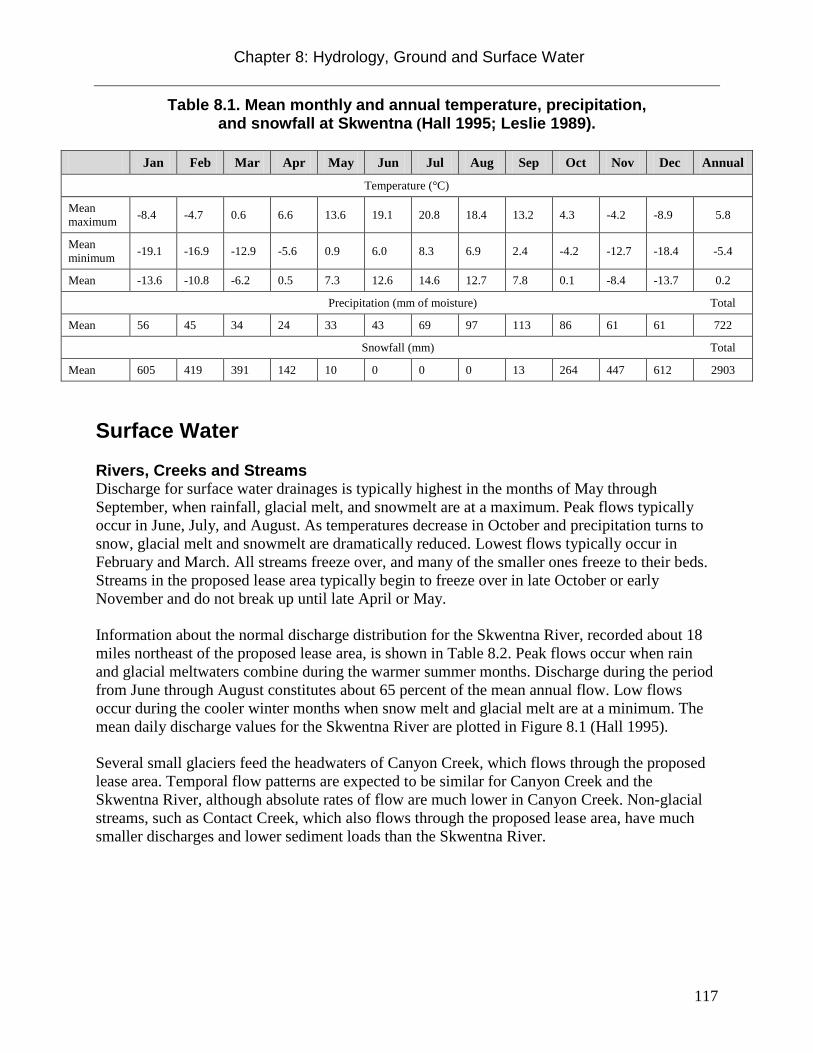
Chapter 8: Hydrology, Ground and Surface Water
117
Table 8.1. Mean monthly and annual temperature, precipitation, and snowfall at Skwentna (Hall 1995; Leslie 1989).
Jan Feb Mar Apr May Jun Jul Aug Sep Oct Nov Dec Annual
Temperature (°C)
Mean maximum -8.4 -4.7 0.6 6.6 13.6 19.1 20.8 18.4 13.2 4.3 -4.2 -8.9 5.8
Mean minimum -19.1 -16.9 -12.9 -5.6 0.9 6.0 8.3 6.9 2.4 -4.2 -12.7 -18.4 -5.4
Mean -13.6 -10.8 -6.2 0.5 7.3 12.6 14.6 12.7 7.8 0.1 -8.4 -13.7 0.2
Precipitation (mm of moisture) Total
Mean 56 45 34 24 33 43 69 97 113 86 61 61 722
Snowfall (mm) Total
Mean 605 419 391 142 10 0 0 0 13 264 447 612 2903
Surface Water Rivers, Creeks and Streams Discharge for surface water drainages is typically highest in the months of May through September, when rainfall, glacial melt, and snowmelt are at a maximum. Peak flows typically occur in June, July, and August. As temperatures decrease in October and precipitation turns to snow, glacial melt and snowmelt are dramatically reduced. Lowest flows typically occur in February and March. All streams freeze over, and many of the smaller ones freeze to their beds. Streams in the proposed lease area typically begin to freeze over in late October or early November and do not break up until late April or May. Information about the normal discharge distribution for the Skwentna River, recorded about 18 miles northeast of the proposed lease area, is shown in Table 8.2. Peak flows occur when rain and glacial meltwaters combine during the warmer summer months. Discharge during the period from June through August constitutes about 65 percent of the mean annual flow. Low flows occur during the cooler winter months when snow melt and glacial melt are at a minimum. The mean daily discharge values for the Skwentna River are plotted in Figure 8.1 (Hall 1995). Several small glaciers feed the headwaters of Canyon Creek, which flows through the proposed lease area. Temporal flow patterns are expected to be similar for Canyon Creek and the Skwentna River, although absolute rates of flow are much lower in Canyon Creek. Non-glacial streams, such as Contact Creek, which also flows through the proposed lease area, have much smaller discharges and lower sediment loads than the Skwentna River.

Chapter 8: Hydrology, Ground and Surface Water
118
Table 8.2.Monthly mean flow at USGS streamflow gaging station 15294300, Skwentna River near Skwentna (Hall 1995).
Jan Feb Mar Apr May Jun Jul Aug Sep Oct Nov Dec Annual
Data in cubic meters per second
Mean 31.7 27.0 23.7 31.0 244 538 500 380 240 128 55.1 37.6 187
Monthly Mean maximum
80.1 51.6 38.3 60.5 634 1040 811 571 429 205 119 81.3 285
Monthly Mean minimum
17.0 17.0 17.0 17.2 46.3 302 331 212 107 54.6 19.2 17.7 146
Figure 8.1 Mean daily discharge during the 1982 water year at USGS streamflow gaging station 15294300, Skwentna River near Skwentna (Hall 1995). Floods In 1986, heavy rain caused erosion of the banks of the Skwentna River, which destroyed two houses in Skwentna (U.S. Army Corps of Engineers 1993). During the peak of this flood, the discharge of the Skwentna River was about 2,000 cubic meters per second at the gaging station (Jones and Fahl, 1994). A flow of 2,000 cubic meters per second is equaled or exceeded an average of once every 100 to 200 years based on records through 1990 (Jones and Fahl 1994). This flood frequency, however, applies to rain and snowmelt runoff floods and is not applicable to ice-jam floods (Jones and Fahl 1994). Ice-jam flooding occurs when river ice broken during spring thaw is transported downstream, and its downstream movement is blocked by a constriction, sandbar, or other obstruction such as a sharp meander bend. The blockage prevents ice movement and restricts water flow as the ice jam builds in thickness and length. As the water velocity slows, it produces a rise in water level

Chapter 8: Hydrology, Ground and Surface Water
119
or backwater effect that propagates upstream from the ice jam. When the ice jam releases, a flood wave propagates downstream (Hall 1995). Ice-jam flooding could occur in any of the numerous meanders of the Skwentna River, and smaller ice jam floods are likely to occur in creeks and streams located within the proposed lease area. Lakes Several small lakes within the proposed lease area feed small streams and therefore contribute to their flow regulation. In addition, some lakes within the proposed lease area may be in communication with ground water (Hall 1995). There are no named lakes within the proposed lease area; Canyon Lake lies approximately two miles west of the northern lease area boundary, and Shell Lake lies approximately six miles to the northeast, across the Skwentna River. Other nearby lakes include Hiline Lake, Trinity Lake, and Judd Lake. Onestone Lake, Bob’s Lake, Hewitt Lake, and Whiskey Lake are located across the Skwentna River from the proposed lease area. The area also includes numerous smaller lakes and ponds. Watersheds, lakes and rivers around the proposed lease area are shown in Figure 8.2.

Chapter 8: Hydrology, Ground and Surface Water
120
Figure 8.2. Watersheds, Lakes and Rivers in the vicinity of the proposed lease area.

Chapter 8: Hydrology, Ground and Surface Water
121
Ground Water A large aquifer system is found beneath much of the Cook Inlet region including the northern portion of the proposed lease area (Figure 8.3). Ground water is also found in saturated fractures in the bedrock, and provides most of the water in streams in the proposed lease area during winter (Glass 1999). Aquifers are primarily situated within glacial till, glacial outwash, and fluvial deposits overlying sedimentary and low-grade metamorphic bedrock. Glacial deposit aquifers have been described as “irregular in distribution and highly variable both in composition and in their ability to provide water to wells” (Brabets 1999).
Figure 8.3. Location of Cook Inlet Aquifer System and location of wells sampled for USGS Water Quality Assessment Water-Resources Investigations Report 99-4116 (Glass 1999; Miller et al. 1997).

Chapter 8: Hydrology, Ground and Surface Water
122
Both confined and unconfined aquifers may be present within the proposed lease area. The upper ground water surface in an unconfined aquifer is the water table, which varies according to factors such as topography, geology, and seasonal and tidal effects. Unconfined aquifers are usually recharged by rain or stream water infiltrating directly through the overlying soil. Confined aquifers are permeable rock units overlain by relatively impermeable rock or clay that limits ground water movement into and out of the aquifer. These aquifers may be recharged by rain or stream water infiltrating the rock at a considerable distance from the aquifer. The ADNR Web-based Well Log Tracking System (WELTS) contains ground water data for all known water wells in the state. At present, there are more than 30,000 water-well logs in the database. The WELTS database shows that there are no known wells within townships and ranges included in the proposed lease area. However, data are available for the Skwentna School well, located on the north side of the Skwentna River, approximately 18 miles from the proposed lease area. The Skwentna School well was drilled in 1990 to a depth of 33 feet and provides drinking water to some water users within the community of Skwentna. The shallow depth of the Skwentna School well suggests that it draws water from an unconfined aquifer.
Local Water Supplies No public water supplies, water distribution systems, or wells are located within the proposed lease area. Public facilities such as the Skwentna School have wells and some of the population is believed to obtain water from wells (Hall 1995). Alternative sources of drinking water include streams and lakes, and are not publicly treated (U.S. Army Corps of Engineers 1993). Near Skwentna, glacial and alluvial surficial deposits overlie marine sedimentary bedrock, and are likely the primary aquifer. Ground water is an important source of drinking water near Skwentna and the Skwentna FAA facility (Hall 1995). Alternative sources of drinking water include surface-water sources. However, available data are inadequate to characterize the quantity or quality of these sources (Hall 1995).
Water Quality Water quality is variable within the project area. Precipitation in Alaska is typically free of contamination or impurities. As water from rain and snowmelt passes over and through vegetation, soils, and rocks, the water picks up soluble compounds and organic materials. Surface water consists of both direct runoff from precipitation and ground water discharge. During the winter, recharge from precipitation is almost non-existent; therefore most surface water flow during winter consists exclusively of ground water moving to the surface (Brabets et al. 1999). Ground water will typically have higher concentrations of dissolved compounds, but lower turbidity, than surface run off. Because of this, flowing streams will typically have high concentrations of dissolved compounds and low turbidity in the winter, and high turbidity but low concentrations of dissolved compounds in the summer. Naturally high turbidity is present in many Alaska rivers and streams due to the abundance of glacial silt.

Chapter 8: Hydrology, Ground and Surface Water
123
Lakes typically follow a different pattern. During freezing of the surface water, lake ice generally rejects dissolved compounds. This causes concentrations of dissolved compounds to become elevated in the remaining water. In addition, ice may prevent contact between water and air. As a result, bacteria that degrade organic matter in lakes may quickly deplete the dissolved oxygen, making the surface water sources anoxic, and adversely impacting water quality. As a result, smaller ponds and lakes may become unpotable during the winter. Nine surface-water samples were taken within ten km of the Skwentna FAA facility during a uranium reconnaissance of the Tyonek NTMS quadrangle (Jacobsen et al. 1979). Analyses of these surface-water samples established basic water-quality information such as pH and specific conductance, as well as the concentrations of several dissolved metals (Jacobsen et al. 1979). Concentrations of selected elements as well as water-quality data for these samples are summarized in Table 8.3. Additional information related to local water supplies is included in Chapter 6 of this document: Current and Projected Uses of the Permitting Area.
Table 8.3. Water-quality data from nine surface-water samples taken within 10 kilometers of the Skwentna FAA facility (from Jacobsen et al. 1979).
Constituent (or
property)
USEPA regulation
for drinking watera
Sample Number
49801 49802 49901 49902 49938 49939 49986 49987 50056
Chromium (Cr) (µg/L) 100b <25 <25 <25 <25 <25 <25 <25 <25 <25
Copper (Cu) (µg/L)
1,300c 27 16 22 20 5 9 47 41 13
Iron (Fe) (µg/L)
300d 2,396 431 5,614 6,014 5,499 25,902 14,153 13,054 546
Lead (Pb) (µg/L)
0.0c <200 <200 <200 <200 <200 <200 <200 <200 <200
Manganese (Mn) (µg/L)
50d 50 6 <25 <25 558 2,146 1,700 2,275 13
Nickel (Ni) (µg/L)
100b <25 <25 45 <25 <25 41 <25 <25 32
Zinc (Zn) (µg/L)
5,000d 55 <50 <50 51 69 68 <50 <50 <50
pH 6.5 -8.5d 6.0 5.8 5.6 5.6 5.5 5.7 5.4 5.5 7.0
specific conductance
(µS/cm) n.a. 14 8 22 307 27 167 164 138 16
a- from U.S. Environmental Protection Agency (1995). b- maximum contaminant level. c- maximum contaminant level goal. d- secondary maximum contaminant level.

Chapter 8: Hydrology, Ground and Surface Water
124
Iron concentrations less than 300 μg/L (0.3 mg/L) are preferred for public supply without treatment. The chronic aquatic toxicity level for total iron is 1,000 μg/L. Iron was present in concentrations that exceed these criteria in the surface water samples described in Table 8.3. Dissolved iron concentrations vary widely in ground water, and concentrations greater than 1,000 μg/L are common throughout the Cook Inlet Basin. In addition, manganese is common within ground water of the Cook Inlet Basin (USGS 2001). Manganese concentrations less than 50 μg/L (0.05 mg/L) are preferred for human consumption of water according to both state and federal water quality criteria (ADEC 2008; USEPA 1995). Manganese was present in concentrations that exceed these criteria in the surface water samples described in Table 8.3. Contaminated Sites No known contaminated sites are located within the proposed lease area. The Alaska Department of Environmental Conservation (ADEC) online databases were searched for incidents of “active” contaminated sites located near the proposed lease area (ADEC 2012). The search resulted in the identification of three active sites located adjacent to the Skwentna FAA facility. The anthropogenic contaminants present consisted of petroleum hydrocarbons and landfill leachate. Due to their distance from the proposed lease area, there is no potential for lease area resources to be affected by these contaminated sites. References
ADEC, 2008. Alaska water quality criteria manual for toxic and other deleterious organic and inorganic substances. As amended through December 12, 2008.
ADEC, 2012. Contaminated Sites Program Database. accessed 19 March 2012. <http://dec.alaska.gov/applications/spar/CSPSearch/default.asp>
Brabets, Timothy P.; Nelson, Gordon L.; Dorava, Joseph M.; Milner, Alexander M., 1999. Water-Quality Assessment of the Cook Inlet Basin, Alaska – Environmental Setting. USGS Water-Resources Investigations Report 99-4025.
Glass, R. L. 1999. Water-quality assessment of the Cook Inlet Basin, Alaska - summary of data through 1997. Water-Resources Investigations Report 99-4116, USGS National Water-Quality Assessment Program.
Hall, J.D., 1995. Overview of Environmental and Hydrologic Conditions at Lake Minchumina and Skwentna, Alaska. U.S. Geological Survey Open File Report 95-438, prepared in cooperation with the Federal Aviation Administration, Anchorage, Alaska.
Hartman, C.W., and Johnson, P.R., 1984, Environmental atlas of Alaska: University of Alaska Fairbanks, Institute of Water Resources/Engineering Experiment Station, 95 p.
Jacobsen, S.I., Aamodt, P.L., and Sharp, R.R., Jr., 1979, Uranium hydrogeochemical and stream sediment reconnaissance of the Lime Hills and Tyonek NTMS quadrangles, Alaska, including concentrations of forty-three additional elements: Los Alamos Scientific Libraries, Informal Report LA-7348-MS, 224 p.

Chapter 8: Hydrology, Ground and Surface Water
125
Jones, S.H., and Fahl, C.B., 1994, Magnitude and frequency of floods in Alaska and conterminous basins of Canada: U.S. Geological Survey Water-Resources Investigations Report 93-4179, 122 p.
Leslie, L.D., 1989, Alaska climate summaries (2d ed.): University of Alaska Anchorage, Arctic Environmental Information and Data Center, Alaska Climate Center Technical Note No. 5.
Magoon, L.B., Adkison, W.L., and Egbert, R.M., 1976. Map showing geology, wildcat wells, tertiary plant fossil localities, K-Ar age dates, and petroleum operations, Cook Inlet area, Alaska: U.S. Geological Survey Miscellaneous Geologic Investigations Map I- 1019.
Miller, J.A., Whitehead, R.L., and Olcott, P.G., 1997. Ground Water Atlas of the United States, Segment 13, Alaska, Hawaii, Puerto Rico and the U.S. Virgin Islands: U.S. Geological Survey Hydrologic Investigations Atlas 730-N, 36 p.
Reed, B.L., and Nelson, S.W., 1980. Geologic map of the Talkeetna quadrangle, Alaska: U.S. Geological Survey Miscellaneous Geologic Investigations Map I- 11 74.
U.S. Army Corps of Engineers, 1993. Alaskan communities-Flood hazard data: U.S. Army Corps of Engineers, Alaska District, 335 p.
U.S. Environmental Protection Agency, 1995, Drinking-water regulations and health advisories: Washington, D.C., U.S. Environmental Protection Agency, Office of Water, May 1995, 11 p.
United States Geological Survey (USGS), 2001. Distribution of Arsenic in Water and Streambed Sediments, Cook Inlet Basin, Alaska. USGS Fact Sheet FS–083–01.

Chapter 9: Reasonably Foreseeable Effects of Leasing
126
Chapter 9: Reasonably Foreseeable Effects of Leasing This decision is to determine whether or not the state should hold a competitive coal lease sale in the proposed lease area. The proposed coal lease sale will not, in itself, permit any physical activity on the ground. All coal exploration and mining in Alaska is subject to the Alaska Surface Coal Mining Control and Reclamation Act (ASCMCRA, or the Act). The ASCMCRA is administered by the Coal Inspection and Regulatory Program within the Mining Section of the Division of Mining, Land and Water in the Alaska Department of Natural Resources. The Act provides for strict environmental standards for protection of air and water quality (surface and groundwater), vegetation, fish and wildlife, soils, wetlands, and historic and cultural sites. It also provides for comprehensive reclamation and associated bonding requirements. No exploration or mining can be conducted without further permitting by the State Coal Inspection and Regulatory Program. Furthermore, any significant disturbance requires public and agency comment and review (See Statutory and Regulatory Background, Chapter 4). The type, location, duration, and level of mining development that may potentially occur in the proposed lease area are not known at this time. In addition, the methods used to develop, produce, and transport coal would depend on the specific location, size and quality of the coal deposit, depth, and other factors unique to any discovery of coal resources that may occur. Best interest findings are not required to speculate about possible future effects of the proposed action (AS 38.05.035[h]). However, under 11 AAC 85.200 (b) this finding must be based upon the best available information and must consider, among other items: significant conflicts with surface use; significant social and environmental effects of coal exploration, development, and production; significant impacts on potentially affected communities; economic effects of coal exploration and development; and measures which may be required to mitigate identified impacts. The potential effects of coal exploration and development can be both positive and negative. Most potentially negative effects on fish and wildlife species, habitats, and their uses, and on local communities and residents, can be avoided or minimized through implementation of mitigation measures. A discussion of potential mitigation measures can be found in Chapter 10. Leasing activities are not expected to have any effects, other than generation of revenue to the state and borough. Post-leasing activities, including exploration, development and production, could affect terrestrial and freshwater habitats, and fish and wildlife in the proposed leasing area. These activities could include: seismic surveys related to exploration, development, and production; drill site construction; environmental and other studies; excavation of material sites; construction and use of support facilities such as gravel pads, staging areas, roads, airstrips, pipelines, and housing; transportation of machinery and workers to the site; and ongoing production activities such as stripping of overburden, mining, and reclamation.

Chapter 9: Reasonably Foreseeable Effects of Leasing
127
If a discovery is made and brought into production, the State of Alaska, the Matanuska-Susitna Borough (MSB), and local communities could experience the effects of coal resource development activities. Table 9.1 is a summary of the potential effects of coal exploration, development, and production.
Table 9.1. Potential effects of coal exploration, development, and production.
Potentially Positive Effect Potentially Negative Effect
State tax and royalty revenues; local property and sales taxes
Land use conflicts, such as restriction of access for recreational activities
Disturbance to fish and wildlife (including loss or degradation of fish and wildlife and habitat )
Road and airstrip construction or improvement, leading to improved access to the area
Possible degradation of aesthetic qualities due to development
Employment and training opportunities Increased noise and traffic
Environmental studies Water quality changes; contamination of ground or surface waters; alteration of hydrology
Increased state exports of value added products Product spills
Increased trade for local businesses Air quality degradation
Development of a coal project includes several distinct phases, each of which has different potential impacts to the environment. Subsequent sections of this document focus on the potential cumulative effects associated with development of the leases.
Exploration Exploration activities are designed to gather as much information as possible about the development potential of an area. Exploration activities may include examination of the surface geology, geophysical surveys, performing environmental assessments, and exploratory drilling and excavation. Geophysical Exploration Geophysical surveys help reveal what the subsurface may look like. Although it is impossible to predict what geophysical methods a future lessee might find beneficial, possible tools include gradient array resistivity and (less likely) shallow seismic surveys. Gradient array resistivity is a method for tracing low resistivity stratigraphic horizons such as coal seams in the subsurface. The process involves laying out cables and electrodes to create a dipole-dipole array with spacings from 50 to 200 meters. A seismic survey designed to image coal seams at shallow depths would involve laying out geophones and cables at a relatively close spacing, and using a small explosive charge, such as a shotgun shell, to generate the seismic signal.

Chapter 9: Reasonably Foreseeable Effects of Leasing
128
Seismic surveys are not often used for open-cut coal exploration. This is because borehole drilling is relatively cheap for open-cut seam depths, and continuous imaging of the seam is not always as critical as it is for underground mine planning and development. In addition, conventional seismic surveys tend to produce inconsistent results when imaging very shallow coal seams (less than approximately 50 m in depth) (Hendrick 2005). Where seismic methods are employed, much smaller energy sources are used than those typical of oil industry seismic surveys. Smaller energy sources are appropriate primarily because of the shallow depths involved. Common seismic energy sources for shallow, high-resolution seismic surveys include: shotgun shells, rifle shots, dropped weights or sledge hammers on metal plates, or short sections of Primacord. Burial depths for explosives are generally about one meter. (Miller et al. 1986) The lack of larger explosive charges and shot holes eliminates the need for a drill rig, and much of the disturbance caused by seismic work. Seismic surveys would require laying out geophones and probably cables to transmit their signals to a central processing facility. However, the work might be done using wireless geophones. These geophones are located using GPS and have radio connection to a central data collection point. This system eliminates the need for cutting lines to distribute the geophones and associated wires. Workers would likely be housed in a field camp. Exploration Drilling Drill holes are anticipated to be between 50 and 500 feet in depth, depending on the depth of the coal. A substantial coal drilling program was conducted in the proposed lease area in the 1970s by Mobil Oil Corporation Mining and Coal Division. The data from the Mobil drilling program are summarized in Chapter 3: Coal Resource Potential Evaluation for the Proposed Canyon Creek Lease Area. Future wells might be drilled for further evaluation of the coal resources, or for hydrologic testing. Some of the hydrologic holes could be drilled at considerable distances from the proposed operation in order to characterize regional hydrology. The drilling process typically is as follows:
(1) The drill site must be prepared for the drill and associated testing equipment. Site preparation would consist of clearing, and possibly leveling and covering with gravel or protective pads, depending on topography and ground conditions. For mineral exploration drilling, mud and drill cuttings are generally maintained in one or more sump pits near the drill.
(2) Roads might be built to drill sites, but more commonly low ground pressure vehicles would be required, and operations would be limited to winter months. Drilling might be helicopter supported, eliminating the need for roads.
(3) Casing would be set through any glacial materials which may cover the area.
(4) When testing is complete, the holes would likely be plugged. Hydrological wells might be kept open for some time for testing.
Drilling operations may include the collection of core samples, well logs, cuttings, geophysical testing, hydrological testing, and various other forms of information. Reverse circulation drilling would be done down to the coal seams, and the coal would probably be cored to obtain high

Chapter 9: Reasonably Foreseeable Effects of Leasing
129
quality samples. Drilling fluids would consist primarily of water, possibly with bentonite to prevent loss of circulation.
Development and Production If initial exploration were to yield favorable results, then resource development and coal production could potentially occur within the proposed lease area. However, the specific location, size, and nature of potential mining activity within the proposed lease area cannot be predicted. The most likely scenario would be a surface coal mine, involving stripping and storage of topsoil and overburden, pit mining, beneficiation and shipping of the coal. Additional facilities would be needed for coal handling and storage, equipment storage and maintenance, power supply and utility lines, office space, and waste disposal areas. A mine would cause some loss of habitat and displacement of wildlife. However, the displacement and habitat loss would be limited to the immediate mine area and transportation routes, and to the time period of construction through reclamation. The ASCMCRA contains strict requirements for the protection of fish and wildlife and restoration of habitat after mining. (See Chapter 10: Potential Measures t o Avoid, Minimize, and Mitigate Negative Impacts) Mining would also require some restriction of public access. Access constraints are limited to those necessary for public and worker safety in and around the immediate mine area. If coal were to be mined from the proposed lease area, it would have to be transported from the mine site to a shipping facility at tidewater, to the Parks Highway, or to the Alaska Railroad adjacent to the Parks Highway. However, no mine project or transportation routes have been proposed at this time, so mining operations and related coal transportation cannot be discussed in detail. Chapter 7 provides a brief description of potential transportation routes and modes of transport. The following sections discuss reasonably foreseeable effects of leasing based on the best available information at the time of writing. Due to the limited information available, this review is necessarily generalized.
Statewide and Local Fiscal Effects Statewide Fiscal Effects Alaska’s economy depends on revenues related to oil, gas, and mineral exploration and production. In 2009, 51 percent of Alaska’s mining jobs were in rural areas, and 49 percent were in urban areas (Anchorage, Fairbanks North Star Borough, and Juneau) (ADOL 2010). Table 9.2 provides a summary of the mining industry’s statewide economic impact for 2010.
Table 9.2. Summary of the Mining Industry’s Statewide Economic Impact, 2010.
Direct Employment and Payroll Direct mining industry employment in Alaska 4,100
Direct mining industry payroll in Alaska $297.4 million
Total Employment and Payroll (direct, indirect and induced) Total employment attributable to the Alaska mining industry 8,200

Chapter 9: Reasonably Foreseeable Effects of Leasing
130
Total payroll attributable to the Alaska mining industry $565.1 million
Investment Total exploration investment in Alaska, 1981-2010 $4.6 billion Exploration expenditures $264 million
Development expenditures $293 million
Government Revenue Payments to state government $109 million Rents, royalties, taxes $55 million
Facilities use fees to Alaska Industrial Development and Export Authority $29 million
Mining commodity movement to Alaska Railroad $25 million
Payments to local governments $14 million Payments to Alaska Native (ANCSA) corporations $146 million
Payments to Alaska Mental Health Trust $1 million Source: McDowell Group, 2012.
Metals represented the majority of total mineral exploration, production, operations, employment, and payments. Coal mining represented about two to three percent of economic activity, primarily driven by Usibelli coal mine operations located near Healy, Alaska (McDowell 2012). The Usibelli Mine produced 1.9 million tons of coal in 2009, about half of which was used to generate power in state, and the remainder was exported from Alaska (ADOL 2010). In addition to bonuses paid through the competitive sale process, the proposed coal leases would generate the following taxes, royalties, and fees to the state each year of operation: Coal Royalties. Royalties represent the state’s share of the production as the mineral interest owner. The royalty rate under 11 AAC 85.220 is as follows:
• five percent of the adjusted gross value for noncompetitive leases • no less than five percent for competitive leases where royalty is a bid variable • no less than five percent nor more than 12 percent for competitive leases where royalty is
not a bid variable
Mining License Tax. The state collected $43,338,119 in mining license taxes in 2010. This is a tax on the net income of all mining property in the state irrespective of land ownership status, capping at seven percent, less exploration and other credits. Except for sand and gravel operations, new mining operations are exempt from the mining license tax for a period of 3.5 years after production begins. The Alaska Department of Revenue forecasts mining license taxes to reach $48.5 million in FY2012 (McDowell 2012). Coal mining is subject to the Mining License Tax (MLT), which is administered by the Alaska Department of Revenue under AS 43.65.010. The MLT is as follows: upon the net income of the taxpayer from the property in the state, computed with allowable depletion, plus royalty received in connection with mining property in the state. over $40,000 and not over $50,000 .....................3 percent

Chapter 9: Reasonably Foreseeable Effects of Leasing
131
over $50,000 and not over $100,000 ...................$1,500 plus 5 percent of the excess over $50,000
over $100,000 ......................................................$4,000 plus 7 percent of the excess over $100,000
Corporate Income Tax. Coal mined by a corporation is subject to the Tax on Corporations under AS 43.20.011. The corporate income tax is effectively $4,500 plus 9.4 percent of taxable income over $90,000 earned by the corporation. Lease Rental. The annual rental for all coal leases is three dollars per acre, and is subject to adjustment by the Commissioner of Department of Natural Resources at intervals of no more than 20 years. The lease rental may be credited against the royalty (AS 38.05.150 (d)(2) and 11 AAC 85.235). Regional and Local Fiscal Effects The scope of potential mining exploration or development on the proposed lease is unknown. The fiscal effects of potential development of the lease would extend beyond the proximity of the proposed lease area and affect the regional and state economy. The broader region’s economic structure includes the MSB and the Municipality of Anchorage, which comprise over half of the state’s population. Population of the area has increased, as shown in Table 9.3 (US Census 2010).
Table 9.3. Population of the Municipality of Anchorage and the Matanuska-Susitna Borough, 2000-2010.
Year Population Year Population
2000 319,605 2006 360,060
2001 326,507 2007 362,163
2002 331,975 2008 366,562
2003 340,267 2009 375,304
2004 347,904 2010 380,821
2005 352,028
Source: US Census, 2010. The region represents the economic and transportation hub for the state. The proposed lease is located within the MSB approximately 18 miles west of the town of Skwentna. Skwentna, with a population of about 65, lies on the north side of the Skwentna River (U.S. Census 2010). There are 34 occupied housing units there, and over 700 other seasonal dwellings, such as recreational cabins in the area. Neither the proposed lease area nor the town of Skwentna is connected by road to other communities within the MSB or the Municipality of Anchorage. There is no development or infrastructure in the vicinity of the proposed lease area. Current and proposed mining activities in the area west of Cook Inlet are described in Chapter 6: Current and Projected Uses of the Proposed Leasing Area, and include the Chuitna Coal Project, in the Kenai Peninsula Borough, and the Whistler Project, west of the proposed lease area.
Chapter 9: Reasonably Foreseeable Effects of Leasing
132
Leases and any coal mining operations would be subject to MSB property taxes. Property taxes are levied on the surface estate, infrastructure, and any inventories held on the property. The tax is levied on a mill rate basis, which varies from year-to-year, and geographically within the borough. Although the MSB does not have a sales tax, the cities of Palmer, Wasilla, and Houston do each levy their own sales taxes. The respective tax rates are: Palmer, three percent with a $1,000/purchase cap; Wasilla, two percent; and Houston, two percent. Any local purchases made by a mining operator would be subject to these sales taxes, bringing revenue into the local municipal governments. In addition, if a developing coal mine operation brought new workers and their families into the area, these new families would also pay sales and property taxes. Employment Background - The Alaska Department of Labor collects and reports employment data for those jobs that are subject to employment regulation. Table 9.4 shows 2010 industry employment estimates for the Anchorage and MSB area. Non-oil and gas mining accounts for about 200 jobs in the area, representing .012 percent of all jobs (Figure 9.1).

Chapter 9: Reasonably Foreseeable Effects of Leasing
133
Table 9.4 - Municipality of Anchorage and Matanuska-Susitna Borough Industry Employment Estimates 2010.
Industry Annual Average
Total Non-farm 172,200
Goods Producing 14,900
Services Providing 157,300
Mining and Logging (formerly “Natural Resources and Mining”) 2,800
Mining (Oil and Gas) 2,600
Mining (other, including coal) 200
Construction 10,000
Manufacturing 2,100
Trade/Transportation/Utilities 37,100
Wholesale Trade 4,700
Retail Trade 20,500
Trans/Warehouse/Utilities 11,800
Air Transportation 3,000
Information 4,800
Financial Activities 9,700
Professional & Business Services 19,400
Educational & Health Services 25,600
Health Care 18,500
Leisure & Hospitality 18,100
Accommodation 3,800
Food Services & Drinking Places 12,000
Other Services 6,400
Government 36,200
Federal Government 10,100
State Government 11,700
State Education 2,700
Local Government 14,400
Local Education 10,500
Tribal Government 100 Benchmark date: March 2011 Source: Alaska Department of Labor and Workforce Development, Research and Analysis Section; U.S. Department of Labor, Bureau of Labor Statistics

Chapter 9: Reasonably Foreseeable Effects of Leasing
134
Figure 9.1. Municipality of Anchorage and Matanuska-Susitna Borough Industry Employment Estimates 2010 by Percentage (Source: Alaska Department of Labor and Workforce Development, Research and Analysis Section; U.S. Department of Labor, Bureau of Labor Statistics). Average unemployment in the area was 7.3 percent in 2010, slightly lower than the state’s rate of 7.9 percent (ADOL 2012). Alaska’s median household income in 2010 was $63,456; for the Anchorage Borough it was $70,524, and for the MSB, $68,670 (US Census 2010). Nearly three-quarters of all wage and salary earnings from mining stay within the state, due to the fact that the majority of workers are Alaska residents. Workers in the industry live in 26 of Alaska’s 29 boroughs (ADOL 2010). There has been an overall growth trend in the economic contributions of mining. Alaska’s mining employment has outpaced the US by 40 percent, and mining jobs have the second highest earnings for any industry except for oil and gas (ADOL 2010). Cost of Living Several entities produce a consumer price index, which tracks consumer prices. Generally, this estimate is provided only for Anchorage, and is used to compare costs from year-to-year with other metropolitan areas. Costs in the Anchorage and MSB metro areas are higher in many measures than the average US cost, such as groceries, housing and health care. Living in Alaska involves higher costs, which is somewhat offset by higher wages, and lower unemployment rates in the larger cities. Alaskans in areas not connected by road pay considerably more for all goods

Chapter 9: Reasonably Foreseeable Effects of Leasing
135
and services (ADOL 2011). The proposed lease area is unconnected to the provision of any goods or services, so the post-lease cost of living differentials cannot be calculated with traditional measures. This challenge often prevails when conducting planning for mine development in remote areas. Summary of Potential Fiscal Effects Considering the proposed lease sale alone, few potential effects would be realized. There would be some additional revenue to the MSB in property taxes, and to the state for bonus payments and lease rental fees. Future effects depend on the level of exploration effort and mine development. With successful development of the proposed leases for surface coal mining, there would be further effects. These could include; expanded employment in the mining sector, decreased unemployment, expansion of infrastructure into an undeveloped area, increases in state and regional/local revenues, addition of an additional fuel source, increased demand on public services in the Anchorage/MSB area, and possible economic opportunities in the nearby community of Skwentna. Potential mitigation measures include encouraging the lessee, while formulating operating plans, to coordinate with employment services offered by the state of Alaska to train and recruit employees from local communities. Local businesses, such as consultants, heavy equipment operators, welders, plumbers and pipe fitters, carpenters, and vendors could provide support for exploration and development activities.
Municipal and Community Effects Commercial Fishing Commercial fisheries for salmon and other species occur in Cook Inlet, located approximately 40 miles south of the proposed lease area. Effects of the proposed leasing on commercial fishing in Cook Inlet are expected to be negligible, given the stringent protections provided for water quality and anadromous fish streams through the ASCMCRA and other government agencies such as the Alaska Department of Environmental Conservation and the U.S. Army Corps of Engineers (See Chapter 4: Statutory and Regulatory Background, and Chapter 10: Potential Measures to Avoid, Minimize, and Mitigate Negative Impacts). Therefore, no significant adverse impacts to commercial fishing are expected to result from the proposed lease sale. Should exploration and development occur, appropriate mitigation measures would be required. Infrastructure Proximity to existing transportation, storage, and distribution facilities is a major consideration in mine planning. Logistical constraints and environmental parameters also affect decisions on locating post-exploration phase operations. Access to the area is currently by dog sleds; skis; snowmachines; all-terrain vehicles (ATVs); on foot; boats; aircraft with floats or skis, and helicopters. There are no designated roads, trails, easements, or other existing or proposed infrastructure in the proposed lease area. Development of the lease site for mining would require new infrastructure, such as a road or other transportation facilities. Power sources would have to be identified and developed, as well as

Chapter 9: Reasonably Foreseeable Effects of Leasing
136
housing and other facilities for workers. Because of the remote location, it is probable that mining would be conducted by shift workers, and families and support services personnel would be located elsewhere, in towns where public services and facilities exist. This could create a minor increased demand on uses of public facilities in those communities. Land Use The coal lease would be reviewed for compatibility with existing land use plans. A land use designation recognizes uses or resources that are of major importance in a particular management unit. Unit designations are based on current and projected future use patterns and the most significant resources identified in each unit. The Alaska Department of Natural Resources (DNR) manages activities in the unit to encourage, develop, or protect the uses or resources for which the unit is designated. (See Chapter 2: Description, Planning and Classification.) Access constraints would be limited to those necessary for public and worker safety in and around the immediate mine area. However, new roads within or near the proposed lease area could improve access for sport and subsistence hunting and fishing, and recreational uses. Increased access could have the potential to increase competition for fish and game resources. A plan of operations would need to include an analysis of access and transportation issues associated with site development. All aspects of transportation related to the activity and possible effects on existing uses and implementation of mitigation measures would be considered.
Physical and Biological Effects The environmental effects associated with coal exploration and mining in the proposed lease area may include impacts to water quality, air quality, fish and wildlife and their habitats, and human uses. The risk of adverse impact may be mitigated or eliminated through siting decisions and adoption of best management practices during the exploration, development, and production phases of a proposed project. Environmental effects of potential operations cannot be foreseen at the leasing phase. However, the following discussions address some of the reasonably foreseeable effects of coal mining exploration and operations in the proposed lease area. Effects on Water Quality Mining operations could result in adverse effects to surface and groundwater if an inappropriate site is selected or if operations are not optimally managed. However, these effects could generally be avoided, minimized, or mitigated by operational measures, which would be implemented as permit requirements. Potential impacts to surface water resources may include:
• Direct disturbance to tributaries and land draining to Canyon Creek and Contact Creek. • Elimination of existing seeps and springs through both direct disturbance and through
loss or reduction of flow due to drawdowns associated with pit excavation and drainage. • Changes in infiltration and runoff characteristics for mine disturbance areas. • Erosion, siltation, and sedimentation associated with stormwater runoff.

Chapter 9: Reasonably Foreseeable Effects of Leasing
137
• Minor changes in surface water chemistry resulting from permitted discharges. Potential impacts to groundwater resources may include:
• Localized dewatering of aquifer units as a result of excavation and consequent pit drainage.
• Alteration of groundwater recharge, storage, and discharge characteristics and relationships.
• Localized changes in groundwater levels. • Changes in groundwater chemistry.
Coal sequences in the proposed lease area may contain shale, claystone, and sandstone, which are impregnated with salts and trace elements, which upon exposure are more readily available to the hydrologic system (Scully et al. 1981). Potential effects on surface water quality could include changes in the concentrations of dissolved solids and dissolved trace elements. Another possible effect is a temporary increase in concentrations of total suspended sediments resulting from runoff and erosion potential associated with exposed and unvegetated topsoil, overburden, or interburden sedimentary rock. Mining activity could also result in changes in stream base flows and infiltration within the proposed lease area. Water withdrawals from lakes, ponds, or shallow aquifers may be required for cleaning and beneficiation of coal, and for potable and domestic water uses at camps. Withdrawals have the potential to affect water quality through changes in water chemistry and decreased circulation in shallow lakes, thereby affecting dissolved oxygen levels (BLM 2004). However, there are no large lakes within the proposed leasing area. Water usage during exploration is anticipated to be relatively minor, and is not likely to negatively affect surface water bodies. Any water withdrawals would require state permitting or water rights prior to use. Water quality could also be affected by spills occurring during post-leasing activity. The extent of the effects would depend on the type of product, the location of the spill, volume spilled, environmental conditions, and the effectiveness of clean-up response. Heavy equipment, such as trucks, tracked vehicles, aircraft, and tank trucks commonly use diesel fuel, gasoline, jet fuel, motor oil, hydraulic fluid, antifreeze, and other lubricants. Spills or leaks could result from accidents during normal operations, such as refueling, or from corrosion of lines. However, mitigation measures requiring secondary containment or surface liners under all vehicle fuel tank inlet and outlet points may minimize the potential effects of spills resulting during the post-lease period (ADNR 2009). Although activities subsequent to leasing could potentially have cumulative effects on water quality, prescribed measures in this best interest finding, along with regulations imposed by the ASCMCRA, as well as other state and federal agencies, are expected to avoid, minimize, and mitigate those potential effects. Mitigation measures included in this finding that will protect water quality address; siting of facilities and pipelines, product storage and shipment, gravel mining, protection of fish bearing water bodies, and handling and disposal of hazardous wastes. A discussion of potential mitigation measures is found in Chapter 10.

Chapter 9: Reasonably Foreseeable Effects of Leasing
138
Effects on Air Quality Exploration, development, and production activities may produce emissions that have the potential to affect air quality. Equipment that could produce pollutants includes diesel engines, drilling equipment, flares, gas engines, turbines, and process equipment (MMS 2004a). Emissions may include: carbon monoxide (CO); nitrogen oxides (NOx); sulfur dioxide (SO2); particulate matter-10 (PM10), PM2.5; volatile organic compounds (VOC); ozone; and greenhouse gases including carbon dioxide (CO2), methane (CH4), and nitrous oxide (N20) (MMS 2004b). Construction of roads, pads, and other infrastructure could require new gravel mining activities in the vicinity of the proposed lease sale. Construction of such improvements could cause temporary dust and noise issues; however these could be mitigated with proper construction techniques. At the leasing phase, the amounts of pollutants that might be produced in subsequent phases of development are unknown, however, all industrial emissions must comply with the Clean Air Act and state air quality standards. The ASCMCRA, ADEC and EPA programs and requirements described in Chapters 4 and 10 are expected to provide adequate protections of air quality during phases subsequent to leasing. Effects on Terrestrial Habitat Wetlands may provide key ecological functions within the proposed lease area, including floodwater storage, sediment and pollutant filtration, erosion control, nutrient production, and provision of habitat for fish and wildlife. Degradation or isolation of wetland areas could detrimentally affect watersheds and associated organisms within the proposed lease area. Although efforts are made to avoid wetlands during exploration and development, impacts to certain wetlands may occur. The discharge of dredge or fill material affecting wetlands requires a permit from the U.S. Army Corps of Engineers pursuant to Section 404 of the Clean Water Act and, depending on the activity, could require additional action from the EPA and the state. The construction and maintenance of mine facilities and transportation infrastructure would require some removal of vegetation, habitat conversions, and disturbance of soils during clearing and grubbing activities. Some clearing activities may be necessary for exploration as well, particularly in parts of the proposed leasing area dominated by woody vegetation. Clearing involves chipping vegetation or felling and removing any trees and undergrowth from an area; grubbing involves removal of roots and other vegetation within the same area. Any clearing or grubbing activities related to exploration and development would require prior approval from the regulatory agencies. Proper disposal of slash during clearing and grubbing activities is necessary to reduce the risks of fire, infestation, and disease. All significant surface or habitat disturbance requires an approved plan of operation, public notice and comment, and permitting through the ASCMCRA and the Coal Regulatory Program within the Mining Section of the DNR. Dust blown from gravel roads and pads could reduce photosynthesis and plant growth and lead to an increase in downstream siltation and sedimentation, which can affect plant viability. Water impoundment associated with mine facilities and along gravel roads and pads could create inundation upgradient and drier habitat downgradient, which would result in changes in the structures of plant communities related to water impoundment and drainage.

Chapter 9: Reasonably Foreseeable Effects of Leasing
139
If any part of a pipeline or conveyor associated with coal transportation were to be elevated, a small amount of vegetation could be permanently displaced by the installation of vertical support members, and vegetation could be cleared within the right-of-way. Adjacent vegetation could be potentially altered in terms of species composition (e.g., introduction of disturbance-tolerant species) or a change in the moisture regime. If a buried pipeline were constructed, initially a larger area of vegetation would be disturbed because of the trenching requirements. Trenched areas would be revegetated after installation of the pipeline. All revegetation efforts would use local native vegetation to avoid impacts from introduced species as required by the ASCMCRA. However, the right-of-way might need to be maintained to allow access for maintenance. (See Chapter 7: Coal Transportation). A discussion of potential mitigation measures is found in Chapter 10.
Effects on Fish and Wildlife Populations and Their Uses The proposed lease area provides habitat for a wide variety of fish and wildlife species with a broad range of life histories and ecosystem requirements. Populations of the various species depend on many factors, including ecological parameters such as availability of habitat and food; and predator abundance; reproductive success and survival; and human factors such as harvest rates. Several species that could potentially occur within the proposed lease area have been identified as species of special concern by ADF&G (see Chapter 5, Table 5.3), but no species in the area have been identified as either threatened or endangered under the Endangered Species Act. Post leasing activities could potentially result in habitat change, as well as changes in the behavior and abundance of fish and wildlife. If best management practices are not adopted during the development and production phases of a project, the effects of contaminants on fish and wildlife populations in the proposed lease area could be adverse. In addition, physical impacts associated with development of infrastructure such as roads and pipelines may affect fish and wildlife within the proposed lease area. Effects on Fish The effects of greatest concern would be related to the potential for contamination of lakes and streams that function as fish habitat within and around the proposed lease area. Mining development would have the potential to introduce high concentrations of suspended solids, dissolved materials including heavy metals, and other contaminants into aquatic environments, which could have severe impacts on fish populations. Best management practices are able to avoid, minimize, and mitigate the risk associated with such contaminants in aquatic environments, and mitigation measures to prevent adverse impacts to fish populations within the proposed lease area would be essential (See Chapter 10: Potential Measures to Avoid, Minimize, and Mitigate Negative Impacts). Use of water for development and drilling, discharge of treated water, site runoff, and storage of potentially hazardous substances are all subject to federal and state regulations and approvals (See Chapter 4: Statutory and Regulatory Background). Measures for addressing these potential effects would be required and assessed in plans of operations under the ASCMCRA.

Chapter 9: Reasonably Foreseeable Effects of Leasing
140
Clearing of vegetation for roads, pads, pipelines, and other facilities could impact fish habitat and passage between overwintering, spawning, and feeding areas. Improperly designed stream crossings could cause damage to stream banks. During the open water period, stream bank degradation may create erosion problems, which could potentially impact downstream fish habitat through siltation of the streambeds. Common obstructions to fish passage include improperly sized culverts or low water crossings (BLM 2004; ADNR 2009). Operational discharges such as those resulting from small leaks from equipment or facilities may affect fish depending on the type and amount of material discharged, the location of the discharge, the time of year, length of exposure, and the stage of development of any fish present in the area (BLM 2004; ADNR 2009). Potential adverse effects could include lethal concentrations of contaminants, mortality of prey species, mortality from consumption of contaminated prey, and blockage of movement or displacement from important habitats. Mortality of eggs and fry could result from the toxic effects of discharged material. Sublethal effects could also reduce fitness and affect the ability of fish to endure environmental stress, depending on site-specific conditions. Although activities subsequent to leasing could potentially have cumulative effects on fish, the mitigation measures described in Chapter 10 of this finding, along with regulations imposed by the ASCMCRA and other state and federal agencies, are expected to avoid, minimize, and mitigate those potential effects. Effects on Birds The proposed lease area provides habitat for numerous species of birds (see Chapter 5). Effects of industrial activities on birds would depend on the species, time of the year, and age or reproductive state of the species. Effects would also depend on the disturbance type, intensity, and duration. Cumulative adverse effects on birds from post-lease activities could result from direct habitat loss, barriers to movement, collisions with structures, noise and disturbance during nesting and brood rearing, and pollution of the terrestrial and aquatic environments. Clearing vegetation or filling wetlands for the construction of gravel pads, roads, mine facilities, and pipelines or conveyors could also result in the direct loss of bird habitat. Surface water impoundment, and fugitive dust from gravel roads and pads could damage habitat indirectly during the construction of permanent facilities. The Migratory Bird Treaty Act protects certain species of birds from disturbance. In addition, post lease activities would be subject to regulations imposed under the ASCMCRA and by other state and federal agencies. Birds are particularly susceptible to disturbance when attending a nest, accompanying fledging young, or in a flightless molt condition. Disturbance could cause birds to abandon local nesting, feeding, or molting areas; to expend energy stores necessary for migration or winter survival; and to experience increased predation from animals attracted to the facilities. Bird mortality could result from collisions with vehicular traffic, buildings, and other mine- associated infrastructure. Although activities subsequent to leasing could potentially have cumulative effects on birds, mitigation measures in this finding, along with regulations imposed by the ASCMCRA and other state and federal agencies, are expected to avoid, minimize, and mitigate those potential effects.

Chapter 9: Reasonably Foreseeable Effects of Leasing
141
Potential mitigation measures included in this finding that will protect birds include: siting of facilities and associated infrastructure, protection of important waterfowl habitat, and handling and disposal of hazardous wastes. A discussion of mitigation measures is found in Chapter 10. Effects on Terrestrial Wildlife Moose Exploration, development, and mining may require the construction and continued use of facilities such as mine pits, soil and overburden stockpiles, coal storage facilities, beneficiation facilities, roads, pads, and pipelines or conveyors. Clearing of vegetation for these uses could affect moose habitat. Clearing of certain areas for exploration programs or road construction could result in fragmentation of moose habitat, which could reduce the usefulness of the habitat (Schneider 2002). Development and production phases of a mining project might also involve gravel infilling, or diversion of water, which could affect moose habitat. Support facilities may result in increased human activity, vehicle traffic, and aircraft activity; noise and traffic associated with the presence of humans have the potential to impact moose behavior. Repeated disturbances can result in increased movement rates of wildlife and subsequent significant energy losses, which can be particularly problematic during winter when food supplies may be scarce (Schneider 2002). Bear Both brown bear and black bear could potentially be affected by activities subsequent to leasing. According to a study of the movements of radio collared bears in their dens, wintertime exploration activity may disturb denning brown bears, and has the potential to impact bear cubs that are born during the winter (Reynolds et al. 1986). Food and garbage associated with human activity could attract both brown bear and black bear; however, mitigation measures to control and monitor the disposal of garbage related to mine development should prevent bears from becoming conditioned to unnatural food sources. With increased development, wildlife managers may also be concerned about the potential for increased bear/human interactions and potential increases in non-hunting mortality of bears resulting from those interactions (Suring and Del Frate 2002). Furbearers and Other Small Mammals Several species of furbearers are found in the area, including beaver, northern flying squirrel, lynx, martin, muskrat, red fox, red squirrel, weasel, and wolf (ADF&G 1988). The effects of direct habitat loss on populations of these species are likely to be negligible. Roads and vehicle traffic could disturb small mammals, as well as posing a lethal threat due to collisions. Long linear infrastructure, such as roads and pipelines, could also fragment habitat. Attraction of animals to garbage could also result in adverse impacts on individual animals, but is unlikely to have substantial effects on populations of small mammals within the proposed lease area. Mitigation Measures Although activities subsequent to leasing could potentially have effects on terrestrial wildlife, measures in this finding, along with regulations imposed by the ASCMCRA and other state and
Chapter 9: Reasonably Foreseeable Effects of Leasing
142
federal agencies, are expected to avoid, minimize, and mitigate those potential effects. A discussion of potential mitigation measures is found in Chapter 10. Effects on Hunting and Fishing Hunting and fishing in the proposed lease area and adjacent areas depend on the area’s fish, wildlife, and habitats. Therefore, potential cumulative effects of post-lease activities on the area’s fish, wildlife, and habitats could also affect these uses. Potential impacts to fish, wildlife, and habitats are discussed in the preceding sections. Other potential effects on hunting and fishing uses are discussed below. Subsistence Uses Reductions in local fish and wildlife populations could result in; increased travel distance and hunting time required to harvest subsistence resources, potential reductions in harvest success rates, and increased competition for nearby fish and game resources. Development of roads or trails in support of development could improve access to the area for subsistence users, which could result in higher success rates. For example, roads built by oil companies during exploration and development over the last 50 years are important for access to subsistence resources for Tyonek and Beluga residents (Braund 2007), which would likely be true for user groups in other areas as well. However, increased public access to hunting and fishing areas due to construction of new roads could also increase competition between user groups for fish and wildlife resources. Post lease activity could also have similar adverse and beneficial effects on subsistence gathering activities, such as gathering firewood, berries and greens. In addition, increased employment opportunities could allow local residents to more readily purchase supplies and equipment for subsistence activities. Development of the area could adversely impact subsistence resources and human uses of the area if access to hunting, fishing, or gathering areas is restricted or if industry activities occur at the same place and time as these activities. Development could influence the spatial distribution of subsistence activity due to changes in user access and resource availability in and around the proposed lease area. However, access constraints are limited to those necessary for public and worker safety in and around the immediate mine area. Activities subsequent to leasing could potentially have cumulative effects on subsistence activities in the proposed lease area. However, mitigation measures described in this best interest finding, along with regulations imposed by the ASCMCRA and other state and federal agencies, are expected to avoid, minimize, and mitigate the potential effects. Mitigation measures included in this finding that will directly protect subsistence uses address siting of facilities and associated infrastructure, and access limitations to hunting and fishing areas. Additional mitigation measures protect subsistence uses indirectly by protecting the fish and wildlife populations and habitats upon which these uses rely. A discussion of potential mitigation measures is provided in Chapter 10.
Chapter 9: Reasonably Foreseeable Effects of Leasing
143
Effects on Cultural and Historic Resources Cultural and historic resources are those sites and artifacts having significance to the culture of the people within the proposed lease area. The ADNR, Office of History and Archaeology, through the Alaska Heritage Resources Survey (AHRS), maintains an inventory of cultural and historic resources within the state, including objects, structures, buildings, sites, districts, and travel ways within the region. Historical and cultural resources commonly include sites such as isolated Native villages and gravesites, cabins, fish camps, mines and mining-related sites, and transportation-related sites. The ADNR, Office of History and Archaeology, has researched the available sources and the results of this research are reported in Chapter 2 of this document. Although there are no known historical or archeological sites within the proposed lease sale area, if a potentially important cultural or historic site is discovered during project activities, an archaeologist should immediately be brought onsite to confirm the presence and subsequent preservation of the site. The archaeologist would complete the reporting requirements for the State Historical Preservation Office for the site’s inclusion in the AHRS, including the site name, description, location, and pertinent dates. State policy on these resources is reflected in AS 41.35.010: “It is the policy of the state to preserve and protect the historic, prehistoric, and archaeological resources of Alaska from loss, desecration, and destruction ....” Existing statutes, which apply to both known sites and newly discovered sites, include the following:
• AS 41.35.200(a) prohibits a person from unlawfully appropriating, excavating, removing, injuring, or destroying any historic, prehistoric, or archaeological resources of the state. Historic, prehistoric, or archaeological resources include deposits, structures, ruins, sites, buildings, graves, artifacts, fossils, or other objects of antiquity that provide information pertaining to the historical or prehistorical culture of people in the state as well as to the natural history of the state.
• AS 41.35.010 through AS 41.35.240 prohibit the unlawful destruction, mutilation, defacement, injury to, removal of, or excavation of a grave site, tomb, monument, gravestone, or other structure or object at a grave site, even if the grave site appears to be abandoned, lost, or neglected.
• AS 41.35.210 and AS 41.35.215 specify that violators of AS 41.35.230(2) and of AS 41.35.010 through AS 41.35.240 are subject to criminal (misdemeanor) penalties and civil penalties (fines up to $100,000 per violation).
Potential impacts on cultural resources could occur during the exploration, development, or production phases. Prehistoric and historic archaeological resources could be affected by any ground-disturbing activities, including those associated with installation and operation of mine facilities and associated infrastructure. Damage to archaeological sites could include breakage of cultural objects, damage to vegetation and soil resulting in erosion and deterioration of sites, and shifting or mixing of components at sites resulting in loss of association between objects. Work crews at archaeological or historic sites also could damage or destroy sites by collecting artifacts.

Chapter 9: Reasonably Foreseeable Effects of Leasing
144
Cumulative effects on archaeological sites from exploration, development, and production activities are expected to be negligible. In the event that a cultural or historic site is discovered during project activities, state and federal laws and regulations are expected to mitigate effects to archaeological resources. Although activities subsequent to leasing could potentially have cumulative effects on cultural and historic resources, mitigation measures in this finding, along with regulations imposed by other state and federal agencies, are expected to avoid, minimize, and mitigate those potential effects. Mitigation measures included in this finding that will protect cultural and historic resources address inventories of prehistoric, historic, and archaeological sites, and reporting and preservation of such sites. A discussion of mitigation measures is found in Chapter 10.
Effects on Recreational Resources Recreation within the proposed lease area is closely tied to fish and wildlife populations and the habitats that support them through activities such as fishing, hunting, wildlife viewing, hiking, camping, boating, and other outdoor activities. Therefore, effects on fish and wildlife populations and habitats could impact recreation opportunities in the proposed lease area. Effects on fish and wildlife populations and their habitats are discussed in previous sections of this document. Other potential impacts related to recreation are discussed below. The Talachulitna State Recreation River is located approximately eight miles east of the eastern boundary of the proposed lease area. Construction of mine facilities and associated infrastructure could affect recreational resources through changes to the land use, water quality, and aesthetic qualities of the area. Roads could increase or introduce access to the area, which could improve recreational opportunities, but could also create conflicts related to community development, land use planning, or fish and game management. Development activities could affect recreation in the proposed lease area if the aesthetics of the area were changed. However, mitigation measures to avoid, minimize, and mitigate aesthetic impacts and impacts to recreational resources that could potentially result from actions associated with the proposed lease sale are discussed in Chapter 10 of this document. Due to the limited amount of information currently available with regard to the siting of potential facilities and operations associated with post lease development, it is difficult to assess the nature and magnitude of their potential effects to recreation resources in the area. If specific development projects are proposed and a plan of operations approved, a more complete assessment of potential impacts to recreation resources will be possible.
Cumulative Effects Potential cumulative effects on specific resources are described in the preceding sections. Adverse effects of coal exploration and mining activities in the proposed lease area could include loss of fish and wildlife habitat, environmental degradation, and adverse impacts to water and air

Chapter 9: Reasonably Foreseeable Effects of Leasing
145
quality. Beneficial effects could include expanded infrastructure, tax revenues, employment opportunities, and increased access to recreational and wildlife resources. Although activities subsequent to leasing could potentially have cumulative effects on a variety of resource types, mitigation measures in this finding, along with regulations imposed by the ASCMCRA and other state and federal agencies, are expected to avoid, minimize, and mitigate those potential effects.
Summary Leasing activities are not expected to have any effects, other than generation of revenue to the state and borough. If a discovery is made and brought into production, the State of Alaska, the MSB, and local communities could experience the effects of coal resource development activities. The potential effects of coal exploration and development can be both positive and negative. Leasing would most likely provide direct economic benefits to the state in the form of revenue from taxes, royalties, and lease rentals. Other benefits depend on the level of exploration effort and on the success of exploration. Positive effects of coal exploration and resource development would include employment and training opportunities; increased exports; and increased trade for local businesses. Most potentially negative effects on fish and wildlife species, habitats, and their uses, and on local communities and residents, can be avoided or minimized through implementation of mitigation measures. Direct effects on communities and municipalities would depend on the location, frequency and duration of post-lease activities. Infrastructure that might be built for a coal mine would be for transportation and power. Given the remote location, workers would likely work shifts at a mine camp, but live elsewhere, although they and their families would likely live in the Matanuska-Susitna Borough or Anchorage. Environmental effects associated with potential coal exploration and mining in the proposed lease area may include impacts to water quality, air quality, fish and wildlife and their habitats, and human uses. The risk of adverse impact may be mitigated or eliminated through siting decisions and adoption of best management practices during the exploration, development, and production phases of a proposed project. The absolute magnitude of these effects cannot be estimated prior to the lease sale due to a lack of essential information related to a number of factors, including whether coal is actually available in quantities and locations that would support development. References
ADF&G (Alaska Department of Fish and Game) 1988. “Susitna Flats State Game Refuge Management Plan.” Habitat Division.
ADNR (Alaska Department of Natural Resources). 2009. Cook Inlet areawide oil and gas lease sale: Final finding of the Director. January 20, 2009.
ADNR (Alaska Department of Natural Resources). 2010. Susitna Matanuska Area Plan Public Review Draft.

Chapter 9: Reasonably Foreseeable Effects of Leasing
146
ADOL (Alaska Department of Labor), 2010. Alaska Economic Trends. October 2010, Volume 30, No. 10. Alaska’s Mining Industry. ADOL (Alaska Department of Labor), 2012. Research and Analysis ALARI database. Accessed March 28, 2012.
ADOL (Alaska Department of Labor), 2011. The Cost of Living in Alaska.
BLM. 2004. Northeast National Petroleum Reserve –Alaska, Draft Amended IAP/EIS. Bureau of Land Management. June.
Braund, S. R. 2007. Subsistence and traditional knowledge studies: subsistence use area and traditional knowledge study for Tyonek and Beluga, Alaska. PACRIM Coal, Chuitna Coal Project, West Cook Inlet, Alaska.
Hendrick, N. 2005. Converted-wave seismic reflection for open-cut coal exploration; Bowen Basin Symposium 2005: The Future for Coal – Fuel for Thought.
McDowell, 2012. For the Alaska Miners Association. The Economic Impacts of Alaska’s Mining Industry. Miller, R. D., S. E. Pullan ., J. S. Waldner ., and F. P. Haeni, 1986. Field comparison of shallow seismic sources. Geophysics, Vol. 51. No 11I, P. 2067-2092.
Minerals Management Service (MMS), 2004a. Data quality control and emissions inventories of OCS oil and gas production activities in the Breton area of the Gulf of Mexico. OCS Study MMS 2004-071, Gulf of Mexico Outer Continental Shelf. http://www.gomr.boemre.gov/PI/PDFImages/ESPIS/2/3008.pdf
Minerals Management Service (MMS), 2004b. Gulfwide emission inventory study for the regional haze and ozone modeling effort. OCS Study MMS 2004-072, Gulf of Mexico Outer Continental Shelf. http://www.gomr.boemre.gov/PI/PDFImages/ESPIS/2/3010.pdf
Reynolds, P.E., H.V. Reynolds III, and E.H. Follmann. 1986. Responses of Grizzly Bears to Seismic Surveys in Northern Alaska, in Proceedings, International Conference on Bear Research and Management, p. 169–175.
Schneider, R. R. 2002. Alternative futures: Alberta's boreal forest at the crossroads. The Federation of Alberta Naturalists and The Alberta Centre for Boreal Research, Edmonton, Alberta. http://www.borealcentre.ca/reports/book/0%20Title.pdf
Scully, D.R., Krumhardt, A.P. , and Kernodle, D.R., 1981, Hydrologic reconnaissance of the Beluga, Peters Creek, and Healy coal areas, Alaska: U.S. Geological Survey, Water Resources Investigations Report 81-56, 79 pages.
Suring, L. H. and G. Del Frate. (2002). Spatial analysis of locations of brown bears killed in defense of life or property on the Kenai Peninsula, Alaska, USA. Ursus 13:237-245. http://www.bearbiology.com/fileadmin/tpl/Downloads/URSUS/Vol_13/Suring_13.pdf
U.S. Census, 2010. Accessed 2 May 2012 http://2010.census.gov/2010census/data/

Chapter 10: Potential Measures to Avoid, Minimize, and Mitigate Negative Impacts
147
Chapter 10: Potential Measures to Avoid, Minimize, and Mitigate Negative Impacts This preliminary best interest finding is to determine whether the state should conduct a competitive coal lease sale in the Canyon Creek area. Coal leasing will not, in itself, permit any physical activity on the ground. All coal exploration and mining in Alaska is subject to the Alaska Surface Coal Mining Control and Reclamation Act (ASCMCRA, or the Act, at AS 27.21) and the associated regulations at 11 AAC 90. The ASCMCRA is administered by the Coal Inspection and Regulatory Program within the Mining Section of the Division of Mining, Land and Water in the Alaska Department of Natural Resources. The Act provides for strict environmental standards for protection of air and water quality (surface and groundwater), vegetation, fish and wildlife, soils, wetlands, and historic and cultural sites. It also provides for comprehensive reclamation and bonding. No exploration or mining can be conducted without further permitting by the Coal Inspection and Regulatory Program. Furthermore, any significant disturbance requires public and agency comment and review. (See Chapter 4: Statutory and Regulatory Background)
Under AS 27.21.998, Definitions, "surface coal mining operations" means, in part, an activity conducted on the surface of land in connection with a surface coal mine or, to the extent that the activity affects the surface of land, conducted in connection with an underground coal mine. This definition extends the protections of the ASCMCRA beyond the boundaries of any coal permit or lease to adjacent land. AS 27.21.998 is supported by the regulations at 11 AAC 90.151 Facilities Outside Permit Area, which requires a permit for all roads, transportation, support facilities and utility installations included in 11 AAC 90.491, whether or not these facilities are outside the permit area of any particular mine. These facilities must comply with all performance standards of this chapter determined to be applicable by the commissioner and must comply with the appropriate bonding provisions of 11 AAC 90.201 - 11 AAC 90.207. Regulation 11 AAC 90.491 includes the following facilities: roads, railroad loops, spurs, sidings, surface conveyor systems, chutes, aerial tramways, airfields, ports, docks, or other transportation facilities, mine buildings, coal loading facilities at or near the minesite, coal storage facilities, storage facilities, fan buildings, hoist buildings, preparation plants, sheds, shops, and other support facilities. The exact nature of future developments resulting from the disposal of coal exploration and mining rights cannot be foreseen at present. However, a range of possible activities and their effects on the land, environment, and local communities can be predicted. Potential mitigation measures for these activities and their effects are discussed in this chapter. The term “mitigation” is used frequently throughout this chapter. It is the practice of the Department of Natural Resources to avoid, minimize, and mitigate negative effects of all activities. The Departmental emphasis is to first avoid negative impacts. Avoidance is followed by efforts to minimize these impacts, and finally to mitigate any negative effects that cannot be avoided.

Chapter 10: Potential Measures to Avoid, Minimize, and Mitigate Negative Impacts
148
Potential Mitigation Measures for Exploration Activities Exploration activities will vary depending on the operator and their financial situation, local geology, and access to the area. The likely scenario is that early exploration work would consist of surface geological and geophysical investigations and sampling supported by helicopter and possibly fixed wing aircraft. There would probably be a temporary camp set up to support the work crews during the exploration season. The camp would be removed after exploration was completed, or possibly broken down and stored during the off season if further work was anticipated. If early exploration results were encouraging, a drilling program would follow, and possibly bulk sampling of the coal. All these activities would require permitting by the DNR and other government agencies, and would be regulated under the ASCMCRA. Possible exploration activities are summarized in Table 10.1.
Table 10.1. Activities that might occur during exploration
Phase Activity Permitting Geologic studies Geophysical studies Sampling Environmental studies
Early exploration Aircraft operations Camp activity Mobilizing and de-mobilizing equipment Airstrip construction Water usage and disposal Drilling Preparation and reclamation of drill sites Permitting Environmental studies Mine planning Possible geophysical studies Aircraft operations Airstrip construction Camp activity Construction of: Man camp, office, and
storage facilities Advanced Exploration Drilling
Preparation and reclamation of drill sites Water usage and disposal Ice road construction and use Trail building in facilities area Bulk sampling

Chapter 10: Potential Measures to Avoid, Minimize, and Mitigate Negative Impacts
149
Reclamation of trails, airstrip and facilities Equipment and materials storage Mobilizing and de-mobilizing equipment
Wildlife disturbance by aircraft Wildlife could be disturbed by the use of aircraft. However, wildlife disturbance can be avoided by adhering to appropriate flight path guidelines. Aircraft can be limited to minimum elevations, and can maintain acceptable distances from any wildlife in the area. In some situations seasonal flight restrictions might be needed. Exploration camps An exploration camp would entail tents or WeatherPort type structures mounted on wooden platforms for crew housing, cooking and eating facilities, storage, sample handling, etc. Surface disturbance due to these facilities would be minimal. Sanitation facilities would also be needed, and wastewater would have to be disposed of in a permitted facility. The Alaska Department of Environmental Conservation (DEC) regulates sanitation and the disposal of wastewater. A plan of exploration and reclamation is required by 11 AAC 90.163 (a) (2) (c). This plan must detail how all surface disturbances will be restored. An airstrip might be constructed to serve any camp and surrounding exploration activity. Regulation 11 AAC 90.167 (e) stipulates that aircraft runways must be limited to the minimum necessary for the approved exploration and reclamation activities. If use of the airstrip is part of the postmining land use plan, it could be left in place for future use. If the airstrip is to be reclaimed after use, topsoil must be stored and redistributed as part of the reclamation process under 11 AAC 90.311, 313, and 315. Under 11 AAC 90.443 the disturbed area must be regraded to approximately the original contours. A DEC approved Storm Water Pollution Prevention Plan (SWPPP) must be in place to ensure that storm runoff does not carry sediment into any water bodies. Seismic work Seismic surveys are not often used for open-cut coal exploration. This is because borehole drilling is relatively cheap for open-cut seam depths, and continuous imaging of the seam is not always as critical as it is for underground mine planning and development. In addition, conventional seismic surveys tend to produce inconsistent results when imaging very shallow coal seams (less than approximately 50m in depth). (Hendrick, 2005)
Where seismic methods are employed, much smaller energy sources are used than those typical of oil industry seismic surveys. Smaller energy sources are appropriate primarily because of the shallow depths involved. Common seismic energy sources for shallow, high-resolution seismic surveys include: shotgun shells, rifle shots, dropped weights or sledge hammers on metal plates, or short sections of Primacord. Burial depths for explosives are generally about one meter. (R. D. Miller et. Al., 1986) The lack of larger explosive charges and shot holes eliminates the need for a drill rig, and much of the disturbance caused by seismic work.

Chapter 10: Potential Measures to Avoid, Minimize, and Mitigate Negative Impacts
150
Seismic surveys might require laying out geophones and probably cables to transmit their signals to a central processing facility. However, the work might be done using wireless geophones. These geophones are located using GPS and have radio connection to a central data collection point. This system eliminates the need for cutting lines to distribute the geophones and associated wires.
Drilling Early drilling might be supported with helicopters and fixed wing aircraft, with a camp of about 10 people. Drilling may be completed during the winter months, with equipment being brought in over the snow. If exploration moved into a more advanced stage of drilling more equipment might be moved to the area over ice roads or by cross country travel using tracked vehicles. The camp size would increase by about 4.5 workers per drill rig, and there would be storage facilities for equipment, fuel, and supplies, as well as facilities for sample preparation and handling. The overall area involved in the drilling would likely be reduced, concentrating on evaluation of a potential mine site. All phases of exploration might include the installation of groundwater monitoring wells, surface water monitoring, fish and wildlife studies, and soil and vegetation mapping. To avoid impacts to surface water resources, standard precautions should be taken in any drilling activity (control and proper disposal of drilling mud, control of storm water run-off and dust, sealing of drill holes through drinking water aquifers, etc.). Performance standards 11 AAC 90.321(a) provides that all operations must be planned and conducted to prevent long-term adverse changes in the hydrologic balance. From 11 AAC 90.911 (53), "hydrologic balance" means the relationship between the quality and quantity of water inflow to, water outflow from, and water storage in a hydrologic unit such as a drainage basin, aquifer, soil zone, lake, or reservoir. "Hydrologic balance" encompasses the dynamic relationships among precipitation, runoff, evaporation, and changes in ground and surface water storage. Subsection (c) of that regulation and 11 AAC 90.323 require that the operator comply with all applicable federal and state water quality statutes and regulations.
Coal exploration drilling is done with the drill mounted on cribbing so that surface disturbance and clearing of vegetation are kept to a minimum. To the extent that exploration drilling disturbs the surface, various regulations are in place to ensure proper reclamation of the drill site. Under 11 AAC 90.163 (a)(2)(C) the plan of operations must include a plan for drill hole reclamation. 11 AAC 90.303 requires that all drill hole closures be designed to prevent acid or other toxic drainage from entering ground or surface water, to minimize disturbance to the prevailing hydrologic balance, and to ensure the safety of people, livestock, fish and wildlife, and machinery. Regulations 11 AAC 90.167 (h) and 11 AAC 90.443 require that each disturbed area be recontoured to its approximate original contour. Performance standards 11 AAC 90.167 (i) and (j), and 11 AAC90.451 require that topsoil be stored and redistributed and the area revegetated. Revegetation after any surface disturbance must be diverse, effective, and permanent, and must be at least equal to the natural cover in the area. Under 11 AAC 90.453 seeding and planting of disturbed areas must be conducted during the first normal period for favorable planting conditions after replacement of the plant growth

Chapter 10: Potential Measures to Avoid, Minimize, and Mitigate Negative Impacts
151
medium. Finally, regulation 11 AAC 90.303 stipulates that, “Each exploration hole, other drill or borehole, shaft, drift, adit, tunnel, entryway, well, or other exposed underground opening must be capped, cased, sealed, backfilled or otherwise managed, as approved by the commissioner, consistent with 30 CFR 75.1711, Sealing of Mines. Closure measures must be designed to prevent contaminated water from entering ground or surface water, to minimize disturbance to the prevailing hydrologic balance, and to ensure the safety of people, livestock, fish and wildlife, and machinery.”
Large scale sampling Bulk sampling could cause significant surface disturbance. Backfilling and grading are regulated under 11 AAC 90.167. The sampling area must be backfilled and graded to the approximate original contours and soil must be stockpiled and redistributed after sampling. Finally, the area must be revegetated. (Revegetation requirements are discussed in the previous section, Drilling.) Mine Development If exploration were ultimately successful, permitting for mine development would begin. The size and nature of the mine would depend on a number of factors, including: size and quality of the coal deposit, depth, shape and orientation of the deposit, nature of the surrounding rocks, environmental and reclamation considerations, transportation facilities, coal prices and markets, financing, equipment and operating costs, and mining method. Under the ASCMCRA any project must be bonded for the maximum disturbance proposed such that the DNR can contract a third party to completely reclaim the mine area and all related facilities even if the operator becomes unable to do so. Table 8.2 lists the major activities that might occur during mine development, mining, and post-mining.
Table 10.2. Activities that might occur during development, mining, and post-mining
Phase Activity
Permitting Environmental Studies Move equipment to mine Road construction
Mine Development Construction of: Man camp, office, shop and storage facilities, coal processing facilities, loading facilities.
Construction of facilities to transport coal to a port. This could involve construction of a road, conveyor system, slurry pipeline, or rail spur (See Chapter 7).
Possible seismic studies Gravel pits

Chapter 10: Potential Measures to Avoid, Minimize, and Mitigate Negative Impacts
152
Monitoring of environmental conditions Removal and storage of soils, overburden Permitting Environmental studies Removal and storage of soil and
overburden Coal mining
Mining Coal beneficiation – crushing, cleaning Gravel pits Road construction Reclamation – backfilling, contouring,
revegetation Monitoring of environmental conditions Removal of buildings, roads, and facilities Environmental studies
Post Mining Reclamation – backfilling, contouring, revegetation
Monitoring of reclamation, water sampling, and revegetation work
Potential Mitigation Measures for Mine Development and Mining Activities Restriction of Public Access Mining would require some restriction of public access. However, access constraints are limited to those necessary for public and worker safety in and around the immediate mine area. Restoration of Mine Pits, Ponds, and Other Disturbances Regulation 11 AAC 90.083 (b)(3) requires a plan for backfilling, soil stabilization, compacting, and grading of mined ground. Performance standards 11 AAC 90.441 and 443 require that all mined areas be recontoured to their approximate pre-mining contours as soon as is practicably possible after mining. Regulation 11 AAC 90.443 requires that, except as specifically provided elsewhere in 11 AAC 90, each disturbed area must be returned to its approximate original contour, and all spoils must be backfilled and compacted as necessary to ensure stability and to prevent leaching. Backfilled materials must be placed to minimize erosion and adverse changes to the quality and quantity of surface and ground water systems, and to minimize off-site effects. Under 11 AAC 90.441 reclamation, including backfilling and grading, topsoil replacement, and revegetation, must occur as contemporaneously as practicable with mining operations. The above regulations contain detailed stipulations, not reproduced here, sufficient to ensure that performance standard objectives are met. Habitat Protection and Restoration A coal mine would cause some loss of habitat and displacement of wildlife. The ASCMCRA contains strict requirements for the protection of fish and wildlife and restoration of habitat after

Chapter 10: Potential Measures to Avoid, Minimize, and Mitigate Negative Impacts
153
mining. Performance standard 11 AAC 90.423 (a) Protection of Fish and Wildlife states, “An operator shall, to the extent possible using the best technology currently available, minimize disturbances and adverse impacts on fish, wildlife, and related environmental values, and achieve enhancement of such resources where practical.” Paragraph (d) of that same section stipulates that the operator shall, to the extent possible using the best technology currently available,
(1) fence roadways where specified by the commissioner to guide wildlife to road crossings. No new barrier will be approved in known and important wildlife migration routes unless satisfactory provision is made for mitigating possible interference with migration; (2) fence, cover, or use other appropriate methods to exclude wildlife from ponds which contain hazardous concentrations of toxic-forming materials as a result of the operations; (3) avoid disturbances to, enhance if practical, restore, or replace habitats of unusually high value for fish and wildlife; (4) ensure that the design and construction of electric power lines and other transmission facilities are designed to minimize damage to eagles and other large birds; (5) not use persistent pesticides on the area during operations, unless approved by the commissioner as unlikely to harm fish and wildlife; and (6) prevent, control, and suppress fires caused by the operation which are not approved by the commissioner as part of a management plan.
In preparation for revegetation, 11 AAC 90.083 (b) (4) calls for a plan for the removal, storage and redistribution of topsoil. Performance standards 11 AAC 90.311, 313, and 315 provide detailed instructions for the removal, storage, and redistribution of topsoil. These regulations also mandate protection during storage of the topsoil against wind or water erosion, and against degradation of nutrients and organic material through leaching. Stockpiled materials must be selectively placed on a stable area, must not be disturbed, and must be protected from erosion, leaching, and compaction through the maintenance of an effective cover of quick growing plants or other measures approved by the commissioner. After final grading of replaced overburden and before the replacement of topsoil the graded land must be treated to eliminate slippage surfaces and to promote root penetration. Topsoil must be redistributed in an approximately uniform thickness consistent with the approved postmining land uses, contours, and surface water drainage system. The redistribution process must prevent unnecessary compaction, and protect the material from wind and water erosion before and after it is seeded and planted. Standard 11 AAC 90.317 stipulates that soil nutrient deficiencies will be corrected as needed to ensure revegetation success.
Briefly, 11 AAC 90.451 provides that the mine operator must establish on all affected land a vegetative cover that is at least equal in cover to the natural vegetation in the area, and which is comprised of species native to the area. The vegetation must be compatible with the plant and animal species of the area, and appropriate to the planned postmining use of the area. In order to ensure that non-native plant species do not invade the area an additional stipulation might require that if seeds are brought from outside the project area they should be free of any non-native or otherwise inappropriate seeds. Paragraph (e) of 11 AAC 90.423 further requires that, “If fish and wildlife habitat is to be a postmining land use, the plant species to be used on reclaimed areas must be selected based on their proven nutritional value for fish or wildlife, their use as cover for

Chapter 10: Potential Measures to Avoid, Minimize, and Mitigate Negative Impacts
154
fish and wildlife, and their ability to support and enhance fish or wildlife habitat after bond release. The selected plants must be grouped and distributed in a manner which optimizes edge effect, cover, and other benefits for fish and wildlife. Restoration of aquatic habitats must be designed based on proven, or reasonably expected, value to fish and wildlife, and on their ability to support and enhance fish and wildlife after bond release.” In order to ensure that a revegetation program is adequate, 11 AAC 90.457 details a set of standards by which to measure revegetation success. All of the above reclamation standards apply to mine facilities outside the immediate mine, including the mill, office facilities, shops and storage buildings, roads, conveyors, etc.
If a coal mine is to be developed, there should be some degree of flexibility in the location of associated facilities, such as overburden storage piles, transportation facilities, and other elements of mine infrastructure. In conjunction with developing a mine project, the lessee should consult with the Alaska Department of Fish and Game (ADF&G) to locate project-related facilities in a manner to minimize the size and degree of impacts to highly sensitive habitat areas. Prior to mine development and other project related construction, the lessee should complete jurisdictional delineations of wetlands and other surface waters subject to section 404 of the Clean Water Act. Placement of waste materials or other fill in wetlands or other water bodies should be avoided or minimized. To the extent practicable, transportation facilities such as roads, railroads or pipelines should be sited to avoid wetlands.
Where streams or wetlands must be crossed by roads or other transportation facilities, precautions should be taken to avoid or minimize loss, degradation, or fragmentation of habitat for fish and other wildlife. Construction should be designed to maintain natural water flow and drainage patterns to the extent practicable. Bridges and culverts should be constructed as necessary to maintain natural flow, while preventing impoundment of water or excessive drainage. The U. S. Army Corps of Engineers (USACE) permits and oversees all fill placement in waters of the U. S., including wetlands. The number, size, and placement of culverts and bridges are determined according to the specific wetlands situation, subject to approval by the Corps. Harm to fish or fish habitat can be further avoided through regular inspections of all bridges and culverts crossing fish-bearing waters. Inspections should be conducted by qualified individuals such as fisheries biologists or wetland scientists, and should check for perched culverts, debris blockages, or other conditions that might prevent fish passage. Other Effects on Fish and Wildlife Roads and railroads could present a potential collision hazard for wildlife. Vehicle-wildlife collisions can be minimized through measures including:
• Establishing a driver training and awareness program. • Establishing appropriate speed limits, and requiring drivers to wait for wildlife to cross
roads. • Plowing snow well back from roads or railroads in order to allow wildlife easy egress
from the roadway.

Chapter 10: Potential Measures to Avoid, Minimize, and Mitigate Negative Impacts
155
• Keeping vegetation adjacent to roads or tracks short, and discouraging growth of preferred moose browse. Encouraging non-preferred species such as alder and dwarf birch.
In the event that mine related construction had to be done near anadromous streams the lessee might minimize negative effects on fish and fish habitat by timing activities to avoid work during critical salmon life stages when practicable. The lessee could incorporate timing windows (i.e., those time periods when salmon are least vulnerable to disturbances) as specified by the Alaska Department of Fish and Game Division of Habitat into construction contract specifications for instream work. Power lines to and in the vicinity of a mine could create electrocution or collision hazards for large birds, such as waterfowl and raptors. Animals are not hurt or injured by voltage alone. Injury occurs when an animal becomes a path for current flow. As current flows from a higher potential (or voltage) to a lower potential (often a ground), the animal must complete a connection between the two potentials to have current flow through it. (Harness, 2000. )
Electrical power lines and facilities can be constructed to minimize the potential for bird electrocution. The principles of both isolation and insulation should be considered when designing structures. Isolation refers to providing adequate separation to accommodate avian use of the structure. Facilities should be designed such that large birds cannot span the distance between different voltages, particularly an energized part of the structure and a ground, thereby creating a path for electrical current. Appropriate designs might include features such as appropriate lengths of insulator between poles and power lines (usually 60 inches), nonconductive support materials, and adequate spacing between conducting lines and other conductive parts of the support structure, such as metal. Insulation refers to covering exposed energized or grounded parts to prevent avian contacts. Birds may use power poles and lines for nesting. Design and installation of platforms on or near power structures can enhance nesting while minimizing the risk of electrocution. (Avian Power Line Interaction Committee (APLIC), 2006. ) Appropriate designs can be found in Suggested Practices for Avian Protection on Power Lines: The State of the Art in 2006 (APLIC, 2006). Power lines can also represent a collision risk for birds. According to the U. S. Fish and Wildlife Avian Protection Plan Guidelines collision risk is divided into three categories: those related to the species, those related to the environment, and those related to the configuration and location of lines. Heavy-bodied, less agile birds or birds in large flocks may lack the ability to quickly negotiate obstacles, making them more likely to collide with power lines. Inexperienced birds as well as those distracted by territorial or courtship activities may also collide with power lines. Environmental factors include the effects of weather and time of day on line visibility, and surrounding land use practices that may attract birds. Line-related factors influencing collision risk include the configuration and location of the line and line placement with respect to other structures or topographic features. (Edison Electric Institute’s Avian Power Line Interaction Committee and U. S. Fish and Wildlife Service, 2005) Recommended mitigation measures might include avoiding siting lines in areas where birds concentrate, such as wetlands, feeding areas, and nesting areas; taking advantage of vegetation or topography that shields birds from
Chapter 10: Potential Measures to Avoid, Minimize, and Mitigate Negative Impacts
156
colliding with the wires; and installing devices to make lines more visible, such as marker balls, bird diverters, or other visibility devices. In the event that blasting were to be conducted in the vicinity of fish-bearing streams, appropriate offset distances from the streams would have to be observed. The Department of Fish and Game establishes setback standards for explosives use near fish-bearing waterbodies. The most sensitive organ of a fish to the shock wave created by explosives is the swim bladder. Mortality is caused either directly by trauma to the swim bladder or indirectly through loss of equilibrium, resulting in increased susceptibility to predation or inability to feed. Although not all fish have swim bladders, almost all Alaskan fish species important to sport, commercial, and subsistence fisheries do have swim bladders. Research has found that explosive discharges that produce an instantaneous pressure change less than 2.7 psi in the swim bladder of fish are unlikely to cause fish mortality. Fish eggs are also extremely sensitive to shock, and the sensitivity varies with the stage of development. Shock can cause high mortality at several stages from the time the eggs are laid until they develop eye pigment. Shock waves that produce a peak particle velocity above 0.5 inches per second (ips) may cause mortality in fish eggs. Fish have relatively low sensitivity to shock from the time eye pigment develops until they develop swim bladders. (ADF&G 1991) Current ADF&G setback criteria are based on the above values. Operators may not discharge an explosive that produces an instantaneous pressure change greater than approximately 2.7 psi in the swim bladder of a fish or produces a peak particle velocity greater than 0.5 inches per second (ips) in a spawning bed during the early stage of egg incubation. The ADF&G setbacks consider four parameters to determine the impact of a given explosion: charge weight and type, distance from the charge to the waterbody, substrate type, and in specific cases, local topography. The substrate types considered are bedrock, saturated soil, unsaturated soil, ice, frozen soil, and water. Based on these four parameters the ADF&G employs a mathematical model to calculate setback distances to maintain instantaneous pressure change and peak particle velocity within safe limits for fish and fish eggs. (ADF&G 1991) However, the ADF&G is currently re-evaluating their blasting setback standards. Lessees should consult with the ADF&G, Habitat Division to determine appropriate setbacks. Sediment Control Measures Under 11 AAC 90.329 sediment must be controlled to prevent, to the extent possible, additional contributions of sediment to stream flow or to runoff outside the permit area, to minimize erosion, and to meet the more stringent of applicable state or federal effluent limitations. Potential measures to avoid or minimize sediment discharge include:
• disturbing the smallest practical area at any one time through progressive backfilling, grading, and prompt revegetation as required in 11 AAC 90.453;
• stabilizing the backfill material to reduce the rate and volume of runoff in accordance with 11 AAC 90.441;
• retaining sediment within disturbed areas; • diverting runoff away from disturbed areas; • using protected channels or pipes for diversions to prevent additional erosion;

Chapter 10: Potential Measures to Avoid, Minimize, and Mitigate Negative Impacts
157
• using riprap, check dams, mulches, vegetative sediment filters, dugout ponds, and other measures that reduce overland flow velocity or runoff volume, or trap sediment; and
• treating with chemicals. Sedimentation ponds may be constructed to trap sediment before it can be discharged into the surrounding environment. Performance standard 11 AAC 90.331 stipulates that these ponds must be designed and constructed to contain or treat the 10-year, 24-hour precipitation event unless a lesser design event is approved by the commissioner. The design must further minimize short-circuiting; provide for periodic sediment removal to maintain the design sediment storage volume; and include a non-clogging dewatering device capable of maintain the design detention time. In the event that a precipitation event occurs that is in excess of the 10-year, 24-hour containment requirement, 11 AAC 90.336 requires that the impoundment must contain spillways designed and constructed to safely pass the peak discharge for a 25-year, 6-hour event if the impoundment is temporary, and a 100-year, 6-hour event in the case of a permanent impoundment. Permanent impoundments are prohibited unless the commissioner finds that seven separate criteria are met, including:
• the quality of the impounded water will be suitable on a permanent basis for its
intended use, and discharge of water from the impoundment will not degrade the quality of the receiving water below the requirements of applicable state and federal water quality laws and regulations;
• the water impoundment will not diminish the quality or quantity of water used by surrounding landowners for agricultural, industrial, recreational, or domestic uses; and
• the long term maintenance and operation requirements of the structure have been assessed and provided for where appropriate.
See 11 AAC 90.336, 337, and 338 for further design and inspection criteria. Water Quality Protection Mining and associated activities could disturb surface or groundwater flows or quality. All discharge or drainage waters must pass through one or more siltation facilities before leaving the permit area. Performance standard 11 AAC 90.339 (b) mandates that in order to control the effects of mine drainage, pits, cuts, and other mine excavations or disturbances must be located, designed, constructed, and utilized to prevent or control discharge of acid, toxic, or otherwise harmful mine drainage water into ground water systems, and to prevent adverse impacts on ground water systems or on approved post mining land uses. Under 11 AAC 90.445 (c), if acid forming or toxic forming materials are to be covered, backfilling materials must be selectively transported and compacted as necessary to prevent leaching of acid-forming and toxic-forming materials into surface or ground water. Standard 11 AAC 90.443 requires that all surface mining be conducted in a manner that will restore the capability of the area as a whole to transmit water to the groundwater system. The recharge capacity must be restored to a condition that supports the approved postmining land use, minimizes any disturbance of the prevailing hydrologic balance in the mining area, and provides a recharge rate approximating the premining recharge rate.

Chapter 10: Potential Measures to Avoid, Minimize, and Mitigate Negative Impacts
158
Performance standard 11 AAC 90.345, Surface and Ground Water Monitoring, mandates that the mine operator must monitor ground water level, infiltration rate, subsurface flow and storage characteristics, and the quality of ground water within a permit area. The monitoring must be conducted in a manner approved by the commissioner, and at a sufficient number of wells to determine the effect of the mining activity on the recharge capacity of reclaimed land and on the quantity and quality of water in any ground water system in the permit and adjacent areas. In addition, 11 AAC 90.445 (e) mandates that the permittee monitor each stream, lake, and surface water body that may be affected by the mining operation or that will receive a discharge. This subsection also provides standards for the monitoring of surface waters.
For any proposed project, the applicant must provide their determination of the probable hydrologic consequences (PHC) within the project area (See 11 AAC 90.085 Plan for Protection of Hydrologic Balance, and 11 AAC 90.321 Hydrologic Balance). This determination addresses the anticipated effects of any planned mining and reclamation on the quality and quantity of surface and ground water systems throughout the life of the project. From this determination the applicant proposes a hydrologic reclamation plan (HRP) that shows how the project will minimize impacts to surface and ground water systems within and adjacent to the permit area, and how the project will prevent material damage outside the permit areas.
From the PHC and HRP, the Department develops a Cumulative Hydrologic Impact Assessment (CHIA) for the project (11 AAC 90.085 and 11 AAC 90.321). The CHIA is an assessment of the probable cumulative impacts of all anticipated mining in an area to assure the operation has been designed to prevent material damage to the hydrologic balance outside the permit area.
In addition to the requirements of the ASCMRCA, the federal Clean Water Act established the National Pollutant Discharge Elimination System (NPDES) permit to ensure that state and federal clean water quality standards are maintained by requiring a permit to discharge wastes into the nation’s waters. The NPDES is administered by the Environmental Protection Agency (EPA). NPDES permits limit the type and amount of pollutants that can be discharged to ensure that discharges are not harmful to water quality and human health. Permits include monitoring and reporting requirements. NPDES covers a broad range of pollutants, which are defined as “any type of industrial, municipal, and agricultural waste discharged into water.” Examples of effluents regulated by the NPDES include drilling muds, cuttings and wash water, sanitary and domestic wastes, sewage, solid waste, chemical wastes, discarded equipment, rock and sand. In 2010 the NPDES program was administratively transferred to the State of Alaska, and is now the Alaska Pollutant Discharge Elimination System (APDES). The APDES program is administered by the Alaska Department of Environmental conservation (DEC). The same basic rules and standards apply to the state program as for the NPDES.
There is a possibility that storm runoff could wash sediment from a mine area into streams or other water bodies. To prevent damage cause by storm water runoff all mining operations are required to have a Storm Water Pollution Prevention Plan (SWPPP), approved by the DEC. Mining operations must also comply with the federal Clean Water Act and other applicable water quality laws and regulations.

Chapter 10: Potential Measures to Avoid, Minimize, and Mitigate Negative Impacts
159
Waste Management A conventional coal mine, either surface or subsurface, will produce coal and non-coal mine wastes. The following ASCMRCA regulations provide for stringent management of waste materials that are not used in the backfilling of mining pits, cuts, or underground mines. 11 AAC 90.391 Disposal of excess spoil or coal mine waste 11 AAC 90.395 Coal mine waste, general requirements 11 AAC 90.397 Disposal area site inspections 11 AAC 90.401 Coal mine waste, refuse piles 11 AAC 90.403 Coal mine waste, fires 11 AAC 90.405 Burned waste removal 11 AAC 90.407 Coal mine waste, dams and embankments 11 AAC 90.411 Disposal of noncoal waste The above performance standards provide for the management and placement of waste materials in such a manner as to effect the following objectives.
• Waste materials will be placed within the permit area. • Materials will be stored in such a manner that leachate and surface runoff do not degrade
surface or groundwater. • Leachate must meet all state and federal water quality standards for the stream into which
the leachate is ultimately discharged. • Storage of coal waste will be designed to prevent fires. • Storage sites will be stable, and amenable to reclamation and revegetation. • Spoils will be placed in horizontal lifts and compacted concurrently. Lift thicknesses will
not exceed 4 feet. • Foundations and abutments of the fill area must be designed to be stable as determined by
foundation testing and laboratory investigations of founding materials. • Dams and embankments may not be retained permanently as part of the postmining land
use. • Any springs, seeps, or other watercourses near the storage area must be diverted
according to the requirements of 11 AAC 90.325 or 11 AAC 90.327, whichever is applicable.
Hazardous Materials Coal development, from exploration through mining and reclamation, has the potential for spills of petroleum products and other hazardous substances. Potential measures to avoid spills or aid in their cleanup include the following:
• Clearly mark all fuel and hazardous materials containers with the contents and the permittee’s name using a permanent label.
• Store fuel and other hazardous materials at an appropriate distance from water bodies. • Store fuel in lined, bermed containment areas with at least 110 percent capacity. Keep
adequate cleanup materials, such as adsorbents and scrubbing equipment on hand at storage facilities.
• Use double-walled fuel containers where appropriate.

Chapter 10: Potential Measures to Avoid, Minimize, and Mitigate Negative Impacts
160
• Place secondary containment or a surface liner under all container or vehicle fuel tank inlet and outlet points, hose connections, and hose ends during fuel or hazardous substance transfers. Maintain appropriate spill response equipment on hand during any transfer or handling of fuel or other hazardous substances. Train personnel in proper transfer procedures.
• Do not refuel vehicles within floodplains or near water bodies. In addition to the requirement that all discharges meet state and federal water quality standards, the ASCMRA contains performance standards for treatment of acid and toxic forming spoils. Performance standard 11 AAC 90.335 provides that drainage from acid-forming and toxic-forming spoil into the ground and surface water must be avoided by identifying, burying, and treating where necessary, spoil and waste which, in the judgment of the commissioner, may be detrimental to vegetation or may adversely affect water quality if not treated or buried; and preventing water from coming into contact with acid-forming and toxic-forming material in accordance with 11 AAC 90.445, and other measures required by the commissioner. Treatment and burial of acid or toxic-forming materials must be accomplished within 30 days after it is first exposed unless the commissioner determines that burial or treatment within 30 days is not feasible and temporary storage will not result in any material risk of water pollution or environmental damage. Standard 11 AAC 90.445 requires the operator to cover or otherwise treat all exposed coal seams remaining after mining and all acid or toxic-forming, combustible, and other materials specified by the commissioner in order to prevent water pollution and combustion, and minimize adverse effects on plant growth and land uses. Backfilled materials must be selectively transported and compacted if necessary to prevent leaching of acid-forming and toxic-forming materials into surface or ground water and if necessary to insure stability of the backfilled materials. The method and design specifications of compacting material must be approved by the commissioner before acid-forming or toxic-forming materials are covered. The Alaska Department of Environmental Conservation (DEC) does not require an oil discharge prevention and contingency plan for noncrude fuel storage tank facilities with less than 420,000 gallons capacity. However, that agency has considerable regulatory authority regarding spill reporting and cleanup. Reporting requirements are mandated under 18 AAC 75.300, and generally specify the timing of reports, spill size and content, causes, and measures being used to treat and dispose of the hazardous substance. 18 AAC 75.310 and 18 AAC 75.315 require that a responsible person act immediately to contain and control the discharge and seek approval from the DEC of cleanup and disposal plans for cleanup and disposal of the release. Department of Environmental Conservation regulations 18 AAC 75.325-390 are referred to as the "site cleanup rules." These regulations provide detailed requirements and instructions for site characterization; cleanup planning, including waste management handling; acceptable levels of contamination after cleanup; sampling and analysis; soil storage and disposal; and reporting. As an example, a portion of 18 AAC 75.370 Soil Storage and Disposal is reproduced below:
(2) store contaminated soil (A) 100 feet or more from surface water, a private water system, a Class C public water system as defined in 18 AAC 80.1990, or a fresh water supply system that uses groundwater for a use designated in 18 AAC 70.020(a) (1)(A) and 18 AAC 70.050(a) (2); and

Chapter 10: Potential Measures to Avoid, Minimize, and Mitigate Negative Impacts
161
(B) 200 feet or more from a water source serving a Class A or Class B public water system, as defined in 18 AAC 80.1990; (3) place contaminated soil on a liner or on or within another impermeable surface that prevents soil and groundwater beneath the liner from becoming contaminated; (4) place petroleum-contaminated soil on a liner that meets the minimum specifications for the testing methods set out in Table D of this section; (5) place nonpetroleum contaminated soil on a liner compatible with the type of hazardous substance, and meet the general strength and thickness requirements of Table D; (6) cover and protect the contaminated soil stockpile from weather with no less than a six-mil, reinforced polyethylene liner or its equivalent, with the edge of the cover lapped over the bottom liner to prevent water running through the soil; and (7) inspect and maintain the contaminated soil stockpile regularly to ensure that the cover remains intact and that the soil and any liquid leachate derived from the soil is contained.
Fuel tanks with storage capacity over 1,320 gallons (including a collection of 55 gallon drums that add up to 1,320 gallons) are regulated by the Environmental Protection Agency (EPA). An operation using above-ground oil storage tanks having capacities greater than 1,320 gallons, and that could reasonably be expected to discharge oil to the navigable waters of the United States, must prepare a written Spill Prevention Control and Countermeasure (SPCC) Plan in accordance with Section 112.7 of the Clean Water Act (CWA). The CWA defines "navigable waters" as "waters of the United States." Courts have construed the term "waters of the United States" very broadly; the waters need not be navigable in fact and can include wetlands. (EPA, 2012) The EPA requires the following for SPCC plans:
• Plans must be signed by a registered engineer and kept at the facility. • Personnel training in spill prevention, containment, removal and disposal of
spilled oil. • Inspection and maintenance program. • Proper selection and construction of spill prevention systems, including
dikes, liners, pumps, absorbent boom, etc. Air Quality Protection Regulation 11 AAC 90.421 regulates dust control and stipulates that the mining operation must comply with all state and federal air quality laws and regulations. Required fugitive dust control measures are to be an integral part of operations. 11 AAC 90.151 (a)(4) provides that all applications must contain plans for monitoring air quality.
In addition to the regulations under ASCMCRA, the DEC issues two basic types of air quality permits, the Prevention of Significant Deterioration (PSD) permit, and a Minor Permit. The PSD permit is issued under authority of AS 46.14.130 (a) and (b) and the associated regulations at 18 AAC 50.302-306. The Minor Permit is issued under AS 46.14.130 (c) and 18 AAC 50.502-560. The PSD permit is based on national air quality standards, which the State of Alaska has adopted. There are two types of standards, the National Ambient Air Quality Standards (NAAQS), and incremental standards. The National Ambient Air Quality Standards are applied to six principal pollutants: carbon monoxide, lead, nitrogen dioxide, ozone, sulfur dioxide, and
Chapter 10: Potential Measures to Avoid, Minimize, and Mitigate Negative Impacts
162
particle pollution. The NAAQS provide a ceiling for the combined pollution from all emitters in a region. These standards are the upper limits of pollution considered safe for public health, and they are applied nationwide. No emissions are allowed that might cause levels of any pollutant to exceed the NAAQS.
The intent of the incremental standards is to prevent serious deterioration of air quality in a region relative to a base level of air quality measured over the region. Incremental standards are established for each pollutant for a given region. The baseline concentration of a pollutant is the ambient concentration existing at the time that the first complete PSD permit application affecting the area was submitted. Base levels were set for various pollutants, by area, during the late 1970s and 1980s as applications were submitted. The increment is the amount of increase allowed for the particular pollutant. For example, if the base level for CO is 10 mg/m3, and the increment is 8 mg/m3for an area, no emissions would be allowed that caused CO levels to exceed 18 mg/m3. These incremental limits apply to all emitters combined. If a new pollutant emitter is expected to cause any pollutant to exceed the incremental standard, no permit can be issued. The incremental standard applies even where the incremental standard is below the NAAQS. Conversely, if the combined base level and incremental standard is higher than the NAAQS, pollutant levels may not be permitted to rise above the NAAQS level. Using the above example of CO, if the NAAQS standard was 15 mg/m3 no permit would be issued that allowed CO to rise above that level, even though the base level and increment sum to 18 mg/m3. The effect of the incremental standards is to prevent an area that had relatively clean air at the time the base was established from becoming significantly dirtier. The Minor Permit is required for emission sources that do not meet the standard for a PSD permit, but produce over 15 tons/yr of particulates, 40 tons/yr of either NOx or SO2, or 100 tons/yr of CO2. Effects on aesthetic values and recreational resources Recreational uses should be little affected by coal development other than in the immediate mine area. Access constraints are limited to those necessary for public and worker safety in and around the immediate mine area. If a road were built into the mine area and open to the public, recreational access could be increased. Aesthetic values would suffer some degradation within the view shed of the mine and related transportation facilities, but the effects would be limited to the period of mining. Protection of Cultural and Historical Sites If a potentially important cultural or historic site is discovered during project activities, an archaeologist should immediately be brought on-site to confirm the presence and plan subsequent preservation of the site. The archaeologist would complete the reporting requirements for the State Historical Preservation Office (SHPO) for the site’s inclusion in the AHRS, including the site name, description, location, and pertinent dates.
State policy on cultural and historic resources is reflected in AS 41.35.010: “It is the policy of the state to preserve and protect the historic, prehistoric, and archaeological resources of Alaska from loss, desecration, and destruction ....” Existing statutes, which apply to both known sites and newly discovered sites, include the following:

Chapter 10: Potential Measures to Avoid, Minimize, and Mitigate Negative Impacts
163
• AS 41.35.200(a) prohibits a person from unlawfully appropriating, excavating, removing,
injuring, or destroying any historic, prehistoric, or archaeological resources of the state. Historic, prehistoric, or archaeological resources include deposits, structures, ruins, sites, buildings, graves, artifacts, fossils, or other objects of antiquity that provide information pertaining to the historical or prehistorical culture of people in the state as well as to the natural history of the state.
• AS 41.35.010 through AS 41.35.240 prohibit the unlawful destruction, mutilation, defacement, injury to, removal of, or excavation of a grave site, tomb, monument, gravestone, or other structure or object at a grave site, even if the grave site appears to be abandoned, lost, or neglected.
• AS 41.35.210 and AS 41.35.215 specify that violators of AS 41.35.230(2) and of AS 41.35.010 through AS 41.35.240 are subject to criminal (misdemeanor) penalties and civil penalties (fines up to $100,000 per violation).
Depending on the permitted activity, potential mitigation measures to protect historical and archeological sites might include the following:
• Stipulation that The State Historical Preservation Office (SHPO) and the Matanuska-Susitna Borough (MSB) be consulted with regard to the need for protection of any existing historical or archaeological sites, and appropriate protective measures be put into place.
• Stipulation that prior to ground disturbing activities the affected area must be evaluated for significant objects or historical or archaeological sites. If new objects or sites are found work will be suspended until they can be evaluated, in consultation with the SHPO and the MSB, and appropriate protective measures can be put into place.
• Stipulation that in the event that any object or site of historic or archaeological significance is found in the course of exploration or mining, the operator will immediately report the finding to the Director of Mining, Land and Water. The Director, in consultation with the SHPO, would determine what actions must be taken to preserve the site if such actions are necessary.
Mitigation of Geologic Hazards Chapter 2 discussed the potential for earthquake and volcanic hazards. Measures that might be taken to mitigate earthquake hazards include designing pits and highwalls to minimize potential for collapse or rockfall during seismic activity; employing earthquake resistant building design, and implementing appropriate earthquake resistant engineering of transportation structures where they cross earthquake susceptible ground. Other than safety training and monitoring for potential volcanic activity, little can be done to mitigate potential volcanic hazards. However, damage due to volcanic activity is very unlikely.

Chapter 10: Potential Measures to Avoid, Minimize, and Mitigate Negative Impacts
164
References ADF&G (Alaska Department of Fish and Game) 1991. Blasting Standards for the Protection of Fish (Draft).
Avian Power Line Interaction Committee (APLIC), 2006. Suggested Practices for Avian Protection on Power Lines: The State of the Art in 2006. Edison Electric Institute, APLIC, and the California Energy Commission, Washington, D. C. and Sacramento, CA.
Edison Electric Institute’s Avian Power Line Interaction Committee and U. S. Fish and Wildlife Service, 2005. Avian Protection Plan Guidelines. http://www.fws.gov/migratorybirds/CurrentBirdIssues/Hazards/APP/AVIAN%20PROTECTION%20PLAN%20FINAL%204%2019%2005.pdf.
EPA, 2012. Design for the Environment, Section B. Clean Water Act Requirements. http://www.epa.gov/dfe/pubs/pwb/tech_rep/fedregs/regsectb.htm
Harness, Rick, 2000. Raptor Electrocutions and Distribution Pole Types. North American Wood Pole Coalition, Technical Bulletin. http://www.woodpoles.org/PDFDocuments/TechBulletin_0ct_00.pdf.
Hendrick, Natasha, 2005. Converted-wave seismic reflection for open-cut coal exploration. Bowen Basin Symposium 2005: The Future for Coal – Fuel for Thought
Miller, R. D., Pullan, S. E., Waldner J. S., and F. P. Haeni, F. P., 1986. Field comparison of shallow seismic sources. Geophysics, Vol. 51. No 11I, P. 2067-2092.

Chapter 11: Discussion, Alternatives, and Recommendation
165
Chapter 11: Discussion, Alternatives, and Recommendation Discussion and Alternatives The proposed competitive lease sale does not authorize any physical activity on the land; the decision to explore for and develop a coal mining operation is the subject of separate regulatory processes. Because this Decision only considers whether to dispose of coal rights in the requested area, there are only two basic alternatives.
1. Offer coal leases for competitive bid over the approximately 13,175 acres proposed for sale.
2. Do not hold a coal lease sale. The ASCMCRA mandates that all future coal exploration and development must be thoroughly studied, with agency and public comment, and then permitted before any actions are taken. At each step along the way lessees will clearly state desired exploration and development activities through plans of operation and reclamation. As exploration and development proceed (if exploration and development occur) more information will become available to guide better informed decisions. If the requirements of the ASCMCRA cannot be met at any stage, development will not be permitted. The proposed Canyon Creek coal lease sale has been sent to other agencies for review. Comments were solicited from: ADNR, DMLW Land and Water Sections and Coal Regulatory Program, Division of Oil and Gas, and State Historical Preservation Office; ADEC; ADF&G; USEPA; USACE; and USFWS. Agency comments and DNR responses are provided in Appendix A. Alternative 1: Offer coal leases for competitive bid over the approximately 13,175 acres proposed for the sale. As has been discussed in the previous text, there are numerous potential benefits to coal development in the Canyon Creek area. There are also potential drawbacks. It is impossible to foresee all future scenarios for coal development in, and particularly transport from the Canyon Creek area. However, some of the potential benefits and concerns of coal exploration and development are listed below (See also Chapter 9, this decision). Potential Benefits
• Employment opportunities in a variety of fields • Training opportunities associated with new jobs • Increased trade for existing local businesses • New business opportunities • Revenues to state and local governments through taxes and royalties

Chapter 11: Discussion, Alternatives, and Recommendation
166
• Increased state exports • Possible infrastructure improvements • Environmental studies and discovery/survey of cultural and historic sites
Potential Negative Effects
• Land use conflicts such as restriction of access for recreational activities • Disturbance to fish and wildlife, including loss or degradation of fish and wildlife habitat • Possible degradation of aesthetic qualities • Water quality changes; contamination of ground or surface waters; alteration of
hydrology • Spills of hazardous substances • Air quality degradation
The DNR believes that the potential negative effects of coal development can be largely avoided or mitigated. Access constraints are limited to those necessary for public and worker safety in and around the immediate mine area. Mine pits, ponds, spoil piles, and other disturbances must be recontoured to approximately their pre-mining contours. Topsoil must be stockpiled and redistributed, and all areas must be revegetated according to their intended post-mining use. If wildlife habitat is the intended post-mining use, revegetation must be compatible with the plant and animal species of the area. Species must be selected base on their proven nutritional value for fish or wildlife and their ability to support and enhance fish and wildlife. The required bond is not released until satisfactory vegetation has been successfully established. If transportation facilities must be constructed through wetlands, habitat disruption can be minimized through appropriate construction methods. Bridges and culverts can be constructed to largely maintain natural flow patterns, and prevent impoundment or excessive drainage of the wetlands. (See Chapter 10: Potential Measures to Avoid, Minimize, and Mitigate Negative Impacts) Roads, railroads, or other transportation infrastructure that might be needed can be constructed and operated to minimize detrimental effects to wildlife. Chapter 10 outlines potential techniques for building roads and powerlines to minimize the chance of wildlife-vehicle collisions and bird electrocutions or powerline collisions. The ASCMCRA performance standards provide for protection of the hydrological balance. The operator must provide a determination of the probable hydrologic consequences (PHC) of development and mining within the project area. From this determination the operator must propose a hydrologic reclamation plan (HRP) showing how the project will minimize impacts to surface and ground water systems within and adjacent to the permit area, and how the project will prevent material damage outside the permit areas. From the PHC and HRP, the Department develops a Cumulative Hydrologic Impact Assessment (CHIA) for the project. The CHIA is an assessment of the probable cumulative impacts of all anticipated mining in an area to assure the operation has been designed to prevent material damage to the hydrologic balance outside the permit area. (See Water Quality Protection, in Chapter 10) In addition, all discharges from a mining area must meet all applicable state and federal water standards, and any discharge into waters of the U. S. must be permitted by the DEC under the APDES program.


Appendix A: Agency Comments and Responses
168
Appendix A: Agency Comments and Responses
Agency Comment DNR Response ADF&G commented that remote streams in the proposed lease area have not been thoroughly surveyed for fishery information. However, Canyon and Contact Creeks are known anadromous streams, supporting varieties of salmon and resident fish, including rainbow trout, Dolly Varden, and Arctic grayling. (See Chapters 5 & 6 for details) ADF&G recommends that, as a condition of the lease sale, buffers should be implemented on all anadromous streams and major resident fish-bearing waters. Buffers should be a minimum of 100 feet on either side of the stream, and should be delineated in the field to take local topography into consideration.
DNR will require the recommended buffers in any lease issued. DNR and the coal operator will work with DF&G to establish the extent of anadromous and major resident fish-bearing streams, and appropriate buffer widths (100’ minimum on each side of stream). (See comment below regarding fish surveys)
ADF&G recommends that a comprehensive fish survey should be conducted before coal development commences.
DNR will require that a comprehensive fish survey be performed to determine fish streams in need of protection prior to coal development.
ADF&G commented that water needs of a mine and potential impact to fish resources should be considered before mine development begins.
Under 11 AAC 90.085 and 11 AAC 90.321 the applicant must provide their determination of the probable hydrologic consequences (PHC) if development and mining within the project area. From this determination the applicant proposes a hydrologic reclamation plan (HRP) that shows how the project will minimize impacts to surface and ground water systems within and adjacent to the permit area, and how the project will prevent material damage outside the permit areas. From the PHC and HRP, the Department develops a Cumulative Hydrologic Impact Assessment (CHIA) for the project. The CHIA is an assessment of the probable cumulative impacts of all anticipated mining in an area to assure the operation has been designed to prevent material damage to the hydrologic balance outside the permit area. (See Water Quality Protection in Chapter 10)

Appendix A: Agency Comments and Responses
169
ADF&G recommends that any coal lease in the area contain a provision to reclaim the area in acceptable moose browse.
Performance standard 11 AAC 90.451 provides that the mine operator must establish on all affected land a vegetative cover that is at least equal in cover to the natural vegetation in the area, and which is comprised of species native to the area. The vegetation must be compatible with the plant and animal species of the area, and appropriate to the planned postmining use of the area. Paragraph (e) of 11 AAC 90.423 further requires that, “If fish and wildlife habitat is to be a postmining land use, the plant species to be used on reclaimed areas must be selected based on their proven nutritional value for fish or wildlife, their use as cover for fish and wildlife, and their ability to support and enhance fish or wildlife habitat after bond release.
ADF&G recommends that if coal is transported to the Tyonek/Ladd Landing area, haul routes excluding the Susitna Flats State Game Refuge should be considered. ADF&G believes that coal transport is likely not a compatible use with the Game Refuge.
Coal transport routes will avoid crossing the Susitna Flats State Game Refuge.
DNR/DMLW Water Resource Section commented as follows: There are no active water case files within T19N, R13W, S.M., T19N, R14W, S.M., T20N, R13W, S.M., T20N, R14W, S.M., and T21N, R14W. In T21N, R13W, S.M. Sections 16 and 17, water right case file LAS 9008, Certificate of Appropriation for 75 gallons per day from Carlson Creek has been issued. This certificate is appurtenant to Tract B of Alaska Land Survey No. 76-223. The case file is in Anchorage. The headwaters for Carlson Creek are located within the area noted for the competitive lease sale, thus enough flow must remain in Carlson Creek to provide for the water right Certificate of Appropriation, LAS 9008.
No response necessary.