pre-construction notification (pcn) form applications... · 1 dwq project no. _____...
TRANSCRIPT


1
Pre-Construction Notification (PCN) Form
A. Applicant Information
1. Processing
1a. Type(s) of approval sought from the Corps: Section 404 Permit Section 10 Permit
1b. Specify Nationwide Permit (NWP) number: 13 33 or General Permit (GP) number:
1c. Has the NWP or GP number been verified by the Corps? Yes No
1d. Type(s) of approval sought from the DWQ (check all that apply):
401 Water Quality Certification – Regular Non-404 Jurisdictional General Permit
401 Water Quality Certification – Express Riparian Buffer Authorization
1e. Is this notification solely for the record because written approval is not required?
For the record only for DWQ 401 Certification:
Yes No
For the record only for Corps Permit: Yes No
1f. Is payment into a mitigation bank or in-lieu fee program proposed for mitigation of impacts? If so, attach the acceptance letter from mitigation bank or in-lieu fee program.
Yes No
1g. Is the project located in any of NC’s twenty coastal counties. If yes, answer 1h below.
Yes No
1h. Is the project located within a NC DCM Area of Environmental Concern (AEC)? Yes No
2. Project Information
2a. Name of project: Replacement of Bridge No. 75 over Right Prong Mud Creek and Bridge No. 76 over Left Prong Mud Creek on Little River Road (SR 1123).
2b. County: Henderson
2c. Nearest municipality / town: Edneyville
2d. Subdivision name: not applicable
2e. NCDOT only, T.I.P. or state project no: B-4147
3. Owner Information
3a. Name(s) on Recorded Deed: North Carolina Department of Transportation
3b. Deed Book and Page No. not applicable
3c. Responsible Party (for LLC if applicable): not applicable
3d. Street address: 1598 Mail Service Center
3e. City, state, zip: Raleigh, NC 27699-1598
3f. Telephone no.: (919) 707-6124
3g. Fax no.: (919) 212-5785
3h. Email address: [email protected]
Office Use Only:
Corps action ID no. _____________
DWQ project no. _______________
Form Version 1.3 Dec 10 2008

2
4. Applicant Information (if different from owner)
4a. Applicant is: Agent Other, specify:
4b. Name: not applicable
4c. Business name (if applicable):
4d. Street address:
4e. City, state, zip:
4f. Telephone no.:
4g. Fax no.:
4h. Email address:
5. Agent/Consultant Information (if applicable)
5a. Name: not applicable
5b. Business name (if applicable):
5c. Street address:
5d. City, state, zip:
5e. Telephone no.:
5f. Fax no.:
5g. Email address:

3
B. Project Information and Prior Project History
1. Property Identification
1a. Property identification no. (tax PIN or parcel ID): not applicable
1b. Site coordinates (in decimal degrees): Latitude: 35.264779 Longitude: - 82.486154 (DD.DDDDDD) (-DD.DDDDDD)
1c. Property size: 0.002 acres
2. Surface Waters
2a. Name of nearest body of water (stream, river, etc.) to proposed project: Right and Left Prong Mud Creek
2b. Water Quality Classification of nearest receiving water: C
2c. River basin: Broad
3. Project Description
3a. Describe the existing conditions on the site and the general land use in the vicinity of the project at the time of this application:
Residential development along roads interspersed with agriculture; forested along stream
3b. List the total estimated acreage of all existing wetlands on the property:
0
3c. List the total estimated linear feet of all existing streams (intermittent and perennial) on the property: 159 linear feet
3d. Explain the purpose of the proposed project: Bridge No. 76 is structurally deficient and Bridge No. 75 is functionally obsolete. Due to the required hydraulic opening for Bridge No. 76 and the spacing between the two bridges of 15 feet, it is not feasible or practical to replace Bridge No. 76 and not replace Bridge No. 75. One structure will replace both existing bridges and result in safer and more efficient traffic operations.
3e. Describe the overall project in detail, including the type of equipment to be used: The project involves replacing a 68-foot bridge, Bridge No. 75, and a 21-foot bridge, Bridge No. 76, with a 160-foot, 2-span bridge on the existing alignment with an off-site detour. Standard road building equipment, such as trucks, dozers, and cranes will be used.
4. Jurisdictional Determinations
4a. Have jurisdictional wetland or stream determinations by the Corps or State been requested or obtained for this property / project (including all prior phases) in the past? Comments: We are requesting a final approved JD with this application.
Yes No Unknown
4b. If the Corps made the jurisdictional determination, what type of determination was made? Preliminary Final
4c. If yes, who delineated the jurisdictional areas? Name (if known):
Agency/Consultant Company: Other:
4d. If yes, list the dates of the Corps jurisdictional determinations or State determinations and attach documentation.
5. Project History
5a. Have permits or certifications been requested or obtained for this project (including all prior phases) in the past? Yes No Unknown
5b. If yes, explain in detail according to “help file” instructions.

4
6. Future Project Plans
6a. Is this a phased project? Yes No
6b. If yes, explain.

5
C. Proposed Impacts Inventory
1. Impacts Summary
1a. Which sections were completed below for your project (check all that apply):
Wetlands Streams - tributaries Buffers
Open Waters Pond Construction
2. Wetland Impacts If there are wetland impacts proposed on the site, then complete this question for each wetland area impacted. 2a.
Wetland impact number –
Permanent (P) or Temporary (T)
2b. Type of impact
2c.
Type of wetland (if known)
2d.
Forested
2e. Type of jurisdiction (Corps - 404, 10
DWQ – non-404, other)
2f. Area of impact
(acres)
Site 1 P T Yes No
Corps DWQ
Site 2 P T Yes No
Corps DWQ
Site 3 P T Yes No
Corps DWQ
Site 4 P T Yes No
Corps DWQ
Site 5 P T Yes No
Corps DWQ
Site 6 P T Yes No
Corps DWQ
2g. Total wetland impacts X Permanent X Temporary
2h. Comments:
3. Stream Impacts If there are perennial or intermittent stream impacts (including temporary impacts) proposed on the site, then complete this question for all stream sites impacted.
3a. Stream impact
number -Permanent (P) or
Temporary (T)
3b. Type of impact
3c. Stream name
3d. Perennial (PER) or
intermittent (INT)?
3e. Type of
jurisdiction (Corps - 404, 10 DWQ – non-404,
other)
3f. Average stream width (feet)
3g. Impact length (linear feet)
Site 1 P T Bank
Stabilization due to Bridge
Right Prong Mud Creek
PER INT
Corps DWQ
15 73
Site 2 P T Impact to
install rip-rap pad
Left Prong Mud Creek
PER INT
Corps DWQ
17 10
Site 3 P T Impact to
install rip-rap pad
Right Prong Mud Creek
PER INT
Corps DWQ
15 13
Site 4 P T PER INT
Corps DWQ
Site 5 P T PER INT
Corps DWQ
Site 6 P T PER INT
Corps DWQ
3h. Total stream and tributary impacts 73 Perm 23 Temp

6
3i. Comments:
4. Open Water Impacts
If there are proposed impacts to lakes, ponds, estuaries, tributaries, sounds, the Atlantic Ocean, or any other open water of the U.S. then individually list all open water impacts below. 4a.
Open water impact number – Permanent (P) or
Temporary (T)
4b. Name of
waterbody (if applicable)
4c.
Type of impact
4d.
Waterbody type
4e.
Area of impact (acres)
O1 P T
O2 P T
O3 P T
O4 P T
4f. Total open water impacts X Permanent X Temporary
4g. Comments:
5. Pond or Lake Construction
If pond or lake construction proposed, then complete the chart below. 5a. Pond ID number
5b.
Proposed use or purpose of pond
5c. Wetland Impacts (acres)
5d. Stream Impacts (feet)
5e. Upland (acres)
Flooded Filled Excavated Flooded Filled Excavated Flooded
P1
P2
5f. Total
5g. Comments:
5h. Is a dam high hazard permit required?
Yes No If yes, permit ID no:
5i. Expected pond surface area (acres):
5j. Size of pond watershed (acres):
5k. Method of construction:

7
6. Buffer Impacts (for DWQ)
If project will impact a protected riparian buffer, then complete the chart below. If yes, then individually list all buffer impacts below. If any impacts require mitigation, then you MUST fill out Section D of this form.
6a.
Project is in which protected basin? Neuse Tar-Pamlico Other: Catawba Randleman
6b. Buffer impact
number – Permanent (P) or
Temporary (T)
6c.
Reason for impact
6d.
Stream name
6e. Buffer mitigation required?
6f. Zone 1 impact (square feet)
6g.
Zone 2 impact (square feet)
B1 P T Yes No
B2 P T Yes No
B3 P T Yes No
6h. Total buffer impacts
6i. Comments:

8
D. Impact Justification and Mitigation
1. Avoidance and Minimization
1a. Specifically describe measures taken to avoid or minimize the proposed impacts in designing project.
The proposed bridge is 71 feet longer than the two existing bridges allowing for a larger hydraulic opening; the proposed bridge will be at approximately the same grade as the existing structure; an off site detour will be used.
1b. Specifically describe measures taken to avoid or minimize the proposed impacts through construction techniques.
By replacing the existing bridges with a single structure on the existing alignment we are able to avoid a floodplain modification for Mud Creek and allows for less construction activities in the Mud Creek floodplain.
2. Compensatory Mitigation for Impacts to Waters of the U.S. or Waters of the State
2a. Does the project require Compensatory Mitigation for impacts to Waters of the U.S. or Waters of the State?
Yes No
If no, explain: impacts are due to the use of riprap for bank stabilization and is not considered a loss of waters of the U.S.
2b. If yes, mitigation is required by (check all that apply): DWQ Corps
2c. If yes, which mitigation option will be used for this project?
Mitigation bank
Payment to in-lieu fee program
Permittee Responsible Mitigation
3. Complete if Using a Mitigation Bank
3a. Name of Mitigation Bank: not applicable
3b. Credits Purchased (attach receipt and letter) Type Quantity
3c. Comments:
4. Complete if Making a Payment to In-lieu Fee Prog ram
4a. Approval letter from in-lieu fee program is attached. Yes
4b. Stream mitigation requested: linear feet
4c. If using stream mitigation, stream temperature: warm cool cold
4d. Buffer mitigation requested (DWQ only): square feet
4e. Riparian wetland mitigation requested: acres
4f. Non-riparian wetland mitigation requested: acres
4g. Coastal (tidal) wetland mitigation requested: acres
4h. Comments:
5. Complete if Using a Permittee Responsible Mitiga tion Plan
5a. If using a permittee responsible mitigation plan, provide a description of the proposed mitigation plan.

9
6. Buffer Mitigation (State Regulated Riparian Buff er Rules) – required by DWQ
6a. Will the project result in an impact within a protected riparian buffer that requires buffer mitigation?
Yes No
6b. If yes, then identify the square feet of impact to each zone of the riparian buffer that requires mitigation. Calculate the amount of mitigation required.
Zone
6c. Reason for impact
6d. Total impact (square feet)
Multiplier
6e. Required mitigation
(square feet)
Zone 1 3 (2 for Catawba)
Zone 2 1.5
6f. Total buffer mitigation required:
6g. If buffer mitigation is required, discuss what type of mitigation is proposed (e.g., payment to private mitigation bank, permittee responsible riparian buffer restoration, payment into an approved in-lieu fee fund).
6h. Comments:

10
E. Stormwater Management and Diffuse Flow Plan (re quired by DWQ)
1. Diffuse Flow Plan
1a. Does the project include or is it adjacent to protected riparian buffers identified within one of the NC Riparian Buffer Protection Rules?
Yes No
1b. If yes, then is a diffuse flow plan included? If not, explain why.
Comments: Yes No
2. Stormwater Management Plan
2a. What is the overall percent imperviousness of this project? N/A
2b. Does this project require a Stormwater Management Plan? Yes No
2c. If this project DOES NOT require a Stormwater Management Plan, explain why:
2d. If this project DOES require a Stormwater Management Plan, then provide a brief, narrative description of the plan:
See attached permit drawings.
2e. Who will be responsible for the review of the Stormwater Management Plan? Certified Local Government DWQ Stormwater Program DWQ 401 Unit
3. Certified Local Government Stormwater Review
3a. In which local government’s jurisdiction is this project? not applicable
3b. Which of the following locally-implemented stormwater management programs apply (check all that apply):
Phase II NSW USMP Water Supply Watershed Other:
3c. Has the approved Stormwater Management Plan with proof of approval been attached?
Yes No
4. DWQ Stormwater Program Review
4a. Which of the following state-implemented stormwater management programs apply (check all that apply):
Coastal counties HQW ORW Session Law 2006-246 Other:
4b. Has the approved Stormwater Management Plan with proof of approval been attached?
Yes No Stormwater Permit is Pending
5. DWQ 401 Unit Stormwater Review
5a. Does the Stormwater Management Plan meet the appropriate requirements? Yes No N/A
5b. Have all of the 401 Unit submittal requirements been met? Yes No N/A
11
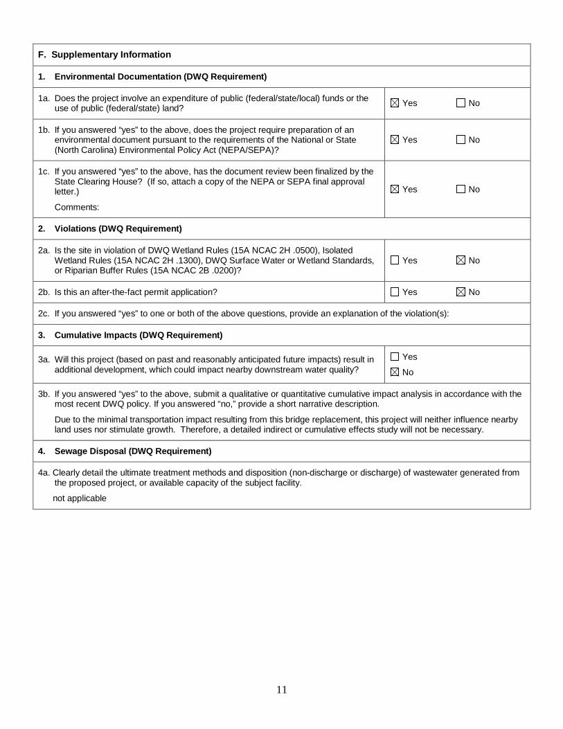
F. Supplementary Information
1. Environmental Documentation (DWQ Requirement)
1a. Does the project involve an expenditure of public (federal/state/local) funds or the use of public (federal/state) land? Yes No
1b. If you answered “yes” to the above, does the project require preparation of an environmental document pursuant to the requirements of the National or State (North Carolina) Environmental Policy Act (NEPA/SEPA)?
Yes No
1c. If you answered “yes” to the above, has the document review been finalized by the State Clearing House? (If so, attach a copy of the NEPA or SEPA final approval letter.)
Comments:
Yes No
2. Violations (DWQ Requirement)
2a. Is the site in violation of DWQ Wetland Rules (15A NCAC 2H .0500), Isolated Wetland Rules (15A NCAC 2H .1300), DWQ Surface Water or Wetland Standards, or Riparian Buffer Rules (15A NCAC 2B .0200)?
Yes No
2b. Is this an after-the-fact permit application? Yes No
2c. If you answered “yes” to one or both of the above questions, provide an explanation of the violation(s):
3. Cumulative Impacts (DWQ Requirement)
3a. Will this project (based on past and reasonably anticipated future impacts) result in additional development, which could impact nearby downstream water quality?
Yes
No
3b. If you answered “yes” to the above, submit a qualitative or quantitative cumulative impact analysis in accordance with the most recent DWQ policy. If you answered “no,” provide a short narrative description.
Due to the minimal transportation impact resulting from this bridge replacement, this project will neither influence nearby land uses nor stimulate growth. Therefore, a detailed indirect or cumulative effects study will not be necessary.
4. Sewage Disposal (DWQ Requirement)
4a. Clearly detail the ultimate treatment methods and disposition (non-discharge or discharge) of wastewater generated from the proposed project, or available capacity of the subject facility.
not applicable

12
5. Endangered Species and Designated Critical Habit at (Corps Requirement)
5a. Will this project occur in or near an area with federally protected species or habitat? Yes No
5b. Have you checked with the USFWS concerning Endangered Species Act impacts? Yes No
5c. If yes, indicate the USFWS Field Office you have contacted. Raleigh
Asheville
5d. What data sources did you use to determine whether your site would impact Endangered Species or Designated Critical Habitat?
USFWS web page of T/E species for Henderson County lists seven species. Habitat is present within the study area for the following species: Appalachian elktoe, Small whorled pogonia and White irisette. These species all have a biological conclusion of No Effect; NHP database of element occurrences
6. Essential Fish Habitat (Corps Requirement)
6a. Will this project occur in or near an area designated as essential fish habitat? Yes No
6b. What data sources did you use to determine whether your site would impact Essential Fish Habitat?
NMFS County Index
7. Historic or Prehistoric Cultural Resources (Corp s Requirement)
7a. Will this project occur in or near an area that the state, federal or tribal governments have designated as having historic or cultural preservation status (e.g., National Historic Trust designation or properties significant in North Carolina history and archaeology)?
Yes No
7b. What data sources did you use to determine whether your site would impact historic or archeological resources?
NEPA Documentation - On May 29, 2007 the NCDOT met with HPO and the Federal Highway Administration to discuss effects on the Flat Rock Historic District; it was determined that this alternative would have "No Adverse Effect" on the Flat Rock Historic District.
8. Flood Zone Designation (Corps Requirement)
8a. Will this project occur in a FEMA-designated 100-year floodplain? Yes No
8b. If yes, explain how project meets FEMA requirements: NCDOT Hydraulics Unit coordination with FEMA
8c. What source(s) did you use to make the floodplain determination? FEMA Maps
Dr. Gregory J. Thorpe, Ph D Applicant/Agent's Printed Name
_______________________________ Applicant/Agent's Signature
(Agent's signature is valid only if an authorization letter from the applicant is provided.)
Date


Page 1 of 2
Project Manager:
State Stormwater Permit Required? If yes, why?no
Sub-Regional Tier Guidelines apply
Average Daily Traffic (existing): 1595 (year 2011)
North Carolina Department of Transportation
Highway Stormwater ProgramSTORMWATER MANAGEMENT PLAN
Marshall Clawson
CAMA County?
Description of Existing Project Area: Rural two lane two way SR route
Description of Proposed Project: Replace insufficient bridges
General Comments:
Buffer Rules in Effect? no
4/5/2011
Designer:
farmland ,woods, some residential
Average Daily Traffic (proposed):
no
Existing Cross Section: 2 - 10' travel lanes with shoulder section.
Left and Right Prong of Mud Creek
Description:
Anadromous Fish Present?
Other Stream Classification:
River Basin(s):
NCDWQ Surface Water Classification for Primary Receiving WaterPrimary Receiving Water:
no
Primary: Class C
Supplemental:
Project Length (lin. miles/feet): insignificant, pavement width not increased
Surrounding Land Use:
Existing Site
Project Description
303(d) Stream?
Could the Project Impact Threatened or Endangered Species? no
Type(s) of Impairment:
3515 (year 2031)
Proposed Cross-Section: 2 - 10' travel lanes with shoulder section.
Buffer Rules:
Median Type:
Terminus:
Interchange Modification:
Terminus:
General Comments: Added Impervious Area (ac.): 0.199 miles
City/Town:
County(ies):
General Project Information
French Broad
Max Price - Wetherill Eingineering
Date:
TVA County?no yes
Henderson County
33496.1.1 (B-4147)Project No.:
NCDWQ Stream Index:
Version 1.1Released: July 2010 (DRAFT)

North Carolina Department of Transportation
Highway Stormwater ProgramSTORMWATER MANAGEMENT PLAN
Version 1.1Released: July 2010 (DRAFT)
Page 2 of 2
Stream NameStream Type
Jurisdict. Stream Buffer?
Classific-ation? SCM Type
Checklist Complete? DA (ac.)
Q2
(ft3/s)
Q10
(ft3/s)
WQvc
(ft3)
Mud Creeek Perennial RPW No Class C no
Riparian Buffer and Jurisdictional Stream Impacts and Associated SCMs
Environmental Summary
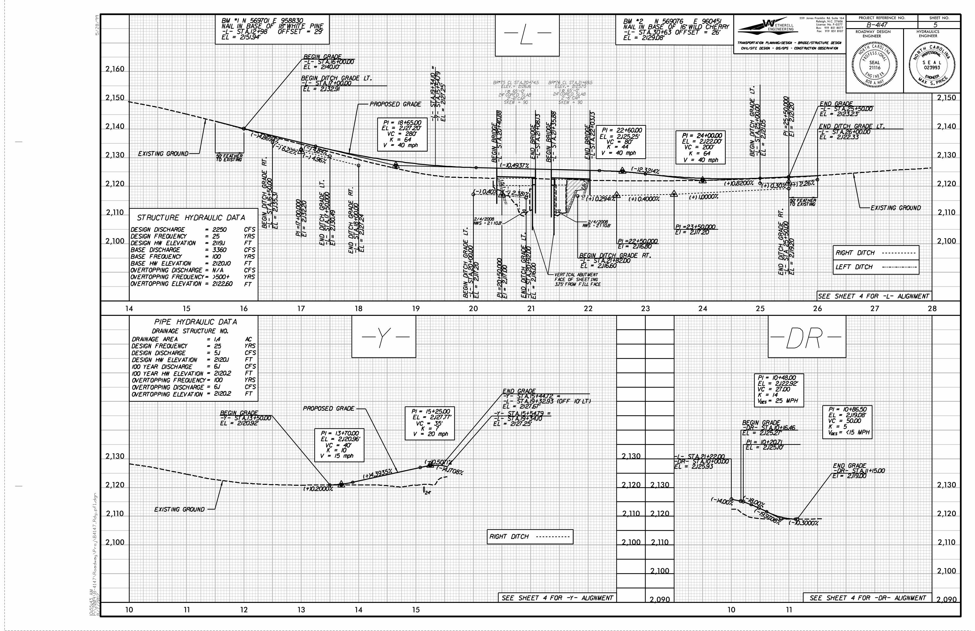
Station
General Comments:
Proposed StructureBRG# 75 65' 24" CORED SLAB (2'-6" CAP) ; BRG# 76 65' 24" CORED
SLAB (2'-6" CAP)21+22

Hand Existing Existing Permanent Temp. Excavation Mechanized Clearing Permanent Temp. Channel Channel Natural
Site Station Structure Fill In Fill In in Clearing in SW SW Impacts Impacts StreamNo. (From/To) Size / Type Wetlands Wetlands Wetlands in Wetlands Wetlands impacts impacts Permanent Temp. Design
(ac) (ac) (ac) (ac) (ac) (ac) (ac) (ft) (ft) (ft)1 21+25 to 22+02 Bridge
Bank Stabilization < 0.01 73Right Prong
20+92 LT DitchBank Stabilization < 0.01 10
Left Prong
2 21+75 RT Ditch < 0.01 13Bank Stabilization
Right Prong
TOTALS: 0.00 0.00 0.00 0.00 0.00 < 0.01 < 0.01 73 23 0
TEMPORARY IMPACTS TO SURFACE WATER LEFT PRONG : LESS THAN 0.0I ACRES ( 25 SQ. FT. )
TEMPORARY IMPACTS TO SURFACE WATER RIGHT PRONG : LESS THAN 0.0I ACRES ( 47 SQ. FT. )
PERMANENT IMPACTS TO SURFACE WATER RIGHT PRONG : LESS THAN 0.0I ACRES ( 199 SQ. FT. )
ATN Revised 3/31/05 SHEET REV.
WETLAND PERMIT IMPACT SUMMARYSURFACE WATER IMPACTSWETLAND IMPACTS
NC DEPARTMENT OF TRANSPORTATION
DIVISION OF HIGHWAYS
10/17/2012
Brgs 75 over Right Prong of Mud Creek and
HENDERSON COUNTY
WBS -33496.1.1 (B-4147)
76 over Left Prong of Mud Creek on SR 1123


5/28/99
SHEET NO.PROJECT REFERENCE NO.
HYDRAULICSROADWAY DESIGN
ENGINEER ENGINEER
5 B-4147
10:5
5:4
3
AM
P:\
2009\
B-4147\
Road
way\
Proj\
B4147_
Rdy_pfl.d
gn
8/7/2012
14 15 16 17 18 19 20 21 22 23 24 25 26 27 28
V = 40 mph
V = 40 mphK = 64
PI = 24+00.00
K = 64
EL = 2140.10’-L- STA. 16+00.00BEGIN GRADE
TO EXISTING50’ FEATHER
TO EXISTING50’ FEATHER
EL = 2123.23’-L- STA. 25+50.00END GRADE
EL = 212
7.2
5’
-Y-
ST
A. 15+54.7
9-
L-
ST
A. 19+34.10 =
2,100
2,110
2,120
2,130
2,140
2,150
2,160
2,100
2,110
2,120
2,130
2,140
2,150
10 11 12 13 14 15
PI = 13+70.00
EL = 2,120.96’
(+)0.2000%
PI = 15+25.00
EL = 2,127.77’
V = 15 mphK = 10VC = 40’
VC = 35’K = 7
V = 20 mph
EL = 2127.25’-L- STA. 19+34.10-Y- STA. 15+54.79 =
EL = 2120.92’-Y- STA. 13+50.00BEGIN GRADE
2,100
2,110
2,120
2,130
2,100
2,110
2,120
2,130
-L-
-Y-
EL = 2127.67’-L- STA. 19+32.93 (OFF 10’ LT)-Y- STA. 15+44.72 =END GRADE
PROPOSED GRADE
EXISTING GROUND
EXISTING GROUND
PROPOSED GRADE
EXISTING GROUND
STRUCTURE HYDRAULIC DATA
DESIGN DISCHARGE
DESIGN FREQUENCY
BASE DISCHARGE
CFS
YRS
YRS
BASE FREQUENCY
OVERTOPPING ELEVATION
OVERTOPPING FREQUENCY
OVERTOPPING DISCHARGE CFS
CFS
YRS
FT
FT
FT
DESIGN HW ELEVATION
BASE HW ELEVATION
= 3360
= 25
= 100
SEE SHEET 4 FOR -L- ALIGNMENT
SEE SHEET 4 FOR -DR- ALIGNMENT
(-)4.8694%
PI = 18+65.00EL = 2,127.20’
VC = 280’PI = 22+60.00
EL = 2,125.25’
(-)0.4937%(-)2.3214%
VC = 80’K = 44
PI = 24+00.00
EL = 2,122.00’
VC = 200’
(+)0.8200%
V = 40 mph
(-)4.1708%
(-)0.5071%
(+)4.393
5%
NWS = 2110.8’
2/4/20082/4/2008
NWS = 2110.8’
= N/A
= >500+
= 2122.60
EL = 2129.08’-L- STA. 30+63 OFFSET = 26’NAIL IN BASE OF 16" WILD CHERRY BM #2 N 569076 E 960451
EL = 2151.94’-L- STA. 12+98 OFFSET = 29’NAIL IN BASE OF 18" WHITE PINEBM #1 N 569701 E 958830
ENGINEERING
ETHERILLWRaleigh, N.C. 27606
Bus: 919 851 8077
Fax: 919 851 8107
CIVIL/SITE DESIGN - GIS/GPS - CONSTRUCTION OBSERVATION
TRANSPORTATION PLANNING/DESIGN - BRIDGE/STRUCTURE DESIGN
559 Jones Franklin Rd. Suite 164
License No. F-0377
1.5:1
1.5:1
PI =17
+00.0
00
El = 2,132.2
0
(+) 0.2941% (+) 0.4000% (+) 1.0000%
-L-
ST
A. 16+50.0
0B
EGIN
DIT
CH
GR
AD
E
RT.
-L-
ST
A. 18+00.0
0E
ND
DIT
CH
GR
AD
E
RT.
EL = 2,127.2
4
EL = 2,135.3
1
-L-
ST
A 25+50.0
0E
ND
DIT
CH
GR
AD
E
RT.
EL = 2,119.2
0
El = 2,130.4
9
PI =20+50.0
00
El = 2,117.0
0
PI =25+50.0
00
El = 2,121.20
(+) 0.30% (+) 2.26%
END DITCH GRADE LT.
-L- STA. 26+00.00
EL = 2,121.05
EL = 2,122.33
-L-
ST
A. 2
5+00.0
0B
EGIN
DIT
CH
GR
AD
E
LT.
EL = 2,117.2
0
EL = 2,116.0
0
-L-
ST
A. 2
0+00.0
0B
EGIN
DIT
CH
GR
AD
E
LT.
EN
D
DIT
CH
GR
AD
E
LT.
-L-
ST
A. 2
0+92.0
0
(-) 0.40% (-) 2.381%
-L- STA. 17+00.00BEGIN DITCH GRADE LT.
EL = 2,132.91
(-) 6.22%(-) 4.96%
DRAINAGE STRUCTURE NO.
DRAINAGE AREA
DESIGN FREQUENCY
DESIGN DISCHARGE
DESIGN HW ELEVATION
100 YEAR DISCHARGE
100 YEAR HW ELEVATION
OVERTOPPING FREQUENCY
OVERTOPPING DISCHARGE
OVERTOPPING ELEVATION
PIPE HYDRAULIC DATA
AC
YRS
YRS
CFS
CFS
CFS
FT
FT
FT
= 1.4
= 2120.2
= 6.1
= 100
= 25
= 5.1
= 2120.1
= 6.1
= 2120.2
= 2250
= 2119.1
= 2120.10
RIGHT DITCH
RIGHT DITCH
LEFT DITCH
24"
-L-
ST
A. 17+50.0
00
EN
D
DIT
CH
GR
AD
E
LT.
(-) 4.84%
PRO
FESSIONAL
ENGINEER
NORT
H CAROLINA
SEAL
21116
BOB A. MAY
-L-
ST
A. 2
1+08.13
EN
D
BRID
GE
-L-
ST
A. 2
1+35.8
8B
EGIN
BRID
GE
BR#75 CL STA. 20+74.5ELEV. = 2126.16
24" CORED SLAB1 @ 65’-0"
2’-6" CAPSKEW = 90
BR#76 CL STA. 21+69.5ELEV. = 2125.70
24" CORED SLAB1 @ 65’-0"
2’-6" CAP
SKEW = 90
3.75’ FROM FILL FACE
FACE OF SHEETING
VERTICAL ABUTMENT
PI =23+50.000El = 2,117.20
PI =22+50.000El = 2,116.80
-L- STA. 21+82.00BEGIN DITCH GRADE RT.
EL = 2,116.60
SEE SHEET 4 FOR -Y- ALIGNMENT
-DR-
10 11
2,090
2,100
2,110
2,120
2,130
2,090
2,100
2,110
2,120
2,130
EL = 2,125.27’
PI = 10+20.71EL = 2,125.10’
PI = 10+48.00
EL = 2,122.92’
PI = 10+86.50
EL = 2,119.08’
(-)9.9708% (-)0.3000%
(-)8.00%(-)4.00%
-DR- STA. 11+15.00END GRADE
El = 2,119.00
-L- STA. 21+22.00-DR- STA. 10+00.00EL = 2,125.93
-DR- STA. 10+16.46BEGIN GRADE
VC = 27.00
K = 14
V = 25 MPHDES
VC = 50.00
K = 5
V = <15 MPHDES
-L-
ST
A. 2
0+40.8
8B
EGIN
BRID
GE
-L-
ST
A. 2
2+03.13
EN
D
BRID
GE
ROL
INA
SIONAL
INEER
A
NO
RH
C
PROF
ES
ENG
T
023993
S E A L
E
CIRP .S XAM


