post-flood recovery assessment and stream restoration ......post-flood recovery assessment and...
TRANSCRIPT

Page 1
Colorado Parks and Wildlife
Post-Flood Recovery Assessment and Stream Restoration Guidelines for
the Colorado Front Range
Eric E. Richer, Matt C. Kondratieff, and Benjamin D. Swigle
Colorado Parks and Wildlife, Fort Collins, Colorado
April 29, 2015
Abstract
Severe flooding impacted rivers and streams in the Colorado Front Range during September 2013. The
flooding had devastating effects on communities and infrastructure, but had many beneficial effects on
river ecosystems and stream functions. Flooding is a natural component of river systems that is vital for
many ecological and physical processes. Following the flood, rebuilding infrastructure was given top
priority and permitting processes were suspended or expedited to facilitate reconstruction activities. In
many cases, emergency reconstruction activities led to degradation of stream functions and aquatic
habitat. Degradation was often associated with the creation of trapezoidal and armored channels.
Initial monitoring following the flood showed variable impacts to fish populations, with changes in trout
abundance ranging from -58% to +69% at sites that were severely impacted by the flood but not further
altered during emergency reconstruction. Monitoring sites that underwent substantial channel
alterations during emergency reconstruction had an average change in trout abundance of -95%. Floods
may provide an opportunity to improve a variety of stream functions related to channel stability, flood
conveyance, geomorphology, water quality, and habitat connectivity. However, programmatic
constraints at both the state and federal level limit opportunities to improve rivers beyond their pre-
flood condition. Addressing permitting and funding constraints prior to the next major flood could
greatly improve the efficiency and effectiveness of emergency flood response while reducing long-term
maintenance and stream restoration costs.
Introduction
The Colorado Front Range was impacted by severe flooding in September 2013 as a result of a 1000-
year precipitation event. The intensity and duration of precipitation caused unprecedented runoff
events in many rivers, which led to loss of life and substantial property damage. The Cache la Poudre,
Big Thompson, St. Vrain, Left Hand, and Boulder watersheds experienced 25- to 500-year floods.
Although the flood had devastating effects on infrastructure and daily life, it had many positive effects
on natural stream functions. Flooding is a natural component of river ecology, and natural river
systems not only benefit from, but are dependent upon, high flows for many ecological and physical
processes. Given the devastating effects of floods on communities, it is not surprising that the
functional benefits of floods on natural ecosystems are often misunderstood and understated.
Flooding has many unfortunate effects, the most tragic being the loss of life and property. Preliminary
estimates from the Colorado Water Conservation Board (CWCB) included nine fatalities, 16,000
damaged homes, 1,800 destroyed homes, 750 damaged businesses, 200 destroyed businesses, and 200
miles of damaged state highways. Stream gauges and water delivery infrastructure also suffered severe
damages with 207 dams impacted, nine low hazard dams lost, and over 160 water-diversion structures
damaged or destroyed (Colorado Division of Water Resources). In addition, damage to oil and gas and
wastewater treatment facilities may have impacted water quality. This devastation required a swift

Page 2
Colorado Parks and Wildlife
and coordinated emergency response, and we are grateful to the emergency responders that saved
lives and restored access to isolated communities.
Colorado Parks and Wildlife (CPW) is responsible for perpetuating the wildlife resources of the state
(C.R.S.§ 33-9-101 (12) (b)). CPW also holds more individual water rights in Colorado than any other
entity and owns or manages publically-accessible properties along many rivers impacted by the flood.
When combined, these factors provide a unique perspective on the flood. Habitat conservation,
connectivity, enhancement, and restoration are all vital components of fisheries management.
Management goals include maintaining sport fish populations that provide recreational and economic
benefits and long-term conservation of native fish populations. From a functional standpoint, it is
important to note that most rivers in the Colorado Front Range were already in a severely degraded
state prior to the flood. Some characteristics of healthy rivers include the ability to convey water and
sediment, longitudinal connectivity between upstream and downstream reaches, functioning riparian
corridors that mitigate flood impacts when inundated, and habitat complexity that supports aquatic
and terrestrial wildlife. Many of these characteristics are missing from large portions of rivers along the
Colorado Front Range.
Rivers and streams along the Colorado Front Range have experienced substantial anthropogenic
changes over the past 200 years. These changes were largely due to historic land use activities and
water development, such as beaver trapping, placer and gravel mining, flow regulation, timber harvest
and tie drives, and construction of roads and railroads (Wohl, 2011). Most rivers in the Front Range are
fragmented by numerous diversion structures that prevent upstream migration of fish, adversely affect
sediment transport, entrain downstream migrating fish in irrigation ditches, and sporadically dry up
river segments during periods of drought or baseflow. Roads have been constructed along many rivers
in the Front Range, leaving little room to dissipate energy through the process of floodplain inundation
during high flows. Many of these rivers and streams have also been channelized in an attempt to
convey floods, protect infrastructure, and maximize crop production. However, experience has shown
us that channelized, trapezoidal rivers experience massive channel adjustments during and
immediately following floods while natural rivers with healthy and functioning floodplains do not. Yet
channelization and armoring of rivers continues to be a common practice, despite the repeated failure
of this approach during floods.
The response to the 2013 floods along the Colorado Front Range has many positive aspects, highlighted
by promptly-restored access to isolated communities, emergency protection of property and
infrastructure, moving highways farther away from river channels, and protecting livelihoods through
reconstruction and repair of water delivery infrastructure. However, there are many ways in which our
response to floods could be improved. There are valuable lessons from the 2013 flood response that
should be addressed prior to the next flood event. Floods may provide opportunities to improve the
health of our rivers for the benefit of both local communities and the wildlife that depend on them.
With proper advance planning, protecting communities and river ecosystems do not need to be
mutually exclusive. There are opportunities to coordinate stream reconstruction activities so that
multiple goals and objectives can be achieved simultaneously in a more efficient manner. The
objectives of this paper are to improve understanding of natural stream functions, discuss more
comprehensive approaches to emergency flood response and reconstruction, and develop conceptual
guidelines for post-flood stream restoration. The overarching goal is to be better prepared for the next
flood.

Page 3
Colorado Parks and Wildlife
Post-Flood Recovery Assessment
The flood recovery process was broken into two
phases: (Phase I) emergency or exigent repairs
and (Phase II) permanent repairs. Exigent repairs
were focused on protecting life and property,
and needed to be completed prior to snowmelt
runoff in spring 2014. This exigent work consisted
of rebuilding roads and water diversion
structures, bank stabilization and armoring, and
channel dredging to return rivers to their pre-
existing condition. Permanent repairs were
mostly delayed until after runoff and will focus
on infrastructure protection, bank stabilization,
and stream restoration. In-stream construction
and stream restoration are challenging processes
that often involve interdisciplinary teams of
engineers, hydrologists, geomorphologists, and
biologists. Because rivers are highly dynamic
systems used by a variety of stakeholders,
processes have been implemented at both the
state and federal level to protect rivers and
streams from activities that lead to habitat
degradation and loss of function.
Colorado Senate Bill 40 (33-5-101-107, CRS 1973
as amended) exists to protect the state’s fish and
wildlife resources from actions that obstruct,
damage, diminish, destroy, change, modify, or
vary the natural existing shape and form of any
stream or its banks or tributaries. Highway
construction projects and maintenance activities
that impact any stream or its banks or tributaries
require formal application to CPW for Senate Bill
40 (SB40) Certification. This process was
suspended immediately following the flood to
streamline reconstruction efforts. Section 404 of
the Clean Water Act established a program to
regulate the discharge of dredged or fill material
into the waters of the United States, including
wetlands. The 404 permitting process was also
expedited after the flood. Given the need for
emergency reconstruction, expediting the SB40
and 404 processes was justifiable. However,
these regulations exist to protect rivers from unnecessary degradation, and their absence likely
contributed to degradation of aquatic resources during reconstruction in some areas.
Figure 1. Pictures of the South Fork of St. Vrain Creek
through Bohn Park showing pre-flood condition, post-
flood condition, and post-channelization condition.
The yellow arrow denotes the same river birch.

Page 4
Colorado Parks and Wildlife
River projects are increasingly challenging because they typically involve multiple stakeholders with
diverse and often conflicting objectives. Projects that focus on a single goal, such as bank stabilization,
can adversely affect physical processes and ecological functions, thereby degrading resources valued by
other stakeholders. The total economic output from fishing in north central Colorado is $523 million
annually (Southwick, 2014), which highlights the importance of fishing in the Colorado Front Range.
River projects that focus only on the protection of infrastructure can result in degradation of a fishery
and adversely impact those stakeholders that value fisheries. In addition to sport fish, there are many
native fish species in the Colorado Front Range that are currently listed as state threatened or
endangered due to habitat fragmentation and degradation. The flood recovery effort provided a rare
opportunity to improve conditions for both sport fish and native species by elevating the ecological
function of these river systems.
Funding for Phase I recovery efforts was primarily provided by the Federal Emergency Management
Agency (FEMA) and Natural Resource Conservation Service (NRCS) Emergency Watershed Protection
Program (EWP). Funding for Phase 2 “non-exigent” or permanent repairs was uncertain. Due to this
uncertainty, many of the “temporary” fixes may become permanent features along rivers of the Front
Range. Ecological lift and stream functions were not considered for most of these temporary or exigent
projects. In many cases, the protection of property was the primary and only concern. We recognize
the importance of protecting property and acknowledge the critical need for these efforts, but
recommend alternative approaches to protecting property that minimize degradation of river
ecosystems. It is possible to approach emergency flood response in a comprehensive manner that
protects life and property as well as stream functions. Opportunities exist to incorporate principles of
natural channel design into emergency flood response that will maximize the potential for post-flood
stream recovery and stability. With some advance planning, overall project costs could be reduced,
efficiency increased, and long-term river stability and function improved.
Some of the emergency work that was completed is concerning from an ecological standpoint. One of
the major ecological concerns is related to “sweeping” the river to accommodate downstream
construction. We understand this is a convenient means to work within the active channel, but
diverting all of the flow has severe implications for all aquatic life downstream of the diversion point.
CPW received numerous reports of dead or stranded fish during the peak of construction activities. We
recommend using coffer dams and pumps to manage water in the immediate vicinity of construction as
a means to accommodate in-stream construction while maintaining downstream flows. As a last resort,
should a river need to be dried for in-stream construction, we recommend that water flows be reduced
incrementally so that aquatic organisms can seek refuge in pools or other reaches with sufficient flow.
Sediment transport and geomorphology were not priorities during emergency reconstruction.
Channelization, abrupt changes in channel width, and inappropriate use of in-stream treatments may
lead to issues with post-flood channel stability. In many instances, rivers were “temporarily”
channelized to achieve design dimensions that accommodate a 5-year or 25-year flood. These
temporary channels were typically trapezoidal and designed with the objective to lower the 100-year
flood stage (Figure 1). We feel this is one of the greatest challenges facing post-flood stream
restoration efforts. Can we restore rivers to a more natural and sustainable condition when homes and
businesses are built in the floodplain? Throughout history, we have attempted to modify and constrain
rivers to achieve our engineering objectives. But the traditional approach to managing rivers, which
focuses on containing all flows within engineered channels, not only leads to ecological degradation
but also leads to severe channel adjustments during floods. Trapezoidal channels fail because they
concentrate energy within the channel instead of dissipating energy on the floodplain.
Page 5
Colorado Parks and Wildlife
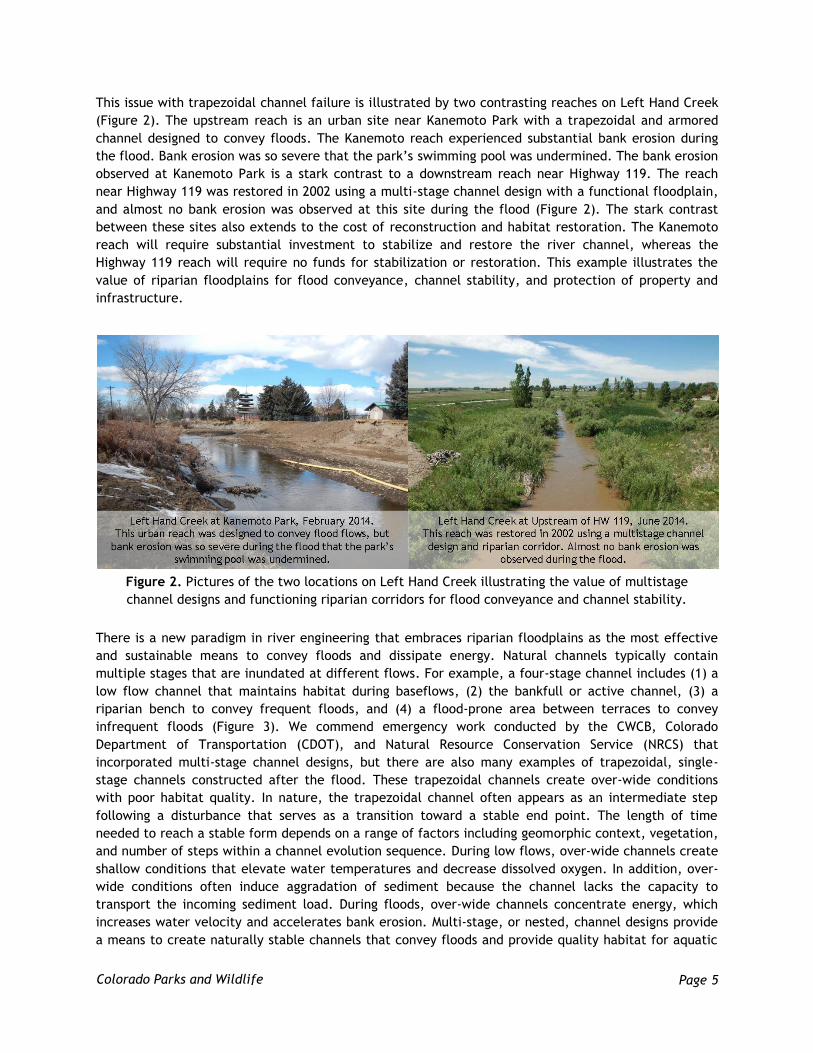
This issue with trapezoidal channel failure is illustrated by two contrasting reaches on Left Hand Creek
(Figure 2). The upstream reach is an urban site near Kanemoto Park with a trapezoidal and armored
channel designed to convey floods. The Kanemoto reach experienced substantial bank erosion during
the flood. Bank erosion was so severe that the park’s swimming pool was undermined. The bank erosion
observed at Kanemoto Park is a stark contrast to a downstream reach near Highway 119. The reach
near Highway 119 was restored in 2002 using a multi-stage channel design with a functional floodplain,
and almost no bank erosion was observed at this site during the flood (Figure 2). The stark contrast
between these sites also extends to the cost of reconstruction and habitat restoration. The Kanemoto
reach will require substantial investment to stabilize and restore the river channel, whereas the
Highway 119 reach will require no funds for stabilization or restoration. This example illustrates the
value of riparian floodplains for flood conveyance, channel stability, and protection of property and
infrastructure.
There is a new paradigm in river engineering that embraces riparian floodplains as the most effective
and sustainable means to convey floods and dissipate energy. Natural channels typically contain
multiple stages that are inundated at different flows. For example, a four-stage channel includes (1) a
low flow channel that maintains habitat during baseflows, (2) the bankfull or active channel, (3) a
riparian bench to convey frequent floods, and (4) a flood-prone area between terraces to convey
infrequent floods (Figure 3). We commend emergency work conducted by the CWCB, Colorado
Department of Transportation (CDOT), and Natural Resource Conservation Service (NRCS) that
incorporated multi-stage channel designs, but there are also many examples of trapezoidal, single-
stage channels constructed after the flood. These trapezoidal channels create over-wide conditions
with poor habitat quality. In nature, the trapezoidal channel often appears as an intermediate step
following a disturbance that serves as a transition toward a stable end point. The length of time
needed to reach a stable form depends on a range of factors including geomorphic context, vegetation,
and number of steps within a channel evolution sequence. During low flows, over-wide channels create
shallow conditions that elevate water temperatures and decrease dissolved oxygen. In addition, over-
wide conditions often induce aggradation of sediment because the channel lacks the capacity to
transport the incoming sediment load. During floods, over-wide channels concentrate energy, which
increases water velocity and accelerates bank erosion. Multi-stage, or nested, channel designs provide
a means to create naturally stable channels that convey floods and provide quality habitat for aquatic
Figure 2. Pictures of the two locations on Left Hand Creek illustrating the value of multistage
channel designs and functioning riparian corridors for flood conveyance and channel stability.

Page 6
Colorado Parks and Wildlife
organisms. During emergency reconstruction, multi-stage dimensions can be “roughed-in” thereby
reducing the cost of permanent stream restoration efforts.
Figure 3. A typical four-stage channel design for a C4 stream type in a Valley Type VIII (Used with
permission from D.L. Rosgen).
Fish Passage at Diversion Structures
Over 160 diversion structures were damaged
during the 2013 floods. These structures typically
consist of concrete walls or grouted boulders
that span the width of the channel (e.g., Figure
4). These structures were designed to create
upstream backwater with enough differential
head to maintain flows into irrigation ditches.
Substantial investments have been made to
develop the water delivery infrastructure that
sustains the economy of the Colorado Front
Range. Unfortunately, much of this
infrastructure was developed decades ago
without any consideration for dynamic river
processes or ecological functions. The traditional
diversion structure consisting of a low-head
concrete dam and head-gate has many negative
effects on stream functions. Diversion structures often create barriers to the upstream migration of
fish. Upstream migration is a vital component of many species’ life histories. Trout are known to
migrate upstream to find ideal spawning habitat and then move back downstream to over-winter in
warmer, lower-velocity, and more productive waters. Barriers to migration, such as diversion or grade-
control structures, can adversely impact populations of many fish species.
Following the 2013 floods, CPW worked with the NRCS, CWCB, US Fish and Wildlife Service (USFWS),
and FEMA to address issues with fish passage at diversion structures. These efforts culminated in a Fish
Passage Workshop and Webinar that is hosted on the FEMA website at
https://fema.connectsolutions.com/fishpassage/. This workshop provided information on different
approaches to achieving fish passage at diversion structures, including design criteria for rock ramps,
and alternative approaches to diversion structure design such as the cross-vane diversion structure
(Figure 5). Hydraulic design criteria for fish passage structures are presented in Table 1. In addition to
Figure 4. Diversion structure at the Watson
State Wildlife Area, Cache la Poudre River.

Page 7
Colorado Parks and Wildlife
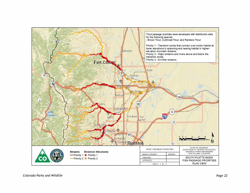
design criteria, CPW developed maps that prioritized streams for fish passage in the South Platte basin
for both native fish species and trout (Appendix A). These maps identified St. Vrain Creek, South Platte
River, Left Hand Creek, Boulder Creek, and Cache la Poudre River as the highest priority streams for
native fish passage in flood-impacted drainages. Transition zones that connect over-winter habitat at
lower elevations to spawning and rearing habitat at higher elevations were identified as the highest
priority reaches for trout passage.
Table 1. Hydraulic design criteria for fish passage structures in the Colorado Front Range.
Species Assemblage
Velocity (ft/s) Minimum Depth (ft)
Vertical Drop (ft) Turbulence (*EDF)
Native minnows and darters
1-2 0.5 0.0 <7
Native dace and suckers
3-4 0.5 0.0 <7
Trout 3-6 0.5-1.0 0.5-1.0 <7
* Energy Dissipation Factor (EDF) = (γQS)/A (Laiho, 2014)
St. Vrain Creek and Left Hand Creek are two of the last refuges for a number of state threatened and
endangered fish species. Both of these streams were severely impacted by the flood, with devastating
effects from Lyons through Longmont. Forty-three diversion structures were damaged on these two
streams. As of March 2014, only two of the 43 damaged structures had incorporated fish passage during
reconstruction efforts. Furthermore, fish passage designs for these structures were adapted from
techniques used in the Pacific Northwest to pass salmon, such as the pool-weir fish ladder. The
threatened and endangered native species in St. Vrain Creek and Left Hand Creek are adapted to the
historical conditions in the rivers of the Colorado Front Range. As such, they can neither jump as high
nor swim as fast as the salmon of the Pacific Northwest. Unfortunately, the two examples of fish
passage on St. Vrain Creek are not ideal designs for passing small-bodied native fishes. Regardless, we
commend the ditch companies that incorporated fish passage in the face of so many challenges.
Multiple obstacles to incorporating fish passage, including permitting, funding, and historical
designation, led most ditch companies to abandon fish passage as a viable option during the emergency
reconstruction period. We feel it is important to address these issues so that future fish passage efforts
are better prepared for these obstacles and, hopefully, more successful. Perhaps the greatest obstacle
was related to 404 permitting from the Army Corps of Engineers (ACOE). Given the magnitude of
damage, the ACOE did not want to impede reconstruction efforts. Ditch companies needed to be
operational by April 1, 2014, and most were granted agricultural exemptions from the 404 process. Two
types of agricultural exemptions can be used to satisfy permitting requirements for diversion structure
re-construction: (1) a maintenance exemption which requires the diversion structure be rebuilt to its
pre-existing condition, and (2) an irrigation maintenance exemption, which allows repairs to be
completed outside the footprint of the original structure, such as incorporation of a fish passage
structure. Under the maintenance exemption, any modification that changed the character, scope, or
size of the original design would require a permit.

Page 8
Colorado Parks and Wildlife
Figure 5. Conceptual example of a cross-vane diversion structure with irrigation head gate and
sediment sluice (Rosgen, 2006).
Page 9
Colorado Parks and Wildlife
Due to confusion regarding the two types of agricultural exemptions offered by the ACOE, many ditch
companies and conservancy districts feared that incorporating fish passage into the diversion design
would nullify their agricultural exemption and trigger the need for a nationwide or individual 404
permit. The ACOE Regional General Permit (RGP) No. 12 is a permit that explicitly applies to fish
passage structures in Colorado. Unfortunately, RGP No. 12 was not utilized during post-flood
reconstruction process. We recommend that state and federal agencies work with the ACOE to clarify
permitting options for rebuilding damaged diversion structures in a manner that accommodates fish
passage without delaying reconstruction efforts. We also recommend that RGP No. 12 be considered,
possibly on a watershed scale, as a means to permit large scale fish passage efforts in a timely manner.
Funding concerns were the second major obstacle to building fish passable diversion structures. Due to
programmatic constraints, FEMA would only fund the reconstruction of diversion structures to their
pre-existing condition. Although it is more cost effective to incorporate fish passage during a major
construction project, FEMA could not pay for fish passage if the structure did not have fish passage
before the flood. This issue was further complicated because many threatened and endangered species
in Colorado are not federally listed under the Endangered Species Act (ESA). If the brassy minnow or
common shiner were federally listed as threatened or endangered, FEMA may have required that all
diversion structures in priority reaches incorporate fish passage. Colorado’s list of state threatened and
endangered species is statutory in nature but lacks jurisdictional authority. Despite the lack of
authority, we recommend that FEMA includes the conservation of state-listed species as a priority when
responding to similar natural disasters. Furthermore, incentives could be used to address fish passage
and habitat conservation for the preservation of state-listed species.
Based on our experience from the September 2013 flood, there is not a readily available source of
funding for implementing fish passage at diversion structures. CWCB did offer low or no interest loans
for ditch companies that wanted to incorporate fish passage into the design of their new structures.
However, this incentive did not outweigh the permitting issues discussed above. To address limited
funding for fish passage in Colorado, we recommend that an emergency flood response fund be
established that could address fish passage and conservation of native species. Ideally, this fund would
support design and implementation of fish passage projects, as well as monitoring and research
activities to evaluate and improve effectiveness of fish passage designs.
These permitting and funding issues may have prevented ditch companies from considering alternative
diversion designs recommended by the CWCB and CPW, such as the cross-vane diversion structure
(Figure 5). These structures have not been widely used in the Colorado Front Range, but have been
successfully and broadly applied in western Colorado to divert water and provide grade control while
accommodating the passage of sediment, fish, and boats. Furthermore, these structures are often
cheaper to build and repair than the traditional low-head concrete dam. These alternative structures
may not have qualified for the agricultural exemption from the ACOE because they departed from the
“character, scope, or size” of the original design under the maintenance exemption. However, the
cross-vane structure is included under the Regional General Permit No. 12, which could expedite the
permitting process for these structures in Colorado. We recommend that state and federal agencies
work with the ACOE to identify permitting options for incorporating alternative diversion designs into
emergency flood response.
The third issue that prevented a large scale effort to incorporate fish passage was related to the
historical designation of diversion structures. Many diversion structures are considered “historical” by
the State Historical Preservation Office (SHPO) due to the important role irrigation played in the

Page 10
Colorado Parks and Wildlife
development of the Colorado Front Range. SHPO is committed to maintaining the historical nature of
these diversion structures, such that repairs to damaged structures must use the same type of grout
that was used when the structure was originally built. There were concerns that incorporating fish
passage would alter the historical character of these diversion structures. SHPO’s concerns about fish
passage were acknowledged by FEMA and placed fish passage projects in a negative context. We
recommend that issues with historical designation and fish passage at diversion structures be resolved
in a way that incorporates fish passage without compromising historical integrity.
State of the Fishery CPW is the lead agency responsible for fisheries management of public waters in Colorado. The primary
tool that guides fisheries management in rivers is the multiple-pass electrofishing survey. Electrofishing
is a common method used to sample fish populations and determine abundance, density, species
composition, and fish condition. These surveys monitor fish populations and evaluate the impacts of
flooding, wildfire, disease, and competition. Surveys are used to assess fishing regulations, the need
for reintroduction via stocking, the need for habitat improvement, as well as the success of stream
restoration projects. Electrofishing surveys are conducted regularly in all major rivers in the Colorado
Front Range, and provide a valuable dataset for evaluating the effects of both the flood and emergency
reconstruction efforts on these fisheries. In general, post-flood electrofishing surveys conducted in the
Cache la Poudre River and Boulder Creek revealed limited impacts to the fishery and very limited
channelization work. As a result, post-flood fishery assessments focused on the Big Thompson River and
St. Vrain Creek, as large portions of these systems were physically altered and channelized to convey
spring runoff and facilitate re-construction. Preliminary observations suggest that major river
restoration would not be necessary in many locations had post-flood channels been left intact.
Big Thompson Fishery Assessment
CPW conducted a large-scale, pre-flood study of the Big Thompson River to document fishery resources
for relicensing the Idlewilde Dam Hydroelectric Project with the Federal Energy Regulatory Commission
(FERC). Following the September 2013 floods, the Idlewilde Dam, all turbines, and pipeline were
damaged beyond repair which led to the complete removal of the dam. Although the fisheries data no
longer applied to the relicensing process, they provided valuable baseline information for assessing
post-flood damages to aquatic resources. A total of nine sites, five completed as part of the FERC study
in 2012 and four historical sampling sites, were resurveyed following the flood. Results from the
comparative surveys are presented in Table 2, and historical survey data are included in Appendix B.
These data suggest that post-flood channelization activities conducted to rebuild Highway 34 between
Loveland and Estes Park had a more devastating impact on the Big Thompson fishery than the flood
itself. Sections of river that were undisturbed by post-flood reconstruction contained 7% more trout per
mile, on average, relative to pre-flood estimates. Sections of river that were heavily channelized and
armored during post-flood reconstruction contained 95% fewer trout, on average, relative to pre-flood
conditions.

Page 11
Colorado Parks and Wildlife
Channelization and armoring of the Big Thompson
River reduced trout abundance by 90-100% at
most locations surveyed (Table 2). For example,
a section of the Big Thompson River at Drake
contained 3,206 trout per river mile when
surveyed in September 2012. No fish were found
at this same location in November 2013 following
channelization work (Figure 6). Farther
upstream, near the Waltonia Bridge, trout
abundance was reduced from 5,895 fish per mile
in September 2012 to 130 fish per mile in
October 2013. Sections of the Big Thompson
River that were not artificially channelized fared
much better in terms of trout abundance. The
handicap fishing pier access site located near
Highway 34 mile marker 72 yielded 3,769 trout
per mile in October 2011. Following the 2013
flood, this same section contained 4,368 trout
per mile, a 16% increase. Relatively little
restoration work is needed for sections of the Big
Thompson River where post-flood landscapes
were not altered or channelized during post-flood
reconstruction activities.
St. Vrain Fishery Assessment
In September 2013, the St. Vrain Watershed,
including the North and South Forks of St. Vrain
Creek, experienced a record flood event,
reaching 100-year flood levels and surpassing 500-
1000 year levels in certain areas. Stream flows
below the town of Lyons were estimated at
19,600 cfs (Houck, 2014), easily surpassing the
previous record set in 1941. CPW initially
conducted post-flood electrofishing surveys at
Bohn Park, South Fork St. Vrain Creek, and
Meadow Park, North Fork St. Vrain Creek, during
October 2013. The monitoring reach through Bohn
Park was subsequently channelized during
February 2014. Following this channelization
work, CPW re-surveyed both Bohn Park and
Meadow Park to evaluate the effects of channel
alterations on the fishery.
Figure 6. Post-flood photos of fish monitoring sites
along the Big Thompson River showing the effects of
channelization.

Page 12
Colorado Parks and Wildlife
Table 2. Total trout abundance (brown trout and rainbow trout) prior to and after the September 2013
floods at monitoring locations along the Big Thompson River.
Location
Miles Downstream of Olympus
Dam
Pre-Flood Post-Flood
Sample Date
Abundance (trout/mile)
Sample Date
Abundance (trout/mile)
Abundance (% change)
Channel Alterations
Below Olympus Dam 0.3 10/18/11 3013 10/30/13 5092 69% Minimal
Chucks Place 3.5 10/18/10 6805 11/07/13 4730 -30% Minimal
Bridge at Glen Comfort
5.1 10/18/10 4358 11/08/13 3134 -28% Minimal
Handicap Ramp 8.8 10/19/11 3769 11/07/13 4368 16% Minimal
Waltonia Bridge 10.2 09/20/12 5895 10/08/13 130 -98% Channelized
Drake 12.3 09/25/12 3206 11/07/13 0 -100% Channelized
Upstream of Idlewilde Dam
13.7 09/17/12 5003 11/26/13 522 -90% Channelized
Indian Meadow 14.8 09/25/12 2797 11/27/13 122 -96% Channelized
Viestnz Smith Park 16.0 09/24/12 3104 11/27/13 243 -92% Channelized
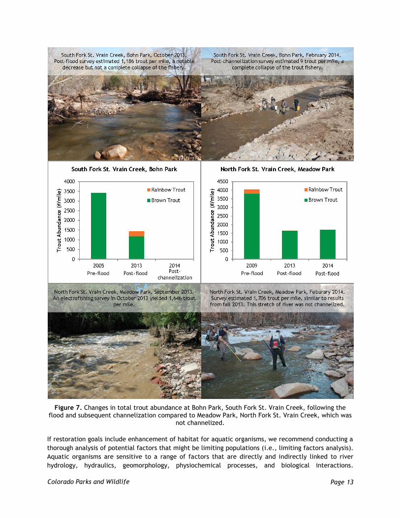
Decreased trout abundance was observed at both St. Vrain sites following the flood (Figure 7). Trout
abundance at Bohn Park was previously estimated at 3,417 trout per mile in October 2005. Following
the flood, trout abundance had decreased to 1,442 trout per mile in October 2013, representing a 58%
decline for the previous estimate. Following post-flood channelization work, the electrofishing survey
at Bohn Park yielded a single trout, or roughly nine trout per mile, representing a 99% decline in trout
abundance between the post-flood and post-channelization surveys. Unlike Bohn Park, the historical
survey site at Meadow Park on the North Fork St. Vrain was not channelized and remained relatively
unaltered following the September 2013 flood. At this site, trout abundance decreased from 4,033
trout per mile in September 2009 to 1,659 trout per mile in October 2013, representing a 59% decline
in the fishery due to the flood. However, survey results indicate that the fishery remained stable after
the flood as 1,706 trout per mile were observed in February 2014. Although high flows observed during
the flood impacted fisheries, these results suggest that drastic channel alterations during post-flood
reconstruction further degraded fisheries in the Colorado Front Range. CPW will continue monitoring
efforts to further evaluate the effects of both the 2013 floods and post-flood reconstruction on fishery
resources in flood-impacted rivers.
Stream Restoration Guidelines
CPW recommends the following guidelines for stream restoration. These guidelines are general in
nature, and may not be applicable in certain situations or appropriate for all stream reaches. The most
important components of successful stream restoration projects are identification of appropriate goals,
development of a design that addresses those goals, and selection of qualified and experienced
contractors. The first step in any stream restoration project is identifying goals and objectives. Initial
development of goals and objectives should involve all stakeholders affected by the project, although
some goals may be weighted higher than others when finalizing a master plan for restoration.
Identifying the condition to which the river will be restored is a vital step. Restoration implies
returning a river to its pre-development condition, which is often not feasible or desired by all
stakeholders. We recommend setting stream restoration goals that elevate the ecological function of
rivers beyond their pre-flood condition in accordance with the Stream Functions Pyramid developed by
the Environmental Protection Agency (EPA), USFWS, and ACOE (Harman et al., 2012).
Page 13
Colorado Parks and Wildlife
Figure 7. Changes in total trout abundance at Bohn Park, South Fork St. Vrain Creek, following the flood and subsequent channelization compared to Meadow Park, North Fork St. Vrain Creek, which was
not channelized.
If restoration goals include enhancement of habitat for aquatic organisms, we recommend conducting a
thorough analysis of potential factors that might be limiting populations (i.e., limiting factors analysis).
Aquatic organisms are sensitive to a range of factors that are directly and indirectly linked to river
hydrology, hydraulics, geomorphology, physiochemical processes, and biological interactions.
Page 14
Colorado Parks and Wildlife
Therefore, restoration projects that address biological enhancement are inherently complex and should
utilize monitoring and adaptive management to maximize effectiveness. Before-After/Control-
Treatment (BACT) study designs are particularly useful for evaluating the effectiveness of stream
restoration projects.
Stream Restoration Priorities: Protect
Trout Unlimited promotes one of the more common themes for habitat conservation and stream
restoration, which is to protect, reconnect, and restore. The most effective way to maintain
functioning river systems is to protect streams or reaches that are not degraded. The 2013 flood
improved stream functions in many locations. Examples of improved functions include: newly
established point bars that support deep pools at low flows while dissipating energy at high flows;
channel narrowing that improved width-to-depth ratios; improved hyporheic connectivity and
interstitial habitat; increased bedform diversity; recruitment of large wood and boulders that enhanced
instream habitat; increased sinuosity that improved form roughness to dissipate energy at high flows;
improved floodplain connectivity that will dissipate energy at high flows; and improved connectivity
between upstream and downstream reaches.
Flows of the magnitudes observed during the 2013 floods also provide flushing and channel
maintenance benefits (Kondolf and Wilcock, 1996). Prior to the flood, many stream beds were severely
armored due to decreased frequency of flushing flows, meaning there was impaired connectivity
between the active channel and hyporheic zone, which is the area beneath and alongside the
streambed. This embeddedness, or armoring, degraded habitat for aquatic insects, small bodied native
fishes, and spawning sport fish. Unfortunately, much of the improved habitat that resulted from the
flood was not protected. Rather, this newly formed habitat was removed during channelization and
used for road base or armoring of stream banks. We understand that rebuilding infrastructure was the
highest priority after the flood, but it is important to acknowledge the ecological benefits that result
from floods and to preserve those to the fullest extent possible without endangering life or property.
Another common observation in the post-flood response was the removal of large woody debris (LWD).
There are many studies that document the importance of wood in natural river channels. Some of the
benefits of LWD include energy dissipation at the channel boundary, storage of sediment and organic
matter on the streambed, increased habitat complexity, and retention of organic matter and nutrients
(Wohl, 2011). We understand there are many instances in which large wood was intermingled with
trash or hazardous materials, and we support the removal of this “debris”. Although the accumulation
of LWD at bridges can create issues with flood conveyance, Johnson and Scheeder (2011) suggest that
the best solution for debris management at bridges lies within stream restoration practices,
particularly bank stabilization. However, many of the emergency bank stabilization techniques used
after the flood, including rip-rap and Jersey barriers, adversely affect stream functions and may not be
sustainable.
Channel evolution models demonstrate that channelized rivers are not stable and that channelization
will lead to degradation and widening followed by aggradation and further widening (Figure 8). Rip-rap
is commonly used in an attempt to prevent the natural evolution of channel morphology, but rip-rap
can become mobilized or undermined during floods, as observed during the 2013 floods. We hope that
bank stabilization measures can be utilized in a manner that supports stream functions, while both
creating quality habitat and reducing debris accumulation at bridges. There are many stream
restoration techniques, such as toe-wood or log-vanes, that utilize LWD to stabilize banks and create

Page 15
Colorado Parks and Wildlife
habitat. It is vital that these techniques be used in the appropriate geomorphic context and meet
design specifications. Examples of these techniques can be found at the ACOE website under Regional
General Permit No. 12. Abbe and Brooks (2011) is another resource on geomorphic, engineering, and
ecological considerations for using LWD in river restoration. Wohl et al. (in preparation) is also a
valuable resource for analyzing the risk associated with large wood in streams of the Colorado Front
Range.
Figure 8. The Simon channel evolution model (Harman et al., 2012).
Stream Restoration Priorities: Reconnect
Habitat connectivity is vital component of a functioning river or stream. There are three dimensions of
habitat connectivity: longitudinal, lateral, and vertical (Figure 9). Longitudinal connectivity relates to
connectivity between upstream and downstream reaches, lateral connectivity implies connectivity
between the active channel and floodplain, and vertical connectivity pertains to connectivity between
the active channel and hyporheic zone. Despite aforementioned issues with fish passage, re-connecting
upstream and downstream reaches should remain an important goal for stream restoration along the
Colorado Front Range. Longitudinal connectivity allows fish and other organisms to migrate upstream or
downstream. Migration is a vital component of many species life cycle. Over a typical life cycle, fish
seek out a variety of habitat conditions depending on their life stage, season, and environmental
variability, among other factors. Should their local habitat patch become degraded from land use,
point-source pollution, or climate change, fish and other organisms require access to habitat conditions
found upstream or downstream. Lateral connectivity is also important for fish, as many species utilize
the low velocities found on inundated floodplains for both refuge and migration. Therefore, it is

Page 16
Colorado Parks and Wildlife
important to design channels that inundate their floodplains on a frequent basis, every 1-2 years. This
multi-stage channel design supports a variety of river functions, including channel maintenance,
exchange of nutrients and sediment, healthy riparian corridors, groundwater recharge, and energy
dissipation during floods.
Figure 9. The three dimensions of habitat connectivity in a functioning river system.
Stream Restoration Priorities: Restore
Guidelines for improving stream functions are detailed in the Stream Functions Pyramid (Figure 10;
Harman et al., 2012). The Stream Functions Pyramid is a simple, conceptual framework based on the
premise that all streams share common characteristics and functions. Hydrology and hydraulic
processes provide the foundation for all stream functions, followed by geomorphologic,
physiochemical, and biological functions. The pyramid captures the hierarchical nature of these
functions and is a valuable tool for conducting stream assessments, developing project goals and
objectives, and identifying approaches to restoration. We encourage state and federal agencies that
are responsible for emergency reconstruction to consider the Stream Functions Pyramid when
conducting exigent repairs after a major flood. By utilizing approaches to emergency flood response
that support stream functions and ecological lift, we could not only improve the condition of our rivers,
but also reduce costs associated with “permanent” stream restoration efforts following a major flood.
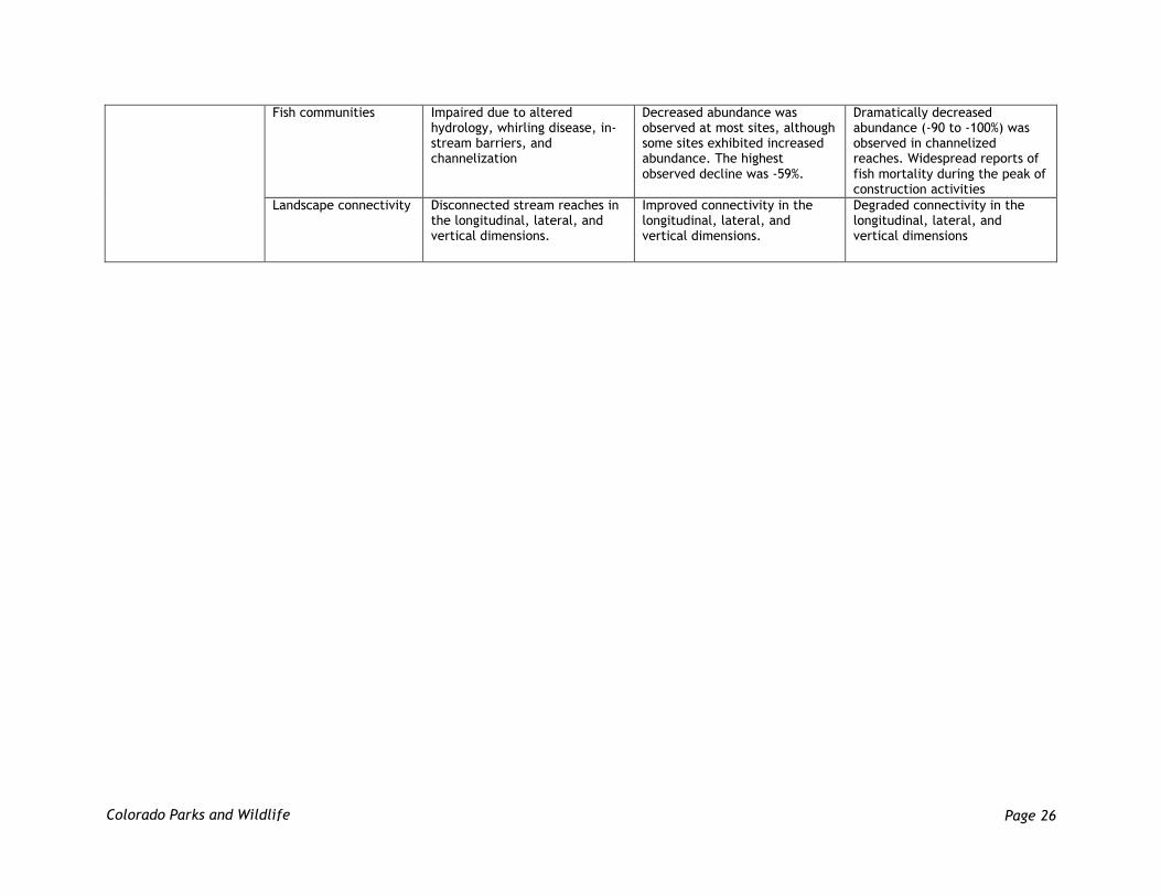
Appendix C provides a general assessment of function-based parameters prior to the flood, after the
flood, and following emergency reconstruction. This assessment was based on site visits to the Cache la
Poudre River, Big Thompson River, St. Vrain Creek, Left Hand Creek, and South Boulder Creek.
Although quantitative metrics were not used for this assessment, this qualitative assessment is
representative of post-flood changes to function-based parameters in the Colorado Front Range. To
summarize, the following parameters were improved by the flood: floodplain connectivity, flow
dynamics, groundwater/surface water exchange, sediment transport capacity, large woody debris

Page 17
Colorado Parks and Wildlife
transport and storage, channel evolution, bedform diversity, bed material characterization, water
temperature and dissolved oxygen, nutrients and organic carbon, and landscape connectivity. All of
these parameters were subsequently degraded to a lower functioning state in reaches where
emergency reconstruction took place. We encourage restoration programs and grants to utilize a
function-based approach for stream restoration projects that will improve conditions beyond their pre-
flood, degraded condition. If streams must be returned to a pre-existing condition, we recommend that
they be returned to their post-flood condition rather than their pre-flood condition.
Figure 10. Functions and parameters associated with the each level of the Stream Functions Pyramid
(Harman et al., 2012).
Although funding and programmatic constraints could impact the extent of post-flood stream
restoration, permitting should not be a major obstacle for stream restoration because CPW has worked
with the ACOE to develop Regional General Permit No. 12. This permit addresses aquatic habitat
improvement for stream channels in Colorado, including a list of authorized activities and examples of
in-stream structural designs. The permit also includes a list of general conditions and best management
practices. We recommend that Regional General Permit No. 12 be utilized for post-flood stream
restoration projects, and hope that it provides a means to expedite the 404 permitting process while
maximizing the benefits of stream restoration projects.
Page 18
Colorado Parks and Wildlife
Summary of Recommendations
We recommend that the following points be addressed or incorporated into future flood responses. The
points are divided by topic, including recommendations for emergency in-stream construction, fish
passage, and stream restoration.
Recommendations for Post-Flood Emergency Reconstruction
Utilize coffer dams and pumps to manage water in the vicinity of in-stream construction
activities instead of drying long segments of river.
If the entire river must be dried prior to in-stream construction, gradually decrease flows so
that aquatic organisms can seek refuge in pools or downstream reaches.
Develop or utilize existing criteria for identifying large woody debris that can be left in the
channel.
If large woody debris must be removed from the channel, stockpile the wood nearby for use in
future stream restoration projects.
Clarify definitions of “debris” so that large wood and boulders are not included under the same
category as hazardous materials, building materials, or trash.
Work with FEMA and NRCS to indentify efficient means to fund exigent projects that improve
stream function over the pre-existing condition.
Extend the length of service for emergency FEMA employees beyond 120 days to minimize
inconsistent priorities and processing of information due to high-turnover rates.
Reduce stream restoration costs by approaching emergency construction efforts in a
comprehensive manner that minimizes disturbances to geomorphology and ecology.
Develop conceptual channel dimensions based on hydrologic analysis, such as regional curves,
prior to the next flood to expedite restoration designs.
Incorporate multi-stage channel dimensions and bedform-spacing into post-flood channel work
to place the river on a trajectory towards dynamic equilibrium between sediment supply and
stream flows.
Improve understanding of river ecology and stream functions among federal agencies, state
agencies, and contractors working on emergency reconstruction projects.
Develop a central “clearing house” for information pertinent to reconstruction efforts that
allows for streamlined communications between multiple agencies, contractors, and
stakeholders.
Organize a workshop or symposium with state and federal agencies, municipalities, water
users, and other stakeholders to discuss lessons learned and begin planning for the next flood
response.
Recommendation for Incorporating Fish Passage into Emergency Flood Response
Identify priority streams for fish passage prior to the next flood.
Develop fish passage design criteria for priority streams.
Develop a process for addressing fish passage at diversion structures that is endorsed by the
ACOE, FEMA, and SHPO. This process should address funding and permitting constraints,
including the historical designation of diversion structures.
Establish an emergency flood-response fund that could be used for fish passage and post-flood
habitat conservation.
Page 19
Colorado Parks and Wildlife
Improve awareness of alternative diversion structure designs that accommodate fish passage
and improve stream functions, such as the cross-vane diversion structure.
Incorporate fish screens into diversion designs to reduce the frequency of fish entrainment in
irrigation ditches. This will require addressing funding issues related to pre-existing conditions.
Improve understanding among stakeholders of aquatic organisms found in Colorado streams and
rivers, including the economic value of sport fish populations and ecological significance of
native species.
Utilize Regional General Permit No. 12 for permitting fish passage projects in Colorado.
Recommendations for Stream Restoration
Protect functioning stream reaches, improve habitat connectivity, and restore degraded
streams to a higher functioning state.
Utilize the Stream Functions Pyramid to develop project goals and objectives.
Conduct a limiting factors analysis to evaluate project goals and objectives and inform
selection of habitat treatments.
Utilize functional floodplains to convey flows and dissipate energy during floods.
Develop multi-stage channel designs based on the current hydrologic and sediment regimes.
Design channels to achieve sediment continuity.
Incorporate large woody materials into stream restoration designs to improve geomorphic
function.
Utilize post-restoration monitoring to evaluate the effectiveness of stream restoration and
habitat enhancement projects.
Utilize the ACOE Regional General Permit No. 12 for permitting post-flood stream restoration
projects in Colorado.
References
Abbe, T. and A. Brooks. 2011. Geomorphic, engineering, and ecological considerations when using
wood in river restoration. Pages 419–451 in Simon A., S.J. Bennett, J.M. Castro, eds. Stream
Restoration in Dynamic Fluvial Systems: Scientific Approaches, Analyses, and Tools. American
Geophysical Union.
Houck, K. 2014. CDOT/CWCB Hydrology Investigation, Phase One – 2013 Flood Peak Flow
Determinations. Watershed & Flood Protection Section, Colorado Water Conservation Board. 8 pp.
Harman, W., R. Starr, M. Carter, K. Tweedy, M. Clemmons, K. Suggs, C. Miller. 2012. A Function-Based
Framework for Stream Assessment and Restoration Projects. US Environmental Protection Agency,
Office of Wetlands, Oceans, and Watersheds, Washington, DC EPA 843-K-12-006.
Johnson, P.A. and S.A. Sheeder. 2011. Controlling debris at bridges. Pages 385-397 in Simon A., S.J.
Bennett, J.M. Castro, eds. Stream Restoration in Dynamic Fluvial Systems: Scientific Approaches,
Analyses, and Tools. American Geophysical Union.
Kondolf, G.M. and P.R. Wilcock. 1996. The flushing flow problem: defining and evaluating objectives.
Water Resources Research 32(8): 2589-2599.

Page 20
Colorado Parks and Wildlife
Laiho, D.R. 2014. Engineering river diversions to include fish passage. Presented at the Fish Passage
Workshop and Webinar, Northern Water Headquarters, Berthoud, Colorado.
Rosgen, D.L. 2006. Cross-vane, w-weir, and j-hook vane structures: description, design and application
for stream stabilization and river restoration. Wildland Hydrology, Inc., Fort Collins, Colorado.
Southwick Associates. 2014. The economic contributions of outdoor recreation in Colorado: a regional
and county-level analysis. Fernandina Beach, Florida. 35 pp.
Wohl, E. 2011. Seeing the forest for the trees: wood in stream restoration in the Colorado Front Range,
United States. Pages 339–418 in Simon A., S.J. Bennett, J.M. Castro, eds. Stream Restoration in
Dynamic Fluvial Systems: Scientific Approaches, Analyses, and Tools. American Geophysical Union.
Wohl, E., K. Bestgen, B. Bledsoe, K. Fausch, M. Gooseff, and N. Kramer. In preparation. Management of
large wood in streams of Colorado’s Front Range: a risk analysis based on physical, biological, and
social factors. Colorado State University, Fort Collins, Colorado.

Page 21
Colorado Parks and Wildlife
Appendix A
Page 22
Colorado Parks and Wildlife

Page 23
Colorado Parks and Wildlife
Appendix B
Trout abundance data (#/mile) for monitoring sites along the Big Thompson River. Notes: * denotes locations where post-flood channelization
occurred in 2013; scale for abundance varies among sites.

Page 24
Colorado Parks and Wildlife
Appendix C
Comparison of function-based parameters prior to the 2013 flood, after the flood, and after emergency reconstruction.
Level & Category Parameters Pre-flood condition Post-flood condition Post-emergency reconstruction
1 - Hydrology
Channel-forming discharge
Significant decrease from historic range
Not affected Not affected
Flood frequency Magnitude of floods has decreased from historic range
Not affected Not affected
Flow duration Duration of flows has decreased from historic range
Not affected Not affected
2 - Hydraulics
Floodplain connectivity Reduced connectivity from past channelization
Improved connectivity due to channel forming flows during the flood
Degraded connectivity from channelization and streambank armoring
Flow dynamics Velocity, shear stress, and stream power decreased from hydrologic alteration
Improved flow dynamics due to more natural channel morphology
Degraded flow dynamics from channelization
Groundwater/surface water exchange
Reduced exchange due to water development & channelization
Substantial exchange of groundwater and surface water from floodplain inundation
Degraded exchange of groundwater and surface water from channelization and streambank armoring
3 - Geomorphology
Sediment transport capacity
Reduced capacity from water development
Improved capacity from lower width-to-depth ratio, improved flow dynamics, and removal of low-head dams
Degraded capacity from reconstruction of low-head dams and channelization
Large woody debris transport and storage
Reduced transport capacity and storage
Significant increase in storage and potential for future transport
Significant decrease in storage and potential for future transport
Channel evolution Ongoing degradation and widening
Improved sinuosity, width-to-depth ratios, and floodplain connectivity
Returned to degraded, channelized stage of channel evolution
Bank migration/lateral stability
Prevalence of armored streambanks
Substantial bank erosion and channel avulsion
Eroding banks stabilized with rip-rap and grout
Riparian vegetation Reduced cottonwood recruitment and overall function
Scoured or buried vegetation in many locations. Sediment deposition created favorable conditions to re-establishing riparian vegetation.
Channelization degraded lateral connectivity, which adversely affected riparian vegetation.
Bed form diversity Degraded from reduced frequency of channel maintenance flows
Improved diversity from channel maintenance flows
Reduced diversity from channelization and in-stream construction

Page 25
Colorado Parks and Wildlife
Bed material characterization
Increasing presence of fines and embeddedness
Reduced embeddedness and improved hyporheic conditions
Instream construction likely impacted stream bed and degraded hyporheic zone
4 - Physiochemical
Water quality - toxicants
Degraded from land use and emerging contaminates of concern
Sewage and hazardous materials introduced to channel
Sewage lines repaired and hazardous materials removed
Water quality - temperature
Increased temperatures from water development and over-wide conditions
Newly scoured pools and narrower channels likely to reduce water temperatures
Channelization created over-wide, shallow conditions that elevate water temperatures. Poor floodplain connectivity reduces riparian water storage and return flows.
Water quality - dissolved oxygen
Decreased DO from increased temperatures
Reduced temperatures (see above) and improved bedform diversity likely to increase DO
Elevated temperatures from channelization likely to reduce DO
Nutrients Elevated nutrients from wastewater treatment facilities, agricultural fertilizers, and atmospheric deposition
Nutrient exchange with floodplain
Channelization reduces floodplain connectivity and subsequent nutrient exchange between riparian areas and the active channel
Organic carbon Removal of LWD likely reduced amount of organic carbon
Improved carbon exchange with floodplain and recruitment of wood
Removal of wood from the channel reduces the amount of available organic carbon
5 - Biology
Microbial communities Uncertain Uncertain Removal of large wood decreased available nutrients and organic carbon which adversely impacts primary production
Macrophyte communities
Uncertain Likely scoured Removal of large wood decreased available nutrients which adversely impacts primary production
Benthic macroinvertebrate communities
Negatively impacted by streambed armoring
Improved hyporheic connectivity, but populations likely decreased due to streambed disturbance
Instream construction likely impacted stream bed which degraded hyporheic connectivity. Removal of large wood decreased available nutrients and organic carbon which adversely impacts primary production
Page 26
Colorado Parks and Wildlife
Fish communities Impaired due to altered hydrology, whirling disease, in-stream barriers, and channelization
Decreased abundance was observed at most sites, although some sites exhibited increased abundance. The highest observed decline was -59%.
Dramatically decreased abundance (-90 to -100%) was observed in channelized reaches. Widespread reports of fish mortality during the peak of construction activities
Landscape connectivity Disconnected stream reaches in the longitudinal, lateral, and vertical dimensions.
Improved connectivity in the longitudinal, lateral, and vertical dimensions.
Degraded connectivity in the longitudinal, lateral, and vertical dimensions