port procedures and information for shipping – whitsundays
TRANSCRIPT

Port Procedures and Information for Shipping – Whitsundays
December 2018

Hard copies of this document are considered uncontrolled. Please refer to the Maritime Safety Queensland website for the latest version. Port Procedures and Information for Shipping – Whitsundays – September 2018
Creative Commons information © State of Queensland (Department of Transport and Main Roads) 2017
http://creativecommons.org.licences/by/4.0/ This work is licensed under a Creative Commons Attribution 4.0 Licence. You are free to copy, communicate and adapt the work, as long as you attribute the authors. The Queensland Government supports and encourages the dissemination and exchange of information. However, copyright protects this publication. The State of Queensland has no objection to this material being reproduced, made available online or electronically but only if it’s recognised as the owner of the copyright and this material remains unaltered.
The Queensland Government is committed to providing accessible services to Queenslanders of all cultural and linguistic backgrounds. If you have difficulty understanding this publication and need a translator, please call the Translating and Interpreting Service (TIS National) on 13 14 50 and ask them to telephone the Queensland Department of Transport and Main Roads on 13 74 68.
Disclaimer: While every care has been taken in preparing this publication, the State of Queensland accepts no responsibility for decisions or actions taken as a result of any data, information, statement or advice, expressed or implied, contained within. To the best of our knowledge, the content was correct at the time of publishing.

Hard copies of this document are considered uncontrolled. Please refer to the Maritime Safety Queensland website for the latest version. Port Procedures and Information for Shipping – Whitsundays – September 2018 3
Contents List of tables ................................................................................................................................ 6
List of figures ............................................................................................................................... 6
Table of Amendments ................................................................................................................. 7
Section 1 Introduction ............................................................................................................. 8 General........................................................................................................................... 8 Purpose .......................................................................................................................... 8 Datum ............................................................................................................................. 9 Authorities ...................................................................................................................... 9 Definitions .................................................................................................................... 10
1.5.1 Australian Maritime Safety Authority (AMSA) .............................................................. 10 1.5.2 MASTREP — Modernised Australian Ship Tracking and Reporting System .............. 10 1.5.3 Great Barrier Reef Marine Park Authority (GBRPMA) ................................................. 10 1.5.4 Highest astronomical tide (HAT)/Lowest astronomical tide (LAT) ............................... 10 1.5.5 International Maritime Organization (IMO) ................................................................... 10 1.5.6 Maritime Safety Queensland (MSQ) ............................................................................ 10 1.5.7 Overall length (LOA) .................................................................................................... 11 1.5.8 REEFREP .................................................................................................................... 11 1.5.9 Reef VTS ...................................................................................................................... 11 1.5.10 Regional Harbour Master (RHM) ................................................................................. 11 1.5.11 Whitsundays Plan of Management (WPOM) ............................................................... 11
Contact information ...................................................................................................... 11 1.6.1 The Regional Harbour Master ...................................................................................... 11 1.6.2 Great Barrier Reef Marine Park Authority .................................................................... 11 1.6.3 Hamilton Island Marina ................................................................................................ 11 1.6.4 Reef VTS ...................................................................................................................... 12 1.6.5 Marine authorities ......................................................................................................... 12
Section 2 Whitsundays pilotage area .................................................................................. 13 Pilotage area ................................................................................................................ 13 Compulsory pilotage area ............................................................................................ 13 Applicable vessels ........................................................................................................ 14
Section 3 Movement and traffic procedures ....................................................................... 15 General......................................................................................................................... 15 Vessel Traffic Service (VTS) ........................................................................................ 15
3.2.1 Information Service (INS) ............................................................................................. 15 3.2.2 Traffic Organisation Service (TOS) .............................................................................. 15 3.2.3 Navigational Assistance Service (NAS) ....................................................................... 15
Prior notification of movement ..................................................................................... 16 3.3.1 QSHIPS (Queensland Shipping Information Planning System) .................................. 16
Booking a vessel movement ........................................................................................ 16 Arrival reporting requirements ...................................................................................... 17 Departure reporting requirements ................................................................................ 17 Tug and tow transiting the GBRMPA Compulsory pilotage area. ................................ 17 Cruise ship anchorage applications ............................................................................. 17

Hard copies of this document are considered uncontrolled. Please refer to the Maritime Safety Queensland website for the latest version. Port Procedures and Information for Shipping – Whitsundays – September 2018 4
MASTREP .................................................................................................................... 18 Reporting defects ......................................................................................................... 18
Section 4 Cruise ship anchorages ....................................................................................... 19 General......................................................................................................................... 19 Pilotage ........................................................................................................................ 19 Fitzalan anchorage ....................................................................................................... 19
4.3.1 Environmental issues: .................................................................................................. 20 4.3.2 Application and voyage plan for Fitzalan Anchorage ................................................... 20 4.3.3 Maximum length of ship ............................................................................................... 21 4.3.4 Minimum manoeuvring equipment ............................................................................... 21 4.3.5 Navigation Information for Fitzalan Anchorage ............................................................ 21 4.3.6 Anchorage details ........................................................................................................ 22 4.3.7 Navigation aids ............................................................................................................. 22 4.3.8 Geographic location ..................................................................................................... 23 4.3.9 Anchoring practices ...................................................................................................... 23 4.3.10 Recommended anchorage position ............................................................................. 23 4.3.11 Swinging room ............................................................................................................. 23 4.3.12 Swinging limits ............................................................................................................. 24 4.3.13 Marshalling craft ........................................................................................................... 24 4.3.14 Tidal information and controlling depth ........................................................................ 25 4.3.15 Entry and departure track information .......................................................................... 26 4.3.16 Standby requirements .................................................................................................. 29 4.3.17 Chart and position-fixing requirements ........................................................................ 29 4.3.18 Limited period access .................................................................................................. 30
Hardy Reef anchorage ................................................................................................. 30 CID Harbour anchorage ............................................................................................... 31 Turtle Bay anchorage ................................................................................................... 34 South East Hamilton anchorage .................................................................................. 36 Recreational vessels — restricted areas and activities ............................................... 37 Sewage pump-out facilities .......................................................................................... 38 Resorts ......................................................................................................................... 38
4.10.1 Hamilton Island ............................................................................................................ 38 4.10.2 Hayman Island ............................................................................................................. 39 4.10.3 Daydream Island .......................................................................................................... 39 4.10.4 Hook Island .................................................................................................................. 39 4.10.5 Lindeman Island ........................................................................................................... 41 4.10.6 South Molle Island ........................................................................................................ 41 4.10.7 Laguna Whitsundays .................................................................................................... 42
Reefs and reef pontoons .............................................................................................. 42 4.11.1 Hardy Reef ................................................................................................................... 43 4.11.2 Bait Reef ...................................................................................................................... 43 4.11.3 Knuckle Reef ................................................................................................................ 43 4.11.4 Disclaimer .................................................................................................................... 43
Section 5 General information .............................................................................................. 45 Charts and books ......................................................................................................... 45 Shipping announcements ............................................................................................ 45 Differential global positioning system (DGPS) Service ................................................ 45 Volunteer Marine Rescue (VMR) Whitsunday and Mackay ......................................... 46 Speed restrictions ........................................................................................................ 46

Hard copies of this document are considered uncontrolled. Please refer to the Maritime Safety Queensland website for the latest version. Port Procedures and Information for Shipping – Whitsundays – September 2018 5
Navigation information ................................................................................................. 47 5.6.1 Vessels underway ........................................................................................................ 47 5.6.2 Under keel clearance ................................................................................................... 47 5.6.3 Specific problem areas................................................................................................. 48
Aids to navigation ......................................................................................................... 49 5.7.1 Radio and electronic aids ............................................................................................. 50
Anchoring ..................................................................................................................... 50 5.8.1 ‘No anchoring’ areas .................................................................................................... 50
Buoy moorings ............................................................................................................. 51
Section 6 Weather information ............................................................................................. 52 General......................................................................................................................... 52
6.1.1 Extreme Weather Event Contingency Plan.................................................................. 52 6.1.2 Cyclone procedures - Abel Point Marina ..................................................................... 52 6.1.3 Cyclone procedures — Port of Airlie Marina ................................................................ 52
Tidal information ........................................................................................................... 53 6.2.1 Tidal information — Tsunami effects ........................................................................... 53
Section 7 Dangerous cargo................................................................................................... 54 General......................................................................................................................... 54
7.1.1 Notification ................................................................................................................... 54 Dangerous cargo events .............................................................................................. 54 Reporting requirements for local marine services ....................................................... 55
Section 8 Emergency pollution marine incidents ............................................................... 57 General......................................................................................................................... 57 Emergency contact numbers ....................................................................................... 57 Marine pollution ............................................................................................................ 57
8.3.1 Reporting ...................................................................................................................... 58 8.3.2 Waste disposal ............................................................................................................. 58 8.3.3 Sewage ........................................................................................................................ 58
Marine incidents ........................................................................................................... 60 8.4.1 Marine incident reporting.............................................................................................. 60 8.4.2 Marine incident reporting — AMSA .............................................................................. 61
Great Barrier Reef Marine Park Authority incident report form .................................... 61
Section 9 Appendices ............................................................................................................ 62 Whitsunday reporting area - pre-arrival report ............................................................. 63 Form 1 - Fitzalan Anchorage - Application for technical assessment .......................... 64 Form 2 - Fitzalan Anchorage - Application to visit ....................................................... 65 Form 3 - Fitzalan Anchorage - Voyage plan ................................................................ 66 Hamilton Island request form ....................................................................................... 67 Whitsundays Pilotage area .......................................................................................... 68

Hard copies of this document are considered uncontrolled. Please refer to the Maritime Safety Queensland website for the latest version. Port Procedures and Information for Shipping – Whitsundays – September 2018 6
List of tables Table 1 – Marine authorities ........................................................................................................ 12 Table 2 – Prior notification of movement ..................................................................................... 16 Table 3 – Navigation aids ............................................................................................................ 22 Table 4 – Fitzalan Anchorage swinging circles ........................................................................... 24 Table 5 – Hardy Reef anchorage information ............................................................................. 30 Table 6 – Cid Harbour anchorage - information .......................................................................... 32 Table 7 - Turtle Bay anchorage - information .............................................................................. 34 Table 8 – South East Hamilton anchorage - information ............................................................ 36 Table 9 – Hamilton Island information .................................................................................... 38 Table 10 – Hayman Island information .................................................................................... 39 Table 11 – Daydream Island information ................................................................................ 39 Table 12 – Hook Island information ......................................................................................... 40 Table 13 – Lindeman Island information ................................................................................. 41 Table 14 – South Molle Island information ............................................................................. 41 Table 15 – Laguna Whitsundays information ......................................................................... 42 Table 16 – Reef and reef pontoons .......................................................................................... 42 Table 17 – Bait Reef information .............................................................................................. 43 Table 18 – Disclaimer ................................................................................................................ 43 Table 19 – Tidal information ..................................................................................................... 53 Table 20 – Movement Notification ........................................................................................... 54 Table 21 – Emergency contact numbers ................................................................................. 57
List of figures Figure 1 – Anchorage details....................................................................................................... 22 Figure 2 – Entry/departure track into Fitzalan Anchorage ........................................................... 26 Figure 3 – Fitzalan Anchorage – Henning Entrance ................................................................... 27 Figure 4 – Henning Entrance....................................................................................................... 28 Figure 5 – Henning Entrance – Head mark ................................................................................. 28

Hard copies of this document are considered uncontrolled. Please refer to the Maritime Safety Queensland website for the latest version. Port Procedures and Information for Shipping – Whitsundays – September 2018 7
Table of Amendments Contact for enquiries and proposed changes. If you have any questions regarding this document or if you have a suggestion for improvements, please contact:
Contact officer: ............... Regional Harbour Master (Mackay)
Phone: ............................ +61 7 4944 3700
Email: .............................. [email protected]
Revision Date Page number or section Summary of Changes Approved by
April 2009 - First Issue Regional Harbour Master
January 2016 - Second Issue Regional Harbour Master
September 2016 Various TOMSA / TOMSR updates Regional Harbour Master
November 2016 Various Corrected formatting for consistency. Updated references to VTS Area
Regional Harbour Master
October 2017 3.10, 4.10.4, 4.10.5, 4.10.7 & 6.1.1 Amended Regional Harbour Master
May 2018 Various Amended Regional Harbour Master
July 2018 1.6.5, 5.7, 8.2 Amended Regional Harbour Master
September 2018 8.3 & 8.3.1 TOMPR updates Regional Harbour Master
December 2018 6.1.2 Abel Point Marina link updated Regional Harbour Master

Hard copies of this document are considered uncontrolled. Please refer to the Maritime Safety Queensland website for the latest version. Port Procedures and Information for Shipping – Whitsundays – December 2018 8
Section 1 Introduction
General The Whitsunday region is part of the Great Barrier Reef World Heritage Area and includes the commonwealth Great Barrier Reef Marine Park and Queensland national park and marine park areas.
The area controlled encompasses the Whitsunday Passage, a number of cruise ship anchorages and numerous island passages, bays, beaches and inlets used by both recreational and commercial craft.
Within the Whitsunday Islands are several holiday resorts some of which share boundaries with national parks under the direction of the National Parks and Wildlife Service (NPWS).
Marine activity in the region is generally busy throughout the year but does experience periods of higher activity associated with annual holiday peaks. Regular ferry services interconnect the islands and the mainland and recreational boating is becoming increasingly popular as facilities are provided to cater for them.
The Great Barrier Reef Marine Park Authority (GBRMPA) oversees designated zones in which all activities are controlled depending on the sensitivity of the particular zone. Some activities require the issue of a permit. For example cruise ship anchorages and certain areas are designated as preservation zones that prohibit all activities and are ‘no go’ areas. The marine park has ‘designated shipping areas’ (DSA) where particular activities, such as shipping, are permitted. Penalties apply for operating ships outside designated shipping areas without the written permission of the Great Barrier Reef Marine Park Authority.
The Australian Maritime Safety Authority (AMSA), the Great Barrier Reef Marine Park Authority and Queensland authorities regularly monitor shipping activities to ensure that local, national and international laws are followed, and to record and evaluate shipping information for future policies. Ship owners, captains and crews face heavy fines and possible prosecution if they do not follow the rules and regulations of shipping within the Great Barrier Reef Marine Park.
As a destination for domestic and international cruise shipping the Whitsunday region generally is highly attractive because of the its unique mix of environmental credentials, proximity to the Great Barrier Reef and quality tourist development.
Cruise ship patronage of the Whitsunday region has expanded markedly in the last decade. Most of the international traffic favours the southern summer months, December to April, with cruise ships engaged mostly on Pacific-rim or round-world cruises. Domestic cruise ship traffic has tended to operate year-round.
Purpose This document defines the standard procedures to be followed in the pilotage area; it contains information and guidelines to assist ship's masters, owners, and agents of vessels arriving at and traversing the area. It provides details of the services and the regulations and procedures to be observed.
Nothing in this publication is intended to relieve any vessel, owner, operator, charterer, master, or person directing the movement of a vessel from the consequences of any failure to comply with any applicable law or regulation or of any neglect of precaution

Hard copies of this document are considered uncontrolled. Please refer to the Maritime Safety Queensland website for the latest version. Port Procedures and Information for Shipping – Whitsundays – December 2018 9
which may be required by the ordinary practice of seamanship, or by the special circumstances of the case.
Information contained in this document is based on information available as at the latest date indicated on the document control sheet at the start of this publication. Although every care has been taken to ensure that this information is correct, no warranty, expressed or implied, is given in regard to the accuracy of all printed contents. The publisher shall not be responsible for any loss or damage resulting from or caused by any inaccuracy produced herein.
The latest version of this publication is available on the Maritime Safety Queensland website.
Any significant updates to the content of these procedures will be promulgated on this site.
Should errors or omissions in this publication be noted, it would be appreciated if advice of these could be forwarded to:
The Regional Harbour Master (Mackay)
PO Box 58, Mackay, Queensland 4740
Phone: +61 7 4944 3700
Email: [email protected]
Datum All water depths refer to the ‘lowest astronomical tide’ height (LAT). All positions in this manual are in WGS84.
All directions are referenced to True North.
Authorities The Transport Operations (Marine Safety) Act 1994 (section 88) — ‘A harbour master may direct the master of a ship to navigate or otherwise operate the ship in a specified way.’
Maritime Safety Queensland, through the authority of the harbour master, has jurisdiction over the safe movement of all shipping within the pilotage area.
The Transport Operations (Marine Pollution) Act 1995 (section 68) — ‘Authorised officers have the following functions — a) to investigate discharges prohibited by this act, b) to monitor compliance with this act, c) to monitor transfer operations, d) to examine ships using coastal waters to minimise discharges, e) to take action to remove a pollutant discharged into coastal waters or to mitigate its effect on Queensland marine and coastal environment.’
The Great Barrier Reef Marine Park Act 1975 is the primary act in respect of the Great Barrier Reef Marine Park. It includes provisions which:
• establish the Great Barrier Reef Marine Park
Information on external agencies (customs, quarantine, port authority rules, and REEFREP and so on) is provided as an example only. Readers are strongly recommended to consult their respective websites for current information.

Hard copies of this document are considered uncontrolled. Please refer to the Maritime Safety Queensland website for the latest version. Port Procedures and Information for Shipping – Whitsundays – December 2018 10
• establish the Great Barrier Reef Marine Park Authority (GBRMPA), a commonwealth authority responsible for the management of the marine park
• provide a framework for planning and management of the marine park, including through zoning plans, plans of management and permits
• prohibit operations for the recovery of minerals (which includes prospecting or exploration for minerals) in the marine park (unless approved by the Great Barrier Reef Marine Park Authority for research)
• require compulsory pilotage for certain ships in prescribed areas of the Great Barrier Reef Region
• provide for regulations, collection of environmental management charges, enforcement and so on.
The Environment Protection and Biodiversity Conservation Act 1999 (the EPBC act) is the Australian government's central piece of environmental legislation. It provides a legal framework to protect and manage nationally and internationally important flora, fauna, ecological communities and heritage places — defined in the act as matters of national environmental significance.
Definitions
1.5.1 Australian Maritime Safety Authority (AMSA)
The Australian Maritime Safety Authority is the commonwealth authority charged with enhancing efficiency in the delivery of safety and other services to the Australian maritime industry.
1.5.2 MASTREP — Modernised Australian Ship Tracking and Reporting System
MASTREP is a Ship Reporting System designed to contribute to safety of life at sea and is operated by the Australian Maritime Safety Authority (AMSA) through the Rescue Coordination Centre (RCC) Australia in Canberra.
1.5.3 Great Barrier Reef Marine Park Authority (GBRPMA)
A Commonwealth authority responsible for the management of the marine park within the Great Barrier Reef.
1.5.4 Highest astronomical tide (HAT)/Lowest astronomical tide (LAT)
These are the highest and lowest levels that can be predicted to occur under average meteorological conditions and any combination of astronomical conditions. These levels may not be reached every year. HAT or LAT are not the extreme levels that can be reached, as storm surges can cause considerably higher or lower levels to occur.
LAT is the datum to which all soundings are referred to.
1.5.5 International Maritime Organisation (IMO)
The world organisation charged with enhancing efficiency in the delivery of safety to the whole maritime industry.
1.5.6 Maritime Safety Queensland (MSQ)
The state government agency responsible for marine safety, the protection of the marine environment from ship-sourced pollution, Vessel Traffic Services and the administration

Hard copies of this document are considered uncontrolled. Please refer to the Maritime Safety Queensland website for the latest version. Port Procedures and Information for Shipping – Whitsundays – December 2018 11
of all aspects of vessel registration and qualifications of mariners in the state of Queensland.
1.5.7 Overall length (LOA)
The LOA is the extreme length of a vessel.
1.5.8 REEFREP
REEFREP is the mandatory ship reporting system established by IMO Resolution MSC.52 (66), as amended by Resolution MSC.161 (78), and specified in Marine Orders Part 63 (Reef VTS) Issue 2.
1.5.9 Reef VTS
The Great Barrier Reef and Torres Strait Vessel Traffic Service (Reef VTS) established by Australia as a means of enhancing navigational safety and environmental protection in Torres Strait and the Great Barrier Reef.
1.5.10 Regional Harbour Master (RHM)
The person authorised to give direction under the relevant provisions of the Transport Operations (Marine Safety Act 1994).
1.5.11 Whitsundays Plan of Management (WPOM)
The Whitsundays Plan of Management (WPOM) was released by the Great Barrier Reef Marine Park Authority to protect and conserve the values of the Whitsundays area.
Contact information
1.6.1 The Regional Harbour Master
For operational maritime questions, marine incidents, pollution, buoy moorings and navigation aids, please contact the Regional Harbour Master's office located at:
Level 3, 44 Nelson Street, Mackay
Postal address:
PO Box 58, Mackay, Queensland 4740
Phone: ............................ +61 7 4944 3700,
Email: .............................. [email protected]
1.6.2 Great Barrier Reef Marine Park Authority
Sustainable Development and Policy Great Barrier Reef Marine Park Authority
2-68 Flinders Street (PO Box 1379), Townsville Queensland 4810
Phone: ............................ (07) 4750 0705
Fax: ................................. (07) 4750 0760
1.6.3 Hamilton Island Marina
Marina manager

Hard copies of this document are considered uncontrolled. Please refer to the Maritime Safety Queensland website for the latest version. Port Procedures and Information for Shipping – Whitsundays – December 2018 12
Phone: ............................ +61 7 4946 8352
Fax: ................................. +61 7 4946 8743
Mobile: ............................ +61 7 411 708 162
Email: .............................. [email protected]
1.6.4 Reef VTS
Townsville Operations Centre
Phone: ............................ +61 7 4726 3428 / +61 1300 721 293
Fax: ................................. +61 7 4721 0633
Email: .............................. [email protected]
VHF Channel: ................. 11, 14
1.6.5 Marine authorities
Organisation Telephone Facsimile Email
Hay Point VTS 1300 645 022 [email protected]
Regional Harbour Master (Mackay) 07 4944 3700 [email protected]
Maritime Safety Queensland Airlie Beach 07 48414500 [email protected]
Volunteer Marine Rescue 07 4946 7207 07 4946 5200 [email protected]
Water Police 07 4967 7222 07 4948 8855 [email protected]
Queensland Boating and Fisheries Patrol 07 4946 7003 07 4946
5186
Great Barrier Reef Marine Park Authority 1800 990 177 07 4772
6093 [email protected]
Queensland Parks and Wildlife Service QPWS (Airlie Beach) 07 4967 7351
Department of Agriculture (Quarantine) 07 49559600 07 4955
9699 0427 861 911 or [email protected]
Australian Border Force 07 4965 7100 07 4965 7199 [email protected]
Table 1 – Marine authorities

Hard copies of this document are considered uncontrolled. Please refer to the Maritime Safety Queensland website for the latest version. Port Procedures and Information for Shipping – Whitsundays – December 2018 13
Section 2 Whitsundays pilotage area
Pilotage area This document applies to the designated pilotage area for the region as described in Schedule 2 of the Transport Operations (Marine Safety) Regulation 2016 as the area of:
(a) waters bounded by an imaginary line drawn— starting at the high water mark at the northern tip of George Point on the mainland:
• then to latitude 20º01.19' south, longitude 148º52.84' east
• then to latitude 20º02.94' south, longitude 148º58.63' east
• then to the high-water mark at the north-eastern tip of Deloraine Island
• then along the high-water mark of the eastern shoreline of Deloraine Island to its south-eastern tip
• then to the high-water mark at the northern tip of Harold Island
• then along the high-water mark of the eastern shoreline of Harold Island to its southern tip
• then to the high-water mark at the northern tip of Jesuit Point on Maher Island
• then along the high-water mark of the western shoreline of Maher Island to its southern tip
• then to the high-water mark at the northern tip of Shaw Island
• then along the high-water mark of the western shoreline of Shaw Island to its south-western tip
• then to the southern tip of Cape Conway on the mainland
• then by the high-water mark, initially in a general north-westerly direction, to the starting point; and
(b) the navigable waters of rivers and creeks flowing, directly or indirectly, into the waters in paragraph (a) (Whitsunday Pilotage area)
The Whitsunday pilotage area described above defines the area of jurisdictional control for navigation purposes of Maritime Safety Queensland, with the local authority being the Mackay Regional Harbour Master.
Compulsory pilotage area The ‘compulsory pilotage area’ means all regulated ships must have a pilot on board when travelling through the Inner Route, Hydrographer’s Passage and the Whitsundays. This is defined under Regulation 118, Part 5 of the Great Barrier Reef Marine Park Regulations 1983.
The compulsory pilotage area covering areas of the Whitsunday Passage, the Whitsunday and the Lindeman Island groups is defined on AUS charts 824, 825 and 821.
Hard copies of this document are considered uncontrolled. Please refer to the Maritime Safety Queensland website for the latest version. Port Procedures and Information for Shipping – Whitsundays – December 2018 14
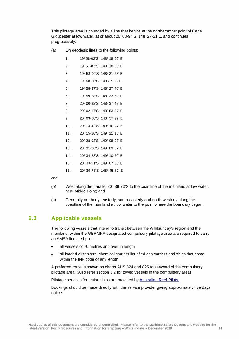
This pilotage area is bounded by a line that begins at the northernmost point of Cape Gloucester at low water, at or about 20° 03·94’S, 148° 27·51’E, and continues progressively:
(a) On geodesic lines to the following points:
1. 19o 58·02’S 148o 18·60’ E
2. 19o 57·83’S 148o 18·53’ E
3. 19o 58·00’S 148o 21·68’ E
4. 19o 58·28’S 148o27·05’ E
5. 19o 58·37’S 148o 27·40’ E
6. 19o 59·28’S 148o 33·62’ E
7. 20o 00·82’S 148o 37·48’ E
8. 20o 02·17’S 148o 53·07’ E
9. 20o 03·58’S 148o 57·92’ E
10. 20o 14·42’S 149o 10·47’ E
11. 20o 15·20’S 149o 11·15’ E
12. 20o 28·93’S 149o 08·03’ E
13. 20o 31·20’S 149o 09·07’ E
14. 20o 34·28’S 149o 10·50’ E
15. 20o 33·91’S 149o 07·06’ E
16. 20o 39·73’S 148o 45·82’ E
and
(b) West along the parallel 20° 39·73’S to the coastline of the mainland at low water, near Midge Point; and
(c) Generally northerly, easterly, south-easterly and north-westerly along the coastline of the mainland at low water to the point where the boundary began.
Applicable vessels The following vessels that intend to transit between the Whitsunday’s region and the mainland, within the GBRMPA designated compulsory pilotage area are required to carry an AMSA licensed pilot:
• all vessels of 70 metres and over in length
• all loaded oil tankers, chemical carriers liquefied gas carriers and ships that come within the INF code of any length
A preferred route is shown on charts AUS 824 and 825 to seaward of the compulsory pilotage area. (Also refer section 3.2 for towed vessels in the compulsory area)
Pilotage services for cruise ships are provided by Australian Reef Pilots.
Bookings should be made directly with the service provider giving approximately five days notice.
Hard copies of this document are considered uncontrolled. Please refer to the Maritime Safety Queensland website for the latest version. Port Procedures and Information for Shipping – Whitsundays – December 2018 15
Section 3 Movement and traffic procedures
General Maritime Safety Queensland, through the authority of the RHM, has jurisdiction over the safe movement of all shipping within the pilotage area.
The scheduling of ship movements is initiated by the agent submitting movement details for a vessel to Hay Point VTS via the QSHIPS ship planning programme in accordance with this section
These requirements apply to ships of 35 metres and over or a ship under 35 metres in length that is combined with another ship for propelling one of the ships and the total lengths of the ships is 35 metres or more proceeding to an anchorage within the pilotage area of the Whitsundays. It does not apply to vessels transiting the pilotage area.
Applicable vessels (see section 2.2.2 above) are required to comply with the mandatory reporting requirements of Reef VTS.
Vessel Traffic Service (VTS) Maritime Safety Queensland does not operate a Vessel Traffic Service for the Whitsunday pilotage area. However, a VTS centre operates from Hay Point, south of Mackay with the callsign “Hay Point VTS” and maintains a listening watch on VHF Channels 10, 16 and 67 via repeaters though the Whitsunday region.
Maritime Safety Queensland provides VTS in accordance with IMO Resolution A.857 (20). The role of the Hay Point VTS is to facilitate the safe and efficient movement of large commercial shipping (passenger ships) within the pilotage area, including all necessary coordination of port services, and dissemination of relevant information, to ensure that a continual program of shipping movements can be affected to the advantage of all commercial shipping in an impartial manner.
3.2.1 Information Service (INS) The VTS or at the request of a vessel, can transmit essential and timely information to assist in the on-board decision making process, which may include: position, identity and intentions of other traffic, hazards and other factors which may affect a vessels transit.
3.2.2 Traffic Organisation Service (TOS) The VTS will forward plan vessel movements to prevent congestion and provide for safe and efficient movement of traffic. The VTS will identify and manage potentially dangerous traffic situations and provide essential and timely information to assist the on-board decision making process and may advise, instruct, or exercise the authority to direct movements.
3.2.3 Navigational Assistance Service (NAS)
The VTS will, at the request of a Marine Pilot, provide navigational assistance for a deep draft vessel, utilising the Departure Channel. The NAS provided will be limited to the position of the vessel in relation to the departure channel centre line, utilising chainage of offset format.

Hard copies of this document are considered uncontrolled. Please refer to the Maritime Safety Queensland website for the latest version. Port Procedures and Information for Shipping – Whitsundays – December 2018 16
Prior notification of movement
Action Minimum notice Approved form
Prior notification of arrival to an anchorage in the pilotage area
48 hours prior to entry
Arrival information to Regional Harbour Master via QSHIPS and Port Control.
Transport of dangerous goods in pilotage area
48 hours prior to entry
Dangerous cargo report (section 7 Dangerous Cargo)
Anchorage permit application to GBRMPA
At least three months prior to arrival.
Fitzalan anchorage ‘Application for technical assessment’
When application has been made for a GBRMPA permit
Form 1 - Fitzalan Anchorage - Application for technical assessment
Fitzalan anchorage ‘application to visit’
When application has been made for a GBRMPA permit
Form 2 - Fitzalan Anchorage - Application to visit
Fitzalan anchorage ‘voyage plan’
At least three days prior to Arrival. Form 3 - Fitzalan Anchorage - Voyage plan
Table 2 – Prior notification of movement
3.3.1 QSHIPS (Queensland Shipping Information Planning System)
The movement of all vessels of LOA 35 m or more arriving at Whitsundays is recorded in an internet based program known as QSHIPS. https://qships.tmr.qld.gov.au/webx/
The program is operated from the VTS centre; shipping agents submit booking information on line in accordance with the reporting requirements and record their requisitions for tugs, pilot and linesmen. The ancillary services respond on line to acknowledge the booking and allocate their resources; the movement then assumes the confirmed status. Work permits (section 10) requests should be submitted on line and to the respective agencies if required. QSHIPS will indicate when the approval has been granted and the agent is then able to print the permit for the vessel.
Since the program is live, port service providers, agents, government agencies and the general community are able to view scheduled movements in any Queensland port in real time.
Booking a vessel movement When an agent is advised by his principals that a ship is bound for the Whitsundays then that agent shall book in the ship via the QSHIPS program at least 48 hours prior to the movement as required under Transport Operations (Marine Safety) Regulations 2016 section 168. Request for the supply of a pilot should also be made via QSHIPS https://qships.tmr.qld.gov.au/webx
The use of the QSHIPS program is recommended for notification of the impending arrival and subsequent movements of a vessel unless exceptional circumstances preclude this. If an agent is unable to submit a booking by QSHIPS the Arrival / Departure Report must be faxed or emailed to the VTS centre. If a vessel is calling at the port for the first time the Vessel details report (new ship) form must also be completed and submitted.
Details of any removal movement and departure information are to be submitted at least 24 hours prior to the start time in a similar manner to the above.
Arrival advice should be confirmed to the VTS centre 24 hours prior to the start of the movement.
Hard copies of this document are considered uncontrolled. Please refer to the Maritime Safety Queensland website for the latest version. Port Procedures and Information for Shipping – Whitsundays – December 2018 17
Arrival reporting requirements Report the expected arrival date and time at the pilotage area to the Regional Harbour Master by;
• If the ship is 50m or more in length, notifying Hay Point VTS by submitting a booking in QSHIPS at least 48 hours prior to the expected arrival at the pilotage area.
• .If the ship is 35m or more in length, but less than 50m in length, notifying Hay Point VTS at least 24 hours prior to the expected arrival at the pilotage area
When entering the pilotage area, notify Hay Point VTS, the ship’s name, intended anchorage and ETA at the anchorage.
Notify Hay Point VTS when safely anchored.
Departure reporting requirements Report the intended departure from the pilotage area to the Regional Harbour Master by;
• If the ship is 50m or more in length, notifying Hay Point VTS at least 24 hours prior to departure.
• If the ship is 35m or more in length, but less than 50m in length, notifying Hay Point VTS at the time of departure.
Notify Hay Point VTS when commence heaving anchor.
Notify Hay Point VTS when departing the pilotage area.
Tug and tow transiting the GBRMPA Compulsory pilotage area. The Regional Harbour Master has directed that ships engaged in towing or pushing;
• where the combined length of the tow measured from the stern of the towing vessel to the stern of the last vessel being towed exceeds 150 metres
• and intend to transit between the Whitsunday’s region and the mainland, within the GBRMPA designated compulsory pilotage area
are required to carry an AMSA licensed pilot. (Refer section 2.2.2 for more information)
Cruise ship anchorage applications There are eight gazetted cruise ship anchorages within the Whitsundays that are controlled by a joint permit arrangement involving the Great Barrier Reef Marine Park Authority and Queensland Parks and Wildlife Service. The issue of a permit is required for vessels over 70 metres LOA.
Vessels wishing to use these anchorages should make application to GBRMPA as (www.gbrmpa.gov.au/zoning-permits-and-plans/permits) early as possible as the application can take at least three months to process and is issued on a first come first served basis. The permit is issued for a specific anchorage on a specified date. With the exception of the Turtle Bay anchorage only one ship at a time is permitted to use a designated anchorage.
Vessels planning to visit the Fitzalan anchorage are required to submit the following forms to the Mackay Regional Harbour Master. These documents can be lodged by the ship’s master, owner/operator, or the ship’s Australian port agent on their behalf:

Hard copies of this document are considered uncontrolled. Please refer to the Maritime Safety Queensland website for the latest version. Port Procedures and Information for Shipping – Whitsundays – December 2018 18
Form 1 - Fitzalan Anchorage - Application for technical assessment;
(9.2) this includes the technical details of the vessel — LOA, tonnage, draft, manoeuvring and navigational equipment for assessment.
Form 2 - Fitzalan Anchorage - Application to visit;
(9.3) intended date of visit and planned times of arrival and departure.
Form 3 - Fitzalan Anchorage - Voyage plan
(9.4) at least three (3) days prior to arrival at the anchorage. A 9.9m shoal patch to the south east of “Reef Pt” (approx. position Lat 21° 17.5’S, Long 148° 54.7’E is the controlling depth for ships entry into Fitzalan Passage.
Dangerous goods must not be brought into or handled in the pilotage area until notification has been sent to the harbour master in the approved Dangerous Cargo Report form at least 48 hours prior to arrival in port limits. For further information (see section 7)
MASTREP The Modernised Australian Ship Tracking and Reporting System (MASTREP) as described in Marine Order 63 (MASTREP) 2013, effective 1 July 2013, is used to track the location of vessels. Under this system:
• Positional reporting for vessels is sourced from the vessel’s Automatic Identification System (AIS).
• Sailing Plans, Deviation Reports and Final Reports are not required.
• Communications with vessels continue to be available through Inmarsat, HF, satellite telephony and other means.
• Special Reports are required to support AMSA’s role in shipping oversight and incident reporting management.
MASTREP is operated by the Australian Maritime Safety Authority (AMSA) as part of the services offered by the Rescue Coordination Centre (RCC Australia). RCC Australia is staffed 24 hours per day.
Reporting defects The Australian Maritime Safety Authority (AMSA) requires notification of any deficiencies or suspected deficiencies on ships visiting Australian ports. Deficiencies are to be reported to AMSA which can be found on AMSA website.
‘Report of suspected non-compliance with Navigation Act or Safety/Pollution conventions’.

Hard copies of this document are considered uncontrolled. Please refer to the Maritime Safety Queensland website for the latest version. Port Procedures and Information for Shipping – Whitsundays – December 2018 19
Section 4 Cruise ship anchorages
General In order to meet the growing demand for anchorage sites for visiting cruise vessels eight ‘cruise ship anchorages’ have been designated within the ‘Whitsunday Planning Area’ that are controlled by a joint permitting arrangement involving the Great Barrier Reef Marine Park Authority and Queensland Parks and Wildlife Service. Link to Whitsundays Cruise ship anchorages.
Cruise ships are required to carry a licensed pilot in the Whitsunday compulsory pilotage area. Anchorages are booked on a ‘first come, first served’ basis.
Pilotage Great Barrier Reef Marine Park regulations introduced in October 2000 require all vessels over 70 metres LOA to engage a licensed pilot when transiting the ‘Whitsunday Plan of Management’ (WPOM) compulsory pilotage area.
Furthermore, cruise ships seeking a permit to enter any of the gazetted anchorages and conduct tourist activities are obliged under the WPOM to engage a licensed pilot. The region is within the jurisdictional limits of Queensland Barrier Reef pilots’ licenses issued by the Australian Maritime Safety Authority.
Pilotage services for cruise ships in the Whitsundays are provided Australian Reef Pilots. Preferably four to five days’ notice is required.
Fitzalan anchorage The information on Fitzalan Anchorage is reproduced from a document written by Captain J Ellyett — Regional Harbour Master (Mackay) and Captain John Foley (Australian Reef Pilots Pty Ltd) in 2009. The material contained in this document contributes to the safe and efficient management of shipping within Queensland waters. This does not absolve the master of responsibility for all aspects of the safe navigation and operation of the ship. This material is current at time of promulgation. Any detail shown in diagrammatic form is not to be used for navigational purposes.)
Fitzalan Anchorage lies close north of Hamilton Island in Queensland’s Whitsunday Islands region. It is bounded by Whitsunday Island to the north and east, Hamilton Island to the south, and Henning Island to the west. First declared available for cruise ship traffic in early 2003, it is one of eight gazetted Whitsunday cruise ship anchorages. In the absence of any official name the area is referred to as Fitzalan Anchorage, the name Fitzalan taken from a nearby channel between Fitzalan Island and Hamilton Island; locally, the region is known as Hamilton Cove. Being almost landlocked, Fitzalan Anchorage is in consequence protected from strong winds, ocean seas and swells.
The recommended anchorage position is approximately 1·8 miles from the landing pontoon in Hamilton Island harbour. The harbour contains a marina with 135 berths, plus public landing pontoons. Cruise ships anchored in Fitzalan Anchorage are entitled to use their tenders to shuttle passengers to Hamilton Harbour.
Hamilton Island is described as a residential resort, with a range of accommodation styles, private residences, specialty shops, restaurants, banks, and a variety of tourist attractions on the island itself.

Hard copies of this document are considered uncontrolled. Please refer to the Maritime Safety Queensland website for the latest version. Port Procedures and Information for Shipping – Whitsundays – December 2018 20
Patronage of Fitzalan Passage by local traffic mostly comprises tourist vessels in transit between Hamilton Island and other Whitsunday destinations. Hamilton Harbour is the base for many other Whitsunday region tourist attractions. The island has an airport with daily direct jet connections to major Australian cities.
Prior to the opening of Fitzalan Anchorage the most-used cruise ship anchorage in the area and traditional focus of Whitsunday cruise ship activities has been Cid Harbour, between Cid Island and Whitsunday Island. Cid Harbour is protected from the predominant southerly winds and has afforded a safe, calm environment in which to transfer passengers into local tourist craft engaged in Whitsunday activities. Northerly winds springing up in the late afternoons have, however, sometimes rendered the anchorage uncomfortable for passenger transfers and on rare occasions ships have been obliged to relocate to Turtle Bay, south of Whitsunday Island.
In 1998 other cruise ship anchorages — to the west of Hardy Reef (outer Barrier Reef), in Funnel Bay (near Airlie Beach), Hayman Island anchorage, Port Molle (west of Long Island), and two weather-alternate anchorages south of Whitsunday Island — were gazetted under the ‘Whitsunday Plan of Management’ (WPOM).
Note: It is also, with permission from the Mackay Regional Harbour Master, possible to anchor in the main Whitsunday Passage, west of Henning Island, and to run ship’s tenders from the anchorage to Hamilton Harbour. The ship must anchor no closer than 1500m (approximate 0·8 miles) from the nearest island or reef. This anchorage can be a useful stop-gap anchorage for ships bound for Hamilton Cove. If the tidal conditions at the entrance to Fitzalan Passage are unsuitable at the planned arrival time the ship can anchor temporarily off Henning Island and, weather permitting, conduct passenger transfer operations to Hamilton Harbour until able to move around into Hamilton Cove. Again, in reverse, it can be used if the tidal conditions at the planned departure time are unsuitable and the ship has to depart earlier than intended.
4.3.1 Environmental issues:
Fitzalan Passage anchorage lies within the commonwealth Great Barrier Reef Marine Park and the Queensland Townsville/Whitsunday Marine Park; this is a world heritage listed area. The anchorage area is zoned ‘Conservation Park Zone’, within which cruise ships may neither transit nor anchor without a marine park permit issued jointly by the Great Barrier Reef Marine Park Authority and Queensland Parks and Wildlife Service.
Bookings are made on a first-come-first-served basis and can be made up to three years in advance.
The area that encompasses Fitzalan Anchorage is classified in the ‘Whitsunday Plan of Management’ as ‘moderate recreational use’, which is defined as:
‘A natural setting that may have moderate levels of visitation, with appropriate moorings, and management facilities to manage impacts.’
The area around the northern tips of Hamilton and Dent Islands is classified ‘developed’, which is defined as:
‘Immediately adjacent to urban areas and resorts; these areas are the access points to the area and a focus for intensive tourism and recreation.’
4.3.2 Application and voyage plan for Fitzalan Anchorage
‘Great Barrier Reef Marine Park Authority recommends that a cruise ship operator’s initial application for a Great Barrier Reef Marine Park Authority permit and booking for Fitzalan Anchorage should include a technical application for assessment and approval by the Mackay Regional Harbour Master. Great Barrier Reef Marine Park Authority further recommends that a detailed voyage plan, showing the vessel’s entry, anchoring and

Hard copies of this document are considered uncontrolled. Please refer to the Maritime Safety Queensland website for the latest version. Port Procedures and Information for Shipping – Whitsundays – December 2018 21
departure intentions, be lodged with the Regional Harbour Master at least three days prior to the scheduled arrival, for assessment and approval.’
Whitsunday Cruise Ship Anchorage Risk Analysis Group discussed the need for the Regional Harbour Master to be given advance advice of an applicant cruise ship’s relevant technical details, to ensure they meet the specific limitations and requirements. This includes the technical details of the vessel, that is LOA, tonnage, draft, manoeuvring and navigational equipment, intended date of visit and planned times of arrival and departure.
These documents can be lodged by the ship’s master, owner/operator, or the ship’s Australian port agent on their behalf. The details are assessed by the Regional Harbour Master, who will then approve or reject, make recommendations, or set conditions for the visit. (Form 1 - Fitzalan Anchorage - Application for technical assessment; Form 2 - Fitzalan Anchorage - Application to visit, and Form 3 - Fitzalan Anchorage - Voyage plan, at the end of this manual).
4.3.3 Maximum length of ship
‘Great Barrier Reef Marine Park Authority recommends that the maximum length of ships entering Fitzalan Anchorage be provisionally set at around 200 metres WLL.’
Amendment: On 4 January 2007 the Executive of the Great Barrier Reef Marine Park Authority approved the removal of length restrictions at Fitzalan Anchorage. Length restrictions henceforth are at the jurisdiction of the Regional Harbour Master Mackay. The holders of Great Barrier Reef Marine Park Authority permits which still contain a 200 metres WLL length restriction can apply to Great Barrier Reef Marine Park Authority to have the condition removed.
4.3.4 Minimum manoeuvring equipment
‘Great Barrier Reef Marine Park Authority recommends that cruise ships entering Fitzalan Anchorage be equipped with at least twin screws and a bow thruster.’
This was assessed as the minimum manoeuvring kit needed to enable the vessel to turn short round, if necessary, on arrival at or departure from the anchorage compound.
4.3.5 Navigation Information for Fitzalan Anchorage
The current hydrographic chart for the area is metric chart AUS254, ‘Plans in Whitsundays’, published by the Australian Hydrographic Service. The relevant plan is titled ‘Fitzalan Passage Anchorage’, and has a scale of 1:25,000, with depths shown in metres. The area is also shown on chart AUS253, ‘Whitsunday Passage’.
Parts of the area bounded by Hamilton Island, Henning Island and Whitsunday Island (including the northern and southern banks) have been surveyed in detail by Queensland Transport’s hydrographic surveys branch. Details can be obtained from the Regional Harbour Master.
The Whitsunday region is now covered by a ‘Differential Global Positioning System’ (DGPS) network. DGPS offers navigators an accuracy of +/- 10m.
The Australian Hydrographic Service has established its ‘Electronic Navigation Chart’ (ENC) vector database along the Queensland coast and including the Whitsunday region. This enables the operation of ECDIS (Electronic Chart Display and Information System).

Hard copies of this document are considered uncontrolled. Please refer to the Maritime Safety Queensland website for the latest version. Port Procedures and Information for Shipping – Whitsundays – December 2018 22
4.3.6 Anchorage details Not to be used for navigation
4.3.7 Navigation aids
The navaid network comprises:
Table 3 – Navigation aids
Mark Position: Structure: Characteristic Comments:
Reef Point beacon 20o 17·49’S 148o 54·76’E
Port hand beacon Fl.R. 2·5sec
Provides clearance from the rocks off Reef Point
Northern Bank buoy 20° 17·815' S 148° 54·985' E
Special mark buoy Fl.Y. 2·5sec
Marks the shallow areas on the Northern Bank.
Henning Bank buoy 20o 18·792’S 148o 56·057’E
Special mark buoy Fl.Y. 2·5sec
Marks the shoal area east of Henning Island.
Henning Entrance buoy
20o 18·422’S 148o 55·380’E
Special mark buoy Q.Y Marks the southern limit of Entrance Bank
Figure 1 – Anchorage details

Hard copies of this document are considered uncontrolled. Please refer to the Maritime Safety Queensland website for the latest version. Port Procedures and Information for Shipping – Whitsundays – December 2018 23
4.3.8 Geographic location
The anchorage compound (shown above) is bounded by the following coordinates:
• latitude 20° 18·893’S, longitude 148° 56·516’E
• latitude 20° 19·091’S, longitude 148° 56·194’E
• latitude 20° 19·504’S, longitude 148° 56·474’E
• latitude 20° 19·306’S, longitude 148° 56·798’E.
The geographical centre of the compound is latitude 20°19’·2’S, longitude 148°56’·5’E.
(See recommended anchorage position, 4.3.10)
In the anchorage compound the depth varies from 21 to 37 metres. The depth in the nominal anchorage position is 27 metres. The seabed at the nominal anchor position comprises coral, coarse sand, broken shell, and rock.
4.3.9 Anchoring practices
Cruise ships may drop anchor anywhere within the confines of the compound provided the ship remains within these limits at all times. The compound is 0·5 miles across the NW/SE axis, and 0·36 miles across the NE/SW axis.
In calm conditions, cruise ships are tide-rode rather than wind-rode for most of the time. They settle heading roughly NNW on the flood tide and SSE on the ebb; the peak of the ebb tide is almost twice the strength of the peak of the flood. During the flood tide in prevailing E to SE winds the ship usually cants to the east. The tide rarely predominates; instead the ship lies on headings between about ENE and SE. This effect gives the ship a ‘natural port side lee’, which assists the safe transfer of passengers to tourist craft.
4.3.10 Recommended anchorage position
In practice, especially during SE winds, an anchorage position slightly SE of the centre of the anchorage compound is recommended. This recommended position is 20° 19·26’S, 148° 56·66’E (indicated by the red dot on the map above).
Although close to the eastern and southern edges of the anchoring compound, experience shows that the ship is extremely unlikely to swing more than one cable in those directions. During NW winds, which are rare, it might be more prudent to anchor in the geographical centre of the anchorage compound.
4.3.11 Swinging room
From the central anchorage position to the nearest peripheral danger the ship has a safe swinging radius of 667 metres (0·35’). This provides for a minimum clearance of 360 metres for a ship of 200 metres waterline length anchored to a minimum four shackles of cable as recommended by Maritime Safety Queensland and the Australian Maritime Safety Authority for the known depth at the anchorage.
During spring tides, especially during fresh winds, a minimum of six shackles of cable in the water is recommended. (‘The World’, on her inaugural visit anchored to five shackles in ESE winds of 15-20 knots and began to drag when the ebb tide stream peaked, about two hours after HW on a 3·5m tide. Paying out extra cable was sufficient to grip and the ship held firmly from then on.)
During very strong winds, prudence will suggest increasing the scope even more. In all cases, the peak of the ebb tide (about two hours after HW) should be monitored for signs of anchor drag.

Hard copies of this document are considered uncontrolled. Please refer to the Maritime Safety Queensland website for the latest version. Port Procedures and Information for Shipping – Whitsundays – December 2018 24
The following table shows the safety margin for ships of various lengths, based on the ship anchoring to six shackles in the geographical centre of the anchorage compound.
Comparison of clear swinging circles — Fitzalan Anchorage — anchoring to 6 shackles:
Ship’s WLL (in metres) 100 150 200 250 300
LW depth at anchorage 27 27 27 27 27
Scope of cable (6 shackles) 164 164 164 164 164
Max radius of swing* 262 312 362 412 462
Safety clearance 667 667 667 667 667
Margin 405 355 305 255 205
* Basis: Radius of swing = square root of (length of chain squared - depth of water squared) + WLL
Table 4 – Fitzalan Anchorage swinging circles
Note 1: Waterline length (WLL) is a more appropriate measure for this purpose than length overall (LOA). However, for assessment purposes, LOA is the accepted ship-length method.
Note 2: During ‘The World’ visit in March 2003, an analysis of the geographical movement of the ship’s GPS antenna (approx. 10 metres abaft the anchor hawse pipe) showed an overall variation of not more than 0.1 mile.
Note 3: Passenger transfers: The decision to conduct passenger transfers is always the captain’s, having regard for company safety procedures and policies, contemporary and expected weather conditions, and technical factors (tenders, platforms, and so on). To improve the lee for passenger transfer operations during slack water in strong winds, when the vessel is classically ‘wind rode’, it may be necessary to skew the ship off the wind with the engines (preferably the stern thruster).
4.3.12 Swinging limits
‘Great Barrier Reef Marine Park Authority recommends that anchored cruise ships be required to remain within the geographical limits of the anchorage compound at all times, even during swinging to the change of tide.” Any extension of that limit is to be determined by the Mackay Regional Harbour Master in the light of experience over a period of time, also taking into consideration the particular manoeuvring characteristics of the applicant vessel and the anticipated conditions during the planned visit.’
It was recognised that the master and pilot of the vessel should have the professional discretion to select an appropriate anchorage position within the compound, depending on the weather and tidal conditions at the time.
Given the environmental sensitivity of the region and the tidal regime, it was agreed to impose over-restrictive limits at least provisionally, until — or indeed if — statistical evidence in the light of experience suggests some relaxation. Any changes to the criteria would be at the discretion of the Regional Harbour Master.
4.3.13 Marshalling craft
A marshalling craft is required when using Henning Entrance, both for marshalling nearby traffic but also to alert people recreating on either Pelican Island or the northern beach of

Hard copies of this document are considered uncontrolled. Please refer to the Maritime Safety Queensland website for the latest version. Port Procedures and Information for Shipping – Whitsundays – December 2018 25
Henning Island that a cruise ship will be passing and may cause a wash up onto the beach. Experience indicates that for vessels entering Fitzalan via Reef Point Entrance the assistance of marshalling craft is unnecessary. If either the master or pilot considers a marshalling craft is necessary, one can be obtained by contacting Hamilton Island Marina. (9.5 Hamilton Island request form).
4.3.14 Tidal information and controlling depth
Tidal heights: There are no published daily tidal predictions for Hamilton Harbour or the Fitzalan Anchorage area as such; the ‘standard port’ in the area for calculating semidiurnal tidal planes is Shute Harbour. Hamilton Island has a listed ratio of 1·13 on Shute Harbour tides. The highest annual forecasted tide at Shute is 4·1 metres, giving a prediction of 4·6 metres at Hamilton.
Controlling depth: The least depth near the track for entering Fitzalan Passage is 9·9 metres, SE of Reef Point. It is not shown on the hydrographic chart, but can be seen on the field plan. Yellow buoys mark the northern and southern extremities of Northern Bank, which has shallower depths.
In practice, the entrance between Reef Point and the Northern Bank buoy is sufficiently broad to allow an entrance/exit without having to cross the 9·9 metre patch. The controlling depth provision merely adds an extra element of safety, should the ship drift over this patch.
Tidal streams: In early 2000 two tidal stream current meters were laid by the Australian Hydrographic Service in the area for a three-month analysis period. A summary of the findings show:
• direction of stream: flood — 145° to 165°; ebb — 300° to 340°
• strength of stream: flood — maximum 1·2 knots; ebb — maximum 2·46 knots
• time of max rate: flood — average 1hr 50m after LW (see note 1)
• ebb — average 1hr-55m after HW
Note 1: While the time of the maximum rate of the ebb stream after HW varies little, the morning flood tide streams peak at about 2 hours 5 minutes after LW and the evening flood tide streams peak at about 1 hour 30 minutes after LW.
Note 2: Data supplied by the Australian Hydrographic Service indicates that the ebb stream begins about 30 minutes before the time of HW and runs for 20 minutes after the time of LW.

Hard copies of this document are considered uncontrolled. Please refer to the Maritime Safety Queensland website for the latest version. Port Procedures and Information for Shipping – Whitsundays – December 2018 26
4.3.15 Entry and departure track information
There are two entry/departure tracks into Fitzalan Anchorage: Reef Point Entrance and Henning Entrance.
Reef Point Entrance: Directions from sea to the recommended anchorage position (see 4.3.10).
From an entry point (20° 17·522’S, 148° 54·032’E) west of Reef Point, set course 105°(T) with Whitsunday Island right ahead; a prominent headland will be seen fine on each bow. This course just clips the edge of the 10 metre contour on Northern Bank. The least depth in the vicinity is the 9·9 metre patch just inside this contour. A special marker buoy (20° 17·815'S 148° 54·985'E Datum WGS 84) marks the shallower patches.
The next waypoint is 20°-17·799’S, 148° 55·159’E and next course 132°(T) with the west edge of Fitzalan Island right ahead and Reef Point beacon right astern. Pass the headland on Whitsunday Island at 0·2 miles.
The next alter course waypoint is 20° 18·933’S, 148° 56·512’E, and next course 155° (T); the radio tower on Hamilton Island is right ahead. Continue on to the anchorage position at 20° 19·26’S, 148° 56·66’E, with the northern tip of Hamilton Island distant 0·7 miles.
Both entry and departure tracks have several very clear visible marks (peaks and islands in transit) to guide a vessel safely along the indicated courses. The outward tracks follow the reciprocal courses to the inward tracks.
The depth of water in the entrance channel from Reef Point to the anchorage area varies from a minimum 9·9 metres near the approach track SE of Reef Point, to a maximum 27 metres. Ships of extremely light draft can run directly across the northern bank, if tidal height allows.
The most difficult phase of the operation is likely to be on departure, if the ship is lying SSE to the ebb tide; the ship has to turn ‘short round’ before proceeding outwards. It may be necessary to close up towards Hamilton Island before turning, to make most use of the one-mile-long NNW/SSE clearance between Hamilton Island and Henning Bank.
Figure 2 – Entry/departure track into Fitzalan Anchorage

Hard copies of this document are considered uncontrolled. Please refer to the Maritime Safety Queensland website for the latest version. Port Procedures and Information for Shipping – Whitsundays – December 2018 27
Note: ‘Closing up’ towards Hamilton Island to improve the swing area for departure is not a breach of the Marine Park regulations.
Henning Entrance: Henning Entrance passes between the northern coast of Henning Island and the southern extremity of Entrance Bank. It offers a straight track, at least 20 metres deep and 400 metres wide at its narrowest point.
Not to be used for navigation
Figure 3 – Fitzalan Anchorage – Henning Entrance

Hard copies of this document are considered uncontrolled. Please refer to the Maritime Safety Queensland website for the latest version. Port Procedures and Information for Shipping – Whitsundays – December 2018 28
Directions from sea to the recommended anchorage: From an entry point northwest of Henning Island (20°18·40’S, 148°54·011’E), set course 096°(T) with the 211 metre peak on Whitsunday Island right ahead. Beneath this peak is a sandy beach, the northern extremity of which, in line with a gap in the trees on the 211 metre peak, offers a natural set of leads.
Figure 5 – Henning Entrance – Head mark
The next waypoint is 20°18·624’S, 148°56·143’E and course 132o (T) with the west edge of Fitzalan Island right ahead and Reef Point beacon right astern.
The next alter course waypoint is 20°18·915’S, 148°56·494’E, and course 155° (T); the radio tower on Hamilton Island is right ahead. Continue on to the anchorage position at 20°19·26’S, 148°56·66’E, with the northern tip of Hamilton Island distant 0·7 miles.
Note 1: In practice, once through the gap the ship can begin a slow, one-mile radius turn around the Henning Bank buoy and into the anchorage. A good mark to begin this turn is when the southern end of Henning Island comes on with the northern end of Dent Island, both in line with a prominent peak in the distance.
Note 2: Local Queensland Parks and Wildlife officers advise there are no Queensland Parks and Wildlife Service issues other than the need to pass the island at a moderate speed.
Figure 4 – Henning Entrance

Hard copies of this document are considered uncontrolled. Please refer to the Maritime Safety Queensland website for the latest version. Port Procedures and Information for Shipping – Whitsundays – December 2018 29
Note 3: While there has been no official study of the tidal influences in Henning Entrance, local operators anecdotally confirm they are more benign than around Reef Point and this has been corroborated by experience to date.
Note 4: A small beach on the northern end of Henning is occasionally used for private recreational purposes. To alert private users of that beach that a cruise ship is passing and may cause a surge on the beach, Hamilton Island Marina personnel will provide a marshalling craft for this purpose when ships arrive and depart. This craft operates under the direction of the cruise ship’s master/pilot (9.5 Hamilton Island request form).
4.3.16 Standby requirements
‘Great Barrier Reef Marine Park Authority recommends that while a cruise ship is anchored in Fitzalan Anchorage: an active bridge watch with a qualified deck officer be maintained throughout; the main engines and bow thruster remain on standby; a senior deck officer, that is, either captain or staff-captain/chief officer, is in attendance on the bridge at the turn of the tide to monitor the swing of the vessel and ensure it remains within the confines of the anchorage area at all times.’
Whitsunday Cruise Ship Anchorage Risk Analysis Group considered that the position of the vessel should be continually monitored from the bridge while it is anchored in Fitzalan Anchorage. This is to ensure that it remains always within the confines of the marked anchorage area and to be alert to possible anchor drag.
During most stages of the tide, cruise ships will lay in line with the direction of tide, — either NNW or SSE. In this position they have the maximum clear room should they drag their anchors. The closest dangers are to the northeast and southwest of the anchorage position, and a cruise ship affected by wind can, at slack water, swing its stern in those directions. If the wind is strong enough it is potentially feasible that a cruise ship could drag towards those dangers; it is to eliminate all possibility of that happening that continuous position monitoring be in place on the bridge.
It was likewise considered prudent that a ship should have access to its engines and bow thruster at reasonably short notice, should the need arise. Even though standard cruise ship practice is to have the bridge constantly manned by a qualified ship’s officer while at anchor, Whitsunday Cruise Ship Anchorage Risk Analysis Group considered that at slack water, when the ship turns to the changing tidal stream, the presence on the bridge of a senior officer — either captain or staff— captain/chief officer — is warranted.
Note: As an added measure of safety, from experience gained during ‘The World’ visit, it is recommended that the period of peak ebb tide (approximately two hours after HW) be also monitored by a senior officer, with an engineer standing by in the engine room ready for immediate action if necessary.
4.3.17 Chart and position-fixing requirements
‘Great Barrier Reef Marine Park Authority recommends that cruise ships entering Fitzalan anchorage be equipped with Differential Global Position equipment and also an approved electronic chart system (preferably Electronic Chart Display and Information System — ECDIS).”
The Whitsunday region is now covered by a ‘Differential Global Positioning System’ (DGPS) network. DGPS offers an accuracy of +/- 10 metres.
The Australian Hydrographic Service (AHS) has extended its ‘Electronic Navigation Chart’ (ENC) vector database along the Queensland coast, including the Whitsunday region. In consequence the local DGPS network and ENC database enables the operation of ECDIS.

Hard copies of this document are considered uncontrolled. Please refer to the Maritime Safety Queensland website for the latest version. Port Procedures and Information for Shipping – Whitsundays – December 2018 30
Whitsunday Cruise Ship Anchorage Risk Analysis Group considered it wise to take maximum advantage of the available technology to assist cruise ships entering and departing from Fitzalan Anchorage and while anchoring.
4.3.18 Limited period access
‘Great Barrier Reef Marine Park Authority recommends that visits to Fitzalan Anchorage be provisionally restricted to daylight hours, including entry and departure procedures; the actual entry and departure time limits to be at the discretion of the Regional Harbour Master Mackay.’
Note: Experience has shown that the available navigation aid network is adequate to support night-time operations, at the discretion of the Regional Harbour Master.
‘Great Barrier Reef Marine Park Authority further recommends that, provisionally, cruise ships should enter and exit Fitzalan Anchorage only at slack water or when ‘stemming the tide’, the actual entry and departure tidal limits to be at the discretion of the Regional Harbour Master Mackay.
Experience in the first two seasons of cruise ship operations in Fitzalan indicates that in certain circumstances — at the discretion of the Regional Harbour Master — it is safe for ships to enter or depart at tidal stages other than at slack water or when stemming the tide.
Hardy Reef anchorage
Reference Information Remarks
Anchorage position
The point within the Great Barrier Reef Marine Park at or about 19° 44.45´ S, 149° 08.40´ E, being approximately 1·10 nautical miles due west of the beacon depicted as No. 2 on hydrographic chart AUS254
See chartlet below
Approach From NW staying outside the 30 metre contour
Depth 30-50 metres Bottom broken coral, shells and sand
Tides Maximum rise and fall about 4·2 metres. Tidal streams ebb north and flood south
Strong eddies can be experienced in the anchorage area.
Facilities Fantasea moored pontoons Explorer 1 and Adventure 1
Protection Exposure for larger vessels from all directions
Communications Vessels to advise Hay Point VTS on VHF channel 10 when arriving or departing the anchorage
Hay Point VTS
Zone/setting Marine National Park Zone Moderate use
Table 5 – Hardy Reef anchorage information

Hard copies of this document are considered uncontrolled. Please refer to the Maritime Safety Queensland website for the latest version. Port Procedures and Information for Shipping – Whitsundays – December 2018 31
CID Harbour anchorage
Reference Information Remarks
Anchorage boundaries
The area of the Great Barrier Reef Marine Park bounded by a notional line beginning at 20° 14.30´ S, 148° 56.00´ E and running progressively: south-easterly along the geodesic to 20° 15.00´ S, 148° 56.20´ E south along the meridian to 20° 15.70´ S, 148° 56.20´ E west along the parallel to 20° 15.70´ S, 148° 55.80´ E north-easterly along the geodesic to 20° 14.30´ S, 148° 55.20´ E east along the parallel to the point of commencement
See chartlet below
Approach
From a position in Whitsunday Passage three nautical miles NW of Hill Rock align Daniel Point with the summit of Mt Robinson on a bearing of 105oT. Once clear of Condor Shoal (9 metres) turn south and steer for position 20o 14.9’S 149o 55.8’E and anchor as convenient
Recommended approach is from the north as the tidal streams in the Hunt Channel (southern entrance) are strong and uncertain

Hard copies of this document are considered uncontrolled. Please refer to the Maritime Safety Queensland website for the latest version. Port Procedures and Information for Shipping – Whitsundays – December 2018 32
Reference Information Remarks
Depth 10–15 metres Bottom — mud
Tides Maximum rise and fall about 4·2 metres. Tidal streams ebb north and flood south maximum 1·5 knots
Facilities None — passengers transferred to Hamilton Island
Vessel unable to use own tenders as distance to Hamilton Harbour >3 miles.
Protection Protected from all directions except N to NW
Communications Vessels to advise Hay Point VTS on VHF channel 10 when arriving or departing the anchorage
Hay Point VTS
Zone/setting Conservation Park Zone N/A
Table 6 – Cid Harbour anchorage - information

Hard copies of this document are considered uncontrolled. Please refer to the Maritime Safety Queensland website for the latest version. Port Procedures and Information for Shipping – Whitsundays – December 2018 33

Hard copies of this document are considered uncontrolled. Please refer to the Maritime Safety Queensland website for the latest version. Port Procedures and Information for Shipping – Whitsundays – December 2018 34
Turtle Bay anchorage
Reference Information Remarks
Anchorage boundaries
The area of the Great Barrier Reef Marine Park bounded by a notional line beginning at 20° 19.50´ S, 149° 01.00´ E and running progressively: south along the meridian to 20° 20.00´ S, 149° 01.00´ E west along the parallel to 20° 20.00´ S, 148° 59.50´ E north along the meridian to 20° 19.50´ S, 148° 59.50´ E east along the parallel to the point of commencement.
See chartlet below
Approach Approach from S or SE in depths of 15–20 metres On approach from south beware Surprise Rock which is marked by an isolated danger mark (lit)
Depth About 15 metres Bottom — sand and mud
Tides Maximum rise and fall about 4·2 metres. Tidal streams ebb north and flood south maximum 1.5 knots.
Strong eddies in the vicinity of Surprise Rock
Facilities None — passengers transferred to Hamilton Island Vessel unable to use own tenders as distance to Hamilton Harbour >3 miles
Protection Protected from all directions except east through south
Communications Vessels to advise Hay Point VTS on VHF channel 10 when arriving or departing the anchorage Hay Point VTS
Zone/setting Conservation Park Zone N/A
Table 7 - Turtle Bay anchorage - information

Hard copies of this document are considered uncontrolled. Please refer to the Maritime Safety Queensland website for the latest version. Port Procedures and Information for Shipping – Whitsundays – December 2018 35

Hard copies of this document are considered uncontrolled. Please refer to the Maritime Safety Queensland website for the latest version. Port Procedures and Information for Shipping – Whitsundays – December 2018 36
South East Hamilton anchorage
Reference Information Remarks
Anchorage position
The point within the Great Barrier Reef Marine Park at or about 20° 22.10´ S, 148° 59.25´ E
See chartlet below
Approach Approach from S or E in depths of 15–20m
On approach from east beware Surprise Rock which is marked by an isolated danger mark (lit) When approaching from south beware of: Cole Island and an un-named islet to WSW of Pentecost Island – dries 5 metres An 8.6 metre patch due west of Pentecost Island about 2.4 miles
Depth About 12 metres. Bottom — sand and mud
Tides Maximum rise and fall about 4·2m. Tidal streams ebb north and flood south maximum 1.5 knots
Strong eddies in the vicinity of Surprise Rock
Facilities None — passengers transferred to Hamilton Island
Vessel unable to use own tenders as distance to Hamilton Harbour >3NM
Protection Protected from all directions except east through WSW
Communications Vessels to advise Hay Point VTS on VHF channel 10 when arriving or departing the anchorage
Hay Point VTS
Zone/setting Conservation Park Zone N/A
Table 8 – South East Hamilton anchorage - information

Hard copies of this document are considered uncontrolled. Please refer to the Maritime Safety Queensland website for the latest version. Port Procedures and Information for Shipping – Whitsundays – December 2018 37
Recreational vessels — restricted areas and activities If you are planning a boating trip to the Great Barrier Reef Marine Park, you will need to know where you can go and what you can do, as penalties apply if you do not follow zoning rules.
Zoning maps and an introductory guide explaining zoning and best environmental practice guidelines are available free of charge from bait and tackle shops, community access points, the Environmental Protection Agency and by contacting the Great Barrier Reef Marine Park Authority.
A recommended publication titled ‘100 Magic miles of the Great Barrier Reef — The Whitsunday Islands’(9th Edition 2012) by David Colfelt. It contains comprehensive information on resorts, diving, camping, boating, fishing, managing the marine park, anchorages, zones and the management plan.

Hard copies of this document are considered uncontrolled. Please refer to the Maritime Safety Queensland website for the latest version. Port Procedures and Information for Shipping – Whitsundays – December 2018 38
Sewage pump-out facilities Sewage pump out facilities have been established Abel Point Marina (Phone: +61 7 4946 2400), Mackay Marina and are in the process of being established at Port of Airlie Marina. Complete information on ship-sourced sewage management is available on the MSQ website.
Resorts
4.10.1 Hamilton Island
Hamilton Island is the largest and most developed resort in the Whitsundays hosting hotels, condominiums, residential development, retail outlets, a marina and an airport.
Reference Information Remarks
Access Marked by port and starboard beacons, lit at night (Lighthouse on port breakwater is decorative). Leads in line 081oT
See section 5.6.3.7 re danger from aircraft and restricted area to the north and south of runway.
Depth Approach >10 metres. Inner Harbour 2 to 4·5 metres
Tides Maximum rise and fall about 4·2 metres Care is required for approaches from the north. See section 5.6.3.3 re Plum Pudding Island.
Facilities Fuel, water, most repair facilities, shops, buses and taxis.
Protection From all directions for 25+ knots of wind
Berths 180 berths, maximum length of vessel 47 metres
Contact H/M VHF channel 16/68 Telephone: +61 7 4946 8353 Email: [email protected]
Zone/setting Conservation Park Zone Setting — developed.
Hamilton Island is served by three cruise ship anchorages Cid Harbour, Fitzalan Passage and Turtle Bay.
Table 9 – Hamilton Island information

Hard copies of this document are considered uncontrolled. Please refer to the Maritime Safety Queensland website for the latest version. Port Procedures and Information for Shipping – Whitsundays – December 2018 39
4.10.2 Hayman Island
The resort on Hayman Island lies on the south side of the island and is served by a man-made harbour a short distance from the resort to the SW.
Table 10 – Hayman Island information
4.10.3 Daydream Island
Daydream Island resort is situated on the NE corner of the island. The resort is served by a small man made harbour.
Reference Information Remarks
Access Marked by port and starboard beacons, lit at night
Depth Approach <10 metres Approach harbour from seaward as reefs extend both sides of the harbour entrance.
Tides Maximum rise and fall about 4·2 metres
Daydream Island subject to strong currents down both sides.
Facilities Resort, some fresh water available Restrictions on visitors
Protection Little protection afforded
Berths A small jetty for service vessels
Communications
VHF channel 17 Tel: +61 7 4948 8488 Web: www.daydreamisland.com e-mail: [email protected]
Zone/setting Conservation Park Zone Setting — developed
Table 11 – Daydream Island information
4.10.4 Hook Island
Hook Island Wilderness resort is situated on the western side of Hook Passage at the top end of Hook Island.
Reference Information Remarks
Access Marked by six port and starboard beacons, lit at night. Triangular/lit leads in line 340oT
Depth Approach >10 metres Care is required for approaches from the south as there is extensive shoal water to the south of Hayman Island
Tides Maximum rise and fall about 4·2m
Facilities Resort, some fresh water available Restrictions on visitors
Protection For all directions except south 25+ knots
Berths Small passenger jetty and berths for visiting boats and service craft
Communications
VHF channel 16/06 Telephone: +61 7 4940 1882 Web: www.hayman.com.au e-mail: [email protected]
Zone/setting Conservation Park Zone
Marine National Park Zone
Hayman Island has a cruise ship anchorage.
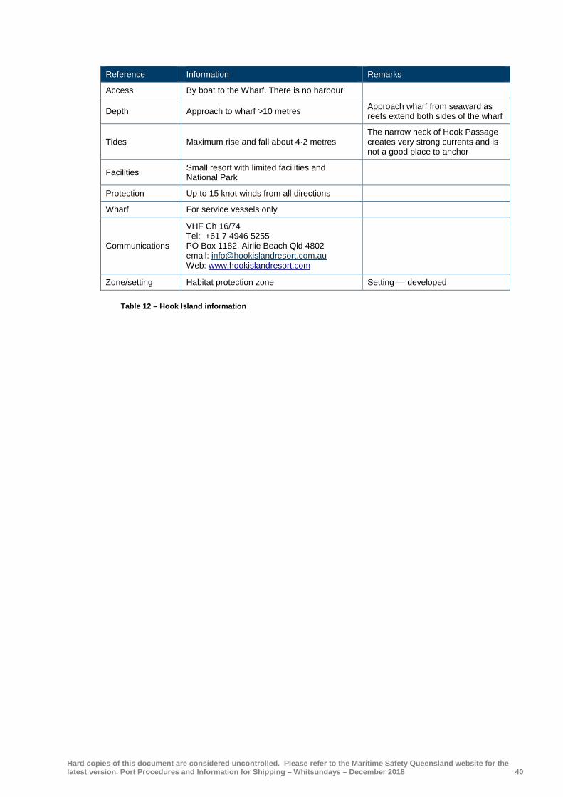
Hard copies of this document are considered uncontrolled. Please refer to the Maritime Safety Queensland website for the latest version. Port Procedures and Information for Shipping – Whitsundays – December 2018 40
Reference Information Remarks
Access By boat to the Wharf. There is no harbour
Depth Approach to wharf >10 metres Approach wharf from seaward as reefs extend both sides of the wharf
Tides Maximum rise and fall about 4·2 metres The narrow neck of Hook Passage creates very strong currents and is not a good place to anchor
Facilities Small resort with limited facilities and National Park
Protection Up to 15 knot winds from all directions
Wharf For service vessels only
Communications
VHF Ch 16/74 Tel: +61 7 4946 5255 PO Box 1182, Airlie Beach Qld 4802 email: [email protected] Web: www.hookislandresort.com
Zone/setting Habitat protection zone Setting — developed
Table 12 – Hook Island information

Hard copies of this document are considered uncontrolled. Please refer to the Maritime Safety Queensland website for the latest version. Port Procedures and Information for Shipping – Whitsundays – December 2018 41
4.10.5 Lindeman Island
Lindeman Island Resort is on the south side of Lindeman Island which lies to the east of the Whitsunday Passage. Strong tidal streams flow between Lindeman Island and Seaforth Island so care must be taken when approaching the dredged channel to access the public wharf. The resort is currently closed as at December 2013.
Reference Information Remarks
Access By public jetty via a dredged channel marked by port and starboard hand beacons the seaward pair of which are lit at night
Access to the dredged channel is restricted
Depth Approach to jetty six to10 metres Approach channel from seaward as reefs extend both sides of the channel
Tides Maximum rise and fall about 4·9 metres Lindeman Island is surrounded by reefs and outlying islands — tidal flow can be very strong
Facilities Resort and mainly national park Day visitors permitted
Protection Up to 15 knot winds from north to south through east
Jetty For use by service vessels only
Communications Nil comms
Zone/setting Conservation park zone Setting — developed
Table 13 – Lindeman Island information
4.10.6 South Molle Island
South Molle Island Resort lies on Bauer Bay on the northern side of South Molle Island one of a number of islands in the Molle Group. The island is surrounded by reefs and has strong tidal rips and overfalls down its eastern side. With Unsafe Passage to the north (section 5.6.3.2) and Roma Point to the south (section 5.6.3.4) care is necessary when navigating around this group of islands.
Reference Information Remarks
Access By public jetty that extends out over the reef
Depth Bauer Bay five-10m Approach jetty from seaward as reefs extend both sides of the channel
Tides Maximum rise and fall about 4·2m Strong overfalls and rips — see note above
Facilities Resort and National Park Day visitors permitted
Protection Up to 15-25 knot winds from east through south west via south
Jetty For use by service vessels only
Communications
VHF Channel 16/74 Tel: +61 7 4946 9433 Email: [email protected] Web: www.south-molle-island.com.au/south-molle-island-resort.html
Zone/setting Conservation park zone Setting — developed
Table 14 –South Molle Island information

Hard copies of this document are considered uncontrolled. Please refer to the Maritime Safety Queensland website for the latest version. Port Procedures and Information for Shipping – Whitsundays – December 2018 42
4.10.7 Laguna Whitsundays
Laguna Whitsundays is a golfing resort served by a man made harbour known as Laguna Marina. The resort is approximately two kilometres from the marina. The approach channel and marina has not recently been dredged. The depths and clearances in the channel and marina maybe less than charted. Local advice should be obtained.
Reference Information Remarks
Access Approach the marina on leads bearing 249.5oT through a dredged channel marked by port and starboard lit beacons
Sharp 90o turn required when abeam of harbour wall to port
Depth Inside marina four metres. Dredged channel 3.2 metres (1999)
Channel subject to silting — caution required
Tides Maximum rise and fall about 4·2 metres Tides variable — contact marina for specific advice
Protection Up to 25 knot winds from all directions
Communications Email: [email protected] Web: www.lagunawhitsundays.info
Zone/setting N/A Setting — N/A
Table 15 – Laguna Whitsundays information
Reefs and reef pontoons There are a number of outlying reefs in the Whitsunday region which, although outside the compulsory pilotage area, are included in the ‘Whitsunday Planning Area’ therefore Plan of Management provisions apply. Navigation in the vicinity of the reefs can be hazardous and the following points must be considered:
Reference Information Remarks
Access
The entrance is marked by a W Cardinal (# 2 Beacon) and a starboard hand mark (# 4 Beacon) which should be left to starboard. Proceed to the Waterfall gap
Enter the lagoon when the outflow of tide has ceased or at high water. Beware ‘The Waterfall’ at other times due to very strong water movement through the gap
Depth Inside lagoon five to nine metres Coral clearly visible — beware amphibious aircraft landing in lagoon
Tides Maximum rise and fall about 4·2 metres
Facilities ‘Reef pontoons and a helicopter landing pontoon are moored at Hardy Reef and provide a range of tourist activities
Protection Up to 15 knot winds from all directions
Zone/setting Marine National Park Zone Setting — high use
Hardy Reef has a cruise ship anchorage — see section 4.4
Table 16 – Reef and reef pontoons
• extremely strong tidal flows from two to eight knots can be experienced in amongst the reefs and care should be taken when passing through narrow passages as ‘waterfall’ effects can be experienced causing short steep waves up to four metres in height
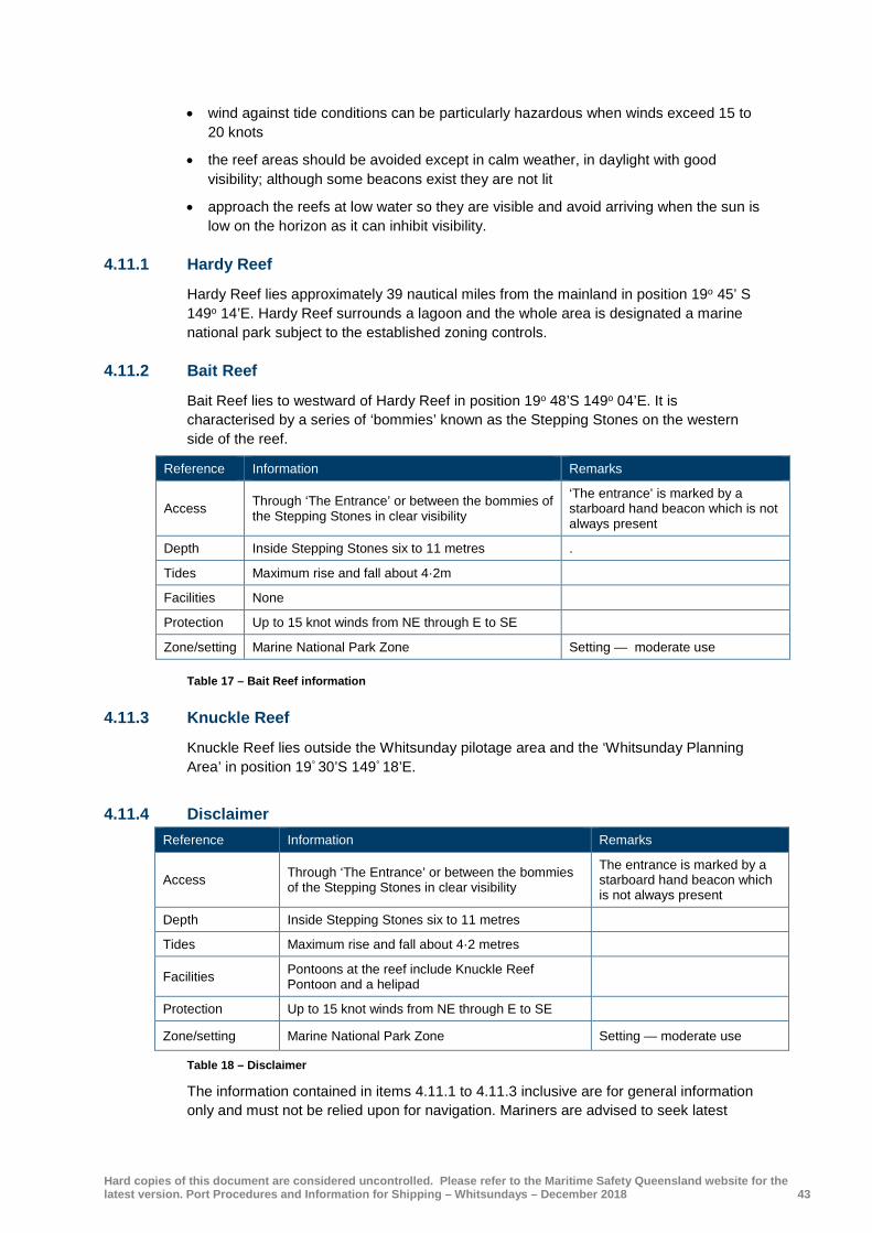
Hard copies of this document are considered uncontrolled. Please refer to the Maritime Safety Queensland website for the latest version. Port Procedures and Information for Shipping – Whitsundays – December 2018 43
• wind against tide conditions can be particularly hazardous when winds exceed 15 to 20 knots
• the reef areas should be avoided except in calm weather, in daylight with good visibility; although some beacons exist they are not lit
• approach the reefs at low water so they are visible and avoid arriving when the sun is low on the horizon as it can inhibit visibility.
4.11.1 Hardy Reef
Hardy Reef lies approximately 39 nautical miles from the mainland in position 19o 45’ S 149o 14’E. Hardy Reef surrounds a lagoon and the whole area is designated a marine national park subject to the established zoning controls.
4.11.2 Bait Reef
Bait Reef lies to westward of Hardy Reef in position 19o 48’S 149o 04’E. It is characterised by a series of ‘bommies’ known as the Stepping Stones on the western side of the reef.
Reference Information Remarks
Access Through ‘The Entrance’ or between the bommies of the Stepping Stones in clear visibility
‘The entrance’ is marked by a starboard hand beacon which is not always present
Depth Inside Stepping Stones six to 11 metres .
Tides Maximum rise and fall about 4·2m
Facilities None
Protection Up to 15 knot winds from NE through E to SE
Zone/setting Marine National Park Zone Setting — moderate use
Table 17 – Bait Reef information
4.11.3 Knuckle Reef
Knuckle Reef lies outside the Whitsunday pilotage area and the ‘Whitsunday Planning Area’ in position 19° 30’S 149° 18’E.
4.11.4 Disclaimer
Table 18 – Disclaimer
The information contained in items 4.11.1 to 4.11.3 inclusive are for general information only and must not be relied upon for navigation. Mariners are advised to seek latest
Reference Information Remarks
Access Through ‘The Entrance’ or between the bommies of the Stepping Stones in clear visibility
The entrance is marked by a starboard hand beacon which is not always present
Depth Inside Stepping Stones six to 11 metres
Tides Maximum rise and fall about 4·2 metres
Facilities Pontoons at the reef include Knuckle Reef Pontoon and a helipad
Protection Up to 15 knot winds from NE through E to SE
Zone/setting Marine National Park Zone Setting — moderate use

Hard copies of this document are considered uncontrolled. Please refer to the Maritime Safety Queensland website for the latest version. Port Procedures and Information for Shipping – Whitsundays – December 2018 44
information from respective resorts for infrastructure and waterways including latest navigational charts for navigation.

Hard copies of this document are considered uncontrolled. Please refer to the Maritime Safety Queensland website for the latest version. Port Procedures and Information for Shipping – Whitsundays – December 2018 45
Section 5 General information
Charts and books For navigation in pilotage areas, masters should refer to the nautical charts produced by the Australian Hydrographic Office and Admiralty Sailing Directions NP15 (Australian Pilot Volume III / V). Charts of the area include:
• AUS 252 Whitsunday Group
• AUS 253 Whitsunday Passage
• AUS 254 Plans in Whitsundays
• AUS 825 Whitsunday Island to Bowen
• AUS 826 Bowen to Cape Bowling Green
• AUS 4620 Percy Isles to Booby Island including Gulf of Papua
Shipping announcements Maritime Safety Information includes navigational warnings, meteorological warnings — and other important safety related messages required by ships at sea. The ‘Rescue Co-ordination Centre’ (RCC) Australia is responsible for issuing safety messages relating to the Whitsunday region as follows:
• Coastal navigation warnings — these are issued as ‘AUSCOAST’ warnings and are numbered consecutively and are broadcast for as long as they remain active or are included in other available information — Notices to Mariners AUSCOAST warnings are broadcast on Inmarsat EGC or can be viewed on AMSA’s website.
• Safety messages (SSM Series) — normally broadcast for a defined period as they relate to short term problems such as floating objects likely to cause damage to vessels.
• Notices to Mariners — issued as an annual document and is available from the Australian Hydrographic Office or other recognised distributors. A free service called ‘e Notices’ is also available from the Australian hydrographic office.
• Maritime Safety Queensland produces Queensland Notices to Mariners on a daily basis. These can be accessed through the Regional Harbour Master’s office and on the Maritime Safety Queensland website at www.msq.qld.gov.au/Notices-to-Mariners/Ntm-whitsundays.aspx.
Differential global positioning system (DGPS) Service The Australian Maritime Safety Authority provides a network of DGPS radio beacons that improve the accuracy and integrity of the ‘Global Positioning System’ (GPS) in critical areas of Australia's coastline. These areas include the Great Barrier Reef, Torres Strait and Brisbane.
A network of 16 stations are remotely controlled and monitored 24 hours a day. There is a DGPS station in Mackay. Details of this station can be found on the AMSA website at www.amsa.gov.au/navigation/services/dgps/.

Hard copies of this document are considered uncontrolled. Please refer to the Maritime Safety Queensland website for the latest version. Port Procedures and Information for Shipping – Whitsundays – December 2018 46
Volunteer Marine Rescue (VMR) Whitsunday and Mackay The regional Volunteer Marine Rescue group is based in Cannonvale, close to Airlie Beach. The volunteers man an operations base on weekends and some public holidays from 0700 to 1700. There are three radio sites each with a monitoring radio setup listening on VHF channel 16 (Airlie Beach only) and repeater channel 67, 80, 81 and 22, 2182 H/F and channel 88 on 27 MHz. Refer section 1.5.4 for contact details.
VMR (Mackay) is manned from 0800-1800 (seven days) and monitors VHF frequencies 16, 67, 80 and 21, H/F frequencies 4215 and 6215 and channel 88 on 27 MHz.
Phone/Fax: +61 7 4955 5448
Email: [email protected]
VMR services are transferred to Hay Point VTS outside of the above hours.
A Queensland Water Police Service is located at Shingley Drive, Airlie Beach
Refer to section 1.5.4 for contact details.
All emergency services can be contacted by phoning 000.
Speed restrictions Under section 81 of the Transport Operations (Marine Safety) Regulation 2016 the following speed restrictions are in force:
Vessels other than personal watercraft (PWC’s) must not exceed six knots within 30 metres of:
• a person in the water
• a vessel at anchor, moored or made fast to the shore or aground
• a jetty, wharf, boat ramp or pontoon in or on the waters.
• Speed limit for personal watercraft must not exceed six knots within 60 metres of:
• a person in the water
• a ship at anchor, moored or made fast to the shore or aground
• a jetty, wharf, boat ramp or pontoon in or on the waters
• the boundary of a bathing reserve
• the shore.
A personal watercraft driver is to maintain a distance of 30 meters from other moving vessels when travelling at more than 10 knots, unless the personal watercraft is involved in an approved aquatic event.
Other restrictions for personal watercraft when operating:
A personal watercraft licence holder is to wear the “kill switch” safety lanyard when the personal watercraft is being driven by a learner driver.
A learner personal watercraft driver cannot carry passengers other than the supervising personal watercraft licence holder.
A person must not while operating a personal watercraft freestyle, surf or wave jump within 200 metres of the shore if:
• the personal watercraft is being operated in coastal waters; and

Hard copies of this document are considered uncontrolled. Please refer to the Maritime Safety Queensland website for the latest version. Port Procedures and Information for Shipping – Whitsundays – December 2018 47
• one or more dwellings are within 100 metres of the shore and are visible from, and in the vicinity of, where the personal watercraft is being operated.
Coastal waters mean the coastal waters of the state, and include other waters within the limits of the state that are subject to the ebb and flow of the tide.
A person must not operate a ship at a speed at which the ship’s wash is reasonably capable of causing:
• a marine incident; or
• damage to the shoreline.
In addition, under section 206A of the Transport Operations (Marine Safety) Act 1994 the general manager has the authority to restrict speed as indicated by a sign.
Navigation information The Whitsunday region is a busy traffic area in which both commercial and recreational vessels operate. There is a range of skill levels from novice to professional amongst the crews and a variety of vessel types from dinghies to large commercial ships, including cruise liners. The following procedures and guidance are to be followed by all vessels navigating in the Whitsunday region.
5.6.1 Vessels underway
All vessels are to comply with the collision regulations:
• restrictions and directions indicated by navigation marks and aids to navigation are to be complied with
• mariners should bear in mind that some vessels may be operated by persons with limited experience and knowledge so it is prudent to expect the unexpected
• fast sailing craft operate in the region so mariners should be aware of their closing speed with particular reference to ‘Right of Way’ under the collision regulations
• a proper lookout is to be kept at all times; consideration should be given to approaching ‘blind’ areas at speed and restricted visibility caused by sudden tropical rain squalls
• care should be exercised when navigating in the vicinity of fringing reefs as their extent may be greater than that shown on the chart.
5.6.2 Under keel clearance
There are many shallow areas within the controlled area of the Whitsunday region and mariners must be aware that the extent of these shallows can change due to shifting seabeds caused by weather, tides, and coral growth.
Although the passages between many of the islands have relatively deep water there are many patches that create a danger to deep draft vessels so care must be taken when navigating these areas.
The Whitsunday Passage is occasionally used by large vessels as an alternative to the outside route. The passage is approximately two miles wide at its narrowest point between Dent Island and Pine Island and has a depth of 35 to 60 metres at chart datum.
The cruise ship anchorage at Funnel Bay is draft restricted to vessels drawing no more than about eight metres except in the NE corner of the anchorage where such vessels can remain outside the 10 metre contour.

Hard copies of this document are considered uncontrolled. Please refer to the Maritime Safety Queensland website for the latest version. Port Procedures and Information for Shipping – Whitsundays – December 2018 48
The northern entrance to the Fitzalan cruise ship anchorage has a 9·9 metre patch, that in normal circumstances, should not present a problem to vessels transiting this passage. (See section 4.3).
5.6.3 Specific problem areas
The development of marinas at Abel Point and Muddy Bay has increased traffic levels significantly in the area between Pioneer Rocks and Pioneer Point. Care must be exercised when navigating in this confined area with vessels allowing sufficient sea room for safe passing.
Local traffic should be aware that large cruise vessels occasionally anchor in Funnel Bay and tender their passengers to Abel Point Marina. Passenger tenders are to be given a wide berth.
Unsafe Passage lies between North Molle Island and Mid Molle Island. The passage is approximately one cable wide and is only suitable for small vessels. The passage is regularly used by the inter-island ferries and caution is necessary to avoid a passing situation in the passage due to it narrowness. A set of leading beacons/lights on NE Daydream Island marks the centre of the passage on a bearing of 240·5° (T).
South and east of Henning Island lies Plum Pudding Island. The island is surrounded by a reef and there is no passage between the two islands due to extensive shoal water. There are no navigation marks to rely on so care should be taken when passing through this area when making a northerly approach into Dent Passage.
When making the approach to Shute Harbour care must be taken not to use the harbour leading beacons/lights (261°/081°T) when east of Roma Point as the reef extends a long way south of this point, over the leading line.
A local magnetic anomaly is reported to occur near the middle of the Whitsunday Passage where compass deflections of 4° to 7° either east or west may be experienced.
When making for Whitsunday Island from the south and east mariners should be aware of Surprise Rock in approximate position 20° 21.3’S 149° 01.6’E. The shoal is marked by an isolated danger mark showing a light flashing W 2 6 secs. Currents near the shoal can be up to two knots north or south.
Vessels operating in Dent Passage between Titan Island and the Hamilton Island airstrip are advised that there are frequent aircraft movements in this area 24 hours a day, seven days a week. Vessels with an overall height greater than eight metres are advised to keep clear of the flight path zone during aircraft movements. These vessels if entering Hamilton Island marina are advised to keep to the eastern side of Dent passage and are not to stop in the aircraft zone (refer attached chartlet).
This restriction also applies to the southern end of the runway in Driftwood Bay.

Hard copies of this document are considered uncontrolled. Please refer to the Maritime Safety Queensland website for the latest version. Port Procedures and Information for Shipping – Whitsundays – December 2018 49
Aids to navigation Maritime Safety Queensland is responsible for the placement and upkeep of aids to navigation in coastal areas within the Whitsunday region. Reports of failures to aids to navigation in this area should be made to Hay Point VTS either by VHF Channel 16, or telephone 1300 645 022. AMSA has some responsibility for navigational aids that are used by SOLAS compliant vessels — DGPS network, some buoys, beacons and lights.

Hard copies of this document are considered uncontrolled. Please refer to the Maritime Safety Queensland website for the latest version. Port Procedures and Information for Shipping – Whitsundays – December 2018 50
5.7.1 Radio and electronic aids
Position accuracy using electronic methods can exceed the accuracy of some charts so care must be taken when position fixing. Good practice dictates that more than one method of position fixing should be used.
GPS fixes positions relative to the earth’s WGS84 datum giving an accuracy of +/- 20 metres to 30 metres for about 95% of the time. The remaining 5% could, however, give errors up to +/- 300 metres so care needs to be exercised when using GPS in the vicinity of reefs and islands.
Although DGPS provides for more accuracy (+/- 10 metres) than GPS it must be remembered that DGPS is still reliant on supply of a signal so it should not be used solely for navigation when operating in amongst reefs and islands. DGPS coverage in the region comes from the Mackay DGPS station. Information for this station can be found on the AMSA website.
It should be remembered that the collision regulations are based on headings not course made good, so information gained from ARPA plots can be misleading with regard to headings when operating in strong currents and tidal streams, particularly at slow speeds.
When using some electronic charts mariners should be aware that the same source data limitations may apply as for paper charts. Only electronic navigational charts (ENC’s) recognised by a national authority or equivalent meet the criteria for compulsory carriage under SOLAS and the Navigation Act 2012.
Anchoring It is an offence to damage coral within the marine park. Care must be taken when anchoring, where allowed, to minimise this damage. Anchor away from corals, allow sufficient room for swinging and be aware of wind anomalies.
When at anchor the appropriate daytime/night time shapes and/or lights are to be displayed.
5.8.1 ‘No anchoring’ areas
NPWS have established a number of prohibited anchoring areas that are controlled by statute and are marked by reef protection markers (pyramid shaped buoys with blue labels). These areas are defined as follows:
Hook Island East and West Butterfly Bay
Maureen’s Cove
Luncheon Bay
Pinnacle Bay
North and South Stonehaven Bay
False Nara Inlet
Manta Ray Bay (no markers)

Hard copies of this document are considered uncontrolled. Please refer to the Maritime Safety Queensland website for the latest version. Port Procedures and Information for Shipping – Whitsundays – December 2018 51
Hayman Island Blue Pearl Bay
Border Island Cateran Bay
Daydream Island Sunlovers Bay
Langford Reef
Bait Reef (parts of — (no markers))
Full details of these areas should be accessed on the Great Barrier Reef Marine Park Authority website.
Buoy moorings Buoy moorings have been established throughout the area in three categories:
• public moorings
• privately owned moorings
• dedicated use moorings.
Full details are available on the GBRMPA website.
Information on buoy mooring applications managed by Maritime Safety Queensland may be accessed on their website.

Hard copies of this document are considered uncontrolled. Please refer to the Maritime Safety Queensland website for the latest version. Port Procedures and Information for Shipping – Whitsundays – December 2018 52
Section 6 Weather information
General The prevailing weather in the Whitsunday region is E to SE with the strongest winds blowing from March to May. November to March is considered to be the ‘wet’ season. North/easterly winds tend to prevail from September through to November.
‘Bullets’ is the local name for gusty winds that are created by the funnelling effect some of the higher land masses have on the surface winds. These ‘bullets’ can sometimes double the strength of the wind and catch vessels unawares, particularly in some of the north facing anchorages.
Cyclones affect the Queensland coast in the summer months. While Coral Sea cyclones are generally unpredictable in their movements they typically form in the Coral Sea and move in a direction between west and south towards the coast, either crossing the coast or re-curving to the southeast before reaching the Great Barrier Reef. Those that pass north of the Whitsunday Group bring the area strong southeast winds; those that pass south bring northwest winds.
Weather charts, satellite images, warnings and reports may be obtained from the Australian Bureau of Meteorology website.
6.1.1 Extreme Weather Event Contingency Plan
The Whitsunday region is also subject to “extreme weather events” of similar intensity to a cyclone. These “extreme weather events” can impact the area at very short notice. Maritime Safety Queensland has issued an Extreme Weather Event Contingency Plan for the Mackay Region which includes the Whitsunday area. This plan addresses cyclones as well as other extreme weather events. A copy of this plan is available on the Queensland Government website.
The overall objective of this plan is to provide for the safety of vessels and their operation during extreme weather events. Personal safety is of prime importance at all times.
An extreme weather event may require the evacuation of the port, part of a port, a harbour or boat harbour. The Regional Harbour Master may close the Whitsunday Pilotage Area in an extreme weather.
6.1.2 Cyclone procedures - Abel Point Marina
Link to Cyclone procedures for Abel Point Marina
6.1.3 Cyclone procedures — Port of Airlie Marina
Link to Cyclone procedures for Port of Arlie Marina

Hard copies of this document are considered uncontrolled. Please refer to the Maritime Safety Queensland website for the latest version. Port Procedures and Information for Shipping – Whitsundays – December 2018 53
Tidal information Generally the ebb tide flows NW and the flood tide flows SE but the tidal flows can be unpredictable amongst the Whitsunday Islands where the general flow is interrupted. Care should be taken when navigating in narrows as the tidal flows can be dangerous due to very strong currents, overfalls and eddies.
Heights in metres above datum (LAT)
Place HAT MHWS MHWN MSL MLWN MLWS
Hayman Island 20o 03’S 148o 53’E 4·1 3·3 2·6 1·9 1·3 0·6
Shute Harbour 20o 17’S 148o 47’E 4·3 3·3 2·5 1·9 1·2 0·5
East Repulse Island 20o 35’S 148o 53’E 5·7 4·5 3·5 2·6 1·7 0·8
Table 19 – Tidal information
The tidal times and heights for standard Queensland ports are available in the Queensland Tide Tables and are also available on the Bureau of Meteorology website as is the actual height of tide at Shute Harbour.
6.2.1 Tidal information — Tsunami effects
The north, west and east coasts of Australia are bordered by active tectonic plates which are capable of generating a tsunami that could reach the coast-line within two to four hours. The resultant change in swell height could have an adverse effect on a vessel with a minimum under keel clearance navigating within or close to port areas.
The Joint Australian Tsunami Warning Centre (JATWC) has been established to monitor earthquake activity that may lead to a tsunami forming. Warnings are currently issued for the Pacific Ocean region by the ‘Pacific Tsunami Warning Centre’ (PTWC) in Hawaii and for the Indian Ocean region by the ‘Japan Meteorological Agency’ (JMA). Mariners are advised to take heed of such warnings, plan their bar crossings and tend their mooring or anchorages accordingly.

Hard copies of this document are considered uncontrolled. Please refer to the Maritime Safety Queensland website for the latest version. Port Procedures and Information for Shipping – Whitsundays – December 2018 54
Section 7 Dangerous cargo
General This requirement to notify the harbour master that a vessel has dangerous goods on board applies to vessels proceeding to berths and anchorages within the pilotage area. Local marine traffic should refer to section 7.3.
Maritime Safety Queensland is responsible for monitoring and managing the safe movement of ships in Queensland Waters. Maritime Safety Queensland and other relevant authorities operate under the codes and guidelines of:
IMO — IMDG Code
Australian Standard AS 3846-2005
AMSA — Australian Annexe to the IMDG Code — Marine Orders Part 41
AAPMA — Dangerous substances guidelines.
7.1.1 Notification
Chapter 5 Part 4 of the Transport Operations (Marine Safety) Regulation 2016 outlines the duties of owners and masters of vessels in relation to the carriage of dangerous goods.
The regulation requires that ships carrying dangerous goods and bulk liquids must comply with the appropriate directions of the IMDG code and AS3846 and are to notify the Regional Harbour Master of the intent to bring dangerous cargo into or depart from a pilotage area.
The Dangerous Cargo Report form must be lodged either by email or via fax to the Regional Harbour Master accompanied by a copy of the ship's dangerous cargo manifest. These requirements apply to dangerous goods and cargoes that remain onboard a ship or are loaded or handled during a port visit.
Minimum notification times are as follows:
Movement Minimum notification
Ship inbound 48 hours prior to scheduled arrival at pilot boarding ground
Ship departure or removal 3 hours
Ship to Ship transfer 24 hours
Loading, removal or handling alongside 24 hours
Operation of a local marine service 48 hours (see sec.90 &91 TO(MS) Regulation 2016)
Table 20 – Movement Notification
Dangerous cargo events Section 93 of the Transport Operations (Marine Safety) Regulation 2016 defines a dangerous cargo event as:
• the loss, or likely loss, of the cargo from a ship into Queensland waters
• a breach, or danger of a breach, of the containment of the cargo that could endanger marine safety

Hard copies of this document are considered uncontrolled. Please refer to the Maritime Safety Queensland website for the latest version. Port Procedures and Information for Shipping – Whitsundays – December 2018 55
• anything else involving, or that could involve, the cargo that causes risk of explosion, fire, a person's death, or grievous bodily harm of a person
• for a cargo that is a materials hazardous only in bulk (MHB) — an event that causes risk of explosion, fire, a person's death, or grievous bodily harm to a person.
The master and or the person in charge of a place where a dangerous cargo event has occurred are required to report the event immediately to the Regional Harbour Master.
A full written report is to be submitted on form F3220 to the harbour master as soon as reasonably practical.
Reporting requirements for local marine services A local marine service is defined as a shipping service in which a ship is operated on Queensland intrastate voyages (including island ferries) and handles dangerous cargo.
A person who is the owner or master of a ship on a local marine service operating within the pilotage area must report to the Regional Harbour Master the following matters in the approved form — at least 48 hours before the start of the local marine service; and for subsequent voyages that are part of the service — at intervals not exceeding six months:
• voyages under the service
• the nature of the dangerous cargo to be handled.
A person who is the owner or master of a ship operating on a local marine service must notify the Regional Harbour Master general manager of Maritime Safety Queensland within 14 days of the cessation the service.
For local marine services operating within Queensland waters but outside of a designated pilotage area this notification should be made to the general manager.
Advisory Note - Interaction with Marine Mammals
The presence of whales or marine mammals indicates that our ports are seen as environmentally attractive places.
The safety of life and the security of the environment from ship based incidents is paramount.
All vessel masters are required to fully comply with relevant marine mammal legislation, such as the provisions of the Nature Conservation (Wildlife Management) Regulation 2006 part 5A which prescribes minimum approach distances and maximum speeds within proximity to whales as illustrated in the diagram below:

Hard copies of this document are considered uncontrolled. Please refer to the Maritime Safety Queensland website for the latest version. Port Procedures and Information for Shipping – Whitsundays – December 2018 56
When whales or marine mammals are reported in the vicinity of port areas and a risk to marine mammals is perceived, then every possible endeavour will be undertaken to manage shipping movements around the marine mammals to keep them safe, provided the safety of life, the ship and other environmental protection objectives are not threatened. Such action may include not commencing transits until the mammals are deemed clear.
In situations where a vessel is underway and restricted in its ability to manoeuvre or constrained to a channel and marine mammals are reported in the vicinity of the transit and a risk to marine mammals is perceived, the master must take all reasonable action necessary to keep them safe, without endangering the vessel, crew and the environment. Such action may include the reduction of speed to the minimum safe speed to safely navigate the channels.
Masters are encouraged to report collisions with marine mammals to VTS and 1300 ANIMAL (1300 264 625). Link to Department of Environment and Heritage Protection
References:
Nature Conservation (Wildlife Management) Regulation 2006 part 5A, Sections 338A to 338L.
North East shipping Management Plan- Sections 5.5, 5.6 and 9.5

Hard copies of this document are considered uncontrolled. Please refer to the Maritime Safety Queensland website for the latest version. Port Procedures and Information for Shipping – Whitsundays – December 2018 57
Section 8 Emergency pollution marine incidents
General
The aim of this section is to provide guidance to the community for initial response procedures in the event of dangerous incidents, emergencies, terrorist acts and disasters.
Emergency contact numbers
Organisation Telephone
Police/Fire/Ambulance 000
Great Barrier Reef Marine Park Authority +61 7 4750 0700 (Office hours)
+61 7 3830 4919 (After hours)
Environmental Protection Agency (Qld Parks & Wildlife Service) +61 7 4967 7355
Hay Point VTS 1300 645 022 (VHF 16)
Whitsunday Regional Council +61 7 4761 3600
Hospital (Bowen) +61 7 4786 8222
Regional Harbour Master (Mackay) +61 7 4944 3700
Australian Quarantine Inspection Service (Canberra) 1800 020 504
Australian Quarantine Inspection Service (Mackay) +61 7 4955 9600
Australian Customs Watch (24 hours) 1800 061 800
Maritime Safety Queensland (Mackay) +61 7 4944 3700
Volunteer Marine Rescue (VMR) +61 7 4946 7207
Table 21 – Emergency contact numbers
Marine pollution The Transport Operations (Marine Pollution) Act 1995 is designed to protect Queensland's marine and coastal environment by minimising deliberate and negligent discharges of ship-sourced pollution. Discharges of oil, noxious liquid substances, packaged harmful substances, sewage and garbage (MARPOL Annexes I, II, III, lV and V) from ships are prohibited in Queensland coastal waters and pilotage areas.
Maritime Safety Queensland (MSQ) is responsible for oil spill pollution response in Queensland coastal waters. ‘First Strike Oil Spill Response Plan’ has been prepared by Maritime Safety Queensland as a supplement to the ‘Queensland Coastal Contingency Action Plan’ and ‘REEFPLAN’ and describes the various roles, actions and responsibilities to be followed in the event of a spill.
Maritime Safety Queensland has the authority to detain any vessel suspected of causing marine pollution and to intervene where there is imminent danger to the coastline.
Hard copies of this document are considered uncontrolled. Please refer to the Maritime Safety Queensland website for the latest version. Port Procedures and Information for Shipping – Whitsundays – December 2018 58
8.3.1 Reporting
Section 67 of the Transport Operations (Marine Pollution) Act 1995 requires the master of a ship to report a discharge or probable discharge without delay to the harbour master.
The Regional Harbour Master (Mackay) can be contacted on:
Phone: +61 7 4944 3700 or via Hay Point VTS 1300 645 022.
The following details should be provided in a report of marine pollution:
• date/time of incident
• location (latitude, longitude and physical site)
• report source and contact number
• nature, extent and estimated quantity of spill
• type of oil or description
• spill source and point of discharge from source
• identity and position of nearby ships or name of alleged polluter
• nature and extent of spill and movement and speed of spill
• local weather/tide/sea conditions
• whether a sample of the substance spilled has been collected
• and any additional information that relates to the spill.
Pollution is an offence — whether your boat is large or small, it is an offence to deliberately discharge oil or chemicals into Queensland's coastal waters under the Transport Operations (Marine Pollution) Act 1995; severe penalties apply.
Everyone can help protect the marine environment by reporting pollution incidents to their local Regional Harbour Master's office or Great Barrier Reef Marine Park Authority.
Reports can also be made to the Great Barrier Reef Marine Park Authority oil spill response number:
Phone: 3830 4919 (24/7) or 4750 0700 during office hours.
8.3.2 Waste disposal
Pollution is an offence — whether your boat is large or small, it is an offence to deliberately discharge garbage into Queensland's coastal waters under the Transport Operations (Marine Pollution) Act 1995; severe penalties apply.
8.3.3 Sewage
Restrictions apply to the discharge of sewage within the Whitsunday region.
All vessels are defined as either one of the following two categories:
Declared ship — a declared ship is a class 1 commercially-registered passenger-carrying vessel fitted with a toilet. In recognition of their potentially greater sewage-generating capacity, declared ships must adhere to more stringent sewage discharge requirements. These include:
• the ship must be fitted with a sewage holding device
• the ship must carry a sewage disposal record book
• the ship must have a shipboard sewage management plan

Hard copies of this document are considered uncontrolled. Please refer to the Maritime Safety Queensland website for the latest version. Port Procedures and Information for Shipping – Whitsundays – December 2018 59
• if the ship is fitted with a treatment system, records must be kept for all assessment and maintenance of the treatment system.
Other ship (non-declared ship) — other ships or non-declared ships include all recreational vessels and all class 2 and class 3 commercial vessels.

Hard copies of this document are considered uncontrolled. Please refer to the Maritime Safety Queensland website for the latest version. Port Procedures and Information for Shipping – Whitsundays – December 2018 60
Marine incidents Under the Transport Operations (Marine Safety) Act 1994, a marine incident is classified as an event causing or involving:
• the loss of a person from a ship
• the death of, or grievous bodily harm to, a person caused by a ship's operations
• the loss or presumed loss or abandonment of a ship
• a collision with a ship
• the stranding of a ship
• material damage to a ship
• material damage caused by a ship's operations
• danger to a person caused by a ship's operations
• danger of serious damage to a ship
• danger of serious damage to a structure caused by a ship's operations.
8.4.1 Marine incident reporting
A marine incident must be reported to a shipping inspector within 48 hours of the incident, unless there is a reasonable excuse. Shipping inspectors are marine safety officers (located at Maritime Safety Queensland marine operations bases), and officers of Queensland Water Police and Queensland Boating and Fisheries Patrol. If you are unable to access one of these offices, contact a shipping inspector by phone. They will advise you what to do next.
The report must be made on the approved Marine Incident Report Form 3071. These forms are also available from Department of Transport and Main Roads customer service centres, Maritime Safety Queensland regional offices, Queensland Boating and Fisheries patrol and Water Police offices. This form is used to report all incidents, no matter the type of ship involved.
The form may be completed with the assistance of a shipping inspector to ensure the information is accurate, unbiased and as reliable as possible. It is important that the form is filled in completely, with the incident described in as much detail as possible. The shipping inspector who receives the form will check to ensure it has been correctly completed.
If the initial report is not made in the approved form, the owner or master must make a further report to a shipping inspector in the approved form as soon as possible. The master would normally report a marine incident but the owner would report if the master, for some justifiable reason, was not able to make the report. Each marine incident reported will be investigated by a shipping inspector and the results of the investigation reported in the approved form.
Section 124 of the Transport Operations (Marine Safety) Act 1994 requires ships masters to assist if a marine incident involves two or more ships. The master of each ship involved in the marine incident must to the extent that he can do so without danger to his ship or persons on board his ship:
• give the other ship involved in the incident, its master and persons onboard the ship the help necessary to save them from danger caused by the marine incident
• stay by the other ship until no further assistance is required

Hard copies of this document are considered uncontrolled. Please refer to the Maritime Safety Queensland website for the latest version. Port Procedures and Information for Shipping – Whitsundays – December 2018 61
• give the master of the other ship reasonable particulars adequate to identify the ship and its owner.
Section 129 of the Transport Operations (Marine Safety) Act 1994 requires the master of a ship to promptly report dangers to navigation including, an abandoned ship, a damaged aid to navigation, severe weather conditions and so on.
8.4.2 Marine incident reporting — AMSA
Under section 19 of the Transport Safety Investigation Act 2003 any incident involving a ship in Australian waters including:
• breakage of gear or injury to any person during cargo work
• damage or defect to ship, machinery or equipment
• peril or a close quarters situation
• stranding or disappearance
• death, serious injury or a dangerous occurrence
• a birth
must be reported to the Australian Maritime Safety Authority (AMSA) using AMSA Form 18 - Incident Alert within four hours of the incident occurring. A detailed incident report must be submitted to AMSA Canberra on AMSA Form 19 - Incident Report within 72 hours of the incident occurring.
Reports are to be submitted by fax: +61 2 6230 6868 or 1800 622 153 or [email protected].
Complete details of these requirements are available on the Australian Maritime Safety Authority website.
Great Barrier Reef Marine Park Authority incident report form To report an incident where a breach of Great Barrier Reef Marine Park Authority regulations is observed witnesses are asked to complete the Incident Report form
Urgent matters should be reported by phone to the appropriate number listed on the form.

Hard copies of this document are considered uncontrolled. Please refer to the Maritime Safety Queensland website for the latest version. Port Procedures and Information for Shipping – Whitsundays – December 2018 62
Section 9 Appendices Whitsunday reporting area - pre-arrival report ............................................................. 63 Form 1 - Fitzalan Anchorage - Application for technical assessment .......................... 64 Form 2 - Fitzalan Anchorage - Application to visit ....................................................... 65 Form 3 - Fitzalan Anchorage - Voyage plan ................................................................ 66 Hamilton Island request form ....................................................................................... 67 Whitsundays Pilotage area .......................................................................................... 68

Hard copies of this document are considered uncontrolled. Please refer to the Maritime Safety Queensland website for the latest version. Port Procedures and Information for Shipping – Whitsundays – December 2018 63
Whitsunday reporting area - pre-arrival report To be lodged with the Regjonal Harbour Master prior to arrival. A copy should also be sent to Hay Point VTS unless an arrival has been entered into QSHIPS. See section 3.1.

Hard copies of this document are considered uncontrolled. Please refer to the Maritime Safety Queensland website for the latest version. Port Procedures and Information for Shipping – Whitsundays – December 2018 64
Form 1 - Fitzalan Anchorage - Application for technical assessment

Hard copies of this document are considered uncontrolled. Please refer to the Maritime Safety Queensland website for the latest version. Port Procedures and Information for Shipping – Whitsundays – December 2018 65
Form 2 - Fitzalan Anchorage - Application to visit

Hard copies of this document are considered uncontrolled. Please refer to the Maritime Safety Queensland website for the latest version. Port Procedures and Information for Shipping – Whitsundays – December 2018 66
Form 3 - Fitzalan Anchorage - Voyage plan

Hard copies of this document are considered uncontrolled. Please refer to the Maritime Safety Queensland website for the latest version. Port Procedures and Information for Shipping – Whitsundays – December 2018 67
Hamilton Island request form
FAX OR EMAIL MESSAGE TO HAMILTON ISLAND MARINA RE MARSHALLING CRAFT AND ALLOCATED MARINA JETTY
Phone: ........................................................... +61 7 4946 8352
Fax: ................................................................ +61 7 4946 8743
Mobile: ........................................................... +61 411 708 162
Email: ............................................................. [email protected] TO: HAMILTON ISLAND MARINA FROM: CRUISESHIP ……………………………………. MESSAGE: Please note that this vessel will be arriving at the entrance to Fitzalan Anchorage at hours on …………………………………………………………… and departing from the anchorage at hours on . Please provide the marshalling craft to attend the ship’s entry and departure. The vessel will contact the marina on arrival on VHF Channel.68. (if another channel is now being used for marina VHF communications, please inform us.) When contact is made, please advise the ship:
1. The name of the marshalling craft and its working VHF channel; and, 2. The number(s) of the allocated marina berths for the ship’s tenders.
Your cooperation is very much appreciated. Signed:

Hard copies of this document are considered uncontrolled. Please refer to the Maritime Safety Queensland website for the latest version. Port Procedures and Information for Shipping – Whitsundays – December 2018 68
Whitsundays Pilotage area