port of southampton port master plan 2016 - 2035 capital projects... · port of southampton port...
TRANSCRIPT

Associated British Ports
Foreword
1
Port of Southampton Master Plan 2016
DRAFT PRIVATE AND CONFIDENTIAL
Port of SouthamptonPort Master Plan2016 - 2035 CONSULTATION DRAFT

Associated British Ports 3
Port of Southampton Master Plan 2016
Associated British Ports
Foreword
2
Port of Southampton Master Plan 2016 Contents
Foreword
1 Introduction
2 The Port of Southampton
3 Policy context
4 Socio-economic context
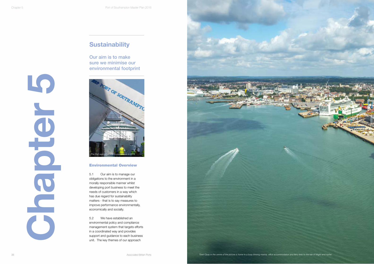
5 Sustainability
6 Trade and demand forecasts
7 Future development of the Port
8 Appraisal and assessment of
the Port Master Plan strategy
Contents
Port of Southampton Master Plan(Consultation Draft)
Con
tent
s 4
6
12
22
32
38
50
74
98

Associated British Ports
Foreword
5
Port of Southampton Master Plan 2016
Associated British Ports
Foreword
4
Port of Southampton Master Plan 2016
I hope you find this Masterplan as interesting to read as it was fascinating for us to prepare.
Alastair Welch
our customers’ needs in the short to medium term.
For the long term, if we are to continue to support growing exports of manufactured goods and the growth in popularity of cruise related holidays, we will at some stage need to consider the case for port expansion.
This Master Plan seeks to set out the Port’s strategy for growth and the steps we believe we need to consider to allow our port – and in turn, our region – to continue to be a successful gateway to the world.
We would very much welcome your comments and would invite you to take part in this consultation.
Foreword
Our Port in Southampton is in a very strong position.
We are the UK’s biggest export port, with over £40bn of UK manufactured goods exported from Southampton each year – 90% of these goods are exported outside the EU.
Over 900,000 cars passed through the port in 2015, 60% of these for export - we play a critical part in the supply chain for the British Automotive industry as it seeks to access global markets. A third of the cars exported from Southampton arrive by rail.
We are the UK’s most efficient container port and 40% of the containers arriving in the Port, continue their journey by rail- higher than any other UK port. We are also home to the UK cruise industry, with over 450 cruise ship calls last year.
Since I arrived as the new Director in Southampton in May this year - and as an Engineer myself - I feel a great sense of pride at the variety and complexity of the goods I see entering the port each day as the UK continues to manufacture for export.
Our port is thriving but with no space to expand, we have chosen to invest heavily in multi deck car parks to free up additional space on the ground to meet Fo
rew
ord
Eastern Docks

Associated British Ports
Foreword
7
Port of Southampton Master Plan 2016
Associated British Ports6
Port of Southampton Master Plan 2016
Cha
pter
1 1.1 It is a dynamic international transport hub that operates 24 hours a day, 365 days a year. It is the UK’s number one port for exports to non-EU countries, handling over one quarter of the UK’s seabourne trade with non-EU countries by value (HM Revenue and Customs, 2014), representing £36 billion of goods to these nations every year. It is also the top ranked port within the UK, and was awarded Port of the Year 2015 at the National Transport Awards. 1.2 Key trades of national significance handled by the Port include containers, cars, cruise and petrochemicals. The Port is a critical stopping point on the world’s busiest trade route from the Far East; a gateway to global markets for the automotive industry; and the busiest cruise port in the UK. Supporting in the order of 15,000 jobs and generating in the order of £1bn to GVA, the Port’s significant contribution to the economy is clear.
1.3 Recognising that ports such as Southampton operate within a free market environment and do not require central direction on how they should be run, the Government recommends that major ports such as Southampton
Introduction
The Port of Southampton is a major international deep-sea port of significant global importance that makes a vital contribution to the national, regional and local economy.
Chapter 1
Cruise ship alongside QEII Cruise Terminal, Eastern Docks

Associated British Ports8
Port of Southampton Master Plan 2016
Associated British Ports 9
Port of Southampton Master Plan 2016 Chapter 1Chapter 1
The boundary of this area is shown on Figure 1.1.
1.12 In spatial terms, our land holdings comprise the following four main areas:
• The Eastern Docks (approximately 170 acres or 69 hectares);• The Western Docks (approximately 585 acres or 237 hectares); • Marchwood Industrial Park and Cracknore Industrial Park (approximately 120 acres or 48 hectares); and• A strategic land reserve, known locally as Dibden Bay, totalling approximately 800 acres or 325 hectares, held for future port expansion, located between Marchwood Seamounting Centre and Hythe Marina Village on the western shore of the River Test.
andtomeettheneedsidentified within Government policy; and• Inform port users, employees and local communities as to how we envisage the Port developing over the coming years.
1.10 The Master Plan has been prepared to cover the approximate 20 yearperiodto2035.Thisperiodreflectsthe suggested time horizons given in the Department for Transport guidance on Master Plans.
The area covered by the Master Plan
1.11 The geographical area that the Master Plan relates to is the commercial port and other land that we own in and around Southampton. This is subsequently referred to throughout the Master Plan as ‘the Port’, ‘the Port Estate’ or ‘the Port of Southampton’.
1.6 ABP operates 21 ports in the UK, including 5 of the UK’s largest 20 ports, with 29% of the volume of all UK seaborne import and export trade passing through its ports in 2015 (The value of goods passing through UK Ports, MDST, 2016), equating to over 100 million tonnes of cargo (ABP website).
1.7 Southampton is recognised as the leading UK port for exported goods to the value of £40 billion per annum (MDST, 2016).
1.8 GiventhesignificanceofthePort of Southampton, we recognise thebenefitofsettingoutourvisionforthe future development of the Port, and sharing this with stakeholders in a way that will help to shape the Port’s future.
Master Plan Key Objectives
1.9 Having regard to the nature of the Port and its operations, wider policy and guidance, the key objectives of the Port of Southampton Master Plan 2016–2035 and our strategy for growth are to:
• Set out our strategy for growth;• Clarify our strategic planning for the medium to long term and thereby assist planning bodies, transport network providers and other stakeholders in preparing their own development strategies and in the carrying out of their functions;• Set out the future development and infrastructure requirements needed to both maintain and enhance the role of the Port as a major international deep-sea gateway
produce Master Plans in order to help co-ordinate their future planning (Guidance on the Preparation of Port Master Plans, Department for Transport 2008).
1.4 Against this background, we have prepared this Draft Port of Southampton Master Plan 2016 – 2035. It sets out our ‘Strategy for Growth’ for the Port to 2035 to ensure that the Portcontinuestomakeasignificantcontribution to the economic success of the local area and the UK as a whole. It builds upon and replaces the First Port of Southampton Master Plan 2009 – 2030 (published in 2010) and explains how the Port will continue to Keep Britain Trading.
1.5 The Port of Southampton is owned by the UK’s largest and leading ports group, Associated British Ports (ABP). ABP contributes £5.6 billion in GVA to UK plc (Economic Value of ABP to UK plc, Arup, 2014).
Marchwood and CracknoreIndustrial Parks
NorthNorth
ABP Ownership
Western DocksEastern Docks
Marchwood and CracknoreIndustrial Parks
Strategic Land Reserve
Western DocksEastern Docks
Strategic Land Reserve
Figure 1.1 – ABP Port of Southampton (Source: ABP)
Cunard’s Queen Mary 2 and Queen Victoria, Western Docks
© Google 2016

Associated British Ports10
Port of Southampton Master Plan 2016
Associated British Ports
Foreword
11
Port of Southampton Master Plan 2016 Chapter 1
1.18 Following the consultation period, we will collate and take account of the comments received. The intention is to publish the final Master Plan 2016 – 2035 before the end of 2016. 1.19 Our aim is to review and update the Master Plan again in approximately five years – or sooner if considered necessary - to ensure that it remains relevant and appropriate.
1.20 The Draft Master Plan 2016 – 2035 should also be read in conjunction with the Draft Shadow Assessment and Appraisal Report (SAAR) and the Draft Shadow Appropriate Assessment (SAA) document, which have been prepared alongside this draft Master Plan for consultation.
1.13 Throughout this Master Plan, occasional reference is made to other strategic port facilities, such as the Exxon refinery and petrochemical complex at Fawley, the BP Terminal at Hamble, the military port at Marchwood (Marchwood Seamounting Centre) and private wharves along the River Itchen, which are not on land we own but which are facilities that require access through the wider ABP controlled harbour authority area.
Public Consultation
1.14 We are publishing this Draft Master Plan to enable consultation to be undertaken with key stakeholders and the wider public to ensure that their views are taken into account before the final Master Plan is published.
1.15 This consultation period will run for 6 weeks from 14 October to 25 November 2016.
1.16 The Consultation Draft Port of Southampton Master Plan 2016–2035, and relevant supporting documentation, is available to read or download from http://www.southamptonvts.co.uk/Port_Information/Commercial/Southampton_Master_Plan/
1.17 Stakeholders are invited to provide feedback via email to [email protected] or in writing to:
Consultation OfficeAssociated British PortsPort of SouthamptonOcean GateAtlantic WaySouthamptonSO14 3QN
Ruby Princess, City Cruise Terminal, Western Docks

Associated British Ports12
Port of Southampton Master Plan 2016
Associated British Ports 13
Port of Southampton Master Plan 2016 Chapter 2 Chapter 2
road access to the Eastern Docks, completing the dual carriageway link between Dock Gate 4, the M271 and the wider strategic road network.
2.8 In recent years we have also invested in upgrading and extending the rail terminal facility within the Eastern Docks to enable it to accommodate longer trains. We have also, very recently in 2016 upgraded the QEII Cruise Terminal to enable it to accommodate larger vessels.
Western Docks
2.9 Construction of the first phase of the Western Docks commenced in the 1920s, with the reclamation of some 400 acres of mudflats along the River Test. It is a busy part of the Port serving a wide variety of trades that include cruise, roll-on/roll-off (ro-ro) cargoes, dry bulk commodities and fresh produce.
2.10 In the mid-1960s development of the second phase of the Western Docks commenced with the construction of the container terminal at berths 201 and 202 – now named berth SCT5 – which was one of the first dedicated container terminals in the UK.
Eastern Docks
2.4 The origins of the modern Port of Southampton go back to the mid-eighteenth century, with the development of the Eastern Docks at the confluence of the Rivers Test and Itchen.
2.5 Whilst a number of the earliest docks constructed have been redeveloped as marinas or in-filled and put to other uses because they were too small to accommodate modernships, the majority of the original Eastern Docks remains as a thriving part of the Port of Southampton now principally serving the automotive and cruise sectors.
2.6 Since the first Port Master Plan was published in 2010, two additional multi-deck vehicle storage terminalshave been constructed and brought into operation to meet the significant growth in the number of vehicles being handled by the Port, which reflects and ongoing growth in this trade. These are shown on the aerial photographs in Chapter 7.
2.7 Major improvement works have also been undertaken along Town Quay and Platform Road to improve
Historical Context of the Port
2.1 The history of docks and wharves at and around Southampton dates back to Roman times. During the eighteenth century the area was recognised as an important coastal port, the few quays available at Southampton being supplemented by other private quays along the River Itchen and in locations along the western shore of Southampton Water such as Eling and Ashlett Creeks.
2.2 The development of the modern Port began in 1838, with the laying of the foundation stone for Southampton Docks. Ever since that time, the Port has been a dynamic enterprise adapting and developing to meet the demands of its customers and the increasing size of the vessels that the shipping industry continues to bring into operation.
2.3 Various key milestones in the development of the Port are summarised in the timeline provide as Figure 2.1. Provided as Figure 7.1 to 7.11 are a series of aerial photographs of the main Port operational area which show how the area has developed over the previous 15 years or so.
The Port of Southampton
This section of the Master Plan sets out the history and the present context of the Port, as it exists today.
Cha
pter
2
Aerial view of Eastern Docks looking down Southampton Water

Associated British Ports 15
Port of Southampton Master Plan 2016
Associated British Ports14
Port of Southampton Master Plan 2016 Chapter 2
The growth in global containerisation of goods since the 1960s has been rapid and resulted in the expansion of the container terminal to create berths 203 to 207 – now named berths SCT1 to 4 - all of which are dedicated to container handling.
2.11 Over time, the Port has experienced considerable success due to its natural advantages of a safe and sheltered harbour and being located a minimal distance away from the main shipping lanes through the English Channel. Throughput has increased significantly.
2.12 We have been able to accommodate customer requirements and, recognising key advancements in trade and shipping patterns such as containerisation and the use of multi-storey vehicle facilities, optimise throughput capability.
2.13 Looking into the future, that ability is, however, facing considerable challenges. Land availability and berth capacity within the existing Port estate are facing severe constraints. Vessel size within a number of sectors continues to grow as shipping companies seek economies of scale to serve their respective markets. These matters are considered further within Chapter 7 of this Master Plan.
Access to the Port
2.14 Both inland and marine access routes are vital to enable cargo to be transported efficiently to and from the Port with the minimum of delays. It is essential that good access is maintained and not inappropriately constrained.
IN
RAIL FACTS
EACH TRAIN
EACH ‘MINI TRAIN’ ISNEARLY 700M LONG
72,000 MINI JAGUAR
REMOVES38CAR TRANSPORTERSFROM THE ROAD
RAIL MOVED 2015
25,000 55,000 LAND ROVER
Chapter 2
Construction of the new Southampton docks commences,allied to the development of a railway connection to London1838
HM Queen Victoria opens Empress Dock, making Southamptonthe only British port at the time able to accommodate the
deepest draught vessels at any state of the tide
The Eastern Dockssystem is completed
Southampton docks are taken over by the Governmentand become the No.1 Military Embarkation Port
The reclamation of land between the River Test and Royal Pier is completed to form the Western Docks
HM King George V opens the King George V Graving Dock,which at the time was the largest dry dock in the world
Marchwood Military Port is established on the westernshore of Southampton Water to providea base for the D-Day invasion of Europe
The Esso Oil Refinery atFawley opens
The world’s first port radio and radar station is openedat Calshot on Southampton Water
Dibden Bay is purchased as a strategic reserveexpansion of the Port.
Berths 201 and 202 are completed for container handling – the first in the UK.
Berths 203, 204 and 205 are completedfor container handling
Berth 206 is completed for container handling
Abolition of the National Dock Labour Scheme
The temperature-controlled Canary IslandsFruit Terminal is opened
Work begins to deepen the main port approach channelto cater for the growing size of vessels calling at the Port
Berth 207, a fourth new deep-sea berth, is completed at the container terminal
First multi-deck car storage facility constructedin the Eastern Docks
City Cruise Terminal opened to passengers
Government refuses permission for Dibden Terminal.
Third multi-deck car storage terminal opened in the Eastern Docks
New Ocean Cruise Terminal opened to passengers
Two additional multi-deck car storage facilitiesopened in the Eastern Docks
Approach Channel Dredge dredged to widen and deepen the approach channel to the PortRedevelopment of berths 201/202, now known as SCT5, completed
Upgrades to Mayflower Cruise Terminal and City CruiseTerminal completed
Upgrade to QEII Cruise Terminal completed
Sixth multi-deck car storage facility constructed in the Eastern Docks
1890
1911
1914
1932
1933
1943
1952
1958
1967
1969
1973
1976
1989
1991
1996
1997
2002
2004
2003
2009
2012
2014
2015
2016
Figure 2.1 – Port of Southampton Timeline (Source: ABP)

Associated British Ports16
Port of Southampton Master Plan 2016
Associated British Ports 17
Port of Southampton Master Plan 2016 Chapter 2Chapter 2
Southampton to the M3 is provided by the A33. We work closely with the City Council to ensure that the road network capacity is optimised.
2.22 As has already been indicated, since the first Port Master Plan was published, major road improvement works were completed in 2015 along Town Quay and Platform Road improving road access to the Eastern Docks and completing the dual carriageway link between the docks and the M271. At the same time improvements were made to the internal dock road network within the Eastern Docks to create a one way in / out system whereby vehicles enter the Eastern Docks via Dock Gate 4 and leave via a newly created Dock Gate 5. We invested some £1.7 million into these improvements.
2.23 Improvements were also completed in 2015 to increase the capacity of the M271 / M27 junction as part of the Government’s national pinch– point programme.
2.24 The first Port Master Plan identified that in 2009 around 70% of containers were transported to /from the Port by road. This figure has now reduced to around 60% of containers, demonstrating the successful modal shift to rail for the transportation of containers to / from the Port. 2.25 For container traffic, Southampton’s Container Terminal, which is operated by DP World Southampton, has been at the forefront of UK port logistics implementing a ‘smart’ vehicle booking system (VBS) to maximise the efficiency of the movement of containers by road. The VBS enables the terminal to control the number of
2.18 Since the first Master Plan was published there have been somesignificant improvements to rail facilities at the Port and on the wider strategic network serving the Port. In 2012,a £9 million terminal enhancement scheme, which included the provision of new cranes, was implemented at Freightliner’s Maritime Terminal. We contributed £6 million to Network Rail’s gauge enhancement project to allow greater capacity for container trains on the strategic rail freight network to and from the Port and the diversionary routes via Salisbury.
2.19 As a result, the number of trains serving the Port on a daily basis has almost doubled to 29 per day and the proportion of containers moved to / from the Port by rail has increased from 25% in 2009 to almost 40% today.The previous Master Plan aspiration for 2030 – more than 40% of container traffic moved by rail – has, therefore, almost been achieved some 15 yearsearly. Even so, we will continue over the lifetime of this Master Plan to seek to increase the amount of cargo moved by rail where it is practicable and viable to do so.
Road2.20 There are four main road accesses from the highway network into the operational Port; the Dock Gate 4 entrance and Dock Gate 5 exit (Eastern Docks) and Dock Gates 8, 10 and 20 (Western Docks). 2.21 The main road access corridor to and from the Port consists ofthe A35, M271, M27, M3 and A34.These routes support both freight and passenger movements and connect the Port to London, the West, the Midlands and the north of England. Asecondary road route through the City of
export. In respect of cars, the terminal is capable of handling up to 7 trains per day, thereby removing significant numbers of transporter movements from the road network.• Maritime Terminal: This facility, which serves the container terminal, is located on the port estate adjacent to the Container Terminal. Operated by Freightliner, this facility is accessed directly from the main line from Southampton to Bournemouth. • Millbrook Terminal: This facility is located to the north of the port estate alongside Millbrook Road and is accessed directly from the main line from Southampton to Bournemouth. This facility also serves the Container Terminal.• Herbert Walker Avenue Terminal: This facility is located within the Western Docks adjacent to the bulks terminal. It serves the bulks trade along with the vehicle, cruise and container trades. This Terminal is shortly to be the subject of significant investment – in the order of £3 million - to make it more efficient
Rail2.15 The movement of cargo by rail is, generally, only viable over longer distances and where there are suitable intermodal facilities available at both ends of the journey. Rail traffic to and from the Port of Southampton includes significant flows from the Midlands, the North West and Scotland.
2.16 The main route to and from the Port is via Basingstoke, Reading, Didcot and Leamington Spa, where the line branches to join the West Coast Main Line at Birmingham and Nuneaton. An alternative route via Romsey and Salisbury provides access to the west of England and offers an alternative to the main northerly route in case of engineering works.
2.17 The Port’s rail network has separate access to the Eastern and Western Docks. Rail terminals which serve the Port include:
• Eastern Docks Rail Terminal: This facility is used to bring UK manufactured cars to the Port for
Figure 2.2 – Road Access Routes (Source: Adams Hendry)A3057
A33
A27
A27
M3
M3
M27
M271
A33
A27
A27
A3024
A3025
A3090
A326
A326
A3057
A3057
A35
A33
A27
A27
M3
M3
M27
M27
M271
A33
A27
A27
A3024
A3025
A3090
A309
0
A326
A326
DibdenPurlieu
Hythe
Eastleigh
Chandler’sFord
ColdenCommonRomsey
NorthBaddesley
Netley
Bishopstoke
Marchwood
DibdenPurlieu
Hythe
SOUTHAMPTONTotton
Eastleigh
Chandler’sFord
ColdenCommonRomsey
NorthBaddesley
Netley
Hamble-Le-Rice
Woolston
Bitterne
Bishopstoke
SOUTHAMPTON WATER
RIVE
R HA
MBL
E
Hamble-Le-Rice
RIVER TEST
SOUTHAMPTON WATER
RIVE
R IT
CHEN
RIVE
R HA
MBL
E
ABP Landholding
Strategic Access
Secondary Access
Marchwood / Cracknore Access
Motorways
A Roads
Railway
NorthNorth
Figure 2.2 - Road access routes

Associated British Ports18
Port of Southampton Master Plan 2016
Associated British Ports 19
Port of Southampton Master Plan 2016 Chapter 2Chapter 2
• The Pilotage (Competent Harbour) Authority for the Harbour Authority area and the central and East Solent (see Figure 2.3). This allows us to make provisions for compulsory marine pilots to be present on board a vessel in order to oversee the passage of that vessel from open sea to a berth (and vice versa); and• TheVesselTrafficServices(VTS) Authority and Local Lighthouse Authority for Southampton, responsible for the monitoring and safe passage of vessels to and from the Port (see Figure 2.3).
The Port’s Land Use Strategy
2.28 As has already been highlighted– and as shown on Figures 7.1 to 7.11 – the Port has continually developed in anticipation of and in response to the growthintrade.ThefirstPortMasterPlan,publishedin2010,identifiedthe following objectives that we had implemented in respect of land use within the Eastern and Western Docks
1) Progressive removal of non-port related land uses;
HGV movements booked to arrive at the terminal, thereby assisting in smoothing outHGVflowsfrompeakhourstooff-peakhoursanddeliveringexcellentterminalproductivityandefficiencylevelsaswellasbenefitstothesurroundingroad network. The VBS system minimises congestion on the City’s roads; reduces the number of queuing lorries whilst minimising emissions to air.
Marine2.26 The Port of Southampton is ideallylocatedincloseproximitytothemajor shipping lines that run through the Channel to the south of the country. ThePortbenefitsfromadeep-wateraccess channel which, as a result of a
Port of Southampton Statutory Harbour Area
Pilotage area
Additional area over which ABP provideVessel Traffic Service coverage
Nab Tower
Diagrammatic Not to Scale
NorthNorth
Figure 2.3 - Port of Southampton Statutory Habour Area, VTS and pilotage areas
Source: ABP and Adams Hendry
Figure 2.3 – Port of Southampton Statutory Harbour Area (Source: ABP)
major dredging programme, ensures that vessels with a draught of up to 15.5m can access the Port on most days of the year.
2.27 In respect of marine operations, our responsibilities include roles as:
• The Statutory Harbour Authority (SHA) for the Port of Southampton. This role includes duties to regulate shipping and manage safety within the harbour area. The statutory harbour boundary is shown on Figure 2.3 and consists of Southampton Water, tidal elements of the Rivers Test and Itchen and parts of the East and West Solent;
Aerial view of Eastern Docks with Grain Terminal in the foreground alongside the QEII Cruise Terminal
Associated British Ports20
Port of Southampton Master Plan 2016
Associated British Ports 21
Port of Southampton Master Plan 2016
• The Maritime and Coastguard Agency (MCA);• UK Borders Agency;• Department for Transport;• The Office of the Rail Regulator;• Southampton City Council; and• New Forest District Council.
2.40 We take our health and safety responsibilities extremely seriously. We have clear systems, structures and specific objectives across all of our operations employing dedicated health and safety and security professionals at the port.
2.41 We are also embarking on a programme which we call Beyond Zero – the purpose of which is to engender a culture based behavioural safety to make sure that all of our employees, contractors and port users go home safe every day. Our challenge is to achieve Zero Harm across the business. We want to create a place where we care for each other and do what is necessary to make sure we are safe and secure.
Chapter 2
shore of Southampton Water opposite the Eastern Docks as a strategic land reserve for future port expansion.
2.36 This land will enable the Port to expand as and when the existing port operational areas become utilised to the extent that opportunities for further land use intensification are, in practical and efficiency terms, exhausted. We envisage that this is likely to happen during the period of this Master Plan, and is a matter further examined in chapters 6 and 7 of this document.
2.37 Port trades have diverse land use needs. An international gateway port such as Southampton needs a combination of specialist infrastructure, sufficient and appropriate berthing space and extensive areas for cargo handling, storage and transport manoeuvring (transfer to/from road and rail). 2.38 The demands made on berth space and back up storage land fluctuate throughout the year with some trades having a seasonal peak.Sufficient land and berths have to be available to provide for peaks ofactivity, otherwise that trade cannot be accommodated. In such circumstances the trade would then move to another port.
Health & Safety and Security
2.39 We operate in a highly regulated environment with multi-agency input into the safety and security of operations and the development of facilities, services and operations. Regulation of ports-wide safety involves amongst others:
• The Health and Safety Executive (HSE);
Chapter 2
Marchwood and Cracknore Industrial Parks
2.33 In 2015 we purchased the Marchwood and Cracknore Industrial Parks on the western shore of the River Test within New Forest District.
2.34 The Marchwood and Cracknore facilities – largely already in commercial or industrial employment use - were purchased, in part, to assist our customers in meeting their commercial requirements and to provide additional land for marine and port related businesses.
Strategic land reserve
2.35 There is a physical limit to the extent to which the sustainable and efficient use of existing land holdings and berth space in the Eastern and Western Docks can be intensified to meet the commercial requirements of the Port’s customers. For this reason, we retain an area of land on the western
2) Land being increasingly allocated to the Port’s key trades;3) Intensification of land use; and 4) Increasing specialisation in port related land use.
2.29 Since the publication of the first Port Master Plan these trends have continued. All major non-port related land uses that could have been removed from the Port have been. Since 2006, we have returned approximately 17 hectares (42 acres) of land to port use within the Western Docks. Furthermore, the development of multi - deck storage facilities in the Eastern Docks since 2002 has effectively increased the storage area available for automotive storage by approximately 23 hectares (57 acres).
2.30 The primary trades of containers, cars and cruise activities occupy an increasingly large proportion of the Port estate. Land use has continued to intensify and become more specialised.
2.31 Demand continues to grow. Developments, such as the construction of further multi-deck vehicle storage facilities and the intensification of the container terminal, are planned and being implemented, further intensifying and specialising land use within the Port.
2.32 We now consider there to be very little scope for the continued implementation of these objectives alone to provide the Port of Southampton with the ability to meet the ongoing and developing needs of the market during the lifetime of the Master Plan.
Marine Team escorting Royal Princess into the Port

Associated British Ports
Foreword
23
Port of Southampton Master Plan 2016
Associated British Ports22
Port of Southampton Master Plan 2016
3.1 The statutory boundary of the Southampton Harbour Authority falls within the boundaries of a number of local authorities. The Port is recognised economically as being of local, national and international significance. Its policy and legislative context is, therefore, extensive. 3.2 As is the case with most major European Ports, much of Southampton’s coastal and water environment is designated for its nature conservation value. The intertidal area of small parts of the western shore of Southampton Water (within the boundary of the Statutory Harbour Authority area) is also within the New Forest National Park.
3.3 The economic activity the Port generates and its physical presence in the area means that the relevant policy framework has been a key consideration in drawing up this Master Plan. The policy framework envisages a key role for this Master Plan as a means of identifying the future infrastructure requirements of the Port of Southampton. As such it is intended that the Master Plan should feed into relevant local development documents, an approach which is endorsed by the DfT’s Master Plan guidance and which
Chapter 3
Policy Context
This section of the Master Plan outlines the policy context relevant to the Port of Southampton.
Cha
pter
3
Marchwood Yacht Club Moorings with Container Terminal in background

Associated British Ports24
Port of Southampton Master Plan 2016
Associated British Ports 25
Port of Southampton Master Plan 2016 Chapter 3Chapter 3
• allow judgments about when and where new developments might be proposed to be made on the basis of commercial factors by the port industry or port developers operating within a free market environment; and • ensure all proposed developments satisfy the relevant legal, environmental and social constraints and objectives, including those in the relevant European Directives and corresponding national regulations” (paragraph 3.3.1).
3.7 The NPSfP sets out the Government’s assessment of the need for new port infrastructure in section 3.4. Throughout this assessment it is made clear that the total need for port infrastructure not only depends upon overall demand for capacity but also on the need to retain the flexibility that ensures that capacity is located where it is required and on the need to ensure effective competition and resilience in port operations.
also a relevant consideration for the Marine Management Organisation (MMO), which is responsible for determining applications for smaller port development proposals, and for local planning authorities ‘where they have a role to play’ (NPSfP, paragraph 1.2.1).
3.5 The NPSfP recognises the essential role of ports in the UK economy, noting that in 2010 ports in England and Wales handled 410 million tonnes of goods, out of a UK total of 512 million tonnes, representing about 95% of the total volume of UK trade and 75% of its value (NPSfP, paragraph 3.1.3).
3.6 The NPSfP summaries the Government’s policy for ports as seeking to:
• “encourage sustainable port development to cater for long-term forecast growth in volumes of imports and exports by sea with a competitiveandefficientport industry capable of meeting the needs of importers and exporterscosteffectivelyandin a timely manner, thus contributing to long-term economic growth and prosperity;
continues the approach adopted by local authorities in respect of the first Port Master Plan.
National Policy
3.4 National ports policy currently consists of the National Policy Statement for Ports (NPSfP) (January 2012). This provides a framework for decisions on new port developments that are nationally significant infrastructure projects (NSIPs) and is
ASSOCIATEDBRITISH PORTS
Communitiesand LocalGovernment
NationalPolicy
Framework
marine managementorganisation
SOLENT LOCAL ENTERPRISE PARTNERSHIP
Department for Transport
SOUTHAMPTONCITY COUNCIL
HampshireCountyCouncil
NEW FORESTNATIONAL PARK
New ForestDistrict Council
3.8 The section of the NPSfP that considers the need for new port infrastructure concludes that, “the Government believes that there is a compelling need for substantial additional port capacity over the next 20 to 30 years”, and that “to exclude the possibility of providing additional capacity for the movement of goods and commodities through new port development would be an outcome strongly against the public interest” (paragraph 3.4.16).
3.9 The success of ports, including the Port of Southampton, is heavily reliant on the UK’s national road and rail infrastructure for transporting goods and customers. The National Policy Statement for National Networks, published in December 2014, recognises the need to improve the integration between transport, including the linkages to ports, reducing end-to-end journey times through improvements to the strategic road network, accommodating modal shift
allow judgments about when and where new developments might be proposed to be made on the basis of commercial factors by the port industry or port developers operating within a free market environment
“
”

Associated British Ports26
Port of Southampton Master Plan 2016
Associated British Ports 27
Port of Southampton Master Plan 2016 Chapter 3Chapter 3
3.14 The Marine Management Organisation (MMO) has responsibility for preparing marine plans and has identified eleven Marine Plan Areas; the Port of Southampton is within the South Inshore Marine Plan Area, which is currently under preparation.
Local Policy
3.15 The Eastern and Western Docks of the port estate are located within the administrative area of Southampton City Council (SCC). Marchwood and Cracknore Industrial Parks are in the
identifies the development needs of the Port.
3.12 Amongst other things, the NPPF makes clear that the planning system should do everything it can to support sustainable economic growth, and that local authorities should plan proactively to meet the development needs of business and support an economy fit for the 21st century (paragraphs 19 and 20). In respect of transport matters, the NPPF makes clear that local plans should protect and exploit opportunities for the use of sustainable transport modes for the movement of goods and people, and should identify and protect, where there is robust evidence, sites and routes which could be critical in developing infrastructure to widen transport choice (paragraph 35 and 41). Local authorities are also encouraged to work with neighbouring authorities and transport providers to develop strategies for the provision of viable infrastructure necessary to support sustainable development, including transport investment necessary to support strategies for the growth of ports (paragraph 31).
3.13 A new system of marine planning has been introduced across the UK through the Marine and Coastal Access Act 2009. The Marine Policy Statement (MPS) sets out the framework against which decisions affecting the marine environment will be made. It is the Government’s vision to have ‘clean, healthy, safe, productive and biologically diverse oceans and seas’. It recognises that ports and shipping are an essential part of the UK economy (paragraph 3.4.1) and that a Port Master Plan may provide marine planning authorities with a strategic view of the potential direction of future port development (paragraph 3.4.8).
to rail, and expanding the network of Strategic Rail Freight Interchanges (SRFIs) (paragraphs 2.8, 2.13 and 2.47).
3.10 The National Planning Policy Framework (NPPF) explains that the purpose of the planning system is to contribute to the achievement of sustainable development (paragraph 6) which is described as having three dimensions, namely economic, social and environmental (paragraph 7). The Framework explains that at its heart is a presumption in favour of sustainable development.
3.11 In respect of plan making, the NPPF highlights, amongst other things, that local planning authorities should positively seek opportunities to meet the development needs of their area; and that local plans should meet objectively assessed needs, with sufficient flexibility to adapt to rapid change, unless certain specified circumstances apply. We consider that, having regard to its purpose and the NPSfP, the Port of Southampton Master Plan is a key evidence document that objectively
Figure 3.1 – Local Authority Boundaries (Source: Local Authorities)
administrative area of New Forest District Council (NFDC). The strategic land reserve on the western shore of the River Test is within the administrative areas of NFDC and the New Forest National Park Authority (NFNPA) – see Figure 3.1.
3.16 Planning applications within the Port estate (made in respect of development that does not constitute permitted development) are required, in summary, to be determined in accordance with the Statutory Development Plan unless material
the Government believes that there is a compelling need for substantial additional port capacity over the next 20 to 30 years . . . to exclude the possibility of providing additional capacity for the movement of goods and commodities through new port development would be an outcome strongly against the public interest
“
”

Associated British Ports28
Port of Southampton Master Plan 2016
Associated British Ports 29
Port of Southampton Master Plan 2016 Chapter 3Chapter 3
considerations indicate otherwise. Section 20 of the Planning and Compulsory Purchase Act 2004 states that Local Plans must be positively prepared, justified, effective and consistent with national policy and the NPPF.
3.17 The Statutory Development Plan for the Port estate currently comprises of the following:
• Southampton Core Strategy 2009, as amended by the Partial Review 2015;• Southampton City Centre Action Plan 2015;• Southampton Local Plan Review 2006 Saved Policies;• New Forest District Council Core Strategy 2009;• New Forest District Council Local Plan Part 2: Sites and Development Management 2014;• New Forest District Council Saved Policy DW-E12 from Local Plan Review 2005;• New Forest National Park Core Strategy and Development Management Polices 2010, and • Hampshire Minerals and Waste Plan 2013.
3.18 The SCC Core Strategy identifies that “the Port of Southampton is a major international deep sea port withsignificantglobalandeconomicimportance and makes a vital contribution to the national, regional and local economy” (paragraph 2.1.2). A strategic objective of the Core Strategy is to “Support the varied operations of the Port of Southampton asafacilityofGlobalsignificanceandas an international gateway in which role it makes a vital contribution to the national, regional and local economy” (Strategic Objective S4). This is partly achieved through Policy CS9, which states that the City Council “will promote and facilitate the growth of the Port of Southampton”.
3.19 The Southampton City Centre Action Plan also recognises the Port’s economic importance to the UK, South Hampshire and the city (paragraph 4.22). Policy AP4 therefore states that “the Council supports the growth and overall competitiveness of the Port of Southampton” including ensuring that development proposals will not have a negative impact on the current or future Port or its strategic or secondary access.
3.20 The NFDC Core Strategy and the NFNPA Core Strategy acknowledge that national policy recognises the Port is a major international deep sea gateway port with significant global and economic importance and that the strategic land reserve is the only area of land which is physically capable of accommodating significant expansion of the Port (NFDC paragraph 9.15 and NFNPA paragraph 2.15).
3.21 The NFDC Local Plan Part 2: Sites and Development Management DPD was adopted in April 2014. NFDC
Aerial photography by Roger D Smith ABIPP Gosport
The Port’s Container Terminal operated by Dubai Ports World Southampton
the Port of Southampton is a major international deep sea port with significant global and economic importance and makes a vital contribution to the national, regional and local economy
“
”
have made it clear that in its forthcoming Local Plan Review it will, amongst other things, specifically address the future of our strategic land reserve.
3.22 The Hampshire Minerals and Waste Plan 2013 (Policy 19) identifies a number of aggregate wharfs that form part of the wider Port of Southampton and seeks to maximise their use and/or expansion. Policy 34 of the plan also safeguards a number of areas so that their appropriateness for use as minerals or waste wharf or rail depots can be considered should they became available, including:
• land located to the north west of Hythe identified in the Port of Southampton Master Plan – the strategic land reserve;• land identified in the Southampton Core Strategy as operational port land, and• Marchwood Military Port (also known as Marchwood Sea Mounting Centre).
Emerging Development Plan3.23 SCC, NFDC and the NFNPA have all commenced a review of their respective development plans. ABP will continue to engage with the preparation of Local Development Plans to protect and promote the Port’s ongoing ability to continue to support British trade.
Partnership for Urban South Hampshire (PUSH)
3.24 PUSH was formed in 2003, and its membership consist of various South Hampshire local authorities, including SCC and NFDC. PUSH has no statutory powers or functions but works collaboratively with the Solent Local Enterprise Partnership (LEP), which
covers broadly the same area, to deliver its distinct but complementary roles and objectives. In 2012 PUSH adopted the South Hampshire Strategy, providing a sub-regional framework for sustainable development and change to 2016. The Strategy recognised the importance of the Port of Southampton as an International gateway and supports the continued growth of the Port (Policy 2).
3.25 PUSH have recently updated its strategy through the publication of the ‘PUSH Spatial Position Statement (June 2016)’. This statement recognises Southampton as being one of the country’s largest, busiest and most diverse ports, and acknowledges the significant economic contribution which the Port makes to the local economy (paragraphs 3.10 to 3.12). In considering employment development matters, the statement recognises the potential for growth in port-

Associated British Ports30
Port of Southampton Master Plan 2016
Associated British Ports 31
Port of Southampton Master Plan 2016 Chapter 3Chapter 3
3.34 The policy framework continues to evolve and it is clear that future Port development proposals will need to take account of policies within local development plans as appropriate. Equally we will continue to advise planning authorities of the development needs of the Port and to ensure that the emerging development plans reflect the local, regional and national importance of the Port, and that the interests of the Port are suitably protected.
represented within relevant policy documents. This Master Plan plays a central role in identifying the Port’s requirements and intentions for the future, which can then be reflected in policy as it is prepared or altered.
3.32 The Port’s future is a key element of the social, economic and environmental make-up of the region and South Hampshire sub-region. As one of the UK’s principal gateways for international trade, it is a major catalyst for wealth generation and employment.
3.33 The Port shares the coastal waters with other users: naval vessels, leisure craft and local and continental ferries. The Master Plan assists in identifying the weight to be attached to the Port’s needs, enabling them to be properly balanced in planning policies against the demands of others on the coastal zone.
free standing document, and has been prepared as a Joint Strategy between the three Local Transport Authorities of Hampshire County Council, Portsmouth City Council and Southampton City Council. Policy B of the South Hampshire LTP states the TfSH authorities will work with the Highways Agency, Network Rail, ports and airports to ensure reliable access to and from South Hampshire’s three international gateways – one of which is the Port of Southampton - for people and freight.
Marine Policy
3.30 As already indicated, the South Inshore Marine Plan is still in the early stages of preparation and consultation. The South Plan Analytical Report (SPAR) June 2014 presents a refined list of core issues for marine planning in the south marine plan area. An options document was consulted on in early 2015, and a consultation draft of the South Inshore Marine Plan is expected to be published shortly.
Policy Implications for the Master Plan
3.31 It is important that the future of the Port, as a key gateway of international significance is properly
related logistics and the potential for additional port capacity to be delivered (paragraph 5.60). Marchwood Industrial Park is specifically identified as an existing waterfront site of sub-regional importance (policy E3) which should be protected for continued employment use, and in particular activities which support the marine and maritime economy
Local Enterprise Partnerships
3.26 The Solent LEP’s Strategic Economic Plan and Transforming Solent Marine and Maritime Supplement were published in 2014, both of which highlight that the future of the Port of Southampton is jeopardised by a lack of space for expansion and insufficient road infrastructure, constraints that need to be removed to enable the port to grow.
3.27 The Enterprise M3 LEP, which overlaps with the Solent LEP, stretches the full length of the M3 corridor; a critical part of the strategic road access to the Port of Southampton. The Port is identified as a key feature of relevance to the M3 LEP area.
Transport Policy
3.28 Local authorities are required to produce and maintain Local Transport Plans (LTP) that identify transport related challenges and set out proposals to resolve them. The Hampshire LTP 2011-2031 sets out a long-term vision for Hampshire’s transport split into three areas: North Hampshire, Central Hampshire and the New Forest, and South Hampshire. 3.29 The Transport for South Hampshire (TfSH) section of the LTP is a
6
7
5
9
4
8
3
8
South Inshore & OffshorePlan Areas
Contains Ordnance Survey and UK Hydrographic Off ice data © Crowncopyright and database right 2012. Marine Management Organisation.
3 - East inshore4 - East offshore5 - South East inshore6 - South inshore7 - South offshore8 - South West inshore9 - South West offshore
Plan area boundaries are describedas defined following the Defraconsultation on marine plan areasand are indicative with furtherrefinement expected as the marineplanning process is implemented.
Map produced in ETRS89 UTM Zone 30N coordinate reference system. August 2012
Figure 3.2 - South Inshore and Offshore Plan Areas Source: MMO
Figure 3.2 – South Inshore and Offshore Plan Areas (Source: MMO)
Support the varied operations of the Port of Southampton as a facility of Global significance and as an international gateway in which role it makes a vital contribution to the national, regional and local economy
“
”

Associated British Ports 33
Port of Southampton Master Plan 2016
Associated British Ports32
Port of Southampton Master Plan 2016 Chapter 4Chapter 4
4.1 The Port of Southampton and its customers contribute significantly to both the local and national economies, supporting in the order of 15,000 jobs and generating in the order of £1bn to the UK economy every year (Economic Value of ABP to UK plc, Arup (2014)) (subsequently referred to as (Arup, 2014)).
4.2 The Port plays a key role in Keeping Britain Trading, providing a strategic hub and gateway to global markets for enterprises across southern and central England. The Port handles over £71 billion of international trade every year (The Value of Goods Passing through UK Ports, MDS Transmodal (2016)) (subsequently referred to as (MDST, 2016)); over one quarter of the UK’s seaborne trade with non-EU countries by value (HM Revenue and Customs, 2014) and is the leading UK port for exports to international markets of £40 billion per annum (MDST, 2016)
4.3 The Port of Southampton is a major deep-sea port with significant global and economic importance.
4.4 The Port is an important part of its locality, a role which is not limited to
Socio-economic context
The Port of Southampton and its customers contribute significantly to both the local and national economies
Cha
pter
4THE PORT OFSOUTHAMPTON
WELCOMES
1.77MCRUISE PASSENGERS
SUPPORTS15,000 LOCAL JOBSHANDLES 900,000
VEHICLESCONTAINERS
CONTRIBUTES£1bnTO THE UKECONOMY
OVER
1M
DRY BULK CARGO1.3M TONNES
providing jobs and income. We provide support for the community by facilitating leisure activities such as marine recreational sports, the Southampton Half Marathon and 10K and through our strong commitment to local charities. The Port Today
4.5 Today the Port of Southampton is a dynamic international gateway and transport hub that operates 24 hoursa day, 365 days a year. The Port is of national significance in a number of trade sectors, including the handling of containers, cars and passenger cruises.
4.6 The Port is a major contributor to the local, regional and national economy, both in terms of providing direct employment and also in respect of businesses that indirectly rely on the Port’s activities, such as road haulage, warehousing and distribution. It is estimated that the Port creates in the order of 5,000 direct jobs (Arup, 2014). This consists of jobs we generate ourselves and by our customers - companies that span a broad range of sectors including automotive, energy,

Associated British Ports34
Port of Southampton Master Plan 2016
Associated British Ports 35
Port of Southampton Master Plan 2016 Chapter 4Chapter 4
of the Port in order to improve the access for the large container vessels.
Motor Vehicles4.12 Handling over 900,000 vehicles in 2015, including around 520,000 for export, Southampton is the UK’s leading port for car handling. Aound one third of the export vehicles arrive at the Port on up to five daily trains.
4.13 To facilitate the import and export of cars the Port currently contains various dedicated multi-deck vehicle terminals, all of which are located in the Eastern Docks. The Port of Southampton is believed to be the first port to have developed such facilities.
4.14 The automotive sector is the UK’s largest export sector by value, worth £27 billion (Arup, 2014). As a gateway to global markets, the Port of Southampton plays a vital role in this sector.
• Distribution warehouse expansion;• Upgrade of 3 cruise terminals, and• New vessel management system.
Containers4.9 Southampton is home to the most efficient container terminal in Europe, which is also the UK’s second largest container terminal. The container terminal is operated by DP World Southampton (DPWS) and in 2015 handled over 1 million containers the equivalent of some 1.9 million twenty foot equivalent units (TEU – a measure by which container volumes are referred). 4.10 In March 2014 the fifth container berth, SCT5, opened. This new 500m long berth, with 16m of available depth of water, is one of the very few facilities within the UK capable of handling the world’s largest container ships – which are regular visitors.
4.11 Around the same time as undertaking work on SCT5, we undertook a dredging programme to deepen the main marine access channel
agriculture and food as well as cruise and ferry services. A further 10,000 jobs are estimated to be created through related employment through the region and the UK (Arup, 2014). 4.7 In 2014 the port facilities in and around Southampton handled in the order of 37 million tonnes of cargo, handling over one quarter of the UK’s seaborne trade with non-EU countries by value. Further information on the key trades handled at the Port, such as containers, cars and cruise passengers is set out in the sections that follow.
4.8 Over the past 5 years or so, we have invested over £180 million at the Port to help drive growth and secure jobs. Such infrastructure projects include:
• Deepening of main approach channel;• Creation of new deep water container berth;• New container cranes;• Multi-deck vehicle storage facilities;• Highway improvements;• Port rail network upgrades;
Cruise and Passengers4.15 The Port of Southampton is the UK’s premier cruise port and in 2015 we welcomed 450 vessels and 1.7 million cruise passengers. The Port accounts for in the order of 70% of the UK’s home port passengers (Arup, 2014) through four cruise terminals; the QEII Cruise Terminal and Ocean Cruise Terminal within the Eastern Docks and the City Cruise Terminal and Mayflower Cruise Terminal within the Western Docks.
4.16 Carnival, the world’s leading cruise operator, relocated its headquarters to Southampton in 2009. The company, whose brands include Cunard, P&O Cruises, Princess, Costa and Holland America, now oversee their Australian, New Zealand and UK operations from Southampton, and employ over 1,000 people in the city. Other cruise companies operating from the Port include Royal Caribbean, Celebrity Cruises, MSC, Fred Olsen and Saga.
The Port is a major exporter of British made vehicles

Associated British Ports36
Port of Southampton Master Plan 2016
Associated British Ports 37
Port of Southampton Master Plan 2016 Chapter 4Chapter 4
General Cargo 4.22 General cargo handled at the Port consists mainly of fresh produce from the Canary Islands, Southampton is the sole UK import facility for this traffic and has extensive specialist facilities for this trade. The Fruit Terminal in the Western Docks provides 14,500m3 of cool and cold storage and has deep-water berths capable of accommodating two ships simultaneously.
4.23 Each year the Port handles approximately 100,000 pallets of fresh produce from the Canary Islands, consisting predominantly of tomatoes destined for supermarket shelves around the UK. Smaller volumes of peppers, avocados and cucumbers are also handled during the season, which lasts from October to May. Liquid Bulks 4.24 Although not forming part of the ABP estate, but located within the wider Statutory Harbour Authority area, the oil refinery at Fawley and the marine fed fuel terminal at Hamble form one of the UK’s leading hubs for the import and export of liquid bulk oil and fuel cargoes. In 2015 over 23 million tonnes of liquid bulk products passed through facilities located within the statutory port authority area.
by Red Funnel from land at Town Quay, and providing both car ferry and fast jet passenger only services, the ferry terminal in 2015 handled in excess of 3.4 million passengers.
Dry Bulks 4.20 In 2015 the Port handled over 1.3 million tonnes of dry bulk cargo. Dry bulk cargoes include a very wide range of commodities including grain, fertilisers, animal feed and scrap metal.
4.21 Dry bulks are handled at a number of facilities. Southampton Grain Terminal, located in the Eastern Docks, primarily handles the export of grain. Within the Western Docks there is a dedicated multi-user bulks terminal. Operated by Solent Stevedores, this facility handles a variety of cargoes including minerals, animal feed, fertiliser, scrap metal, aggregates, salt and biomass products.
4.17 In the Solent region the cruise industry is estimated to generate in the order of 3,500 jobs (2011 estimate) (Arup, 2014). Every cruise that embarks or disembarks at the Port has been estimated to generate £2.5 million for the economy (Arup, 2014).
4.18 With our key partners, we continue to invest in the cruisefacilities at the Port. In 2015 Carnival and ourselves invested £5 million in remodelling the Mayflower Cruise Terminal. The Ocean Cruise Terminal and the City Cruise Terminal have also been significantly upgraded in recent years and a refurbishment of the QEII Cruise Terminal has just been completed.
4.19 In addition to the cruise trade, the Port of Southampton also contains one of the key ferry terminals that provides a connection between the Isle of Wight and the mainland. Operated
PORT OF SOUTHAMPTON
24365WE HANDLE
THETOP
RANKEDPORT
WITHINTHEUK
1/4
HOURS A DAY
OPEN
OCTOBERDAYS A YEAR
SEABOURNETRADE WITHNON-EU COUNTRIES
OF UK
View of Ocean Dock, Eastern Docks, showing ro-ro vessel alongside cruise ship
Associated British Ports
Foreword
39
Port of Southampton Master Plan 2016
Associated British Ports38
Port of Southampton Master Plan 2016
Environmental Overview
5.1 Our aim is to manage our obligations to the environment in a morally responsible manner whilst developing port business to meet the needs of customers in a way which has due regard for sustainability matters - that is to say measures to improve performance environmentally, economically and socially.
5.2 We have established an environmental policy and compliance management system that targets efforts in a coordinated way and provides support and guidance to each business unit. The key themes of our approach
Sustainability
Our aim is to make sure we minimise our environmental footprint
Chapter 5
Cha
pter
5
The Port welcomed 450 cruise vessels in 2015
TownQuayinthecentreofthepictureishometoabusythrivingmarina,officeaccommodationandferrylinkstotheIsleofWightandHythe

Associated British Ports40
Port of Southampton Master Plan 2016
Associated British Ports 41
Port of Southampton Master Plan 2016 Chapter 5Chapter 5
are shown on Figure 5.1 and include Ramsar sites, Special Protection Areas (SPAs), Special Areas of Conservation (SAC), Sites of Special Scientific Interest (SSSI). SPAs and SACs are collectively known as ‘European Sites’ and are the basis for the ‘Natura 2000’ network.
5.6 We recognise that nature conservation designations cover large parts of our strategic land reserve (SSSI and SPA / Ramsar designations) and this will have a direct influence on the future development of that area of land. The Conservation of Habitats and Species Regulations 2010 set out the process and tests that must be
5.4 The following are key environmental matters that influence both current operations and any future development aspirations at the Port. It is not intended to be an exhaustive list and any future development proposals will take all relevant considerations into account on a case-by-case basis.
Biodiversity 5.5 The River Test, River Itchen, Southampton Water and the Solent have long been recognised for their high biological and nature conservation importance. There are a number of sites of international nature conservation interest in the vicinity of the Port. These
risk and impacts during both the construction and operation phases. We work closely with organisations such as local authorities, the Environment Agency and Natural England during the design phase of our biggest projects – we have many successful examples where we have successfully balanced the needs of the environment with the need for port development projects.
• Responsibilities and training: Our team is committed to improving our knowledge of the environment around the Port and we have increased the amount of training and support to employees across a wide range of environmental subjects from introductory programmes to more detailed specialised training in areas such as energy awareness and waste management. Environmental Considerations
5.3 Our sustainable approach to our business concentrates on making the most efficient use of resources; minimising the impact of operations; liaising with key stakeholders; working with wildlife and continually improving overall environmental performances.
to environmental management can be summarised as:
• Managing risks: We review each stage of our operations and activities and assess their impact on the environment, introducing control measures where required and where practical. We assess operational risks by reviewing best practice information and guidance, developing risk assessments, and undertaking audits of our operations. We also seek to ensure that we are prepared for an emergency incident, with well tested plans in place, as demonstrated with the grounding of the MV Hoegh Osaka in 2015.
• Resource efficiency and carbon reduction: Carbon management, improved resource efficiency and waste minimisation are key business priorities for us and we are focused at looking for continual improvements. ABP was awarded accreditation under the ISO 50001 energy management standard in 2015.
• Developing responsibly: We ensure that our developments are designed to minimise environmental
Solent and SouthamptonWater SPA / Ramsar siteand Solent Maritime SAC
Solent and SouthamptonWater SPA / Ramsar siteand Solent Maritime SAC
North SolentSSSI
New Forest SPAand Ramsar site
New ForestSAC
River ItchenSAC
Dibden BaySSSI
Eling and BuryMarsh SSSI
Hythe toCalshot SSSI
Lower TestValley SSSI
Lee-on-the Solentto Itchen Estuary SSSI
New ForestSSSI
River TestSSSI
New Forest SPAand Ramsar site
New ForestSAC
River ItchenSAC
Dibden BaySSSI
Eling and BuryMarsh SSSI
Hythe toCalshot SSSI
Lower TestValley SSSI
Lee-on-the Solentto Itchen Estuary SSSI
New ForestSSSI
River TestSSSI
North SolentSSSI
Solent and SouthamptonWater SPA / Ramsar siteand Solent Maritime SAC
Solent and SouthamptonWater SPA / Ramsar siteand Solent Maritime SAC
ABP Landholdings
SSSI
RAMSAR
SAC
SPA
NorthNorth
0 1kmScale
Figure 5.1 - Sites of National / International Nature Conservation Importance
Source: Magic
Based upon the Ordnance Survey scale map with the permissionof The Controller of Her Majesty's Stationery Office © Crown Copyright
Based upon the Ordnance Survey scale map with the permissionof The Controller of Her Majesty's Stationery Office © Crown Copyright
Figure 5.1 – Sites of national / international nature conservation importance
A busy day in the Eastern Docks with two cruise ships and three ro-ro vessels

Associated British Ports42
Port of Southampton Master Plan 2016
Associated British Ports 43
Port of Southampton Master Plan 2016 Chapter 5Chapter 5
for these fish in the tidal waters through which they must pass, with maintenance dredging taking place outside the key seasonal migration times.
5.17 Management of marine sediments is governed by the Centre for Environment, Fisheries and Aquaculture Science (CEFAS) and the requirements of the MMO. All dredged material we identify for disposal is subject to a testing regime overseen by Cefas.
5.18 Port development has the potential to affect compliance with water quality standards through siltation or deoxygenation of the water column. ABP actively engages with the Environment Agency on all proposed developments that may affect the marine environment to ensure that risks are removed or mitigated.
Energy5.19 The UK government has set some demanding targets for the country’s environmental performance, including in respect to climate change emissions. For our part, we at Southampton have successfully implemented the international standard for energy management (ISO 50001), which looks to record and proactively reduce energy consumption.
5.20 We have significantly improved our knowledge of energy consumption through real time metering systems and we have been able to reduce our overall energy consumption by 20% since 2009 by introducing measures such as Passive Infra Red (PIR) lighting controls, LED lighting in buildings and high mast light columns. Where we undertake refurbishment activities, we look for opportunities to engage best technology options that minimise energy
Water and Sediment Quality 5.12 The Department for the Environment, Food and Rural Affairs (DEFRA) has overall reasonability for water resources in England. The Environment Agency is the key regulator of water quality through legislation including the Environment Act 1995, the Water Resources Act 1991 and the Environmental Protection Act 1990.
5.13 Many standards for water quality are regulated at European level through a range of environmental directives, the most notable being the EU Water Framework Directive (WFD). The WFD requires all water bodies to achieve ‘Good Ecological Status’ and ‘Good Chemical Status’.
5.14 In order to meet the requirements of the WFD, River Basin Management Plan’s (RBMP) have been drawn up for river basin districts across England and Wales. The Solent and Southampton Water is within the South East River Basin District RBMP.
5.15 The provision of environmental safeguards and procedures necessary to minimise the incidence of oil pollution to controlled waters is an important function of the Harbour Master’s team through preparation of emergency response plans to deal with oil spill incidents.
5.16 There are various designations for the protection of shellfish and salmonid waters in Southampton Water and its tributaries. While the salmonid waters designations for the Rivers Test and Itchen apply above their tidal limits, the fact that these rivers are used by migratory salmonid fish means that we have due regard in our operations to the maintenance of suitable conditions
(MMO) using the licensing procedures in place under the Marine and Coastal Access Act 2009.
5.10 We have in place a Maintenance Dredging Protocol (MDP) ’Baseline Document’, which documents dredging activity and considers the effects of dredging on conservation status and the integrity of European Sites. The Southampton ‘Baseline Document’ accompanies all maintenance dredge licence applications. We follow the principles of Waste Hierarchy to minimise the quantity of material we dredge and always look for opportunities for re-use.
5.11 Capital dredge proposals, which deepen the depth or widen the extent of an existing navigation channel to improve marine access to the berths, are taken forward from time to time. Such proposals require consent from the MMO in consultation with stakeholders including Natural England and the Environment Agency. The last capital dredge, completed in 2014, employed a real time monitoring system to ensure that water quality was not compromised at any time.
achieved in order to allow development to take place which affects European sites and Ramsar sites. Development likely to have an adverse effect on SSSIs is subject to the policies set out in the NPPF, which requires particular circumstances to be demonstrated before development can be approved.
5.7 Aquatic ecology in freshwater bodies, transitional waters (estuaries) and coastal water bodies extending one nautical mile out to sea is protected by the Water Framework Directive (WFD). We sit on the Environment Agency’s WFD Liaison Panel, which is tasked with improving the quality of our surface and ground water environments. The implications of this Directive are considered in the paragraphs that follow which consider water quality matters.
Dredging 5.8 Maintenance dredging is essential to maintain safe and navigable depths of water. This is normally undertaken twice per year, generally during spring and autumn.
5.9 Maintenance dredging is managed through relevant liaison with the Marine Management Organisation
A backhoe dredger deepening the main channel approach in 2014
Associated British Ports44
Port of Southampton Master Plan 2016
Associated British Ports 45
Port of Southampton Master Plan 2016 Chapter 5 Chapter 5
reducing the area of saltmarsh habitat on the upper shore. Port development and the beneficial use of dredged material may provide an opportunity to contribute to long-term estuary management in this regard.
Air Quality 5.27 Southampton City Council (SCC) has declared a number of Air Quality Management Areas (AQMAs) around roads in the city, some of which are principal road access routes to and from the Port. New Forest District Council (NFDC) has also declared AQMAs. The locations of these AQMAs and principal access routes to the Port are shown on Figure 5.3.
5.28 These AQMAs are designated in relation to exceedences of European standards for nitrogen dioxide generated by vehicle movements. Measures to achieve air quality improvements are set out in the local Air Quality Action Plans (AQAPs) produced by the relevant Councils. We are committed to continued working with local authorities
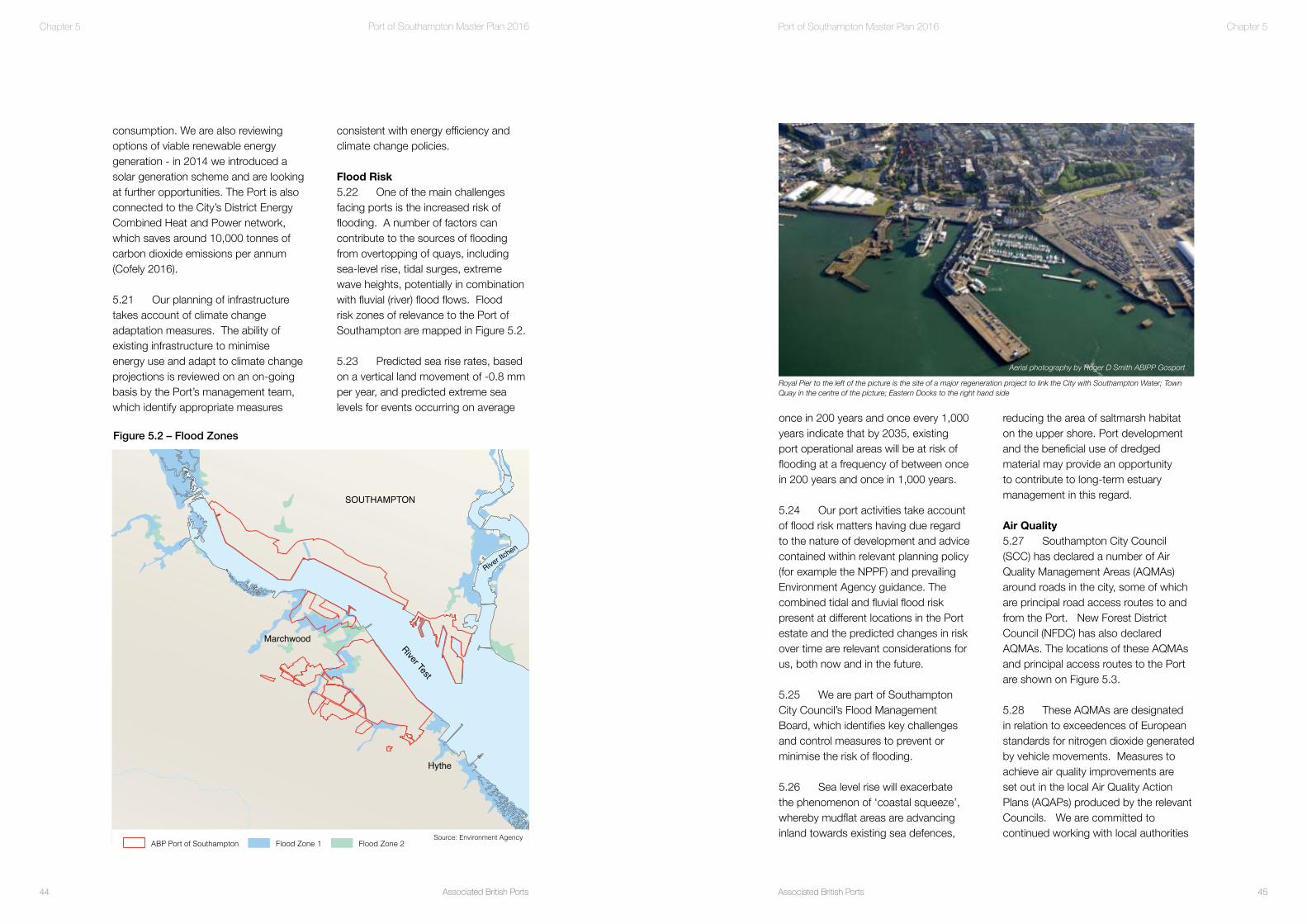
once in 200 years and once every 1,000 years indicate that by 2035, existing port operational areas will be at risk of flooding at a frequency of between once in 200 years and once in 1,000 years.
5.24 Our port activities take account of flood risk matters having due regard to the nature of development and advice contained within relevant planning policy (for example the NPPF) and prevailing Environment Agency guidance. The combined tidal and fluvial flood risk present at different locations in the Port estate and the predicted changes in risk over time are relevant considerations for us, both now and in the future.
5.25 We are part of Southampton City Council’s Flood Management Board, which identifies key challenges and control measures to prevent or minimise the risk of flooding.
5.26 Sea level rise will exacerbate the phenomenon of ‘coastal squeeze’, whereby mudflat areas are advancing inland towards existing sea defences,
consistent with energy efficiency and climate change policies.
Flood Risk5.22 One of the main challenges facing ports is the increased risk of flooding. A number of factors can contribute to the sources of flooding from overtopping of quays, including sea-level rise, tidal surges, extreme wave heights, potentially in combination with fluvial (river) flood flows. Flood risk zones of relevance to the Port of Southampton are mapped in Figure 5.2.
5.23 Predicted sea rise rates, based on a vertical land movement of -0.8 mm per year, and predicted extreme sea levels for events occurring on average
consumption. We are also reviewing options of viable renewable energy generation - in 2014 we introduced a solar generation scheme and are looking at further opportunities. The Port is also connected to the City’s District Energy Combined Heat and Power network, which saves around 10,000 tonnes of carbon dioxide emissions per annum (Cofely 2016).
5.21 Our planning of infrastructure takes account of climate change adaptation measures. The ability of existing infrastructure to minimise energy use and adapt to climate change projections is reviewed on an on-going basis by the Port’s management team, which identify appropriate measures
Marchwood
Hythe
SOUTHAMPTON
River Test
River Itc
hen
ABP Port of Southampton Flood Zone 1 Flood Zone 2Source: Environment Agency
Figure 5.2 – Flood Zones
Aerial photography by Roger D Smith ABIPP Gosport
Royal Pier to the left of the picture is the site of a major regeneration project to link the City with Southampton Water; Town Quay in the centre of the picture; Eastern Docks to the right hand side
Associated British Ports46
Port of Southampton Master Plan 2016
Associated British Ports 47
Port of Southampton Master Plan 2016 Chapter 5Chapter 5
Cultural Heritage 5.37 The Port of Southampton has many connections with the area’s maritime past and there is evidence that the Solent and its tributaries have been used for port activities and by shipping for over 2,000 years. The City’s waterfront was the embarkation point for the Pilgrim Fathers’ voyage to America in 1620, and the RMS Titanic sailed from the Eastern Docks in 1912. The Eastern and Western Docks also played a major role as an embarkation point for troops and supplies during both world wars and more recent conflicts involving our Armed Forces.
5.38 Listed structures within the port estate include two former dry docks (Trafalgar Dry Dock and King George V Dock which is now used as an operational berth), the gateway portals at dock gates 8 and 10, and the remains of the Royal Pier. Old Town West, Old Town South, Oxford Street, Canute Road Conservations Areas are located to the north of the Eastern Docks. The character of these areas will be carefully considered as part of any relevant future development of the Port.
5.39 We have carried out a number of studies in recent years, in consultation with Southampton City Council and Historic England, to better understand the historic environment and, while impacts of dredging on marine archaeology will be minor in areas already subject to dredging, dredging of new areas may have the potential for heritage impacts. Where appropriate we will implement schemes of investigation and finds reporting.
Landscape and Townscape 5.40 The Port of Southampton is an important part of the identity
5.33 There are on-going industry discussions to assess the possibility of vessels using a shore supply of electricity or liquefied natural gas (LNG) when in port rather than the vessel’s auxiliary engines (this is also often referred to as ‘cold ironing’). The adoption of cold ironing has to overcome the challenges of vessels of differing sizes, ages and national origins operating on-board electrical systems at a variety of voltages and frequencies. We are committed to working with shipping lines to assess the viability of the use of alternative fuels when in the Port.
Noise 5.34 Like all major ports throughout the world, Southampton operates 24 hours a day, 7 days a week, in order to provide an acceptable standard of service to cargo owners and shipping companies, enabling the Port to remain competitive. Operating in an urban environment is a key challenge in this respect.
5.35 There are locations where residential uses are found in close proximity to the Port boundaries. We recognise that it is, therefore, important to both minimise and, where possible, mitigate the impacts arising from port operations upon nearby residential occupiers where possible and practicable within the parameters of operating the business. 5.36 Noise from construction projects may be of concern as a result of temporary effects on humans and wildlife. Any such effects will be addressed as part of development proposals through consultation and dialogue with relevant stakeholders.
Port at a pre-arranged time, meaning efficiencies for container handling and reducing the need for HGVs to wait in the Port.
5.31 We also work with our customers to maximise, as far as is practicable and viable, the modal share of onward transport by rail and feeder shipping as a means of minimising emissions to air.
5.32 Emissions to air by ships visiting the Port have reduced significantly in recent years. The Port is located within the English Channel Sulphur Emissions Controlled Area, which means that vessels transiting this area are required to either use low-sulphur fuel or be fitted with an exhaust cleaning system.
to reduce adverse impacts of Port related traffic.
5.29 Ports handling bulk cargoes have the potential to generate emissions. The handling of bulk products brings with it certain responsibilities, including the requirement to manage potential dust emissions. We work with regulators and cargo handlers to ensure a high standard of management is maintained, via monitoring of bulk handling activities and the promotion of best practice, such as retaining walls and water suppression systems.
5.30 As already explained, the container terminal, operated by DPWS, has in place a Vehicle Booking System whereby HGVs can only arrive at the
SOUTHAMPTON
North SolentSSSI
SOUTHAMPTON
North SolentSSSI
Air Quality Management Areas
NorthNorth 0 1kmScale
Figure 5.3 - AQMA
Source: Magic
Based upon the Ordnance Survey scale map with the permissionof The Controller of Her Majesty's Stationery Office © Crown Copyright
Based upon the Ordnance Survey scale map with the permissionof The Controller of Her Majesty's Stationery Office © Crown Copyright
Figure 5.3 - Air Quality Management Areas - Southampton City Council
Source: Southampton City Council

Associated British Ports48
Port of Southampton Master Plan 2016
Associated British Ports 49
Port of Southampton Master Plan 2016 Chapter 5 Chapter 5
boundary and we are committed to supporting those communities in the future.
5.50 We are proposing to give fresh impetus to the Port Consultative Group, which will be chaired by the Port’s Director. We hope to create an open forum which will include representatives of the local community as well as local authorities and regulators. The Group will allow two way dialogue so that we can ensure that we work together to achieve a forward thinking, modern, Port of Southampton.
directly support many of these events, and we issue guidance and advice to ensure safe and use of the marine environment. We also provide services to assist race organisers and co-ordinators to deconflict any events with commercial shipping movements.
5.48 The Port hosts the Southampton Water Recreational Users Group (SWRUG), which exists to ensure safe operating procedures within Southampton Water and to promote co-ordination and dialogue between all user groups.
Stakeholder Engagement and Dialogue5.49 We recognise the intrinsic relationship between the wider port and the locality and we will seek to maintain and improve our relationship with the local community and stakeholders. A significant number of port employees and those dependent on related port businesses live within proximity to the Port which in turn helps to create wider prosperity. We also recognise that in some areas the local community is located in close proximity to the Port
land to enable a substantial mitigation package to be provided and this would be a consideration for discussion with stakeholders representing relevant interests in the area.
Recreation 5.44 In our capacity as Harbour Authority, we are responsible for navigational safety of commercial and recreational craft in the parts of the Solent, Southampton Water and the tidal Rivers Test and Itchen. Vessel Traffic Services (VTS) provides vessels with advice and guidance on navigational safety and plays an essential role in helping to make sure that all recreational sailing within Southampton Water and the Solent takes place safely.
5.45 The waters around the Port and the Solent including the Hamble and Lymington Rivers, are renowned as one of the most popular and intensively used water sports areas in northwest Europe. Informal coastal recreation and tourism, as well as organised activities, are important on the Solent coastline and in the southern half of Southampton Water. Recreational activity includes sailing, jet skiing, diving, water-skiing and windsurfing.
5.46 The Solent is home to a number of world-renowned yachting events, including Cowes Week, the Round the Island Yacht Race and the Little Britain Challenge Cup, which together attract almost 3,000 boats each year. Activity takes place all year round and generally intensifies between March and October.
5.47 As harbour authority, we play a significant role in managing and coordinating a number of large events, such as the Round the Island Race, throughout the year. We are pleased to
of the city and its sub-region. The Port, and the vessels that use it, are characterful features of the landscape of Southampton, the lower reaches of the River Test and Southampton Water. They are an important part of the identity of the city and its sub-region and marine activities attract interest from available viewing points on both shores of the River Test and Southampton Water. The importance of the City’s connections with the waterfront, having due regard to the operation of the Port, are highlighted in the Southampton Core Strategy and City Centre Action Plan.
5.41 The New Forest National Park adjoins our strategic land reserve. At this point the boundary follows the line of the former shore. Fields and woodland in our ownership to the rear of the land reserve are within the National Park.
5.42 The landscape of the existing Port is not expected to change substantially during the plan period. Individual visible infrastructure such as cranes require replacement from time to time, and the Master Plan identifies that new structures, for example multi-deck car storage facilities, are likely to be required to serve trade growth. As they are set in an active dock landscape, these structures are considered unlikely to have a significant impact.
5.43 The Port’s strategic land reserve is opposite the Eastern Docks and next to Marchwood Seamounting Centre. Consequently, its use for Port purposes would not generally be out of character with the established landscape of the lower River Test. Nevertheless, such development will have a visual impact on surrounding areas, which include local communities and the New Forest National Park. We own sufficient
TheHarbourMaster’steamfacilitatessafemarinerecreationalactivities

Associated British Ports
Foreword
51
Port of Southampton Master Plan 2016
Associated British Ports50
Port of Southampton Master Plan 2016 Chapter 6
6.1 This chapter sets out our predicted trade demands at the Port of Southampton through to 2035. Using 2015 as the baseline year the forecasts look forward in five year intervals to 2020 and 2025 and then in a ten year interval to 2035.
6.2 For the avoidance of doubt, this section of the Master Plan does not consider the liquid bulks trade handled at the Exxon Mobil refinery and petrochemical complex at Fawley and by BP at Hamble. These facilities are not operated by us, although they are key strategic facilities located within the statutory harbour authority area of Southampton. In 2015 just over 23 million tonnes of liquid bulk products were handled through the liquid bulk facilities located within the harbour authority area. Neither does this section of the Master Plan consider the operation of the various private wharfs located along the River Itchen and elsewhere within the harbour area, which are also not operated by us. These facilities handle in the region of 750,000 tonnes of cargo every year.
6.3 The Master Plan also does not consider the operation of the Marchwood Seamounting Centre in
Trade and demand forecasts
This chapter sets out our predicted trade demands at the Port of Southampton through to 2035.
Cha
pter
6
Container ship alongside the DPWS Container Terminal

Associated British Ports52
Port of Southampton Master Plan 2016
Associated British Ports 53
Port of Southampton Master Plan 2016 Chapter 6Chapter 6
various of the deep-sea trades critical to the economy of the UK. For example, the Port is one of the very few facilities in the UK - and the only one on the south coast - that can accommodate the large vessels used in the global deep-sea container market, which means that the Port is one of the very few UK facilities handling the significant deep-sea UK trade with the far-east, which some commentators consider is increasingly likely to be a significant trading area for the UK in a post Brexit world.
6.5 Southampton is also a very sheltered harbour which makes it a good location for undertaking cargo handling activity without disruption from bad weather. Southampton also enjoys a unique double high tide, which provides a longer period of high water, generating an extended marine access window to accommodate the largest container vessels afloat. The deep-water channel has recently been deepened and improved to continue to enable the port to accommodate the largest container vessels in the world.
6.6 In addition to these marine access benefits, Southampton also benefits from its close proximity to major UK markets and enjoys excellent road and rail links. Located at the base of the spine of the UK, access to all inland markets is excellent, and is available without the need to use inland transport networks that run through or around London.
6.7 The Port’s ability to adapt to technological change has been critical to continued growth. In particular, the Port has readily adapted to the ever- larger ships used by the world’s major shipping lines.
Our Approach
6.4 Southampton is located – in shipping terms – a relatively short 28 miles from the major shipping lanes linking mainland Europe to the rest of the world. It is the only port on the south coast with sufficient depth of water and marine access to be able to accommodate vessels operating in
respect of commercial port activity. This is, again, because this facility is not operated by us, although it is a key facility located within the statutory harbour area of Southampton. Having regard to the underlying requirementfor this facility to continue to service the needs of the Military, it is currently unclear as to the type and extent of any commercial traffic that could be handled by this facility.
0
2
4
6
8
10
12
14
16
18
1500
1550
1600
1650
1700
1750
1800
2006 2007 2008 2009 2010 2011 2012 2013 2014 2015
mill
ion
tonn
es
billi
on £
Southampton Cargo (excluding Liquid Bulks)
UK GDP
Linear (Southampton Cargo (excluding Liquid Bulks))Linear (UK GDP)
Figure 6.1 – UK GDP and ABP Port of Southampton Cargo Statistics (Source: ABP and ONS)
0
250
500
750
1,000
1,250
1,500
1,750
2,000
2006 2007 2008 2009 2010 2011 2012 2013 2014 2015
000
un
its/
ton
nes
Cruise Passengers
Containers (TEU)
Automotive / RoRo
Bulks
General Cargo
Figure 6.2 – Port traffic 2005-2014 (Source: ABP)
Note: Cruise, Containers (TEU) and Automotive / Ro-Ro measured in units / passengers whilst Bulks and General Cargo measured in tonnes

Associated British Ports54
Port of Southampton Master Plan 2016
Associated British Ports 55
Port of Southampton Master Plan 2016 Chapter 6Chapter 6
Previous Master Plan Forecasts
6.18 The forecasts and figures that were contained in the first Port of Southampton Master Plan and thecorresponding actual 2015 throughput figures which we recorded - are set out in Table 6.1.
6.19 Since the publication of the first Port Master Plan the growth in traffic through the Port has, in a number of respects, exceeded the previous forecasts. For example, a 113% increase in cruise passengers was forecast between 2005 and 2020. By 2015, however, there had already been an increase of 153% in cruise passengers in comparison with the reported 2005 position.
6.20 Similarly, a 3% reduction by 2020 was forecast in the number of motor vehicles being handled by the Port. By 2015, however, there had been a 27% increase in the number of motor vehicles handled in comparison to the reported 2005 position, surpassing the throughput previously predicted in the first Master Plan for the year 2030.
6.21 There has also been a 37% increase in containers (TEU) handled in 2015 in comparison with the position reported in 2005. This, however, is below the level of growth predicted in the first Port Master Plan. As illustrated in Figure 6.2 the growth in container traffic has been more unpredictable since the recession and reflects the challenges experienced by the UK recovery generally. There is, however, an overall continuing trend of growth in container traffic through the Port.
6.15 As mentioned, there is current economic uncertainty about the future as a result of the UK’s decision to leave the European Union. At the time of writing, it is too early to judge exactly what the implications of the vote might be. However, we anticipate that it will give rise both to new opportunities and new challenges. As a key interface and component in the UK’s trade with the rest of the world, we will continue to work hard to seize those opportunities and address those challenges. We consider that the correct approach to take is to continue to plan for forecast growth in trade.
National Forecasts
6.16 The National Policy Statement for Ports (NPSfP), produced by the DfT in 2012, includes forecasts for freightdemand in the UK. With a base year of 2005 the NPSfP forecasts, based upon the MDS Transmodal central UK wide forecasts published in 2007, suggest that by 2030 there will be the following increases in freight traffic:
• 182% increase in container traffic• 101% increase in ro-ro (roll on/roll off) traffic• 4% increase in non-unitised traffic
6.17 The NPSfP recognised that the full effect of the recession on trade could not be fully quantified. The Government’s view, as stated in the NPSfP, is, however, that the long term effect of the recession will be to delay by a number of years but not ultimately reduce the eventual levels of demandfor port capacity, particularly for unitised goods such as containers and motor vehicles. We are aware that the DfT are currently in the process of updating its freight forecasts.
tonnes of cargo in 2015. The sustained pattern of growth in the years prior to and post 2008 / 2009 demonstrates why, despite the recent economic downturn and the current economic uncertainty surrounding the UK’s ‘Brexit’ decision, it is important to take the long- term view and why we are continuing to plan for growth.
6.12 Our forecasts of future growth are informed by various factors, including customers’ market expectations, global market indicators and national statistics and forecasts published by the Office for National Statistics (ONS) and the Department for Transport (DfT). We have sought to ensure that the forecasts are robust by using the most reliable and up to date data possible.
6.13 All ports, however, have their own unique set of circumstances, such as location, transport links andmarine access that have an influence on growth. For the same trade, demand can differ widely from port to port. As a result of these factors, our forecasts also take into account local factors that are unique to the Port of Southampton.
6.14 It is important to recognise that the wider economic trends that emerge over time may lead to stronger growth than forecast.
6.8 In seeking to arrive at robust forecasts, we have reviewed the different types of traffic moving through the Port of Southampton. The historic and current position – according to statistics we hold - is shown in Figures 6.1 and 6.2.
6.9 In 2015 we handled approximately 13.9 million tonnes of cargo, excluding liquid bulks. Dominated by the three “C’s”, Containers, Cars and Cruise, but with an ever expanding range of commodities, demand for our facilities and services is expected to grow in the future in line with national and global maritime forecasts and trends.
6.10 After a 17- year period of economic growth, the global financial crisis of 2008 and 2009 saw the UK economy fall into recession. Affecting all industries, including the port sector, the recession brought about a 25% decline in cargo handled by the ABP Port of Southampton (2009 compared to 2007) after a significantly strong period of growth in the ten years prior to this.
6.11 Between 2000 and 2007 the total cargo handled by the Portincreased, reaching a peak of just over 13 million tonnes of cargo in 2007.Following the recession the Port is now above that pre-recession level of cargo, handling approximately 13.9 million
2005 2020 2030 2015 Cruise Passengers (000) 702 1,498 1,917 1,776Containers (000 TEU) 1,382 2,694 4,204 1,895Automotive and Ro-Ro (000 units)
724 702 844 919
Dry bulks (000 tonnes) 1,357 1,786 2,166 1,379General Cargo (000 tonnes) 104 156 208 54
Table 6.1: Port Master Plan 2009-2030 Forecasts and 2015 Throughput

Associated British Ports56
Port of Southampton Master Plan 2016
Associated British Ports 57
Port of Southampton Master Plan 2016
6.26 Over the 20 year period of the Master Plan, the forecasts show anoverall expected increase in trade and freight movement for all of the trades and commodities listed. It should be noted that the forecasts made do not make assumptions about the availability of future capacity to meet the levelof throughput forecast, but assume that the forecasts are unconstrained. Section 7 of this Master Plan explains the strategy which we are putting in
Trade and Demand Forecasts to 2020, 2025 and 2035
6.25 Our forecasts for 2020, 2025 and 2035 are set out in Table6.2 and illustrated on Figure 6.3. The reasoning behind these forecasts is explained further in the paragraphs that follow.
Chapter 6Chapter 6
to occur going forward. Indeed these issues have led to instances where the Port has had to turn away trade. This is significant as, due to the nature of the ports industry, an inability to handle all of a customer’s requirements may mean that all of that customer’s trade is diverted to another port.
6.24 Therefore, if the Port of Southampton is to continue to grow as an international gateway to support the local, regional and national economy, it will be necessary within the lifetime of this Master Plan for the Port to expand to provide additional land, berth space and facilities to handle cargo. Notto plan for the expansion of the Port, would be to accept a limit on the growth of the Port and the support that thePort can provide to local, regional and national economy. To quote National Ports policy, excluding the possibility of providing additional capacity for the movement of goods and commodities would be to accept limits on economic growth and on the price, choice andavailability of goods, and limits on local and regional economic benefits. As national policy makes clear, such an outcome would be strongly against the public interest.
6.22 The amount of dry bulk products handled in 2015 is only slightly increased in comparison to the 2005 reported position. This is because growth has been constrained by available space. General cargo traffic has reduced overall. Again, this is considered to be as a result of a lack of available space. It is, however, acknowledged that the total general cargo volumes are comparatively smallat Southampton compared to those of containers or motor vehicles.
6.23 As highlighted in the first Port Master Plan, far sighted decisions taken in the past have enabled the Port of Southampton to grow and be capable of handling approximately 13.9 million tonnes of cargo as it did in 2015. However, several practical boundaries of the Port have already been touched and have implications in terms of constraints on capacity. To an extent, these implications are demonstrated in the figures set out, in that growth in one trade has contributed to constraints on the ability of other trades to grow due to the finite amount of land and berth space available within the Port for handling cargo. This is something which we consider is increasingly going
Base Figures (2015)
2020 2025 2035
Cruise Passengers (000’s) 1,776 2,573 2,841 3,464Containers – Lower Growth (000 TEU) 1,895 2,144 2,426 3,105Containers – Higher Growth (000 TEU) 1,895 2,251 2,673 3,771Automotive and Ro-Ro (000 units) 919 1,193 1,383 1,858Dry Bulks (000 tonnes) 1,379 1,845 2,088 2,673General Cargo (000 tonnes) 54 92 105 142IoW Ferry (000 vehicles) 857 993 1,151 1,548
Table 6.2. Forecasts to 2020, 2025 and 2030
0
500
1,000
1,500
2,000
2,500
3,000
3,500
4,000
2015 2020 2025 2030 2035
000
units
/tonn
es
Cruise Passengers
Containers (TEU) Low Growth
Containers (TEU) High Growth
Automotive / RoRo
Bulks
General Cargo
IoW Ferry
Figure 6.3. Forecasts 2015-2035
0
1,000
2,000
3,000
4,000
5,000
6,000
7,000
8,000
9,000
10,000
1998
1999
2000
2001
2002
2003
2004
2005
2006
2007
2008
2009
2010
2011
2012
2013
2014
UK TEU
Southampton TEU
Figure 6.4. UK and Port of Southampton Container Traffic 1998 - 2014(Source: DfT and ABP)

Associated British Ports58
Port of Southampton Master Plan 2016
Associated British Ports 59
Port of Southampton Master Plan 2016 Chapter 6Chapter 6
6.31 Southampton is the UK’s second largest container port, handling approximately 45% of the UK’s container traffic with the Far East. Historically,container throughput at the Port has grown at a faster rate than the national average (the equivalent of 4% CAGR) and 2015 saw the busiest year for the container port, with the facility handling in the region of 1.895 million TEU.
6.32 As has already been highlighted, Southampton’s success in handling container traffic is driven by its prime location (in terms of markets, and its landside and marine side transport connections), its commitment to service excellence and the ongoing development of facilities to deal with the evolving demands of the container industry (for example, the recent development of berth SCT5 and the deepening of the marine access to the Port). The ongoing success of the Southampton container terminal is reflected by its retention of the title of
operation is when the port is operating at around 85% of its theoretical capacity.
Containers
6.29 Over the 16-year period from 1998 to 2014, the total volume of UK port container traffic measured in Twenty Foot Equivalent Units (TEU) increased from 6.4 million to 9.4 million TEU,the equivalent of a compound annual growth rate (CAGR) of 2.4% (see Figure 6.4). Despite a period of relatively flat growth following the recession of 2008/ 2009, container traffic levels in 2015 at Southampton are greater than the highest levels experienced before the recession.
6.30 The increase in container traffic over time has mainly been driven by the globalisation of world markets,the removal of trade barriers and the UK’s growing appetite for goods manufactured overseas.
requires sufficient spare capacity to ensure real choices for port users and requires ports to operate at efficientlevels, which is specifically made clear is not the same as ports operating at full physical capacity.
6.28 Furthermore, the reality of port operations is such that ports never operate at 100%. Taking accountof constraints imposed by tides and matters such as the need to consolidate cargo, it is generally accepted within the port industry that an efficient level of
place to try and meet these throughput forecasts.
6.27 In considering port infrastructure requirements it is of relevance to notethat Ports operate in a competitive environment, and enabling such competition, as explained in the National Policy Statement for Ports (NPSfP), is a key element in determining the need for new port infrastructure. In expanding on the competition element of the need for new infrastructure, the NPSfP makes it clear that effective competition both
Figure 6.5. Growth in container vessels
6623
7720 7979 7938
9306
10033
11492
12666
0
2000
4000
6000
8000
10000
12000
14000
16000
2008 2009 2010 2011 2012 2013 2014 2015
TE
U
Average TEU
Linear (Average TEU)
Figure 6.6. Average TEU of container vessels on Far East trade routes calling at the Port of Southampton (Source. ABP - PAVIS)

Associated British Ports60
Port of Southampton Master Plan 2016
Associated British Ports 61
Port of Southampton Master Plan 2016 Chapter 6Chapter 6
step change in volume that may emerge through new business wins that may, for example, arise from consolidation in the container sector.
Infrastructure
6.40 As is explained further in Chapter 7 of the Master Plan, the overall capacity of a container terminal is determined by a number of factors, including berth capacity and storage yard capacity. The container terminal at Southampton in its current form is estimated – in purely numerical terms - to have a capacity in the region of 2.5m TEU per annum. The forecasts indicate that this estimated numerical capacity would be reached at some point in the period 2023 to 2026.
6.41 Determining the capacity of a container terminal is, however, not an exact science or the result of a simple mathematical calculation, but is influenced by a number of factors. For example, whilst, with the opening of the SCT5 berth in 2014 the Port remains able to accommodate the largest
unique to the Port of Southampton and is reflected nationally. The growth of container throughput at the Port over the long term has, however, historically been at a faster rate than the national average.
6.37 The forecasts for container traffic growth have taken account of national trends and forecasts, as well as the local trends at the Port and other local factors such as the opening of SCT5 in 2014.
6.38 The forecasts shown in Figure6.7 illustrate two scenarios, which take a more conservative approach than in the previous Master Plan.
6.39 The first scenario is a forecast of 2.5% CAGR (referred to as lower growth) which is in line with the average growth rate in UK container traffic between 1998 – 2014. The second scenario is a forecast of 3.5% CAGR (referred to as higher growth), which more closely aligns with the historic level of growth experienced at Southampton. Neither scenario factors in the potential
6.35 This trend of increasing TEU capacity of deep sea container vessels calling at the Port is expected to continue, as shipping companies drive for efficiency with additional large ships being brought into service and smaller capacity ships removed from the far easttrade routes. Thus, ABP expects that the number of container vessels will rise relatively slowly, but that vessel capacity and number of boxes exchanged per call will increase.
6.36 The first Port Master Plan anticipated a 4.5% CAGR in TEU throughput, forecasting that the Port would (in an unconstrained world) be handling 2.7 million TEU by 2020 and4.2 million TEU by 2030. Although the level of container throughput has increased, it has not been at the ratepreviously predicted, largely due to the unpredictable economic recovery, and it has taken longer than initially envisaged to return to the level of throughput experienced prior to the downturn.This deceleration of the market is not
Europe’s most productive container port in 2015.
6.33 The Port’s ability to adapt to technological change has been critical to continued growth. In particular, the Port has readily adapted to the ever-larger ships used by the world’s major container shipping lines. Figure 6.5 illustrates the growth in the dimensions of container vessels since the 1960s.
6.34 The average capacity ofdeep-sea container vessels on the Far East trade routes calling at the Port of Southampton has, as shown in Figure 6.6, risen from 6,623 TEU in 2008 to 12,666 TEU in 2015; an almost doubling in size in 8 years. All of the largest 100 container ships in the world now havea capacity in excess of 13,000 TEU. Since the opening of berth SCT5 in 2014 vessels such as the MSC Maya (at 395m long and 59m beam, witha capacity of approximately 19,224 TEU) are regular callers at the container terminal.
Figure 6.7. Port of Southampton container (TEU) Forecast 2015 - 2035
0
500
1,000
1,500
2,000
2,500
3,000
3,500
4,000
4,500
2005 2010 2015 2020 2025 2030 2035
000
TE
U
2010 Master Plan Forecast
ABP Data
Forecast 2.5% CAGR
Forecast 3.5% CAGR
The automotive trade includes tractors, heavy earth moving machinery and trains

Associated British Ports62
Port of Southampton Master Plan 2016
Associated British Ports 63
Port of Southampton Master Plan 2016 Chapter 6Chapter 6
(844,000). The 2015 throughput also represents in the order of 34% of all cars exported from the UK, ensuring the Port continues to be a leading port for car exports.
6.49 To accommodate the growth in vehicle traffic the Port has invested in additional multi-deck storage facilities. In 2014 a fifth multi-deck facility opened in the Eastern Docks and workcommenced in 2015 to extend this new facility to cater for the increase in trade. A further multi deck facility is planned for the Eastern Docks, to provide additional capacity, and feasibility studies for facilities in the Western Docks are underway.
6.50 The SMMT expects to see a 45% increase in car manufacturing in the UK between 2015 to 2020, and the Port is working with the industry to plan for this growth as far as possible.
6.51 The forecasts (see Figure 6.10) have taken into account the national trends highlighted above and havealso been informed by our customers’
6.46 As demonstrated by the increase in UK car registrations (see Figure 6.9), demand for new cars in the UK is also increasing, following a decline as a result of the recession. Ahigher proportion of new cars are being imported, again demonstrating the extent to which the UK car industry is operating in a global market.
6.47 During the period 2005 to 2009 there was a general decline in the number of vehicles being handled by the Port, which was in line with national trends and exacerbated by therecession in 2008/2009. Taking this into consideration the first Port Master Plan forecast a steady recovery in the growth of vehicles handled by the Port.
6.48 Post recession, however, the market has seen a rapid turnaround. Since 2009 the Port has experienced a year on year increase in the number of import and export vehicles handled. In2015 the Port handled in the order of 919,000 motor vehicles, which is over double the number handled in 2009 (415,000) and above the level forecast by 2030 in the first Port Master Plan
(also known as ‘high and heavy’) such as JCBs and Caterpillar vehicles for export.
6.43 A wide range of manufacturers move vehicles through Southampton, including BMW, Ford, Honda, Jaguar, Land Rover, Renault and Toyota. Regular deep sea and short sea services by all major Ro-Ro lines serve Australasia, the Far East, the Middle East, Africa, USA, South America, the Mediterranean and mainland Europe.
6.44 According to national statistics, between 2009 and 2014, the UK market for import/export motor vehicles grew at a CAGR of 9% (see Figure 6.8); reaching a total of approximately 4 million vehicles, back to the level experienced before the recession.
6.45 The UK car manufacturing industry is increasingly focused on exports. Since 2009, UK car production has increased by over 50%, with over1.5 million cars manufactured in 2014, of which 78.2% were exported.
container vessels in the world,this is the only berth at the Port capable of handling these ultra large container vessels. As already highlighted, the size of container vessels is continuingto increase every year, a trend that is set to continue with more of the largest ships being brought into service each year and smaller ones being removed from the Far East trade routes. This means that overall there may be fewer ships calling at the Port, however, there will be an increasing number of ultra large container vessels continuing to drive the forecast increase in container traffic at the Port. As a result there may be a point in the future where the growth of container traffic at the Portis constrained by marine access and the number of berths available for the largest deep sea container vessels.
Automotive and Ro-Ro
6.42 Motor vehicles moved through Southampton are primarily cars and commercial vehicles, although the Portalso handles larger roll on/roll off (Ro-Ro) units such as heavy wheeled vehicles
0
500
1000
1500
2000
2500
3000
3500
4000
4500
2005 2006 2007 2008 2009 2010 2011 2012 2013 2014
000s
veh
icle
s
National (UK major ports) All Traffic
National (UK major ports) Imports
National (UK major ports) Exports
Southampton All Traffic
Southampton Imports
Southampton Exports
Figure 6.8: Vehicle imports and exports at UK Major Ports and the Port of Southampton (Source: SMMT and ONS)
0
250
500
750
1,000
1,250
1,500
1,750
2,000
2,250
2,500
2,750
3,000
2005 2006 2007 2008 2009 2010 2011 2012 2013 2014 2015
000s
car
s
Figure 6.9: UK car registrations (Source: SMMT)

Associated British Ports64
Port of Southampton Master Plan 2016
Associated British Ports 65
Port of Southampton Master Plan 2016 Chapter 6Chapter 6
6.58 Landside storage capacity remains an issue. So much so that it has been necessary on occasion for a Automotive /Ro-Ro vessel to be moored on a long term basis at the Port to provide additional storage capacity in what is effectively a floating car park. This is not a long term solution to the problem because the vessel takes up much needed berth space and is an inefficient storage solution. One of the snapshot aerial photographs of thePort (presented at Figure 7.2) shows such a vessel in place at the date the photographs were taken (18 June 2016). Further automotive / Ro-Ro storage infrastructure is clearly needed through the lifetime of this Master Plan.
6.59 Like many trades which are handled at the Port, the size of vessels which are used to move motor vehicles to and from the Port is increasing. The ability of available berths of sufficient capacity to accommodate these larger vessels is now also becoming a very real issue in terms of the Port being able to meet the demand.
innovative multi deck storage solutions. Whilst these solutions have provided additional vehicle storage capacity, they have a significant down side in that they effectively sterilise the area of port land they occupy so that they cannot be used by other port trades – even on a temporary basis.
6.56 In 2016, we announced an investment programme of £50 million to support UK vehicle manufacturers with the provision of additional vehicle handling facilities. The new facilities will support a range of manufacturers including Jaguar Land Rover with the first phase comprising two new vehicle handling facilities capable of storing 7,600 vehicles en route from UK factories to global markets.
6.57 The second phase of investment will see a further two multi-deck storage facilities being constructed adding a further 15,000 spaces increasing the Port’s capacity to 55,000 vehicles.
Infrastructure
6.53 As with the container trade, the capacity of the Port to handle the automotive and Ro-Ro trade depends on a number of factors, chief amongst them being the available berth capacity and the available landside storage capacity.
6.54 The ability of the Port to handle the current demands being placed upon it by the automotive / Ro-Ro trade – let alone future demands - is acute. The issues are such that within the first six months of 2016, 18 Automotive / Ro-Ro vessels have either not been able to come to the Port or have only be able to partly load / unload.
6.55 Historically, the key capacity issue at Southampton has been the shortage of landside storage capacity. Over recent years this has resulted in the Port being at the forefront of
market expectations. It is, therefore, forecast that by 2020 the Port will handle approximately 1.2 million motor vehicles, a 5.35% CAGR. This reflects the SMMT forecasts of a 45% increase in the UK car manufacturing between 2015 to 2020, and the rise in UK car registrations. The forecast growth rate is, however, below the 9% CAGR of the UK market for the import/exportmotor vehicles over the last 5 years and considerably below the 15% CAGR growth recently experienced by the Port. Thus, the forecast growth rate used to 2020 is, arguably, on the cautious side.
6.52 Beyond 2020 it is expected that there will be a trend of more modest growth. The forecasts have again taken a conservative approach based upon a 3% CAGR, indicating that by 2025 the Port will be handling around 1.4 million motor vehicles and almost 1.9 millionby 2035 – more than a doubling of the current 2015 level.
0
200
400
600
800
1,000
1,200
1,400
1,600
1,800
2,000
2005 2010 2015 2020 2025 2030 2035
000
Un
its
2010 Master Plan Forecast ABP Figures Forecast (5.35% CARG to 2020 and 3% CAGR betond 2020)
Figure 6.10: Forecast cars to be handled Port of Southampton 2015-2035
0
200
400
600
800
1000
1200
1400
1600
1800
2000
2200
2009 2010 2011 2012 2013 2014
000s
pas
seng
ers
UK
Southampton
Figure 6.11: Cruise Passengers UK and Southampton (Source: CLIA 2015)
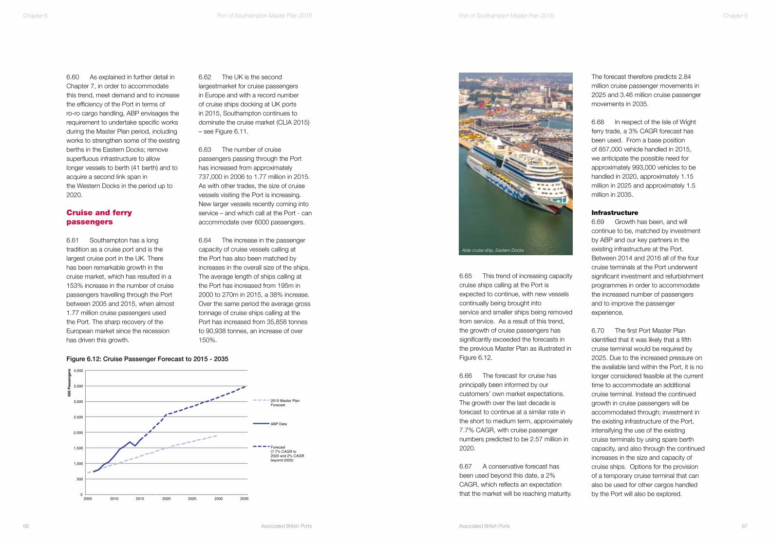
Associated British Ports66
Port of Southampton Master Plan 2016
Associated British Ports 67
Port of Southampton Master Plan 2016 Chapter 6Chapter 6
The forecast therefore predicts 2.84 million cruise passenger movements in 2025 and 3.46 million cruise passenger movements in 2035.
6.68 In respect of the Isle of Wight ferry trade, a 3% CAGR forecast has been used. From a base positionof 857,000 vehicle handled in 2015, we anticipate the possible need for approximately 993,000 vehicles to be handled in 2020, approximately 1.15million in 2025 and approximately 1.5million in 2035.
Infrastructure6.69 Growth has been, and will continue to be, matched by investmentby ABP and our key partners in the existing infrastructure at the Port. Between 2014 and 2016 all of the four cruise terminals at the Port underwent significant investment and refurbishment programmes in order to accommodate the increased number of passengers and to improve the passenger experience.
6.70 The first Port Master Plan identified that it was likely that a fifth cruise terminal would be required by 2025. Due to the increased pressure on the available land within the Port, it is no longer considered feasible at the current time to accommodate an additional cruise terminal. Instead the continued growth in cruise passengers will be accommodated through; investment in the existing infrastructure of the Port, intensifying the use of the existingcruise terminals by using spare berth capacity, and also through the continued increases in the size and capacity of cruise ships. Options for the provision of a temporary cruise terminal that can also be used for other cargos handled by the Port will also be explored.
6.65 This trend of increasing capacity cruise ships calling at the Port is expected to continue, with new vessels continually being brought intoservice and smaller ships being removed from service. As a result of this trend, the growth of cruise passengers has significantly exceeded the forecasts in the previous Master Plan as illustrated in Figure 6.12.
6.66 The forecast for cruise has principally been informed by our customers’ own market expectations. The growth over the last decade is forecast to continue at a similar rate in the short to medium term, approximately 7.7% CAGR, with cruise passenger numbers predicted to be 2.57 million in 2020.
6.67 A conservative forecast has been used beyond this date, a 2% CAGR, which reflects an expectation that the market will be reaching maturity.
6.62 The UK is the second largestmarket for cruise passengers in Europe and with a record number of cruise ships docking at UK ports in 2015, Southampton continues to dominate the cruise market (CLIA 2015) – see Figure 6.11.
6.63 The number of cruise passengers passing through the Port has increased from approximately 737,000 in 2006 to 1.77 million in 2015. As with other trades, the size of cruise vessels visiting the Port is increasing. New larger vessels recently coming into service – and which call at the Port - can accommodate over 6000 passengers.
6.64 The increase in the passenger capacity of cruise vessels calling at the Port has also been matched by increases in the overall size of the ships. The average length of ships calling at the Port has increased from 195m in 2000 to 270m in 2015, a 38% increase. Over the same period the average gross tonnage of cruise ships calling at the Port has increased from 35,858 tonnes to 90,938 tonnes, an increase of over 150%.
6.60 As explained in further detail in Chapter 7, in order to accommodate this trend, meet demand and to increase the efficiency of the Port in terms ofro-ro cargo handling, ABP envisages the requirement to undertake specific works during the Master Plan period, including works to strengthen some of the existing berths in the Eastern Docks; remove superfluous infrastructure to allow longer vessels to berth (41 berth) and to acquire a second link span inthe Western Docks in the period up to 2020.
Cruise and ferry passengers
6.61 Southampton has a long tradition as a cruise port and is thelargest cruise port in the UK. There has been remarkable growth in the cruise market, which has resulted in a 153% increase in the number of cruise passengers travelling through the Port between 2005 and 2015, when almost1.77 million cruise passengers used the Port. The sharp recovery of the European market since the recession has driven this growth.
0
500
1,000
1,500
2,000
2,500
3,000
3,500
4,000
2005 2010 2015 2020 2025 2030 2035
000
Pas
sen
ger
s
2010 Master Plan Forecast
ABP Data
Forecast (7.7% CAGR to 2020 and 2% CAGR beyond 2020)
Figure 6.12: Cruise Passenger Forecast to 2015 - 2035
Aida cruise ship, Eastern Docks

Associated British Ports68
Port of Southampton Master Plan 2016
Associated British Ports 69
Port of Southampton Master Plan 2016 Chapter 6
is proposing to redevelop the existing Royal Pier area into a mixed used site comprising housing, offices, retail, hotels, parking and public access and a long term home for the Southampton Boat Show. As a consequence of the scheme, the Red Funnel Isle of Wight Ferry Terminal would have to be relocated from its current location at Town Quay to a new purpose built facility, located within the Eastern Docks. This purpose built facility is considered able to provide a sufficient base from which the future predicted growth in trade could be handled. This facility also incorporates a multi deck car park facility to offset the loss of cargo storage area to this proposal.
Dry Bulks
6.74 The existing approximate 24 acre (9.7 hectare) dry bulks terminal at the Port is located alongside deep water in the Western Docks. Dry bulk cargoes handled by the Port include a wide range of commodities including grain, fertiliser, animal feed, biomass, minerals, renewables and recyclables. Grain – handled in the Eastern Docks - is the largest element, accounting for approximately 40% of the dry bulks trade. Products such as grain, fertiliser and animal feed are typically weather reliant and are subject to unpredictability and variability.
6.75 In 2014, UK ports handled around 121 million tonnes of dry bulk products, representing almost 25% of the total of the UK’s total port tonnage and predominately serving the needs of the country’s energy sector. The growth in dry bulks is often generated by the needs of industry within the locality of the port in question, and all ports generally play a vital role in serving this need.
Furthermore, the Port will continue to seek to control the timing of the arrival and departure of cruise ships due to these issues.
6.71 The forecast increase in cruise passengers numbers is likely to increase the pressure on land available for associated car parking, both within and outside the Port. It is, therefore, anticipated that multi deck car parking facilities that can be utilised by cruise passengers may be required in the Master Plan period.
6.72 The increasing size of cruise vessels being handled by the Port is generating operational issues. For example, an increasing amount of space around the Terminal is needed to accommodate the over hang and to service these larger ships, which puts further pressure on the finite amount of land available. These are issues which we will have to actively manage going forward and seek to address during the lifetime of this Master Plan.
6.73 Within the period to 2020, Royal Pier Waterfront (Southampton) Limited
Chapter 6
tonnes by 2020, 2.1 million tonnes by 2025 and 2.7 million tonnes by 2035 with appropriate land availability and investment.
Infrastructure6.80 Depending on the precise nature of additional cargo, additional handling and storage facilities will be required during the Master Plan period. An area around the King George V Dock has – as already highlighted - been lost to container handling operations andthis will impact on the Port’s ability to handle dry bulk cargoes.
6.81 In order to accommodate the predicted increase in volumes, it is proposed to developed a new bulkstorage facility, weighbridge facilities and replace the life expired craneage with modern harbour mobile cranes. The creation of a more modern facility will enable the use of larger more efficient plant.
General Cargo
6.82 General cargo in the Port is mainly fresh produce from the Canary Islands, Southampton being thesole UK import facility for this traffic. Southampton has extensive specialist facilities for this trade. The Fruit Terminal provides 14,500m3 of cool and cold storage divided into three separate chambers capable of handling a variety of temperature products and has deep- water berths capable of accommodating two ships simultaneously – when not occupied by vessels serving other trades.
6.83 Each year the Port handles approximately 100,000 pallets of fresh produce from the Canary Islands, consisting predominantly of tomatoes
6.76 The national forecasts for ‘other dry bulks’ show a fairly flat market for UK ports, with the market climbingfrom 40 million tonnes in 2005 to 42 million tonnes by 2030, demonstrating a growth rate of just 0.2% per annum. This overall trend is underlined by decline in some markets and growth in others.
6.77 In the order of 1.38m tonnes of dry bulk cargoes were handled through the Port in 2015. Looked at historically,the amount of dry bulk cargo handled has been fairly static. This trend is generally a result of the fact that over recent years dry bulk cargoes have been constrained by an inability to compete with other trades for the finite area of storage land available at the Port.
6.78 One area of growth, however, is the export of scrap metal by S J Norton and Co Ltd, one of the Country’s leading scrap exporters, making a long term commitment to the Port. In addition,in recent years, more than 250,000 tonnes of road salt has been imported through the Port to supplement the supply from UK salt mines. There has also been significant recent investment in equipment and facilities for handling dry bulk cargoes, which has mainly been brought about by the continuing increases in scrap metal exports.
6.79 Against this background, and having regard to the aspirations of the dry bulk operators at the Port,and accepting and understanding that there will be variability in trade from year to year, our forecasts predict average demand growth of 6% CAGR to 2020 and a conservative estimate of 2.5% CAGR beyond 2020. It is, therefore, anticipated that the Port could handle approximately 1.9 million
Inaugural visit of new container ship at container terminal

Associated British Ports70
Port of Southampton Master Plan 2016
Associated British Ports 71
Port of Southampton Master Plan 2016 Chapter 6Chapter 6
off the coast of Hastings and the second is to the west of the Isle of Wight.
6.94 The Department for Energy and Climate Change (DECC) recognises that ports are a key component of the offshore wind industry and the UK’s push towards a low carbon economy. It has identified them as future bases forthe construction, manufacture, operation and servicing of the turbine technology. The report also identifies the Port of Southampton as being ideally situated for the planned offshore wind projects, acknowledging the already considerable experience that we have working with the wind industry at our ports.
6.95 Establishing a strong and reliable supply chain is crucial to the success of the industry andSouthampton could form part of such a chain. Development sites could be made available within the Port’s strategic land reserve for pre-assembly,
location for a deep sea aggregates hub facility. Throughout the lifetime of the Master Plan, we will, therefore, continue to investigate – along with key stakeholders such as the Crown Estate and the aggregate industry - the possibility of providing a deep- water aggregate hub facility within the Southampton area. In this respect, we are aware of the fact that our strategic land reserve on the western shore of the River Test / Southampton Water is safeguarded in the Minerals and Waste Local Plan so that consideration can be given to its use as an aggregate / waste wharf site if it becomes available in the future.
6.91 If such a facility were developed in the Southampton Water area which simply consolidated existing trade in this area, then throughput in the region of 750,000 to 800,000 tonnes would be likely. A more extensive South Coast Hub facility would, however, we believe likely have a throughput of 2.5 to 3 million tonnes.
Offshore Energy Generation6.92 Offshore energy generation – including wind and tidal generation – is considered likely to play a crucial role in meeting the UK’s future energy targets. The British Wind Energy Association, for example, believes that the UK has potentially the largest offshore wind resource in the world, due to favourablefactors of relatively shallow waters and a strong wind resource.
6.93 The Crown Estate has signed agreements with wind energy companies to develop a number ofoffshore projects around the UK coast. All the projects will require significant land-based infrastructure. Two zones are proposed off the south coast. The first is
6.88 These wharves, however, are also recognised as having important waterside regeneration opportunities for the City of Southampton. Southampton City Council recognise that they could be redeveloped to create a new waterfront quarter for the city, linkedto St Marys Football Stadium and the Ocean Village area. It is also recognised that in the future, these wharves mayno longer be able to meet the needs of the aggregate industry, as it moves to the use of larger vessels. In recognition of this, the Minerals and Waste Plan- whilst safeguarding the facilities – provides some flexibility within the relevant policies to enable regeneration to occur when and if appropriate.
6.89 We are also aware that the Crown Estate are undertaking analysis of a marine aggregate ‘hub wharf’ concept for the south east of England (Crown Estate, 2015). We understand that this concept is being investigated for a number of reasons, including:
i) to give licence holders more efficient options for bringing marine aggregate onshore;ii) to reflect the shift in the focus of aggregate businesses from national aggregates production to one of global cement production;iii) to provide for the needs of the future dredging fleet – which is getting larger – with the obvious implications for existing constrained facilities; andiv) to provide efficient and sustainable rail / barge / short sea supply and distribution routes.
6.90 Southampton has long been recognised – due mainly to its marine access advantages and its landside transport connections – as a potential
destined for supermarket shelves around the UK. Smaller volumes of peppers, avocados and cucumbers are also handled during the season, which lasts from October to May.
6.84 The Port expects to retain this trade and is working hard to capitalise on its excellent facilities to increase the volume of fresh produce business further. This will lead to increased utilisation of existing assets and it may be necessary to expand these facilities in line with growth in trade.
6.85 Our forecasts, based upon an 11% CAGR to 2020 and a 3% CAGR thereafter, result in a significant increase in the general cargo trade from 54,000 tonnes in 2015 to over 140,000 tonnes in 2035.
Infrastructure6.86 It is expected that the growth in general cargo will continue over the Master Plan period. To supportpredicted demand, upgrades to the Fruit Terminal, associated berth and crane facilities will be undertaken in 2016 / 2017 to enable an intensification of activity through the existing facilities.
Potential New Trades
Aggregate6.87 Along the River Itchen, but outside the ABP Port of Southampton, are a number of wharf facilities which make a significant contribution to the supply of minerals for development in South Hampshire and beyond. The Hampshire Minerals and Waste Local Plan – which has formed part of the statutory development plan for the area since its adoption in 2013 – generally safeguards these wharves for mineral use.
OffshorewindisakeyplayerintheUK’senergystrategy

Associated British Ports72
Port of Southampton Master Plan 2016
Associated British Ports
Foreword
73
Port of Southampton Master Plan 2016 Chapter 6
growth area as it provides a competitive advantage to ports and their operations.There is, however, recognised to be a current lack of port centric logistic centres around southern UK ports.The Marine and Maritime Forum make it clear that this issue needs to be addressed if the Solent’s ports are to continue to compete with other ports in Europe – something which Government policy encourages.
6.101 Going forward over the lifetime of this Master Plan, we will seek, where practicable and viable, opportunities whereby they can assist in the provision of port centric logistic facilities to serve the Port of Southampton. In terms of our landholdings, such opportunities are likely only going to arise in respectof land within the Marchwood and Cracknore Industrial Parks, or potentially as part of wider port development proposals promoted on the strategic land reserve.
manufacturing and construction of wind turbines. The Secretary of State’s recent decision to refuse the offshore wind farm, known as Navitus Bay,has, it is recognised, likely reduced opportunities for Southampton to play a full role in this sector.
6.96 The opportunities for development and expansion of current related trades at the Port of Southampton are probably modest and likely to involve the requirement for additional storage capacity to accommodate turbine blades.
6.97 Throughout the lifetime of the Master Plan, we will, however, continue to investigate opportunities– along with key stakeholders - of supporting the offshore energy sector through the development of facilities at the Port of Southampton.
Port Centric Logistics
6.98 Port centric logistics is a concept that has developed over recent years whereby logistic operations required in connection with goods and cargo handled at a port are undertaken at, or very close to, the port rather than at some inland location.
6.99 The opportunity to take advantage of the rapid global growth in port centric logistics is specifically identified by the Solent Marine and Maritime Forum (a forum created by the Minister for Business following the cessation of ship building in the Portsmouth Dockyard) in its Transforming Solent: Marine & Maritime Supplement (March 2014).
6.100 Within the Supplement, port centric logistics is recognised as a
Aida Cruise Ship alongside at QEII Cruise Terminal, Eastern Docks. The Cruise Terminal has been upgraded in 2016 to accommodate increased numbers of passengers

Associated British Ports
Foreword
75
Port of Southampton Master Plan 2016
Associated British Ports74
Port of Southampton Master Plan 2016 Chapter 7
7.1 The history of the Port of Southampton is one of continual redevelopment of land coupled with intensification in the use of land in response to changing customer requirements and the growth in trade. The previous Master Plan 2009-2030 identified the following objectives in land use:
1) Removal of non-port related land uses;2) Land increasingly being allocated to the Port’s key trades;3) Intensification of land use, and 4) Increasing specialisation in port related land use.
7.2 These objectives have continued to be implemented over the last five years or so. All non-port related land uses that can be removed have been; containers, cars and cruise activities continue to occupy a greater proportion of the Port estate; and land use has continued to intensify and become more specialised through, for example, the expansion of the container terminal and the development of additional multi-deck car storage facilities.
Future development of the Port
This chapter of the Master Plan seeks to set out the likely future development of the Port by 2020, 2025 and 2035.
Cha
pter
7
Strategic land reserve at Dibden Bay

Associated British Ports76
Port of Southampton Master Plan 2016
Associated British Ports 77
Port of Southampton Master Plan 2016 Chapter 7Chapter 7
7.13 In respect of car storage facilities, we envisage developing up to four further multi-deck car storage facilities in the period up to 2020. Plans for one of these – a further facility within the Eastern Docks – are advanced, and is proposed to be located on land currently already used for automotive storage (see Figure 7.2).
7.14 Up to a further three multi-deck facilities are proposed to be located within the Western Docks representing a further £50 million in the support of UK manufacturers.
7.15 The location of these potential facilities has not yet been formally determined – and it is not yet clear how straightforward it will be to accommodate them - but they are likely to be located within open areas currently used for automotive storage purposes.
With this extension, the capacity of the terminal is considered to be increased to something in the order of 2.4 to 2.5 million TEU.
7.9 It is, therefore, considered that the current container terminal – with the recent storage yard extension - will theoretically be able to handle the increased level of trade forecast to be reached somepoint before 2025. However, determining the realistic capacity of a container terminal is not an exact science and is not just the outcome of a mathematical calculation. For example, the conclusion that there will be sufficient capacity assumes that the terminal will remain able to accommodate the planned growth in container vessel size in terms of marine and berth accessibility.
7.10 Against this background, and recognising – as highlighted in NPSfP– that ports need to operate efficiently and not at full physical capacity – we consider that during the period 2015 to 2020 we will need to liaise with the operators, DPWS, as to how the container trade can be handled at Southampton in the future Automotive7.11 In order to be able to accommodate the number of motor vehicles forecast to be imported / exported through the port by 2020, both berth improvements and storage area improvements will be required.
7.12 We envisage the requirement to undertake relatively minor works to strengthen some of the existing berths in the Eastern Docks, remove superfluous infrastructure to allow longer vessels to berth (41 berth) and to install a second link span in the Western Docks in the period up to 2020.
gateway port over the timescale of the Master Plan the Port will need to expand.
The position in 2020
The existing Port Estate
Containers7.7 The capacity of a container terminal is a measure of the number of containers that can be moved through it on an annual basis, and is generally determined by the lower of either the berth capacity or the storage yard capacity.
7.8 The capacity of the container terminal was looked at in detail within the documentation supporting the consent applications for the recent SCT5 works. The conclusions reached in that work was that the terminal, at that time, had an overall capacity with SCT5 of something in the region of 2.3 million TEU. Since that time, however, the storage area of the container terminal has been extended by a further 4.5ha (11 acres) into an area previously used for bulks and general cargo storage - with an obvious corresponding loss of storage area for those affected trades (see Figure 7.9).
7.3 We will continue to implement these objectives as far as we are able in order to ensure that we maintain our position as a leading international gateway port.
7.4 This chapter of the Master Plan seeks to set out the likely future development of the Port by 2020, 2025 and 2035 having regard to the forecasts detailed in Chapter 6 and summarised, for ease of reference in Table 7.1.
7.5 Provided at the end of this Chapter are a series of aerial photographs of the main operational areas of the Port taken on Saturday 18th June 2016 (Figures 7.1 to 7.11). As well as showing these areas as they exist today, the commentary attached to the photographs shows how and where our land use objectives have been implemented since circa 2000, and highlights where we envisage likely future developments referred to in this Chapter.
7.6 As this Master Plan demonstrates, the Port is effectively nearing capacity. An outcome of this is that trade is being turned away - with consequential negative implications. To continue to be a first rate international
Base Figures (2015)
2020 2025 2035
Cruise Passengers (000’s) 1,776 2,573 2,841 3,464Containers – Low Growth (000 TEU) 1,895 2,144 2,426 3,105Containers – High Growth (000 TEU) 1,895 2,251 2,673 3,771Motor Vehicles (000 units) 919 1,193 1,383 1,858Dry Bulks (000 tonnes) 1,379 1,845 2,088 2,673General Cargo (000 tonnes) 54 92 105 142IoW Ferry (000 vehicles) 857 993 1,151 1,548
Table 7.1: Forecasts to 2020, 2025 and 2030
Vehicles are stored in the Port’s multi-decks making best use of port land

Associated British Ports78
Port of Southampton Master Plan 2016
Associated British Ports 79
Port of Southampton Master Plan 2016 Chapter 7Chapter 7
and research into whether an increased amount of dry bulks can be handled elsewhere – for example, through the recently acquired Marchwood Industrial Park, which already has a dry bulk wharf, storage and handling area. 7.27 In addition, as has already been indicated, we are aware of the potential going forward for the development of a new deep-water minerals and waste hub facility somewhere within the Southampton Water area.
General Cargo7.28 Growth is expected in the general cargo sector in the period up to 2020. To grow the level of trade, we plan to upgrade and improve facilities at the existing Fruit Terminal in partnership with Solent Stevedores Limited.
Marchwood Industrial Park and Cracknore Industrial Park
7.29 ABP’s landholdings at the Marchwood Industrial Park and the Cracknore Industrial Park are located within areas which New Forest District Council – as made clear within their adopted Local Plan – consider have the potential for further development during the Local Plan period (up to 2026). The relevant site specific local plan policies which cover these sites reflect this by making clear that the development, redevelopment and intensification of employment uses within the sites will be encouraged, but in doing so having due regard to the fact that the sites are identified as being particularly suitable for marine related businesses.
7.30 Both the Marchwood and Cracknore Industrial Parks are well established existing employment
7.22 As already indicated, during the period to 2020, a new purpose built Red Funnel Isle of Wight ferry terminal is likely to be constructed within the Eastern Docks, subject to necessary consents being obtained in respect of the Royal Pier Waterfront development. This facility will be able to accommodate the predicted growth in ferry passenger numbers. The development of the new ferry terminal does, however, have implications for the Ro-Ro and cruise trade which currently occupy the land in question. We have worked hard with the key stakeholders involved in this project to ensure that necessary facilities – in the form of multi deck storage facilities – are also provided as part of this development.
Dry Bulks7.23 The Dry Bulks trade is expected to increase in the period up to 2020 – to something in the order of 1.9 million tonnes per annum.
7.24 In order to accommodate this growth, we envisage works having to be undertaken at the existing bulks terminal within the Western Docks. These works are likely to consist of the creation of a new bulk storage facility as an addition to the existing terminal area, and a re-configuration of the layout of the existing terminal area.
7.25 Although such works will assist the Port in being able to handle the amount of dry bulk cargo forecast, it is not known whether the forecast level of cargo will be able to be handled. There is pressure from other trades and sectors for the space required. It may not, therefore, be feasible to develop the new facilities outlined above.
7.26 In the period up to 2020 we will, therefore, undertake feasibility studies
Cruise and ferry passengers7.19 In 2020 it is forecast that the Port of Southampton will welcome 2.57 million cruise passenger visits to the Port. This represents a significant increase over the 1.77 million passengers in 2015.
7.20 Our strategy for accommodating the projected increase in the number of cruise passengers comprises:
(i) Intensifying use of existing infrastructure by remodeling existing terminals;(i) Encouraging cruise lines to opt for off peak weekdays; and(ii) Exploring the possibility of the development of a facility in the Western Docks that can be used ‘temporarily’ for cruise handling activities.
7.21 Again, it should be noted that due to the finite amount of land within the current port area, the development of a more permanent ‘temporary’ facility will require space within the Port that is already in current use for some form of other cargo handling operation.
7.16 When this development programme is completed, the Port will be home to nine multi-deck facilities, capable of storing 55,000 vehicles.
7.17 With these facilities in place, we consider that the Port will be able to handle the amount of cars which are forecast to be imported / exported through the Port in 2020.
7.18 It should be noted, however, that the construction of a multi deck facility is a major commitment for the Port, and not only in financial terms. In an ideal scenario, Ports require large flat areas of land behind the quay on which to store cargo, as such areas provide the greatest flexibility for port operations. Construction of a multi deck facility effectively sterilises the area it covers from being used for the storage of any other cargo or trade. It may be concluded that constructing some or all of this number of multi-decks in the Western Docks is not in the best interests of the Port.
Cunard’s “3 Queens” in Southampton as part of Cunard’s 175th birthday celebrations

Associated British Ports80
Port of Southampton Master Plan 2016
Associated British Ports 81
Port of Southampton Master Plan 2016 Chapter 7Chapter 7
feasibility studies and research into how the Port can be expanded and will likely be in the position where we have brought forward, or are in the process of bringing forward proposals that are considered necessary as a result of this work. This is likely to involve the working up of proposals to expand the Port in one form or another onto the strategic land reserve we hold. 7.36 This strategic land reserve comprises over 500 acres of land. A large part of which was reclaimed using arisings from various dredging operations in the Solent area. In addition the strategic reserve includes land to the rear of thie reclaimed area, largely made up of farmland and which could provide road and rail access to the main part of the area and areas for mitigation as appropriate.
7.37 Given the considerable lead-time inherent in preparing necessary applications, securing consent and undertaking construction, it is
combination of the various changes and developments outlined and the ongoing process of intensifying activity, the existing operational port estate will, by 2020, be operating close to its effective capacity. It is considered likely that by 2020, the Port may potentially have already lost opportunities to attract enhanced or new business by virtue of there being no available land or berth space to accommodate the demand. Such opportunities may be lost to either other UK or even European ports.
7.34 As has already been explained in Chapter 6, the Port is already experiencing significant issues in respect of accommodating all of the demand which the various trades are placing upon it – see for example paragraph 6.53 to 6.60 in respect of the Ro-Ro trade. Whilst proposed developments in the period up to 2020 may well ease this situation, by 2020 it is envisaged that these issues will be again be of significance. 7.35 Therefore, by 2020 we consider that we will have undertaken necessary
redevelop and intensify the employment use within these sites, we will continue to have regard to the needs of such uses.
7.32 In looking for opportunities to develop, redevelop and intensify employment use within these sites, we will also have regard to the work undertaken by the Marine and Maritime Forum in respect of the competitive benefits associated with the development of Port Centric logistics. Opportunities to develop a marine cluster within the Parks will be considered in this respect.
Strategic land reserve
7.33 As explained in the NPSfP, in the context of the Government’s explanation that ports need to be competitive, ports need to operate at efficient levels, which is not the same as operating at full physical capacity (NPSfP paragraph 3.4.13). As made clear in the preceding text, it is considered that even with a
sites, which contain a large number of existing businesses and employment uses, many of which are on long term leases. During the period to 2020, ABP’s intention is to seek to develop, redevelop and intensify the use of the two parks – as encouraged by local policy - as relevant opportunities present themselves. In doing so, we will have due regard to the fact that the sites are identified as being particularly suitable for marine related businesses.
7.31 One of the outcomes of the continuation of the land use strategy within the Port outlined in paragraph 7.1 (which results directly from a combination of continuing growth in port trade and a finite area of port land) is that vital supporting port trade and port related employment uses are being moved out of the existing Port estate. Increasingly, such uses are finding it difficult to find locations within the locality to relocate. Some of these uses have relocated to the Marchwood and Cracknore Park sites, and in looking for opportunities going forward to develop,
Aerial photography by Roger D Smith ABIPP Gosport
Aerial photography by Roger D Smith ABIPP Gosport
Marchwood and Cracknore Industrial Parks
The Port’s strategic land reserve at Dibden Bay

Associated British Ports82
Port of Southampton Master Plan 2016
Associated British Ports 83
Port of Southampton Master Plan 2016 Chapter 7Chapter 7
position will be fundamentally different to the position in 2020. Our position is that in order to accommodate the growth in trade predicted, it will be necessary for the Port to be able to provide further capacity in the period up to 2025 or soon after.
Marchwood Industrial Park and Cracknore Industrial Park
7.43 In the period up to 2025, we consider that there will have been a continuation of the strategy put in place up to 2020, that strategy being one which seeks to intensify and enhance development – including, where possible, port related development - at the Marchwood and Cracknore Industrial Estates.
Strategic land reserve
7.44 As indicated in the preceeding paragraphs, we consider that in order to accommodate the predicted growth in trade predicted, it will be necessary for the Port to be able to expand in the period up to 2025 or soon after that time.
7.45 It is not currently possible to define what form any such expansion will take, or what particular trade or cargoes the expansion will seek to specifically address. As highlighted in the preceeding section, during the period up to 2020 we will undertake detailed considerations and feasibility work, and work with key stakeholders, to draw up, amongst other things, what form any future expansion of the Port should take.
7.46 What is clear from the preceeding forecasts and analysis is that the existing port estate consists of both a finite area of land and available
(ii) Marine (quay) infrastructure works for the benefit of the Automotive / Ro- Ro car trade and Container trade;(iii) Additional link span for Ro-Ro trade;(iv) Expansion of the bulks terminal with additional covered storage and the development of dedicated weighbridge and lorry queuing area; (v) Refurbishment works at the Fruit Terminal; and(vi) Improvements to rail infrastructure at the berth 109 rail terminal in support of the Bulks, Container and Automotive trades.
7.41 In addition to the above, by 2020 we envisage that we will have taken up opportunities to develop, redevelop and intensify employment uses at the Marchwood and Cracknore Industrial Parks. We also expect to have undertaken necessary feasibility studies and research into how the Port can be expanded and will likely be in the position where we have broughtforward, or are in the process of bringing forward proposals that are considered necessary as a result of this work. This is likely to involve a feasibility assessment of how we may seek to expand onto the strategic land reserve that was created and has been subsequently held for port expansion.
The position in 2025
The existing Port Estate 7.42 By 2025, the forecasts predict ongoing demand and growth in the key trades which are handled at the Port of Southampton. In respect of the existing Port Estate, although there are likely to be – currently unknown - short term capacity enhancements coming forward during the period 2020 to 2025, we consider that it is highly unlikely that the
considered likely that it will be necessary to commence the process of seeking approvals to develop the strategic land reserve some time before 2020. It is thought prudent to adopt a lead in time of 9 - 10 years prior to the requirement for port uses being undertaken on the land reserve. 7.38 The need for the Port of Southampton to expand onto its strategic land reserve therefore occurs during the lifetime of this Master Plan. Such expansion will be needed in order that the Port maintains and enhances its role as an international deep-sea gateway.
7.37 Any future proposal to develop the strategic land reserve for port use will need to include the following requirements:
• follow the applicable consent procedures;• undertake an environmental impact assessment;• assess the implications of the proposals in accordance with the Habitats Regulations; and• design a new road and rail access to the site.
Summary of the position in 2020
7.40 In comparison to the current position, the following developments and changes – which are shown as appropriate on Figures 7.1 to 7.11 - are proposed:
(i) Construction of additional multi- deck facilities in the Eastern Docks and Western Docks for the storage of import and export trade cars and for the parking of vehicles belonging to cruise passengers;
Associated British Ports84
Port of Southampton Master Plan 2016
Associated British Ports 85
Port of Southampton Master Plan 2016 Chapter 7
strategy put in place, that strategy being one which seeks to intensify and enhance development – including, where possible, port and port related development - at the Marchwood and Cracknore Industrial Estates.
Strategic land reserve
7.53 By 2035, we envisage that port and port related facilities will have been developed on the strategic land reserve and will be in operation
Summary of the Port in 2035
7.54 The position in 2035 is, therefore, in summary predicted to be one where:
(i) the existing port estate is fundamentally as it is envisaged in 2025, albeit with a small number of – currently unknown – short term capacity enhancements;(ii) there is a continuation of the strategy that seeks to intensify and enhance development – including, where possible, port and port related development - at the Marchwood and Cracknore Industrial Estates; and(iii) port and port related facilities will be operational on the strategic land reserve which we hold.
The Position in 2035
The existing Port Estate
7.51 By 2035, the forecasts predict ongoing demand and growth in the key trades which are handled at the Port of Southampton. In respect of the existing Port Estate, although there maybe– currently unknown - short term capacity enhancements coming forward during the period to 2035, we do not consider that the existing Port estate will be fundamentally different to the position as at 2025.
Marchwood Industrial Park and Cracknore Industrial Park
7.52 In the period up to 2035, we consider that there will have been a further continuation of the earlier
Chapter 7
Summary of the position in 2025
7.50 The position in 2025 is, therefore, in summary predicted to be one where:
(i) the existing port estate is fundamentally as it is envisaged in 2020, perhaps with a small number of – currently unknown – short term capacity enhancements;(ii) there is a continuation of the strategy that seeks to intensify and enhance development – including, where possible, port and port related development - at the Marchwood and Cracknore Industrial Estates;(iii) consents are either in place and construction underway, or consents are still in the process of being obtained, for the expansion of the Port of Southampton onto the strategic land reserve.
berth infrastructure, which is coming under increasing pressure in terms of its utilisation from a number of different but individually significant trades. In such circumstances, there reaches a point where something has to give. Either the growth in trade is not accommodated at Southampton, or the Port has to expand to accommodate the growth in trade.
7.47 Proceeding on the basis of not accommodating the growth in trade at Southampton would, to use the words of national port policy be a choice that accepts a limit on economic growth and the price, choice and availability of goods imported into the UK and available to consumers. It would also limit the local and regional economic benefits that new developments might bring. Again, to quote national policy, such an outcome would be strongly against the public interest.
7.48 Our view is, therefore, that the Port will need to expand so that it can accommodate the forecast growth in trade. It is also our view – and one which has been accepted by key stakeholders such as relevant local authorities – that the only area of land capable of accommodating physical expansion of the Port of Southampton is the strategic land reserve that we hold.
7.49 By 2025, therefore, we consider that we will need to be in a position of either having secured the necessary consents or be in a position where they are still being obtained to expand the Port of Southampton onto its strategic land reserve in order to secure the long term future of the Port.

Associated British Ports86
Port of Southampton Master Plan 2016
Associated British Ports 87
Port of Southampton Master Plan 2016 Chapter 7
Figures 7.2 - 7.11 illustrate the main operational areas of the Port
Photos were taken on the 18th June 2016 by Roger D Smith ABIPP, Gosport.
Chapter 7
- New VTS Radar mast
- Multi-deck Automotive/Ro-Ro storage facilities. - Developed since 2000
- Automotive/ Ro-Ro storage and loading/unloading area
- Automotive/Ro-Ro storage area - site for a further multi-deck facility
- High and Heavy Ro-Ro storage area
- Grain Terminal and surrounding operational area
- VTS building - shortly to be removed
- QEII Cruise Terminal - Refurbished in 2016
- Ro-Ro vessel on long term hire to provide additional Automotive/Ro-Ro storage space due to lack of space on land
(Note: Boundaries are indicative for illustrative purposes.)
- Removal of ‘knuckle’ at 41 berth
Figu
re 7
.3
Figure 7.2: Eastern Docks (South)
Figure 7.2
Figure 7.3
Figure 7.4
Figure 7.5
Figure 7.6Figure 7.7
Figure 7.8
Figure 7.9
Figure 7.10
Figure 7.11
NorthNorth
Figure 7.2
Figure 7.3
Figure 7.4
Figure 7.5
Figure 7.6Figure 7.7
Figure 7.8
Figure 7.9
Figure 7.10
Figure 7.11
Figure 7.1: Key plan
7.2
7.37.4
7.57.6
7.7
7.8
7.97.10
7.11
7.2
7.37.4
7.57.6
7.7
7.8
7.97.10
7.11
7.2
7.37.4
7.57.6
7.7
7.8
7.97.10
7.11
7.2
7.37.4
7.57.6
7.7
7.8
7.97.10
7.11
7.2
7.37.4
7.57.6
7.7
7.8
7.97.10
7.11
7.2
7.37.4
7.57.6
7.7
7.8
7.97.10
7.11
7.2
7.37.4
7.57.6
7.7
7.8
7.97.10
7.11
7.2
7.37.4
7.57.6
7.7
7.8
7.97.10
7.11
7.2
7.37.4
7.57.6
7.7
7.8
7.97.10
7.11
7.2
7.37.4
7.57.6
7.7
7.8
7.97.10
7.11
© Google 2016

Associated British Ports88
Port of Southampton Master Plan 2016
Associated British Ports 89
Port of Southampton Master Plan 2016 Chapter 7Chapter 7
Figure 7.3
- Eastern Docks Rail Terminal
- Automotive / Ro-Ro high and heavy storage area
- Automotive / Ro-Ro storage area
- Port support and related activities
- Channel Islands Freight Ferry Terminal- Developed since 2000
- Multi-deck Automotive/Ro-Ro storage facility and surrounding storage land- Developed since 2000
- National Environment Research Centre and Southampton University Oceanography Centre
- Automotive/Ro-Ro storage and loading/unloading area
- Multi-deck Automotive/Ro-Ro storage facility and associated working area - Developed since 2000
(Note: Boundaries are indicative for illustrative purposes.)
Figu
re 7
.2
Figure 7.3: Eastern Docks (Central)
- Quayside working, loading/unloading area
Figure 7.4
- Red Funnel Isle of Wight ferry passenger car park
- Automotive/Ro-Ro storage and Cruise parking including site of potential new multi-deck storage facility for Red Funnel development
- Infilled former Dry Dock- Now used for Cruise parking and Automotive/Ro-Ro storage
- Dock Gate 5 (port exit only)
- Dock Gate 4 (port entrance only)
- Proposed site of the new Red Funnel ferry Isle of Wight Terminal
- Ocean Cruise Terminal and associated operational areas - constructed since 2000
- Ocean Gate - main port office building - extend-ed 2015/16
- New internal port road system developed in 2012/13
- Platform Road - recently improved by Southampton City Council
(Note: Boundaries are indicative for illustrative purposes.)
Figu
re 7
.3
Figure 7.4: Eastern Docks (North)
7.2
7.37.4
7.57.6
7.7
7.8
7.97.10
7.11
7.2
7.37.4
7.57.6
7.7
7.8
7.97.10
7.11
7.2
7.37.4
7.57.6
7.7
7.8
7.97.10
7.11
7.2
7.37.4
7.57.6
7.7
7.8
7.97.10
7.11
7.2
7.37.4
7.57.6
7.7
7.8
7.97.10
7.11
7.2
7.37.4
7.57.6
7.7
7.8
7.97.10
7.11
7.2
7.37.4
7.57.6
7.7
7.8
7.97.10
7.11
7.2
7.37.4
7.57.6
7.7
7.8
7.97.10
7.11
7.2
7.37.4
7.57.6
7.7
7.8
7.97.10
7.11
7.2
7.37.4
7.57.6
7.7
7.8
7.97.10
7.11
7.2
7.37.4
7.57.6
7.7
7.8
7.97.10
7.11
7.2
7.37.4
7.57.6
7.7
7.8
7.97.10
7.11
7.2
7.37.4
7.57.6
7.7
7.8
7.97.10
7.11
7.2
7.37.4
7.57.6
7.7
7.8
7.97.10
7.11
7.2
7.37.4
7.57.6
7.7
7.8
7.97.10
7.11
7.2
7.37.4
7.57.6
7.7
7.8
7.97.10
7.11
7.2
7.37.4
7.57.6
7.7
7.8
7.97.10
7.11
7.2
7.37.4
7.57.6
7.7
7.8
7.97.10
7.11
7.2
7.37.4
7.57.6
7.7
7.8
7.97.10
7.11
7.2
7.37.4
7.57.6
7.7
7.8
7.97.10
7.11

Associated British Ports90
Port of Southampton Master Plan 2016
Associated British Ports 91
Port of Southampton Master Plan 2016 Chapter 7Chapter 7
- Dock Gate 8
- Site of former Distribution and Bonded warehouse now used in connection with container trade
- Former Montagu Meyer timber site recently vacated - buildings to be removed and site to be used for Automotive/Ro-Ro cargo storage
- Former Post Office sorting office and car auction site - now used for container related activities
- Automotive/Ro-Ro cargo storage and Cruise Parking area
- Fruit Terminal - currently being reconfigured internally
- Former Fruit Terminal lorry park - now used for Automotive/Ro-Ro and Cruise purposes
- Temporary Cruise Terminal and associated activity
- Former empty container storage area which has been concentrated elsewhere - currently used for Automotive/Ro-Ro storage and cruise parking purposes
- Former Windward Banana Terminal converted to become the City Cruise Terminal since 2000
- Site of former offices and warehouse now cleared and used for Automotive/Ro-Ro cargo and Cruise purposes
- Rank HovisFlour Mill
- Dock Gate 10
(Note: Boundaries are indicative for illustrative purposes.)
Fig
ure
7.6
Figure 7.5: Western Docks (South)
Eas
tern
Do
cks
- Automo-tive/Ro-Ro cargo storage
- Port maintenance, management and operations compound
- Automotive/Ro-Ro storage and Cruise parking
- Former container haulage operations now moved off port - Currently used for Automotive/Ro-Ro/Cruise purposes
- Sulphur processing facility
- Former Martini - Bacardi production and distribution site - Now used by the Automotive/ Ro-Ro and cruise trades
- Former site of Stevedore maintenance and office facilities - Now used for Automotive/Ro-Roand cruise activity
- Storage shed - Currently utilised by the bulks trade
- Linkspan used to load/unload Automotive and Ro-Ro cargo
- General area for additional multi-deck storage facility
(Note: Boundaries are indicative for illustrative purposes.)
Figu
re 7
.5
Figure 7.6: Western Docks (Central 1)
Figu
re 7
.7
7.2
7.37.4
7.57.6
7.7
7.8
7.97.10
7.11
7.2
7.37.4
7.57.6
7.7
7.8
7.97.10
7.11
7.2
7.37.4
7.57.6
7.7
7.8
7.97.10
7.11
7.2
7.37.4
7.57.6
7.7
7.8
7.97.10
7.11
7.2
7.37.4
7.57.6
7.7
7.8
7.97.10
7.11
7.2
7.37.4
7.57.6
7.7
7.8
7.97.10
7.11
7.2
7.37.4
7.57.6
7.7
7.8
7.97.10
7.11
7.2
7.37.4
7.57.6
7.7
7.8
7.97.10
7.11
7.2
7.37.4
7.57.6
7.7
7.8
7.97.10
7.11
7.2
7.37.4
7.57.6
7.7
7.8
7.97.10
7.11
7.2
7.37.4
7.57.6
7.7
7.8
7.97.10
7.11
7.2
7.37.4
7.57.6
7.7
7.8
7.97.10
7.11
7.2
7.37.4
7.57.6
7.7
7.8
7.97.10
7.11
7.2
7.37.4
7.57.6
7.7
7.8
7.97.10
7.11
7.2
7.37.4
7.57.6
7.7
7.8
7.97.10
7.11
7.2
7.37.4
7.57.6
7.7
7.8
7.97.10
7.11
7.2
7.37.4
7.57.6
7.7
7.8
7.97.10
7.11
7.2
7.37.4
7.57.6
7.7
7.8
7.97.10
7.11
7.2
7.37.4
7.57.6
7.7
7.8
7.97.10
7.11
7.2
7.37.4
7.57.6
7.7
7.8
7.97.10
7.11

Associated British Ports92
Port of Southampton Master Plan 2016
Associated British Ports 93
Port of Southampton Master Plan 2016 Chapter 7Chapter 7
- Automo-tive/Ro-Ro cargo storage
- Bulks Terminal - Automotive/Ro-Ro cargo storage - Awaiting next consignment at time of the photograph
- Imperial House - Offices for port related businesses
- Automotive/Ro-Ro cargo and/or Cruise Parking and reception
- Mayflower Cruise Terminal - Refurbished in 2015
- Cruise Terminal reception and operational area - also utilised for automotive/Ro-Ro cargo storage.
- General area where the potential for a multi-deck storage facility being investigated
(Note: Boundaries are indicative for illustrative purposes.)
Figu
re 7
.6
Figure 7.7: Western Docks (Central 2)
Figu
re 7
.8
- Former Dry Dock now utilised as berth space for adjacent bulks operations
- Port related marine support facility
- Millbrook Rail Terminal
- Former site of port support activities, now used for automo-tive/Ro-Ro cargo storage
- Site of former car component factory, removed in the 2000’s and now used for Automotive/Ro-Ro cargo storage
- Part of the site of a former cable manufacturing plant that was removed in early 2000’s. Site subsequently used for container related operations. - Currently used for bulks and/or Automotive/Ro-Ro storage.- Potential expansion area for bulks terminal
- Part of the site of a former cable manufacturing plant that was removed in early 2000’s. Site now used for bulks and/or Automo-tive/Ro-Ro storage.
- Storage sheds along the quayside removed during the 2000’s to provide additional open storage area for bulk cargoes
- Bulks Terminal - Rail Terminal - proposed to be extended/improved to support bulk/Ro-Ro operations
(Note: Boundaries are indicative for illustrative purposes.)
Figu
re 7
.7
Figure 7.8: Western Docks (North)
Figu
re 7
.9
7.2
7.37.4
7.57.6
7.7
7.8
7.97.10
7.11
7.2
7.37.4
7.57.6
7.7
7.8
7.97.10
7.11
7.2
7.37.4
7.57.6
7.7
7.8
7.97.10
7.11
7.2
7.37.4
7.57.6
7.7
7.8
7.97.10
7.11
7.2
7.37.4
7.57.6
7.7
7.8
7.97.10
7.11
7.2
7.37.4
7.57.6
7.7
7.8
7.97.10
7.11
7.2
7.37.4
7.57.6
7.7
7.8
7.97.10
7.11
7.2
7.37.4
7.57.6
7.7
7.8
7.97.10
7.11
7.2
7.37.4
7.57.6
7.7
7.8
7.97.10
7.11
7.2
7.37.4
7.57.6
7.7
7.8
7.97.10
7.11
7.2
7.37.4
7.57.6
7.7
7.8
7.97.10
7.11
7.2
7.37.4
7.57.6
7.7
7.8
7.97.10
7.11
7.2
7.37.4
7.57.6
7.7
7.8
7.97.10
7.11
7.2
7.37.4
7.57.6
7.7
7.8
7.97.10
7.11
7.2
7.37.4
7.57.6
7.7
7.8
7.97.10
7.11
7.2
7.37.4
7.57.6
7.7
7.8
7.97.10
7.11
7.2
7.37.4
7.57.6
7.7
7.8
7.97.10
7.11
7.2
7.37.4
7.57.6
7.7
7.8
7.97.10
7.11
7.2
7.37.4
7.57.6
7.7
7.8
7.97.10
7.11
7.2
7.37.4
7.57.6
7.7
7.8
7.97.10
7.11

Associated British Ports94
Port of Southampton Master Plan 2016
Associated British Ports 95
Port of Southampton Master Plan 2016 Chapter 7Chapter 7
SouthamptonContainer Terminal
- Area of land acquired from Southern Water and incorporated into the Container Terminal in early 2000’s
SCT 5-New deep sea container berth, cranes and storage yard behind. -Developed in 2012/13. -Previously used for automotive/Ro-Ro cargo which has now had to be accommodated elsewhere within the Port
Extension to Container storage yard - Currently under construction. - Previously used for bulk cargo storage which has now had to be concentrated on adjacent site
- Former car terminal employee parking. Now used for automotive/Ro-Ro cargo storage
- Southern Water Millbrook Wastewater Treatment Workslocated outside the Port
- New Cranes provided as part of SCTS development
(Note: Boundaries are indicative for illustrative purposes.)
Figu
re 7
.10
Figure 7.9: Container Terminal (South)
Figu
re 7
.8
Main London to Weymouth Railway Line
SouthamptonContainer Terminal- Significant intensification of activity since 2000
Cranes- Subject to ongoing maintenance and renewal programme
Dock Gate 20- Road access into the Container Terminal area
Container TerminalPre - gate area- Developed in the 2000’s to support container terminal operations
Freightliner Terminal- Rail terminal that moves containers to and from the Port- Expanded and renewed since 2000- Direct links onto main line
K B Crushers- Non-port related activity (tenant of Freightliner)
(Note: Boundaries are indicative for illustrative purposes.)
Figu
re 7
.11
Figure 7.10: Container Terminal (Central)
Figu
re 7
.9
7.2
7.37.4
7.57.6
7.7
7.8
7.97.10
7.11
7.2
7.37.4
7.57.6
7.7
7.8
7.97.10
7.11
7.2
7.37.4
7.57.6
7.7
7.8
7.97.10
7.11
7.2
7.37.4
7.57.6
7.7
7.8
7.97.10
7.11
7.2
7.37.4
7.57.6
7.7
7.8
7.97.10
7.11
7.2
7.37.4
7.57.6
7.7
7.8
7.97.10
7.11
7.2
7.37.4
7.57.6
7.7
7.8
7.97.10
7.11
7.2
7.37.4
7.57.6
7.7
7.8
7.97.10
7.11
7.2
7.37.4
7.57.6
7.7
7.8
7.97.10
7.11
7.2
7.37.4
7.57.6
7.7
7.8
7.97.10
7.11
7.2
7.37.4
7.57.6
7.7
7.8
7.97.10
7.11
7.2
7.37.4
7.57.6
7.7
7.8
7.97.10
7.11
7.2
7.37.4
7.57.6
7.7
7.8
7.97.10
7.11
7.2
7.37.4
7.57.6
7.7
7.8
7.97.10
7.11
7.2
7.37.4
7.57.6
7.7
7.8
7.97.10
7.11
7.2
7.37.4
7.57.6
7.7
7.8
7.97.10
7.11
7.2
7.37.4
7.57.6
7.7
7.8
7.97.10
7.11
7.2
7.37.4
7.57.6
7.7
7.8
7.97.10
7.11
7.2
7.37.4
7.57.6
7.7
7.8
7.97.10
7.11
7.2
7.37.4
7.57.6
7.7
7.8
7.97.10
7.11

Associated British Ports96
Port of Southampton Master Plan 2016
Associated British Ports 97
Port of Southampton Master Plan 2016 Chapter 7Chapter 7
Redbridge Car Terminal- Automotive/ Ro-Ro cargo storage area- Located some distance from the quays which handle Automotive/Ro-Ro cargo vessels
Container Terminal Extension- Approximate 3ha extension to the container terminal that was added in the early 2000’s
Import Services Facility- Associated with and supports adjacent container terminal.- Extended in 2014
Storage Area- Automotive/ Ro-Ro cargo storage area.- Previously a container storage and handling operation, activity which has now been concentrated elsewhere in the Port since 2000 to allow for automotive/Ro-Ro cargo storage on this site
Freightliner Terminal- Rail terminal that moves containers to and from the Port- Expanded and renewed since 2000- Direct links onto main line
(Note: Boundaries are indicative for illustrative purposes.)
Figure 7.11: Container Terminal (North)
Fig
ure
7.10
7.2
7.37.4
7.57.6
7.7
7.8
7.97.10
7.11
7.2
7.37.4
7.57.6
7.7
7.8
7.97.10
7.11
7.2
7.37.4
7.57.6
7.7
7.8
7.97.10
7.11
7.2
7.37.4
7.57.6
7.7
7.8
7.97.10
7.11
7.2
7.37.4
7.57.6
7.7
7.8
7.97.10
7.11
7.2
7.37.4
7.57.6
7.7
7.8
7.97.10
7.11
7.2
7.37.4
7.57.6
7.7
7.8
7.97.10
7.11
7.2
7.37.4
7.57.6
7.7
7.8
7.97.10
7.11
7.2
7.37.4
7.57.6
7.7
7.8
7.97.10
7.11
7.2
7.37.4
7.57.6
7.7
7.8
7.97.10
7.11
QueenVictoriaalongsidetheQEIICruiseTerminalwiththeVesselTrafficServicesbuildingintheforeground

Associated British Ports
Foreword
99
Port of Southampton Master Plan 2016
Associated British Ports98
Port of Southampton Master Plan 2016 Chapter 8
Appraisal and assessment of the Port Master Plan Strategy
8.1 The ‘Guidance on the Preparation of Port Master Plans’ (DfT, 2008) indicates at paragraph 109, that it is for each port to determine whether or not, in producing a port master plan, it is affected by the requirements of the Strategic Environmental Assessment Directive (European Directive 2001/42/EC).
8.2 On a strict, legal analysis we consider that Port Master Plans, such as the one being produced for the Port of Southampton, do not fall within the terms of either European Directive 2001/42/EC in respect of Strategic Environmental Assessment (SEA) matters, or the Planning and Compulsory Purchase Act 2009 in respect of Sustainability Appraisal (SA) matters.
8.3 We have decided, nonetheless, to undertake a ‘Shadow’ appraisal and assessment of its Master Plan, which incorporates relevant requirements of both the SA and SEA processes. Having regard to the objectives and aims of the SA and SEA process, we have chosen this route to ensure that the Port of Southampton Master Plan contributes to the achievement of sustainable development. The draft Shadow Appraisal and Assessment (SAA) is reported within a draft Shadow C
hapt
er 8
Containerhandling.Thecontainerterminalhandles45%ofUKtradewiththeFarEast
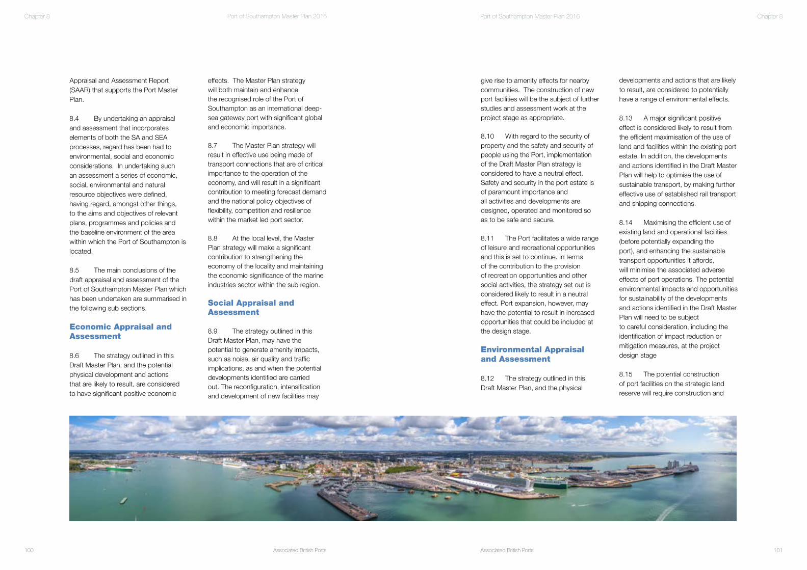
Associated British Ports100
Port of Southampton Master Plan 2016
Associated British Ports 101
Port of Southampton Master Plan 2016 Chapter 8
effects. The Master Plan strategy will both maintain and enhance the recognised role of the Port of Southampton as an international deep-sea gateway port with significant global and economic importance.
8.7 The Master Plan strategy will result in effective use being made of transport connections that are of critical importance to the operation of the economy, and will result in a significant contribution to meeting forecast demand and the national policy objectives of flexibility, competition and resilience within the market led port sector. 8.8 At the local level, the Master Plan strategy will make a significant contribution to strengthening the economy of the locality and maintaining the economic significance of the marine industries sector within the sub region.
Social Appraisal and Assessment
8.9 The strategy outlined in this Draft Master Plan, may have the potential to generate amenity impacts, such as noise, air quality and traffic implications, as and when the potential developments identified are carried out. The reconfiguration, intensification and development of new facilities may
Appraisal and Assessment Report (SAAR) that supports the Port Master Plan.
8.4 By undertaking an appraisal and assessment that incorporates elements of both the SA and SEA processes, regard has been had to environmental, social and economic considerations. In undertaking such an assessment a series of economic, social, environmental and natural resource objectives were defined, having regard, amongst other things, to the aims and objectives of relevant plans, programmes and policies and the baseline environment of the area within which the Port of Southampton is located.
8.5 The main conclusions of the draft appraisal and assessment of the Port of Southampton Master Plan which has been undertaken are summarised in the following sub sections.
Economic Appraisal and Assessment
8.6 The strategy outlined in this Draft Master Plan, and the potential physical development and actions that are likely to result, are considered to have significant positive economic
Panorama of the Port of Southampton
Chapter 8
developments and actions that are likely to result, are considered to potentially have a range of environmental effects. 8.13 A major significant positive effect is considered likely to result from the efficient maximisation of the use of land and facilities within the existing port estate. In addition, the developments and actions identified in the Draft Master Plan will help to optimise the use of sustainable transport, by making further effective use of established rail transport and shipping connections.
8.14 Maximising the efficient use of existing land and operational facilities (before potentially expanding theport), and enhancing the sustainable transport opportunities it affords,will minimise the associated adverse effects of port operations. The potential environmental impacts and opportunities for sustainability of the developments and actions identified in the Draft Master Plan will need to be subjectto careful consideration, including the identification of impact reduction or mitigation measures, at the project design stage 8.15 The potential construction of port facilities on the strategic land reserve will require construction and
give rise to amenity effects for nearby communities. The construction of new port facilities will be the subject of further studies and assessment work at the project stage as appropriate.
8.10 With regard to the security of property and the safety and security of people using the Port, implementation of the Draft Master Plan strategy is considered to have a neutral effect. Safety and security in the port estate is of paramount importance andall activities and developments are designed, operated and monitored so as to be safe and secure.
8.11 The Port facilitates a wide range of leisure and recreational opportunities and this is set to continue. In terms of the contribution to the provision of recreation opportunities and other social activities, the strategy set out is considered likely to result in a neutral effect. Port expansion, however, may have the potential to result in increased opportunities that could be included at the design stage. Environmental Appraisal and Assessment
8.12 The strategy outlined in this Draft Master Plan, and the physical

Associated British Ports102
Port of Southampton Master Plan 2016
Associated British Ports
Foreword
103
Port of Southampton Master Plan 2016 Chapter 8
and maximising sustainable transport opportunities will minimise the use of natural resources and energy.
8.18 Any new development will, however, consume natural resources as part of the construction process in terms of matters such as land take, energy and materials and is likely therefore to have a negative effect on the use of natural resources and energy. Further studies and assessment work will be required to define potential effects at the project stage.
8.19 Sustainable design and construction measures and the maximisation of recycled materials are just some of the mitigation measures that could be employed to minimise negative effects. Sustainable operation measures will be employed where possible together with opportunities for on-site renewable energy supply.
dredging to take place within, or close to, internationally and nationally protected habitats, and it is likely the proposals will result in a loss, to a greater or lesser degree, of intertidal area. The design, construction and operation of any proposals brought forward will seek to minimise adverse effects, although some residual significant impacts are likely to remain. Further studies and assessment work will be required to further define potential effects and appropriate offsetting and mitigation works at the project stage.
Natural Resource Appraisal and Assessment
8.16 The strategy outlined in the Draft Master Plan, and the physical developments that are likely to result within the existing port boundary, are considered to have generally positive effects in respect of the use of natural resources.
8.17 Maximising the efficient use of existing land and operational facilities
P&O’s Britannia alongside the Ocean Cruise Terminal, Eastern Docks

Associated British Ports
Foreword
104
Port of Southampton Master Plan 2016
DRAFT PRIVATE AND CONFIDENTIAL
Port of SouthamptonPort Master Plan2016 - 2035 CONSULTATION DRAFT