planning@::o. banner. preliminary plat application projects/s… · how many acres of submerged...
TRANSCRIPT
BONNER COUNTY PLANNING DEPARTMENT 1500 HIGHWAY 2, SUITE 208, SANDPOINT, ID 83864 (208) 265-1458 (208) 265-1463 (FAX)
planning@::o. banner. id. us (e-mail) http://www.co.bonner.id. us/planning/index. html (web page)
PRELIMINARY PLAT APPLICATION
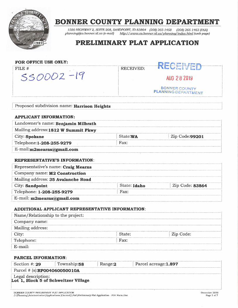
FOR OFFICE USE ONLY: [-FiLE_#_ .
ssoooz -lCf
I Proposed subdivision n~me: Harrison Heights
I RECEIVED:
AUG 2 8 2019
BON NER COUNTY PLANN IN G DEPARTM E NT
------------ -. ---~--- ----------- -·-· - ,.. ___ ----- -- - ·---·-- --- ·-
APPLICANT INFORMATION:
I L;nd;~~'s name: Benjamin Milbrath j"Maili~g address:1812 W _S_u_m_m_ i_t _P_kw_ y _________________________ _
r City~Sp~~~e-- --- I State:WA -, Zip Code:99201 I Telephone:1-208-255-92_7_9 _________ 1 Fax: =3 [-E-mail:[email protected] --· -- ---- ·-------------------------
REPRESENTATIVE'S INFORMATION: ..-------------------------------------- ----- -I Representative's name: Craig Mearns
I Company name: M2 Construction ----------
1 Mailing address: 35 Avalanche Road ! City: Sandpoint ·--, state: Id~ho
I Telephone: 1-208-255-9279 Fax:
I E-mail: [email protected]
ADDITIONAL APPLICANT REPRESENTATIVE INFORMATION:
IN~e/Relationship to the project:
r Company name:
fMailing address:
f<::ity: I State: I~ T_ e_l_e-ph_ o_n_e_: ______________ I Fax:
·-r- ---- ---- ------Zip Code: 83864 . . ---·1
-- I
I Zip Code:
I E-mail: -------------------------------- --- -- - --
------------------ --· ---- --·· -
PARCEL INFORMATION:
IS~ction #: 29 I Township:58 I Range:2 I Parcel acreage:1.897
r-P~rcel # (s):RP004060050010A r --·--1 Legal description: j ot 1, Block 5 of Schweitzer Village
BONNER COUNTY PRELIMINARY PLAT APPLICATION J:\Planning\Administrative\Applications (Current)\Plat\Preliminary Plat Application - PDF Form.Doc
Decem her 2010 Page I of7
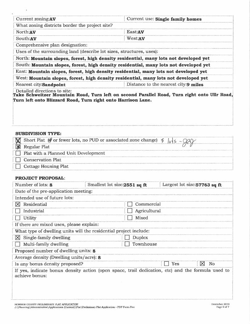
~ rent zoning:AV [ What zoning districts border the proje~t site?
jNorth:AV
n ,outh:AV I Compre_h_e_n_s_i-ve- p-la_n_ d_e_s"°.ignation:
I Current use: Single family homes
- !East:AV
I West:AV
!Uses of the surrounding land (describe lot sizes, structures, uses):
I No~th: Mountain slopes, forest, high density residential, many lots not developed yet
r South: Mountain slopes, forest, high density residential, many lots not developed yet - ___ _I
[ East: Mountain slopes, forest, high density residential, many lots not develop~d ycrt - ·-· I West: Mou~tain slop~s, forest, high density ;esidential, many lots not dev~loped yet- -----~~est city:Sandpoint !Distance to the ~earest city:9 mile; --· ----·--·
I Detailed directions to site: ffake Schweitzer Mountain Road, Turn left on second Parallel Road, Turn right onto Ullr Road, rl'urn left onto Blizzard Road, Turn right onto Harrison Lane.
SUBDIVISION TYPE:
nl~ Short Plat (f or fewer lots, no PUD or associated zone change) 1; JQ._i~ -n--~ Regular Plat
W Plat with_a_ P-lan_ n_e_d_ U_n_1-.t-D- ev. elopment ·------------------
I
! D Conservation Plat
I D Cottage Housing Plat ··--, PROJECT PROPOSAL:
j N~ ~ber of 1; ts: 8 !Smallest lot size:2551 sq ft [ Largest lot size:57763 sq ft .I I Date of the pre-application meeting: I I Intended use of futur_e_l_o_t_s _: -------------------------------
1~ Residential I D Commercial r D Industrial m Ag_n_· c_u_lt_u_r_a_l ·-------------·
I 0 -lliility -----, D Mixed
I If there are mixed uses, please explain:
I What type of dwelling units will the residential project include: I ~ Single-family dwelling I D D_u_p_l-ex---·----------
1 D Multi-family dwelling I D Townhouse --~=-"]
j Proposed number of dwelling units: 8
[Average density (Dwelling units/acre): 8
l Is any bonus density proposed? ID Yes
-l l1&J No
If yes, indicate bonus density action (open space, trail dedication, etc) and the formula used to achieve bonus:
- ·--·-----BONNER COUNTY PRELIMINARY PLAT APPLICATION J:\Planning\Administra tive\Applications (Current)\Plat\Preliminary Pla t Applica tion - PDF Form.Doc
I
--· J December 2010
Page2of7
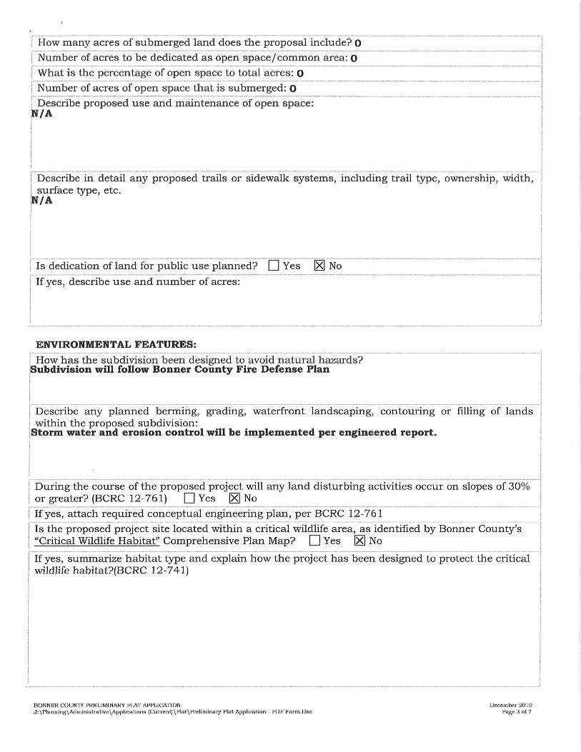
How many acres of submerged land does the proposal include? O
I Number of acres to be dedicated as open space / common area: O ---
[ What is the percentage of open space to total acres: O
I Number of acres of open space that is submerged: O
j Describe proposed use and maintenance of open space: iN/A
~
Describe in detail any proposed trails or sidewalk systems, including trail type, ownership, width·, surface type, etc. /A
I I j ls dedication ofland for public use planned?- D Yes [gJ No
l fyes, describe use and number of acres:
- -- -- I
ENVIRONMENTAL FEATURES:
r ----------·--------·---------·----- ----·----·--·-- ---------··-- ---------- -·--1
How has the subdivision been designed to avoid natural hazards? , ubdivision will follow Bonner County Fire Defense Plan j
I
[ Describe any planned berming, grading, waterfront landscaping, contouring or filling of lands
I within the proposed subdivision:
Storm water and erosion control will be implemented per engineered report.
I During the course of the proposed project will any land disturbing activities occur on slopes of 30% 1 or greater? (BCRC 12-761) D Yes [gJ No
I If yes, attach required conceptual engineering plan, per BCRC 12-761
Jls the propos~d project site located within a critical wildlife area, as identified by Bon.ner Cou; ty's ---., I ~Critical Wildlife Habitat" Comprehensive Plan Map? D Yes [gJ No
---r-·--If yes, summarize habitat type and explain how the project has been designed to protect the critical 1
wildlife habitat?(BCRC 12-7 41)
BONNER COUNTY PRELIMINARY PLAT APPLICATION J:\Planning\Administrative\Applications (Current)\Plat\Preliminary Plat Application - PDF Form.Doc
December 20 10 Page 3 of7
J
ACCESS INFORMATION:
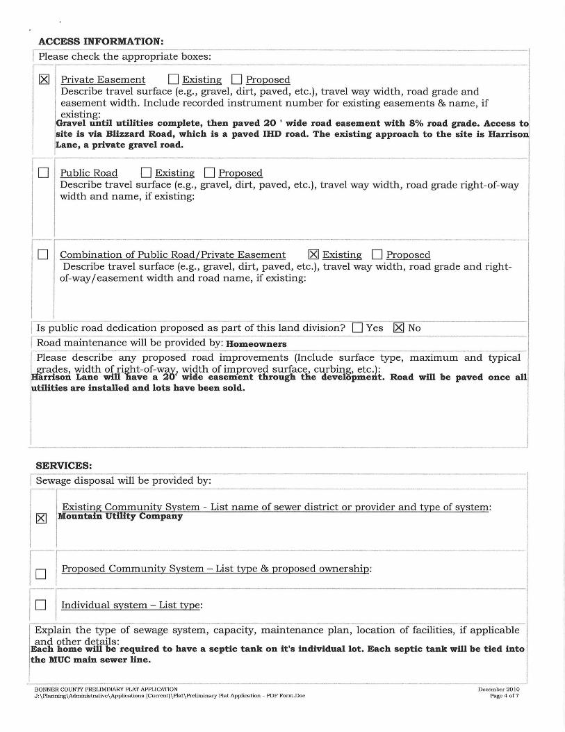
I Please check the appropriate boxes: --·-., Private Easement D Existing D Proposed Describe travel surface (e.g., gravel, dirt, paved, etc.), travel way width, road grade and easement width. Include recorded instrument number for existing easements & name, if existing:
Gravel until utilities complete, then paved 20 ' wide road easement with 8% road grade. Access t site is via Blizzard Road, which is a paved IHD road. The existing approach to the site is Harriso Lane, a private gravel road.
D Public Road D Existing D Proposed Describe travel surface (e.g. , gravel, dirt, paved, etc.), travel way width, road grade right-of-way width and name, if existing:
D Combination of Public Road/Private Easement lg] Existing D Proposed Describe travel surface (e.g., gravel, dirt, paved, etc.), travel way width, road grade and right
of-way / easement width and road name, if existing:
I Is public road dedication proposed as part of this land division? D Yes lg] No
[ Road maintenance will be provided by: Homeowners ----
~
lease describe any proposed road improvements (Include surface type, maximum and typical rades, width of right-of-way width of improved surface, curbing, etc.):
arrison Lane will nave a 20? wide easement through the development. Road will be paved once all r tilities are installed and lots have been sold.
I J SERVICES:
I Sewage disposal will be provided by:
Existing Community System - List name of sewer district or provider and type of system: 18] Mountain Utility Company
Jo Proposed Community System - List type & proposed ownership:
l°f Individual system - List type:
Explain the type of sewage system, capacity, maintenance plan, location of facilities, if applicable and other details:
Each home will be required to have a septic tank on it's individual lot. Each septic tank will be tied into the MUC main sewer line.
--------------- --- --------··------ ------BONNER COUNTY PRELIMINARY PLAT APPLICATION J:\Planning\Administrative\Applications (Current)\Plat\Preliminary Plat Application - PDF Form.Doc
December 2010 Page 4 of7

I Water will be supplied by:
Existing public or community system - List name of provider: Mountain Utility Company I ~ r--~-- ____________ ., _____ , ·--- ----------··
10 -P-ro_p_o_s_e_d_c_o_m_m_ u_n_i-ty_ s_y_s_t_e_m_ -_L_1_· s_t_t_y_p_e_&_p_ro_p_o_s_e_d_ o_wn __ er_s_h_1_· p_: ______________ I
l°I Individual well
I Please explain the water source, capacity, system maintenance plan, storage and delivery system and other details:
.----------- - -- . --- ---Distance (in miles) to the nearest:
I Public/Community Se;~~ System:o -, Scilidwaste Collection Fad lity:a";iles - ----- - -·-·- --·
I Public/Community Water System:O -!Fire Station:3 ·miles ·-·-- ------- -
I Elementary School:14 miles I Secondary Schools: 16 miles
I County Road: 0 j County Road Name: Blizzard Road
r Which fire district will serve the p~~te? Schweitzer Fire ,- -- -·--------------· I Which power company will serve the project site? Northern Lights
SITE INFORMATION:
I-Please provide a detailed description of the following land features: f Topography (lay of the land), including estimated maximum slope, ~-o-c_k_o_u- tc_r_o_p_p_i_n_ g_s _, -b-en_ c_h_e_s _, -et_c_:_ i opography generally slopes 14 - 18% to the NE, mountain slopes, forest
I
I j Water courses (lakes, streams, rivers & other bodies of water): ·
here are no impervious surfaces on the property. No standing water or year long streams
r rs site within a floodplain? ro Yes I ~ No Firm Panel#: I Map Designation:
f Springs & wells:
None
I [ E~isting structures (size & use): ~ homes on proposed lots # 1 and #2. Lot 1 home, 21 Harrison Lane, is 1400 sq ft. Lot 2 home, r5 Harrison Lane,ls 1944 sq ft.
----BONNER COUNTY PRELIMINARY PLAT APPLICATION J: \Pianning\Adminis tra tive \Applications (Current)\Piat\Prelimina ry Plat Application - PDF Form.Doc
I _ __J
Decem her 2010 Page 5 of7
ITand cover (timber, pastures, etc): ~4% covered in timber
~ ~etlands present on site? D Yes ~ No Source of information: ---··! ---------------1
Other pertinent information (attach additional pages if needed):
II How is the proposed subdivision in accordance with the specific objectives of the
comprehensive plan? (Please see attached copy of the goals and objectives): ~----- -----·· ------- . ··---
Property Rights: roposed project meets county's requirements for zoning and land use and complies with state!
raw relevant to any county land use action.
roject contains 7 single family units providing ownership opportunities to a growing
~
Population:
opulation and need.
[ School Facilities & T-ran--sp- o-rt_a_t-io_n_: ------------------------------1 phildren will be served by Farmin Stidwell, Sandpoint Middle School, Forrest Bird Charte~ Schools and Sandpoint High School.
I Economic Development: -- --- -- -,
Project will provide development associated by new housing; provide new housing to Bonnell County's workforce and standards will retain character of community.
I Land Use: rroject is consistent with land use objectives by complying with allowable density while r rotecting wildlife resources and timber. I
I Natural Resources: l (femp BMPs will be installed prior to construction. All BMPs permanent and temporary are to bel !installed per the final storm water/ site plan.
I I !Hazardous Areas: r roject has no hazardous areas. Bonner County's wild land fire policies and plans will be Integrated into development standards.
Public Services: 1 ower, sewer and water are already on site. Access by county road. Fire department is located rwo miles away and law enforcement is located 10 miles away. _
j Transportation: -· --1 Access within site will be by a 20' gravel surface; paved once all utilities are installed for al~ ~nits and phases of development. Project does not adversely impact existing transportation! ~ystem. J
BONNER COUNTY PRELIMINARY PLAT APPLICATION J:\Planning\Administrative \Applications (Current)\Plat\Preliminary Plat Application - PDF Form.Doc
December 20 JO Page 6 of7

Recreation: I ! he project is designed to provide recreational opportunities for lot owners. Public recreationa j ccess and amenities will not be obstructed.
r Special Areas or Sites: t ocated at Schweitzer, project will follow SMCA guide fiestroy culturally or ecologically sensitive sites.
lines and does not adversely affect o
I ! Housing: \ f ill have 7 small single family homes. Project is clustered to save on infrastructure and meets r omp plan's Housing Component requirements.
r - . ·---------! CommunitJ Design:
-------------· r roject conforms to current zoning and comprehensive plan designation. ~rea with similar densities in surrounding resort neighborhood
Project is located ii I n mplementation: ( Not required to complete this element)
I hereby certify that all the information, statements, attachments and exhibits submitted herewith are true to the best of my knowledge. I further grant permission to Bonner County employees and representatives, elected or appointed officials to enter upon the subject land to make examinations, post the prope~ty or review the prem~ ~ processing of this application. _
Landowner's signature: ~ Date: £j - 'l_~ { 9 Landowner's signature: ________________________ Date: _______ _
BONNER COUNTY PRELIMINARY PLAT APPLICATION J:\Planning\Administrative\Applications (Curre nt)\Pla t\Pre liminary Plat Application - PDF Form.Doc
December 2010 Page 7 of7