planning the future of wolston scoping...
TRANSCRIPT
Planning the Future of Wolston - Scoping Report, September 2013
1
Planning the Future of Wolston
Scoping Report
September 2013

Planning the Future of Wolston - Scoping Report, September 2013
2
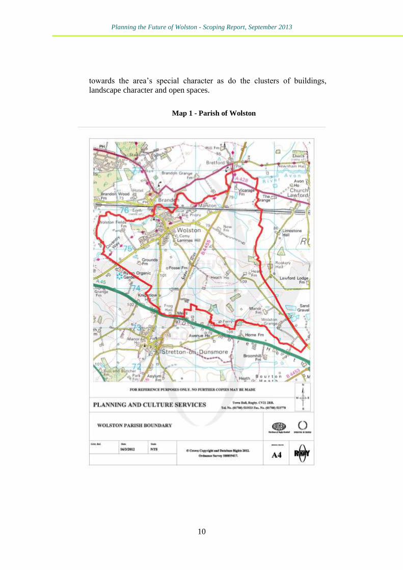
Prepared by:
Louise Kirkup
Reviewed by:
Michael Wellock
Authorised by:
Michael Wellock
Date issued:
Reference:
27th
of September 2013
K/087/LK
Planning the Future of Wolston - Scoping Report, September 2013
3
Contents
1 - Introduction
7
2 - Wolston- The Background
9
3 - Previous Neighbourhood Level Planning in Wolston
13
4 - National and Local Planning Policy Context
25
5 - A Review of the Available Evidence Base
43
6 - Key Issues Facing Wolston
65
7 - How the Key Issues Facing Wolston Could be
Addressed Through the Various Types of Plan
67
8 - Conclusions and Recommendations
73

Planning the Future of Wolston - Scoping Report, September 2013
4
Planning the Future of Wolston - Scoping Report, September 2013
5
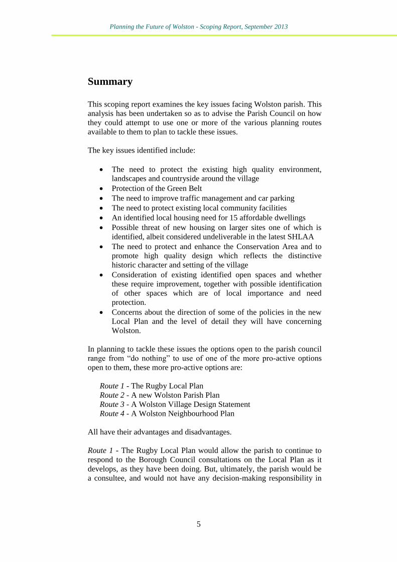
Summary
This scoping report examines the key issues facing Wolston parish. This
analysis has been undertaken so as to advise the Parish Council on how
they could attempt to use one or more of the various planning routes
available to them to plan to tackle these issues.
The key issues identified include:
The need to protect the existing high quality environment,
landscapes and countryside around the village
Protection of the Green Belt
The need to improve traffic management and car parking
The need to protect existing local community facilities
An identified local housing need for 15 affordable dwellings
Possible threat of new housing on larger sites one of which is
identified, albeit considered undeliverable in the latest SHLAA
The need to protect and enhance the Conservation Area and to
promote high quality design which reflects the distinctive
historic character and setting of the village
Consideration of existing identified open spaces and whether
these require improvement, together with possible identification
of other spaces which are of local importance and need
protection.
Concerns about the direction of some of the policies in the new
Local Plan and the level of detail they will have concerning
Wolston.
In planning to tackle these issues the options open to the parish council
range from “do nothing” to use of one of the more pro-active options
open to them, these more pro-active options are:
Route 1 - The Rugby Local Plan
Route 2 - A new Wolston Parish Plan
Route 3 - A Wolston Village Design Statement
Route 4 - A Wolston Neighbourhood Plan
All have their advantages and disadvantages.
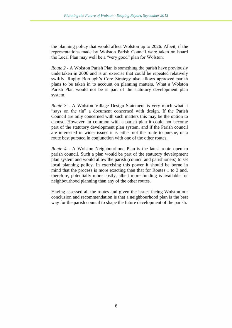
Route 1 - The Rugby Local Plan would allow the parish to continue to
respond to the Borough Council consultations on the Local Plan as it
develops, as they have been doing. But, ultimately, the parish would be
a consultee, and would not have any decision-making responsibility in
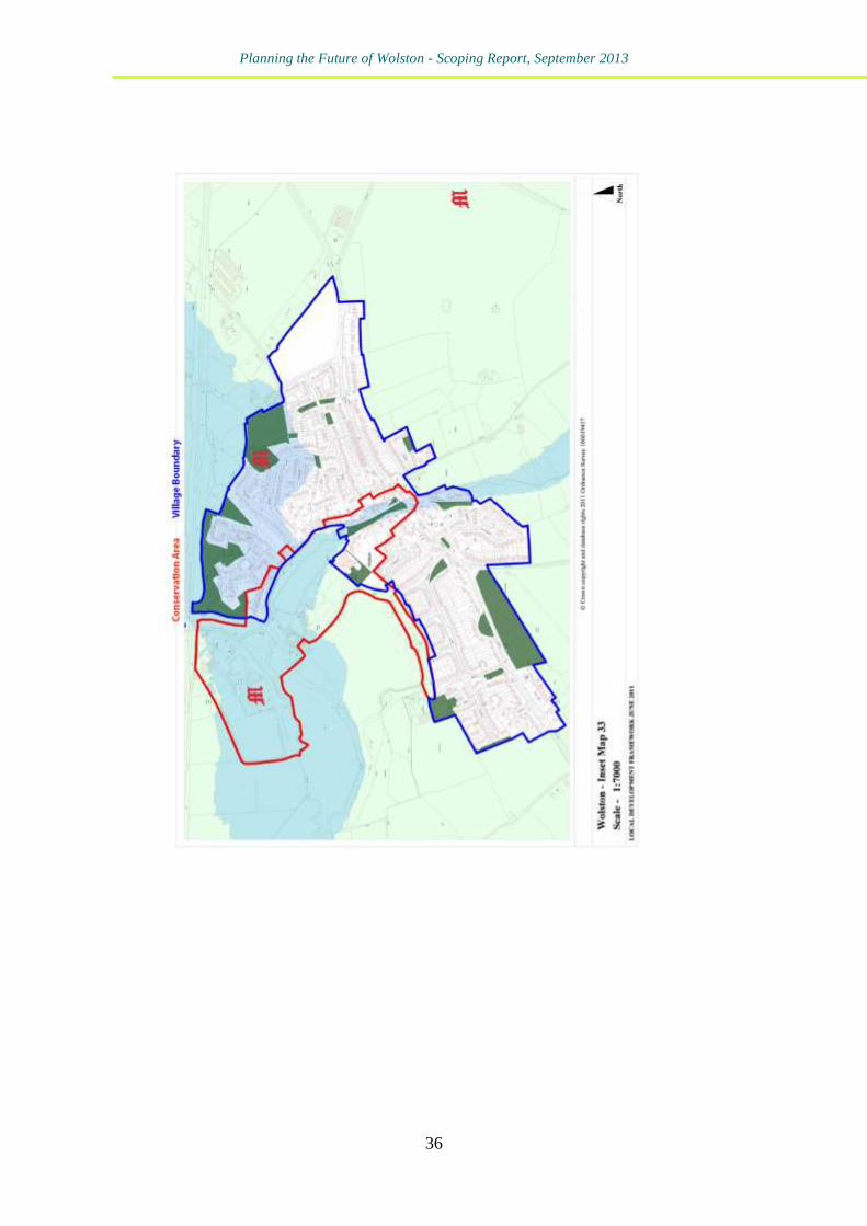
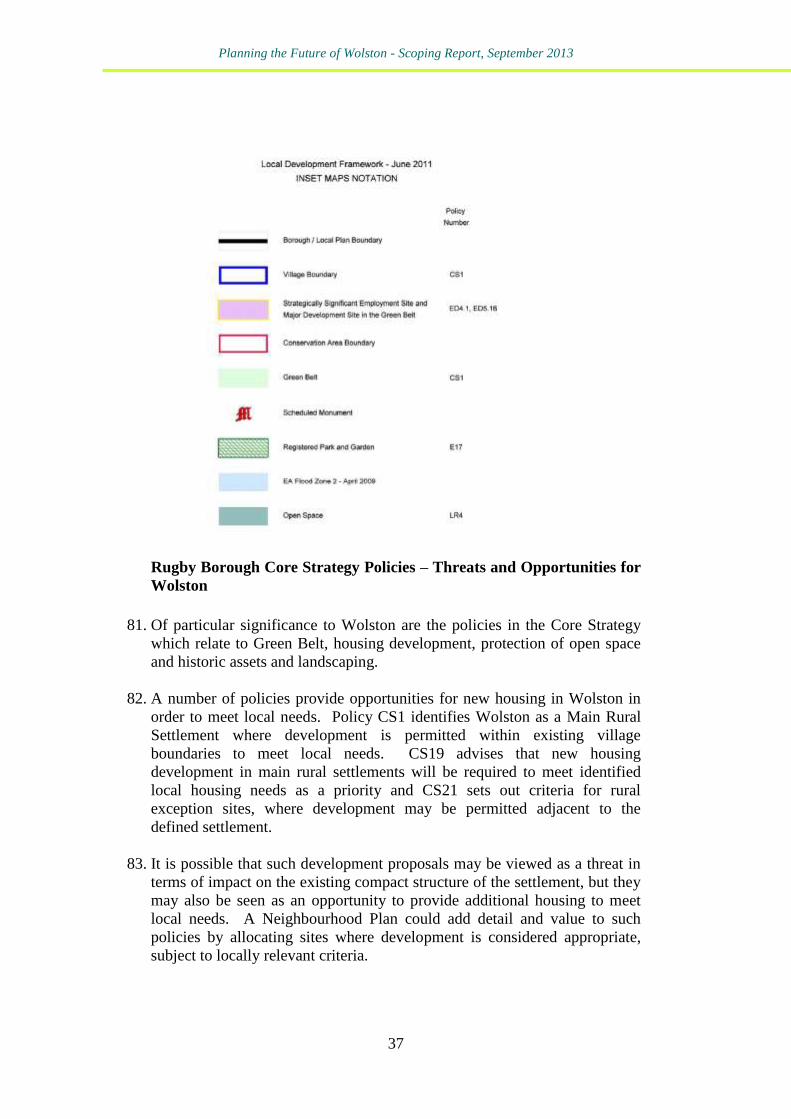
Planning the Future of Wolston - Scoping Report, September 2013
6
the planning policy that would affect Wolston up to 2026. Albeit, if the
representations made by Wolston Parish Council were taken on board
the Local Plan may well be a “very good” plan for Wolston.
Route 2 - A Wolston Parish Plan is something the parish have previously
undertaken in 2006 and is an exercise that could be repeated relatively
swiftly. Rugby Borough’s Core Strategy also allows approved parish
plans to be taken in to account on planning matters. What a Wolston
Parish Plan would not be is part of the statutory development plan
system.
Route 3 - A Wolston Village Design Statement is very much what it
“says on the tin” a document concerned with design. If the Parish
Council are only concerned with such matters this may be the option to
choose. However, in common with a parish plan it could not become
part of the statutory development plan system, and if the Parish council
are interested in wider issues it is either not the route to pursue, or a
route best pursued in conjunction with one of the other routes.
Route 4 - A Wolston Neighbourhood Plan is the latest route open to
parish council. Such a plan would be part of the statutory development
plan system and would allow the parish (council and parishioners) to set
local planning policy. In exercising this power it should be borne in
mind that the process is more exacting than that for Routes 1 to 3 and,
therefore, potentially more costly, albeit more funding is available for
neighbourhood planning than any of the other routes.
Having assessed all the routes and given the issues facing Wolston our
conclusion and recommendation is that a neighbourhood plan is the best
way for the parish council to shape the future development of the parish.
Planning the Future of Wolston - Scoping Report, September 2013
7
1 - Introduction
1. This scoping report examines the key issues facing Wolston parish in
Rugby. The parish council have commissioned this report to help them
decide how they could best attempt to plan to tackle the issues they face.
2. The parish council are well aware that they have a range of options from
“do nothing” to the use of one of the more pro-active options open to
them, these more pro-active options are:
Route 1 - The Rugby Local Plan
Route 2 - A new Wolston Parish Plan
Route 3 - A Wolston Village Design Statement
Route 4 - A Wolston Neighbourhood Plan
3. In part, this study has been provoked by the newest of these options,
Route 4, statutory neighbourhood plans.
4. Neighbourhood Plans are a relatively new addition to the planning
system in England. Parish Councils and other relevant bodies have been
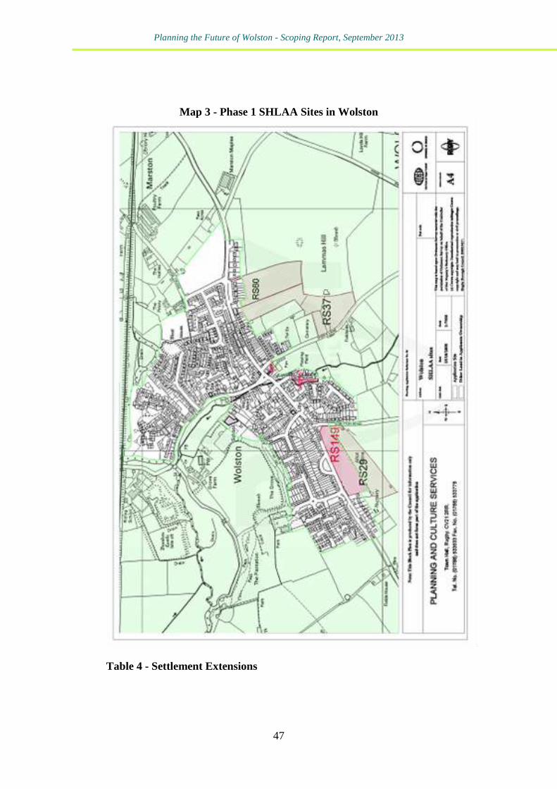
given powers under the Localism Act 2011 to prepare neighbourhood
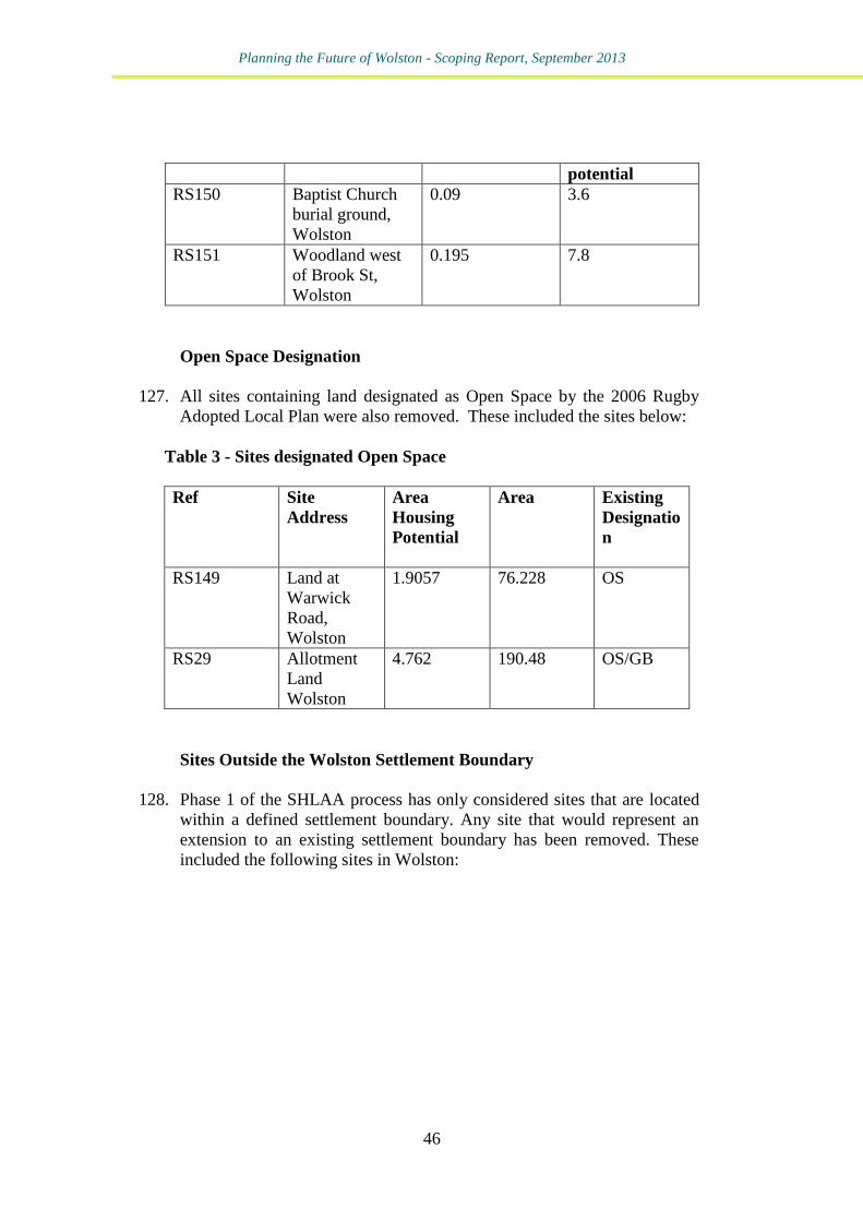
plans to: “establish general planning policies for the development and use of
land in a neighbourhood. They will be able to say, for example,
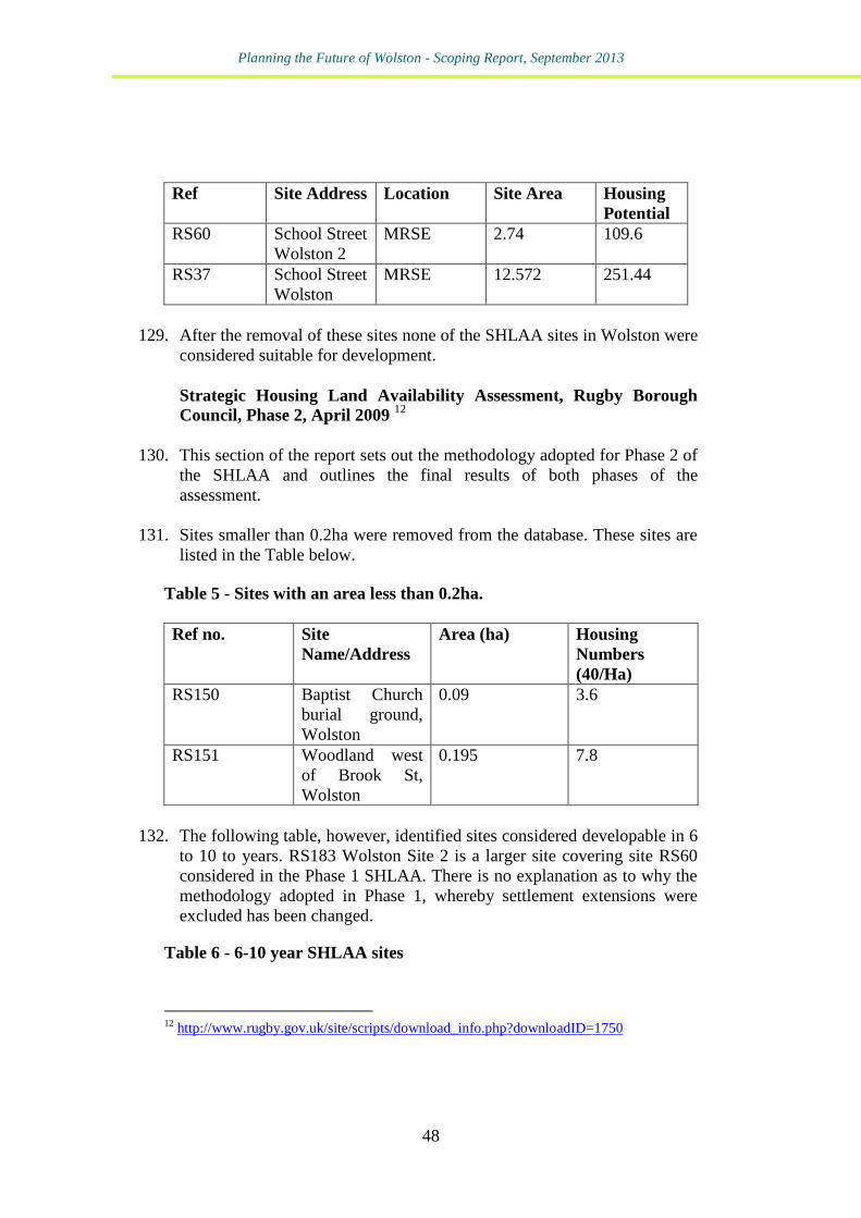
where new homes and offices should be built, and what they should
look like. The neighbourhood plan will set a vision for the future.” 1
5. The Parish Council has commissioned Kirkwells planning consultants to
prepare this scoping report to consider whether a neighbourhood plan
should be prepared for Wolston, or if the planning issues in the parish
would be better addressed by other means. 6. This scoping report sets out a response to the key issues previously
identified by and agreed with the Parish Council, namely:
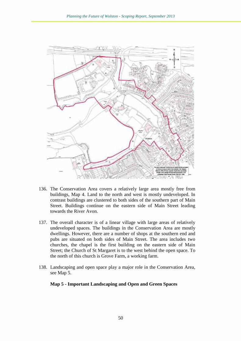
Background to Wolston – a short pen picture of the parish
Previous neighbourhood level planning in Wolston
National and Local planning policy context
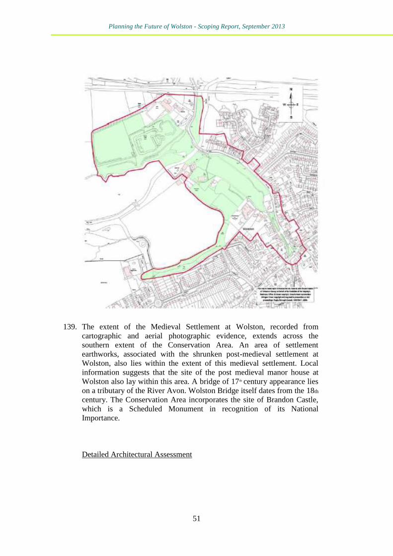
A Review of available evidence base
1 (Communities and Local Government, 2011) An introduction to neighbourhood planning.
Crown Copyright.

Planning the Future of Wolston - Scoping Report, September 2013
8
Key issues facing Wolston
Conclusions and Recommendations
7. It should be noted that the scoping report has been prepared as a desk
based document, and should be used as the basis for further discussion
by the parish council. The report has been prepared by independent
planning consultants, and without prejudice or predetermination of a
prior outcome.
Planning the Future of Wolston - Scoping Report, September 2013
9
2 - Wolston – The Background
8. The parish and village of Wolston fall within the administrative
boundary of Rugby Borough Council. The parish is located
approximately 6 miles from Rugby to the east, and Coventry to the west.
9. The village has a population of 2,564 (2011 Census) and has a rural
character with a historic core centred on the Conservation Area and
listed buildings around Main Street, see Map 1.
10. The Roman Fosse Way runs through the parish from south-west to
north-east and is thought to have crossed the Avon at, or very close to,
the present Bretford Bridge. A Benedictine priory founded in the 11th
century is known to have existed on a site currently occupied by a 16th
century building. There are historic records of the bridge from 1279 and
1653. 2 Extensive earthworks on the northern side of the River Avon
mark the site of the former Brandon castle, which was pulled down in
1265 by Baronial troops from Kenilworth Castle as the occupier John de
Verdon was an active supporter of the King. It was rebuilt as a holding
castle and park and was in use as a residence in 1309.
11. The village has also been shaped by transport. In addition to the Roman
Fosse way the parish is crossed from east to west by the Rugby to
Birmingham railway line.
12. Today the village has a range of community facilities including a
primary school, a church, Baptist chapel, doctors’ surgery, village hall,
and a public library. There is a leisure and community centre, a scout
hut, recreation ground with pavilion, children’s play area, and
allotments. Local businesses include a public houses, shop and Post
Office, hairdressers, and a licensed Indian restaurant in a former public
house.3
13. The Wolston Conservation Area covers a large area although the
majority of this remains undeveloped and free from buildings. The
buildings within the Conservation Area are clustered around the
southern part of Main Street and continue on the eastern site of Main
Street towards the River Avon. The series of village greens contribute
2 From: 'Parishes: Wolston', A History of the County of Warwick: Volume 6: Knightlow
hundred (1951), pp. 273-280. URL: http://www.british-
history.ac.uk/report.aspx?compid=57147 Date accessed: 22 July 2013 3 http://www.wolstonvillage.co.uk/Core/Wolston-Parish-Council/Pages/Default.aspx
Planning the Future of Wolston - Scoping Report, September 2013
10
towards the area’s special character as do the clusters of buildings,
landscape character and open spaces.
Map 1 - Parish of Wolston
Planning the Future of Wolston - Scoping Report, September 2013
11
14. Wolston lies within the Dunsmore Plateau Fringe Landscape Character
Type with Dunsmore Parkland to the north4. Dunsmore Plateau Fringe
has an undulating topography of low rounded hills, broad valleys and
short steep slopes and is mostly an intensively farmed agricultural
landscape with smaller pockets of permanent pasture, hedged fields,
narrow meandering river valleys and small nucleated villages.
Dunsmore Parkland comprises rolling estate parkland with a well
wooded character.
4 Landscape Assessment of the Borough of Rugby Sensitivity and Condition Study,
Warwickshire County Council, 2006
http://www.warwickshire.gov.uk/Web/corporate/wccweb.nsf/Links/C7131B28880DCAE08
0257861003A09CB/$file/Landscape_assessment_Rugby.pdf

Planning the Future of Wolston - Scoping Report, September 2013
12
Planning the Future of Wolston - Scoping Report, September 2013
13
3 - Previous Neighbourhood Level Planning in
Wolston 15. A Parish Plan for Wolston was completed in 2006. The basis for this
was a questionnaire survey sent to all households in December 2004.
This had a very high response rate of over 57% and the results provided
a valuable snapshot of local opinions on the key issues at that time.
16. Key issues identified in the Parish Plan include the following:
People valued the community spirit, attractive rural environment,
good communication links and local facilities.
There were a minority of negative comments including that
community spirit was deteriorating and that the village was growing
and becoming a suburb of Coventry.
Concerns about the reduction in local community facilities such as
the loss of the high school and police station and increased levels of
traffic.
Identification of parking as a significant issue.
The countryside was identified as the most important environmental
feature and people felt strongly about the need to improve public
footpaths; and that priority should be given to protection of open
spaces and green verges, improving wildlife habitats, and improving
footpaths.
Concerns included the need to tackle fly tipping and anti-social
behaviour.
The majority of respondents rated village services as between
satisfactory and excellent.
The frequency of evening and weekend bus services required
improvement, as did the range of destinations.
Traffic levels and lack of provision of public parking for shops were
a concern.
A lack of affordable housing was likely to lead to a number of local
people leaving the village and a subsequent Housing Needs Survey
undertaken by Rugby Borough Council indicated a local need for
more rented housing, and some shared ownership and housing to
buy.
There was a need to improve information about local health services.
The closure of the business park was seen as a loss to the village.
Future development should not impact on the surrounding green
belt.
N N
Planning the Future of Wolston - Scoping Report, September 2013
14
Concerns about crime were linked to the recent closure of the police
station and fear of crime was an issue.
There was an identified need to improve communication within the
village.
There was interest in clubs and recreation.
There was support for more facilities for young people.
17. Although conducted some time ago the issues raised at the time of the
Parish Plan’s preparation remain the only comprehensive snapshot of
attitudes and opinions in the parish. Table 1, therefore, uses this
information to show how the various local and neighbourhood planning
routes could address the, then, and the current issues affecting Wolston.
18. This table shows that there are fundamental differences in what the
different plans can and cannot do.
Table 1 - Key Parish Plan Issues and Possible Planning Responses
Key Issue Planning Response
Maintaining Community Spirit
A Neighbourhood Plan or Parish
Plan (in our view a Village Design
Statement less so) could both help
to galvanise community spirit by
providing new opportunities for
local people to have their say and get
involved in decisions and actions to
improve their parish. Residents
could be involved in steering groups
and working groups, attend
consultation events and put forward
their ideas and comments on the
future of the Parish.
The Local Plan could include
policies to protect local services and
support wellbeing, through for
instance protection of natural
heritage assets, allotments and open
spaces. There will be opportunities
for taking part in consultation
activity on the Local Plan at key
stages.
Planning the Future of Wolston - Scoping Report, September 2013
15
Loss of Local Community Facilities
A Neighbourhood Plan could
include policies to protect local
community facilities and identify
those for protection through the
development plan. The
neighbourhood plan strategy and
allocations could also support local
services through appropriate land
allocations, e.g. new housing
development, to ensure the future
population of the village remains
sustainable to support viable services
and facilities. It could also identify
community assets such as local
shops or public houses for
Community Right to Bid activity.
A Parish Plan could be used to
identify service improvements and
key local facilities – what it could
not offer is to protect these through
the development plan system.
A Local Plan could include policies
to protect community facilities by
defining for instance, village centres
and identifying open spaces and
associated facilities for protection.
Parking and traffic levels
A Neighbourhood Plan could
identify a site for a village car park
and include policies to improve
traffic management, subject to
funding through for instance the
County Council highways
programmes or Community
Infrastructure Levy.
A Local Plan could include strategic
policies for supporting and
promoting improved traffic
management through a range of
schemes.
Planning the Future of Wolston - Scoping Report, September 2013
16
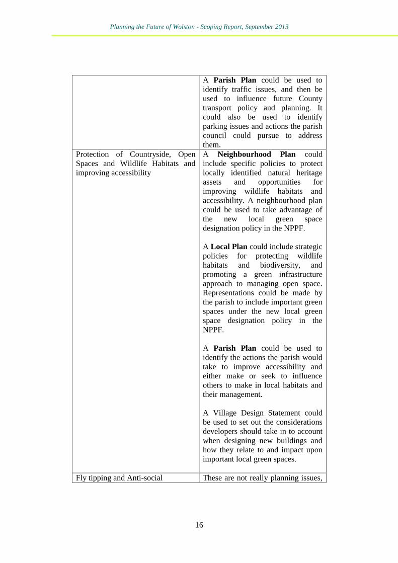
A Parish Plan could be used to
identify traffic issues, and then be
used to influence future County
transport policy and planning. It
could also be used to identify
parking issues and actions the parish
council could pursue to address
them.
Protection of Countryside, Open
Spaces and Wildlife Habitats and
improving accessibility
A Neighbourhood Plan could
include specific policies to protect
locally identified natural heritage
assets and opportunities for
improving wildlife habitats and
accessibility. A neighbourhood plan
could be used to take advantage of
the new local green space
designation policy in the NPPF.
A Local Plan could include strategic
policies for protecting wildlife
habitats and biodiversity, and
promoting a green infrastructure
approach to managing open space.
Representations could be made by
the parish to include important green
spaces under the new local green
space designation policy in the
NPPF.
A Parish Plan could be used to
identify the actions the parish would
take to improve accessibility and
either make or seek to influence
others to make in local habitats and
their management.
A Village Design Statement could
be used to set out the considerations
developers should take in to account
when designing new buildings and
how they relate to and impact upon
important local green spaces.
Fly tipping and Anti-social These are not really planning issues,
Planning the Future of Wolston - Scoping Report, September 2013
17
Behaviour
but both Neighbourhood Plans and
Local Plans can include policies on
design of new development to
promote overlooking and “secure by
design” principles.
If there are particular hotspots for fly
tipping and anti-social behaviour a
Neighbourhood Plan could identify
the sites for environmental
improvement such as provision of a
community garden / wildlife area
etc. and support this with education
and awareness raising activity by the
Parish Council.
A Parish Plan could identify issues
and the type and quality of responses
key local agencies would take to
tackle such issues.
Off Peak Bus services, and
destinations
A Neighbourhood Plan could
include policies which require new
housing development to be located
close to existing bus routes and
stops. Consideration could be given
to asking for developer contributions
to support local bus services.
A Local Plan could include strategic
policies which support transport by
means other than the private car and
allocating new housing sites where
there is good accessibility to
services.
A Parish Plan could identify issues
and be used to influence the service
planning of local providers and the
policy of the County.
Lack of Affordable Housing A Neighbourhood Plan could
include policies and site allocations
to support provision of affordable
Planning the Future of Wolston - Scoping Report, September 2013
18
housing to meet locally identified
need. A Community Right to
Build Order would, in effect, grant
planning consent for an appropriate
development proposal.
A Local Plan could include strategic
policies which support appropriate
affordable housing development to
meet local needs in rural areas.
A Parish Plan could identify issues
and be used to influence the Local
Plan, planning decisions, and the
policies of affordable housing
providers.
Information about health services This is not really a planning issue.
A Parish Plan could be used to
provide some of this information and
set out actions the parish council
would take, with service providers,
to improve its dissemination.
Protecting the Green Belt The green belt is protected from
development in national planning
policy (the NPPF). Green Belt
boundaries can only be changed in
“exceptional circumstances”.
The Local Plan would be the
document to change the Green Belt
boundary. Rugby Borough sees no
need to do this.
Development acceptable in the
Green Belt is also set by national
planning policy. The Local Plan
currently follows this. There is very
little scope, if any, for any
neighbourhood level document to go
beyond national policy.
Planning the Future of Wolston - Scoping Report, September 2013
19
Fear of Crime This is not really a planning issue,
but both Neighbourhood Plans and
Local Plans can include policies on
design of new development to
promote overlooking and “secure by
design” principles.
Similarly, a Village Design
Statement could be used to promote
similar principles.
A Parish Plan could identify issues
and the type and quality of responses
key local agencies would take to
tackle such issues.
Improving Communication A Neighbourhood Plan is unlikely
to address this issue.
A Local Plan is unlikely to address
this.
A Parish Plan could be used to
establish protocols or service level
agreements between the parish and
other service providers.
Improving leisure and recreation
facilities and facilities for young
people
A Neighbourhood Plan could
include policies and site allocations
to protect and enhance recreational
facilities and open spaces to meet
local need. A Community Right to
Bid could be used to acquire
facilities under threat for the benefit
of the local community.
A Local Plan could include strategic
policies which protect local
facilities, open spaces and play
areas.
A Parish Plan could be used to
identify issues and then be used to
influence service providers.
Planning the Future of Wolston - Scoping Report, September 2013
20
Wolston Parish Council’s Responses to Rugby Planning
Consultations and queries regarding neighbouring
planning
19. More recently there are a number of planning related issues and
concerns identified by Wolston Parish Council in correspondence with
Rugby Borough Council. These include the following policy areas
which could have implications for potential neighbourhood level
planning in Wolston. One of the key areas is Housing Allocations and
Housing Need.
20. A number of sites have been considered for housing through the
Strategic Housing Land Availability SHLAA process. One large site,
Site RS183, Site 2 Wolston, remains in the 6-10 year list of sites. This is
considered developable but not deliverable.
21. The Parish Council considers that the proposed mix of housing in an
area should be determined by local housing needs as identified in up to
date local housing needs surveys.
22. The Parish Council is concerned that any provision of open market
housing to support delivery of affordable housing on an exception site
should only be considered as a last resort, where an up to date Housing
Needs Survey supports this, the exception site is considered suitable,
and the proposed development is consistent with local planning policy,
including neighbourhood plans.
23. The parish could remain a consultee responding as they are and seeking
to influence Rugby’s emerging planning policy. A neighbourhood plan
for Wolston could go further and include detailed planning policies and
site allocations to guide new housing development to meet local need
within the parish. Beyond this, a Neighbourhood Development Order
could be used to grant planning consent for such development as the
Parish Council considers appropriate. A Village Design Statement could
be prepared to influence design of future development. A Parish Plan
would have very little scope to influence such issues. Although as
discussed later in this report Core Strategy policy CS2 would allow a
parish plan to “inform” such decisions.
24. Designation and Protection of Open Space the saved Local Plan (2006)
Policy LR4: Safeguarding open spaces continues to be applied by the
Planning the Future of Wolston - Scoping Report, September 2013
21
Borough Council when determining planning applications on designated
open spaces. In addition open spaces are protected by Core Strategy
Policy CS14. The Parish Council regards the safeguarding of existing
open space as critical, and has concerns about the intentions of Policy
LR4 in the recently published Local Plan Discussion Document. On-site
and off-site provision of open space in new developments may be
acceptable to local communities.
25. One area that the National Planning Policy Framework opens up is the
opportunity for local communities through local and neighbourhood
plans to identify for special protection green areas of particular
importance to them. By designating land as Local Green Space local
communities will be able to rule out new development other than in very
special circumstances. The designation should only be used:
where the green space is in reasonably close proximity to the
community it serves;
where the green area is demonstrably special to a local
community and holds particular local significance; and
where the green area concerned is local in character and is not an
extensive tract of land.
Both Local Plan and Neighbourhood Plan could take advantage of this
new planning policy.
26. Landscaping - The Parish Council have expressed concerns that there is
a lack of forward strategy and robust planning policy requiring
landscaping to be an integral part of the overall design of development.
Policies in a Neighbourhood Plan could require appropriately designed
landscaping in proposed new developments, having regard to the
distinctive landscape character and historic setting of the parish.
27. Design - The Parish Council is concerned that there is insufficient
weight given in existing planning policies to requiring high quality
design and promoting healthy communities.
28. Again, policies in a Neighbourhood Plan could be used to highlight local
character and to strengthen planning principles requiring designs of new
development to be appropriate to the local context, for instance by use of
materials, scale, height, massing and landscaping. Similarly, a local list
of (non-designated) historical assets could be identified and given
additional protection in a Neighbourhood Plan.
Planning the Future of Wolston - Scoping Report, September 2013
22
29. A Village Design Statement could be prepared with very similar content
but would not form part of the statutory development plan.
30. Employment - The Parish Council has concerns about the flexible
approach of the Borough Council’s policies in relation to employment
type and change of use.
31. A Neighbourhood Plan could include policies to protect local
employment sites and to support existing and future employment
opportunities in the Parish. However the neighbourhood plan would
have to be in general conformity with the strategic policies of the
Borough Council, as well as mindful of the NPPF’s commitment to
securing economic growth and building a strong, competitive economy.
Paragraph 22 of the NPPF advises that planning policies should avoid
the long term protection of sites allocated for employment use where
there is no reasonable prospect of a site being used for that purpose.
Applications for alternative uses should be treated on their own merits,
having regard to market signals and the relative need for different land
uses to support sustainable local communities.
32. Community Facilities - The Parish Council is concerned about the lack
of Local Plan protection for local services and community facilities in
villages. Whilst a Local Plan policy would be appropriate to provide
strategic protection to local services and facilities a Neighbourhood Plan
could provide much more detail in relation to Wolston. The Parish
Council may wish to consider whether some services should be
identified for protection in a Neighbourhood Plan or for identification on
the list of assets of community value, and targets for possible
Community Right to Bid activity: for instance where a local public
house or village shop / post office is at risk of closing.
33. Wildlife – non-designated sites - The Parish Council is concerned that
not enough protection is given to non-designated wildlife sites in the
Local Plan. The Parish Council may wish to use a Neighbourhood Plan
to identify and protect non-designated natural heritage assets in the
parish, working with local wildlife groups and using local knowledge
and expertise.
34. Historic Environment - Similarly, in relation to built heritage assets, the
Parish Council could consider preparing a “Local List” of locally
important built heritage assets and including these in a Neighbourhood
Plan for added protection.

Planning the Future of Wolston - Scoping Report, September 2013
23
Planning the Future of Wolston - Scoping Report, September 2013
24
4 - National and Local Planning Policy Context 35. Planning applications are determined in accordance with the
development plan and any other material considerations. The
development plan for the purposes of determining planning applications
in Wolston comprises the NPPF, and the saved policies of the Rugby
Local Plan.
36. Should Wolston Parish Council decide to prepare a Neighbourhood
Plan, then the Wolston Neighbourhood Plan would form part of the
statutory development plan. This is a fundamental difference
neighbourhood plans have from parish plans or village design
statements.
37. Neighbourhood plans are required to be in general conformity with
national and local planning policies. In terms of Rugby Borough
planning policy in Policy CS2 parish plans are also required to be in
conformity with planning policy.
National Planning Policy Framework (NPPF)
38. (Note - paragraph numbering in the extracts refers to the numbering in
the published NPPF document to aid referencing).
39. The key paragraphs of relevance to Wolston include the following:
“6. The purpose of the planning system is to contribute to the
achievement of sustainable development.
7. There are three dimensions to sustainable development: economic,
social and environmental. These dimensions give rise to the need for
the planning system to perform a number of roles:
● an economic role – contributing to building a strong,
responsive and competitive economy, by ensuring that
sufficient land of the right type is available in the right places
and at the right time to support growth and innovation; and
by identifying and coordinating development requirements,
including the provision of infrastructure;
Planning the Future of Wolston - Scoping Report, September 2013
25
● a social role – supporting strong, vibrant and healthy
communities, by providing the supply of housing required to
meet the needs of present and future generations; and by
creating a high quality built environment, with accessible
local services that reflect the community’s needs and support
its health, social and cultural well-being; and
● an environmental role – contributing to protecting and
enhancing our natural, built and historic environment; and, as
part of this, helping to improve biodiversity, use natural
resources prudently, minimise waste and pollution, and
mitigate and adapt to climate change including moving to a
low carbon economy.
11. Planning law requires that applications for planning permission
must be determined in accordance with the development plan unless
material considerations indicate otherwise.
15. All plans should be based upon and reflect the presumption in
favour of sustainable development, with clear policies that will guide
how the presumption should be applied locally.
16. The application of the presumption will have implications for
how communities engage in neighbourhood planning. Critically, it
will mean that neighbourhoods should:
● develop plans that support the strategic development needs
set out in Local Plans, including policies for housing and
economic development;
● plan positively to support local development, shaping and
directing development in their area that is outside the
strategic elements of the Local Plan; and
● identify opportunities to use Neighbourhood Development
Orders to enable developments that are consistent with their
neighbourhood plan to proceed.”
Neighbourhood plans
Planning the Future of Wolston - Scoping Report, September 2013
26
40. The key policy from the NPPF on neighbourhood plans is set out below.
The key features for Wolston Parish Council to consider when making a
decision on whether to proceed with a neighbourhood plan are
emphasised:
“183. Neighbourhood planning gives communities direct power to
develop a shared vision for their neighbourhood and deliver the
sustainable development they need. Parishes and neighbourhood
forums can use neighbourhood planning to:
● set planning policies through neighbourhood plans to determine
decisions on planning applications; and
● grant planning permission through Neighbourhood Development
Orders and Community Right to Build Orders for specific
development which complies with the order.
184. Neighbourhood planning provides a powerful set of tools for
local people to ensure that they get the right types of development
for their community. The ambition of the neighbourhood should be
aligned with the strategic needs and priorities of the wider local area.
Neighbourhood plans must be in general conformity with the
strategic policies of the Local Plan. To facilitate this, local planning
authorities should set out clearly their strategic policies for the area
and ensure that an up-to-date Local Plan is in place as quickly as
possible. Neighbourhood plans should reflect these policies and
neighbourhoods should plan positively to support them.
Neighbourhood plans and orders should not promote less
development than set out in the Local Plan or undermine its strategic
policies.
185. Outside these strategic elements, neighbourhood plans will be
able to shape and direct sustainable development in their area. Once
a neighbourhood plan has demonstrated its general conformity with
the strategic policies of the Local Plan and is brought into force, the
policies it contains take precedence over existing non-strategic
policies in the Local Plan for that neighbourhood, where they are in
conflict. Local planning authorities should avoid duplicating
Planning the Future of Wolston - Scoping Report, September 2013
27
planning processes for non-strategic policies where a neighbourhood
plan is in preparation.”
NPPF – Threats and Opportunities for Wolston
41. The NPPF promotes sustainable development. It has a strong emphasis
on economic growth and supports house building to help stimulate the
national economy. The NPPF seeks to redress the identified national
shortfall in housing provision, and aims to speed up and simplify the
planning system by requiring local planning authorities to prepare up to
date Local Plans and to maintain a 5 year supply of deliverable housing
sites to meet current and future demand.
42. However there is recognition that there is a need to protect rural areas
and to ensure that new development is appropriate to local needs. Green
Belt policy remains very strong.
43. High quality design, which responds to distinctive local character is
encouraged, and natural and built heritage assets are protected, including
those assets of local designation.
44. The NPPF also introduces the concept of protected local green spaces.
The potential to use this in a neighbourhood plan has already been
highlighted in para. 25 above.
Warwickshire County Council
Warwickshire Structure Plan (1996-2011)5
45. The saved Warwickshire Structure Plan policies were formally revoked
by Statutory Order SI 2013/933. This was laid in Parliament on
24th April 2013 and came into effect on 20th May 2013. Therefore
as of the 20th May 2013, the saved Warwickshire Structure Plan
policies no longer form part of the statutory development plan
for Warwickshire.
Rugby Borough Council
5 http://www.warwickshire.gov.uk/structureplan
Planning the Future of Wolston - Scoping Report, September 2013
28
Rugby Borough Saved Local Plan Policies, 2006 (Post Core Strategy
Adoption)
46. Current policies in the Saved Local Plan which are considered of
relevance to Wolston are:
GP2 – Landscaping
GP5 – Renewable Energy
E6 – Biodiversity
E17 – Development affecting parks and gardens and other elements
of the historic landscape
H12 – Open space provision in residential developments in the rural
area
LR4 – Safeguarding open space
47. With the emerging Local Plan at discussion document stage these
policies have a limited “shelf life”, but would still need to be taken in to
account if Wolston were to embark on a neighbourhood plan in the short
term.
Rugby Borough Saved Local Plan Policies – Threats and
Opportunities for Wolston
48. The above policies provide general protection for a number of planning
issues relevant to Wolston. Policy GP2 is considered generally robust in
terms of requiring developers to incorporate important features into a
high quality design and to use native species to enhance biodiversity.
Landscape character is mentioned but a Neighbourhood Plan or Village
Design Statement would allow the opportunity to build in more direct
references to the local landscape character, and to the particular features
distinctive to the parish such as the paddocks and open spaces in the
Conservation Area. In addition, landscape design should ideally
consider a Green Infrastructure (GI) approach to ensure that landscapes
support a range of uses from flood protection to enhancing biodiversity.
49. Similarly Policy E6 Biodiversity, provides general protection to wildlife
habitats and species, but will refer largely to existing wildlife records for
designated sites.
50. Historic parks and gardens and landscapes are protected by Policy E17,
including locally important assets. This is a well worded and robust
policy. A neighbourhood plan could supplement this policy by
Planning the Future of Wolston - Scoping Report, September 2013
29
identifying important historic landscape features and sites, and including
more detail about their significance to the landscape setting of the
Parish, and identifying views to and from the asset which should be
protected. This could include for instance the sites of Brandon castle
and the medieval and post medieval settlements.
51. Policy L4 safeguards open space identified on the Proposals Map, and
sets out several scenarios where development of open space would be
acceptable. If Wolston parish wish to protect an open space which is
under threat of development, and the proposed development would
include enhancement of sport and recreation facilities, a neighbourhood
plan could be used to designate a Local Green Space – offering stronger
protection than the Local Plan, see para. 25 above.
Rugby Borough Core Strategy, June 2011
6
52. The Core Strategy contains the strategic policies which will guide the
future development of the Borough up to 2026: all other documents
within the Local Development Framework must be consistent with it.
53. The following targets and policies are of relevance to Wolston:
Strategic Development Targets - Housing Development
54. Rugby Borough Council will deliver 10,800 dwellings within the
Borough between 2006 and 2026 with at least 9,800 accommodated
within or adjacent to Rugby Town itself. This requirement is
demonstrated through the consideration of the latest population
estimates; household estimates and affordability within the Borough.
The Council has undertaken a Strategic Housing Land Availability
Assessment that considers the total supply of housing land and
concludes that approximately 6,000 dwellings need to be allocated
through the Local Development Framework (LDF).
Policy CS1: Development Strategy
55. The location and scale of development must comply with the settlement
hierarchy. It must be demonstrated that the most sustainable locations
are considered ahead of those further down the hierarchy.
6 http://www.rugby.gov.uk/site/scripts/download_info.php?fileID=5102
Planning the Future of Wolston - Scoping Report, September 2013
30
MAIN RURAL SETTLEMENTS
Binley Woods, Brinklow, Clifton on Dunsmore, Dunchurch, Long
Lawford, Ryton on Dunsmore, Stretton on Dunsmore, Wolston and
Wolvey
Will accommodate:
Development permitted within existing defined village
boundaries; and
Local housing needs.
COUNTRYSIDE
New development will be resisted; only where national policy on
countryside locations allows will development be permitted.
GREEN BELT
New development will be resisted. Only where national Green
Belt policy allows will development be permitted.
Policy CS2: Parish Plans
56. Where the views of a community are expressed in a Parish Plan (or
equivalent), they will be taken into account in the planning system. For
the views of a community to be considered, the Parish Plan will need to:
have been endorsed by Rugby Borough Council;
be in conformity with the LDF; and
be regularly updated if necessary.
57. The use of parish plans will principally inform:
the determination of a planning application;
the requirement and scope of development contributions associated
with a planning permission; and
the assessment of schemes in the context of a need identified through
the Parish Plan.
58. This is, in our opinion, a strong policy should Wolston decide to prepare
a parish plan. It sets out the conditions necessary for a parish plan to
carry “weight” with the borough council, and also sets out how parish
plans will be used in planning terms. It is a good basis for any parish
Planning the Future of Wolston - Scoping Report, September 2013
31
plan – considerably stronger than core strategy policies in other areas.
Wolston may wish to consider how it works in practice by discussing
this with any neighbouring parish that has a parish plan that fulfils the
criteria in Policy CS2.
Policy CS11 – Transport and New Development
59. Development will be permitted where sustainable modes of transport are
prioritised and measures mitigating against the transport impacts which
may arise from that development or cumulatively with other proposals
are provided. This shall be achieved where appropriate through the
submission of a transport assessment and:
Contributions to transport modelling work;
The provision of travel plans to promote sustainable travel patterns
for work related trips; and;
The entering into of bus partnerships with the County Council and/or
third parties.
60. The thresholds above which transport assessments will be required and
the relevant car parking standards for all development types are set out
in the Planning Obligations Supplementary Planning Document.
Policy CS13: Local Services and Community Facilities
61. Existing local services and community facilities should be retained
unless it can be demonstrated that:
there is no realistic prospect of the existing use continuing for
commercial and/or operational reasons;
the site has been actively marketed for a similar or alternative type
of service or facility that would benefit the local community; and
the existing service or facility can be provided in an alternative
manner or on a different site in the local area
62. New local services and community facilities to meet the needs of local
communities will be permitted in the following locations:
as an integral part of a planned new development;
in identified areas of deprivation where the provision would
contribute towards addressing the deprivation;
in existing residential areas within the urban area and defined rural
village boundary settlements; and
Planning the Future of Wolston - Scoping Report, September 2013
32
when a provision is identified in a Parish Plan adjacent to the
settlement boundary when it cannot be met within the settlement
boundary.
63. Provided that:
it is readily accessible by a choice of means of transport, including
by foot and cycle;
the nature and the scale of the development would be commensurate
with its function to provide facilities for the local resident
population;
the nature and scale of service provision will reflect and relate to the
size and function of the individual settlement; and
the development would not adversely affect the vitality and viability
of the Town Centre or any planned town centre development.
64. Where new developments are proposed the implications on existing
services need to be taken into account. This may result in contributions
to existing services or new provisions being accrued.
65. This is a very comprehensive policy. Where policy in the Core Strategy
and emerging Local Plan are so comprehensive Wolston Parish needs to
ask the question “what could a neighbourhood/parish plan add to
strategic policy?” For instance could they seek to identify certain sites or
buildings as protected community facilities?
Policy CS14: Enhancing the Strategic Green Infrastructure (GI) Network
66. The Council will work with partners towards the creation of a
comprehensive Borough wide strategic GI. This will be achieved
through the following:
• The protection, restoration and enhancement of existing GI assets
within the network as shown on the Proposals Map;
• The introduction of appropriate multi-functional linkages between
existing GI assets.
67. Where appropriate new developments must provide suitable GI linkages
throughout the development and link into adjacent strategic and local GI
networks or assets, where present.
Policy CS16: Sustainable Design
Planning the Future of Wolston - Scoping Report, September 2013
33
68. All development will demonstrate high quality, inclusive and sustainable
design and will only be allowed where proposals are of a scale, density
and design that would not cause any material harm to the qualities,
character and amenity of the areas in which they are situated.
Development will ensure that the amenities of existing and future
neighbouring occupiers are safeguarded. New development should seek
to complement, enhance and utilise where possible, the historic
environment and must not have a significant impact on existing
designated and non – designated heritage assets and their settings.
Sustainable drainage systems (SUDS) should be proportionately
incorporated in all new scales of development. Infiltration SUDS should
be promoted where it is practical.
69. Where infiltration SUDS are not applicable surface water should be
discharged to a watercourse in agreement with the Environment Agency.
Considerations in reducing the use of non renewable resources and
taking into account the impacts of climate change include:
Urban heat islands and cooling
Promoting sustainable methods of transport;
Conserving and enhancing the built and natural environment
70. All new residential development should meet the water conservation
standards in Level 4 of the Code for Sustainable Homes. Non-residential
development shall demonstrate water efficiency of the relevant
BREEAM very good standard. Actual provision will be determined
through negotiation, taking account of individual site characteristics and
issues relating to the viability of development.
Policy CS19: Affordable Housing
71. Affordable housing should be provided on all sites of at least 0.5
hectares in size or capable of accommodating 15 or more dwellings. On
sites between 0.5 Hectares and 1 Hectare in size a target affordable
housing provision of 33.3% will be sought. On sites exceeding 1 hectare
in size or capable of accommodating 30 or more dwellings a target
affordable housing provision of 40% will be sought.
72. New housing developments in Main Rural Settlements that are within
the thresholds of this policy will be required to meet any identified
Local Housing Needs as a priority before the requirements of this
policy.
Planning the Future of Wolston - Scoping Report, September 2013
34
73. Local Housing Need dwellings will be provided in accordance with
CS22 and contribute to the achievement of the affordable housing
provision target. In circumstances where the provision of the targets set
out here are likely to threaten the financial viability of a development
scheme, the Council will consider a reduced target. Further details of the
requirements are outlined within the Housing Needs SPD which should
be read in conjunction with this policy.
Policy CS20: Local Housing Needs
74. In Main Rural Settlements permission for Local Housing Needs
development will be granted where it is proven to meet the identified
needs of local people. In Local Needs Settlements permission for Local
Housing Needs development will be granted on sites smaller than 0.2
hectares. Need will be judged with reference to the circumstances of the
proposed resident including:
The suitability of present accommodation to meet the need and
whether it could be converted to meet it; and
Whether the need can be met from the existing housing stock
75. There must be an established local connection for those local people that
claim to be in housing need. Local people will include:
A person or persons and their dependants residing permanently in
the parish or adjoining parish, for at least 5 years or more in the
previous 20 years;
A person or persons required to live close to another person who
satisfies the above criteria and is in essential need of frequent
attention and/or care due to age, ill health and/or infirmity;
A person or persons required to live close to their place of work in
the parish or an adjoining parish.
76. In all cases where a local need has been clearly identified arrangements
for the management and occupation of dwellings must be made to
ensure that all dwellings provided will be, and will remain available for
occupancy by eligible local people both initially and in perpetuity.
77. In circumstances where the provision of this requirement is likely to
threaten the financial viability of a development scheme, the council will
consider a reduced provision.
Policy CS21: Rural Exceptions Sites
Planning the Future of Wolston - Scoping Report, September 2013
35
78. The development of affordable housing that meets the needs of local
people, as defined in policy CS20, will be permitted as a Rural
Exception Site adjacent to defined rural settlement boundaries, where
development is normally resisted, if all of the following criteria are met:
It is clearly demonstrated that there is a local need for affordable
housing which outweighs other policy considerations;
It is demonstrated no alternative suitable sites exist within the
defined settlement boundary;
The development consists exclusively of affordable housing;
Developments do not have an adverse impact on the character
and/or appearance of settlements, their setting or the surrounding
countryside;
79. In all cases arrangements for the management and occupation of
dwellings must be made to ensure that all dwellings provided will be,
and will remain available for occupancy by eligible local people at an
affordable cost and at a range of tenures, both initially and in perpetuity.
80. The Core Strategy also includes a map showing the key planning policies
for the village e.g. Green Belt, Settlement Boundary, Conservation Area,
Flood Zone. Etc., see Map 2.
Map 2 - Wolston Village Inset Map 7
7 http://www.rugby.gov.uk/site/scripts/download_info.php?downloadID=2358
Planning the Future of Wolston - Scoping Report, September 2013
36
Planning the Future of Wolston - Scoping Report, September 2013
37
Rugby Borough Core Strategy Policies – Threats and Opportunities for
Wolston
81. Of particular significance to Wolston are the policies in the Core Strategy
which relate to Green Belt, housing development, protection of open space
and historic assets and landscaping.
82. A number of policies provide opportunities for new housing in Wolston in
order to meet local needs. Policy CS1 identifies Wolston as a Main Rural
Settlement where development is permitted within existing village
boundaries to meet local needs. CS19 advises that new housing
development in main rural settlements will be required to meet identified
local housing needs as a priority and CS21 sets out criteria for rural
exception sites, where development may be permitted adjacent to the
defined settlement.
83. It is possible that such development proposals may be viewed as a threat in
terms of impact on the existing compact structure of the settlement, but they
may also be seen as an opportunity to provide additional housing to meet
local needs. A Neighbourhood Plan could add detail and value to such
policies by allocating sites where development is considered appropriate,
subject to locally relevant criteria.
Planning the Future of Wolston - Scoping Report, September 2013
38
84. The Core Strategy also supports the use of parish plans in the planning
process in CS2. In our opinion, this is a very firm basis for preparing a
parish plan. Any parish plan must be in conformity with the LDF and
regularly updated. The existing Wolston Parish Plan is based on survey
information dating from almost 10 years ago in 2004, and therefore would
require reviewing and updating in order to be used effectively in the
planning process.
85. Alternatively a Neighbourhood Plan would offer the opportunity to prepare
an up to date statutory planning document, which would have greater weight
in planning decisions than a parish plan, notwithstanding CS2.
86. Policy CS13 gives protection to local services and facilities in terms of
controlling changes of use, and supports provision of new services and
facilities subject to accessibility, suitability of nature and scale and impact
on neighbouring centres. However such planning policies are powerless in
preventing closure of services which are no longer considered economically
viable, with the potential attendant threat of vacant and disused land and
buildings. Alternatively Community Right to Bid activity offers the
opportunity for a local community to take control of an asset and continue to
run it for the benefit of local people. Such community assets can be
identified in a Neighbourhood Plan.
87. Green Infrastructure (GI) is addressed in CS14. A Neighbourhood Plan
could be used to identify local opportunities for linking in with the strategic
GI network and ensuring that landscaping and management of open spaces
incorporates a GI approach within the parish.
88. Managing transport impacts of new development s addressed in CS11.
However the particular issues of Wolston could be identified for action in a
Neighbourhood Plan, tied into policies relating to developer contributions.
89. The Wolston Village Inset Map (Map 2 above) identifies the village
boundary, Conservation Area, 3 scheduled monuments, green belt, open
space and a flood zone.
Rugby Local Plan Discussion Document, July 2013
90. Rugby Borough Council published a Local Plan Discussion Document for
consultation in July-August 2013.
Planning the Future of Wolston - Scoping Report, September 2013
39
91. This document set out policy areas to be developed and the Council’s
suggested approach. This round of consultation is to be followed by
publication of a Local Plan preferred option document.
92. The Local Plan, alongside the adopted Core Strategy, will replace the
remaining saved Local Plan 2006 policies.
93. Relevant proposals in the Local Plan Discussion Document to Wolston
include the following:
Housing Mix
94. The Council is proposing the Local Plan will set policy guidance on housing
mix. This could be different in urban and rural areas should appropriate
evidence justify this.
Conversions
95. It is proposed to have a policy that allows the conversion of redundant
buildings in Main Rural Settlements.
Rural Occupancy
96. It is proposed to have a rural occupancy policy in the Local Plan for
residential development associated with rural employment uses.
Replacement Dwellings
97. A replacement dwelling policy is proposed.
Open Space and Recreation
98. As the provision and qualitative improvements to open spaces is envisaged
to be delivered through CIL there is no requirement to set out provision
standards.
Open Space Contributions
99. It is proposed the Local Plan sets no thresholds.
Quality and Accessibility of Open Space
Planning the Future of Wolston - Scoping Report, September 2013
40
100. A policy to ensure open spaces are of high quality and accessible, whilst
ensuring no loss of amenity to residents, neighbouring uses or biodiversity
is proposed.
Safeguarding Open Spaces
101. It is proposed a safeguarding policy based on the criteria in para. 74 of
NPPF is developed.
Green Infrastructure
102. A strategic approach to Green Infrastructure is proposed that promotes
preservation, restoration and recreation of priority habitats, ecological
networks and the protection of priority species populations.
Climate change and flooding
103. The Local Plan will support energy efficiency improvements to existing
buildings.
Flooding
104. The Local Plan will contain policy outlining a more detailed approach to
flood risk management.
Design and Historic Environment
105. The Local Plan will include a further policy on massing, height,
landscape, layout, materials and access. A single policy will also outline a
positive strategy for all aspects of the historic environment.
Rugby Borough Local Plan Discussion Document – Threats and
Opportunities for Wolston
106. The Parish Council has already submitted detailed comments as a
response to the recent public consultation on the Local Plan discussion
document. In summary, these include a number of concerns around
potential gaps in local planning policy, when compared to requirements
set out in the NPPF. The main concerns are:
A lack of forward strategy relating to the need to ensure that
landscaping forms an integral part of overall design
Safeguarding open space is critical
Planning the Future of Wolston - Scoping Report, September 2013
41
Housing mix should be driven by local housing need
More weight should be given to promoting health through design
Employment sites should be protected and undue flexibility
avoided
Local services and community facilities should be retained
Areas without Neighbourhood Plans may be at a disadvantage
Protection of wildlife should include non designated species and
habitats
Development should respond to local character and the historic
environment.
107. It should be noted that this document is only a discussion document and it
does not include draft policies at this stage, but highlights the main policy
areas which a new Local Plan would address, including ultimately
replacing the saved Local Plan policies.
108. There will be further opportunities for Wolston Parish Council to submit
detailed comments during future public consultations on the emerging
new Local Plan. The key consideration will be whether the Local Plan
provides a robust planning framework for decision making in relation to
Wolston, or whether the particular issues would be better dealt with
through a more detailed approach to design and site allocations through
the preparation of a Neighbourhood Plan.
109. A key area for consideration by the Parish Council will be whether the
existing and emerging planning policy framework at the national, and
district level will provide a sufficiently detailed and robust framework for
determining planning applications in Wolston.
110. There will be further opportunities to become engaged in the local plan
consultation process, for instance at preferred option and pre-submission
stage. This will help to ensure that the Borough Council takes account of
important local issues in Wolston. However, some issues may be best
dealt with at a local level, due to the level of detail required and
significance in relation to a particular location. In these cases, the
preparation of a neighbourhood plan may offer a more appropriate route.
Planning the Future of Wolston - Scoping Report, September 2013
42
5 - A Review of the Available Evidence Base
111. A wide range of published planning policy documents have been
published to support the preparation of the Core Strategy and Local pPlan.
A number of these should be considered in more detail in relation to
identifying key planning issues for Wolston.
Rugby Borough Council Housing Strategy 2013 - 20158
112. The strategy sets out how the Borough Council will work, over the next
three years, to ensure that Rugby’s housing supply meets housing needs.
113. The over-arching objective for the new housing strategy 2013-15 is to:
‘ensure that Rugby’s housing supply meets housing needs’9
Sitting under this are three area wide priorities:
1. Accessing high-quality housing and preventing homelessness
2. Make best use of existing homes
3. Help people to live independently
114. The Action Plan for delivery includes several proposed actions which may
have implications for housing provision in Wolston. These include:
Understand the housing market(s) and housing needs in the
borough.
(This will be achieved by conducting an updated strategic housing
market assessment (SHMA), developing a Gypsy and Traveller
housing needs assessment , brokering a protocol with stakeholders to
assist identifying and meeting rural housing needs, and developing a
new strategic land availability assessment.)
Ensure that housing and planning policies are based on high-
quality evidence
Increase the supply of new homes
Develop a Gypsy and Traveller site allocations development plan
document
8 http://www.rugby.gov.uk/site/scripts/download_info.php?fileID=6046
9 Approval of the Rugby Radio Mast Sustainable Urban Extension could have significant
implications for the housing land supply in the Borough.
Planning the Future of Wolston - Scoping Report, September 2013
43
Stimulate home-ownership opportunities for first-time buyers
Enable older people to live independently, regardless of tenure
Wolston Housing Needs Assessment: A Detailed Investigation into the
Housing Needs of Wolston, Midlands Rural Housing, 2011 10
115. The survey was conducted in order to obtain clear evidence of any local
housing need for a range of affordable housing tenures for Wolston
residents. Forms were distributed to all households in the Parish and also
to those who contacted Midlands Rural Housing to say that they had
moved away from Wolston, or had a strong connection to the Parish and
wished to complete a form. In total 1,104 survey forms were distributed
and 300 were received in return, giving a return rate of 27% against the
number distributed.
116. The information obtained from a Housing Needs Survey is invaluable at
the local level, particularly in relation to the Local Authority and Parish
Council activities. Such information can be acted upon locally and taken
on board in the decision making process when housing issues arise.
117. Key results of the survey included the following.
Supportive of affordable housing development to meet local needs
There were 41 general comments highlighting a lack of affordable /
low cost / rented / shared ownership / council housing; for the young
/ elderly / families / disabled / first-time buyers and those on low and
average incomes.
Not supportive of affordable housing development to meet local
needs
“Wolston already has a large council/social housing presence,
no need for anymore”
“Wolston does not need affordable housing; site was identified
after our last survey some 4 years ago”
“There are already properties for sale in the parish which
remain unsold/empty. Therefore no need for further build but
need for purchase of existing for shared ownership”
10
http://www.rugby.gov.uk/site/scripts/download_info.php?fileID=3227
Planning the Future of Wolston - Scoping Report, September 2013
44
“There are plenty of homes, some for sale at a variety of prices,
some are very cheap”
Other comments regarding housing, development and life in
Wolston
Various comments linked to concerns about the village expanding,
impacts on local facilities and traffic and the village becoming a
commuter suburb of Rugby.
Housing Needs Analysis
118. As far as the requirement for housing, 19 returns indicated a need for
affordable housing either within the next two years or in two to five years’
time and all but one of these satisfied the Borough Council’s local
connection criteria.
Conclusion
119. The survey identified a need for properties of a mixed tenure to meet the
immediate (i.e. those with a need within 2 years) affordable housing needs
of those with a local connection. (It should be noted that many more
households will be on housing registers wanting an affordable property in
Wolston, but this survey ascertained those in need who have a local
connection to the Parish). The survey also highlighted the needs for
market level rent housing and open market housing as well as needs that
will arise in two to five years’ time.
120. Of the 15 respondents who indicated a housing need within the next two
years:
13 were assessed as being in need of affordable housing
7 x 2 Bed house – social rented home
4 x 2 Bed house – shared ownership home
2 x 2 Bed bungalow (physically adapted) - shared ownership home
2 were assessed as being in need of open market housing
1 x 2 bedroom house - market rent
1 x 2/3 bedroom bungalow (physically adapted) - open market
1 does not yet meet the local connection criteria yet (currently lived
in the Parish for less than 5 years)
121. There were 4 respondents who will require a range of housing options in 2
to 5 years’ time; 3 are not currently in immediate housing need and 1 does
Planning the Future of Wolston - Scoping Report, September 2013
45
not yet meet the local connection criteria. They were discounted from the
analysis at this time.
122. The conclusion of this study was that there is an immediate need of 15
local need dwellings in Wolston for those with a local connection. This
need was met by the planning permission for 80 homes at Priory Lane
(R12/1194).
Strategic Housing Land Availability Assessment (SHLAA), Phase 1,
Rugby Borough Council, 2008 11
123. The primary role of SHLAA is to:
• Identify sites with the potential for housing;
• Assess their housing potential; and
• Assess when they are likely to be developed.
124. It is important to note that although the SHLAA determines the housing
potential of sites it does not in itself determine whether a site should be
allocated for development. The SHLAA is intended to inform the Local
Development Framework which will set out policies that allocate sites for
housing development.
Suitability for Housing: Planning Policy Assessment
125. The sites identified in Wolston are shown on Map 3 below.
Size of Site
126. In the SHLAA methodology all sites with an area less than 0.2ha were
excluded from the assessment. This included the sites below:
Table 2 - Sites with an area less than 2ha.
Ref Site Address Area (ha) Housing
11
http://www.rugby.gov.uk/site/scripts/download_info.php?fileID=3528
Planning the Future of Wolston - Scoping Report, September 2013
46
potential
RS150 Baptist Church
burial ground,
Wolston
0.09 3.6
RS151 Woodland west
of Brook St,
Wolston
0.195 7.8
Open Space Designation
127. All sites containing land designated as Open Space by the 2006 Rugby
Adopted Local Plan were also removed. These included the sites below:
Table 3 - Sites designated Open Space
Ref
Site
Address
Area
Housing
Potential
Area Existing
Designatio
n
RS149 Land at
Warwick
Road,
Wolston
1.9057 76.228 OS
RS29 Allotment
Land
Wolston
4.762 190.48 OS/GB
Sites Outside the Wolston Settlement Boundary
128. Phase 1 of the SHLAA process has only considered sites that are located
within a defined settlement boundary. Any site that would represent an
extension to an existing settlement boundary has been removed. These
included the following sites in Wolston:
Planning the Future of Wolston - Scoping Report, September 2013
47
Map 3 - Phase 1 SHLAA Sites in Wolston
Table 4 - Settlement Extensions
Planning the Future of Wolston - Scoping Report, September 2013
48
Ref
Site Address Location
Site Area Housing
Potential
RS60 School Street
Wolston 2
MRSE 2.74 109.6
RS37 School Street
Wolston
MRSE 12.572 251.44
129. After the removal of these sites none of the SHLAA sites in Wolston were
considered suitable for development.
Strategic Housing Land Availability Assessment, Rugby Borough
Council, Phase 2, April 2009 12
130. This section of the report sets out the methodology adopted for Phase 2 of
the SHLAA and outlines the final results of both phases of the
assessment.
131. Sites smaller than 0.2ha were removed from the database. These sites are
listed in the Table below.
Table 5 - Sites with an area less than 0.2ha.
Ref no. Site
Name/Address
Area (ha) Housing
Numbers
(40/Ha)
RS150
Baptist Church
burial ground,
Wolston
0.09 3.6
RS151 Woodland west
of Brook St,
Wolston
0.195 7.8
132. The following table, however, identified sites considered developable in 6
to 10 to years. RS183 Wolston Site 2 is a larger site covering site RS60
considered in the Phase 1 SHLAA. There is no explanation as to why the
methodology adopted in Phase 1, whereby settlement extensions were
excluded has been changed.
Table 6 - 6-10 year SHLAA sites
12
http://www.rugby.gov.uk/site/scripts/download_info.php?downloadID=1750
Planning the Future of Wolston - Scoping Report, September 2013
49
Ref
no.
Site
Name/Address
Area
(ha)
Housing
Numbers
Deliverable Developable
RS149 Land at
Warwick Road,
Wolston
1.9057 76.228 No Yes
RS183 Wolston site 2 3.269 130.76 No Yes
Strategic Housing Land Availability Assessment, Rugby Borough
Council, Phase 2 Update, June 201013
133. Following the publication of the Phase 2 SHLAA report Rugby Borough
decided to make a number of changes. This was based on updated
information becoming available to the Council, and a number of errors
being identified within the Phase 2 SHLAA report.
134. As a result of this RS149 - Land at Warwick Road, Wolston was excluded
from the list of 6-10 year sites. Wolston Site 2 (RS183) remains within the
identified housing land supply for 6 – 10 years – but it should be noted
whilst it is considered developable it is not considered deliverable –
presumably because of its Green Belt location.
Wolston Conservation Area Appraisal, Rugby Borough Council, June
2010 14
135. Conservation Areas were introduced by the Civic Amenities Act in 1967.
A Conservation Area is defined by the Planning (Listed Buildings and
Conservation Areas) Act 1990 as an ‘area of special architectural or
historic interest, the character of which it is desirable to preserve or
enhance’.
Map 4 - Wolston Conservation Area Designation
13
http://www.rugby.gov.uk/site/scripts/download_info.php?downloadID=1750
14
http://www.rugby.gov.uk/site/scripts/download_info.php?fileID=4969
Planning the Future of Wolston - Scoping Report, September 2013
50
136. The Conservation Area covers a relatively large area mostly free from
buildings, Map 4. Land to the north and west is mostly undeveloped. In
contrast buildings are clustered to both sides of the southern part of Main
Street. Buildings continue on the eastern side of Main Street leading
towards the River Avon.
137. The overall character is of a linear village with large areas of relatively
undeveloped spaces. The buildings in the Conservation Area are mostly
dwellings. However, there are a number of shops at the southern end and
pubs are situated on both sides of Main Street. The area includes two
churches, the chapel is the first building on the eastern side of Main
Street; the Church of St Margaret is to the west behind the open space. To
the north of this church is Grove Farm, a working farm.
138. Landscaping and open space play a major role in the Conservation Area,
see Map 5.
Map 5 - Important Landscaping and Open and Green Spaces
Planning the Future of Wolston - Scoping Report, September 2013
51
139. The extent of the Medieval Settlement at Wolston, recorded from
cartographic and aerial photographic evidence, extends across the
southern extent of the Conservation Area. An area of settlement
earthworks, associated with the shrunken post-medieval settlement at
Wolston, also lies within the extent of this medieval settlement. Local
information suggests that the site of the post medieval manor house at
Wolston also lay within this area. A bridge of 17th century appearance lies
on a tributary of the River Avon. Wolston Bridge itself dates from the 18th
century. The Conservation Area incorporates the site of Brandon Castle,
which is a Scheduled Monument in recognition of its National
Importance.
Detailed Architectural Assessment
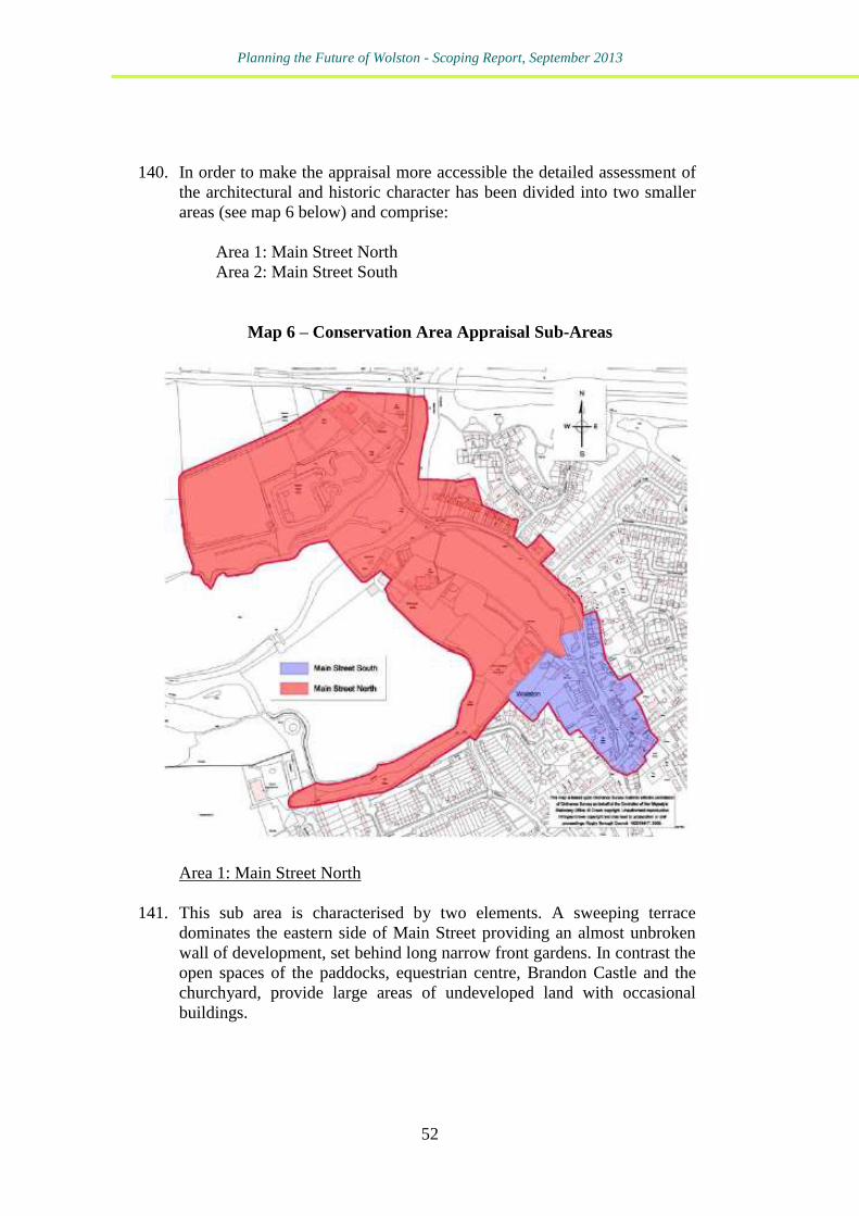
Planning the Future of Wolston - Scoping Report, September 2013
52
140. In order to make the appraisal more accessible the detailed assessment of
the architectural and historic character has been divided into two smaller
areas (see map 6 below) and comprise:
Area 1: Main Street North
Area 2: Main Street South
Map 6 – Conservation Area Appraisal Sub-Areas
Area 1: Main Street North
141. This sub area is characterised by two elements. A sweeping terrace
dominates the eastern side of Main Street providing an almost unbroken
wall of development, set behind long narrow front gardens. In contrast the
open spaces of the paddocks, equestrian centre, Brandon Castle and the
churchyard, provide large areas of undeveloped land with occasional
buildings.
Planning the Future of Wolston - Scoping Report, September 2013
53
Area 2: Main Street South
142. This sub area represents a significant change in character from the
northern section. The grass verges and broader highway creates a focal
point at the southern end of Main Street with buildings on both sides of
the road. There is no single characteristic style of architecture, instead
there is a mix of buildings in appearance and stature. The built
development comprises buildings read as groups, individual buildings of
different characters and terraces. Density of development is higher with
buildings to all sides. 143. The Conservation Area Appraisal also identifies the significant
contribution of unlisted buildings, street furniture and key views and
vistas which should be protected.
144. It is concluded that the overall historic character of Wolston Conservation
Area has been well maintained and most architectural details in the older
buildings have been preserved. The overall quality of the Conservation
Area remains high with the traditional buildings prevailing. Changes have
taken place to buildings but the designation retains its integrity despite the
scale of the twentieth century development to the east and south.
Enhancements could be achieved however with the reduction in the
impact of the larger expanses of tarmac and car parking and the
reinstatement of missing original features or materials.
145. A number of opportunities for enhancement are identified and it may be
appropriate for a village design statement or neighbourhood plan to
consider the inclusion of policies to support some of these:
replace uPVC/non original timber fenestration with timber using the
original windows as reference;
delineate the main highways with areas used for car parking. Blue
engineering bricks, granite setts etc. could be used to reduce the
expanse of tarmac to the foreground of the pubs and buildings on the
western side of Main Street;
place overhead wires underground;
use consistent approach to bollards, e.g. all timber;
use consistent approach to street lighting and road signs in a style to
reflect the rural location;
replace any non native trees with native species;
enhance the facades of the buildings fronting onto the southern end
of Main Street, improve the shop fronts and aim to achieve a more
cohesive appearance;
establish a management plan for Brandon Castle;
Planning the Future of Wolston - Scoping Report, September 2013
54
provide further landscaping to the farm and equestrian buildings;
reduce the impact of hardstanding on the front gardens of the
northern terracing. Smaller areas of blue engineering bricks with
gravel between reduces the visual impact. Maintain landscaping to
the front parts of the front gardens;
establish a management plan for the Grove Plantation.
Rugby Open Space Audit, Rugby Borough Council, 200815
146. The Open Space Audit provides a comprehensive Borough-wide audit of
the distribution, quantity and quality of Rugby’s open spaces and play
facilities. The Audit includes an assessment of the open space and
recreational needs of the open space and recreational needs of the local
community.
147. The audit assessed 15 open spaces in the parish. Four of these were
considered high quality/high value: Warwick Road allotments, the Village
Green; the Burial Ground at Dyers Lane; and the Dyers Lane Recreation
Ground.
148. The remaining sites were considered to be of high quality/low value.
15
http://www.rugby.gov.uk/site/scripts/download_info.php?fileID=3495
Planning the Future of Wolston - Scoping Report, September 2013
55
Warwickshire, Coventry and Solihull Sub-Regional Green
Infrastructure Strategy, February 201316
149. At the moment this is a consultation document. It starts from the basis
that:
“Green Infrastructure is a network of multifunctional greenspace,
both new and existing, both rural and urban, which supports the
natural and ecological processes and is integral to the health and
quality of life of sustainable communities.”
The purpose of the Strategy is to provide evidence for the preparation of
plans, policies and strategies relating to Green Infrastructure (GI) at a sub-
regional level and at a local level.
Rugby Community Infrastructure Levy Preliminary Draft Charging
Schedule, Sept 201217
150. The Community Infrastructure Levy (CIL) is a new tariff that developers
pay on commencement of new development. This tariff is then used by
local authorities to help fund infrastructure to support new development in
their area. It is a fixed rate charge, based on square metre net additional
floorspace. It is set by the local authority (the Charging Authority) in a
Charging Schedule, and is based on evidence of infrastructure needs and
the level of development viability across the Borough. It is not intended to
cover all the costs of providing infrastructure but will be an important
funding source to help deliver growth within the Borough.
151. CIL will supplement and partially replace the current system of securing
developer contributions or planning obligations via Section 106
agreements. Section 106 agreements will still be sought, but mainly to
secure on-site infrastructure necessary to enable development to come
forward.
152. Rugby Borough Council has published a Preliminary Draft Charging
Schedule for consultation.
153. New development, including extensions to buildings, which are over 100
square metre (sq. m.) gross internal floorspace are liable to pay CIL. All
new dwellings regardless of their size are also liable. CIL is only
chargeable on net new floorspace.
154. Table 7 shows the proposed CIL rates for different development types.
The physical extent of the residential charging zones is shown in Map 7
below. Wolston falls in Zone B CIL is proposed to be levied at £50 per sq.
16
http://www.rugby.gov.uk/site/scripts/download_info.php?fileID=5875 17
http://www.rugby.gov.uk/site/scripts/download_info.php?fileID=5637
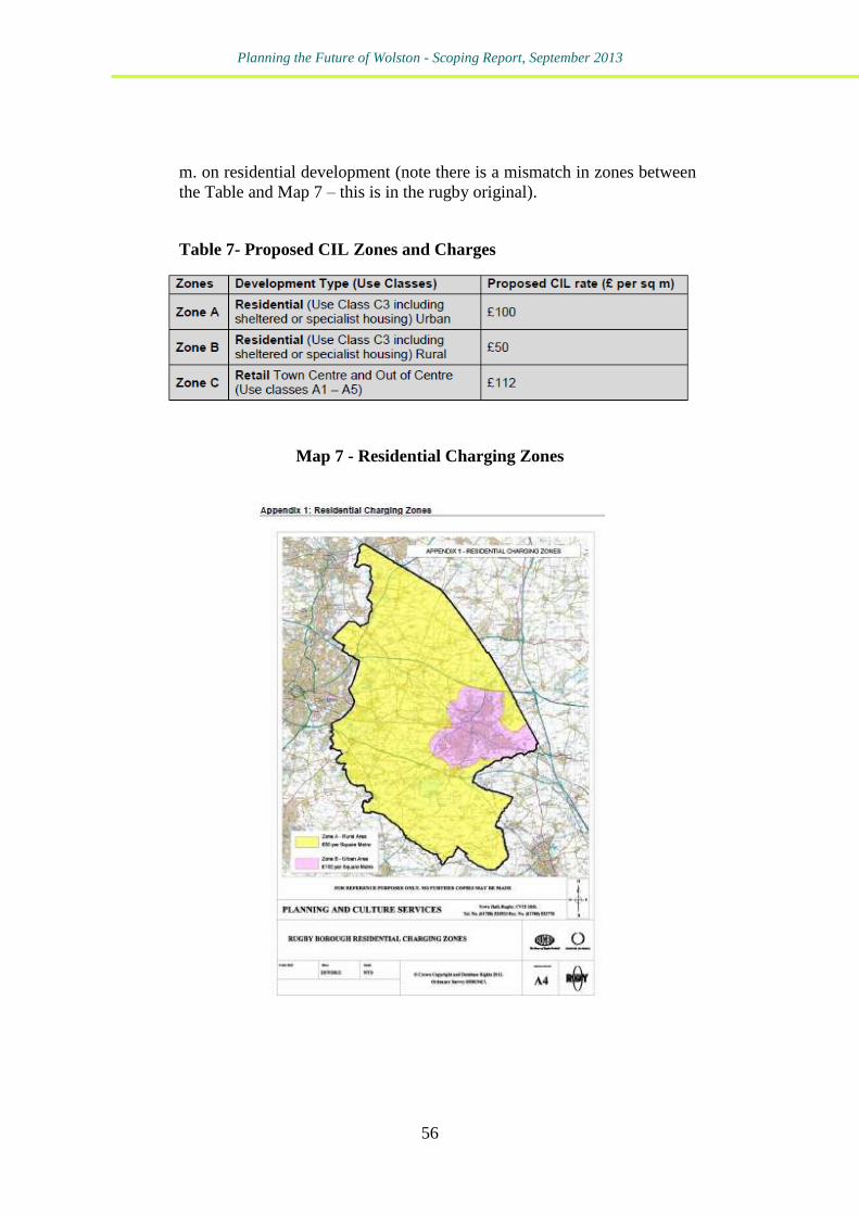
Planning the Future of Wolston - Scoping Report, September 2013
56
m. on residential development (note there is a mismatch in zones between
the Table and Map 7 – this is in the rugby original).
Table 7- Proposed CIL Zones and Charges
Map 7 - Residential Charging Zones
Planning the Future of Wolston - Scoping Report, September 2013
57
Other relevant Local Plan evidence base documents
Landscape Assessment of the Borough of Rugby Sensitivity and
Condition Survey18
155. This is a broad scale landscape assessment and sensitivity analysis of the
Borough of Rugby.
Sensitivity analysis
156. Landscape sensitivity is a measure of the degree to which the countryside
can accept change without causing irreparable, long term damage to the
essential character and fabric of the landscape. Sensitivity is closely
related to the nature and pattern of key elements that define the character
of a particular landscape and any analysis of sensitivity needs to look
separately at the fragility of the inherent (natural and cultural) pattern
and the degree of visibility within each landscape. The concept of
fragility is related to the extent to which change may result in the loss of
features, or patterns that cannot be easily replaced. The concept of
visibility relates to the degree to which change is likely to cause a visual
impact within a particular landscape.
18
Produced by Environmental Design Group, Warwickshire CC
http://www.warwickshire.gov.uk/Web/corporate/wccweb.nsf/Links/C7131B28880DCAE08
0257861003A09CB/$file/Landscape_assessment_Rugby.pdf
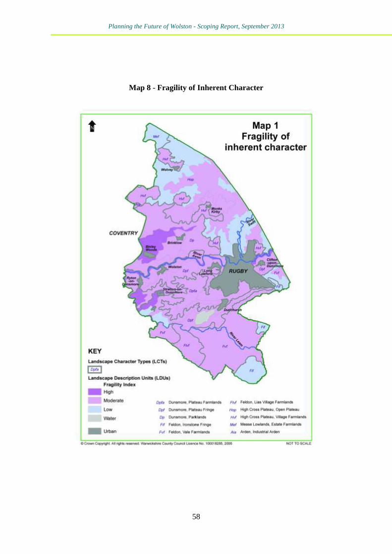
Planning the Future of Wolston - Scoping Report, September 2013
58
Map 8 - Fragility of Inherent Character
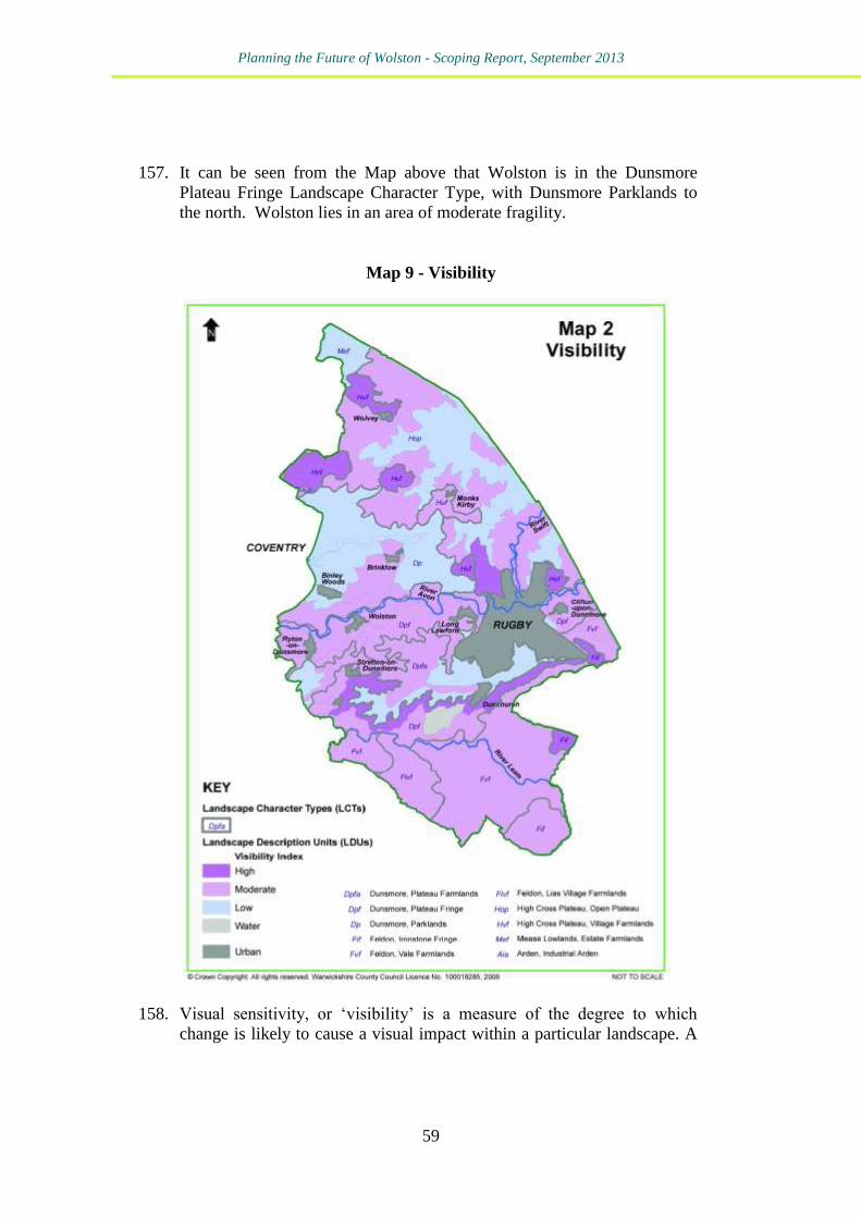
Planning the Future of Wolston - Scoping Report, September 2013
59
157. It can be seen from the Map above that Wolston is in the Dunsmore
Plateau Fringe Landscape Character Type, with Dunsmore Parklands to
the north. Wolston lies in an area of moderate fragility.
Map 9 - Visibility
158. Visual sensitivity, or ‘visibility’ is a measure of the degree to which
change is likely to cause a visual impact within a particular landscape. A
Planning the Future of Wolston - Scoping Report, September 2013
60
visibility index can be defined by looking at the relationship between the
prominence of landform and the nature/extent of tree cover. From the
Map above it can be seen that Wolston is in an area identified as Moderate
on the Visibility Index.
Landscape Character Types
159. Wolston lies within the Dunsmore Landscape Character Type.
160. The area known as Dunsmore is characterised by a range of historical and
ecological associations, which are strongly influenced by the underlying
geology of the region. It lies almost wholly within Rugby Borough,
comprising an area of low glacial plateaux and incised, meandering river
valleys lying between Leamington Spa, Coventry and Rugby. The
widespread occurrence of glacial sands and gravels is reflected in the
strong association with former common and heath. Although none of the
heath remains today, the occurrence of remnant heathy vegetation, the late
enclosure pattern of large geometric fields, and the abundance of "Heath"
names, all impart a strong sense of regional identity. Light sandy soils and
large geometric fields have resulted in an intensively farmed landscape.
The extent of semi-natural habitat is therefore rather limited to: pockets of
unimproved grasslands; flood meadows and associated wetland habitats
along the river corridors; and to two major ancient woodland complexes
to the south and east of Coventry. These ancient woodlands, together
with characteristic mature hedgerow oaks, and historic parklands, give
this region a well-wooded appearance.
161. Dunsmore can be sub-divided into three different landscape types, each of
which is characterised by a particular aspect of the wider regional
character:
Plateau Farmlands
Plateau Fringe
Dunsmore Parklands
162. Wolston lies within the Plateau Fringe with Dunsmore Parklands to the
north.
Plateau Fringe
Planning the Future of Wolston - Scoping Report, September 2013
61
163. The Plateau Fringe is a rather variable landscape with an undulating
topography of low rounded hills, broad valleys, and short, steep slopes
occurring on the northern and southern edge of the Dunsmore plateau. For
the most part it is a large-scale, intensively farmed agricultural landscape,
characterised by large arable fields, often with a poorly defined field
pattern.
164. In places, however, there are smaller scale pockets of permanent pasture
and smaller hedged fields, usually associated with more steeply sloping
ground. The narrow meandering river valleys of the Avon and Leam are
also noteworthy features within this landscape with large arable fields
often sweeping down to the river’s edge. Pockets of river meadowland
still survive in places, notably on the Avon at Little Lawford. Small
nucleated villages are also a characteristic feature and contrast with the
sparsely populated nature of the adjoining Plateau Farmlands.
165. Sensitivity – Fragility: Cultural sensitivity is moderate due to the historic,
coherent pattern within this LCT. Ecological sensitivity is low with the
exception of: the moderately sensitive steeper slopes of southern
escarpment which fall towards Feldon; and the highly sensitive River
Avon.
166. Sensitivity – Visibility: Visibility is generally moderate due to the
presence of small woods and trees superimposed over a rolling
topography. On the slopes of the southern escarpment, however, visibility
is high.
167. Overall sensitivity: With the exception of the southern escarpment and the
River Avon, overall sensitivity is moderate, with visibility being the
limiting factor.
168. Condition: To the north, the Plateau Fringe is generally in decline with
the exception of an area of parkland between the River Avon and Long
Lawford, and land around Church Lawford and King’s Newnham, where
the condition is strong. The southern fringe or escarpment on the other
hand, is not only highly sensitive, but also largely in strong condition,
making this an important feature to the south of the town.
Dunsmore Parklands
Planning the Future of Wolston - Scoping Report, September 2013
62
169. Dunsmore Parklands is a gently rolling estate landscape with a well-
wooded character, defined by woodland edges, parkland and belts of
trees. Wooded streamlines and mature hedgerow and roadside trees,
(typically oak), reinforce this impression by creating a sequence of linked
wooded spaces. Large blocks of woodland and smaller coverts help to
create a sense of scale and enclosure in an otherwise intensively farmed
landscape. Field pattern is large but poorly defined, and in places absent
altogether, allowing middle distant views to wooded skylines.
170. Sensitivity – Fragility: Cultural sensitivity is generally moderate due to
the historic coherent pattern which exists in this area. Where it is high this
is due to a slightly older, more unified pattern (ancient woodlands are
contributing to this pattern). Overall ecological sensitivity is moderate due
to the ancient wooded landscape character.
171. Sensitivity – Visibility: Visibility is generally low, due both to the level of
tree cover, as well as to the low-lying, rolling topography. It is moderate
when tree cover is reduced.
172. Overall sensitivity: Overall sensitivity is moderate as a result of both
cultural (time depth) and ecological factors – primarily ancient
woodlands.
173. Condition: Apart from an area to the south of Harborough Parva, where
the condition is strong, this area is generally in decline.

Planning the Future of Wolston - Scoping Report, September 2013
63
Planning the Future of Wolston - Scoping Report, September 2013
64
6 - Key Issues Facing Wolston
174. The desktop review of relevant published planning related documents
above provides an indication of the main planning issues facing the parish
of Wolston. Briefly these can be summarised as:
The need to protect the existing high quality environment,
landscapes and countryside around the village
Protection of the Green Belt
The need to improve traffic management and car parking
The need to protect existing local community facilities
An identified local housing need for 15 affordable dwellings
Possible threat of new housing on larger sites one of which is
identified, albeit considered undeliverable in the latest SHLAA
The need to protect and enhance the Conservation Area and to
promote high quality design which reflects the distinctive
historic character and setting of the village
Consideration of existing identified open spaces and whether
these require improvement, together with possible identification
of other spaces which are of local importance and need
protection.
Concerns about the direction of some of the policies in the new
Local Plan and the level of detail they will have concerning
Wolston.
175. In addition the Parish Council has provided Kirkwells with Map 10 below
which illustrates discussions so far around future planning and land use
issues.
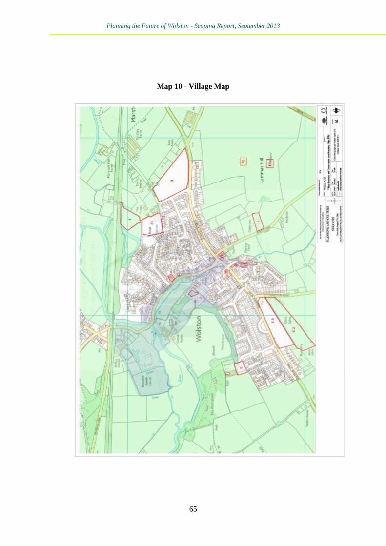
Planning the Future of Wolston - Scoping Report, September 2013
65
Map 10 - Village Map
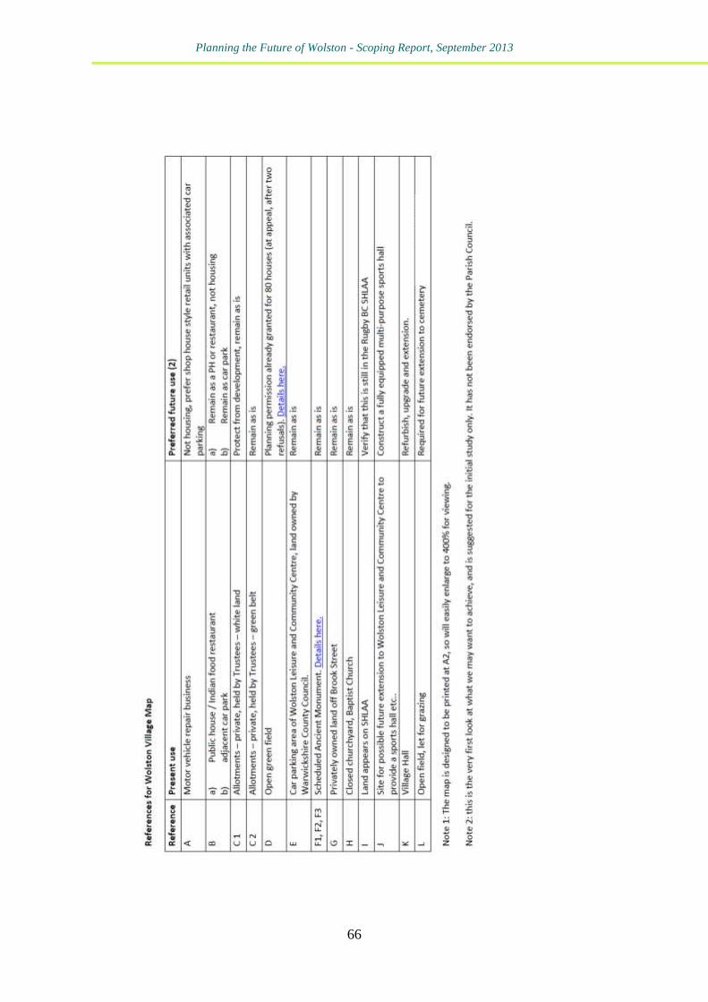
Planning the Future of Wolston - Scoping Report, September 2013
66

Planning the Future of Wolston - Scoping Report, September 2013
67
Planning the Future of Wolston - Scoping Report, September 2013
68
7 -How the Key Issues Facing Wolston could be
addressed through the Various Types of Plan
176. This section of the report provides an assessment of how the various
routes available to the Parish Council could potentially address the key
issues facing Wolston. This section also estimates cost and identifies
possible sources of funding.
177. Aside from “do nothing”, something that we assume the parish council do
not want to do, given the active involvement in planning consultations and
the previous work on a parish plan, these routes are:
Route 1 - The Rugby Local Plan
Route 2 - A new Wolston Parish Plan
Route 3 - A Wolston Village Design Statement
Route 4 - A Wolston Neighbourhood Plan
Route 1 - The Rugby Local Plan
178. Following this route would see the Parish Council reacting as a consultee.
It would be relatively inexpensive, unless, say, professional help were
needed to put together objections, or to represent the Parish at any
examination in to the Local Plan.
179. In our opinion, based on the Core Strategy, and some of the emerging
Local Plan policy work, contained in the Local Plan Discussion
Document, some areas of policy are very strong and may not need adding
to by the parish through a plan, of any kind, of their own. And, by
continuing to influence the development of the Local Plan through the
making of representations the Parish may well secure a Local Plan that
perfectly reflects how the Parish would wish to see Wolston develop to
2026, and would be fit for purpose for the determination of any planning
applications in Wolston.
180. Clearly, however, through the Parish’s own comments on the Local Plan
Discussion Document there are other areas where the Parish feel emerging
Local Plan policy may be less robust, and, in some cases, e.g. open space,
weaker than existing policy. Our advice is, in this instance, that if the
Parish Council wishes to add to, enhance, or strengthen Local Plan policy
then the best route to do this is a statutory neighbourhood plan.
Planning the Future of Wolston - Scoping Report, September 2013
69
Route 2 - A new Wolston Parish Plan
181. A new parish plan for Wolston could review and refresh the 2006 Parish
Plan. It has the advantages of being relatively quick to prepare (not having
some of the procedural hoops Local Plans and Neighbourhood Plans have
to follow), it would also be relatively inexpensive (c. £2-3,000, all figures
exclude VAT).
182. Policy CS2 of the Core Strategy is, in our opinion, a very good strategic
policy under which to prepare a parish plan. In that if prepared in line
with CS2 such a plan would inform the determination of planning
applications; the setting of development contributions associated with
planning permissions; and the assessment of schemes in the context of
identified needs.
183. To have a Wolston Parish Plan that could inform future planning
decisions the parish would have to prepare it in accordance with CS2 and
this would mean: having the plan endorsed by Rugby Borough Council;
making sure the parish plan is in conformity with the Local Development
Framework (Core Strategy and Local Plan); and that the plan is regularly
updated.
184. We would note here that whilst CS2 is a strong policy some of the bars it
sets are very similar to those for a neighbourhood plan, i.e. submission to
Rugby Borough; ensuring conformity; and the keeping of an up to date
plan.
Route 3 - A Wolston Village Design Statement
185. In contrast to the other plan routes available to the parish a Village Design
Statement is much more of a “single issue” document. If future design is
the key issue the parish wish to address this is the document to prepare. In
our opinion, the issues faced by Wolston, and the issues they wish to
address go beyond design and are concerned with future land use, the
control of development, and improved services.
186. The costs to prepare such a document are probably in the region of c. £3-
5,000 depending on the level of professional support required.
Route 4 - A Wolston Neighbourhood Plan
187. A Wolston Neighbourhood Plan would be the most expensive of the four
options. In our experience, depending on the level of outside professional
assistance required, this would be in the region of £4,000 to £9,000. It
Planning the Future of Wolston - Scoping Report, September 2013
70
may also be the most demanding and time-consuming, although the
requirements of Policy CS2 may make the development of Rugby
approved parish plan more demanding than the previous version. But with
an early application for designation as a neighbourhood planning area,
and a Core Strategy in place, Wolston could have a draft plan ready for
submission to Rugby within 12 months. All of the other routes are of a
similar timescale.
188. Our view is that given the Parish Council are also concerned about
planning policy and the allocation/designation of sites that this should be
a policy and allocations plan. Map 10 is a good starting point for this.
Such a plan would allow the Parish to set more detailed planning policy
for Wolston, and e.g. to identify infill sites for new housing, or the local
green spaces for protection.
189. However, what a neighbourhood plan would offer is the opportunity for
the parish to set local planning policy that would be part of the statutory
development plan system and would be used in the future determination
of planning applications. In effect, taking some power and control from
the Borough Council.
190. Having examined the key issues facing Wolston and the concerns of the
Parish Council about emerging Local Plan policy our view is that a
neighbourhood plan offers Wolston the best way of achieving what it
wants. A neighbourhood plan would set planning policy, could look at a
Wolston specific design policy, or policies, that would be stronger than a
Village Design Statement. A neighbourhood plan could also be used to
“flag up” service improvements and other non-planning issues, and
identify actions the parish and others would take outside the
neighbourhood plan to seek improvements.
Possible Funding Sources
Route 1 - The Rugby Local Plan
Funding for this activity would have to come from the parish
council’s own resources.
Route 2 - A new Wolston Parish Plan
Parish council’s own resources; Big Lottery Fund Awards
for All grants of £300-£10,000.
Route 3 - A Wolston Village Design Statement
Planning the Future of Wolston - Scoping Report, September 2013
71
Parish council’s own resources; Big Lottery Fund Awards
for All grants of £300-£10,000.
Route 4 - A Wolston Neighbourhood Plan
Parish council’s own resources; Big Lottery Fund Awards
for All grants of £300-£10,000. Locality grants for
neighbourhood planning £500-£7,000, also available is
direct support. Should Wolston decide to prepare a
neighbourhood plan Rugby Borough would also receive
£5,000 on Wolston’s designation as a neighbourhood
planning area, £5,000 on publication of a plan before
examination; and £20,000 once a plan has successfully
passed through examination. There is no requirement any of
this funding is passed to the parish, but the letter from
Department of Communities and Local Government
announcing its availability to local planning authorities is
clear the spending of it should be discussed with the parish.
Planning the Future of Wolston - Scoping Report, September 2013
72
8 - Conclusions and Recommendations
191. Wolston faces a number of key planning issues. It appears to be an active
parish council and has shown this in the past with the preparation of a
parish plan. We would the recommend following to the Parish:
a. The Parish continues to engage with Rugby Borough and makes
further representations on the Local Plan, pursuing these at
examination if necessary;
b. The Parish looks to prepare a neighbourhood plan. In doing this they
take the following actions:
i. They seek designation as a neighbourhood planning area by
making an application to Rugby Borough Council.
ii. Following designation the Parish makes a grant application
to Locality for neighbourhood planning support.
192. We have reached these conclusions based on the challenges Wolston
faces, most are development plan issues. Therefore, a neighbourhood plan
is the most effective way for Wolston to address these development issues
and have a greater say in how the parish develops in the future.
193. We would make two final observations; much of the foregoing discussion
has concerned the village itself. In our opinion, a neighbourhood plan, if it
is to be pursued, should cover the whole parish and careful thought would
need to be given to how the whole parish is engaged and involved in the
plan’s preparation. The second observation is that parishes with a
neighbourhood plan would receive 25% of any Community Infrastructure
Levy gathered in their area, as against 10% for parishes without a
neighbourhood plan.

Planning the Future of Wolston - Scoping Report, September 2013
73

Planning the Future of Wolston - Scoping Report, September 2013
74
Planning the Future of Wolston - Scoping Report, September 2013
75
For more information on the contents of this document contact:
Michael Wellock or Louise Kirkup
Kirkwells
Lancashire Digital Technology Centre
Bancroft Road
Burnley
Lancashire
BB10 2TP
01282 872570

Planning the Future of Wolston - Scoping Report, September 2013
76