hvdc cable route scoping report - northconnect · 2016-04-25_northconnect_per_rep_hvdc scoping...
TRANSCRIPT
2016-04-25_NorthConnect_PER_REP_HVDC Scoping Report_Rev A
HVDC Cable Route Scoping Report
2016.04.25_NorthConnect_PER_REP_HVDC Scoping Report_ Rev A
Last approval: 2016.04.25
Date: 2016.04.25
By:Fiona Henderson
Control:Richard Blanchfield
Approved by:Øyvind Otterson
2016-04-25_NorthConnect_PER_REP_HVDC Scoping Report_Rev A
ContentsGLOSSARY ............................................................................................................................................ 1
1 INTRODUCTION ....................................................................................................................... 4
2 PROPOSED DEVELOPMENT ................................................................................................. 7
2.1 NORTHCONNECT JOINT VENTURE .................................................................................... 72.2 PROJECT DESCRIPTION ...................................................................................................... 72.3 SCOPE OF PLANNING AND MARINE LICENSE APPLICATION ........................................... 8
2.3.1 Onshore Cabling .............................................................................................................................. 82.3.2 Horizontal Directional Drilling ................................................................................................ 92.3.3 Offshore Cabling ........................................................................................................................... 102.3.4 Fibre Optic Utility Building ..................................................................................................... 102.3.5 Temporary Construction Requirements ............................................................................ 10
2.4 LOCATION .......................................................................................................................... 112.4.1 Landfall and Onshore Cable Corridor................................................................................. 112.4.2 Offshore Corridor ......................................................................................................................... 12
2.5 PROJECT PHASES .............................................................................................................. 122.5.1 Programme ..................................................................................................................................... 122.5.2 Construction and Installation ................................................................................................ 132.5.3 Operation and Maintenance ................................................................................................... 132.5.4 Decommissioning ......................................................................................................................... 13
3 CONSENTING PERMITTING AND LICENSE PROCESS ................................................. 15
3.1 MARINE LICENCE.............................................................................................................. 153.2 MARINE PRE-APPLICATION CONSULTATION (PAC) ................................................... 153.3 PLANNING CONSENT ........................................................................................................ 153.4 EUROPEAN PROTECTED SPECIES (EPS) LICENCE ........................................................ 153.5 HABITATS REGULATION APPRAISAL (HRA)................................................................. 163.6 THE WATER ENVIRONMENT REGULATIONS ................................................................. 163.7 DEVELOPMENT AND PLANNING POLICY CONTEXT ....................................................... 17
3.7.1 Planning Policy ............................................................................................................................. 173.7.2 Marine Planning ........................................................................................................................... 183.7.3 Proposed Assessment ................................................................................................................. 20
4 CUMULATIVE .......................................................................................................................... 21
5 AIR QUALITY ........................................................................................................................... 25
5.1 POLICY AND GUIDANCE .................................................................................................... 255.2 BASELINE........................................................................................................................... 255.3 POTENTIAL IMPACTS ........................................................................................................ 25
5.3.1 Installation ...................................................................................................................................... 255.3.2 Operation ......................................................................................................................................... 265.3.3 Decommissioning ......................................................................................................................... 26
5.4 PROPOSED ENVIRONMENTAL IMPACT ASSESSMENT .................................................... 265.4.1 Dust .................................................................................................................................................... 265.4.2 Carbon Dioxide .............................................................................................................................. 26
6 ARCHAEOLOGY AND CULTURAL HERITAGE ................................................................ 28
6.1 POLICY AND GUIDANCE .................................................................................................... 286.2 BASELINE........................................................................................................................... 28
2016-04-25_NorthConnect_PER_REP_HVDC Scoping Report_Rev A
6.2.1 Onshore ............................................................................................................................................. 286.2.2 Offshore ............................................................................................................................................ 32
6.3 POTENTIAL IMPACTS ........................................................................................................ 326.3.1 Construction and Installation ................................................................................................ 326.3.2 Operation ......................................................................................................................................... 326.3.3 Decommissioning ......................................................................................................................... 33
6.4 PROPOSED ENVIRONMENTAL IMPACT ASSESSMENT .................................................... 337 ECOLOGY AND NATURE CONSERVATION...................................................................... 34
7.1 APPLICABLE POLICIES & GUIDANCE............................................................................... 347.2 DESIGNATED SITES ........................................................................................................... 347.3 BASELINE........................................................................................................................... 36
7.3.1 Habitat Types ................................................................................................................................ 367.3.2 Bats ..................................................................................................................................................... 377.3.3 Otters ................................................................................................................................................. 377.3.4 Water Vole ...................................................................................................................................... 377.3.5 Badgers ............................................................................................................................................. 377.3.6 Amphibians and Reptiles .......................................................................................................... 387.3.7 Ornithology ..................................................................................................................................... 387.3.8 Marine Mammals ......................................................................................................................... 397.3.9 Fish ..................................................................................................................................................... 397.3.10 Benthic Ecology ....................................................................................................................... 40
7.4 POTENTIAL IMPACTS ........................................................................................................ 407.4.1 Construction and Installation ................................................................................................ 407.4.2 Operation ......................................................................................................................................... 427.4.3 Decommissioning ......................................................................................................................... 42
7.5 PROPOSED ENVIRONMENTAL IMPACT ASSESSMENT .................................................... 437.5.1 Onshore Ecology ........................................................................................................................... 437.5.2 Ornithology ..................................................................................................................................... 437.5.3 Marine Mammals ......................................................................................................................... 447.5.4 Fish ..................................................................................................................................................... 447.5.5 Benthic Ecology ............................................................................................................................ 45
8 ELECTRIC AND MAGNETIC FIELDS .................................................................................. 47
8.1 POLICIES AND GUIDELINES .............................................................................................. 478.2 BASELINE........................................................................................................................... 48
8.2.1 Receptors ......................................................................................................................................... 488.3 POTENTIAL IMPACTS ........................................................................................................ 48
8.3.1 Construction & Installation ..................................................................................................... 488.3.2 Operation ......................................................................................................................................... 488.3.3 Decommissioning ......................................................................................................................... 49
8.4 PROPOSED ENVIRONMENTAL IMPACT ASSESSMENT .................................................... 498.4.1 Electric Fields ................................................................................................................................ 498.4.2 Magnetic Fields ............................................................................................................................. 49
9 LANDSCAPE, SEASCAPE AND VISUAL ............................................................................. 51
9.1 POLICY AND GUIDANCE .................................................................................................... 519.2 BASELINE........................................................................................................................... 52
9.2.1 Receptors ......................................................................................................................................... 539.3 POTENTIAL IMPACTS ........................................................................................................ 53
9.3.1 Construction and Installation ................................................................................................ 539.3.2 Operation ......................................................................................................................................... 54
2016-04-25_NorthConnect_PER_REP_HVDC Scoping Report_Rev A
9.3.3 Decommissioning ......................................................................................................................... 549.4 PROPOSED ENVIRONMENTAL IMPACT ASSESSMENT .................................................... 54
10 LAND & SEABED QUALITY .................................................................................................. 55
10.1 POLICY AND GUIDANCE .................................................................................................... 5510.2 BASELINE........................................................................................................................... 5610.3 POTENTIAL IMPACTS ........................................................................................................ 57
10.3.1 Construction and Installation .......................................................................................... 5710.3.2 Operation ................................................................................................................................... 5810.3.3 Decommissioning ................................................................................................................... 58
10.4 PROPOSED ENVIRONMENTAL IMPACT ASSESSMENT .................................................... 5811 LOCAL COMMUNITY AND ECONOMY .............................................................................. 60
11.1 POLICY AND GUIDANCE .................................................................................................... 6011.2 BASELINE........................................................................................................................... 6011.3 POTENTIAL IMPACTS ........................................................................................................ 61
11.3.1 Construction and Installation .......................................................................................... 6111.3.2 Operation ................................................................................................................................... 6211.3.3 Decommissioning ................................................................................................................... 62
11.4 PROPOSED ENVIRONMENTAL IMPACT ASSESSMENT .................................................... 6212 NOISE AND VIBRATION (IN-AIR) ..................................................................................... 64
12.1 POLICY AND GUIDANCE .................................................................................................... 6412.2 BASELINE........................................................................................................................... 64
12.2.1 Receptors .................................................................................................................................... 6412.3 POTENTIAL IMPACTS ........................................................................................................ 65
12.3.1 Construction and Installation .......................................................................................... 6512.3.2 Operation ................................................................................................................................... 6512.3.3 Decommissioning ................................................................................................................... 65
12.4 PROPOSED ENVIRONMENTAL IMPACT ASSESSMENT .................................................... 6513 NOISE AND VIBRATION (UNDERWATER) ..................................................................... 67
13.1 POLICY AND GUIDANCE .................................................................................................... 6713.2 BASELINE........................................................................................................................... 6713.3 POTENTIAL IMPACTS ........................................................................................................ 67
13.3.1 Construction & Installation ............................................................................................... 6713.3.2 Operation ................................................................................................................................... 6913.3.3 Decommissioning ................................................................................................................... 69
13.4 PROPOSED ENVIRONMENTAL ASSESSMENT .................................................................. 6914 RESOURCE USAGE AND WASTE ........................................................................................ 70
14.1 POLICY AND GUIDANCE .................................................................................................... 7014.2 POTENTIAL IMPACTS ........................................................................................................ 70
14.2.1 Construction and Installation .......................................................................................... 7014.2.2 Operation ................................................................................................................................... 7114.2.3 Decommissioning ................................................................................................................... 71
14.3 PROPOSED ENVIRONMENTAL ASSESSMENT .................................................................. 7215 SHIPPING .................................................................................................................................. 73
15.1 APPLICABLE POLICIES & GUIDANCE............................................................................... 7315.2 BASELINE........................................................................................................................... 73
2016-04-25_NorthConnect_PER_REP_HVDC Scoping Report_Rev A
15.3 POTENTIAL IMPACTS ........................................................................................................ 7415.3.1 Construction & Installation ............................................................................................... 7415.3.2 Operation ................................................................................................................................... 7415.3.3 Decommissioning ................................................................................................................... 75
15.4 PROPOSED ENVIRONMENTAL ASSESSMENT .................................................................. 7516 TRAFFIC AND ACCESS .......................................................................................................... 76
16.1 POLICY AND GUIDANCE .................................................................................................... 7616.2 BASELINE........................................................................................................................... 7616.3 POTENTIAL IMPACTS ........................................................................................................ 77
16.3.1 Construction ............................................................................................................................. 7716.3.2 Operation ................................................................................................................................... 7816.3.3 Decommissioning ................................................................................................................... 78
16.4 PROPOSED ENVIRONMENTAL IMPACT ASSESSMENT .................................................... 7817 WATER QUALITY ................................................................................................................... 79
17.1 POLICY AND GUIDANCE .................................................................................................... 7917.2 BASELINE........................................................................................................................... 79
17.2.1 Onshore ....................................................................................................................................... 7917.2.2 Offshore ....................................................................................................................................... 79
17.3 POTENTIAL IMPACTS ........................................................................................................ 8017.3.1 Construction and Installation .......................................................................................... 8017.3.2 Operation ................................................................................................................................... 8117.3.3 Decommissioning ................................................................................................................... 81
17.4 PROPOSED ENVIRONMENTAL IMPACT ASSESSMENT .................................................... 8118 CONCLUSION ........................................................................................................................... 82
19 REFERENCES ........................................................................................................................... 84
APPENDIX A - EXTENDED PHASE 1 HABITAT SURVEY
1
Glossary
Term / Abbreviation Definition / Expansion
AA Appropriate AssessmentAC Alternating CurrentACSEF Aberdeen City and Shire Economic FutureADTFs Average Daily traffic FlowsAIS Automated Identification SystemALDP Aberdeenshire Local Development PlanCAR Controlled Activities RegulationsCEMD Construction Environmental Management DocumentConverter Station Shorthand for - interconnector converter stationdB decibelDC Direct CurrentdSPA Draft Special Protection AreaEIA Environmental Impact AssessmentEMF Electromagnetic FieldEPS European Protected SpeciesES Environmental StatementFourfields Site name GEN General Planning PrinciplesGLVIA Guidelines for Landscape and Visual Impact
AssessmentGW Giga WattHa HectaresHDD Horizontal Directional DrillingHPA Health Protection AgencyHRA Habitats Regulations Appraisal HVAC High Voltage Alternating CurrentHVDC High Voltage Direct CurrentIAQM Institute of Air Quality ManagementIEMA Institute of Environmental Management and
AssessmentIEEM Institute of Ecology and Environmental ManagementIMO International Marine OrganisationInterconnector converter station
The station converting the HVDC electricity to HVAC on import from the interconnector and HVAC to HVDC on export to the interconnector.
JNCC Joint Nature Conservation CommitteekV kilovoltLA10,18h The A-weighted sound pressure level exceeded for 10%
of the 18 hour monitoring period.LA90, 5min The A-weighted sound pressure level exceeded for 90%
of a 5 minute monitoring period.
LAeq,duration The equivalent A-weighted continuous sound pressure
2
Term / Abbreviation Definition / Expansion
level measured over a given duration. When a noise varies over time, the LAeq is the equivalent continuous sound which would contain the same sound energy as the time varying sound.
LCT µ TypeLDP Local Development PlanLonghaven Longhaven village, and used in the names of some
historical sitesLong Haven The Coastal Bay, and used in the names of some
historical sitesMESH Mapping European Seabed HabitatsMHWS Mean High Water SpringsMLWS Mean Low Water Springs MNNS Marine Non Native SpeciesMPA Marine Protection AreaMS-LOT Marine Scotland – Licensing Operations TeamMSS Marine Scotland Scienceµg/m3 Micro gram per cubic meterµT Micro TeslaMW Mega WattNM Nautical MilesNMP National Marine PlanNPF National Planning FrameworkNPF3 Third National Planning Frameworkonshore HVDC interconnector cables
Onshore components comprising the DC connection cables from the converter station site to mean lowwater spring tide level - treated as a separate element for onshore Planning
offshore HVDC interconnector cables
The DC connection cables from mean high water spring tide level to the extent of UK Territorial Waters – for the purpose of Marine Licensing
PAC Pre-Application ConsultationPAN Planning Advice NotesPM10 Particulate Matter with a diameter less than or equal
to 10 micro meterspMPA Proposed Marine Protection AreaPPG Pollution Prevention GuidelinesRCAHMS The Royal Commission on the Ancient and Historical
Monuments of ScotlandSAC Special Area of ConservationSDP Strategic Development PlanSEPA Scottish Environment Protection AgencySNH Scottish Natural HeritageSPA Special Protection AreaSPP Scottish Planning PolicySSSI Special Site of Scientific Interest

3
Term / Abbreviation Definition / Expansion
UNCLOS United Nations Convention on the Law of the SeaV/m Volts per meterWFD Water Framework Directive
4
1 IntroductionA scoping opinion is requested by NorthConnect for the voluntary Environmental Statement (ES) that will be produced to support the planning application and marine licence for the High Voltage Direct Current (HVDC) Interconnector cable route. The HVDC cables will connect the Interconnector Converter Station on the ‘Fourfields’ site near Boddam, Peterhead to the Converter Station located in Simadalen, Norway. The Interconnector Converter Station at Fourfields and the associated High Voltage Alternating Current (HVAC) connection to the Peterhead Substation was granted planning permission in September 2015 [Aberdeenshire Council, 2015].
A fibre optic cable may be laid across the seabed with the HVDC cables and will connect into the existing fibre optic network which runs parallel to the A90 between Longhaven and Peterhead. This may require a utility building to house a repeater to boost the signal.
Planning permission will be sought under the Town and Country Planning (Scotland) Act 1997 (as amended) [Scottish Parliament, 1997] for the cable route above the Mean Low Water Spring (MLWS) and the utility building. A Marine Licence will be sought under the Marine Scotland Act [Scottish Parliament, 2010] for the cable route below the Mean High Water Spring (MHWS) out to 12 nautical miles (NM) and under the Marine and Coastal Access Act [UK Government, 2009] for the remainder of the cable within UK Waters.
Only the construction of above ground electricity cables falls under the Environmental Impact Assessment (EIA) Directive [European Union, 2011], as the proposed cables are all below ground an EIA is not required. The fibre optic utility building; if required; will be an industrial building but will be well below 0.5 hectares (Ha) in size, that would make it fall within the Town and Country Planning (Environmental Impact Assessment) (Scotland) Regulations 2011 [Scottish Government, 2011a].
NorthConnect recognise that due to the scale of the development and its proximity to designated areas there is a potential to have an effect on the environment. These effects need to be understood to allow appropriate avoidance techniques and mitigation to be identified. The regulators and their statutory consultees will require this information to inform the decision making process. As such NorthConnect have committed to carrying out a voluntary EIA and producing a voluntary ES to support the planning and marine licensing applications.
This scoping report has been produced to provide Aberdeenshire Council, Marine Scotland and their consultees with appropriate information to allow them to respond to this request for a scoping opinion in the spirit of Section 14 of The Town and Country Planning (Environmental Impact Assessment) (Scotland) Regulations 2011 [Scottish Government, 2011a] and Section 13 of the Marine Works (EIA) Regulations 2007 [UK Government, 2007].
5
Information on the proposed development is provided to give an understanding of the whole project, the programme, and the specific scope of the planning application and marine licence. The environment and potential impacts are then discussed on a subject by subject basis, to identify the need for baseline data collection and assessment of effects.
This scoping report and the responses received, will determine the work required to complete the EIA, including:
Additional environmental baseline understanding requirements, surveys and desk based assessment;
The impacts to be considered in detail;
The assessment methods to be utilised;
The assessment of in combination/cumulative impacts; and
Mitigation identification process.
The EIA process will culminate in the production of a Voluntary Environmental Statement, including a Non-Technical Summary and a Schedule of Mitigation. The ES will document:
The baseline information utilised;
The assessment methodology;
The assessment results; and
Mitigation measures proposed.
The Schedule of Mitigation will list all the mitigation measures identified through the EIA process. It will then be utilised to inform the detailed design process, and along with the Converter Station Schedule of Mitigation act as the starting point for Construction Environmental Management Documents (CEMD), and in turn feed into the operational and maintenance instructions for the HVDC Interconnector.
The intent is to ensure that appropriate environmental consideration is given throughout the lifecycle of NorthConnect. The ES and Schedule of Mitigation will not only inform the consenting process, but also provide a strong base for the environmental management of NorthConnect, from design to decommissioning.
Each of the EIA topics are discussed in the following sections, in terms of policy and guidance, available baseline data, potential impacts for each stage of the project, and the proposed environmental assessment to be undertaken.
Each ES will include:
Introduction
Project Description (including consideration of Alternatives)
Methodology
Consultation
Planning and Marine Policy
Environmental Topic Chapters o The legislative and regulatory context; o Baseline data:

6
Desk based assessment of all available data; and Survey information if appropriate;
o Potential impact identification; o Avoidance and mitigation; o Assessment of effects; o Cumulative effects; and o Conclusions.
Cumulative Effects
Schedule of Mitigation
Conclusion
It will be made clear within the ES whether a topic is applicable to the planning consent, marine license or both applications. The colour coding green for planning, blue for marine licensing and purple for both has been utilised throughout this document.
A non-technical summary will be produced to accompany the ES.
7
2 ProposedDevelopment
2.1 NorthConnect Joint Venture NorthConnect is a project company owned by four partners in Norway and Sweden; established to develop, build, own and operate a 1400 MegaWatt (MW), +/-500 kilovolt (kV) HVDC ‘Interconnector’. The Interconnector will provide an electricity transmission link between Scotland and Norway. The interconnector will allow electricity to be transmitted in either direction across the North Sea.
The drivers for the NorthConnect interconnector include:
Security of Supply;
Move to a Low Carbon Future;
Energy Market Integration; and
Reduced Risk to Consumers.
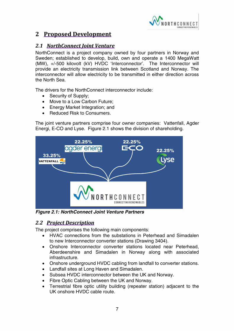
The joint venture partners comprise four owner companies: Vattenfall, Agder Energi, E-CO and Lyse. Figure 2.1 shows the division of shareholding.
Figure 2.1: NorthConnect Joint Venture Partners
2.2 Project Description The project comprises the following main components:
HVAC connections from the substations in Peterhead and Simadalen to new Interconnector converter stations (Drawing 3404).
Onshore Interconnector converter stations located near Peterhead, Aberdeenshire and Simadalen in Norway along with associated infrastructure.
Onshore underground HVDC cabling from landfall to converter stations.
Landfall sites at Long Haven and Simadalen.
Subsea HVDC interconnector between the UK and Norway.
Fibre Optic Cabling between the UK and Norway.
Terrestrial fibre optic utility building (repeater station) adjacent to the UK onshore HVDC cable route.
8
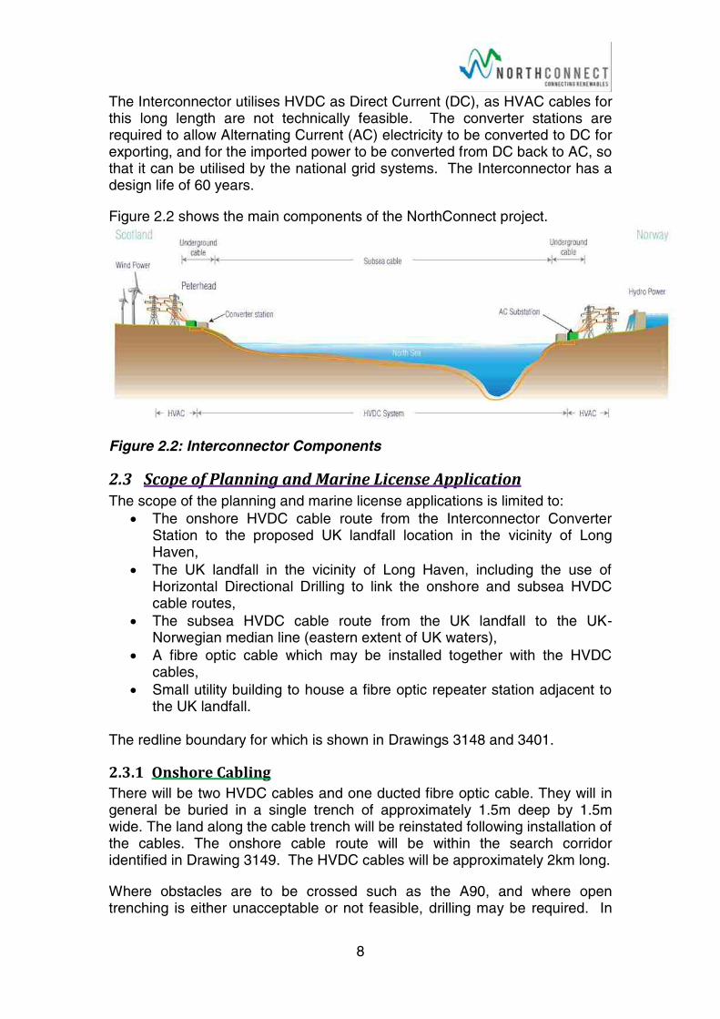
The Interconnector utilises HVDC as Direct Current (DC), as HVAC cables for this long length are not technically feasible. The converter stations are required to allow Alternating Current (AC) electricity to be converted to DC for exporting, and for the imported power to be converted from DC back to AC, so that it can be utilised by the national grid systems. The Interconnector has a design life of 60 years.
Figure 2.2 shows the main components of the NorthConnect project.
Figure 2.2: Interconnector Components
2.3 Scope of Planning and Marine License Application The scope of the planning and marine license applications is limited to:
The onshore HVDC cable route from the Interconnector Converter Station to the proposed UK landfall location in the vicinity of Long Haven,
The UK landfall in the vicinity of Long Haven, including the use of Horizontal Directional Drilling to link the onshore and subsea HVDC cable routes,
The subsea HVDC cable route from the UK landfall to the UK-Norwegian median line (eastern extent of UK waters),
A fibre optic cable which may be installed together with the HVDC cables,
Small utility building to house a fibre optic repeater station adjacent to the UK landfall.
The redline boundary for which is shown in Drawings 3148 and 3401.
2.3.1 Onshore Cabling There will be two HVDC cables and one ducted fibre optic cable. They will in general be buried in a single trench of approximately 1.5m deep by 1.5m wide. The land along the cable trench will be reinstated following installation of the cables. The onshore cable route will be within the search corridor identified in Drawing 3149. The HVDC cables will be approximately 2km long.
Where obstacles are to be crossed such as the A90, and where open trenching is either unacceptable or not feasible, drilling may be required. In
9
this case the cables would be separated for the drilled sections, but returned to a single trench after the obstacle.
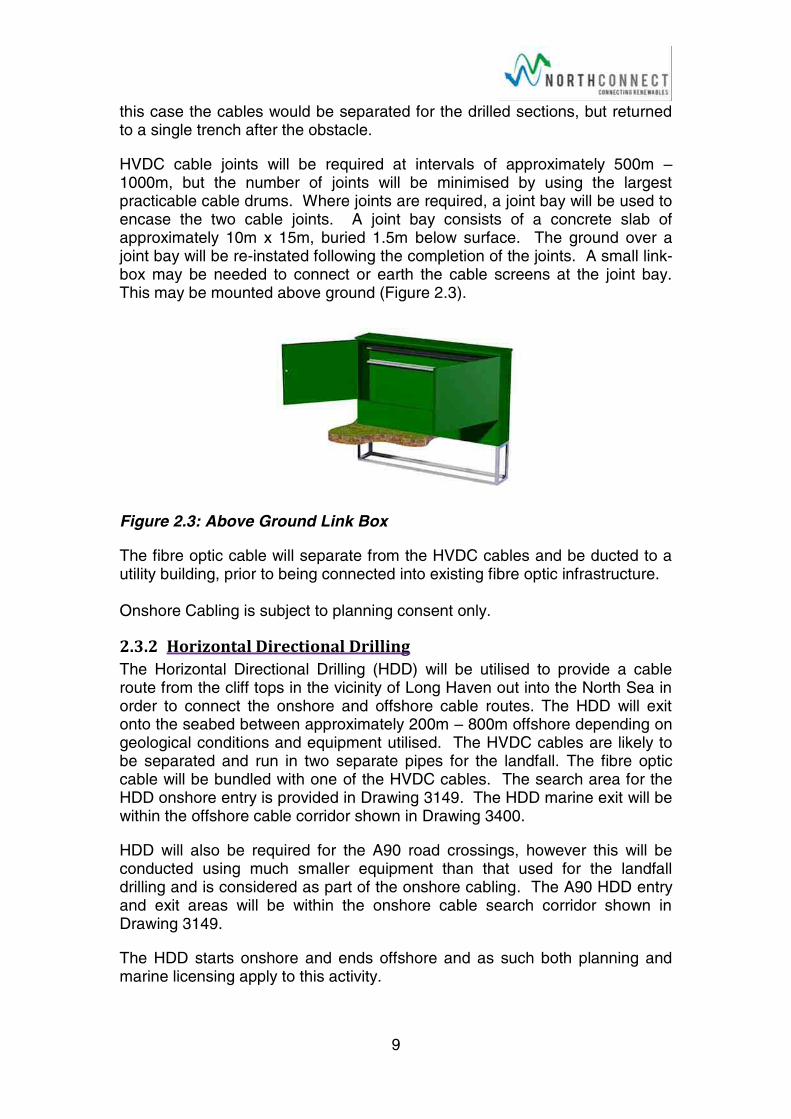
HVDC cable joints will be required at intervals of approximately 500m –1000m, but the number of joints will be minimised by using the largest practicable cable drums. Where joints are required, a joint bay will be used to encase the two cable joints. A joint bay consists of a concrete slab of approximately 10m x 15m, buried 1.5m below surface. The ground over a joint bay will be re-instated following the completion of the joints. A small link-box may be needed to connect or earth the cable screens at the joint bay. This may be mounted above ground (Figure 2.3).
Figure 2.3: Above Ground Link Box
The fibre optic cable will separate from the HVDC cables and be ducted to a utility building, prior to being connected into existing fibre optic infrastructure.
Onshore Cabling is subject to planning consent only.
2.3.2 Horizontal Directional Drilling The Horizontal Directional Drilling (HDD) will be utilised to provide a cable route from the cliff tops in the vicinity of Long Haven out into the North Sea in order to connect the onshore and offshore cable routes. The HDD will exit onto the seabed between approximately 200m – 800m offshore depending on geological conditions and equipment utilised. The HVDC cables are likely to be separated and run in two separate pipes for the landfall. The fibre optic cable will be bundled with one of the HVDC cables. The search area for the HDD onshore entry is provided in Drawing 3149. The HDD marine exit will be within the offshore cable corridor shown in Drawing 3400.
HDD will also be required for the A90 road crossings, however this will be conducted using much smaller equipment than that used for the landfall drilling and is considered as part of the onshore cabling. The A90 HDD entry and exit areas will be within the onshore cable search corridor shown in Drawing 3149.
The HDD starts onshore and ends offshore and as such both planning and marine licensing apply to this activity.
10
2.3.3 Offshore Cabling The two HVDC offshore cables and a fibre optic cable will be installed on the sea floor. The fibre optic cable will be bundled with one of the HVDC cables.
In water depths of 200m or less, the cables will be protected from scour and fouling predominantly through trenching to a depth of approximately 1m –1.5m. Where this is not possible due to ground conditions or existing infrastructure, rock berms or concrete mattressing will be provided to protect the cables. The cables may not be protected where water depth exceeds 200m, however these depths only occur in Norwegian waters and as such it is not considered here.
Cable joints will be required at intervals of between approximately 50km to 150km. The number of joints will be dependent on the loading capacity of installation vessel. Joints in the offshore cables are normally made inline, on the ship as the cable is being laid and do not require any additional marine infrastructure.
The offshore cabling from the exit point of the HDD, is all below the MLWS and as such is subject to Marine Licensing only.
2.3.4 Fibre Optic Utility Building The fibre optic cable will be bundled with one of the HVDC cables and as such will be laid on the seabed and brought onshore as described above.
The length of the optic cable route is short enough not to require an offshore repeater station so no additional infrastructure will be required on the sea bed. However, once onshore the fibre optic cable will be routed to a repeater station to be located in a small utilities building. The search area for which is shown in Drawing 3149. The design of the building has not as yet been considered, however it will be in keeping with the local surrounds to minimise effects on the landscape.
The fibre optic cable building will be subject to planning consent. All other activities will be considered as part of the previously discussed cable laying activities.
2.3.5 Temporary Construction Requirements During the construction process, the majority of the site offices, staff welfare facilities, parking storage and laydown areas will be provided at the Fourfields Converter Station Construction site, and have already been incorporated into the planning consent for that element of the project. Access to the cable corridor north of the A90 will be from the Fourfields site which in turn is accessed from the A90 by an existing quarry road [NorthConnect, 2015].
To support the HDD and works south of the A90 there will be a need for:
A temporary heavy lift access road from the A90, with sufficient capacity to accommodate the large drilling unit;
A heavy lift drilling rig pad at the cliff HDD entry point;
11
A drilling rig pad for the A90 HDD entry point;
Initial excavations, required to set the trajectory of the drill at the HDD entry points;
Welfare facilities for HDD staff close to the drilling site;
Staff parking; and
Laydown area for the storage of pipes, drill sections, and tools.
The HDD Temporary Works Area will be reinstated once the cable has been installed to allow it to return to its previous agricultural use.
During construction, the HVDC cable corridor will comprise a haul road, safety area, area for spoil storage, drainage ditch and boundary fencing. The total construction corridor width required will be approximately 25m wide, although this can be narrowed over short lengths where constraints may be encountered. The cable corridor will be reinstated once construction is complete, to allow activities such as farming to continue as before.
All these works are on land and as such are subject to planning consent only.
2.4 Location
2.4.1 Landfall and Onshore Cable Corridor The landing point selection was identified along with the Converter Station site selection by an optioneering study [Henderson, 2014] this took account of a range of technical, social and environmental factors, and considered a number of landing points. A landing point to the south of the village of Boddam in an area known as Long Haven has been identified; the area has sea cliffs and as such requires the use of HDD.
The cable once ashore will be routed north westerly and pass under the A90 prior to heading North towards the Fourfields Converter Station location. The exact landing point and onshore cable route is yet to be identified, at this point a search corridor is being considered as shown in Drawing 3149. The temporary construction requirements and fibre optic utility building will also be located within a search area shown on Drawing 3149.
The onshore search area is primarily farmed with livestock and arable crops. The A90, main truck road from Edinburgh to Fraserburgh bisects the site. The seacliffs are between 20m and 40m above sea level around the potential HDD entry point. The A90 road level is around 70m where the cable is likely to pass under it. The fields to the north slope up to Fourfields, The highest point being around 93m.
The south west corner of the Fourfields site drops 32m from the southwest to the northeast, the lowest point is approximately 61m above sea level. It is likely that the HVDC cable will run along the western side of Fourfields to the northwest corner, where it will run parallel to the AC cable route along the north edge of Fourfields, to the converter station in the northeast corner.
12
2.4.2 Offshore Corridor Xodus were commissioned to conduct a desktop options analysis for the NorthConnect offshore cable to identify the preferred route based on existing data. The following aspects were considered in the analysis:
Physical characteristics of the cable;
Existing infrastructure including pipelines, cables, and offshore installations;
Bathymetry;
Seabed geology and sediment characteristics;
Commercial fisheries, shipping and navigation;
Cultural heritage and marine archaeology;
Benthic ecology and habitat types; and
Designated sites and protected habitats.
The objective of the study was to identify the most efficient cable route between the UK and Norwegian landfalls, considering the physical limitations; whilst minimising socioeconomic, cultural and environmental impacts [Xodus 2012 & 2015].
The results of this investigation provided the preferred cable corridor between Long Haven and Simadalen, as shown in 3404. The final cable route will likely to be located somewhere within the preferred corridor, although more information is required to conduct the fine scale siting. Survey work planned for 2016 and 2017 will inform the final cable route selection.
2.5 Project Phases
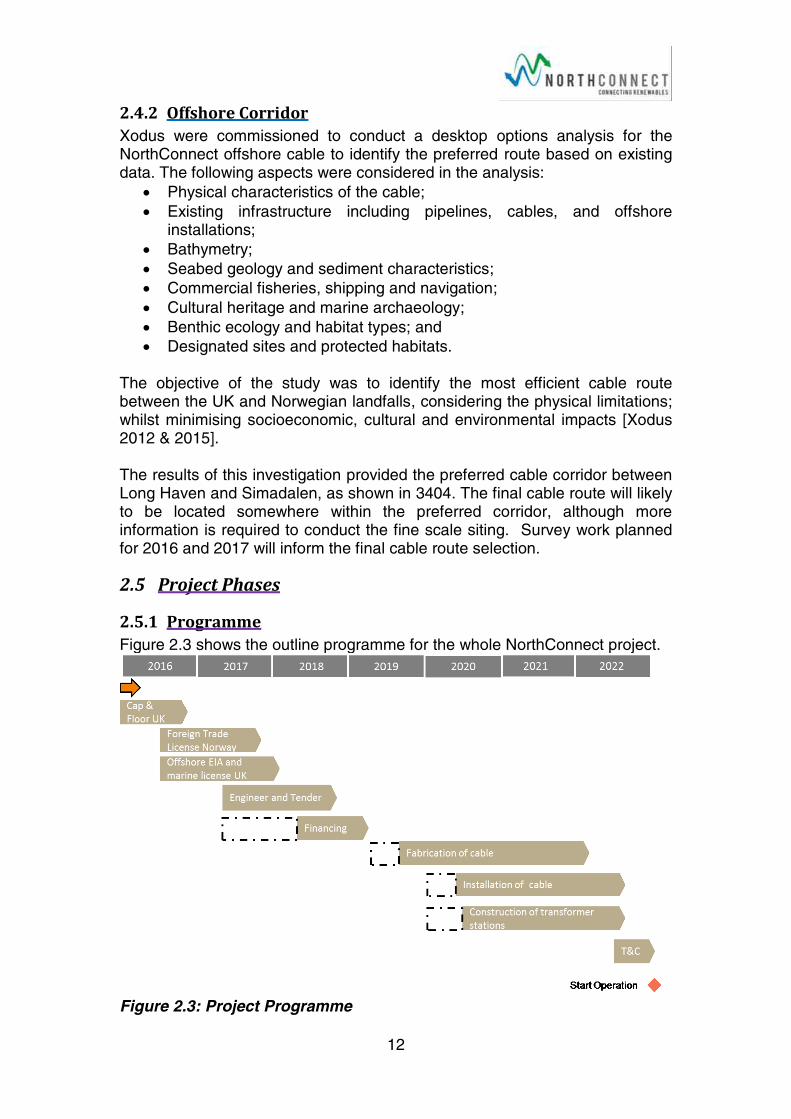
2.5.1 Programme Figure 2.3 shows the outline programme for the whole NorthConnect project.
Figure 2.3: Project Programme
13
2.5.2 Construction and Installation Conventional construction techniques will be utilised for the temporary access road, laydown area and the Fibre Optic utilities building.
The onshore cable lay will start with the installation of livestock fences along the corridor and the establishment of a haul road, for access along the length of the cable route. Topsoil will be stripped and stockpiled along the corridor edge. Excavated subsoil will also be stockpiled within the construction corridor (separate to the topsoil). Once the cables have been laid, the subsoil and topsoil will be used for backfilling and restoration.
Multiple offshore cable lay techniques are available, and it is likely that more than one will be required due to changes in seabed sediment, geology, topology and existing infrastructure. Seabed survey work planned for 2016 and 2017 will inform both the cable routing and the installation techniques to be deployed in various parts of the seabed.
The sequence of cable laying activities is likely to include an initial sweep of the seabed to remove any debris or obstacles such as abandoned nets and wires on the surface. The HVDC cables will then be installed by which ever means is appropriate, as identified by the seabed survey. This will include the preparation of crossings and covering of cables where they cannot be buried.
Post installation surveys will be carried out to ensure the cable is appropriately positioned. Survey techniques employed for the post installation surveys will include; multi-beam echo sounders and cable tracking to check burial depths.
2.5.3 Operation and Maintenance Once installed and energised the HVDC and Fibre Optic cables will not require any routine maintenance. If the cables were damaged in any way then they would need to be accessed and repaired. Onshore this will involve digging up the cable to gain access. On the offshore sections the cables will be laid with enough ‘slack’ to allow them to be brought to the surface for repair prior to being relayed as they were originally.
Cable surveys will be conducted to check that protection status is adequate, and to the extent needed to check cable integrity where the cable is not protected.
2.5.4 Decommissioning The anticipated project life is 60 years. At the point of decommissioning of the project, it is assumed that the HVDC cable will be de-energised, cut off and sealed at appropriate points and left in-situ. This assumption will be made for the purpose of environmental impact assessment.
Should at the time of decommissioning, removal and recycling of the cable be economically viable then the cable maybe removed. For the onshore element this would be a reversal of the installation works. The offshore removal will

14
require any rock berms or concrete mattressing to be removed where present and potentially some dredging in stiff soil areas to allow the cable to be retrieved on-board.
It is assumed that the fibre optic utility building will be demolished and the area reinstated as farmland.
15
3 ConsentingPermittingandLicenseProcess
3.1 Marine Licence A number of activities listed under Part 4, Section 21 of the Marine (Scotland) Act 2010 [Scottish Parliament, 2010], and Part 4, Section 66 of the Marine and Coastal Access Act 2009 [UK Government, 2009], require a Marine Licence issued by the Marine Scotland Licensing Operations Team (MS-LOT).
Any activity involving; ‘the deposit or removal of substances or objects in the sea, either on or under the seabed, or two construct/alter/improve any works in or over the sea or on or under the seabed, under the Mean High Water Spring (MHWS) line’
are all subject to marine licence according to the Acts.
The installation of the HVDC cables between MHWS and the Scottish-Norwegian median line will be subject to marine licensing.
3.2 Marine Pre-Application Consultation (PAC) The Marine Licensing (Pre-application Consultation (PAC)) (Scotland) Regulations 2013 [Scottish Government, 2013], prescribe the marine licensable activities that are subject to PAC and in combination with the Marine (Scotland) Act 2010 [Scottish Parliament, 2010], set out the nature of the pre-application process. The legislation came into force on 1st January 2014 and applies to all relevant marine licence applications submitted to MS-LOT on or after 6 April 2014. The NorthConnect HVDC development falls within these regulations as it involves the installation of a subsea cable exceeding 1NM in length within Scottish offshore waters.
There is no similar provision for PAC in the Marine and Coastal Access Act 2009 [UK, 2009]; as such the PAC requirements only apply the NorthConnect development that falls within the Scottish Inshore Region.
3.3 Planning Consent Under the Town and Country Planning (Scotland) Act 1997 [Scottish Parliament, 1997], any type of development, i.e. carrying out of building, engineering, mining or other operations in, on, over or under land, or the making of any material change in the use of any buildings or other land, over the MLWS line will require Planning Consent. As such the NorthConnect landfall, onshore cable route, and associated infrastructure will require planning permission issued by The Aberdeenshire Council.
3.4 European Protected Species (EPS) Licence If it is determined that the development of construction activities will likely affect European Protected Species (EPS) listed under the Conservation (Natural Habitats, &c.) Regulations 1994 (as amended) [UK Government, 1994]; which includes dolphins, harbour porpoises and European otters; an
16
EPS Licence will be required. An EPS licence will only be granted if it is proved that:
1) The project is on Imperative Reasons of Overriding Public Interest; 2) There are not satisfactory alternatives; and 3) The proposed action must not be detrimental to the maintenance of the
species at 'favourable conservation status'.
Depending on the construction techniques there is a potential to impact
cetaceans and otters, hence an EPS license may be required.
3.5 Habitats Regulation Appraisal (HRA) An appropriate assessment (AA) is part of the Habitats Regulations Appraisal (HRA) process [UK Government, 1994]. It is required when a plan or project potentially affects a European Natura site. The Natura sites’ network in the UK consists of Special Protection Areas (SPAs) and Special Areas of Conservation (SACs). An AA must demonstrate that there will be no adverse effect on site integrity. Should this requirement not be satisfied, a project would only receive consent (as Marine Licence and/or Planning Consent) if:
(1) Imperative Reasons of Overriding Public Interest are proved; and (2) There are not satisfactory alternatives.
The NorthConnect development will cross the Buchan Ness to Collieston
Coast SPA and hence is assumed to require an appropriate assessment. In
addition there is the potential for the development to cause indirect effects on
several adjacent Natura sites, the HRA process will be followed where
possible effects are identified.
3.6 The Water Environment Regulations Controlled Activities Regulations (CAR) [Scottish Government, 2011b] authorisations are required for various activities including:
The abstraction of water from the water environment; and
Any activity liable to cause pollution of the water environment, including discharges of pollution matter.
During the cable installation and fibre option utilities building construction there is a potential for surface water and water abstracted from excavations to require discharge to the water environment. At this point it is thought that this is likely to be carried out under the General Binding Rules and hence it is unlikely that CAR Authorisations will be required. This will be kept under review as the installation and construction methods are developed.

17
3.7 Development and Planning Policy Context
3.7.1 Planning Policy The context for NorthConnect lies in international and national policy on climate change and energy generation. This is distilled into national, regional and local planning through policies on sustainability and energy, where policies exist.
The onshore development plan system in Scotland, which provides the framework for considering planning applications, is made up of three main documents:
The National Planning Framework (NPF);
Strategic Development Plans (SDPs); and
Local Development Plans (LDPs).
Other guidance on a specific planning topic may be prepared and become part of the development plan; this is called supplementary guidance.
Scotland’s Third National Planning Framework (NPF3) [Scottish Ministers, 2014a] sets out the Scottish Government’s development vision for Scotland. The NPF3, published in June 2014, guides Scotland’s spatial development to 2030 by identifying national developments and other strategically important development opportunities in Scotland, and setting out strategic development priorities to support the Scottish Government’s central purpose of promoting sustainable economic growth.
The Scottish Planning Policy (SPP) [Scottish Ministers 2014b] sits alongside the NPF3 in the Scottish Government’s planning policy series. The SPP sets out the Scottish Ministers’ priorities for operation of the planning system, with regard to how nationally important land use planning matters should be addressed across the country. It is intended that the document be used in the preparation and development of plans, the design of development from concept to delivery, and the determination of planning applications.
The Scottish Government provides advice and technical planning information in the form of Planning Advice Notes (PANs). Relevant PANs for the NorthConnect HVDC Interconnector, which will be used to support the EIA are identified for each topic throughout this section.
The relevant development plans applicable to the determination of the application for consent consists of the Aberdeen City and Shire Strategic Development Plan [Aberdeen City and Shire Strategic Development Planning Authority, 2014] and the Aberdeenshire Local Development Plan (ALDP) [Aberdeenshire Council, 2012a] and associated supplementary guidance.
The Aberdeen City and Shire Strategic Development Plan was approved in March 2014, the document is a joint plan prepared by Aberdeen City Council and Aberdeenshire Council, which sets a clear direction for the future
18
development of the North East. The plan recognises the importance of improving links and connections, and providing opportunities for high quality sustainable growth. The Plan covers the whole of Aberdeen City and Shire except those areas within the Cairngorms National Park. The appropriate supplementary guidance documents will be utilised to assist with topic specific assessments.
Aberdeenshire Council adopted the Aberdeenshire Local Development Plan (ALDP) [Aberdeenshire Council, 2012a] and associated supplementary guidance on 1 June 2012 [Aberdeenshire Council, 2012b]. The Proposed Aberdeenshire Local Development Plan 2016 – Shaping Aberdeen has been consulted upon, and published for formal representation. It is now with Scottish Ministers for public examination which should be concluded by the end of August 2016, hence the 2016 ALDP will be considered within the EIA [Aberdeenshire Council, 2016a].
Consideration will also be given to the impact of the proposals upon the Energetica corridor identified in the ALDP, which extends from north Peterhead to Aberdeen, particularly with regard to its potential impacts on its neighbouring land uses, including the approved Energetica Business Park.
3.7.2 Marine Planning As the HVDC Interconnector will cross the area between Scotland’s MHWS and the 12 NM limit, it falls within the remit of the Marine (Scotland) Act 2010 [Scottish Parliament, 2010]. In combination with the executive devolution of the marine planning, conservation, marine licensing and enforcement from 12NM to 200NM through the Marine and Coastal Access Act 2009 [UK Government, 2009], allows Scottish Ministers to manage Scotland’s Seas from MHWS to 200NM limit. The Scottish National Marine Plan (NMP) covering inshore waters to 12NM and offshore waters from 12-200NM was adopted in 2015. The NMP lays out Scottish Minister’s policies for the sustainable development of Scotland's seas [Scottish Government, 2015].
The Scottish NMP provides General Planning Principles (GEN), most of which apply to the NorthConnect project. Many are specific to environmental topics and are identified in the specific topics of this Section. In addition the EIA process will employ GEN 19:
‘Sound evidence: Decision making in the marine environment will be based on sound scientific and socio–economic evidence.’
NorthConnect is keen to work with stakeholders through the project development process; this aligns with GEN 18:
‘Early and effective engagement should be undertaken with the general public and all interested stakeholders to facilitate planning and consenting processes.’
The NMP lays out sector specific objectives and policies, the relevant objectives for subsea cables are as follows:
19
Protect submarine cables whilst achieving successful seabed user co-existence.
Achieve the highest possible quality and safety standards and reduce risks to all seabed users and the marine environment.
Safeguard and promote the global communications network.
Support the generation, distribution and optimisation of electricity from traditional and renewable sources to Scotland, UK and beyond.
The relevant Marine Planning Policies for subsea cables are:
CABLES 1: Cable and network owners should engage with decision makers at the early planning stage to notify of any intention to lay, repair or replace cables before routes are selected and agreed. When making proposals, cable and network owners and marine users should evidence that they have taken a joined-up approach to development and activity to minimise impacts, where possible, on the marine historic and natural environment, the assets, infrastructures and other users. Appropriate and proportionate environmental consideration and risk assessments should be provided which may include cable protection measures and mitigation plans.
CABLES 2: The following factors will be taken into account on a case by case basis when reaching decisions regarding submarine cable development and activities:
• Cables should be suitably routed to provide suf cient requirements for installation and cable protection.
• New cables should implement methods to minimise impacts on the environment, seabed and other users, where operationally possible and in accordance with relevant industry practice.
• Cables should be buried to maximise protection where there are safety or seabed stability risks and to reduce con ict with other marine users and to protect the assets and infrastructure.
• Where burial is demonstrated not to be feasible, cables may be suitably protected through recognised and approved measures (such as rock or mattress placement or cable armouring) where practicable and cost-effective and as risk assessments direct.
• Consideration of the need to reinstate the seabed, undertake post-lay surveys and monitoring and carry out remedial action where required.
CABLES 3: A risk-based approach should be applied by network owners and decision makers to the removal of redundant submarine cables, with consideration given to cables being left in situ where this would minimise impacts on the marine historic and natural environment and other users.
CABLES 4: When selecting locations for land-fall of power and telecommunications equipment and cabling, developers and decision makers should consider the policies pertaining to ooding and coastal protection in Chapter 4, and align with those in Scottish Planning Policy and Local Development Plans.
20
Marine Planning Partnerships are being developed for 11 regions around Scotland; they will work to develop regional marine plans. NorthConnect falls within the North East region, but the Marine Planning Partnership for the area has not as yet been established, and is unlikely to be prior to the EIA being completed.
3.7.3 Proposed Assessment Relevant sections of planning policies and marine plans including those discussed above, will be identified, considered through the project development process and discussed within the ES. An Energetica Compliance Statement will be produced as a separate document to support the planning application.
21
4 CumulativeAs discussed in Section 2.2 the HVDC cable route is only part of the NorthConnect project. From a Scottish and UK perspective the whole project includes the Interconnector Converter Station and HVAC cable route, which has already been granted planning permission. Some aspects of this previously consented element of the NorthConnect project will support the onshore HVDC cable installation; specifically access tracks and laydown areas to the northwest of the A90.
As part of the Converter Station and HVAC EIA process the cumulative effects were identified and considered, however the details of the HVDC cable were not fully developed at that point [NorthConnect, 2015]. Where appropriate the effects of the ‘NorthConnect’ project as a whole will be considered within the ES to take account of the additional level of detail available.
The planning applications lodged within the last three years on the ePlanning website [Aberdeenshire Council, 2016b] for Boddam & District Community Council were reviewed Table 4.1.
Table 4.1: Summary of Planning Applications
Application Type or Status Number
Refused 3
Enquiries superseded by applications 3
Residential <3 house development, garage, shed or alteration/modification to house.
15
Residential 3 house development or larger. 3
Small to medium non-residential applications including: change of use, demolition, signage, carparks and warehouses.
14
Medium to large non-residential. 10
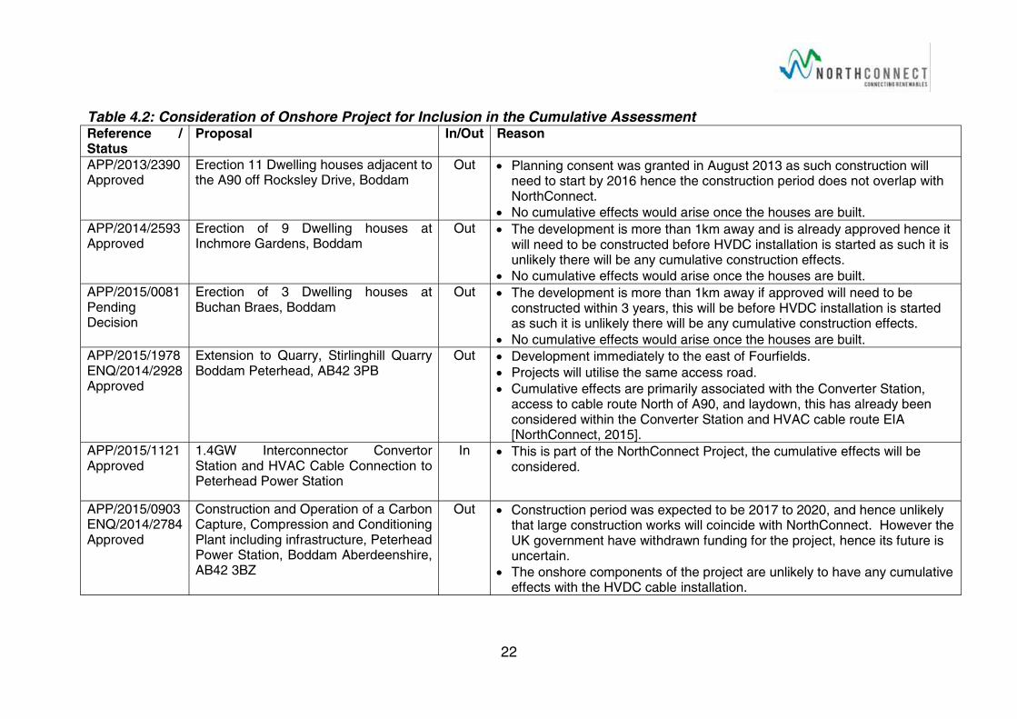
The three large residential projects and ten medium to large non-residential projects are considered within Table 4.2 to identify whether or not they should be considered within the ES with regard to cumulative effects.
Current marine renewable energy projects, construction cable and National Renewable Infrastructure Plan projects are listed on the Scottish Government website [2016a & b]. Each project type has been considered in turn in Table 4.3 and then projects which could have in-combination or cumulative effects are identified.
The ePlanning website [Aberdeenshire Council, 2016b] and Marine Scotland websites [Scottish Government, 2016a & b] will be further reviewed prior to the completion of the EIA process to identify whether any new projects warrant cumulative assessment.
22
Table 4.2: Consideration of Onshore Project for Inclusion in the Cumulative Assessment Reference / Status
Proposal In/Out Reason
APP/2013/2390Approved
Erection 11 Dwelling houses adjacent to the A90 off Rocksley Drive, Boddam
Out Planning consent was granted in August 2013 as such construction will need to start by 2016 hence the construction period does not overlap with NorthConnect.
No cumulative effects would arise once the houses are built.
APP/2014/2593Approved
Erection of 9 Dwelling houses at Inchmore Gardens, Boddam
Out The development is more than 1km away and is already approved hence it will need to be constructed before HVDC installation is started as such it is unlikely there will be any cumulative construction effects.
No cumulative effects would arise once the houses are built.
APP/2015/0081Pending Decision
Erection of 3 Dwelling houses at Buchan Braes, Boddam
Out The development is more than 1km away if approved will need to be constructed within 3 years, this will be before HVDC installation is started as such it is unlikely there will be any cumulative construction effects.
No cumulative effects would arise once the houses are built.
APP/2015/1978ENQ/2014/2928Approved
Extension to Quarry, Stirlinghill QuarryBoddam Peterhead, AB42 3PB
Out Development immediately to the east of Fourfields.
Projects will utilise the same access road.
Cumulative effects are primarily associated with the Converter Station, access to cable route North of A90, and laydown, this has already been considered within the Converter Station and HVAC cable route EIA [NorthConnect, 2015].
APP/2015/1121Approved
1.4GW Interconnector Convertor Station and HVAC Cable Connection to Peterhead Power Station
In This is part of the NorthConnect Project, the cumulative effects will be considered.
APP/2015/0903ENQ/2014/2784Approved
Construction and Operation of a Carbon Capture, Compression and Conditioning Plant including infrastructure, Peterhead Power Station, Boddam Aberdeenshire, AB42 3BZ
Out Construction period was expected to be 2017 to 2020, and hence unlikely that large construction works will coincide with NorthConnect. However the UK government have withdrawn funding for the project, hence its future is uncertain.
The onshore components of the project are unlikely to have any cumulative effects with the HVDC cable installation.
23
Reference / Status
Proposal In/Out Reason
APP/2015/0739Pending Decision
Erection of Retail Shops, Restaurants, Hotel, Petrol Filling Station , Associated Access Infrastructure and Landscaping
Out The development is over 2km from the closest part of the HVDC Cable route; hence it is unlikely that there will be cumulative construction effects even if they were to be constructed at the same time.
If this development is in place prior to the NorthConnect construction phase there is a potential for the construction staff to utilise the proposed facilities which would be a benefit to both projects.
APP/2014/3263Approved
Erection of Outdoor Car Sales Area & Sales Office, Invernettie Roundabout
Out The development is over 2km from the closest part of the HVDC cable route; hence it is unlikely that there will be cumulative construction effects even if they were to be constructed at the same time.
APP/2014/2999Approved
Formation of Ponds and Associated Engineering Works
Out The development is approximately 2km from the closest part of the HVDC cable route; no cumulative or in-combination effects are predicted.
APP/2014/1437ApprovedAPP/2013/1912Approved
Formation of new 400kV electricity substation (including 4 no. buildings housing switchgear and transformers) and associated infrastructure. Newton of Sandford, Boddam AB42 3AJ
Out NorthConnect are likely to connect into this substation, as such the projects are inter related.
Cumulative effects associated with the Converter Station and HVAC cable construction and operation have already been considered [NorthConnect, 2015].
It is unlikely that the HVDC cable installation will have any additional in combination effects.
APP/2013/1786Approved
Section 37 Notification for Reinforcement and Reinsulation of Existing Overhead Electricity Transmission Line to Upgrade Voltage from 275kV to 400kV
Out The work will be well away from the HVDC cable route.
No predicted negative cumulative effects with the HVDC cable route, there may be some advantages with regard to the flexibility within the National Grid to allow energy to be most appropriately managed.
APP/2013/1368 Removal of Overhead Electricity Line and Erection of Single and Double Pole
Out These works should be completed prior to the HVDC cable being installed.
No cumulative or in-combination effects predicted.
24
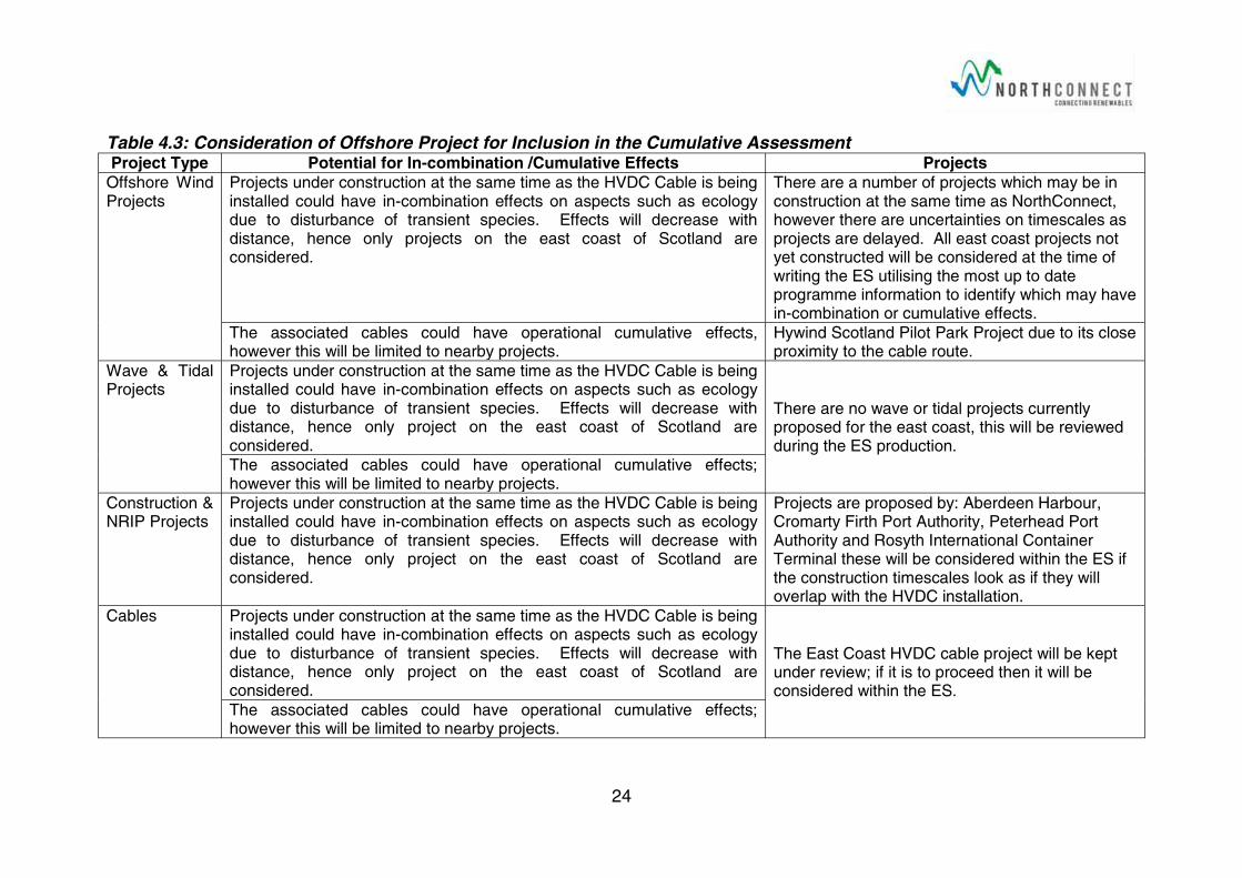
Table 4.3: Consideration of Offshore Project for Inclusion in the Cumulative AssessmentProject Type Potential for In-combination /Cumulative Effects Projects
Offshore Wind Projects
Projects under construction at the same time as the HVDC Cable is being installed could have in-combination effects on aspects such as ecology due to disturbance of transient species. Effects will decrease with distance, hence only projects on the east coast of Scotland are considered.
There are a number of projects which may be in construction at the same time as NorthConnect, however there are uncertainties on timescales as projects are delayed. All east coast projects not yet constructed will be considered at the time of writing the ES utilising the most up to date programme information to identify which may have in-combination or cumulative effects.
The associated cables could have operational cumulative effects, however this will be limited to nearby projects.
Hywind Scotland Pilot Park Project due to its close proximity to the cable route.
Wave & Tidal Projects
Projects under construction at the same time as the HVDC Cable is being installed could have in-combination effects on aspects such as ecology due to disturbance of transient species. Effects will decrease with distance, hence only project on the east coast of Scotland are considered.
There are no wave or tidal projects currently proposed for the east coast, this will be reviewed during the ES production.
The associated cables could have operational cumulative effects; however this will be limited to nearby projects.
Construction & NRIP Projects
Projects under construction at the same time as the HVDC Cable is being installed could have in-combination effects on aspects such as ecology due to disturbance of transient species. Effects will decrease with distance, hence only project on the east coast of Scotland are considered.
Projects are proposed by: Aberdeen Harbour,Cromarty Firth Port Authority, Peterhead Port Authority and Rosyth International Container Terminal these will be considered within the ES if the construction timescales look as if they will overlap with the HVDC installation.
Cables Projects under construction at the same time as the HVDC Cable is being installed could have in-combination effects on aspects such as ecology due to disturbance of transient species. Effects will decrease with distance, hence only project on the east coast of Scotland are considered.
The East Coast HVDC cable project will be kept under review; if it is to proceed then it will be considered within the ES.
The associated cables could have operational cumulative effects; however this will be limited to nearby projects.
25
5 irQuality
5.1 Policy and Guidance Relevant policy and guidance includes:
GEN 14 Air Quality: Development and use of the marine environment should not result in the deterioration of air quality and should not breach any statutory air quality limits [Scottish Government, 2015].
Assessment of dust from demolition and construction [IAQM, 2014].
Air Quality Monitoring in the Vicinity of Demolition and Construction Sites [IAQM, 2012].
5.2 Baseline There are no Air Quality Management Areas in Aberdeenshire Council Area. Air quality monitoring is not routinely conducted in Scotland’s inshore or offshore waters.
Nitrogen dioxide measurements are taken routinely in four locations in Peterhead the highest annual mean concentration measurements being recorded on the kerbside at Queen Street during 2014 was 30µg/m3. Nitrogen dioxide was monitored at an additional five locations around the harbour in 2014, following residents’ concerns regarding a recent development to the harbour. The highest level at the new locations was 38µg/m3; recorded at the Fish Market. The annual mean air quality objective for nitrogen dioxide is to be below 40µg/m3 [Farmer, 2015]. Particulate Matter (PM10) in air is not currently measured by Aberdeenshire Council.
The majority of the onshore HVDC cable route is currently farmland and as such is assumed to have a relatively high air quality. The air quality in the immediate vicinity of the A90 may be reduced due to traffic associated pollutants such as PM10’s. Offshore air quality is assumed to be high throughout the route due to the distance from pollution sources.
No air quality issues in the North Sea region are known about, or expected, there is a potential for localised issues in the vicinity of offshore oil and gas infrastructure.
5.3 Potential Impacts
5.3.1 Installation
Dust Ground works, material storage, the use of cements, and HDD during the installation of the onshore HVDC cable site is likely to give rise to local dust issues.
The offshore cable installation will be conducted underwater and hence will not result in dust emissions.
26
Carbon Dioxide There will be a carbon cost associated with the installation of the HVDC cable. This is primarily due to the metals and plastics used to form the HVDC cables, and the burning of fossil fuels by the installation vessel, associated plant and equipment.
5.3.2 Operation
Dust Maintenance and repair works to the cable may be required during its lifetime. This will result in similar dust emissions as is described for installation; however these will only persist for the duration of the maintenance works.
Carbon Dioxide Although NorthConnect does not produce electricity, it does facilitate the increase of renewables into the energy mix, by coupling the variable renewable energy sources such as wind, wave and tidal in the UK, to the more controllable hydropower resources of Norway.
A larger proportion of renewable energy sources in the energy supply mix, will reduce demand on power generated using fossil fuels, and hence contribute to reducing national CO2 emissions.
5.3.3 Decommissioning
Dust If the cable is to be left in situ then no effects dust emissions will result from their decommissioning. The demolition of the utility building may give rise to a dust source for a short period of time.
Carbon Dioxide The carbon cost of decommissioning will be due to the fuel for vehicles and equipment utilised in the demolition of the utility building, this will be minimal.
5.4 Proposed Environmental Impact Assessment
5.4.1 Dust It is proposed that an assessment of dust impacts is carried out utilising the Institute of Air Quality Management (IAQM) Assessment of Dust from Demolition and Construction Sites [IAQM, 2012] methodology. The methodology will assist in ensuring that appropriate mitigation methods are identified and if appropriate, monitoring will be employed to check its effectiveness.
5.4.2 Carbon Dioxide The carbon saving potential of the NorthConnect Project has been estimated to be between 11.4 million and 120 million tonnes of CO2 through its operational life. This is presented in the NorthConnect Interconnector
27
Converter Station and HVAC Cable Route Environmental Statement [NorthConnect 2015].
An estimate of the carbon cost of the HVDC cable and the installation works will be made, based on the proposed cable materials, quantities, estimated vessel fuel consumption, and published carbon equivalences.
The estimated carbon cost of the HVDC cable installation will be combined with the estimated carbon cost of the HVAC Cable and Converter Station (11925 tonnes of CO2) in order to provide the overall carbon cost of the project. This will be subtracted from the project’s estimated operational carbon CO2 conservative saving figure of 11.4million tonnes, in order to estimate the total carbon benefit of the project.
28
6 rchaeologyandCulturalHeritage
6.1 Policy and Guidance Relevant policy and guidance includes:
GEN 6 Historic environment: Development and use of the marine environment should protect and, where appropriate, enhance heritage assets in a manner proportionate to their significance [Scottish Government, 2015];
PAN 2/2011: Planning and Archaeology [Scottish Government, 2011c];
Managing Change in the Historic Environment, Settings Guidance [Historic Scotland, 2010]; and
Protocol for Archaeological Discoveries for Offshore Renewables Projects [Crown Estate, 2014].
6.2 Baseline
6.2.1 Onshore The sources of information on cultural heritage assets are:
The Royal Commission on the Ancient and Historical Monuments of Scotland’s (RCAHMS) PASTMAP interactive mapping service[RCAHMS, 2016];
Aberdeenshire Sites and Monuments Records Website [Aberdeenshire Council, 2016c]; and
NorthConnect Converter Station and HVAC Cable Route Environmental Statement [NorthConnect, 2015].
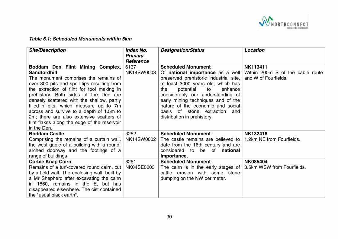
There are 5 Scheduled monuments within 5km of onshore HVDC cable route as discussed in Table 6.1.
There are no listed buildings within 1km of the HVDC cable route, however there are 117 within 2km, the majority of which are in the Boddam area. In addition there is Sandford Lodge; a miniature mansion house and walled garden built around 1800, which is designated a Category B7 Listed Building, with ancillary buildings designated Category C; and the Windmill Tower of Glenugie Distillery also one house in Invernettie, on the southern edge of Peterhead.
As shown on Drawing 3150 there are numerous historic environmental records within 500 m of the cable route. Four of these are within the search corridor of the proposed onshore cable route, the disused Longhaven quarry near Blackhills (primary reference: NK14SW0015), a second disused quarry at Murdoch Head (NK13NW0033), a shipwreck at Long Haven (NK14SW0044) and Sandford Hill Farmstead (NK14SW0069). In addition the ruined Heathery Haven Salmon House (Canmore ID: 75962) is within the search area. The ruined Murdoch Head Smithy (Canmore ID: 75946) is just outside the boundary of the search area.

29
The Boddam Branch dismantled railway runs parallel to the A90 to the south. Only the embankment of the line persists, and this historic feature is not designated as a monument or protected site. The HVDC onshore cable route will cross the former Boddam Branch line.
There are signs of an old road running from the A90 south of Fourfields towards the SW corner of the Fourfields site, this is documented on historic maps of the area.
30
Table 6.1: Scheduled Monuments within 5km
Site/Description Index No.Primary Reference
Designation/Status Location
Boddam Den Flint Mining Complex, SandfordhillThe monument comprises the remains of over 300 pits and spoil tips resulting from the extraction of flint for tool making in prehistory. Both sides of the Den are densely scattered with the shallow, partly filled-in pits, which measure up to 7m across and survive to a depth of 1.5m to 2m; there are also extensive scatters of flint flakes along the edge of the reservoir in the Den.
6137NK14SW0003
Scheduled MonumentOf national importance as a well preserved prehistoric industrial site, at least 3000 years old, which has the potential to enhance considerably our understanding of early mining techniques and of the nature of the economic and social basis of stone extraction and distribution in prehistory.
NK113411Within 200m S of the cable route and W of Fourfields.
Boddam CastleComprising the remains of a curtain wall, the west gable of a building with a round-arched doorway and the footings of a range of buildings
3252NK14SW0002
Scheduled MonumentThe castle remains are believed to date from the 16th century and are considered to be of national importance.
NK1324181.2km NE from Fourfields.
Corbie Knap CairnRemains of a turf-covered round cairn, cut by a field wall. The enclosing wall, built by a Mr Shepherd after excavating the cairn in 1860, remains in the E, but has disappeared elsewhere. The cist contained the "usual black earth".
3251NK04SE0003
Scheduled MonumentThe cairn is in the early stages of cattle erosion with some stone dumping on the NW perimeter.
NK0854043.5km WSW from Fourfields.
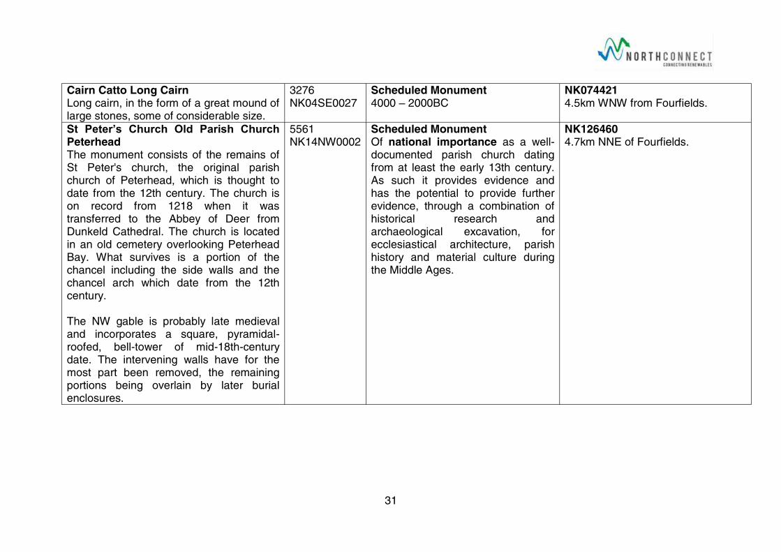
31
Cairn Catto Long CairnLong cairn, in the form of a great mound of large stones, some of considerable size.
3276NK04SE0027
Scheduled Monument4000 – 2000BC
NK0744214.5km WNW from Fourfields.
St Peter’s Church Old Parish Church PeterheadThe monument consists of the remains of St Peter's church, the original parish church of Peterhead, which is thought to date from the 12th century. The church is on record from 1218 when it was transferred to the Abbey of Deer from Dunkeld Cathedral. The church is located in an old cemetery overlooking Peterhead Bay. What survives is a portion of the chancel including the side walls and the chancel arch which date from the 12th century.
The NW gable is probably late medieval and incorporates a square, pyramidal-roofed, bell-tower of mid-18th-century date. The intervening walls have for the most part been removed, the remaining portions being overlain by later burial enclosures.
5561NK14NW0002
Scheduled MonumentOf national importance as a well-documented parish church dating from at least the early 13th century. As such it provides evidence and has the potential to provide further evidence, through a combination of historical research and archaeological excavation, for ecclesiastical architecture, parish history and material culture during the Middle Ages.
NK1264604.7km NNE of Fourfields.
32
6.2.2 Offshore There are no wrecks or other features designated for their historic significance within the offshore cable corridor, as shown in Drawings 3400 & 3401. It should be noted that some wrecks are in close proximity to the cable corridor, and appear to be within, but this is due to the size of the icons, and large scale of the drawing. Wrecks were avoided where they were identified during the desktop options analysis [Xodus 2012 & 2015].
There is the potential for previously unrecorded wrecks to be encountered during the cable route survey.
6.3 Potential Impacts
6.3.1 Construction and Installation Direct impacts on known heritage assets during construction will be avoided by the siting of the HVDC cable route away from heritage assets wherever possible. However it will be necessary to cross the Boddam Branch dismantled railway, which may disturb the archaeological remains associated with this feature.
The Longhaven and Murdoch Head Quarries, the Murdoch Head Smithy, Heathery Haven Salmon House, and Long Haven wreck, are the only other onshore sites that could be directly impacted by the cable route but these should be avoidable with appropriate detailed routing.
The HVDC cable route is likely to run in close proximity to the historic road which runs from the A90 to the Fourfields site. However the route will be designed to avoid disturbance of this feature.
The is a potential to affect the setting of onshore historic assets during HDD drilling, cable installation and the construction of the utility building, however this will be a short, term reversible effect and as such is not deemed to be significant.
Indirect effects on offshore archaeological assets are possible for example sediment redistribution during cable laying onto assets in the immediate vicinity of the works.
There is the potential to disturb previous unknown artefacts and historic sites along the length of the HVDC cable route both on and offshore.
6.3.2 Operation Since the cable will be buried along its length, it will not have any setting effects on the archaeological and cultural heritage assets through the operation of the NorthConnect interconnector.
33
The fibre optic utility building will be sensitively designed to suit the surrounding environment and as such should not have any setting effects on assets in the vicinity.
Indirect effects on offshore archaeological assets in the immediate vicinity of the cable are possible for example changes in the seabed associated with scouring of the seabed due to rock berm placement.
6.3.3 Decommissioning The removal of the fibre optic utility building will be removed, the removal process may have short term reversible impacts on setting of archaeological or cultural heritage assets in the area, the effects are unlikely to be significant.
Indirect effects on offshore assets may continue post operations if the assets are not removed.
6.4 Proposed Environmental Impact Assessment No onshore invasive survey techniques are proposed, however further work to understand the specific historical assets in the immediate vicinity of the HVDC cable route will be carried out. This will include desk based study work and site walkovers.
The marine cable route survey will utilise multi-beam echo sounders, side scan sonar, gradiometers, and underwater photography, in order to identify wrecks and other metallic remains on the sea bed along the cable route search corridor. If artefacts are discovered these will be documented, so that they can be avoided by the detailed cable routing.
The on and offshore investigations and surveys will inform the detailed cable routing; the aim will be to avoid artefacts wherever possible to prevent direct effects.
An assessment of direct and indirect effects on heritage assets on and within 500m of the onshore cable route and fibre optic building will be carried out. Similarly offshore assets with 100m of the cable route will be considered. The focus of the assessment will be proportionate to the value of the asset and scale of impact.
34
7 EcologyandNatureConservation
7.1 Applicable Policies & Guidance Relevant policy and guidance includes:
GEN 9: Natural heritage: Development and use of the marine environment must:
o Comply with legal requirements for protected areas and protected species;
o Not result in significant impact on the national status of Priority Marine Features;
o Protect and, where appropriate, enhance the health of the marine area [Scottish Government, 2015];
GEN 10: Invasive non-native species: Opportunities to reduce the introduction of invasive non-native species to a minimum or proactively improve the practice of existing activity should be taken when decisions are being made [Scottish Government, 2015];
PAN 60: Planning for Natural Heritage [Scottish Government,2008];
Guidelines for Ecological Impact Assessment in the United Kingdom, [IEEM, 2006]
Handbook for Marine Intertidal Phase 1 Biotope Mapping Survey [Countryside Council for Wales, 2006]
Guidance on Survey and Monitoring in Relation to Marine Renewables Deployments in Scotland; Volumes 1-5 [SNH, 2011]
Recommended Approach to the Survey of Benthic Habitats and Species [SNH, 2016]
Seabird monitoring handbook for Britain and Ireland: a compilation of methods for survey and monitoring of breeding seabirds [Walsh et al, 1995]
Guidance on Assigning Benthic Biotopes using EUNIS or the Marine Habitat Classification of Britain and Ireland [Parry 2015]
7.2 Designated Sites Statutory Designated Sites which may be affected either directly or indirectly are detailed in Table 7.1 and mapped in Drawings 3152, 3402 and 3403. These include the following designations:
Marine Protected Areas (MPA) and Proposed MPAs (pMPA),
Sites of Special Scientific Interest (SSSI),
Special Areas of Conservation (SAC), and
Special Protected Areas (SPA) and Proposed SPAs (pSPA).
35
Table 7.1: Designated Sites relevant to the NorthConnect HVDC interconnector development.
Site Distance from
Cable Corridor
Designated Interests
Buchan Ness to Collieston CoastSPA
Crossed at HVDC cable landfall.
Northern fulmar, breedingCommon guillemot, breedingHerring gull, breedingKittiwake, breedingEurasian shag, breedingSeabird assemblage, breeding
Buchan Ness to ColliestonSAC
Crossed at HVDC cable landfall.
Vegetated sea cliffs
Bullers of Buchan Coast SSSI
Crossed at HVDC cable landfall.
Seabird colony, breedingCommon guillemot, breedingKittiwake, breedingEurasian shag, breedingCoastal Geomorphology of ScotlandMaritime cliff
Southern Trench pMPA
Crossed by offshore HVDC cable route.
Burrowed mud,Minke whale,Fronts,Shelf deeps
Scanner Pockmark SAC
Adjacent Submarine structures made by leaking gases.
River Dee SAC 30km SW of UK landfall.
Atlantic salmon,Fresh water pearl mussel,Otter.
Turbot Bank MPA 30km S of cable corridor.
Sandeel ground
Norwegian Boundary Sediment Plain MPA
30km SE of cable corridor.
Ocean quahog aggregations.
Braemar Pockmarks SAC
80km N of cable corridor.
Submarine structures made by leaking gases.
Moray Firth SAC 95km NW of UK landfall.
Bottlenose Dolphin
Firth of Tay and Eden Estuary SAC
120km SW of UK landfall.
Harbour SealEstuaryMud flats
Isle of May SAC 150km SW of UK landfall.
Grey seals.
36
It is recognised that several designated areas are currently in draft form and awaiting consultation, including the Ythan Estuary dSPA. Any designation receiving policy or statutory protection prior to the submission of the Environmental Statement will be appropriately considered.
7.3 Baseline
7.3.1 Habitat Types An extended Phase 1 Habitat Survey of the onshore HVDC cable route search area (Drawing 3149) has been completed, in line with the ‘Guidelines for Baseline Ecological Assessment’ [Institute of Environmental Assessment,1995] and Guidelines for Preliminary Ecological Appraisal [Institute of Ecology and Environmental Management, 2012] [Atmos, 2014a]. The full survey report is provided as Appendix A to this document.
As shown in Figure 3 of Appendix A, the dominant habitats on the onshore section of the onshore HVDC cable route include: improved grassland, marshy grassland, acid dry dwarf shrub heath, and semi improved neutral grassland. Other habitats found to be present along the proposed cable corridor included; quarries, valley mire, scrub, fence, drystone walls, running water, hard cliff, and coast grassland [Atmos 2014a].
In order to ascertain the benthic habitats likely to be present along the offshore portion of the HVDC cable corridor, a review of the Joint Nature Conservation Committee (JNCC) UKSeaMap data was conducted. The UKSeaMap programme provides an overview of the habitats likely to be present in areas of the North Sea and northern Scotland and builds upon previous datasets on sediment and habitats distribution from the MESH (Mapping European Seabed Habitats) programme.
The benthic habitats predicted to be crossed along the HVDC cable route to the UK-Norway median line, are characterised by circalittoral sediments. These include ‘circalittoral coarse sediment’ in inshore waters progressing to ‘deep circalittoral coarse sediment’ and ‘deep circalittoral sand’ to ‘deep circalittoral mud’ further offshore (Drawing 3402 and 3403) [Xodus 2012 & 2015 and JNCC, 2010].
In addition, bedrock outcrops (Annex I reef habitat) have been charted at two or three locations very close to shore within 1 km of the Long Haven landfall location, in addition to which the JNCC has identified the potential for rocky reef habitat (either bedrock or areas of boulders) to occur along the whole coastline within a kilometre or so of the shore. Therefore, the potential for a requirement to cross rocky reef habitat, along the cable corridor is high inshore, but diminishes with distance offshore (Drawing 3402 and 3403) [Xodus, 2015].
The cable corridor will cross approximately 90km of areas recorded as being potential Annexe 1 fluid seeps (Drawing 3403). Fluid seeps are subsea habitats from through the release of gases, which can result in the formation
37
of submarine structures including pock marks and bubbling reefs [JNCC, 2010].
7.3.2 Bats The onshore cable search area may support foraging bats with potential roost sites located in the 3 disused quarries in the north and south of the onshore HVDC cable route search area. There was also limited potential for roosting bats reported in the cracked mortar of a ruined building next to the dismantled railway in the south of the cable route area. However the habitat across the wider Survey Area and beyond was dominated by the agricultural landscape with improved grassland and arable fields, which offered somewhat limited opportunities for foraging bats, although dependent on crop regimes, some seasonal foraging resources may exist. The field boundaries and sparse section of shrub offer little commuting potential for local bat populations [Atmos, 2014a].
7.3.3 Otters A number of otter spraints were found during the otter, badger and water vole survey carried out in 2014, one on the edge of the bog pool in the valley mire to the east of the HVDC Cable Route area and one on the coastal path next to the dismantled railway in the HVDC Cable Route area, although there was no other evidence of otters [Bunyan, 2014]. Being close to the coast there would be plenty of resources for otters, in addition there are drains and small watercourses which would connect to the dam and ponds further inland, and also to the areas of marshy grassland which could provide food resources in terms of amphibians [Atmos, 2014a].
7.3.4 Water Vole An otter, badger and water vole survey was conducted in 2014 as part of the EIA for NorthConnect converter station building at the Fourfields site. It’s focus was the Fourfields site and HVAC cable route and as such only covered the very northern part of the HVDC onshore search area. The survey noted that the field drains in the north of the HVDC search area offer suitable habitat for water voles but none were found here. Water voles were found on the HVAC cable route [Bunyan, 2014].
In addition the extended Phase 1 habitat survey recorded numerous drains which run through the HVDC cable route survey area and offer good quality water vole habitat [Atmos, 2014a].
As such it is likely that water voles could be present in water courses throughout the onshore HVDC cable route search area.
7.3.5 Badgers The extended Phase 1 habitat survey indicated that badgers are present within HVDC search area, latrines were identified in the disused quarry, and at the south western extent of the Valley Mire in the north of the survey area. No setts were identified, although it is possible that there could be a sett at the disused quarry to the north of the HVDC Cable Route area [Atmos, 2014a].
38
In addition the Otter, Badger and Water vole survey provided limited evidence to suggest that badgers are present within the northern extend of the HVDC onshore search area. A single field sign confirming the presence was recorded in the form of snagged hair on barbed wire fence in the west of Four Fields, although no evidence of setts or latrines were identified [Bunyan, 2014].
Evidence suggests that badgers utilise the onshore HVDC cable route search area for both foraging and commuting.
7.3.6 Amphibians and Reptiles The HVDC cable search area is predominantly an agricultural landscape which offers only very limited habitat for amphibians and reptiles due to disturbance from livestock and machinery. Nonetheless reptiles including adder-Vipera berus and common lizard are present throughout this region. It is possible that small numbers of reptiles may be present within undisturbed areas, possibly in the dry heath around the disused quarries and along dry stone walls which also offer potential hibernation habitat [Atmos, 2014a].
Aquatic habitats within the onshore HVDC cable search area are limited to the ditches which were relatively heavily modified by the agricultural activities in the area. As such there is unlikely to be any species of conservation concern present within them, and only likely to support the characteristically impoverished aquatic fauna, typically found in these kind of drains through intensively managed farmland, in this part of Scotland [Atmos, 2014a].
7.3.7 Ornithology A winter walk over bird survey has been completed by Atmos Ltd in February 2014 [Atmos, 2014b]. Herring gulls Larus argentatus argenteuss, were the most numerous species, recorded in small flocks ranging from 3-40 individuals, flying over the site in a well distributed manner. Though there was a slight concentration of herring gull towards the southern end of the section adjacent to Long Haven Bay. A further 189 individuals were recorded within the bay itself roosting on the small islands just offshore. An assemblage of passerines was also recorded in the area, including: yellow hammer Emberiza citrinella, skylark Alauda arvensis, linnet Carduelis cannabina, and dunnock Prunella modularis occidentalis.
Long Haven Bay and the vicinity also contained sightings of SPA qualifier species including fifteen guillemots Uria aalge and fourteen fulmar Fulmarus glacialis. A further nine eider duck Somateria mollissima were observed within Long Haven Bay with buzzard observed at a number of locations inland [Atmos, 2014b].
In addition a preliminary breeding bird survey was conducted in 2014 as part of the EIA for the NorthConnect HVDC Converter station. The survey area included the northern extent of the onshore HVDC cable route search area, to the north of the A90 [Mcknight, 2014].
39
32 bird species were assessed as holding breeding territories or exhibiting breeding behaviour. No breeding Annex 1 species of the EU Birds Directive were noted, however signs of hunting Peregrine falcon Falco peregrinussuggest nearby breeding (potentially sea cliffs) and use of the site. In addition barn owl Tyto alba was noted as being present to the west of the HVDC cable route search area, from a pellet found in a derelict building [Mcknight, 2014].
Nine of the species (House sparrow, Lapwing, Linnet, Lesser redpoll, Skylark, Starling, Song thrush, Tree sparrow and Yellowhammer) are listed on the IUCN Red List, with a further 18 species included on the Amber List and are therefore regarded as being of significant conservation concern in the UK [Mcknight, 2014].
Initial breeding bird surveys being carried out in 2016 have identified a Peregrine falcon nest on the sea cliffs to the north of the cable search area [Jackson, 2016].
As detailed in Table 7.1 the seacliffs to 2km offshore are designated for their seabirds, the cable route and landfall pass through this area.
7.3.8 Marine Mammals The offshore HVDC cable route passes through the North Sea. Eight marine mammal species occur regularly over large parts of the North Sea. These are harbour seal Phoca vitulina, grey seal Halichoerus grypus, harbour porpoise Phocoena phocoena, bottlenose dolphin Tursiops truncatus, white-beaked dolphin Lagenorhynchus albirostris, Atlantic white-sided dolphin Lagenorhynchus acutus, killer whale Orcinus orca, and minke whale Balaenoptera acutorostrata. A further 15 cetacean species and five pinniped species are reported less frequently [JNCC,2003]. In particular the HVDC cable route passes through the Southern Trench pMPA, designated in part for its importance to minke whales and white-beaked dolphins.
7.3.9 Fish Herring Clupea harengus, and sandeel (several species in the family Ammodytidae) spawning grounds may be present along the whole of the offshore HVDC cable route. This is based on the nature of the sediments along the route. Herring are considered to be a sensitive species because they spawn in well-defined areas, across a small timeframe based on geographic location. While the sandeel’s sensitivity is due to the fact they spawn in very specific habitats favouring seabed habitats containing a high proportion of medium and coarse sand with low silt content [Xodus, 2012 & 2015].
It should be noted that the predicted presence of sandeel and herring spawning grounds is based solely on the sediment types present. Additional information is not available on this habitat and its sensitivity is currently unclear [Xodus, 2012 & 2015].
40
Both the rivers Ythan and Dee meet the sea within 30km of the HVDC cable corridor. These rivers support several diadromous fish species including the Atlantic salmon Salmo salar, sea trout Salmo trutta, Europeal eel Anguilla anguilla, and several lamprey species. As such the near shore section of the cable corridor may cross the migration routes of these species [SNH, 2016].
7.3.10 Benthic Ecology The predicted sediment composition consists mainly of circalittoral coarse sediments and deep circalittoral sand. This could potentially harbour sensitive benthic species, for example; horse mussel Modiolus modiolus beds, and reef-building worm Sabellaria spp. reefs could occur in this region [JNCC, 2010].
In addition the rocky reef habitats may provide a home to many species such as corals, sponges and sea squirts, as well as giving shelter to crustaceans such as lobsters and crabs [JNCC, 2010].
Fluid seeps, support a unique community of chemosynthetic organisms that are able to survive on the methane and hydrogen sulphide gases. Such species include the gutless nematode Astomonema southwardorum, which is thought to have a symbiotic relationship with chemosynthetic bacteria and known only to occur at Scanner Pockmark in the North Sea [JNCC, 2010 & SNH, 2016].
7.4 Potential Impacts
7.4.1 Construction and Installation The installation of the onshore HVDC cable will cause temporary loss of habitat along the route. The majority of the route passes through agricultural land, with only three areas of marsh/marshy grassland, and one neutral semi-improved grassland section to be crossed. Two drains will need to be crossed along the cable route, any impacts on water quality associated with the crossing could have knock on ecological impacts.
The construction and installation activities may result in localised disturbance of, and temporary isolated habitat loss for amphibians and reptiles along the offshore cable route. However, the localised and temporary nature of these effects combined with the relatively poor habitat [Atmos, 2014a], mean that these impacts are not likely to be significant.
There is no intent to disturb any of the potential bat roosting areas in the dis-used quarries, or ruined building.
Disturbance impacts associated with construction activities may affect a wider area than the HVDC cable construction corridor. There are signs of badgers and otters in the area, and a potential for water vole.
The cable route will be reinstated once installed to its previous state as far as practicable. Hence the onshore ecology impact will be temporary and
41
reversible. The cable route definition will take account of the ecological aspects in order to avoid the most sensitive areas wherever practicable.
The cliff HDD operations used to enable pulling in the ends of the submarine HVDC cables onshore for jointing to underground HVDC cables will minimise any impacts on the grassy cliff habitat and associated breeding seabird assemblages, designated as an SPA, SAC and SSSI. There will be only extremely localised temporary habitat loss at the entry and exit points for the HDD, with no direct impacts on the cliffs themselves. The entry point for the HDD will be within the search area shown on Drawing 3149 the majority of which is neutral semi-improved grassland. The marine exit point will be located between 200 and 800m offshore; within the SPA; at a location to be determined through detailed survey.
Disturbance impacts associated with construction activities such as noise and vibration may affect a wider area than the HDD entry and exit points. This may result in low level disturbance of the breeding seabird colonies in the area. In addition some disturbance of aggregations of seabirds on the water may result from vessel activity around the marine exit point.
The ecology impact of HDD is likely to be low and temporary, although this will vary depending on the timing of the works. There is some flexibility to adjust the entry and exit locations to avoid sensitive areas.
The installation of the offshore HVDC cable will cause temporary loss of habitat for benthic organisms, fish and marine mammals along the route. The loss of habitat will be isolated, and as such only sessile benthic organisms and fish spawning grounds are likely to be significantly affected. Significant effects are not expected for mobile species including adult fish and marine mammals since they will be able to avoid the isolated area for the short duration of the works.
There is also the potential for localised permanent habitat loss for benthic organisms along the route in areas where cable trenching is not possible and concrete mattressing or rock berms are required to protect the cable, for example; due to pre-existing cables or unsuitable substrate. The exact extent and nature of the habitat loss cannot be determined until a detailed route survey has been conducted.
The offshore cable trenching installation works will disturb the sediments, and hence result in the resuspension of solids (see Section 17), and potentially the release of sediment bound contaminants if present (see Section 10). The resuspension of solids, and release of contaminants has the potential to harm the benthic organisms, demersal fish and fish spawning grounds, through smothering and poisoning.
Disturbance impacts associated with construction activities may affect a wider area than the seabed along HVDC cable construction corridor. Cetaceans and fish species are likely to be encountered which may experience disturbance
42
from the underwater noised generated by the associated vessels, and cable laying process, however this is not likely to be significant see Section 13.
Post installation offshore surveys will be required in order to ensure the cable is properly installed. This will be achieved through an acoustic survey, including multi-beam echo sounders and a cable tracking survey. The use of acoustic survey equipment has the potential to cause disturbance to cetaceans and fish species in close proximity to the survey vessel. The technical details of this equipment will not be known until the survey vessel is appointed, however the source levels of the equipment is expected to be low, and hence the potential acoustic impacts limited and localised.
7.4.2 Operation The onshore HVDC cable route, and HDD installation area and associated temporary construction requirements will be reinstated and will recover to their former status. The majority of the offshore HVDC cable route will be buried, and the seabed will recover to its former status. Areas of rock mattressing where the cable cannot be buried will remain for the lifetime of the project. It should be noted that this hard substrate may act as an artificial reef, supporting a new range of benthic epifauna that prefer harder substrates, with a resulting community feeding on them.
HVDC cables generate heat due to the resistance in the cable conductor. This will result in warming of the sediments in the immediate vicinity of the cable, which may result in localised permanent effects on the benthic community. The extent of the warming will depend on the cable and sediment characteristics, and will not be fully understood until further design work has been completed.
During operation HVDC cables, emit magnetic fields which may cause a disturbance in the local natural earth magnetic field in the immediate vicinity of the cable, see Section 8. The effect will be present along the entire cable route. Significant changes in magnetic fields can impair the navigation and/or cause physiological effects to crustaceans, fish, and marine mammals. Any changes in magnetic field will be limited to immediate vicinity of the cable; levels are not expected to be significant but will be further understood as the design develops.
Repairs to both the on and offshore cable maybe required during the projects lifetime. These operations will have similar effects to those associated with the construction and installation phase; however these will only affect the limited area around the location of the repair. In addition marine surveys may be required to inspect the offshore cables, effects will be similar to those associated with post installation surveys.
7.4.3 Decommissioning If the HVDC cable is left in situ then there will be no additional effects from the decommissioning of NorthConnect. Any heat or magnetic field effects associated with operations will cease.
43
7.5 Proposed Environmental Impact Assessment
7.5.1 Onshore Ecology A combined otter, badger and water vole survey of the entire HVDC cable route search area, including a 200m buffer for otter and water vole and a 100m buffer for badgers, will be conducted between the months of May to September. This survey will document the likely presence or absence of otter, water vole, and badger within the onshore HVDC cable route search area.
This information will inform the standard environmental impact assessment process [IEEM, 2006], which will ascertain whether or not effects will occur and identify appropriate mitigation if required.
Since no significant effects on bats, amphibians or reptiles are expected, these groups will be scoped out of the EIA process. However appropriate standard mitigation measures will be considered, and identified in the schedule of mitigation.
7.5.2 Ornithology A four visit Common Bird Census survey of the onshore cable route will be conducted to determine the numbers and location of breeding territories of farmland birds that could be affected.
In addition a breeding seabird survey of the sea cliffs at least 1km to the north and south of the expected to exit will be conducted, for the duration of one breeding season. This will determine the numbers, distribution and period when present of breeding seabirds in the survey area. The survey techniques will be as per the methods stated in JNCC’s Seabird Monitoring Handbook for Britain and Ireland [Walsh et al, 1995], with counts made at approximately monthly intervals from February to October.
One season (February to October) of shore-based vantage point surveys of seabird aggregations on the water within 2km of the coast will be conducted. These surveys will follow the 'Bird Snapshot Scans' methodology, as detailed in Scottish Natural Heritage’s (SNH) Guidance on Survey and Monitoring in Relation to Marine Renewables Deployments in Scotland Volume 4: Birds [SNH, 2011].
In addition a surveyor with a Schedule 1 license issued by SNH, will specifically look for breeding peregrine falcon, a species afforded special protection. If peregrines are located then every effort will be made to minimise disturbance. The location of any peregrines seen will be recorded, together with information on likely nest sites and the sex of birds. The absence of peregrine will also be recorded, to provide evidence that suitable habitat was checked and found to be vacant.
In addition, a trial of automated remote cameras to gather data on the daily temporal variation in occupancy of the seabird colonies will be conducted. This will identify whether there are certain times of day when the colonies are
44
particularly busy, or, conversely, particularly quiet. The use of remote cameras will also facilitate an investigation into the sensitivity of the colonies to disturbance, by potentially recording the birds responses to existing disturbance sources, e.g. walkers and vessels, without the observations themselves causing disturbance.
This information will inform the standard environmental impact assessment process [IEEM, 2006], which will ascertain whether or not effects will be significantly adverse and identify appropriate mitigation if required.
7.5.3 Marine Mammals A literature review will be conducted to identify the previously documented marine mammal density and abundance along the offshore cable corridor.
The impact of construction noise on marine mammals is not likely to be significant (see Section 13.3.1) and is scoped out. The effect of the post installation survey will be assessed once the source noise levels of the survey equipment are known. The predicted source levels will be compared to published disturbance thresholds, and species specific sensitivity data.
The risk of injury to marine mammals through collision with the installation vessel is not likely to be significant and is scoped out.
The effect of EMF on marine mammals will be assessed using previously published data, based on the characteristics of the HVDC cables to be utilised (Section 8).
The significance off all potential effects will be determined using standard EIA processes [IEEM, 2006].
7.5.4 Fish A desk based study will be undertaken in order to gather data to identify the fish species and associated spawning ground present along the proposed cable route. The desk based study will entail an interrogation of available datasets and literature and consultation with relevant stakeholders. Data will be collated and mapped in GIS to illustrate the spatial and temporal scales of fish assemblages, species of commercial importance, nursery and spawning areas and the occurrence of migratory species, and species of conservation importance.
The benthic survey will be conducted to identify the presence of potential fish spawning grounds along the proposed cable route.
The effects of temporary habitat loss on adult fish are not likely to be significant and are scoped out.
The likely impacts on fish spawning grounds will be assessed by conducting a desk based study of the sensitivity of these areas to disturbance, and quantifying any losses in terms of % loss of available spawning ground.
45
Potential effects of increased sediment loads and release of sediment bound contaminants on demersal fish and spawning grounds will be assessed using published data on the sensitivity of fish species present along the proposed cable route to high sediment loads.
The impact of construction noise on fish is not likely to be significant (Section 13) and is scoped out. The effect of the post installation survey will be assessed once the source noise levels of the survey equipment are known. The predicted source levels will be compared to published disturbance thresholds, and species specific sensitivity data.
The effect of EMF on fish will be assessed using previously published data, including the SNH report on the potential effects of electromagnetic fields and subsea noise from marine renewable energy developments on Atlantic salmon, sea trout and European eel [Gill & Bartlett, 2010] (Section 8).
The significance of all potential effects will be determined using standard EIA processes [IEEM, 2006].
7.5.5 Benthic Ecology A benthic ecological investigation will be undertaken as part of the initial marine cable corridor survey in accordance with the SNH Recommended Approach to the Survey of Benthic Habitats and Species. This will include:
An acoustic survey using multi-beam echo sounders, side scan sonar, and sub-bottom profiling in order to provide a broad characterisation of the benthic environment as according to the EUNIS classification system [Parry 2015].
Video and photographic sampling informed by the acoustic data, to provide detail on epifaunal species, habitats and geological features, and to ground-truth acoustic data.
Benthic grab samples at all video/photographic sampling sites to provide detail on the sediment itself and infauna.
Potential effects through direct habitat loss will be assessed via quantifying any losses in terms of % loss of certain biotopes/habitats.
An assessment of the impacts on the benthic ecology associated with the resuspension of solids, and release of contaminants will be conducted through a literature review of the sensitivity of the species identified along the cable route.
Potential effects of the installation scour protection (rock berms and concrete mattressing) of will be assessed via desk review of likely colonising species including marine invasive non-native species.
The effects on the benthic ecology or EMF and sediment heating will be conducted through a desk based review, once the cable characteristics are known.

46
The significance all potential effects will be determined using standard EIA processes [IEEM, 2006].
47
8 ElectricandMagneticFieldsElectric field strength is an expression of the intensity of an electric field at a particular location. The standard unit is the volt per meter. A field strength of 1 V/m represents a potential difference of one volt between points separated by one meter. Electric fields are produced by voltage. DC voltages produce static electric fields, and AC voltage produce alternating electric fields.
For cables, the electric fields are contained inside the cable, there is no external electric field caused by a cable. Metal clad building structures act as a Faraday cage; an earth metal box; which will effectively screen electric fields within the building. Existing potential sources of Electric fields in the area include, the existing Peterhead substation and overhead electricity cables, these will be AC producing alternating electric fields. The electric fields associated with the substation are likely to be screened by the building structure.
Magnetic Fields are produced by electric current flow. Magnetic Fields are not easily screened and can pass through building and cable screens.
AC currents produce alternating magnetic fields and DC currents produce static magnetic fields. The static magnetic fields generated is added or subtracted locally to the earth’s natural static magnetic field. Where the outgoing and return paths of a DC circuit are in close proximity, magnetic fields cancel within relatively short distances.
Existing overhead AC cables will give rise to alternating magnetic fields.
8.1 Policies and Guidelines There is no specific legislative requirement in terms of Electromagnetic Field (EMF) and EIA assessment and within the UK there are presently no statutory regulations to limit the exposure of people to power-frequency electric or magnetic fields. There are, however, some sources of relevant advice regarding exposure to EMF, although these primarily relate to AC cables. These are outlined below:
Advice on Limiting Exposure to Electromagnetic Fields (0-300 GHz). [National Radiological Protection Board, 2004].
Council Recommendation of 12 July 1999 on the limitation of exposure of the general public to electromagnetic fields (0 Hz to 300 GHz) [European Commission, 1999].
Guidelines for limiting exposure to time-varying electric, magnetic, and electromagnetic fields (up to 300 GHz) [International Commission on Non-Ionising Radiation Protection, 1998].
Power Lines: Demonstrating compliance with EMF public exposure guidelines. A Voluntary Code of Practice. [Department of Energy & Climate Change, 2010].
48
8.2 Baseline The Earth provides a background static magnetic field ranging between 25 and 65 microtesla (µT) the intensity tends to decrease from the poles to the equator. In the Peterhead area it is approximately 50µT.
8.2.1 Receptors Humans can be harmed by high levels of EMF. The National Radiological Protection Board (NRPB); now the Health Protection Agency (HPA) has published Advice on Limiting Exposure to Electromagnetic Fields [NRPB, 2004]. Magnetic fields are often linked to increases in childhood leukaemia, the NRPB suggest that the evidence is not strong enough to justify a firm conclusion. The epidemiological evidence available is with regard to magnetic fields of above 400µT.
High levels of EMF can cause interference with electronic equipment, magnetic equipment and communications such as radio’s and compasses.
A number of marine species can detect electric and/or magnetic fields and utilise them during feeding, predator detection and navigation. Significant changes to EMF can impact the ability of some species to carry out these activities. Species that can be affected include: certain fish species e.g. sharks, rays, skates, lampreys, eels, salmonids, cod, mackerel; some whales – baleen and toothed; sea turtles; and certain invertebrates such as snails, spiny lobster, crayfish and sea urchins.
Various studies of effects on different species have been carried out in recent times, SNH completed a literature review on the subject [Gill & Bartlett, 2010], and Marine Scotland Science (MSS) have carried out experiments to see if Atlantic Salmon change their behaviour [Armstrong et al, 2015]. MSS observed no unusual behaviours in Atlantic Salmon with magnetic fields of up to 95µT.
8.3 Potential Impacts
8.3.1 Construction & Installation There should be no significant sources of electric or magnetic fields associated with the construction works.
8.3.2 Operation
Electric Fields The DC voltages will be at around 500kV. The electric fields are contained inside the cable cables, as such there is no electric field outwith the cable to affect human or ecological receptors.
The HVDC cable will be below the seabed either within the HDD section in the nearshore area or in a cable trench for the majority of the route to protect the cables from damage by fishing trawls and anchors.
49
Magnetic Fields The HVDC cable will produce a static magnetic field. As there are two cables where they are close together the magnetic fields will cancel each other out. The degree of cancelation depends on the separation distance of the cables and the distance to the observer. The closer the cables and the further the distance to the observer the greater the cancellation will be. Onshore the cables will be in the same trench buried deep enough to avoid mechanical damage and as such the magnetic fields will cancel each other out to good extent, minimising the resultant magnetic field.
The distance between the two offshore cables is yet to be determined and hence it cannot yet be ascertained the degree of cancelation. If a magnetic field is generated then it could in theory cause compasses to deviate within the vicinity of the cables. Within UK waters there are limits to the permitted magnetic deviation which will determine the maximum cable separation. As compass deviation is only relevant at sea level, the maximum permitted separation will increase with sea bed depth. If high enough the magnetic field changes could affect marine ecology receptors.
Magnetic fields from underwater cables dissipate quickly with distance; hence they are of most ecological concern in shallow waters where fish for example cannot avoid them by moving higher in the water column. Due to the use of HDD for the landfall the cables will be further below the seabed close to shore where water is shallower than if they were trenched. The additional distance and insulation from potential receptors in the shallow waters helps to reduce the overall effect on ecological receptors.
8.3.3 Decommissioning There should be no significant sources of electric or magnetic fields associated with decommissioning.
8.4 Proposed Environmental Impact Assessment
8.4.1 Electric Fields The electric fields due to cables, are contained inside the cables, hence there are no external electric fields associated with the HVDC cables. However due to the potential public concern associated with this topic, it is proposed that it is explained and discussed within the environmental statement.
8.4.2 Magnetic Fields Public exposure to magnetic fields associated with the onshore HVDC cables will be less than those of the earth, and are an order of magnitude lower than those that may have an impact on human health. However due to the potential public concern with this topics, it is proposed that it is explained and discussed within the environmental statement.
NorthConnect have made a commitment to Aberdeenshire Council to carry out pre and during operation EMF monitoring at the Fourfields site, this will demonstrate that levels are well below all published guidelines.
50
The magnetic field caused by the offshore cables will be calculated for a range of distances utilising Biot-Savarts Law. The magnetic field from the HVDC cables will add to/subtract from the earth’s magnetic field, this will be understood to identify any potential impacts on navigation, i.e. compass deviation.
If there is a potential for cumulative effects with other electricity cables the magnetic fields will also be calculated.
An assessment of the effects of magnetic fields on marine ecology will be included within the Ecology chapter of the ES. This will take account of published research including that mentioned above on species likely to be present along the cable route.
51
9 Landscape,SeascapeandVisual
9.1 Policy and Guidance As discussed within Section 3.2.1 the ALDP [Aberdeenshire Council, 2012a] and associated supplementary guidance will be replaced later in 2016 when the proposed 2016 ALDP [Aberdeenshire Council, 2016a] is adopted.
The 2016 proposed ALDP includes Policy E2 Landscape:
“We will refuse development that causes unacceptable effects through its scale, location or design on key natural landscape elements, historic features or the composition or quality of the landscape character. These impacts can be either alone or cumulatively with other recent developments. Development should not otherwise significantly erode the characteristic of landscapes as defined in the Landscape Character Assessment produced by Scottish Natural Heritage or have been identified as Special Landscape Areas of local importance” [Aberdeenshire Council, 2016d].
The underpinning supplementary guidance to the 2016 proposed ALDP on Special Landscape Areas is still under preparation.
Aberdeenshire Council has also published Landscape Planning Advice for Small Scale Development [Aberdeenshire Council, 2012c]. This non-statutory planning advice provides guidance on the key characteristics of landscape character areas. It provides specific advice for development and how to fit this into the landscape. The advice is aimed at small scale development such as single houses, small groups of houses, agricultural buildings, and small-scale commercial developments; hence is appropriate for the Fibre Optic Utility Building.
Aberdeen City and Aberdeenshire Councils, in association with Aberdeen City and Shire Economic Futures (ACSEF), Scottish Enterprise, and other stakeholders, support the “Energetica Framework”, as promoted by the NPF3 [Scottish Ministers, 2014a]. Supplementary guidance under the 2016 proposed ALDP on Energetica states that:
“development must make a contribution to the quality of life, environmental performance and economic development targets”
Included within the list of items that developments must meet to be approved is point 6:
“a commitment to the provision of high quality landscaping which contributes to a unified sense of place within the framework area”[Aberdeenshire, 2016e].
Although the 2016 proposed ALDPs and the associated underpinning guidance has not as yet been adopted, the text is very similar to the previous version of the Energetica area and as such is likely to be adopted.
52
The NMP GEN 7 states that: Landscape/seascape: Marine planners and decision makers should ensure that development and use of the marine environment take seascape, landscape and visual impacts into account [Scottish Government, 2015].
Guidelines for Landscape and Visual Impact Assessment (GLVIA) [Landscape Institute and Institute of Environmental Assessment, 2013] provide a methodology for undertaking Landscape and Visual Impact Assessments.
9.2 Baseline The character of the onshore HVDC cable route is coastal to the east, changing to coastal farmland further inland. The coastal farmland is defined as “Agricultural Plain” landscape character type (LCT) [Cobham, 1997].
The onshore cable route is open and windswept, rising from the sea toward Fourfields. Fourfields is productive arable land with medium sized fields, bounded by post and wire fences and some dilapidated stone walls. The land falls gently from south-west to the north-east. There are some mature conifer belts with a few broadleaved trees to the north of the site around nearby dwellings. Recent hedgerow planting within and around the Fourfields site has been of variable success, with fewer survivors towards the more exposed southern edge of Fourfields. Wider, more mature broadleaved belts around the north-east corner of Fourfields show reasonable growth. To the immediate east of the site is the Stirling quarry.
To the south of Fourfields, the HVDC search area passes through grazing fields which include clumps of gorse and slope in a south-south east direction towards the A90. To the west of the northern extent of the route, is the Ministry of Defence installation of RAF Buchan, which is surrounded by a high metal fence. To the south of the A90 the HVDC search area are agricultural fields separated by post and wire fencing.
The sight and sound of activity at Stirling quarry, views of Ministry of Defence installations at RAF Buchan, the A90, more distant transmission lines, and some large industrial sheds to the north detract slightly from the rural character of the search area.
For most of the onshore search area there are open views out over the sea. The sea cliffs are quite steep in most areas around the jagged coastline. The view from the sea will be dominated by the cliffs, with Stirling hill rising in the background.
The majority of the cable route is in open sea, with wide open vista’s. The offshore cable search area avoids oilrigs however from some locations they will be close enough to be visible.
53
9.2.1 Receptors There are a number of residential properties to the west of the proposed search area, Longhaven Mains and the village of Longhaven.
The A90 crosses the proposed HVDC cable route, and as such road users will have a view of the cable search area.
The Stirling Hill Access Network lies adjacent to the Fourfields site and the Aberdeenshire Coastal Path (North Sea Trail), between the HDD entry point and the sea.
Vessels heading to Peterhead harbour from the south, or heading south from Peterhead will pass the onshore HVDC cable works and hence will have a view of the works.
Oil rigs in the vicinity of the offshore cable route and other shipping traffic passing the installation vessels could be visual receptors.
9.3 Potential Impacts
9.3.1 Construction and Installation Activities that could give rise to landscape, seascape and visual effects during installation of the onshore section of the HVDC cable include; deliveries to the site, digging of trenches along the cable route, the laying of cables and the restoration of ground along the cable route. These effects will be on a few residential properties, recreational users of the area, people on vessels close to shore, drivers and passengers of vehicles on the A90. The effects will be temporary, minor and reversible, and as such are not significant.
The HDD drilling operations and utility building construction will result in a limited landscape, seascape and visual impacts on a few residential properties, recreational users of the North Sea Trail, people on vessels close to shore, as well as drivers and passengers of vehicles on the A90. This is due to the presence of the utility building construction operations, drilling rig, generators, welfare facilities and other associated plant. The minor, temporary, reversible nature of effects from the HDD operations makes them insignificant. The building construction impacts will also be minor and temporary.
The only visual effects from the offshore cable installation to onshore receptors will be the presence of the cable installation and support vessels when the near shore portion of the cable is installed. However the cable landfall location is situated between the busy ports of both Aberdeen and Peterhead, as such vessels are regularly present in the area, so presence of the vessels during the installation period is not likely to cause a significant effect.
Offshore receptors will also be accustomed to seeing vessels hence the vessels associated with the HVDC installation will not have a significant effect.
54
9.3.2 Operation The HVDC cable will be buried onshore, and the land reinstated to its former condition. The offshore section of the cable route is submerged, and hence is not visible during the operational phase. If repairs are required then only potentially effected parts of the cable will be accessed (dug up) as such effects will be very small, temporary and reversible.
The fibre optic utility building and the cable link boxes will be visible during operations. The link boxes as shown in Figure 2.1 are small and will be sensitively sited. The utility building may be visible from the A90, by residential and recreational users of the area. It has not as yet been designed; however it will be small and sympathetically designed to fit the setting. As such effects will be minimal.
9.3.3 Decommissioning It is assumed that at the end of its useful life the HVDC cable will be left in situ and as such there will be no effects.
The cable link boxes will most likely be isolated from the cables and removed at the point of decommissioning. Similarly the fibre optic utility building can be removed and the area reinstated.
9.4 Proposed Environmental Impact Assessment No significant landscape or visual effects are predicted, and hence it is proposed this topic is scoped out of the EIA. The cable junction boxes and the fibre optic utility building will be sensitively located. The utility building will be appropriately designed taking account of local polices. As discussed in Section 3.2.3 an Energetica Compliance Statement will be produced as a separate document to support the planning application.
55
10 Land&SeabedQuality
10.1Policy and Guidance The NPF3 [Scottish Ministers, 2014a] has four key priorities for the Scottish Government, including:
‘the protection and promoting of Scotland’s key environmental resources, whilst supporting their sustainable use’.
The Scottish Planning Policy [Scottish Ministers, 2014b] identifies two principles guiding policies and decisions relating to land quality. These are:
‘Having regard to the principles for sustainable land use set out in the Land Use Strategy’;
and
‘Avoiding over-development, protecting the amenity of new and existing development and considering the implications of development for water, air and soil quality.’
It is stated in the Scottish Planning Policy (Scottish Ministers, 2014b ‘Valuing the Natural Environment’) that:
‘The planning system should seek to protect soils from damage such as erosion or compaction’ and that ‘Local nature conservation sites designated for their geodiversity should be selected for their value for scientific study and education, their historical significance and cultural and aesthetic value, and for their potential to promote public awareness and enjoyment’.
The 2016 proposed ALDP includes Policy PR1: Protecting Important Resources, which covers mineral resources, prime agricultural land. In addition the need to protect peat rich soils as Carbon sinks and stores is identified under Policy C3 [Aberdeenshire Council, 2016d].
Additionally, the Scottish Executive has issued advice to planning authorities on the development of contaminated land, in the form of Planning Advice Note 33 [Scottish Executive, 2000].
The following sources of information and guidance are available:
Sitelink website [SNH, 2016b].
Land Capability for Agriculture (LCA) in Scotland Aberdeen, [Macaulay Institute for Soil Research (now the James Hutton Institute), 1981].
North Collielaw & Denend, Peterhead, Desk Study [ERS, 2013].
National Marine Plan Interactive [Scottish Government, 2014].
NorthConnect Landfall Option Study [Technip Offshore Wind Ltd, 2013].
56
BS 10175:2011 Code of Practice for the Investigation of Potentially Contaminated Sites [BSI, 2011].
Planning & Construction for Earthworks Projects [Horner, 1988].
BS 1377-1:1990: Methods of Test for Soils for Civil Engineering Purposes. [British Standards Institution, 1990].
BS EN 1997-1:2004: Eurocode 7: Geotechnical Design. British Standards Institution.
BS EN ISO 14688-1:2002+A1:2013: Geotechnical Investigation and Testing — Identification and Classification of Soil (Part 1: Identification and description). [British Standards Institution, 2013].
BS 5930: 2015: Code of Practice for Site Investigation [British Standards Institution, 2015].
IEEE Std 81-2012: Guide for Measuring Earth Resistivity, Ground Impedance and Earth Surface Potentials of a Ground System, [IEEE 2012].
NorthConnect Stage 1&2 Ground Investigation Report, [Blanchfield, December 2014]
Pre-dredge Sampling Guidance [Marine Scotland, 2011].
10.2Baseline The Bullers of Buchan Coast SSSI is located along the cliffs to the east of the HDD entry point as shown in Drawing 3402, its main geological features being the coastal geomorphology of Scotland and marine cliff. The Hill of Longhaven SSSI is located approximately 2.8km to the West of Fourfields. Its features are quaternary geology and geomorphology, which are also the main features qualifying the Moss of Cruden SSSI located approximately 7 km to the West.
The Skelmuir Hill, Stirling Hill, Duwick Local Nature Conservation Site has been designated by Aberdeenshire Council. The main interest of the site is the pre-glacial Buchan Gravels Formation which is deemed unique in nature in Scottish Context. The site includes the Den of Boddam Glacial Meltwater Channel.
A stage 1 ground investigation of the Fourfields site was undertaken in March 2014 involving trial pit excavation, observation and logging, soil sampling, physical and chemical (contamination) laboratory testing, and the production of an interpretative geotechnical report [Blanchfield, 2014].
The investigation found stratigraphy at the site to be in line with the expectations from area-wide British Geological Survey mapping, which was Topsoil over Lake Alluvium over Glacial (Hatton) Till over (Peterhead Pluton) Granite.
There is a potential for un-exploded ordinance to be present in the North Sea from World War I and II and other military operations including training.
Geological conditions indicate that the offshore cable corridor will cross through predominantly sand or gravelly sand soils of the Forth Formation
57
before entering the very soft clay terrain of the Witch Ground Basin. Locally, firm to very stiff clays or interbedded sands and clays of the Swatchway, Coal Pit or Fisher Formations may be encountered. Water depths within UK water will range from 0 m at the Long Haven bay landfall to approximately 150 m.
There is the potential to encounter substantial seabed features along the offshore cable corridor, including sand waves, fluid seeps, and pock marks [Xodus 2012].
10.3Potential Impacts
10.3.1 Construction and Installation The onshore cables will be laid in trenches 1.5m below ground, in the majority of locations this will be above bedrock. The turves and topsoil’s will be stripped and stored separately from the overburden to allow it to be replaced on-top during reinstatement. There is a potential to affect soil and till structure during this process. No soil materials are due to be removed from the site area, as they will all be re-utilised to infill the cable trench after it has been laid. The land will be reinstated to allow it to return to its agricultural usage.
To pass the cables under the A90 there will be a need to tunnel beneath the road using HDD; this may pass into the till or bedrock which will be removed to make way for the cable.
The HDD connecting the onshore to offshore cable routes will pass under the cliffs of the Bullers of Buchan Coast SSSI exiting on the seabed. All materials removed will be brought up onto land for appropriate disposal.
The seabed cable will primarily be buried; there are various techniques for this but in all cases the seabed substrates will be disturbed in the process. Where they are not buried rock berms or mattressing will be placed over the cable to provide protection; this will change the nature of the benthic substrate which may have knock on implications for fishing (see Section 11.2) and ecology (see Section 7.4.2).
If there is contaminated land or contaminated areas of seabed, there is a potential that the cable installation will cause this to be disturbed and potentially mobilised.
The installation could disturb UXO on the cable route, which may cause it to explode; this would potentially cause damage to the seabed and potentially ecology and infrastructure in the immediate area.
Other construction activities involving the use and storage of chemicals and hydrocarbons (fuels and hydraulics) for construction plant, may pose a risk of land quality impact; however these risks can be managed by implementing standard good practice.
58
10.3.2 Operation Once installed the onshore cable route will be reinstated and hence will be utilised as farmland as it is currently. The offshore cable route will be subject to the natural forces of the sea, hence there is a potential for change throughout the projects lifetime, for example scouring or damage to rock berms or mattressing.
Repairs to damage to onshore cabling may lead to small groundworks excavations being required from time to time. Risk assessments and method statements will be developed at the time should these occur. The effects will be equivalent in nature but of a smaller scale than the initial installation.
Repairs to damage to offshore cabling may require the cable to be lifted out of the seabed, fixed and then relayed, effects will be similar in nature to those associated with installation but will be of a much smaller scale than installation works.
10.3.3 Decommissioning Assuming the cables are to be left in situ the impacts will be similar to those associated with operation; however there will be no need to repair the cables.
10.4Proposed Environmental Impact Assessment A topographic survey of the onshore cable search corridor will be carried out. In addition onshore ground investigations will be completed, boreholes will be drilled to inform the HDD’s entry point, and trial pits will dug to inform the cable routing and laying. The borehole depths will be appropriate to gain the understanding for the HDD, hence those for the A90 crossing will be less than those required for the HDD under the cliff. Samples will be taken for chemical analysis to identify whether or not there is any contaminated land present.
Extensive seabed surveys are planned to be carried to ensure an appropriate understanding of the seabed to: allow fine scale routing to be completed, to inform the HDD design, identify appropriate installation techniques, and to identify any contamination and UXO which may be present. The following surveys techniques will be utilised:
Acoustic o Side scan sonar, providing information on the character and
features of the seabed. o Multi-beam echo sounder to provide accurate bathymetry of the
cable route. o Sub-bottom profilers to provide understanding of the seabed
sediment, thicknesses and formations.
Geophysical Techniques o Piezo-cone penetration testing to determine stratigraphy, relative
density and strength. o Sediment coring for particle size distribution and chemistry of the
seabed. o Deep coring providing geological information required to inform
the HDD routing design.

59
Magnetometer to detect presence of metallic debris
The acoustic techniques and magnetometer will be carried out for the full length of the cable search corridor. The acoustic survey results will inform the location of the geophysical survey work.
A UXO risk assessment will be completed to inform the survey work. If any UXO is found an appropriate plan to avoid or manage it will be implemented prior to cable laying.
The survey work will inform the installation technique, once known their effects on the land and seabed quality will be assessed, and where appropriate mitigation identified.
60
11 LocalCommunityandEconomy
11.1Policy and Guidance Relevant policy and guidance includes:
GEN 2 Economic benefits: Sustainable development and use which provides economic benefit to Scottish communities is encouraged when consistent with the objectives and policies of this Plan [Scottish Government, 2015].
GEN 3 Social benefits: Sustainable development and use which provides social benefits is encouraged when consistent with the objectives and policies of this Plan [Scottish Government, 2015].
Aberdeenshire Economic Development Strategy [Aberdeenshire Council, 2012d].
ALDP Supplementary Guidance 3 – Energetica [Aberdeenshire Council, 2016e].
11.2Baseline The HVDC Cable route crosses the North Sea. The North Sea plays a large role in the economy locally and nationally, due to the oil & gas and fishing sectors, with some movement into the renewable energy sector. In addition shipping, ferries and recreational boat users will regularly pass over the proposed offshore cable route.
Peterhead is the nearest major town to the HVDC, onshore cable route and the landfall site. Peterhead relies heavily on fishing and the oil and gas sector for local employment, while the harbour facilities are also now starting to provide support to the renewable energy industry. Hence the sea plays an important role in the local economy.
The Scottish Government has set a target of achieving 100% of its demand for electricity (gross consumption) from renewable sources by 2020. As part of this, it is anticipated that a total investment of £46 billion is required in both electricity generation and the transmission network. Peterhead has been identified as a potential location for development to support the rapidly expanding renewable energy industry within Scotland, building on its experience in supporting the oil and gas industry of the North Sea.
At a local level, Boddam is approximately 2km to the north of the cable landfall site, Boddam is just under 5km south of Peterhead. As with Peterhead, Boddam grew during the 18th century due to the local fishing industry; however, in the 1800s, the local fleet outgrew the harbour, and many vessels moved to use the expanding Peterhead harbour instead. Quarrying was also an important local industry, with ‘Peterhead granite’ being exported both around the UK and overseas. The quarry closed in 1956. The town was also the location of a former RAF base, and a railway branch, both now closed.
In the present day, Boddam is a commuter settlement for workers in Aberdeen or Peterhead, with some low level fishing still ongoing, primarily for lobster. It has a primary school, library, post office, shops and hotels.

61
Longhaven is approximately 1km to the east of the HVDC cable route, it is a smaller village than Boddam but has its own primary school, village hall and post office.
There are a number of footpaths in the vicinity of the Fourfields site, and around Stirling Hill area providing access to the viewpoint. The Boddam Community Association have recently constructed additional paths, one bisecting the Fourfields site west to east, the other running along the southern boundary of the site. There is also a right of way which runs along the east side of the northerly section of the onshore search area. Hence the area is utilised for recreational purposes, primarily walking, but as the path structure improves this is likely to encourage runners and potentially cyclists onto the network of paths.
A cliff top path runs through the search area. This is part of The North Sea Trail which includes the whole of the Aberdeenshire Coastline. The section within the search area is owned and maintained by the Scottish Wildlife Trust as it passes through their Longhaven Cliffs reserve.
The disused Long Haven Quarry and sea cliffs in the vicinity of the search area are utilised by climbers [UK Climbing, 2016].
11.3Potential Impacts
11.3.1 Construction and Installation During the offshore cable lay there is a potential that activities such as fishing will be displaced for very short periods of time. Transiting vessels may have to divert around the cable installation vessels. The cable will cross existing oil, gas and communication infrastructure. These crossings will be agreed and carefully managed to avoid impacts upon these sectors.
During preparation of the onshore HVDC cable route and cable installation, there will be the potential for a range of jobs to be created. It is NorthConnect’s intention to source the workforce locally where possible; however, given the technical and specialist nature of some elements of the work, some imported labour may be required.
As discussed in the Environmental Statement produced to support the Converter Station and HVAC Cable Route [NorthConnect, 2015], it is currently anticipated that there will be between 40 and 200 jobs through the various onshore construction phases of the work. The HVDC onshore works are unlikely to increase these numbers; rather the timeframe that certain skills are required will be longer. Where possible, the workforce for these elements will be sourced as locally as practicable.
The HDD aspect of the works has not previously been considered within the assessment of jobs for the project. This element of the work requires very
62
specific equipment and skills and as such labour may not be sourced locally. However, these individuals will require accommodation, food and drink and other services, therefore local hotels, restaurants and entertainment venues are likely to benefit from the influx of people and additional revenue generated during these works.
The offshore cable laying is a very specialist activity, with only a handful of companies worldwide able to carry out these works, although work will be provided during this time it is less likely that this will give rise to local employment opportunities.
There is a potential to need to divert the existing path to the south of the Fourfields site for a short time to allow the installation of the HVDC cable. It is currently thought unlikely that the cliff top path will need to be diverted during construction but this will depend on the exact location of the HDD works in relation to the cliff path. Any temporary closures or diversions will be due to associated health and safety concerns and will be kept to a minimum. Similarly it is hoped that access to climbing crags will be maintained throughout construction.
The construction activities may detract from the attractiveness of the area to recreational users of the footpaths, viewpoints and climbing crags. These impacts will be temporary and over short timescales, they will be appropriately managed and mitigated. NorthConnect look forward to working with the local community on this.
11.3.2 Operation The cables will be buried where practicable and should not affect commercial or recreational use of the land or sea. Where cables cannot be buried rock berms or mattressing may be utilised, these may not be compatible with some fishing activities as nets can be snagged or damaged by this infrastructure.
The socioeconomic benefits of the NorthConnect Interconnector have already been considered within the Converter Station Environmental Statement [NorthConnect, 2015].
The fibre optic connection to Norway should improve the electronic communications in the area, which can in turn assist businesses in the area.
11.3.3 Decommissioning It is likely that the cable will be left in situ, if so then there will be no additional impacts associated with decommissioning.
11.4Proposed Environmental Impact Assessment The EIA process will focus on working with the community to ensure that the socio-economic impacts of the project are well understood and where possible, the benefits maximised. Communication with the communities of

63
Longhaven and Boddam are ongoing. A Fisheries Liaison Officer will be employed to facilitate discussions with the fishing sector to ensure their needs are understood and to allow any potential effects to be minimised.
The seabed surveys detailed in Section 10.4 will be utilised to identify the cable routing, including where burial of the cable is not feasible, due to crossings or seabed conditions. This will be compared with the known fishing areas to identify whether or not there is a potential to impact upon any fishing activities and if so to what extent.
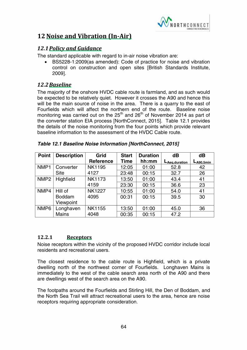
64
12NoiseandVibration(In-ir)
12.1Policy and Guidance The standard applicable with regard to in-air noise vibration are:
BS5228-1:2009(as amended): Code of practice for noise and vibration control on construction and open sites [British Standards Institute, 2009].
12.2Baseline The majority of the onshore HVDC cable route is farmland, and as such would be expected to be relatively quiet. However it crosses the A90 and hence this will be the main source of noise in the area. There is a quarry to the east of Fourfields which will affect the northern end of the route. Baseline noise monitoring was carried out on the 25th and 26th of November 2014 as part of the converter station EIA process [NorthConnect, 2015]. Table 12.1 provides the details of the noise monitoring from the four points which provide relevant baseline information to the assessment of the HVDC Cable route.
Table 12.1 Baseline Noise Information [NorthConnect, 2015]
Point Description Grid Reference
Start Time
Duration hh:mm
dB LAeq,duration
dBLA90,5min
NMP1 Converter Site
NK1195 4127
12:05 01:00 52.8 42
23:48 00:15 32.7 26
NMP2 Highfield NK1173 4159
13:50 01:00 43.4 41
23:30 00:15 36.6 23
NMP4 Hill of Boddam Viewpoint
NK1227 4095
10:55 01:00 54.0 41
00:31 00:15 39.5 30
NMP6 Longhaven Mains
NK1155 4048
13:50 01:00 45.0 36
00:35 00:15 47.2
12.2.1 Receptors Noise receptors within the vicinity of the proposed HVDC corridor include local residents and recreational users.
The closest residence to the cable route is Highfield, which is a private dwelling north of the northwest corner of Fourfields. Longhaven Mains is immediately to the west of the cable search area north of the A90 and there are dwellings west of the search area on the A90.
The footpaths around the Fourfields and Stirling Hill, the Den of Boddam, and the North Sea Trail will attract recreational users to the area, hence are noise receptors requiring appropriate consideration.
65
The breeding seabirds which utilise the cliff tops will be sensitive to noise and vibration disturbance when in residence.
12.3Potential Impacts
12.3.1 Construction and Installation The cable installation works including, excavations, HDD under the A90, cable laying and reinstatement, may have noise affecting both residential and recreational receptors. No vibration effects are expected as it is unlikely that any blasting will be required.
The cliff HDD search area is close to the cliff tops, North Sea Trail, and residential receptors on the A90. During drilling there could be noise and potentially vibration effects on these receptors. The exact location of the HDD entry point will determine the extent each receptor is affected.
The Fibre Optic Utilities Building construction will not be a major noise source and will have minimal noise effects on the coastal path users and local residents.
The number of vehicles on the A90 is in the order of 8500 per day (see Section 16.1). The increase in vehicles on the A90 associated with construction will be well below the 25% increase defined in the Design Manual for Roads and Bridges as increasing the noise level by 1dB LA10,18h. As such the construction traffic is not deemed to have a significant effect on noise levels.
12.3.2 Operation Once the cable has been installed there will be no associated operational impacts. If a fault develops in the cable then there may be a need to dig up and replace the affected section of cable this would have very short term noise impacts similar to those associated with the cable installation.
12.3.3 Decommissioning Assuming the cable is to be left in situ there will be no decommissioning noise or vibration impacts.
12.4Proposed Environmental Impact Assessment As the noise sources in the area have not changed it is deemed appropriate to utilise the 2014 background noise measurements from noise monitoring points NMP1, NMP2, NMP4 and NMP6 to inform the assessment. In addition it is proposed that background noise measurements are taken at the additional locations detailed in Table 12.2 and Drawing 3151; or as close as possible to; access permitting.

66
Table 12.2: Propose Noise Monitoring Locations
No. Name Grid Reference
NMP8 A90 Residence NK116 402
NMP9 North Sea Trail NK123 400
It is proposed that a construction noise assessment will be carried out in alignment with BS5228-1:2009(as amended): Code of practice for noise and vibration control on construction and open sites [British Standards Institute, 2009].
If deemed necessary appropriate mitigation will be identified to reduce noise and vibration impacts during construction and installation works.
67
13NoiseandVibration(Underwater)
13.1Policy and Guidance Relevant policy and guidance includes:
GEN 13 Noise: Development and use of the marine environment should avoid significant adverse effects of man-made noise and vibration, especially on species sensitive to such effects [Scottish Government, 2015].
13.2Baseline No data is available for baseline underwater noise levels in the North Sea along the offshore HVDC cable corridor. The HVDC cable corridor in general passes through open water, with only two main types of acoustic source. The predominant acoustic sources that are present along the cable corridor include: offshore oil and gas installations, fishing vessels and shipping.
The oil and gas installations are localised sources, which may generate high underwater noise levels in their vicinity. Shipping provides numerous transient, low intensity noise sources which in isolation have little effect on baseline noise levels. However, in high traffic areas, shipping noise can result in a significantly elevated baseline.
The oil and gas installation are concentrated along the UK-Norway median line, in the north east of the HVDC cable corridor. This infrastructure has been avoided during the initial cable routing, however it is likely that the baseline in the vicinity of oil and gas infrastructure will be elevated.
Shipping density is generally low throughout the cable corridor; however there are localised areas of high vessel traffic. These include the route between Aberdeen and Peterhead, and the water around the offshore oil and gas installations. Shipping is covered in more detail in Section 15.
As such baseline underwater noise levels are assumed to be low along the majority of the HVDC cable corridor. However, isolated acoustic sources including oil and gas installations, and areas of high vessel traffic may resulted in localised elevated noise levels.
13.3Potential Impacts
13.3.1 Construction & Installation During construction there is a potential for underwater noise to be generated, and increased marine noise can affect marine mammals and fish. The following activities associated with the construction and installation of the offshore HVDC cable:
Horizontal Directional Drilling (HDD),
Vessel movements,
Trenching operations, and
68
Cable protection installation (rock berms and concrete mattressing).
A report titled ‘Assessment of underwater noise during the installation of export power cables at the Beatrice Offshore Wind Farm’ was composed by SubAcoustec in 2012 for the installation of an HVDC cable for the Beatrice Offshore Wind development [Nedwell et al 2012]. The cable characteristics, installation techniques, and environmental conditions are comparable to the NorthConnect HVDC cable.
The report compared the predicted noise levels from the different aspects of cable installation, with the 90dB re 1μPa assessment criteria resulting in a ‘strong avoidance reaction by virtually all individuals’ for various marine mammals and fish species [Nedwell et al 2012]. Noise propagation loss modelling was used to calculate the distance from source that the resultant noise levels from each construction activity would fall below 90dB re 1μPa, this is referred to as the 90dB re 1μPa disturbance zone. It is likely that marine animals within this zone will be exposed to noise levels greater than or equal to 90dB re 1μPa, and are likely to experience significant disturbance, while out with the zone no disturbance effect is expected.
Different species have different hearing abilities, and hence any given sound will be perceived differently by each species. This is accounted for in the report, and hence different 90dB re 1μPa disturbance zones are reported for marine mammals and fish [Nedwell et al 2012]. The findings of this report are summarised below:
HDD Operations – The measured noise levels at the sea bed associated with HDD were very low. For example, for harbour porpoises the perceived noise level at the sea bed was 47dB, when corrected for the species’ hearing threshold. As such 90dB re 1μPadisturbance zone were not calculated, since the corrected noise levels would never exceed 90dB.
Vessel Movements – For marine mammals the 90dB re 1μPa disturbance zone was estimated to extend a maximum of 41m from the source for marine mammals, and 2m for fish.
Trenching Operations – This was the most significant noise source, resulting in a 90dB re 1μPa disturbance zone of 140m for marine mammals, but less than 1m for fish.
Cable Protection – Resulted in a 99m 90dB re 1μPa disturbance zone for marine mammals, and 6m for fish.
These predicted disturbance zones are very small, for comparison, impact piling has a typical 90dB re 1μPa disturbance zone of 12km [Nedwell et al 2012]. As such the effects of the underwater noise resulting from the installation of the HVDC are not likely to be significant.
Post installation offshore surveys will be required in order to ensure the cable is properly installed. This will be achieved through an acoustic survey, including multi-beam echo sounders and a cable tracking survey. The noise levels associated with the post installation survey cannot be determined until
69
the survey techniques and equipment are confirmed, and as such the level of impact is not currently known.
13.3.2 Operation There should be no significant sources of underwater noise resulting directly from the operation of the cable. However repairs and surveys of the cable may result in underwater noise emissions. Repairs are assumed to generate localised noise levels similar to those produced during construction and installation, and as such will not be significant.
Surveys may lead to significant underwater noise levels, although this will depend on the techniques and equipment employed.
13.3.3 Decommissioning There should be no significant sources of underwater noise associated with decommissioning.
13.4 Proposed Environmental Assessment Previous studies have revealed that the underwater noise emissions resulting from the installation of a similar submarine HVDC cable are not likely to have significant environmental impacts. As such these will be scoped out of the assessment.
The potential impacts of the post installation survey will be assessed once the equipment and survey techniques are finalised. Appropriate mitigation will be identified if the impacts of the post installation survey are found to be significant.
The impacts associated with operation and decommissioning will not be significant, and as such will not be considered in the scope of the environmental statement.
70
14ResourceUsageandWaste
14.1Policy and Guidance Relevant policy and guidance includes:
GEN 11 Marine Litter: Developers, users and those accessing the marine environment must take measures to address marine litter where appropriate. Reduction of litter must be taken into account by decision makers [Scottish Government, 2015].
The Waste (Scotland) Regulations 2012 [Scottish Minister, 2012].
Zero Waste Plan [Scottish Government, 2010].
Waste Hierarchy
There are currently no regulations on, or pertaining to, sustainable resourcing in Scotland, out with the Public Sector. However, in 2010 the Scottish Government published Scotland’s Zero Waste Plan [Scottish Government, 2010a], which sets out the government’s vision for a sustainable and resource efficient future. While the sustainable resourcing aspect of the vision is still to be brought into the legislation, NorthConnect will strive to fulfil the following two components of the vision:
‘Individuals, the public and business sectors - appreciate the environmental, social and economic value of resources, and how they can play their part in using resources efficiently.’
And;
‘Reduce Scotland’s impact on the environment, both locally and globally, by minimising the unnecessary use of primary materials, reusing resources where possible, and recycling and recovering value from materials when they reach the end of their life.’
14.2Potential Impacts
14.2.1 Construction and Installation During construction and installation materials will be required to produce the HVDC and fibre optic cables. Additional materials will also be required to provide cable protection, junction boxes and other associated infrastructure. It will not be possible to finalise the material requirements and volumes until the design stage has been progressed, however Table 14.1 below provides an indication of the main material requirements of the project.
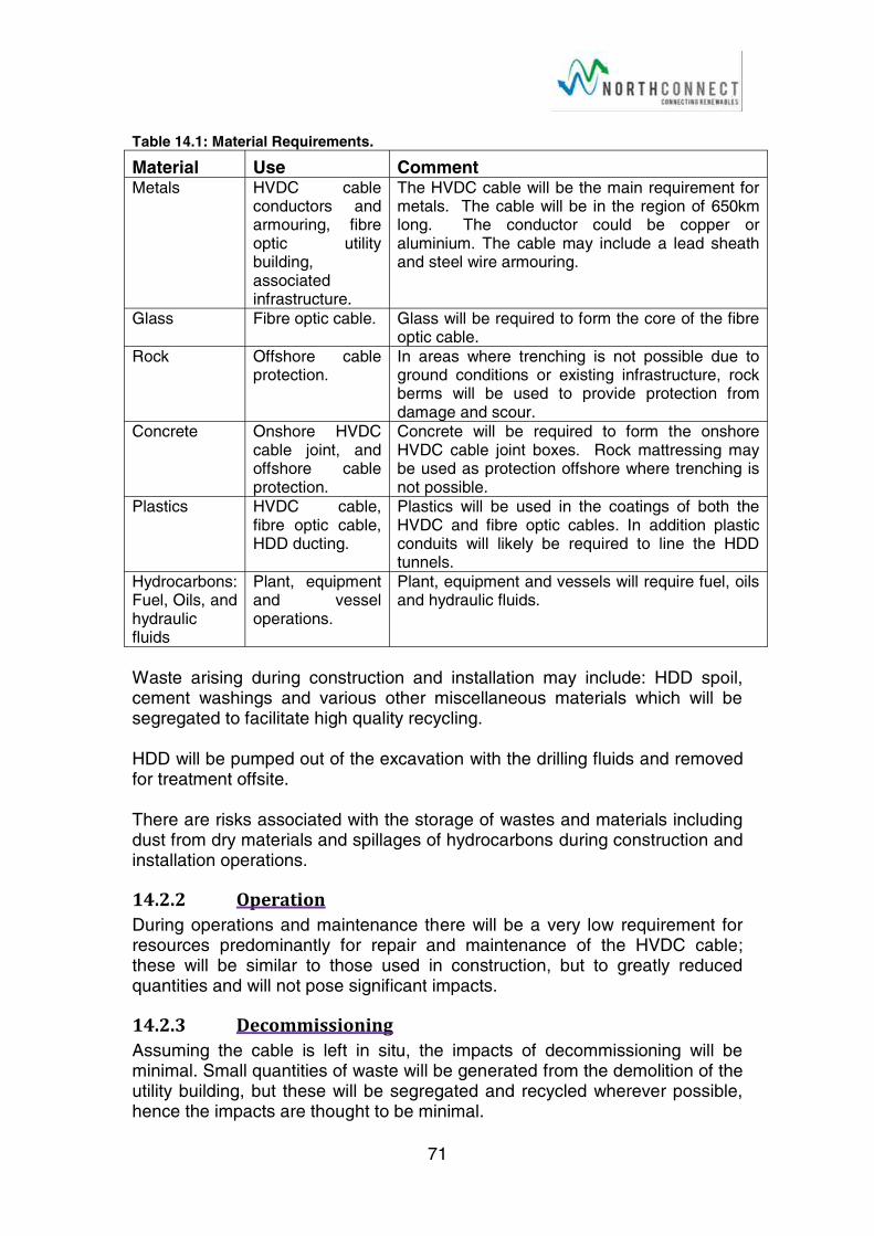
71
Table 14.1: Material Requirements.
Material Use CommentMetals HVDC cable
conductors and armouring, fibre optic utility building, associated infrastructure.
The HVDC cable will be the main requirement for metals. The cable will be in the region of 650km long. The conductor could be copper or aluminium. The cable may include a lead sheath and steel wire armouring.
Glass Fibre optic cable. Glass will be required to form the core of the fibre optic cable.
Rock Offshore cable protection.
In areas where trenching is not possible due to ground conditions or existing infrastructure, rock berms will be used to provide protection from damage and scour.
Concrete Onshore HVDC cable joint, and offshore cable protection.
Concrete will be required to form the onshore HVDC cable joint boxes. Rock mattressing may be used as protection offshore where trenching is not possible.
Plastics HVDC cable, fibre optic cable, HDD ducting.
Plastics will be used in the coatings of both the HVDC and fibre optic cables. In addition plastic conduits will likely be required to line the HDD tunnels.
Hydrocarbons: Fuel, Oils, and hydraulic fluids
Plant, equipment and vessel operations.
Plant, equipment and vessels will require fuel, oils and hydraulic fluids.
Waste arising during construction and installation may include: HDD spoil, cement washings and various other miscellaneous materials which will be segregated to facilitate high quality recycling.
HDD will be pumped out of the excavation with the drilling fluids and removed for treatment offsite.
There are risks associated with the storage of wastes and materials including dust from dry materials and spillages of hydrocarbons during construction and installation operations.
14.2.2 Operation During operations and maintenance there will be a very low requirement for resources predominantly for repair and maintenance of the HVDC cable; these will be similar to those used in construction, but to greatly reduced quantities and will not pose significant impacts.
14.2.3 Decommissioning Assuming the cable is left in situ, the impacts of decommissioning will be minimal. Small quantities of waste will be generated from the demolition of the utility building, but these will be segregated and recycled wherever possible, hence the impacts are thought to be minimal.

72
14.3Proposed Environmental Assessment It is proposed that the construction materials are identified and quantified in terms of volume and environmental lifecycle cost, within the Environmental Assessment. This information will be utilised to inform the detailed design and procurement process so that wherever possible, quantities can be minimised.
Material and waste handling will be considered and the Schedule of Mitigation will include appropriate methods to minimise effects.
73
15 Shipping
15.1Applicable Policies & Guidance Relevant policy and guidance includes:
NMP TRANSPORT 1: Navigational safety in relevant areas used by shipping now and in the future will be protected, adhering to the rights of innocent passage and freedom of navigation contained in United Nation Convention on the Law of the Sea (UNCLOS).
NMP TRANSPORT 2: Marine development and use should not be permitted where it will restrict access to, or future expansion of, major commercial ports or existing or proposed ports and harbours which are identified as National Developments in the current NPF or as priorities in the National Renewables Infrastructure Plan.
NMP TRANSPORT 3: Ferry routes and maritime transport to island and remote mainland areas provide essential connections and should be safeguarded from inappropriate marine development and use that would significantly interfere with their operation. Developments will not be consented where they will unacceptably interfere with lifeline ferry services.
NMP TRANSPORT 6: Marine planners and decision makers and developers should ensure displacement of shipping is avoided where possible to mitigate against potential increased journey lengths (and associated fuel costs, emissions and impact on journey frequency) and potential impacts on other users and ecologically sensitive areas [Scottish Government, 2015].
The International Regulations for Preventing Collisions at Sea 1972 (Colregs). [International Marine Organisation (IMO) 1972].
15.2Baseline The proposed landfall of the HVDC cable in the Long Haven bay area lies between the two major ports of Peterhead, approximately 3 miles to the north, and Aberdeen 20 miles to the south. The HVDC cable corridor does not cross the Harbour Limits of either the Ports of Aberdeen or Peterhead.
There are no designated anchorages along the HVDC cable corridor.
A review of the National Marine Plan Interactive website indicates there are no IMO recommended shipping routes, deep water routes, or vessel traffic separation schemes in the waters crossed by the HVDC cable corridor. However the Aberdeen-Kirkwall, and Aberdeen-Lerwick ferry routes are bisected by the proposed HVDC cable route [Scottish Government, 2014].
The MarineTraffic website publishes vessel traffic density data, obtained from vessels’ Automated Identification Systems (AIS). AIS is an automated tracking system used by ships and for identifying and locating vessels by electronically exchanging data with other nearby ships, AIS base stations and satellites. This data indicates that vessel density along the majority of the HVDC cable corridor is low, although there are two notable high density
74
areas. These are the inshore waters between Aberdeen and Peterhead, and the waters surrounding the offshore oil and gas installations adjacent to the UK-Norway median line.
The HVDC cable corridor also passes through waters which are important to the fisheries industry. However this will be addressed separately in Section 11 – Local Community and Economics.
15.3Potential Impacts
15.3.1 Construction & Installation The construction and installation of a subsea cable requires the use of several large vessels, including a cable laying vessel, a cable protection vessel for installing rock berms and concrete mattressing, survey vessels, and other support craft. During the installation process both the cable laying, and cable protection vessels will be operating using dynamic position systems, and are restricted in their ability to manoeuvre. As such all other vessel traffic will be required to divert around the installation vessels under the International Regulations for the Prevention of the Collisions at Sea 1972 [IMO,1972].
The avoidance of vessels that are restricted in their ability to manoeuvre is standard practice, and applies to any vessel which is limited in its ability to change course due to its operations, for example an anchored handler placing an anchor. The required diversion will be relatively small, and hence will not increase travel time or fuel costs for other vessel traffic significantly. Also the installation vessels will be constantly moving, and as such the impact will be temporary. It is therefore concluded that the impacts on shipping from the construction and installation activities will not be significant.
15.3.2 Operation Since the cable will be installed on or below the seabed throughout its length within UK waters, there will be no obstruction to vessel traffic during the operational phase.
Anchoring will not be possible along the length of the cable route once it is installed, due to the risk of fouling the cable. However the cable route is narrow, and does not pass through any designated anchorages or Harbour Authority Waters means that this effect will not be significant.
As identified in Section 8 EMF can effect compass deviation which has implications for the navigation of vessels operating in close proximity to the cable; this will be considered within the EMF assessment.
The use of rock berms and concrete mattressing as cable protection in areas where trenching is not possible may have implications for the fishing industry. This is considered in Section 11 Local Community and Economics.
75
15.3.3 Decommissioning Assuming the cable is left in situ following decommissioning, the impacts will be as those described for the operational phase. However the EMF effects will not be present if the cable is no longer in use.
15.4 Proposed Environmental Assessment No significant impacts on shipping are expected from the Construction and Installation, Operation, or Decommissioning phases of the North Connect HVDC Interconnector. As such this aspect will be scoped out of the EIA.
It should be noted that that following standard mitigation measures will be implemented throughout the offshore construction and installation works:
All vessels associated with the installation of the HVDC cable will be compliant with the International Regulations for the Prevention of Collisions at Sea 1972 [IMO, 1972].
Notice to Mariners will be published as appropriate to advise other shipping of the operations.
Following completion, the as-built cable route details will be provided to the National Hydrographic Office for inclusion in future navigational charts.
76
16Trafficandccess
16.1Policy and Guidance Relevant policy and guidance includes:
Planning Advice Note (PAN) 75: Planning for Transport [Scottish Government, 2005].
Local Transport Strategy [Aberdeen City and Shire, 2012].
Transport Assessment Guidance [Transport Scotland, 2012]; and
Guidelines for the Environmental Assessment of Road Traffic, Institute of Environmental Management and Assessment [IEMA, 1993].
16.2Baseline The A90 is the major north to south road in eastern Scotland, running from Edinburgh to Perth in the form of the M90, then as the A90 to Dundee, through Aberdeen, around Peterhead to Fraserburgh. All deliveries and personnel traveling to the site from the North or South will utilise the A90. In addition the A982 into Peterhead and passing the harbour, will be utilised to transport materials which are delivered by sea, and potentially personnel from the town.
In order to establish the baseline situation, traffic survey data was sought along the road network in the vicinity of the development site. Average Daily Traffic Flows (ADTFs) for 2000 to 2012 have been obtained from the Department for Transport (2016) for the A90 at two locations in the vicinity of the site. This data provides a daily average flow of the number of vehicles passing a point in the road network each day averaged over a four-week (Monday to Saturday) period in a neutral month.
Aberdeenshire Council has two existing permanent traffic count points nearby, providing daily traffic flow data.
Count Site 1 - (CP 20803) is located on the A90 between the junction with the A975 (just South of Longhaven) and the junction with the A982 (into Peterhead); passing the proposed access point to the Fourfields site and the HDD site. Traffic is counted over a length of 6.2km.
Count Site 2 - (CP 80574) is also located north of the proposed site, on the A982. This is the route in and out of Peterhead, to access the port. Traffic is counted over a length of 2.4km.
The traffic data is for a 24 hour period, the traffic levels for the last 5 years of data (2010-2014) at count point 1 is relatively steady. At count point 2 the traffic numbers have increase year on year for four years, primarily due to an increase in car and taxis numbers, HGV movements have reduced over the same time period. Table 3.7 provides the average daily travel numbers for the last five years of available data.
No pedal cycles have been counted at count site 1 on the A90 since 2005, daily numbers at count site 2 average 23 a day. The A90 is a busy, fast road so it is not all that surprising that cyclist avoid it. The Formartine & Buchan
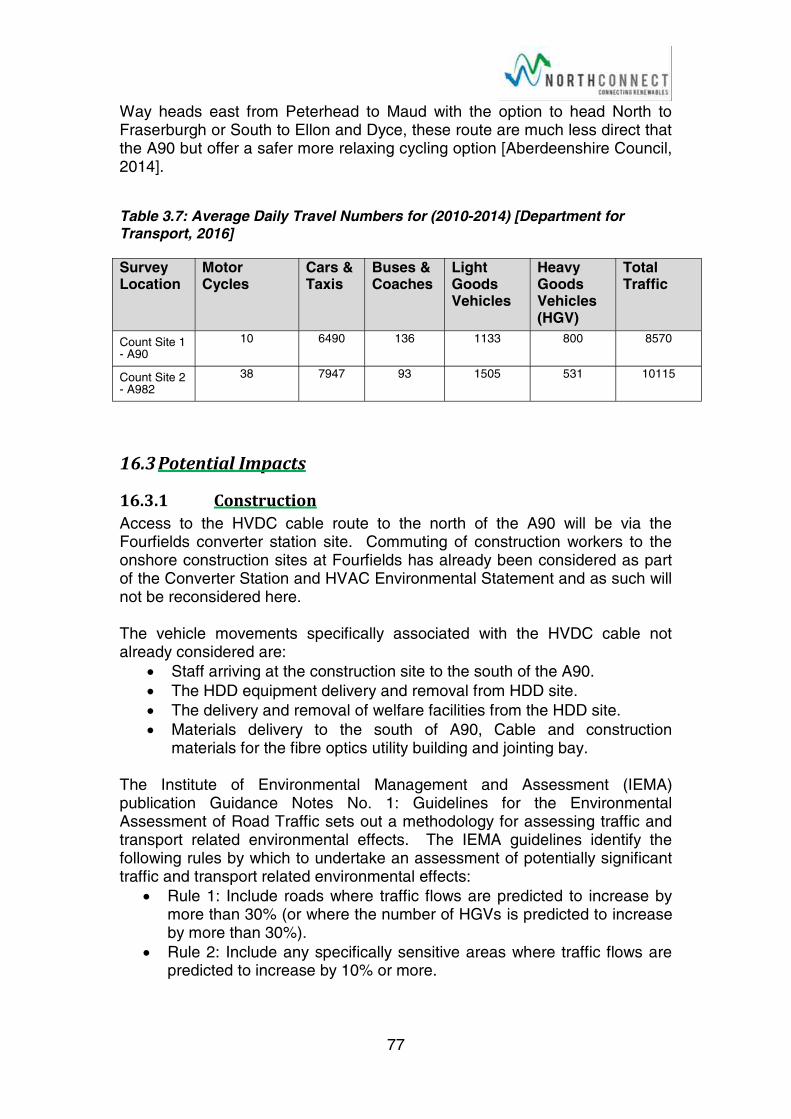
77
Way heads east from Peterhead to Maud with the option to head North to Fraserburgh or South to Ellon and Dyce, these route are much less direct that the A90 but offer a safer more relaxing cycling option [Aberdeenshire Council, 2014].
Table 3.7: Average Daily Travel Numbers for (2010-2014) [Department for Transport, 2016]
Survey Location
Motor Cycles
Cars & Taxis
Buses & Coaches
Light Goods Vehicles
Heavy Goods Vehicles (HGV)
Total Traffic
Count Site 1 - A90
10 6490 136 1133 800 8570
Count Site 2 - A982
38 7947 93 1505 531 10115
16.3Potential Impacts
16.3.1 Construction Access to the HVDC cable route to the north of the A90 will be via the Fourfields converter station site. Commuting of construction workers to the onshore construction sites at Fourfields has already been considered as part of the Converter Station and HVAC Environmental Statement and as such will not be reconsidered here.
The vehicle movements specifically associated with the HVDC cable not already considered are:
Staff arriving at the construction site to the south of the A90.
The HDD equipment delivery and removal from HDD site.
The delivery and removal of welfare facilities from the HDD site.
Materials delivery to the south of A90, Cable and construction materials for the fibre optics utility building and jointing bay.
The Institute of Environmental Management and Assessment (IEMA) publication Guidance Notes No. 1: Guidelines for the Environmental Assessment of Road Traffic sets out a methodology for assessing traffic and transport related environmental effects. The IEMA guidelines identify the following rules by which to undertake an assessment of potentially significant traffic and transport related environmental effects:
Rule 1: Include roads where traffic flows are predicted to increase by more than 30% (or where the number of HGVs is predicted to increase by more than 30%).
Rule 2: Include any specifically sensitive areas where traffic flows are predicted to increase by 10% or more.
78
The worst case increase in traffic flow to the construction area to the south of the A90 is estimated to be 100 movements (25 cars or vans and 25HGV’s arriving and leaving a day), this would be for short time frames (up to 2 weeks) only. This is a less than 1.2% increase in overall traffic volume on the A90 and a 6.3% increase in HGV movements.
The worst case increase in traffic flow to the Fourfields site was estimated to be 500 movements a day (400 car, 30 vans and 80HGV’s), it is unlikely that the worst case traffic numbers would occur on both parts of the construction site at the same time, however this has been assumed for the purpose of assessment. The worst case in-combination effect would therefore be 600 movements (480 cars & vans and 130HGV’s), which is a 7.1% increase in all movements and a 16.3% increase in HGV movements. The in-combination worse case effect does not breach either of the IEMA rules; as such a significant effect is not predicted.
A temporary access route to the south side of the A90 will need to be designed, to manage the size and volume of vehicles predicted.
16.3.2 Operation During operations access to the onshore HVDC cable should not be required, in event of a fault temporary access will be required, this is likely to be by suitable vehicles through existing field access routes.
16.3.3 Decommissioning It is likely that the cable will be left in situ, if so then there will be no impacts associated with decommissioning.
16.4Proposed Environmental Impact Assessment A topographical and engineering survey of the area will inform the design of the temporary access to the cable route south of the A90.
No significant effects on traffic are predicted for the HVDC cable installation, nor the in-combination effects with the rest of the NorthConnect project as such in assessment of traffic effects proposed. Appropriate mitigation to minimise traffic impacts such as car sharing will be incorporated into the projects Schedule of Mitigation.
The design and construction of a temporary access to the south side of the A90 will be incorporate appropriate environmental considerations and will be addressed with the Environmental Statement.
79
17WaterQuality
17.1Policy and Guidance Relevant policy and guidance includes:
GEN 8 Coastal process and flooding: Developments and activities in the marine environment should be resilient to coastal change and flooding, and not have unacceptable adverse impact on coastal processes or contribute to coastal flooding.
GEN 12: Water quality and resource: Developments and activities should not result in a deterioration of the quality of waters to which the Water Framework Directive, Marine Strategy Framework Directive or other related Directives apply [Scottish Government, 2015];
European Water Framework Directive (WFD) [European Parliament, 2000].
Water Environment and Water Services (Scotland) Act 2003 [Scottish Parliament, 2003].
PAN 79: Water and Drainage [Scottish Government, 2006];
Pollution Prevention and Environmental Management in the Marine Environment [Scottish Environment Protection Agency (SEPA), 2015];
Pollution Prevention Guideline Note (PPG) 5: Works and Maintenance in or Near Water [SEPA et al, 2007];
PPG6: Work at Construction and Demolition Sites [SEPA et al, 2014];
Guidance on Marine Non-Native Species [GreenBlue, 2013]; and
Marine Non-Native Species [Scottish Natural Heritage, 2013].
17.2Baseline
17.2.1 Onshore The water quality of Scotland’s rivers is classified by Scottish Environment Protection Agency (SEPA), who have developed a classification scheme for surface waters following the requirements of the WFD, to support the river basin management planning process. However none of the watercourses in the vicinity of the HVDC cable route have been assessed due to their small size.
There are three field drains which cross the HVDC cable route corridor. Two of the drains have been shown to drain down to the sea, while the outfall of the third is unknown at present.
There are no pools, ponds or natural watercourses in the vicinity of the HVDC cable route.
17.2.2 Offshore The water quality of Scotland’s coastal waters (defined as 3 miles offshore to the highest tide limit) is classified by SEPA, under the requirements of the WFD. The most recent classification results were published in 2014 by SEPA as part of the River Basin Management Plan.
80
The HVDC landfall at Long Haven falls within the monitoring zone of Buchan Ness to Cruden Bay (ID: 200125). These water are categorised by SEPA as not being heavily modified, not being artificial, and with a typology of CW2. In 2013 SEPA classified the Buchan Ness to Cruden Bay waters as having an overall status of ‘high with high confidence’; with overall ecological status of ‘high’ and overall chemical status of ‘pass’.
The adjacent water quality monitoring zones are Ugie Estruary to Buchan Ness (ID: 200131) to the North, and Cruden Bay (ID: 200181) to the south. The Ugie estuary to Buchan Ness zone is categorised as being heavily modified (due to the port of Peterhead), but not artificial, while Cruden Bay is not heavily modified and not artificial, both are CW2 waters.
SEPA classified the Ugie Estuary to Buchan Ness water body as having an overall status of ‘good ecological potential with medium confidence’ in 2013; with overall ecological status of ‘moderate’ and overall chemical status of ‘pass’. In 2013 Cruden Bay was classified as having an overall status of ‘highwith high confidence’; with overall ecological status of ‘high’ and overall chemical status of ‘pass’.
The quality of waters further offshore than the 3 mile limit is not routinely measured under the existing monitoring programmes. However it is assumed that the water quality in this region will be high. This is due to the fact that the majority of contaminants which enter the marine environment in association with water (river and waste water outfalls), tend to be trapped in the estuarine and near coastal zones, as components of the sediment. Substances which are soluble in water are readily diluted. It is possible that contaminants can enter this zone from direct local inputs, such as the offshore oil and gas infrastructure. However where this occurs levels will be elevated locally, but will decrease rapidly with distance from the input site.
17.3Potential Impacts
17.3.1 Construction and Installation For the construction process the following potential impacts have been identified:
Onshore Pollution risks associated with the use of hydrocarbons: oils, fuels,
hydraulic fluids;
Pollution risks associated with cement products and cement washings (sediments, suspended solids and alkalinity);
Pollution risks associated with sediments and suspended solids from the storage of materials; and
Surface water runoff leading to silt discharges to freshwater.
81
Offshore Surface water runoff from onshore activities leading to silt discharges to
sea.
Re-release of contamination from the seabed;
Pollution risks associated with the use of hydrocarbons: oils, fuels, hydraulic fluids;
Introduction of Marine Non-Native Species (MNNS); and
Suspended solids issues arising during: o Horizontal directional drill marine exit; o Offshore cable trenching (jetting, ploughing, etc.). o Installation of rock berms for cable protection.
17.3.2 Operation Since the HVDC cable will either be buried or covered by protection along its length, no ongoing effects on water quality are expected during normal operations.
Maintenance and repair works to the cable may be required during its lifetime. This will result in similar risks to water quality as is described for installation; however these will only persist for the duration of the maintenance works.
17.3.3 Decommissioning If the cable is left in situ then no effects on water quality will result from decommissioning.
17.4 Proposed Environmental Impact Assessment A desk based baseline assessment to understand the general water quality and sensitivity of the area is proposed.
The pollution risks and risks associated with introducing MNNS will be assessed.
Appropriate mitigation in line with best practice such as those mentioned in Section 17.1 will be identified in the Schedule of Mitigation for inclusion within the CEMD to minimise risks to water quality.
Any discharges associated with the construction works or operations will be appropriately treated and licensed under CAR (see Section 3.3.6). Potential discharges and the proposed management will be discussed in the ES.
82
18ConclusionA full range of environmental topics have been considered. Table 4.1 summarises the environmental topics which have been scoped in and out of the EIA process. The level of detail provided will be proportionate to the significance of the effect.
Three topics have been scoped out and as such NorthConnect do not propose to include the within the ES, these are:
Landscape, Seascape and Visual Impacts
Shipping; and
Traffic and Access.
Onshore ecological surveys and noise monitoring are proposed, ornithological surveys are already in progress. A detailed seabed survey is to be carried out in 2016 and 2017. This will provide information to support the assessment of marine effects on ecology, archaeology, seabed, and water quality. The surveys will inform the siting of the fibre optic building, and the cable routing. In addition they will aid in the identification of offshore cable installation requirements and appropriate technique selection.
NorthConnect welcome a scoping response to allow the project to be able to tailor our surveys and assessments to meet Marine Scotland, Aberdeenshire Council and their statutory consultees’ requirements.
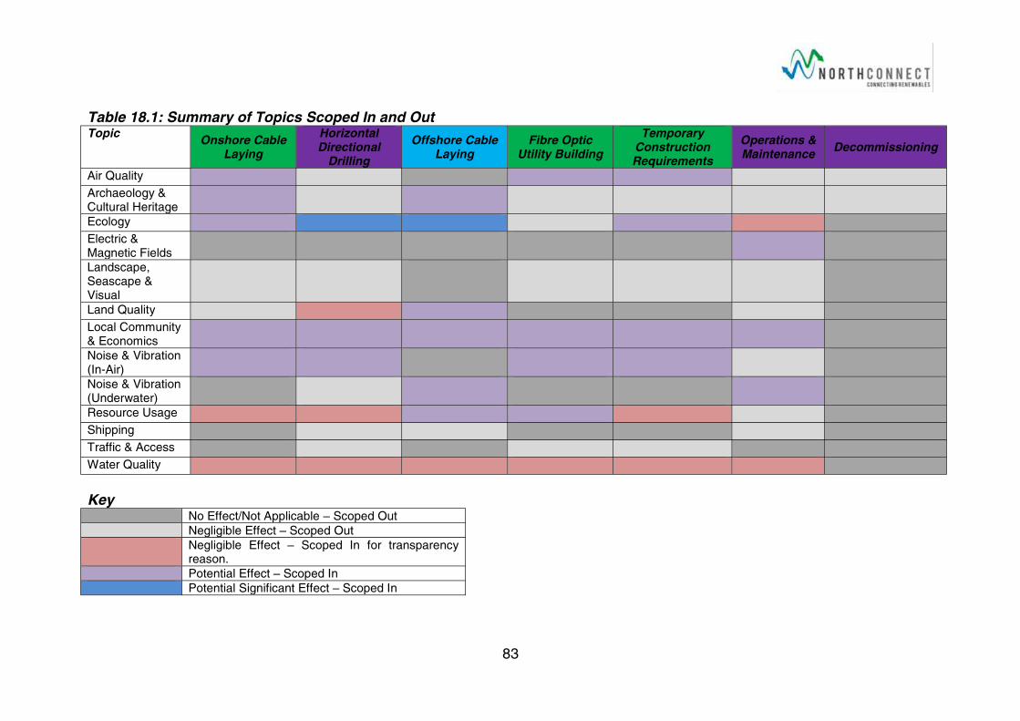
83
Table 18.1: Summary of Topics Scoped In and Out Topic
Onshore Cable Laying
Horizontal Directional
Drilling
Offshore Cable Laying
Fibre Optic Utility Building
Temporary Construction Requirements
Operations & Maintenance
Decommissioning
Air Quality
Archaeology & Cultural Heritage
Ecology
Electric & Magnetic Fields
Landscape, Seascape & Visual
Land Quality
Local Community & Economics
Noise & Vibration (In-Air)
Noise & Vibration(Underwater)
Resource Usage
Shipping
Traffic & Access
Water Quality
Key No Effect/Not Applicable – Scoped Out
Negligible Effect – Scoped Out
Negligible Effect – Scoped In for transparency reason.
Potential Effect – Scoped In
Potential Significant Effect – Scoped In
84
19References
Aberdeen City and Shire (2012), Local Transport Strategy 2012
Aberdeen City and Shire Strategic Development Planning Authority, (2014). Aberdeen City and Shire Strategic Development Plan: Aberdeen City and Shire
Aberdeenshire Council, (2012a). Aberdeenshire Local Development Plan.
Aberdeenshire Council, (2012b). Aberdeenshire Local Development Plan. Supplementary Guidance – Policies
Aberdeenshire Council, (2012c) Planning Advice 12/2012 Landscape Character Advice for Small Scale Development.
Aberdeenshire Council (2012d). Economic Development Strategy 2011-2016, GDT14101
Aberdeenshire Council (2014). The Formartine & Buchan Way http://www.aberdeenshire.gov.uk/outdooraccess/long_routes/LongsidetoPeterhead.pdf
Aberdeenshire Council (2015). Full Planning Permission, Application Reference: APP/2015/1121
Aberdeenshire Council (2016a), The Proposed Aberdeenshire Local Development Plan 2016 – Shaping Aberdeenshire, https://www.aberdeenshire.gov.uk/planning/plans-and-policies/the-proposed-aberdeenshire-local-development-plan-2016-shaping-aberdeenshire/.
Aberdeenshire Council (2016b). eplanning website, https://upa.aberdeenshire.gov.uk/online-applications/, Accessed 3rd April 2016
Aberdeenshire Council (2016c). Aberdeenshire Sites and Monuments Record, http://www.aberdeenshire.gov.uk/smrpub/shire/.
Aberdeenshire Council, (2016d), Local Development Plan 2016 – Proposed Plan – Part 2
Aberdeenshire Council, (2016e) Supplementary Guidance 3 – Energetica.
Armstrong JD, Hunter D-C, Fryer RJ, Rycroft P & Orpwood JE (2015), Behavioural Responses of Atlantic Salmon to Mains Frequency Magnetic Fields. Scottish Marine and Freshwater Science, Vol 6, No9. ISSN:2043-7722.
Atmos (2014a). North Connect Converter Building, Peterhead - Extended Phase 1 Survey_19400-07/Rev1
Atmos (2014b). North Connect Converter Building - Winter Walkover Bird Survey_19400-06/Rev1.
Blanchfield, R (2014). NorthConnect Stage 1&2 Ground Investigation Report
British Standards Institution (1990). BS 1377-1:1990: Methods of Test for Soils for Civil Engineering Purposes.
British Standards Institution (1997). BS EN 1997-1:2004: Eurocode 7: Geotechnical Design
British Standard Institute (2009). BS 5228-1:2009 Code of practice for noise and vibration control on construction and open sites – Part 1: Noise Annex E 3.3
British Standards Institute (2011). BS 10175:2011 Code of Practice for the Investigation of Potentially Contaminated Sites
British Standards Institution (2013). BS EN ISO 14688-1:2002+A1:2013: Geotechnical Investigation and Testing — Identification and Classification of Soil (Part 1: Identification and description)
85
British Standards Institution (2015). BS 5930: 2015: Code of Practice for Site Investigation
Bunyan,J (2014) NorthConnect Ecological Surveys, Otter, Water Vole & Badger Survey, Report Ref: 14/021/AFF/R01
Cobham Resource Consultants (1997). Banff and Buchan Landscape Character Assessment, SNH Review No 37
Countryside Council for Wales (2006). Handbook for Marine Intertidal Phase 1 Biotope Mapping Survey.
Crown Estate (2014). Protocol for Archaeological Discoveries, Offshore Renewables Projects, 2nd Issue.
Department for Transport (2016). Download Traffic Datasets Aberdeenshire http://www.dft.gov.uk/traffic-counts/download.php
Department of Energy & Climate Change (2010). Power Lines: Demonstrating compliance with EMF public exposure guidelines. A Voluntary Code of Practice.
ERS (2013) North Collielaw & Denend, Peterhead, Desk Study, REP01-REV02
European Commission (1999). Council Recommendation of 12 July 1999 on the limitation of exposure of the general public to electromagnetic fields (0 Hz to 300 GHz) EU Recommendation 1999/519/EC. L199/59. 30.7.1999
European Parliament (2000). European Water Framework Directive. Directive 2000/60/EC
European Union (2011). Environmental Impact Assessment (“EIA”) Directive, 2011/92/EU.
Farmer (2015). 2015 Aberdeenshire Council LAQM 2015 Updating and Screening Assessment for Aberdeenshire Council, In fulfilment of Part IV of the Environment Act 1995, Local Air Quality Management, 2015USA1.
Gill, A.B. & Bartlett, M. (2010). Literature review on the potential effects of electromagnetic fields and subsea noise from marine renewable energy developments on Atlantic salmon, sea trout and European eel. Scottish Natural Heritage Commissioned Report No.40.
GreenBlue (2013), Guidance on Marine Non-Native Species, http://www.thegreenblue.org.uk/clubs_and_training_centres/antifoul_and_invasive_species/best_practice_invasive_species.aspx, Accessed 24/03/16.
Henderson (2014). NorthConnect - Site Selection Optioneering Report, 2014.03.23_NorthConnect_PER_REP_SiteSelectionOptioneering_Rev1
Historic Scotland (2010) Managing Change in the Historic Environment, Setting.
Horner, P.C. (1988). Planning & Construction for Earthworks Projects
IEEE (2012). Std 81-2012: Guide for Measuring Earth Resistivity, Ground Impedance and Earth Surface Potentials of a Ground System
Institute of Air Quality Management (IAQM) (2012), Air Quality Monitoring in the Vicinity of Demolition and Construction Sites.
Institute of Air Quality Management (IAQM) (2014), Assessment of Dust From Demolition and Construction
Institute of Ecology and Environmental Management (IEEM) (2006), Guidelines for Ecological Impact Assessment in the United Kingdom
Institute of Ecology and Environmental Management (IEEM) (2012). Guidelines for Preliminary Ecological Appraisal
86
Institute of Environmental Assessment (1995) Guidelines for Baseline Ecological Assessment. E&F Spon.London
Institute of Environmental Management and Assessment 919930, Guidelines for the Environmental Assessment of Road Traffic, Institute of Environmental Management and Assessment
International Commission on Non-Ionising Radiation Protection (1998). Guidelines for limiting exposure to time-varying electric, magnetic, and electromagnetic fields (up to 300 GHz). Health Physics April 1998, Volume 74, Number 4:494-522
International Maritime Organisation (1972). The International Regulation for Preventing Collisions at Sea, Colregs
Jackson,D (2016) Personal communications with Fiona Henderson, Email 13th
April 2016
JNCC (2003), Atlas of Cetacean Distribution in North West European Waters.
JNCC (2010), UKSeaMap Interactive Website, http://jncc.defra.gov.uk/page-5534, Accessed 31/03/16.
Landscape Institute and Institute of Environmental Assessment (2013). Guidelines for Landscape and Visual Impact Assessment. Third edition.
Macaulay Institute for Soil Research (now the James Hutton Institute) (1981). Land Capability for Agriculture (LCA) in Scotland, Aberdeen
Marine Scotland (2011), Pre-dredge Sampling Guidance, http://www.gov.scot/Topics/marine/Licensing/marine/Applications/predredge.
Mcknight, A (2014) Preliminary Breeding Bird Survey – NorthConnect Potential Development Site Boddum, Peterhead
National Radiological Protection Board, 2004. Advice on Limiting Exposure to Electromagnetic Fields (0-300 GHz). Documents of the National Radiological Protection Board (2004) Volume 15 No 2 2004
Nedwell J, Brooker A, & Barham R (2012), Assessment of underwater noise during the installation of export power cables at the Beatrice Offshore Wind Farm. Subacoustech Environmental Report No.E318R0106.
NorthConnect (2015), NorthConnect Interconnector Converter Station and HVAC Cable Route – Environmental Statement
Parry M.E.V (2015).Guidance on Assigning Benthic Biotopes using EUNIS or the Marine Habitat Classification of Britain and Ireland. JNCC Report No: 546.
Royal Commission on the Ancient and Historic Monuments of Scotland (RCAHMS) (2016). Pastmap, http://pastmap.org.uk/.
Scottish Environment Protection Agency, Environment Agency, Environment and Heritage Services (2007). Pollution Prevention Guidance Note 5: Works and Maintenance in or Near Water
Scottish Environment Protection Agency, Environment Agency, Environment and Heritage Services (2014). Pollution Prevention Guidance Note 6: Work at Construction and Demolition Sites.
Scottish Environment Protection Agency (SEPA) (2015). Pollution Prevention and Environmental Management in the Marine Environment.
Scottish Government (2000). Planning Advice Note PAN 33 Development of Contaminated land, http://www.gov.scot/Publications/2000/10/pan33
Scottish Government (2005). Planning Advice Note: PAN 75 – Planning for Transport, ISBN 0755926323,
87
Scottish Government (2006). Planning Advice Note PAN:79 Water and Drainage, ISBN 0755962621
Scottish Government (2008). Planning for Natural Heritage: Planning Advice Note 60, August 200 updated 2008, http://www.gov.scot/Publications/2000/08/pan60-root/pan60
Scottish Government (2010). Scotland’s Zero Waste Plan, ISBN 978 0 7559 8306 3.
Scottish Government, (2011a). Town and Country Planning (Environmental Impact Assessment) (Scotland) Regulations, S.I 2011/1824
Scottish Government (2011b), The Water Environment (Controlled Activities) (Scotland) Regulations 2011, SI; 2011:209.
Scottish Government, (2011c). Planning Advice Note PAN 2/2011 Planning and Archaeology
Scottish Government (2013), The Marine Licensing (Pre-application Consultation) (Scotland) Regulations 2013, SI; 2013:286.
Scottish Government (2014), Scotland’s National Marine Plan Interactive Website. Accessed 7th April 2016.
Scottish Government (2015), Scotland’s National Marine Plan, ISBN: 978-1-78544-214-8
Scottish Government (2016a), Current Marine Renewable Energy Projects, http://www.gov.scot/Topics/marine/Licensing/marine/scoping, Accessed 3rd
April 2016
Scottish Government (2016b), Current Construction, Cable and NRIP Projects, http://www.gov.scot/Topics/marine/Licensing/marine/current-construction-projects, Accessed 3rd April 2016
Scottish Ministers (2012), The Waste (Scotland) Regulations 2012, SI; 2012:148.
Scottish Ministers, (2014a). Scotland’s Third National Planning Framework (NPF3). SG/2014/100
Scottish Ministers, (2014b). Scottish Planning Policy
Scottish Natural Heritage (2011), Guidance on Survey and Monitoring in Relation to Marine Renewables Deployments in Scotland, Volumes 1-5.
Scottish Natural Heritage (2013). Marine Non-Native Species, http://www.snh.gov.uk/land-and-sea/managing-coasts-and-sea/marine-nonnatives/, Accessed 28/02/16.
Scottish Natural Heritage (2016a), Recommended Approach to the Survey of Benthic Habitats and Species.
Scottish Natural Heritage (2016b), Sitelink, https://gateway.snh.gov.uk/sitelink/Accessed 11th April 2016.
Scottish Parliament, (1997). Town and Country Planning (Scotland) Act. 1997 c. 8
Scottish Parliament (2003). Water Environment and Water Services (Scotland) Act 2003. 2003 Asp 3
Scottish Parliament (2010). Marine (Scotland) Act 2010, 2010 ASP 5.
Technip Offshore Wind Ltd (2013). NorthConnect Landfall Option Study, TOWL-1076-RT-ENG-001
Transport Scotland (2012). Transport Assessment Guidance, ISBN: 978-1-908181-37-4
88
UK Climbing (2016), Find Crags http://www.ukclimbing.com/logbook/map/?q=ABERDEENSHIRE&x=-2.646&y=56.956&z=10
UK Government (1994), The Conservation (Natural Habitats, &c.) Regulations 1994. SI; 1994:2716.
UK Government (2007), Marine Works (Environmental Impact Assessment) Regulations 2007, SI 2007;1518.
UK Government (2009), Marine and Coastal Access Act 2009. 2009 c. 23.
Walsh, P.M. et al, (1995), Seabird monitoring handbook for Britain and Ireland: a compilation of methods for survey and monitoring of breeding seabirds, ISBN 1 873701 73 X
Xodus (2012), NorthConnect Desktop Survey and Route Engineering Study –Route Options Analysis Report. A-30722-S04-REPT-002-A01
Xodus (2015), NorthConnect Adjustment to Route Study – Addendum Route Study Report, A-100295-S00-REPT-001-R02.