planning proposal - reclassification of property no. 18x … proposal reclassification of property...
TRANSCRIPT
PLANNING PROPOSAL Reclassification of property No. 18X Water Street, Hornsby from Community Land to Operational Land
Reclassification Planning Proposal – Version 1 / April 2013
CONTENTS BACKGROUND PART 1 - OBJECTIVES OR INTENDED OUTCOMES PART 2 - EXPLANATION OF THE PROVISIONS PART 3 - JUSTIFICATION Section A - Need for the planning proposal Section B - Relationship to strategic planning framework Section C - Environmental, social and economic impact Section D - State and Commonwealth interests PART 4 - COMMUNITY CONSULTATION RECLASSIFICATION OF PUBLIC LAND PROPOSED TIMELINE APPENDICES Appendix A – Group Mangers Report No.28/13 and Council Minutes Appendix B - Map of site to be reclassified Appendix C – Section 117 Direction Checklist Appendix D - Consultation Strategy Appendix E – LEP Practice Note PN 09-003 – Written Statement

Reclassification Planning Proposal – Version 1 / April 2013
BACKGROUND Property No. 18X Water Street, Hornsby (known as Water Street Park) was dedicated to Council in 1961 as a Public Reserve under Section 340A (Public garden and recreation spaces) of the Local Government Act 1919 as part of the subdivision of Belair Close, Hornsby. The site is classified as Community Land. The Hornsby Shire Housing Strategy was gazetted in September 2011. The Strategy identified precincts throughout the Shire for multi-unit housing, including a precinct in Belair Close, Hornsby. The Belair Close Precinct is zoned Residential C (Medium/High Density) under the Hornsby Shire Local Environmental Plan 1994 (HSLEP) and R4 High Density Residential under the draft Hornsby Local Environmental Plan (HLEP) and permits multi-unit housing to a height of 5 storeys. Given the sites zoning and location with respect to the Belair Close Precinct, Council has been approached concerning the opportunity to purchase and include property No. 18X Water Street as part of a development site.
Reclassification Planning Proposal – Version 1 / April 2013
PART 1 - OBJECTIVES OR INTENDED OUTCOMES To enable the reclassification of Council owned land known as property No. 18X Water Street, Hornsby, Lot 15 DP 204624, from Community land to Operational Land. The reclassification would enable the land classification to be consistent with the current zoning and enable opportunities for the integration of the site within an adjoining development for multi-unit housing in accordance with its zoning and the Belair Close Precinct Key Principles Diagram contained in the Housing Strategy Development Control Plan. The Planning Proposal does not propose any changes to the zoning of the subject site.
Reclassification Planning Proposal – Version 1 / April 2013
PART 2 - EXPLANATION OF THE PROVISIONS The Planning Proposal for the site seeks to reclassify land owned by Hornsby Shire Council from Community to Operational and discharge any trusts, estates, interests, dedications, conditions, restrictions and covenants affecting the land or any part of the land. a). If the changes were made to the HSLEP:
Inserting into Part 2 of Schedule C Operational Land of the HSLEP the map of site,
18X Water Street, Hornsby, to be reclassified from community to operational as shown in Appendix B.
b). If the changes were made to the HLEP:
Inserting into Part 2 Land classified, or reclassified, as operational land – interests
changed of Schedule 4 Classification and reclassification of public land of the HLEP the site to be reclassified from community to operational.
Colum 1 Column 2 Column 3 Locality Description Any trusts etc not
discharged Hornsby Lot15, DP 204624, 18X
Water Street Nil
Reclassification Planning Proposal – Version 1 / April 2013
PART 3 - JUSTIFICATION Section A - Need for the planning proposal 1. Is the planning proposal a result of any strategic study or report? Yes. The need for the reclassification came out of the Hornsby Shire Housing Strategy. The Strategy identified precincts throughout the Shire for multi-unit housing, including a precinct in Belair Close, Hornsby. The Belair Close Precinct is zoned Residential C (Medium/High Density) and permits multi-unit housing to a height of 5 storeys. Property No. 18X Water Street, Hornsby sits within the Belair Close Precinct. As part of the preparation of the Housing Strategy, consideration was given to open space required to meet the recreational demand associated with the provision of additional housing. Council’s Leisure Strategic Plan was considered during this process. The Plan recommends the sale of relatively small and ‘low value’ open space sites with no limited open space functions. The Plan states that there are a large number of small pocket parks throughout the Shire which have limited recreation value and are relatively expensive to maintain. Although Water Street Park is defined as a public reserve, its suitability for recreational use is limited. Pocket parks typically range in size from 1000m2 to 5000m2 and contain facilities such as children’s playground equipment, seating, shade structures etc. The property is undersized for a pocket park and does not contain play equipment, seating or other facilities except for a trash rack and a concealed sewer line that runs through the reserve. The property is also adjacent to a stormwater outlet which is not physically separated from the reserve. An existing pocket park to service the needs of local residents, known as Beatrice Thompson Park, is located in close proximity on the corner of Water Street and Albert North Street. The park is approximately 4000m2 and contains children’s playground equipment, seating and shade structures. The Key Principals diagram for Belair Close identifies the desired character and detailed controls for the development of 5 storey residential flat buildings, located within a landscape setting with associated underground car parking. The diagram identifies a building footprint that is inclusive of setbacks to provide for the orderly development of the precinct. The proposal to reclassify the subject property will provide for improved siting and design of a future development by providing a more regular shaped building footprint. 2. Is the planning proposal the best means of achieving the objectives or intended
outcomes, or is there a better way? Yes. A planning proposal is the best means of achieving the intended outcome of enabling redevelopment of the precinct for multi-unit housing. The site is currently classified as Community land and therefore Council is not able to develop, sell, exchange or dispose of the land under the provisions of the Local Government Act 1993. 3. Is there a net community benefit? Yes. The Planning Proposal would result in a net community benefit by:
provision of potential opportunities for new housing consistent with the land zoning; and
proceeds from the sale of the property could be reinvested into purchasing new open space or upgrading existing assets which are of greater benefit to the public.
Reclassification Planning Proposal – Version 1 / April 2013
Section B - Relationship to strategic planning framework 4. Is the planning proposal consistent with the objectives and actions contained
within the applicable regional or sub-regional strategy (including the Sydney Metropolitan Strategy and exhibited draft strategies)?
Yes. The Planning Proposal is consistent with the objectives of the Sydney Metropolitan Strategy and draft North Subregional Strategy. The Proposal will facilitate the redevelopment of the site and assist in achieving the residential targets for Hornsby Shire. 5. Is the planning proposal consistent with the local council’s Community
Strategic Plan, or other local strategic plan? Yes. The Planning Proposal is consistent with Hornsby Shire Community Plan 2010-2012.The Planning Proposal is consistent with the ‘Habitat’ theme and outcomes. The Plan identifies that Council will support vibrant and viable living centres. The Proposal supports the action of providing a range of housing types within the Shire. 6. Is the planning proposal consistent with applicable state environmental
planning policies? Yes. The Planning Proposal is consistent with the following relevant State Environmental Planning Policies (SEPPs) and deemed SEPPs identified within Table 1 Table 1: Relevant State Environmental Planning Policies SEPP Title Comment 19. Bushland in Urban Areas The Planning Proposal is consistent with SEPP 19. The site
is currently zoned Residential C (Medium/High) Density and permits multi-unit housing to 5 storeys. During the preparation of the Housing Strategy vegetation mapping was undertaken to identify areas with high biodiversity value to be protected. The site does not contain threatened species or endangered ecological communities. The Belair Close Key Principles Diagram within Council’s Housing Strategy Development Control Plan (DCP) indicates that the bushland remnants along the creek should be conserved. Council is seeking to revoke the public reserve status of the site as outlined below (Section 117 direction 6.2).
65. Design Quality of Residential Flat Development
The Planning Proposal is consistent with SEPP 65. Council’s Housing Strategy DCP requires development proposals be in accordance with the design quality principles from the SEPP.
SREP20. Hawkesbury Nepean River (No. 2 – 1997)
The Planning Proposal is consistent with SREP 20. The site does not include an environmentally sensitive area within the Hawkesbury-Nepean catchment. The site does not contain a river, riparian land, escarpments and other scenic areas, national parks, wetlands, or significant floral and faunal habitats.
Reclassification Planning Proposal – Version 1 / April 2013
7. Is the planning proposal consistent with applicable Ministerial Directions (s.117 directions)?
The planning proposal is consistent with Section 117 directions. For further details see Appendix C. The following Ministerial Directions are of particular relevance:
3.1 Residential Zones; 6.2 Reserving Land for Public Purposes; 6.3 Site Specific Provisions; and 7.1 Implementation of the Metropolitan Strategy
Section C - Environmental, social and economic impact 8. Is there any likelihood that critical habitat or threatened species, populations or
ecological communities, or their habitats, will be adversely affected as a result of the proposal?
The Proposal does not apply to land that has been identified as containing critical habitats or threatened species, populations or ecological communities, or their habitats. 9. Are there any other likely environmental effects as a result of the planning
proposal and how they are proposed to be managed? There are no likely environmental effects as a result of the Planning Proposal. Council is aware of drainage pressures in the area. Development of the site would not have a detrimental impact on the stormwater channel/creekline on the adjoining land to the north of the site. Any drainage matters relating to the redevelopment of the site and adjoining channel would be addressed through the development approval process. 10. How has the planning proposal adequately addressed any social and economic
effects? The subject site is zoned residential not open space. As outlined in Section A(1) of this Planning Proposal, the social impact is deemed to be low as the current space is underutilised and surplus to the Council’s and public needs. The site does not contain any park equipment and is not suitable for recreational use in its current form. By reclassifying the subject land from Community to Operational, the Planning Proposal will provide Council with the opportunity to dispose of surplus land. Should the Planning Proposal result in the eventual sale of the property, proceeds could be reinvested into purchasing new open space or upgrading existing assets which are of greater benefit to the public. Disposal of the land would also enable Council to rationalise its current maintenance cost and redirect resources towards more functional reserves that currently meet the open space and recreation needs of the community. Section D - State and Commonwealth interests 11. Is there adequate public infrastructure for the planning proposal? Yes. Services are available in the vicinity of the subject site. 12. What are the views of State and Commonwealth public authorities consulted in
accordance within this gateway determination? No consultation has been carried out with State and Commonwealth public authorities. Consultation will occur with relevant public authorities identified as part of the gateway determination.

Reclassification Planning Proposal – Version 1 / April 2013
PART 4 - COMMUNITY CONSULTATION It is proposed to publicly exhibit the Planning Proposal for a period of twenty eight days. It is proposed that consultation be carried out in accordance with the attached Consultation Strategy (Appendix D). The Planning Proposal will be exhibited in accordance with the NSW Department of Planning and Infrastructure’s Practice Note PN09-003 Classification and reclassification of public land through a local environmental plan. The Planning Proposal includes a written statement required by the Practice Note (Attachment E). At the close of the public exhibition period Council would hold a public hearing for the reclassification of land from Community land to Operational land, pursuant to the provisions of the Local Government Act 1993.
Reclassification Planning Proposal – Version 1 / April 2013
RECLASSIFICATION OF PUBLIC LAND 1. Is the planning proposal a result of any strategic study or report? Yes. As outlined in Part 3.1 of this Planning Proposal the need for the reclassification came out of the Hornsby Shire Housing Strategy and Council’s Leisure Strategic Plan. The Strategy identified precincts throughout the Shire for multi-unit housing, including a precinct in Belair Close, Hornsby. 2. Is the planning proposal consistent with the local council’s community plan, or
other local strategic plan? Yes. The Planning Proposal is consistent with the Hornsby Shire Community Plan 2010-2012. See Part 3.5 of this Planning Proposal. 3. If the provisions of the planning proposal include the extinguishment of any
interest in the land, an explanation of the reasons why the interest are proposed to be extinguished.
Property No. 18X Water Street, Hornsby, was dedicated to Council in 1961 as a Public Reserve under Section 340A (Public garden and recreation spaces) of the Local Government Act 1919. The Planning proposal makes provision to the effect that, on commencement of the LEP, the subject site will be discharged from any trusts, estates, interests, dedications, conditions, restrictions and covenants affecting the land or any part of the land. The extinguishment of such interest from the land is necessary to provide Council with the opportunity to dispose of the surplus property and to remove restrictions from the site to facilitate redevelopment of the site and surrounding properties for multi-unit housing in accordance with its zoning. 4. The concurrence of the landowner, where the land is not owned by the relevant
planning authority. Council is the landowner of the site and has endorsed the Planning Proposal.
Reclassification Planning Proposal – Version 1 / April 2013
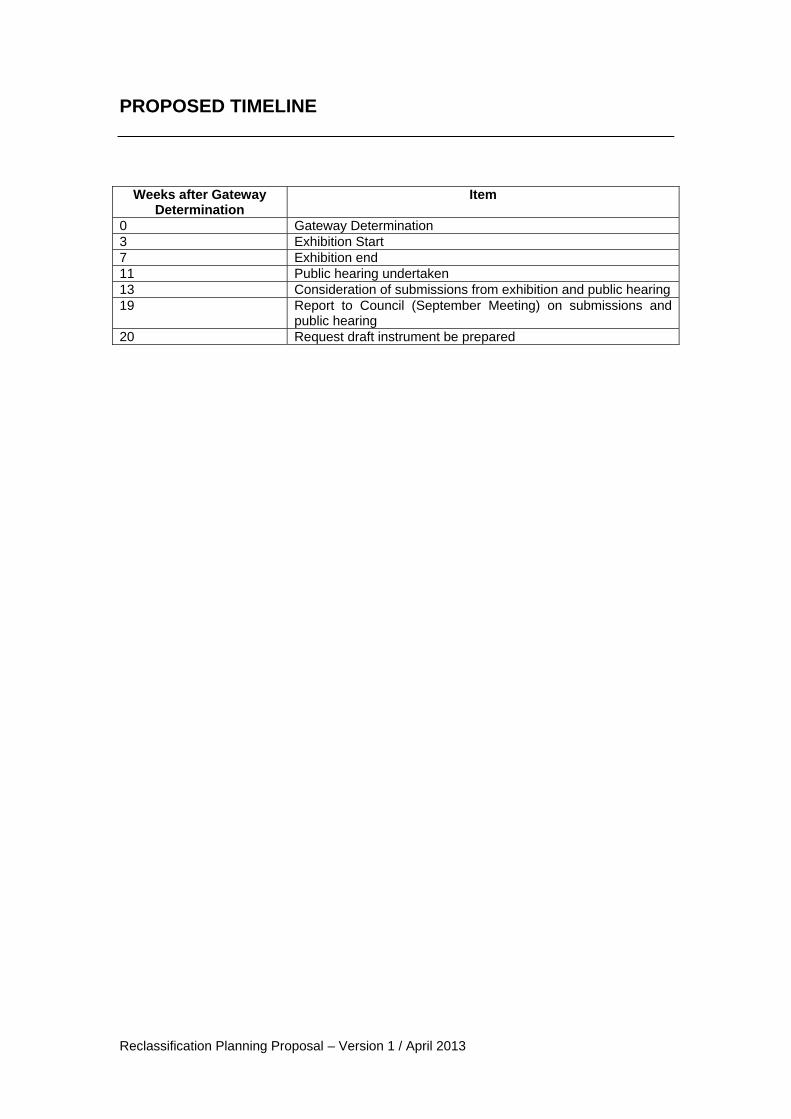
PROPOSED TIMELINE
Weeks after Gateway
Determination Item
0 Gateway Determination 3 Exhibition Start 7 Exhibition end 11 Public hearing undertaken 13 Consideration of submissions from exhibition and public hearing 19 Report to Council (September Meeting) on submissions and
public hearing 20 Request draft instrument be prepared

Reclassification Planning Proposal – Version 1 / April 2013
Appendix A Group Mangers Report No.28/13 and Council Minutes (excluding attachments)
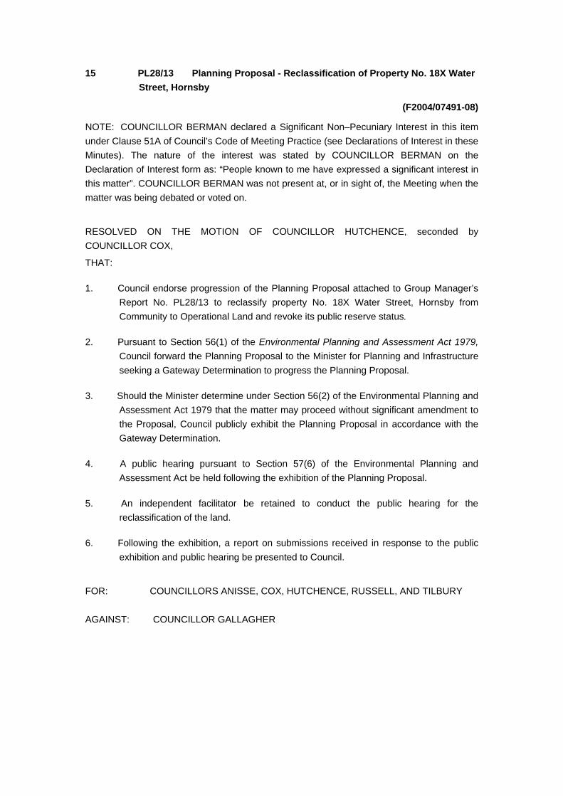
15 PL28/13 Planning Proposal - Reclassification of Property No. 18X Water
Street, Hornsby
(F2004/07491-08)
NOTE: COUNCILLOR BERMAN declared a Significant Non–Pecuniary Interest in this item
under Clause 51A of Council’s Code of Meeting Practice (see Declarations of Interest in these
Minutes). The nature of the interest was stated by COUNCILLOR BERMAN on the
Declaration of Interest form as: “People known to me have expressed a significant interest in
this matter”. COUNCILLOR BERMAN was not present at, or in sight of, the Meeting when the
matter was being debated or voted on.
RESOLVED ON THE MOTION OF COUNCILLOR HUTCHENCE, seconded by
COUNCILLOR COX,
THAT:
1. Council endorse progression of the Planning Proposal attached to Group Manager’s
Report No. PL28/13 to reclassify property No. 18X Water Street, Hornsby from
Community to Operational Land and revoke its public reserve status.
2. Pursuant to Section 56(1) of the Environmental Planning and Assessment Act 1979,
Council forward the Planning Proposal to the Minister for Planning and Infrastructure
seeking a Gateway Determination to progress the Planning Proposal.
3. Should the Minister determine under Section 56(2) of the Environmental Planning and
Assessment Act 1979 that the matter may proceed without significant amendment to
the Proposal, Council publicly exhibit the Planning Proposal in accordance with the
Gateway Determination.
4. A public hearing pursuant to Section 57(6) of the Environmental Planning and
Assessment Act be held following the exhibition of the Planning Proposal.
5. An independent facilitator be retained to conduct the public hearing for the
reclassification of the land.
6. Following the exhibition, a report on submissions received in response to the public
exhibition and public hearing be presented to Council.
FOR: COUNCILLORS ANISSE, COX, HUTCHENCE, RUSSELL, AND TILBURY
AGAINST: COUNCILLOR GALLAGHER
General Meeting 17 April 2013
Group Manager's Report No. PL28/13
Planning Division
Date of Meeting: 17/04/2013
15 PLANNING PROPOSAL - RECLASSIFICATION OF PROPERTY NO. 18X WATER STREET,
HORNSBY
EXECUTIVE SUMMARY
Property No. 18X Water Street, Hornsby, has an area of approximately 675m2 and is
classified as Community Land. The site is considered surplus to Council’s open space needs.
The Hornsby Shire Housing Strategy was gazetted in September 2011. The Strategy
identified precincts throughout the Shire for multi-unit housing. Property No. 18X Water
Street, Hornsby is located within the Belair Close Precinct.
The Belair Close precinct is zoned Residential C (Medium/High Density) under the Hornsby
Shire Local Environmental Plan 1994 (HSLEP) and R4 High Density Residential under the
draft Hornsby Local Environmental Plan (HLEP) and permits multi-unit housing to a height of
5 storeys.
Proponents have approached Council concerning development of the Belair Close Precinct
and the opportunity to purchase and include property No. 18X Water Street as part of a
development site.
RECOMMENDATION
THAT:
1. Council endorse progression of the Planning Proposal attached to Group Manager’s Report
No. PL 28/13 to reclassify property No. 18X Water Street, Hornsby from Community to
Operational Land and revoke its public reserve status.
2. Pursuant to Section 56(1) of the Environmental Planning and Assessment Act 1979, Council
forward the Planning Proposal to the Minister for Planning and Infrastructure seeking a
Gateway Determination to progress the Planning Proposal.
3. Should the Minister determine under Section 56(2) of the Environmental Planning and
Assessment Act 1979 that the matter may proceed without significant amendment to the
Proposal, Council publicly exhibit the Planning Proposal in accordance with the Gateway
Determination.
4. A public hearing pursuant to Section 57(6) of the Environmental Planning and Assessment
Act be held following the exhibition of the Planning Proposal.
5. An independent facilitator be retained to conduct the public hearing for the reclassification of
the land.
6. Following the exhibition, a report on submissions received in response to the public exhibition
and public hearing be presented to Council.

Hornsby Shire Council Report No. PL28/13 Page 2
General Meeting 17 April 2013
PURPOSE
The purpose of this report is to present a Planning Proposal to reclassify Lot 15 DP 204264 known as
property No. 18X Water Street, Hornsby (Water Street Park) from community land to operational land
and revoke its public reserve status.
BACKGROUND
Council prepared the Hornsby Shire Housing Strategy to identify areas for the provision of additional
housing to assist meet Council’s housing obligations under the NSW State Government’s Metropolitan
Strategy. The Housing Strategy identified precincts throughout the Shire for multi-unit housing,
including a precinct in Belair Close, Hornsby. The Plan to implement the Housing Strategy was
finalised by the State Government in September 2011.
The planning controls for the Belair Close Precinct have been amended to permit multi-unit housing to
a height of 5 storeys. Property No. 18X Water Street, Hornsby sits within the Belair Close Precinct
and is classified as Community Land.
In accordance with Clause 25 and 26 of the Local Government Act 1993 (LG Act 1993), all land within
Council ownership is required to be classified as either Community or Operational land. The
classification of these lands ultimately determines how Council manages the land.
Operational land may be sold or developed in accordance with the permitted use of the land having
regard to any easements or restrictions as to user. However, Community land is generally reserved
for public use with the following restrictions required by the LG Act 1993:
cannot be sold;
cannot be leased, licensed or any other estate granted over the land for more than 21 years;
and
must have a plan of management prepared for it.
SITE
Property No. 18X Water Street, Hornsby (known as the Water Street Park) was dedicated to Council
in 1961 as a Public Reserve under Section 340A (Public garden and recreation spaces) of the Local
Government Act 1919 as part of the subdivision of Belair Close. The property is zoned Residential C
(Medium/High density) under the HSLEP and R4 (High Density Residential) under the draft HLEP.
The allotment has an area of approximately 675m2and is located adjacent to the unformed section of
Water Street. The site is predominately cleared and grassed, with mature vegetation along the
northern boundary.
DISCUSSION
The Water Street Park is identified as Reserve No.328 in Council’s District 3 and 9 Community Land
and Crown Reserves Generic Plan of Management and is classified as Community Land for a park.
The Plan grades the existing level of service as ‘low’ and identifies the possible reclassification and
rationalisation of the reserve following an assessment of open space needs and supply in the area.
As part of the preparation of the Housing Strategy, consideration was given to open space required to
meet the recreational demand associated with the provision of additional housing. Council’s Leisure
Strategic Plan was considered during this process. The Plan recommends the sale of relatively small
Hornsby Shire Council Report No. PL28/13 Page 3
General Meeting 17 April 2013
and ‘low value’ open space sites with limited open space functions. The Plan states that there are a
large number of small pocket parks throughout the Shire which have limited recreation value and are
relatively expensive to maintain.
Although Water Street Park is defined as a public reserve, its suitability for recreational use is limited.
Pocket parks typically range in size from 1000m2 to 5000m2 and contain facilities such as children’s
playground equipment, seating, shade structures etc. The property is undersized for a pocket park
and does not contain play equipment, seating or other facilities except for a trash rack and a
concealed sewer line that runs through the reserve. The property is also adjacent to a stormwater
outlet which is not physically separated from the reserve.
An existing pocket park to service the needs of local residents, known as Beatrice Thompson Park, is
located in close proximity on the corner of Water Street and Albert North Street. The park is
approximately 4000m2 and contains children’s playground equipment, seating and shade structures.
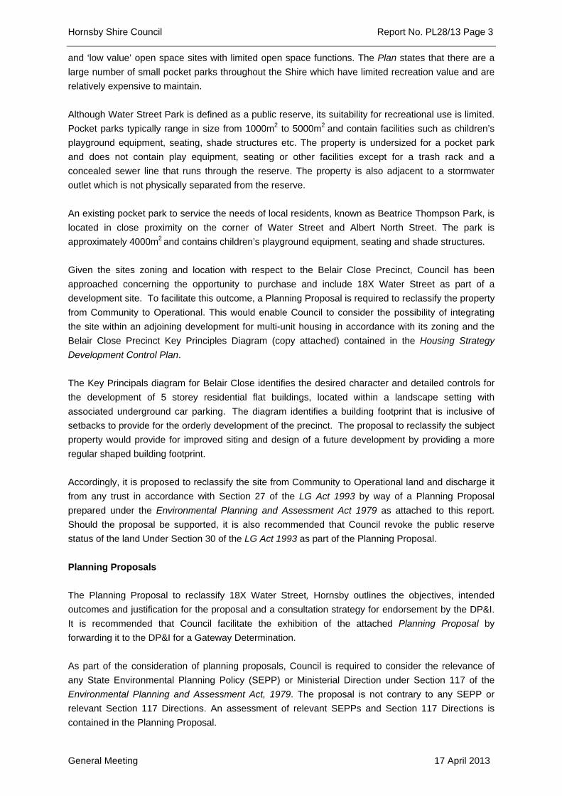
Given the sites zoning and location with respect to the Belair Close Precinct, Council has been
approached concerning the opportunity to purchase and include 18X Water Street as part of a
development site. To facilitate this outcome, a Planning Proposal is required to reclassify the property
from Community to Operational. This would enable Council to consider the possibility of integrating
the site within an adjoining development for multi-unit housing in accordance with its zoning and the
Belair Close Precinct Key Principles Diagram (copy attached) contained in the Housing Strategy
Development Control Plan.
The Key Principals diagram for Belair Close identifies the desired character and detailed controls for
the development of 5 storey residential flat buildings, located within a landscape setting with
associated underground car parking. The diagram identifies a building footprint that is inclusive of
setbacks to provide for the orderly development of the precinct. The proposal to reclassify the subject
property would provide for improved siting and design of a future development by providing a more
regular shaped building footprint.
Accordingly, it is proposed to reclassify the site from Community to Operational land and discharge it
from any trust in accordance with Section 27 of the LG Act 1993 by way of a Planning Proposal
prepared under the Environmental Planning and Assessment Act 1979 as attached to this report.
Should the proposal be supported, it is also recommended that Council revoke the public reserve
status of the land Under Section 30 of the LG Act 1993 as part of the Planning Proposal.
Planning Proposals
The Planning Proposal to reclassify 18X Water Street, Hornsby outlines the objectives, intended
outcomes and justification for the proposal and a consultation strategy for endorsement by the DP&I.
It is recommended that Council facilitate the exhibition of the attached Planning Proposal by
forwarding it to the DP&I for a Gateway Determination.
As part of the consideration of planning proposals, Council is required to consider the relevance of
any State Environmental Planning Policy (SEPP) or Ministerial Direction under Section 117 of the
Environmental Planning and Assessment Act, 1979. The proposal is not contrary to any SEPP or
relevant Section 117 Directions. An assessment of relevant SEPPs and Section 117 Directions is
contained in the Planning Proposal.
Hornsby Shire Council Report No. PL28/13 Page 4
General Meeting 17 April 2013
CONSULTATION
“A guide to preparing local environmental plans” has been prepared by the DOP&I (2009) to assist
councils in preparing planning proposals and LEPs. In accordance with the Guidelines, the Planning
Proposal is required to be exhibited for a period of 28 days. A consultation strategy relevant to the
public exhibition of the draft LEP has been prepared as part of the Planning Proposal for endorsement
by the DP&I.
The reclassification of land, in any instance, requires a public hearing to take place and conducted by
an independent professional in accordance with Section 29 of the LG Act 1993. Within 21 days
following the exhibition period, a public hearing must be held to ensure full community consultation. At
the conclusion of the public hearing, a report will be prepared by the facilitator of the public hearing for
Council’s consideration which details any submissions to the reclassification of land.
A report outlining the outcomes of the public agency consultation, submissions received during public
exhibition and hearing would be presented to Council for its consideration at the conclusion of the
exhibition period.
BUDGET
There are budgetary implications associated with the reclassification of the site. Council’s staff time
and resources are required in the administration of the Planning Proposal and an independent person
will need to be retained to conduct the necessary public hearing. The estimated minimum cost for
obtaining a consultant to facilitate the public hearing and preparation of a report is approximately
$2500. The monies for engagement of the consultant have been allocated from the Strategic Planning
Branch’s Consultant budget.
Should the Planning Proposal result in the eventual sale of the property, proceeds could be
reinvested into purchasing new open space or upgrading existing assets which are of greater benefit
to the public. Disposal of the land would also enable Council to rationalise its current maintenance
cost and redirect resources towards more functional reserves that currently meet the open space and
recreation needs of the community.
POLICY
There are no policy implications associated with this Report.
CONCLUSION
The classification of public land determines how that land is operated and used by Council. The
reclassification of property No. 18X Water Street from Community to Operational and revocation of
the public reserve would facilitate the redevelopment of the site and surrounding properties for multi-
unit housing in accordance with its zoning and the Belair Close precinct Key Principles Diagram
contained in the Housing Strategy Development Control Plan. The property serves limited purpose as
a public reserve due to its small size and proximity to a stormwater outlet.
It is recommended that Council endorse the Hornsby Quarry Planning Proposal for submission to the
DP&I for Gateway Determination and exhibition.
Hornsby Shire Council Report No. PL28/13 Page 5
General Meeting 17 April 2013
RESPONSIBLE OFFICER
The officer responsible for the preparation of this Report is the Manager, Strategic Planning – Fletcher
Rayner - who can be contacted on 9847 6744.
FLETCHER RAYNER
Manager - Strategic Planning
Planning Division
JAMES FARRINGTON
Group Manager
Planning Division
Attachments:
1. Locality Plan
2. Key Principles diagram - Belair Close Precinct
3. Planning Proposal
File Reference: F2004/07491-08
Document Number: D02137189

Reclassification Planning Proposal – Version 1 / April 2013
Appendix B Map of site to be reclassified
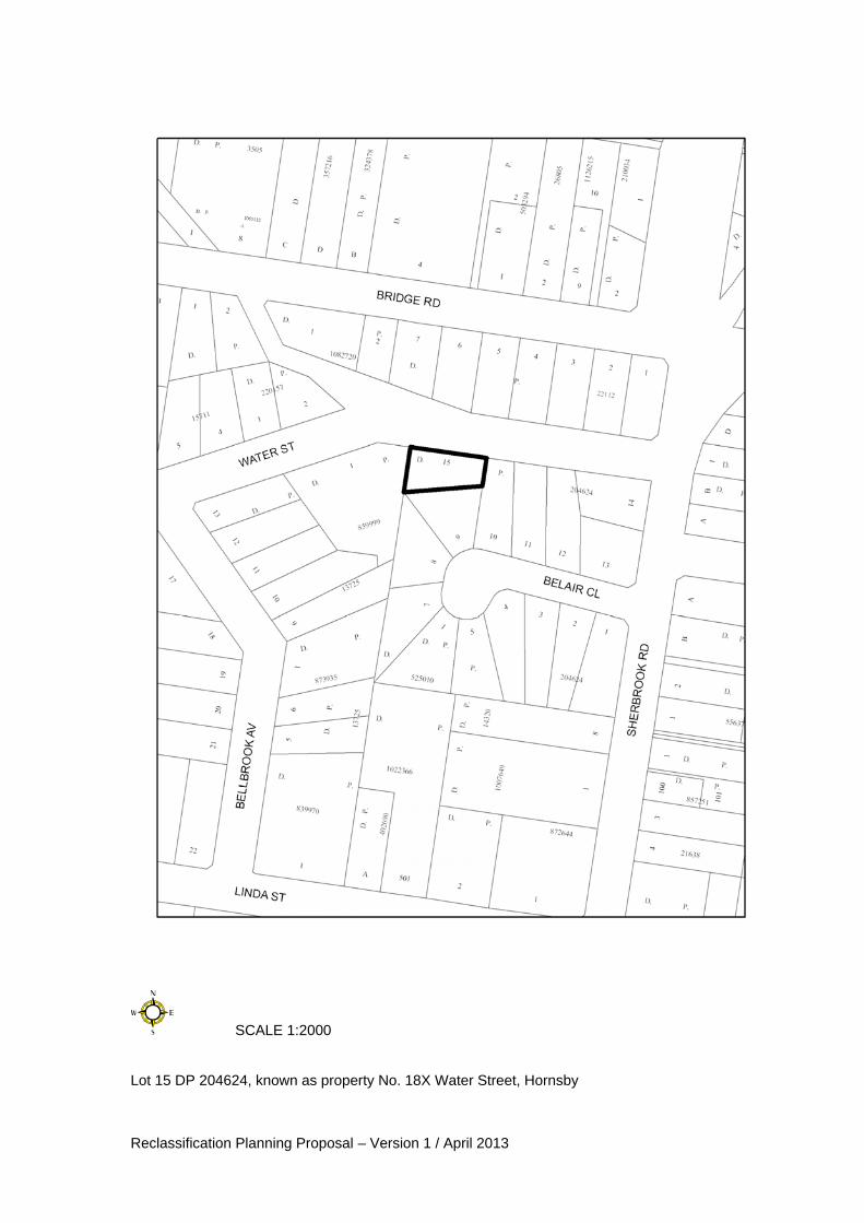
Reclassification Planning Proposal – Version 1 / April 2013
SCALE 1:2000 Lot 15 DP 204624, known as property No. 18X Water Street, Hornsby
Reclassification Planning Proposal – Version 1 / April 2013
Appendix C Section 117 Direction Checklist
Reclassification Planning Proposal – Version 1 / April 2013
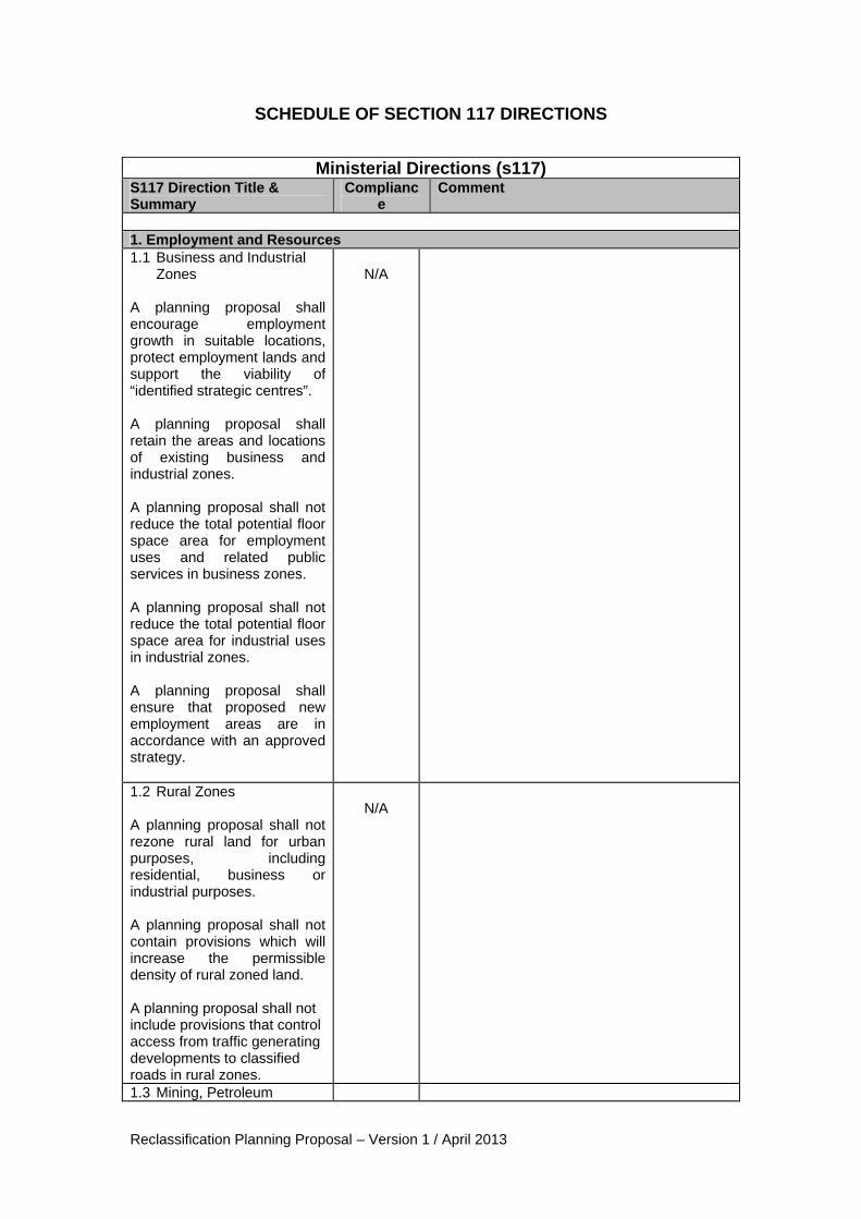
SCHEDULE OF SECTION 117 DIRECTIONS
Ministerial Directions (s117) S117 Direction Title & Summary
Compliance
Comment
1. Employment and Resources 1.1 Business and Industrial
Zones A planning proposal shall encourage employment growth in suitable locations, protect employment lands and support the viability of “identified strategic centres”. A planning proposal shall retain the areas and locations of existing business and industrial zones. A planning proposal shall not reduce the total potential floor space area for employment uses and related public services in business zones. A planning proposal shall not reduce the total potential floor space area for industrial uses in industrial zones. A planning proposal shall ensure that proposed new employment areas are in accordance with an approved strategy.
N/A
1.2 Rural Zones A planning proposal shall not rezone rural land for urban purposes, including residential, business or industrial purposes. A planning proposal shall not contain provisions which will increase the permissible density of rural zoned land. A planning proposal shall not include provisions that control access from traffic generating developments to classified roads in rural zones.
N/A
1.3 Mining, Petroleum
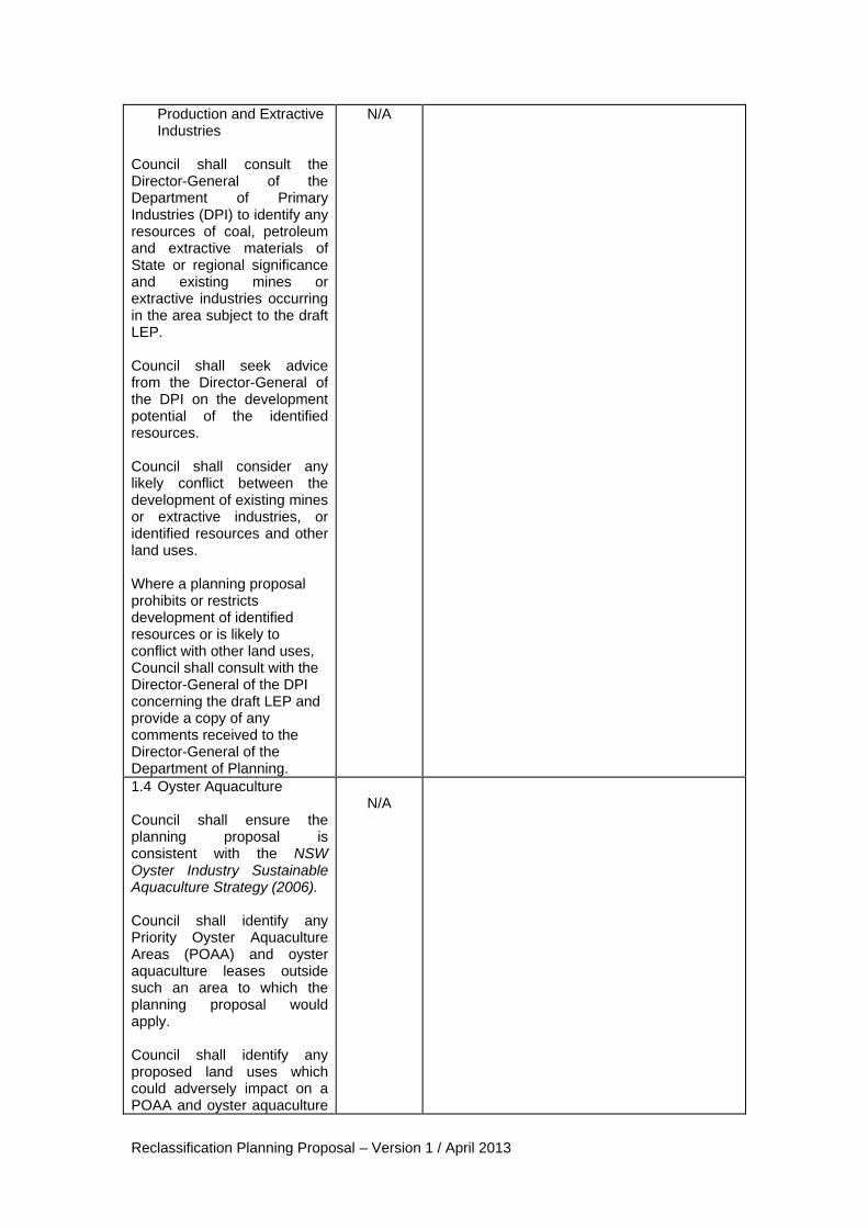
Reclassification Planning Proposal – Version 1 / April 2013
Production and Extractive Industries
Council shall consult the Director-General of the Department of Primary Industries (DPI) to identify any resources of coal, petroleum and extractive materials of State or regional significance and existing mines or extractive industries occurring in the area subject to the draft LEP. Council shall seek advice from the Director-General of the DPI on the development potential of the identified resources. Council shall consider any likely conflict between the development of existing mines or extractive industries, or identified resources and other land uses. Where a planning proposal prohibits or restricts development of identified resources or is likely to conflict with other land uses, Council shall consult with the Director-General of the DPI concerning the draft LEP and provide a copy of any comments received to the Director-General of the Department of Planning.
N/A
1.4 Oyster Aquaculture Council shall ensure the planning proposal is consistent with the NSW Oyster Industry Sustainable Aquaculture Strategy (2006). Council shall identify any Priority Oyster Aquaculture Areas (POAA) and oyster aquaculture leases outside such an area to which the planning proposal would apply. Council shall identify any proposed land uses which could adversely impact on a POAA and oyster aquaculture
N/A

Reclassification Planning Proposal – Version 1 / April 2013
leases outside such an area. Council shall consider any likely incompatibilities between oyster aquaculture and other land uses and evaluate ameliorative measures. Where a planning proposal could result in an impact on a POAA and oyster aquaculture leases outside such an area, Council shall consult the Director-General of the Department of Primary Industries (DPI) concerning the draft LEP and provide a copy of any comments received to the Director-General of the Department of Planning. 2. Environment and Heritage 2.1 Environmental Protection Zones A planning proposal shall include provisions that facilitate the protection and conservation of environmentally sensitive areas. A planning proposal that applies to environmental protection zoned land or land identified for environmental protection purposes shall not reduce the protection standards that apply to the land.
N/A
2.2 Coastal Protection A planning proposal shall be consistent with the NSW Coastal Policy: A Sustainable Future for the New South Wales Coast 1997, the Coastal Design Guidelines 2003 and the NSW Coastline Management Manual 1990.
N/A
2.3 Heritage Conservation A planning proposal shall contain provisions to facilitate the conservation of items, places, buildings, works,
N/A

Reclassification Planning Proposal – Version 1 / April 2013
relics, moveable objects or precincts of environmental heritage significance. A planning proposal shall contain provisions that facilitate the conservation of areas, places, landscapes and objects identified of being of Aboriginal heritage significance. 2.4 Recreation Vehicle Areas Planning proposals shall not zone or enable land to be developed for a recreational vehicle area where the land is in an Environmental Protection Zone, is a beach or dune, or in other areas unless the council has taken into consideration relevant guidelines listed in the Direction.
N/A
3. Housing Infrastructure and Urban Development 3.1 Residential Zones A planning proposal shall include housing provisions that broaden the choice of building types and housing locations, make more efficient use of existing infrastructure and services, reduce urban sprawl and be of good design. A planning proposal shall contain a requirement that residential development is not permitted until land is adequately services with water and sewerage. Planning proposals shall not contain provisions which reduce the permissible density on residential zoned lands.
Yes
The site included within the Planning Proposal is located within established residential areas with existing infrastructure and services. The Proposal retains the current density provisions. Accordingly, the Proposal is not inconsistent with this direction.
3.2 Caravan Parks and Manufactured Home Estates Planning proposals shall retain existing zones of land or utilise an appropriate zone under the standard Instrument to permit caravan parks in LEPs When preparing planning proposals, Council shall consider the categories of land and principles in SEPP No. 36
N/A
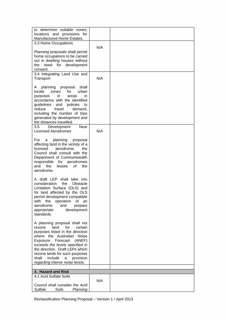
Reclassification Planning Proposal – Version 1 / April 2013
to determine suitable zones, locations and provisions for Manufactured Home Estates. 3.3 Home Occupations Planning proposals shall permit home occupations to be carried out in dwelling houses without the need for development consent.
N/A
3.4 Integrating Land Use and Transport A planning proposal shall locate zones for urban purposes in areas in accordance with the identified guidelines and policies to reduce travel demand, including the number of trips generated by development and the distances travelled.
N/A
3.5 Development Near Licensed Aerodromes For a planning proposal affecting land in the vicinity of a licensed aerodrome, the Council shall consult with the Department of Commonwealth responsible for aerodromes and the lessee of the aerodrome. A draft LEP shall take into consideration the Obstacle Limitation Surface (OLS) and for land affected by the OLS permit development compatible with the operation of an aerodrome and prepare appropriate development standards. A planning proposal shall not rezone land for certain purposes listed in the direction where the Australian Noise Exposure Forecast (ANEF) exceeds the levels specified in the direction. Draft LEPs which rezone lands for such purposes shall include a provision regarding interior noise levels.
N/A
4. Hazard and Risk 4.1 Acid Sulfate Soils Council shall consider the Acid Sulfate Soils Planning
N/A

Reclassification Planning Proposal – Version 1 / April 2013
Guidelines adopted by the Director-General of the Department of Planning when preparing a planning proposal that applies to any land identified on the Acid Sulfate Soils Risk Maps prepared by the Department of Natural Resources. Planning proposals that regulate works in acid sulfate soils shall be consistent with the Acid Sulfate Soils Model LEP or such other provisions provided by the Director-General of the Department of Planning. Council shall not prepare a planning proposal that intensifies land uses on land having a probability of containing acid sulfate soils unless an acid sulfate soils study has been considered 4.2 Mine Subsidence and Unstable Land Where the land is subject to mine subsidence, council shall consult the Mine Subsidence Board to ascertain if the Board has any objection to the Plan and the appropriateness of the development for the potential level of subsidence. A planning proposal shall not permit development on unstable land.
N/A
4.3 Flood Prone Land A planning proposal shall include provisions that give effect to the NSW Flood Prone Land Policy and are consistent with the Floodplain Development Manual 2005. A draft LEP shall not rezone land within the flood planning areas from Special Use, Special Purpose, Recreation, Rural or Environmental Protection Zones to a Residential, Business, Industrial, Special Use or Special Purpose Zone. A planning proposal shall not
N/A
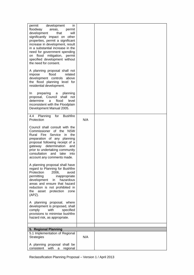
Reclassification Planning Proposal – Version 1 / April 2013
permit development in floodway areas, permit development that will significantly impact on other properties, permit a significant increase in development, result in a substantial increase in the need for government spending on flood mitigation, permit specified development without the need for consent. A planning proposal shall not impose flood related development controls above the flood planning level for residential development. In preparing a planning proposal, Council shall not determine a flood level inconsistent with the Floodplain Development Manual 2005. 4.4 Planning for Bushfire Protection Council shall consult with the Commissioner of the NSW Rural Fire Service in the preparation of any planning proposal following receipt of a gateway determination and prior to undertaking community consultation and take into account any comments made. A planning proposal shall have regard to Planning for Bushfire Protection 2006, avoid permitting inappropriate development in hazardous areas and ensure that hazard reduction is not prohibited in the asset protection zone (APZ). A planning proposal, where development is proposed, shall comply with specified provisions to minimise bushfire hazard risk, as appropriate.
N/A
5. Regional Planning 5.1 Implementation of Regional Strategies A planning proposal shall be consistent with a regional
N/A
Reclassification Planning Proposal – Version 1 / April 2013
strategy released by the Minister for Planning. 5.2 Sydney Drinking Water Catchments A planning proposal shall be prepared in accordance with the general principle that water quality within the hydrological catchment must be protected and in accordance with specified principles. When preparing a planning proposal that applies to land within a hydrological catchment, Council, shall consider any strategic land and water capability assessment, or a settlement or rural residential strategy, consult the Sydney Catchment Authority (SCA) under Section 62 of the EP&A Act and zone SCA land in accordance with the specified zones from the Standard Instrument.
N/A
5.3 Farmland of State and Regional Significance on the NSW Far North Coast A planning proposal shall not rezone land identified as “State Significant Farmland”, “Regionally Significant Farmland” or “Significant non-contiguous farmland” for urban or rural residential purposes.
N/A
5.4 Commercial and Retail Development along the Pacific Highway, North Coast A planning proposal that applies to land “within town” shall provide that new commercial or retail development shall be concentrated within distinct centres rather than spread along the Pacific Highway. A draft LEP that applies to land “out of town” shall provide that new commercial or retail development shall not be established near the Pacific Highway. Development with
N/A
Reclassification Planning Proposal – Version 1 / April 2013
frontage to the Pacific Highway shall consider the impact the development has on the safety and efficiency of the Highway. A planning proposal shall permit a highway service centre beside the Pacific Highway where they are located close to the town bypassed, the local economy is considered and there is adequate separation from other service centres. A planning proposal shall limit the uses permitted in highway service centres to those specified in the Direction. 5.5 Development in the vicinity of Ellalong, Paxton and Millfield (Cessnock LGA)) Council shall not prepare a planning proposal that is inconsistent with relevant agreements and strategies that apply to the area.
N/A
5.6 Sydney to Canberra Corridor A planning proposal shall include provisions that give effect to, and are consistent with, the publication entitled The Sydney to Canberra Corridor Strategy 1995.
N/A
5.7 Central Coast A planning proposal shall be consistent with the Gosford-Wyong Structure Plan except as amended by the Sydney Regional Environmental Plan No. 6 – Gosford Coastal Areas.
N/A
5.8 Sydney Second Airport: Badgerys Creek Planning proposals shall not contain provisions that enable development which could hinder the potential for development of a Second Sydney Airport.
N/A
6. Local Plan Making 6.1 Approval and Referral Requirements
Yes
The Planning Proposal does not include any provisions that would require the concurrence,
Reclassification Planning Proposal – Version 1 / April 2013
A planning proposal shall minimise provisions requiring concurrence, consultation or referral of development applications to a Minister or public authority. A planning proposal shall not identify development as designated development unless Council can satisfy the Director-General that such is warranted.
consultation or referral of development applications to a Minister or public authority.
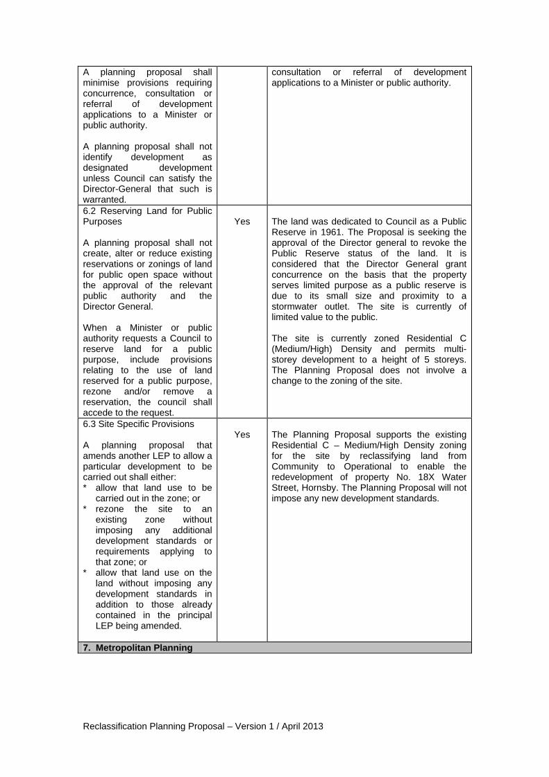
6.2 Reserving Land for Public Purposes A planning proposal shall not create, alter or reduce existing reservations or zonings of land for public open space without the approval of the relevant public authority and the Director General. When a Minister or public authority requests a Council to reserve land for a public purpose, include provisions relating to the use of land reserved for a public purpose, rezone and/or remove a reservation, the council shall accede to the request.
Yes
The land was dedicated to Council as a Public Reserve in 1961. The Proposal is seeking the approval of the Director general to revoke the Public Reserve status of the land. It is considered that the Director General grant concurrence on the basis that the property serves limited purpose as a public reserve is due to its small size and proximity to a stormwater outlet. The site is currently of limited value to the public. The site is currently zoned Residential C (Medium/High) Density and permits multi-storey development to a height of 5 storeys. The Planning Proposal does not involve a change to the zoning of the site.
6.3 Site Specific Provisions A planning proposal that amends another LEP to allow a particular development to be carried out shall either: * allow that land use to be
carried out in the zone; or * rezone the site to an
existing zone without imposing any additional development standards or requirements applying to that zone; or
* allow that land use on the land without imposing any development standards in addition to those already contained in the principal LEP being amended.
Yes
The Planning Proposal supports the existing Residential C – Medium/High Density zoning for the site by reclassifying land from Community to Operational to enable the redevelopment of property No. 18X Water Street, Hornsby. The Planning Proposal will not impose any new development standards.
7. Metropolitan Planning
Reclassification Planning Proposal – Version 1 / April 2013
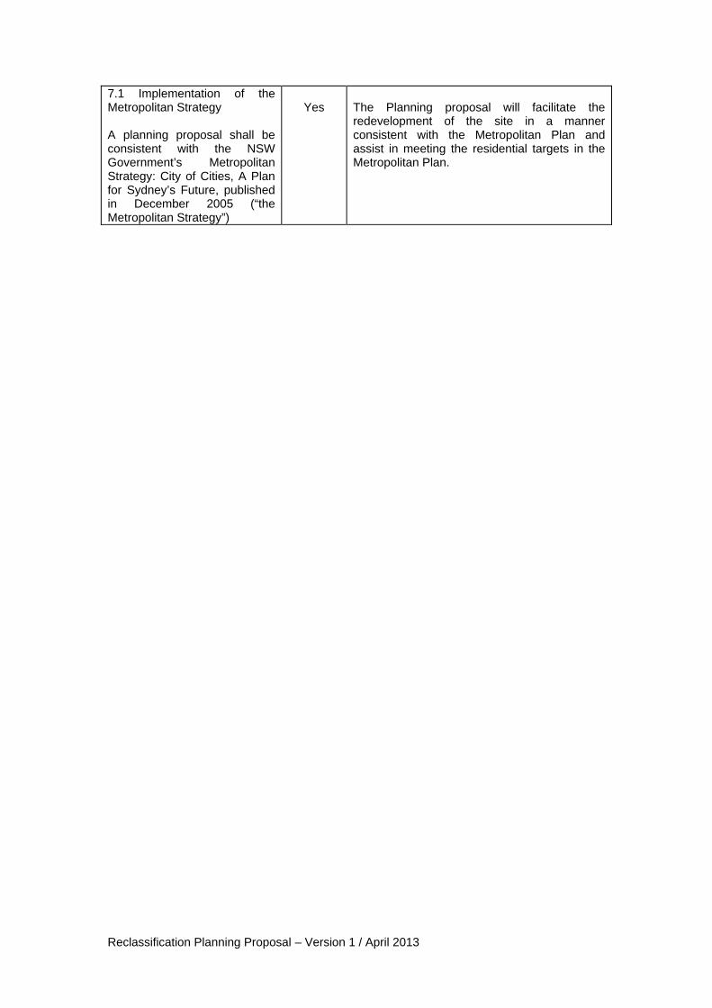
7.1 Implementation of the Metropolitan Strategy A planning proposal shall be consistent with the NSW Government’s Metropolitan Strategy: City of Cities, A Plan for Sydney’s Future, published in December 2005 (“the Metropolitan Strategy”)
Yes
The Planning proposal will facilitate the redevelopment of the site in a manner consistent with the Metropolitan Plan and assist in meeting the residential targets in the Metropolitan Plan.
Reclassification Planning Proposal – Version 1 / April 2013
Appendix D Consultation Strategy

Reclassification Planning Proposal – Version 1 / April 2013
Council is committed to undertaking comprehensive community consultation as part of the progression of the Planning Proposal. At a minimum, consultation will include: Public Authorities Notification letters and a copy of the Planning Proposal will be sent to relevant public authorities. Advertisement in the local newspaper An advertisement will be placed in the Hornsby Advocate, to identify the purpose of the Planning Proposal and where the Planning Proposal can be viewed.
Advertisement on the Council website
The Planning Proposal will be exhibited on the Council website (www.hornsby.nsw.gov.au/onexhibition) under On Exhibition. Council’s libraries have access to the website. Letters to affected and adjoining property owners A letter will be sent to adjoining property owners advising of the exhibition of the Proposal and inviting submissions. Displays at the Council Administration Building and local libraries The Planning Proposal will be displayed at the Council Administration Centre, 296 Pacific Highway, Hornsby and Hornsby Library. Referrals to other Divisions/Branches A copy of the Planning Proposal will be forwarded to relevant Divisions/Branches of Council for comment. Review of Consultation Strategy Where submissions warrant, the consultation strategy may be reviewed to extend the exhibition period and/or the methods of consultation. This may occur where a submission provides reasonable justification for a request for an extension to the exhibition period or where Council is of the opinion an amendment to the consultation strategy would facilitate greater feedback on the draft Plan. Following the exhibition period, a report on submissions will be presented to Council for its consideration. Public Hearing A Public Hearing will be undertaken in accordance with section 29 of the Local Government Act 1993. Notification of the Public Hearing will be issued at least 21 days before the start of the hearing:
On Council’s website; In the local newspaper; and In writing to adjoining owners, persons who requested a public hearing when making
a submission and relevant public authorities. Information relating to the Public Hearing will be on display at the Council Administration Centre, 296 Pacific Highway, Hornsby and Hornsby Library.
Reclassification Planning Proposal – Version 1 / April 2013
Appendix E LEP Practice Note PN 09-003 – Written Statement
Reclassification Planning Proposal – Version 1 / April 2013
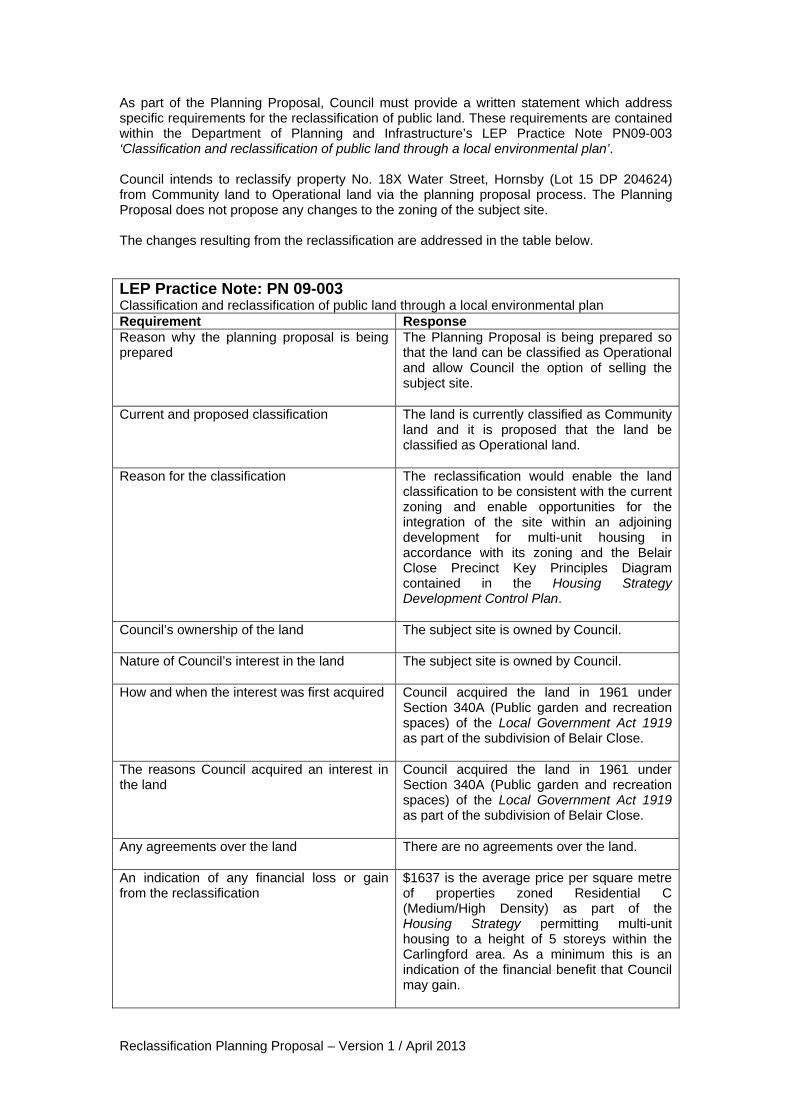
As part of the Planning Proposal, Council must provide a written statement which address specific requirements for the reclassification of public land. These requirements are contained within the Department of Planning and Infrastructure’s LEP Practice Note PN09-003 ‘Classification and reclassification of public land through a local environmental plan’. Council intends to reclassify property No. 18X Water Street, Hornsby (Lot 15 DP 204624) from Community land to Operational land via the planning proposal process. The Planning Proposal does not propose any changes to the zoning of the subject site. The changes resulting from the reclassification are addressed in the table below. LEP Practice Note: PN 09-003 Classification and reclassification of public land through a local environmental plan Requirement Response Reason why the planning proposal is being prepared
The Planning Proposal is being prepared so that the land can be classified as Operational and allow Council the option of selling the subject site.
Current and proposed classification The land is currently classified as Community land and it is proposed that the land be classified as Operational land.
Reason for the classification The reclassification would enable the land classification to be consistent with the current zoning and enable opportunities for the integration of the site within an adjoining development for multi-unit housing in accordance with its zoning and the Belair Close Precinct Key Principles Diagram contained in the Housing Strategy Development Control Plan.
Council’s ownership of the land The subject site is owned by Council.
Nature of Council’s interest in the land The subject site is owned by Council.
How and when the interest was first acquired Council acquired the land in 1961 under Section 340A (Public garden and recreation spaces) of the Local Government Act 1919 as part of the subdivision of Belair Close.
The reasons Council acquired an interest in the land
Council acquired the land in 1961 under Section 340A (Public garden and recreation spaces) of the Local Government Act 1919 as part of the subdivision of Belair Close.
Any agreements over the land There are no agreements over the land.
An indication of any financial loss or gain from the reclassification
$1637 is the average price per square metre of properties zoned Residential C (Medium/High Density) as part of the Housing Strategy permitting multi-unit housing to a height of 5 storeys within the Carlingford area. As a minimum this is an indication of the financial benefit that Council may gain.
Reclassification Planning Proposal – Version 1 / April 2013
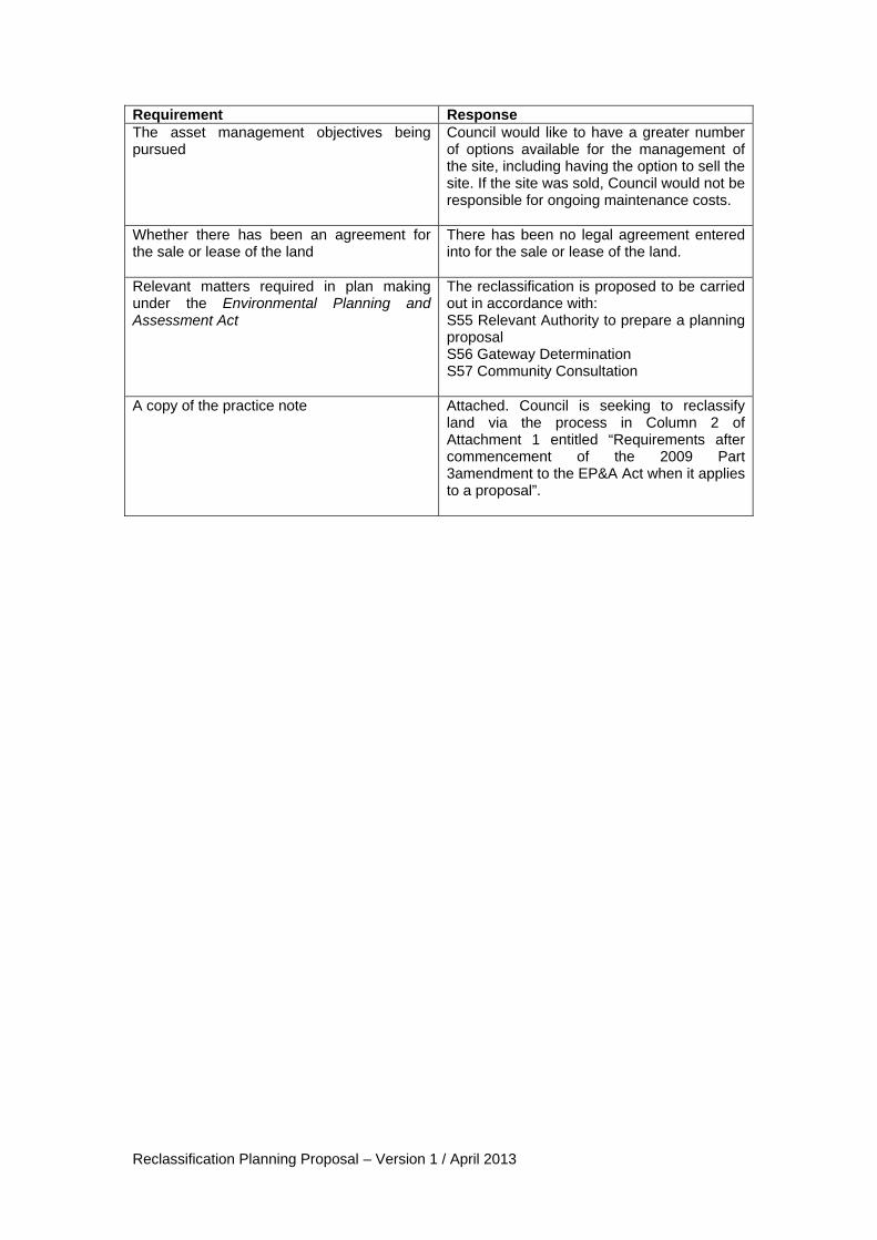
Requirement Response The asset management objectives being pursued
Council would like to have a greater number of options available for the management of the site, including having the option to sell the site. If the site was sold, Council would not be responsible for ongoing maintenance costs.
Whether there has been an agreement for the sale or lease of the land
There has been no legal agreement entered into for the sale or lease of the land.
Relevant matters required in plan making under the Environmental Planning and Assessment Act
The reclassification is proposed to be carried out in accordance with: S55 Relevant Authority to prepare a planning proposal S56 Gateway Determination S57 Community Consultation
A copy of the practice note Attached. Council is seeking to reclassify land via the process in Column 2 of Attachment 1 entitled “Requirements after commencement of the 2009 Part 3amendment to the EP&A Act when it applies to a proposal”.
1 / 4
Classification and reclassification of public land through a local environmental plan The purpose of this practice note is to update (and supersede) previous guidance on the process to classify or reclassify public land through a local environmental plan including a principal plan in accordance with the Standard Instrument.
Introduction ‘Public land’ is any land (including a public reserve) vested in, or under the control of, council. Exceptions include roads, land to which the Crown Lands Act 1989 applies, a common, or land to which the Trustees of Schools of Arts Enabling Act 1902 applies.
‘Community’ land is generally open to the public, for example, parks, reserves or sports grounds. ‘Operational’ land may be used for other purposes, for example, as works depots or garages, or held by council as a temporary asset.
‘Classification’ of public land refers to the process when this land is first acquired and first classified as either ‘operational’ land or ‘community’ land. ‘Reclassification’ of public land refers to the process of changing the classification of ‘operational’ land to ‘community’ land or from ‘community’ land to ‘operational’ land.
How is public land classified or reclassified? Depending on circumstances, this is undertaken by either:
resolution of council under section 31, 32 or 33 of the Local Government Act 1993 (LG Act) [through section 27(2)], or
a local environmental plan (LEP) under the Environmental Planning and Assessment Act 1979 (EP&A Act) [through section 27(1) of the LG Act].
In both cases, it is not possible for councils to delegate their decision to classify or reclassify public land [section 377(1) of the LG Act]. Councils are encouraged to classify or reclassify land through the LG Act wherever circumstances conform to sections 31, 32 or 33 of the LG Act.
The remaining parts of this practice note identify the key areas councils must consider when proposing to classify or reclassify public land by means of a local environmental plan (LEP) under the second option.
This practice note supersedes the sections relating to classification and reclassification in LEPs and council land, Best Practice Guideline (Department of Urban Affairs and Planning 1997).
Procedure under the EP&A Act Where classification or reclassification is proposed through an LEP, council is advised to include the proposal as early as possible in the draft LEP or planning proposal. If the public land to be classified or reclassified is not owned by council, landowner’s consent is required prior to either section 54 or section 56 of the EP&A Act (when the Part 3 amendment to the EP&A Act applies).1
The proposal would then form part of the material presented through either section 54 or section 56 of the EP&A Act (when the Part 3 amendment to the EP&A Act applies).
1 In relation to the Part 3 amendment, council should also
check the changes to the EP&A Act and Regulation once these commence.
LEP practice note STANDARD INSTRUMENT FOR LEPS
Note PN 09–003
Date 12 June 2009
Related Supersedes (re)classification advice in Best Practice Guideline (1997)
Department of Planning I practice note PN 09–003
2 / 4
To assist councils, the steps in preparing material either as a draft LEP or planning proposal are summarised in Attachment 1. Column 1 of Attachment 1 sets out the requirements in accordance with the EP&A Act prior to the Part 3 amendment commencing. Column 2 of the attachment sets out the requirements after the Part 3 amendment commences. In relation to the Part 3 amendment, council should also check the savings and transitional arrangements under the EP&A Act, once these commence.
Where land is proposed to be reserved for a public purpose such as provision of public services and facilities, section 117 Direction 6.2—Reserving Land for Public Purposes applies. The Direction also sets out requirements when a reservation of public land for such purposes is no longer required.
A summary of relevant matters that need to be available at the time the planning proposal is first forwarded are listed in Attachment 2 under ‘Exhibition’. Other matters for exhibition and later stages are listed separately in that attachment.
Provisions in the Standard Instrument The following Standard Instrument provisions are relevant to the classification and reclassification of public land.
Clause 5.2—Classification and reclassification of public land The purpose of this clause is to enable councils to classify or reclassify public land identified in Schedule 4 of the Standard Instrument. Only public land to be classified or reclassified by publication on the NSW legislation website of that principal LEP is to be identified in the schedule. Schedule 4 must not contain a reference to any land already classified or reclassified.
Part 1 Schedule 4—change to ‘operational’ land, no interest changes Land is identified in Part 1 of Schedule 4 where the trusts, estates, interests, dedications, conditions, restrictions or covenants over the land are to remain after reclassification to ‘operational land’, i.e. where no interests will change.
Part 2 Schedule 4—change to ‘operational’ land and an interest will change Land is identified in Part 2 of Schedule 4 where the land is to be classified or reclassified as ‘operational land’ and some of the trusts, estates, interests, dedications, conditions, restrictions, or covenants over the land remain. The interests to remain are identified in column 3 of this part of the schedule.
Part 3 Schedule 4—change to ‘community’ land Land proposed to be classified or reclassified as ‘community land’ through the LEP is identified in Part 3 of the schedule.
Where there is no land to be classified or reclassified through the LEP, the clause remains with the schedule empty.
General requirements for exhibition Public exhibition of the LEP occurs after certification of the LEP (in accordance with section 66 of the EP&A Act). Public exhibition of a planning proposal may occur in accordance with section 57(2) (when the Part 3 amendment to the EP&A Act commences). To assist the public in understanding an exhibited draft LEP or planning proposal to classify or reclassify land, requirements are summarised in Attachment 2.
A copy of council’s response to these requirements together with a copy of this practice note is to be part of material displayed during public exhibition of an LEP or planning proposal to reclassify or classify public land.
Public hearing A public hearing must be held when ‘community land’ is proposed to be reclassified as ‘operational land’.
To ensure council and the community have sufficient time to consider relevant matters associated with the proposed change, the public hearing is held after the close of the exhibition period under section 68 of the EP&A Act (section 29 of the LG Act) for an LEP and in accordance with section 57(6) (when the Part 3 amendment to the EP&A Act commences).
Public hearing provisions are set out in the EP&A Regulation (clause 14) and public notice of a hearing must be sent or published at least 21 days before the start of the public hearing.
The independence of the person chairing the public hearing and requirements relating to the preparation and inspection of reports from the hearing are specified in section 47G of the LG Act.
Further information A copy of this practice note, Standard Instrument, and other specific practice notes and planning circulars on using the Standard Instrument, can be accessed on the Department’s website http://www.planning.nsw.gov.au/lep/index.asp
Authorised by:
Sam Haddad, Director-General
List of attachments:
1. Main steps (in sequence) for classifying and reclassifying public land under the Environmental Planning and Assessment Act 1979
2. General requirements for classification or reclassification of land through local environmental plans and planning proposals
Attachment Department of Planning I practice note PN 09–003
3 / 4
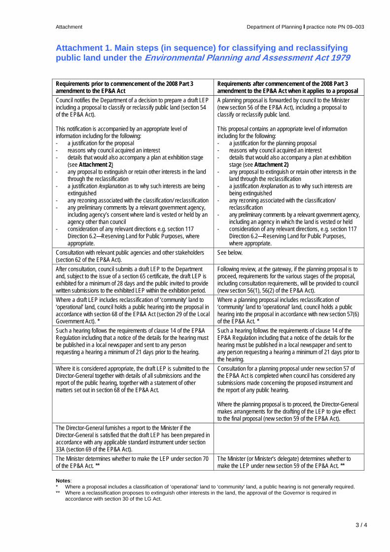
Attachment 1. Main steps (in sequence) for classifying and reclassifying public land under the Environmental Planning and Assessment Act 1979 Requirements prior to commencement of the 2008 Part 3 amendment to the EP&A Act
Requirements after commencement of the 2008 Part 3 amendment to the EP&A Act when it applies to a proposal
Council notifies the Department of a decision to prepare a draft LEP including a proposal to classify or reclassify public land (section 54 of the EP&A Act). This notification is accompanied by an appropriate level of information including for the following: - a justification for the proposal - reasons why council acquired an interest - details that would also accompany a plan at exhibition stage
(see Attachment 2) - any proposal to extinguish or retain other interests in the land
through the reclassification - a justification /explanation as to why such interests are being
extinguished - any rezoning associated with the classification/ reclassification - any preliminary comments by a relevant government agency,
including agency’s consent where land is vested or held by an agency other than council
- consideration of any relevant directions e.g. section 117 Direction 6.2—Reserving Land for Public Purposes, where appropriate.
A planning proposal is forwarded by council to the Minister (new section 56 of the EP&A Act), including a proposal to classify or reclassify public land. This proposal contains an appropriate level of information including for the following: - a justification for the planning proposal - reasons why council acquired an interest - details that would also accompany a plan at exhibition
stage (see Attachment 2) - any proposal to extinguish or retain other interests in the
land through the reclassification - a justification /explanation as to why such interests are
being extinguished - any rezoning associated with the classification/
reclassification - any preliminary comments by a relevant government agency,
including an agency in which the land is vested or held - consideration of any relevant directions, e.g. section 117
Direction 6.2—Reserving Land for Public Purposes, where appropriate.
Consultation with relevant public agencies and other stakeholders (section 62 of the EP&A Act).
See below.
After consultation, council submits a draft LEP to the Department and, subject to the issue of a section 65 certificate, the draft LEP is exhibited for a minimum of 28 days and the public invited to provide written submissions to the exhibited LEP within the exhibition period.
Following review, at the gateway, if the planning proposal is to proceed, requirements for the various stages of the proposal, including consultation requirements, will be provided to council (new section 56(1), 56(2) of the EP&A Act).
Where a draft LEP includes reclassification of ‘community’ land to ‘operational’ land, council holds a public hearing into the proposal in accordance with section 68 of the EP&A Act (section 29 of the Local Government Act). *
Where a planning proposal includes reclassification of ‘community’ land to ‘operational’ land, council holds a public hearing into the proposal in accordance with new section 57(6) of the EP&A Act. *
Such a hearing follows the requirements of clause 14 of the EP&A Regulation including that a notice of the details for the hearing must be published in a local newspaper and sent to any person requesting a hearing a minimum of 21 days prior to the hearing.
Such a hearing follows the requirements of clause 14 of the EP&A Regulation including that a notice of the details for the hearing must be published in a local newspaper and sent to any person requesting a hearing a minimum of 21 days prior to the hearing.
Where it is considered appropriate, the draft LEP is submitted to the Director-General together with details of all submissions and the report of the public hearing, together with a statement of other matters set out in section 68 of the EP&A Act.
Consultation for a planning proposal under new section 57 of the EP&A Act is completed when council has considered any submissions made concerning the proposed instrument and the report of any public hearing. Where the planning proposal is to proceed, the Director-General makes arrangements for the drafting of the LEP to give effect to the final proposal (new section 59 of the EP&A Act).
The Director-General furnishes a report to the Minister if the Director-General is satisfied that the draft LEP has been prepared in accordance with any applicable standard instrument under section 33A (section 69 of the EP&A Act).
The Minister determines whether to make the LEP under section 70 of the EP&A Act. **
The Minister (or Minister’s delegate) determines whether to make the LEP under new section 59 of the EP&A Act. **
Notes: * Where a proposal includes a classification of ‘operational’ land to ‘community’ land, a public hearing is not generally required. ** Where a reclassification proposes to extinguish other interests in the land, the approval of the Governor is required in
accordance with section 30 of the LG Act.

Attachment Department of Planning I practice note PN 09–003
4 / 4
Attachment 2. General requirements for classification or reclassification of land through local environmental plans and planning proposals
Exhibition When exhibiting a planning proposal or draft LEP to classify or reclassify public land, council must provide a written statement including the following:
the reasons why the draft LEP or planning proposal is being prepared including the planning merits of the proposal, e.g. the findings of a centres’ strategy, council’s intention to dispose of the land, provision of open space in a town centre
the current and proposed classification of the land
the reasons for the reclassification including how this relates to council’s strategic framework, council’s proposed future use of the land, proposed zones, site specific requirements, e.g. heritage controls, anticipated physical or operational changes resulting from the reclassification
council’s ownership of the land, if this applies the nature of council’s interest in the land, e.g.
council has a 50 year lease over the site how and when the interest was first acquired,
e.g. the land was purchased in 20XX through section 94
the reasons council acquired an interest in the land, e.g. for the extension of an existing park; council was given responsibility for the land by a State agency
any agreements over the land together with their duration, terms, controls, agreement to dispose of the land, e.g. whether any aspect of the draft LEP or planning proposal formed part of the agreement to dispose of the land and any terms of any such agreement
an indication, as a minimum, of the magnitude of any financial gain or loss from the reclassification and of the type(s) of benefit that could arise e.g. council could indicate the magnitude of value added to the land based on comparable sites such as the land is currently valued at $1500 per square metre, nearby land zoned for business development is valued at between $2000 and $5000 per square metre
the asset management objectives being pursued, the manner in which they will be achieved and the type of benefits the council wants, i.e. without necessarily providing details of any possible financial arrangements, how the council may or will benefit financially
whether there has been an agreement for the sale or lease of the land; the basic details of any such agreement and, if relevant, when council intends to realise its asset, either
immediately after rezoning/reclassification or at a later time
Relevant matters required in plan making under the EP&A Act
A copy of this practice note must be included in the exhibition material to assist the community in identifying information requirements. Council staff may wish to identify the column in Attachment 1 that applies.
Post-exhibition Once a decision has been made regarding whether the draft LEP or planning proposal proceeds, everyone who made a written submission must be notified in writing of the decision.
Written notification must occur within 14 days of the decision and needs to clearly identify the reasons for council’s decision. An explanation must be included of how issues raised in submissions were addressed including the reasons for council’s decision.
The final report after exhibition to either the Director-General or the Minister should include:
a brief summary of council’s interest in the land issues raised in any relevant submissions the dates of the exhibition and the hearing an explanation of how issues raised were
addressed or resolved.
Additional matters to be addressed when the Governor’s approval is required The Governor’s approval is required for the extinguishment of public reserve status and other interests in land which a council proposes to reclassify from ‘community’ to ‘operational’ status under the LG Act.
Council must provide sufficient information in accordance with this practice note to inform the Minister of any public reserve and/or other third party property interests (e.g. trust, covenant, easement) that are proposed to be extinguished upon the making of such a draft LEP or planning proposal.
Important note This note does not constitute legal advice. Users are advised to seek professional advice and refer to the relevant legislation, as necessary, before taking action in relation to any matters covered by this note. © 2009 New South Wales Government through the Department of Planning www.planning.nsw.gov.au DOP 09_004 Disclaimer: While every reasonable effort has been made to ensure that this document is correct at the time of publication, the State of New South Wales, its agencies and employees, disclaim any and all liability to any person in respect of anything or the consequences of anything done or omitted to be done in reliance upon the whole or any part of this document.